Embed Size (px)
Citation preview
Handbook for Phase 1habitat survey
A technique for environmental audit
JNCC Handbook 2010.qxd 30/03/2010 10:03 Page 1

Handbook for Phase 1 habitat survey
- a technique for environmental audit
Revised reprint 2010 © JNCC 1993, 2003, 2004, 2007(2), 2010
JNCC Handbook 2010.qxd 17/03/2010 07:05 Page 3

Preface - 2010 edition
The Phase 1 habitat classification and methodology, as published originally by the Nature ConservancyCouncil in 1990 and reprinted with minor revisions by JNCC, has been widely used throughout Britain for adiverse range of purposes. It has largely stood the test of time, and continues to be used as the standard'phase 1' technique for habitat survey across the UK.
The responsibilities of the former Nature Conservancy Council are now held by the three country agencies,Natural England, Scottish Natural Heritage and the Countryside Council for Wales, with JNCC nowmaintaining common standards across the UK.
Only a few minor changes have been made for the 2010 edition of the handbook. Appendix 9 provides acompendium of the main changes and developments since 1990. JNCC has no plans for furtherdevelopment of the Phase 1 standard methodology.
JNCC Handbook 2010.qxd 17/03/2010 07:05 Page 4

Contents
PagePart 1 Operational guidelines1 Introduction 7
1.1 History of Phase 1 survey 71.2 Rationale of Phase 1 survey 71.3 Outline of methodology for Phase 1 survey 81.4 The purpose of Phase 1 survey 8
2 Planning a Phase 1 survey 92.1 Choice of survey system 92.2 Use of aerial photography and satellite imagery 92.3 Choice of scale for mapping 112.4 Use of existing information 112.5 Use of public appeals 112.6 Survey preparation 112.7 Staffing requirements 122.8 Selection and training of surveyors 142.9 Equipment and office requirements 142.10 Transport requirements 152.11 Publicity 15
3 Field and office procedures 163.1 Fieldwork organisation 163.2 Mapping in the field 163.3 Preparation of the final map 163.4 Reproduction of habitat maps 183.5 Measurement and analysis of habitat areas 183.6 Sampling procedures 193.7 Area estimation by the line-intercept method 193.8 Digitisation 193.9 Accuracy 203.10 Interpretation of Phase 1 survey maps 203.11 Evaluation 213.12 Use of hierarchical alphanumeric habitat codes 22
4 Urban surveys 234.1 Choice of scale 234.2 Target notes 234.3 Habitat classification 234.4 Survey procedure 244.5 Phase 2 survey 24
5 Using the colour code mapping system 265.1 Use of colour 265.2 Additional codes 26
6 Target notes 276.1 Importance of target notes 276.2 Target note content 276.3 Target note format 276.4 General descriptions 28
7 Data storage 297.1 Survey products 297.2 Habitat maps 297.3 Habitat area data 297.4 Target notes 29
JNCC Handbook 2010.qxd 17/03/2010 07:05 Page 5

8 The survey report 30
9 Comparison of Phase 1 survey classification with other classifications 319.1 The SSSI habitat mapping scheme and the NCC/RSNC
classification 319.2 The Draft Phase 1 Habitat Mapping Manual 329.3 The National Vegetation Classification 33
Part 2 Field Manual 35
1 Habitat classification and coding. 37
2 Habitat definitions 38
A Woodland and scrub 38B Grassland and marsh 39C Tall herb and fern 41D Heathland 41E Mire 42F Swamp, marginal and inundation 44G Open water 45H Coastland 47I Rock exposure and waste 48J Miscellaneous 49
Acknowledgements 50
References 51
Appendices
1 Phase survey habitat classification, hierarchical alphanumeric referencecodes and mapping colour codes. 53
2 Habitat codes for use on monochrome field maps and fair maps 61
3 Dominant species codes 64
4 Key words and status categories for target notes 67
5 Hypothetical examples of target notes 70
6 Standard recording forms 71
7 The NCC/RSNC habitat classification 75
8 Relationship between Phase 1 habitat categories and National VegetationClassification Communities in British Plant Communities Volumes 1-5 77
9 Technical developments and other changes since 1990 - key points 79
Additional references for Appendices 8 and 9 only 80
JNCC Handbook 2010.qxd 17/03/2010 07:05 Page 6

Part 1Operational guidelines
JNCC Handbook 2010.qxd 17/03/2010 07:05 Page 7

JNCC Handbook 2010.qxd 17/03/2010 07:05 Page 8

1 Introduction
7
This manual presents a standardised system forclassifying and mapping wildlife habitats in allparts of Great Britain, including urban areas. Themanual provides information on the planning andexecution of habitat surveys and is based on theexperience of a large number of surveys whichhave been carried out in the past decade. It ishoped that this publication will facilitate the surveyof the remaining areas of Britain. It would be ofgreat benefit to nature conservation and todevelopment planning if every local authority werein possession of a Phase 1 habitat survey and if acomprehensive Phase 1 survey database existedfor each area of the country.
The Nature Conservancy Council (NCC) hasplayed a leading role in devising andimplementing standardised methods of biologicalsurvey and the NCC Phase 1 survey methodologyhas been widely used throughout Britain. It is veryimportant that a standardised system is used andthat surveys are carried out to a consistent level ofdetail and accuracy, so that the results of onesurvey may be compared with those of anotherand maps and statistical data may be readilyinterpreted.
1.1 History of Phase 1 survey
The origins of Phase 1 survey go back to the1970s, when a system was devised for rapidmapping of wildlife habitats over large areas ofcountryside. The method was used originally insouth-east Scotland and later in Cumbria and WestYorkshire (NCC 1979a, 1979b).
After the passing of the Wildlife andCountryside Act 1981, this system was modifiedand extended for use in mapping habitats on Sitesof Special Scientific Interest (SSSI) (NCC 1982,1983a). The SSSI habitat mapping system wasconsidered to be too detailed for use in Phase 1surveys of the wider countryside and a simplified,but compatible, version was produced for thispurpose (NCC 1983b). This version has beenwidely used for large-scale habitat surveys such asthe Phase 1 Survey of Cumbria (NCC 1986a, Kelly& Perry 1990), although a number of large-scalesurveys initiated before its publication (forexample Somerset and Dorset - NCC 1983c,1983d) used the full SSSI mapping system.
A draft manual on habitat survey was producedin 1986 (NCC 1986b) and this afforded anopportunity to clarify a number of habitatdefinitions and to make some minor changes inthe habitat classification and coding. Althoughunpublished, this draft was widely circulated and
has been used as the basis of most of the Phase 1surveys of the late 1980s in England, Wales andScotland.
The present manual is a revision of the 1986draft and introduces further revisions of habitatdefinitions, mainly clarifying what has becomeaccepted practice in existing survey but alsointroducing some changes in areas of ambiguityand confusion. In particular, the mires section hasbeen revised, the dune classification has beensimplified and the rather large semi-improvedgrassland category has been split into two, morefunctionally convenient, units. The classificationcovers the full range of terrestrial and intertidalhabitats, but no attempt has been made to coversub-tidal habitats.
Since 1982 all versions of the NCC Phase 1habitat mapping system have been based on thesame hierarchical classification system and arethus, in most respects, compatible with oneanother
1.2 Rationale of Phase 1 survey
The aim of Phase 1 survey is to provide,relatively rapidly, a record of the semi-naturalvegetation and wildlife habitat over large areas ofcountryside. The methodology presented in thismanual is applicable both to surveys of specifichabitats, such as grasslands or woodlands, and tosurveys of the whole countryside, in which everyparcel of land is classified and recorded. However,this manual is written largely with general surveysin mind, because these are more usual.
The habitat classification presented here isbased principally on vegetation, augmented byreference to topographic and substrate features,particularly where vegetation is not the dominantcomponent of the habitat. Vegetation is relativelysimple to observe, identify and record and canthus be surveyed fairly rapidly over large areaswithout much difficulty. Because most animals aremobile, fugitive and small, they are often muchmore difficult to observe and record in the field, socomprehensive, large-scale faunal surveys are nota practical proposition.
The nature and condition of the vegetationembodies information about many of the living andnon-living components of the environment. A studyof the vegetation can thus provide an effectivemeans of classifying and surveying habitats.
Ideally, a Phase 1 habitat survey should befollowed up by a Phase 2 survey. This defines the
JNCC Handbook 2010.qxd 17/03/2010 07:05 Page 9

8
vegetation of selected areas more precisely interms of its plant communities, preferably asdefined by the National Vegetation Classification,(Rodwell in prep.) and may include surveys ofanimal species and communities. Phase 2 surveycan be used to describe the range of variationpresent for a particular habitat, thus indicating therepresentation required in the SSSI series. Thesites at which Phase 2 surveys are to be targetedcan be identified from the Phase 1 surveyinformation. Occasionally it is desirable to carryout Phase 2 survey concurrently with Phase 1. Afurther stage in survey - Phase 3 - involves an evenmore detailed survey of the extent and distributionof plant and animal species on sites. The objectiveis to produce detailed information on thefrequency or abundance of communities andspecies for site management and monitoringpurposes. Information may be gathered onaspects such as the population size of individualspecies or their reproductive capacity.
1.3 Outline of methodology for Phase 1survey
Briefly, the method of Phase 1 survey is asfollows. Ideally every parcel of land in the entiresurvey area is visited by a trained surveyor and thevegetation is mapped on to Ordnance Surveymaps, usually at a scale of 1:10,000, in terms ofsome ninety specified habitat types, usingstandard colour codes. In practice much of themapping can be carried out from public rights ofway, using binoculars at relatively short ranges toidentify the vegetation. Aerial photographs mayalso be useful, especially in urban and in uplandareas, as an adjunct to ground survey.
The use of colour codes on the final habitatmaps allows rapid visual assessment of the extentand distribution of different habitat types. Furtherinformation is gained from the use of dominantspecies codes within many habitat types and fromdescriptive 'target notes' which give a brief accountof particular areas of interest. The target notes arean essential part of Phase 1 survey and mayprovide the basis for selection of sites for Phase 2survey and for decision-making in relation toconservation in the wider countryside.
Once mapped, the habitat areas are measuredon the maps and statistics compiled on the extentand distribution of each habitat type. Thesestatistics can then be held on computers.
The end products of a Phase 1 survey are (a)habitat maps, (b) target notes and (c) statistics.Ideally, the results should be supported by adescriptive and interpretative report. A descriptivesummary for each Ordnance Survey map sheethas been found useful in some circumstances.
1.4 The purpose of Phase 1 survey
Nature conservation entails the conservation ofwild plants and animals and natural and semi-natural habitats. It cannot be carried out effectivelywithout a knowledge of the nature of these habitatsand of their location, extent and distribution. Thepurpose of Phase 1 survey is to provide thisinformation.
The availability of Phase 1 survey information inthe form of coloured maps, target notes andstatistics has been much appreciated by plannersand conservationists and, where available, makesan almost daily contribution to the work of natureconservation. Even sites of relatively limitedconservation interest may nevertheless be ofstrategic importance to nature conservation, actingfor instance, as wildlife corridors or 'steppingstones'. These areas, as well as sites with moreobvious wildlife value, and the relationshipsbetween them, can be clearly seen on the Phase 1survey maps.
The information provided by Phase 1 surveyhas many uses for conservationists. It provides anobjective basis for determining which sites warrantPhase 2 surveys and which sites deserveconsideration for protection as SSSIs, Local NatureReserves, local trust wildlife sites, etc. It gives aclearly defined baseline for monitoring change andembodies the information needed for thecompilation of a habitat database for use in theconservation of the countryside.
Local authorities find Phase 1 survey of greatvalue because it provides vital information neededin the formulation of policy, applied, for instance, instructure, local, subject and development plans orindividual planning applications. The possessionof a Phase 1 survey report allows planners torespond quickly to planning applications. It alsostrengthens the attitude of authorities, because thestatistics it provides can be used to support thecase for conservation of threatened habitats,especially in work connected with appeals. Theinformation helps in the production and evaluationof environmental impact assessments and in thedevelopment of countryside strategies. Finally,Phase 1 survey can save time and money byproviding knowledge that will enable planners anddevelopers to avoid the controversy involved inenvironmental issues.
The early completion of nationwide surveys ofbiological features, for the purpose of identifyingall those areas which qualify for protection andwildlife management, is a priority objective inNature conservation in Great Britain (NCC, 1984).Phase 1 survey is the most suitable vehicleavailable for accomplishing this task
JNCC Handbook 2010.qxd 17/03/2010 07:05 Page 10

2 Planning a Phase 1 survey
9
2.1 Choice of survey system
It is generally considered that no real choiceexists as to the method of collecting Phase 1survey information since there is no satisfactoryalternative to the inspection of each habitat unit inthe field by a trained surveyor. The use of remotesensing techniques such as aerial photographyand satellite imagery would appear to be a muchmore cost-effective way of surveying large areas ofland but these methods have not yet been provedcapable of distinguishing the full range of habitatcategories required for Phase 1 survey in Britain.Although further technological improvements may,in time, achieve this capability, remote sensingmethods will probably never be able to supply thelevel of detail available from ground survey andwill, in any case, always rely on ground survey forverification.
2.2 Use of aerial photography andsatellite imagery
Although aerial photography is no substitute forfieldwork in Phase 1 survey, the availability ofcontemporary aerial photographic coverage at asuitable scale (from 1:5,000 to 1:12,000) cangreatly increase the speed and facility with whichfield survey is carried out. Aerial photographs,preferably in colour, should be procured whereavailable.
It must be stressed that some habitat types aredifficult or impossible to distinguish on aerialphotographs and that habitats which areuncommon and of small extent, and thereforelikely to be of high conservation value, may beoverlooked.
Aerial photography has been found to be mostuseful for:-
• providing an overview of an area prior to survey;
• mapping habitats in areas of restricted ordifficult access, where these may be directlycompared with similar habitats in theneighbouring area;
• picking out areas of high arable intensity;
• determining the boundaries of well definedhabitat units which are not apparent from theOrdnance Survey map (for example woodlands,plantation, fellings, quarries, housing estatesand new industrial development);
• pinpointing areas of broadleaved woodland in
conifer plantations (or vice-versa);
• picking out undeveloped sites in urban areas;
• determining the boundaries between adjacenthabitats where these do not correspond to anyfeature on the Ordnance Survey map (forexample a boundary between blanket bog andacid grassland in the uplands);
• checking the alignments of recent road-buildingdevelopments, although this is probably bestachieved using plans from the council highwaydepartment.
The value of aerial photographs is limitedprimarily by the quality and age of thephotographs and by scale. The ease ofinterpretation also depends on the season of yearand time of day that they were taken, becauseshadows greatly alter the look of vegetation. Winterphotographs can be difficult to interpret becauseof the lack of vegetation cover.
At a scale of 1:5,000, species of broadleavedtrees can be distinguished by crown shape andevery habitat feature of sufficient size can berecognised using a stereoscope. Distinctions canbe made between most of the habitats recognisedin this manual, although the grassland type(calcareous, neutral, acidic) would be inferredfrom local knowledge rather than from the aerialphotograph itself. Topography can be clearly seenusing a stereoscope and this too helps todistinguish features such as unimprovedcalcareous grassland on slopes too steep to'improve'. Certain species (for example of Nardus,Molinia and Juncus) are easily distinguished onaerial photographs and this can help in identifyinggrassland types in upland areas.
Aerial photographic survey is a useful means ofmonitoring changes in the distribution andabundance of specific habitat types such asbroadleaved woodland, hedges or heathland.Studies carried out using the aerial photography ofthe 1940s and 1970s indicate the scale of habitatloss during that period and form the basis of theNational Countryside Monitoring Scheme (NCC1980, 1987, 1988).
The two main types of satellite imagery whichcan be used most effectively for habitat mappingare LANDSAT Thematic Mapper (LANDSAT TM)images, with 30 m resolution capability, and theSPOT system, which has resolution capabilitiesdown to 10 m. However, neither system providesimages of the quality needed for the whole rangeof habitats mapped at Phase 1. These techniquesproduce images corresponding to the reflectance
JNCC Handbook 2010.qxd 17/03/2010 07:05 Page 11

10
recorded in certain wavelengths of light, includingthe infra-red band, enabling vegetation to bedistinguished from buildings, etc. In the SPOTsystem, despite the greater spatial resolution, thespectral resolution is less good than withLANDSAT TM. However, texture is more obviouswith SPOT images. No species list can becompiled. Because remote sensing techniquesdepend on intensity of reflection, certain habitattypes such as scrub may be overlooked if the areaof scrub is scattered over grassland, since eachpixel of the image displays an average intensity forthe vegetation present. In this respect, it shouldalso be noted that small habitat areas (less than 10x 10 m for SPOT and less than 30 x 30 m forLANDSAT TM) may be overlooked entirely.
Satellite imagery can be valuable in monitoringland use change, as, for example, in a study of anarea of marsh pastureland in East Anglia (Baker &Drummond 1984). Here, data from LANDSAT weresuccessfully used to pinpoint pasture fields whichhad been converted to arable land over the courseof a decade.
If remote sensing techniques are used it isstrongly recommended that ground truth exercisesare carried out to check the accuracy ofinterpretation.
The relative advantages and disadvantages ofground survey, aerial photography and satelliteimagery are summarised in Table 1.
Complete ground cover possible; Complete cover exists for 1940s; Frequent complete cover exists sincenot limited by availability of cover good for 1970s but 1982 for LANDSAT TM, but cloudother data incomplete for other dates; obscures many images
quality variable
Direct recording in the field Relies on tone and pattern of Relies on spectral reflectance in aspectral reflectance more limited range of tones, but
images have greater contrast thanfor aerial photography
Accuracy depends on skill of field Image accurate but interpretation Image accurate; interpretation bysurveyors; few problems of variable and often difficult specialists essentialinterpretation
Can be used to standardise other Should be calibrated by field Should be calibrated by field surveymethods survey
No sophisticated or expensive Needs complicated and expensive Needs complicated and expensiveequipment equipment equipment
Yields complete set of Phase 1 Yields limited set of habitat Yields limited set of habitathabitat categories categories categories
Yields maps, descriptive notes and Can yield maps and statistical data Can yield maps and statistical datastatistical data
Gives information on dominant Little species information Very little species informationand other plant species
Gives information on canopy and Information on canopy only Information on canopy only (unlessgroundlayer (unless repeated at different repeated at different seasons)
seasons)
Data gathering slow, interpretation Data gathering quick, but Data gathering quick, interpretationrapid interpretation laborious potentially very fast if fully
automated
Target notes give site-related Site-related information Site-related information limited;information on species, communities, limited; no target notes no target notesmanagement, threats, etc for a largenumber of sites
Can be used for conservation Limited use for conservation Limited use for conservationevaluation evaluation evaluation
Table 1 Comparison of Phase 1 survey with remote sensing methods
Phase 1 survey Aerial photography Satellite imagery
JNCC Handbook 2010.qxd 17/03/2010 07:05 Page 12

11
2.3 Choice of scale for mapping
Those planning Phase 1 rural surveys are facedwith the choice of using either 1:10,000 or 1:25,000scale Ordnance Survey maps. To date, countywidePhase 1 surveys have been carried out at either1:10,000 or 1:25,000 scale but there has been anincreasing tendency to standardise on a scale of1:10,000 despite some of the advantages of thesmaller scale. The choice of scale for urbansurveys is discussed in Section 4.1.
1:10,000 scale maps cost more than 1:25,000maps and four times as many sheets are requiredto cover a given area. The large number of muchlarger maps is less convenient to store, more time-consuming to produce and more costly toreproduce. The area used to represent a given unitof land on a 1:10,000 scale map is 6.25 times thaton a 1:25,000 scale map. However, the cost ofpurchasing maps is small compared with the costof the surveyors' time and the larger 1:10,000 scaleallows habitats to be mapped in greater detail andprovides space for the inclusion of dominantspecies codes. At 1:25,000 scale, the minimummappable area is approximately 0.5 ha, whereas at1:10,000 scale habitat units down to 0.1 ha can bemapped routinely and smaller habitats, such asponds, may also be mapped.
There is no doubt that for use in relation toplanning matters a 1:10,000 scale is desirable, butit is recognised that for very large areas such asthe Scottish Highlands a 1:25,000 scale survey maybe the only economically feasible choice. Thehabitat codes presented in this manual are suitablefor use at either scale. Where survey is carried outat 1:25,000 scale, it is recommended that full use ismade of target notes to provide greater detail inthe survey.
2.4 Use of existing information
Existing information relevant to Phase 1 surveymay take many forms.
Examples are:-
• maps and descriptive information from previoushabitat surveys of all or part of the survey area,including detailed information on Sites ofSpecial Scientific Interest;
• maps and descriptions of sites of local wildlifeinterest, usually held by the county wildlife trust;
• records relating to specific habitats at a limitednumber of sites, or more extensive habitat-specific surveys (for example woodland,meadow, lakeshore or riverbank surveys);
• records of ornithological and other speciessurveys which may be general or restricted toselected sites;
• Biological Recording Centre (BRC) cards andother species lists relating to specific sites.
All these data should be made available to thesurveyor and summarised in the form of grid-referenced target notes. These should beindicated on the field maps for easy referenceduring the field survey. Wherever possible orrelevant, the surveyor should attempt to update theexisting information, verifying its present status inthe field and noting any change or loss (or lack ofchange). Existing information should not be usedas a substitute for current survey but whereincorporated it should be dated and attributed.
2.5 Use of public appeals
The use of public appeals as a means ofascertaining the whereabouts of specific habitatshas been suggested and may be particularlyuseful in locating herb-rich grasslands (see NCC1977) but caution should be exercised in their use.Like other sources of existing information they maybe a useful addition to field survey but are nosubstitute for it and consideration must be given tothe time involved in dealing with the members ofthe public who provide information. This said, themore local knowledge surveyors can acquire, themore effective their survey is likely to be.
2.6 Survey preparation
The work programme should be plannedcarefully at the beginning of the survey so as tocover the survey area within the field season.There is much to be said for workingsystematically over the area, completing one mapat a time so that no gaps are left. However, somehabitats are best surveyed at different times of yearfrom others - woodlands in spring, grasslands inmid-summer, heathlands in autumn, open watersbetween mid-June and the end of September. Tosurvey an area one habitat at a time in this fashionis likely to be time-consuming and costly, involvingrepeated visits to each locality. A reasonablecompromise would be to select for survey inspring and early summer those areas most rich inwoodlands, to survey in midsummer those areasmost likely to have semi-natural grasslands and toleave areas of moorland until later in the fieldseason. Within these selected areas, all habitatsshould be surveyed at the same time, althoughsome may be noted as requiring further survey ata later (or earlier) period of the year.
The field season should be considered asstarting in late March/early April in the south andlate April/early May in the north of England. Theseason generally ends about mid-October,although in a mild season it may be possible tocarry out some survey in November. Exceptperhaps in the uplands, such end-of-season fieldsurvey should be restricted to checking areassurveyed earlier, and must be pursued withcaution since many plant species will no longer be
JNCC Handbook 2010.qxd 17/03/2010 07:05 Page 13

12
apparent. For safety reasons the field season maybe curtailed in upland areas. It is important to setaside sufficient time during the winter period tocomplete the production of maps and target notes,the measurement and analysis of the maps and thewriting and production of a report.
It is important to allow time prior to the fieldseason for planning and preparation. The morethat is accomplished before the field season getsunderway, the more successful the survey will be.
Items on which time should be spent prior tothe field season are:-
• planning the field survey;
• recruiting and training surveyors and ancillarystaff (for example cartographers and typists);
• providing office accommodation, equipmentand clothing for the team;
• compiling existing survey information;preparing field maps.
2.7 Staffing requirements
The main areas of work entailed in Phase 1survey are as follows:-
• supervision, co-ordination and administration
• field survey and target note production;
• fair and master map production;
• measurement and analysis of habitat areas;
• report production.
Staff will, of course, have to be taken on tocover all these requirements, but the availability ofresources and personnel have varied so much inthe past (and will no doubt continue to do so in thefuture) that little guidance can be given onrecruitment.
Experience suggests that full-time supervisoryposts are essential for smooth and efficientoperation and to co-ordinate team effort. Themaximum number of surveyors per supervisorshould be seven.
Surveyor fieldwork rates depend on manyfactors, including the relative competence ofindividual surveyors, whether they operate singlyor in pairs, whether surveying is continued into thewinter, the topography, complexity, interest andaccessibility of the area to be surveyed and thescale at which mapping is carried out. As a roughguide, the work involved in surveying, producingand analysing a single 1:10,000 scale habitat map(5 x 5 km) is shown below, in Table 2. For most1:10,000 scale habitat surveys it would bereasonable to expect each surveyor to produce 10map sheets of completed survey per year.
Table 2 Approximate time needed for each 1:10,000 scale habitat map (5x5 km)
Field survey and production of fair copy 8-10 daysProduction of final copy from fair copy 1½-2½ daysAnalysis of final copy using dot grid 1-1½ days
Rates based on Phase 1 surveys of Cumbria and Lancashire, 1983-1988
JNCC Handbook 2010.qxd 17/03/2010 07:05 Page 14

13
Table 3 presents average fieldwork rates from anumber of different surveys and can be used togive an indication of likely manpower requirements.It is apparent from Table 3 that survey rates varyconsiderably from one area to another dependingupon the terrain, the amount of interest and the
scale of the survey. One remarkably constant resultis that the total area covered by each surveyor in ayear is approximately 90 times the daily survey rate(except where survey was continued through thewinter), thus one can estimate on the basis of 90field survey days per year.
The following examples give some idea of thestaffing needed for map production. In the GreaterLondon Council/London Wildlife Trust habitatsurvey of Greater London a single cartographerwas able to cope with the input from five surveyorspreparing coloured fair maps from field maps. Inthe Dorset, Somerset and Cumbria surveys,surveyors prepared their own fair maps, spendingapproximately two days per week on this task and
writing up target notes. In the Dorset survey it tookabout 16 hours per 1:25,000 sheet to copy faircolour maps. In the Norfolk survey it took about 8hours per 1:10,000 sheet to prepare monochromefair maps from field maps.
With regard to the measurement of habitat areas,in the Dorset survey it took roughly 10 hours tomeasure each habitat parcel within a 1:25,000 scalesheet, using an electronic planimeter. In the Norfolksurvey, it took about 8 hours to do the same for a1:10,000 scale sheet, using a graphic digitisingtablet linked to a micro-computer. In Cumbria ittook 20 hours to measure all habitat areas on a1:10,000 scale sheet using a Romer dot grid.
Adequate time must be set aside for producingthe survey report (see Section 8).
Dorset 1:25,000 No No 5.5 500
Somerset 1:25,000 No No 6.4 580
Devon and 1:10,000 No No c.6 310Cornwall
Cumbria 1:10,000 Yes No 3.0 270
Wales 1:10,000 No No 2.5 240
Norfolk 1:10,000 Yes Yes - 670
Nottingham 1:10,000 No No 2.4 200
Yorkshire 1:10,000 No No 1.6 -Dales NationalPark
N York 1:10,000 No No 0.8 81Moors
London, 1:10,000 Yes Yes - 537GLC/LWT
Table 3 Average fieldwork rates for ten Phase 1 surveys (including fair map production)
Survey Map scale Cartographic Winter Survey rate per surveyorassistance surveying
km²/day km/year
JNCC Handbook 2010.qxd 17/03/2010 07:05 Page 15

14
2.8 Selection and training of surveyors
Surveyors should be taken on by early March inorder to complete training for fieldwork beginningin April. Ideally, each surveyor should be acompetent botanist with a keenness for accuratefield recording and mapping. Familiarity with theuse of large scale maps, the ability to workindependently in the field and a readiness to makedecisions are all advantageous. A personalitysuited to negotiating and liaising with landownersis desirable. A driving licence may be essential.Writing and numerical skills will be needed for theproduction of target notes and reports, and theability to produce neat final maps is essential whencartographers are not employed. Willingness towork away from the base, possibly for extendedperiods during the field season, is advantageous. Itmust be remembered that the work is physicallydemanding and surveyors should be fit andhealthy. Conscientiousness, enthusiasm andreliability all make for a good surveyor.
The use of volunteers can be less thansatisfactory since they may not be available at thetime the survey needs their help. Also, until theyare thoroughly trained they are of limited use to thesurvey and must therefore be regarded as a lastresort. The use of volunteers for cartographicassistance is a possibility, but careful supervisionis needed.
It is essential that surveyors are adequatelytrained to ensure accuracy and consistency bothwithin and between surveys. Discrepanciesbetween the work of different surveyors andbetween different surveys can be reduced ifsurveyors are trained to a uniform standard, as laidout in this manual. The amount of trainingnecessary will depend on the experience of thesurveyors, but generally an initial period of 2weeks in the field will be the minimumrequirement, with frequent further training,monitoring and refresher sessions throughout thefield season. During the initial training the teamshould operate as a group so that generalagreement may be reached on how to deal withany problems that may arise. Particular attentionshould be paid to the habitat classification andtrainers should attempt to visit the full range ofhabitats likely to be encountered, including somesamples of species-rich sites.
Training should cover the field identification ofthe full range of vascular plants likely to beencountered in the area of the survey (floweringplants, including grasses, sedges and rushes, alsoferns and club mosses). The field identification ofbog-mosses Sphagnum spp is important inidentifying mire habitats and should be included ifpossible.
Training should also be given in other fieldworkskills such as the use of binoculars in vegetationsurvey, mapping techniques, navigation and route-finding, planning a day's survey, negotiatingaccess, habitat identification, indications of trophic
status, soils, management and writing target notes.The amount of detail to be recorded must bemade clear to surveyors and they should be madeaware of their expected rate of progress.
Even after initial training, surveyors should beencouraged to bring back plant specimens to theoffice for identification or checking and shouldreport the whereabouts of any problematichabitats, so that these can be reviewed andclassified by the whole team, seeking outsideadvice as necessary. Under the Wildlife andCountryside Act 1981, it is an offence to uprootwild plants without the authority of the owner oroccupier. Surveyors should follow the BSBI(Botanical Society of the British Isles) Code ofConduct.
To ensure consistency throughout the country,trainers should, ideally, have some experience ofother Phase 1 surveys. Likewise it is very useful forsurvey supervisors to meet together at thebeginning and end of the field season in order toshare ideas, solve problems and maintain uniformstandards of survey.
2.9 Equipment and officerequirements
2.9.1 Personal equipment
Each surveyor will require the following items:-
• identity card and code of conduct
• waterproof jacket and overtrousers
• wellington boots and walking boots
• compass
• binoculars (8 x 30)
• clipboard (A3 or A4)
• large plastic bags (for protection of maps,notebooks etc in wet weather)
• botanical field guides, including Excursion flora(3rd ed.) (Clapham et al. 1981) and/or Flora ofthe British Isles (3rd ed.) (Clapham et al. 1987)
• hand lens (x10)
• 1:50,000 Ordnance Survey maps
• 1:10,000 or 1:25,000 (copy) field maps
• coloured pencils, lead pencils, rubber, notebook
• first aid kit
• whistle
• survival bag if working in remote ormountainous country
• field manual section of Handbook for Phase 1habitat survey ;
JNCC Handbook 2010.qxd 17/03/2010 07:05 Page 16
15
• insect repellent and sun-tan lotion, if needed.
• hand-held radios for person-to-personcommunication during fieldwork arerecommended for use by surveyors. They areuseful for morale and safety as well as being avaluable means of altering plans during the day(for example when access permission isrefused). Personal alarms should be available tothose who wish to carry them.
2.9.2 Office equipment
The following items should be provided for use inthe office:-
• line hatching apparatus (optional)
• planimeter (optional)
• Romer dot grids for measuring areas anddetermining grid references
• T-squares, set squares, rulers
• pocket calculators
• stationery: pens, pencils, paper, etc.
• Rotring drawing pens (0.35 mm, 0.5 mm)
• Berol Verithin or comparable coloured pencils
• full version of Handbook for Phase 1 habitatsurvey
2.9.3 Maps and aerial photographs
Complete coverage of the survey area isneeded at 1:50,000 and 1:10,000 (or 1:25,000)scale. Geological maps and soil maps arevaluable aids to habitat mapping and should beavailable in the office if possible.
Aerial photographs, particularly recent colourphotography, are very useful (see Section 2.2). Ifaerial photographs are to be taken into the field,commercially available transparent protectiveenvelopes should be used.
2.9.4 Other items
In addition to the above equipment,photocopying, typing and map storage facilitieswill be required. Photocopying machines must beof high quality so that maps are copied with theminimum of distortion.
A range of text books on relevant specialisttopics, including standard floras and identificationguides, should be available.
2.9.5 Office space
Offices must be well-lit, and a working surfaceof lx2m should be available for each surveyor. Ifthe area to be surveyed is large, then it may bedeemed desirable to use several widely separatedoffices, each with overnight accommodation
available nearby, in order to minimize the timespent travelling and to reduce transport costs. Inthe Phase 1 survey of Cumbria, it was foundworthwhile to limit the maximum distance betweenoffice and survey area to 50 km.
2.10 Transport requirements
The surveyors will require almost continuousaccess to motor vehicles during the field season,preferably with not less than one car to twosurveyors. After salaries, transport will be the mostexpensive item on any Phase 1 budget. Areasclose to the surveyors' homes or to the office maybe visited on foot or by bicycle but access to allother areas must be by car, except for theoccasional train or bus journey. The North WalesPhase 1 team used a combination of a car and abicycle; driving to the area of survey and droppingoff one surveyor with a bike for the day to bepicked up later on. This worked well and reducedcosts considerably. Table 4 gives an indication ofthe likely total distance.
2.11 Publicity
It is strongly recommended that details of anyforthcoming survey are published in the localfarming press, with a request for co-operation andan address to which enquiries may be directed.Advice should be sought from local branches ofthe National Farmers' Union and CountyLandowners' Association as to appropriate papersor journals. Coverage on local television shouldalso be considered. Such publicity has in the pastbeen found valuable in helping landowners andoccupiers to consider requests for accesspermission in a favourable light and reducingunfounded accusations of trespass or 'spying'. Italso prepares the farming community to acceptsurvey results such as figures on the extent ofremaining semi-natural habitat.
County (or Regional in Scotland) and DistrictCouncils should be approached during the initialstages of planning of any survey, and asked toendorse the proposals. They may be able to usetheir powers under the 1971 Town and CountryPlanning Act (Section 280) to provide access forthe purpose of survey, especially if they arefunding the survey.
Survey Area surveyed Distance travelled(km²) (km)
Dorset 2700 17,669
Somerset 2920 21,440
N York Moors 325 11,400
Nottingham 1800 23,000
Table 4 Total distance travelled by carin four Phase 1 surveys
JNCC Handbook 2010.qxd 17/03/2010 07:05 Page 17
3 Field and office procedures
16
3.1 Fieldwork organisation
For reasons of safety, consistency and transporteconomy, it is suggested that surveyors operate inpairs, surveying separate areas in the field butremaining in loose contact, to ensure that theground is completely covered and to guardagainst accident. Such daily contact also helps tomaintain consistency of work to resolve minordifficulties and to maintain morale.
Surveying should be carried out from roads,footpaths and other public rights of way whereverpossible, using binoculars where necessary andonly resorting to the time-consuming process ofseeking access permission where no such rightsof way exist. Trespass should be avoided at alltimes. Aerial photographs can be used to mapareas of difficult or restricted access and also formapping the interiors of large woods (see Section2.1). Indeed, it may be a good idea to take aerialphotographs into the field, where they can also beused for on-the-spot comparison with OrdnanceSurvey maps, for checking boundaries etc.However, aerial photographs are expensive andtheir owners may be reluctant for them to be takenout of the office.
Owners of large estates, or their agents, shouldbe approached well in advance by letter ortelephone for access permission, but a personalvisit from the surveyor on the day of the survey isnormally sufficient to secure access to most farms.
Each day's fieldwork should be carefullyplanned to maximise the amount of groundcovered and to minimise overlap andbacktracking. Care should be taken to ensure thatthe whole landscape is covered, and that no gapsare left which will necessitate a further visit to thearea. Drop-off and pick-up points and times mustbe agreed upon and surveyors' routes marked ontheir field maps. For safety reasons a daily itineraryand route map should also be left with someone atthe office or place of accommodation.
In hilly terrain, it is often advantageous to startthe day's surveying by making a preliminaryinspection with binoculars from a vantage point, toidentify land use patterns and field boundarychanges and to locate potentially interesting sitesand eliminate arable areas which can be mappedfrom that point. Binoculars are also extremelyvaluable at short range. They are essential forexamining fields from gateways and footpaths inorder to determine the species diversity in themain body of the field. With practice, many plantspecies can be reliably identified from a distance.
In preparation for a day's fieldwork, surveyorsshould mark up their maps with appropriateinformation such as the boundaries of the day'ssurvey, the location of SSSIs and reserves andprevious survey data.
3.2 Mapping in the field
Each distinct habitat unit is recorded in the fieldusing coloured pencils (see Appendix 1) or,alternatively, lettered codes or alphanumericcodes (Appendix 2) in pencil or ink Colours andcodes should be entered directly onto copies ofthe large scale (normally 1:10,000) OrdnanceSurvey maps. These copies are usually paperphotocopies, but dyeline copies on polyester sheetand photocopies on waterproof paper have alsobeen used. Waterproof paper, though expensive, isuseful in wet conditions. Whichever method ofcopying is chosen, it is essential to check that thecontour lines are visible on the copies, as theseare often needed in field mapping.
There are advantages in mapping directly incolour in the field but some surveys have chosento use pen or pencil only, mapping the habitatboundaries and using the mnemonic letteredcodes or the hierarchical alphanumeric codes toidentify the habitat types (see Appendix 2). This isquicker and more convenient, particularly in wetweather and in recording uncomplicatedsituations. The use of colour is preferable incomplex situations and where there are largeamounts of semi-natural vegetation, but the mapsmust be kept dry as the colours run when wet.
From the point of view of accuracy andconsistency it is important to standardise on theminimum size of habitat unit to be mapped. It issuggested that at 1:10,000 scale all habitat unitslarger than 0.1 ha should be mapped and at1:25,000 scale all units larger than 0.5 ha, althoughit is possible to map smaller units, for instanceponds. The mapping of features which crossboundaries must be standardised, to facilitate thepreparation of a database.
Dominant species should be recordedwherever feasible using the species codes givenin Appendix 3.
3.3 Preparation of final map
The procedure for preparation of final mapshas varied from one survey to another, but the finalobjective in each case is to produce an accurate,full-colour habitat map - the master map - which
JNCC Handbook 2010.qxd 17/03/2010 07:05 Page 18
17
has a high visual impact and is easy to interpret.The example printed with Appendix 1 is one of thefinal maps for the Leighton Buzzard area, takenfrom the Phase 1 habitat survey of Bedfordshire(Moreau in prep.).
Information may be transferred from field mapsto fair maps either by surveyors themselves or bycartographers employed specifically for thatpurpose. Surveyors are likely to perform the taskmore precisely because of their familiarity with theactual ground situation, whilst cartographic staffare likely to produce more consistent and neatermaps. Without doubt, employment ofcartographers in addition to surveyors will makebetter use of the skills of the latter. If surveyors doprepare field maps themselves, experiencesuggests that the maps should be transferredwithin 3 days of being in the field, but if their targetnotes are good, they should be able to leave themapping exercise a little longer. The same holdstrue for any other site-related information, but thismust be carefully weighed against the surveyors'individual abilities and experience.
To reduce colour-fading to a minimum, mapsshould be stored in light-proof cabinets. Dyelinecopies, which fade and change colour even in thedark, should not be used for master maps.
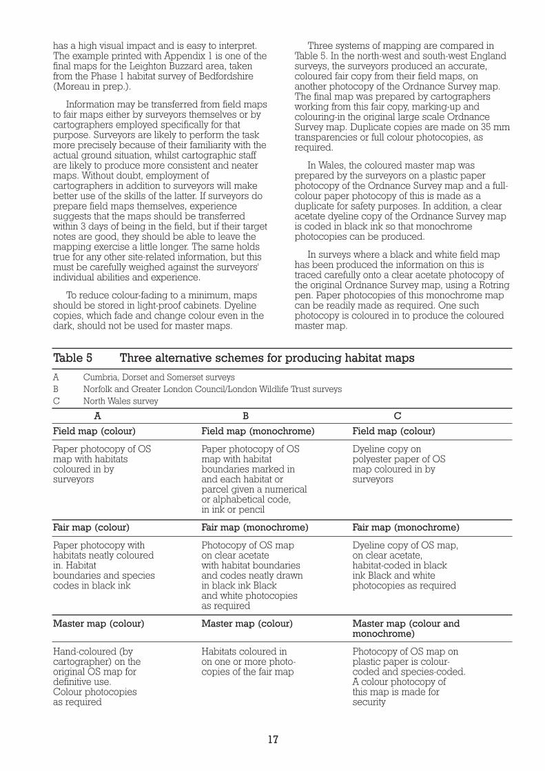
Three systems of mapping are compared inTable 5. In the north-west and south-west Englandsurveys, the surveyors produced an accurate,coloured fair copy from their field maps, onanother photocopy of the Ordnance Survey map.The final map was prepared by cartographersworking from this fair copy, marking-up andcolouring-in the original large scale OrdnanceSurvey map. Duplicate copies are made on 35 mmtransparencies or full colour photocopies, asrequired.
In Wales, the coloured master map wasprepared by the surveyors on a plastic paperphotocopy of the Ordnance Survey map and a full-colour paper photocopy of this is made as aduplicate for safety purposes. In addition, a clearacetate dyeline copy of the Ordnance Survey mapis coded in black ink so that monochromephotocopies can be produced.
In surveys where a black and white field maphas been produced the information on this istraced carefully onto a clear acetate photocopy ofthe original Ordnance Survey map, using a Rotringpen. Paper photocopies of this monochrome mapcan be readily made as required. One suchphotocopy is coloured in to produce the colouredmaster map.
A B C
Field map (colour) Field map (monochrome) Field map (colour)
Paper photocopy of OS Paper photocopy of OS Dyeline copy onmap with habitats map with habitat polyester paper of OScoloured in by boundaries marked in map coloured in bysurveyors and each habitat or surveyors
parcel given a numericalor alphabetical code,in ink or pencil
Fair map (colour) Fair map (monochrome) Fair map (monochrome)
Paper photocopy with Photocopy of OS map Dyeline copy of OS map,habitats neatly coloured on clear acetate on clear acetate,in. Habitat with habitat boundaries habitat-coded in blackboundaries and species and codes neatly drawn ink Black and whitecodes in black ink in black ink Black photocopies as required
and white photocopiesas required
Master map (colour) Master map (colour) Master map (colour andmonochrome)
Hand-coloured (by Habitats coloured in Photocopy of OS map oncartographer) on the on one or more photo- plastic paper is colour-original OS map for copies of the fair map coded and species-coded.definitive use. A colour photocopy ofColour photocopies this map is made foras required security
Table 5 Three alternative schemes for producing habitat mapsA Cumbria, Dorset and Somerset surveysB Norfolk and Greater London Council/London Wildlife Trust surveysC North Wales survey
JNCC Handbook 2010.qxd 17/03/2010 07:05 Page 19
18
3.4 Reproduction of habitat maps
Habitat maps are most convenientlyreproduced, whether in whole or in part, byphotocopying, either in colour or black and white.The increasing availability and decreasing cost ofcolour photocopying facilities allows the use of fullcolour copies and extracts of habitat maps forworking purposes in preference to black and whitecopies, except where large numbers are needed.
As noted in the previous section, amonochrome copy of the master map, mostconveniently prepared by tracing onto clearacetate sheet, allows black and white photocopiesto be made as required.
Permission must be obtained beforephotocopying and the copies should carry a noticedeclaring that the maps are based on theOrdnance Survey, with permission, and reservingthe copyright.
It is important to keep a duplicate set of thefinal hand-coloured master maps and this may bedone using 35mm transparencies or full-colourphotocopies. Laser photocopiers can now produceaccurate, full-size, full-colour copies (usually on A3paper) at less than £10.00 per 1:10,000 map sheet.35mm transparencies, mounted on microfiches,cost only 50 pence, but require a microfichereader for use. They are easily stored and providea useful back-up system in case of loss or damageof the originals.
3.5 Measurement and analysis ofhabitat areas
Measurement of the extent of each of thedifferent types of habitat in the area covered by thesurvey represents one of the most useful analysesthat can be carried out on the Phase 1 habitatmaps, so this should be regarded as an essentialpart of the Phase 1 survey.
Statistics of the total amount of semi-naturalhabitat remaining and of the total area of eachhabitat type, expressed as a percentage of thesurvey area or as a percentage of the total semi-natural area, may be used effectively todemonstrate the status of a given habitat type inthe survey area and to support the case forprotection of habitats which are most endangered.Such habitat statistics also provide a valuablebaseline for monitoring future change in thecountryside.
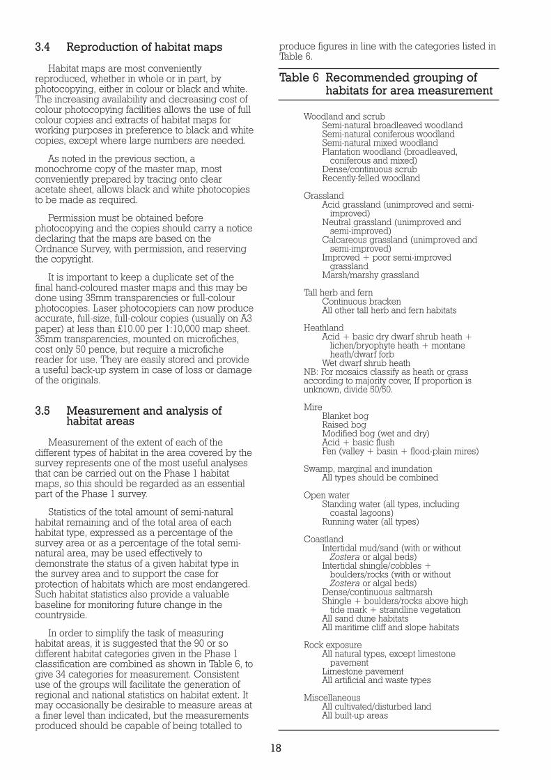
In order to simplify the task of measuringhabitat areas, it is suggested that the 90 or sodifferent habitat categories given in the Phase 1classification are combined as shown in Table 6, togive 34 categories for measurement. Consistentuse of the groups will facilitate the generation ofregional and national statistics on habitat extent. Itmay occasionally be desirable to measure areas ata finer level than indicated, but the measurementsproduced should be capable of being totalled to
produce figures in line with the categories listed inTable 6.
Table 6 Recommended grouping ofhabitats for area measurement
Woodland and scrubSemi-natural broadleaved woodlandSemi-natural coniferous woodland Semi-natural mixed woodland Plantation woodland (broadleaved,
coniferous and mixed)Dense/continuous scrubRecently-felled woodland
GrasslandAcid grassland (unimproved and semi-
improved)Neutral grassland (unimproved and
semi-improved)Calcareous grassland (unimproved and
semi-improved)Improved + poor semi-improved
grasslandMarsh/marshy grassland
Tall herb and fernContinuous brackenAll other tall herb and fern habitats
HeathlandAcid + basic dry dwarf shrub heath +
lichen/bryophyte heath + montaneheath/dwarf forb
Wet dwarf shrub heathNB: For mosaics classify as heath or grassaccording to majority cover, If proportion isunknown, divide 50/50.
MireBlanket bogRaised bogModified bog (wet and dry)Acid + basic flushFen (valley + basin + flood-plain mires)
Swamp, marginal and inundationAll types should be combined
Open waterStanding water (all types, including
coastal lagoons)Running water (all types)
CoastlandIntertidal mud/sand (with or without
Zostera or algal beds)Intertidal shingle/cobbles +
boulders/rocks (with or withoutZostera or algal beds)
Dense/continuous saltmarshShingle + boulders/rocks above high
tide mark + strandline vegetation All sand dune habitatsAll maritime cliff and slope habitats
Rock exposureAll natural types, except limestone
pavementLimestone pavementAll artificial and waste types
MiscellaneousAll cultivated/disturbed land All built-up areas
JNCC Handbook 2010.qxd 17/03/2010 07:05 Page 20

19
Where possible, area measurements should bemade on the original Ordnance Survey map ratherthan on a photocopy. If a photocopy is used, areameasurements should be corrected for anymagnification error present. It should be noted thatas a result of paper stretch in the copyingmachine, this error may be different along andacross the grain of the paper Despite the fact thathillsides will be under-measured, no attemptshould be made to adjust areas for slope. Theprocedure is time-consuming and prone to errorand the resulting correction is only significant inmountainous areas, where the method isinapplicable for other reasons.
The areas of plots should be measured using aRomer dot grid. Planimeters are not sufficientlyaccurate for the measurement of small areas.Measurements should be recorded on speciallydesigned forms so that data may be readilyretrieved and manipulated. This may be donemost conveniently if the data are subsequentlyentered into a suitable computer file. It is then asimple matter to calculate such parameters as theaverage size, or the size-class distribution, ofwoodland or heathland habitat units in the county,the number of habitat blocks larger than 1 km', orthe proportion of the total unimproved grassland inthe county occurring within a particular district.
It is not considered practical to calculate thearea of hedges, the width of which is over-represented by the coloured line on the map. Theirabundance is best expressed as a linearmeasurement and most easily obtained from aerialphotographs. In Phase 1 survey, the area of thehedge or other boundary is included in the area ofthe habitat unit which it bounds. Similarly, mostroad verges, railway cuttings and embankments,should, if measured, be expressed as length, butverges wider than 25 m should be included in areameasurements for grassland or scrub, asappropriate.
Ditches, streams and rivers are also bestrepresented by a linear measurement, but riversexceeding 25 m in width, that is 2.5 mm at 1:10,000scale, are included in area measurements asrunning water. The total area of road may beconsiderable, though much of it may lie within thebuilt-up areas.
3.6 Sampling procedures
Although it is strongly recommended that allhabitat areas are measured as described above, ifresources are severely limited it is possible toobtain estimates of habitat abundance by the useof sampling procedures. However, great care isrequired in the design and use of samplingstrategies, since habitats are invariably distributedin a non-random fashion. If sampling iscontemplated, expert advice should be sought onsuitable stratification procedures. Even with suchprocedures, it is difficult to produce reliableestimates for rare and localised habitats which are,
by their nature, readily over- or under-sampled.Analysis of variance should be carried out in orderto estimate the error in the area estimates, but itshould be remembered that the reliability of thisestimate is also sensitive to the samplingprocedure.
A simple procedure which copes well withpoorly dispersed samples is the line-interceptmethod (see 3.7), though it is somewhat sensitiveto habitat size and will underestimate thosehabitats which are both small and rare. It is mostaccurate for the most abundant habitats andprovides a convenient method of calculating theproportions of improved grassland and arable landin areas with large blocks of mixed agriculturalland.
3.7 Area estimation by the line-intercept method
In this method the habitat map is sampled by aseries of parallel line-transects to estimate thepercentage cover of each habitat type (seeCanfield 1941). The proportion of the map areacovered by each habitat type is given by the totaltransect length falling within that habitat. Ideally,the transect lines should be parallel offsets atrandom intervals, but in practice, provided that thehabitat patches are not regularly distributed, agood estimate of cover can be obtained by regularsampling. The area should be sampled with twosets of transects at 90° to correct for bias due toasymmetry of the habitat patches. At 1:10,000 scaleit is convenient to use the lkm grid lines for thispurpose, taking ten north-south and ten east-westtransects in each 10 km square, giving a totalscale of length transect of 200 km. This will give areasonable estimate of cover for all but thescarcest habitats. These should be measureddirectly. If carried out over all maps in the surveyarea, or possibly on a carefully stratifiedrepresentative sample, the method will give auseful estimate of the proportions of each habitatin the area surveyed. The accuracy of the methodshould be checked against dot grid measurementsto give error estimates.
3.8 Digitisation
If the equipment is available, a digitisinggraphics tablet linked to a microcomputer is aneffective method of measuring areas on the habitatmaps and the resulting data can be readily storedand processed on the computer.
Full digitisation of the maps, on the other hand,is a major undertaking but once completed itallows a wealth of information to be extracted inthe minimum of time. The digitisation of all theinformation on the base maps and thesuperimposed habitat map is a time-consumingand exacting task but the likely availability ofdigitised base maps in the future would simplifythe procedure considerably, so that the work
JNCC Handbook 2010.qxd 17/03/2010 07:05 Page 21

20
involved would be little more than that of areameasurement.
It should be noted that digitised maps require avery large data storage capacity and that a largecolour printer is needed to output habitat mapsinformation. Once digitised, maps can be printedout at any scale and using any frame. This is usefulwhere sites of interest overlap several maps.
The digitised habitat data can of course beused directly for area measurement andsubsequent analysis and can also be fed into aGIS (Geographical Information System), whichwould allow it to be combined by computer withother spatially distributed data for the survey area.
Although the availability of this technology isstill very recent, some surveys have been fullydigitised. The Cheshire Phase 1 survey made useof the mainframe computing facilities at the countyplanning office, including a large scale digitiserand plotter, while the Wigan Phase 1 survey used amuch smaller PC-based system with a 6-colour A3plotter. Both systems allow any portion of any map,or maps, to be printed out on request.
3.9 Accuracy
Survey results should always be produced withas much accuracy and consistency as time andresources will allow. Ideally, estimates of theprobable error should accompany all numericaldata on habitat abundance and distribution, but inpractice, error estimation is not easy to accomplishand limited resources may be better allocated tominimising the error.
The errors involved in measuring habitat areason 1:10,000 scale maps are likely in most cases tobe well below 5%. A statistical treatment of theseerrors is not likely to be justified unless a samplingprocedure has been used, in which case thestandard error resulting from the sampling shouldbe estimated in the usual way.
The greatest source of error is likely to be the'observer error' in assigning the habitat to onecategory or another. As there is no absolutemethod of determining habitat categories in thefield, this error can only be estimated by havingdifferent trained observers map the same areas inthe field. This exercise is well worth carrying outon a limited scale and will also give information onthe second most important source of error - theboundary error involved in mapping unboundedhabitat units.
Accuracy may be kept high by a number ofprocedures.
• Initial training and subsequent supervision andmonitoring of surveyors and cartographers mustbe thorough.
• Selected areas should be surveyed
independently by two or more surveyors, andthe results compared. Sources of error for anyappreciable discrepancies must be identifiedand corrective procedures initiated.
• Experienced Phase 1 surveyors should bebrought in from outside to check over randomlyselected areas. This will help to ensureconsistency at a national level.
• If surveyors operate in pairs or small groups,then the members of such pairs or groupsshould be interchanged on occasion.
• From time to time, the edges of survey areasshould be overlapped and comparisons madeof the mapped areas which coincide.
• The identification of dominant species shouldbe checked, possibly by asking surveyors tobring back specimens for confirmation ofidentification.
• Target notes should be reviewed periodically toensure that they are attaining the agreedminimum standard.
• Team leaders should check independently andthoroughly that map information is beingtranscribed accurately, both from field to fairmaps and from fair to master maps. Wherecartographers are employed, they must referproblems back to the surveyors.
• Habitat areas should be measuredindependently over a sample of map sheets.
If these procedures are followed, it will bepossible to generate estimates of error for each ofthe following operations:-
• classification of habitats in the field;
• determination of habitat boundaries;
• transcription of mapped information;
• measurement of habitat areas.
If doubt exists as to how to calculate statisticallimits, a statistician should be consulted. Errorsshould be presented and discussed in full in thesurvey report, and the validity of results assessedin view of them.
3.10 Interpretation of Phase 1 surveymaps
All users of Phase 1 habitat maps should beaware of their limitations. Maps should not be lentor copied without a covering note on their use,otherwise they may do more harm than good. Apolicy decision should be made as to who willreceive the information and how it is to bedisseminated. Users should be encouraged toconsult NCC regional offices, or those responsiblefor the Phase 1 survey, about the interpretation ofPhase 1 habitat maps.
JNCC Handbook 2010.qxd 17/03/2010 07:05 Page 22
21
It is recommended that all habitat maps shouldbe accompanied by a caveat such as this:-
'Although this map has been produced with theintention of indicating and classifying theoccurrence of semi-natural habitats, it is not tobe regarded as a definitive representation of theconservation value or interest of any piece ofland. In particular, the absence of any symbolsuch as a colour code or target symbol shouldnot be taken as denoting a lack of conservationvalue.'
The following points must be considered wheninterpreting habitat maps. Firstly, the maps shouldnot be used as the sole basis of assessing thelikely effects of specific land-use changeproposals for the following reasons:-
• the maps are not 100% accurate, as will bereflected by the error estimates (see 3.9);
• many important animal communities will not beindicated because the maps are based onvegetation;
• significant habitat changes may have occurredsince the maps were produced;
• habitats smaller than the specified minimum arenot mapped;
• sites are visited only once, so somecommunities may have been missed due toseasonal effects;
• no attempt is made to construct completespecies lists and rarities may have beenoverlooked.
Secondly, all mapped habitats are not of equalconservation value, and indeed all sites of anyparticular habitat type are not of equal value.Thirdly, even if a habitat is widespread, it may stillbe threatened. The great majority of it may beseriously damaged, leaving only small patches ingood condition. Quite large tracts of habitat mayonly be remnants of more extensive cover and maythemselves be vanishing or changing rapidly. Themaps give no indication of the rates of change ofhabitats.
3.11 Evaluation
Strictly speaking, site evaluation is not theconcern of Phase 1 survey. Nevertheless, becausethe value of any site depends upon the contextwithin which it is to be evaluated, Phase 1 surveyof a large number of sites in the same general areadoes afford a basis for comparison. Therefore aPhase 1 surveyor is well placed to make such acomparison.
In drawing comparisons, surveyors shouldmake clear the limited nature of the informationused in the assessment. Phase 1 survey is rapid
and fairly superficial, and the single visit may havebeen carried out at a less than ideal time of year.Also, the survey is based simply on vegetation andother aspects of wildlife are not considered.
On the basis of Phase 1 survey informationalone it is possible to categorise sites on a three-point scale as follows:-
1 site of high conservation priority
2 site of lower priority for conservation
3 site of limited wildlife interest.
The principles and criteria used in evaluatingwildlife habitats are set out in A natureconservation review (Ratcliffe 1977) and Wildlifeconservation evaluation (Usher 1986). Referencemay also be made to Guidelines for selection ofbiological SSSIs (NCC 1989). Evaluation criteriainclude naturalness, diversity, rarity of species andhabitat types, site size and spatial relationshipsbetween habitats. Although fragmentation isusually detrimental, mosaics of semi-naturalhabitats are often of great importance for animalcommunities. Diversity is not always a goodindication of conservation value - for examplehabitats on acid soils tend to be inherently lessdiverse than those on neutral or basic soils.
The criteria used for evaluating sites should bemade clear and shortcomings, such as the needfor further information, pointed out. The nature ofthe wildlife interest in the three site categoriesshould be explained. Sites should not be rankedwithin these categories. Although categorisation isnecessary, it should be stressed that all semi-natural habitat is of wildlife value and that areas oflow intrinsic interest may play a vital role aswildlife corridors and be very important for wide-ranging and dispersed species.
Maps showing suggested site boundaries at asuitable scale (probably 1:25,000) can be providedfor areas of conservation interest. Brief sitedescriptions should be written. Where doubt existsover whether to include a piece of land within theboundary, this should be mentioned, with thereasons.
Where Phase 2 survey might subsequently beundertaken, a different site classification has beenfound useful. The site categories are:-
1 sites meriting Phase 2 survey
2 sites of wildlife interest which are worth afurther visit but do not, at present, merit Phase 2 survey
3 sites of wildlife interest not meriting furthersurvey.
JNCC Handbook 2010.qxd 17/03/2010 07:05 Page 23

22
3.12 Use of hierarchical alphanumerichabitat codes
The Phase 1 survey habitat classificationpresented in this manual and summarised inAppendix 1 is a hierarchical system in which eachhabitat may be represented by an alphanumericcode. These codes are also set out in Appendix 2,which shows the mnemonic lettered codes used inhabitat mapping in the field.
The alphanumeric codes have been chosen soas to be consistent with the earlier NCC/RSNChabitat classification (NCC/RSNC 1984) and
habitat recording on SSSIs (see Section 9.1). Theuse of codes alongside the name of a habitat type,for example wet heath (D2), broadleaved semi-natural woodland (A1.1.1), indicates that thehabitat has been defined according to the Phase 1survey system.
It is recommended that the alphanumeric codesare used when listing the habitats present on agiven site and in compiling habitat information forcomputer databases. According to preference andprecedent they may also be used on monochromemaps as an alternative to the letteredhabitat codes.
JNCC Handbook 2010.qxd 17/03/2010 07:05 Page 24
4 Urban surveys
23
The Phase 1 classification and surveymethodology presented in this manual are directlyapplicable to urban surveys, with only slightmodifications to allow for the larger scale andgreater detail which may be required.
4.1 Choice of scale
Because of the limited range and extent ofwildlife habitats in most urban areas, thesignificance of relatively small sites is increased.Some sites may be quite complex and intricateand the use of a large map scale allows them to berepresented more clearly. The use of very largemap scales, such as 1:2500, is only likely to befeasible where the total survey area is quite small.It should be noted that a scale of 1:10,000 hasbeen found suitable for many urban surveysincluding the surveys of Greater London and WestMidlands.
In urban areas, wildlife habitat tends to occuras islands in a sea of urban development, so that itappears to consist of a series of isolated sites.However, as in intensively farmed areas, therelationship between these sites is important andany linear habitats or chains of smaller sites linkingone area with another may be of considerablevalue. It is easier to see these relationships on a1:10,000 scale map than on a larger scale map,which necessarily encompasses a much smallerarea.
The use of a 1:10,000 scale for both urban andrural surveys allows both surveys to berepresented on the same map. This allows therelationships between the wildlife habitats in thetwo areas to be clearly discerned. In practice thereis often no clear boundary between urban andrural areas. The transition from one to the othermay be gradual and may extend over aconsiderable distance. Furthermore, county,district and other 'rural' surveys must, of necessity,include many towns and villages, some of whichmay be quite extensive. Clearly there is aconsiderable advantage in applying a uniformmethodology over the whole area.
The availability of reasonably up-to-datecartography is a further point in favour of the useof a 1:10,000 scale, because in many urban areasthe larger scale maps are long out of date.
4.2 Target notes
The relative importance of small sites and thefrequent occurrence of complex habitat mosaics in
urban areas lead to an increased need fordescriptive target notes, so it is likely that mostsites will require a target note. In many cases thisnote may be quite brief but it should give anindication of the significance of the site. Indicationsof past management are at least as important as inrural areas and information on the presentownership should be included where available.
4.3 Habitat classification
The habitat classification presented here takesinto account the experience of urban surveys suchas the Greater London and the St Helens andKnowsley surveys (Game 1984, Ash & Gately 1984)in using earlier versions of the Phase 1classification. The definitions of several habitatshave been expanded and made more rigorous inthe light of this experience, in particular the tallruderal (C3.1) and ephemeral/short perennial(J1.3) habitat classes, which now encompass allearly successional communities on derelict land.
Two new categories were added to the originalPhase 1 habitat classification in 1986 in responseto the needs of urban surveys. These are amenitygrassland (J1.2) and introduced shrub (J1.4).Amenity grassland is the prevalent form of openland use in many towns and cities and is readilydistinguished from other types of improved orreseeded grassland. Although usually of little valueas wildlife habitat, amenity grassland is a majorconstituent of urban greenspace and a knowledgeof its extent and distribution is of importance tonature conservation planning in urban areas. It isworth pointing out that less rigorous mowingregimes and more sympathetic management of atleast the margins of amenity grassland couldbenefit both the amenity and the natureconservation value of such land. The large extentof amenity grassland, clearly visible on urbanhabitat maps, often contrasts markedly with themuch smaller areas of semi-natural habitat,making clear the need to conserve the latter.
It should be stressed that the amenity grasslandcategory (J1.2) applies only to closely mownamenity grassland. Other forms of amenity landand other habitats occurring within amenitygrasslands should be mapped according to theirvegetation as woodland, heathland, semi-improvedgrassland, etc.
The introduced shrub category (J1.4) isregarded as sufficiently distinct to warrant a classof its own and should be used for large stands ofnon-native shrubs, whether single-species or multi-species stands, and for mixed stands where non
JNCC Handbook 2010.qxd 17/03/2010 07:05 Page 25

24
native species predominate over native shrubs.Where native shrubs predominate, the standshould be mapped as scrub (A2) and the non-native species target noted. Introduced tall herbs,such as Reynoutria japonica should be mapped astall ruderal (C3.1).
4.4 Survey procedure
Much of the methodology described inprevious sections is equally applicable to urbansurvey. The purpose of this section is to drawattention to some of the techniques andprocedures which have been used to deal with theparticular problems arising in urban surveys.
One of the first problems after deciding on thescope and scale of the survey is to locate the areasof wildlife habitat requiring field survey - the'wildlife sites'. The usefulness of aerialphotography for this task has already been noted(see Section 2.2) but it must be up-to-date.Ordnance Survey maps are seldom fully up-to-date; many are more than 10 years old, some relyheavily on earlier surveys, and even the latesteditions cannot incorporate the most recentdevelopments in the urban landscape. Whereasrecent maps and aerial photography are useful inplanning the survey, they are no substitute fordirect field survey as a means of locating, definingand describing wildlife sites.
The use of a car, essential in rural surveys, isgenerally more of a hindrance than a help in urbanareas and the survey is best carried out on foot,bicycle or public transport. Bicycles have beenfound to be very useful in many urban surveys andprovide a means of covering considerabledistances while still allowing the surveyor to stopand investigate at will.
Survey on foot will generally need to becombined with use of public transport andadvantage should be taken of this opportunity toobtain a view of other areas in the neighbourhoodfrom bus or train. Suburban trains were found tobe particularly useful in the Greater Londonsurvey, providing a view of the railside habitats andof other habitats in the vicinity of the railway.
Although many urban wildlife sites have openaccess, some will require access to be negotiatedin advance and may be either in public or privateownership. Casual local enquiries by the surveyormay provide the necessary information onownership and also on the past history of the site.Failing this, enquiry should be made of the localwildlife trust, the national governmental natureconservation agency or the local council planningdepartment.
Contact with the public in the course of urbansurvey is unavoidable and can be beneficial toboth sides, but needs to be prepared for. Manymembers of the public will be curious about theactivities of the Phase 1 surveyor and some may
be interested in the aims and objectives of thesurvey.
Some members of the public may be able toprovide useful information which will increase thevalue of the survey or facilitate the work of thesurveyor. Others may wish to ask for advice onhabitat management. Clearly, talking to the publicduring the course of a survey can be anopportunity to promote the ideas and objectives ofnature conservation and may be of direct benefit tothe survey. However, the surveyor has aresponsibility to maintain the pace of the surveyand will usually need to limit contact with thepublic to the minimum, referring enquiries toothers for more detailed or more definiteresponses.
In the same way, because of the greaterpopulations in urban areas and the time needed todeal with large numbers of responses or enquiries,careful thought will need to be given to the amountof publicity to be given to the survey and, inparticular, to whether to make an appeal forinformation or simply to survey the area 'on sight'.
It should be clearly understood that Phase 1survey is essentially a reconnaissance survey toestablish the nature, extent and distribution of thewildlife habitat resource. In urban surveys, as inother areas, the surveyor should guard againstbeing led by the scarcity of the habitat or thecomplexity of the site into attempting to survey ingreater detail than is required or justified atPhase 1.
If more detailed survey is required, it may bemost efficient to carry out Phase 2 survey at thesame time as Phase 1, but this requirement needsto be clearly recognised and resourced from theoutset.
4.5 Phase 2 survey
The need for more detailed information onpractically all wildlife habitat sites in urban areasresults in the need for Phase 2 survey to covervirtually the full extent of the Phase 1 survey, interms of both the number of sites and the range ofhabitats. This is markedly different from thesituation in rural surveys where Phase 2 survey iscommonly restricted to a single habitat type, suchas woodland or grassland, and to a limited numberof sites within this category, the sites beingselected from the completed Phase 1 survey.
Urban Phase 2 survey is therefore usually arelatively comprehensive multi-habitat survey andmay be carried out either concurrently with thePhase 1 survey or as a follow-up after completionof Phase 1. Most, though not all, urban surveyshave found it convenient to carry out Phase 2survey at the same time as Phase 1.
Up to the present, most urban Phase 2 surveyshave been based on A Conspectus of urbanvegetation types devised by Shimwell (1983). This
JNCC Handbook 2010.qxd 17/03/2010 07:05 Page 26
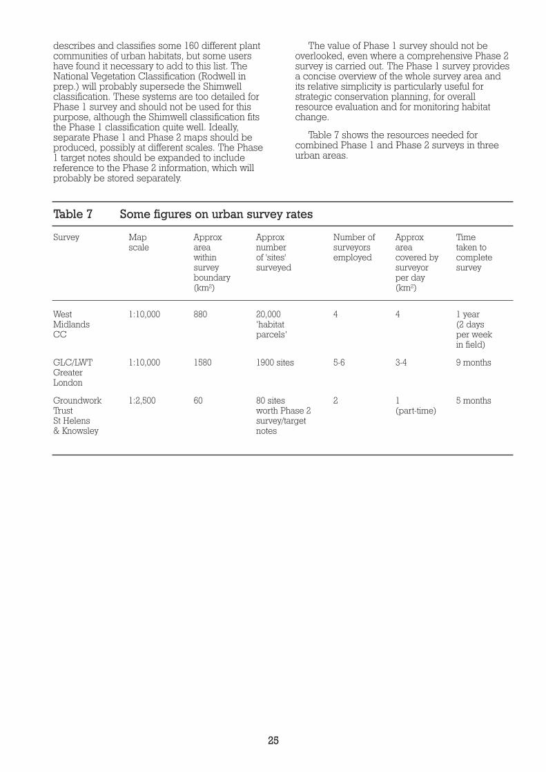
25
describes and classifies some 160 different plantcommunities of urban habitats, but some usershave found it necessary to add to this list. TheNational Vegetation Classification (Rodwell inprep.) will probably supersede the Shimwellclassification. These systems are too detailed forPhase 1 survey and should not be used for thispurpose, although the Shimwell classification fitsthe Phase 1 classification quite well. Ideally,separate Phase 1 and Phase 2 maps should beproduced, possibly at different scales. The Phase1 target notes should be expanded to includereference to the Phase 2 information, which willprobably be stored separately.
The value of Phase 1 survey should not beoverlooked, even where a comprehensive Phase 2survey is carried out. The Phase 1 survey providesa concise overview of the whole survey area andits relative simplicity is particularly useful forstrategic conservation planning, for overallresource evaluation and for monitoring habitatchange.
Table 7 shows the resources needed forcombined Phase 1 and Phase 2 surveys in threeurban areas.
Survey Map Approx Approx Number of Approx Timescale area number surveyors area taken to
within of 'sites' employed covered by completesurvey surveyed surveyor surveyboundary per day(km²) (km²)
West 1:10,000 880 20,000 4 4 1 yearMidlands ‘habitat (2 daysCC parcels’ per week
in field)
GLC/LWT 1:10,000 1580 1900 sites 5-6 3-4 9 monthsGreaterLondon
Groundwork 1:2,500 60 80 sites 2 1 5 months Trust worth Phase 2 (part-time)St Helens survey/target& Knowsley notes
Table 7 Some figures on urban survey rates
JNCC Handbook 2010.qxd 17/03/2010 07:05 Page 27

5 Using the colour code mappingsystem
26
5.1 Use of colour
It is strongly recommended that the final habitatmaps should be colour-coded (see Appendix 1).The use of colour allows complex situations to bepresented clearly and enables a rapid visualassessment to be made of the abundance anddistribution of particular habitats.
Coloured maps may be duplicated by makingfull-colour photocopies or, if large numbers arerequired, it may be preferable to make amonochrome copy by tracing onto acetate sheetand photocopying this in the normal way.Alternatively, where monochrome maps have beenproduced using alphanumeric or mnemoniclettered codes, one or two copies should becoloured in for use by those most likely to consultthe habitat maps frequently, whilst the othermonochrome copies may be used as they stand,or coloured in by their users.
Standard Berol Verithin colour pencils (seeAppendix 1) or comparable coloured pencilsshould be used. Colour should be applied with amoderate pressure and shading kept even so asnot to obscure underlying detail on the printedmap. Colours will photocopy best if shading iseven and not too light.
Hatched lines should be spaced 2.5 to 5 mmapart, depending on the size of the habitat unit,and should be at 450 to the vertical except wherethe shape and orientation of the habitat unit makesit preferable to vary this. Cross-hatching linesshould intersect at 900. The use of a Linexhatching apparatus is helpful in producingaccurately spaced hatching; otherwise a setsquare and ruler (or T-square) should be used.The direction of hatching shown for each habitat inthe coloured key in Part 2 should be adhered to.
Where there is no marked boundary betweenhabitats a dashed line in black ink (0.35 mm)should be marked in. This greatly facilitates visualassessment of the map and subsequent areameasurement.
The minimum mappable area at 1:10,000 scaleis about 0.1 ha for solid colour and 0.25 ha forhatching. (At 1:25,000 scale the equivalent areasare 0.5 ha and 1.5 ha respectively). Areas ofinterest smaller than this should be marked with a
target symbol and described in a target note (seeSection 6).
Linear areas less than 25 m wide should berepresented by a single line of the appropriatecolour, and should be marked with a target symboland described in a target note if of interest. Linearhabitats such as marginal vegetation, strandlinevegetation, hedges, ditches and roadside vergeswill always need to be treated in this way.
When mapping acid grassland in hilly areas,confusion with calcareous grassland may ariseowing to the intersection of the orange hatchingwith brown contour lines. This problem may bealleviated by drawing the lines for acid grasslandroutinely at 5 mm spacing and calcareousgrassland at 2.5 mm spacing.
5.2 Additional codes
The colour codes for scattered scrub, scatteredtrees and scattered bracken are designed to besuperimposed on the appropriate code for theunderlying vegetation, and combined codes arespecified for mosaics of acid grassland with wetheath and dry heath, but in general, transitionaland mixed habitats should be represented by thecode for the most prevalent habitat and the relativeproportions of the other habitats recorded in atarget note. In cases where a new combination isnecessary this should be shown in a key attachedto the habitat map.
In a given survey it may be considereddesirable to drop the use of certain codes underspecific circumstances, for example the code forunvegetated crags might be dropped where theseare numerous and evident from the OrdnanceSurvey symbols. Likewise, as previously noted, adecision may be made not to map hedges andwalls. These departures from the standard shouldbe noted in the key.
The habitat coding system has been widelyused over a number of years in many differentparts of the country and it should not be necessaryto devise new habitat codes. Any new codesagreed on must not conflict in any way withexisting codes and should be shown in a key onthe habitat map.
JNCC Handbook 2010.qxd 17/03/2010 07:05 Page 28

6 Target notes
27
6.1 Importance of target notes
Target notes are an essential part of Phase 1survey and increase considerably the value of thehabitat maps by providing:-
• supplementary information on sites of interest(for example species composition, structure andmanagement);
• information on sites too small to map and onsites where habitat mapping is found to bedifficult or doubtful (for example transitional andmixed habitats);
• information on sites previously surveyed andsites requiring further survey.
The more numerous and more detailed thetarget notes are, the more useful the survey will be.A target note should enable others to make apreliminary assessment of the nature conservationvalue of a given site and a comparison betweenone site and another. It is likely that the target noteswill form the chief basis of site selection forconservation planning and for further survey atPhase 2 level.
Before starting a survey, careful considerationshould be given to deciding which habitats andwhich types of site are to be target noted. Thedecisions made must be followed thereafter, sothat a consistent and workable set of target notes isproduced. Such factors as the skill and training ofthe surveyors and the prevalence and importanceof particular habitats must be taken into account.However, the most important consideration will bethe resources available, because making targetnotes is a time-consuming process.
6.2 Target note content
The overall aim of the target note is to give asuccinct picture of the nature conservation interestof a site in the context of its land-use andmanagement.
Target notes must be clear concise andinformative. Even the briefest of descriptions, forexample 'ancient coppiced sessile oak/birchwoodland with hazel understorey and acid groundflora', can greatly enhance the value of the habitatmap.
Ideally, each discrete unit of semi-naturalvegetation should be target noted, but in practicesmall and uninteresting areas are usually omittedin order to maintain the speed of the survey. If
necessary, note that a site was not visited norneeds a further visit. It is important to target notesites in which wildlife interest has been reduced ordestroyed.
The following should always be included in thetarget note:-
• habitat type or types present together with theirdominant plant species;
• other species of note;
• need for further survey if relevant.
Where time and resources allow, the followingelements may also be included:-
• a description of the habitat structure,topography and substrate;
• a description of the plant communities present;
• details of any noteworthy animal associations;
• a note of any known rare species of plant oranimal;
• notes on past, present or proposedmanagement practices;
• details of ownership (if found in passing);
• details of any form of site protection;
• notes on any changes, particularly if damaging,that have occurred recently, or are taking place,or are threatened;
• reference to, or results of, any previous surveys;
A list of key words, such as that given in Appendix4, is helpful in the preparation and computerisationof target notes.
6.3 Target note format
The site to be target noted is marked on themap with a red target symbol. The full gridreference for this point is recorded in the targetnote, together with the date of survey (month andyear) and the initials of the surveyors.
Grid references estimated in the field must bechecked and all grid references measured on thefinished map with a Romer grid or a metric scale,to ensure that they are correct.
The site name, if any, should be given, followedby information as detailed in section 6.2.Information from previous surveys should be given
JNCC Handbook 2010.qxd 17/03/2010 07:05 Page 29

28
in the standard target note form, with original dateand surveyors, and source.
Botanical nomenclature should follow theExcursion flora of the British Isles, 3rd Edition(Clapham et al. 1981) or the Flora of the BritishIsles, 3rd edition (Clapham et al. 1987). Vernacularnames may be used in the habitat descriptions (forexample 'ash-hazel woodland with holly), providedambiguity is avoided (for example specify 'sessileoak', or 'oak (Q. petraea)' rather than just 'oak).Systematic names of species should be given infull and are particularly important when noting rarespecies.
Target notes may be typed in numerical orderof their grid references on A4 sheets, with thenotes for each 1 km square starting on a freshpage, identified by the 4-figure grid reference forthe square. Alternatively, the notes may be typedindividually on reference cards. This systemfacilitates up-dating, but is cumbersome to storeand tedious to manage, as a county survey maygenerate several thousand target notes. A typicalpage of target notes is shown in Appendix 5.
The target note symbols on the habitat mapsmay be numbered sequentially in grid referenceorder, but this is not essential, since the gridreference should be sufficient to locate the targetsymbol.
The informal descriptive target note is readableand gives an impression of the site as perceivedby the surveyor, but covers only those features
considered to be significant. This degree ofsubjectivity and selectivity is a weakness if what isrequired is a consistent, objective record of anagreed set of characteristics for each site. Thecreation of a computer database favours a morestructured form of target note and to this end it issuggested that a standard form, such as thatshown in Appendix 6, is used for target noterecording. The use of such a form will help tostandardise the information noted by the surveyorand to avoid the omission of potentially importantinformation due to oversight, while still allowing adescriptive account to be written. Some repetitiveinformation, such as vice-county and local authoritydistrict, can be filled in before photocopying therelevant batches of forms for use by the surveyors.
6.4 General descriptions
A useful addition to the set of target notes foreach 5 km or 10 km square is a concise generaldescription of the geology, topography and natureconservation interest of that square. Thisintroduction to the habitat map and target notes forthe given square is particularly useful to personsunfamiliar with the area and should be filed at thebeginning of the relevant set of target notes.
The general description sheets also provide auseful resource on which to base district andcounty reports.
JNCC Handbook 2010.qxd 17/03/2010 07:05 Page 30

7 Data storage
29
7.1 Survey products
The products resulting from Phase 1survey are:-
• a series of habitat maps;
• a set of habitat area measurements andstatistics;
• a file of target notes;
• a survey report, including resource statementand overview.
These products are likely to have a working lifeof at least 10 years and must be stored securely.On the other hand the survey results are likely tobe most useful and most used if they are readilyaccessible. Storage facilities must meet these tworequirements - security and accessibility.
7.2 Habitat maps
Completed habitat maps should be mountedand stored, in grid-reference order, in vertical-hanging steel map cabinets. A3 size photocopiesmay be stored flat in drawers, folded to A4 andfiled or hung vertically.
Field maps should be retained and are mostconveniently stored by folding to A4 size and filingin grid square order in storage files.
For security purposes a duplicate set of mapsshould be kept at a separate location. These maybe in the form of coloured fair copies, colourphotocopies, 35 mm colour transparenciesmounted as slides or microfiches, or fully codedmonochrome maps. This copy set may be held byanother organisation, provided it is accessible inan emergency.
Fully digitised habitat maps are, of course,stored on tape or disk in the computer system, butthe paper originals must also be stored carefully incase of loss or damage to these data.
7.3 Habitat area data
Habitat area measurements should be storedon paper, filed in grid square order in storage files.Where computing facilities are available theyshould be input onto a computer data-file andstored on tape or disk with a back-up copy. Astandard form for use in computerising map sheetdata is given in Appendix 6.
7.4 Target notes
Completed target notes and generaldescription sheets should be filed in grid squareorder in a metal filing cabinet. A duplicate setshould be stored at a separate location. Thisrequirement is met if a related organisation has afull duplicate set.
There are considerable advantages to begained from storing target note information on acomputer database. Large quantities of targetnotes may be stored in this way in a very compactand easily accessible form. They can be updatedreadily and the information in them can beselected, sorted and printed out in any form. Forease of reference, target notes are best stored on aPC-based system and a number of systems havebeen developed for this purpose, usingcommercially available software. Thus, CheshireCounty Council has developed a HeritageDatabase package using PC-PROMISE fromDuncan Databases (Ramsay 1985) and WiganBorough Council uses DATA-EASE fromHoneywell (Wigan MBC 1987).
NCC is currently developing a standardisedpackage for recording Phase 1 survey data. It isintended that this package will be compatible withthe COREDATA system used by NCC forrecording information on statutory sites and withRECORDER (Ball 1988), which is used in localbiological records centres.
The standard target note recording form shownin Appendix 6 will probably be adopted for usewith the NCC Phase 1 survey database, and canbe used in the field.
JNCC Handbook 2010.qxd 17/03/2010 07:05 Page 31

8 The survey report
30
The final task of the survey, after the habitatmaps, target notes and habitat area measurementsare completed, is to produce the survey report.This is a very important element of the survey andadequate time and resources must be allocated toit.
The purpose of the report is to present theresults of the survey in a concise form to thepotential user, summarising and interpreting themso as to facilitate their use in conservationplanning. The report should give an overview ofthe wildlife habitat resource of the survey area interms of quantitative data, with interpretation andcomment, supported by a descriptive account ofthe resource.
Ideally, a separate report should be producedfor each local authority district and a further reportfor the whole county. Where districts are small, asingle county report will suffice but separatehabitat statistics should be produced for eachdistrict.
The time taken to write and produce a reportvaries considerably with the amount of detailrequired and with the experience of theparticipants but it is a valuable exercise for allconcerned, providing an opportunity for thesurveyors to take a broader view of their work andto present their accumulated experience to others.The task may be divided between the surveyors byhabitat or by district, the former being probably themost satisfactory. The work involved in editing thetext and producing maps, diagrams and tablesshould not be underestimated and 10-12 man-weeks would not be too much time to allocate tothe writing and production of a report.
The report must describe how the survey wascarried out, as this may have a bearing on the
interpretation of the results, and should indicatebriefly the nature of the area to be surveyed. Itshould present a summary of the habitat areastatistics in the form of tables, pie-charts anddistribution maps. These collectively constitute aquantitative resource statement for the county ordistrict (see Kelly & Perry 1990; NCC 1983a, b,1986a). This is expanded and interpreted in thedescriptive section, which should include for eachhabitat type in the survey area, a description of itscharacter, distribution and importance and anindication of current and threatened changes. Thereport should draw attention to typical andoutstanding examples of particular habitats in thesurvey area and to important sites andaggregations of sites but it is not necessarily therole of the surveyor to evaluate these or to makerecommendations as to action. The purpose of thesurvey is to provide sufficient information to enableothers to evaluate sites and to decide uponappropriate action. If evaluation is required, referto section 3.11.
The report should be designed to be read byenvironmental planners as well as by ecologistsand nature conservation specialists. To this end itis recommended that English names of floweringplants should be included, together with their Latinsystematic names. English names should followthe nomenclature of Dony et al. (1986), whichshould be quoted as a reference. Where a localvariant of the English names is preferred thestandardised English name should be labelled inbrackets.
The report should include full references toprevious surveys and other sources of informationincorporated into the survey in the form of targetnotes.
JNCC Handbook 2010.qxd 17/03/2010 07:05 Page 32

9 Comparison of Phase 1 surveyclassification with other classifications
31
9.1 The SSSI habitat mapping schemeand the NCC/RSNC classification
Appendix 7 shows the habitat classificationagreed between NCC and the Royal Society forNature Conservation (NCC/RSNC 1984). Thisscheme is very similar to the system used by NCCto map SSSIs (NCC 1982). The differencesbetween the two are indicated in Appendix 7.
The revised Phase 1 habitat classification(Appendix 1) differs from the SSSI andNCC/RSNC systems in a number of details, butthere is one major difference: for Phase 1 there arefour mire categories - bog, flush and spring, fen,bare peat -rather than two. Less importantly, in therevised Phase 1 classification single-speciesdominant swamp and tall fen vegetation arecombined in a single swamp category; fore, yellowand grey dunes are combined as open dune, andcoastal lagoons are classified as brackish standingwater, rather than being included in coastalhabitats (J).
Habitat categories which are now used forPhase 1 survey, but are not included in either theSSSI habitat mapping scheme or the NCC/RSNCclassification, are:
Parkland/scattered trees - broad-leaved- coniferous- mixed
Recently-felled woodland - broad-leaved- coniferous- mixed
Poor semi-improved grasslandFenFlood-plain mireRefuse-tipCultivated/disturbed ground - arable
- amenity grassland - ephemeral/short
perennial- introduced shrub
Hedges - native species-rich- species-poor
Earth bankSea wall
All instances where the classification andcorresponding alphanumeric reference codes forPhase 1 survey differ from those used in the SSSIor NCC/RSNC systems are indicated in Appendix1 by an asterisk. All new categories in the Phase 1system have been given unique alphanumericcodes, to avoid confusion with previously usedcodes. The gaps in the numbering systemcorrespond to codes in the SSSI and NCC/RSNCclassifications which are not used in the Phase 1system. The alternative series of lettered habitatcodes (Appendix 2) is unique to the Phase 1system.
The coloured symbols (hatching patterns,overlaid letters, etc) used in the SSSI habitatmapping system differ in a number of ways fromthose used for Phase 1 habitat mapping. However,the colours themselves are the same in bothsystems for all the major habitat types except fen
JNCC Handbook 2010.qxd 17/03/2010 07:05 Page 33
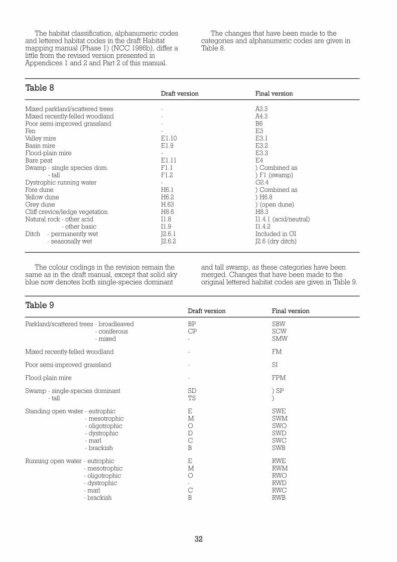
32
The habitat classification, alphanumeric codesand lettered habitat codes in the draft Habitatmapping manual (Phase 1) (NCC 1986b), differ alittle from the revised version presented inAppendices 1 and 2 and Part 2 of this manual.
The changes that have been made to thecategories and alphanumeric codes are given inTable 8.
The colour codings in the revision remain thesame as in the draft manual, except that solid skyblue now denotes both single-species dominant
and tall swamp, as these categories have beenmerged. Changes that have been made to theoriginal lettered habitat codes are given in Table 9.
Draft version Final version
Mixed parkland/scattered trees - A3.3Mixed recently-felled woodland - A4.3Poor semi-improved grassland - B6Fen - E3Valley mire E1.10 E3.1Basin mire E1.9 E3.2Flood-plain mire - E3.3Bare peat E1.11 E4Swamp - single species dom. F1.1 ) Combined as
- tall F1.2 ) F1 (swamp)Dystrophic running water - G2.4Fore dune H6.1 ) Combined asYellow dune H6.2 ) H6.8Grey dune H.63 ) (open dune)Cliff crevice/ledge vegetation H8.6 H8.3Natural rock - other acid I1.8 I1.4.1 (acid/neutral)
- other basic I1.9 I1.4.2 Ditch - permanently wet J2.6.1 Included in GI
- seasonally wet J2.6.2 J2.6 (dry ditch)
Table 8
Parkland/scattered trees - broadleaved- coniferous- mixed
Mixed recently-felled woodland
Poor semi-improved grassland
Flood-plain mire
Swamp - single-species dominant- tall
Standing open water - eutrophic- mesotrophic- oligotrophic- dystrophic- marl- brackish
Running open water - eutrophic- mesotrophic- oligotrophic- dystrophic- marl- brackish
Table 9Draft version
BPCP-
-
-
-
SDTS
EMODCB
EMO-CB
Final version
SBWSCWSMW
FM
SI
FPM
) SP)
SWESWMSWOSWDSWCSWB
RWERWMRWORWDRWCRWB
JNCC Handbook 2010.qxd 17/03/2010 07:05 Page 34

33
The Royal Society for the Protection of Birds hasissued a manual (Evans 1988) for use in habitatclassification and recording on their reserves. This
is a modified version of the 1986 draft Phase 1habitat mapping manual.
Saltmarsh - dense/continuous- scattered plants
Sand dune - fore dune- yellow dune- grey dune
Rock exposure and waste - cave- mine
Intact hedge - native species-rich- species-poor
Defunct hedge - native species-rich- species-poor
Hedge and trees - native species-rich- species-poor
Dry ditch
DSmSSm
FDYDGD
CaMi
HH
H-H-
HTHT
D
DSMSSM
)) OD)
CAMI
RHH
RH-H-
RHTHT
DD
9.3 The National VegetationClassification (NVC)
The habitat classification used for Phase 1survey is a broad one, although further subdividedby species coding, and reflects the conservationinterest of the habitats. Thus, woodlands andgrasslands are subdivided into various categoriesbut arable land is not.
The habitat categories are defined in Part 2 ofthis manual and the relationships between thesecategories and the community types of theNational Vegetation Classification (Rodwell inprep.) are shown in Appendix 8. In general there isno one-to-one correspondence between the twosystems. Each habitat type may include a number
of different NVC community types and, in somecases, the same NVC community may occur inseveral different habitat types. This is anunavoidable consequence of the fact that the twosystems are based on different approaches to theclassification of vegetation.
Although the NVC system is much too detailedfor use in Phase 1 surveys it is now standard forPhase 2 surveys, so it may be useful for surveyorsto be aware of the relationship between the NVCand the Phase 1 classification.
Further information on the NVC communities ofdifferent habitats is to be found in Guidelines forselection of biological SSSIs (NCC 1989).
JNCC Handbook 2010.qxd 17/03/2010 07:05 Page 35

JNCC Handbook 2010.qxd 17/03/2010 07:05 Page 36

Part 2Field manual
JNCC Handbook 2010.qxd 17/03/2010 07:05 Page 37

JNCC Handbook 2010.qxd 17/03/2010 07:05 Page 38

1 Habitat classification and coding
37
As explained in Part 1, habitats may be mappedusing colour codes (Appendix 1), a hierarchicalalphanumeric coding system, or lettered codes(Appendix 2).
The full range of the classification should beused wherever possible, although this may attimes prove difficult. For example, it may beimpossible to determine the trophic status of awater body or to tell whether a fen is a basin, valleyor flood-plain mire. For this reason the recording ofsome habitat types is optional, as indicated inAppendix 1. In cases such as dry heath/acidgrassland, the existence of vegetation mosaics hasbeen recognised and a combination of colours isused in mapping.
The use of codes for dominant species(Appendix 3) effectively provides a furthersubdivision of the habitat categories and isrecommended for use wherever practicable.Target notes give additional detail and they canalso be used to clarify areas of difficulty incategorisation or mapping. Key words for use incompiling target notes are given in Appendix 4. Anumber of examples of target notes and a standardtarget note recording form are given inAppendices 5 and 6.
Part 1 of this manual should be read beforeany fieldwork is undertaken.
JNCC Handbook 2010.qxd 17/03/2010 07:05 Page 39
2 Habitat definitions
38
This section provides definitions for each of thehabitats which have been distinguished for thepurpose of Phase 1 survey. The definitions givenare based on those used by the NCC for surveyingSSSIs (see Appendix 7). Appendix 8 shows theNational Vegetation Classification (NVC)communities to be expected in each Phase 1habitat category.
A Woodland and scrub
Al Woodland
Woodland is defined as vegetation dominatedby trees more than 5m high when mature, forminga distinct, although sometimes open, canopy.Dominant species should be coded and theunderstorey and ground layer target noted. Distinctblocks of woodland, whether broadleaved orconiferous, should be mapped separatelywherever possible.
The definitions of the main categories are:-
• broadleaved woodland: 10% or less conifer inthe canopy;
• coniferous woodland: 10% or less broadleavedin the canopy;
• mixed woodland: 10-90% of either broadleavedor conifer in the canopy. The approximateproportions of the two types should be targetnoted.
If the cover of trees is less than 30% the areashould be shown as scattered trees on theappropriate background colour. Where the coveris higher than 30% but there are sizeable openspaces or rides, these should be target noted todescribe the ground flora.
Semi-natural woodland
Semi-natural woodland comprises all standswhich do not obviously originate from planting.The distribution of species will generally reflectnatural variations in the site and its soil. Bothancient and more recent stands are included.Woodland with both semi-natural and planted treesshould be classified as semi-natural if the plantedtrees account for less than 30% of the canopycomposition, but as plantation if more than 30% isplanted. In cases where it is doubtful whether ornot a wood should be classified as semi-natural,target notes giving details of origin and speciescomposition are essential. For details of ancientwoodland sites see Kirby et al. (1984).
The following should, amongst others, beincluded in the semi-natural category:-
• woods with planted standards in semi-naturalcoppice;
• mature plantations (more than about 120 yearsold) of native species growing on sites wherethose species are native and where there aresemi-natural woodland ground flora and shrubcommunities;
• self-sown secondary stands of exotic species(for example sycamore, pine on southernheaths, holm oak on Isle of Wight);
• alder carr, and willow can where the willows aremore than 5m tall (although Salix cinerea shouldalways be classified as scrub);
• well-established sweet-chestnut coppice (that is,over 25 years old);
• woods which have been completelyunderplanted, but where the planted trees donot yet contribute to the canopy;
• stands of young trees or coppice regrowth, evenwhen less than 5 m.
Plantation woodland
All obviously planted woodland of any ageshould be included in this category, with theexception of those types mentioned previously.Orchards should be mapped by placing greenhatching over the OS symbols (which should beadded where missing), and target notes madegiving tree species and details of any conservationinterest. Ornamental tree gardens and arboretashould be included here, and target noted wherenecessary.
A2 Scrub
Scrub is seral or climax vegetation dominatedby locally native shrubs, usually less than 5 m tall,occasionally with a few scattered trees. Dominantspecies should always be coded. The ground floraunder scattered scrub should be coded or targetnoted.
The following should, amongst others, beincluded in this category:-
• Ulex europaeus, Cytisus scoparius andJuniperus communis scrub;
• stands of Rubus fruticosus and Rosa canina
JNCC Handbook 2010.qxd 17/03/2010 07:05 Page 40
39
montane scrub with Salix lapponum, S lanata, S.myrsinites, S. arbuscula or S. phylicifolia;
• stands of mature Crataegus monogyna, Prunusspinosa or Salix cinerea, even if more than 5 mtall;
• all willow carr less than 5 m tall; all Salix cinereacarr;
• stands of Myrica gale more than 1.5 m tall.
The following should not be included in thiscategory:-
• very low Salix herbacea (see heathland, D),Salix repens (see dune slack, H6.4), or Myricagale (see mire, E);
• Ulex gallii or Ulex minor (see heathland D);
• hedges (see J2);
• stands of young trees or stump regrowth lessthan 5 m high, where these represent more than50% of the immature canopy cover;
• stands of introduced shrub species (see J1.4);
• scrub on dunes (see H6.7).
A3 Parkland and scattered trees
Tree cover must be less than 30% to warrantinclusion in this category. For scattered trees overpasture (as in parkland), or over heath, bog,limestone pavement, etc, the green dot symbolshould be superimposed on the appropriatehabitat colour. The density of dots should be variedin proportion to the density of trees. Dominantspecies should be coded. Exotic trees should betarget noted. Lines of trees forming windbreaks oravenues should be marked as a series of dots withthe dominant species code.
A4 Recently-felled woodland
The only areas of felled trees which should beincluded in this category are those whose futureland use is uncertain, for instance when it is notclear whether they are to be replanted or used forcrops. The dominant species which have beenfelled should be coded and the codes placed inparentheses.
B Grassland and marsh
This category includes both areas ofherbaceous vegetation dominated by grasses andcertain wet communities dominated by Juncusspecies, Carex species, Filipendula ulmaria or byother marsh herbs. For grasslands where there is agreater than 25% cover of dwarf shrub heaths seeheathland (D), for emergent stands of tall reedgrasses see swamp (Fl), for coastal grasslandssee saltmarsh (H2), dune (H6) and maritime cliffand slope (H8).
Most grasslands have been subjected to somedegree of agricultural improvement by repeatedgrazing, mowing, fertilising, drainage or herbicidetreatment. It is important to try to distinguishunimproved and semi-improved from improvedgrasslands. However, these grassland types form acontinuum, so that it is not possible to define eachwith precision, especially as species critical fortheir definition are often only observable for a shortseason in the year. Agricultural improvementusually results in a decrease in the floristicdiversity of the sward and dominance by a fewquick-growing grasses such as Lolium perenne,Holcus lanatus and Festuca rubra. The resultingsward composition is likely to vary with intensity oftreatment and with the composition of the originalsward, so careful field training is necessary todefine and maintain the boundaries between thesecategories. However, residual difficulties arebound to occur.
Grassy roadside verges, railway cuttings andembankments may be very important features,especially in intensively farmed areas. If they arewide enough they should be mapped as theappropriate grassland habitat. Narrow herb-richverges should be shown by a broken orange lineand target noted, if time permits. See also amenitygrassland (J1.2).
Unimproved grassland
Unimproved grasslands are likely to be rare,especially in the lowlands. They may be rank andneglected, mown or grazed. They may have beentreated with low levels of farmyard manure, butshould not have had sufficient applications offertiliser or herbicide, or have been so intensivelygrazed or drained, as to alter the swardcomposition significantly. Species diversity is oftenhigh, with species characteristic of the area andthe soils and with a very low percentage ofagricultural species.
In cases of doubt, map as semi-improved andtarget note the need for further information.
Semi-improved grassland
Semi-improved grassland is a transitioncategory made up of grasslands which have beenmodified by artificial fertilisers, slurry, intensivegrazing, herbicides or drainage, and consequentlyhave a range of species which is less diverse andnatural than unimproved grasslands. Suchgrasslands are still of some conservation value.Semi-improved grassland may originate frompartial improvement of acid, neutral or calcareousgrassland and should be mapped as such.However, it should be noted that improvementreduces the acid or calcareous character of thegrassland, so that this is not always easy todistinguish in the field.
JNCC Handbook 2010.qxd 17/03/2010 07:05 Page 41

40
Species diversity will generally be lower than inunimproved grassland in the same area. If thesigns of improvement listed under B4 are lacking,the grassland is likely to be semi-improved andshould be mapped accordingly. Target notesshould be made in all of the better quality sites.Surveyors should be aware of the speciescompositions indicative of semi-improvedconditions in the locality of the survey. See alsopoor semi-improved grassland (B6).
B1 Acid grassland
Grassland in this category is often unenclosed,as on hill-grazing land, and occurs on a range ofacid soils (pH less than 5.5). It is generallyspecies-poor, and often grades into wet or drydwarf shrub heath, although it must always haveless than 25% dwarf shrub cover (see heathland,especially D5 and D6). Pioneer annual-richcalcifuge communities on dry sandy soils areincluded in this category, as are wet acidicgrasslands typified by species such as Juncussquarrosus (but see marsh/marshy grassland, B5).
The following are indicative of acidic conditionswhen frequent or abundant: Deschampsiaflexuosa, Nardus stricta, Juncus squarrosus,Galium saxatile, and Rumex acetosella.
B2 Neutral grassland
Typically enclosed and usually more intensivelymanaged than acid or calcareous grassland(except on roadside verges), this categoryencompasses a wide range of communitiesoccurring on neutral soils (pH 5.5-7.0).
The following are indicative of neutralconditions when frequent or abundant: Alopecuruspratensis, Arrhenatherum elatius, Cynosuruscristatus, Dactylis glomerata, Deschampsiacespitosa, Festuca arundinacea and Festucapratensis. Lolium perenne may be present, butwhen abundant it is indicative of improvedgrassland (see B4).
Hay meadows will usually fall within thiscategory. Surveyors should be aware that aftercutting, a hay meadow can have the appearance ofimproved pasture as the new growth comesthrough.
Included in neutral grassland is a range ofgrasslands which are inundated periodically,permanently moist, or even water-logged (but seemarsh/marshy grassland, B5). Examples are:-
• inundated grassland with abundant Glyceriaspecies, Alopecurus geniculatus, Poa trivialisand Polygonum hydropiper;
• water meadows and alluvial meadows;
• species-poor Deschampsia cespitosagrasslands and grazed Juncus effusus/Juncusinflexus - Holcus lanatus/Deschampsiacespitosa grasslands;
• wet meadows or pastures where grasses aredominant in the sward (cf. marsh/marshygrassland, B5) but with species such as Calthapalustris, Filipendula ulmaria, Valeriana species,Juncus species or Crepis paludosa present.
B3 Calcareous grassland
These grasslands are often unenclosed, notmanaged intensively, and occur on calcareoussoils (pH above 7.0). Dryas octopetalacommunities are included. Where the grass is tall,the dominant species is usually eitherBrachypodium pinnatum or Bromus erectus, whilstspecies indicative of short, close-grazed andspecies-rich calcareous turf are Koeleriamacrantha, Avenula pratensis, Sesleria albicans,Helianthemum nummularium, Sanguisorba minorand Thymus praecox.
B4 Improved grassland
Improved grasslands are those meadows andpastures which have been so affected by heavygrazing, drainage, or the application of herbicides,inorganic fertilisers, slurry or high doses ormanure that they have lost many of the specieswhich one could expect to find in an unimprovedsward. They have only a very limited range ofgrasses and a few common forbs, mainly thosedemanding of nutrients and resistant to grazing.Lolium perenne, Cynosurs cristatus, Trifoliumrepens, Rumex acetosa, Taraxacum officinale,Bells perennis, Ranunculus acris and Ranunculusbulbosus are typical of improved grassland, whilestands of dock Rumex species, common nettleUrtica dioica and thistles Cirsiurn species indicatelocal enrichment of the soil by grazing animals.
The following signs usually indicate substantialimprovement:-
• bright green, lush and even sward, dominatedby grasses (though poaching causesunevenness);
• low diversity of forb species;
• more than 50% Lolium perenne, Trifoliumrepens and other agricultural species.
Fields which have been reseeded in the pastand have since become somewhat more diverseare included in this category, but recentlyreseeded monoculture grassland such as ryegrass leys, with or without clover, should beclassified under cultivated land (J1). Most amenitygrassland should also be classified under J1.
B5 Marsh/marshy grassland
This is a diffuse category covering certainMolinia grasslands, grasslands with a highproportion of Juncus species, Carex species orFilipendula ulmaria, and wet meadows andpastures supporting communities of species suchas Caltha palustris or Valeriana species, wherebroadleaved herbs rather than grasses,
JNCC Handbook 2010.qxd 17/03/2010 07:05 Page 42

41
predominate. The category differs from swamp(F1) in that the latter has a water table distinctlyabove the substratum for much of the year and isdominated by reed grasses or large sedges.Unlike marginal vegetation (F2), marsh/marshygrassland occurs on more or less level areas,rather than on the banks of watercourses. It differsfrom flush (E2) in that bryophytes are not aconspicuous component of the vegetation, alsoflushes always have a flow or seepage of waterthrough them.
The following communities are included inmarsh/marshy grassland:-
• vegetation with a greater than 25% cover ofMolinia caerulea, on less than 0.5m of peat (cf.mire, E);
• vegetation with less than 25% dwarf shrub coveron peat less than 0.5 m deep (cf. heathland, D);
• vegetation with a greater than 25% cover ofJuncus acutiflorus, J. effusus, J. inflexus, Carexspecies or Filipendula ulmaria, except forgrazed Juncus effusus - Holcuslanatus/Deschampsia cespitosa grasslands,which should be classified under neutralgrassland, B2;
• wet meadows and pastures where grasses aresubordinate to forbs (cf. wet neutral grassland,B2). Such communities are often rich in plantssuch as Caltha palustris, Filipendula ulmaria,Valeriana species, Crepis paludosa, Dacylorhizaspecies, Eupatorium cannabinum, Juncusspecies and Carex species.
If Sphagnum is abundant, refer to the mireclassification (E).
B6 Poor semi-improved grassland
Where there is a large amount of semi-improved grassland it may be useful to split thiscategory into 'good semi-improved' and 'poorsemi-improved', to facilitate re-survey of the bettersemi-improved grasslands at a later date. Thissub-division is optional.
Good semi-improved grassland will have areasonable diversity of herbaceous species, atleast in parts of the sward, and is clearlyrecognisable as acid, calcareous or neutral inorigin. Such grassland should be left in the semi-improved categories of acid, neutral andcalcareous grassland (B1.2, 2.2 and 3.2). Poorsemi-improved grassland will have a much morerestricted list of species and, being moreimproved, it is more likely to resemble a species-poor neutral grassland, irrespective of its origin.This category (B6) should be marked SI and leftuncoloured.
C Tall herb and fern
C1 Bracken
Areas dominated by Pteridium aquilinum, orwith scattered patches of this species.
C2 Upland species-rich ledges
This ledge vegetation contains species such asAngelica sylvestris, Filipendula ulmaria, Solidagovirgaurea, Athyrium filix-femina, Trollius europaeusand Crepis paludosa. Areas supporting this habitatare nearly always too small to map andconsequently must be target noted.
C3 Other tall herb and fern
Tall ruderal (C3.1)
This category comprises stands of tallperennial or biennial dicotyledons, usually morethan 25cm high, of species such as Chamenon(Chamaenerion) angustifolium, Urtica dioica andReynoutria japonica. Dominant species should becoded. See also ephemeral/short perennial (J1).
Non-ruderal (C3.2)
Non-wooded stands of species such asOreopteris limbosperma, Athyrium felix-femina,Dryopteris species or Luzula sylvatica should beincluded in this category. Dominant species shouldalways be coded.
D Heathland
Heathland includes vegetation dominated byericoids or dwarf gorse species, as well as 'heaths'dominated by lichens and bryophytes, dwarf forbs,Carex bigelowii or Juncus trifidus. Generallyoccurring on well-drained acid soils, heathland isfurther distinguished from mire (E) by beingarbitrarily defined as occurring on peat less than0.5m thick (but see flood-plain mire E3.3).Dominant species should always be coded. Seealso dune heath (H6.6) and coastal heathland(H8.5).
D1 Dry dwarf shrub heath
Vegetation with greater than 25% cover ofericoids or small gorse species in relatively drysituations forms this category. Calluna vulgaris,Vaccinium myrtillus, Erica cinerea, Ulex minor andUlex gallii are typical of lowland dry dwarf shrubheath, whilst Empetrum nigrum, Empetrumhennaphroditum, Arctostaphylos uva-ursi andVaccinium vitis-idaea are found in upland heaths.Acid heaths usually occur on deep podsolsdeveloped on base-deficient sands, gravels andclays. Basic heaths are much more restricted inextent, and may be recognised by the presence ofherbs characteristic of chalk grassland and openhabitats. See also wet dwarf shrub heath (D2), dryheath/acid grassland mosaic (D5) and drymodified bog (E1.4). Damp Calluna heath with
JNCC Handbook 2010.qxd 17/03/2010 07:05 Page 43

42
Sphagnum capillifolium (mainly in westernScotland) should be included in this category andtarget noted.
D2 Wet dwarf shrub heath
As with dry dwarf shrub heath (D1), thisvegetation type has more than 25% cover ofericoids and/or small Ulex species. However, itdiffers from D1 in that Molinia caerulea is oftenabundant and it generally contains someSphagnum compactum or Sphagnum tenellumand less frequently other Sphagna. In transitions tomires, the proportion of Sphagna will increase andthe species composition will change, often withSphagnum papillosum and Sphagnum subnitensbecoming more frequent. Erica tetralix is commonin wet dwarf shrub heath and is often present insignificant quantity. Trichophorum cespitosum isoccasionally present at lower levels. Macrolichenssuch as Cladonia portentosa (impexa), C.arbuscula and C. uncialis may be locallyabundant. The abundance of Molinia and Ericatetralix decreases in the transition from wet to dryheath. See also wet heath/acid grassland mosaic(D6) and wet modified bog (E1.3).
D3 Lichen/bryophyte heath
This category comprises bryophyte and lichen-dominated heaths of mountain summits andlowland situations such as the East AnglianBreckland. Bryophytes and/or lichens must bedominant and there must be less than 30%vascular plant cover.
D4 Montane heath/dwarf herb
This is a rather diverse grouping of montaneheath and snow-bed vegetation types. Included inthis category are heaths dominated by Carexbigelowii and Juncus trifidus, also dwarf forbcommunities of Alchemilla alpina, Silene acaulis,Sibbaldia procumbens and Saxifraga species.Montane dwarf shrub heath should not beincluded, but should be classified under D1 or D2;Dryas octopetala communities should be classifiedunder calcareous grassland (B3).
D5 Dry heath/acid grassland mosaic
This represents a common mixture of dry heath(D1) and acid grassland (B 1), to be found on hilland moorland, and the category has beenspecified only for ease of mapping. The relativeproportions of each type of habitat should betarget noted.
D6 Wet heath/acidic grassland mosaic
Vegetation mosaics similar to D5, but involvinga mixture of wet heath (D2) with acid grassland(B1), make up this category. Again, the proportionsof each habitat type should be target noted.
E Mire
Mires occur typically on deep peat (over 0.5 mthick) with the water table at or just below thesurface, but flushes and springs on shallow orincipient peats are also included in this category.
The classification of peatlands has recentlybeen revised (see NCC 1989) and the term bog isnow restricted to ombrotrophic mires (blanket bogand raised bog), which are fed only by directprecipitation, unlike minerotrophic mires - fens(valley, flood-plain and basin mires), flushes andsprings - which are fed by ground water orstreams. The distinction between ombrotophic andminerotrophic mires is not always clear-cut andtransitional examples should be target-noted.Furthermore, areas of minerotrophic mire mayoccur within blanket and raised mires; likewise,ombrotrophic areas may occur locally within fens.Examples of these should be target noted, but maybe included within the major mire type formapping purposes.
E1 Bog
Unmodified bog (blanket bog and raised bog)consists of Sphagnum-rich vegetation, lying onpeat more than 0.5 m deep, with the water table ator just below the surface and no input of waterfrom the surrounding land. Modified bog containslittle or no Sphagnum.
Blanket bog (E1.6.1)
Blanket bog comprises Sphagnum-richvegetation on deep peat, forming a blanket overboth concave and convex surfaces, on level tomoderately sloping ground in the uplands. It iswidespread in the north and west of Britain, whereit may be fragmentary or very extensive. Thedrainage is usually diffuse and undisturbedblanket bog often shows a hummock-and-hollowstructure, with Sphagnum-rich pools in thehollows. Blanket bog includes watershed mires,saddle mires, terrace bog and valleyside mire andmay also include other mire types, where theseoccur within a blanket bog complex.
This habitat category is used for relativelyundamaged blanket bog, with Sphagnum usuallyabundant (typically Sphagnum papillosum,together with other species such as Sphagnummagellanicum). A wide range of ericoids,including Calluna vulgaris, Erica tetralix,Vaccinium species and Empetrum species, maybe present, mainly on the hummocks, togetherwith Eriophorum vaginatum, Eriophorumangustifolium and Trichophorum cespitosum.Calluna and/or Eriophorum vaginatum are oftendominant over large areas, but various mixtures ofspecies occur. Dominant species should becoded. Bog pool systems and areas of peatcutting, often characterised by the presence ofSphagnum recurvum, should be target noted ormapped as open water (G1.4) or bare peat (E4) ifsufficiently large.
JNCC Handbook 2010.qxd 17/03/2010 07:05 Page 44

43
Significantly damaged blanket bog, in whichSphagnum is much reduced or absent, should beclassified as modified bog (E1.7 or E1.8).
Raised bog (E1.6.2)
Raised bogs are found on estuarine flats, riverflood plains and other level areas with impededdrainage in the lowlands, also at moderatealtitudes, where they may grade into blanket mire.Many raised bogs overlie sites of glacial lakeswhich became infilled. In a classic raised bog, astructure now rare in Britain, the peat is severalmetres deep and has accumulated to form adistinctly raised dome, with peat depth greatest inthe centre and decreasing towards the edges,which are marked by the more steeply slopingmire margin. Drainage tends to flow around themire, forming a lagg stream, and the drier slopingmargins of the mire may carry lagg woodland,which should be mapped as woodland.
Undamaged raised bog vegetation is verysimilar to that described under blanket bog(E1.6.1). Modification of raised bogs by draining,burning and peat-cutting can lead to the formationof wet modified bog and dry modified bog, whichshould be mapped as E1.7 or E1.8.
Wet modified bog (E1.7)
This category comprises modified bogvegetation with little or no Sphagnum, often withbare peat and patches of Trichophorumcespitosum and/or Molinia caerulea. Ericoids maybe abundant, sparse or absent.
This vegetation is mainly found on drying anddegraded blanket bogs and cut-over raised bogs.It may resemble wet heath (D2), but isdistinguished by having a peat depth greater than0.5 m. Molinia-dominated vegetation on deep peatis included in this category rather than in marshygrassland (B5).
Dry modified bog (E1.8)
The vegetation of dry modified bog isdominated by Calluna vulgaris and other ericoids,or by Eriophorum vaginatum, on peat more than0.5m deep. Sphagnum is notably absent, but underthe dwarf shrubs there may be a carpet of hypnoidmosses, with lichens such as Cladonia portentosaand Cladonia arbuscula. Where Eriophorumvaginatum is dominant, as on many Pennineblanket bogs, other species may be sparse orabsent. Essentially dry heath vegetation (or cotton-grass moor) on deep peat, this habitat type istypical of areas of blanket bog or raised bogsubjected to heavy grazing, burning and draining.
E2 Flush and spring
These types of minerotrophic mire are termedsoligenous because they are associated with watermovement. They may or may not form peat, butwhere they do, the peat is often less than 0.5 m
deep. Flushes occur on gently-sloping ground, areoften linear or triangular and may include smallwatercourses. They may be extensive or too smallto map, in which case they should be target noted.Where flushes feed a fen (E3) they should betarget noted and mapped as an integral part of themire complex, unless they are very large anddistinct, when they may be individually mapped.
Flushes typically have an open or closedground layer of Sphagnum and/or otherbryophytes, together with small sedges and Juncusspecies. The presence of a well developedbryophyte ground layer and the lack of dominantgrasses distinguishes flush habitats from marshygrassland and from wet acid, neutral andcalcareous grasslands. Thus, a habitat with Juncuseffusus over herbs and grasses is a marsh/marshygrassland (B5). Complex mosaics of grasslandand flush are quite common, particularly in theuplands, and should be mapped according to themost prevalent habitat, with the proportions ofeach recorded in a target note.
Flushes may be acid, neutral (mesotrophic) orbasic. These categories are not always easy todistinguish. In cases of doubt use the magentacolour code only and target note.
Acid/neutral flush (E2.1)
These typically support species-poorvegetation consisting of a Sphagnum carpetoverlain by Carex or Juncus species.Characteristic moss species include Sphagnumrecurvum, S. palustre and S. auriculatum.Overlying vegetation may consist of small Carexspecies (Carex echinata, C. nigra or C cura),Carex rostrata, Juncus acutifloris, J. effusus, J.squarrosus, or Eriophorum angustifolium.Dominant species should be coded.
Basic flush (E2.2)
Basic flushes typically support a carpet ofpleurocarpous brown mosses, often withoutSphagnum, overlain by a conspicuous small sedgelayer, Carex flacca, Schoenus nigricans or amixed-herb layer. Characteristic pleurocarpousmosses include Scorpidium, Campylium,Drepanocladus and Calliergon species, whilstcharacteristic herbs include Eleocharisquinqueflora, Eriophorum latifolium and Carexlepidocarpa.
Bryophyte-dominated spring (E2.3)
This habitat occurs only in the immediatevicinity of up-wellings and it usually consists ofspongy mats or small mounds dominated bybryophytes such as Cratoneuron or Philonotisspecies. Areas which fall within this category arenormally too small to map and should be targetnoted. Flushes occurring downslope of a springshould be mapped if they are large enough.
JNCC Handbook 2010.qxd 17/03/2010 07:05 Page 45

44
E3 Fen
Fens are defined as minerotrophic mires,usually over peat more than 0.5 m deep (but seeE3.3). The water table is at or just below thesurface.
Three main types of fen can be distinguished,using topographical rather than vegetationalcriteria. These are valley mire, which, becausethere is obvious water flow, is classified assoligenous, and basin and flood-plain mires, whichhave impeded drainage and are termedtopogenous. However, the distinction betweenthese three mire types is not always clear in thefield, so for Phase 1 mapping purposes theiridentification is optional.
'Poor fen' contains acid water (pH 5 or less) andshort vegetation with a high proportion ofSphagnum. 'Rich fen' contains more calcareouswater (pH above 5), Sphagnum is often absent andthe vegetation usually includes patches of tallplants and species such as Juncus subnodulosus,Schoenus nigricans and Carex lepidocarpa,characteristic of base-rich situations. Where acidor basic fen can be identified, this should be madeclear in a target note and basic fen should beindicated by the code 'B'.
Where there are very wet areas containing tallswamp vegetation such as Phragmites australis orlarge sedges, these should be target noted asswamp (F1), or marked as patches of sky blue, iflarge enough to map within the area delineated asfen. Parts of the mire dominated by marsh (fenmeadow) or can should be mapped or targetnoted as grassland (B5), woodland (Al) or scrub(A2). Springs and small flushes which feed or liewithin a fen should be treated as an integral part ofthe mire system and target noted (see E2). Areasof bog within a fen and patches of degraded fenshould also be target noted.
Valley mire (E3.1)
A valley mire develops along the lower slopesand floor of a small valley and receives water fromsprings and seepages on the valley sides, feedinga central watercourse. Such a fen can bedistinguished from a flush because the former is acomplex, whereas a flush is a discrete singlefeature, usually of limited extent.
Valley mires are often dominated byacidophilous vegetation containing Sphagnumspecies, Carex species and ericoids. However,vegetation typical of base-rich conditions can alsooccur, for instance Schoenus nigncans and Juncussubnodulosus. Floating mats of mosses andsedges may be present. Acid watercourses oftencontain Hypericum elodes and Potamogetonpolygonifolius.
Basin mire (E3.2)
This type of fen develops in a waterloggedbasin and contains very little open water The water
table within the basin is level, but small flushesmay occur around the edges and there is a limitedthrough-flow of water.
The vegetation may be dominated bySphagnum species, together with Carex rostrataand ericoids, or by tall swamp plants such asPhragmites australis, Schoenoplectus (Scirpus)lacustris, Typha species and, in base-richsituations, Cladium mariscus.
Flood-plain mire (E3.3)
This type of fen forms on a river or streamflood-plain which is waterlogged and, typically,inundated periodically. The substrate may be peat,mineral or a mixture of both. The range ofvegetation types is similar to that of a basin mire(E3.2).
E4 Bare peat
Patches of bare peat more than 0.25 ha in extent(that is, approximately 50 m x 50 m) should bemapped. Peat hagging and areas of eroding peathaggs should be target noted. Commercial peat-workings are included in this category.
F Swamp, marginal and inundation
This habitat category is defined as emergent orfrequently inundated vegetation, occurring overpeat or mineral soils. The depth of water at thetime of survey, or seasonal variation in water level,if known, should be target noted, also the nature ofthe substrate. Note that this category differs frommire (E) and from marsh/marshy grassland (B5) inhaving the water table distinctly above the level ofthe substrate for most of the year.
Fl Swamp
Swamp contains tall emergent vegetationtypical of the transition between open water andexposed land. Swamps are generally in standingwater for a large part of the year, but mayoccasionally be found on substrates that areseldom immersed, as in the later stages of theseral succession to marshy grassland.
Species composition varies according to thetrophic status of the water, the substrate type, etc.Note that vegetation dominated by Moliniacaerulea, Filipendula ulmaria, mosses, smallCarex species or Juncus species, should beclassified as marsh/marshy grassland (B5) or flush(E2), as appropriate. Swamp vegetation includesboth mixed and single-species stands of Typhaspecies, Phragmites australis; Phalarisarundinacea, Glyceria maxima, Carex paniculata,C. acutiforrnis, C. rostrata or other tall sedge.Single-species stands are usually found in deeperwater and should be indicated with species codes.
Strips of swamp vegetation narrower than 5mbordering watercourses should be classified asmarginal vegetation (F2.1).
JNCC Handbook 2010.qxd 17/03/2010 07:05 Page 46

45
F2 Marginal and Inundation
Marginal vegetation (F2.1)
This category encompasses all narrow strips ofemergent vegetation occurring on the (often steep)margins of lowland watercourses, where the watertable is permanently high. Bands of tall vegetationwider than 5 m should be classified as swamp(Fl). Marginal vegetation is typically open andcontains plants such as Glyceria species, Rorippaspecies, Apiurn nodiflorum, Berula erecta,Oenanthe species, Galium palustre, Nasturtiumofficinale, Myosotis species, Veronica species,Alisma species, Sparganium erectum, Carexriparia, Juncus effusus and Juncus inflexus, alsosmall stands of taller plants such as Phragmitesaustralis, Typha species and Phalans arundinacea.Areas of such vegetation will be too small to map,so should be target noted.
Inundation vegetation (F2.2)
This category includes open and innatelyunstable communities that are subject to periodicinundation, as found on sorted or unsorted silts,sands and gravels of river beds and islands andon the draw-down zone around pools, lakes andreservoirs. A wide variety of species occur in suchcommunities, including Polygonum species,Juncus bulbosus, Bidens species, Agrostisstolonifera and Alopecurus geniculatus, as well asmany ruderal species.
G Open water
Open water is defined as water lying beyondthe limits of swamp or emergent vegetation,although it may contain submerged, free-floating orfloating-leaved vegetation. The dominant speciesof any such vegetation should be coded, and thesalinity of the water, whether fresh or brackish,indicated if possible. Where aquatic vegetation ispresent in quantity but there is insufficient room tocode all abundant species, a target note should beprovided. For those wishing to provide details ofthe trophic status of the water, Table 10 gives thecharacteristics of each type (see also Palmer1989).
G1 Standing water
Standing water includes lakes, reservoirs,pools, flooded gravel pits, ponds, water-filledditches, canals and brackish lagoons.
G2 Running water
Running water comprises rivers and streams.The direction of flow should be indicated by anarrow. If survey is needed at a more detailed levelthan for Phase 1, refer to Surveys of wildlife in rivercorridors (NCC 1985). This draft methodologyincludes a comprehensive classification of bankand open water habitats, a recording card andinstructions on the preparation of habitat maps.
H Coastland
Coastal lagoons should be classified asstanding water (G1.6).
H1 Intertidal
The codes for Zostera, green algal beds orbrown algal beds should, where appropriate, besuperimposed over the relevant Ordnance Surveysymbols (mud/sand; shingle/cobbles;boulders/rocks).
H2 Saltmarsh
Saltmarsh/dune interface (H2.3)
Vegetation peculiar to this area, characterisedby species such as Frankenia laevis or Suaedafruticosa, should be mapped wherever largeenough, and always target noted.
Scattered plants (H2.4)
The dominant species should be coded.
Dense/continuous (H2.6)
Dominant species should be coded,particularly noting Spartina where it is abundant.Areas of inland saltmarsh should be included inthis category.
H3 Shingle/gravel above high-tide mark
Target note any vascular plants or lichenvegetation that may occur,
H4 Boulders/rocks above high-tide mark
Target note as for H3.
H5 Strandline vegetation
This type of vegetation occurs as an opencommunity on the drift line and is characterised byspecies such as Cakile maritima, Honkenyapeploides, Rumex crispus, Salsola kali, Atriplexspecies and Beta vulgaris ssp. maritima. Incontrast to fore dunes, Elymus farctus (Agropyronjunceiforme) is characteristically sparse or absent.Target note where feasible, stating whether thesubstrate is shingle or rock
H6 Sand dune
Dune slack (H6.4)
Dune slacks are valleys or hollows betweendune ridges, where the water table is close to thesurface for at least several months in the year,leading to marshy vegetation. Ammophila arenariais usually absent. Characteristic species are Salixrepens, Hydrocotyle vulgaris, Dactylorhiza speciesand Epipactis palustris. Saline slacks should beclassified as saltmarsh (H2).
Dune grassland (H6.5)
All grassland occurring on consolidated andflattened dunes should be classified in thiscategory. Generally, little Ammophila arenaria willbe present. Machair should be included here.
JNCC Handbook 2010.qxd 17/03/2010 07:05 Page 47
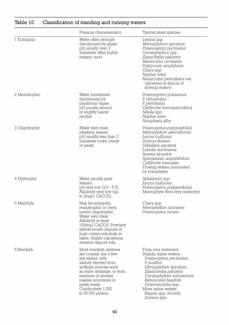
46
Physical characteristics Typical plant species
1 Eutrophic Water often strongly Lemna spp.discoloured by algae. Myriophyllurn spicatumpH usually over 7. Potamogeton pectinatusSubstrate often highly Ceratophyllum spp.organic mud. Zannichellia palustris
Ranunculus circinatusPolygonum amphibiumChara spp.Nuphar luteaRanunculus penicillatus var.
calcareus is typical offlowing waters
2 Mesotrophic Water sometimes Potamogeton gramineusdiscoloured by P. obtusifoliusplanktonic algae. P. perfoliatuspH usually around Callitriche hermaphroditicaor slightly below Nitella spp.neutral Nuphar lutea
Nymphaea alba
3 Oligotrophic Water very clear, Potamogeton polygonifoliusplankton sparse. Myriophyllum alterniflorumpH usually less than 7. Juncus bulbosusSubstrate rocky, sandy Scirpus fluitansor peaty. Subularia aquatica
Lobelia dortmannaIsoetes lacustrisSparganium angustifoliumCallitriche hamulata.Flowing waters dominatedby bryophytes
4 Dystrophic Water usually peat- Sphagnum spp.stained. Juncus bulbosuspH very low (3.5 - 5.5). Potamogeton polygonifoliusAlkalinity very low (up Macrophyte flora very restrictedto 2mg/1 CaCO3).
5 Marl/tufa May be eutrophic, Chara spp.mesotrophic or (very Myriophyllum spicatumrarely) oligotrophic. Potamogeton lucensWater very clear.Alkalinity at least100mg/l CaCO3. Powderyyellow-brown deposit ofmarl covers substrate inlakes. Highly calcareousstreams deposit tufa.
6 Brackish Most brackish systems Flora very restricted.are coastal, but a few Slightly saline waters -are inland, with Potamogeton pectinatussalinity derived from P. pusillusartificial sources such Myriophyllum spicatumas mine drainage, or from Zannichellia palustrisresidues of ancient Ceratophyllum submersummarine incursions in Ranunculus baudotiipeaty areas. Enteromorpha spp.Conductivity 1,250 More saline waters -to 50,000 µmhos. Ruppia spp, fucoids,
Zostera spp.
Table 10 Classification of standing and running waters
JNCC Handbook 2010.qxd 17/03/2010 07:05 Page 48

47
Dune heath (H6.6)
All heathland occurring on consolidated andflattened dunes should be included in thiscategory. Calluna is usually the dominant ericoid,with Erica cinerea and Erica tetralix also common.Carex arenaria is often present and lichens,particularly Cladonia species, are often abundant.Occasionally, juniper may be present. Use yellowcrosses for scattered heath.
Dune scrub (H6.7)
All scrub occurring on consolidated andflattened dunes should be classified in thiscategory. Hippophae rhamnoides is acharacteristic species. Use green crosses forscattered scrub.
Open dune (H6.8)
This category comprises the three earlysuccessional stages of dune formation, less stableand with lower vegetation cover than H6.4-H6.7.
• Fore dune: unstable, usually low ridges of sandon the foreshore, often with a very open plantcover. Elymus farctus is strongly characteristic,often dominant, and sometimes the only speciespresent; Honkenya peploides, Atriplex speciesand Cakile maritima are typical associatedspecies; Ammophila arenaria may be present insmall quantities, but should not be dominant.
• Yellow dune: partially stabilized ridges of sandlying between fore and grey dunes, with amarked but incomplete plant cover, nearlyalways dominated by Ammophila arenaria,although Leymus (Elymus) arenarius and/orElymus farctus may be common; a variety ofsmall herbs may be present.
• Grey dune: stable ridges of sand, almostcompletely vegetated. The vegetation is veryvariable in species composition; Ammophilaarenaria is usually present, but not dominant,mosses and lichens may be frequent. Grey dunecan be distinguished from fixed dune by beingmarkedly hilly or undulating, and by the sandnot being fully consolidated.
H8 Maritime cliff and slope
Maritime hard cliff (H8.1)
These are cliffs formed of rock (includingchalk) with less than 10% vascular plant cover. Thetype of rock should be target noted. Vegetatedcliffs should be mapped using the relevantvegetation code and target noted.
Maritime soft cliff (H8.2)
These are cliffs formed of mud or clay with lessthan 10% vascular plant cover. The type ofsubstrate should be target noted.
Crevice and ledge vegetation (H8.3)
This category comprises vegetation,occasionally sparse, but covering at least 10% ofthe cliff surface, occurring in crevices or on ledgeson steep cliffs. The communities present shouldbe described with a target note, taking care torecord whether the vegetation is influenced by theuse of the cliffs by birds, as may be indicated byspecies such as Beta vulgaris. Vegetationoccurring in the splash zone at the base of cliffsshould be included here.
Coastal grassland (H8.4)
These are grasslands which include maritimespecies and which occur on shallow slopes orlevel areas by the sea, often on cliff tops (but seedune grassland - H6.5). Indicator species includeScilla vema, Plantago maritima and Armeriamaritima. Festuca rubra is often dominant. Otherspecies may include Hieracium pilosella, Anthyllisvulneraria, Lotus comiculatus, Gallium verurn andThymus praecox.
Coastal heathland (H8.5)
All heathlands which include maritime speciesand which occur on shallow slopes, or even levelareas, by the sea should be included in thiscategory (but see dune heath - H6.6). Indicatorspecies include Scilla vema, Armeria maritima,Jasione montana, Plantago maritima and Plantagocoronopus. Calluna vulgaris is often dominant;Erica cinerea and dwarf Ulex species arefrequently present. Coastal heathland often occursjust inland of coastal grassland, and like thatcategory, frequently occurs at the top of cliffs.
I Rock exposure and waste
This grouping includes both natural andartificial exposed rock surfaces where these arealmost entirely lacking in vegetation, as well asvarious forms of excavations and waste tips.Significant communities of mosses, lichens andferns growing on walls or rock ledges should betarget noted. See also maritime cliff and slope(H8).
I1 Natural exposures
Inland cliff (I1.1)
This category is defined as rock surfaces over 2m high and sloping at more than 60°. Vegetatedcliffs with more than 10% vascular plant cover arenot included, but should be mapped using therelevant vegetation code, and target noted asnecessary.
Scree (I1.2)
Scree is defined as an accumulation, usually atthe foot of a cliff, of weathered rock fragments ofall sizes, mostly angular in shape. This category
JNCC Handbook 2010.qxd 17/03/2010 07:05 Page 49

48
includes large boulders (boulder scree) whichshould be mapped using enlarged red dots.
Limestone pavement (I1.3)
This comprises a near horizontal surface,usually of Carboniferous Limestone, which isirregularly corrugated and furrowed by solutionand often cut by deeper and more regular fissures(grikes), which correspond to naturally occurringjoints within the rock.
Other exposure (I1.4)
Exposed rock on mountain tops and in riverbeds should, for example, be included in thiscategory.
Cave (I1.5)
Any natural recess, large enough to enter andwith a complete ceiling, should be mapped ascave and any features of interest target noted.Large crevices and deep narrow gullies should notbe included here, but should be mapped under'other'.
I2 Artificial exposures and waste tips
The boundaries of quarries, spoil heaps, minesor refuse tips should be outlined in red. Coveringvegetation, if abundant, should be coded asappropriate, under grassland, scrub, etc, or targetnoted if sparse.
Quarry (I2.1)
Excavations such as gravel, sand or chalk pitsand stone quarries should be included in thiscategory. Target note the mineral or ore which hasbeen, or is being, extracted. If the site is water-filled, map as open water and target note previoususe.
Spoil (I12.2)
Includes abandoned industrial areas and tips ofwaste material such as coal mine spoil and slag.Spoil heaps within quarries should be included in12.1. Target note the type of spoil.
Mine (I2.3)
Mark the area on the map and target note anyfeatures of interest.
Refuse-tip (I2.4)
Target note any vegetation of interest, if itcovers an area too small to map, and code thedominant species.
J Miscellaneous
Features such as parks, gardens, golf coursesand railway cuttings or embankments are not listedas separate habitat types, since they are clearlymarked as such on Ordnance Survey maps. The
colour codes for the appropriate habitat type (forexample grassland, woodland or scrub) should,however, be superimposed over the feature on theOrdnance Survey map.
J1 Cultivated/disturbed land
Arable (J1.1)
This includes arable cropland, horticulturalland (for example nurseries, vegetable plots,flower beds), freshly-ploughed land and recentlyreseeded grassland, such as rye grass and rye-clover leys, often managed for silage.
Amenity grassland (J1.2)
This comprises intensively managed andregularly mown grasslands, typical of lawns,playing fields, golf course fairways and manyurban 'savannah' parks, in which Lolium perenne,with or without Trifolium repens, oftenpredominates. The sward composition will dependon the original seed mixture used and on the ageof the community. Herbs such as Bellis perennis,Plantago major and Taraxacum officinale may bepresent. If the amenity grassland has a sward richin herbs, it may be possible to classify it as semi-improved acidic, neutral or calcareous grassland,as appropriate. In such cases, the area concernedshould be mapped as the specific grassland typeand its amenity use target noted.
Ephemeral/short perennial (J1.3)
Short, patchy plant associations typical ofderelict urban sites, quarries and railway ballast,should be classified here. The land must be freelydraining, and usually has shallow stony soil. Thevegetation typically lacks a clear dominantspecies, but consists of a mixture of low-growingplants, often less than 25 cm high, such asPlantago major, Ranunculus repens, Trifoliumrepens, Medicago lupulina, Tussilago farfara,Leucanthemum vulgare and Senecio species, or oftaller species such as Sisymbrium or Melilotusspecies. Parts of fields containing similarcommunities, such as areas around gates, shouldnot be included, but should be classified asgrassland (B). See also tall ruderal (C3.1).
Introduced shrub (J1.4)
This is vegetation dominated by shrub speciesthat are not locally native, whether planted or self-sown. Common introduced shrubs includespecies of Buxus, Corn us, Laurus, Ligustrum,Rhododendron and Symphoricarpus. Formal bedsof shrubs such as of Hypericum calycinum,Cotoneaster, heaths and dwarf conifers should beincluded here. Introduced shrubs forming anunderstorey in woodland should be mapped aswoodland (Al) and target noted. Introduced shrubon sand dunes should be classified as dune scrub(H6.7). See also scrub (A2).
JNCC Handbook 2010.qxd 17/03/2010 07:05 Page 50

49
J2 Boundaries
Although a key to field boundaries is supplied,time constraints often preclude the mapping ofboundaries. Nevertheless, the conservation valueof hedges should not be overlooked and it isrecommended that at least the better examplesshould be mapped and target noted, particularly inlowland areas. Species-rich hedges should bedifferentiated from species-poor ones by the use ofthe zig-zag symbol. Fences are usually of littlesignificance, as their wildlife value is low, butrecording new boundaries and removedboundaries may be important. A clear decisionshould be made as to the types of boundary to bemapped and consistency should be maintained.
Guidance on recording grassy road verges,railway cuttings and embankments is given underthe grassland section (B). Where they aredominated by trees or scrub they should becategorised as woodland (A) and mapped if verybroad, otherwise simply target noted.
Intact hedge (J2.1)
Intact hedges are entire and more-or-less stock-proof.
Defunct hedge (J2.2)
Hedges in which there are gaps and which areno longer stock-proof fall into this category.
Hedgerow with trees (J2.3)
The frequency of cross-hatching should bevaried to indicate the density of trees. Windbreaksshould be classified under A3.
Species-rich hedges (J2.4)
These have a diversity of native woody speciesand a good hedgerow bottom flora.
Wall (J2.5)
Significant communities of mosses, lichens orferns growing on walls may be target noted,particularly in built-up areas.
Ditch (J2.6)
Only ditches which appear to be dry for most of
the year should be included in this category. Wetditches are mapped as standing water (G1) orpossibly swamp (F1).
Boundary removed (J2.7)
Use spaced crosses on the appropriateOrdnance Survey symbol.
Earth bank (J2.8)
The ditch/bank systems found on ancientwoodland sites may be included here, as shouldsea walls constructed of natural materials.
J3 Built-up areas
Caravan site (J3.4)
Hatching may be used as an overlay on theappropriate semi-natural habitat colour, forinstance where the site is on coastal grassland orin woodland.
Sea wall (J3.5)
Only sea walls constructed of artificial materials(for example concrete) should be included here.Others should be mapped as earth banks (J2.8).
Buildings (J3.6)
Map unmarked new buildings or built-up areasand colour those already shown on the OrdnanceSurvey maps. Agricultural, industrial and domesticbuildings should all be coloured in solid black.There is no need to distinguish between them.
J4 Bare ground
Any type of bare soil or other substrate shouldbe included here where not already covered(compare bare peat E4, intertidal H1, shingle H3,boulders and rocks H4, Dunes H6, maritime cliffH8 and natural rock exposure I). Target noteextensive or otherwise important areas of bareground.
J5 Other habitat
Draw a black line around any habitat notencompassed by the classification and describe itin a target note.
JNCC Handbook 2010.qxd 17/03/2010 07:05 Page 51

Acknowledgements
50
This manual is a revision of NCC's draft Habitatmapping manual (Phase 1), produced in 1986 byRobert Walton. This was based on the originalmethodology devised by Ian Bonner in 1974 anddeveloped by Tim Bines and Peter Welsh, of theEngland Field Unit, in 1982 and 1983. After wideconsultation within the NCC, an initial revision ofthe 1986 draft was produced in 1989 by CarolBlake.
Since then, the manual has been thoroughlyrevised by Peter Kelly and Margaret Palmer, tobring it into line with current survey practice in theNCC and to improve the habitat classification anddefinitions.
Many people have been consulted over theperiod of years in which this manual has been inpreparation and all have freely given their time and
advice. Thanks are due to Dr H Ash (St Helensand Knowsley survey), Dr R G H Bunce (Institute ofTerrestrial Ecology), I Collis (West MidlandsCounty Council), Dr M Game (Greater LondonCouncil), J Green (Grampian Regional Councilsurvey), Dr J F Handley (Groundwork Trust), RHobs (Norfolk Naturalists Trust), D Nicholls(Leicester City Wildlife Project), J A Spalton(Norfolk Survey), C Steel (Devon Trust for NatureConservation), D Stubbs (London Wildlife Trustsurvey) and Dr B J Trowbridge (Woodland Trust),all of whom advised on the preparation of the draftversion.
Further helpful comment and advice have beenreceived from the many users of the draft version,in particular from Tim Blackstock, Ann Greatrex,Lindsay Kinnes, Liz Pulford, Denise Ramsay, andGreg Smith.
JNCC Handbook 2010.qxd 17/03/2010 07:05 Page 52

References
51
ASH, H. J. & GATELEY, P. 1984. Urban botanicalsurvey: draft report. St Helens, Merseyside, TheGroundwork Trust.
BAKER, J.R. & DRUMMOND, J.E. 1984.Environmental monitoring and map revision usingintegrated LANDSAT and digital cartographicdata. ITC Journal, 1, 10-19.
BALL, S.G. 1988. RECORDER, a biologicalrecording package for Local Record Centres.(Advanced Revelation Version). Peterborough,Nature Conservancy Council.
CANFIELD, RH. 1941. Application of the line-intercept method in sampling range vegetation. J.Forestry, 39, 388-394.
CLAPHAM, A.R, TUTIN, T.G. & MOORE, D.M.1987, Flora of the British Isles, 3rd ed. Cambridge,Cambridge University Press.
CLAPHAM, A.R., TUTIN, T.G. & WARBURG, E.F1981. Excursion flora of the British Isles, 3rd ed.Cambridge, Cambridge University Press.
DONY, J.G., JURY, S.L. & PERRING, F 1986.English names of wild flowers, 2nd ed. Reading,Botanical Society of the British Isles.
EVANS, C. 1988. Habitat classification manual.Reserves Ecology Department, Royal Society forthe Protection of Birds.
GAME, M. 1984. A strategic survey of London'swildlife habitats. Unpublished note onmethodology and on survey uses and limitations.London, Transportation and DevelopmentDepartment, Greater London Council.
KELLY, P.G., & PERRY, K.P. In prep. Wildlife habitatin Cumbria. (Research and Survey in NatureConservation series). Peterborough, NatureConservancy Council.
KIRBY, KJ., PETERKEN, GE, SPENCER, J.W. &WALKER, G.J. 1984. Inventories of ancient semi-natural woodland. (Focus on Nature Conservation,No. 6). Peterborough, Nature ConservancyCouncil.
NCC. 1977. Methods of locating old herb-richgrasslands. (GB studies on SSSI criteria, No. 1).Unpublished report by J E Forbes, NatureConservancy Council.
NCC. 1979a. Description of Phase 1 broadecological survey and land use mapping, as usedin south east Scotland, Cumbria and parts of WestYorkshire.
Unpublished paper by I. Bonner. NatureConservancy Council.
NCC. 1979b. Land use/habitat survey (Phase 1),revised version. Unpublished paper. NW EnglandRegion, Nature Conservancy Council.
NCC. 1980. Lowland agricultural habitats(Scotland): Air-photo analysis of change. (CSTReport No 332). I Langdale-Brown, S Jennings, C LCrawford, G M Jolly and J Muscott. Unpublished.Nature Conservancy Council.
NCC. 1982. The standard habitat classification foruse in NCC for the mapping and description ofSSSIs. Unpublished paper. England Field Unit,Nature Conservancy Council.
NCC. 1983a. Selection of biological SSSI. Policy &Procedure Guidelines. NCC/P83/19G.Unpublished, Nature Conservancy Council.
NCC, 1983b. Phase 1 survey, habitat classificationand mapping codes. Unpublished paper. NWEngland Region, Nature Conservancy Council.
NCC. 1983c. Phase 1 land use and habitat surveyof Somerset (1983). D Howlett, J Williamson, HTripp, A Burdett, D Burton, D Chown, M Elliot and
C Pulteney. Unpublished. SW England Region,Nature Conservancy Council.
NCC. 1983d. Phase 1 land use and habitat surveyof Dorset (1983). A Swash, I Alexander, P Christian,D Exton, P Harvey and T Warrick. Unpublished.SW England Region, Nature Conservancy Council.
NCC. 1984. Nature conservation in Great Britain.Peterborough, Nature Conservancy Council.
NCC, 1985. Surveys of wildlife in river corridors:draft methodology. Unpublished report. NatureConservancy Council.
NCC. 1986a. Phase 1 survey of Cumbria: 1Carlisle District. Unpublished report by P Kelly, RJerram, J Hooson & A Kyle. NW Region, NatureConservancy Council.
NCC. 1986b. Habitat mapping manual (Phase 1).Unpublished draft by Nature ConservancyCouncil.
NCC. 1987. Changes in the Cumbrian countryside.First report of the National Countryside MonitoringScheme. (Research and survey in natureconservation, No. 6.) Peterborough, NatureConservancy Council.
JNCC Handbook 2010.qxd 17/03/2010 07:05 Page 53

52
NCC. 1988. National Countryside MonitoringScheme, Scotland: Grampian. Battleby, Perth,Countryside Commission for Scotland and NatureConservancy Council.
NCC. 1989. Guidelines for selection of biologicalSSSIs. Peterborough, Nature ConservancyCouncil.
NCC/RSNC. 1984. NCC/RSNC habitatclassification. Unpublished paper. Royal Societyfor Nature Conservation and Nature ConservancyCouncil.
PALMER, M.A. 1989. A botanical classification ofstanding waters in Great Britain. (Research andsurvey in Nature Conservation, No 19).Peterborough, Nature Conservancy Council.
RAMSAY, D.B. 1985. Cheshire habitat surveyanalysis. Unpublished report. Country Planning
Department. Cheshire County Council.
RATCLIFFE, DA, ed. 1977. A nature conservationreview. Cambridge, Cambridge University Press.
RODWELL, J. in prep. British plant communities 5vols. Cambridge, Cambridge University Press.(National Vegetation Classification.)
SHIMWELL, D. 1983. A conspectus of urbanvegetation types. University of Manchester.Unpublished report to Nature ConservancyCouncil.
USHER, M.B., ed. 1986. Wildlife conservationevaluation. London, Chapman and Hall.
WIGAN MBC. 1987. Wigan Metropolitan BoroughPhase 1 survey. Unpublished report. WiganMetropolitan Borough Council.
JNCC Handbook 2010.qxd 17/03/2010 07:05 Page 54

Phase 1 surveyhabitat classification,
hierarchical alphnumericreference codes
andmapping colour codes
Appendix one
JNCC Handbook 2010.qxd 17/03/2010 07:05 Page 55

Woodland and scrubA1 Woodland
1 Broad-leaved
1 Semi-natural Green
2 Plantation Green
2 Coniferous
1 Semi-natural True Green
2 Plantation True Green
3 Mixed
1 Semi-natural Green over true green
2 Plantation Green over true green
2 Scrub1 Dense/continuous Green
2 Scattered Green
3 Parkland.scattered trees1 Broad-leaved Green
2 Coniferous True Green
3 Mixed Green over true green
4 Recently-felled woodland1 Broad-leaved Green
2 Coniferous True Green
3 Mixed Green over true green
Grassland and marshB1 Acid grassland
1 Unimproved Orange
2 Semi-proved Orange
2 Neutral grassland1 Unimproved Orange
2 Semi-improved Orange
3 Calcareous grassland1 Unimproved Orange
2 Semi-improved Orange
4 Improved grassland No colour
5 Marsh/marshy grassland Purple over orange
*6 Poor semi-improvedgrassland (optional)
No colour
JNCC Handbook 2010.qxd 17/03/2010 07:05 Page 56
Tall herb and fernC1 Bracken
1 Continuous Terra cotta
2 Scattered Terra cotta
2 Upland species-richledges
3 Other1 Tall ruderal Terra cotta
2 Non-ruderal Terra cotta
Terra cotta + target note
HeathlandD1 Dry dwarf shrub heath
1 Acid Yellow ochre
2 Basic Yellow ochre
2 Wet dwarf shrub heath Purple over yellow ochre
3 Lichen/bryophte heath Yellow ochre
4 Montane heath/dwarf herb Yellow ochre
5 Dry heath/acidgrassland mosaic Orange over yellow ochre
6 Wet heath/acidgrassland mosaic
Purple and orangeover yellow ochre
Swamp, marginal and inundationF1 Swamp
Sky luue
2 Marginal and inundation
1 Marginal vegetation Sky luue + target note
2 Inundation vegetation Sky luue
MireE1 Bog*6 Sphagnum bog
*1 Blanket bog Purple
*2 Raised bog Purple
*7 Wet modified bog Purple
*8 Dry modified bog Purple
2 Flush and spring1 Acid/neutral flush Magenta
2 Basicl flush Magenta
3 Bryophyte-dominatedspring Target note
*3 Fen
Basic Magenta over purple
Magenta over purple
Optional codings:
*1 Valley mire Magenta over purple
*2 Basin mire Magenta over purple
*3 Flood-plain mire Magenta over purple
Purple*4 Bare peat
JNCC Handbook 2010.qxd 17/03/2010 07:06 Page 57

JNCC Handbook 2010.qxd 17/03/2010 07:06 Page 58
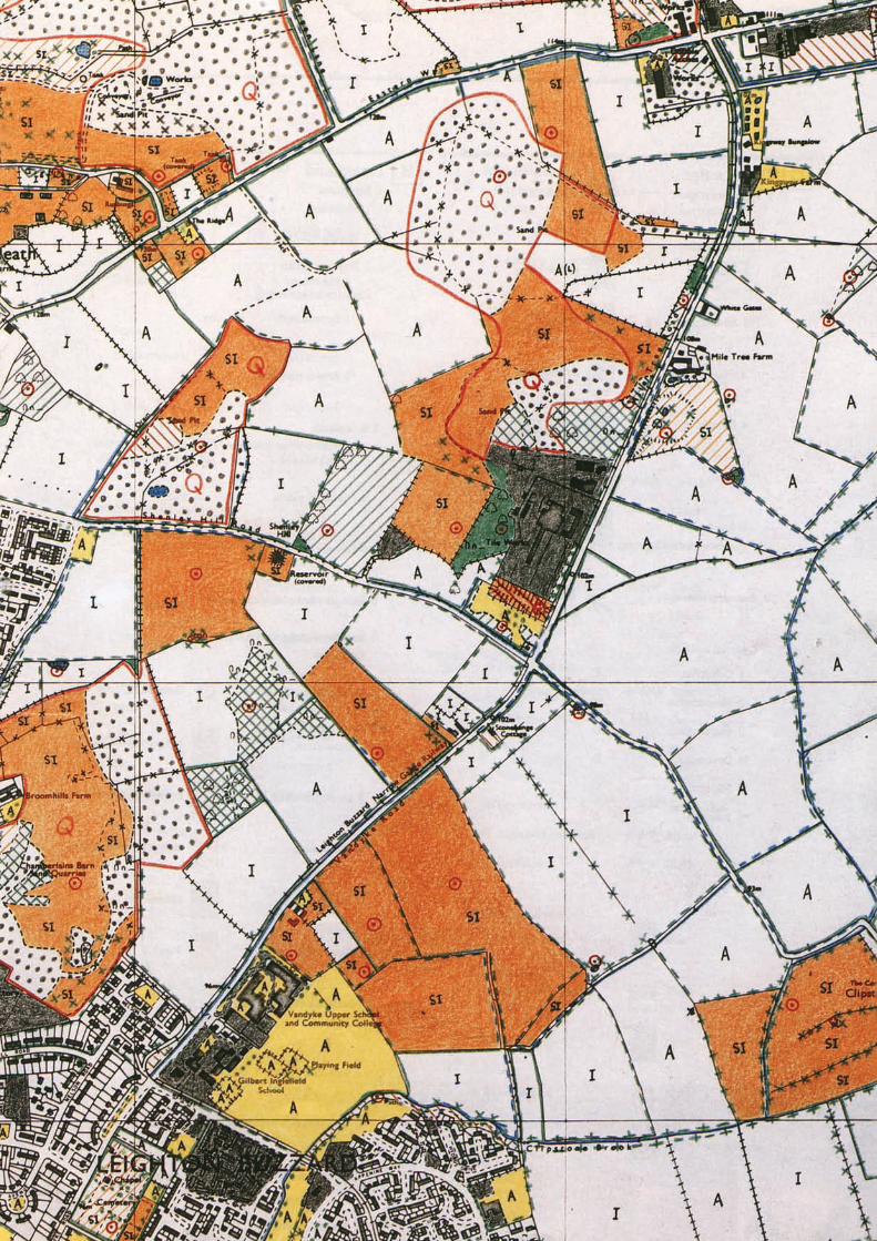
JNCC Handbook 2010.qxd 17/03/2010 07:07 Page 59
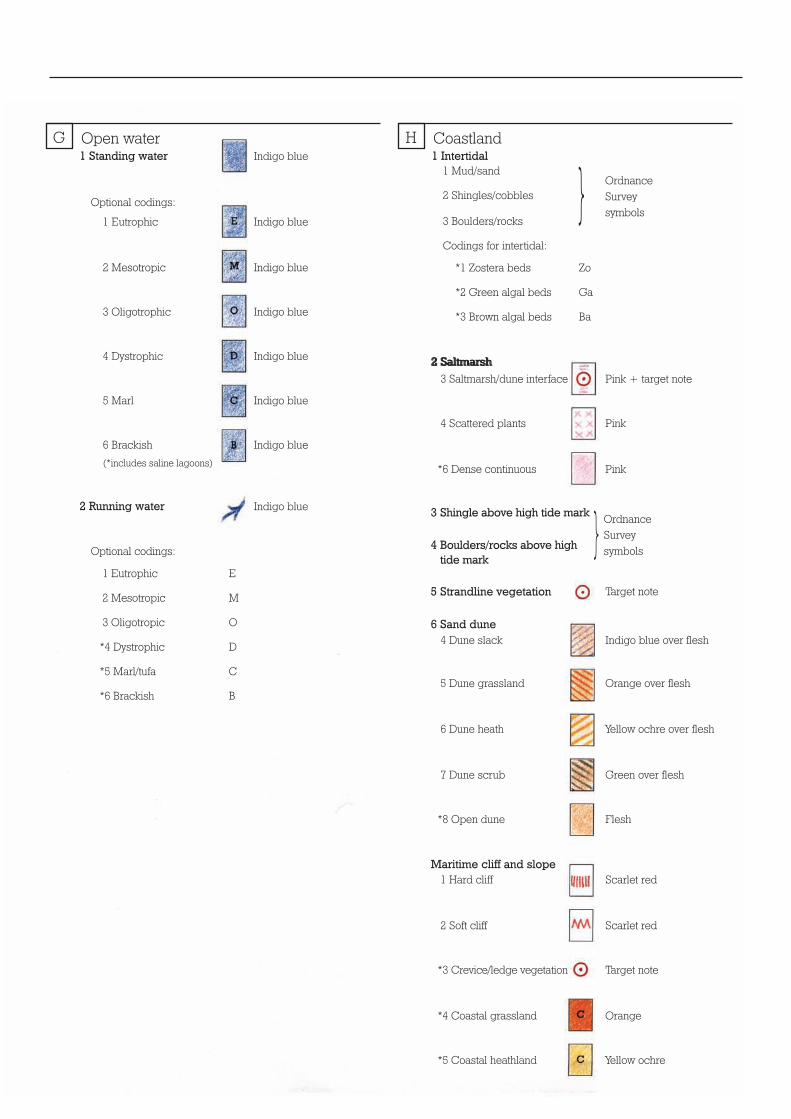
CoastlandH1 Intertidal
1 Mud/sandOrdnanceSurveysymbols
2 Saltmarsh
*1 Zostera beds Zo
Open waterG1 Standing water Indigo blue
1 Eutrophic Indigo blue
2 Mesotropic Indigo blue
3 Oligotrophic Indigo blue
Optional codings:
4 Dystrophic Indigo blue
5 Marl Indigo blue
6 Brackish Indigo blue
(*includes saline lagoons)
2 Running water Indigo blue
1 Eutrophic E
Optional codings:
2 Mesotropic M
3 Oligotropic O
*4 Dystrophic D
*5 Marl/tufa C
*6 Brackish B
*2 Green algal beds Ga
*3 Brown algal beds Ba
2 Shingles/cobbles
3 Boulders/rocks}
Codings for intertidal:
2 Saltmarsh3 Saltmarsh/dune interface Pink + target note
4 Scattered plants Pink
*6 Dense continuous Pink
3 Shingle above high tide mark
4 Boulders/rocks above hightide mark
OrdnanceSurveysymbols}
6 Sand dune4 Dune slack Indigo blue over flesh
5 Dune grassland Orange over flesh
6 Dune heath Yellow ochre over flesh
7 Dune scrub Green over flesh
*8 Open dune Flesh
1 Hard cliff Scarlet red
2 Soft cliff Scarlet red
Maritime cliff and slope
*3 Crevice/ledge vegetation Target note
*4 Coastal grassland Orange
*5 Coastal heathland Yellow ochre
5 Strandline vegetation Target note
JNCC Handbook 2010.qxd 17/03/2010 07:07 Page 60
Rock exposure and wasteI1 Natural
1 Inland cliff
1 Acid/neutral Scarlet red
2 Basic Scarlet red
3 Limestone pavement Scarlet red
2 Scree
1 Acid/neutral Scarlet red
2 Basic Scarlet red
5 Cave Scarlet red
4 Other exposure
1 Acid/neutral Scarlet red
2 Basic Scarlet red
2 Artificial1 Quarry Scarlet red
2 Spoil Scarlet red
3 Mine Scarlet red
*4 Refuse-tip Scarlet red
MiscellaneousJ1 Cultivated/disturbed land
*1 Arable No colour
*2 Amenity grassland Canary yellow
*4 Introduced shrub Terra cotta
*3 Ephemeral/shortperennial Black
2 Boundaries (mapping optional)
3 Built-up areas
4 Bare ground
5 Other habitat
1 Intact hedge
*1 Native species-rich Green
*2 Species-poor Green
2 Defunct hedge
*1 Native species-rich Green
*2 Species-poor Green
3 Hedge and trees
*1 Native species-rich Green
*2 Species-poor Green
4 Fence Black
5 Wall Scarlet Red
6 Dry ditch Indigo blue
*7 Boundary removed Black
*8 Earth bank Black
4 Caravan site Black
*5 Sea wall
(artificial material) Black
*6 Buildings Black
Black
Black + target note
JNCC Handbook 2010.qxd 17/03/2010 07:07 Page 61
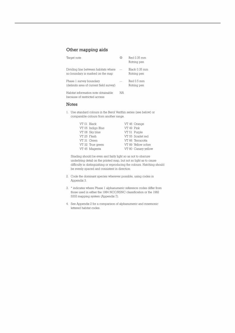
Other mapping aids
Target note Red 0.35 mmRotring pen
Dividing line between habitats where --- Black 0.35 mmno boundary is marked on the map Rotring pen
Phase 1 survey boundary --- Red 0.5 mm(delimits area of current field survey) Rotring pen
Habitat information note obtainable NAbecause of restricted access
Notes
1. Use standard colours in the Berol Verithin series (see below) orcomparable colours from another range.
VT 01 Black VT 46 OrangeVT 05 Indigo Blue VT 49 PinkVT 08 Sky blue VT 51 PurpleVT 25 Flesh VT 55 Scarlet redVT 31 Green VT 66 TerracottaVT 32 True green VT 89 Yellow ochreVT 45 Magenta VT 80 Canary yellow
Shading should be even and fairly light so as not to obscureunderlying detail on the printed map, but not so light as to causedifficulty in distinguishing or reproducing the colours. Hatching shouldbe evenly spaced and consistent in direction.
2. Code the dominant species wherever possible, using codes inAppendix 3.
3. * indicates where Phase 1 alphanumeric reference codes differ fromthose used in either the 1984 NCC/RSNC classification or the 1982SSSI mapping system (Appendix 7).
4. See Appendix 2 for a comparison of alphanumeric and mnemoniclettered habitat codes.
JNCC Handbook 2010.qxd 17/03/2010 07:07 Page 62

61
JNCC Handbook 2010.qxd 17/03/2010 07:08 Page 63
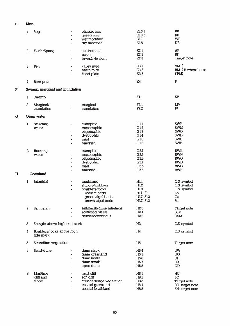
62
JNCC Handbook 2010.qxd 17/03/2010 07:08 Page 64
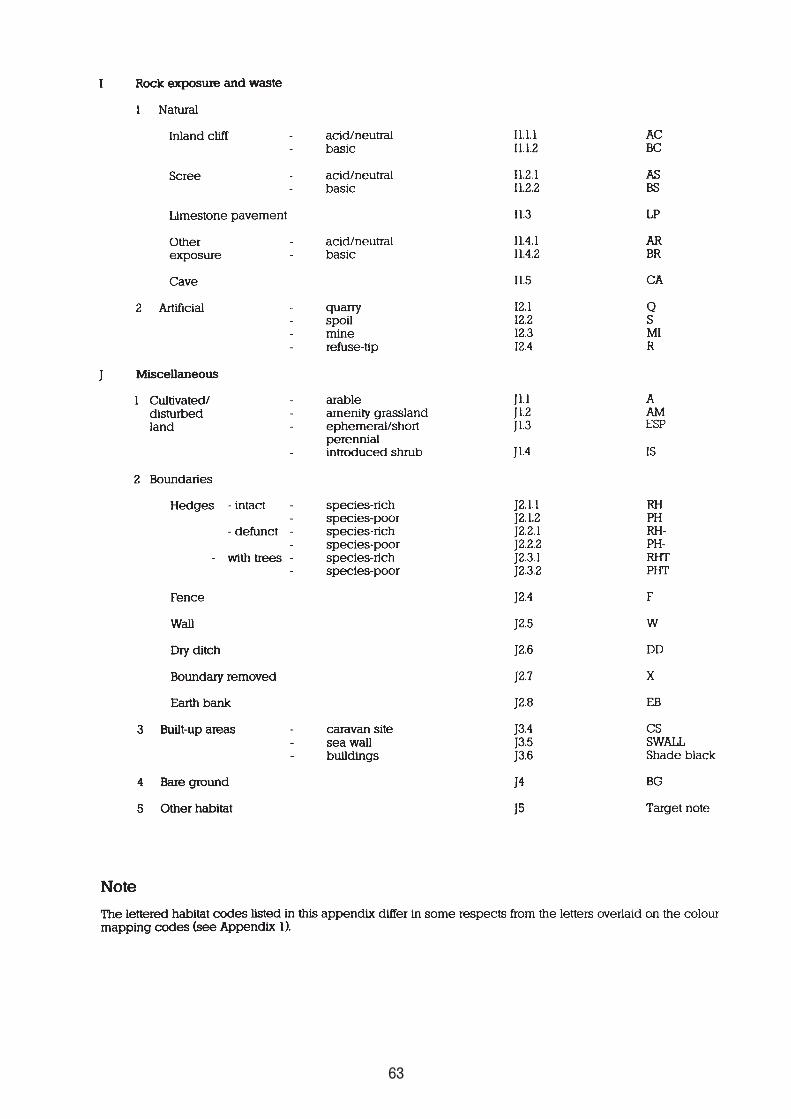
63
JNCC Handbook 2010.qxd 17/03/2010 07:08 Page 65

64
JNCC Handbook 2010.qxd 17/03/2010 07:09 Page 66

65
JNCC Handbook 2010.qxd 17/03/2010 07:09 Page 67

66
Notes
1. These codes should be used for mapping dominantspecies, by superimposing the species code on theappropriate colour code for the habitat (see Appendix1), where there is sufficient room on the map. Theoccurrence of dominant species on small areas andnon-dominant species of interest should be recorded intarget notes.
2. New codes may be devised for any species notgiven on this list, as long as care is taken to ensure thatthey do not duplicate existing symbols
Group abbreviations
Ba - Brown algae (Fucus etcin coastal waters)
Brys - Bryophytes (other thanSphagnum)
Cons - ConifersExos - Exotic shrubsGa - Green algae (including
Ulva, Enteromorpha andfilamentous algae, insaline and fresh waters)
Licn - Lichens
JNCC Handbook 2010.qxd 17/03/2010 07:09 Page 68

67
JNCC Handbook 2010.qxd 17/03/2010 07:09 Page 69

68
JNCC Handbook 2010.qxd 17/03/2010 07:09 Page 70

69
JNCC Handbook 2010.qxd 17/03/2010 07:10 Page 71

70
JNCC Handbook 2010.qxd 17/03/2010 07:10 Page 72
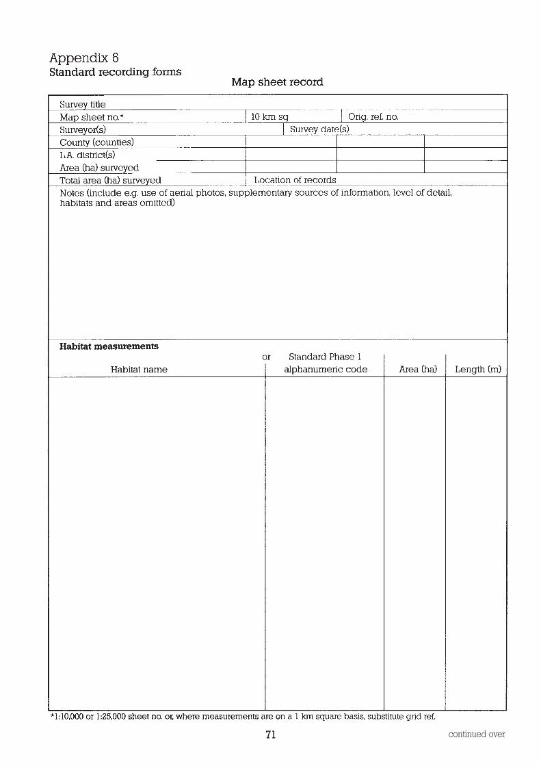
71 continued over
JNCC Handbook 2010.qxd 17/03/2010 07:10 Page 73

72
JNCC Handbook 2010.qxd 17/03/2010 07:10 Page 74

73 continued over
JNCC Handbook 2010.qxd 17/03/2010 07:11 Page 75

74
JNCC Handbook 2010.qxd 17/03/2010 07:11 Page 76

75
JNCC Handbook 2010.qxd 17/03/2010 07:11 Page 77
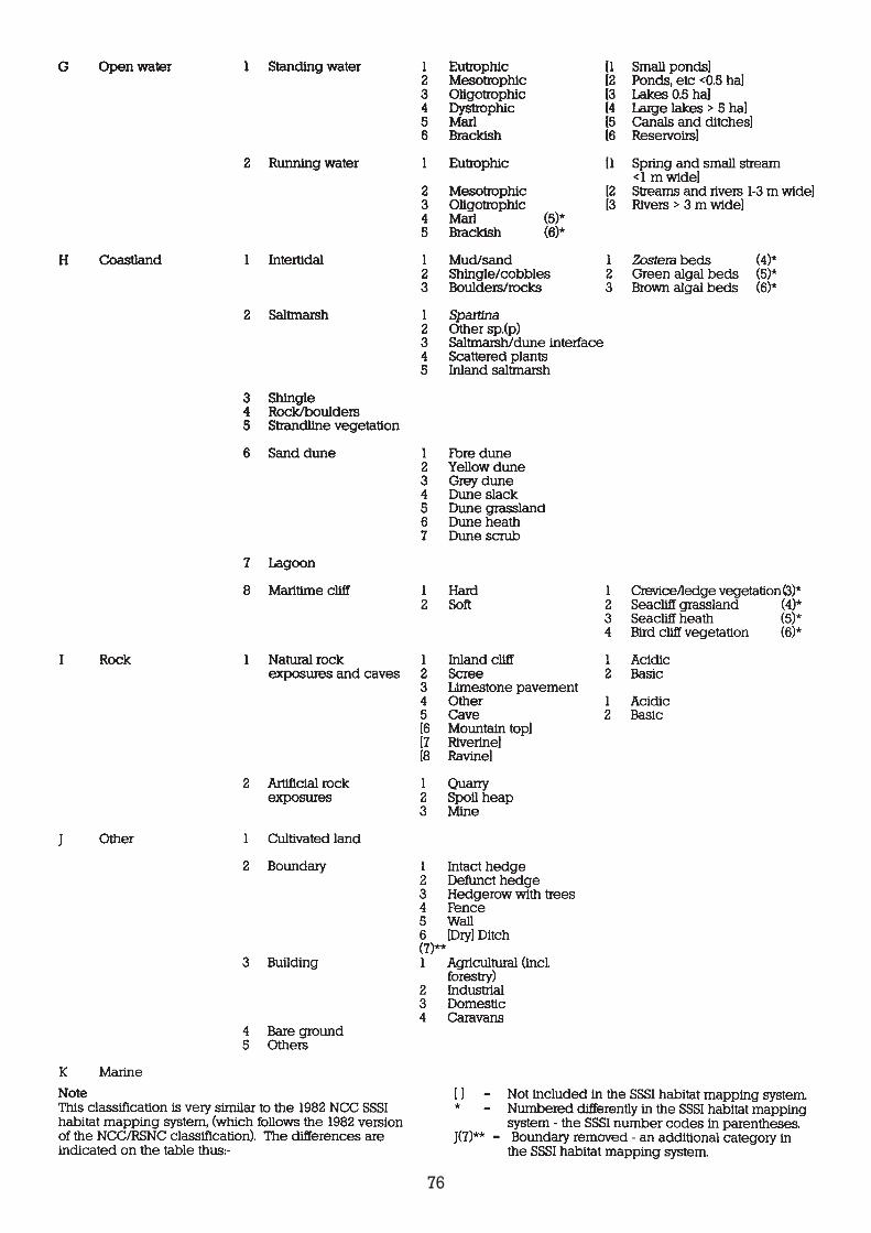
76
JNCC Handbook 2010.qxd 17/03/2010 07:12 Page 78

77
Appendix 8.
Relationship between Phase 1 habitat categories and National Vegetation Classificationcommunities in British plant communities Volumes 1-5
This table is not definitive, but gives provisional guidance only. Few of the correspondencesare exact and many NVC communities correspond to more than one Phase 1 category.Some correspondences are only at sub-community level (details not given here). A fullerversion is available via the JNCC website.
JNCC Handbook 2010.qxd 17/03/2010 07:12 Page 79
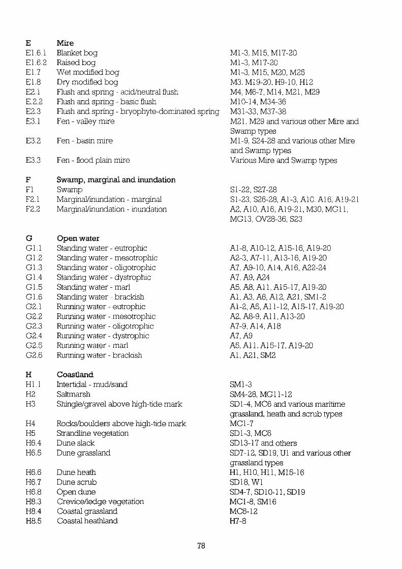
78
JNCC Handbook 2010.qxd 17/03/2010 07:12 Page 80

79
Appendix 9.
Technical developments and other changes since 1990 - key points.
Section 2.2 and 3.2-3.8
There have been major developments in the area of electronic data handling and storage,notably the use of Geographical Information Systems (GIS), and also in remote sensingtechniques. Hand-held GPS (Global Positioning System) is now commonly used, especiallyin more difficult terrain, and equipment that allows electronic mapping and data entry in thefield combined with GPS is available.
Section 5.1 (also 2.9.2 and Appendix 1)
It is no longer a requirement to only use standard Berol Verithin coloured pencils, i.e.comparable coloured pencils are entirely acceptable.
Section 6.3 (also 2.9.1)
The standard taxonomic reference for vascular plants is currently Stace (1997) and thecompanion field flora Stace (1999).
Section 8 and Appendix 3
It is no longer necessary to send a copy of Phase 1 survey reports to NCC, or to consult onand send new dominant species codes to them.
Section 9.3 (also 1.2) and Appendix 8
The National Vegetation Classification (NVC) has been published in five volumes as BritishPlant Communities (Rodwell, 1991-2000) and is widely used in detailed habitat survey.Summaries of the NVC descriptions for grassland and montane communities, mires andheaths, and woodlands are available for use in the field (Cooper, 1997, Elkington et al. 2001,Hall et al. 2001). JNCC has published a new single volume on plant communities of theBritish uplands (Averis et al. 2004) and a handbook for users of the NVC classificationapproach (Rodwell 2006).
The relationship between Phase 1 and the UK Biodiversity Action Plan Broad HabitatClassification was published in Jackson (2000).
JNCC Handbook 2010.qxd 30/03/2010 10:11 Page 81
80
Additional references for Appendices 8 and 9 only
Averis, AM, Averis, ABG, Birks, HJB, Horsfield, D, Thompson, DBA, and Yeo, MJM (2004) Anillustrated Guide to British Upland Vegetation. Joint Nature Conservation Committee, Peterborough
Cooper, E A (1997) Summary descriptions of National Vegetation Classification grassland andmontane comunities. UK Nature Conservation No. 14. Joint Nature Conservation Committee,Peterborough
Elkington, T, Dayton, N, Jackson, D L and Strachan, I M (2001) National Vegetation Classification:fie1d guide to mires and heaths. Joint Nature Conservation Committee, Peterboroughwww.jncc.gov.uk/communications/pubcat/heathland.htm.
Hall, J E, Kirby, K J and Whitbread, A M (2001) National Vegetation Classification: field guide towoodland. Joint Nature Conservation Committee, Peterborough
Jackson DL (2000) Guidance on the interpretation of the Biodiversity Broad Habitat Classification(terrestrial and freshwater types): Definitions and the relationship with other habitat classifications.JNCC Report, No. 307 www.jncc.gov.uk/communications/pubcat/jnccreport.htm
Rodwell, J S (ed.) (199la) British Plant Communities, Vol. 1: Woodlands and Scrub. CambridgeUniversity Press, Cambridge
Rodwell, J S (ed.) (199lb) British Plant Communities, Vol 2: Mires and Heaths. Cambridge UniversityPress, Cambridge
Rodwell, J S (ed.) (1992) British Plant Communities, Vol 3: Grassland and Montane Communities.Cambridge University Press, Cambridge
Rodwell, J S (ed.) (1995) British Plant Communities, Vol. 4: Aquatic Communities, Swamps and Tall-herb Fens. Cambridge University Press, Cambridge
Rodwell, J S (ed.) (2000) British Plant Communities, Vol 5: Maritime communities and vegetation ofopen habitats. Cambridge University Press, Cambridge
Rodwell, J S (2006) National Vegetation Classification: Users’ handbook. Joint Nature ConservationCommittee, Peterborough
Stace, C (1997) New Flora of the British Is1es, 2nd ed. Cambridge University Press, Cambridge
Stace, C (1999) Field Flora of the British Is1es. Cambridge University Press, Cambridge
As a result of the above publications and other developments, Appendix 8 of the handbookhas been superseded by an improved and substantially expanded online product. Details ofthe correspondences between Phase 1 types and other mainstream classification systemsare contained in an interactive spreadsheet, which can be downloaded fromhttp://www.jncc.gov.uk/page-4258. Also available from this web page is an electronic Phase1 colour palette style file that can be applied to ArcGIS shapefiles.
JNCC Handbook 2010.qxd 17/03/2010 07:12 Page 82

ISBN : 978-0-86139-636-8
Revised reprint 2010 © JNCC 1993, 2003, 2004, 2007(2), 2010
JNCC SUPPORT CO. Registered in England and Wales, company no. 05380206
The Joint Nature Conservation Committee (JNCC) is the statutory adviser to Government on UKand international nature conservation. Its work contributes to maintaining and enriching biologicaldiversity, conserving geological features and sustaining natural systems.
JNCC delivers the UK and international responsibilities of the Council for Nature Conservation andthe Countryside (CNCC), the Countryside Council for Wales (CCW), Natural England, and ScottishNatural Heritage (SNH). The functions that arise from these responsibilities are principally to:
• advise Government on the development and implementation of policies for, or affecting, natureconservation in the UK and internationally;
• provide advice and disseminate knowledge on nature conservation issues affecting the UK andinternationally;
• establish common standards throughout the UK for nature conservation, including monitoring,research, and the analysis of results;
• commission or support research which it deems relevant to these functions.
The Committee comprises 14 members: a Chairman and five independent members appointed bythe Secretary of State; the Chairman of CNCC; the Chairmen or deputy Chairmen of CCW, NaturalEngland and SNH; and one other member from each of these bodies.
JNCC, originally established under the Environmental Protection Act 1990, was reconstituted bythe Natural Environment and Rural Communities Act 2006. Support is provided to the JNCC by acompany limited by guarantee (JNCC Support Co) that the Committee established in 2005.
Details of publications produced by JNCC are available from:Communications Team, JNCC, Monkstone House, City Road, Peterborough. PE1 1JY.Telephone: +44 (0)1733 562626Fax: +44 (0)1733 555948Email: [email protected]
JNCC also provides extensive information through its website: www.jncc.gov.uk
Des
igne
d b
y G
ask
and
Haw
ley,
Pro
duc
ed b
y C
elan
din
e B
ank.
1.
5M,
.85M
, 1M
, 1M
, 1M
, 1.
5M,
1M,
1.5M
, 2M
.
JNCC Handbook 2010.qxd 30/03/2010 10:11 Page 84