Embed Size (px)
Citation preview

Harbour Master’s Directions 10TH EDITION
AUGUST 2017


10th Edition Harbour Master’s Directions for port waters of the Port of Melbourne
Printed copies of this document are considered uncontrolled. Please refer to the VPCM website for the latest version Page ii
Contents 1 Section 1: Introduction ....................................................................................... 1
1.1 Preamble ................................................................................................................................ 1 1.1.1 Port Information Guide .............................................................................................. 1 1.1.2 Users to ensure they are referring to the most up to date version of the Harbour
Master’s Directions .................................................................................................... 1 1.2 Disclaimer ............................................................................................................................... 1 1.3 Victorian Ports Corporation (Melbourne) ................................................................................ 1 1.4 Marine Safety Act ................................................................................................................... 2 1.5 Harbour Master ....................................................................................................................... 2 1.6 Harbour Master’s Directions (HMDs) ...................................................................................... 3
1.6.1 Application of Harbour Master’s Directions ............................................................... 3 1.7 Vessel Traffic Services (VTS) ................................................................................................. 4
1.7.1 VTS Instrument of Authority ...................................................................................... 4 1.7.2 VTS objectives .......................................................................................................... 4 1.7.3 Senior Vessel Traffic Services Officer (SVTSO) ....................................................... 4 1.7.4 Vessel Traffic Services Officer (VTSO) ..................................................................... 4 1.7.5 Type of VTS .............................................................................................................. 4 1.7.6 VTS Area ................................................................................................................... 4 1.7.7 Participation in the VTS ............................................................................................. 6 1.7.8 VTS participation table .............................................................................................. 6
2 Section 2: General .............................................................................................. 7 2.1 Application .............................................................................................................................. 7 2.2 Definitions ............................................................................................................................... 7 2.3 Assisting VPCM officers ....................................................................................................... 12 2.4 Action likely to prejudice the safe operation of a vessel ....................................................... 12 2.5 Compliance requirements ..................................................................................................... 12 2.6 Operation of Automatic Identification System (AIS) ............................................................. 13 2.7 Over dimension vessel ......................................................................................................... 13 2.8 Unsafe vessel ....................................................................................................................... 13 2.9 Pilotage ................................................................................................................................. 13
2.9.1 Statutory requirements ............................................................................................ 13 2.9.2 Navigating with a pilot on board .............................................................................. 14 2.9.3 Pilot transfer arrangements ..................................................................................... 14
2.10 Monitoring of the weather ..................................................................................................... 14 2.11 Towing .................................................................................................................................. 14
2.11.1 Towing in a designated shipping channel, fairway or Transit Only Zone ................ 14 2.11.2 Transiting the Fairway Through Port Phillip Heads ................................................. 15 2.11.3 Port working vessels engaged in towing ................................................................. 15
2.12 Placing orders for vessel movements and port services ...................................................... 15 2.12.1 Placing orders in PortVIEW ..................................................................................... 16
2.13 Diving activities ..................................................................................................................... 16 2.13.1 Contractor diving ..................................................................................................... 16 2.13.2 Charter boat diving trips conducted at Port Phillip Heads and in the South Channel17 2.13.3 Recreational diving activity ...................................................................................... 18
2.14 Aquatic events ...................................................................................................................... 18 2.15 Seaplanes ............................................................................................................................. 19 2.16 Navigation aids ..................................................................................................................... 19
2.16.1 Making fast to a navigation aid ................................................................................ 19 2.16.2 Interfering with a navigation aid .............................................................................. 19

10th Edition Harbour Master’s Directions for port waters of the Port of Melbourne
Printed copies of this document are considered uncontrolled. Please refer to the VPCM website for the latest version Page iii
2.16.3 Vessel causing damage to a navigation aid ............................................................ 19 2.16.4 Reporting a faulty navigation aid ............................................................................. 19
2.17 Transit Only Zone (TOZ) ...................................................................................................... 20 3 Section 3: All vessels with LOA 50 m or greater ............................................ 22
3.1 Application ............................................................................................................................ 22 3.2 VTS participation .................................................................................................................. 22 3.3 Clearance to proceed ........................................................................................................... 22 3.4 Passage plan and navigating within designated channels ................................................... 22 3.5 Vessel reporting requirements .............................................................................................. 22
3.5.1 Vessel reporting requirements inbound .................................................................. 23 3.5.2 Vessel reporting requirements departing a berth .................................................... 24 3.5.3 Vessel reporting points in Melbourne VTS sector (north of Fawkner Beacon) ....... 25 3.5.4 Vessel reporting requirements departing an anchorage ......................................... 25 3.5.5 Vessel reporting requirements departing Geelong ................................................. 26
3.6 Special sound signal when manoeuvring ............................................................................. 26 3.7 Immobilisation ....................................................................................................................... 27 3.8 Under keel clearance ............................................................................................................ 27
3.8.1 Vessels with a draught of less than 11.6 m............................................................. 27 3.8.2 Vessels with a draught of 11.6 m or greater ........................................................... 29
3.9 Deep draught vessels – participation in the DUKC system .................................................. 30 3.9.1 Unavailability of DUKC system ............................................................................... 30
3.10 Vessels with a draught greater than 14.0 m – additional requirements ............................... 31 3.11 Speed limits .......................................................................................................................... 31
3.11.1 Vessels with a draught of less than 11.6 m............................................................. 31 3.11.2 Vessels with a draught of 11.6 m or greater ........................................................... 32
3.12 VHF radio communications .................................................................................................. 32 3.12.1 Requirement to maintain a continuous listening watch ........................................... 32
3.13 Lonsdale VTS sector ............................................................................................................ 32 3.13.1 Fairway Through Port Phillip Heads ........................................................................ 32 3.13.2 Night time signals .................................................................................................... 33 3.13.3 Tidal stream restrictions .......................................................................................... 33 3.13.4 Vessels converging at the Heads or Hovell Pile ..................................................... 34 3.13.5 Navigating in the South Channel ............................................................................. 34 3.13.6 Vessel with a draught greater than 14.0 m ............................................................. 34
3.14 Melbourne VTS sector .......................................................................................................... 35 3.14.1 Restrictions on passing and overtaking .................................................................. 35 3.14.2 Passing in the Williamstown Channel ..................................................................... 35 3.14.3 Passing Holden Dock .............................................................................................. 35 3.14.4 Conduct of inbound vessels .................................................................................... 35 3.14.5 Air draught requirements ......................................................................................... 35
3.15 Berth information, berthing and unberthing .......................................................................... 37 3.16 Swinging basins .................................................................................................................... 41 3.17 Ships at berths ...................................................................................................................... 41
3.17.1 General requirements .............................................................................................. 41 3.17.2 Testing propulsion units alongside a berth.............................................................. 41 3.17.3 Precautions to be taken at container terminals with regard to portainer cranes ..... 42 3.17.4 Minimum clearance between berthed vessels ........................................................ 43 3.17.5 Topping of portainer booms/ship’s cranes .............................................................. 43 3.17.6 Safe access for mooring gangs ............................................................................... 43 3.17.7 Swanson Dock – restriction on the movement of vessels with beam >32.5 m ....... 43 3.17.8 Swanson Dock – the southernmost 50 m at West Swanson to be unoccupied for
arriving vessels with LOA ≥ 290 m .......................................................................... 43

10th Edition Harbour Master’s Directions for port waters of the Port of Melbourne
Printed copies of this document are considered uncontrolled. Please refer to the VPCM website for the latest version Page iv
3.17.9 Webb Dock West – use of storm bollards ............................................................... 44 3.17.10 Holden Dock – minimum mooring requirements ..................................................... 44 3.17.11 Holden Dock – maximum draught and minimum under keel clearance ................. 44 3.17.12 Station Pier – use of shore gangways for cruise vessels ........................................ 44
3.18 Ship’s telephone number ...................................................................................................... 45 3.19 Securing of cargo prior to departure ..................................................................................... 45 3.20 Navigation bridge visibility .................................................................................................... 45 3.21 Limiting wind speeds for berthing/unberthing manoeuvres .................................................. 45 3.22 Towage and minimum requirements .................................................................................... 45
3.22.1 Notes on the minimum towage table ....................................................................... 50 3.23 Lines boat requirements ....................................................................................................... 51 3.24 Shifting ship .......................................................................................................................... 52
3.24.1 Warping ................................................................................................................... 52 3.24.2 Dead ship movements ............................................................................................. 53
3.25 Restricted visibility ................................................................................................................ 53 3.25.1 Lonsdale VTS sector ............................................................................................... 53 3.25.2 Melbourne VTS sector ............................................................................................. 53
3.26 Anchorages and anchoring ................................................................................................... 54 3.26.1 Designated anchorages within port waters of the Port of Melbourne ..................... 54 3.26.2 Anchoring ................................................................................................................ 55 3.26.3 Permits required at anchor ...................................................................................... 56 3.26.4 Tank cleaning or gas freeing at anchor ................................................................... 56 3.26.5 Vessels equipped with dynamic position (DP) systems .......................................... 57
3.27 Bunkering .............................................................................................................................. 57 3.27.1 Master of a bunker vessel to notify VTS ................................................................. 57 3.27.2 In the event of a spill ............................................................................................... 58 3.27.3 Bunkering alongside a vessel at a river berth, Station Pier or Webb Dock ............ 58 3.27.4 Bunkering alongside a vessel at Swanson Dock .................................................... 58
3.28 Bulk liquid cargo ship to ship transfers ................................................................................. 58 3.29 The lowering/launching of survival craft and rescue boats................................................... 59 3.30 Vessels licensed to carry passengers .................................................................................. 59
3.30.1 In the event of an emergency .................................................................................. 59 3.30.2 Emergency contact number .................................................................................... 59 3.30.3 Use of AIS ............................................................................................................... 59 3.30.4 Entering Swanson Dock or Webb Dock .................................................................. 59
3.31 Incident reporting .................................................................................................................. 60 4 Section 4: Non-recreational vessels with LOA < 50 m ................................... 61
4.1 Application ............................................................................................................................ 61 4.2 VTS participation .................................................................................................................. 61 4.3 Vessels with an LOA of 35 m or greater and less than 50 m, mandatory reporting
requirements ........................................................................................................................ 61 4.3.1 Lonsdale VTS sector – inbound .............................................................................. 61 4.3.2 Lonsdale VTS sector – outbound ............................................................................ 62 4.3.3 Melbourne VTS sector ............................................................................................. 62
4.4 VHF radio .............................................................................................................................. 62 4.5 Responsibilities between vessels ......................................................................................... 62 4.6 Speed limits .......................................................................................................................... 63
4.6.1 Speed limits for vessels with an LOA of 35 m or greater ........................................ 63 4.6.2 Speed limits for vessels with an LOA of less than 35 m ......................................... 63
4.7 Vessel wake .......................................................................................................................... 64 4.8 Anchoring .............................................................................................................................. 64 4.9 Entering Swanson Dock and Webb Dock............................................................................. 64

10th Edition Harbour Master’s Directions for port waters of the Port of Melbourne
Printed copies of this document are considered uncontrolled. Please refer to the VPCM website for the latest version Page v
4.10 Port working vessels ............................................................................................................. 64 4.10.1 Melbourne VTS sector ............................................................................................. 64 4.10.2 Lonsdale VTS sector ............................................................................................... 65 4.10.3 Recommended communication procedures for tug masters assisting vessels ...... 65
4.11 Swing basins ......................................................................................................................... 65 4.12 Waterside restricted zones ................................................................................................... 65 4.13 Vessels licensed to carry passengers .................................................................................. 65
4.13.1 Reporting requirement ............................................................................................. 65 4.13.2 Emergency contact number .................................................................................... 66 4.13.3 Use of AIS ............................................................................................................... 66
4.14 Bolte Bridge .......................................................................................................................... 66 4.15 Incidents ............................................................................................................................... 66
4.15.1 Rendering assistance .............................................................................................. 66 4.15.2 Incident reporting ..................................................................................................... 66 4.15.3 Definition of an Incident ........................................................................................... 66
5 Section 5: Recreational vessels with LOA < 50 m .......................................... 68 5.1 Application ............................................................................................................................ 68 5.2 VTS participation .................................................................................................................. 68 5.3 Vessels with an LOA of 35 m or greater and less than 50 m, mandatory reporting
requirements ........................................................................................................................ 68 5.3.1 Lonsdale VTS sector – inbound .............................................................................. 68 5.3.2 Lonsdale VTS sector – outbound ............................................................................ 69 5.3.3 Melbourne VTS sector ............................................................................................. 69
5.4 Speed limits .......................................................................................................................... 69 5.4.1 Speed limits for vessels with an LOA of 35 m or greater ........................................ 69 5.4.2 Speed limits for vessels with an LOA of less than 35 m ......................................... 70
5.5 Vessel wake .......................................................................................................................... 70 5.6 Steer clear ............................................................................................................................ 71 5.7 Transit Only Zone (TOZ) ...................................................................................................... 71 5.8 Non-powered vessels operating in the River ........................................................................ 71
5.8.1 Sailing vessels ......................................................................................................... 71 5.8.2 Kayaks and canoes ................................................................................................. 71 5.8.3 Rowing shells and dragon boats ............................................................................. 72 5.8.4 Row boats ............................................................................................................... 73
5.9 Swing basins ......................................................................................................................... 73 5.10 No-go areas .......................................................................................................................... 74 5.11 Prohibited activities ............................................................................................................... 74 5.12 Waterside restricted zones ................................................................................................... 74 5.13 Anchoring .............................................................................................................................. 74 5.14 VHF radio .............................................................................................................................. 74 5.15 Bolte Bridge .......................................................................................................................... 75 5.16 Incidents ............................................................................................................................... 75
5.16.1 Rendering assistance .............................................................................................. 75 5.16.2 Incident reporting ..................................................................................................... 75
6 Abbreviations .................................................................................................... 76

10th Edition Harbour Master’s Directions for port waters of the Port of Melbourne
Printed copies of this document are considered uncontrolled. Please refer to the VPCM website for the latest version Page vi
Record of corrections Date Page Correction subject Source Edition
version No

10th Edition Harbour Master’s Directions for port waters of the Port of Melbourne
Printed copies of this document are considered uncontrolled. Please refer to the VPCM website for the latest version Page 1 of 77
1 Section 1: Introduction
1.1 Preamble
This publication supersedes and replaces the Harbour Master’s Directions – August 2015 edition.
1.1.1 Port Information Guide
The companion publication to the Harbour Master’s Directions is the Port Information Guide which contains information for port users presented in the format endorsed by the International Harbour Masters’ Association.
The Port Information Guide will provide further information and details of additional requirements with which masters, ships’ agents and vessel operators may have to comply as a result of rules and regulations imposed by such organisations as EPA Victoria, Port of Melbourne Operations Pty Ltd, Australian Maritime Safety Authority (AMSA) and the Department of Immigration and Border Protection.
1.1.2 Users to ensure they are referring to the most up to date version of the Harbour Master’s Directions
The current version of this publication is available on the Victorian Ports Corporation (Melbourne) (VPCM) website. The document may be amended from time to time as required.
Changes which affect the Harbour Master’s Directions are disseminated by Notices to Mariners, which are also available on the VPCM website.
Users are responsible for ensuring they are referring to the latest version of this publication, noting that any printed copy is an uncontrolled document.
1.2 Disclaimer
The information and material contained in this publication has been compiled by VPCM for use by port users. VPCM shall not in any way be, or become, responsible in law or otherwise for any errors in, or omissions from, this publication of whatsoever nature and howsoever occurring. The information provided in no way whatsoever supersedes or detracts from that available in Commonwealth or State Acts, ordinances, rules or regulations.
1.3 Victorian Ports Corporation (Melbourne)
VPCM is the successor organisation to Port of Melbourne Corporation (PoMC) following the lease of the port of Melbourne’s commercial operations to the Lonsdale Consortium effective 1 November 2016.
VPCM is a public entity established under section 10 of the Port Services Act 1995 (Vic) and continued under section 141B of the Transport Integration Act 2010 (Vic).
VPCM retains responsibility for the Harbour Master, Station Pier, relevant safety and environmental regulation, waterside emergency management and marine pollution response.

10th Edition Harbour Master’s Directions for port waters of the Port of Melbourne
Printed copies of this document are considered uncontrolled. Please refer to the VPCM website for the latest version Page 2 of 77
The main objects of VPCM are:
to ensure that the Port of Melbourne waters and the channels in the Port of Melbourne waters are managed for use on a fair and reasonable basis
to manage and develop Station Pier and West Finger Pier Pursuant to the Transport Integration Act 2010 (Vic), VPCM’s functions include the following with respect to Port of Melbourne waters:
the establishment, management, dredging and maintenance of channels
the provision and maintenance of navigation aids
the publication of information about the depths and configuration of channels and berths
the provision or maintenance of systems related to navigation, including systems for managing vessel traffic and vessel communications and systems for the scheduling and allocation of vessels to berths
to generally direct and control, in accordance with the Marine Safety Act 2010 (Vic), the movement of vessels
the regulation of towage services in accordance with Part 4A of the Port Management Act 1995 (Vic)
the development and operation of Station Pier and West Finger Pier. Pursuant to Marine Order 64 (Vessel Traffic Services Authority) 2013, issued by the Australian Maritime Safety Authority (AMSA), VPCM is also the Vessel Traffic Services (VTS) Authority.
All shipping movement within port waters is governed by the requirements of Harbour Master’s Directions and is controlled by the Harbour Master through Melbourne VTS (located at the Port Operations Control Centre, Fishermans Bend) and Lonsdale VTS.
1.4 Marine Safety Act
The Marine Safety Act 2010 (Vic) (Marine Safety Act) commenced on 1 July 2012 and its purpose is to provide for safe marine operations in Victoria. Among other things, the Marine Safety Act highlights marine safety as a shared responsibility with all parties having an obligation and duty to act safely.
Pursuant to section 14, the objects of the Marine Safety Act are to promote:
the safety of marine operations
the effective management of safety risks in marine operations and in the marine operating environment
continuous improvement in marine safety management
public confidence in the safety of marine operations
involvement of relevant stakeholders in marine safety
a culture of safety among all participants in the marine operating environment
1.5 Harbour Master
VPCM engages a licensed Harbour Master for the port waters of the Port of Melbourne in accordance with Chapter 6 of the Marine Safety Act. VPCM is also empowered to authorise persons to act as Assistant Harbour Masters, in accordance with section 229 of the Marine Safety Act.

10th Edition Harbour Master’s Directions for port waters of the Port of Melbourne
Printed copies of this document are considered uncontrolled. Please refer to the VPCM website for the latest version Page 3 of 77
Pursuant to section 230 (1) of the Marine Safety Act, the functions of a Harbour Master are as follows:
to control and direct vessels entering and leaving the waters for which he or she has been engaged, including the time and manner of doing so
to control and direct the navigation and other movement of vessels in those waters
to control and direct the position where and the manner in which any vessel may anchor or be secured in those waters
to control and direct the time and manner of the taking in or discharging from any vessel of cargo, stores, fuel, fresh water and water ballast in those waters
to control and direct the securing or removal of any vessel in those waters in, from or to any position the Harbour Master thinks fit
any other functions conferred on Harbour Masters by or under the Marine Safety Act or any other Act
Pursuant to section 230 (2) of the Marine Safety Act, a Harbour Master must carry out his or her functions under subsection (1) in a manner
that ensures the safety of persons and the safe operation of vessels
that minimises the effect of vessel operations on the environment
Pursuant to section 231 of the Marine Safety Act, a Harbour Master has all the powers that are necessary and convenient to enable him or her to carry out the functions given to the Harbour Master under the Marine Safety Act or any other Act.
1.6 Harbour Master’s Directions (HMDs)
Section 232 of the Marine Safety Act provides a Harbour Master with the power to give written and/or oral directions for or with respect to vessels entering or within waters for which the Harbour Master has been engaged. The Harbour Master’s Directions set out in this document are made pursuant to section 232 of the Marine Safety Act in relation to the port waters of the Port of Melbourne.
Pursuant to section 237 of the Marine Safety Act it is an offence for the master of a vessel to refuse or fail to comply with a direction of the Harbour Master without reasonable excuse. In complying with these directions all vessels, or the owner, master, crew or pilot thereof, must have due regard to all dangers of navigation and collision and to any special circumstances, including the limitations of the vessels involved.
Any deviation from these directions must be reported in writing to the Harbour Master by the master of the vessel (and the pilot if the vessel is under the advice of a pilot) as soon as it is safe and practicable to do so.
1.6.1 Application of Harbour Master’s Directions
These Harbour Master’s Directions apply to all vessels operating in port waters of the Port of Melbourne. The document is divided into various Sections, with Section 2 being applicable to all vessels and each of the other Sections containing HMDs directed towards a certain category, or categories, of vessel.
Refer to Table 1(b) in HMD 1.7.8 for guidance on which sections of the HMDs apply to which category of vessel.
10th Edition Harbour Master’s Directions for port waters of the Port of Melbourne
Printed copies of this document are considered uncontrolled. Please refer to the VPCM website for the latest version Page 4 of 77
1.7 Vessel Traffic Services (VTS)
1.7.1 VTS Instrument of Authority
On 11 April 2014, AMSA issued a Vessel Traffic Services Instrument of Authority to VPCM, certifying that VPCM is an authorised VTS Authority under Marine Order 64 (Vessel Traffic Services Authority) 2013 with responsibilities to manage, operate and coordinate VTS in the VTS Area. This instrument of authority sets out objectives and standards with respect to VTS in the port waters of the Port of Melbourne.
1.7.2 VTS objectives
The 3 general objectives of the VTS are:
a. to discharge VPCM’s responsibilities for navigational safety
b. to comply with the applicable Victorian, Australian, and international laws and conventions and VPCM’s Harbour Master's Directions
c. to provide a Vessel Traffic Service on a continuous 24-hour basis to improve safety of life at sea, the safety and efficiency of vessel navigation, and the protection of the marine environment, the adjacent shore area and worksites from possible adverse effects of maritime traffic
1.7.3 Senior Vessel Traffic Services Officer (SVTSO)
The SVTSO is the Assistant Harbour Master on duty at Melbourne VTS and has the authority of the Harbour Master to direct and control vessels in port waters of the Port of Melbourne pursuant to the Marine Safety Act. The SVTSO is in charge of all shipping movements within the Port of Melbourne VTS Authority Area and is accountable directly to the Harbour Master.
1.7.4 Vessel Traffic Services Officer (VTSO)
A VTSO is an appropriately qualified person who is engaged and authorised by the VTS Authority to perform one or more of the VTS tasks and activities constituting the VTS.
1.7.5 Type of VTS
The VTS will provide the following services, as described in the International Association of Marine Aids to Navigation and Lighthouse Authorities Guidelines and Recommendations:
Information Service (INS): a service that provides essential and timely information to assist the on board decision-making process, and
Traffic Organisation Service (TOS): a service to prevent the development of dangerous maritime traffic situations and to provide for the safe and efficient movement of vessel traffic within the VTS Area.
1.7.6 VTS Area
The VTS Area is the same as the port waters of the Port of Melbourne, as defined in HMD 2.2 Definitions.
The Port of Melbourne VTS Authority Area is divided at Latitude 38° 05’ S into 2 sectors, namely, the Melbourne VTS sector (northern sector) and Lonsdale VTS sector (southern sector). See Chartlet 1(a). In both sectors the designated port working frequency is VHF Channel 12.

10th Edition Harbour Master’s Directions for port waters of the Port of Melbourne
Printed copies of this document are considered uncontrolled. Please refer to the VPCM website for the latest version Page 5 of 77
Chartlet 1(a) Port waters of the Port of Melbourne: Port Phillip areas of responsibility, VTS sectors and mandatory reporting points

10th Edition Harbour Master’s Directions for port waters of the Port of Melbourne
Printed copies of this document are considered uncontrolled. Please refer to the VPCM website for the latest version Page 6 of 77
1.7.7 Participation in the VTS
All vessels operating in the port waters of the Port of Melbourne must abide by Harbour Master’s Directions and thereby participate in the VTS to some degree, the level of involvement dependent upon the vessel category, as detailed in Table 1(b).
There are 3 levels of participation.
Full participation: this requires vessels to actively engage with the VTS and comply with the requirements of Sections 2 and 3 of the HMDs.
Passive participation: vessels at this level of participation should continuously monitor VHF Channel 12, respond to communications from the VTS as required and comply with Sections 2 and 4 of the HMDs.
Basic participation: vessels in this category are not required to actively participate in the VTS but must comply with Sections 2 (as applicable) and 5 of the HMDs.
1.7.8 VTS participation table
Table 1(b) VTS participation
Vessel category Level of VTS participation
Section of HMDs applicable to vessel category
All vessels with an LOA of 50 m or greater Full participation
Section 2 (General) Section 3
Commercial vessels <50 m LOA
Port Working Vessels <50 m LOA Volunteer Marine Rescue vessels <50 m LOA
Government vessels <50 m LOA
Passive participation
Section 2 (General) Section 4
Recreational vessels <50 m LOA
Vessels <50 m LOA operated by schools, not-for-profit organisations or community groups
Basic participation Section 2 (General)
Section 5

10th Edition Harbour Master’s Directions for port waters of the Port of Melbourne
Printed copies of this document are considered uncontrolled. Please refer to the VPCM website for the latest version Page 7 of 77
2 Section 2: General
2.1 Application
This section applies to all vessels in port waters of the Port of Melbourne.
2.2 Definitions
For the purpose of these directions:
Air draught means the maximum vertical distance measured from the ship's waterline to the highest point on the ship at the prevailing draught.
At anchor in relation to any vessel means anchored either ahead or astern by anchors, and includes a vessel moored alongside a vessel at anchor.
Berthed vessel means a vessel secured to a wharf, jetty, or pier, or to another berthed vessel.
Bulk carrier means a vessel which is intended primarily to carry dry cargo in bulk.
Bunkering operations means the transfer between a vessel and a barge, other vessel or road tanker, including all activities preparatory and incidental to the transfer, of the following:
flammable and combustible fuel for main propulsion and auxiliary operations
lubricating and hydraulic oil for machinery
waste oils, sludge and residues
slops and tank washings
grey water and sewage. Channel means that part of the body of water within the port waters of Port of Melbourne of sufficient depth to be used by commercial vessels for navigation that is either marked with navigation aids or as marked on the appropriate approved navigational chart (paper or electronic) and includes a swinging basin, turning circle and an area alongside a berth or dock.
Clearance to proceed means a time-limited permission from the Harbour Master or Melbourne VTS or Lonsdale VTS for a specific vessel, or vessels, to navigate through the Port of Melbourne VTS Area.
Commercial shipping refers to the activities of commercial vessels with an LOA of 50 m or greater.
Commercial vessel means any vessel used or intended to be used for or in connection with any business or commercial activity, and includes (but is not limited to):
a vessel used or intended to be used wholly or principally for carrying passengers or cargo for profit or reward
a vessel providing services to vessels and shipping for profit or reward
a domestic commercial vessel (DCV)
a vessel used or intended to be used for catching fish or other living resources of the sea or seabed for profit or reward
but does not include:
a government vessel, or

10th Edition Harbour Master’s Directions for port waters of the Port of Melbourne
Printed copies of this document are considered uncontrolled. Please refer to the VPCM website for the latest version Page 8 of 77
a ‘hire and drive’ vessel if the master of the vessel is the hirer of the vessel. Constrained to "---" Channel means that the vessel, either because of her draught in relation to the available depth and width of navigable water or due to some other operational requirement (e.g. adherence to the Dynamic Under Keel Clearance [DUKC] passage plan) will be constrained to using the indicated channel and will be severely restricted in her ability to deviate from that channel.
Cruise vessel means any vessel with an LOA >100 m designed exclusively for the carriage of passengers.
Daylight means, when referred to in matters relating to these Harbour Master’s Directions, that period of the day commencing 30 minutes before sunrise and ending at 30 minutes after sunset.
Deep draught vessel means a vessel with a draught of 11.6 m or over.
Deep water route means:
that part of the western approach to the South Channel that lies to the south of the Goorangai Wreck (13.5 m) in position Lat 38° 17.403' S Long 144° 40.979' E, and
that part of the eastern approach of the South Channel (in the vicinity of Hovell Pile) that lies to the east of the transit of South Channel Beacon 19 and Rosebud Jetty Light (bearing 182° T).
Dead ship movement applies to the shifting of a vessel within a port, including anchorages, when its propulsion and/or steering systems are not operational.
Designated anchorage means any one of the formally declared anchorages located within port waters (refer to HMD 3.26.1).
Designated berth means a berth included in Table 3(j).
Designated channel means any of the following shipping channels:
Great Ship Channel
Western Ship Channel
Outer Western Channel
Eastern Ship Channel
Outer Eastern Channel
South Channel
Port Melbourne Channel
Western By-Pass Channel
Eastern By-Pass Channel
Williamstown Channel
Yarra River Channel Dynamic Under Keel Clearance (DUKC) is a sophisticated maritime information system the purpose of which is to enhance navigation safety and mitigate the risk of groundings within port channels. The system integrates key vessel information with channel bathymetry and environmental conditions to calculate under keel clearance predictions for a specific vessel transit within a forecast period and provide real time information to facilitate the safe and efficient transit of deep draught vessels through port waters. It is mandatory for all deep draught vessels to participate in the system.
Eastern Triangle means the sector of the Fairway Through Port Phillip Heads contained between the eastern boundary of the Great Ship Channel and the transit of High Light and

10th Edition Harbour Master’s Directions for port waters of the Port of Melbourne
Printed copies of this document are considered uncontrolled. Please refer to the VPCM website for the latest version Page 9 of 77
Murray Tower (bearing 038.7° T). A vessel using this ‘triangle’ must have sufficient under keel clearance to transit the Eastern Channel.
Emergency incident means any circumstances which are causing, or give rise to a risk of, serious injury to a person, damage to property or the environment.
Fairway means that part of an area of navigable waters that is usually used by vessels for navigation through the area. There are 3 designated fairways within port waters: the Fairway Through Port Phillip Heads; the South Channel West Fairway; and the Port Phillip Bay Shipping Fairway.
Fairway Through Port Phillip Heads means the fairway north of Port Phillip Heads marked by the eastern boundary of the High Light White Sector extending to Point Nepean, and the fairway south of Port Phillip Heads between the eastern boundary of the Outer Eastern Channel and the western boundary of the Outer Western Channel extending 2 nautical miles to seaward.
Government vessel includes any vessel operated by or on behalf of the Commonwealth or a State or Territory of the Commonwealth, and includes, but is not limited to, vessels operated by the Water Police, Australian Border Force or the Metropolitan Fire Brigade (MFB), but does not include a vessel belonging to the defence forces of the Commonwealth or any other nation.
Hampered vessel means a vessel defined in the International Regulations for Preventing Collisions at Sea – Rules 3(f) and 3(g), and therefore unable to keep out of the way of another vessel.
Harbour Master includes an Assistant Harbour Master, authorised under Section 220 and 229 of the Marine Safety Act.
Large tanker means a tanker of LOA greater than 260 m and beam greater than 45 m.
Licensed Harbour Master means a Harbour Master licensed under Chapter 6 of the Marine Safety Act, for the port waters of the Port of Melbourne.
Maintained depth means the declared water depth in the relevant channel. All details relating to the maintained depth of shipping channels, swing basins and berth pockets quoted in this edition of the Harbour Master's Directions are based on advice received from Port of Melbourne Operations Pty Ltd (PoMO).
Master in relation to a vessel means a person having command or charge of the vessel.
Notice to Mariners means a navigational procedure or navigational safety notice promulgated by VPCM or any other authorised body to vessels and port users intending to navigate in or through the port waters of the Port of Melbourne. Notices are consecutively numbered, starting with No. 1 on 1 January of each year. VPCM-issued Notices to Mariners are available on the respective websites of both the VPCM and the Victorian Regional Channels Authority.
Pilot means a person who is licensed as a pilot under the Marine Safety Act.
Pilot boarding ground means an area located 5 nautical miles south-west of Point Lonsdale.
Pilot exempt master as per the Marine Safety Act means a master who is exempted under the regulations from the requirement to engage a pilot for any particular port. Pilot exemption certificates are issued to a specific person for a specific ship operating in specific waters and using specific berths.
Port Information Notice (PIN) means an operational or organisational notice promulgated by VPCM to port users. Notices are consecutively numbered, starting with No. 1 on 1 January of each year.

10th Edition Harbour Master’s Directions for port waters of the Port of Melbourne
Printed copies of this document are considered uncontrolled. Please refer to the VPCM website for the latest version Page 10 of 77
Port of Melbourne VTS Authority Area means the port waters of the Port of Melbourne. The Port of Melbourne VTS Authority Area is divided at Latitude 38° 05’ S into 2 sectors namely, the Melbourne VTS sector (northern sector) and Lonsdale VTS sector (southern sector).
Port Phillip Heads (the Heads) means an imaginary line joining Point Lonsdale and Point Nepean.
Port Phillip Bay Shipping Fairway means the fairway that runs south from the Transit Only Zone (TOZ) entrance beacons, Beacons T1 and T2, to South Channel Beacons 24 and 25, as marked on approved navigational charts.
PortVIEW means the Port Management System, a 24/7 online computer booking system used by the master or authorised shipping agent of a vessel to place arrival, departure and shifting orders and any amendments to these orders.
Port waters of the Port of Melbourne means any waters which by Order in Council made under section 5(2) of the Port Management Act 1995 (Vic) are declared to be port waters of the Port of Melbourne. The declared port waters of the Port of Melbourne can be found on the VPCM website.
Port working vessel means a vessel engaged in providing port services within the port waters of the Port of Melbourne for commercial gain, and includes harbour tugs, pilot launches, floating plant and dredging plant.
Recreational vessel means a vessel used or intended to be used wholly for the purpose of recreation or sport and includes a ‘hire and drive’ vessel provided such a vessel is being used wholly for recreational purposes and the master of the vessel is the hirer of the vessel.
Reporting points means positions within the Port of Melbourne VTS Authority Area, as marked on approved navigational charts, at which all vessels required to maintain Full Participation must report to the respective VTS sector.
River includes the Yarra River and Maribyrnong River.
Shipping agent means the person acting as the authorised representative for a vessel that is arriving or departing or moving within the port waters of the Port of Melbourne, including a vessel that is proceeding to or coming from the port of Geelong.
Slack water ebb means the period of slack water immediately preceding the next flood tide.
South Channel means the navigable channel marked by beacons in the south of Port Phillip Bay which is bounded by Entrance Beacon and Popes Eye beacon in the west and Beacons 24 and 25 in the east.
South Channel Cut means the section of the South Channel between Beacons 12 and 14.
South Channel West Fairway means that section of dredged channel with a declared maintained depth that lies between the inner (eastern) boundary of the Fairway Through Port Phillip Heads and the South Channel Entrance Beacons.
Tanker means a vessel carrying bulk liquid dangerous cargoes with flammable or toxic properties, or liquefied gas in bulk, or has non-gas free cargo spaces.

10th Edition Harbour Master’s Directions for port waters of the Port of Melbourne
Printed copies of this document are considered uncontrolled. Please refer to the VPCM website for the latest version Page 11 of 77
Transit Only Zone (TOZ) means the zone as gazetted that is defined by an imaginary line joining co-ordinates indicated by (a) (b) (c) (d) (e) (f) (g) (h) (i) (j) and returning to (a) below.
Commencing at Breakwater Pier light (a) 37° 51.86’ S, 144° 55.07’ E;
Williamstown Channel Beacon 17 (b) 37° 51.80’ S, 144° 55.29’ E;
Williamstown Channel Beacon 15 (c) 37° 52.09’ S, 144° 55.56’ E;
Port Melbourne Channel Beacon 70 (d) 37° 52.08’ S, 144° 55.66’ E;
Port Melbourne Channel Beacon 71 (e) 37° 52.07’ S, 144° 55.76’ E;
Beacon T25 (f) 37° 52.48’ S, 144° 55.91’ E;
Beacon T1 (g) 38° 00.00’ S, 144° 55.66’ E;
Beacon T2 (h) 38° 00.00’ S, 144° 54.87’ E;
Beacon T16 (i) 37° 55.60’ S, 144° 55.19’ E;
Beacon T26 (j) 37° 52.69’ S, 144° 55.29’ E;
Back to Breakwater Pier light (a) 37° 51.86’ S, 144° 55.07’ E;
The TOZ is marked by Special Marks [VQ(4)Y4s], fitted with top marks and synchronised with each other. The operator, master or person in charge of a vessel must not use the TOZ other than for transiting of the vessel and must not permit the vessel to be anchored in or allow the vessel to drift in the TOZ.
See HMD 2.17 for a chartlet depicting the extent of the TOZ.
Underway means that a vessel is not at anchor, or made fast to the shore, or aground, or moored to another vessel, or ashore.
Unsafe vessel means a vessel the operation of which is likely to endanger any person because of:
the condition of the vessel’s equipment
the manner in which its cargo or equipment is stowed or secured
the nature of the cargo
the overloading of the vessel with persons or cargo
the number or qualifications of its crew
the absence of marine safety equipment that is required under the regulations to be carried or installed on the vessel.
Vessel includes every description of watercraft, including non-displacement craft, WIG craft (a multimodal craft which, in its main operational mode, flies in close proximity to the surface by utilizing surface-effect action) and seaplanes, used or capable of being used as a means of transportation on water.
Seaplane includes any aircraft designed to manoeuvre on the water.
Western Triangle means the sector of the Fairway Through Port Phillip Heads contained between the western boundary of the Great Ship Channel and the transit of High Light and Hume Tower (bearing 046° T). A vessel using this ‘triangle’ must have sufficient under keel clearance to transit the Outer Western Channel.
Yarra River entrance means an imaginary line between Beacons 23 and 24.
Yarra River Services refers to that section of the Yarra bounded by an imaginary line joining Beacons 33 and 34, at the downstream end, and an imaginary line joining Beacons 35 and 36, at the upstream end, where a number of services, including the WAG (Western Port-Altona-Geelong) pipeline, pass under the river.

10th Edition Harbour Master’s Directions for port waters of the Port of Melbourne
Printed copies of this document are considered uncontrolled. Please refer to the VPCM website for the latest version Page 12 of 77
2.3 Assisting VPCM officers
The master of a vessel which is within port waters of the Port of Melbourne must assist an officer of VPCM in boarding or leaving the vessel, while executing their duties, by every means consistent with the safety of the vessel including the supply of information regarding the current status of the vessel. No person on board the vessel or berth (including leased berths/terminals) may interfere with or obstruct any officer of VPCM while carrying out their duties.
2.4 Action likely to prejudice the safe operation of a vessel
A person must not take any action that is likely to distract, or prevent, or obstruct, or interfere with, or in any other way compromise the ability of the master of a vessel, pilot, harbour master or VTS officer from safely and effectively discharging their responsibilities.
Such action includes, but is not limited to:
making inappropriate or deceptive VHF radio transmissions
the directing of a visible laser or other narrow beam of visible light at a vessel in circumstances likely to cause harm to those on the vessel or disruption to the safe navigation of the vessel
the unauthorised use of any other electronic or physical device which may disrupt or impair the safe navigation of a vessel.
Note:
The transmission of false or deceptive distress, urgency or safety messages is strictly forbidden. Extremely severe penalties, including imprisonment, exist under the Radiocommunications Act 1992 (Cwlth) for any person found guilty of making such a transmission.
A hand-held battery-operated article commonly known as a ‘laser pointer’ designed or adapted to emit a laser beam with an accessible emission limit of greater than 1mW is designated a ‘prohibited weapon’ under Victorian legislation (Control of Weapons Regulations).
2.5 Compliance requirements
The master of a vessel while in port waters of the Port of Melbourne must ensure that the vessel:
complies with the International Regulations for Preventing Collisions at Sea
displays the signals required to be displayed under the International Code of Signals
complies with Victorian Notices to Mariners affecting port waters of the Port of Melbourne
complies with the Harbour Master’s Directions
complies with provisions of the Marine Safety Act, and the regulations that apply to the vessel or master
complies with the provisions of AMSA Marine Order 64 (Vessel traffic services).

10th Edition Harbour Master’s Directions for port waters of the Port of Melbourne
Printed copies of this document are considered uncontrolled. Please refer to the VPCM website for the latest version Page 13 of 77
AMSA Marine Order 64, which applies to all vessels, including Domestic Commercial Vessels and recreational vessels, gives effect to Regulation 12 of Chapter V of SOLAS and, inter alia, requires that:
The master of a vessel must give to a VTS authority each report or any information the VTS authority requires the master to provide.
The master of a vessel must comply with each instruction for the movement of the vessel given to the vessel by a VTS Authority.
2.6 Operation of Automatic Identification System (AIS)
If the vessel is fitted with an AIS, the master should ensure that such equipment is in operation at all times and that the input data is accurate and kept updated.
2.7 Over dimension vessel
A vessel with dimensions in excess of the limits set out in these Directions must not operate in port waters of the Port of Melbourne, except with the permission of the Harbour Master.
2.8 Unsafe vessel
The master of a vessel intending to enter port waters of the Port of Melbourne or transiting, berthed or at anchor within port waters of the Port of Melbourne, on becoming aware the vessel is unsafe, must report details of all deficiencies (suspected or actual) to the Harbour Master immediately or, in the case of a vessel intending to enter port waters of the Port of Melbourne, at least 24 hours before arrival at Port Phillip Heads.
The master of an unsafe vessel must not enter port waters of the Port of Melbourne, or navigate the vessel in port waters of the Port of Melbourne, or depart a berth or anchorage without the approval of the Harbour Master, and must comply with any conditions, restrictions or requirements imposed by the Harbour Master contingent upon granting permission to proceed.
2.9 Pilotage
2.9.1 Statutory requirements
Vessels must comply with the pilotage provisions set out in Chapter 7 of the Marine Safety Act. Without limiting the provisions of the Marine Safety Act, the master of a vessel must not enter or leave port waters of the Port of Melbourne or attempt to enter or leave port waters of the Port of Melbourne or navigate within port waters of the Port of Melbourne or attempt to do so without the services of a licensed pilot.
The above does not apply to:
1. a vessel that is less than 35 m in length, or
2. a pilot exempt master, or
3. a master who has an appropriate Local Knowledge Certificate for port waters of the Port of Melbourne and who by virtue of the regulations in the Marine Safety Act is not required to use the services of a pilot for those port waters of the Port of Melbourne.

10th Edition Harbour Master’s Directions for port waters of the Port of Melbourne
Printed copies of this document are considered uncontrolled. Please refer to the VPCM website for the latest version Page 14 of 77
Note:
A master of a trading vessel of LOA greater than 12 m and less than 35 m, in addition to holding an appropriate certificate of competency for the vessel size and type, is required to hold a Local Knowledge Certificate for the appropriate area of operation in accordance with the Marine Safety Act.
It is the master’s responsibility to ensure that the Pilot Exemption Certificate or Local Knowledge Certificate, whichever is applicable, is both valid and appropriate for the vessel in question and the area of port waters in which it will be operating.
For further information refer to Transport Safety Victoria’s (TSV) Local Knowledge Certificate for Masters of Commercial Vessels Guide or contact Maritime Safety Victoria.
Pursuant to section 232 (6) of the Marine Safety Act, the Harbour Master may, as a condition of allowing a vessel to be anchored or secured within any part of the port waters of the port of Melbourne, direct that a pilot remain on board the vessel while it is so anchored or secured, even if the vessel is not subject to compulsory pilotage.
2.9.2 Navigating with a pilot on board
If taking a pilot the master of a vessel must:
plot a course to embark the pilot 5 nautical miles south-west of Point Lonsdale, except when otherwise directed by the boarding pilot
not allow the vessel to enter port limits (the seaward limit of the arc of a circle of radius 3 nautical miles centred on Point Lonsdale Signal Station, position 38° 17.52’ S 144° 36.84’ E) until such time as the pilot has boarded and assumed conduct of the vessel
not disembark the pilot when departing port waters of the Port of Melbourne for sea until such time as the vessel, having passed Port Phillip Heads, has cleared the Fairway Through Port Phillip Heads.
2.9.3 Pilot transfer arrangements
When a vessel uses a pilot, the master must ensure that the pilot transfer arrangements are in accordance with Regulation 23 of Chapter V of SOLAS.
This SOLAS regulation is given effect in Australian Waters through Marine Order 21 (Safety and emergency arrangements) 2016.
2.10 Monitoring of the weather
The master must ensure that the prevailing weather conditions are continuously monitored and that up to date weather forecasts are obtained from the Bureau of Meteorology, either by monitoring VHF Channel 16/67 for weather reports issued from Marine Radio Victoria or by any other available means.
Melbourne VTS, contactable on VHF Channel 12, will also provide weather information and weather forecast reports on request.
2.11 Towing
2.11.1 Towing in a designated shipping channel, fairway or Transit Only Zone
A vessel must not engage in towing operations within any designated shipping channel, fairway or Transit Only Zone without first obtaining permission from:

10th Edition Harbour Master’s Directions for port waters of the Port of Melbourne
Printed copies of this document are considered uncontrolled. Please refer to the VPCM website for the latest version Page 15 of 77
Melbourne VTS (for the Port Melbourne Channel, Western By-Pass Channel, Eastern By-Pass Channel, Transit Only Zone, Williamstown Channel and Yarra River);
Lonsdale VTS (for the South Channel, South Channel Western Fairway, Fairway Through Port Phillip Heads, and the various small boat channels lying outside the Fairway Through Port Phillip Heads).
2.11.2 Transiting the Fairway Through Port Phillip Heads
A vessel engaged in towing, whether inbound or outbound, must notify Lonsdale VTS before entering the Fairway Through Port Phillip Heads and in sufficient time to allow an appropriate risk assessment to be conducted.
The assessment will take into account such factors as the nature and size of the tow, the capabilities of the towing vessel, and environmental conditions at the time of the transit, and may result in the imposition of additional controls measures (e.g. daylight entry only, slack water Heads transit, the requirement to engage a pilot) with which the master must comply before Lonsdale VTS is able to grant the vessel clearance to proceed.
2.11.3 Port working vessels engaged in towing
Port working vessels engaged in towing must also comply with the requirements of HMD 4.10.
2.12 Placing orders for vessel movements and port services
The following movements must be entered, by the master or shipping agent, into the VPCM online port management system (PortVIEW).
Any movement which requires a pilot.
Any movement which requires the attendance of one or more port service providers (tugs, lines boat, mooring gang) at the Port of Melbourne.
Any arrival or departure of a vessel which has a gross tonnage of 200 tonnes or greater.
Any arrival or departure of a vessel with an LOA of 50 m or greater.
Any movement to, from or between a designated berth or designated anchorage within the port waters of the Port of Melbourne.
Any other movement as required by the Harbour Master.
These requirements also apply to vessels transiting any part of the port waters of the Port of Melbourne while proceeding to or from the port of Geelong.
Subsequent amendments to arrival, departure or shifting orders must also be made by the master or shipping agent using PortVIEW, except if the amendment has to be made within 2 hours of the original time, in which case the change will need to be done by contacting Melbourne VTS.
The master, owner or agent of a vessel with an LOA of 50 m or greater or any commercially operated vessel licensed to carry passengers that is operating in, or intends to transit, port waters of the Port of Melbourne must provide details of the vessel’s general particulars to VPCM for entering into the PortVIEW vessel database.
10th Edition Harbour Master’s Directions for port waters of the Port of Melbourne
Printed copies of this document are considered uncontrolled. Please refer to the VPCM website for the latest version Page 16 of 77
2.12.1 Placing orders in PortVIEW
Arrivals Orders should be entered into PortVIEW as early as practicable or at least 48 hours before the expected time of arrival.
Departures A departure order will be created automatically in PortVIEW at the time of placing the arrival order. The details of the departure order should be updated at least 24 hours before the expected time of departure.
Shifting ship Shifting orders must be created at least 3 hours before the expected time of the shifting.
Melbourne VTS on being informed in writing or by VHF Channel 12 or by telephone by the master or the shipping agent will enter a remark in PortVIEW of the following circumstances.
The vessel will be slow steaming as a consequence of repairs or maintenance undertaken during the port visit (this can be communicated by using the check box on the Application for permission to immobilise form which can be downloaded from the VPCM website.
There are circumstances that will affect the vessel’s manoeuvrability.
There will be any other activities conducted that could affect its transit in port waters of the Port of Melbourne.
2.13 Diving activities
2.13.1 Contractor diving
Any company undertaking contractor diving activities or under-wharf work, for construction or maintenance purposes, must apply for and be issued with an Occupational Diving Permit.
The contractor dive supervisor must ensure:
compliance with the permit requirements and be prepared to suspend work or clear divers from the water if requested by Melbourne VTS or Lonsdale VTS (as applicable)
that Melbourne VTS or Lonsdale VTS (as applicable) is informed:
when work starts and ends
when divers have entered the water and are clear of the water
of the name of the dive support vessel, if one is attending
that a listening watch on VHF Channel 12 is maintained at all times
that the International Code flag ‘A’ is prominently displayed, either on a dive support vessel or on the wharf close to where the work is being undertaken. The flag shall be of an approved type and size and a rigid replica should be used whenever possible to ensure all-round visibility
when diving occurs at night the dive support vessel shows the international signal for a vessel restricted in its ability to manoeuvre: 3 all-round lights in a vertical line, the top and bottom being red and the middle one white.

10th Edition Harbour Master’s Directions for port waters of the Port of Melbourne
Printed copies of this document are considered uncontrolled. Please refer to the VPCM website for the latest version Page 17 of 77
The master of the dive support vessel must also comply with the relevant requirements of the Section of the Harbour Master’s Directions which is pertinent to the vessel being used for the diving activity.
2.13.2 Charter boat diving trips conducted at Port Phillip Heads and in the South Channel
The master of a vessel may conduct daylight charter diving activities at Port Phillip Heads (including within the Fairway Through Port Phillip Heads as well as the area of port waters of the Port of Melbourne outside the Heads which lie beyond the boundaries of this Fairway) and in the South Channel and South Channel West Fairway provided the following conditions and provisions are complied with:
The vessel has on board a qualified master with appropriate local knowledge who must ensure the vessel does not anchor in channels, fairways or other restricted areas.
Manning of the vessel is in accordance with the requirements of the National Standards for Commercial Vessels Part E (Operations).
The vessel has on board a person nominated as divemaster who has, as a minimum, completed a divemaster course and has been awarded a certificate as divemaster from a recognised diver instruction agency.
An on board visual lookout is maintained at all times.
The vessel must have on board a VHF marine transceiver fitted with Channels 12 and 16.
A continuous listening watch must be maintained on VHF Channel 12 by a person holding a current Radio Operator’s Certificate.
Diving activities do not start within 1 hour of the expected passing of an approaching vessel.
All divers are clear out of the water at least 30 minutes before the expected passing of an approaching vessel.
That the International Code flag ‘A’ is prominently displayed. The flag shall be of an approved type and size and a rigid replica should be used whenever possible to ensure all-round visibility:
In the case of a vessel of 10 m or more in length, the height of such a dive flag must not be less than 1 m.
In the case of a vessel of less than 10 m in length, the minimum size of such a dive flag or replica must be 750 mm by 600 mm.
Any request by Lonsdale VTS, or an officer authorised by the Harbour Master, to clear the area before the passage of a vessel or any other reason is complied with immediately.
The master of the vessel must advise Lonsdale VTS:
before starting dive activities, the location of the dive site
on completion of the dive activities, that all divers are clear of the water and the vessel is departing the dive site.
Diving at night at Port Phillip Heads and in the South Channel is prohibited without the express written permission of the Harbour Master.
When diving occurs at night the dive vessel must show the international signal for a vessel restricted in its ability to manoeuvre: 3 all-round lights in a vertical line, the top and bottom being red and the middle one white.
10th Edition Harbour Master’s Directions for port waters of the Port of Melbourne
Printed copies of this document are considered uncontrolled. Please refer to the VPCM website for the latest version Page 18 of 77
The master of the dive support vessel must also comply with the relevant requirements of the Section of the Harbour Master’s Directions which is pertinent to the vessel being used for the diving activity.
2.13.3 Recreational diving activity
Recreational diving, without the written permission of the Harbour Master, is prohibited within:
the designated shipping channels, designated anchorages, fairways, the Transit Only Zone, docks, swinging basins, and berths in port waters of the Port of Melbourne, as delineated on charts Aus143, Aus144, Aus154, Aus155, and Aus158, or relevant official electronic navigational charts (ENCs).
A vessel engaged in this activity must be equipped with VHF radio and the master must ensure a listening watch is maintained on the VTS working channel, VHF Channel 12.
The master of the vessel must ensure that an on board visual lookout is maintained at all times.
The master of a vessel engaged in recreational diving activities must prominently display the International Code flag ‘A’. The flag shall be of an approved type and size and a rigid replica should be used whenever possible to ensure all-round visibility.
In the case of a vessel of 10 m or more in length, the height of such a dive flag must not be less than 1 m.
In the case of a vessel of less than 10 m in length, the minimum size of such a dive flag or replica must be 750 mm by 600 mm.
Diving at night at Port Phillip Heads and in the South Channel is prohibited without the express written permission of the Harbour Master.
When diving occurs at night the dive vessel must show the international signal for a vessel restricted in its ability to manoeuvre: 3 all-round lights in a vertical line, the top and bottom being red and the middle one white.
The master of the vessel involved with the diving activity must also comply with the relevant requirements of the Section of the Harbour Master’s Directions that is pertinent to the vessel being used for the diving activity.
Divers’ personal flags
Any person engaged in diving must be attached to a buoy by a length of rope, the buoy having attached to it a dive flag, or a rigid replica of that flag, with dimensions of not less than 300 mm by 200 mm. Divers’ personal flags are not required if:
the dive vessel is displaying an approved dive flag; or
the vessel is in an area in which the operation of vessels is prohibited or in which vessels are not permitted to exceed 5 kt; or
diving is solely for recreation and the person is not equipped with any breathing apparatus designed to facilitate diving.
2.14 Aquatic events
Notification for aquatic events taking place either wholly or partly within port waters of the Port of Melbourne must be submitted to the Harbour Master at least 1 week before the event takes place. An Aquatic Events Advice Form can be downloaded from the VPCM website.

10th Edition Harbour Master’s Directions for port waters of the Port of Melbourne
Printed copies of this document are considered uncontrolled. Please refer to the VPCM website for the latest version Page 19 of 77
In addition, event organisers must provide evidence that a risk assessment has been undertaken for the event, to:
eliminate risks to safety so far as is reasonably practicable or
if it is not reasonably practicable to eliminate risks to safety, to reduce those risks so far as is reasonably practicable.
Organisations or clubs that wish to apply for a temporary waterway rule change, boating activity exemptions or an exclusion zone for an on-water event, boating activity or works must submit the request in accordance with Chapter 5 of the Marine Safety Act at least 5 weeks before an event.
Vessels must not navigate port waters of the Port of Melbourne while taking part in any regatta, contest, race or other event unless an Aquatic Event Advice has been issued to cover the event.
Vessels are not to navigate through port waters of the Port of Melbourne to and from any regatta, contest, race or other event held in waters adjacent to the Port of Melbourne unless an Aquatic Event Advice has been issued to cover the event.
Event organisers must be aware that the Harbour Master is empowered to control and direct the navigation and other movements of vessels in port waters of the Port of Melbourne.
2.15 Seaplanes
The pilot of a seaplane must not take off or touchdown in Port of Melbourne waters without the permission of the Harbour Master.
2.16 Navigation aids
2.16.1 Making fast to a navigation aid
It is prohibited for a vessel to be made fast to any type of navigation aid, other than for carrying out authorised repair or maintenance work.
2.16.2 Interfering with a navigation aid
It is prohibited for any person to interfere with a navigation aid.
2.16.3 Vessel causing damage to a navigation aid
The master of a vessel must inform the Harbour Master (by contacting Lonsdale VTS or Melbourne VTS) as soon as reasonably practicable if the vessel makes contact with, or in any other way damages, a navigation aid.
2.16.4 Reporting a faulty navigation aid
Reports of faulty navigation aids should be passed to either:
Lonsdale VTS or Melbourne VTS on VHF Channel 12 or
by email to [email protected].

10th Edition Harbour Master’s Directions for port waters of the Port of Melbourne
Printed copies of this document are considered uncontrolled. Please refer to the VPCM website for the latest version Page 20 of 77
2.17 Transit Only Zone (TOZ)
Pursuant to clause 13 of the Vessel Operating and Zoning Rules for Victorian Waters an Exclusive use and special purpose area has been established between Breakwater Pier and latitude 38° 00’ S (the full list of coordinates can be found in HMD 2.2 Definitions).
The operator, master or person in charge of a vessel must not use the TOZ, delineated on Chartlet 2(a), other than for transiting the area and must not permit the vessel to be anchored in or allow the vessel to drift in the Transit Only Zone.

10th Edition Harbour Master’s Directions for port waters of the Port of Melbourne
Printed copies of this document are considered uncontrolled. Please refer to the VPCM website for the latest version Page 21 of 77
Chartlet 2(a) Transit Only Zone

10th Edition Harbour Master’s Directions for port waters of the Port of Melbourne
Printed copies of this document are considered uncontrolled. Please refer to the VPCM website for the latest version Page 22 of 77
3 Section 3: All vessels with LOA 50 m or greater
3.1 Application
This section applies to all vessels with an LOA of 50 m or greater.
Unless stated otherwise, when used in this section the term ‘vessel’ refers only to a vessel with an LOA of 50 m or greater.
3.2 VTS participation
All vessels to which this section applies are required to maintain Full Participation in the VTS.
3.3 Clearance to proceed
Before entering port waters of the Port of Melbourne, or departing from a berth or anchorage within those waters, the master of a vessel must seek clearance to proceed, from either Melbourne VTS or Lonsdale VTS, depending on the VTS sector in which the vessel will start its movement.
When a vessel does not begin navigating within 15 minutes of having been given clearance, the master of the vessel must obtain further clearance before the vessel begins to navigate within the Port of Melbourne VTS Authority Area.
3.4 Passage plan and navigating within designated channels
The master of a vessel transiting port waters of the Port of Melbourne must have an intended passage plan which, as far as reasonably practicable, uses designated channels and fairways for all movements within port waters of the Port of Melbourne.
The navigational content of the passage plan must be communicated to the VTS (Lonsdale or Melbourne as applicable) as required by the mandatory reporting requirements stipulated in HMD 3.5.
3.5 Vessel reporting requirements
All vessels to which this section applies are required to report to the VTS in accordance with the following tables.
Table 3(a) Reporting when inbound to Melbourne/Geelong/Anchorage
Table 3(b) Reporting when departing a berth
Table 3(c) Reporting points within the Melbourne VTS sector
Table 3(d) Reporting when departing an anchorage
Table 3(e) Reporting when departing Geelong
Note: the Fawkner reporting point means anywhere along the line of latitude passing through Fawkner Beacon, i.e. 37° 56.9’ S.

10th Edition Harbour Master’s Directions for port waters of the Port of Melbourne
Printed copies of this document are considered uncontrolled. Please refer to the VPCM website for the latest version Page 23 of 77
3.5.1 Vessel reporting requirements inbound
Table 3 (a) Vessel reporting requirements inbound
Mandatory VTS reporting point
Vessel’s destination
Information required Report to
At least 2 hours before arrival at the PBG (or port limits, if the master is pilot exempt)
PBG (or port limits)
ETA at PBG (or port limits if pilot exempt)
Maximum draught Vessel type
Any defects or circumstances that may hamper the vessel’s ability to manoeuvre
Lonsdale VTS
3 nautical miles from Point Lonsdale
All destinations
Seek clearance to enter the Fairway Through Port Phillip Heads
Give name of master (if pilot exempt)
Advise the vessel’s intended route, including the shipping channel to be used to transit the Heads
Advise if vessel is constrained to the Great Ship Channel or requires ‘one way passage through the Heads’
Lonsdale VTS
On passing Port Phillip Heads
Melbourne
Provide ETAs at: - Hovell Pile - Fawkner Beacon
The number of tugs required for berthing
Lonsdale VTS
Geelong Provide ETAs at:
- Hovell Pile - Point Richards Beacon
Lonsdale VTS
Anchorage
Provide ETAs at: - Hovell Pile - Fawkner Beacon or Outer Anchorage
Nominate preferred designated anchorage If vessel will transit to the west of the Spoil Ground
Lonsdale VTS
On passage All destinations
Update any ETA that differs by more than 10 minutes from those previously advised
Update intended route if this should differ from the one previously advised
Lonsdale VTS or
Melbourne VTS
30 minutes south of Fawkner
or 30 minutes from the nominated
anchorage
Melbourne
Obtain clearance to pass north of Fawkner Beacon
Advise intended route, including the shipping channel (or combination of channels) to be used
Confirm the air draught of the vessel (if intending to pass under West Gate Bridge)
If berthing at Holden Dock or Appleton Dock, confirm where the vessel intends to swing.
Melbourne VTS
Anchorage Obtain clearance to proceed to nominated anchorage Advise intended route, including the shipping channel
(or combination of channels) to be used
Melbourne VTS
On passing Fawkner
Melbourne / Anchorage Passing reporting point Melbourne
VTS

10th Edition Harbour Master’s Directions for port waters of the Port of Melbourne
Printed copies of this document are considered uncontrolled. Please refer to the VPCM website for the latest version Page 24 of 77
Mandatory VTS reporting point
Vessel’s destination
Information required Report to
On passing any of the reporting points listed in Table 3(c)
Melbourne Passing reporting point Melbourne VTS
At anchor Anchorage Time of anchoring
Advise when vessel brought up and number of shackles used.
Melbourne VTS
3.5.2 Vessel reporting requirements departing a berth
Table 3(b) Vessel reporting requirements departing a berth
Mandatory VTS reporting point
Vessel’s destination
Information required Report to
Before departure
All destinations
Maximum draught
Air draught (if intending to pass under West Gate Bridge)
Advise intended route, including the shipping channel (or combination of channels) to be used within the Melbourne VTS sector
Give name of master (if pilot exempt)
Any defects or circumstances that may hamper the vessel’s ability to manoeuvre
If going to anchor, nominate preferred anchorage Request clearance to proceed
Melbourne VTS
All destinations Advise all shipping on VHF Channel 12 that vessel is about to depart. All stations
On passing any of the reporting points listed in Table 3(c)
All destinations Passing reporting point Melbourne VTS
At anchor (if vessel is anchoring in port waters)
Anchorage
Time of anchoring
Advise when vessel brought up and number of shackles used.
Melbourne VTS
Passing Fawkner (crossing latitude 37° 56.9’ S)
Proceeding to sea
ETA at Hovell Pile and Port Phillip Heads If vessel requires one-way transit of the Heads
If vessel requires the Deep Water Route If vessel will be constrained to the Great Ship
Channel
The vessel’s type if a tanker or cruise vessel
Melbourne VTS
Proceeding to Geelong
ETA at Point Richards Beacon (if the vessel leaves the TOZ north of Fawkner, this information can be passed as soon as the vessel is clear of the TOZ)

10th Edition Harbour Master’s Directions for port waters of the Port of Melbourne
Printed copies of this document are considered uncontrolled. Please refer to the VPCM website for the latest version Page 25 of 77
Mandatory VTS reporting point
Vessel’s destination
Information required Report to
On passage All destinations
Update any ETA that differs by more than 10 minutes from those previously advised
Update intended route if this should differ from the one previously advised
Lonsdale VTS
2 nautical miles north of an imaginary line joining South Channel Beacons 24 and 25
Proceeding to sea
Confirm maximum draught
Confirm if vessel requires one-way transit of the Heads
Confirm if vessel will be constrained to the Great Ship Channel
Advise the vessel’s intended route, including the shipping channel to be used to transit the Heads
Request clearance to enter South Channel
Lonsdale VTS
Passing South Channel Beacon 6
Proceeding to sea Passing reporting point Lonsdale
VTS
3.5.3 Vessel reporting points in Melbourne VTS sector (north of Fawkner Beacon)
Table 3(c) Vessel reporting points in Melbourne VTS sector (north of Fawkner Beacon)
All vessels, inbound or outbound, must report to Melbourne VTS whenever passing any of the following reporting points
Breakwater Pier 37° 51’ S 144° 55’ E
Beacon 70 Port Melbourne Channel 37° 52’ S 144° 56’ E
West Gate Bridge 37° 50’ S 144° 54’ E
Bolte Bridge 37° 49’ S 144° 56’ E
3.5.4 Vessel reporting requirements departing an anchorage
Table 3(d) Vessel reporting requirements departing an anchorage
Departing an anchorage: reporting requirements
Mandatory VTS reporting point
Vessel’s destination
Information required Report to
Before getting underway All destinations
Seek clearance to get underway
Advise maximum draught Advise intended route, including the shipping channel
(or combination of channels) to be used.
Confirm air draught (if intending to pass under West Gate Bridge)
Give name of master (if pilot exempt)
Melbourne VTS
Before leaving anchorage
All destinations Advise all shipping on VHF Channel 12 that vessel is about to depart the anchorage
All stations
Geelong Advise ETA at Point Richards Channel beacon. Melbourne VTS
Vessel should then make reports as required by Tables 3(a), 3(b), and 3(c), as applicable

10th Edition Harbour Master’s Directions for port waters of the Port of Melbourne
Printed copies of this document are considered uncontrolled. Please refer to the VPCM website for the latest version Page 26 of 77
3.5.5 Vessel reporting requirements departing Geelong
Table 3(e) Vessel reporting requirements departing Geelong
Departing Geelong: reporting requirements
Mandatory VTS reporting point
Vessel’s destination
Information required Report to
On passing Point Richards Beacon
To sea
Maximum draught Any defects or circumstances that may hamper the
vessel’s ability to manoeuvre
ETA at Hovell Pile and Port Phillip Heads If vessel requires one-way transit of the Heads
If vessel requires the Deep Water Route If vessel will be constrained to the Great Ship
Channel
The vessel’s type if a tanker or cruise vessel
Lonsdale VTS
Melbourne
Maximum draught Any defects or circumstances that may hamper the
vessel’s ability to manoeuvre
ETA at Fawkner or Breakwater Confirm air draught (if intending to pass under West
Gate Bridge) Give name of master (if pilot exempt)
Vessel type if a tanker
Melbourne VTS
Anchorage
Maximum draught
Any defects or circumstances that may hamper the vessel’s ability to manoeuvre
Nominate anchorage
ETA at nominated anchorage Give name of master (if pilot exempt)
Melbourne VTS or
Lonsdale VTS
(depending on the
sector in which the
vessel intends to anchor)
Vessel should then make reports as required by Tables 3(a), 3(b), and 3(c), as applicable
3.6 Special sound signal when manoeuvring
The master of a vessel swinging and/or navigating in a fairway or channel must, if necessary for the purpose of warning another vessel, make the following sound signals:
if the vessel is proceeding up or down a fairway or channel:
when the vessel is at least 500 m distant from the point at which it intends to swing – a warning signal consisting of 1 long blast followed by 4 short blasts on the whistle
immediately before the start of swinging – a repeat of the sound signal described above and, after a short interval, the international signal to indicate the movement of the vessel’s head

10th Edition Harbour Master’s Directions for port waters of the Port of Melbourne
Printed copies of this document are considered uncontrolled. Please refer to the VPCM website for the latest version Page 27 of 77
if the vessel is not under power and is being towed by a tug, the sound signal described above must be made by the tug
if the vessel is leaving a berth to swing at a point in the fairway or channel at a distance of less than 500 m from the berth, the sound signal described above must be given immediately on letting go.
3.7 Immobilisation
The master or the shipping agent of a vessel within port waters of the Port of Melbourne must not cause or permit any repairs to main engines, or other repairs that will immobilise the vessel, to be carried out without ensuring that prior and adequate notification is provided to Melbourne VTS.
The notification must be made using the Application for permission to immobilise form which is available from the VPCM website.
The completed form should then be emailed to [email protected].
If intending to immobilise the vessel while at anchor, the master must make a full assessment of the environmental conditions and weather forecasts before starting, and then continue to closely monitor weather conditions throughout the period of immobilisation.
If intending to immobilise or conduct repairs for more than 12 hours while at anchor the master must apply for a special permit.
If immobilising while alongside a leased berth the master should also seek permission from the terminal operator.
The master or shipping agent must advise Melbourne VTS when immobilisation has been completed, and of any resulting changes to the vessel’s ability to manoeuvre.
3.8 Under keel clearance
3.8.1 Vessels with a draught of less than 11.6 m
Masters of vessels with a draught of less than 11.6 m shall ensure that the maximum static draught is such that the UKC is not less than the limits stated in Table 3(f), taking into account tide.
Table 3(f) Minimum permissible UKC for vessels with draughts less than 11.6 m
Channel reach General description Maintained depth (m)
Minimum UKC (m)
Maximum draught at
zero tide (m)1
The Great Ship Channel (The Entrance)
From the pilot boarding ground to due south of Shortland Bluff
17.0 N/A No restriction2
Entrance Fairway From due south of Shortland Bluff to Popes Eye
16.5 N/A No restriction2
Outer Western Channel
The westernmost secondary channel adjacent to the Great Ship Channel
10.3 2.4 7.9
Western Ship Channel
The secondary channel to the immediate west of the Great Ship Channel
11.4 2.4 9.0

10th Edition Harbour Master’s Directions for port waters of the Port of Melbourne
Printed copies of this document are considered uncontrolled. Please refer to the VPCM website for the latest version Page 28 of 77
Channel reach General description Maintained depth (m)
Minimum UKC (m)
Maximum draught at
zero tide (m)1
Eastern Ship Channel The secondary channel to the immediate east of the Great Ship Channel
11.9 2.4 9.5
Outer Eastern Channel
The easternmost secondary channel adjacent to the Great Ship Channel
10.1 2.4 7.7
South Channel-West From Popes Eye to the South Channel Cut
15.5 1.5 No restriction2
South Channel-East The South Channel Cut 15.5 1.5 No restriction2
Hovell Pile The waters about Hovell Pile 16.0 1.5 No restriction2
Hovell Pile Secondary Channel
A 400 m wide channel located north east of the Hovell Pile and due west of the defined channel, with its south western edge marked by Beacon 22 (Fl(3)R.10s 8M).
13.1 (least depth)
1.5 11.66
Port Phillip Bay Shipping Fairway
From South Channel Beacons 24 and 25 to the Transit Only Zone entrance beacons, T1 and T2
15.5 1.5 No restriction2
TOZ - south From Transit Only Zone entrance beacons, T1 and T2, to Port Melbourne Channel entrance beacons, E1 and E2
15.5 1.5 No restriction2
Port Melbourne Channel-South
From Port Melbourne Channel Entrance Beacons E1 and E2 to Williamstown Channel-Port Melbourne Channel junction
15.5 1.5 No restriction2
Eastern By-Pass Channel
The one-way secondary approach channel to the east of, and parallel to, Port Melbourne Channel-South extending south from Beacon 71 to Beacon 5
8.5 1.5 7.0
Western By-Pass Channel
The two-way secondary approach channel to the west of, and parallel to, Port Melbourne Channel-South extending north from Beacon 6 towards Breakwater Pier
9.1 1.5 7.6
Port Melbourne Channel-North
From north of Williamstown Channel-Port Melbourne Channel junction to Station Pier
10.9 0.6 10.3
Williamstown Channel
From Williamstown Channel-Port Melbourne Channel junction to Webb Dock Entrance (Beacons 23 and 24)
15.5 1.2 No restriction2
Yarra River Channel-South
From Webb Dock Entrance (Beacons 23 and 24) to Beacons 33 and 34
15.5 1.2 No restriction2
Yarra River Channel-Centre
From Beacons 33 and 34 to the entrance of Maribyrnong River
15.2 1.2 No restriction2

10th Edition Harbour Master’s Directions for port waters of the Port of Melbourne
Printed copies of this document are considered uncontrolled. Please refer to the VPCM website for the latest version Page 29 of 77
Channel reach General description Maintained depth (m)
Minimum UKC (m)
Maximum draught at
zero tide (m)1
Yarra River Channel-North
From the entrance of Maribyrnong River to the entrance of Swanson Dock
14.6 0.6 No restriction2
Between Swanson Dock and Appleton Dock
Between Swanson Dock and Appleton Dock
14.6 0.6 No restriction2
Between Appleton Dock and Bolte Bridge
Between Appleton Dock and Bolte Bridge
11.0 0.6 10.4
All swing basins See Table 3(k) See Table 3(k)
0.6 See Table 3(k)
All berths -manoeuvring alongside
See Table 3(j) See Table 3(j)
0.63,4 See Table 3(j)
Hobson’s Bay, Anchorage, Shortland Bluff Anchorage, Quarantine Anchorage
See Table 3(p) 0.6
Inner Anchorage See Table 3(n) See Table 3(n)5
1.5 See Table 3(n)
Outer Anchorage See Table 3(o) See Table 3(o)5
1.5 See Table 3(o)
1 To determine the actual maximum permissible draught, tide height above or below the Chart Datum will need to be incorporated, and the values in this column are given for example purposes only. Note that if there is a negative tide height the maximum permissible draught will need to be reduced accordingly. 2 There is no restriction on a vessel which has a draught of less than 11.6 m in these channels except when the tide falls below the Chart Datum. 3 At Holden Dock a vessel must maintain a minimum UKC of 1.0 m at all times, whether manoeuvring off the berth or moored alongside. 4 At Webb Dock 1 East the minimum UKC is 0.5 m for vessels operated by Toll Shipping. 5 The depth quoted in this table is ‘least depth’, not ‘maintained depth’ 6 Deep draught vessels are not to use this channel, even with tidal assistance.
3.8.2 Vessels with a draught of 11.6 m or greater
The under keel clearance of deep draught vessels is subject to the operating parameters of the DUKC system.
Once the vessel’s details have been entered into the system, the DUKC program will calculate a suitable Specific Transit Window that will incorporate sufficient under keel clearance throughout the passage.
For areas of port waters not covered by the DUKC system, including the anchorages, deep draught vessels should maintain a minimum static under keel clearance of 1.5 m.
When shifting from one location to another within the same dock basin, a minimum static under keel clearance of 0.6 m must be maintained at all times.

10th Edition Harbour Master’s Directions for port waters of the Port of Melbourne
Printed copies of this document are considered uncontrolled. Please refer to the VPCM website for the latest version Page 30 of 77
Vessels with draughts 14 m or over are not permitted to enter port waters of the Port of Melbourne without the express permission of the Harbour Master.
For further information regarding the requirements for participating in the DUKC system, refer to HMD 3.9.
3.9 Deep draught vessels – participation in the DUKC system
DUKC applies to vessels with a draught of 11.6 m or greater.
The movement of a deep draught vessel (including movements to and from the Port of Geelong) is required to conform to the following DUKC requirements.
Participation in the DUKC system is mandatory whenever the vessel is transiting any part of:
the Fairway Through Port Phillip Heads
the South Channel
the Port Melbourne Channel
the Williamstown Channel
the Yarra River
The master of a deep draught vessel must:
apply to use the DUKC system by downloading form DUKC 01 - Application to use the Dynamic Under Keel Clearance (DUKC) system from the VPCM website
email the completed form DUKC 01 to: [email protected]:
when inbound: no more than 24 hours and no less than 12 hours before arrival at the pilot boarding ground
when outbound or shifting: at least 6 hours before departure from the berth or anchorage
use the Great Ship Channel when transiting the Fairway Through Port Phillip Heads
follow the Deep Water Route when transiting the South Channel
when arriving at or departing from a berth at the Port of Melbourne, use the full length of the Port Melbourne Channel that is contained between Beacons E1/E2 and the Junction (the intersection with the Williamstown Channel).
not permit the vessel to transit that section of the Port Melbourne Channel between Beacons E1 and E2 and Beacons 1A and 2A at a speed greater than 12 kt, to minimise the scouring effect over the ethane pipeline
make use of the VPCM DUKC system if it is available.
If the PPU is not operational or unable to connect to the DUKC system, the master must immediately advise the VTS and refer to the backup hardcopy DUKC passage plan for the remainder of the vessel’s transit.
3.9.1 Unavailability of DUKC system
If the DUKC system is not available, and the master has not been supplied with a hard copy of a valid DUKC Specific Transit, Melbourne VTS will determine the operating parameters for the vessel’s transit based on static under keel clearance calculations, and advise the master accordingly.

10th Edition Harbour Master’s Directions for port waters of the Port of Melbourne
Printed copies of this document are considered uncontrolled. Please refer to the VPCM website for the latest version Page 31 of 77
3.10 Vessels with a draught greater than 14.0 m – additional requirements
The master of a vessel arriving at Melbourne with a draught greater than 14.0 m should provide the vessel’s shore-side operations department with output from the vessel’s loading computer. This information should reflect the vessel’s anticipated Melbourne arrival condition for validation by the operator’s subject matter experts. The loading computer output should be transmitted to the operator no later than 24 hours before the vessel’s scheduled arrival at Melbourne (pilot boarding ground), and should accurately reflect:
the liquid level and density in all of the vessel’s tanks at time of transmission, with adjustments made to reflect any anticipated changes (e.g. fuel consumption) between the time of transmission and the time of vessel arrival
the water density in Port Phillip Bay, to be confirmed by the master from operator’s local agent.
Upon completion of the validation to confirm accuracy, the operator should provide the port authorities and the operator’s local agent in Melbourne with a copy of the loading computer output showing the vessel’s anticipated arrival draughts for Melbourne. This should also contain details of the deadweight of the vessel and the value of water density used in the calculations.
Permission of the Harbour Master to proceed should be sought subject to the above conditions being met.
3.11 Speed limits
3.11.1 Vessels with a draught of less than 11.6 m
The master of a vessel with a draught of less than 11.6 m shall ensure that the speed limits in Table 3(g) are not exceeded.
In the South Channel due to tidal streams, the speed measured will be ‘through the water’.
In the Port Melbourne Channel, Williamstown Channel and Yarra River where the tidal streams are considered negligible, speed over the ground will equal speed through the water.
Table 3 (g) Speed limits for vessels with draughts less than 11.6 m
Speed limits for vessels with draughts less than 11.6 m
Channel reach Limiting speed (kt)
Yarra River Channel upstream of West Gate Bridge 6
Yarra River Channel downstream of West Gate Bridge and in Williamstown Channel north of Breakwater Pier
8
While transiting within port waters of the Port of Melbourne between Breakwater Pier and Port Melbourne Channel Beacon 9 and in the Port Melbourne Channel north of the Junction
10
While transiting port waters of the Port of Melbourne south of Port Melbourne Channel Beacon 9 and north of Beacons E1 and E2
14
While transiting within port waters of the Port of Melbourne between Beacons E1 and E2 and Beacons T1 and T2
18
While transiting the South Channel between Beacons 1 and 2 through to Beacons 24 and 25. 18

10th Edition Harbour Master’s Directions for port waters of the Port of Melbourne
Printed copies of this document are considered uncontrolled. Please refer to the VPCM website for the latest version Page 32 of 77
3.11.2 Vessels with a draught of 11.6 m or greater
The transit of a deep draught vessel is subject to the under keel calculations performed by the DUKC system. These calculations will include an assumed vessel speed. The master should ensure that the actual vessel speed does not exceed the maximum speed quoted in the DUKC calculations.
Details of vessel speed for each stage of the DUKC transit are listed in the DUKC Specific Transit Tidal Window.
The vessel speed used in DUKC calculations is ‘speed through the water’.
In the Port Melbourne Channel, Williamstown Channel and Yarra River where the tidal streams are considered negligible, speed through the water will equal speed over the ground. In the South Channel, the effect of the actual tidal stream will need to be considered when determining the vessel’s speed through the water.
If the DUKC system is not available, and the master has not been supplied with a hard copy of a valid DUKC Specific Transit, Melbourne VTS will determine the maximum speed applicable for the various stages of the vessel’s transit, and advise the master accordingly.
3.12 VHF radio communications
The master of a vessel while underway or at anchor in port waters of the Port of Melbourne must ensure that the vessel maintains VHF radio communications through Lonsdale VTS when south of latitude 38° 05’ S, and through Melbourne VTS when north of latitude 38° 05’ S.
3.12.1 Requirement to maintain a continuous listening watch
The master must ensure that a listening watch on VHF Channel 12 is maintained for the entire period the vessel is in port waters, whether underway, at anchor or moored alongside a berth at the Port of Melbourne.
3.13 Lonsdale VTS sector
3.13.1 Fairway Through Port Phillip Heads
The master of a vessel planning to transit the fairway at Port Phillip Heads must advise Lonsdale VTS if the vessel is constrained to the Great Ship Channel.
A vessel with an LOA of 50 m or greater is not permitted to overtake another vessel with an LOA of 50 m or greater while transiting the Fairway Through Port Phillip Heads.
The following types of vessel must not pass another vessel with an LOA of 50 m or greater in the Fairway Through Port Phillip Heads:
Tanker*
Cruise vessel*
Vessel constrained to the Great Ship Channel (which includes all DUKC vessels)*
Hampered vessel
Vessel that has requested a one-way transit

10th Edition Harbour Master’s Directions for port waters of the Port of Melbourne
Printed copies of this document are considered uncontrolled. Please refer to the VPCM website for the latest version Page 33 of 77
*Those vessel types marked with an asterisk may be passed in the Fairway Through Port Phillip Heads by the coastal vessels listed below, provided:
the coastal vessel is inbound
the coastal vessel remains to the east of the Great Ship Channel there is prior agreement from both the master of the other vessel and Lonsdale VTS.
The coastal vessels to which this exception applies are: Tasmanian Achiever, Victorian Reliance, Searoad Mersey, Searoad Tamar, Searoad Mersey II, Spirit of Tasmania I, Spirit of Tasmania II.
If an inbound vessel and an outbound vessel are converging at the Fairway Through Port Philip Heads and one or both are a vessel type listed above:
the outbound vessel will have priority to proceed
and the inbound vessel must not enter the Fairway until the outbound vessel has either:
exited the Fairway or
has passed the inbound vessel.
3.13.2 Night time signals
The master of a vessel planning to transit the fairway at Port Phillip Heads must obey the following night time signals when displayed from Point Lonsdale Signal Station, as detailed in Table 3(h).
Table 3(h) Night time signals
Signal Meaning Vessels affected
Fixed red-green-red lights in a vertical line
Do not enter the Fairway Through Port Phillip Heads
All vessels inbound and outbound
Flashing green light
Do not enter the Fairway Through Port Phillip Heads
Inbound vessels only
Flashing red light
Do not enter the Fairway Through Port Phillip Heads
Outbound vessels only
3.13.3 Tidal stream restrictions
Masters of vessels are advised that tidal stream limits apply to vessels when transiting the Fairway Through Port Phillip Heads. Transit restrictions relate to the periods of strong tidal flows and apply as follows:
for tankers with a draught of 11.6 m up to 14.0 m, transit is restricted during periods when the flood and ebb tidal streams are over 3 kt
tankers with a draught greater than 14.0 m are to transit the Heads at slack water ebb with a tidal stream of < 1 kt and swell height < 2 m
all vessels (except tankers) with a draught deeper than 12.1 m
inbound transit restricted during periods when the flood and ebb tidal streams are 5 kt and over

10th Edition Harbour Master’s Directions for port waters of the Port of Melbourne
Printed copies of this document are considered uncontrolled. Please refer to the VPCM website for the latest version Page 34 of 77
outbound transit restricted during periods when the flood tidal stream is 5 kt and over, or the ebb tidal stream is 4 kt and over.
These restrictions are summarized in Table 3 (i).
Table 3(i) Tidal Stream Limits
Tidal Stream Limits The designated vessel type is not permitted to transit the Fairway through Port Phillip Heads during
periods when the rate of the tidal stream reaches the following limits.
Vessel type Inbound or outbound
Tide flooding Tide ebbing
Tanker draught >11.6 m to >14.0 m
In and Out Greater than 3 kt Greater than 3 kt
Tanker draught >14.0 m
In 1 kt and over 1 kt and over
Non-tanker draught >12.1 m
In 5 kt and over 5 kt and over
Non-tanker draught >12.1 m
Out 5 kt and over 4 kt and over
3.13.4 Vessels converging at the Heads or Hovell Pile
The master of a vessel when notified that their vessel has a similar estimated time of arrival as another inbound or outbound vessel at Hovell Pile or at Port Phillip Heads must, no closer than 5 nautical miles from Hovell Pile or 3 nautical miles from Port Phillip Heads, communicate with the other vessel and Lonsdale VTS to agree on the arrangements for rounding Hovell Pile or passing through Port Phillip Heads.
3.13.5 Navigating in the South Channel
The master of a vessel, whether inbound or outbound, must not allow the vessel to pass or overtake a hampered vessel within the South Channel between Hovell Pile and South Channel Beacon 10.
All vessels, including those proceeding to or from the Outer Anchorages and Geelong, must pass to the east of South Channel Beacon 24.
The 400 m wide Secondary Channel with least depth of 13.1 m located north east of the Hovell Pile and due west of the defined channel, with its south western edge marked by Beacon 22 (Fl(3)R.10s 8M), may be used for the transit of vessels with a draught less than 11.6 m. All deep draught vessels must transit via the defined deep water channel where the maintained depth is 16.0 m (which forms the eastern section of the Deep Water Route).
3.13.6 Vessel with a draught greater than 14.0 m
A vessel with a draught greater than 14.0 m must not be passed or overtaken by another vessel with an LOA of 50 m or greater in the following areas:
From the Fairway Through Port Phillip Heads up to South Channel Beacon 6.
In the South Channel between Beacon 12 and Beacon 24.

10th Edition Harbour Master’s Directions for port waters of the Port of Melbourne
Printed copies of this document are considered uncontrolled. Please refer to the VPCM website for the latest version Page 35 of 77
3.14 Melbourne VTS sector
3.14.1 Restrictions on passing and overtaking
The master of a vessel 50 m or greater in length must not allow that vessel to pass or overtake another vessel 50 m or greater in length within the following shipping channels:
Port Melbourne Channel
Eastern By-Pass Channel
Williamstown Channel (except in the circumstances stated in HMD 3.14.2)
Yarra River
3.14.2 Passing in the Williamstown Channel
Passing in the Williamstown Channel is permitted between Beacon 15 and Yarra River Beacon 24 provided:
neither of the 2 vessels is a tanker
the combined length of the 2 vessels does not exceed 400 m and the combined beam does not exceed 50 m
there is prior agreement between the vessels’ masters and Melbourne VTS.
3.14.3 Passing Holden Dock
The master of an inbound or outbound vessel in the Yarra River, when passing another vessel that is moored at Holden Dock must:
pass the moored vessel with as wide a berth as is safe and practicable
if the passing vessel is a deep draught vessel and unable to maintain a speed of 6 kt or less, have a tug in attendance to assist in maintaining a speed of 6 kt or less.
3.14.4 Conduct of inbound vessels
The master of an inbound vessel must not:
impede the safe passage of another vessel using the Port Melbourne Channel or Williamstown Channel
impede the safe passage of an outbound vessel which is about to enter the Western By-Pass Channel
go beyond Fawkner Beacon if intending to proceed upstream of the West Gate Bridge before:
the intended berth is available
confirming that suitable tugs will be available at the designated meeting place.
3.14.5 Air draught requirements
West Gate Bridge
Vessels intending to pass under West Gate Bridge must declare an air draught.
Vessels with an air draught of less than 50.1 m can normally transit under the bridge at any state of tide up to highest astronomical tide (HAT is 1.04 m above Chart Datum).

10th Edition Harbour Master’s Directions for port waters of the Port of Melbourne
Printed copies of this document are considered uncontrolled. Please refer to the VPCM website for the latest version Page 36 of 77
Vessels transiting under the West Gate Bridge with an air draught above 50.1 m must seek clearance from the Harbour Master. Such a transit will only be permitted if the Harbour Master is satisfied that it will not breach the required safety margins for vessels passing under West Gate Bridge. The transit will be subject to a permit and the master will be required to comply with any additional control measures imposed by the Harbour Master.
Air draughts in excess of 50.7 m will not be permitted at any time.
Bolte Bridge
Vessels with an air draught of less than 24.36 m can normally transit under the Bolte Bridge at any state of tide up to highest astronomical tide (HAT is 1.04 m above Chart Datum).
In the case of a vessel exceeding this air draught the master of the vessel must contact the CityLink Operations Room (Tel: +61 3 9674 2001). More information regarding the clearance under Bolte Bridge can also be obtained by contacting Parks Victoria.

10th Edition Harbour Master’s Directions for port waters of the Port of Melbourne
Printed copies of this document are considered uncontrolled. Please refer to the VPCM website for the latest version Page 37 of 77
3.15 Berth information, berthing and unberthing
Table 3(j) contains berth dimensions and associated ship limits and restrictions.
Vessels which exceed the limits in Table 3(j) must obtain the approval of the Harbour Master to berth.
Table 3(j) Berth information, berthing and unberthing
Berth Maintained depth (m)
Ship’s limits at berth (m) Wharf height
(m) above Chart Datum
General remarks Name Length
(m) Berth Max. draught
Max. length
Swanson Dock East 884
14.6 14.0 320 1 2.7
Dedicated container berths. LOA >250 m must berth head out Maximum displacement: 98,000 t Maximum beam: 42.9 m If beam is >32.5 m, vessel cannot pass between 2 moored vessels with beams >32.5 m For arrivals with LOA ≥ 290 m, the southernmost 50 m at West Swanson should be unoccupied (see HMD 3.17.8) 1 Contact VPCM for LOA >300 m
Swanson Dock West 944
Appleton Dock B 192
10.7 10.1 2502
3.7
General cargo and Ro/Ro berths 2 Appleton Dock B, C & D can accommodate vessels of LOA ≤270 m with prior arrangement
Appleton Dock C 192
Appleton Dock D 200
Appleton Dock E 137 126 General cargo berth
Appleton Dock F 263 11.4 10.8 228 Common user berth Head in berthing if using shiploader PoMO permission required for LOA >228 m
Victoria Dock 315 9.4 8.8 250 4.0 General cargo berth; sub-leased
South Wharf 26 266 11.0 10.4 215 3.5 Bulk cement berth

10th Edition Harbour Master’s Directions for port waters of the Port of Melbourne
Printed copies of this document are considered uncontrolled. Please refer to the VPCM website for the latest version Page 38 of 77
Berth Maintained depth (m)
Ship’s limits at berth (m) Wharf height
(m) above Chart Datum
General remarks Name Length
(m) Berth Max. draught
Max. length
South Wharf 27 146
9.4 8.8 185 3.5
Bulk cement and common user berth Controlled cargo operations over wharf apron due to low load limits
South Wharf 28 146 Lay-up and common user berth (wharf apron only) Cargo only direct to road transport with PoMO permission South Wharf 29 146
South Wharf 30 & 31 Tug berths. Not used for shipping.
South Wharf 33 210 11.6 11.0 185 2.7 Common user berth - bulk cement terminals.
Maribyrnong No. 1 - 10.0 9.4 180 2.9
Bulk liquid terminal Head out only Vessels with beam >25 m require permit Maximum displacement 40,000 t
Yarraville 5 148 9.5 8.9 180 3 3.5
Bulk sugar/gypsum Beam >28.6 m: vessel to move clear of Maribyrnong River channel for all movements to/from Maribyrnong No. 1 berth (vessel must shift as directed by Melbourne VTS) 3 Maximum 16 m overlap allowed at each end
Yarraville 6 235 10.2 9.6 190 3.4 Bulk cargo common user berth Bulk cargoes must not be dumped directly on to the wharf
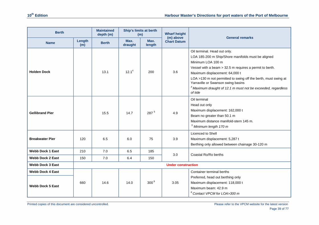
10th Edition Harbour Master’s Directions for port waters of the Port of Melbourne
Printed copies of this document are considered uncontrolled. Please refer to the VPCM website for the latest version Page 39 of 77
Berth Maintained depth (m)
Ship’s limits at berth (m) Wharf height
(m) above Chart Datum
General remarks Name Length
(m) Berth Max. draught
Max. length
Holden Dock 13.1 12.14 200 3.6
Oil terminal. Head out only. LOA 185-200 m Ship/Shore manifolds must be aligned Minimum LOA 100 m Vessel with a beam > 32.5 m requires a permit to berth. Maximum displacement: 64,000 t LOA >130 m not permitted to swing off the berth, must swing at Yarraville or Swanson swing basins 4 Maximum draught of 12.1 m must not be exceeded, regardless of tide
Gellibrand Pier 15.5 14.7 287 5 4.9
Oil terminal Head out only Maximum displacement: 162,000 t Beam no greater than 50.1 m Maximum distance manifold-stern 145 m. 5 Minimum length 170 m
Breakwater Pier 120 6.5 6.0 75 3.9 Licenced to Shell Maximum displacement: 5,287 t Berthing only allowed between chainage 30-120 m
Webb Dock 1 East 210 7.0 6.5 185 3.0 Coastal Ro/Ro berths
Webb Dock 2 East 150 7.0 6.4 150
Webb Dock 3 East Under construction
Webb Dock 4 East
660 14.6 14.0 300 6 3.05
Container terminal berths Preferred, head out berthing only Maximum displacement: 118,000 t Maximum beam: 42.9 m 6 Contact VPCM for LOA>300 m
Webb Dock 5 East

10th Edition Harbour Master’s Directions for port waters of the Port of Melbourne
Printed copies of this document are considered uncontrolled. Please refer to the VPCM website for the latest version Page 40 of 77
Berth Maintained depth (m)
Ship’s limits at berth (m) Wharf height
(m) above Chart Datum
General remarks Name Length
(m) Berth Max. draught
Max. length
Webb Dock 1 West
890 12.4 11.8 265 3.4 Ro/Ro car terminal berths Maximum displacement 60,000 t
Webb Dock 2 West
Webb Dock 3 West
Station Pier Inner East 220 10.9 10.3 195 3.4 Bass Strait ferry terminal
Station Pier Outer East 223 10.9 10.3 240 7 3.4
Cruise ship terminal Berthing also subject to passenger capacity and security requirements 7 Vessels with LOA >240 m may be accommodated on request
Station Pier Inner West 95 8.8 8.2 105 8 3.4
Cruise ship terminal Berthing also subject to passenger capacity and security requirements 8 Vessels with LOA >105 m may be accommodated on request
Station Pier Outer West 400 10.9 10.3 345 9 3.4
Cruise ship terminal Berthing also subject to passenger capacity and security requirements 9 Vessels with LOA>345 m may be accommodated on request

10th Edition Harbour Master’s Directions for port waters of the Port of Melbourne
Printed copies of this document are considered uncontrolled. Please refer to the VPCM website for the latest version Page 41 of 77
3.16 Swinging basins Table 3(k) Swinging basin dimensions
Swinging basin dimensions
Swinging basin Diameter (m) Maintained depth (m) Max draught at zero tide (m)
Appleton 366 2 14.6 14.0
Swanson 342 14.6 14.0
Yarraville 274 3 11.04 10.4
Station Pier 450 1 10.9 10.3
Gellibrand 396 14.64 14.0
Webb 450 (NW-SE axis) 420 (NE-SW axis)
14.64 14.0
Channel Junction (Port Melbourne and Williamston Channels)
420 10.94 10.3
1 When Station Pier Outer West berth is occupied this diameter is reduced
2 Swinging basin diameter is reduced when vessels occupy berths at Appleton Dock/South Wharf
3 Swinging basin diameter is reduced when vessels occupy berths at Yarraville
4 Part of the swinging basin lies in deeper water; this is the minimum depth of the swing circle taken as a whole
3.17 Ships at berths
3.17.1 General requirements
The master of a vessel must ensure the vessel is appropriately and effectively secured to the berth and that the vessel’s moorings are tended at frequent intervals to prevent vessel movement in all weather conditions.
In addition, the master of a berthed vessel must:
ensure that the ship or shore gangways are positioned correctly, and adequately tended for the duration of the vessel’s stay in port
ensure that the vessel remains afloat while alongside a berth
immediately notify Melbourne VTS if mooring lines part
obtain clearance from Melbourne VTS to change the vessel’s position on the berth
monitor weather conditions and forecasts throughout the vessel’s stay.
3.17.2 Testing propulsion units alongside a berth
The master of a vessel must:
obtain clearance from Melbourne VTS to allow a propeller to be worked, other than for testing the engines before departure
notify the masters of vessels at adjacent berths of the intention to work the propeller
before testing, visually confirm the waters are clear of all persons and any obstructions such as work pontoons or other small craft.

10th Edition Harbour Master’s Directions for port waters of the Port of Melbourne
Printed copies of this document are considered uncontrolled. Please refer to the VPCM website for the latest version Page 42 of 77
3.17.3 Precautions to be taken at container terminals with regard to portainer cranes
To minimise the risk associated with the berthing or unberthing of a vessel at a berth with portainer cranes, the following requirements have been established to assist terminal operators in planning the safe placement and management of portainer cranes.
At Swanson Dock and Webb Dock for vessels of LOA less than 250 m:
a minimum distance of 20 m ahead or astern must be maintained at all times between the closest portainer crane leg and the bow and stern of the arriving/departing vessel
a maximum of 2 portainer cranes may, at times, be positioned in way of the parallel body of the vessel, alongside each other, as close as possible amidships and with a minimum 30 m clearance from the nearest crane leg to the vessel’s accommodation.
At Swanson Dock and Webb Dock for vessels of LOA of 250 m and greater:
a minimum distance of 20 m ahead/astern must be maintained at all times between the nearest portainer crane leg and the bow and stern of an arriving/departing vessel
a maximum of 3 portainer cranes may, at times, be positioned in way of the parallel body of the vessel, alongside each other, as close as possible amidships and with a minimum 30 m clearance from the nearest crane leg to the vessel’s accommodation.
When the terminal is unable to comply with any of the above requirements this must be reported to Melbourne VTS as soon as possible before any scheduled vessel movements that may be affected. Melbourne VTS, in consultation with the vessel’s master, will then determine whether:
additional tug assistance is required to assist berthing or unberthing (the movement will then be subject to tug availability)
the vessel can proceed to or from the berth
berth marks are adjusted accordingly
berthing is aborted and the vessel proceeds to the anchorage
departure is aborted and the vessel remains alongside.
Portainer cranes must not be traversed along the wharf while vessels are berthing or unberthing.
When portainer booms are lowered for maintenance/repair, Melbourne VTS must be advised as soon as possible and provided with the chainage position of the crane legs. In such situations, movements may be delayed should additional tugs be required. Movements at West Webb may also be impacted when portainers are in the lowered position at East Webb.
When in the lowered position over open water (i.e. with no vessel at the berth), no personnel should be anywhere on a portainer boom when a vessel is passing.
When portainer booms are lowered for maintenance/repair they must remain adequately lit during the hours of darkness.
When not being used for cargo operations or lowered for maintenance/repair, portainer booms must always be stowed in the raised position.

10th Edition Harbour Master’s Directions for port waters of the Port of Melbourne
Printed copies of this document are considered uncontrolled. Please refer to the VPCM website for the latest version Page 43 of 77
3.17.4 Minimum clearance between berthed vessels
For safety and operational reasons, minimum clearances between berthed vessels apply as follows:
At Swanson Dock East and Swanson Dock West: 22 m
Webb Dock East (berths 4 and 5): 30 m
At all other berths: 15 m
If a vessel is using a stern ramp, the minimum clearance is to be measured from where the outboard edge of the lowered ramp crosses the wharf face.
Note that these are minimum clearances and there may be occasions when the separation between vessels needs to be increased due to such factors as the arrangement of mooring lines leading from vessel to wharf, the availability and disposition of bollards, the presence of shore-side infrastructure such as container cranes, or to facilitate cargo operations.
3.17.5 Topping of portainer booms/ship’s cranes
Before arriving at or departing from a container terminal, the master may require portainer crane boom(s) to be raised or the jibs of ships’ cranes on vessels at other berths be topped/swung clear of the dock. The master should advise Melbourne VTS which, in turn, will request the operator of the relevant terminal either to raise the portainer crane boom(s) or ask the vessel’s crew to reposition the ship’s crane(s). The request must be made in adequate time, to allow for its implementation.
3.17.6 Safe access for mooring gangs
Terminal operators must also ensure that mooring gangs have safe access to and from the berth and that the areas in proximity to bollards, mooring hooks and capstans are clear of obstructions and adequately illuminated.
3.17.7 Swanson Dock – restriction on the movement of vessels with beam >32.5 m
If a vessel with a beam >32.5 m moored on one side of Swanson Dock overlaps any part of a vessel with a beam >32.5 m moored on the opposite side of Swanson Dock, no other vessel with a beam >32.5 m is permitted to pass between the 2 moored vessels.
3.17.8 Swanson Dock – the southernmost 50 m at West Swanson to be unoccupied for arriving vessels with LOA ≥ 290 m
When a vessel with an LOA of 290 m or greater is to berth at Swanson Dock, the southernmost 50 m of the berth at Swanson Dock 1 West should be unoccupied.
If it is not, the arriving vessel must be advised (Melbourne VTS to provide the chainage of the vessel occupying the berth) in sufficient time to allow the master to undertake an appropriate risk assessment and so decide whether:
the vessel will berth as planned
the vessel will berth subject to the application of additional risk control measures
the vessel’s berthing will be delayed until such time as the southernmost 50 m is unoccupied.

10th Edition Harbour Master’s Directions for port waters of the Port of Melbourne
Printed copies of this document are considered uncontrolled. Please refer to the VPCM website for the latest version Page 44 of 77
3.17.9 Webb Dock West – use of storm bollards
When winds are forecast to be 30 kt (steady) or above from the south-west through to west, a car carrier moored alongside any of the berths at West Webb must make use of the storm bollards provided, otherwise a tug will be mandated to standby the vessel for the expected duration of strong winds.
3.17.10 Holden Dock – minimum mooring requirements
To counteract the surge effect caused by vessels transiting the Yarra River, vessels berthed at Holden Dock must comply with the following mooring requirements:
Vessel with LOA equal to or less than 140 m, with mooring lines of any type:
2 head and 2 stern lines
2 breast lines at each end
2 spring lines at each end
Vessel with LOA greater than 140 m, with mooring lines of wire or high modulus synthetic fibre (HMPE/HMSF), e.g. Dyneema.
2 head and 2 stern lines
2 breast lines at each end
2 spring lines at each end
Vessel with LOA greater than 140 m, with synthetic fibre lines such as Nylon, Polyester and Polypropylene
2 head and 2 stern lines
2 breast lines at each end
3 spring lines at each end or 1 spring plus 1 spring on the bight at each end with the eye on the bitts.
All mooring lines must pass through the mooring leads directly in front of the winch.
All spring lines must be on a winch, not turned up on bitts.
Sharing a load between lines of the same type and size but of different lengths is undesirable.
To avoid potential damage to cargo transfer equipment, shore gangway and gangway tower, moorings are to be frequently monitored and carefully tended throughout the vessel’s time alongside and particularly prior to the passing of other vessels.
3.17.11 Holden Dock – maximum draught and minimum under keel clearance
The maximum permissible draught for a vessel berthed at the Holden Dock terminal is 12.1 m. This maximum must not be exceeded at any time, even with tidal assistance.
A vessel manoeuvring alongside Holden Dock must maintain a minimum under keel clearance of 1.0 m.
3.17.12 Station Pier – use of shore gangways for cruise vessels
Shore gangways will be disconnected by the port gangway attendant if the vessel’s crew/safety officer or the gangway attendant considers there is a risk of damage to the gangway due to the vessel surging or moving away from the berth.

10th Edition Harbour Master’s Directions for port waters of the Port of Melbourne
Printed copies of this document are considered uncontrolled. Please refer to the VPCM website for the latest version Page 45 of 77
The gangway will be reconnected once all the risks are mitigated and it is declared safe to do so by both the gangway attendant and the vessel’s safety officer.
3.18 Ship’s telephone number
The master or the shipping agent should ensure that arrangements are made to supply the vessel with an Australian service mobile phone for the duration of the vessel’s stay in port and that the telephone number is inserted in PortVIEW.
3.19 Securing of cargo prior to departure
All cargo must be secured to the master’s satisfaction, and in compliance with the requirements of Marine Order 42, before the vessel departs the berth.
Melbourne VTS will not grant permission for the lashing of cargo to be completed while the vessel is transiting Port Phillip Bay.
If lashing is still ongoing at the scheduled time of departure the vessel will not be given clearance to depart and it must remain alongside until all cargo securing is completed.
3.20 Navigation bridge visibility
SOLAS Regulation 22 of Chapter V stipulates minimum requirements regarding Navigation Bridge Visibility. It is the master’s responsibility to ensure these minimum requirements are maintained.
If, due to the design of the vessel or the stowage of cargo, these requirements cannot be met, the Harbour Master may declare the vessel a ‘hampered vessel’ and/or require additional measures to be implemented to ensure the safe transit of the vessel through port waters. Such additional measures may include the posting of extra lookouts forward or on the monkey island, the provision of a second pilot, a daylight-only transit, the presence of an escort vessel or a reduction in stern trim through re-ballasting.
If the master of a vessel is aware that navigation bridge visibility is restricted, Melbourne VTS must be notified of the situation at least 24 hours before the start of the vessel’s transit of the port or, if this is not possible, as soon as the master is made aware that the vessel will be unable to comply with the requirements of SOLAS V/22.
This SOLAS regulation is given effect in Australian Waters through Marine Order 21 (Safety and emergency arrangements), 2016.
3.21 Limiting wind speeds for berthing/unberthing manoeuvres
The master of a vessel must ensure that a berthing or unberthing manoeuvre, with or without tug assistance, does not start if the prevailing steady wind and/or wind gusts exceed the Wind Limits as contained in Table 3(l).
3.22 Towage and minimum requirements
Tugs must be ordered to meet the towage and minimum tug requirements listed in this section - see Table 3(l) - unless the master requests tugs additional to those identified. Masters of vessels on inward transits must discuss with the pilot the tug requirements for departure.
The ship’s nominated towage provider will be responsible for providing the required number of tugs and advising Melbourne VTS of the name(s) of tug(s) allocated.

10th Edition Harbour Master’s Directions for port waters of the Port of Melbourne
Printed copies of this document are considered uncontrolled. Please refer to the VPCM website for the latest version Page 46 of 77
Additional tugs may be requested by the master:
on an inbound vessel:
by advising Lonsdale VTS at Port Philip Heads
on an outbound vessel or a vessel arriving from an anchorage:
by advising Melbourne VTS of requirements at least 2 hours before the vessel’s departure from the berth/anchorage.
If a vessel experiences main engine, thruster or steering failure while transiting port waters of the Port of Melbourne, that vessel must be attended by 1 tug in addition to the minimum requirements, to a maximum of 2 tugs under normal weather conditions, for the vessel’s next transit.
This condition may be extended to cover further transits if determined necessary by the Harbour Master.
If the ‘next transit’ does not occur within 6 months of the original equipment failure this condition will lapse.
Tugs required to attend a vessel with main engine, thruster or steering failure:
inbound vessel, must attend until berthing is completed or
outbound vessel, at least 1 tug must attend until the vessel has cleared Breakwater and
subject to the particular circumstances, as determined by the master, 1 tug should be secured to the ship through the centre lead aft.
Ordered tugs must meet a vessel inward bound for:
berths upstream of West Gate Bridge, in the vicinity of Yarra River Channel Beacons 25 and 26
Station Pier, in the vicinity of Port Melbourne Channel Beacon 70
other Hobsons Bay berths, in the vicinity of Port Melbourne Channel Beacons 11 and 12
One or more tugs may be required to meet arriving vessels considered to have higher operational requirements, as determined by the Harbour Master or the ship’s master, before the locations identified above.
Towage requirements for all movements will be subject to a risk assessment conducted by the master and, if one has been engaged, the pilot, but in any event will not be less than those specified in Table 3(l).
The minimum towage requirements are contained in the Table 3(l) and are based on tugs complying with at least Tier 2 standard (as defined in the Towage Requirements Determination), except where Tier 1 is mandated within the table.

10th Edition Harbour Master’s Directions for port waters of the Port of Melbourne
Printed copies of this document are considered uncontrolled. Please refer to the VPCM website for the latest version Page 47 of 77
Table 3(l) Minimum towage requirements and wind limits (to be read in conjunction with accompanying Notes)
Towage category Number of tugs
Bow thruster able to
count as 1 tug
Stern thruster or twin
independent/high performance rudder able to count as 1 tug
‘Clear berth ahead’ (CBA) able to count
as 1 tug for head out departure
Wind limits (referenced to nearest available wind gauge)
Additional remarks
Car carriers: Webb Dock
2 1
(See Notes below on Stern Thruster
& Rudders)
(provided
LOA <270 m and steady wind <15 kt)
3 West not CBA Steady wind >20 kt or gusts >25 kt: movements suspended
When the winds are forecast to be 30 kt (steady) or above from the south-west through to west, the storm bollards provided at the berth must be used or a tug will be mandated to standby the vessel for the expected duration of strong winds.
Car Carriers: Appleton Dock
2
(See Notes below on Stern Thruster
& Rudders)
(provided
LOA <270 m and steady wind <15 kt)
During periods when the wind is from the north through to west and forecast to be greater than 30 kt, the master should order a tug to standby to assist in keeping the vessel safely alongside the berth. This can be arranged through the ship’s agent or by contacting Melbourne VTS.
Large tankers: Gellibrand Pier (displacement >70,000 t)
Arrival: 3 2 Departure: 2 1
Steady wind >25 kt: movements suspended
Large tanker = vessel with LOA >260 m and beam >45 m Large tankers:
Gellibrand Pier (displacement <70,000 t)
2 1
Other than large tanker: Gellibrand Pier (displacement <100,000 t)
2 3
(See Notes below on Stern Thruster
& Rudders)
(provided
LOA <200 m)
Steady wind >30 kt or gusts >35 kt: movements suspended
1 Tier 1 tugs only 4 Tier 1 tugs only if steady wind exceeds 20 kt
2 At least 2 x Tier 1 tugs 5 Tier 1 tugs only if beam >34 m
3 For arrival, Tier 1 tugs only if displacement >70,000 t 6 One less tug if departing head out

10th Edition Harbour Master’s Directions for port waters of the Port of Melbourne
Printed copies of this document are considered uncontrolled. Please refer to the VPCM website for the latest version Page 48 of 77
Towage category Number of tugs
Bow thruster able to
count as 1 tug
Stern thruster or twin
independent/high performance rudder able to count as 1 tug
‘Clear berth ahead’ (CBA) able to count
as 1 tug for head out departure
Wind limits (referenced to nearest available wind gauge)
Additional remarks
Other than large tanker: Gellibrand Pier (displacement >100,000 t)
Arrival: 3 2 Departure: 2 1
Steady wind >30 kt or gusts >35 kt: movements suspended
Container vessels Swanson Dock & Webb Dock: LOA >130 m to <200 m
2 5 East Webb not CBA
Steady wind >30 kt or gusts >35 kt: movements suspended
Container vessels Swanson Dock & Webb Dock: LOA >200 m to <250 m
2 5 East Webb not CBA
Container vessels Swanson Dock & Webb Dock: LOA >250 m to <290 m
2
Container vessels Swanson Dock & Webb Dock: LOA >290 m to <295 m
2 4,5
Vessel’s beam ≤34 m: movements suspended when steady wind >25 kt. Vessel’s beam >34 m: movements suspended when steady wind >20 kt.
Berthing of vessels with an LOA >300 m at Swanson Dock and Webb Dock is subject to prior written permission from the Harbour Master.
Swanson Dock and Webb Dock: LOA >295 m to <300 m
2 1 Steady wind >20 kt: movements suspended
1 Tier 1 tugs only 4 Tier 1 tugs only if steady wind exceeds 20 kt
2 At least 2 x Tier 1 tugs 5 Tier 1 tugs only if beam >34 m
3 For arrival, Tier 1 tugs only if displacement >70,000 t 6 One less tug if departing head out

10th Edition Harbour Master’s Directions for port waters of the Port of Melbourne
Printed copies of this document are considered uncontrolled. Please refer to the VPCM website for the latest version Page 49 of 77
Towage category Number of tugs
Bow thruster able to
count as 1 tug
Stern thruster or twin
independent/high performance rudder able to count as 1 tug
‘Clear berth ahead’ (CBA) able to count
as 1 tug for head out departure
Wind limits (referenced to nearest available wind gauge)
Additional remarks
Cruise vessels 2
(all lengths)
(all lengths)
Steady wind >20 kt and gusts >25 kt: movement subject to specific risk assessment between master and pilot.
A movement must not commence if the steady wind >35 kt.
Coastals with pilot exempt master: at dedicated berths 1 & 2 Webb Dock East, Station Pier, & South Wharf
0 Steady wind >30 kt or gusts >35 kt: movement subject to risk assessment carried out by the master.
Vessel must be appropriately equipped to the satisfaction of the Harbour Master to allow berthing/unberthing operations to be safely undertaken without the assistance of tugs.
General minimum towage requirements (for all berths and vessel types not specified elsewhere in this table)
LOA 100 m to <130 m 1 6 N/A
Steady wind > 30 kt or gusts > 35 kt: movements suspended
LOA >130 m to <250 m 2
See Notes for excluded/conditional
berths
Nil tug required for all head out departures from 24 Victoria Dock, all Appleton Dock berths (provided there is a clear berth ahead), 6 Yarraville, and Station Pier (Outer berths).
LOA >250 m to <270 m 2
See Notes for excluded/conditional
berths
A Stern Thruster/High Performance Rudder is only equivalent to 1 tug if the vessel is departing, is head out and the wind is <15 kt.
1 Tier 1 tugs only 4 Tier 1 tugs only if steady wind exceeds 20 kt
2 At least 2 x Tier 1 tugs 5 Tier 1 tugs only if beam >34 m
3 For arrival, Tier 1 tugs only if displacement >70,000 t 6 One less tug if departing head out

10th Edition Harbour Master’s Directions for port waters of the Port of Melbourne
Printed copies of this document are considered uncontrolled. Please refer to the VPCM website for the latest version Page 50 of 77
3.22.1 Notes on the minimum towage table
The towage table has been developed by VPCM in consultation with port stakeholders and incorporates the results of extensive ship handling simulations conducted at the Australian Maritime College.
Port requirements: The table contains the Port Requirements (PR) for towage in standard conditions (based on winds of up to 15 kt and vessel not hampered in its ability to manoeuvre). Tug requirements for other than standard conditions will be subject to a risk assessment by the master of the vessel and the Port Phillip Sea Pilots, provided that any such assessment shall not result in a lowering of the minimum requirements stipulated in the towage table.
In prevailing steady winds greater than 35 kt all berthing and unberthing movements will be suspended, except for coastal vessels.
LOA means length overall.
Wind gauges: Masters and pilots must use wind speed readings from VPCM wind gauges and take into account prevailing weather forecasts to determine compliance with Harbour Master’s Directions, referencing the nearest available wind gauge appropriate to the planned manoeuvre.
Tugs: Tier 1 and Tier 2 tugs as defined in the Towage Requirements Determination:
A Tier 1 towage vessel must be less than 30 m in length, be low profile, have azimuth stern drive or equivalent, be fitted with an Automatic Identification System and have a minimum certified bollard pull of (within a range of 5%) 65 t.
A Tier 2 towage vessel must be less than 35 m in length, have azimuth stern drive or equivalent, be fitted with an Automatic Identification System and have a certified bollard pull of 43 t or more.
SWL of bitts: It is important that the master‐pilot exchange includes the Safe Working Load (SWL) of the vessel’s equipment used for towing and that this information is then passed on to attending tugs, as it is now common for tugs to have a bollard pull capacity in excess of the rated SWL of the ship’s bitts.
Thrusters: For a thruster to be considered equivalent to 1 tug it must be ‘effective’. An effective thruster is one which is fully operational, sufficiently immersed and adequately powered relative to the ship’s size and the prevailing weather conditions. For example, thrusters on a common hydraulic line with deck machinery are known to be significantly affected when winches are operated and, therefore, in this situation it is unlikely the vessel would be able to comply with the ‘efficient thruster’ requirement.
Effective bow thruster: can be considered equivalent to 1 tug as indicted in the table above.
Effective stern thruster: can be considered equivalent to 1 tug (as indicted in the table) for the following:
Cruise vessels, all lengths
Container vessel movements at Swanson and Webb Docks, for vessels with an LOA <200 m
All other vessels, LOA <250 m
For vessels with LOA >250 m to <290 m this dispensation only applies to departures: the vessel must be head out and the wind <15 kt (excludes: container vessels at Swanson and Webb Docks, and large tankers)

10th Edition Harbour Master’s Directions for port waters of the Port of Melbourne
Printed copies of this document are considered uncontrolled. Please refer to the VPCM website for the latest version Page 51 of 77
Rudders: twin independent or high performance rudders, such as Becker and Schilling designs, can be considered equivalent to 1 tug (as indicted in the table) for the following:
Cruise vessels, all lengths
Container vessel movements at Swanson and Webb Docks, LOA <200 m
All other vessels, LOA <250 m
For vessels with LOA >250 m to <290 m this dispensation only applies to departures: the vessel must be head out and the wind <15 kt (excludes: large tankers; and container vessel departures from Swanson and Webb Docks)
Clear berth ahead (CBA) applies to vessels with an LOA <270 m (except for cruise vessels for whom the LOA is unrestricted, and container vessels at Swanson and Webb Docks where the LOA must be <250 m) departing head out, and is considered the equivalent of 1 tug.
A vessel has a clear berth ahead when the unoccupied length of berth or clear channel/waterway immediately ahead of the departing vessel is not less than the vessel’s LOA (apart from the exceptions listed below).
A berth is considered clear ahead even if occupied by floating plant, provided such plant has a beam <8 m and is located >50 m clear of the departing vessel.
Clear berth ahead is conditional for:
Maribyrnong No. 1: only applies if 5 Yarraville is either vacant or occupied by a vessel with a beam <28.6 m
Gellibrand Pier: only applies for vessels with an LOA <200 m
Holden Dock: the old berth immediately downstream must be clear
5 Yarraville: only applies if 6 Yarraville is clear
26 South Wharf: only applies if 27 South Wharf is clear.
For clarification, clear berth ahead does apply (provided the relevant LOA limit is not exceeded)) at:
1 East and 1 West Swanson Dock
Outer East and Outer West Station Pier
29 South Wharf. Clear berth ahead does not apply:
at 5 Webb Dock East
at 3 Webb Dock West
at 33 South Wharf
if portainers cannot be positioned in accordance with HMD 3.17.3.
3.23 Lines boat requirements
Table 3(m) identifies minimum lines boat requirements which must be adhered to by the vessel’s master/shipping agent when ordering lines boats.

10th Edition Harbour Master’s Directions for port waters of the Port of Melbourne
Printed copies of this document are considered uncontrolled. Please refer to the VPCM website for the latest version Page 52 of 77
Table 3(m) Lines boat requirements Arrivals Requirements
All vessels mooring at Gellibrand Pier, Holden Dock, and Maribyrnong No. 1 2 lines boats
All vessels mooring at South Wharf 26 and 33. 1 lines boat
All vessels mooring within 20 m of the outer end of the berth at Swanson Dock East 1
All vessels berthing at Yarraville 5 and 6 when using bollards off the wharf at which the vessel is berthed
Vessels berthing at Swanson Dock East 3 with the stern or stem beyond the 860 m mark. Vessels berthing at Swanson Dock West 3 with the stern or stem beyond the 915 m mark
1 lines boat
Warping along a wharf over a distance greater than 100 m (see HMD 3.24.1) 1 lines boat
For ships of more than 220 m LOA, vehicle carriers, and container vessels with a beam of 40 m or more not identified in the table, shipping agents are strongly advised to:
consult with the ship’s master
consider the ship’s design, size, type of mooring lines and proposed position on the berth
consider the requirements of the contracted mooring service provider before deciding whether a lines boat is required or not.
3.24 Shifting ship
If at any time during a shifting operation the vessel will be underway, standard pilotage and minimum towage requirements will apply.
To determine the minimum towage requirements the movement from the original location should be considered a ‘departure’ and manoeuvring at the second location an ‘arrival’.
3.24.1 Warping
A vessel may be warped along a straight line wharf for a distance of up to 200 m without the need for tugs or a pilot but such a movement must comply with the following provisions:
The master must be proficient in the English language to allow effective communication with the mooring gang.
A mooring gang must attend the shift.
If the distance of the shift is more than 100 m a lines boat must also attend.
A minimum of 1 head line and 1 stern line must remain fast at all times throughout the shifting operation.
If the master requires a tug to assist, then a pilot must also be engaged.
The master must consider the following when determining whether warping is an appropriate option for shifting ship:
Type of mooring lines in use
Weather conditions
Potential language issues
Possible time constraints
The vessel’s master or agent must advise the terminal operator of the intention to warp the ship along the wharf so that potential obstructions such as portainer cranes, gantry loaders

10th Edition Harbour Master’s Directions for port waters of the Port of Melbourne
Printed copies of this document are considered uncontrolled. Please refer to the VPCM website for the latest version Page 53 of 77
and other shore installations are not at risk of damage and can be moved if likely to create a hazard for the mooring gang.
Before warping, the master must obtain clearance from Melbourne VTS.
Melbourne VTS will advise the master the VHF channel to use when communicating with the mooring gang.
A vessel is not permitted to warp along the wharf if the planned distance of the shift is greater than 200 m.
3.24.2 Dead ship movements
Management of dead ship movements will be subject to a risk assessment by the Harbour Master, Port Phillip Sea Pilots and the towage provider.
3.25 Restricted visibility
All vessels transiting port waters of the Port of Melbourne shall proceed in accordance with Rule (19) of the International Regulations for Preventing Collision at Sea.
Overtaking is not allowed in any designated shipping channel. Overtaking in open water is permitted subject to the prior agreement between the masters of the vessels involved.
All vessels proceeding in the same direction shall maintain a minimum 2 nautical mile separation from the vessel ahead, unless overtaking.
3.25.1 Lonsdale VTS sector
Inbound tankers, hampered vessels, vessels constrained to the Great Ship Channel (which includes all DUKC vessels) and vessels that have requested a one-way transit shall not enter the Fairway Through Port Phillip Heads when visibility at the Heads is less than 2 nautical miles.
Vessels other than those listed above may transit the Heads during periods of restricted visibility but the passing of another vessel with an LOA of 50 m or greater in the Fairway Through Port Phillip Heads is not permitted at such times and vessels must abide by the following restricted visibility protocols.
Transits of the Fairway Through Port Phillip Heads - outbound vessels will have priority.
Transits of the South Channel Cut - inbound vessels will have priority.
An outbound vessel:
shall, if necessary, adjust its time of passing the Hovell Pile to ensure that it does not pass an inbound vessel between Hovell Pile and South Channel Beacon 12
if conditions are considered unsafe for transiting the Heads, may, depending on draught, proceed to the Quarantine Anchorage or Queenscliff Anchorage until visibility improves.
3.25.2 Melbourne VTS sector
Vessels inbound to Melbourne shall not proceed past a safe abort point* unless visibility is greater than 0.5 nautical mile for the entire transit.
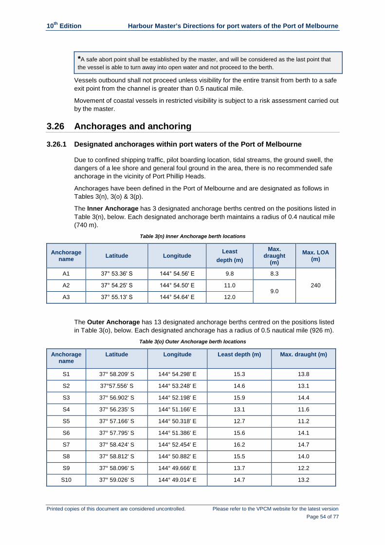
10th Edition Harbour Master’s Directions for port waters of the Port of Melbourne
Printed copies of this document are considered uncontrolled. Please refer to the VPCM website for the latest version Page 54 of 77
*A safe abort point shall be established by the master, and will be considered as the last point that the vessel is able to turn away into open water and not proceed to the berth.
Vessels outbound shall not proceed unless visibility for the entire transit from berth to a safe exit point from the channel is greater than 0.5 nautical mile.
Movement of coastal vessels in restricted visibility is subject to a risk assessment carried out by the master.
3.26 Anchorages and anchoring
3.26.1 Designated anchorages within port waters of the Port of Melbourne
Due to confined shipping traffic, pilot boarding location, tidal streams, the ground swell, the dangers of a lee shore and general foul ground in the area, there is no recommended safe anchorage in the vicinity of Port Phillip Heads.
Anchorages have been defined in the Port of Melbourne and are designated as follows in Tables 3(n), 3(o) & 3(p).
The Inner Anchorage has 3 designated anchorage berths centred on the positions listed in Table 3(n), below. Each designated anchorage berth maintains a radius of 0.4 nautical mile (740 m).
Table 3(n) Inner Anchorage berth locations
Anchorage name Latitude Longitude
Least depth (m)
Max. draught
(m) Max. LOA
(m)
A1 37° 53.36ʹ S 144° 54.56ʹ E 9.8 8.3
240 A2 37° 54.25ʹ S 144° 54.50ʹ E 11.0 9.0
A3 37° 55.13ʹ S 144° 54.64ʹ E 12.0
The Outer Anchorage has 13 designated anchorage berths centred on the positions listed in Table 3(o), below. Each designated anchorage has a radius of 0.5 nautical mile (926 m).
Table 3(o) Outer Anchorage berth locations
Anchorage name
Latitude Longitude Least depth (m) Max. draught (m)
S1 37° 58.209' S 144° 54.298' E 15.3 13.8
S2 37°57.556' S 144° 53.248' E 14.6 13.1
S3 37° 56.902' S 144° 52.198' E 15.9 14.4
S4 37° 56.235' S 144° 51.166' E 13.1 11.6
S5 37° 57.166' S 144° 50.318' E 12.7 11.2
S6 37° 57.795' S 144° 51.386' E 15.6 14.1
S7 37° 58.424' S 144° 52.454' E 16.2 14.7
S8 37° 58.812' S 144° 50.882' E 15.5 14.0
S9 37° 58.096' S 144° 49.666' E 13.7 12.2
S10 37° 59.026' S 144° 49.014' E 14.7 13.2

10th Edition Harbour Master’s Directions for port waters of the Port of Melbourne
Printed copies of this document are considered uncontrolled. Please refer to the VPCM website for the latest version Page 55 of 77
Anchorage name
Latitude Longitude Least depth (m) Max. draught (m)
S11 37° 59.742' S 144° 50.230' E 16.9 14.71
S12 38° 00.672' S 144° 49.578' E 16.8 14.71
S13 37° 59.955' S 144° 48.362' E 14.7 13.2
G1 38° 01.601' S 144° 48.926' E 15.3 13.8
G2 38° 01.815' S 144° 47.057' E 15.3 13.8
G3 38° 02.531' S 144° 48.273' E 17.2 14.71
G4 38° 02.744' S 144° 46.404' E 15.3 13.8 1 Max draught governed by max draught that may be permitted to operate in port waters subject to HMD 3.10
Table 3(p) Other anchorages
Anchorage name Latitude Longitude Max. LOA (m)
Hobsons Bay Anchorage 37° 51.75ʹ S 144° 55.50ʹ E 100
Quarantine Anchorage 38° 18.21ʹ S 144° 41.75ʹ E -
Shortland Bluff Anchorage 38° 16.43ʹ S 144° 40.30ʹ E -
3.26.2 Anchoring
The master of a vessel which is anchored within port waters of the Port of Melbourne must ensure that:
permission is sought from the VTS before anchoring
if the vessel’s LOA is >50 m, that it anchors in a designated anchorage and as close to the centre of the anchor circle as possible
sufficient cable is paid out, having regard to the holding ground, depth of water, the prevailing and forecast weather conditions
Melbourne VTS or Lonsdale VTS is notified of the time and position of anchoring and when the vessel is brought up,
permission is obtained from Melbourne VTS or Lonsdale VTS to immobilise main engines
the vessel does not change its position without clearance from Melbourne VTS or Lonsdale VTS
Melbourne VTS or Lonsdale VTS is notified immediately if the vessel parts from its anchor or drags from its anchoring position
the vessel is not allowed to drag an anchor cable over:
a cable or other subsurface service
the underwater gas pipeline between Mordialloc and Altona.
at least 1 competent person is on watch at all times to ensure security and safety
the vessel is capable of being safely moved and navigated at all times
sufficient crew or other competent persons are readily available to comply with any directions given by the Harbour Master for the removal or shifting of the vessel and, so far as reasonably practicable, can deal with any emergency that may arise
permission to vary these requirements is obtained from the Harbour Master

10th Edition Harbour Master’s Directions for port waters of the Port of Melbourne
Printed copies of this document are considered uncontrolled. Please refer to the VPCM website for the latest version Page 56 of 77
Unless the safety of the vessel is at imminent risk, the master of a vessel must:
not anchor:
within 0.5 nautical mile (approximately 900 m) of another vessel, or in a position which may endanger the safety of other vessels
within 0.1 nautical mile (approximately 200 m) from any wharf except for the purpose of swinging the vessel or immediately hauling alongside that wharf
within prohibited anchorage as delineated on charts Aus143, Aus144, Aus154, Aus155, and Aus158, or relevant official ENCs
in the Yarra River, between an imaginary line joining Beacons 33 and 34 and an imaginary line joining Beacons 35 and 36
in port waters of the Port of Melbourne, within 0.17 nautical mile (approximately 300 m) of where a cable or other subsurface service has been laid
within 0.8 nautical mile, (approximately 1500 m) of the underwater gas pipeline between Mordialloc and Altona, as delineated on chart Aus143 and Aus155, or relevant official ENCs
within any shipping fairway, channel and the Transit Only Zone (TOZ)
obtain the permission of the Harbour Master to allow:
the vessel to anchor or lie in any shipping fairway or channel
any cable, chain, hawser, rope or other obstruction across, through or above any shipping fairway or channel.
When imminent risk to the safety of the vessel has compelled a master of a vessel to anchor or allow the vessel to lie in any shipping fairway or channel, the master must:
immediately notify the position of the vessel to Melbourne VTS or Lonsdale VTS
as soon as possible, move the vessel to a place where it does not impede the safe passage of other vessels
immediately after the vessel has cleared the shipping fairway or channel, notify Melbourne VTS or Lonsdale VTS.
3.26.3 Permits required at anchor
Permits are required in the following circumstances:
To immobilise or conduct repairs for more than 12 hours (this is in addition to the notification required by HMD 3.7).
To carry out tank washing.
When carrying explosives.
When ship-to-ship transfer operations are to be carried out.
3.26.4 Tank cleaning or gas freeing at anchor
A vessel intending to engage in tank cleaning or gas freeing while at anchor must use one of the designated Outer Anchorage locations and:
document in full all operations to be carried out
comply fully with on board operational procedures
follow the requirements of the appropriate ICS and OCIMF guides, namely:
International Safety Guide for Oil Tankers and Terminals (ISGOTT)
10th Edition Harbour Master’s Directions for port waters of the Port of Melbourne
Printed copies of this document are considered uncontrolled. Please refer to the VPCM website for the latest version Page 57 of 77
Tanker Safety Guide (Chemicals)
Tanker Safety Guide (Liquefied Gases)
retain all tank washing slops on board the vessel.
3.26.5 Vessels equipped with dynamic position (DP) systems
The master of a vessel with dynamic positioning capability may elect to maintain position within a designated anchorage by means of its DP systems instead of using conventional ground tackle.
If this is the case and the master is not pilot exempt, the pilot may disembark once the vessel is in position provided the following conditions are satisfied:
Notification of the vessel’s intentions is given to, and express permission received from, the relevant VTS.
The vessel remains within the designated anchorage circle.
The master ensures compliance with the relevant requirements of HMD 3.26.2.
While at the Anchorage, the master of the vessel must also ensure that any attending vessels (e.g. pilot launch, bunker vessel, crew support vessel) are advised whenever DP equipment is in operation so that such vessels are not caught unawares by sudden fast moving water from thrusters as they make their approach.
3.27 Bunkering
When bunkering from a bunker vessel or road tanker all bunker transfers must comply with VPCM’s Bunker & (non-cargo) Liquid Transfer Management Guideline, which is available from the VPCM website.
The master of a vessel must ensure that bunkering operations are not carried out:
if weather conditions are not suitable
if the anchorage has not been approved for bunkering (Quarantine Anchorage).
3.27.1 Master of a bunker vessel to notify VTS
The master of a bunker vessel must:
seek clearance from Melbourne VTS before moving from one location to another within the port
if moving to bunker another vessel, notify Melbourne VTS of the following:
name of vessel to be bunkered
name of anchorage or berth where bunkering will take place
anticipated start and completion date and time
once alongside the vessel to be bunkered, notify Melbourne VTS before the start and on completion of bunkering operations.
10th Edition Harbour Master’s Directions for port waters of the Port of Melbourne
Printed copies of this document are considered uncontrolled. Please refer to the VPCM website for the latest version Page 58 of 77
3.27.2 In the event of a spill
If a bunker spillage occurs the following actions are to be implemented immediately and jointly by the master of the bunker vessel and the master of the vessel taking bunkers:
Cease bunkering operations.
Take measures to stop or limit the spillage.
Notify Melbourne VTS (VHF Channel 12).
3.27.3 Bunkering alongside a vessel at a river berth, Station Pier or Webb Dock
A bunker barge alongside a vessel at a river berth, Station Pier or Webb Dock must stop pumping when a vessel passes and, in certain circumstances (vessel size, manoeuvrability, weather conditions etc.), the master on board the passing vessel may require disconnection and/or removal of the bunker barge.
3.27.4 Bunkering alongside a vessel at Swanson Dock
To reduce the risk of interaction between vessels engaged in bunkering and vessels manoeuvring to or from a berth, a bunker vessel may not remain alongside a vessel in Swanson Dock if this will result in it being passed by another vessel.
3.28 Bulk liquid cargo ship to ship transfers
The master of a vessel in port waters of the Port of Melbourne must not allow a ship to ship transfer of bulk liquid cargoes, other than bunkering operations, to or from the vessel unless:
a written application is made to the Harbour Master and permission has been obtained including an authority to conduct the bulk liquid transfer
the ship is anchored at the Outer Anchorage, or is within a temporary restricted area declared by the Harbour Master for the planned transfer operation
the vessels involved in the operation are compatible
the vessels involved ensure the provision of appropriate fendering
pre-planning to cover navigational, operational and safety aspects is done between representatives of the Harbour Master, Port Phillip Sea Pilots and operators of both vessels
the requirements of the International Safety Guide for Oil Tankers and Terminals (ISGOTT), the Ship to Ship Transfer Guide (Petroleum), and VPCM’s Bulk Liquid Cargo Management Guidelines are followed
the receiving vessel is in all respects ready to load before coming alongside the other vessel
pre-washing and/or flushing of tanks is done once vessels are secured alongside each other
the language communication skills, along with the competence and experience of the crew, are acceptable.

10th Edition Harbour Master’s Directions for port waters of the Port of Melbourne
Printed copies of this document are considered uncontrolled. Please refer to the VPCM website for the latest version Page 59 of 77
3.29 The lowering/launching of survival craft and rescue boats
The requirements of this HMD apply to a vessel located anywhere within port waters of the Port of Melbourne, whether the vessel is underway or at anchor or berthed.
The master of a vessel intending to lower or launch survival craft or a rescue boat must:
contact Melbourne VTS on VHF Channel 12 to:
obtain permission to lower or launch a survival craft or rescue boat
notify when the survival craft/rescue boat has been recovered and secured on board
maintain a listening watch on VHF Channel 12 for VTS communications
remain in VHF contact with the survival craft/rescue boat at all times.
Additional requirement for a vessel not registered in Australia Prior to the launching of any survival craft/rescue boat, the master or the ship’s agent must first obtain permission from the Shipping Operations/Maritime Operations division in Australian Border Force by emailing [email protected]. Once permission has been granted by Australian Border Force, the master must then comply with the provisions of HMD 3.29.
3.30 Vessels licensed to carry passengers
3.30.1 In the event of an emergency
In the event of an emergency situation involving a vessel licensed to carry passengers, the operator of the vessel must be able to advise Melbourne VTS of the total number of people on board the vessel at that time.
3.30.2 Emergency contact number
The operator of a Domestic Commercial Vessel licensed to carry passengers is recommended to register a designated mobile telephone number with Melbourne VTS and the Water Police for emergency contact purposes.
3.30.3 Use of AIS
It is strongly recommended that Domestic Commercial Vessels licensed to carry passengers are fitted with AIS.
3.30.4 Entering Swanson Dock or Webb Dock
A vessel must not enter Swanson or Webb Docks without clearance from Melbourne VTS.
Notwithstanding the granting of clearance, the master of a vessel entering these docks while undertaking a port cruise with passengers on board must be mindful the vessel is entering a work area. The vessel must avoid passing under the lowered booms of portainers, even if there is no ship alongside the berth, and remain as close as practicable to the centreline of the dock.

10th Edition Harbour Master’s Directions for port waters of the Port of Melbourne
Printed copies of this document are considered uncontrolled. Please refer to the VPCM website for the latest version Page 60 of 77
3.31 Incident reporting
The master, owner, shipping agent, or person having the conduct of the navigation of a vessel in port waters of the Port of Melbourne must:
report an incident as soon as reasonably practicable to Melbourne VTS or Lonsdale VTS
thereafter, as soon as reasonably practicable, provide the Harbour Master with full details in writing
in the case of an obstruction, unless otherwise directed by the Harbour Master, take the necessary steps for its removal
complete AMSA Form 18 – Incident Alert and AMSA Form 19 – Incident Report and send to all relevant stakeholders.
Incidents which must be reported include those when a vessel:
has been involved in a collision with another vessel, a floating object, a fixed object, a submerged object or property
by reason of fire, explosion, capsizing, flooding, sinking, loss or presumed loss of vessel, loss of stability, structural failure, or any other defect or otherwise in such a condition as to affect its safe navigation or give rise to danger or damage to other vessel’s property
is at a quay which is on fire
has been involved in any incident or occurrence which causes or threatens contamination or pollution of the environment by any means or observes such an incident happening
has been involved in a grounding in any part of the port waters of the Port of Melbourne
has been involved in a close quarters situation
has experienced a failure of hull, machinery or navigational equipment
has been involved in the death of, or serious injury to, any person on board a vessel, or caused by a vessel
has had a person overboard
has caused or observed a vessel or any other object to strand, collide, sink, or cause damage to any vessel, wharf or property within port waters of the Port of Melbourne, or in any way obstruct the use of port waters of the Port of Melbourne
observes any other situation that has the potential to cause a near miss, accident, damage to property, personnel or equipment

10th Edition Harbour Master’s Directions for port waters of the Port of Melbourne
Printed copies of this document are considered uncontrolled. Please refer to the VPCM website for the latest version Page 61 of 77
4 Section 4: Non-recreational vessels with LOA < 50 m
4.1 Application
This section applies to:
Commercial vessels <50 m LOA
Port Working Vessels <50 m LOA
Volunteer Marine Rescue vessels <50 m LOA
Government vessels <50 m LOA
4.2 VTS participation
Vessels covered by this section are to maintain passive participation with the VTS.
The requirements of passive participation are:
comply with the requirements of Sections 2 and 4 of these Harbour Master’s Directions
maintain a continuous listening watch on the VTS working frequency, VHF Channel 12
respond immediately when hailed by the VTS and comply with any directions given
abide by the International Regulations for Preventing Collisions at Sea
observe all other practices of safe navigation and prudent seamanship
The Harbour Master may impose special conditions on vessels of less than 50 m LOA requiring enhanced levels of participation in VTS
4.3 Vessels with an LOA of 35 m or greater and less than 50 m, mandatory reporting requirements
4.3.1 Lonsdale VTS sector – inbound
The master of a vessel with an LOA of 35 m or greater but less than 50 m intending to enter port waters from seaward must contact Lonsdale VTS at least 2 hours before arrival at the pilot boarding ground (or port limits, if the master is pilot exempt) and provide the following information:
Name of the vessel.
Vessel’s maximum draught.
ETA at the pilot boarding ground (or port limits if the master is pilot exempt).
Any defects or circumstances that may hamper the vessel’s ability to manoeuvre.
When 3 nautical miles from Point Lonsdale the master must contact Lonsdale VTS and seek clearance to enter port waters and advise:
the vessel’s intended route, including the shipping channel to be used to transit the Heads
the vessel’s intended destination.
If the master does not intend to engage the services of a licensed pilot, the following additional information is required:

10th Edition Harbour Master’s Directions for port waters of the Port of Melbourne
Printed copies of this document are considered uncontrolled. Please refer to the VPCM website for the latest version Page 62 of 77
The name of the master.
Verbal confirmation that the master either has an applicable pilot exemption certificate or holds a valid Local Knowledge Certificate, applicable for the areas of port waters in which the vessel will be operating, issued by the Director of Marine Safety Victoria and which, in accordance with section 248 (2) (c) of the Marine Safety Act 2010, provides exemption from the requirement to use a pilot. (Verbal confirmation is acceptable but the master must provide documentary proof upon request.)
4.3.2 Lonsdale VTS sector – outbound
The master of a vessel intending to exit port waters via the Heads must contact Lonsdale VTS before entering the Fairway Through Port Phillip Heads and provide the following information:
Name of the vessel
Vessel’s maximum draught
Name of the master (if pilot exempt)
The vessel’s intended route, including the shipping channel to be used to transit the Heads
4.3.3 Melbourne VTS sector
The master must advise Melbourne VTS whenever the vessel passes any of the following reporting points:
Fawkner Beacon
Breakwater
West Gate Bridge
Bolte Bridge
If the master is not using a pilot, the following information must be provided to Melbourne VTS upon request:
Master’s name.
Confirmation that the master either has an applicable pilot exemption certificate or holds a valid Local Knowledge Certificate, applicable for the areas of port waters in which the vessel will be operating, issued by the Director of Marine Safety Victoria and which, in accordance with section 248 (2) (c) of the Marine Safety Act 2010, provides exemption from the requirement to use a pilot.
4.4 VHF radio
Vessels must maintain a continuous listening watch on the VTS working channel, VHF Channel 12.
4.5 Responsibilities between vessels
Vessels in this section must keep out of the way of:
vessels with an LOA of 50 m or greater. (If in doubt, the master should assume that the other vessel’s length is 50 m or greater.)
a tug or lines boat assisting the movement, berthing or unberthing of another vessel.

10th Edition Harbour Master’s Directions for port waters of the Port of Melbourne
Printed copies of this document are considered uncontrolled. Please refer to the VPCM website for the latest version Page 63 of 77
4.6 Speed limits
4.6.1 Speed limits for vessels with an LOA of 35 m or greater
Vessels with an LOA of 35 m or greater must comply with the speed limits contained in Table 4(a):
Table 4 (a) Speed limits for vessels with an LOA of 35 m or greater
Channel reach Limiting speed (kt)
Yarra River Channel upstream of West Gate Bridge 6
Yarra River Channel downstream of West Gate Bridge and in Williamstown Channel north of Breakwater Pier
8
While transiting within port waters of the Port of Melbourne between Breakwater Pier and Port Melbourne Channel Beacon 9 and in the Port Melbourne Channel north of the Junction
10
While transiting port waters of the Port of Melbourne south of Port Melbourne Channel Beacon 9 and north of Beacons E1 and E2
14
While transiting within port waters of the Port of Melbourne between Beacons E1 and E2 and Beacons T1 and T2
18
While transiting the South Channel between Beacons 1 and 2 through to Beacons 24 and 25. 18
4.6.2 Speed limits for vessels with an LOA of less than 35 m
Speed limits for vessels with an LOA of less than 35 m operating in the Yarra Rive are prescribed in the Schedules to the Guide to Vessel Operating and Zoning Rules (VOZR) published by MSV.
Within the Yarra River between the southern (downriver) drip line of the West Gate Bridge and the western (downriver) drip line of the Bolte Bridge the speed limit is 6 knots.
Within the Yarra between the southern (downriver) drip line of the West Gate Bridge and a line joining beacons 23 and 24 the speed limit is 8 knots.
In all other areas of port waters of the Port of Melbourne the master of a vessel must adhere to the general speed limits and safety distances stipulated in VOZR (as summarised in the information box below).
To comply with the Guide to Vessel Operating and Zoning Rules the master of a vessel must not cause or allow a vessel to be operated at a speed exceeding 5 kt when:
within 50 m of a person in the water within 100 m of a vessel or buoy on which a dive flag is displayed, or a rigid replica of that dive
flag within 50 m of another vessel except where both vessels are engaged in competition or
training*
within 200 m of the water’s edge
within 50 m of a wharf, jetty, slipway diving platform or boat ramp; or passing through a recognised anchorage for small craft.
*’Competition or training’ means an activity undertaken as part of a competition or training organised in accordance with the rules of a Victorian sporting organisation; and approved in writing by the Director, Transport Safety, as competition or training.

10th Edition Harbour Master’s Directions for port waters of the Port of Melbourne
Printed copies of this document are considered uncontrolled. Please refer to the VPCM website for the latest version Page 64 of 77
4.7 Vessel wake
Even when operating within the applicable speed limit, the master of a vessel must always be mindful of the possible impact the vessel’s wake may have when passing other vessels or objects and if necessary adjust the vessel’s speed to minimise such impact.
4.8 Anchoring
The master of a vessel must not anchor in any designated shipping fairway or channel unless:
the safety of the vessel is at imminent risk, or
it is necessary in order to conduct port-related work.
Vessels must not anchor or drag anchor over the Yarra River services.
Vessels are strictly prohibited from anchoring or dragging anchor within 0.17 nautical mile (300 m) of the underwater gas pipeline between Mordialloc and Altona, as delineated on chart Aus143 and Aus155, or relevant official ENCs.
When imminent risk to the safety of the vessel has compelled a master of a vessel to anchor or allow the vessel to lie in any shipping fairway or channel, the master must:
immediately notify the position of the vessel to Melbourne VTS or Lonsdale VTS
as soon as possible, move the vessel to a place where it does not impede the safe passage of other vessels
immediately after the vessel has cleared the shipping fairway or channel, notify Melbourne VTS or Lonsdale VTS.
4.9 Entering Swanson Dock and Webb Dock
A vessel must not enter Swanson Dock or Webb Dock without clearance from Melbourne VTS.
Notwithstanding the granting of clearance, the master of a vessel entering these docks while undertaking a port cruise with passengers on board does so at own risk and must be mindful the vessel is entering a work area. The vessel must avoid passing under the lowered booms of portainers, even if there is no ship alongside the berth, and remain as close as practicable to the centreline of the dock.
4.10 Port working vessels
4.10.1 Melbourne VTS sector
Port working vessels must call Melbourne VTS before each departure and provide the following information:
Vessel’s name.
Point of departure and intended destination.
Whether the vessel will be engaged in towing.
The nature of any work to be undertaken and any special requirements for passing vessels (e.g. minimum wash, pass with a wide berth).

10th Edition Harbour Master’s Directions for port waters of the Port of Melbourne
Printed copies of this document are considered uncontrolled. Please refer to the VPCM website for the latest version Page 65 of 77
4.10.2 Lonsdale VTS sector
Port working vessels must call Lonsdale VTS to provide information on the location and nature of any work to be undertaken, along with any special requirements for passing vessels, before the start of the activity.
4.10.3 Recommended communication procedures for tug masters assisting vessels
Tug masters are advised that if they see any potential risk developing during towage operations they are to communicate directly with the pilot on the working VHF channel.
If they have difficulty communicating with the vessel then a call should be made to Melbourne VTS on VHF Channel 12 or the assigned VHF working channel.
4.11 Swing basins
Vessels must exercise particular caution when approaching designated swing basins.
When a vessel with a LOA of 50 m or greater is manoeuvring within a swing basin, a vessel to which this section applies must not enter the swing basin until it is safe to do so.
If in any doubt, a vessel should not enter the swing basin until the manoeuvring vessel has moved clear.
Care must be taken not to inadvertently drift into a swing basin while waiting for a manoeuvring vessel to move clear. For the location of swing basins see HMD 3.16.
4.12 Waterside restricted zones
Vessels must comply with waterside restricted zones declared under the Maritime Transport and Offshore Facilities Security Act 2003 (Cwlth) (MTOFSA), and ensure the following minimum clear distance is maintained when approaching a ship berthed at:
Station Pier, 75 m
Holden Dock, 75 m
Gellibrand Pier, 75 m
Maribyrnong No. 1, 40 m
4.13 Vessels licensed to carry passengers
4.13.1 Reporting requirement
When operating in any part of port waters of the Port of Melbourne all vessels licensed to carry passengers must report the total number of persons on board and the duration of the passage in port waters of the Port of Melbourne to Melbourne VTS.
This report is to be sent via an SMS text message to a dedicated VPCM virtual mobile number: +61 428 640 602.
The text message report must contain the following information:
Vessel's name
Route (origin and destination), for those vessels on a set route, or the duration (time) the vessel will be cruising in port waters
Total number of persons on board (POB)

10th Edition Harbour Master’s Directions for port waters of the Port of Melbourne
Printed copies of this document are considered uncontrolled. Please refer to the VPCM website for the latest version Page 66 of 77
4.13.2 Emergency contact number
The operator of a vessel licensed to carry passengers is recommended to register a designated mobile telephone number with Melbourne VTS and the Water Police for emergency contact purposes.
4.13.3 Use of AIS
It is strongly recommended that vessels licensed to carry passengers are fitted with AIS.
4.14 Bolte Bridge
Vessels with an air draught of less than 24.36 m can normally transit under the Bolte Bridge at any state of tide up to highest astronomical tide (HAT is 1.04 m above Chart Datum).
In the case of a vessel exceeding this air draught the master of the vessel must contact the CityLink Operations Room (Tel: +61 3 9674 2001).
More information regarding the clearance under Bolte Bridge can also be obtained by contacting Parks Victoria.
4.15 Incidents
4.15.1 Rendering assistance
The master of a vessel involved in an accident must give assistance to other persons involved, without endangering their own vessel, crew or passengers.
Emergency assistance can also requested by dialling 000, or by contacting Lonsdale VTS or Melbourne VTS on VHF Channel 12, or by phone on +61 3 9644 9777.
4.15.2 Incident reporting
The owner/master of a vessel involved in a marine incident is required to report an incident to Melbourne VTS or Lonsdale VTS, as applicable, as soon as reasonably practicable.
The owner/master of a vessel must also supply Maritime Safety Victoria (the AMSA delegate in Victoria) with a written marine incident report within 72 hours of becoming aware of the incident, using the form Marine Incident Report form which can be downloaded from the Marine Safety Victoria website.
Submit the completed form, along with any supporting documents as required, to:
Email: [email protected]
Fax: +61 3 9655 6611
Mail: PO Box 2797, Melbourne VIC 3001
A copy of the incident report must also be forwarded to the Harbour Master at [email protected].
4.15.3 Definition of an Incident
The Marine Safety (Domestic Commercial Vessel) National Law Act 2012 (Cwlth) defines a Marine Incident as:
a death of, or injury to, a person associated with the operation or navigation of a domestic commercial vessel
10th Edition Harbour Master’s Directions for port waters of the Port of Melbourne
Printed copies of this document are considered uncontrolled. Please refer to the VPCM website for the latest version Page 67 of 77
the loss or presumed loss of a domestic commercial vessel
a collision of a domestic commercial vessel with another vessel
a collision by a domestic commercial vessel with an object
the grounding, sinking, flooding or capsizing of a domestic commercial vessel
a fire on board a domestic commercial vessel
a loss of stability of a domestic commercial vessel that affects the safety of the vessel
the structural failure of a domestic commercial vessel
a close quarters situation
an event that results in, or could have resulted in:
the death of, or injury to, a person on board a domestic commercial vessel; or
the loss of a person from a domestic commercial vessel; or
a domestic commercial vessel becoming disabled and requiring assistance
the fouling or damaging by a domestic commercial vessel of:
any pipeline or submarine cable; or
any aid to navigation within the meaning of the Navigation Act 2012 of the Commonwealth
a prescribed incident involving a domestic commercial vessel.

10th Edition Harbour Master’s Directions for port waters of the Port of Melbourne
Printed copies of this document are considered uncontrolled. Please refer to the VPCM website for the latest version Page 68 of 77
5 Section 5: Recreational vessels with LOA < 50 m
5.1 Application
This section applies to:
recreational vessels <50 m LOA
vessels <50 m LOA operated by schools, not-for-profit organisations or community groups.
5.2 VTS participation
Vessels covered by this section are not required to actively participate in the VTS but are expected to:
comply with any directions given by the VTS
comply with the requirements of Sections 2 and 5 of these Harbour Master’s Directions
abide by the International Regulations for Preventing Collisions at Sea, and
adhere to all other practices of safe navigation and prudent seamanship.
5.3 Vessels with an LOA of 35 m or greater and less than 50 m, mandatory reporting requirements
5.3.1 Lonsdale VTS sector – inbound
The master of a vessel with an LOA of 35 m or greater but less than 50 m intending to enter port waters from seaward must contact Lonsdale VTS at least 2 hours before arrival at the pilot boarding ground (or port limits, if the master is pilot exempt) and provide the following information:
Name of the vessel.
Vessel’s maximum draught.
ETA at the pilot boarding ground (or port limits if the master is pilot exempt).
Any defects or circumstances that may hamper the vessel’s ability to manoeuvre.
When 3 nautical miles from Point Lonsdale the master must contact Lonsdale VTS and seek clearance to enter port waters and advise:
the vessel’s intended route, including the shipping channel to be used to transit the Heads
the vessel’s intended destination
If the master does not intend to engage the services of a licensed pilot, the following additional information is required:
the name of the master
confirmation that the master either has an applicable pilot exemption certificate or holds a valid Local Knowledge Certificate, applicable for the areas of port waters in which the vessel will be operating, issued by the Director of Marine Safety Victoria and which, in accordance with section 248 (2) (c) of the Marine Safety Act 2010,

10th Edition Harbour Master’s Directions for port waters of the Port of Melbourne
Printed copies of this document are considered uncontrolled. Please refer to the VPCM website for the latest version Page 69 of 77
provides exemption from the requirement to use a pilot. (Verbal confirmation is acceptable but the master must provide documentary proof upon request.)
5.3.2 Lonsdale VTS sector – outbound
The master of a vessel intending to exit port waters via the Heads must contact Lonsdale VTS before entering the Fairway Through Port Phillip Heads and provide the following information:
Name of the vessel.
Vessel’s maximum draught.
Name of the master (if pilot exempt).
The vessel’s intended route, including the shipping channel to be used to transit the Heads.
5.3.3 Melbourne VTS sector
The master must advise Melbourne VTS whenever the vessel passes any of the following reporting points:
Fawkner Beacon
Breakwater
West Gate Bridge
Bolte Bridge
If the master is not using a pilot, the following information must be provided to Melbourne VTS upon request:
master’s name
confirmation that the master either has an applicable pilot exemption certificate or holds a valid Local Knowledge Certificate, applicable for the areas of port waters in which the vessel will be operating, issued by the Director of Marine Safety Victoria and which, in accordance with section 248 (2) (c) of the Marine Safety Act 2010, provides exemption from the requirement to use a pilot.
5.4 Speed limits
5.4.1 Speed limits for vessels with an LOA of 35 m or greater
Vessels with an LOA of 35 m or greater must comply with the speed limits contained in Table 5(a): (See next page.)

10th Edition Harbour Master’s Directions for port waters of the Port of Melbourne
Printed copies of this document are considered uncontrolled. Please refer to the VPCM website for the latest version Page 70 of 77
Table 5 (a) Speed limits for vessels with an LOA of 35 m or greater
Channel reach Limiting speed (kt)
Yarra River Channel upstream of West Gate Bridge 6
Yarra River Channel downstream of West Gate Bridge and in Williamstown Channel north of Breakwater Pier
8
While transiting within port waters of the Port of Melbourne between Breakwater Pier and Port Melbourne Channel Beacon 9 and in the Port Melbourne Channel north of the Junction
10
While transiting port waters of the Port of Melbourne south of Port Melbourne Channel Beacon 9 and north of Beacons E1 and E2
14
While transiting within port waters of the Port of Melbourne between Beacons E1 and E2 and Beacons T1 and T2
18
While transiting the South Channel between Beacons 1 and 2 through to Beacons 24 and 25. 18
5.4.2 Speed limits for vessels with an LOA of less than 35 m
Speed limits for vessels with an LOA of less than 35 m operating in the Yarra Rive are prescribed in the Schedules to the Guide to Vessel Operating and Zoning Rules (VOZR) published by MSV.
Within the Yarra River between the southern (downriver) drip line of the Westgate Bridge and the western (downriver) drip line of the Bolte Bridge the speed limit is 6 knots.
Within the Yarra between the southern (downriver) drip line of the Westgate Bridge and a line joining beacons 23 and 24 the speed limit is 8 knots.
In all other areas of port waters of the Port of Melbourne the master of a vessel must adhere to the general speed limits and safety distances stipulated in VOZR (as summarised in the information box below).
To comply with the Guide to Vessel Operating and Zoning Rules the master of a vessel must not cause or allow a vessel to be operated at a speed exceeding 5 kt when: within 50 m of a person in the water
within 100 m of a vessel or buoy on which a dive flag is displayed, or a rigid replica of that dive flag
within 50 m of another vessel except where both vessels are engaged in competition or
training*
within 200 m of the water’s edge
within 50 m of a wharf, jetty, slipway diving platform or boat ramp; or passing through a recognised anchorage for small craft.
*’Competition or training’ means an activity undertaken as part of a competition or training organised in accordance with the rules of a Victorian sporting organisation; and approved in writing by the Director, Transport Safety, as competition or training.
5.5 Vessel wake
Even when operating within the applicable speed limit, the master of a vessel must always be mindful of the possible impact the vessel’s wake may have when passing other vessels or objects and if necessary adjust the vessel’s speed to minimise such impact.

10th Edition Harbour Master’s Directions for port waters of the Port of Melbourne
Printed copies of this document are considered uncontrolled. Please refer to the VPCM website for the latest version Page 71 of 77
5.6 Steer clear
Vessels to which this section applies must keep out of the way of:
vessels with an LOA of 50 m or greater (if in doubt, the master should assume that the other vessel’s length is 50 m or greater)
a tug or lines boat assisting the movement, berthing or unberthing of another vessel.
Shipping channels and their approaches are areas where the interaction between large ships and small craft can be particularly hazardous. Small boat operators should exercise particular caution in the vicinity of these areas and must avoid impeding the passage of vessels which can safely navigate only within the confines of a shipping channel or fairway.
5.7 Transit Only Zone (TOZ)
A Transit Only Zone has been established between Breakwater Pier (Williamstown) south to an imaginary line at latitude 38° 00’ S (the full coordinates of the TOZ are given in section HMD 2.2).
The purpose of the TOZ is to assist in managing the interaction, and avoid the potential for collision, between small boats and large commercial ships, and thereby enhance the safety of small boat operators and their passengers.
The operator, master or person in charge of a vessel must not use the TOZ other than for transiting the area and must not permit the vessel to be anchored in or allow the vessel to drift in the Transit Only Zone.
See HMD 2.17 for a chartlet depicting the extent of the TOZ.
5.8 Non-powered vessels operating in the River
5.8.1 Sailing vessels
When transiting the River (this includes both the Yarra and Maribyrnong), sailing vessels are not permitted to navigate under sail only.
5.8.2 Kayaks and canoes
Kayaks and canoes are small and sit low in the water, making them difficult to see from other vessels. Such craft must take care when operating near other vessels and when crossing channels. 839
When operating in port waters of the Port of Melbourne the operators of such craft should:
ensure the craft is as visible as possible to other vessels by:
attaching a high visibility flag to the vessel
wearing highly visible clothing
avoid transiting the River between sunset and sunrise or during periods of restricted visibility
where possible, stay clear of designated shipping channels and fairways
when transiting the River in a group, paddle in tight formation
be mindful of the wash created by other vessels, particularly tugs.

10th Edition Harbour Master’s Directions for port waters of the Port of Melbourne
Printed copies of this document are considered uncontrolled. Please refer to the VPCM website for the latest version Page 72 of 77
5.8.3 Rowing shells and dragon boats
Rowing shells and dragon boats engaged in formal training are permitted to operate from the Bolte Bridge to the River Entrance, and in the Maribyrnong River.
Rowing shells and dragon boats when operating more than 50 m downstream of Bolte Bridge or in the Maribyrnong downstream of Shepherd Bridge must comply with the following:
All rowing shells and dragon boats must be accompanied by a motorised support vessel.
The motorised support vessel must be equipped with a VHF marine radio fitted with Channel 12.
Before entering the River, communication must be established with Melbourne VTS on VHF Channel 12.
When in port waters maintain a listening watch on VHF Channel 12.
Be mindful of the wash created by other vessels, particularly tugs.
Maintain safe distances from vessels manoeuvring in swing basins, or arriving at or departing from a berth.
The motorised support vessel is responsible for the conduct and safe navigation of all the craft it is accompanying.
When operating during hours of darkness, the motorised support vessel and the rowing craft should be equipped with lights of sufficient intensity, range and elevation to be seen by other vessels. As a minimum the rowing craft shall exhibit between sunset and sunrise:
a light in accordance with Rule 25 of the International Regulations for Preventing Collisions at Sea; or
a fixed 180 degree white light located on the bow of the vessel and a flashing 180 degree white light located on the stern of the vessel.
Rowing shells and dragon boats should not operate in the River during periods of restricted visibility.
Reporting requirement
In addition to establishing VHF contact with Melbourne VTS, a series of 2 SMS text messages must be sent to a dedicated VTS reporting number: +61 428 64 0602.
The first text message, to be sent just before entering the port area at the Bolte/Shepherd Bridge, should contain the following information:
Name of the rowing club
Number of rowing shells
Total number of persons in the group (i.e. those manning the escort/support vessel(s) plus all the rowers involved).
The second text message is to be sent at the completion of the session as the rowing group passes back under the Bolte/Shepherd Bridge and clears the port area. This message should contain the following information:
Name of rowing club
The word ‘out’.
10th Edition Harbour Master’s Directions for port waters of the Port of Melbourne
Printed copies of this document are considered uncontrolled. Please refer to the VPCM website for the latest version Page 73 of 77
Carriage of safety equipment and wearing of PFDs
Pursuant to Exemption Notice 1 of MSV’s Vessel Operating and Zoning Rules, all operators and occupants of a rowing boat or canoe (excluding dragon boats) or kayak engaged in formal training or competition on the River between the Bolte Bridge and River Entrance are exempt from both the carriage of safety equipment requirements and PFD wearing requirements, as specified in Regulation 96 of the Marine Safety Regulations (2012,) providing:
communications have been established with Melbourne VTS before entering the area defined above, and
each occupant wears a PFD Type 1, 2 or 3 at all times or
is accompanied by an inshore rescue boat or powered rescue craft in accordance with the specifications of Surf Life Saving Australia or
is accompanied by an appropriate powered rescue craft carrying the following equipment:
lifesaving appliances sufficient to support all persons that may be required to be rescued or
PFD Type 1, 2 or 3 sufficient to support all persons that may be required to be rescued.
5.8.4 Row boats
Row boats which are not engaged in competition or training activities should stay clear of all designated shipping channels.
5.9 Swing basins
Vessels must exercise particular caution when approaching designated swing basins.
When vessel with a LOA of 50 m or greater is manoeuvring within a swing basin, a vessel to which this section applies must not enter the swing basin until it is safe to do so.
If in any doubt, a vessel should not enter the swing basin until the manoeuvring vessel has moved clear.
Care must be taken not to inadvertently drift into a swing basin while waiting for a manoeuvring vessel to move clear.
Designated swing basins have been established at the following locations:
in Appleton Dock
at the entrance to Swanson Dock
at the mouth of the Maribyrnong River (Yarraville swing basin)
at the entrance to Webb Dock
off the end of Gellibrand Pier
off the end of Station Pier.
10th Edition Harbour Master’s Directions for port waters of the Port of Melbourne
Printed copies of this document are considered uncontrolled. Please refer to the VPCM website for the latest version Page 74 of 77
5.10 No-go areas
Recreational vessels must not enter the following areas at any time:
Swanson Dock.
Webb Dock.
The area west of the Williamstown Channel contained between Gellibrand Pier and Breakwater Pier.
5.11 Prohibited activities
Unless the subject of an Aquatic Event Advice the following activities are prohibited in any designated shipping channel or the Transit Only Zone:
Any form of towed water sport.
Sailboarding, kiteboarding, or similar.
Stand up paddle boarding, surf skis or similar.
Bathing/swimming.
5.12 Waterside restricted zones
Vessels must comply with waterside restricted zones declared under Maritime Transport and Offshore Facilities Security Act 2003 (MTOFSA), and ensure the following minimum clear distance is maintained when approaching a ship berthed at:
Station Pier, 75 m
Holden Dock, 75 m
Gellibrand Pier, 75 m
Maribyrnong No. 1, 40 m.
5.13 Anchoring
Unless the safety of the vessel is at imminent risk, the master of a vessel must not anchor in any designated shipping fairway or channel and is strictly prohibited from anchoring or dragging anchor within 0.17 nautical mile (300 m) of the underwater gas pipeline between Mordialloc and Altona, as delineated on chart Aus143 and Aus155, or relevant official ENCs.
When imminent risk to the safety of the vessel has compelled a master of a vessel to anchor or allow the vessel to lie in any shipping fairway or channel, the master must:
immediately notify the position of the vessel to Melbourne VTS or Lonsdale VTS
as soon as possible, move the vessel to a place where it does not impede the safe passage of other vessels
immediately after the vessel has cleared the shipping fairway or channel, notify Melbourne VTS or Lonsdale VTS.
5.14 VHF radio
Vessels equipped with VHF radio must maintain a listening watch on the VTS working channel, VHF Channel 12, at all times when operating within port waters of the Port of Melbourne.

10th Edition Harbour Master’s Directions for port waters of the Port of Melbourne
Printed copies of this document are considered uncontrolled. Please refer to the VPCM website for the latest version Page 75 of 77
5.15 Bolte Bridge
Vessels with an air draught of less than 24.36 m can normally transit under the Bolte Bridge at any state of tide up to highest astronomical tide (HAT is 1.04 m above chart datum).
In the case of a vessel exceeding this air draught the master of the vessel must contact the CityLink Operations Room (Tel: +61 3 9674 2001).
More information regarding the clearance under Bolte Bridge can also be obtained by contacting Parks Victoria.
5.16 Incidents
5.16.1 Rendering assistance
The master of a vessel involved in an accident must give assistance to other persons involved, without endangering their own vessel, crew or passengers.
Emergency assistance can also be requested by dialling 000 or by contacting Lonsdale VTS or Melbourne VTS on VHF Channel 12 or by phone on +61 3 9644 9777.
5.16.2 Incident reporting
Penalties apply for owners and operators who fail to notify Marine Safety Victoria of a marine incident.
Where death, injury or property damage occurs:
details of the incident must be reported to the police as soon as possible (if police officers are not in attendance at the scene of the incident, this report must be made at the police station nearest to where the accident took place)
you must give your name, address, identification and registration details to (where applicable):
any person injured (or his or her representative)
the owner of any property damaged
police officers present at the scene. The owner/master of a vessel involved in a marine incident is also required by law to report the incident to Marine Safety Victoria using the form Marine Incident Record Serious Incident Form which can be downloaded from the Marine Safety Victoria website.
Submit the completed form, along with any supporting documents as required, to:
Email: [email protected].
Fax: +61 3 9655 6611
Mail: PO Box 2797, Melbourne VIC 3001 A copy of the incident report must also be forwarded to the Harbour Master at [email protected].

10th Edition Harbour Master’s Directions for port waters of the Port of Melbourne
Printed copies of this document are considered uncontrolled. Please refer to the VPCM website for the latest version Page 76 of 77
6 Abbreviations
Term Definition
> : ≥ Greater than : Equal to or greater than
< : ≤ Less than : Equal to or less than
AIS Automatic Identification System
AMSA Australian Maritime Safety Authority
Aus Australia
Bn Beacon
CG Coast Guard
DCV Domestic Commercial Vessel
DEDJTR Department of Economic Development, Jobs, Transport and Resources
DP Dynamic positioning
DUKC® Dynamic Under Keel Clearance
ENC Electronic Navigational Chart
EPA Victoria Environment Protection Authority (Victoria)
ETA Estimated Time of Arrival
ETD Estimated Time of Departure
HAT Highest Astronomical Tide
HMDs Harbour Master’s Directions
IALA International Association of Marine Aids to Navigation & Lighthouse Authorities
ICS International Chamber of Shipping
IMDG International Maritime Dangerous Goods Code
IMO International Maritime Organisation
ISGOTT International Safety Guide for Oil Tankers and Terminals
ISPS Code International Ship and Port Facility Security Code
Kt Knot
LOA Length Overall
LVTS Lonsdale VTS
m Metre
MARSEC Maritime Security Levels
Max. Maximum
Min. Minimum
MFB Metropolitan Fire Brigade
mm Millimetre
MSA Marine Safety Act 2010 (Vic)
MSV Marine Safety Victoria

10th Edition Harbour Master’s Directions for port waters of the Port of Melbourne
Printed copies of this document are considered uncontrolled. Please refer to the VPCM website for the latest version Page 77 of 77
Term Definition
MTOFSA Maritime Transport and Offshore Facilities Security Act 2003 (Cwlth)
MVTS Melbourne VTS
N/A Not applicable
NM Nautical mile
OCIMF Oil Companies International Marine Forum
PBG Pilot boarding ground
PEC Pilot Exemption Certificate
PFD Personal Flotation Device
PIN Port Information Notice
PoMO Port of Melbourne Operations Pty Ltd
POCC Port Operations Control Centre
PPSP Port Phillip Sea Pilots
PPU Portable Pilotage Unit
PR Port requirements
PWC Personal watercraft
SOLAS International Convention for the Safety of Life at Sea
SVTSO Senior Vessel Traffic Services Officer (Assistant Harbour Master)
SWL Safe working load
TOZ Transit Only Zone
TSV Transport Safety Victoria
VHF Very High Frequency
Vic Victoria
VICPLAN Victorian Marine Pollution Contingency Plan
VMR Volunteer Marine Rescue
VOZR Vessel Operating and Zoning Rules
VPCM Victorian Ports Corporation (Melbourne)
VQ Very quick
VTS Vessel Traffic Services i.e. Melbourne VTS (MVTS) and Lonsdale VTS (LVTS)
VTSO Vessel Traffic Services Officer
WGS84 World Geodetic System 1984
Y Yellow

Past editions of Harbour Master’s Directions
1st Edition 1999
2nd Edition 2002
3rd Edition 2006
4th Edition 2009
5th Edition 2009
6th Edition 2011 (September)
7th Edition 2013 (January)
8th Edition 2015 (April)
9th Edition 2015 (August)


Victorian Ports Corporation (Melbourne)
Street address Level 5, 530 Collins Street Melbourne Victoria 3000
Australia
Postal address GPO Box 261
Melbourne VIC 3001 Australia
Tel: +61 3 8347 8300 Fax: +61 3 8347 8301
www.vicports.vic.gov.au


![Minimising Harbour Siltation (MHS) - IZW - … below Chart Datum [m] Old Outer Harbour 100 kHz Old Outer Harbour 15 kHz New Outer Harbour 100 kHz New Outer Harbour 15 kHz Old Locks](https://img.pdfslide.net/doc/110x75/5aa108c67f8b9ac67a8b45ec/minimising-harbour-siltation-mhs-izw-below-chart-datum-m-old-outer-harbour.jpg)