Embed Size (px)
Citation preview

Executive Summary Conditional Use Authorization
HEARING DATE: FEBRUARY 17TH, 2011
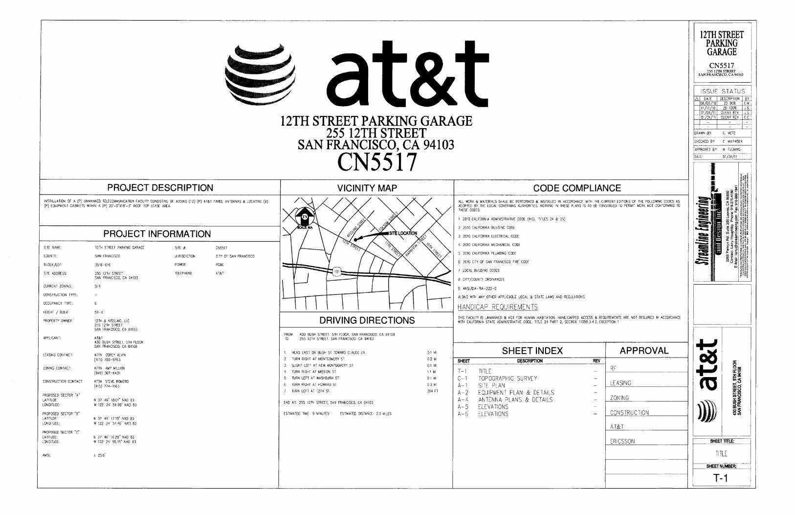
Date: February 10, 2011 Case No.: 2010.0831C Project Address: 255 12th Street Current Zoning: SLR (Service/Light Industrial/Residential) District 50‐X Height and Bulk District SUD: Western SOMA Block/Lot: 3516/019 Project Sponsor: Amy Million for AT&T 855 Folsom Street, Ste 106 San Francisco, CA 94107 Staff Contact: Diego R Sánchez – (415) 575‐9082 [email protected] Recommendation: Approval with Conditions
PROJECT DESCRIPTION The proposal is to install twelve panel antennas, one GPS antenna and associated equipment cabinets as part of the wireless transmission network operated by AT&T on a Location Preference 4 (Preferred Location – Industrial or Commercial Structures) site according to the Wireless Telecommunications Services (WTS) Siting Guidelines. The twelve panel antennas will be located at three locations on a five‐story parking structure. One group of four antennas will be located at the northeast corner of the parking structure enclosed within faux vents. The second group of four antennas will be façade mounted at the southwest corner of the structure and painted to match the structure. The last group of four antennas, located at the southeast corner of the structure, will also be façade mounted and painted to match. The antennas will be mounted at heights of 58 feet (faux vent enclosed antennas) and 53 feet (façade mounted antennas). The antennas measure 51.5 inches high, 11.9 inches deep and 7.1 inches wide.
SITE DESCRIPTION AND PRESENT USE The proposed site, 255 12th Street, is a five story parking structure open to the public for use on a daily or monthly basis. Parking is also provided on the roof of the structure. The lot is at the northwest corner of 12th and Kissling Streets, between Folsom and Howard Streets. The parking structure was constructed in 1978, according to Assessor records, and covers the majority of the 53,840 square foot lot. Vehicles access the site from 12th Street.
SURROUNDING PROPERTIES AND NEIGHBORHOOD The Project Site is located within the South of Market Neighborhood. The subject site is zoned SLR which is a zoning district intended to maintain and foster the growth of small scale light industrial, home and
www.sfplanning.org

Executive Summary CASE NO. 2010.0831C Hearing Date: February 17, 2011 255 12th Street
business service, wholesale distribution, arts production, general commercial and neighborhood serving retail activities while balancing the needs for existing and future housing in the area. As such, the uses surrounding the subject property include an automotive repair garage, multifamily apartment buildings, neighborhood serving food establishments and a contractor tool rental shop. Uses in the vicinity also include wholesale food production establishments, contractor supply shops, and neighborhood serving bars. Properties in the vicinity are zoned CM (Heavy Commercial) M‐1 (Light Industrial) and NCT‐3 (Moderate Scale Neighborhood Commercial Transit). ENVIRONMENTAL REVIEW The project is exempt from the California Environmental Quality Act (“CEQA”) as a Class 3 categorical exemption. The categorical exemption and all pertinent documents may be found in the files of the Planning Department, as the custodian of records, at 1650 Mission Street, San Francisco.
HEARING NOTIFICATION
TYPE R E Q U I R E D PERIOD
R E Q U I R E D NOTICE DATE
A C T U A L NOTICE DATE
A C T U A L PERIOD
Classified News Ad 20 days January 28, 2011 January 28, 2011 20 days
Posted Notice 20 days January 28, 2011 January 28, 2011 20 days
Mailed Notice 20 days January 28, 2011 January 28, 2011 20 days
PUBLIC COMMENT As of February 9, 2011, the Department has received 1 letter of support for the project and 1 in opposition. Those in support stated the need for improved cell phone coverage in the area, especially in times of emergency, while those in opposition indicated poor management of the site.
REQUIRED COMMISSION ACTION In order for the project to proceed, the Commission may grant the Conditional Use authorization pursuant to Planning Code Sections 816.73 and 303 to allow the installation of wireless facilities.
BASIS FOR RECOMMENDATION The Department believes this project is necessary and/or desirable under Section 303 of the Planning Code for the following reasons:
The project complies with the applicable requirements of the Planning Code. The project is consistent with the objectives and policies of the General Plan. The Project is consistent with the 1996 WTS Facilities Siting Guidelines, Planning Commission
Resolution No. 14182. The project site is a Location Preference 4, a preferred location, according to the Wireless
Telecommunications Services (WTS) Siting Guidelines. The project will improve coverage for an area where there is currently poor cell phone coverage.
2

Executive Summary CASE NO. 2010.0831C Hearing Date: February 17, 2011 255 12th Street
RECOMMENDATION: Approval with Conditions
3

Executive Summary CASE NO. 2010.0831C Hearing Date: February 17, 2011 255 12th Street
4
Executive Summary Project sponsor submittal
Draft Motion Drawings: Proposed Project
Zoning District Map Check for legibility
Parcel Map Photo Simulations
Sanborn Map Coverage Maps
Aerial Photo RF Report
Context Photos DPH Approval
Site Photos
Exhibits above marked with an “X” are included in this packet Plannerʹs Initials DRS G:\DOCUMENTS\Conditional Use\255 12th Street\Commission Packet\255 12th Street Executive Summary.doc
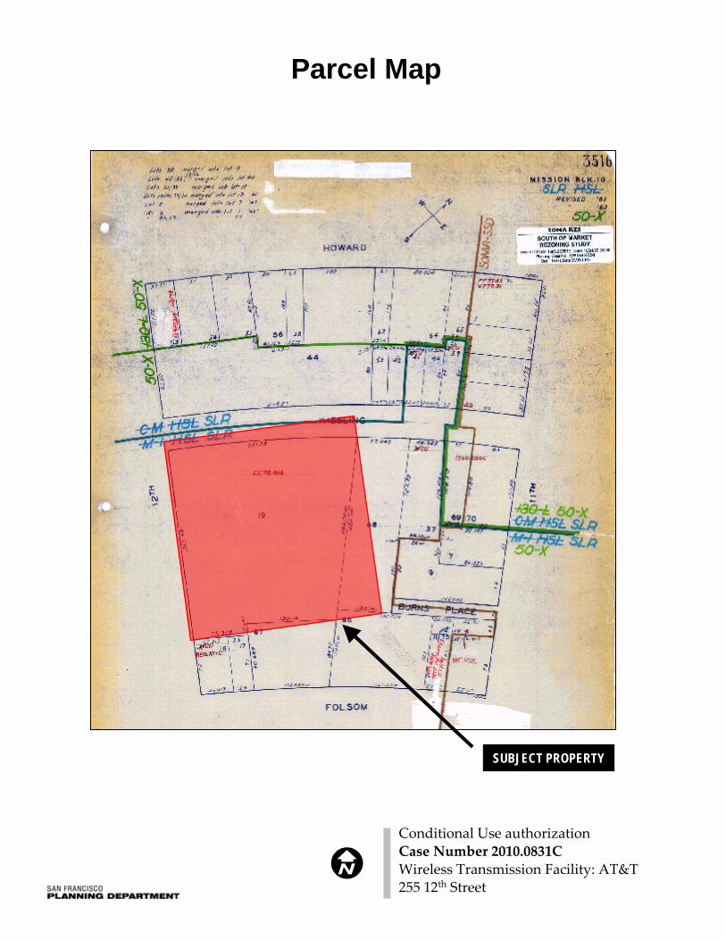
Parcel Map
Conditional Use authorizationCase Number 2010.0831CWireless Transmission Facility: AT&T255 12th Street
SUBJECT PROPERTY

*The Sanborn Maps in San Francisco have not been updated since 1998, and this map may not accurately reflect existing conditions.
Sanborn Map*
SUBJECT PROPERTY
Conditional Use authorizationCase Number 2010.0831CWireless Transmission Facility: AT&T255 12th Street
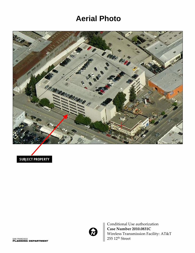
Aerial Photo
SUBJECT PROPERTY
Conditional Use authorizationCase Number 2010.0831CWireless Transmission Facility: AT&T255 12th Street
Zoning Map
Conditional Use authorizationCase Number 2010.0831CWireless Transmission Facility: AT&T255 12th Street
Site Photo
Conditional Use authorizationCase Number 2010.0831CWireless Transmission Facility: AT&T255 12th Street

-u 0
0 U)
3
0
0
CD V -’ 0 V 0 U) CD 0.
CD CD C) 0
3 3
C,
0
1
C,
U) U) CD CD
OIX
0 0
0 -
-I’ -’ 0
3 I)
Cl)
0. ’1 0 (I) 0
3 Cl)

T
0
0 U)
3
0
0 -I’
CD
-
0 V 0 U) CD 0.
CD CD C, 0
3 3 C
C,
0
C)
U) U) CD CD
0 0
CD
U)
0
3 I Fs,) ’-p
U) ’-p -
CD CD
’I 44
-
EKWORS I -
I . I 0 U .-’.
I 0 I U)
stz~ 255 12th Street 5 at&t CN5517 12th Street Parking Garage San Francisco, CA 94103
*
proposed AT&T antennas inside new CD
CD faux vents
0 I 0
CD
CD
I I I
rr
I - �
W L*.Ign 5 .owIrIng. Inc. .nndcIeroCot
� M C,e,k CA 94598 hotosiflis corn

Pro
pose
d S
ite a
t 255
12t
h S
t (C
N55
17)
Sig
nal s
tren
gth
BE
FO
RE
site
is c
onst
ruct
ed
Plum
St
I
.
c:
Erie
St
/, 0-~
Â-s
Exi
stin
g M
acro
Site
s
..Existing Micro
Site
s
ÂP
ropo
sed
Mac
ro S
ite
.Indo
orSi
gnal
In-Transit Signal
Out
door
Sig
nal -'~
'b'"
e,'-
~,I:
~",o
,e,
""'"
.r",
,,'1
' -,/v
'i0(O
r -s
CN
5517
e,"
Âo~
102f
t¡~.
,,,0
Sf1'
0?; o/
f -S
tí ,!! .!
tí '" ,!: s ,¡
,¡'¡t
~
-S13th St
Aug
ust 5
, 201
0

~I'..InInZU~..ui.c..N..InInN..raeu ~.. ef
1- a:ui ~u.
i: cieu 'Sui g'
o ~Q. t)o Ri¡. C
QD- Vi
i:cu..u:i¡,..efCoUef1-cu
~..iiEvII::cic..II
'XW
II !! iiii EE vv II¡ ::'tgi ~';; 0II Q.'X Ew Q.
IICciii..oo'tC..
~ciii..'iicEtc..~.~.
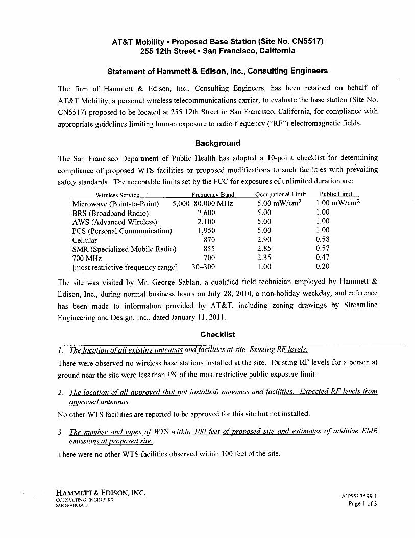
AT&T Mobilty. Proposed Base Station (Site No. CN5517)255 12th Street · San Francisco, California
Statement of Hammett & Edison, Inc., Consulting Engineers
The firm of Hammett & Edison, Inc., Consulting Engineers, has been retained on behalf ofAT&T Mobility, a personal wireless telecommunications carrier, to evaluate the base station (Site No.
CN55 17) proposed to be located at 255 12th Street in San Francisco, California, for compliance with
appropriate guidelines limiting human exposure to radio frequency ("RF") electromagnetic fields.
Background
The San Franciscû Department ûf Püblic Heälth håS adopted a lO..point checklist for determining
compliance of proposed WTS facilities or proposed modifications to such facilities with prevailing
safety standards. The acceptable limits set by the FCC for exposures of unlimited duration are:
Frequency Band
5,000-80,000 MHz2,6002,1001,950
870855700
30-300
Wireless Service
Microwave (Point-to-Point)BRS (Broadband Radio)AWS (Advanced Wireless)PCS (Personal Communication)CellularSMR (Specialized Mobile Radio)700 MHz
(most restrictive frequency range)
Occupational Limit
5.00 mW/cm25.005.005.002.902.852.351.00
Public Limit
1.00 mW/cm21.001.001.000.580.570.470.20
The site was visited by Mr. George Sablan, a qualified field technician employed by Hammett &
Edison, Inc., during normal business hours on July 28, 2010, a non-holiday weekday, and reference
has been made to information provided by AT&T, including zoning drawings by StreamlineEngineering and Design, Inc., dated January 11,2011.
Checklist
1. The location of all existing antennas and facilities at site. Existing RF levels.
There were observed no wireless base stations installed at the site. Existing RF levels for a person at
ground near the site were less than 1 % of the most restrictive public exposure limit.
2. The location of all approved (but not installed) antennas and faciliies. Expected RF levels from
approved antennas.
No other WTS facilities are reported to be approved for this site but not installed.
3. The number and tyes of WTS within 100 feet of proposed site and estimates of additive EMRemissions at proposed site.
There were no other WTS facilities observed within 100 feet of the site.
HAMMETT & EDISON, INC.CO:-SLlllNG ENGINEERSSANI'I(O\NCISCO
A T55 i 7599.1Page i of3

AT&T Mobility · Proposed Base Station (Site No. CN5517)255 12th Street · San Francisco, California
4. Location (and number) ofApplicants antennas and back-up facilties per building and location(and number) of other WTS at site.
AT&T proposes to install twelve Andrew Model DBXNH-6565A-R2M directional panel antennas on
the five-story parking structure located at 255 12th Street. F our antennas would be installed incylindrical enclosures above the northeast corner of the roof at an effective height of about 51 Yi feet
above ground, 1 Yi feet above the roof, and two groups of four antennas would be installed on the
southwest and southeast corners of the roof parapet at an effective height of about 50Yi feet above
ground. The antennas would be oriented with up to 6° downtilt toward 25°T, 1400T, and 245°T, away
from the building.
5. Power rating (maximum and expected operating power) for all existing an proposed backupequipment subject to application.
The expected operating power of the AT&T transmitters is reflected in the resulting effective radiated
power given in Item 6 below; the transmitters may operate at a power below their maximum rating.
6. Total number of watts per installation and total number of watts for all installations at site.
The maximum effective radiated power proposed by AT&T in any direction is 5,480 watts,representing simultaneous operation at 1,660 watts for A WS, 1,780 watts for PCS, 1,260 watts for
cellular, and 780 watts for 700 MHz service.
7. Plot or roofplan showing method of attachment of antennas. directionality of antennas. and height
above roof/eve/. Discuss nearby inhabited buildings.
The drawings show the proposed antennas to be installed as described in Item 4 above. There were
noted no buildings of similar height nearby.
8. Estimated ambient RF levels for proposed site and identify three-dimensional perimeter whereexposure standards are exceeded.
For a person anywhere at ground, the maximum ambient RF exposure level due to the proposed
AT&T operation is calculated to be 0.012 mW/cm2, which is 2;3% of the applicable public exposure
limit. Ambient RF levels at the site are therefore estimated to be below 3% of the limit. The three-
dimensional perimeter of RF levels equal to the public exposure limit is calculated to extend up to
52 feet out from the antenna faces and to much lesser distances above, below, and to the sides; this
includes a smal1 area of the roof ofthe building, but does not reach any other publicly accessible areas.
9. Describe proposed signage at site.
It is recommended that a barricade be erected, as shown in Figure 1, to preclude public access in front
of the antennas on the northeast corner of the building. To prevent occupational exposures in excess
of the FCC guidelines, no access directly in front of the antennas, such as might occur duringmaintenance work on the roof, should be allowed while the base station is in operation, unless other
HAMMETT & EDISON, INC.CO::SLLTING ENGINEERSSAN FRo\NClSCO
AT5517599.1Page 2 of3

AT&T Mobilty. Proposed Base Station (Site No. CN5517)255 12th Street · San Francisco, California
measures can be demonstrated to ensure that occupational protection requirements are met. Posting
explanatory warning signs * on the barricade and at the antennas, such that the signs would be readily
visible from any angle of approach to persons who might need to work within that distance, would be
suffcient to meet FCC-adopted guidelines.
10. Statement of authorship.
The undersigned author of this statement is a qualified Professional Engineer, holding California
Registration Nos. E-13026 and M-20676, which expire on June 30, 201 i. This work has been carried
out under his direction, and all statements are true and correct of his own knowledge except, where
noted, when data has been supplied by others, which data he believes to be correct.
Conclusion
Based on the information and analysis above, it is the undersigned's professional opinlOn that
operation of the base station proposed by AT&T Mobility at 255 12th Street in San Francisco,California, can comply with the prevailing standards for limiting human exposure to radio frequency
energy and, therefore, need not for this reason cause a significant impact on the environment. The
highest calculated level in publicly accessible areas is much less than the prevailing standards allow
for exposures of unlimited duration. This finding is consistent with measurements of actual exposure
conditions taken at other operating base stations. Erecting a barricade is recommended to establish
compliance with public exposure limitations, and posting explanatory signs is recommended toestablish compliance with occupational exposure limitations.
January 26, 2011
,
* Warning signs should comply with OET-65 color, symbol, and content recommendations. Contact informationshould be provided (e.g., a telephone number) to arange for access to restricted areas. The selection of language(s)is not an engineering matter; the San Francisco Deparent of Public Health recommends that all signs be writtenin English, Spanish, and Chinese.
HAMMETT & EDISON, INCCO::SLLTlNG ENGINEERSSAN FRANCISCO
AT5517599.1Page 3 of3

AT&T Mobilty. Proposed Base Station (Site No. CN5517)255 12th Street · San Francisco, California
Suggested Location for Barricade
/-- (E) BUILDl~jG 8ELOW
Location for Barricade
/oiA~7'
'i
'vI "../k
~J~tt,~-, / ê:"vi/i
v
I
(P) A 1&1 ANTENNA iNSiDE A (P) "20' iRAOOME. PAINT TO MATCH (E) BULD!NG J
(P) AT&T ANTENNA iNSIDE II (P) 020.RADOM£. P MH TO MA 1CH (t. BUICDING j
(P1AT&:T ANTENN4 INSIDE A íP) Ø20- ,
RÀDOW:. PA'NT TO MATCH (E) BUILDING j
(p) A T &: T ANTEM,.l INSIDE II (P) ø20~RI\ÓOME. PAiNT TO MATCH (E) BUILDING j
(6) (P) 6" CORES FOR COA); -_/ /I
"'-- (E) ROOFTCP E.QUIPMENT
(P) 2.r CABLE TRAY I'OUNiEDON CEILING BE.LOW .-..~ /
i /
Notes:Base drawing from Streamline Engineering andDesign, Inc., dated January 11,2011.Explanatory warning signs should be posted at thebarrcade and at the antennas, readily visible toauthorized workers needing access.See text.
HAMMETT & EDISON, INC.cO'\SlllJ"'G ENGJ"lEERSSo\N I'K.\MïSCO
AT5517599.1Figure 1

/-\ City and County of San Francisco Gavin Newsom, Mayor
DEPARTMENT OF PUBLIC HEALTH Mitchell H. Katz, MD, Director of Health
,7 F ENVIRONMENTAL HEALTH SECTION Rajiv Bhatia, MD, MPH, Director of EH
Review of Cellular Antenna Site Proposals
Project Sponsor: AT&T Wireless Planner: Jonas lonin
RF Engineer Consultant: Hammett and Edison Phone Number: (707) 996-5200
Project Address/Location: 255 12TH Si
Site ID: 1330 SiteNo.: CN5517
The following information is required to be provided before approval of this project can be made. These information requirements are established in the San Francisco Planning Department Wireless Telecommunications Services Facility Siting Guidelines dated August 1996. In order to facilitate quicker approval of this project, it is recommended that the project sponsor review this document before submitting the proposal to ensure that all requirements are included.
X I. The location of all existing antennas and facilities. Existing RF levels. (WTS-FSG, Section 11, 2b)
Existing Antennas No Existing Antennas:
2. The location of all approved (but not installed) antennas and facilities. Expected RF levels from the approved antennas. (WTS-FSG Section 11, 2b)
°Yes No
3. The number and types of WTS within 100 feet of the proposed site and provide estimates of cumulative EMR emissions at the proposed site. (WTS-FSG, Section 10.5.2)
OYes ENo
4. Location (and number) of the Applicant’s antennas and back-up facilities per building and number and X location of other telecommunication facilities on the property (WTS-FSG, Section 10.4.1a)
5. Power rating (maximum and expected operating power) for all existing and proposed backup L equipment subject to the application (WTS-FSG, Section 10.4.1c)
Maximum Power Rating: 5530 watts.
X 6. The total number of watts per installation and the total number of watts for all installations on the building (roof or side) (WTS-FSG, Section 10.5.1).
Maximum Effective Radiant: 5530 watts.
7. Preferred method of attachment of proposed antenna (roof, wall mounted, monopole) with plot or roof L plan. Show directionality of antennas. Indicate height above roof level. Discuss nearby inhabited
buildings (particularly in direction of antennas) (WTS-FSG, Section 10.41d)
8. Report estimated ambient radio frequency fields for the proposed site (identify the three-dimensional X perimeter where the FCC standards are exceeded.) (WTS-FSG, Section 10.5) State FCC standard utilized
and power density exposure level (i.e. 1986 NCRP, 200 .tw/cm 2)
Maximum RF Exposure: 0.0097 mw/cm. Maximum RF Exposure Percent: 1.7
9. Signage at the facility identifying all WTS equipment and safety precautions for people nearing the X equipment as may be required by any applicable FCC-adopted standards. (WTS-FSG, Section 10.9.2).
Discuss signage for those who speak languages other than English.
Public� Exclusion � Area Public Exclusion In Feet: 51
Occupational � Exclusion � Area Occupational Exclusion In Feet: 14

X 10. Statement on who produced this report and qualifications.
Approved. Based on the information provided the following staff believes that the project proposal will X comply with the current Federal Communication Commission safety standards for radiofrequency
radiation exposure. FCC stand ard_1986 NCRP Approval of the subsequent Project Implementation Report is based on project sponsor completing recommendations by project consultant and DPH.
Comments:
There are 0 existing antennas operated by AT&T Wireless installed on the parking structure located at 255 12TH Street. Exisiting RF levels at ground level are projected to be around 2% of the FCC public exposure limit. There were observed no other antennas within 100 feet of this site. AT&T Wireless proposes to install 12 new antenna. The antennas will be mounted at a height of 50 feet above the ground. The estimated ambient RF field from the proposed AT&T Wireless transmitters at ground level is calculated to be 0.0097 mW/sq cm., which is 1.7 % of the FCC public exposure limit. The three dimensional perimeter of RF levels equal to the public exposure limit extends 51 feet and does not reach any publicly accessible areas. Warnings signs must be posted at the antennas and roof access points in English, Spanish and Chinese. Worker should not have access to within 14 feet of the front of the antennas while they are in operation.
Not Approved, additional information required.
Not Approved, does not comply with Federal Communication Commission safety standards for radiofrequency radiation exposure. FCC Standard
1 Hours spent reviewing
Charges to Project Sponsor (in addition to previous charges, to be received at time of receipt by S
0-
Dated: 8/18/2010
Signed: Q Patrick Fosdahl
Environmental Health Management Section San Francisco Dept. of Public Health 1390 Market St., Suite 210, San Francisco, CA. 94102 (415) 252-3904
Subject to: (Select only if applicable)
Affordable Housing (Sec. 415)
Jobs Housing Linkage Program (Sec. 413)
Downtown Park Fee (Sec. 412)
First Source Hiring (Admin. Code)
Child Care Requirement (Sec. 414)
Other
Planning Commission Motion HEARING DATE: FEBRUARY 17, 2011
Date: February 10, 2011 Case No.: 2010.0831C Project Address: 255 12th Street Current Zoning: SLR (Service/Light Industrial/Residential) District 50‐X Height and Bulk District SUD: Western SOMA Block/Lot: 3516/019 Project Sponsor: Amy Million for AT&T 855 Folsom Street, Ste 106 San Francisco, CA 94107 Staff Contact: Diego R Sánchez – (415) 575‐9082 [email protected]
ADOPTING FINDINGS RELATING TO THE APPROVAL OF A CONDITIONAL USE AUTHORIZATION UNDER PLANNING CODE SECTIONS 816.73 AND 303 TO INSTALL A WIRELESS TELECOMMUNICATIONS FACILITY CONSISTING OF TWELVE PANEL ANTENNAS AND ASSOCIATED EQUIPMENT ON AN FIVE STORY EXISTING PARKING STRUCTURE AS PART OF THE AT&T WIRELESS TELECOMMUNICATIONS NETWORK WITHIN THE SLR (SERVICE/LIGHT INDUSTRIAL/RESIDENTIAL) ZONING DISTRICT AND A 50‐X HEIGHT AND BULK DISTRICT.
PREAMBLE On September 16, 2010, AT&T (hereinafter ʺProject Sponsorʺ), made an application (hereinafter ʺapplicationʺ), for Conditional Use Authorization on the property at 255 15th Street, Lot 019 in Assessorʹs Block 3516, (hereinafter ʺproject siteʺ) to install a wireless telecommunications facility consisting of twelve panel antennas on an existing five story parking structure as part of the AT&T wireless telecommunications network within the SLR (Service/Light Industrial/Residential) Zoning District and a 50‐X Height and Bulk District. The project is exempt from the California Environmental Quality Act (“CEQA”) as a Class 3 categorical exemption. The Commission has reviewed and concurs with said determination. The categorical exemption and all pertinent documents may be found in the files of the Planning Department (hereinafter “Department”), as the custodian of records, at 1650 Mission Street, San Francisco.
www.sfplanning.org
Motion No. XXXX CASE NO. 2010.0831C Hearing Date: February 17th, 2011 255 12th Street
On February 17th, 2011, the San Francisco Planning Commission (hereinafter “Commission”) conducted a duly noticed public hearing at a regularly scheduled meeting on the application for a Conditional Use authorization. The Commission has heard and considered the testimony presented to it at the public hearing and has further considered written materials and oral testimony presented on behalf of the applicant, department staff, and other interested parties. MOVED, that the Commission hereby authorizes the Conditional Use in Application No. 2010.0831C, subject to the conditions contained in “EXHIBIT A” of this motion, based on the following findings:
FINDINGS Having reviewed the materials identified in the preamble above, and having heard all testimony and arguments, this Commission finds, concludes, and determines as follows:
1. The above recitals are accurate and constitute findings of this Commission.
2. Site Description and Present Use. The proposed site, 255 12th Street, is a five story parking structure open to the public for use on a daily or monthly basis. Parking is also provided on the roof of the structure. The lot is at the northwest corner of 12th and Kissling Streets, between Folsom and Howard Streets. The parking structure was constructed in 1978, according to Assessor records, and covers the majority of the 53,840 square foot lot. Vehicles access the site from 12th Street.
3. Surrounding Properties and Neighborhood. The Project Site is located within the South of
Market Neighborhood. The subject site is zoned SLR which is a zoning district intended to maintain and foster the growth of small scale light industrial, home and business service, wholesale distribution, arts production, general commercial and neighborhood serving retail activities while balancing the needs for existing and future housing in the area. As such, the uses surrounding the subject property include an automotive repair garage, multifamily apartment buildings, neighborhood serving food establishments and a contractor tool rental shop. Uses in the vicinity also include wholesale food production establishments, contractor supply shops, and neighborhood serving bars. Properties in the vicinity are zoned CM (Heavy Commercial) M‐1 (Light Industrial) and NCT‐3 (Moderate Scale Neighborhood Commercial Transit).
4. Project Description. The proposal is to install twelve panel antennas, one GPS antenna and
associated equipment cabinets as part of the wireless transmission network operated by AT&T on a Location Preference 4 (Preferred Location – Industrial or Commercial Structures) site according to the Wireless Telecommunications Services (WTS) Siting Guidelines. The twelve panel antennas will be located at three locations on a five‐story parking structure. One group of four antennas will be located at the northeast corner of the parking structure enclosed within faux vents. The second group of four antennas will be façade mounted at the southwest corner of the structure and painted to match the structure. The last group of four antennas, located at the southeast corner of the structure, will also be façade mounted and painted to match. The
2
Motion No. XXXX CASE NO. 2010.0831C Hearing Date: February 17th, 2011 255 12th Street
3
antennas will be mounted at heights of 58 feet (faux vent enclosed antennas) and 53 feet (façade mounted antennas). The antennas measure 51.5 inches high, 11.9 inches deep and 7.1 inches wide.
5. Past History and Actions. The Planning Commission established guidelines for the installation
of wireless telecommunications facilities in 1996 (“Guidelines”). These Guidelines set forth the land use policies and practices that guide the installation and approval of wireless facilities throughout San Francisco. A large portion of the Guidelines was dedicated to establishing location preferences for these installations. The Board of Supervisors, in Resolution No. 635‐96, provided input as to where wireless facilities should be located within San Francisco. The Guidelines were updated by the Commission in 2003, requiring community outreach, notification, and detailed information about the facilities to be installed.1
Section 8.1 of the Guidelines outlines Location Preferences for wireless facilities. There are five primary areas were the installation of wireless facilities should be located:
1. Publicly‐used Structures: such facilities as fire stations, utility structures, community
facilities, and other public structures; 2. Co‐Location Site: encourages installation of facilities on buildings that already have wireless
installations; 3. Industrial or Commercial Structures: buildings such as warehouses, factories, garages,
service stations; 4. Industrial or Commercial Structures: buildings such as supermarkets, retail stores, banks;
and 5. Mixed Use Buildings in High Density Districts: buildings such as housing above commercial
or other non‐residential space.
Before the Planning Commission can review an application to install a wireless facility, the project sponsor must submit a five‐year facilities plan, which must be updated biannually, an emissions report and approval by the Department of Public Health, Section 106 Declaration of Intent, a submittal checklist and details about the facilities to be installed. Under Section 704(B)(iv) of the 1996 Federal Telecommunications Act, local jurisdictions cannot deny wireless facilities based on Radio Frequency (RF) radiation emissions so long as such facilities comply with the FCC’s regulations concerning such emissions.
On February 17th, 2011, the Commission conducted a duly noticed public hearing at a regularly scheduled meeting on the application for a Conditional Use authorization pursuant to Planning Code Sections 816.73 and 303 to allow the installation of a wireless telecommunications facility consisting of twelve panel antennas and related equipment and one GPS antenna on an existing five story parking structure as part of the AT&T wireless telecommunications network.
1 PC Resolution 16539, passed March 13, 2003.

Motion No. XXXX CASE NO. 2010.0831C Hearing Date: February 17th, 2011 255 12th Street
6. Location Preference. The WTS Facilities Siting Guidelines identify different types of buildings for the siting of wireless telecommunications facilities. Under the Guidelines, the Project is a Location Preference Number 4, a structure wholly industrial or commercial in use.
7. Radio Waves Range. The Project Sponsor has stated that the proposed wireless network will
transmit calls by radio waves operating in the 734 ‐ 2145 Megahertz (MHZ) bands and receive calls in the 704 to 1880 MHZ bands, which are regulated by the Federal Communications Commission (FCC) and which must comply with the FCC‐adopted health and safety standards for electromagnetic radiation and radio frequency radiation.
8. Radiofrequency (RF) Emissions: The project sponsor retained Hammett & Edison, Inc., a radio
engineering consulting firm, to prepare a report describing the expected RF emissions from the proposed facility. Pursuant to the Guidelines, the Department of Public Health reviewed the report and determined that the proposed facility complies with the standards set forth in the Guidelines.
9. Department of Public Health Review and Approval. The proposed project was referred to the
Department of Public Health (DPH) for emissions exposure analysis. There are 0 existing antennas operated by AT&T Wireless installed on the parking structure located at 255 12th Street. Existing RF levels at ground level are projected to be around 2% of the FCC public exposure limit. There were observed no other antennas within 100 feet of this site. AT&T Wireless proposes to install 12 new antennas. The antennas will be mounted at a height of 50 feet above the ground. The estimated ambient RF field from the proposed AT&T Wireless transmitters at ground level is calculated to be 0.0097 mW/sq cm, which is 1.7 % of the FCC public exposure limit. The three dimensional perimeter of RF levels equal to the public exposure limit extends 51 feet and does not reach any publicly accessible areas. Warnings signs must be posted at the antennas and roof access points in English, Spanish and Chinese. Worker should not have access to within 14 feet of the front of the antennas while they are in operation.
10. Maintenance Schedule. The proposed facility would operate without on‐site staff but with a
two‐person maintenance crew visiting the property approximately once a month and on an as‐needed basis to service and monitor the facility.
11. Community Outreach. Per the Guidelines, the project sponsor held a Community Outreach
Meeting for the proposed project. The meeting was held at 7:00 P.M. on August 10th, 2010 at The Arc of San Francisco (1500 Howard Street). A total of 4 members of the public attended the meeting with general comments and concerns regarding potential health impacts.
12. Five‐year plan: Per the Guidelines, the project sponsor submitted its latest five‐year plan, as
required, in October 2010.
13. Public Comment. As of February 9, 2011, the Department has received 2 letters, one in of support for the project stating the need for improved cell phone coverage in the area, especially in times of emergency, and one in opposition citing poor site management.
4

Motion No. XXXX CASE NO. 2010.0831C Hearing Date: February 17th, 2011 255 12th Street
14. Planning Code Compliance. The Commission finds that the Project is consistent with the relevant provisions of the Planning Code in the following manner:
A. Use. Planning Code Section 816.73 requires Conditional Use authorization for the
installation of wireless transmission facilities.
The project sponsor is seeking Conditional Use authorization to install a wireless transmission facility consisting of twelve antennas, a GPS antenna ad associated equipment cabinets.
B. Height. Height Map 07 indicates that the subject property is within a 50 foot Height District,
limiting the height of structures to no more than 50 feet above grade, as measured in accordance with Planning Code Section 260.
While the project is in a 50 Foot Height District and the antennas are proposed to be mounted above that limit, Planning Code Section 260(b)2(I) exempts radio antennae for transmission, reception, or relay of radio, television of other electronic signals, where permitted as a principal or conditional use from the height limit in this instance.
15. Planning Code Section 303 establishes criteria for the Planning Commission to consider when
reviewing applications for Conditional Use approval. On balance, the project does comply with said criteria in that:
A. The proposed new uses and building, at the size and intensity contemplated and at the
proposed location, will provide a development that is necessary or desirable, and compatible with, the neighborhood or the community.
i Desirable: San Francisco is a leader of the technological economy; it is important and desirable to
the vitality of the city to have and maintain adequate telecommunications coverage and data capacity. This includes the installation and upgrading of systems to keep up with changing technology and increases in usage. It is desirable for the City to allow wireless facilities to be installed.
The proposed project at 255 12th Street will be desirable and compatible with the surrounding neighborhood because the project will not conflict with the existing uses of the property and will be of such size and nature to be compatible with the surrounding vicinity. The approval of this authorization has been found, first and foremost, to ensure public safety, and ensure that the placement of antennas and related support and protection features are so located, designed, and treated architecturally to minimize their visibility from public places, to avoid intrusion into public vistas, avoid disruption of the architectural design integrity of building and ensure harmony with neighborhood character.
ii Necessary: In the case of wireless installations, there are 2 criteria that the Commission reviews: coverage and capacity.
5
Motion No. XXXX CASE NO. 2010.0831C Hearing Date: February 17th, 2011 255 12th Street
6
Coverage: It is necessary for San Francisco to have as much coverage as possible in terms of wireless facilities. Due to the topography and tall buildings in San Francisco, unique coverage issues arise because the hills and building break up coverage. Thus, telecommunication carriers often install additional installations to make sure coverage is sufficient.
Capacity: While a carrier may have adequate coverage in a certain area, the capacity may not be sufficient. With the continuous innovations in wireless data technology and demand placed on existing infrastructure, individual telecommunications carriers must upgrade and in some instances expand their facilities network to be able to have proper data distribution. It is necessary for San Francisco, as a leader in technology, to have adequate capacity.
The proposed project at 255 12th Street is necessary in order to achieve sufficient street and in‐building mobile phone coverage within the western end of the South of Market Neighborhood. Recent drive tests in the subject area conducted by the AT&T Radio Frequency Engineering Team provide conclusive evidence that the subject property is the most viable location, based on factors including quality of coverage, population density, land use compatibility, zoning and aesthetics. The proposed coverage area will serve the vicinity bounded by Howard Street to the north, Harrison Street to the south, 13th Street to the west and 10th Street to the east, as indicated in the coverage maps. This facility will fill in the gaps to improve coverage in the western end of the South of Market Neighborhood as well as to provide necessary facilities for emergency transmission and improved communication for the neighborhood, community and the region.
B. The proposed project will not be detrimental to the health, safety, convenience or general
welfare of persons residing or working in the vicinity. There are no features of the project that could be detrimental to the health, safety or convenience of those residing or working the area, in that:
i Nature of proposed site, including its size and shape, and the proposed size, shape and
arrangement of structures;
The proposed project must comply with all applicable Federal and State regulations to safeguard the health, safety and to ensure that persons residing or working in the vicinity will not be affected, and prevent harm to other personal property. The Department of Public Health conducted an evaluation of potential health effects from Radio Frequency radiation, and has concluded that the proposed wireless transmission facilities will have no adverse health effects if operated in compliance with the FCC‐adopted health and safety standards. The Department has received information that the proposed wireless system must be operated so as not to interfere with radio or television reception in order to comply with the provisions of its license under the FCC. The Department is developing a database of all such wireless communications facilities operating or proposed for operation in the City and County of San Francisco. All applicants are now required to submit information on the location and nature of all existing and approved wireless

Motion No. XXXX CASE NO. 2010.0831C Hearing Date: February 17th, 2011 255 12th Street
transmission facilities operated by the Project Sponsor. The goal of this effort is to foster public information as to the location of these facilities.
ii The accessibility and traffic patterns for persons and vehicles, the type and volume of such traffic, and the adequacy of proposed off‐street parking and loading;
No increase in traffic volume is anticipated with the facilities operating unmanned, with a single maintenance crew visiting the site once a month or on an as‐needed basis.
iii The safeguards afforded to prevent noxious or offensive emissions such as noise, glare,
dust and odor;
While some noise and dust may result from the erection of the antennas and transceiver equipment, noise or noxious emissions from continued use are not likely to be significantly greater than ambient conditions due to the operation of the wireless communication network.
iv Treatment given, as appropriate, to such aspects as landscaping, screening, open spaces, parking and loading areas, service areas, lighting and signs;
The proposed antennas are proposed to be screened by faux vents at one location and to be painted to match the existing parking structure at the other two locations.
C. That the use as proposed will comply with the applicable provisions of the Planning Code
and will not adversely affect the General Plan.
The Project complies with all relevant requirements and standards of the Planning Code and is consistent with objectives and policies of the General Plan as detailed below.
16. General Plan Compliance. The Project is, on balance, consistent with the following Objectives
and Policies of the General Plan
HOUSING ELEMENT HOUSING DENSITY, DENSITY, DESIGN & QUALITY OF LIFE
OBJECTIVE 11 ‐ IN INCREASING THE SUPPLY OF HOUSING, PURSUE PLACE MAKING AND NEIGHBORHOOD BUILDING PRINCIPLES AND PRACTICES TO MAINTAIN SAN FRANCISCO’S DESIRABLE URBAN FABRIC AND ENHANCE LIVABILITY IN ALL NEIGHBORHOODS.
POLICY 11.2 ‐ Ensure housing is provided with adequate public improvements, services, and amenities.
The Proposed Project will improve AT&T Wireless coverage in an area with residential uses that are within the largely commercial and light industrial area.
7

Motion No. XXXX CASE NO. 2010.0831C Hearing Date: February 17th, 2011 255 12th Street
COMMERCE AND INDUSTRY ELEMENT Objectives and Policies OBJECTIVE 1: MANAGE ECONOMIC GROWTH AND CHANGE TO ENSURE ENHANCEMENT OF THE TOTAL CITY LIVING AND WORKING ENVIRONMENT. Policy 1: Encourage development, which provides substantial net benefits and minimizes undesirable consequences. Discourage development, which has substantial undesirable consequences that cannot be mitigated. Policy 2: Assure that all commercial and industrial uses meet minimum, reasonable performance standards. The project would enhance the total city living and working environment by providing communication services for residents and workers within the City. Additionally, the project would comply with Federal, State and Local performance standards. OBJECTIVE 2: MAINTAIN AND ENHANCE A SOUND AND DIVERSE ECONOMIC BASE AND FISCAL STRUCTURE FOR THE CITY. Policy 1: Seek to retain existing commercial and industrial activity and to attract new such activity to the city. Policy 3: Maintain a favorable social and cultural climate in the city in order to enhance its attractiveness as a firm location. The site is an integral part of a new wireless communications network that will enhance the City’s diverse economic base. OBJECTIVE 4: IMPROVE THE VIABILITY OF EXISTING INDUSTRY IN THE CITY AND THE ATTRACTIVENESS OF THE CITY AS A LOCATION FOR NEW INDUSTRY. Policy 1: Maintain and enhance a favorable business climate in the City. Policy 2:
8
Motion No. XXXX CASE NO. 2010.0831C Hearing Date: February 17th, 2011 255 12th Street
Promote and attract those economic activities with potential benefit to the City. The project would benefit the City by enhancing the business climate through improved communication services for residents and workers. VISITOR TRADE OBJECTIVE 8 ‐ ENHANCE SAN FRANCISCOʹS POSITION AS A NATIONAL CENTER FOR CONVENTIONS AND VISITOR TRADE. POLICY 8.3 ‐ Assure that areas of particular visitor attraction are provided with adequate public services for both residents and visitors.
The Project will ensure that residents and visitors have adequate public service in the form of AT&T Wireless mobile telecommunications.
COMMUNITY SAFETY ELEMENT Objectives and Policies OBJECTIVE 3: ENSURE THE PROTECTION OF LIFE AND PROPERTY FROM THE EFFECTS OF FIRE OR NATURAL DISASTER THROUGH ADEQUATE EMERGENCY OPERATIONS PREPARATION. Policy 1: Maintain a local agency for the provision of emergency services to meet the needs of San Francisco. Policy 2: Develop and maintain viable, up‐to‐date in‐house emergency operations plans, with necessary equipment, for operational capability of all emergency service agencies and departments. Policy 3: Maintain and expand agreements for emergency assistance from other jurisdictions to ensure adequate aid in time of need. Policy 4: Establish and maintain an adequate Emergency Operations Center. Policy 5: Maintain and expand the city’s fire prevention and fire‐fighting capability. Policy 6: Establish a system of emergency access routes for both emergency operations and evacuation.
9

Motion No. XXXX CASE NO. 2010.0831C Hearing Date: February 17th, 2011 255 12th Street
The project would enhance the ability of the City to protect both life and property from the effects of a fire or natural disaster by providing communication services.
17. Planning Code Section 101.1(b) establishes eight priority‐planning policies and requires review
of permits for consistency with said policies. On balance, the project does comply with said policies in that:
A. That existing neighborhood‐serving retail uses be preserved and enhanced and future
opportunities for resident employment in and ownership of such businesses be enhanced.
No neighborhood‐serving retail use would be displaced and the wireless communications network will enhance personal communication services.
B. That existing housing and neighborhood character be conserved and protected in order to
preserve the cultural and economic diversity of our neighborhoods.
No residential uses would be displaced or altered in any way by the granting of this authorization.
C. That the Cityʹs supply of affordable housing be preserved and enhanced,
The project would have no adverse impact on affordable housing.
D. That commuter traffic not impede MUNI transit service or overburden our streets or neighborhood parking.
Due to the nature of the project and minimal maintenance or repair, municipal transit service would not be impeded and neighborhood parking would not be overburdened.
E. That a diverse economic base be maintained by protecting our industrial and service sectors
from displacement due to commercial office development, and that future opportunities for resident employment and ownership in these sectors be enhanced.
The Project would cause no displacement of industrial and service sector activity.
F. That the City achieve the greatest possible preparedness to protect against injury and loss of
life in an earthquake.
Compliance with applicable structural safety and seismic safety requirements would be considered during the building permit application review process.
G. That landmarks and historic buildings be preserved.
There are no landmarks or historic buildings involved in the Proposed Project.
10

Motion No. XXXX CASE NO. 2010.0831C Hearing Date: February 17th, 2011 255 12th Street
H. That our parks and open space and their access to sunlight and vistas be protected from development.
The Project will have no adverse impact on parks or open space, or their access to sunlight or vistas.
18. The Project is consistent with and would promote the general and specific purposes of the Code
provided under Section 101.1(b) in that, as designed, the Project would contribute to the character and stability of the neighborhood and would constitute a beneficial development.
19. The Commission hereby finds that approval of the Determination of Compliance authorization
would promote the health, safety and welfare of the City.
11
Motion No. XXXX CASE NO. 2010.0831C Hearing Date: February 17th, 2011 255 12th Street
DECISION The Commission, after carefully balancing the competing public and private interests, and based upon the Recitals and Findings set forth above, in accordance with the standards specified in the Code, hereby approves the Conditional Use authorization under Planning Code Sections 816.73 and 303 to install a wireless telecommunications facility consisting of twelve panel antennas with related equipment on an existing five story parking structure with a Location Preference 4 (Preferred Location – Wholly Commercial or Industrial structures) according to the Wireless Telecommunications Services (WTS) Siting Guidelines, as part of the AT&T wireless telecommunications network within the SLR (Service / Light Industrial / Residential) Zoning District and a 50‐X Height and Bulk District and subject to the conditions of approval attached hereto as Exhibit A. APPEAL AND EFFECTIVE DATE OF MOTION: Any aggrieved person may appeal this conditional use authorization to the Board of Supervisors within thirty (30) days after the date of this Motion No. XXXX The effective date of this Motion shall be the date of this Motion if not appealed (after the 30‐day period has expired) OR the date of the decision of the Board of Supervisors if appealed to the Board of Supervisors. For further information, please contact the Board of Supervisors at (415) 554‐5184, City Hall, Room 244, 1 Dr. Carlton B. Goodlett Place, San Francisco, CA 94102. I hereby certify that the foregoing Motion was adopted by the Planning Commission on February 17th, 2011.
Linda Avery Commission Secretary
AYES: NAYS: ABSENT: ADOPTED: February 17th, 2011
12

Motion No. XXXX CASE NO. 2010.0831C Hearing Date: February 17th, 2011 255 12th Street
Exhibit A Conditions of Approval
Whenever “Project Sponsor” is used in the following conditions, the conditions shall also bind any successor to the Project or other persons having an interest in the Project or underlying property.
AUTHORIZATION This authorization is for a conditional use to allow a wireless telecommunications facility consisting of twelve panel antennas located at 255 12th Street, Lot 019 in Assessor’s Block 3516 pursuant to Planning Code Section(s) 816.73 and 303 within the SLR (Service/Light Industrial/Residential) District and a 50‐X Height and Bulk District; in general conformance with plans, dated September 16, 2010, and stamped “EXHIBIT B” included in the docket for Case No. 2010.0831 and subject to conditions of approval reviewed and approved by the Commission on February 17,2010 under Motion No XXXXXX. This authorization and the conditions contained herein run with the property and not with a particular Project Sponsor, business, or operator.
RECORDATION OF CONDITIONS OF APPROVAL Prior to the issuance of the building permit or commencement of use for the Project the Zoning Administrator shall approve and order the recordation of a Notice in the Official Records of the Recorder of the City and County of San Francisco for the subject property. This Notice shall state that the project is subject to the conditions of approval contained herein and reviewed and approved by the Planning Commission on February 17, 2011 under Motion No XXXXXX.
PRINTING OF CONDITIONS OF APPROVAL ON PLANS The conditions of approval under the ʹExhibit Aʹ of this Planning Commission Motion No. XXXXXX shall be reproduced on the Index Sheet of construction plans submitted with the Site or Building permit application for the Project. The Index Sheet of the construction plans shall reference to the Conditional Use authorization and any subsequent amendments or modifications.
SEVERABILITY The Project shall comply with all applicable City codes and requirements. If any clause, sentence, section or any part of these conditions of approval is for any reason held to be invalid, such invalidity shall not affect or impair other remaining clauses, sentences, or sections of these conditions. This decision conveys no right to construct, or to receive a building permit. “Project Sponsor” shall include any subsequent responsible party.
13
Motion No. XXXX CASE NO. 2010.0831C Hearing Date: February 17th, 2011 255 12th Street
CHANGES AND MODIFICATIONS Changes to the approved plans may be approved administratively by the Zoning Administrator. Significant changes and modifications of conditions shall require Planning Commission approval of a new Conditional Use authorization.
PERFORMANCE Validity and Expiration. The authorization and right vested by virtue of this action is valid for three years from the effective date of the Motion. A building permit from the Department of Building Inspection to construct the project and/or commence the approved use must be issued as this Conditional Use authorization is only an approval of the proposed project and conveys no independent right to construct the project or to commence the approved use. The Planning Commission may, in a public hearing, consider the revocation of the approvals granted if a site or building permit has not been obtained within three (3) years of the date of the Motion approving the Project. Once a site or building permit has been issued, construction must commence within the timeframe required by the Department of Building Inspection and be continued diligently to completion. The Commission may also consider revoking the approvals if a permit for the Project has been issued but is allowed to expire and more than three (3) years have passed since the Motion was approved. For information about compliance, contact Code Enforcement, Planning Department at 415‐575‐6863, www.sf‐planning.org. Extension. This authorization may be extended at the discretion of the Zoning Administrator only where failure to issue a permit by the Department of Building Inspection to perform said tenant improvements is caused by a delay by a local, State or Federal agency or by any appeal of the issuance of such permit(s). For information about compliance, contact Code Enforcement, Planning Department at 415‐575‐6863, www.sf‐planning.org .
DESIGN – COMPLIANCE AT PLAN STAGE Plan Drawings ‐ WTS. Prior to the issuance of any building or electrical permits for the installation of the facilities, the Project Sponsor shall submit final scaled drawings for review and approval by the Planning Department (ʺPlan Drawingsʺ). The Plan Drawings shall describe:
a. Structure and Siting. Identify all facility related support and protection measures to be installed. This includes, but is not limited to, the location(s) and method(s) of placement, support, protection, screening, paint and/or other treatments of the antennas and other appurtenances to insure public safety, insure compatibility with urban design, architectural and historic preservation principles, and harmony with neighborhood character.
b. For the Project Site, regardless of the ownership of the existing facilities. Identify the location of all existing antennas and facilities; and identify the location of all approved (but not installed) antennas and facilities.
c. Emissions. Provide a report, subject to approval of the Zoning Administrator, that operation of the facilities in addition to ambient RF emission levels will not exceed adopted FCC standards with regard to human exposure in uncontrolled areas.
14
Motion No. XXXX CASE NO. 2010.0831C Hearing Date: February 17th, 2011 255 12th Street
For information about compliance, contact the Case Planner, Planning Department at 415‐558‐6378, www.sf‐planning.org . Screening ‐ WTS. To the extent necessary For information about compliance with adopted FCC regulations regarding human exposure to RF emissions, and upon the recommendation of the Zoning Administrator, the Project Sponsor shall:
a. Modify the placement of the facilities; b. Install fencing, barriers or other appropriate structures or devices to restrict access to the
facilities; c. Install multi‐lingual signage, including the RF radiation hazard warning symbol identified in
ANSI C95.2 1982, to notify persons that the facility could cause exposure to RF emissions; d. Implement any other practice reasonably necessary to ensure that the facility is operated in
compliance with adopted FCC RF emission standards. e. To the extent necessary to minimize visual obtrusion and clutter, installations shall conform to
the following standards: f. Antennas and back up equipment shall be painted, fenced, landscaped or otherwise treated
architecturally so as to minimize visual impacts; g. Rooftop installations shall be setback such that back up facilities are not viewed from the street; h. Antennae attached to building facades shall be so placed, screened or otherwise treated to
minimize any negative visual impact; and i. Although co location of various companiesʹ facilities may be desirable, a maximum number of
antennas and back up facilities on the Project Site shall be established, on a case by case basis, such that ʺantennae farmsʺ or similar visual intrusions for the site and area is not created.
For information about compliance, contact the Case Planner, Planning Department at 415‐558‐6378, www.sf‐planning.org .
MONITORING - AFTER ENTITLEMENT Enforcement. Violation of any of the Planning Department conditions of approval contained in this Motion or of any other provisions of Planning Code applicable to this Project shall be subject to the enforcement procedures and administrative penalties set forth under Planning Code Section 176 or Section 176.1. The Planning Department may also refer the violation complaints to other city departments and agencies for appropriate enforcement action under their jurisdiction. For information about compliance, contact Code Enforcement, Planning Department at 415‐575‐6863, www.sf‐planning.org Monitoring. The Project requires monitoring of the conditions of approval in this Motion. The Project Sponsor or the subsequent responsible parties for the Project shall pay fees as established under Planning Code Section 351(e) (1) and work with the Planning Department for information about compliance. For information about compliance, contact Code Enforcement, Planning Department at 415‐575‐6863, www.sf‐planning.org Revocation due to Violation of Conditions. Should implementation of this Project result in complaints from interested property owners, residents, or commercial lessees which are not resolved by the Project Sponsor and found to be in violation of the Planning Code and/or the specific Conditions of Approval for
15

Motion No. XXXX CASE NO. 2010.0831C Hearing Date: February 17th, 2011 255 12th Street
the Project as set forth in Exhibit A of this Motion, the Zoning Administrator shall refer such complaints to the Commission, after which it may hold a public hearing on the matter to consider revocation of this authorization. For information about compliance, contact Code Enforcement, Planning Department at 415‐575‐6863, www.sf‐planning.org. Implementation and Monitoring Costs ‐ WTS.
a. The Project Sponsor, on an equitable basis with other WTS providers, shall pay the cost of preparing and adopting appropriate General Plan policies related to the placement of WTS facilities. Should future legislation be enacted to provide for cost recovery for planning, the Project Sponsor shall be bound by such legislation.
b. The Project Sponsor or its successors shall be responsible for the payment of all reasonable costs associated with the monitoring of the conditions of approval contained in this authorization, including costs incurred by this Department, the Department of Public Health, the Department of Electricity and Telecommunications, Office of the City Attorney, or any other appropriate City Department or agency pursuant to Planning Code Section 351(f) (2). The Planning Department shall collect such costs on behalf of the City.
c. The Project Sponsor shall be responsible for the payment of all fees associated with the installation of the subject facility, which are assessed by the City pursuant to all applicable law.
For information about compliance, contact Code Enforcement, Planning Department at 415‐575‐6863, www.sf‐planning.org Implementation and Monitoring ‐ WTS. In the event that the Project implementation report includes a finding that RF emissions for the site exceed FCC Standards in any uncontrolled location, the Zoning Administrator may require the Applicant to immediately cease and desist operation of the facility until such time that the violation is corrected to the satisfaction of the Zoning Administrator. For information about compliance, contact Code Enforcement, Planning Department at 415‐575‐6863, www.sf‐planning.org Project Implementation Report ‐ WTS. The Project Sponsor shall prepare and submit to the Zoning Administrator a Project Implementation Report. The Project Implementation Report shall:
a. Identify the three dimensional perimeter closest to the facility at which adopted FCC standards for human exposure to RF emissions in uncontrolled areas are satisfied;
b. Document testing that demonstrates that the facility will not cause any potential exposure to RF emissions that exceed adopted FCC emission standards for human exposure in uncontrolled areas.
c. The Project Implementation Report shall compare test results for each test point with applicable FCC standards. Testing shall be conducted in compliance with FCC regulations governing the measurement of RF emissions and shall be conducted during normal business hours on a non holiday weekday with the subject equipment measured while operating at maximum power.
d. Testing, Monitoring, and Preparation. The Project Implementation Report shall be prepared by a certified professional engineer or other technical expert approved by the Department. At the sole option of the Department, the Department (or its agents) may monitor the performance of testing required for preparation of the Project Implementation Report. The cost of such monitoring shall
16

Motion No. XXXX CASE NO. 2010.0831C Hearing Date: February 17th, 2011 255 12th Street
be borne by the Project Sponsor pursuant to the condition related to the payment of the City’s reasonable costs.
i. Notification and Testing. The Project Implementation Report shall set forth the testing and measurements undertaken pursuant to Conditions 2 and 4.
ii. Approval. The Zoning Administrator shall request that the Certification of Final Completion for operation of the facility not be issued by the Department of Building Inspection until such time that the Project Implementation Report is approved by the Department for compliance with these conditions.
For information about compliance, contact the Environmental Health Section, Department of Public Health at (415) 252‐3800, www.sfdph.org. Notification prior to Project Implementation Report ‐ WTS. The Project Sponsor shall undertake to inform and perform appropriate tests for residents of any dwelling units located within 25 feet of the transmitting antenna at the time of testing for the Project Implementation Report.
a. At least twenty calendar days prior to conducting the testing required for preparation of the Project Implementation Report, the Project Sponsor shall mail notice to the Department, as well as to the resident of any legal dwelling unit within 25 feet of a transmitting antenna of the date on which testing will be conducted. The Applicant will submit a written affidavit attesting to this mail notice along with the mailing list.
b. When requested in advance by a resident notified of testing pursuant to subsection (a), the Project Sponsor shall conduct testing of total power density of RF emissions within the residence of that resident on the date on which the testing is conducted for the Project Implementation Report.
For information about compliance, contact Code Enforcement, Planning Department at 415‐575‐6863, www.sf‐planning.org Installation ‐ WTS. Within 10 days of the installation and operation of the facilities, the Project Sponsor shall confirm in writing to the Zoning Administrator that the facilities are being maintained and operated in compliance with applicable Building, Electrical and other Code requirements, as well as applicable FCC emissions standards. For information about compliance, contact Code Enforcement, Planning Department at 415‐575‐6863, www.sf‐planning.org Periodic Safety Monitoring ‐ WTS. The Project Sponsor shall submit to the Zoning Administrator 10 days after installation of the facilities, and every two years thereafter, a certification attested to by a licensed engineer expert in the field of EMR/RF emissions, that the facilities are and have been operated within the then current applicable FCC standards for RF/EMF emissions. For information about compliance, contact the Environmental Health Section, Department of Public Health at (415) 252‐3800, www.sfdph.org.
OPERATION Community Liaison. Prior to issuance of a building permit application to construct the project and implement the approved use, the Project Sponsor shall appoint a community liaison officer to deal with
17

Motion No. XXXX CASE NO. 2010.0831C Hearing Date: February 17th, 2011 255 12th Street
18
the issues of concern to owners and occupants of nearby properties. The Project Sponsor shall provide the Zoning Administrator written notice of the name, business address, and telephone number of the community liaison. Should the contact information change, the Zoning Administrator shall be made aware of such change. The community liaison shall report to the Zoning Administrator what issues, if any, are of concern to the community and what issues have not been resolved by the Project Sponsor. For information about compliance, contact Code Enforcement, Planning Department at 415‐575‐6863, www.sf‐planning.org Out of Service – WTS. The Project Sponsor or Property Owner shall remove antennae and equipment that has been out of service or otherwise abandoned for a continuous period of six months. For information about compliance, contact Code Enforcement, Planning Department at 415‐575‐6863, www.sf‐planning.org Emissions Conditions – WTS. It is a continuing condition of this authorization that the facilities be operated in such a manner so as not to contribute to ambient RF/EMF emissions in excess of then current FCC adopted RF/EMF emission standards; violation of this condition shall be grounds for revocation. For information about compliance, contact the Environmental Health Section, Department of Public Health at (415) 252‐3800, www.sfdph.org. Noise and Heat – WTS. The WTS facility, including power source and cooling facility, shall be operated at all times within the limits of the San Francisco Noise Control Ordinance. The WTS facility, including power source and any heating/cooling facility, shall not be operated so as to cause the generation of heat that adversely affects a building occupant. For information about compliance, contact the Environmental Health Section, Department of Public Health at (415) 252‐3800, www.sfdph.org. Transfer of Operation – WTS. Any carrier/provider authorized by the Zoning Administrator or by the Planning Commission to operate a specific WTS installation may assign the operation of the facility to another carrier licensed by the FCC for that radio frequency provided that such transfer is made known to the Zoning Administrator in advance of such operation, and all conditions of approval for the subject installation are carried out by the new carrier/provider. For information about compliance, contact Code Enforcement, Planning Department at 415‐575‐6863, www.sf‐planning.org Compatibility with City Emergency Services – WTS. The facility shall not be operated or caused to transmit on or adjacent to any radio frequencies licensed to the City for emergency telecommunication services such that the City’s emergency telecommunications system experiences interference, unless prior approval for such has been granted in writing by the City. For information about compliance, contact the Department of Technology, 415‐581‐4000, http://sfgov3.org/index.aspx?page=1421 DRS G:\DOCUMENTS\Conditional Use\255 12th Street\Commission Packet\255 12th Street Motion.doc

Northern block face of 12th Street
Looking \vcst to aid Ho\\aJd Strect
Looking east toward Howard Street
looking o eI ton ard Folsom Sticet
Southern block face of 12th Street
Looking east toward Folsom Street
Looking west toward Howard Street
at&t mobility Panoramic Photographs of 12th Street Site No. CN5517 Site Address: 255 12a Street
DRIVING DIRECTIONS
SHEET INDEX SHEET DESCRIPTION
T-1 TITLE C-i TOPOGRAPHIC SURVEY A-i SITE PLAN A-2 EQUIPMENT PLAN & DETAILS A-A ANTENNA PLANS & DETAILS A-5 ELEVATIONS A-6 ELEVATIONS
APPROVAL REV
HF
I LEASING
ZONING
- I CONSTRUCT
12TH STREET PARKING GARAGE CN5517
255 I2ThSThEET SAN FRANCISCO, CA 94103
ISSUE STATUS A DATE DESCRIPTION BY
06/02/10 70 9011 CM 11/11/10 70 1007U US. 01/06/11 CLIENT REV US, 01/31/11 CLIENT REV C.C.
DRAWN BY: C. METZ
CHECKED BY C MATHISEN
APPROVED BY N FLEMING
DATE 01/31/11
.1 hql
I
to o o
Lb
ft’
SHEET TITLE
TITLE
SHEET NUMBEft
T-1
SITE NAME: 12TH STREET PARKING GARAGE SITE # 0N5517
COUNTY. SAN FRANCISCO JURISDICTION. CITY OF SAN FRANCISCO
BLOCK/LOT. 3516-019 POWER PG&E
SITE ADDRESS: 255 12TH STREET TELEPHONE AT&T SAN FRANCISCO, CA 94103
CURRENT ZONING: SLR
CONSTRUCTION TYPE: -
OCCUPANCY TYPE: U
HEIGHT / BULK SO-U
PROPERTY OWNER: 12TH & KISSLING, LLC 255 12TH STREET SAN FRANCISCO, CA 94103
APPLICANT: AT&T 430 BUSH STREET, 5TH FLOOR SAN FRANCISCO, CA 94108
LEASING CONTACT: ATTN: COREY ALU1N (415) 780-9763
ZONING CONTACT: ATTN: AMY MILLION (949) 307-6431
CONSTRUCTION CONTACT. ATTN: STEVE ROMERO (415) 774-1163
PROPOSED SECTOR "A" LATITUDE N 37 46’ 18.01 SAD 83 LONGITUDE: W 122 24’ 5409" NAIl 93
PROPOSED SECTOR "R fl LATITUDE ’ N 37 46’ I 7.19 BAD 83 LONGITUDE: W 122’ 24’ 57.46" NAG 83
PROPOSED SECTOR LATITUDE: N 37’ 46’ 16 29" NAT 83 LONGITUDE. W 122’ 24’ 55.15 NAB 83
AMSL’ – 25.6’
12TH STREET PARKING GARAGE 255 12TH STREET
SAN FRANCISCO, CA 94103
CN5517 ALL WORK & MATERIALS SHALL BE PERFORMED & INSTALLED IN ACCORDANCE WITH THE CURRENT EDITIONS OF THE FOLLOWING CODES AS ADOPTED BY THE LOCAL GOVERNING AUTHORITIES. NOTHING IN THESE PLANS IS TO BE CONSTRUED TO PERMIT WORK NOT CONFORMING TO THESE CODES’
1. 2010 CALIFORNIA ADMINISTRATIVE CODE (INCL. TITLES 24 & 25)
2 2010 CALIFORNIA BUILDING CODE
3. 201 CALIFORNIA ELECTRICAL CODE
4. 2010 CALIFORNIA MECHANICAL CODE
5 2010 CALIFORNIA PLUMBING CODE
6 2010 CITY OF SAN FRANCISCO FIRE CODE
7 LOCAL BUILDING CODES
8. CITY/COUNTY ORDINANCES
9 ANSI/EIA-TIA-222-G
ALONG WITH ANY OTHER APPLICABLE LOCAL & STATE LAWS AND REGULATIONS
HANDICAP REQUIREMENTS THIS FACILITY IS UNMANNED & NOT FOR HUMAN HABITATION, HANDICAPPED ACCESS & REQUIREMENTS ARE NOT REQUIRED IN ACCORDANCE NTH CALIFORNIA STATE ADMINISTRATIVE CODE, TITLE 24 PART 2, SECTION 11058342, EXCEPTION 1
FROM: 430 BUSH STREET, 5TH FLOOR, SAN FRANCISCO, CA 96108 TO: 255 12TH STREET, SAN FRANCISCO, CA 94103
1. HEAD EAST ON BUSH ST TOWARD CLAUDE LA. Dl MI
2. TURN RIGHT AT MONTGOMERY ST. 0 2 MI
3 SLIGHT LEFT AT NEW MONTGOMERY ST. 01 MI
4 TURN RIGHT AT MISSION ST. 1.1 MI
5. 1TJF1N LEFT AT WASHBURN ST. D 1 MI
6 TURN RIGHT AT HOWARD ST. 03 NI
7. TURN LEFT AT 12TH ST. 364 FT
END AT: 255 12TH STREET, SAN FRANCISCO, CA 84103
ESTIMATED TIME: 9 MINUTES ESTIMATED DISTANCE: 2.0 MILES
AT&T
ERICSSON
INSTALLATION OF A (P) UNMANNED TELECOMMUNICATION FACILITY CONSISTING OF ADDING (12) (P) AT&T PANEL ANTENNAS & LOCATING (8) (P) EQUIPMENT CABINETS WITHIN A (P) 20’-D’X1R’-3" ROOF TOP LEASE AREA
PROJECT INFORMATION I
PROJECT DESCRIPTION I VICINITY MAP I CODE COMPLIANCE I

Geographic Coordinates at Proposed Sectors 1943 EUTU,AA1 LATITUDE LA’LEITUOE 1927 OAHILUUI LAN TUDE LORTSTLOC RECTOR ’U’ 07 49’ 10017 102 25’ 54,099 17 4E IR,O69 122 2A’ SL IA’* SECTOR ’H’: IT AS’ I7HIEN 22 24’ SlANt El AN’ HI "
:N02 OR’ ODSN’R
SECTOR ’C’ 01 IN’ IS DS’N 122’ DR 55 15’A 11 NA’ IN 54TH Ill lA ST 2547
ELEVATION = 75,4 FEET ROCHE MEAN TEA LEHIL
REP 1*10* lION ME LATiTUDE HAD LONGITUDE SHOWN ROCHE ARE ACCURATE TO WITHIN H/ 13 FEETAORI2OI14LF AND THAT THE ELEVATIONS SHORN 1801� ARE ACCURATE ID N9TRIAU *1- 0 FEET VERTICALLY THE ARROONTAL DATUM (CEOCRARNIC COCRONATOSE IS RH TEAMS OF THE NORTH AMERICAN EATON DI 1983 MEAD NO) AND IS EXPRESSED IN DECADES ( ), MINUTES (’) AND RECONDS (’), ID THE NEAREST CURDREOTO OF A SECOND THE NERTAEAU IA TEN (ELEVATIONS) IS IN ICONS HE Ill NORTH OMEXICRRA LIP1ICAL DATUM OF 1964 (NAVE IS) AND IS DETRAINED TO THE NEAREST TENTH HE A FOOT,
Overall Site Detail SCALE, ’=20’
Legend
O TREE
PINE
YROPERFE LINE /
,/ ER
PA TI FEE OCPT, CCNNEETIDN
TI EIGHT
22/77– Vo
Vp
74 OF
M 7M
7 r0>
MR811
42P\
OS241UE / . - LAND 0 OF AMERICA A.SPVI /
TRHHGSY
/ / /
, 07101*1 NATION T ST ’ATHSSOCIA DON 72 IT HAUUMSFE /72. JIR
00
604 27 rC
7926 1P H
.
71, IN
\ \ / ’
OVETY
0
15 ,TP3HAR \
15 Jf1
POSED A S SEOR /
TSP RAPHICCOORDAS
2224 57,46 N 00)
W 1 P OSE F
/
12 OHIO ’R’ ILEAS
ON
P VI
n55‘5 PROPOSED ANTENNAS SECTOR’G
SI - 09.551*1 /
Basis of Bearings PHCRTHE
THE STATE PLANE COORDINATE SYSTEM CE 1083 (NAB 03), CALIFORNIA ZONE 3
/ Bench Mark THE CALIFORNIA SPATIAL REFERENCE COR S ’SURE’, ELEVATION = 10143 MET (RAVE RN)
SI
ED 016 T 24210E
/
Date of Survey HIRE 26, 2010 ’0
YASSEr 259211
Legal Description TINE LAND REFERRED TO HEREIN IS SITUATED IN THE STATE RE CALIFORNIA COUNTY OF SAN FRANCISCO , OTT I 5RIN FRANCISCO. AND IS DESERVED AS COLONS
PARCEL CITE HEOIMAINC RE A PORT ON TILE NORTHEASTERLY ONE RE TYTELETH STREET. DISTORT THEREON 15 FEET NORTHWESTERLY 17044 TATE NORTHWESTERLY LINE RE FELSOR STREET. RVNNINNC THENCE NORTHNSSIERLT ALONG $700 LINT RE TNELFTH STREET 252 FEET AND H *407(5 TO THE SOUTTFEASTEYLY LINE OF KUTRERIC STREET THENCE NORTHEASTERLY ALONG SAO ERIE OF NSSJNE STREET 251.28 FEET TO THE NORTHEASTERLY LIRE OF THE LANDS 005071802 IN THE REED FROM OMALEE GALLAGHER TERMING AJORcAILTLD AND REALTY CC$JPMAH. A CORPORATION, TO IR’.YNC SE NEAR AND CHARLES LEE IILDEN, OR - DATED MAY DR, 1955 AND RECORDED EAT I. THS5, IN ROOT 6625 OF VEFTCIAL AECS, AT PACE 444, IN THE 01110$ RE THE RECORDER OF THE OTT ANSI COUNTY HE SARA FRANCISCO, STATE Dl CALIFORNIA. TIRN SRJTIYEAEICREH ALONG LAST SAUD NORTHEASTERLY END AND THE SOUTHEASTERLY PRODUCTION THEREOF 237.7 FEET, MORE OR LESS. TO THE NORTHNESYEALH BOUNDARY LIRE OF THAT CERTAIN LOT RE LAND DUMBED AS PARCEL NO, ID HA THE 000710 CSTRRLTSERAC TIRE. DATED NUOUST IT, 1709. IN EPEDAL SUPERIOR COURT SUIT NO 6677. ENTiTLED. WHAM REEF US. AU PERSONs, ETC..’ THENCE OCELECTINE OS HR 4 TO THE ROUT AND RUNNING SOUTHWESTERLY ALONG TATE NORTHWESTERLY LIRE RE THE LOT RE LAND LAS’ YERCHAREPORC REFERRED TO 114 FEET ARID 8-7/8 INCHES ACHE IA LYSS TO THE SOUTHNESEERLY LINE RE SEE PARCEL NO ID DESCRIBED IN ’ARM JAW RELY HO ALL PERSONS ETC!, ABOVE RETERAED TII THENCE SOUTHEASTERLY ALONE THE SOJTHNESTCELY
BOUNDARYLINE OF SAID PARCEL NO TI. II FEET AND I/I OF AN 14(71 TO A LINE DRAWN AT
810417 ANGLES TO THE NORTHEASTERLY LINT CT TNSLETII STREET THOR THE POLITE OF ATONNINUE THENCE SOUTHWESTERLY RANT ALONG THE LINE SO 07*4141 TO EOEI AND S-S/N RLCACS TO SUE POINT CE HCEIIIRAING HERO A PORTION RE MIRROR NEVER NO ID PARCEL 14107 DESIRING AT A PINT OR TIE NORTHERLY CURIE LINE CE IVESDAN STREET. DISTANT THEREON 17177 FEET EASTERLY COON TILE EASTERLY LINE CE TNELFTH STREET (NOTE: THE WESTERLY LINE CE ELEVENTH STREET IN MISSION ALDER NB IC, IDA THE PURPOSES OF THIS OESCRIPT4 IV ASSURED TO RE NORTH RUNE ALL REARING TREE COJRSIS HERYED HEREIN RHO RGLRRLR RLERUHE)I REARING YAENEE 5141111 0’ LI’ AC VEST 9077 FEET TO A III ON TATE NOIHSEHLH LINE El IRE RRRCHL RE 04150 OESCRREO AS PARCEL ND 1* IN TUE CEEHEE ESYARJSHINS YIYLD, SATED AUGUST II, TONY AND ENTERED IN ME ACTION IN ME SUPEROR COURT ENTITLED, ’NYLLIAUU NO_F A RUG PERSONS CTE,. SPECIAL SUPERIOR COUNT GRSE 70. 9671, CCRTYIFD CHEF OF 941107 DECREE WAS REEOR000 AUGUST 20, 19CR. IN 402* III RE SEEDS. ATPACE 095 19 SEE OTFICE RE THE RECORDER RE THE 0TH AND COUNTY OS SAIL TRASEOCO, STATE RE CRUPORYUA. RAE THE TRUE PONT CE NEONNING RLRANNG THENCE SEEM 60 40’ 37 LIST ALONG THE NORTHERLY LINE CT THE PARCEL RE LONE DESCRIBED HA SAID DECREE 170 TN FEET TO THE WESTERLY LANE ME For: 14(71CC SOUTH 15 TI’ 3? EAST ALONG LAST SAID NESTORLY LINE 020 CE A FOOT THENCE NORTH HE 20 46" EAST 110 10 FEET ED A LINE 274441 SOUTH 2 21’ 91 EASE PROM THE TRUE PONT IF BEGINNING; THENCE NORTH 0’ 21 ’A4 ATTEST 5M FEET TO THE TRUE PONT RE 800NNINE, HEALS A PORTION RE 707504 CEDER INC ID
Assessors Parcel No. 3075- DI 9
Easements NO EASEMENTS [OTTO IN EXCEPTIONS OF TITLE REPORT
Lease Area AS 510*71
I 7
c / 4Y
IP
Site
I S
Vicinity Map
Title Report PREPARED Oh STEWART TITHE VI CAUFORELIA, lYlE ORDER NO: 307542 DATED: JUNE I, 1010
!luiil!ai (’704,1 I&ly@$E,4,5,l,&l5,LH,l F4o.NIHCRO.ORRR
PROPRIETARY INFORMATION
FILEINFORMATION CONTAINED IN THIS SET OF CONSTRUCTION DOCUMENTS IS
PROPRIETARY BY NATURE. ANY USE OR DISCLOSURE OTHER THAN THAT
WHICHRELATES TO AT&T MOBILITY IS STRICTLY PROHIBITED
CONS ULTONT
CAL VADA SURVEYING, INC. SIR
MnhI4SII rSaWm TSA..flCkNftflt et II
19474
PREPARED FOR
40 at&t 430 RUsh St, SIR FIOOT
SAP FFOHEENCO, CA 94100
APPROVALS
R.F. DATE
SAC AND ZONING DATE
ERICSSON CM DATE
AT&T CM DATE
OWNER APPROVAL DATE
PROJECT NAME
PARKING GARAGE PROJECT NUMBER
CN551 7 255 12TH STREET
SAN FRANCISCO. CA 54103 SAN FRANCISCO COUNTY
0 T DESCRIPTION OH
05/07/10 PRELIMINARY HO
CR/ID/TO TITLE REPORT HAS
TI/ID/ED LEASE AREA IN
SHEET TITLE
TOPOGRAPHIC SURVEY
II
GRAPHIC SCALE 20 0 TO 20
FEET
c-i SHEET 1 OF 1
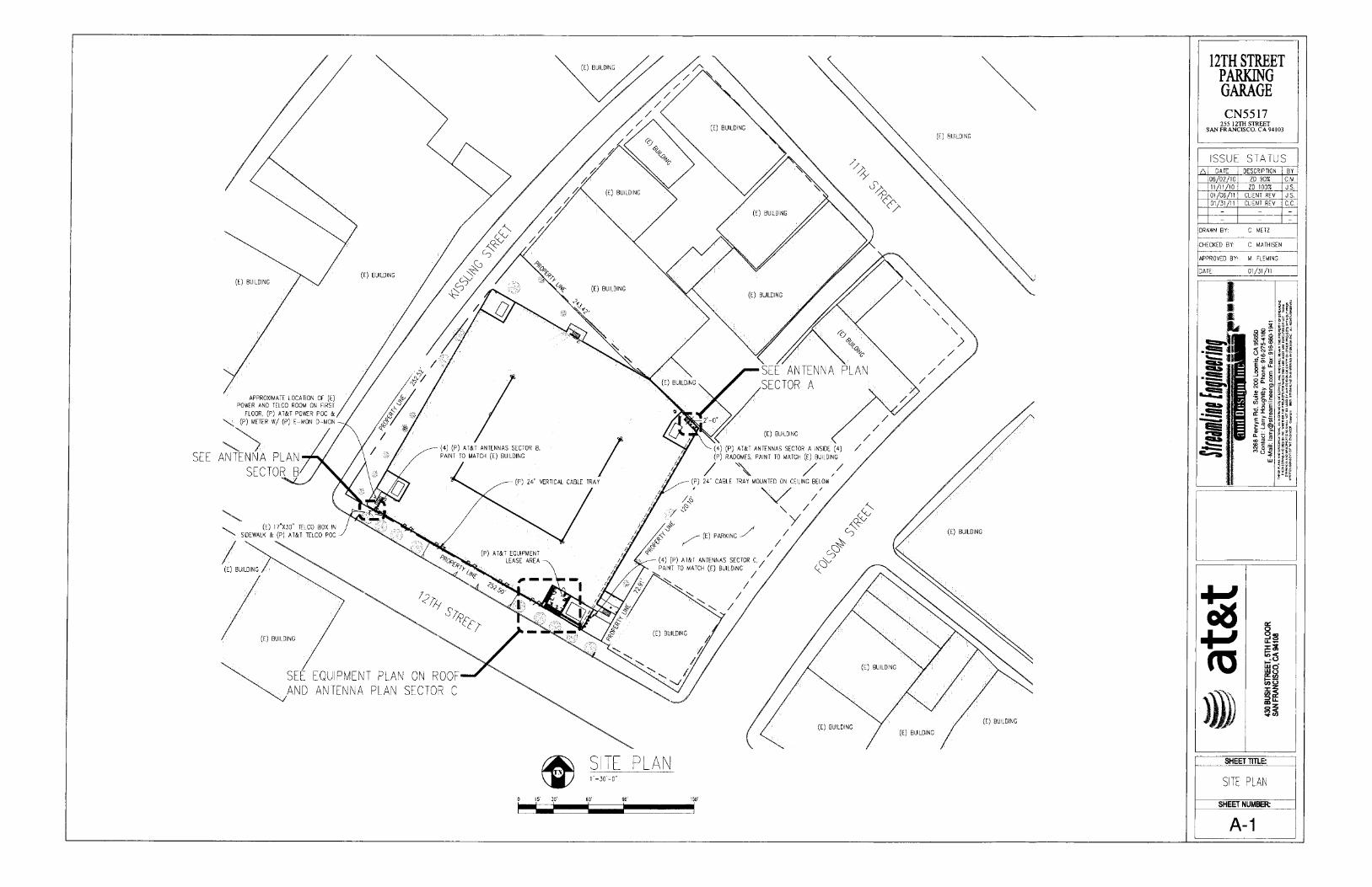
APPROXIMATE LOCATION OF (E) POWER AND TELCO ROOM ON FIRST
FLOOR, (P) AT&T POWER POC & (P) METER W/ (P) E-MON D-MON
SEE ANTENNA PLAN SECTOR B
(U I7V30" TELCO BOO IN SIDEWALK & (P) AT&T TELCO POD
/ / A’
BUIL DING
7/
\\ v
SEE EQUPMENT PLAN ON POOP AND ANTENNA PLAN SECTOR C
t JJ0
PLAN 1
90’ 110.
12TH STREET PARKING GARAGE CN5517
255 12Th STREET SAN FRANCISCO, CA 94103
ISSUE STATUS DATE DESCRIPTION BY
06/02/10 ZD 905 C.M 11/11/10 ZD 1005 JS. 01/06/11 CLIENT REV 35. 01/31/11 CLIENT REV C.C.
DRAWN BY, C METZ
CHECKED BY C MAIHISEN
APPROVED BY 0. FLEMINC
DATE 01/31/11
I
P4 DB
WA
- - ir = t PD
-:
SHEET TITLE:
SITE PLAN
SHEET NUMBER
A-i

(36 42
.0.0.0.0.
0. BATTERY BACKUP UNIT
CPS DETA I L
FRONT VIEW RIGHT VIEW
ORBS DETAL 1"1’-0’
PURCELL FLX16WS LIE SOLUTION CABINET
(36 42")
(77.81")
I I /
I I
C
LI
TOP VIEW
FRONT VIEW RIGHT VIEW
QBS DETA I L
EITICSSON 2106/ 3106 RBS CABINET W/ BASE
TOP VIEW
(300")
30.00
66.35
TOP VIFW
�D0")-
(7200")
1~
FRONT VIEW RIGHT VIEW
OCA8NET DETAI L
2 =- COMMSCOPE RBA72 CABINET
F-1
(28 0")
~t Y2"=I’�O’
EQU I PMENT PLAN
I � �
12TH STREET PARKING GARAGE CN5517
255 12Th STREET SAN FRANCISCO, CA 94103
SSUE STATUS DATE DESCRIPTION BY
06/02/10 ZD 504 0.8. 11/11/10 ZO 1U07 JS. 01 /06/11 CLIENT REV U.S. 01/31/Il CLIENT REV CC.
DRAWN BY C. METZ
CHECKED BY C MATHISEN
APPROVED BY B. FLEMINC
DATE: 01/31/11
I *
B9
I1E <_ � 3R1
cf(’fl
- -
ca
SHEET TITLE:
EQUIPMENT PLAN & DETAILS
SHEET NUMBER
A-2

E) BUILDING BELOW
PARAPET RNH’S
(P) BARRICADE
(P) AT&T ANTENNA INSIDE A (P) 020" RADOME, PAINT
TO MATCH (C) BUILDING
(P) AT&T ANTENNA INSIDE A )P) 020" RADOME, PAINT
TO MATCH (E) BUILDING 12-0’
(P) AT&T ANTENNA INSIDE A (P) 020" RADOME, PAINT
TO MATCH ([) BUILDING 3-0
(P) AT&T ANTENNA INSIDE
6’ CORES FOR COAX
A (P) ADO" RADOME, PAINT TO MATCH (E) BUILDING
FTOP EQUIPMENT (P) 24" CABLE TRAP MOUNTED
ON CEILING BELOW
ANTENNA PLAN SECTOR A It )~"=V-0"
(E) STAIRCASE TO ROOF (P) GEN PLUG AT GROUND LEVEL
e14,t- 4 (P) AT&T ANTENNA PAINT TO MATCH (E) BUILDING
/ (P) AT&T ANTENNA PAINT TO MATCH (E) BUILDING
3’ � 0’ (C) VENT
32P: S T
1, vIll T T
T - r - P
(H) AT&T ANTENNA PAINT
}T
TO MATCH (E) BUILDING
(P) AT&T ANTENNA PAINT
TO MATCH (T) BUILDING
ANTENNA PLAN SECTOR B iollrelp
(C) PARAPET
) AT&T ANTENNA PAINT 0 MATCH (E) BUILDING
ANTENNA PAINT (C) BUILDING
ANTENNA PLAN SECTOR C TN
LI TOP VIEW
H
LEFT VIEW FRONT VIEW
0ANTENNA DETAI L
tF (ll3)
Z~ TOP VIEW
FRONT VIEW RIGHT VIEW
RRH DETAL
12TH STREET PARKING GARAGE CN5517
255 12TH STREET SAN FRANCISCO, CA 94103
ISSUE STATUS A DATE DESCRIPTION BY
06/02/10 ZD 90% G.M 11/11/10 ZD 100% J. S. 01/00/11 CLIENT REV U.S. 01/31/11 CLIENT REV C.G
DRAWN BY C MET?
CHECKED BY C MATHISEN
APPROVED BY. A FLEMING
DATE 01/31/11
I
quo-
°
...
C0
ir A
I -
SHEET TIRE
ANTENNA PLANS & DETAILS
SHEET NUMBER
A-3

GROUND LEVEL 0’-D
-- (E) NEIGHBORING BUILDING
5 T’GROUND LEVEL -O"
12TH STREET PARKING GARAGE CN5517
255 1211-ISTREET SAN FRANCISCO, CA 94103
ISSUE STATUS A DATE DESCRIPTION BY
00/02/10 05 90% CM. 11/11/10 ZD 100% 3.5. 01/05/11 CLIENT REV J. S. 01/31/11 CLIENT REV C. C.
DRAWN BY: C. MElT
CHECKED BY C MATHISEN
APPROVED BY: H. FLEMING
DATE: 01/31/11
I * * 09
�
- . - --
oE DB I w.
(o Lud
co
SHEET TITLE
ELEVATIONS
SHEET NUMBER
A-4
(4) (P) AT&T ANTENNAS SECTOR A INSIDE (4) TOP OF (P) AT&T EQUIPMENT (P) R-- –57-8 A C.L
TOP OF )E) PARAPET & ( F) AT&T ANTENNAS SECTOR A –53-9" A G.L
TOP OF (U) ROOF AT EQUIPMENT –55-4" AC L
TOP OF
S TOP OF (E) ROOF 45. A.O L.
GROUND LEVEL S
_- (F) ACCESS DOOR
NORTHEAST ELEVAT I ON
VIEWED FROM KISSLING STREET
SOUTHEAST ELEVAT I ON
MEWED FROM FOLSOM STREET
(F) AT&T EQUIPMENT AREA
(4) (P) AT&T ANTENNAS SECTOR A INSIDE (4) (F) RADOHES PRINT TO MATCH (E) BUILDING I
P OF P AT&T ANTENNAS SECTOR A 53’-9"AGL
TOP OFR
I
(E( NEIGHBORING BUILDING
AT&T EQUIPMENT
TOP OF (Q
SS
TOP OF (P) AT&T ANTENNAS SECTORS B & C –52’-9 A C L
TOP OF(E) ROOF AT EQUIPMENT –50’-4 A C L.
(4) )P) AT&T ANTENNAS SECTOR B BEHIND (F) FRP SCREEN PAINT TO MATCH (E) BUILDING
(4) )P) AT&T ANTENNAS SECTOR C BEHIND (P) FRP SCREEN PAINT TO MATCH (E) BUILDING
(F) ROOF DECK

GROUND LEVEL 0 , - a"
TOP OFP AT&T ANTENNAS SECTOR
OF PARAPET K8-1"AGL
(F) AT&T EQUIPMENT AREA
A r’4’ ’1 Lt1J
(E( ROOF DECK
1 1 --- -- --
L - ---- - -- --- - - - - - -- - -- - - - - - - - - --- - - - - - - - - - - - - - - - _
I
GROUND LEVEL 4"
TOP OF P AT&T EQUIPMENT
PAR4
Gips TOP O
TOP OF (P( AT&T ANTENNAS
\ \ SECTORS B & C –52-9" AOL
\ \ TOP OF (E) ROOF AT EQUIPMENT AL
(4) (P) AT&T ANTENNAS SECTOR PAINT TO MATCH (C) BUILDING
’
GROUND LEVEL
12TH STREET PARKING GARAGE CN5517
255 12Th STREET SAN FRANCISCO, CA 94103
ISSUE STATUS A DATE DESCRIPTION BY
06/02/10 ZD 905 C.M. 11/11/10 ZD 1005 J. S. 01/06/11 CLIENT REV J. S. 01/31/11 CLIENT REV C C.
DRAWN BY C METZ
CHECKED BY’ C MATHISEN
APPROVED BY IA FLEMING
DATE: 01/31/11
I I *
-! U
dl -
’
4J (O
SHEET ME
ELEVATDNS
SHEET NUMBER:
A-5
(4) (P) AT&T ANTENNAS SECTOR A INSIDE (4) (P) RADOMEIS PAINT TO MATCH (C) BUILDING
(P) GPS (4) (P) AT&T ANTENNAS SECTOR B PAINT ED MATCH (E) BUILDING (P) AT&T EQUIPMENT AREA
(P) POWER & TELCO ROUTE (C) ROOF DECK
NORTHWEST ELEVAT I ON /321-0
VIEWED FROM KISSLING STREET
SOUTHWEST ELEVAT I ON /32IO
MEWED FROM 12TH STREET
TOP OF (K) AT&T EQUIPMENT
OF (C) PA RAPET
TOP –57-8" AOL
–53-9’ AG L
(P) AT&T ANTENNAS SECTORS B & C 4" TOP OF –52’T" A G.L.
TOP OF (E( ROOF AT EQUIPMENT 4 –50-4" AOL,
(4) (P) AT&T ANTENNAS SECTOR C PAINT TO MATCH (E) BUILDING
1"
k i
N 5


![From: Rodney Minott [mailto:rodneyminott@outlook.com] …commissions.sfplanning.org/hpcpackets/20181017pre.pdfheight of the proposed 300 foot tower and other large buildings to the](https://img.pdfslide.net/doc/110x75/5e25eadef4193443567763fd/from-rodney-minott-mailtorodneyminott-commissionssfplanningorghpcpackets20181017prepdf.jpg)