Embed Size (px)
Citation preview
Hart District Council Local Plan Site Assessment: Stage 2 – High Level Site Assessment – SHL080 – Tanglewood Confidential Draft - 1.1 – May 2015
Adams Hendry Consulting Ltd 1
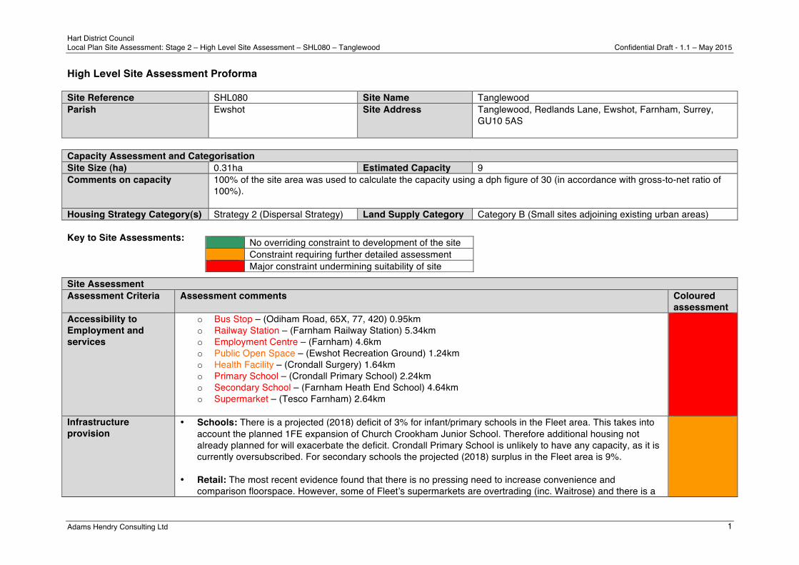
High Level Site Assessment Proforma Site Reference SHL080 Site Name Tanglewood Parish Ewshot Site Address Tanglewood, Redlands Lane, Ewshot, Farnham, Surrey,
GU10 5AS
Capacity Assessment and Categorisation Site Size (ha) 0.31ha Estimated Capacity 9 Comments on capacity 100% of the site area was used to calculate the capacity using a dph figure of 30 (in accordance with gross-to-net ratio of
100%).
Housing Strategy Category(s) Strategy 2 (Dispersal Strategy) Land Supply Category Category B (Small sites adjoining existing urban areas) Key to Site Assessments: Site Assessment Assessment Criteria Assessment comments Coloured
assessment Accessibility to Employment and services
o Bus Stop – (Odiham Road, 65X, 77, 420) 0.95km o Railway Station – (Farnham Railway Station) 5.34km o Employment Centre – (Farnham) 4.6km o Public Open Space – (Ewshot Recreation Ground) 1.24km o Health Facility – (Crondall Surgery) 1.64km o Primary School – (Crondall Primary School) 2.24km o Secondary School – (Farnham Heath End School) 4.64km o Supermarket – (Tesco Farnham) 2.64km
Infrastructure provision
• Schools: There is a projected (2018) deficit of 3% for infant/primary schools in the Fleet area. This takes into account the planned 1FE expansion of Church Crookham Junior School. Therefore additional housing not already planned for will exacerbate the deficit. Crondall Primary School is unlikely to have any capacity, as it is currently oversubscribed. For secondary schools the projected (2018) surplus in the Fleet area is 9%.
• Retail: The most recent evidence found that there is no pressing need to increase convenience and
comparison floorspace. However, some of Fleetʼs supermarkets are overtrading (inc. Waitrose) and there is a
No overriding constraint to development of the site Constraint requiring further detailed assessment Major constraint undermining suitability of site

Hart District Council Local Plan Site Assessment: Stage 2 – High Level Site Assessment – SHL080 – Tanglewood Confidential Draft - 1.1 – May 2015
Adams Hendry Consulting Ltd 2
modest deficit in convenience floorspace. Therefore, additional housing not already planned for will increase the need to expand retail floorspace (convenience and comparison) in Fleet.
• Health: Richmond Surgery (Fleet) has been identified in a previous PCT Estates plan as having potential for
improvement. Any additional housing not already planned for will exacerbate any deficiencies at that surgery. • Transport (road): From the available evidence, there are no proposed road/junction improvements in close
proximity to the site. However there will be a scheme to reduce the amount of HGV traffic through Crondall Village.
• Transport (other): Stagecoach has recently reorganised several bus routes in Hart, and this has significantly
reduced the level of bus service for this site with the end of the routing of the 72 from Fleet to Aldershot via Church Crookham and Ewshot. The remaining services on the Odiham Road are tailored towards school and collage services for students.
• Green Infrastructure: This site is located within of the Hitches Lane SANG catchment area. As of the 31st
March 2015, the SANG had remaining capacity for approximately 338 dwellings. There is a lack of provision in certain types of infrastructure in the area and development on the site will only increase the pressure on existing services. It is unlikely that the site is of sufficient size to provide the supporting infrastructure onsite.
Current Use and Relevant Planning History
The site is currently a single dwelling house and garden. There is no planning history for this site.
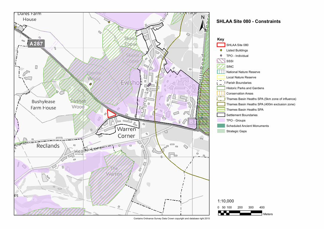
Nature Conservation Site is within the 5km Thames Basin Heaths SPA Zone of Influence. It is possible that a site of this scale could be within the capacity of the Hitches Lane SANG to mitigate its potential impact on the TBH SPA. If this proves not to be the case, any development at the site would require contributions for the provision of appropriate SANGs. There are no nature conservation designations on the site. To the north of the site and the A327 is an area with a TPO designation; additionally the Combe Wood and Ewshot Wood SINCs are in close proximity to the north and west of the site.
Minerals Resources The Hampshire Minerals and Waste Plan Policies Map indicates that there are no areas within the site that are subject to minerals safeguarding.
Hart District Council Local Plan Site Assessment: Stage 2 – High Level Site Assessment – SHL080 – Tanglewood Confidential Draft - 1.1 – May 2015
Adams Hendry Consulting Ltd 3
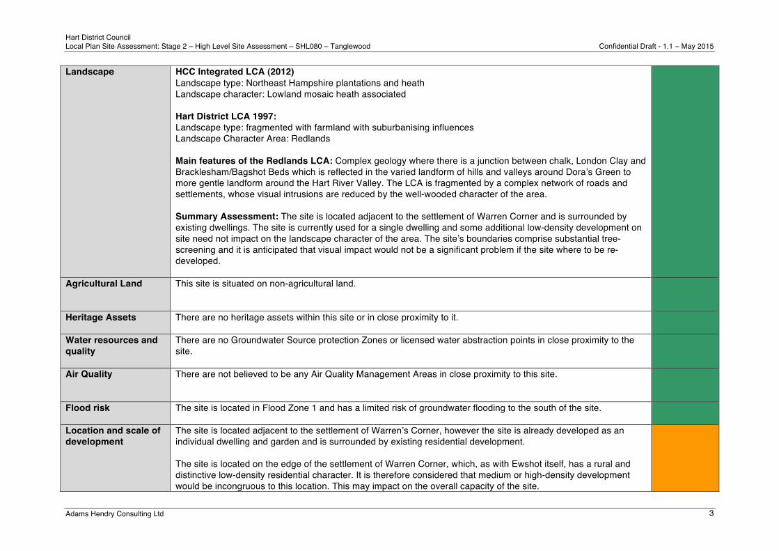
Landscape HCC Integrated LCA (2012) Landscape type: Northeast Hampshire plantations and heath Landscape character: Lowland mosaic heath associated Hart District LCA 1997: Landscape type: fragmented with farmland with suburbanising influences Landscape Character Area: Redlands Main features of the Redlands LCA: Complex geology where there is a junction between chalk, London Clay and Bracklesham/Bagshot Beds which is reflected in the varied landform of hills and valleys around Doraʼs Green to more gentle landform around the Hart River Valley. The LCA is fragmented by a complex network of roads and settlements, whose visual intrusions are reduced by the well-wooded character of the area. Summary Assessment: The site is located adjacent to the settlement of Warren Corner and is surrounded by existing dwellings. The site is currently used for a single dwelling and some additional low-density development on site need not impact on the landscape character of the area. The siteʼs boundaries comprise substantial tree-screening and it is anticipated that visual impact would not be a significant problem if the site where to be re-developed.
Agricultural Land This site is situated on non-agricultural land.
Heritage Assets There are no heritage assets within this site or in close proximity to it.
Water resources and quality
There are no Groundwater Source protection Zones or licensed water abstraction points in close proximity to the site.
Air Quality
There are not believed to be any Air Quality Management Areas in close proximity to this site.
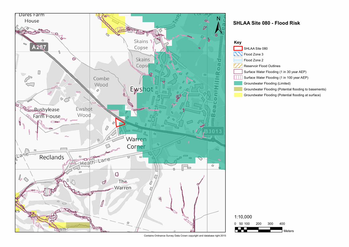
Flood risk The site is located in Flood Zone 1 and has a limited risk of groundwater flooding to the south of the site.
Location and scale of development
The site is located adjacent to the settlement of Warrenʼs Corner, however the site is already developed as an individual dwelling and garden and is surrounded by existing residential development. The site is located on the edge of the settlement of Warren Corner, which, as with Ewshot itself, has a rural and distinctive low-density residential character. It is therefore considered that medium or high-density development would be incongruous to this location. This may impact on the overall capacity of the site.
Hart District Council Local Plan Site Assessment: Stage 2 – High Level Site Assessment – SHL080 – Tanglewood Confidential Draft - 1.1 – May 2015
Adams Hendry Consulting Ltd 4
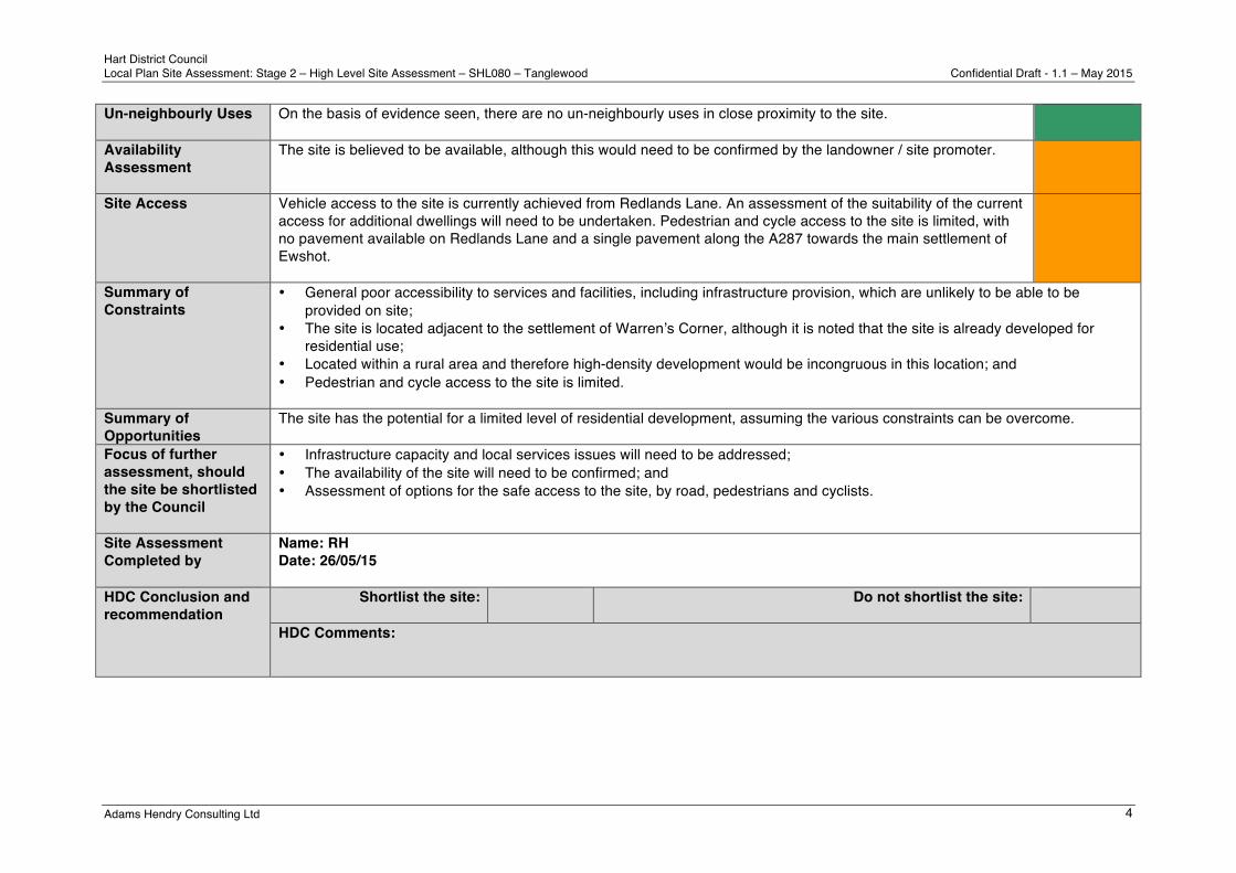
Un-neighbourly Uses
On the basis of evidence seen, there are no un-neighbourly uses in close proximity to the site.
Availability Assessment
The site is believed to be available, although this would need to be confirmed by the landowner / site promoter.
Site Access
Vehicle access to the site is currently achieved from Redlands Lane. An assessment of the suitability of the current access for additional dwellings will need to be undertaken. Pedestrian and cycle access to the site is limited, with no pavement available on Redlands Lane and a single pavement along the A287 towards the main settlement of Ewshot.
Summary of Constraints
• General poor accessibility to services and facilities, including infrastructure provision, which are unlikely to be able to be provided on site;
• The site is located adjacent to the settlement of Warrenʼs Corner, although it is noted that the site is already developed for residential use;
• Located within a rural area and therefore high-density development would be incongruous in this location; and • Pedestrian and cycle access to the site is limited.
Summary of Opportunities
The site has the potential for a limited level of residential development, assuming the various constraints can be overcome.
Focus of further assessment, should the site be shortlisted by the Council
• Infrastructure capacity and local services issues will need to be addressed; • The availability of the site will need to be confirmed; and • Assessment of options for the safe access to the site, by road, pedestrians and cyclists.
Site Assessment Completed by
Name: RH Date: 26/05/15
HDC Conclusion and recommendation
Shortlist the site:
Do not shortlist the site:
HDC Comments:
0 100 200 300 40050Meters
1:10,000
±Key
SHLAA Site 080Listed Buildings
! TPO - IndividualSSSISINCNational Nature ReserveLocal Nature ReserveParish BoundariesHistoric Parks and GardensConservation AreasThames Basin Heaths SPA (5km zone of influence)Thames Basin Heaths SPA (400m exclusion zone)Thames Basin Heaths SPASettlement BoundariesTPO - GroupsScheduled Ancient MonumentsStrategic Gaps
Contains Ordnance Survey Data Crown copyright and database right 2015
SHLAA Site 080 - Constraints
0 100 200 300 40050Meters
1:10,000
±Key
SHLAA Site 080Flood Zone 3Flood Zone 2Reservoir Flood OutlinesSurface Water Flooding (1 in 30 year AEP)Surface Water Flooding (1 in 100 year AEP)Groundwater Flooding (Limited)Groundwater Flooding (Potential flooding to basements)Groundwater Flooding (Potential flooding at surface)
Contains Ordnance Survey Data Crown copyright and database right 2015
SHLAA Site 080 - Flood Risk