Embed Size (px)
DESCRIPTION
High Route Paznaun English
Citation preview
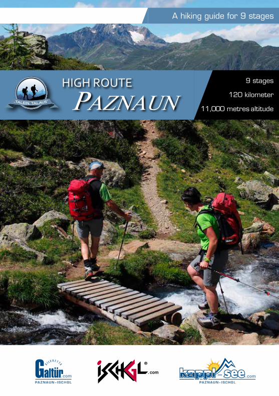
A hiking guide for 9 stages
9 stages
120 kilometer
11,000 metres altitude
HIGH ROUTE
PAZNAUN
2 3HIGH ROUTE
PAZNAUN
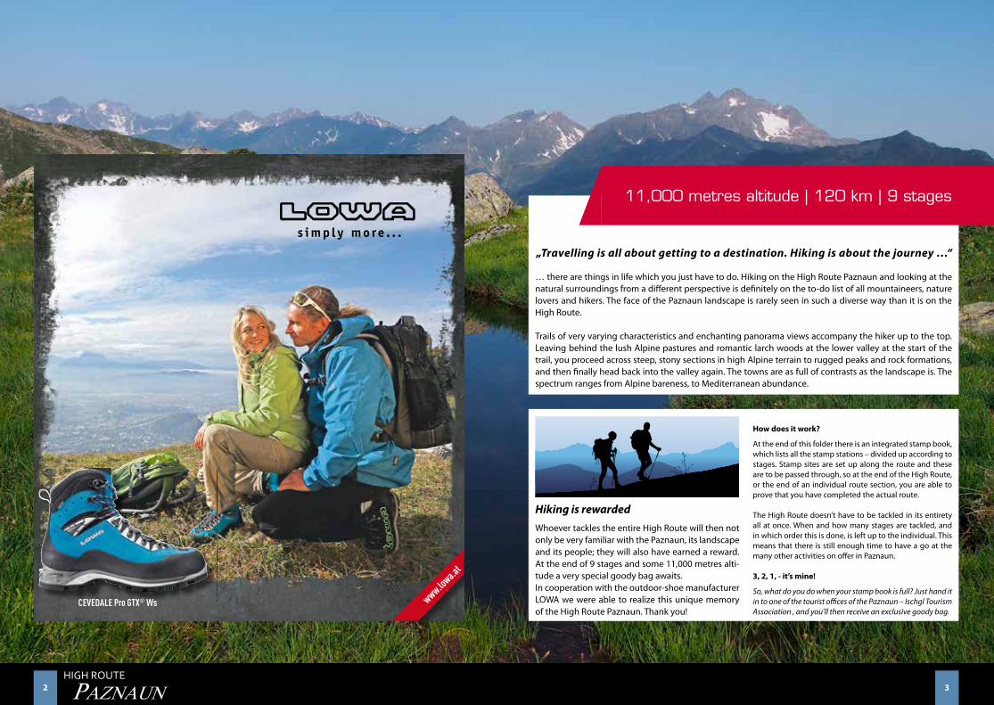
„Travelling is all about getting to a destination. Hiking is about the journey …“
… there are things in life which you just have to do. Hiking on the High Route Paznaun and looking at the natural surroundings from a different perspective is definitely on the to-do list of all mountaineers, nature lovers and hikers. The face of the Paznaun landscape is rarely seen in such a diverse way than it is on the High Route.
Trails of very varying characteristics and enchanting panorama views accompany the hiker up to the top. Leaving behind the lush Alpine pastures and romantic larch woods at the lower valley at the start of the trail, you proceed across steep, stony sections in high Alpine terrain to rugged peaks and rock formations, and then finally head back into the valley again. The towns are as full of contrasts as the landscape is. The spectrum ranges from Alpine bareness, to Mediterranean abundance.
Hiking is rewardedWhoever tackles the entire High Route will then not only be very familiar with the Paznaun, its landscape and its people; they will also have earned a reward. At the end of 9 stages and some 11,000 metres alti-tude a very special goody bag awaits.In cooperation with the outdoor-shoe manufacturer LOWA we were able to realize this unique memory of the High Route Paznaun. Thank you!
How does it work?
At the end of this folder there is an integrated stamp book, which lists all the stamp stations – divided up according to stages. Stamp sites are set up along the route and these are to be passed through, so at the end of the High Route, or the end of an individual route section, you are able to prove that you have completed the actual route.
The High Route doesn’t have to be tackled in its entirety all at once. When and how many stages are tackled, and in which order this is done, is left up to the individual. This means that there is still enough time to have a go at the many other activities on offer in Paznaun.
3, 2, 1, - it’s mine!
So, what do you do when your stamp book is full? Just hand it in to one of the tourist offices of the Paznaun – Ischgl Tourism Association , and you’ll then receive an exclusive goody bag.
11,000 metres altitude | 120 km | 9 stages
4 5HIGH ROUTE
PAZNAUN ... the High Route Paznaun and it‘s 9 stages !
Page
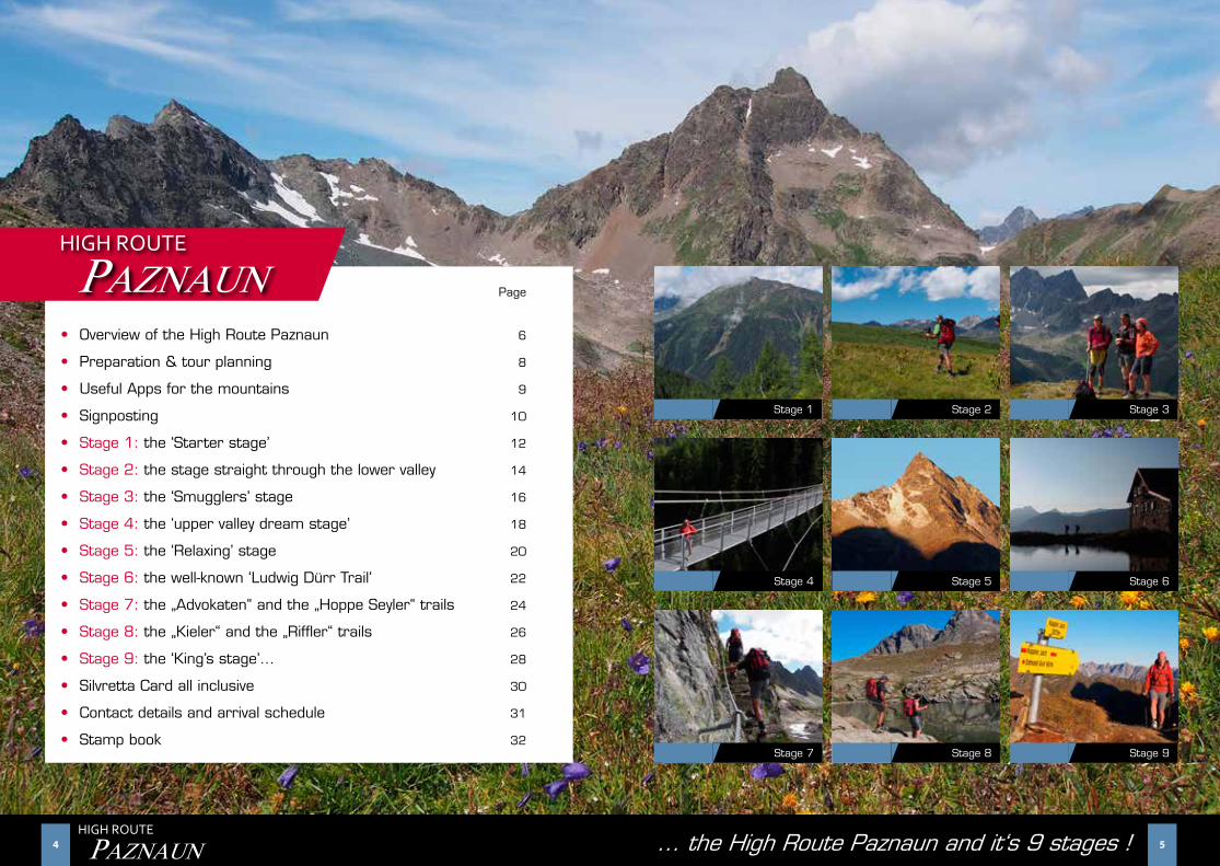
• Overview of the High Route Paznaun 6
• Preparation & tour planning 8
• Useful Apps for the mountains 9
• Signposting 10
• Stage 1: the ‘Starter stage’ 12
• Stage 2: the stage straight through the lower valley 14
• Stage 3: the ‘Smugglers’ stage 16
• Stage 4: the ‘upper valley dream stage’ 18
• Stage 5: the ‘Relaxing’ stage 20
• Stage 6: the well-known ‘Ludwig Dürr Trail’ 22
• Stage 7: the „Advokaten“ and the „Hoppe Seyler“ trails 24
• Stage 8: the „Kieler“ and the „Riffler“ trails 26
• Stage 9: the ‘King’s stage’… 28
• Silvretta Card all inclusive 30
• Contact details and arrival schedule 31
• Stamp book 32
HIGH ROUTE
PAZNAUN
Stage 1 Stage 2 Stage 3
Stage 6Stage 5Stage 4
Stage 7 Stage 8 Stage 9
6 7HIGH ROUTE
PAZNAUN
Stage 1: the ‘Starter stage’
Stage 2: the stage straight through the lower valley
Stage 3: the ‘Smugglers’ stage
Stage 4: the ‘upper valley dream stage’
Stage 5: the ‘Relaxing’ stage
Stage 6: the well-known ‘Ludwig Dürr Trail’
Stage 7: the „Advokaten“ and the „Hoppe Seyler“ trails
Stage 8: the „Kieler“ and the „Riffler“ trails
Stage 9: the ‘King’s stage’…
See
Kappl
Ischgl
Galtür
1
2
3
4
5
6
7
8
9
8 9HIGH ROUTE
PAZNAUN
Being well prepared is half the battle for hiking …
Tour planning
Irrespective of whether you are hiking just one stage, or the entire High Route Paznaun – meticu-lous planning with regard to your fitness level, the weather conditions and extraneous circumstan-ces is indispensable. The routes proceed in part through high Alpine terrain, which means Alpine experience, surefootedness and, from time to time, a head for heights are required.
Map material
This guide should be of use to you when it comes to meticulously planning a tour; nevertheless it is indispensable that you ready yourself with rele-vant map material for an undertaking like the High Route. All route information as well as GPS data for download are available at the following links:
www.galtuer.com / www.ischgl.com www.kappl.com / www.see.at
Equipment
Long tours and overnight stays in Alpine lodges also require special equipment, which should not only be functional but also easy to stow away, so the weight of the backpack remains in its frame-work. Perfectly fitting mountain boots and functio-nal clothing appropriate for Alpine weather is part of the basic equipment required. Having enough food supplies with you is just as important. (Keep walking times in mind and bring plenty of li-
quids!). You should also take emergency equipment with you, which, in addition to a small First Aid box should also contain a torch and a bivvy bag. Telesco-pic poles can also be very useful for steep ascents and descents and help protect your joints. Please note too that you need to bring a sleeping bag for your overnight stay in an Alpine lodge.
Walking times
The walking times listed here are averages and lon-ger breaks have not been factored in. Adverse wea-ther conditions such as rain, snow, fog and wet con-ditions can extend walking times considerably and increase the difficulty level of the tour.
Weather
Please be aware that the High Route runs in part in high Alpine terrain where the weather can change very quickly and occasionally even in the summer months low temperatures, and even snow, has to be reckoned with. Therefore appropriate tour planning is indispensable, as is clothing and equipment which is suitable for the weather conditions. Get informati-on in advance about the prevailing weather situati-on and plan accordingly.
Alpine association weather service: Tel +43 (0) 512 / 291600 (personal assistance)
ü
i
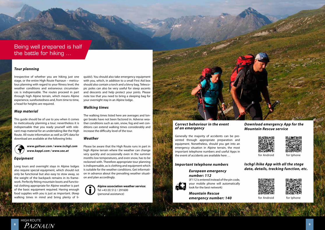
Correct behaviour in the eventof an emergency
Generally the majority of accidents can be pre-vented through appropriate preparation and equipment. Nonetheless, should you get into an emergency situation in Alpine terrain, the most important telephone numbers and useful Apps in the event of accidents are available here …
Important telephone numbers
European emergency number: 112 (if 112 is entered instead of the pin code, your mobile phone will automatically look for the best network)
Mountain Rescue emergency number: 140
Download emergency App for the Mountain Rescue service
for Android for Iphone
Ischgl ihike App with all the stage data, details, tracking function, etc.
for Android for Iphone
h
10 11HIGH ROUTE
PAZNAUN
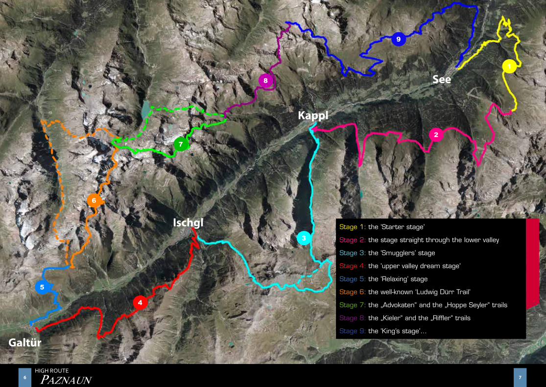
An overview of the High Route
Essentially the High Route starts in See and pro-ceeds into the valley on Alpine terrain high above towns of Kappl and Ischgl, to Galtür – the trail then takes us on the other side of the valley back again to the starting point in See. This High Route may of course be investigated in both directions and also in stages. There are options to descend into the val-ley from each Alpine lodge. This means there is the opportunity to head out on selected stages over a weekend, and maybe even complete the entire High Route.
The entire tour takes 9 days. The romantic and best managed Alpine lodges along the route serve as support bases. These not only provide an oppor-tunity for an overnight stay – tasty food and key information about the next route section are a par for the course here.
There are five overnight stops in Alpine lodges on the entire route and four overnight stops in the val-ley locations. This demonstrates that the Paznaun high Alpine trail doesn’t only have to be tackled as part of a great Alpine undertaking. A whole series of places where you access and get back off the trail make it possible for individual stages to be selected.
Peak Pleasures
The majority of the High Route Paznaun appeals to mountain hikers of average fitness level, who still want to investigate Paznaun on routes they haven’t previously known about. The route also provides plenty of challenges for experienced mountaineers too. Every now and again en route from Alpine lodge to Alpine lodge they can “bag“a summit, so to speak. We are in the Samnaun, Silvretta and Verwall groups here. That is, sort of ‘only’ on the fringes of
the world-renown Silvretta. This is perhaps a lovely way to see this valley - which is somewhat shady in the summer and seems narrow and barren – and see it at its best. This High Route really does provide immense views and at the end of the trail a visitor might even feel right at home.
Traditional Alpine lodge style & tasty food – a traditional stop-off
‘Hiking a lot will make you proficient’… but it will also make you hungry. Along the High Route Paznaun there are Alpine lodges which bask in the sun, serving traditional dishes, as well as other con-temporary buildings which have well-selected deli-cious treats. There is something to suit every taste.
However, the lodge landlords don’t just provide food and drinks, they are also happy to help with tour pl-anning and information and have exciting stories to tell about Paznaun and its people.
In the stage outlines you will find information about the respective Alpine lodges which are available along the trail as stop-off points and places to stay the night. Since the number of beds is limited, con-tacting the lodge landlord/landlady when you are planning a tour is recommended with regard to get-ting details about options for an overnight stay.
The opening hours of the lodges are compiled ac-cording to the information provided by the lodges, these may however change at short notice due to the current weather and snow situation. Now and then the trail will include a descent into the valley – in the respective town, Paznaun-Ischgl Tourism Association information offices will of course assist with your accommodation search.
We hope you have an exciting and also a relaxing time on the high route Paznaun!
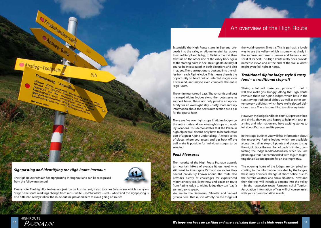
Signposting and identifying the High Route Paznaun
The High Route Paznaun has signposting throughout and can be recognisedfrom the following symbol.
Please note! The High Route does not just run on Austrian soil, it also touches Swiss areas, which is why on Stage 3 the route markings change from ‘red – white – red’ to ‘white – red – white’ and the signposting is also different. Always follow the route outline provided here to avoid going off route!
12 13HIGH ROUTE
PAZNAUN
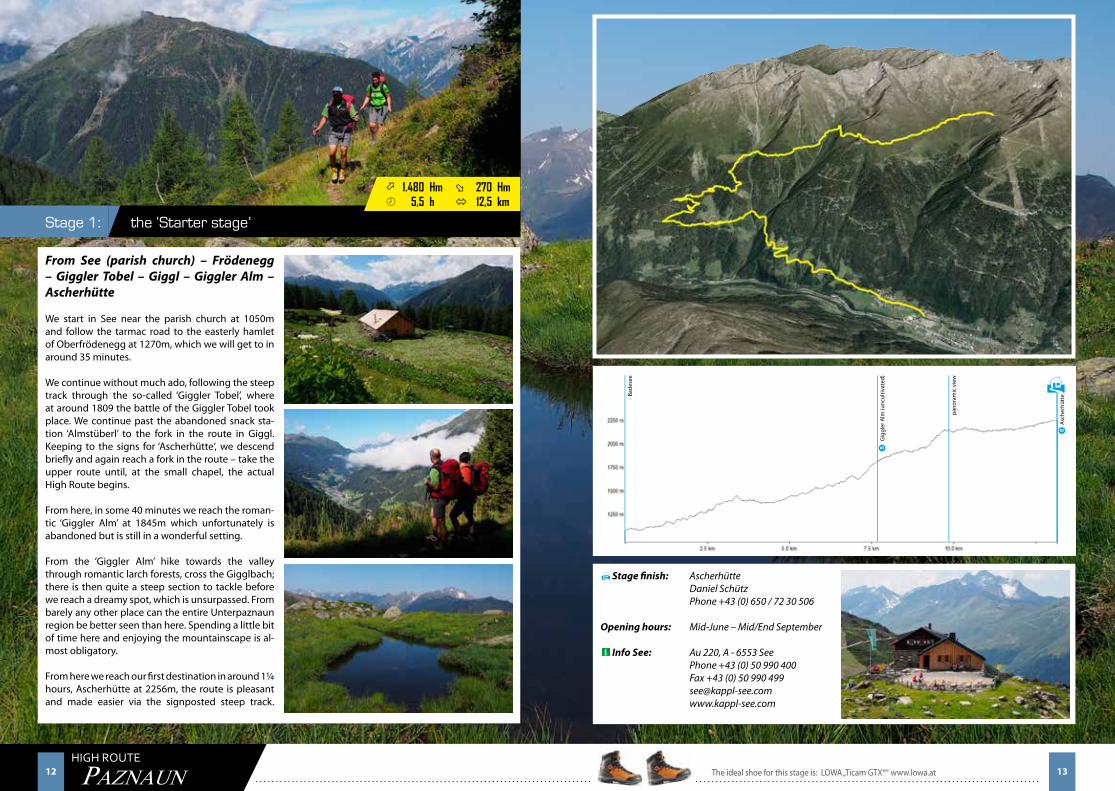
the ‘Starter stage’ Stage 1:
Stage finish: Ascherhütte Daniel Schütz Phone +43 (0) 650 / 72 30 506
Opening hours: Mid-June – Mid/End September
Info See: Au 220, A - 6553 See Phone +43 (0) 50 990 400 Fax +43 (0) 50 990 499 [email protected] www.kappl-see.com
From See (parish church) – Frödenegg – Giggler Tobel – Giggl – Giggler Alm – Ascherhütte
We start in See near the parish church at 1050m and follow the tarmac road to the easterly hamlet of Oberfrödenegg at 1270m, which we will get to in around 35 minutes.
We continue without much ado, following the steep track through the so-called ‘Giggler Tobel’, where at around 1809 the battle of the Giggler Tobel took place. We continue past the abandoned snack sta-tion ‘Almstüberl’ to the fork in the route in Giggl. Keeping to the signs for ‘Ascherhütte‘, we descend briefly and again reach a fork in the route – take the upper route until, at the small chapel, the actual High Route begins.
From here, in some 40 minutes we reach the roman-tic ‘Giggler Alm’ at 1845m which unfortunately is abandoned but is still in a wonderful setting.
From the ‘Giggler Alm’ hike towards the valley through romantic larch forests, cross the Gigglbach; there is then quite a steep section to tackle before we reach a dreamy spot, which is unsurpassed. From barely any other place can the entire Unterpaznaun region be better seen than here. Spending a little bit of time here and enjoying the mountainscape is al-most obligatory.
From here we reach our first destination in around 1¼ hours, Ascherhütte at 2256m, the route is pleasant and made easier via the signposted steep track.
H
H
ö 1.480 Hm ø 270 Hm¾ 5,5 h ó 12,5 km
Bade
see
Gig
gler
Alm
(unc
ultiv
ated
)
pano
ram
ic v
iew
Asc
herh
ütte
The ideal shoe for this stage is: LOWA „Ticam GTX®“ www.lowa.at 13
S
S
14 15HIGH ROUTE
PAZNAUN
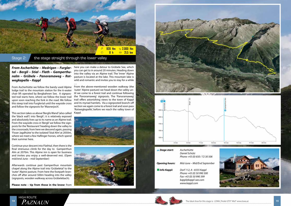
the stage straight through the lower valley Stage 2:
ö 920 Hm ø 2.000 Hm¾ 8 h ó 21,5 km
From Ascherhütte – Medrigen – Furgler-tal – Bergli – Stial – Flath – Gamperthu-nalm – Grübele – Panoramaweg – Rot-wegkapelle – Kappl
From Ascherhütte we follow the barely used Alpine lodge trail to the mountain station for the 6-seater chair lift operated by Bergbahnen See. A signpos-ted trail starts here, where we follow the lower trail upon soon reaching the fork in the road. We follow this steep trail into Furglertal until the wayside cross and follow the signposts for ‘Masnerjoch’.
This section takes us above ‘Berglis Wand’ (also called the ‘black wall’) into ‘Bergli’; it is relatively exposed and absolutely lives up to its name as an Alpine trail. From the wayside cross in ‘Bergli’ we follow the sign-posts for the ‘Restaurant’ heading down the valley to the crossroads; from here we descend again, passing ‘Fisser Jagdhütte’ to the isolated ‘Stial Alm’ at 2050m, where we meet a few Haflinger horses, which spend their summer here.
Continue your descent into Flathtal, then there is the final strenuous climb for the day to Gamperthun Alm at 2070m. This Alpine inn is open for business and invites you enjoy a well-deserved rest. (Open mid/end June – mid September)
Afterwards continue past Gamperthun mountain chapel along the Alpine trail into ‘Grübeletal’ to the ‘outer’ Alpine pasture. From here the footpath bran-ches off after around 500m heading into the valley (signposts, wooden walkway across Grübelebach).
Please note – tip from those in the know: from
here you can make a detour to Grübele See, which you can get to in around 20 minutes. Heading down into the valley via an Alpine trail. The ‘inner’ Alpine pasture is located at the lake. This mountain lake is wild and romantic and invites you to stay for a while …From the above-mentioned wooden walkway (the ‘outer’ Alpine pasture) we head down the valley un-til we come to a forest trail and continue following the ‘Panoramaweg’ signposts. The ‘Panoramaweg’ trail offers astonishing views to the town of Kappl and its myriad hamlets. Via a signposted branch-off section we again come to a forest trail and soon pass ‘Rotwegkapelle’, before we reach the valley town of Kappl.
Stage start: Ascherhütte Daniel Schütz Phone +43 (0) 650 / 72 30 506
Opening hours: Mid-June – Mid/End September
Info Kappl: Dorf 112, A - 6555 Kappl Phone +43 (0) 50 990 300 Fax +43 (0) 50 990 399 [email protected] www.kappl.com
H
H
Gam
pert
hun
Alm
Berg
li - S
ee
Asc
herh
ütte
The ideal shoe for this stage is: LOWA „Triolet GTX® Mid“ www.lowa.at 15
S
16 17HIGH ROUTE
PAZNAUN
the ‘Smugglers’ stageStage 3:
ö 2.000 Hm ø 1.800 Hm¾ 9,5 h ó 21 km
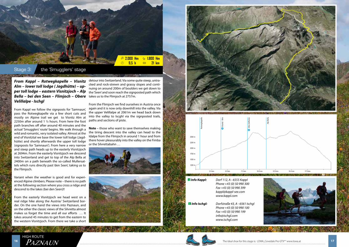
From Kappl – Rotwegkapelle – Visnitz Alm – lower toll lodge ( Jagdhütte) – up-per toll lodge – eastern Visnitzjoch – Alp Bella – bei den Seen – Flimjoch – Obere Velillalpe - Ischgl
From Kappl we follow the signposts for ‘Samnaun’, pass the Rotwegkapelle via a few short cuts and mostly on Alpine trail we get to Visnitz Alm at 2250m after around 1 ½ hours. From here the foot path branches off after around 40 minutes and the actual ‘Smugglers’ route’ begins. We walk through a wild and romantic, very isolated valley. Almost at the end of Visnitztal we base the lower toll lodge (Jagd-hütte) and shortly afterwards the upper toll lodge (signposts for ‘Samnaun’). From here a very narrow and steep path heads up to the easterly Visnitzjoch at 2694m. From the easterly Visnitzjoch we descend into Switzerland and get to top of the Alp Bella at 2400m on a path beneath the so-called Mullersat-tels which runs directly past ‘den Seen’, taking us to the Flimjoch.
Variant when the weather is good and for experi-enced Alpine climbers. Please note – there is no path at the following section where you cross a ridge and descend to the lakes (bei den Seen)!!
From the easterly Visnitzjoch we head west on a real ridge hike along the Austria/ Switzerland bor-der. On the one hand the views into Paznaun, and on the other the classic views of the Silvretta almost makes us forget the time and all our efforts … It takes around 45 minutes to get from the eastern to the western Visnitzjoch. From there we take a short
detour into Switzerland. Via some quite steep, untra-cked and rock-strewn and grassy slopes and conti-nuing on around 200m of boulders we get down to the ‘Seen’ and soon reach the signposted path which takes us to the Flimjoch at 2757m.
From the Flimjoch we find ourselves in Austria once again and it is now only downhill into the valley. Via the upper Velillalpe at 2061m we head back down into the valley to Iscghl via the signposted trails, paths and sections of piste.
Note – those who want to save themselves making the tiring descent into the valley can head to the Idalpe from the Flimjoch in around 1 hour and from there hover pleasurably into the valley on the Fimba or the Silvrettabahn …
Info Kappl: Dorf 112, A - 6555 Kappl Phone +43 (0) 50 990 300 Fax +43 (0) 50 990 399 [email protected] www.kappl.com
Info Ischgl: Dorfstraße 43, A - 6561 Ischgl Phone +43 (0) 50 990 100 Fax +43 (0) 50 990 199 [email protected] www.ischgl.com
Visn
itz -
Alm
Rotw
egka
pelle
Alp
Bel
la
The ideal shoe for this stage is: LOWA „Cevedale Pro GTX®“ www.lowa.at 17
S Alte
Zol
lhüt
teS
18 19HIGH ROUTE
PAZNAUN
the ‘upper valley dream stage’Stage 4:
ö 1.800 Hm ø 1.600 Hm¾ 7,5 h ó 16 km
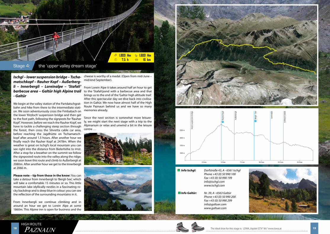
Ischgl – lower suspension bridge – Tscha-matschkopf – Rauher Kopf – Außerberg-li – Innerbergli – Loreinalpe – ‘Stafali‘ barbecue area – Galtür high Alpine trail - Galtür
We begin at the valley station of the Partdatschgrat-bahn and hike from there to the intermediate stati-on. We soon adventurously cross the Fimbabach on the lower ‘Kitzloch’ suspension bridge and then get to the foot path, following the signposts for ‘Rauher Kopf’. However, before we reach the Rauher Kopf, we have to tackle a challenging steep section through the forest, then cross the Silvretta cable car area, before reaching the Jagdhütte on Tschamatsch-kopf after around 1.5 hours. After another hour we finally reach the Rauher Kopf at 2478m. When the weather is great on Ischgl’s local mountain you can see right into the distance from Bielerhöhe to Imst. After a stop for a breather on the summit we follow the signposted route into the valley along the ridge; we soon leave this route and climb to Außerbergli at 2080m. After another hour we get to the Innerbergli at 2066 m.
Please note – tip from those in the know: You can take a detour from Innerbergli to ‘Bergli-See’, which will take a comfortable 15 minutes or so. This little mountain lake idyllically nestles in a fascinating ro-cky backdrop and is deep blue in colour; you can see the reflection of the surrounding mountains in it.
From Innerbergli we continue climbing and in around an hour we get to Lorein Alpe at some 1860m. This Alpine inn is open for business and the
cheese is worthy of a medal. (Open from mid-June – mid/end September).
From Lorein Alpe it takes around half an hour to get to the ‘Stafali’pond with a barbecue area and that brings us to the end of the ‘Galtür high altitude trail’. After this spectacular day we dive back into civilisa-tion in Galtür. We now have almost half of the High Route Paznaun behind us and we have so many memories already.
Since the next section is somewhat more leisure-ly, we might start the next stage with a trip to the Alpinarium or relax and unwind a bit in the leisure centre …
Info Ischgl: Dorfstraße 43, A - 6561 Ischgl Phone +43 (0) 50 990 100 Fax +43 (0) 50 990 199 [email protected] www.ischgl.com
Info Galtür: Nr. 39, A - 6563 Galtür Phone +43 (0) 50 990 200 Fax +43 (0) 50 990 299 [email protected] www.galtuer.com
Berg
li - S
ee
Auße
rber
gli
Lare
inal
pe
Gril
lteic
h St
afal
i
low
er s
uspe
nsio
n br
idge
The ideal shoe for this stage is: LOWA „Vajolet GTX® Ws“ www.lowa.at 19
Rauh
er K
opf
S S
20 21HIGH ROUTE
PAZNAUN
the ‘Relaxing’ stageStage 5:
ö 850 Hm ø 250 Hm¾ 3,5 h ó 7 km
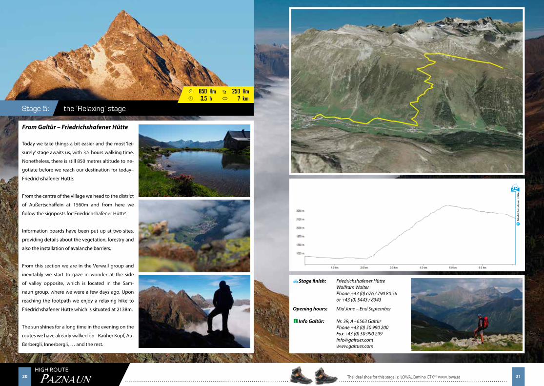
From Galtür – Friedrichshafener Hütte
Today we take things a bit easier and the most ‘lei-
surely’ stage awaits us, with 3.5 hours walking time.
Nonetheless, there is still 850 metres altitude to ne-
gotiate before we reach our destination for today–
Friedrichshafener Hütte.
From the centre of the village we head to the district
of Außertschaffein at 1560m and from here we
follow the signposts for ‘Friedrichshafener Hütte’.
Information boards have been put up at two sites,
providing details about the vegetation, forestry and
also the installation of avalanche barriers.
From this section we are in the Verwall group and
inevitably we start to gaze in wonder at the side
of valley opposite, which is located in the Sam-
naun group, where we were a few days ago. Upon
reaching the footpath we enjoy a relaxing hike to
Friedrichshafener Hütte which is situated at 2138m.
The sun shines for a long time in the evening on the
routes we have already walked on - Rauher Kopf, Au-
ßerbergli, Innerbergli, … and the rest.
Stage finish: Friedrichshafener Hütte Wolfram Walter Phone +43 (0) 676 / 790 80 56 or +43 (0) 5443 / 8343
Opening hours: Mid June – End September
Info Galtür: Nr. 39, A - 6563 Galtür Phone +43 (0) 50 990 200 Fax +43 (0) 50 990 299 [email protected] www.galtuer.com
H
H
Frie
dric
hsha
fene
r Hüt
te
The ideal shoe for this stage is: LOWA „Camino GTX®“ www.lowa.at 21
S
22 23HIGH ROUTE
PAZNAUN
the well-known ‘Ludwig Dürr Trail’ Stage 6:
ö 1.150 Hm ø 950 Hm¾ 6,5 h ó 10 km
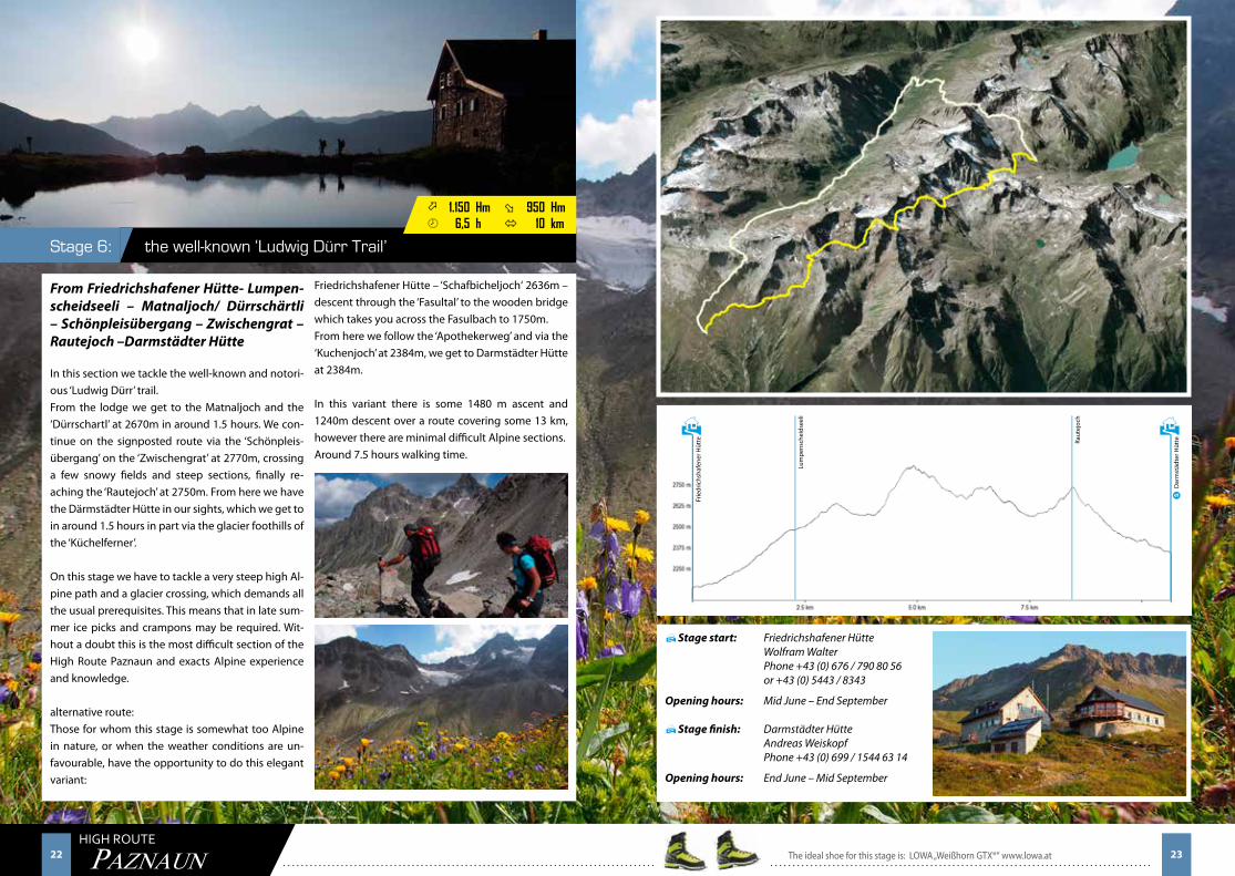
From Friedrichshafener Hütte- Lumpen-scheidseeli – Matnaljoch/ Dürrschärtli – Schönpleisübergang – Zwischengrat – Rautejoch –Darmstädter Hütte
In this section we tackle the well-known and notori-ous ‘Ludwig Dürr’ trail.From the lodge we get to the Matnaljoch and the ‘Dürrschartl’ at 2670m in around 1.5 hours. We con-tinue on the signposted route via the ‘Schönpleis-übergang’ on the ‘Zwischengrat’ at 2770m, crossing a few snowy fields and steep sections, finally re-aching the ‘Rautejoch’ at 2750m. From here we have the Därmstädter Hütte in our sights, which we get to in around 1.5 hours in part via the glacier foothills of the ‘Küchelferner’.
On this stage we have to tackle a very steep high Al-pine path and a glacier crossing, which demands all the usual prerequisites. This means that in late sum-mer ice picks and crampons may be required. Wit-hout a doubt this is the most difficult section of the High Route Paznaun and exacts Alpine experience and knowledge.
alternative route:Those for whom this stage is somewhat too Alpine in nature, or when the weather conditions are un-favourable, have the opportunity to do this elegant variant:
Friedrichshafener Hütte – ‘Schafbicheljoch‘ 2636m – descent through the ‘Fasultal’ to the wooden bridge which takes you across the Fasulbach to 1750m. From here we follow the ‘Apothekerweg’ and via the ‘Kuchenjoch’ at 2384m, we get to Darmstädter Hütte at 2384m.
In this variant there is some 1480 m ascent and 1240m descent over a route covering some 13 km, however there are minimal difficult Alpine sections. Around 7.5 hours walking time.
Stage start: Friedrichshafener Hütte Wolfram Walter Phone +43 (0) 676 / 790 80 56 or +43 (0) 5443 / 8343
Opening hours: Mid June – End September
Stage finish: Darmstädter Hütte Andreas Weiskopf Phone +43 (0) 699 / 1544 63 14
Opening hours: End June – Mid September
H
H
H
Raut
ejoc
h
Lum
pens
chei
dsee
li
Frie
dric
hsha
fene
r Hüt
te
H
Dar
mst
ädte
r Hüt
te
The ideal shoe for this stage is: LOWA „Weißhorn GTX®“ www.lowa.at 23
S
24 25HIGH ROUTE
PAZNAUN
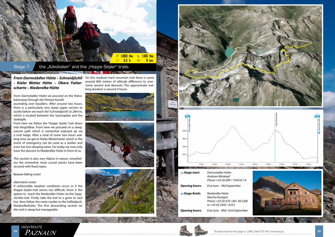
the „Advokaten“ and the „Hoppe Seyler“ trailsStage 7:
ö 1.000 Hm ø 1.100 Hm¾ 5,5 h ó 9 km
From Darmstädter Hütte – Schneidjöchli - Kieler Wetter Hütte – Obere Fatlar-scharte – Niederelbe Hütte
From Darmstädter Hütte we proceed on the ‘Advo-katenweg’ through the Hintere Kartell,ascending over boulders. After around two hours, there is a particularly very steep upper section to tackle before we reach the ‘Schneidjöchli’ at 2841m, which is located between the Saumspitze and the Seeköpfe. From here we follow the ‘Hoppe Seyler’ trail down into Vergrößkar. From here we proceed on a steep, narrow path which is somewhat exposed up via a rock ledge. After a total of some two hours wal-king time we get to ‘Kieler Wetterhütte’, which in the event of emergency can be used as a shelter and even has two sleeping areas. For today we now only have the descent to Niederelbe Hütte in front of us.
This section is also very Alpine in nature, nonethel-ess the somewhat more crucial points have been secured with fixed ropes.
Beware falling rocks!
alternative route:If unfavorable weather conditions occur or if the Hoppe-Seyler-trail seems too difficult, there is the option to reach the Niederelbe Hütte via the Sepp-Jöchler-trail. Firstly, take the trail to a gone to rack hut. Now follow the route marker to the Seßladjoch, Niederelbehütte. The first descending section on this trail is steep but manageable.
Stage start: Darmstädter Hütte Andreas Weiskopf Phone +43 (0) 699 / 1544 63 14
Opening hours: End June – Mid September
Stage finish: Niederelbe Hütte Martha Rudigier Phone +43 (0) 676 / 841 38 5200 or +43 (0) 5445 / 6355
Opening hours: End June – Mid / End September
H
H
H
Kiel
er W
ette
rhüt
te
Dar
mst
ädte
r Hüt
te
H
Nie
dere
lbe
Hüt
te
On this medium hard mountain trail there is some around 800 metres of altitude difference to over-come (ascent and descent). The approximate wal-king duration is around 4 hours.
The ideal shoe for this stage is: LOWA „Tibet GTX® Ws“ www.lowa.at 25
S
26 27HIGH ROUTE
PAZNAUN
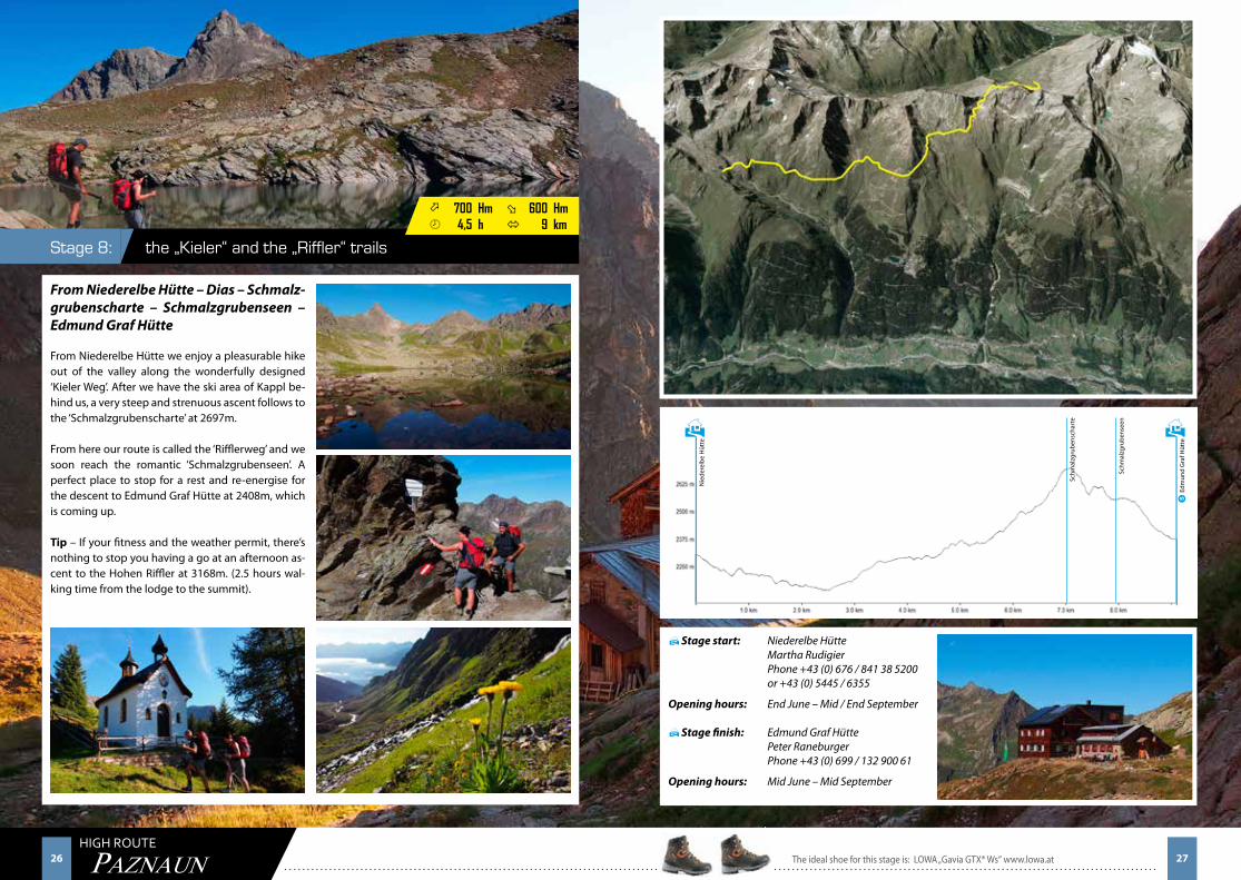
the „Kieler“ and the „Riffler“ trailsStage 8:
ö 700 Hm ø 600 Hm¾ 4,5 h ó 9 km
From Niederelbe Hütte – Dias – Schmalz-grubenscharte – Schmalzgrubenseen – Edmund Graf Hütte
From Niederelbe Hütte we enjoy a pleasurable hike out of the valley along the wonderfully designed ‘Kieler Weg’. After we have the ski area of Kappl be-hind us, a very steep and strenuous ascent follows to the ‘Schmalzgrubenscharte’ at 2697m.
From here our route is called the ‘Rifflerweg’ and we soon reach the romantic ‘Schmalzgrubenseen’. A perfect place to stop for a rest and re-energise for the descent to Edmund Graf Hütte at 2408m, which is coming up.
Tip – If your fitness and the weather permit, there’s nothing to stop you having a go at an afternoon as-cent to the Hohen Riffler at 3168m. (2.5 hours wal-king time from the lodge to the summit).
Stage start: Niederelbe Hütte Martha Rudigier Phone +43 (0) 676 / 841 38 5200 or +43 (0) 5445 / 6355
Opening hours: End June – Mid / End September
Stage finish: Edmund Graf Hütte Peter Raneburger Phone +43 (0) 699 / 132 900 61
Opening hours: Mid June – Mid September
H
H
H
Schm
alzg
rube
nsch
arte
Nie
dere
lbe
Hüt
te
H
Edm
und
Gra
f Hüt
te
Schm
alzg
rube
nsee
n
The ideal shoe for this stage is: LOWA „Gavia GTX® Ws“ www.lowa.at 27
S
28 29HIGH ROUTE
PAZNAUN
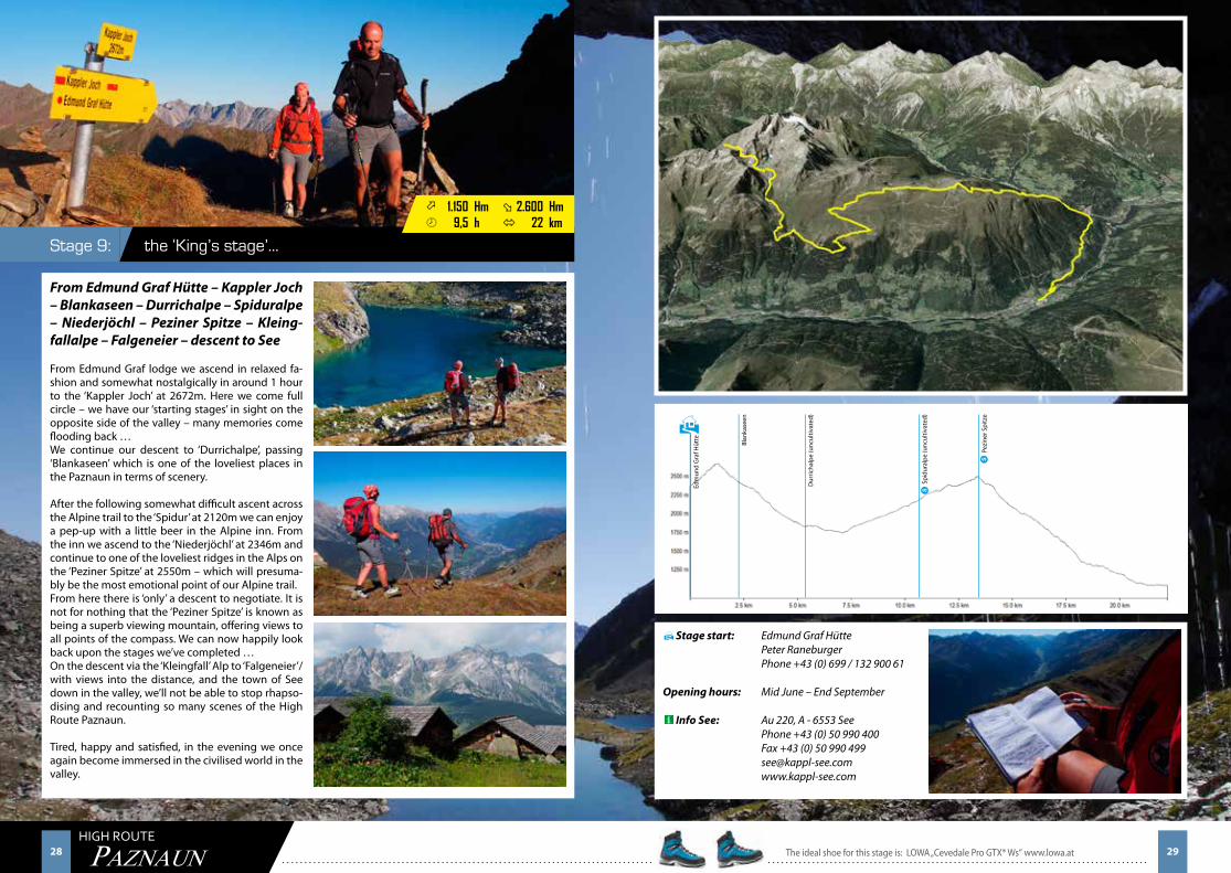
the ‘King’s stage’… Stage 9:
ö 1.150 Hm ø 2.600 Hm¾ 9,5 h ó 22 km
From Edmund Graf Hütte – Kappler Joch – Blankaseen – Durrichalpe – Spiduralpe – Niederjöchl – Peziner Spitze – Kleing-fallalpe – Falgeneier – descent to See
From Edmund Graf lodge we ascend in relaxed fa-shion and somewhat nostalgically in around 1 hour to the ‘Kappler Joch’ at 2672m. Here we come full circle – we have our ‘starting stages’ in sight on the opposite side of the valley – many memories come flooding back …We continue our descent to ‘Durrichalpe’, passing ‘Blankaseen’ which is one of the loveliest places in the Paznaun in terms of scenery.
After the following somewhat difficult ascent across the Alpine trail to the ‘Spidur’ at 2120m we can enjoy a pep-up with a little beer in the Alpine inn. From the inn we ascend to the ‘Niederjöchl’ at 2346m and continue to one of the loveliest ridges in the Alps on the ‘Peziner Spitze’ at 2550m – which will presuma-bly be the most emotional point of our Alpine trail. From here there is ‘only’ a descent to negotiate. It is not for nothing that the ‘Peziner Spitze’ is known as being a superb viewing mountain, offering views to all points of the compass. We can now happily look back upon the stages we’ve completed …On the descent via the ‘Kleingfall’ Alp to ‘Falgeneier’/ with views into the distance, and the town of See down in the valley, we’ll not be able to stop rhapso-dising and recounting so many scenes of the High Route Paznaun.
Tired, happy and satisfied, in the evening we once again become immersed in the civilised world in the valley.
Stage start: Edmund Graf Hütte Peter Raneburger Phone +43 (0) 699 / 132 900 61
Opening hours: Mid June – End September
Info See: Au 220, A - 6553 See Phone +43 (0) 50 990 400 Fax +43 (0) 50 990 499 [email protected] www.kappl-see.com
H
H
Blan
kase
en
Edm
und
Gra
f Hüt
te
Dur
richa
lpe
(unc
ultiv
ated
)
Spid
ural
pe (u
ncul
tivat
ed)
Pezi
ner S
pitz
e
The ideal shoe for this stage is: LOWA „Cevedale Pro GTX® Ws“ www.lowa.at 29
S
S
30 31HIGH ROUTE
PAZNAUN
Paznaun – Ischgl Tourism Association A – 6561 Ischgl Phone +43 (0) 50 990 Fax +43 (0) 50 990 199 www.paznaun-ischgl.com [email protected]ü
... Stamp book for all 9 stages !
Giggler AlmS1:
Gamperthun AlmS2:
Alte Zollhütte S3:
To receive the exclusive finisher’s goody bag at the end of the High Route, you must have collected one to two stamps for each stage, in order to prove that you have walked the route.
As soon as you have collected all the stamps and have tackled the entire length of the high route Paznaun, you may hand the stamp book into a Paznaun-Ischgl Tourism Association Information Office and in return you will receive a finisher’s goody bag sponsored by LOWA! We hope you like it!
Stamp book
Ascherhütte S1:
Visnitz AlmS3:
Rauher KopfS4:
The Paznaun-Ischgl Tourism Association especially thanks Vinzenz Gstrein from See for idea generati-on and conception of the High Route Paznaun and Herbert Blank for the amazing photographs. Thank you very much for your commitment during the origination process of this project.
Contact and creative directorGUEST INFORMATION
SILVRETTA CARD ALL INCLUSIVE
With your Silvretta Card you can enjoy almost
unlimited advantages in Paznaun - and the card is free!
When you stay overnight in Paznaun you get the Silvretta Card which has
the most attractive leisure offers in the region!
1 Ticket - 1000 possibilities:
The following services are included in the Silvretta Card
• Use of all the cable cars and chair lifts in Ischgl, Galtür, Kappl,
See & Samnaun
• Use of the public transport in Paznaun/Bielerhöhe
• Free admission to the indoor and outdoor pools in Ischgl & Galtür
• Free admission to the play-, sports- & water park See
• Free admission to the Alpinarium Galtür & Cablecar Museum Ischgl
• Toll-free use of the `Silvretta Hochalpenstrasse´ mountain road
by car, bus or motorbike
• Discount on motorbike hire at the High Bike Testcenter Paznaun
• Free participation in the Kids Club programme in Paznaun
• Free participation in all the guided themed walks in Paznaun
Your competent contact for questi-ons of any kind
The staff at Paznaun – Ischgl Tourism Association are here to help with any advice you need when it comes to planning your holiday.
a l l i n c l u s i v eSilvretta Card
LA_597_AZ_CevedaleGTX_Ws_200x94+3.indd 1 26.03.13 14:51
S
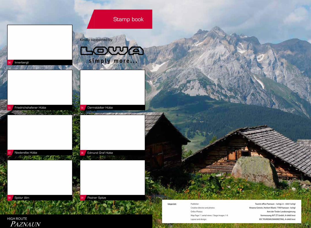
Stamp book
Niederelbe HütteS7:
Spidur AlmS9:
Darmstädter Hütte S6:
Edmund Graf HütteS8:
Peziner SpitzeS9:
InnerbergliS4:
Friedrichshafener HütteS5:
HIGH ROUTE
PAZNAUN
Kindly supported by
Imprint Publisher: Tourist office Paznaun – Ischgl, A – 6561 Ischgl
Creative director and photos: Vinzenz Gstrein, Herbert Blank / TVB Paznaun - Ischgl
Ortho-Photos: Amt der Tiroler Landesregierung
Map Page 7 / aerial views / Stage images 1-9: Vermessung AVT ZT GmbH, A-6460 Imst
Layout and design: IDC TOURISMUSMARKETING, A-6460 Imst