Embed Size (px)
Citation preview
His
toric
al D
ev. P
rofil
e
12006 City of Duluth Comprehensive Plan
Duluth will be known for its “Old World” flavor, due to the preservation of its rich historic and architectural resources and through celebration of its diverse cultural heritage.
From the Duluth “2001 and beyond” Visioning Process
Landforms: A Three-Dimensional City
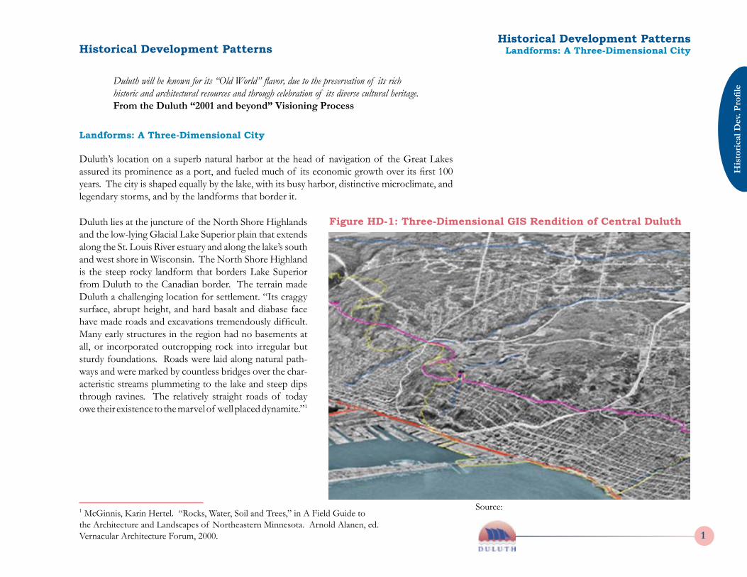
Duluth’s location on a superb natural harbor at the head of navigation of the Great Lakes assured its prominence as a port, and fueled much of its economic growth over its first 100 years. The city is shaped equally by the lake, with its busy harbor, distinctive microclimate, and legendary storms, and by the landforms that border it.
Duluth lies at the juncture of the North Shore Highlands and the low-lying Glacial Lake Superior plain that extends along the St. Louis River estuary and along the lake’s south and west shore in Wisconsin. The North Shore Highland is the steep rocky landform that borders Lake Superior from Duluth to the Canadian border. The terrain made Duluth a challenging location for settlement. “Its craggy surface, abrupt height, and hard basalt and diabase face have made roads and excavations tremendously difficult. Many early structures in the region had no basements at all, or incorporated outcropping rock into irregular but sturdy foundations. Roads were laid along natural path-ways and were marked by countless bridges over the char-acteristic streams plummeting to the lake and steep dips through ravines. The relatively straight roads of today owe their existence to the marvel of well placed dynamite.”1
1 McGinnis, Karin Hertel. “Rocks, Water, Soil and Trees,” in A Field Guide to the Architecture and Landscapes of Northeastern Minnesota. Arnold Alanen, ed. Vernacular Architecture Forum, 2000.
Figure HD-1: Three-Dimensional GIS Rendition of Central Duluth
Source:
Historical Development PatternsLandforms: A Three-Dimensional CityHistorical Development Patterns
Historical D
ev. Profile
2 2006 City of Duluth Comprehensive Plan
His
toric
al D
ev. P
rofil
e
32006 City of Duluth Comprehensive Plan
The city’s steep terrain and severe winter weather have always created continuous challenges in the maintenance of its infrastructure, especially its streets. The terrain also provides the expansive views and vistas that made the City a tourist destination as early as the 1880s. The city’s many streams and the steep wooded ravines through which they flow function as green corridors, forming natural boundaries between neighborhoods and providing most city resi-dents with easy access to natural landscapes, many with a near-wilderness character.
Geology: Bedrock and Building Material
The underlying bedrock of the North Shore Highlands is among the oldest in North America; much of it consisting of ancient lava flows, sculpted by glacial activity. The Duluth Complex, a large mass of igneous rock, crops out in many locations on the city’s hillsides, notably at the Bardon’s Peak overlook along Skyline Parkway. Rock outcroppings were quarried to form the retaining walls and ‘guard stones” that line Skyline Parkway and the city’s other parkways and park boulevards. Native stone was also used in some of the picturesque mansions built on the hillsides east of downtown at the turn of the 20th century. Early Settlement
While northeastern Minnesota was inhabited by native peoples for millennia prior to Euro-pean settlement, two tribes played key roles in the historical development of the Great Lakes region: the Dakota (Sioux) and the Ojibwe (Chippewa). Both tribes occupied the Lake Su-perior region and northern Minnesota during the early exploration and fur-trading era of the 17th century, but conflict between the two tribes led the Dakota to move south along the Mis-sissippi and Minnesota rivers by the time of the American Revolution. Ojibwe settlement was centered on the south shore of Lake Superior, around the village of La Pointe on Madeleine Island. The end of the French and Indian War, 1754-1760, and the revival of the British fur trade led many Ojibwe to move westward to the Duluth-Fond du Lac area. A trading post was established at Fond du Lac as early as the 1780s. Fort St. Louis, a trading post of the North West Company, was built in 1793 in present-day Superior, near the natural entrance to the harbor, and was occupied until the company withdrew from American territory after the War of 1812. The Fond du Lac post was occupied by John Jacob Astor’s American Fur Company from that period through the 1840s, when the fur trade declined from a corporate enterprise to one conducted by individual government-licensed traders. One such trader, George R. Stuntz, established a settlement on the bay side of Minnesota Point in 1853, which quickly became a center for would-be land speculators.
Historical Development PatternsGeology: Bedrock and Building Material
Historical D
ev. Profile
2 2006 City of Duluth Comprehensive Plan
His
toric
al D
ev. P
rofil
e
32006 City of Duluth Comprehensive Plan
The opening of the canal at Sault St. Marie in 1855 gave the ‘head of the lakes’ region in-creased prominence as a future port. In that year, the Treaty of La Pointe with the Ojibwe opened the north shore to European settlement. Many early settlers in both Duluth and Superior (platted in 1854) were drawn by the promise of copper mining in the region, while others were drawn by the region’s potential for shipping and trade.
Original Townsites
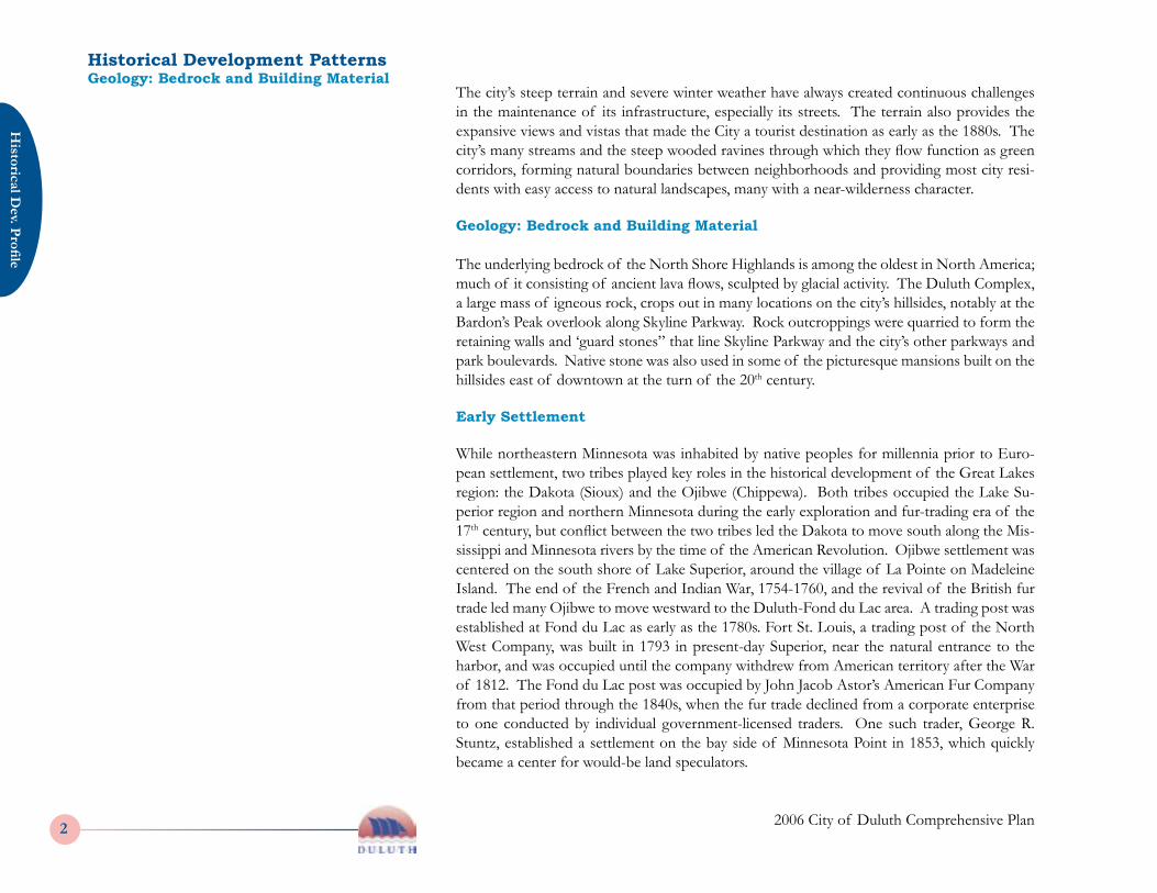
The original settlement known as Duluth, located at the base of Minnesota Point (then connected to the mainland) was platted in 1856 and incorporated as a city in 1857. Duluth was just one of a string of eleven small north shore settlements platted between 1856 and 1859, all of which were later incorpo-rated into the city. They included:
Ø Fond du Lac, the site of the original trading post and earliest settle-ment; the term once referred to the entire “head of the lakes” area.
Ø Oneota, established along the St. Louis River estuary at the base of Ely’s Peak, the site of the area’s first non-mission school, steam saw-mill, and the first post office in St. Louis County.
Ø Rice’s Point, established on the peninsula extending from Point of Rocks between St. Louis Bay and the harbor in hopes of becoming the county seat of St. Louis County.
Ø Portland, established just east of the Duluth townsite, (in what is now the East Hillside neighborhood), was platted according to cardinal directions (unlike the other townsites, which used the lakeshore as a baseline). Its streets were eventually replatted in 1869.2 It became the site of the area’s first brewery, now Fitger’s.
Ø Fremont, platted largely on floating bogland on the harborfront; was largely destroyed by the harbor currents created by the opening of the Duluth ship canal in 1871; it included the site of the Union Depot.
Figure HD-2: Original Townsites, from Bailey, 1976.
2 “Today a small bronze plaque commemorates the beginning of the Vermilion Trail at the intersection of First Street and Seventh Avenue East (Washington Avenue)… the only [street] retaining the plat line of the early Portland planners.” Anne Stutz Bailey, “The Towns that Became Duluth,” in Duluth: Sketches of the Past, 1976. It appears that this diagonal street was subsequently displaced by construction of I-35.
Source: Duluth: Sketches of the Past, 1976: Bailey
Historical Development PatternsOriginal Townsites
Historical D
ev. Profile
4 2006 City of Duluth Comprehensive Plan
His
toric
al D
ev. P
rofil
e
52006 City of Duluth Comprehensive Plan
Ø Three settlements platted on Minnesota Point were Middleton (also known as Park Point, a neighborhood name that now refers to the entire peninsula), Cowell’s Addi-tion and North Duluth,
Ø Endion, platted into “suburban lots for capitalists doing business in Superior,”3 and Bellville, later replatted as Lakeside, were the easternmost settlements.
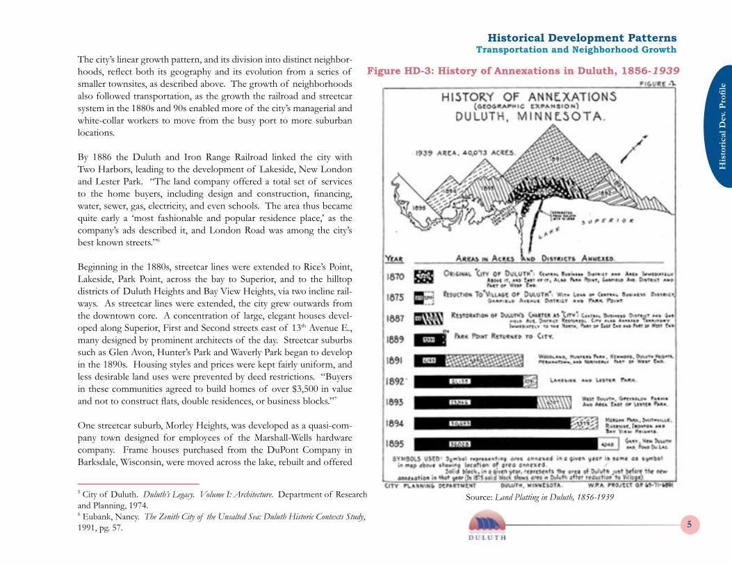
Duluth in its early years was described as “an irregular, disjointed and unconnected assort-ment, mostly of cheap frame structures, newly built with all the glare of new boards, fresh paint, tin and tar paper.”4 The land and building boom of the 1850s ended suddenly in the national financial panic of 1857, brought about by eastern bank failures, which decimated the region’s population and halted economic expansion in the region until plans for the arrival of the railroad began to bring new activity to the area in the 1860s. The selection of Duluth, on the deep-water harbor, as the site for the railroad’s terminus, was the impetus that led to its eventual incorporation as a city, in 1870. Once Duluth was granted its city charter by the state legislature, it quickly annexed the town-sites of Portland, Rice’s Point, Endion, and the Park Point townsites of Middleton, Cowell’s Addition and North Duluth. However, the financial panic of 1873 soon left the city in debt, and by 1875 the city reverted to village status, and lost Rice’s Point and Park Point, not to regain them until 1887-89. Figure 2, from the 1940 report “Land Platting in Duluth, 1856-1939” provides a graphically elegant summary of these and subsequent annexations in the 1890s. By 1895 Duluth had reached its present boundaries.
Transportation and Neighborhood Growth
“The traditional grid pattern of North-South, East-West streets met its match in Duluth. Its growth pattern was dictated almost wholly by the geography. The St. Louis River here becomes wide, slow and estuary-like as it nears Lake Superior, dividing the south shore and Superior, Wisconsin’s sandy plain from the steeply rising ridges and rock outcroppings on the Minnesota side.
Development was aligned with the natural land and water features resulting in a distinctly lin-ear city extending 23 miles from Southwest to Northeast. Most major development has been confined to a strip a few miles wide along this line, and significant growth beyond the ridge is a comparatively recent phenomenon.”5
3 Woodbridge, Dwight E. and Pardee, John S. History of Duluth and St. Louis County, Volume I, 1910. Quotation in Bailey, 1976.4 Ibid.
Historical Development PatternsTransportation and Neighborhood Growth
Historical D
ev. Profile
4 2006 City of Duluth Comprehensive Plan
His
toric
al D
ev. P
rofil
e
52006 City of Duluth Comprehensive Plan
The city’s linear growth pattern, and its division into distinct neighbor-hoods, reflect both its geography and its evolution from a series of smaller townsites, as described above. The growth of neighborhoods also followed transportation, as the growth the railroad and streetcar system in the 1880s and 90s enabled more of the city’s managerial and white-collar workers to move from the busy port to more suburban locations.
By 1886 the Duluth and Iron Range Railroad linked the city with Two Harbors, leading to the development of Lakeside, New London and Lester Park. “The land company offered a total set of services to the home buyers, including design and construction, financing, water, sewer, gas, electricity, and even schools. The area thus became quite early a ‘most fashionable and popular residence place,’ as the company’s ads described it, and London Road was among the city’s best known streets.”6
Beginning in the 1880s, streetcar lines were extended to Rice’s Point, Lakeside, Park Point, across the bay to Superior, and to the hilltop districts of Duluth Heights and Bay View Heights, via two incline rail-ways. As streetcar lines were extended, the city grew outwards from the downtown core. A concentration of large, elegant houses devel-oped along Superior, First and Second streets east of 13th Avenue E., many designed by prominent architects of the day. Streetcar suburbs such as Glen Avon, Hunter’s Park and Waverly Park began to develop in the 1890s. Housing styles and prices were kept fairly uniform, and less desirable land uses were prevented by deed restrictions. “Buyers in these communities agreed to build homes of over $3,500 in value and not to construct flats, double residences, or business blocks.”7
One streetcar suburb, Morley Heights, was developed as a quasi-com-pany town designed for employees of the Marshall-Wells hardware company. Frame houses purchased from the DuPont Company in Barksdale, Wisconsin, were moved across the lake, rebuilt and offered
Figure HD-3: History of Annexations in Duluth, 1856-1939
5 City of Duluth. Duluth’s Legacy. Volume I: Architecture. Department of Research and Planning, 1974.6 Eubank, Nancy. The Zenith City of the Unsalted Sea: Duluth Historic Contexts Study, 1991, pg. 57.
Source: Land Platting in Duluth, 1856-1939
Historical Development PatternsTransportation and Neighborhood Growth
Historical D
ev. Profile
6 2006 City of Duluth Comprehensive Plan
His
toric
al D
ev. P
rofil
e
72006 City of Duluth Comprehensive Plan
to company employees. The design of this triangular neighborhood centered on a small park and tree-lined parkway, speaks to its origins as a planned community.
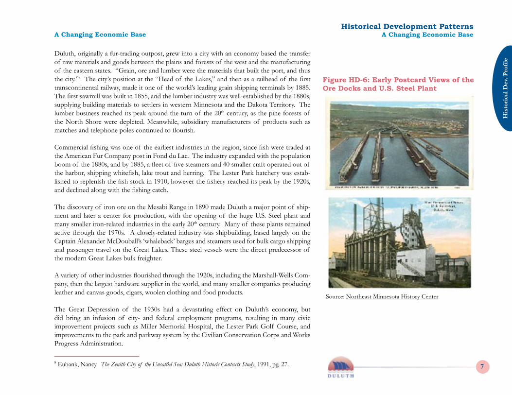
West Duluth grew rapidly during the same period, with increasing numbers of foreign-born workers drawn by jobs in the port or factories. Certain districts attracted large numbers of particular ethnic groups, including Eastern European, Italian, Romanian, Greek and Italian immigrants in the neighborhoods of West Duluth, Gary and New Duluth. Germans, Swedes and Norwegians moved into the Denfeld area. The western riverfront was the location of two major company towns, Morgan Park and Riv-erside. Morgan Park was an ambitious model village developed for the U.S. Steel workforce beginning in 1913. Designed by the Minneapolis landscape architecture firm of Morell and Nichols, Morgan Park exemplifies City Beautiful planning principles and careful consideration of natural features. Major streets terminate in vistas, and community buildings and churches are clustered along a central axis, surrounded by individual residential neighborhoods. Public
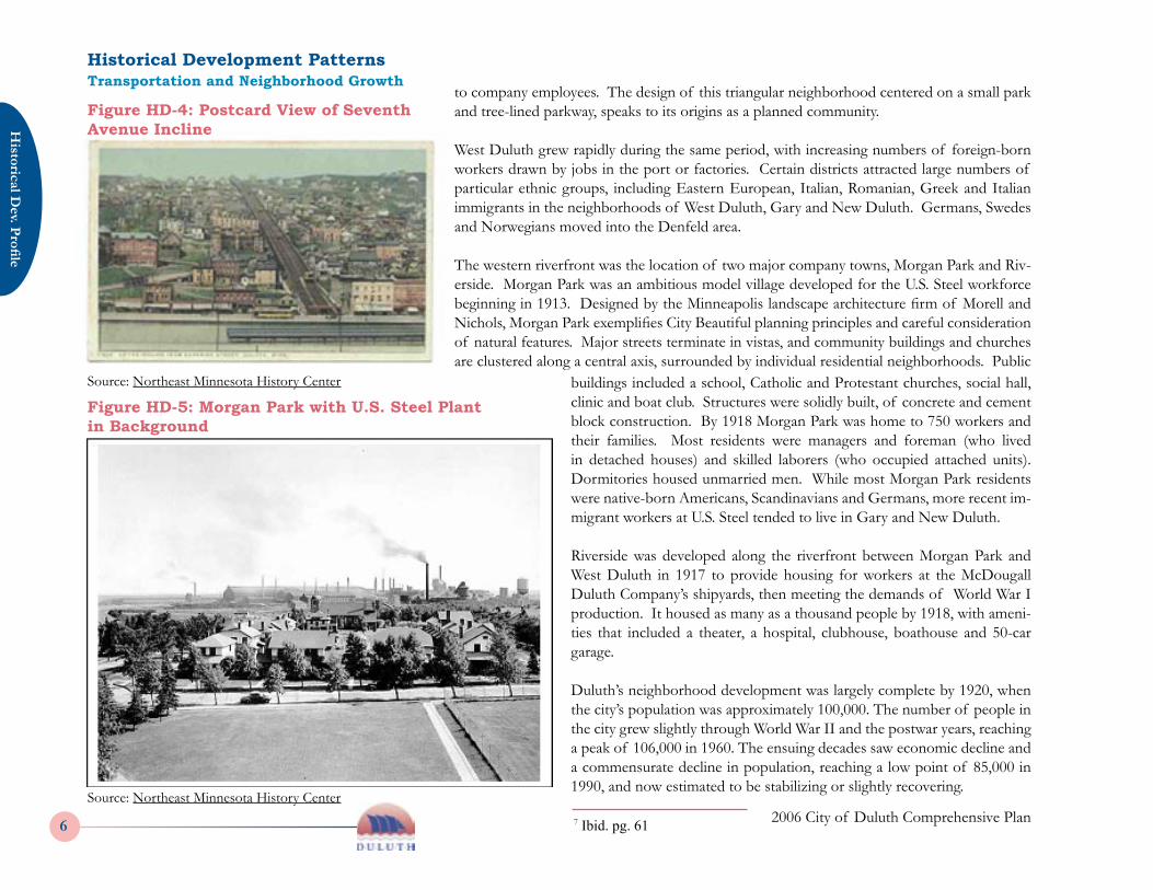
Figure HD-4: Postcard View of Seventh Avenue Incline
buildings included a school, Catholic and Protestant churches, social hall, clinic and boat club. Structures were solidly built, of concrete and cement block construction. By 1918 Morgan Park was home to 750 workers and their families. Most residents were managers and foreman (who lived in detached houses) and skilled laborers (who occupied attached units). Dormitories housed unmarried men. While most Morgan Park residents were native-born Americans, Scandinavians and Germans, more recent im-migrant workers at U.S. Steel tended to live in Gary and New Duluth.
Riverside was developed along the riverfront between Morgan Park and West Duluth in 1917 to provide housing for workers at the McDougall Duluth Company’s shipyards, then meeting the demands of World War I production. It housed as many as a thousand people by 1918, with ameni-ties that included a theater, a hospital, clubhouse, boathouse and 50-car garage.
Duluth’s neighborhood development was largely complete by 1920, when the city’s population was approximately 100,000. The number of people in the city grew slightly through World War II and the postwar years, reaching a peak of 106,000 in 1960. The ensuing decades saw economic decline and a commensurate decline in population, reaching a low point of 85,000 in 1990, and now estimated to be stabilizing or slightly recovering.
Figure HD-5: Morgan Park with U.S. Steel Plant in Background
7 Ibid. pg. 61
Source: Northeast Minnesota History Center
Source: Northeast Minnesota History Center
Historical Development PatternsTransportation and Neighborhood Growth
Historical D
ev. Profile
6 2006 City of Duluth Comprehensive Plan
His
toric
al D
ev. P
rofil
e
72006 City of Duluth Comprehensive Plan
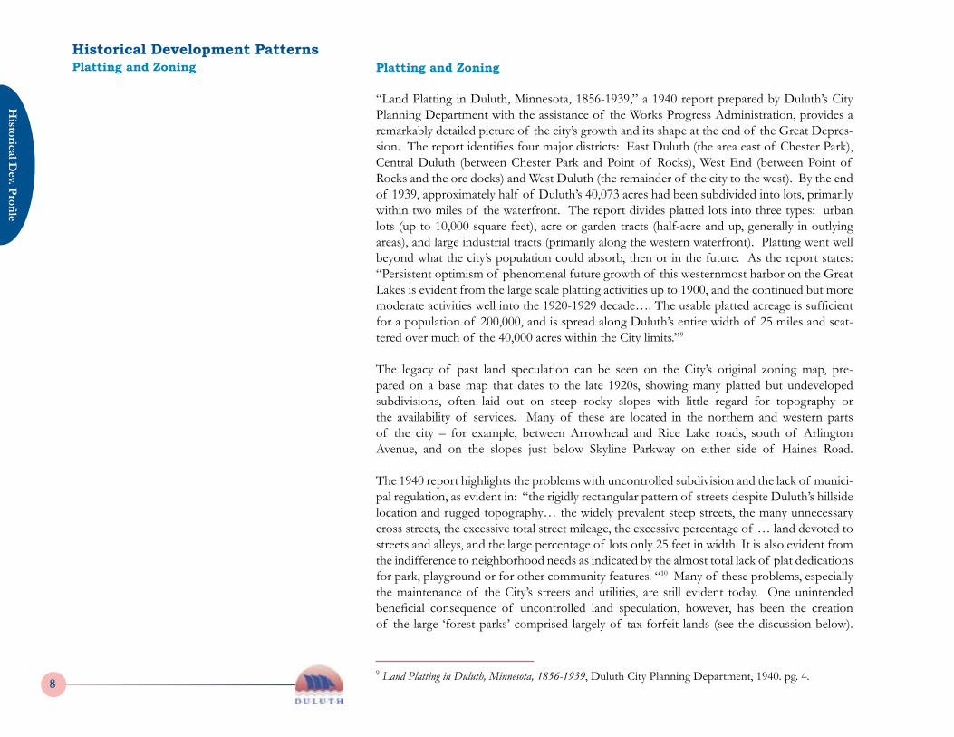
Duluth, originally a fur-trading outpost, grew into a city with an economy based the transfer of raw materials and goods between the plains and forests of the west and the manufacturing of the eastern states. “Grain, ore and lumber were the materials that built the port, and thus the city.”8 The city’s position at the “Head of the Lakes,” and then as a railhead of the first transcontinental railway, made it one of the world’s leading grain shipping terminals by 1885. The first sawmill was built in 1855, and the lumber industry was well-established by the 1880s, supplying building materials to settlers in western Minnesota and the Dakota Territory. The lumber business reached its peak around the turn of the 20th century, as the pine forests of the North Shore were depleted. Meanwhile, subsidiary manufacturers of products such as matches and telephone poles continued to flourish.
Commercial fishing was one of the earliest industries in the region, since fish were traded at the American Fur Company post in Fond du Lac. The industry expanded with the population boom of the 1880s, and by 1885, a fleet of five steamers and 40 smaller craft operated out of the harbor, shipping whitefish, lake trout and herring. The Lester Park hatchery was estab-lished to replenish the fish stock in 1910; however the fishery reached its peak by the 1920s, and declined along with the fishing catch. The discovery of iron ore on the Mesabi Range in 1890 made Duluth a major point of ship-ment and later a center for production, with the opening of the huge U.S. Steel plant and many smaller iron-related industries in the early 20th century. Many of these plants remained active through the 1970s. A closely-related industry was shipbuilding, based largely on the Captain Alexander McDouball’s ‘whaleback’ barges and steamers used for bulk cargo shipping and passenger travel on the Great Lakes. These steel vessels were the direct predecessor of the modern Great Lakes bulk freighter. A variety of other industries flourished through the 1920s, including the Marshall-Wells Com-pany, then the largest hardware supplier in the world, and many smaller companies producing leather and canvas goods, cigars, woolen clothing and food products.
The Great Depression of the 1930s had a devastating effect on Duluth’s economy, but did bring an infusion of city- and federal employment programs, resulting in many civic improvement projects such as Miller Memorial Hospital, the Lester Park Golf Course, and improvements to the park and parkway system by the Civilian Conservation Corps and Works Progress Administration.
Figure HD-6: Early Postcard Views of the Ore Docks and U.S. Steel Plant
8 Eubank, Nancy. The Zenith City of the Unsalted Sea: Duluth Historic Contexts Study, 1991, pg. 27.
Source: Northeast Minnesota History Center
Historical Development PatternsA Changing Economic BaseA Changing Economic Base
Historical D
ev. Profile
8 2006 City of Duluth Comprehensive Plan
His
toric
al D
ev. P
rofil
e
92006 City of Duluth Comprehensive Plan
“Land Platting in Duluth, Minnesota, 1856-1939,” a 1940 report prepared by Duluth’s City Planning Department with the assistance of the Works Progress Administration, provides a remarkably detailed picture of the city’s growth and its shape at the end of the Great Depres-sion. The report identifies four major districts: East Duluth (the area east of Chester Park), Central Duluth (between Chester Park and Point of Rocks), West End (between Point of Rocks and the ore docks) and West Duluth (the remainder of the city to the west). By the end of 1939, approximately half of Duluth’s 40,073 acres had been subdivided into lots, primarily within two miles of the waterfront. The report divides platted lots into three types: urban lots (up to 10,000 square feet), acre or garden tracts (half-acre and up, generally in outlying areas), and large industrial tracts (primarily along the western waterfront). Platting went well beyond what the city’s population could absorb, then or in the future. As the report states: “Persistent optimism of phenomenal future growth of this westernmost harbor on the Great Lakes is evident from the large scale platting activities up to 1900, and the continued but more moderate activities well into the 1920-1929 decade…. The usable platted acreage is sufficient for a population of 200,000, and is spread along Duluth’s entire width of 25 miles and scat-tered over much of the 40,000 acres within the City limits.”9
The legacy of past land speculation can be seen on the City’s original zoning map, pre-pared on a base map that dates to the late 1920s, showing many platted but undeveloped subdivisions, often laid out on steep rocky slopes with little regard for topography or the availability of services. Many of these are located in the northern and western parts of the city – for example, between Arrowhead and Rice Lake roads, south of Arlington Avenue, and on the slopes just below Skyline Parkway on either side of Haines Road. The 1940 report highlights the problems with uncontrolled subdivision and the lack of munici-pal regulation, as evident in: “the rigidly rectangular pattern of streets despite Duluth’s hillside location and rugged topography… the widely prevalent steep streets, the many unnecessary cross streets, the excessive total street mileage, the excessive percentage of … land devoted to streets and alleys, and the large percentage of lots only 25 feet in width. It is also evident from the indifference to neighborhood needs as indicated by the almost total lack of plat dedications for park, playground or for other community features. “10 Many of these problems, especially the maintenance of the City’s streets and utilities, are still evident today. One unintended beneficial consequence of uncontrolled land speculation, however, has been the creation of the large ‘forest parks’ comprised largely of tax-forfeit lands (see the discussion below).
9 Land Platting in Duluth, Minnesota, 1856-1939, Duluth City Planning Department, 1940. pg. 4.
Historical Development PatternsPlatting and Zoning Platting and Zoning
Historical D
ev. Profile
8 2006 City of Duluth Comprehensive Plan
His
toric
al D
ev. P
rofil
e
92006 City of Duluth Comprehensive Plan
The Duluth City Planning Commission was established in 1922, and the city’s first zoning ordinance was enacted in 1927. Like many zoning ordinances of that period, it divides the city into two types of districts: five use districts and six height and area districts. The use dis-tricts encompassed the generalized land use categories of: “residence” (single- and two-family dwellings), multiple dwelling, commercial, light industrial and heavy industrial. The height and area districts roughly correspond to the use districts, with residential lots from 3,500, 4,800 to 6,000 square feet in area, and downtown building heights of up to 8 stories or 90 feet. However, the Planning Commission struggled with the issue of control of subdivisions.
In 1933 the City succeeded in having state legislation enacted giving it the authority to regulate the subdivision of land and to require reasonable street improvements and installation of utilities. The 1940 “Platting” report acknowledges the value of the legislation, but describes it as inadequate to regulate “strip development” along highway frontages, often of large resi-dential lots with on-site septic treatment. The report concludes with a call for rehabilitation of older parts of the city, in order to redirect new housing into areas equipped with public utilities and services.
The Parkway System and the “Greenbelt”
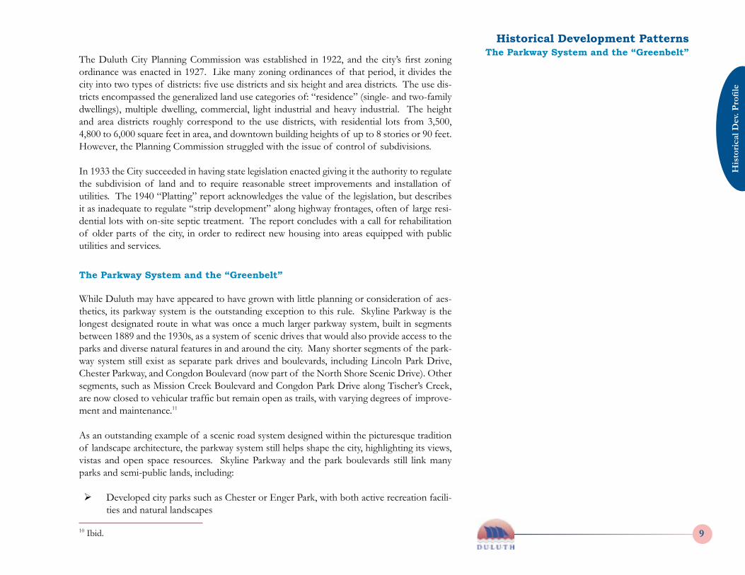
While Duluth may have appeared to have grown with little planning or consideration of aes-thetics, its parkway system is the outstanding exception to this rule. Skyline Parkway is the longest designated route in what was once a much larger parkway system, built in segments between 1889 and the 1930s, as a system of scenic drives that would also provide access to the parks and diverse natural features in and around the city. Many shorter segments of the park-way system still exist as separate park drives and boulevards, including Lincoln Park Drive, Chester Parkway, and Congdon Boulevard (now part of the North Shore Scenic Drive). Other segments, such as Mission Creek Boulevard and Congdon Park Drive along Tischer’s Creek, are now closed to vehicular traffic but remain open as trails, with varying degrees of improve-ment and maintenance.11
As an outstanding example of a scenic road system designed within the picturesque tradition of landscape architecture, the parkway system still helps shape the city, highlighting its views, vistas and open space resources. Skyline Parkway and the park boulevards still link many parks and semi-public lands, including:
Ø Developed city parks such as Chester or Enger Park, with both active recreation facili-ties and natural landscapes
10 Ibid.
Historical Development PatternsThe Parkway System and the “Greenbelt”
Historical D
ev. Profile
10 2006 City of Duluth Comprehensive Plan
His
toric
al D
ev. P
rofil
e
112006 City of Duluth Comprehensive Plan
Ø Undeveloped city parks such as Lakeview and Brewer Park; some with hiking trails and other informal facilities
Ø “Forest parks” such as Fond du Lac Forest and Bayview Forest Park, originally desig-nated in the 1930s to manage the City’s large areas of tax-forfeit lands. (See the discus-sion of forest parks in the Land Use Profile report – these areas include a variety of land ownerships, public and private, including potentially developable land.)
Ø Publicly-owned lands managed by nonprofits or other entities, such as Spirit Mountain Recreation Area and Hawk Ridge Nature Reserve.
These areas were collectively referred to as the “greenbelt” in plans of the 1960s and 70s. This open space system still comprises about one-fourth of the city. The greenbelt generally follows the ridgeline above the lake and extends into City-owned lands in the City of Proctor and Midway Township, as well as a 10-mile greenbelt along the St. Louis River in Superior. For all its rich recreational, natural and scenic resources, the greenbelt has no official status as a unit, no unified signage, and a variety of management arrangements and policies. Questions as to the disposition of tax-forfeit lands, and their suitability for development, are central to this planning effort.
Looking Forward - Comprehensive Plan Issues
Understanding the way in which Duluth has grown provides insights into the City’s es-sential character and urban form. Understanding Duluth’s past also suggests opportuni-ties for avoiding a repetition of past mistakes, while building on the many strengths of earlier settlement patterns. These insights and opportunities will become relevant as the Comprehensive Plan addresses the future direction and character of new development, as well as urban design policies that will guide this development. Some specific issues include:
Ø Land speculation through the 1920s produced a multitude of platted but undeveloped subdivisions across the City’s uplands. Other subdivisions have been only minimally developed with a few scattered lots. The current status of these historical plats, and whether they can or should they be considered for re-platting and development, is an issue that the comprehensive plan should address.
Ø An examination of Duluth’s past land development practices makes it clear that the City’s infrastructure, especially its street system, was designed to serve a larger popula-
11 Nunnally, Patrick D. Jewel of the North: Duluth’s Parkway System. A Historic Landscape Evaluation Study. City of Duluth, Heritage Preservation Commission, July 1997.
Source: Northeast Minnesota History Center
Figure HD-7: Early Views of Skyline Parkway
Historical Development PatternsLooking Forward - Comprehensive Plan Issues
Historical D
ev. Profile
10 2006 City of Duluth Comprehensive Plan
His
toric
al D
ev. P
rofil
e
112006 City of Duluth Comprehensive Plan
tion than currently exists, or that is projected to exist. Street design with little regard for topography has also created tremendous maintenance challenges. Are there ways of using the existing road system more efficiently to serve current and future develop-ment?
Ø The parkway system has been the subject of much study, including the Skyline Park-way Corridor Management Plan, but land use management adjacent to the parkways will be determined through the comprehensive planning effort. Management of sce-nic views may involve public improvements, vegetation management and some type of design standards for new development in sensitive areas. Protection of sensitive natural resources also presents challenges, as discussed in the Natural Systems report.
Ø Early zoning standards, while simple and basic in their regulation of land use, served to codify traditional neighborhood development patterns that still give the City’s older districts much of their character. They also allowed for mixing of uses to a greater degree than current zoning regulations. These early standards may pro-vide insights or examples that can be used in the updating of the City’s current ordinances, an effort that will be needed to implement the Comprehensive Plan.
Historical Development PatternsLooking Forward - Comprehensive Plan Issues
Historical D
ev. Profile
12 2006 City of Duluth Comprehensive Plan
Alanen, Arnold. “Morgan Park: U.S. Steel and a Planned Company Town.” in Duluth: Sketches of the Past, A Bicentennial Collection. American Revolution Bicentennial Commission, 1976.
Bailey, Anne Stutz, “The Towns that Became Duluth,” in Duluth: Sketches of the Past. 1976.
City of Duluth. Duluth’s Legacy. Volume I: Architecture. Department of Research and Planning, 1974.
_____. Here’s Duluth: General Information about Duluth, Minnesota. Department of Research and Planning, 1975.
_____. Land Platting in Duluth, Minnesota, 1856-1939, Duluth City Planning Department, 1940. Works Progress Administration, Official Project 65-71-6891.
Eubank, Nancy. The Zenith City of the Unsalted Sea: Duluth Historic Contexts Study. Duluth Heritage Preservation Commission, 1991.
McGinnis, Karin Hertel. “Rocks, Water, Soil and Trees,” in A Field Guide to the Architecture and Landscapes of Northeastern Minnesota. Arnold Alanen, ed. Vernacular Architecture Forum, 2000.
Nunnally, Patrick D. Jewel of the North: Duluth’s Parkway System. A Historic Landscape Evaluation Study. City of Duluth, Heritage Preservation Commission, July 1997.
Olsen, Wayne C. “Street Railway and Transit Development in Duluth.” in Duluth, Sketches of the Past. 1976
Sommer, Lawrence J. “Forgotten Industries of Duluth.” in Duluth, Sketches of the Past. 1976.
Historical Development PatternsSources Sources