Embed Size (px)
Citation preview
The Friends of Fourmile, composed of volunteers from all user groups and affected landowners, invites you to join us in ensuring that this special place remains a quality recreation area for generations to come.
The Bureau of Land Management, US Forest Service, Friends of Fourmile and other authorized groups patrol the area regularly. They can answer questions on the responsible use of the area.
To report a violation or for information on other public lands recreational areas, contact
US Forest Service, Salida Ranger DistrictSan Isabel National Forest 719 539-3591
Arkansas Headwaters Recreation Area, Salida719 539-7289
Bureau of Land Management Royal Gorge Field Office, Cañon City 719 269-8500
Fire and other emergency 911
To join, volunteer or to make a donationFriends of Fourmile, a GARNA chapter 719 539-5106Visit our website at www.friends-of-fourmile.org
This brochure was produced by Friends of Fourmile with support from grants, BLM and USFS funds and citizen donations.
Thank you for using the Fourmile Travel Management Area responsibly!
rev
5.1.
16
Recycle this brochure in kiosk boxes, please.
Download the Fourmile Travel Management mapwww.friends-of-fourmile.org
Travel Management AreaRecreation Guide
Expect and respect other users!
Downloadable map at
www.friends-of-fourmile.org
History along the trails Recreation opportunities Camping
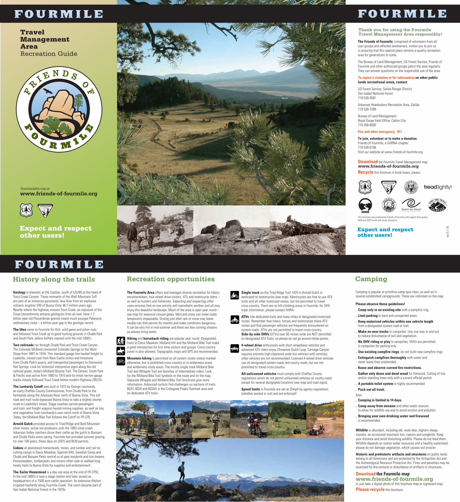
Geology is dramatic at the Castles, south of US285 at the head of Trout Creek Canyon. These remnants of the Wall Mountain Tuff are part of an immense pyroclastic lava flow from an explosive volcanic eruption SW of Buena Vista 36.7 million years ago. Nearby where the highway crosses Trout Creek, an exposure of the Great Unconformity attracts geologists from all over. Here 1.7 billion year old Precambrian granite meets much younger Paleozoic sedimentary rocks – a billion-year gap in the geologic record.
The Utes came to Fourmile for flint, wild game and piñon nuts, and followed Trout Creek up to good hunting grounds in Chubb Park and South Park, where buffalo roamed until the mid-1800’s.
Two railroads ran through Chubb Park and Trout Creek Canyon. The Colorado Midland connected Colorado Springs to the West Slope from 1887 to 1918. This standard guage line hauled freight to Leadville, moved coal from New Castle mines and limestone from Chubb Park’s quarry, and transported passengers to Glenwood Hot Springs. Look for historical interpretive signs along the old railroad grade, today’s Midland Bicycle Trail. The Denver, South Park & Pacific was active from 1880 to 1910 and its initial narrow gauge tracks closely followed Trout Creek below modern Highway 285/24.
The Lenhardy Cutoff was built in 1872 by George Leonhardy, an early Chaffee County Commissioner, from Chubb Park to the farmlands along the Arkansas River north of Buena Vista. This toll road and mail route bypassed Buena Vista to take a slightly shorter route to Leadville’s mines. Stage coaches carried passengers and mail, and freight wagons hauled mining supplies, as well as hay and vegetables from Leonhardy’s own ranch north of Buena Vista. Today, the Midland Bike Trail follows the Cutoff on FR 376.
Arnold Gulch provided access to Triad Ridge and Bald Mountain silver mines, active ore producers until the 1893 silver crash.Arkansas Valley ranchers drove their cattle up the gulch to Bassam and Chubb Parks every spring. Fourmile has provided summer grazing for over 100 years, these days on USFS and BLM permits.
Cabins at abandoned homesteads, mines, and lumber and rail tie cutting camps in Davis Meadow, Spanish Mill, Swedish Camp and Chubb and Bassam Parks remind us of past residents and lost dreams. Homesteaders, lumberjacks and miners often rode or walked long lonely trails to Buena Vista for supplies and entertainment.
The Sailor Homestead is a day use area at the end of FR 375C. In the mid 1800’s it was a stage station and later served as headquarters of a 1500 acre cattle operation. Its extensive ditches irrigated hayfields along Fourmile Creek. The ranch became part of San Isabel National Forest in the 1970s.
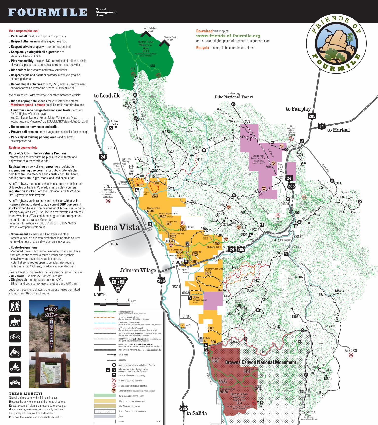
The Fourmile Area offers and manages diverse recreation for hikers, mountainbikers, four-wheel drive visitors, ATV and motorcycle riders – as well as hunters and fishermen. Expecting and respecting other users ensures that no one activity will overwhelm another and all may enjoy this beautiful landscape. Much of the area is open year round – see map for seasonal closure gates. Mud and snow can make roads temporarily impassable. Driving just after rain or snow may leave muddy ruts that persist for months and make conditions dangerous. It can be very hot in mid-summer and there are few running streams so always bring water.
Hiking and horseback riding are popular year round. Designated trails to Davis Meadow, Midland Hill and the Midland Bike Trail make a good introduction for first time visitors and groups. Cross country travel is also allowed. Topographic maps and GPS are recommended.
Mountain biking is permitted on all system routes unless marked otherwise, but is prohibited cross-country or in wilderness areas and wilderness study areas. The mostly single track Midland Bike Trail and Whipple Trail are favorites of intermediate riders. Look for the Midland Bike Trail symbols on the route and on the map. Separate Whipple and Midland Bike Trail brochures give more information. Advanced cyclists find challenges on sections of trails 6033, 6034 and 6034A in the Collegiate Peaks Overlook area and on dedicated ATV trails.
Single track on the Triad Ridge Trail 1425 in Arnold Gulch is dedicated to motorcycles (see map). Motorcycles are free to use ATV trails and all other motorized routes, but not permitted to travel cross-country. There are no hill-climbing areas in Fourmile; for OHV track information, please contact AHRA.
ATVs ride dedicated trails and many miles of designated motorized routes. Remember that hikers, horses and motorcycles share ATV routes and that passenger vehicles are frequently encountered on system roads. ATVs are not permitted to travel cross-country.Side-by-side OHVs (UTVs) over 50 inches wide are NOT permitted on designated ATV Trails, so please do not go around choke points.
4-wheel drive enthusiasts with short wheelbase vehicles and advanced ATV riders enjoy Chinaman Gulch Loop. Carnage Canyonrequires extreme high-clearance wide-tire vehicles with winches; other vehicles are not recommended. Licensed 4-wheel drive vehicles use all designated system roads and county roads, but are not permitted to travel cross-country.
All unlicensed vehicles must comply with Chaffee County regulations which do not permit unlicensed vehicles on county roads except for several designated locations (see map and road signs).
Speed limits in Fourmile are set at 25mph by agency regulations (whether posted or not) and are enforced!
Wildlife is abundant, including elk, mule deer, bighorn sheep, coyotes, an occasional mountain lion, raptors and songbirds. Keep your distance and avoid disturbing wildlife. Please do not feed them. Wildlife depends on scarce water resources and a healthy watershed; please do not damage vegetation, which causes soil erosion.
Historic and prehistoric artifacts and structures on public lands belong to all Americans and are protected by the Antiquities Act and the Archeological Resource Protection Act. Fines and penalties may be assessed for the removal or disturbance of artifacts or structures.
Download the Fourmile mapwww.friends-of-fourmile.orgor just take a digital photo of this brochure map or signboard map.
Please recycle this brochure.
Camping is popular at primitive camp spur sites, as well as inseveral established campgrounds. These are indicated on the map.
Please observe these guidelines!
. Camp only in an existing site with a campfire ring.
. Limit parking to bare and compacted areas.
. Keep motorized vehicles within one vehicle length from a designated system road or trail.
. Make no new tracks in campsites. Use one way in and out to reduce disturbance of soil and vegetation.
. No OHV riding or play in campsites; OHVs are permitted in campsites for parking only.
. Use existing campfire rings; do not build new campfire rings.
. Extinguish campfires thoroughly with water and never leave fires unattended.
. Know and observe current fire restrictions.
. Gather only down and dead wood for firewood. Cutting of live and/or standing trees only with a current official permit.
. A portable toilet system is highly recommended.
. Pack out all trash.
Also. Camping is limited to 14 days.
. Camp away from streams and other water sources. to allow for wildlife use and to avoid erosion and pollution.
. Bringing your own drinking water and firewood is recommended.
Buena Vista
Johnson Village
to Fairplay
to Hartsel
to Salida
to Leadville
to Salida15.8 miles
first 6.5 miles open to unlicensed OHVs
315
305
376
376
376A
376B
1450ACR307
CR187
308
CR309
311311
309
311
373
375
375
377
329
329318
309
188
300
300
CR300
185 186
1435
1434
618617
1415
1414
375D
375B
375A375E
375AA
373A
311E
311D
311B
376G
376AC376AB
329A
308B2
308B 308H
308C308
188A
185E
185D
300A
300B1
300C
1434A
1424
14251423
188
185B
185C1
185C
Elk1Elk2
Elk3
184
300
CR301
CR371
6043
Chinaman Gulch Loopadvanced
6044
6042Carnage Canyon
308A
6029
6037
311F375C
376D
376I
309A
311A
315A
315C
315B
315D
CR304
N Whipple Trail6030A
Broken Boyfriend Trail6032A advanced
Whipple Trail6031
Midland Hill Trail6032B
South Loop Trail6032
N Colorado
185
1450Midland Bike Trail
CR371
6039
6038
1425
1423
Fistful of Dollars Trail6034
186
CR306
376AA
1423A
1413Davis Meadow Trail
advanced
Few Dollars More Trail6034A
CR303
CR187
CR187
CR305
CR304
307
Bald Mtn Loopadvanced
300Bextreme
Park CR86
CR375
Windmill Dr
plannedreroute
Turret Trail6045
Django Trail6033
Turret Trail6045
Catkin Gulch Loop6046
River Bench Trail6045A
River Access Trail6045B
Browns CanyonWilderness Study Area
BLM
Buffalo PeaksWilderness
AreaUSFS
no motorized or mechanized travel permitted
Ruby Mtn CG
Davis Meadow
Triad Ridge
Arkansas River
Arnold G
ulch
Bald M
tn Gulc
h
Bassam Park
McGee Gulch
Aspen Ridge
Sevenm
ile Cree
k
Fourmile Creek
Mushroo
m Gulch
Shields Gulch
Lenhardy Cut-off
Railroad Bridge
CG
Kaufman Ridge
W Buffalo Peak13,326’
E Buffalo Peak13,300’
The Castles
Trout Creek
Castle Rock Gulch
Chubb Park State Land Trust
special rules,regulations apply
Fisherman’s Bridge
Kaufman Pasture
Ruby Mtn
Elk Mtn
Spanish Mill
Chubb Park
Arch
Castle Rock
Collegiate Peaks Overlook
E Main
Arkansas River
Turtle Rock Camp Spur
MidlandRR Tunnels
Arkansas River
ElephantRock
ClimbingArea
Bob’s RockClimbingArea
SailorHomestead
closed tounlicensed vehicles
between CR371and trailhead
nounlicensed
vehiclehighwaycrossing
nounlicensed
vehiclehighwaycrossing
Limestone Ridge
nounlicensed
vehiclehighwaycrossing
Chubb Park
Ranch SWA
onprivate
land
Browns Canyon National Monument
no motorized or mechanized travel permitted
nonmotorized trailsopen to mountain bikes, hikers, horseback
motorcycle motorized trails also open to mountain bikes, hikers, horseback
extreme 4WD system roads not recommended for ATVs, motorcycles, mountain bikes, horseback
ATV motorized trails 50” max width also open to motorcycles, mountain bikes, hikers, horseback
system roads open to all vehicles including unlicensed OHVs;also open to mountain bikes, hikers, horseback
county roads open to all vehicles including unlicensed OHVs; also open to mountain bikes, hikers, horseback
county roads closed to all unlicensed vehicles open to licensed vehicles; also mountain bikes, hikers, horseback
state & federal highways closed to all unlicensed vehicles
end of route
camp spur
seasonal closure gates, typically Dec 1 – April 15
Arkansas Headwaters Recreation Areacampground and picnic site: fee areas
trailhead information kiosk, parking
no mechanized travel permitted
no unlicensed vehicle travel permitted
Midland Bike Trail: mountain bikes, hikers, horseback
USFS, San Isabel National Forest
BLM, Bureau of Land Management
BLM Wilderness Study Area
Browns Canyon National Monument
State
Private
TREAD LIGHTLY!Travel and recreate with minimum impact.Respect the environment and the rights of others.Educate yourself, plan and prepare before you go.Avoid streams, meadows, ponds, muddy roads and trails, steep hillsides, wildlife and livestock.Discover the rewards of responsible recreation.
Be a responsible user!
. Pack out all trash, and dispose of it properly.
. Respect other users and be a good neighbor.
. Respect private property – ask permission first!
. Completely extinguish all cigarettes and properly dispose of them.
. Play responsibly; there are NO unrestricted hill climb or circle play areas; please use commercial sites for these activities.
. Ride safely, be prepared and know your limits.
. Respect signs and barriers posted to allow revegetation of damaged areas.
. Report illegal activities to BLM, USFS, local law enforcement. and/or Chaffee County Crime Stoppers 719 539-7289
When using your ATV, motorcycle or other motorized vehicle:
. Ride at appropriate speeds for your safety and others. Maximum speed is 25mph on all Fourmile motorized routes.
. Limit your use to designated roads and trails identified for Off-Highway Vehicle travel. See San Isabel National Forest Motor Vehicle Use Map. www.fs.usda.gov/Internet/FSE_DOCUMENTS/stelprdb5200515.pdf
. Do not create new roads and trails.
. Prevent soil erosion, protect vegetation and soils from damage.
. Park only at existing parking areas and pull-offs, on compacted soil.
. Mountain bikes may use hiking trails and other system routes, but are prohibited from riding cross-country or in wilderness areas and wilderness study areas.
. Route designations Motorized travel is limited to designated roads and trails that are identified with a route number and symbols showing what travel the route is open to. Note that some routes open to vehicles may require high clearance, 4WD and/or advanced operator skills.
Please travel only on routes that are designated for that use.. ATV trails – vehicles 50” or less in width . Singletrack – motorcycles only, no ATVs. (Hikers and cyclists may use singletrack and ATV trails.)
Look for these signs showing the types of uses permitted and not permitted on each route.
TravelManagement Area
Download this map atwww.friends-of-fourmile.orgor just take a digital photo of brochure or signboard map.
Recycle this map in brochure boxes, please.
Register your vehicle
Colorado’s Off-Highway Vehicle Program information and brochures help ensure your safety and enjoyment as a responsible rider.
Registering a new vehicle, renewing a registration and purchasing use permits for out-of-state vehicles help fund trail maintenance and construction, trailheads, parking areas, trail signs, maps, and land acquisition.
All off-highway recreation vehicles operated on designated OHV routes or trails in Colorado must display a current registration sticker from the Colorado Parks & Wildlife Off-Highway Vehicle Program.
All off-highway vehicles and motor vehicles with a valid license plate must also display a current OHV use permit sticker when traveling on designated OHV trails in Colorado. Off-highway vehicles (OHVs) include motorcycles, dirt bikes, three-wheelers, ATVs, and dune buggies that are operated on public land or trails in Colorado.For more information, call 303 791-1920 or 719 539-7289Or visit www.parks.state.co.us.
2016