Embed Size (px)
Citation preview
History of Mining in the Southeast Missouri Lead District and Description of Mine Processes, Regulatory Controls, Environmental Effects, and Mine Facilities in the Viburnum Trend Subdistrict
By Cheryl M. Seeger1
Chapter 1 ofHydrologic Investigations Concerning Lead Mining Issues in Southeastern MissouriEdited by Michael J. Kleeschulte
1Missouri Department of Natural Resources, Division of Geology and Land Survey
Scientific Investigations Report 2008–5140
U.S. Department of the InteriorU.S. Geological Survey

Contents
Abstract ...........................................................................................................................................................5Introduction.....................................................................................................................................................5
Purpose and Scope ..............................................................................................................................7Previous and Current Studies .............................................................................................................7
Missouri Lead Study ....................................................................................................................7U.S. Geological Survey Studies .................................................................................................7Other Viburnum Trend Studies ...................................................................................................9
Acknowledgments ..............................................................................................................................10Early Mining in Southeastern Missouri ....................................................................................................10Southeast Missouri Lead District ..............................................................................................................10
Old Lead Belt........................................................................................................................................10Mine La Motte-Fredericktown ..........................................................................................................12Viburnum Trend ...................................................................................................................................12Other Lead-Zinc Subdistricts of the Southeast Missouri Lead District .....................................13
General Mining Processes, Regulatory Controls, and Environmental Effects in the Viburnum Trend ...............................................................................................................................13
Mining Processes ...............................................................................................................................14Mill ................................................................................................................................................14Mine Tailings ...............................................................................................................................14Transportation of Ore and Concentrate .................................................................................15Smelting .......................................................................................................................................15
Regulatory Controls ............................................................................................................................15Environmental Effects ........................................................................................................................16
Mine Facility Descriptions in the Viburnum Trend Subdistrict .............................................................17Viburnum No. 27 Mine ........................................................................................................................18Viburnum No. 28 Mine and Central Mill ..........................................................................................18Viburnum No. 29 Mine ........................................................................................................................20Fletcher Mine and Mill .......................................................................................................................20Magmont Mine and Mill.....................................................................................................................20Sweetwater Mine and Mill ................................................................................................................23Buick Mine and Mill............................................................................................................................25Brushy Creek Mine and Mill..............................................................................................................25Casteel Mine (Viburnum No. 35 Mine) .............................................................................................26West Fork Mine and Mill ....................................................................................................................27Buick Resource Recovery Facility (Buick Smelter) ......................................................................30
Summary........................................................................................................................................................30References Cited..........................................................................................................................................31

xi
Figures 1–2. Maps showing— 1. Southeast Missouri Lead District......................................................................................6 2. Viburnum Trend Subdistrict ...............................................................................................8 3. Stratigraphic column for an exploration hole in Reynolds County, Missouri, and a
general lithologic description of formations in the Viburnum Trend ..................................11 4–14. Aerial photographs showing— 4. Viburnum No. 27 Mine, 2003 .............................................................................................18 5. Viburnum No. 28 Mine and Central Mill, 2003 ...............................................................19 6. Viburnum No. 29 Mine, 2003 .............................................................................................21 7. Fletcher Mine and mill, 2003 ............................................................................................22 8. Magmont Mine and mill, 2003 ..........................................................................................23 9. Sweetwater Mine and mill, 2003 .....................................................................................24 10. Buick Mine and mill, 2003 .................................................................................................25 11. Brushy Creek Mine and mill, 2003 ...................................................................................26 12. Casteel Mine (Viburnum No. 35 Mine), 2003 .................................................................27 13. West Fork Mine and mill, 2003 .........................................................................................28 14. Buick Resource Recovery Facility (Buick Smelter), 2003 ...........................................29
Table 1. Summary of features and facilities at the Viburnum Trend mine complexes. ..................17

xii

History of Mining in the Southeast Missouri Lead District and Description of Mine Processes, Regulatory Controls, Environmental Effects, and Mine Facilities in the Viburnum Trend Subdistrict
By Cheryl M. Seeger1
1Missouri Department of Natural Resources, Division of Geology and Land Survey.
AbstractMissouri has three world-class lead/zinc subdistricts
(Old Lead Belt, Mine La Motte-Fredericktown, and Vibur-num Trend) and several minor subdistricts that are in a region referred to as the Southeast Missouri Lead District. Arsenic, cadmium, cobalt, copper, lead, nickel, and zinc are the primary trace elements associated with the sulfide minerals of the Mississippi Valley Type ore deposits present in the district. As more ore bodies were discovered, a relation between Precam-brian structural highs and mineralization that developed in complex carbonate facies in the surrounding Bonneterre For-mation was observed. This observation aided in the discovery of the Viburnum Trend Subdistrict.
Production began in the Viburnum Trend in 1960; 10 mines eventually were opened in the subdistrict. Galena (PbS) is the primary ore mineral, and sphalerite (ZnS) is the second most common ore mineral. Total ore production from indi-vidual mines range from 20 to more than 50 million tons, and contain as much as 8 percent lead and about 3 percent zinc.
Mining and milling processes have remained essentially the same throughout the history of the Viburnum Trend, although the mills have undergone changes and improvements for recovery enhancement or for recovery of additional metals. Mining is done using a room and pillar method that follows the ore trend. Of the 10 mines in the Viburnum Trend, 7 have or had mills onsite to concentrate the ore. Milling processes follow four major stages; crushing and grinding, flotation, filtering and dewatering, and tailings disposal. All mills in the Viburnum Trend have lead and zinc circuits; most mills had or have copper circuits. Mine tailings (waste rock) from the mill-ing process are contained in a surface disposal area (tailings pond) and consists of gangue minerals (primarily dolomite) and minor amounts of ore minerals; flotation reagents also may be present.
The Missouri Department of Natural Resources, Hazard-ous Waste Program inspects facilities for violations of hazard-ous waste handling. The primary environmental issue for The Missouri Department of Natural Resources, Land Reclamation Program is wind-blown transport of tailings material outside the waste management area. Inspections of other Viburnum Trend mines and the Buick Smelter have indicated no viola-tions since the mid-1990s. The Hazardous Waste Program has one Superfund action in the Viburnum Trend area—public highways used as transportation routes by trucks hauling ore mineral concentrates to smelters or shipment points.
Waste products from mining, milling, and smelting have affected the environment immediately surrounding the opera-tion. The environmental effects of concern in the Viburnum Trend include wind-blown dust or water-transported trace ele-ments from ore mineral concentrates and tailings, deposition from gases related to smelting, and unusual widespread growth of benthic bacterial/algal mats downstream from operations.
IntroductionMissouri has a long and diverse mining heritage, begin-
ning with Native Americans, followed by French-Canadian explorers, and later by European settlers. Lead and fur were the most important exports from Missouri during its early years as a Spanish, French, and then United States territory (Burford, 1978). Southeastern Missouri, with the largest known concentration of galena (lead sulfide) in the world, was the site of the first prolonged mining in the state and has produced lead almost continuously since 1721. It has three world-class lead/zinc subdistricts surrounding the St. Francois Mountains (fig. 1): the Old Lead Belt; the Mine La Motte-Fredericktown, which also produced nickel, copper, silver, and cobalt; and the Viburnum Trend, currently (2008) producing lead, zinc, copper, and silver. The Old Lead Belt is north of the St. Francois Mountains, Mine La Motte-Fredericktown is

6 Hydrologic Investigations Concerning Lead Mining Issues in Southeastern Missouri
Indian Creek
Viburnum Trend
Subdistrict
Old Lead Belt
Mine La Motte-Fredericktown
Irondale
Viburnum
Shirley-Palmer
Valle MinesHerculaneum
20 miles
Desloge
Doe Run
Irondale
Leadwood
Flat River(Park Hills)
BonneTerrePotosi
Fredericktown
Annapolis
Ste. Genevieve
Glover
Buick
Keysville
11 miles
OREGON
SHAN
NON
CARTER
RIPLEY
DENT
REYNOLDS
IRON
WAYNE
BUTLER
STODDARD
BOLLINGER
MADISON
PERRYSTE.
GENEVIEVE
WASHINGTON
CRAWFORD
CAPE
GIR
ARDE
AU
JEFFERSON
ST. FRANCOIS
DENT
ILLINOIS
HigdonDeposit
Hayden CreekMine
Mine La Motte
Map area
MISSOURI
Subdistrict boundaries from Snyder and Gerdemann, 1968Physiographic areas from Fenneman, 1938
Salem Plateau
St. Francois Mountains
Mississippi Lowlands
Precambrian outcrop
Physiographic areas Mining subdistrict
Mine—Only selected mines are shown except in the Viburnum Trend Subdistrict where all mines are shown
0 5 10 MILES
0 5 10 KILOMETERS
37°00’
37°30’
38°00’
91°00’ 90°30’ 90°00’
River
EXPLANATION
Base from U.S. Geological Survey digital data, 1:100,000, 1994Universal Transverse Mercator projection, Zone 15
Keysville
Herculaneum
Smelter
Meramec
St. FrancoisMountains
Figure 1. Southeast Missouri Lead District.

Introduction 7
to the east, and the Viburnum Trend is to the west. The entire region is referred to as the Southeast Missouri Lead District.
The deposits of the Southeast Missouri Lead District are a class known as Mississippi Valley Type (MVT) depos-its. Although MVT deposits are named for the region in the United States where they were first described and studied, they occur on every continent of the world (Leach and Sangster, 1993). The MVT deposits of the Southeast Missouri Lead District are metal-sulfide deposits that are hosted in Paleozoic dolostone, limestone, and to a lesser extent sandstone. Arse-nic, cadmium, cobalt, copper, lead, nickel, and zinc are the primary trace elements associated with the sulfide minerals of MVT. The primary metal-sulfide minerals of these deposits are pyrite–marcasite (FeS
2), galena (PbS), and sphalerite (ZnS).
In localized areas, mixed-metal sulfide minerals also occur in minor amounts. These include copper sulfide minerals such as bornite (Cu
5FeS
4), chalcopyrite (CuFeS
2), and enargite
(Cu3AsS
4); nickel sulfide minerals such as millerite (NiS) and
vaesite (NiS2); and iron sulfide minerals such as arsenopyrite
(FeAsS) (Rakovan, 2007). Missouri has been and continues to be the largest lead
producer in the United States, and generally ranks in the top five states in the nation for zinc production (U.S. Geological Survey, 2008). The Old Lead Belt and the Viburnum Trend also account for most of historical and current copper produc-tion from the State. Missouri copper production often ranks in the top 10 states in the country based on production from Viburnum Trend mines (U.S. Geological Survey, 2008). Silver recovered during smelting of the Viburnum Trend deposits causes Missouri to be ranked in the top 10 silver producing states in the nation. Cobalt and nickel are present in the Vibur-num Trend ore deposits, but are not recovered (Denis Murphy, The Doe Run Company, written commun., 2007).
Purpose and Scope
This chapter briefly describes the history of lead and zinc mining in the Southeast Missouri Lead District, including location of mining activity, the extent of mineralization, and the period during which each subdistrict was mined. Emphasis is placed on the Viburnum Trend, which is an active subdis-trict. A general description of the mine processes, regulatory controls, environmental effects, and mine facilities in the Viburnum Trend is provided to explain possible contaminant sources and transport routes of mining-related materials to the surrounding environment.
Previous and Current Studies
Numerous environmental studies have been done in the Old Lead Belt, Mine La Motte-Fredericktown, and Viburnum Trend in southeastern Missouri. Most have been in the Old Lead Belt. The Viburnum Trend has been the focus of two pri-mary investigations, the Missouri Lead Study (Wixson, 1977) and studies by the U.S. Geological Survey (USGS). Stud-
ies completed as part of the Missouri Lead Study that have been referenced in this chapter are Wixson and others (1972), Escalera (1973), Wixson and Anderson (1973), Bolter and oth-ers (1974a), Gale (1974), Jennett (1974), Butherus (1975), and Arseneau (1976). Several studies unrelated to or built upon the Missouri Lead Study also are discussed in this section. Studies completed by the USGS that are referenced in this chapter include Kleeschulte (2001), Kleeschulte and Seeger (2003), Femmer (2004), and Kleeschulte (2006).
Missouri Lead Study
The most comprehensive study previously completed for the Viburnum Trend is the Missouri Lead Study. The study was done between 1972 and 1977 by an interdisciplinary team from the University of Missouri—Rolla (now the Missouri University of Science and Technology), the University of Missouri—Columbia, and mining companies operating in the Viburnum Trend. The study covered the major aspects of air and water quality, and soil, geochemical, and vegetation stud-ies; remote sensing data also were examined. Air-quality stud-ies examined air-quality characteristics, source concentrations and characterization, transport of trace-element particulates, and distribution of trace element particulates around the Buick Smelter near the Magmont Mine (fig. 2) (Wixson, 1977).
Water-quality studies examined chemical and biological aspects of the streams. Chemical analyses of samples deter-mined the effects of mining on surface water and streambed sediment, trace organic material from mining and milling, toxicity of milling reagents, and sorption and desorption by soils in contact with water and industrial wastes. Biologic aspects included the concentration of trace elements in vegeta-tion, toxicity of reagents to aquatic life, and the potential for Clearwater Lake (fig. 2) to be a sink for trace elements. Stud-ies were done in Strother Creek, Bee Fork of the Black River, and Crooked Creek Basins (Wixson, 1977).
Soil and geochemical studies examined the distribution patterns of trace elements near possible contamination sources, the chemical and mineralogical properties of baghouse and flue dusts from the Buick Smelter, and identification of con-tamination sources. Studies also examined the accumulation of lead and other trace elements in vegetation in the vicinity of the mine operations, lead contamination along roadways, and lead accumulation in specific vegetable crops (Wixson, 1977).
U.S. Geological Survey Studies
The USGS performed several studies concerning the hydrology in the Viburnum Trend. For most of the approxi-mately 40 years the mines have been in operation along the Viburnum Trend, 27 million gallons (Mgal) of water per day have been pumped from the St. Francois aquifer for mine dewatering (Kleeschulte, 2001). To determine if mine dewater-ing was affecting water levels in the shallower Ozark aquifer, the USGS compared a pre-mining (before 1960) potentiomet-

8 Hydrologic Investigations Concerning Lead Mining Issues in Southeastern Missouri
Viburnum Trend
Subdistrict
Brazil
Ellington
Bunker
Eminence
Piedmont
Annapolis
Redford
Glover
SHANNON
DENT
CRAWFORD
WASHINGTON
IRON
REYNOLDS
CARTER
WAYNE
19
19
49
49
49
49
34
49
32
32
21
21
72
72
21
19
19
106
106
3249
3272
2172
3449
2172
214972
Creek
Creek
Brushy
West
Bills
River
Black
ForkBee
Fork
Middle
River
Black
Fork
Eas
t
River
Black
Black
Sinking
ClearwaterLake
Current
Jacks Fork
Cr
StrotherCreek
Creek
Huzzah
Dry
Creek
Crooked
Neals Cr
Fork
River
Creek
Creek
Logan
North Fork Webb Creek
Sweetwater
Creek
Adair Cr
Cre
ek
River
Courtois
Creek
IndianLick Creek Hollow
SweetwaterMine
Viburnum
West Fork Mine
Fletcher Mine
Viburnum No. 29 Mine
Viburnum No. 28 Mine
CasteelMine
BrushyCreekMine
Buick MagmontMine
Buick Mine
Viburnum No. 27 Mine37°45’
37°30’
91°15’ 91°00’ 90°45’
37°15’
Base from U.S. Geological Survey digital data, 1:100,000, 1990Universal Transverse Mercator projectionZone 15
MILES0 1 2 3 4 5
0 1 2 3 4 5KILOMETERSEXPLANATION
Mark Twain National Forest
Ozark National Scenic Riverways
SmelterMeramec River
Basin
Black River Basin
Studyarea
MISSOURI
Figure 2. Viburnum Trend Subdistrict.

Introduction 9
ric surface to a 1999 potentiometric surface for the Viburnum Trend. The report concluded no large cones of depression are apparent in the potentiometric surface of the Ozark aquifer in the Viburnum Trend as a consequence of mining activity. Leakage of water from the Ozark aquifer into the St. Francois aquifer probably is occurring at shafts, ventholes, and inad-equately plugged exploration drill holes; therefore, there may be localized areas of small drawdowns.
A deficiency of the previous ground-water level report was that there were few water-level measurements directly over the active mine works (Kleeschulte, 2006). During 2001, eight monitoring wells were installed along the Viburnum Trend directly over or in proximity to active mine works. Results of this study reinforced the conclusions of Kleeschulte (2001) in that in most wells no long-term, continuous water-level declines occurred from 2002 to 2005. One well did have a substantial water-level decline [about 30 feet (ft)] that developed during the study. This indicated that small areas of drawdown in the Ozark aquifer may be present along the Viburnum Trend as a result of mine dewatering.
The St. Francois confining unit separates the shallow ground water in the Ozark aquifer from that in the deeper St. Francois aquifer. The vertical hydraulic conductivity of the confining unit in the Viburnum Trend was compared to a potential lead and zinc exploration area about 30 miles (mi) south that has similar geohydrologic characteristics as the Viburnum Trend (Kleeschulte and Seeger, 2003). The report concluded that based on the calculated vertical hydraulic conductivity ranges, the St. Francois confining unit is consid-ered ‘tight’, meaning the unit does not readily transmit water, at both locations. The effective vertical hydraulic conductiv-ity range for the St. Francois confining unit in the Viburnum Trend is 2 x 10-13 to 3 x 10-12 foot per second (ft/s).
Femmer (2004) studied baseline conditions of streams in non-mining basins of the Viburnum Trend, stream reaches upstream from mining activity, and a lead and zinc exploration area in Shannon and Oregon Counties about 30 mi south of the Viburnum Trend. Biologic, water-quality, and streambed-sediment data were collected for three sites in the Viburnum Trend in 1995; similar data were collected for four sites in the exploration area in 2001. Water samples were analyzed for specific conductance, pH, temperature, dissolved oxygen, concentrations of major ions, trace elements, nutrients, and bacteria densities. Streambed-sediment samples also were col-lected and analyzed for major and trace elements.
Fish-tissue samples were collected at one site in the Viburnum Trend and one site in the exploration area, and both were assessed for bioaccumulation of trace elements. Benthic invertebrate community data were collected and habitat char-acteristics noted. Results indicated that, with the exception of potassium, dissolved major ion concentrations generally were larger in samples from the exploration area than in samples from the Viburnum Trend sites. Trace-element concentrations were small in all samples, but did not differ greatly between sample areas; in general, concentrations were slightly larger in samples from the exploration area. Most samples were less
than minimum reporting levels for nutrients. Habitat charac-teristics varied from site to site in both areas, with differences in substrate, level of disturbance, canopy, and woody plant densities. The report concluded that “..background conditions at sites in the exploration study area are not substantially dif-ferent from non-mining sites in the Viburnum Trend study area in relation to nutrients, trace elements, streambed sediment, and fish tissue. Data for physical parameters, major ions, bacteria, and habitat characteristics indicated slight differences between the two study areas. Invertebrate communities were diverse and demonstrated differences between study areas” (Femmer, 2004).
Other Viburnum Trend StudiesTibbs (1969) determined baseline concentrations for cop-
per, lead, and zinc in streams in the Viburnum Trend area. This work was incorporated as part of a larger project in the Mis-souri Lead Study by Bolter and others (1974b). Constituent concentrations were not stated to be either dissolved or total; however, the concentrations determined for lead, zinc, and copper ranged from 1 to 20 milligrams per liter (mg/L), with most concentrations from 4 to 6 mg/L. Other reported concen-trations were calcium (1.5 to 27 mg/L), potassium (0.5 to 0.9 mg/L), sodium (0.8 to 5 mg/L), and manganese [as much as 30 µg/L (micrograms per liter)]. The pH values ranged from 7.0 to 8.8 (Bolter and others, 1974b).
Fernandes (1987) conducted geochemical and bioas-say tests on mine and process waters to study the effects of lead, zinc, and cadmium on water quality and stream biota. The study reported that mine and process waters increased the hardness derived from calcium of receiving stream waters from 55 to 70 percent of the total hardness.
Erten (1988) discussed the adequacy of the Buick Mine meander system that modified Strother Creek downstream from the tailings dam. The constructed oscillating channel lowers stream velocities, thus increasing the detention time of water discharged from the tailings pond into the stream. The study noted that the trace elements mainly were transported in a particulate state. Major removal of these particles occurs in the meander system within 1.5 mi downstream from the tail-ings dam. Particle removal was induced by carbonate compl-exation, precipitation, entrapment and detention, and adsorp-tion by aquatic vegetation. Removal rates of the trace elements and other waste products were improved by decreasing veloci-ties within the meander system. Downstream distance and meander widths were predominant factors in the determination of velocity and detention time in the system. Erten (1988) concluded, as did Wixson (1977), that the meander system provided adequate treatment for mine and mill wastewater according to the trace-element (heavy-metal) ratios defined by Missouri. The heavy-metal ratio is the ratio of the concentra-tion of a particular metal to the concentration of that metal that is allowed in effluent (Wixson, 1977).
Bornstein (1989) compared lead concentrations in leaf litter and soil samples collected in 1975 and 1988 to exam-

10 Hydrologic Investigations Concerning Lead Mining Issues in Southeastern Missouri
ine long-term effects of the Buick Smelter. The leaf and soil samples had increased lead concentrations within 2 mi of the smelter, near background concentrations within the 2- to 5-mi radius, and background concentrations outside a 5-mi radius from the smelter. Lead concentrations in the 1988 leaf litter and soils samples were essentially the same as in the 1975 samples, indicating no appreciable increase in the lead concen-trations during this period (Bornstein, 1989).
A study at the University of Missouri—Rolla (Faeth and others, 2004) examined the transport of trace elements in the Black River as they relate to mining in the Viburnum Trend. They reported lead and zinc concentrations in Clearwater Lake sediment downstream from the Viburnum Trend.
Acknowledgments
Denis Murphy of The Doe Run Company provided information and assistance on changes and enhancements to the facilities in the Viburnum Trend. Larry Hopkins of The Missouri Department of Natural Resources, Land Reclama-tion Program (LRP) provided assistance obtaining information regarding Metallic Mine Waste permits, National Pollution Discharge Elimination System outfalls, and compliance issues. The staff of The Missouri Department of Natural Resources, Hazardous Waste Program provided information on compli-ance and enforcement issues.
Early Mining in Southeastern MissouriThe first written record of a lead mine in Missouri was
made by Father James Gravier, who, in the story of his voyage to Missouri in 1700, noted the potential for lead mining on the Meramec River in what is now Washington County (Burford, 1978). The first major lead mining in Missouri began in 1721, when French explorer Phillipe Francois Renault brought slave labor into the area north of the present town of Potosi (fig. 1) to mine the surface and near-surface lead ores. Numerous small mines rapidly opened and produced as much as 1,500 pounds (lbs) of ore per day that was shipped through the town of Ste. Genevieve, down the Mississippi River, and ultimately to France. Mining also occurred at Mine La Motte, near the present-day city of Fredericktown (fig. 1) (Burford, 1978).
Mining activity tapered off by the 1750s, with only intermittent metal production until 1799, when Moses Austin settled in Potosi (Burford, 1978). Austin brought improved mining and beneficiation methods to the local lead mining industry. Ore in the region previously had been recovered from shallow pits less than 10 ft deep; Austin sank his first shaft to a depth of 80 ft. He erected the first reverberatory furnace and, by 1802, was smelting ore for the entire Potosi region. The new process tripled the per pound yield. Austin also devel-oped the town of Herculaneum (fig. 1), the present (2008) site of The Doe Run Company smelter operations, to establish a shipping point closer to the mines than the port at Ste. Gen-
evieve (Burford, 1978). Additional lead ore discoveries during this time led to the development of about 45 larger mines and numerous smaller ones in what are now Washington, Jeffer-son, Madison, and St. Francois Counties (Burford, 1978).
Production declined in many of the mines by 1820, although intermittent production continued until the mid-1860s (Burford, 1978). In 1864, a group of New York inves-tors formed the St. Joseph Lead Company, predecessor of The Doe Run Company. The company purchased lands in the vicinity of Bonne Terre (fig. 1), which contained rich deposits of galena at or near the surface (Burford, 1978).
Southeast Missouri Lead DistrictThe Southeast Missouri Lead District is made of several
subdistricts. Because mineralization is so widespread, both geographically and stratigraphically, the Southeast Missouri Lead District is defined as the area in which MVT stratiform deposits of lead-zinc-copper primarily occur around the exposed Precambrian rocks of the St. Francois Mountains (fig. 1) (Snyder and Gerdemann, 1968). The ore deposits primar-ily occur in the Bonneterre Formation, but can extend into the underlying Lamotte Sandstone and the overlying Davis Formation (fig. 3). Ore has been mined in rocks as young as the Potosi Dolomite in some of the subdistricts. Three of the most productive subdistricts include the Old Lead Belt, Mine La Motte-Fredericktown Subdistrict, and the Viburnum Trend. Minor subdistricts include Annapolis, Indian Creek, Irondale, and other small mines (fig. 1). Currrently (2008), the only active mines are in the Viburnum Trend.
Old Lead Belt
The lead-producing subdistrict commonly known as the Old Lead Belt (fig. 1; primarily located in St. Francois County, with minor production in Washington and Ste. Genevieve Counties) encompassed mines in the vicinity of Bonne Terre, Desloge, Park Hills, Doe Run, and Leadwood. The district produced more than 90 percent of the lead and zinc mined in southeastern Missouri before the advent of mining in the Viburnum Trend.
Between 1864 and 1972, the St. Joseph Lead Company (referred to as St. Joe in this chapter) operated numerous mines and mills in the Old Lead Belt. Lead and zinc were the primary commodities produced. During the first 70 years, as many as 14 other companies operated in the Old Lead Belt, including the American Smelting and Refining Company, St. Louis Smelting and Refining (later National Lead Company), and the Flat River Lead Company. By the mid-1930s, St. Joe had absorbed all of the competing operations; National Lead Company was the last company to be purchased (Kiilsgaard and others, 1967).
Nearly all mining in the Old Lead Belt before 1869 was from scattered and shallow workings above the water table.

Southeast Missouri Lead District 11
FEET
1,300
1,200
1,100
1,000
900
800
700
600
500
400
300
200
100
100
200
300
400
500
600
NGVD 29
Overburden-residuum; Soils, clay, chert fragmentsRoubidoux Formation; residue included in the
residuum. Where the formation has not deteriorated, the formation is a dolostone, light gray to brown, fine-grained, cherty, some quartzose sandstone.
Gasconade Dolomite; Light gray, argillaceous dolostone that gradually grades into more massive, medium- to coarse-grained, gray dolostone containing abundant dense to porous cherts. The basal Gunter Sandstone Member is an arenaceous dolostone, containing thin, discontinuous lenses of sandstone.
Eminence Dolomite; Light gray, massive, cherty dolostone with some quartz druse near the base. The chert is ‘rusty’ in appearance and porous. In the upper part of the formation, the bedding is thinner and more uniform than in the lower part.
Potosi Dolomite; Light gray to dark brown, moderately crystalline, medium- to fine-grained, massive, drusy dolostone. Three separate lithologies have been assigned to the formation. Algal reef rock normally is a medium-crystalline dolomite, with ‘honeycomb’ or ‘pipe’ druse. The oolite and carbonate beds are medium crystalline and characterized by druse that follows horizontal bedding planes. The carbonate slime beds are very dense, fine crystalline, and thin-bedded.
Derby-Doerun Dolomite; Upper part is thin-bedded, fine- to medium-grained, argillaceous, light-buff to light-gray dolostone.
Davis Formation; Upper part consists of thin-bedded, fine-grained, argillaceous, light gray to tan dolostone overlain by dolostone similar to that near the base.
Bonneterre Formation; Upper part contains the Whetstone Creek Member
light gray and contains numerous vugs lined with dolomite or calcite crystals and is cavernous or pitted on exposed surfaces. Four major carbonate facies occur: back reef facies, reef facies, off-shore facies, and open marine shelf.
(the base of which is the False Davis shale horizon) and the Sullivan Siltstone. Generally, the upper part is massive, coarsely crystalline,
Lamotte Sandstone; Light gray to reddish brown, red, and shades of yellow brown, thin- to massive-bedded quartz sandstone with a siliceous cement. The upper part commonly is not well cemented.
Precambrian basement rock; granite and rhyolite porphyry.
St. F
ranc
ois
aqui
fer
St. F
ranc
ois
conf
inin
g un
itOz
ark
aqui
fer
Base
men
tco
nfin
ing
unit
Prec
ambr
ian
Low
erOr
dovi
cian
Geoh
ydro
logi
c un
it
Tim
e-
stra
tigra
phic
unit
(Ser
ies)
NOTE: The geologic names used in this figure follow the nomenclatureused by the Missouri Department of Natural Resources, Division of Geologyand Land Survey (DGLS). General lithologic description modified from Fletcher (1974). Geologic contacts from DGLS log number 19,937.
Middle part contains moderate shale and fine-grained, light-gray limestone.
Lower part contains light gray, coarse-grained, massively bedded, highly glauconitic dolostone with interbedded green or black shale.
False Davis
Uppe
r Cam
bria
n
usually light gray to buff with occasional dark gray color. The dolostone is fine- to medium-grained, dense, and argillaceous.
Lower part is completely crystalline, but fine-grained, buff-colored dolostone and sparingly mottled with gray.
Lower part is essentially thick-bedded to massive, non-cherty dolostone,
Figure 3. Stratigraphic column for an exploration hole in Reynolds County, Missouri, and a general lithologic description of formations in the Viburnum Trend.

12 Hydrologic Investigations Concerning Lead Mining Issues in Southeastern Missouri
Exploratory drilling led to the discovery of deeper ores, and underground mining soon commenced, resulting in a complex of underground mines 200 to 300 ft deep that were connected by more than 250 mi of underground railroad. Mining was active in Bonne Terre from 1864 to 1961, Doe Run from 1887 to 1914, Desloge from 1929 to 1958, and Leadwood from 1915 to 1962. The first St. Joe mine at Bonne Terre closed in 1961 after 97 years of continuous mining. The last mine to close was at Flat River and production ceased in 1972. St. Joe opened a lead smelter at Herculaneum (fig. 1) in 1891; its smelting operations have been continuously based there since (Kiilsgaard and others, 1967).
Galena was the principal ore mineral, although in the early days of mining, oxidized lead ores comprised of cerus-site (PbCO
3) also were mined. Much of this ore was contained
in residual material at the ground surface. Minor zinc (from sphalerite) and copper (from chalcopyrite) were recovered at the Federal Mill in Flat River. Total production figures for the Old Lead Belt are not readily available; however, more than 8.5 million tons of lead were estimated to have been produced (Wharton, 1975).
Mineralization in the Old Lead Belt occurred through-out the Bonneterre Formation and extended 100 ft into the underlying Lamotte Sandstone. Ore generally followed depo-sitional features and post-lithification faulting. Much of the mineralization was in reef and related carbonate facies; some also occurred in bar-reef complexes (Snyder and Gerdemann, 1968) and where the Bonneterre Formation onlapped or pinched out against Precambrian knobs. Lead mineralization primarily is galena replacing the dolomite; however, ore also was present along bedding-plane contacts, in fracture zones, and occasionally as breccia cement. The orebodies spread laterally for hundreds of feet and vertically up to 200 ft.
Mine La Motte-Fredericktown
Lead was discovered north of what is now Fredericktown (Madison County) in 1720 at the site of Mine La Motte (fig. 1). The mine was active intermittently until 1959; when it closed, it had produced more than 325,000 tons of lead (Kiils-gaard and others, 1967). A number of mines were worked around Fredericktown from the 1860s until 1961. Early min-ing was from surface and near surface areas similar to mining in the Old Lead Belt. The St. Louis Smelting and Refining Division of the National Lead Company operated the most productive mines, located southeast of Fredericktown, as well as a mill (Kiilsgaard and others, 1967).
The ores generally were shallow, usually 250 to 400 ft below the surface. Orebodies were nearly flat lying, sinuous lenses as much as 40 ft thick, 50 to 250 ft wide, and several hundred feet long; ore was restricted to the lower 50 ft of the Bonneterre Formation and, in places, the upper 15 ft of the Lamotte Sandstone. Mineralization was strongly controlled by Lamotte Sandstone pinchouts against Precambrian knobs,
although algal facies also controlled some ore deposition (Sny-der and Gerdemann, 1968).
Mine La Motte-Fredericktown ores contained lead, copper, silver, nickel, and cobalt. Average ore grades for the subdistrict were 3 percent lead, 0.9 percent copper, 0.25 percent nickel, and 0.2 percent cobalt. Copper primarily was in chalcopyrite; cobalt and nickel were in siegenite [(Ni,Co)
3S
4]
and bravoite [(Ni,Fe)S2]. Cobalt and nickel ores were distrib-
uted erratically within individual deposits, making mine plan-ning for their recovery difficult. Difficulty also was encoun-tered in separating the cobalt and nickel ores from the other sulfide minerals; consequently cobalt and nickel ores may be concentrated in mine tailings and mine dumps (disposal areas containing waste rock not processed through mill). Some of the tailings and dumps were re-worked for recovery of metals during World Wars I and II (Burford, 1978).
No continuous cobalt and nickel production was from the subdistrict. Attempts were made to recover the ores from 1903 to 1910, 1917 to 1920, and 1944 to 1961. Mine La Motte was the primary domestic source of nickel at various periods in the 1800s. The National Lead Company, assisted by the Defense Minerals Exploration Administration, explored southeast and east of Fredericktown during the 1950s and discovered the Higdon deposit (fig. 1). This deposit contains an unspecified tonnage of lead-copper-cobalt-nickel ore. Two shafts were installed and construction was begun on a surface plant and concentrator; work was suspended in 1967 (Kiilsgaard and others, 1967) and currently (2008) the mine is inactive. The Anschutz Company evaluated the property in the early 1980s; in recent years, The Doe Run Company (hereinafter, referred to as Doe Run in this chapter) purchased the property and submitted an application to reactivate the mine, which is being reviewed by LRP and other programs within the Missouri Department of Natural Resources (Missouri Department of Natural Resources, Division of Environmental Quality, 2008).
Viburnum Trend
Declining reserves in the Old Lead Belt led to explora-tion for additional orebodies in the late 1940s. Exploration was conducted on the northern and western margins of the St. Francois Mountains. St. Joe discovered an isolated orebody, Indian Creek (fig. 1), north of the St. Francois Mountains in 1948; the mine began production in 1953 and closed in 1982.
Exploration extended southwestward from Indian Creek toward Viburnum (fig. 2), where St. Joe drilled the discovery hole for the Viburnum Trend in 1955. Further drilling defined the orebody for what was to become the Viburnum No. 27 Mine (fig. 2). Continued exploration by St. Joe and other com-panies, including Amax Inc., Cominco, Kennecott Copper, and Asarco, Inc., led to the eventual opening of 10 mines along the 60-mi long ore trend in Crawford, Washington, Iron, Dent, Reynolds, and Shannon Counties (fig. 2). The Viburnum Trend produces lead, zinc, copper, and silver, and the ore deposits also contain substantial cobalt and nickel mineralization. Con-
General Mining Processes, Regulatory Controls, and Environmental Effects in the Viburnum Trend 13
struction began on smelters near the Buick Mine (fig. 2) and at Glover (fig. 1) in 1966, and both smelters were opened in 1967 (Missouri Department of Labor and Industrial Relations, 1967).
Exploration in the Viburnum Trend is a “story of geol-ogy successfully applied” (Vineyard, 1977) and was in part based on discoveries made in the Old Lead Belt and Indian Creek Subdistricts. In these subdistricts, a relation between Precambrian structural highs and mineralization that devel-oped in complex carbonate facies in the surrounding Bonne-terre Formation was observed. This relation also applies to the Viburnum Trend. Lead-zinc mineralization is associated with and seaward of stromatolite reefs that grew around Precam-brian knobs that were islands or shallow submerged highs during Bonneterre Formation deposition. Mineralization also is related to limestone/dolostone interfaces, solution-collapse breccias, and fault-related breccias. Exploration was com-pleted by development of detailed stratigraphic and structural studies. Gravity and magnetic surveys were used to determine the locations of Precambrian structural highs. Because Davis Formation shales were a barrier (confining unit) to mineraliz-ing fluids, exploration centered on areas where Davis Forma-tion shales are present (Vineyard, 1977).
Galena is the primary ore mineral in the Viburnum Trend, and sphalerite is the second most common ore mineral. Copper is recovered from chalcopyrite and bornite. Minor potential ore minerals include cobalt- and nickel-bearing siegenite and bravoite. In addition, sulfur is recovered from pyrite, and silver is recovered during the smelting process. Common gangue minerals (waste rock) include dolomite, calcite, marcasite, and quartz.
The deposits are sinuous tabular stratabound bodies that generally trend north-south and exhibit varying structural control. The average depth to ore is 1,200 ft. Deposits average 30 to 85 ft thick and have a width of 200 to 2,000 ft. Total ore production from individual mines range from 20 to more than 50 million tons, and ore contains as much as 8 percent lead and about 3 percent zinc.
According to Hagni and Trancynger (1977), the ore is open-space fill and replacement (disseminations and along bedding planes) that exhibits a general paragenesis of pyrite and marcasite → sphalerite → cubic and octahedral galena → marcasite blades → cubic galena → sphalerite → chalcopyrite, pyrite, quartz, siegenite, bornite, and millerite. Early dissemi-nated mineralization was followed by sulfides with colloform (typically irregularly banded) texture. Colloform sulfides were then followed by open-space fill. Ore fluids were brines with suggested fluid temperatures of 85 to 150 degrees Celsius (°C). Sulfur isotopes indicate that there were different fluid sources for different sulfide generations; this implies fluid mixing and multiple mineralizing events. The positioning of different minerals indicate that the fluids had varying stages of deposition, nondeposition, dissolution, and redeposition (Hagni and Trancynger, 1977).
Other Lead-Zinc Subdistricts of the Southeast Missouri Lead District
Several small subdistricts in southeastern Missouri also have produced lead and zinc. The Indian Creek Subdistrict (fig. 1) was the first major discovery outside the Old Lead Belt and Mine La Motte-Fredericktown. The deposits are unusual in that a substantial part of the ore was in the Lamotte Sand-stone; major mineralization was in the Bonneterre Formation.
The Valle Mines Subdistrict (fig. 1), located primarily in southern Jefferson County and extending into Ste. Genevieve and St. Francois Counties, began production in 1824 and was most active from the late-1800s to 1917. With the exception of dump material shipped during World War II, Valle Mines has been inactive since 1917. Ore was mined from shallow work-ings generally less than 200 ft deep; smithsonite (ZnCO
3) was
the most common ore mineral. Residual barite (BaSO4) was
common in the ore; other lead-bearing minerals were present, but never recovered (Kiilsgaard and others, 1967).
The Irondale (Washington County) and Annapolis (Iron County) Subdistricts (fig. 1) were small orebodies concen-trated around igneous Precambrian knobs. Mineralization at Irondale was similar to that in the Old Lead Belt; ore at Annapolis occurred in vuggy dolomite near the Bonneterre Formation-Precambrian contact. The Hayden Creek Mine (fig. 1) in St. Francois County, near Irondale, produced ore from granite conglomerate beds located where the Bonneterre Formation and Lamotte Sandstone pinch out against a Precam-brian knob (Snyder and Gerdemann, 1968).
Galena also was produced from the Shirley-Palmer Subdistrict (Washington County). Most production was from residual deposits and from solution channels in the Potosi Dolomite, with minor production from the Eminence Dolo-mite. This later became the Washington County Barite District (Kiilsgaard and others, 1967).
General Mining Processes, Regulatory Controls, and Environmental Effects in the Viburnum Trend
Most Viburnum Trend mines operate using the same general steps and procedures during the mining and milling processes; and these processes have remained essentially the same throughout the history of the Viburnum Trend, although, the mills have undergone changes and improvements for recovery enhancement or for recovery of additional metals. An overview of these processes helps in understanding the com-plexity of turning ore into concentrate and potential sources of environmental effects. The section on “Regulatory Controls” in this chapter details regulations, permit application, and inspection procedures.

14 Hydrologic Investigations Concerning Lead Mining Issues in Southeastern Missouri
Mining Processes
Mining is done using a room and pillar method that fol-lows the ore trend. First-pass mine passages are about 30 ft wide and about 20 ft high and trend in a generally orthogonal grid pattern. Spacing between the centers of adjoining pas-sages varies, but usually is 60 ft. Subsequent back (ore above the first pass) mining and bench (ore beneath the first pass) mining can result in mine openings as large as 100 ft or more. The remaining rocks are support pillars. Pillars may be recov-ered near the end of mining in specific areas of the mine. Ore is moved using diesel equipment, and facilities for equipment maintenance are located underground. Primary crushing is completed underground, then the ore is hoisted to the surface for beneficiation. Hoisted ore is put directly into ore feed bins for the mill.
Mine water from dewatering is pumped to the surface and detained in either a reservoir in a tailings pond or in a mine water detention pond, where any remaining fine sediments (fines) in the water are allowed to settle before the mine water is discharged into surrounding surface streams. These waters are discharged under National Pollution Discharge Elimina-tion System (NPDES) permits from the Missouri Department of Natural Resources with specific limits on trace elements, oil and grease, pH, and total suspended solids (Boggess and Wixson, 1977). The water can contain increased trace element concentrations, other inorganic and organic constituents, fines from mining, unused blasting agents, and fluid from minor oil or hydraulic fluid spills. Mine water also has a slightly basic pH and large carbonate concentration (Boggess and Wixson, 1977), which gives the water a high buffering capacity, and can be used in the milling process.
Mill
The beneficiation process consists of four major stages: crushing and grinding, flotation, filtering and dewatering, and tailings disposal. Primary crushing occurs underground and decreases the ore to less than 6 inches (in.). After the ore is hoisted to the surface, it is put in ore feed bins and is carried by conveyer for secondary crushing. Secondary crushing uses a combination of rod and ball mills. Ore from the secondary crushers is separated into coarse material that is sent back into a rod or ball mill and fine material that is slurried and sent to flotation cells. The slurry is comprised of 50 percent ore and 50 percent water. The process water is mine water collected during dewatering, water recovered from the tailings ponds, a mixture of both, or water recycled from the mill.
At the flotation cells, a small quantity of frothing reagent is added to the slurry. Impellers within each cell agitate the slurry, keeping the particles in suspension and generating air bubbles. The reagent causes the lead and copper mineral grains (if copper is recovered) to attach to the air bubbles, which are then collected from the cell. The lead- and copper-bearing mineral concentrate is then sent through a circuit
that separates the lead minerals from the copper minerals and remaining gangue minerals. Further concentration separates the copper minerals from the gangue minerals at mills that have copper circuits. The remaining slurry from the first sepa-ration, which contains the zinc ore minerals, is sent to another flotation circuit for a similar recovery process. The collected concentrate is passed through additional flotation cells for fur-ther concentration. Water is added at all stages of this process. All mills in the Viburnum Trend have lead and zinc circuits; mills at the Viburnum No. 28 Mine (Central Mill), Fletcher Mine, Magmont Mine, Buick Mine, and Brushy Creek Mine also have or had copper circuits.
The concentrated ore mineral slurries are sent to thick-eners where the solids are allowed to settle. The mineral concentrates are then dewatered, often on a drum or vacuum filter, and are stored briefly before transport to the smelter or buyer. Gangue minerals are sent to the tailings pond. Pro-cess water may be retained in either the tailings pond or in a separate impoundment, or recycled for use in the mill. The process water may contain trace elements and gangue mineral fines, other inorganic constituents, as well as excess flotation reagents.
Doe Run upgraded the stream x-ray analyzers at the Buick, Brushy Creek, and Fletcher Mills. These analyzers pro-vide “real-time” data that allow better control of the addition or removal of mill reagents as needed, based on analysis of the ore feed to the mill (Denis Murphy, The Doe Run Company, written commun., 2005). In addition to improving ore recov-ery, the analyzers helped minimize the quantity of unused reagents disposed of in the tailings pond.
The Buick and Brushy Creek Mills have the highest zinc ore grade. Because of this, Doe Run installed auxiliary zinc and copper collectors at each mill for improved recovery of these minerals. At the Fletcher Mill, column cells installed for zinc circuit flotation have improved zinc recovery. Col-umn cell flotation is a relatively new process that provides the ability to remove more impurities from the concentrates with additional reagents (Denis Murphy, The Doe Run Company, written commun., 2005).
Mine Tailings
Mine tailings are composed of gangue minerals (primar-ily dolomite) and minor amounts of ore minerals; flotation reagents also may be present in the tailings ponds. Tailings generally are transported to the disposal area through pipes as slurry consisting of about 35 percent solid grains and 65 percent water. Coarse tailings are placed on the downstream side of the tailings dam and are used to build and maintain the dam structure. Fine tailings are placed on the upstream side of the dam. Mill water pumped out with the tailings may be reused in the mill and usually is collected by a barge pump. A water pool is maintained in the tailings pond to provide a water source and to allow mill reagents to biodegrade. Upon property closure, tailings ponds have been drained, capped,

General Mining Processes, Regulatory Controls, and Environmental Effects in the Viburnum Trend 15
and revegetated (Missouri Department of Natural Resources, Division of Environmental Quality, 2008).
Tailings pond discharges are monitored for trace elements that may leach from the tailings. Dolomite in the tailings is a buffer, decreasing production of acidic surface water. Sur-face water contamination by non-degraded mill reagents is a concern. Mine waters pumped into the impoundment also may contain chemical residue from explosive agents used dur-ing mining. To prevent contamination of local streams, most impoundments have catchment ponds downstream from the tailings dam to contain normal discharge and unplanned dis-charges such as stormwater runoff. Water in these catchment ponds commonly is pumped back into the impoundments. Several mines employ meander systems in the stream channel to increase detention time and allow additional biodegradation and particulate settling (Asarco, Inc., 1991a; McLaren/Hart Environmental Engineering Company, 1991b).
Transportation of Ore and Concentrate
For mines that do not have mill operations onsite, the ore must be transported to a mill. Transportation generally is by truck on haul roads on property owned or leased by the company; however, part of this transportation occurs on public highways. After ore mineral concentrates have been prepared for shipment, they are transported by truck directly to a smelter, or in the case of copper and zinc, by truck to a rail system for shipment to a smelter. Potential exists for ore or ore mineral concentrates to be released into the environment if not handled properly during transportation.
Smelting
Smelting is the process of separating the metal from impurities (primarily sulfur) by heating the concentrate, sepa-rating the sulfur from the metal-sulfide concentrates, and caus-ing the metal to melt. Smelter dust (fine-particulate fraction) and gas releases probably are the greatest potential source of contamination in the production process. Air from the smelting process is first passed through a cooling chamber to condense as much gas as possible. The air then passes through a baghouse, where it is forced through Teflon bags that capture particulate material. The air can then pass through a sulfuric acid production plant. Air from the blast furnace usually is routed through a cooling chamber and baghouse filtration sys-tem before release to the atmosphere; air emissions are moni-tored for sulfur dioxide. Hazardous materials can be spilled and carried into the offsite environment by stormwater runoff. Material can be released to the environment by spillage while loading onto truck or rail transport or may be windblown from ore concentrate piles (Boggess and Wixson, 1977).
Regulatory Controls
The Metallic Minerals Waste Management Act is imple-mented by the LRP. Missouri legislation requires that a permit application be made for the operation of a waste management area (WMA) that is associated with metallic mineral mining. The WMA includes areas designated and used for the disposal of metallic mining waste. The waste includes material from mining, beneficiation, and processing, as well as mine water and topsoil and vegetation over mine waste. The WMA does not include mine shafts, shop areas, or smelters. Issues cov-ered under the permit include wind or water erosion, sedimen-tation of materials beyond permit boundaries, affected ground not included in the permit, and ground water. Inspections are made annually, at a minimum, and the permit application is reviewed every 5 years (Missouri Department of Natural Resources, Division of Environmental Quality, 2008).
The WMA permit application requires information per-taining to the physical aspects of the tailings pond dams and to outfall locations regulated under the federally enforceable NPDES permits. The NPDES permit program was authorized as part of the Clean Water Act and these federally enforceable permits control water pollution by regulating point sources that discharge pollutants into waters of the United States (U.S. Environmental Protection Agency, 2008). The NPDES dis-charge points are monitored monthly; non-scheduled monitor-ing is done for intermittent discharge. Mine and mill sites also are monitored for air emissions.
Companies conducting metallic minerals mining must provide financial assurance information and must file an inspection-maintenance plan and a permanent closure plan that includes permanent stabilization of tailings disposal and storage areas. The plans must establish and explain the steps planned to complete and maintain closure after mining has ceased and metallic mine waste disposal is completed. Issues addressed in the plan include design and construction of waste control structures and tailings dams; characterization of waste products; methods for control and protection of surface water; methods for protection of ground water and aquifers; geology and seismicity of the area; potential of subsidence; reuse and offsite removal of wastes; and surface reclamation of waste management areas (Missouri Department of Natural Resources, 2003).
Tailings pond monitoring includes measurements of precipitation, pumping rates, tailings levels, reservoir water volumes, and seepage volumes. These data are recorded monthly. Tailings dams are inspected and re-permitted yearly by Missouri Department of Natural Resources, Dam and Res-ervoir Safety Program.
Because permitting and legislation affecting the mines, mills, and smelters only have been in effect for relatively few years, compliance/enforcement information is limited to more recent years. The primary environmental issue for the LRP is wind-blown transport of tailings material outside of the WMA (Larry Hopkins, Missouri Department of Natural Resources, Land Reclamation Program, written commun., 2005). The

16 Hydrologic Investigations Concerning Lead Mining Issues in Southeastern Missouri
LRP has, in the past, taken enforcement action against the Fletcher Mine for wind-blown tailings leaving the WMA and crossing State Route TT. Abatement requirements, determined in conjunction with The Missouri Department of Natural Resources, Dam and Reservoir Safety Program, included cov-ering part of the tailings dam with rock, installing a sprinkler system to keep the tailings wet and minimize wind transport, and planting trees and grasses between the tailings pond and the highway. These have all been implemented. Other mines and the Buick Smelter have not had documented violations (Larry Hopkins, Missouri Department of Natural Resources, Land Reclamation Program, written commun., 2005).
The Missouri Department of Natural Resources, Hazard-ous Waste Program (HWP) inspects facilities for violations of hazardous waste handling. During 1997, the Sweetwater Mine was issued a notice of violation as an unauthorized hazardous waste treatment/disposal facility. Violations included failure to label and mark containers, and the presence of an open container. Compliance was met in 2 to 3 weeks. Inspections of other Viburnum Trend mines and the Buick Smelter have indicated no violations since the mid-1990s (Robert Hinkson, Missouri Department of Natural Resources, Hazardous Waste Program, oral commun., 2005).
The HWP has one Superfund site in the Viburnum Trend area—public highways used as transportation routes by trucks hauling ore mineral concentrates to smelters or shipment points. Highways within the Superfund site are located in Iron, Reynolds, and Dent Counties. Reports of mining-related sediment being transported downstream from the Sweetwater Mine have led to sampling and investigation, but have not trig-gered a formal Superfund action at this time (Robert Hinkson, Missouri Department of Natural Resources, Hazardous Waste Program, oral commun., 2005).
Environmental Effects
The potential exists for waste products from mining, milling, and smelting to affect the environment immediately surrounding the operation. Studies completed in and around the Viburnum Trend, including the Missouri Lead Study, document some of the effects. The environmental effects of concern in the Viburnum Trend include wind-blown dust or water-transported trace elements from ore mineral concen-trates and tailings, deposition from gases related to smelting, and unusual widespread growth of benthic bacterial/algal mats downstream from operations (Wixson and others, 1972; Wixson, 1977). A decline in the number and type of benthic organisms downstream from operations was noted by Jen-nett (1974). Responses by the industry to these effects have resulted in improved air quality from smelter stack releases and further remediation of mine and process waters (Wixon, 1977).
The Buick Smelter had the most immediate noted effect on the surrounding environment. By the summer of 1970, smelter emissions were affecting the foliage of trees in the
surrounding woodlands (Wixson and Anderson, 1973). Geo-chemical sampling indicated increased sulfur and lead con-centrations in the soil and vegetation immediately surrounding the smelter. By 1973, a mist eliminator and extra cooling capacity had been added to the smelter to decrease sulfur dioxide emissions. In addition, two dams were built to catch and allow particulate matter to settle from stormwater runoff from the plant area, and baghouse maintenance and operation were improved. The baghouse in the plant producing sulfuric acid was replaced by an electrostatic dust precipitator. A new dust handling system was implemented, and the onsite roads and yard were paved. The in-plant ventilation system also was improved at the smelter (Wixson and Anderson, 1973).
The distribution of trace elements near the Buick Smelter as part of the Missouri Lead Study was examined by Bolter and others (1974a). They noted an extended retention of trace elements in the leaf litter, with minimal contamination of soils during the first 5 years of smelter operations. This indicated that the metals may be transportable with intense rains and movement of the leaf litter. Butherus (1975) noted that where leaf litter is absent, metal contamination moved quickly down the soil column. The report also described a maximum con-tamination radius for lead of 20 to 25 mi around the smelter; the cadmium, copper, and zinc contamination radii were not as extensive.
Also, as part of the Missouri Lead Study, Arseneau (1976) studied flue and baghouse dust and noted large enrich-ments of cadmium in the dust that could easily escape the system. Lead and cadmium concentrations in dust surrounding the smelter, however, indicated that “fugitive sources” or non-regulated sources also were responsible for the contamination. The report also stated that older, more decayed leaf litter had higher lead to cadmium ratios than the more recent leaf litter, indicating a faster removal rate for cadmium than for lead.
In response to data from the Missouri Lead Study (Wix-son, 1977), the Buick Smelter also installed four wet scrubbers that, along with the electrostatic dust precipitator, returned dust to the smelting system. The paved parts of the site were washed by sprinkler trucks several times a day, and the dust was collected and recycled into the smelter (Wixson, 1977).
During the first few years of production from the Vibur-num Trend mines, releases of process and mine water stimu-lated downstream algal and bacterial growth (Gale, 1974). Natural nutrients were being supplemented by nitrogen and ammonia from unused and degraded blasting agents, by man-ganese in mine water, and by phosphate, sulfate, and nitrate from milling agents that had not biodegraded.
Jennett (1974) noted that most metals were transported in water in fine materials (less than 63-micrometer fraction). Large concentrations of lead and zinc were related to excessive surface runoff and turbulent streamflow. The report also noted incomplete biodegradation of constituents in process water that were diluted with mine water in tailings ponds, detention ponds that were too deep for effective light penetration, and inadequate detention time.

Mine Facility Descriptions in the Viburnum Trend Subdistrict 17
In response to concerns about the water quality of tailings pond discharges, the Buick Mine implemented a meander system for water treatment (Wixson and Anderson, 1973). The meander system allowed growth of algal/bacterial mats within property boundaries, consuming nutrients before the water left the property. Trace-element and gangue fines were trapped by the mats (Wixson and Anderson, 1973; Jennett, 1974) and these fines settled within the meander system (Escalera, 1973). An additional sediment pond was constructed to retain any remaining fines, as well as material and algal/bacterial mats transported by stormwater runoff (Wixson and Ander-son, 1973; Jennett, 1974). A decrease in the quantity of trace elements trapped in the algal mats occurred after tailings pond size increased and the meander system was implemented (Jen-nett, 1974). The primary tailings pond and meander system at Buick Mine provided adequate treatment of mine/mill wastes (Wixson, 1977).
Water recycling and treatment of process waters were implemented at mine sites to help alleviate water-quality issues. The Fletcher Mine constructed a process-water recy-cling system. Brushy Creek Mine constructed a complete recy-cling system for water discharged from milling and flotation (Wixson, 1977). By 1972, efforts were made at the existing
mines to limit the direct release of mine and process waters to the environment. Additionally, cycloned water from coarse tailings deposited at the dams was pumped into the tailings pond, rather than released directly into streams (Wixson and others, 1972).
Increased concentrations of trace elements on roads and railways used for ore, concentrate, and smelter product shipment were noted by Butherus (1975) and Wixson (1977). Covers on vehicles and rail cars transporting the ore and con-centrate were recommended and companies implemented this recommendation (Wixson, 1977).
Mine Facility Descriptions in the Viburnum Trend Subdistrict
St. Joe, which became Doe Run in 1986, opened the first mine in the Viburnum Trend in 1960; it was followed by five other St. Joe mines and mines operated by Cominco American Inc., Amax Inc., Kennecott Copper, and Asarco, Inc. Most of the mines opened during the 1960s, one opened in the 1970s, and two during the 1980s (table 1).
Table 1. Summary of features and facilities at the Viburnum Trend mine complexes.
[NPDES, National Pollution Discharge Elimination System; NA, not applicable; L, lead; Z, zinc; C, copper]
MineYear
productionbegan
Mill onsite
Tailings impoundments
onsite
Mill circuits
PermittedNPDESoutfalls
Receivingstream
Year closed
Viburnum No. 27 Mine 1960 Noa No NA NA NA b1978
Viburnum No. 28 Mine 1962 Yes Yes L,Z,C 4 Indian Creek 2004
Viburnum No. 29 Mine 1964 Noc No NA 1 Indian Creek NA
Fletcher Mine 1966 Yesd Yes L,Z,C 3 Bee Fork NA
Magmont Mine 1968 Yes Yes L,Z,C 2 Neals Creek b,e1994
Crooked Creek
Sweetwater Mine 1968 Yes Yes L,Z f4 Adair Creek NA
Buick Mineg 1969 Yes Yes L,Z,C 2 Strother Creek NA
Brushy Creek Mine 1973 Yes Yes L,Z,C 3 Lick Creek Hollow NA
Bills Creek
Casteel Mine 1983 Noc Yes NA 3 Crooked Creek NA
(Viburnum No. 35 Mine)
West Fork Mineh 1985 Yes Yes L,Z 4 West Fork Black River NAa Ore shipped to Central Mill at Viburnum No. 28 Mine.
b Surface reclamation activity performed.
c Ore shipped to Buick Mill.
d Ore shipped to Brushy Creek Mill.
e Production underground continues as part of Buick operation.
f Four permits were issued, but only two permits are used.
g Smelter considered a separate facility from mine and mill and operated by different entity within The Doe Run Company.
h Currently (2008) part of Fletcher Mine.

18 Hydrologic Investigations Concerning Lead Mining Issues in Southeastern Missouri
All mine sites in the Viburnum Trend have certain features in common—at a minimum, they have a production shaft, detention pond(s) for mine water and surface runoff, and buildings for offices, supplies, change room, and hoist room. At sites that do not have a mill, loading facilities are present for transportation of ore to a mill. Of the 10 mines in the Viburnum Trend, 7 have or had mills onsite, as well as facilities for transportation of ore concentrates. Provisions for detention of process waters used in the milling operations are present. The mine sites in the Viburnum Trend are discussed below in chronological order of their development, and the Buick Smelter is discussed last.
Viburnum No. 27 Mine
The Viburnum No. 27 Mine (figs. 2, 4) in Crawford County was opened by St. Joe and was the first mine in the Viburnum Trend. The discovery hole was drilled in 1955, and it intersected 31 ft of 29 percent lead ore. Ore reserves were
proven by 1958 and production began in 1960. The mine, located 2 mi north of the town of Viburnum, ceased operations in 1978.
The Viburnum No. 27 Mine had a minimal surface effect because no mill or tailings pond was constructed at the site; all ore was shipped to the Central Mill located at Viburnum No. 28 Mine. Onsite structures included the headframe and a building that contained offices, a change room, and the hoist room. After closure in 1978, the structures were removed for use at the Casteel Mine (Viburnum No. 35 Mine) (McLaren/Hart Environmental Engineering Company, 1991d). The mine currently (2008) is used as the drinking-water supply for the city of Viburnum and consistently meets the water-quality standards required for a public drinking-water supply (Mis-souri Department of Natural Resources, 2007, 2008) .
During production, mine water was pumped to a settling pond that discharged to Mill Rock Creek. After closure, the pond was allowed to drain and native vegetation was estab-lished (McLaren/Hart Environmental Engineering Company, 1991d). Because mine closure and drainage of the pond pre-
dated legislation, no NPDES outfall permits were issued for the mine.
Viburnum No. 28 Mine and Central Mill
The Viburnum No. 28 Mine (figs. 2, 5), a St. Joe and later Doe Run facility, is located in Iron County on the east edge of Viburnum. The mine began full production in 1962; mining ceased and the pumps were removed from the mine in August 2004, allowing the mine to flood (Denis Murphy, The Doe Run Company, written commun., 2004). The Viburnum Central Mill, located at Viburnum No. 28 Mine, began operation in 1961 and closed in 2000. While active, the mill processed ore from the Viburnum No. 27, No. 28, and No. 29 Mines, and Casteel Mine (Viburnum No. 35; fig. 2) (Grund-mann, 1977). Since construction, mill capacity doubled from 6,000 to 12,000 tons per day (ton/d) when it closed.
Tailings from the Central Mill (fig. 5) were pumped to the old and new Viburnum tailings ponds that are located within the Indian Creek Basin. The old Viburnum tailings pond received tailings and process water from 1960 to 1975. From 1975
EXPLANATION
Former mine shaft location
37°45’05’’
37°45’10’’
37°45’15’’
91°08’20’’ 91°08’15’’91°08’25’’
0
0 100 METERS50
400 FEET200Base from Center for Agricultural, Resource and Environmental Systems (CARES) Universal Transverse Mercator projection, Zone 15Horizontal coordinate information referenced to the North American Datum of 1983 (NAD 83)
Mill
Rock
Creek
Location of former mine water settling pond
Location of formersupport building
91°08’10”
Figure 4. Viburnum No. 27 Mine, 2003.

Mine Facility Descriptions in the Viburnum Trend Subdistrict 19
until closure, it received mine water and stormwater runoff, with some possible input from nearby springs. The mine waters were treated by settling. The tailings pond originally had a primary dam and six small dams that formed separate reservoir areas. Subsequent tailings emplacement buried the small dams. A decant system allowed overflow in the tail-ings pond to discharge beyond the toe of the dam. The water flowed into a series of three settling ponds before its release into Indian Creek at outfall 002. The discharge from tailings dewatering was released at a pipe located at the toe of the
primary dam [outfall 003 (McLaren/Hart Environmental Engi-neering Company, 1991d)].
The new Viburnum tailings pond received tailings and process water from 1975 until closure. A reservoir pool, located near the headwaters of the tailings pond, provided water for the mill. A seepage collection pond system located downstream from the toe of the dam embankment (outfall 006) was composed of two mill water collection ponds and a pump-back system. The pump-back system recycled water back to the tailings pond. Outfall 005 discharged floodwater
006
005
002
003
Indi
an
Extent of old Viburnumtailings pond
New Viburnumtailings pond
Mill watercollection
pondCentral Mill and
support buildings area
37°42’
37°44’
91°08’ 91°06’91°07’
0
0 1.0 KILOMETER0.5
1.0 MILE0.5
37°43’
EXPLANATION
National Pollution Discharge Elimination System outfall and number
Shaft
002
Viburnum
Base from Center for Agricultural, Resource and Environmental Systems (CARES) Universal Transverse Mercator projection, Zone 15Horizontal coordinate information referenced to the North American Datum of 1983 (NAD 83)
Cre
ek
49
Figure 5. Viburnum No. 28 Mine and Central Mill, 2003.

20 Hydrologic Investigations Concerning Lead Mining Issues in Southeastern Missouri
over a spillway into Indian Creek; precipitation must equal or surpass 27 in. in 24 hours for discharge to occur. Outfalls 005 and 006 had no discharge during normal operation (McLaren/Hart Environmental Engineering Company, 1991d).
Viburnum No. 29 Mine
The Viburnum No. 29 Mine in Washington County (figs. 2, 6) began production in 1964. Similar to the Viburnum No. 27 Mine, the Viburnum No. 29 Mine has no mill or tail-ings pond onsite, and ore was trucked to the Central Mill for processing until 2000 and currently (2008) is trucked to the Buick Mill (Denis Murphy, The Doe Run Company, written commun., 2008). Mine water is pumped to five surface ponds that were constructed in 1974 and are used as settling basins for mine water and stormwater runoff. The ponds were built as a “step-down,” using mine waste rock and clay-rich soil. The water eventually drains into a tributary of Indian Creek at outfall 004. Eight shallow bermed impoundments immediately to the east of the ponds were used for the same purpose from 1964 to 1974. These bermed impoundments were allowed to dry and naturally revegetate (McLaren/Hart Environmen-tal Engineering Company, 1991d). Because these bermed impoundments pre-dated legislation, no NPDES outfall per-mits were issued for them.
Fletcher Mine and Mill
The first ore discovery for the Fletcher Mine (figs. 2, 7), in Reynolds County, was drilled by St. Joe in 1958. The production shaft, which extends to a depth of 1,334 ft (Paarlberg and Evans, 1977), was completed in 1965; ore was hoisted in 1966 and mill production began in 1967. The mine briefly was placed on standby in 1986; before 1989, all ore from the Fletcher Mine was processed at the mill onsite. Beginning in 1989, approximately 300 ton/d of high grade copper ore were trucked to the Brushy Creek Mill for processing (Denis Murphy, The Doe Run Company, written commun., 2005).
The Fletcher Mine has three NPDES outfall permits that were issued in 1989. The mine water pond was constructed in 1976; before this, all mine water was stored in the tailings pond. Mine water is treated by allowing the particulate mat-ter to settle. The pond is designed to contain mine water and runoff from a 48-hour storm. In the event of a larger storm, floodwaters are routed downstream from the dam. Discharge is from outfall 001 into a tributary of Bee Fork of the Black River (fig. 7) (McLaren/Hart Environmental Engineering Company, 1991c).
The tailings pond originally had two dams that retained small reservoirs. These have since been buried by tailings infill after construction of a single larger dam downstream. A return water basin is located at the toe of the dam from which water is pumped back into the tailings pond. Discharge from the tailings pond is through outfall 002. Outfall 003
is a spillway discharge for the tailings pond. Both outfalls are designed to be zero-discharge during normal opera-tion (McLaren/Hart Environmental Engineering Company, 1991c). A process water recycling system also has been constructed so that process water can be reused in the mill (Wixson, 1977).
Magmont Mine and Mill
The Magmont Mine (figs. 2, 8) is primarily in Iron County; however, subsurface workings extend into Dent County. The deposit was first discovered in 1962 at a depth of approximately 1,200 ft. Exploration was performed jointly by Cominco American Inc. (operating as Montana Phosphate Products Company) and Dresser Industries (operating as Mag-net Cove Barium). The name “Magmont” was created from the operating names of the companies. The first ore was produced from the mine-mill complex in 1968 (Sweeney and others, 1977), and the mill continued to operate at or above capacity from 1971 until closure in 1994 (Hydro-Search, Inc., 1991; Milton Bradley, Cominco American, oral commun., 2005), when Cominco American Inc. and Dresser Industries ceased operations. Surface buildings and the mill were removed and the site was reclaimed. Doe Run purchased the underground operations soon after closure and currently (2008) produces ore from the mine as part of its Buick operation.
Surface waters at the Magmont Mine site drained into two separate basins, resulting in two NPDES outfall permits issued in 1989. Most of the surface water drained into the tailings pond (fig. 8), which also contained process and mine waters. A return water basin for overflow was located imme-diately downstream from the tailings dam in the Left Fork of Neals Creek. A second dam was located further downstream and formed a settling pond. Water from this pond was moni-tored at outfall 001 (Hydro-Search Inc., 1991).
The remaining surface water drained west into a small runoff collection pond with an emergency outfall (002) that discharged into the headwaters of Crooked Creek. Water that collected in the runoff collection pond was pumped into the tailings pond, which was designed as zero-discharge (Hydro-Search, Inc., 1991).
Upon closure, the surface structures at the site were removed. Two temporary solid waste landfills that contained scrap steel, tires, drums, and other materials were remediated as part of the closure and reclamation process and the tailings pond was reclaimed. The tailings were allowed to drain; dry areas received a clay cap and were covered by local soil, then seeded with native grasses and other flora (Hydro-Search, Inc., 1991; Swenty, 1996). The tailings pond was modified to improve its drainage characteristics and to provide a single outlet for all storm water. The decant pipe in the tailings pond was plugged, and a concrete channel was constructed as a principal spillway (Swenty, 1996). All closure and reclamation work was completed by 1998.
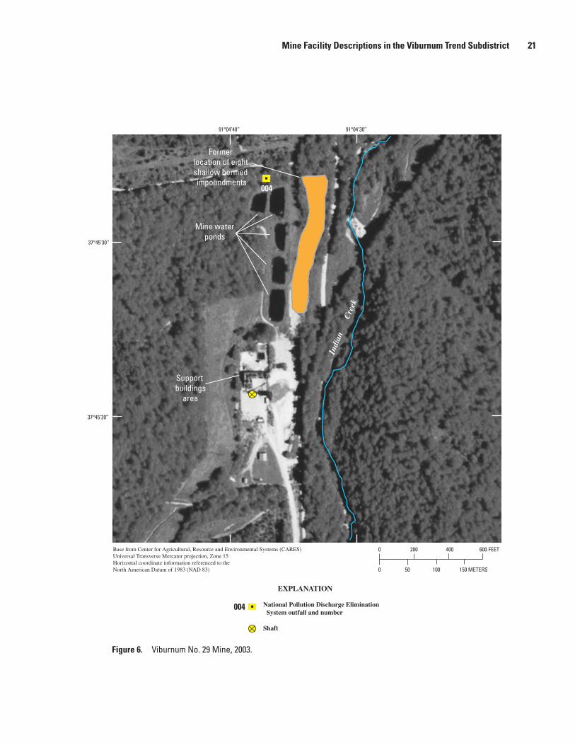
Mine Facility Descriptions in the Viburnum Trend Subdistrict 21
0
0
200 400 600 FEET
10050 150 METERS
37°45’20’’
37°45’30’’
91°04’30’’91°04’40’’
Mine waterponds
Former location of eight shallow bermed impoundments
Support buildings
area
Indi
an
C
reek
Base from Center for Agricultural, Resource and Environmental Systems (CARES) Universal Transverse Mercator projection, Zone 15Horizontal coordinate information referenced to the North American Datum of 1983 (NAD 83)
004
EXPLANATION
National Pollution Discharge Elimination System outfall and number
Shaft
004
Figure 6. Viburnum No. 29 Mine, 2003.

22 Hydrologic Investigations Concerning Lead Mining Issues in Southeastern Missouri
001
002
003
Mine water pond
Tailingspond
0 1,000
0 500 METERS250
2,000 FEET
91°07’
37°27’
91°06’
37°28’
Return waterbasin
Mill
Base from Center for Agricultural, Resource and Environmental Systems (CARES) Universal Transverse Mercator projection, Zone 15Horizontal coordinate information referenced to the North American Datum of 1983 (NAD 83)
Dam
TT
EXPLANATION
National Pollution Discharge Elimination System outfall and number
Shaft
002
Bee Fork
Figure 7. Fletcher Mine and mill, 2003.

Mine Facility Descriptions in the Viburnum Trend Subdistrict 23
Sweetwater Mine and Mill
The Sweetwater Mine (figs. 2, 9), in Reynolds County, was originally known as the Ozark Lead Company Mine or the Frank R. Milliken Mine. It is the southernmost mine in the Viburnum Trend. The orebody, located at 1,400 ft deep, was discovered by Bear Creek Mining Company, an explora-tion subsidiary of Kennecott Copper (Mouat and Clendenin, 1977). The discovery hole was drilled in 1962 and production began in 1968. Lead concentrates were sold to the Asarco, Inc. Smelter at Glover (fig. 1). Because of depressed lead prices, the Ozark Lead Company placed the mine on standby in 1983 and ceased operations. The mine was purchased by Asarco, Inc. in 1986 and renamed the Sweetwater Mine; production was restarted in 1987. The mine was purchased by Doe Run in 1997. The Sweetwater Mill recovers lead and zinc con-centrates. Lead concentrates are now (2008) shipped to the Herculaneum Smelter.
The original NPDES permits for the Sweetwater Mine were issued to Kennecott Copper in 1986. The permits were modified in 1987 because of the change in ownership from Kennecott Copper to Asarco, Inc. and the accompanying name change to Sweetwater Mine. The current (2008) outfall 001 (fig. 9) discharges non-mining related wastewater into a
tributary of Adair Creek after the water has undergone settling and aerobic digestion (Asarco, Inc., 1991a). Process water from the mill is decanted and reused from two return water basins at the base of the tailings pond dam. Excess mill water is routed through a 6,800-ft meander system ending at outfall 002 in Adair Creek. Runoff to the tailings pond from exces-sive rainfall is channeled through an emergency spillway at the north end of the tailings pond dam and routed to Adair Creek. The tailings pond is designed to discharge only with storm waters that equal or exceed a 25-year storm. Surface water from the mill and support buildings area is channeled into a drainage east of the mill, where it flows through settling ponds and discharges into the meander system upstream from outfall 002 (Asarco, Inc., 1991a).
The original permits included two additional outfalls to Sweetwater Creek (formerly designated outfalls 001 and 002). One was for domestic wastewater near the production shaft, and the other was for stormwater runoff from a proposed mine impoundment. Neither site was ever developed. With the permit modifications, these outfalls were renamed outfalls 003 and 004 (Asarco, Inc., 1991a), for a total of four permitted outfalls. There are no plans to build the wastewater treatment site or impoundment (Asarco, Inc., 1991a). The outfalls are not included in figure 9.
37°38’
37°38’30’’
91°08’ 91°07’30” 91°07’ 91°06’ 91°05’30” 91°06’30”
Former settlingpond
001
Former return water basin
002Formertailings
pond
Left
Fork
Neals Creek
Former mill and support buildings area
0
0
2,000 4,000 FEET
1,000 METERS500
Headwaters ofCrooked Creek
Former runoff
collectionpond
Base from Center for Agricultural, Resource and Environmental Systems (CARES) Universal Transverse Mercator projection, Zone 15Horizontal coordinate information referenced to the North American Datum of 1983 (NAD 83)
EXPLANATION
National Pollution Discharge Elimination System outfall and number
Shaft
002
KK
Figure 8. Magmont Mine and mill, 2003.

24 Hydrologic Investigations Concerning Lead Mining Issues in Southeastern Missouri
Sweetwater Creek
001
002
Adair
Tailingspond
Return waterbasins
CreekSettlingponds
Mill and supportbuildings area
Meander system
0
0
2,000 4,000 FEET
1,000 METERS500
91°09’ 91°10’
37°22’
91°08’
37°23’
Base from Center for Agricultural, Resource and Environmental Systems (CARES) Universal Transverse Mercator projection, Zone 15Horizontal coordinate information referenced to the North American Datum of 1983 (NAD 83)
EXPLANATION
National Pollution Discharge Elimination System outfall and number
Shaft
002
Figure 9. Sweetwater Mine and mill, 2003.
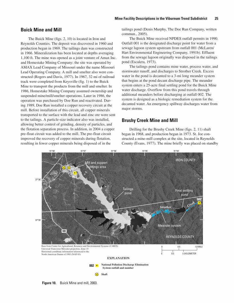
Mine Facility Descriptions in the Viburnum Trend Subdistrict 25
Buick Mine and Mill
The Buick Mine (figs. 2, 10) is located in Iron and Reynolds Counties. The deposit was discovered in 1960 and production began in 1969. The tailings dam was constructed in 1966. Mineralization has been located at depths averaging 1,100 ft. The mine was opened as a joint venture of Amax Inc. and Homestake Mining Company; the site was operated by AMAX Lead Company of Missouri under the name Missouri Lead Operating Company. A mill and smelter also were con-structed (Rogers and Davis, 1977). In 1967, 32 mi of railroad track were completed from Keysville (fig. 1) to the Buick Mine to transport the products from the mill and smelter. In 1986, Homestake Mining Company assumed ownership and suspended mine/mill/smelter operations. Later in 1986, the operation was purchased by Doe Run and reactivated. Dur-ing 1989, Doe Run installed a copper recovery circuit at the mill. Before installation of this circuit, all copper minerals transported to the surface with the lead and zinc ore were sent to the tailings. A particle-size indicator also was installed, allowing better control of grinding, density of particles, and the flotation separation process. In addition, in 2004 a copper pre-float circuit was added to the mill. The pre-float circuit improved the recovery of copper minerals during flotation, resulting in fewer copper minerals being disposed of in the
tailings pond (Denis Murphy, The Doe Run Company, written commun., 2005).
The Buick Mine received NPDES outfall permits in 1990. Outfall 001 is the designated discharge point for water from a sewage lagoon system upstream from outfall 001 (McLaren/Hart Environmental Engineering Company, 1991b). Effluent from the sewage lagoon originally was disposed in the tailings pond (Escalera, 1973).
The tailings pond contains mine water, process water, and stormwater runoff, and discharges to Strother Creek. Excess water in the pond is decanted to a 3-mi long meander system that begins at the pond decant discharge pipe. The meander system enters a 25-acre final settling pond for the Buick Mine water discharge. Overflow from this pond travels through additional meanders before discharging at outfall 002. The system is designed as a biologic remediation system for the decanted water. An emergency spillway discharges water from major storms.
Brushy Creek Mine and Mill
Drilling for the Brushy Creek Mine (figs. 2, 11) shaft began in 1968, and production began in 1973. St. Joe con-structed a mine-mill complex at the site, located in Reynolds County (Evans, 1977). The mine briefly was placed on standby
IRON COUNTY
REYNOLDS COUNTY
Meander system
002
0
0
0.5 1.0 MILE
1.00.5 KILOMETER
001
Mill and supportbuildings area
Tailingspond
Final settling pond
Strother Creek
37°35’
37°36’
91°04’ 91°05’ 91°06’ 91°07’91°08’
Base from Center for Agricultural, Resource and Environmental Systems (CARES) Universal Transverse Mercator projection, Zone 15Horizontal coordinate information referenced to the North American Datum of 1983 (NAD 83)
EXPLANATION
National Pollution Discharge Elimination System outfall and number
Shaft
002
KK
Figure 10. Buick Mine and mill, 2003.

26 Hydrologic Investigations Concerning Lead Mining Issues in Southeastern Missouri
in 1986. The mill processes all ore from the Brushy Creek Mine and about 20 percent of the ore from the Casteel Mine (Vibur-num No. 35 Mine). In addition, starting in 1989, about 300 ton/d of high grade copper ore from the Fletcher Mine has been trucked to the Brushy Creek Mill for processing (Denis Murphy, The Doe Run Company, oral commun., 2005).
The Brushy Creek Mine has three NPDES outfall permits, issued in 1989. Mine water is pumped to a detention pond in Lick Creek Hollow; the pond also retains stormwater runoff. Treatment is by settling. Excess water is released at outfall 001 (McLaren/Hart Environmental Engineering Company, 1991a).
The tailings pond retains process water and stormwater runoff and is designed as zero discharge. Water collected in a return water (seepage collection) pond at the toe of the dam is pumped back into the tailings pond. The seepage collection pond is zero discharge during normal operation; any discharge would be at outfall 003. An emergency spillway on the south-
east side of the tailings pond (outfall 002) discharges into a tributary of Bills Creek. The spillway is zero discharge during normal rainfall (McLaren/Hart Environmental Engineering Company, 1991a).
Brushy Creek Mine constructed a complete recycling sys-tem for water discharged from milling and flotation (Wixson, 1977). A mill water pond, constructed in 1969, contains water pumped back from the tailings pond. Excess water is piped to the tailings pond. No discharge point exists for this reservoir (McLaren/Hart Environmental Engineering Company, 1991a). The reservoir is part of a complete recycling system for water used in milling and flotation (Wixson, 1977).
Casteel Mine (Viburnum No. 35 Mine)
The Casteel Mine (figs. 2, 12), also called the Vibur-num No. 35 Mine, is in Iron County and was opened by St.
0
0
1,000 2,000 FEET
500 METERS250
003
Mill and supportbuildings area
002
001
Tailingspond
Mine water detention pond
Mill water pond
Bills Creek
Lick C
reek Hollow
37°31’30’’
37°32’30’’
37°32’
91°07’30’’91°08’30’’91°09’ 91°08’
EXPLANATION
National Pollution Discharge Elimination System outfall and number
Shaft
002
Base from Center for Agricultural, Resource and Environmental Systems (CARES) Universal Transverse Mercator projection, Zone 15Horizontal coordinate information referenced to the North American Datum of 1983 (NAD 83)
Return waterpond
Figure 11. Brushy Creek Mine and mill, 2003.

Mine Facility Descriptions in the Viburnum Trend Subdistrict 27
Joe in 1983. Similar to Viburnum No. 27 and No. 29 Mines, the Casteel Mine has no mill or tailings pond. Until 2000, about 80 percent of the ore from the mine was trucked to the Central Mill and about 20 percent was trucked to the Brushy Creek Mill. Currently (2008) ore is trucked to the Buick Mill (Denis Murphy, The Doe Run Company, written commun., 2008). Mine water is pumped to two mine water ponds, then discharged into tributaries of Crooked Creek. The dam for the east pond also is a bridge structure for the haul road to the Central Mill. Outfalls for the ponds are 001 (west pond) and 003 (east pond). Sewage is passed through a treatment system, followed by a single cell lagoon; this water is released at out-fall 002 (McLaren/Hart Environmental Engineering Company, 1991d).
West Fork Mine and Mill
The West Fork ore body was discovered in Reynolds County in the early 1960s by Asarco, Inc. Various factors, including depressed lead prices, delayed development of the deposit until the early 1980s. The mine (figs. 2, 13) began limited production in 1985 and reached full production in 1988. The mine was purchased by Doe Run in 1997. The West Fork Mill produces lead and zinc concentrates. Lead concen-trate was shipped to the Glover Smelter until operations at the smelter were suspended in 2003 because of a decreased demand for lead; the concentrate is now shipped to the Hercu-laneum Smelter. West Fork Mine is currently (2008) consid-ered to be part of the Fletcher Mine.
Mine water pond
Mine water pond
Support buildingarea
Tributaries of Crooked Creek
002
003
001
0
0
200 400 600 FEET
10050 150 METERS
37°39’30’’
37°39’40’’
91°07’20’’91°07’30’’
Haul road
Base from Center for Agricultural, Resource and Environmental Systems (CARES) Universal Transverse Mercator projection, Zone 15Horizontal coordinate information referenced to the North American Datum of 1983 (NAD 83)
EXPLANATION
National Pollution Discharge Elimination System outfall and number
Shaft
002
Figure 12. Casteel Mine (Viburnum No. 35 Mine), 2003.

28 Hydrologic Investigations Concerning Lead Mining Issues in Southeastern Missouri
Toms
Cree
k
37°28’30’’
37°29’
West
ForkB
lack
River001
004
003
002
Tailingspond
Mine water settling pond
Mill water pond
37°29’30’’
91°07’ 91°06’30’’
Mill
0
0
1,000 2,000 FEET
500 METERS250
EXPLANATION
National Pollution Discharge Elimination System outfall and number
Shaft
002
Base from Center for Agricultural, Resource and Environmental Systems (CARES) Universal Transverse Mercator projection, Zone 15Horizontal coordinate information referenced to the North American Datum of 1983 (NAD 83)
KK
Figure 13. West Fork Mine and mill, 2003.
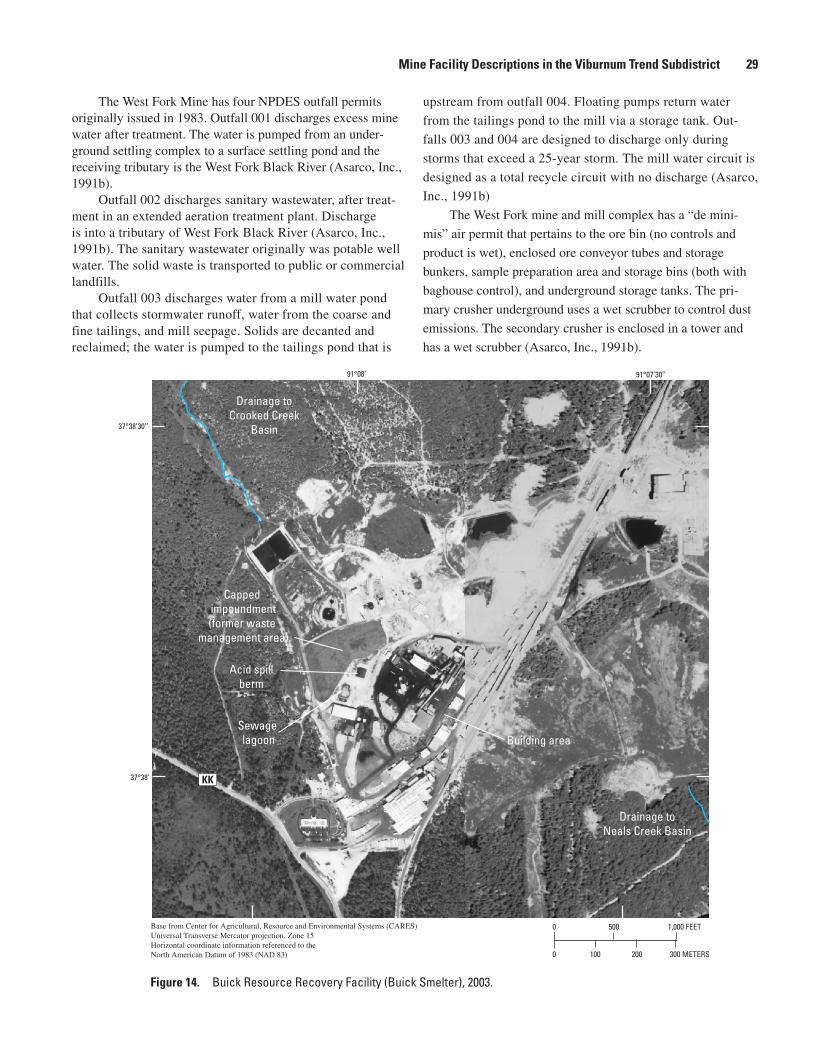
Mine Facility Descriptions in the Viburnum Trend Subdistrict 29
The West Fork Mine has four NPDES outfall permits originally issued in 1983. Outfall 001 discharges excess mine water after treatment. The water is pumped from an under-ground settling complex to a surface settling pond and the receiving tributary is the West Fork Black River (Asarco, Inc., 1991b).
Outfall 002 discharges sanitary wastewater, after treat-ment in an extended aeration treatment plant. Discharge is into a tributary of West Fork Black River (Asarco, Inc., 1991b). The sanitary wastewater originally was potable well water. The solid waste is transported to public or commercial landfills.
Outfall 003 discharges water from a mill water pond that collects stormwater runoff, water from the coarse and fine tailings, and mill seepage. Solids are decanted and reclaimed; the water is pumped to the tailings pond that is
upstream from outfall 004. Floating pumps return water
from the tailings pond to the mill via a storage tank. Out-
falls 003 and 004 are designed to discharge only during
storms that exceed a 25-year storm. The mill water circuit is
designed as a total recycle circuit with no discharge (Asarco,
Inc., 1991b)
The West Fork mine and mill complex has a “de mini-
mis” air permit that pertains to the ore bin (no controls and
product is wet), enclosed ore conveyor tubes and storage
bunkers, sample preparation area and storage bins (both with
baghouse control), and underground storage tanks. The pri-
mary crusher underground uses a wet scrubber to control dust
emissions. The secondary crusher is enclosed in a tower and
has a wet scrubber (Asarco, Inc., 1991b).
37°38’
37°38’30’’
91°07’30’’91°08’
0
0
500 1,000 FEET
200100 300 METERS
Acid spillberm
Capped impoundment(former waste
management area)
Building areaSewage lagoon
Drainage toCrooked Creek
Basin
Drainage toNeals Creek Basin
Base from Center for Agricultural, Resource and Environmental Systems (CARES) Universal Transverse Mercator projection, Zone 15Horizontal coordinate information referenced to the North American Datum of 1983 (NAD 83)
KK
Figure 14. Buick Resource Recovery Facility (Buick Smelter), 2003.

30 Hydrologic Investigations Concerning Lead Mining Issues in Southeastern Missouri
Buick Resource Recovery Facility (Buick Smelter)
The Buick Smelter (figs. 2, 14) is located about 2 mi north of the Buick Mine and mill and immediately west of the Magmont Mine on the drainage divide between Crooked Creek and Neals Creek. The Buick Smelter and Buick Mine and mill are separate facilities and are operated by different entities within Doe Run. The smelter operated intermittently for several years. In 1991, the Buick Smelter was converted from primary recovery of lead from ore concentrates to a sec-ondary smelter recovering lead as a recycled product. At this time, the facility was renamed the Buick Resource Recovery Facility (The Doe Run Company, 2007). Because of its loca-tion near the drainage divide, smelter emissions potentially can affect Neals Creek Basin as well as Crooked Creek Basin. Water impoundments onsite are for stormwater runoff control (Barr Engineering, 2005).
The Buick Smelter has a WMA primarily consisting of a slag disposal area. Closure of the former WMA was initiated with closure of a surface impoundment and with the grad-ing and covering (capped) of the WMA. The WMA currently (2008) is being evaluated as a potential future secondary slag storage area under a Resource Conservation and Recovery Act (RCRA) permit modification. This modification may affect some closure and post-closure aspects of the WMA (Barr Engineering, 2005).
SummaryMissouri has three world-class lead/zinc subdistricts
(Old Lead Belt, Mine La Motte-Fredericktown, and Vibur-num Trend) and several minor subdistricts that are in a region referred to as the Southeast Missouri Lead District. Arsenic, cadmium, cobalt, copper, lead, nickel, and zinc are the primary trace elements associated with the sulfide minerals of the Mississippi Valley Type ore deposits present in the district. Although the history of lead and zinc mining in the Southeast Missouri Lead District is discussed in this report, emphasis is placed on the Viburnum Trend, which is an active subdis-trict. A general description of the mine processes, regulatory controls, environmental effects, and mine facilities in the Viburnum Trend are provided to explain possible contaminant sources and transport routes of mining-related materials to the surrounding environment.
Earliest mining occurred in pits less than 10-foot deep, but with time companies had to mine deeper (depths more than 1,000 feet) to find ore. As more ore bodies were discovered, a relation between Precambrian structural highs and mineraliza-tion that developed in complex carbonate facies in the sur-rounding Bonneterre Formation was observed. This observa-tion aided in the discovery of the Viburnum Trend Subdistrict.
Production began in the Viburnum Trend in 1960; 10 mines eventually were opened in the subdistrict. Galena is the
primary ore mineral; sphalerite is the second most common ore mineral. Total ore production from individual mines range from 20 to more than 50 million tons, and ore contains as much as 8 percent lead and several percent zinc.
Most Viburnum Trend mines operate using the same gen-eral steps and procedures. Mining is done using a room and pillar method that follows the ore trend with mine passages that are approximately 30 feet wide and at least 20 feet high. Mine water from dewatering is pumped to the surface and retained in either a tailings pond or mine water detention pond, then discharged to surrounding surface streams.
Of the 10 mines in the Viburnum Trend, 7 have or had mills onsite to concentrate the ore, as well as facilities for transportation of ore mineral concentrates. Milling processes have remained essentially the same throughout the history of the Viburnum Trend and follows four primary stages; crushing and grinding, flotation, filtering and dewatering, and tailings disposal. The mills have undergone changes and improve-ments for recovery enhancement or for recovery of additional metals. All mills in the Viburnum Trend have lead and zinc circuits; most mills had or have copper circuits. Mine tailings (waste rock) from the milling process generally are transported through pipes as slurry and are contained in a surface disposal area (tailings pond). Materials in the tailings ponds consist of gangue minerals (primarily dolomite) and minor amounts of ore minerals; flotation reagents also may be present. Mines that do not have mill operations onsite transport the ore to either the Buick Mill or Brushy Creek Mill generally by truck on haul roads or on property owned or leased by the company; some transportation occurs on public highways.
Smelter dust (fine-particulate fraction) and gas releases probably are the greatest potential source of contamination in the production process. Air emissions at the smelters are monitored for sulfur dioxide. Material can be released to the environment by spillage while being loaded onto truck or rail transport or may be windblown from ore concentrate piles at the smelter. These materials can be carried into the offsite environment by stormwater runoff.
Permitting and legislation affecting mines and smelters only have been in effect for relatively few years. The Mis-souri Department of Natural Resources, Hazardous Waste Program inspects facilities for violations of hazardous waste handling. The major environmental issue for The Missouri Department of Natural Resources, Land Reclamation Pro-gram is wind-blown transport of tailings material outside the waste management area. During 1997, the Sweetwater Mine was issued a notice of violation as an unauthorized hazardous waste treatment/disposal facility. Violations included failure to label and mark containers and the presence of an open container. Compliance was met in 2 to 3 weeks. Inspections of other Viburnum Trend mines and the Buick Smelter have indicated no violations since the mid 1990s. The Missouri Departmemt of Natural Resources, Hazardous Waste Program has one Superfund site in the Viburnum Trend area—public highways used as transportation routes by trucks hauling ore mineral concentrates to smelters or shipment points. Highways

References Cited 31
within the Superfund site are located in Iron, Reynolds, and Dent Counties.
Waste products from mining, milling, and smelting have affected the environment immediately surrounding the opera-tion. Studies completed in and around the Viburnum Trend document some of the effects. The environmental effects of concern in the Viburnum Trend include wind-blown dust or water-transported trace elements from ore mineral concen-trates and tailings, deposition from gases related to smelting, and unusual widespread growth of benthic bacterial/algal mats downstream from operations. One study noted a decline in the number and type of benthic organisms downstream from operations. Another study observed the Buick Smelter emis-sions affecting the foliage of trees in the surrounding wood-lands. Responses by the industry to these effects have resulted in improved air quality from smelter stack releases and further remediation of mine and process waters.
All mine sites in the Viburnum Trend have certain features in common—at a minimum, they have a production shaft, detention pond(s) for mine water and surface runoff, and buildings for offices, supplies, change room, and hoist room. At sites that do not have a mill, loading facilities are present for transportation of ore to a mill. There also are provisions for detention of process waters used in the milling operations.
References Cited
Arseneau, J.G., 1976, Chemical and mineralogical characteris-tics of particulates in stack emission from two lead smelt-ers in southeast Missouri: University of Missouri—Rolla, unpublished M.S. thesis, 63 p.
Asarco, Inc., 1991a, Application for metallic minerals waste management permit (Asarco, Inc. Missouri Lead Division Sweetwater Unit): Tucson, Ariz., 147 p., 5 pl.
Asarco, Inc., 1991b, Application for metallic minerals waste management permit (Asarco, Inc. Missouri Lead Division West Fork Unit): Tucson, Ariz., 173 p., 5 pl.
Barr Engineering, 2005, 2004 annual groundwater monitoring report, The Doe Run Company Buick Resource Recovery Facility: Minneapolis, Minn., 212 p.
Boggess, W.R., and Wixson, B.G., 1977, Lead in the environ-ment: A report and analysis of research at Colorado State University, University of Illinois at Urbana—Champaign, and University of Missouri—Rolla: Washington, D.C., National Science Foundation, 272 p.
Bolter, Ernst, Wixson, B.G., Butherus, D.L., Jennett, J.C., 1974a, Distribution of trace elements in soils near an active lead smelter: University of Missouri—Rolla, 17 p.
Bolter, Ernst, Jennett, J.C., and Wixson, B.G., 1974b, Geo-chemical impact of lead-mining wastewaters on streams in southeastern Missouri: University of Missouri—Rolla, 9 p.
Bornstein, R.E., 1989, Long term geochemical effects of lead smelting within the New Lead Belt, southeast Missouri: University of Missouri—Rolla, unpublished M.S. thesis, 84 p.
Burford, J., 1978, Underground treasures: The story of mining in Missouri, in Johnson, K.M., ed., Official Manual State of Missouri 1977–1978: Jefferson City, Mo., p. 1–33.
Butherus, D.L., 1975, Trace element contamination in soil around a lead smelter in southeast Missouri: University of Missouri—Rolla, unpublished M.S. thesis, 131 p.
Erten, Z.M., 1988, Toxicity evaluation and biological treat-ment of lead and zinc mine-mill effluents in southeast Mis-souri: University of Missouri—Rolla, unpublished Ph.D. dissertation, 292 p.
Escalera, W.A., 1973, Pollution abatement of mining effluents in the New Lead Belt of Missouri: University of Missouri—Rolla, unpublished M.S. thesis, 87 p.
Evans, L.L., 1977, Geology of the Brushy Creek Mine, Vibur-num Trend, southeast Missouri: Economic Geology, v. 72, no. 3, p. 381–390.
Faeth, A.M., Wronkiewicz, D.J., Adams, C.D., Mendoza, C., McBurnett, J., Krizanich, G.W., Struttman, S.R., Hemman, R., and Wolf, S.F., 2004, Trace element transport processes in the Black River of Missouri’s New Lead Belt: Geological Society of America Abstracts with Program 38th Annual Meeting 2004, v. 36, no. 3, p. 4.
Femmer, S.R., 2004, Background and comparison of water-quality, streambed-sediment, and biological characteristics of streams in the Viburnum Trend and the exploration study areas, southern Missouri, 1995 and 2001: U.S. Geological Survey Water-Resources Investigations Report 03–4285, 18 p.
Fenneman, N.M., 1938, Physiography of eastern United States: New York, McGraw-Hill, 714 p.
Fernandes, D.L., 1987, A study on chemical extraction and bioassays for lead, zinc and cadmium and effluent charac-terization in the New Lead Belt of Missouri: University of Missouri—Rolla, unpublished M.S. thesis, 98 p.
Fletcher, C.S., 1974, The geology and hydrogeology of the New Lead Belt, Missouri: University of Missouri—Rolla, unpublished M.S. thesis, 91 p.
Gale, N.L., 1974, The impact of lead mine and mill effluent on aquatic life: University of Missouri—Rolla, 22 p.

32 Hydrologic Investigations Concerning Lead Mining Issues in Southeastern Missouri
Grundmann, W.H. Jr., 1977, Geology of the Viburnum No. 27 Mine, Viburnum Trend, southeast Missouri: Economic Geology, v. 72, no. 3, p. 349–364.
Hagni, R.D., and Trancynger, T.C., 1977, Sequence of deposi-tion of the ore minerals at the Magmont Mine, Viburnum Trend, southeast Missouri: Economic Geology, v. 72, no. 3, p. 451–464.
Hydro-Search, Inc., 1991, Revised application for metallic minerals waste management permit, Magmont Mine tailings pond, Cominco American Incorporated, Bixby, Missouri: Golden, Colo., 146 p., 3 pls.
Jennett, J.C., 1974, Transport mechanisms of lead industry wastes: University of Missouri—Rolla, 19 p.
Kiilsgaard, T.H., Hayes, W.C., and Heyl, A.V., 1967, Lead and zinc, in Mineral and Water Resources of Missouri: Rolla, Missouri Department of Natural Resources, Division of Geology and Land Survey, v. 43, p. 41–63.
Kleeschulte, M.J., 2001, Effects of lead-zinc mining on ground-water levels in the Ozark Aquifer in the Viburnum Trend, Southeastern Missouri: U.S. Geological Survey Water-Resources Investigations Report 00–4293, 28 p.
Kleeschulte, M.J., 2006, Ground-water levels in the Ozark Aquifer along the Viburnum Trend, Southeastern Missouri, 2001–05: U.S. Geological Survey Scientific Investigations Report 2006–5220, 21 p.
Kleeschulte, M.J., and Seeger, C.M., 2003, Stratigraphy and vertical hydraulic conductivity of the St. Francois confining unit in the Viburnum Trend and evaluation of the unit in the Viburnum Trend and exploration areas, Southeastern Mis-souri: U.S. Geological Survey Water-Resources Investiga-tions Report 03–4329, 57 p.
Leach, D.L., and Sangster, D., 1993, Mississippi Valley-Type lead-zinc deposits, in Kirkham, R.V., Sinclair, W.D., Thorpe, R.I., and Duke, J.M., eds., Mineral deposit model-ing: Geological Association of Canada, Special Paper, v. 40, p. 289–314.
McLaren/Hart Environmental Engineering Company, 1991a, Application for metallic minerals waste management area permit, The Doe Run Company Brushy Creek operations, Missouri: Lester, Pa., 120 p.
McLaren/Hart Environmental Engineering Company, 1991b, Application for metallic minerals waste management area permit, The Doe Run Company Buick operations, Missouri: Lester, Pa., 144 p.
McLaren/Hart Environmental Engineering Company, 1991c, Application for metallic minerals waste management area permit, The Doe Run Company Fletcher facility, Missouri: Lester, Pa., 122 p.
McLaren/Hart Environmental Engineering Company, 1991d, Application for metallic minerals waste management area permit, The Doe Run Company Viburnum operations, Mis-souri: Lester, Pa., 402 p.
Missouri Department of Labor and Industrial Relations, 1967, Eightieth annual report of the Division of Mine Inspection: Jefferson City, Mo., 38 p.
Missouri Department of Natural Resources, 2007, 2006 Annual Compliance Report of Missouri Public Drinking Water Systems: Jefferson City, Public Drinking Branch, Water Protection Program, accessed January 14, 2008, at URL: http://dnr.missouri.gov/pubs/pub2228.pdf
Missouri Department of Natural Resources, 2008, Census of Missouri public water systems: accessed January 15, 2008, at URL, http://dnr.missouri.gov/env/wpp/census.htm
Missouri Department of Natural Resources, Division of Environmental Quality, 2008, Metallic minerals permitting: accessed January 14, 2008, at URL http://www.dnr.mo.gov/env/lrp/homemm.htm
Missouri Department of Natural Resources, Land Reclamation Program, 2003, 2001 and 2002 Biennial Report: Jefferson City, Mo., 30 p.
Mouat, M.M., and Clendenin, C.W., 1977, Geology of the Ozark Lead Company Mine, Viburnum Trend, southeast Missouri: Economic Geology, v. 72, no. 3, p. 398–407.
Paarlberg, N.L., and Evans, L.L., 1977, Geology of the Fletcher Mine, Viburnum Trend, southeast Missouri: Eco-nomic Geology, v. 72, no. 3, p. 391–397.
Rakovan, John, 2007, Mississippi Valley Type deposits: Oxford, Ohio, Miami University, accessed October 5, 2007, at URL http://www.users.muohio.edu/rakovajf/WTTW%20MVT.pdf
Rogers, R.K., and Davis, J.H., 1977, Geology of the Buick Mine, Viburnum Trend, southeast Missouri: Economic Geology, v. 72, no. 3, p. 372–380.
Snyder, F.G., and Gerdemann, P.E., 1968, Geology of the Southeast Missouri Lead District, in Ridge, J.D., ed., Ore deposits of the United States, 1933–1967: New York, The American Institute of Mining Metallurgical and Petroleum Engineers, Inc., p. 327–358.
Sweeney, P.H., Harrison, E.D., and Bradley, M., 1977, Geol-ogy of the Magmont Mine, Viburnum Trend, southeast Mis-souri: Economic Geology, v. 72, no. 3, p. 365–371.
Swenty, B.J., 1996, Construction permit application for the modification of the Magmont Mine tailings dam, Iron County, Missouri: Jefferson City, Mo., 104 p.

References Cited 33
The Doe Run Company, 2007, Company information, accessed November 6, 2007, at URL http://www.doerun.com/about/company.aspx#timeline
Tibbs, N.H., 1969, The background concentrations of copper, lead, and zinc in streams of the “New Lead Belt”: Univer-sity of Missouri—Rolla, unpublished M.S. thesis, 86 p.
U.S. Environmental Protection Agency, 2008, National Pol-lutant Discharge Elimination System (NPDES), accessed January 15, 2008, at URL http://cfpub.epa.gov/npdes/
U.S. Geological Survey, 2008, Mineral commodity summary, accessed January 18, 2008, at URL http://minerals.usgs.gov/minerals/pubs/commodity/statistical_summary/
Vinyard, J.D., 1977, Preface: Economic Geology, v. 72, no. 3, p. 337–338.
Wharton, H.M., 1975, Introduction to the Southeast Missouri Lead District, in Guidebook to the geology and ore deposits of selected mines in the Viburnum Trend, Missouri: Rolla, Missouri Department of Natural Resources, Division of Geology and Land Survey, Report of Investigations Number 58, p. 2–14.
Wixson, B.G., 1977, The Missouri lead study: An interdis-ciplinary investigation of environmental pollution by lead and other trace elements from industrial development in the New Lead Belt of southeastern Missouri: University of Missouri—Rolla and University of Missouri—Columbia, 1,108 p.
Wixson, B.G., and Anderson, M.N., 1973, Missouri Lead Belt project: University of Missouri—Rolla, 11 p.
Wixson, B.G., Bolter, Ernst, Gale, N.G., Jennett, J.C., Purushothaman, K., 1972, The lead industry as a source of trace elements in the environment: University of Missouri—Rolla, 22 p.

34 Hydrologic Investigations Concerning Lead Mining Issues in Southeastern Missouri