Embed Size (px)
Citation preview
1
ITEM NO: 6.2 REPORT NUMBER: 35/16 TO: DEVELOPMENT ASSESSMENT PANEL DATE: 24 FEBRUARY 2016
SUBJECT: REFERRAL ITEM – COMMENTS TO DEVELOPMENT ASSESSMENT COMMISSION
AUTHOR: CRAIG WATSON TEAM LEADER DEVELOPMENT ASSESSMENT
ATTACHMENTS: 1. PROPOSED DEVELOPMENT PLANS INCLUDING LOCALITY PLANS 2. JENSEN AND DESIGN PLANNING REPORT ON BEHALF OF THE
APPLICANT 3. BESTEC ACOUSTIC SERVICES REPORT ON BEHALF OF APPLICANT
4. TREE ENVIRONS TREE REPORT ON BEHALF OF APPLICANT 5. W AND G STORMWATER MANAGEMENT PLAN ON BEHALF OF
APPLICANT 6. TONKIN TRAFFIC IMPACT ASSESSMENT ON BEHALF OF
APPLICANT 7. DESIGN REPORT ON BEHALF OF APPLICANT 8. D SQUARED ESD REPORT ON BEHALF OF APPLICANT
9. GHD VISUAL IMPACT ANALYSIS ON BEHALF OF COUNCIL 10. OXIGEN LANDSCAPE PLAN
PURPOSE TO PROVIDE COMMENTS ONLY ON THE PROPOSAL, AS THE STATE DEVELOPMENT ASSESSMENT COMMISSION IS THE RELEVANT PLANNING AUTHORITY FOR THIS APPLICATION. THE PANEL HAS NO DECISION MAKING AUTHORITY IN THIS MATTER, SO ITS RESPONSE IS LIMITED TO A COMMENTARY ON THE MERITS OF THE PROPOSAL
1
2
ITEM NO: 6.2 REPORT NUMBER: 35/16 DA NO. : 110/01097/15 APPLICANT : MINDA INCORPORATED LOCATION : 12 – 16 KING GEORGE AVENUE, NORTH BRIGHTON DEVELOPMENT PLAN : CONSOLIDATED 26 NOVEMBER 2015 ZONE AND POLICY AREA : RESIDENTIAL INSITUTION POLICY AREA 4 NATURE OF DEVELOPMENT: MAJOR DEVELOPMENT PROPOSAL : • RESIDENTIAL FLAT BUILDING COMPRISING 5 AND 7 STOREY
TOWERS AND 68 RETIREMENT APARTMENTS • MINDA RESIDENT ACCOMMODATION COMPRISING 11 SINGLE
STOREY GROUP DWELLINGS, 4 SINGLE STOREY RESIDENTIAL FLATS (COMPRISING 2 DWELLINGS EACH) AND 2 THREE STOREY RESIDENTIAL FLAT BUILDINGS EACH COMPRISING 17 DWELLINGS AND SUPPORT STAFF FACILITIES.
• 4 MULTI PURPOSE SINGLE STOREY BUILDINGS • REMOVAL OF 6 REGULATED TREES • DEMOLITION OF EXISTING BUILDINGS AND SUPERFLUOUS
INTERNAL ROADS AND PATHS AND CONSTRUCTION OF NEW INTERNAL ROADS AND CARPARKING FOR 216 VEHICLES
EXISTING USE : SUPPORTED RESIDEANTIAL CARE FACILITY AND RETIREMENT APARTMENTS
RECOMMENDATION : PROVIDE THE DEVELOPMENT ASSESSMENT COMMISSION WITH COMMENTS ON THE PROPOSAL
1. Site and Locality Minda Incorporated (Minda) offers supported accommodation for more than 1700 people with a
disability. The Brighton Campus is a significant land holding, comprising approximately 28 hectares bounded by Repton Road (north), King George Avenue (east), Lynmouth Avenue (south) and the sand dunes (west). The campus contains four heritage listed buildings, supported living accommodation, the Pat Kaufman Centre aged care facility and substantial green open spaces. Ninety trees on the site are identified as Regulated Trees, of which 30 are Significant Trees. The site has four access points, one from Repton Road and three from King George Avenue.
Major landmarks and sites include the Somerton Surf Life Saving Club to the immediate north west
and North Brighton cemetery and Brighton High School to the east. Residential development dominates the locality to the north with a variety of dwelling styles and heights established, including contemporary developments up to three storeys in height along the coast and single to two storey dwellings fronting Repton Road. A number of dwellings on the southern side of Repton Road have recently been demolished.
The campus is serviced by public transport (buses) on King George Avenue and is located less than
2 km to Brighton, 4 km to Glenelg and 14 km to the Central Business District of Adelaide. 2. Background In 2012 Minda released its long term Master Plan for the Brighton Campus. The aims are to:
• De-institutionalise accommodation for Minda residents;
2
3
ITEM NO: 6.2 REPORT NUMBER: 35/16
• Ensure ongoing sustainability of Minda into the future to enable it to expand on the services it provides;
• Provide opportunities for retirement living; • Improve connectivity across the site; and • Maintain and improve the landscape character.
The development involves a number of development proposals within a 10 year plan. Stage 1 involved multi-level retirement apartments in the north western portion of the site, accommodation for Minda residents in dwellings and an apartment building with new roadway from King George Avenue and the first stage of a wetland and storm water detention system. These developments were approved by Council in 2012 and have now been completed.
3. Procedural The applicant has exercised its rights under the Development Regulations 2008 to bypass the
traditional assessment path and seek special dispensation from the State Coordinator General on the basis that the project exceeds $3m in value and is a development of ‘economic significance’. The State Coordinator granted permission to the applicant’s request and appointed the Development Assessment Commission (DAC) as the planning authority pursuant to Schedule 10 of the Development Regulations 2008.
The DAC has invited Council, through its Panel, to provide comments on the current proposal. The
Panel has no decision making authority in this matter, so the response to the DAC will be limited to a commentary on the merits of the proposal.
4. Proposed Development The development involves stages 2 and 3 of the Master Plan for the MInda Campus and includes:
• Construction of stage 2 of the Brighton Dunes retirement apartments, which comprise two towers (western tower of 7 storeys, eastern tower 5 storeys) accommodating 68 apartments. Both towers will be connected by a basement car park for 96 vehicles. The apartments will be sited 42 metre to the south of the existing retirement apartments and 1.5 metres from the Coastal Conservation Zone boundary at its closest. The space between the two towers and the existing apartment building will comprise communal areas, pergolas, planter and seating areas with shelters.
• Minda accommodation apartments. These will be developed in two locations. One adjacent the recently constructed apartments in Stage 1 and fronting Bonython Way, the other to the south of the campus and accessed from the existing southernmost access. Each of the apartment buildings will be three storeys (10.3 metres high) and each will accommodate 16 apartments for Minda residents. The southern apartments will require the removal of one regulated tree.
• Minda accommodation dwellings. These are also developed in two locations. Eleven will have a direct frontage and vehicular access points to Repton Road and replace 4 dwellings recently demolished. Eight will be located towards the southern portion of the campus adjacent to King George Avenue but accessed from a new internal road. Timber slated front fencing to 1.8 metres will be located along Repton and King George Avenue frontages. All the dwellings will be single storey and provide accommodation for Minda residents. The southern dwellings will require the removal of one regulated tree.
3
4
ITEM NO: 6.2 REPORT NUMBER: 35/16
• Lifestyle Precinct Facilities. The precinct will be formed around a new internal road with new access to King George Avenue north of the existing main driveway. The main drive and access will be removed in stage 3. The precinct comprises 4 single storey buildings ranging in size from 600m² to 1120m². Existing day option services and facilities within the campus will be relocated to the precinct. Activities will include gym, exercise and games facilities, healthy ageing, mind, body and spirit, independent living lessons, computer gaming and lounge areas, pets, animals, recycling/green waste and potting, general workshop, dance cooking, arts pottery and retail outlet (for goods made on site). Future commercial uses will also be constructed within the precinct and form part of separate future applications. A 133 vehicle car park and bus parking bay will be provided to the rear of the buildings. The internal roadway and parking areas will require the removal of four regulated trees.
A detailed description of the construction materials building design and staging of the development is provided in the report by Jensen Planning and Design.
5. Internal Referrals The development application was referred to the City Asset’s Department and Strategic and
Commercial Services section of Council for comment on traffic, infrastructure and strategic matters. A number of outstanding issues have been identified and are summarised below:
Infrastructure/stormwater management
• While the applicant proposes completion of the development within 3 years no agreement has been reached regarding infrastructure provision to support the development stages;
• The Planning report notes that future works are proposed are proposed to connect the
retention basin to the Repton Road outfall, but are reliant on Council upgrading/augmenting public infrastructure north of the site. While the Report suggests these works may be in place close to completion of Stage 2 & 3 (by 2018) and have been identified as a priority by Council this is not yet included or prioritised in Council’s current asset planning. It would therefore be premature to approve development in its entirety without guarantees that supporting stormwater infrastructure will be provided;
• The W&G Stormwater Management Plan suggests that the wetland may need to be
upgraded in terms of size. It is unclear whether this requires a development application in its own right; and
• A management plan for the wetlands is lacking. The wetlands needs to be augmented by a
management plan that articulates how the wetland is to be maintained and cleaned because the overflow will discharge into Council’s stormwater system in the future.
4
5
ITEM NO: 6.2 REPORT NUMBER: 35/16
Coast Park
• Contrary to Policy Area 4 Principle 20 no agreement has been reached regarding Council and public access to the future Coast Park land. Further, access arrangements through Minda’s site to the future shared pathway have not yet been confirmed and Council has not supported closing off access to the public;
• The Planning Report (page 28) states that the “proposed development lies entirely within the Residential Zone and therefore does not impact on the dune system”. However, siting of development up to 7 storeys within 1.5 metres of the Coastal Conservation Zone boundary may indeed have impacts and requires an appropriate environment impact to confirm there are no negative impacts on the ecology of the sensitive coastal dunes and undeveloped portion of the secondary dunes (eg. from overshadowing, wind, excavation for basement, etc.). Impacts on comfort levels for beach users should also be considered. Notably, references to overshadowing in the Planning report focus on impacts on adjacent development only.
• Previous studies and surveys have identified a number of plants of local importance or conservation status within the dunes, and the site provides habitat for indigenous birds, reptiles and insects. There is limited discussion in the supporting documents regarding the potential impacts on the coastal dunes and sensitive dune ecosystem. The importance of the site and its future management is recognised in the Metropolitan Adelaide and Northern Coastal Action Plan (MANCAP), which is a State strategic document but is not referenced in the development application;
• Increased human traffic in such close proximity to the Conservation Zone will need to be managed; conservation fencing is the only conceivable method to reduce human impact on the dunes (see Tennyson Dunes). Fencing is recommended to control human traffic and cease development of informal access paths through the Conservation Zone;
• The undeveloped portion of the secondary dunes should be protected to the western boundary by providing a barrier (conservation fencing) to public access, which would also assist in rejuvenating the secondary dunes;
• Plants such as Agave and ‘hybrid natives’ should not be planted anywhere near the Conservation Zone to prevent further pollution of the flora gene pool and continued hybridisation of vulnerable flora species;
• Advice received from Council during the policy setting stage suggests that the impact of shading from taller buildings on the coastal dunes may be significant (eg. Reduced levels of sunlight may affect the viability of dunal plant species). It also confirmed that the impacts of shading may be more pronounced on the undeveloped secondary dunes; and
• Perspectives used in the Design report showing visual impact from beach and dunes are misleading. Council previously engaged GHD to prepare perspectives at the policy setting stage and more accurately reflect the visual impact of buildings from public vantage points (see attachment 9). Similar perspectives should be developed in support of the application.
5
6
ITEM NO: 6.2 REPORT NUMBER: 35/16
Traffic management
• It is noted that the existing Pedestrian Actuated Crossing (PAC) in King George Avenue is no longer proposed to be relocated and a roundabout is no longer proposed at the Lynmouth/King George Avenue intersection to provide safe entry/exit to the site. There appears to be limited clarification in the Traffic Impact Assessment (TIA)to justify the shift away from these proposals;
• There is no reference in the Planning report to access for fire fighting vehicles, particularly in relation to the 4+ storeys development in the Foreshore Development Area – including required operating pad adjacent taller buildings and whether existing and proposed roads and roundabouts can accommodate these vehicles. The TIA does, however, state that the internal road network should be able to accommodate the “most common form of emergency vehicles expected”, but notes that the vehicles may need to travel over the Repton Road/King George Avenue traffic island. Consideration of whether the Repton roundabout needs to be redesigned is needed. It would also be appropriate for DAC to obtain advice from the MFS that it is satisfied with the proposed buildings and access arrangements;
• While Minda previously sought to allow for articulated buses to enter the site the TIA states that the design for access into and out of the campus will be via a 12.5m large rigid vehicle (i.e. garbage truck). Confirmation should be obtained as to whether bus access is no longer anticipated;
• Need to reconcile the intent to accommodate 12.5 metre-long commercial vehicles with the turning circle provided as part of the traffic plan which is limited to smaller 9.4 metre-long vehicles;
• There is no bicycle path inter-connectivity with the broader road network; • Clarification is needed as to whether the internal pedestrian linkages/paths are accessible to
the general public or just Minda residents. East/west public permeability through the site is favourable; and
• There are minimal disabled parking spaces given the clientele catered for.
Tree removals/landscaping
• The retention of the two Red Gums and the Bunya Pine in the vicinity of the Lifestyle Precinct is recommended;
• The species selection for the new designs are ideal and the numbers are plentiful, which will help to achieve maximum canopy coverage with the Resilient South Initiative; and
• The logs resulting from tree removals should be utilised to provide habitat logs on the Minda site. Should Minda not make these available as habitat on site, then Council should be given the logs to create habitat elsewhere.
Development on Council owned land
• The development site includes two unmade roads (extensions of Lynton and Lynmouth
Avenues) owned by Council (page 4 of planning report). Some of the southern MInda accommodation dwellings are proposed to be constructed over the unmade portion of Lynton Avenue, not owned by Minda; and
• The Report states that “Minda is currently finalising negotiations for the swapping of these land parcels into their ownership in favour of the transfer of portion of land Minda owns which currently has the Somerton Surf Life Saving Club Building over it”. No formal agreement has been reached regarding transfer of ownership of these unmade roads.
6
7
ITEM NO: 6.2 REPORT NUMBER: 35/16
Further Minda is not proposing to transfer the SLSC land to Council but is instead seeking to lease this land to Council on terms that are presently onerous and unacceptable to Council. Therefore no development plan consent should be issued to development proposed on Council land until some formal agreement has been reached on land ownership;
Streetscape/fencing
• The Planning report states on page 8 that fencing up to 1.8m in height (including solid
‘colorbond’ to King George Avenue despite timber panelling shown on the elevations) will be located along Repton Road and King George Avenue frontages, which may not align with intent of the Master Plan to ‘open-up the site to the wider community and avoid a gated estate.
HOLDFAST BAY (CITY) DEVELOPMENT PLAN – ASSESSMENT – RESIDENTIAL – COUNCIL WIDE – PRINCIPLES OF DEVELOPMENT CONTROL Coastal Areas 1. Development should be compatible with the coastal environment in terms of built-form, appearance and landscaping including the use of walls and low pitched roofs of non-reflective texture and natural earth colours.
A 7 storey building is proposed only 1.5 metres from the Coastal Conservation Zone. The submitted perspective showing beach impact is considered misleading. Accurate perspectives from appropriate vantage points should be submitted to enable a proper assessment of visual impact on the beach.
2. The coast should be protected from development that would adversely affect the marine and onshore coastal environment, whether by pollution, erosion, damage or depletion of physical or biological resources, interference with natural coastal processes or any other means.
An environmental impact assessment is required to appropriately assess potential impacts on the sensitive coastal dunes and undeveloped portions of the secondary dunes from overshadowing, wind, excavation activities, etc.
3. Development should not be located in delicate or environmentally-sensitive coastal features such as sand dunes, cliff-tops, wetlands or substantially intact strata of native vegetation.
Development is located immediately adjacent primary and secondary dunes and has potential impacts.
4. Development should not be undertaken where it will create or aggravate coastal erosion, or where it will require coast protection works which cause or aggravate coastal erosion.
Refer Principle 2 above.
5. Development should be designed so that solid/fluid wastes and stormwater runoff is disposed of in a manner that will not cause pollution or other detrimental impacts on the marine and on-shore environment of coastal areas.
Development may be able to manage stormwater on site but management plan for wetlands is needed. Future development likely to significantly impact public infrastructure.
20. Development and its site should be protected against the standard sea-flood risk level which is defined as the 1-in-100 year average return interval flood extreme sea level (tide, stormwater and associated wave effects combined), plus an allowance to accommodate land subsidence until the year 2100.
Complies.
21. Development including associated roads and parking areas, other than minor structures unlikely to be adversely affected by flooding, should be protected from sea level rise by ensuring all of the following apply: (a) achieve (not less than those prescribed by the constraint) the ‘Coastal Building and Site Levels (Australian Height Datum)’ shown on the Overlay Maps - Development Constraints, including sill levels around underground car parking, cellars or the like (b) there are practical measures available to protect the development against an additional sea Ievel rise of 0.7 metres, plus an allowance to accommodate land subsidence until the year 2100 at the site.
May be affected by 1 in 100 Year ARI event but protected from se level rises by coastal dunes.
7
8
ITEM NO: 6.2 REPORT NUMBER: 35/16 Crime Prevention 1. Development should be designed to maximise surveillance of public spaces through the incorporation of clear lines of sight, appropriate lighting and the use of visible permeable barriers wherever practicable.
Does not comply for Minda accommodation dwellings adjacent Repton Road, which have solid front fences.
2. Buildings should be designed to overlook public and communal streets and public open space to allow casual surveillance.
Complies.
3. Development should provide a robust environment that is resistant to vandalism and graffiti.
Complies.
7. Site planning, buildings, fences, landscaping and other features should clearly differentiate public, communal and private areas.
Complies.
8. Buildings should be designed to minimise and discourage access between roofs, balconies and windows of adjoining dwellings.
Complies.
Design and Appearance 1. Buildings should reflect the desired character of the locality while incorporating contemporary designs that have regard to the following: (a) building height, mass and proportion (b) external materials, patterns, colours and decorative elements (c) roof form and pitch (d) façade articulation and detailing (e) verandas, eaves, parapets and window screens.
Generally complies although height of Dunes apartment western tower exceeds recommended wall height.
2. Where a building is sited on or close to a side boundary, the side boundary wall should be sited and limited in length and height to minimise: (a) the visual impact of the building as viewed from adjoining properties (b) overshadowing of adjoining properties and allow adequate sun light to neighbouring buildings.
Complies.
3. The external walls and roofs of buildings should not incorporate highly reflective materials which will result in glare to neighbouring properties or drivers.
Complies.
4. Structures located on the roofs of buildings to house plant and equipment should form an integral part of the building design in relation to external finishes, shaping and colours.
Complies.
5. Building form should not unreasonably restrict existing views available from neighbouring properties and public spaces.
Complies.
6. Balconies should: (a) be integrated with the overall form and detail of the building and make a positive contribution to the external and external amenity of residential buildings (b) be sited adjacent to the main living areas, such as the living room, dining room or kitchen to extend the dwelling’s living space (c) include balustrade detailing that enables line of sight to the street (d) be recessed where wind would otherwise make the space unusable (e) have a minimum dimension of 2 metres for upper level balconies or terraces.
Complies.
8. The design of multi-storey buildings should not detract from the form and materials of adjacent State and local heritage places listed in Table HoB/ 5 - State Heritage Places or in Table HoB/4- Local Heritage Places.
Complies.
9. Development on land adjacent to a State or local heritage place, as listed in Table HoB/5 - State Heritage Places or in Table Hob/4 - Local Heritage Places, should be sited and designed to reinforce the historic character of the place and maintain its visual prominence.
Development is considerable distance from State Heritage Places.
8
9
ITEM NO: 6.2 REPORT NUMBER: 35/16 Design and Appearance (Cont) 10. The design and location of buildings should enable direct winter sunlight into adjacent dwellings and private open space and minimise the overshadowing of: (a) windows of habitable rooms (b) upper-level private balconies that provide the primary open space area for a dwelling (c) solar collectors (such as solar hot water systems and photovoltaic cells).
Complies.
11. Development should minimise direct overlooking of habitable rooms and private open spaces of dwellings through measures such as: (a) off-setting the location of balconies and windows of habitable rooms with those of other buildings so that views are oblique rather than direct (b) building setbacks from boundaries (including building boundary to boundary where appropriate) that interrupt views or that provide a spatial separation between balconies or windows of habitable rooms (c) screening devices (including fencing, obscure glazing, screens, external ventilation blinds, window hoods and shutters) that are integrated into the building design and have minimal negative effect on residents’ or neighbours’ amenity.
Complies.
13. Buildings (other than ancillary buildings or group dwellings) should be designed so that their main façade faces the primary street frontage of the land on which they are situated.
Street impact would be improved if the southern Minda accommodation single storey dwellings were facing King George Avenue rather than internally orientated.
14. Buildings, landscaping, paving and signage should have a coordinated appearance that maintains and enhances the visual attractiveness of the locality.
Complies.
15. Buildings should be designed and sited to avoid creating extensive areas of uninterrupted walling facing areas exposed to public view.
To minimise solid fencing to King george Avenue it is recommended that the southern Minda accommodation dwellings be orientated to that road with low front fences.
16. Building design should emphasise pedestrian entry points to provide perceptible and direct access from public street frontages and vehicle parking areas.
Complies.
17. Outdoor lighting should not result in light spillage on adjacent land.
Complies.
18. The ground floor of mixed use buildings should comprise non-residential land uses.
Complies.
19. In mixed use areas, development facing the street should be designed to activate the street frontage(s): (a) including features that attract people to the locality such as frequent doors and display windows, retail shopfronts and/or outdoor eating or dining areas (b) minimising the frontage for fire escapes, service doors, plant and equipment hatches (c) avoiding undercroft or ground floor vehicle parking that is visible from the primary street frontage (d) using colour, vertical and horizontal elements, roof overhangs and other design techniques to provide visual interest and reduced massing.
The Lifestyle Precinct has no direct frontage to a public road.
9
10
ITEM NO: 6.2 REPORT NUMBER: 35/16 Energy Efficiency 1. Development should provide for efficient solar access to buildings and open space all year around.
Complies.
2. Buildings should be sited and designed: (a) to ensure adequate natural light and winter sunlight is available to the main activity areas of adjacent buildings (b) so that open spaces associated with the main activity areas face north for exposure to winter sun (c) to promote energy conservation by maintaining adequate access to winter sunlight to the main ground level of living areas of existing dwellings on adjoining land.
Complies.
3. Except for buildings that take advantage of coastal views, development should promote the efficient consumption of energy through the use of larger but appropriately shaded windows on the north and east building surfaces and smaller windows on the south and west building surfaces.
Generally complies.
4. Development should facilitate the efficient use of photovoltaic cells and solar hot water systems by: (a) taking into account overshadowing from neighbouring buildings (b) designing roof orientation and pitches to maximise exposure to direct sunlight.
Apartment buildings have flat roofs but doesn’t preclude the future use of solar panels.
Hazards 1. Development should be excluded from areas that are vulnerable to, and cannot be adequately and effectively protected from, the risk of hazards.
May be impacted by 1 in 100 Year ARI flood but it is noted within the Planning report that Minda is prepared to accept ongoing risk of flooding. Future infrastructure work by Council has not as yet been included in its current asset planning.
2. Development located on land subject to hazards as shown on the Overlay Maps - Development Constraints should not occur unless it is sited, designed and undertaken with appropriate precautions being taken against the relevant hazards.
Complies with minimum AHD floor and site levels as required by the Constraints overlay map.
3. There should not be any significant interference with natural processes in order to reduce the exposure of development to the risk of natural hazards.
4. Development should not occur on land where the risk of flooding is likely to be harmful to safety or damage property.
See Principle 1 above.
5. Development should not be undertaken in areas liable to inundation by tidal, drainage or flood waters unless the development can achieve all of the following: (a) it is developed with a public stormwater system capable of catering for a 1-in-100 year average return interval flood event (b) buildings are designed and constructed to prevent the entry of floodwaters in a 1-in-100 year average return interval flood event.
Development may be impacted by the 1 in 100 Year flood. Future stormwater infrastructure work by Council has not as yet been prioritised in its asset planning and negotiations with Minda re contributions to the cost of that work are ongoing. Until such work has been formalised in Council’s asset planning any development on the Minda site should not exceed existing stormwater flow from the site.
10
11
ITEM NO: 6.2 REPORT NUMBER: 35/16 Hazards (Cont) 6. Development, including earthworks associated with development, should not do any of the following: (a) impede the flow of floodwaters through the land or other surrounding land (b) increase the potential hazard risk to public safety of persons during a flood event (c) aggravate the potential for erosion or siltation or lead to the destruction of vegetation during a flood (d) cause any adverse effect on the floodway function (e) increase the risk of flooding of other land (f) obstruct a watercourse.
Until the public storm water infrastructure is up graded Minda should ensure that all stormwater is managed on-site to pre-development levels.
14. Development, including land division, should not occur where site contamination has occurred unless the site has been assessed and remediated as necessary to ensure that it is suitable and safe for the proposed use.
Land remediation will be needed for parts of the development sites. If approved conditions should require appropriate Certification from an Environmental Auditor that the sites can be made suitable for the proposed uses.
Heritage Places 1. A heritage place spatially located on Overlay Maps – Heritage and more specifically identified in Table HoB/5 - State Heritage Places or in Table HoB/4- Local Heritage Places should not be demolished, destroyed or removed, in total or in part, unless either of the following apply: (a) that portion of the place to be demolished, destroyed or removed is excluded from the extent of the listing identified in the Table(s) (b) the structural condition of the place represents an unacceptable risk to public or private safety and the place cannot reasonably be rehabilitated.
Complies.
2. Development of a State or local heritage place should retain those elements contributing to its heritage value, which may include (but not be limited to): (a) principal elevations (b) important vistas and views to and from the place (c) setting and setbacks (d) building materials (e) outbuildings and walls (f) trees and other landscaping elements (g) access conditions (driveway form/width/material) (h) architectural treatments (i) the use of the place.
Complies.
3. Development of a State or local heritage place should be compatible with the heritage value of the place.
Complies.
5. New buildings or building additions should not be placed or erected between the front street boundary and the façade of existing State or local heritage places.
Complies. Existing heritage places not seen from a public place.
6. Development that materially affects the context within which the heritage place is situated, including development on adjoining properties and on nearby properties where there would be an influence upon the character, integrity and setting, should be compatible with the heritage place. It is not necessary to replicate historic detailing, however design elements that should be compatible include, but are not limited to: (a) scale, bulk and form (b) width of frontage (c) boundary setback patterns (d) proportion and composition of design elements such as rooflines, window and door openings, fencing and landscaping (e) colour and texture of external materials.
Proposed buildings are a considerable distance from heritage places.
11
12
ITEM NO: 6.2 REPORT NUMBER: 35/16 Heritage Places (Cont) 10. Development of a State or Local Heritage Place, or development on land adjacent to a State or Local Heritage Place should conserve, maintain, enhance and reinforce the historic character of individual buildings and/or the existing streetscape character by exhibiting architectural and roof-form designs, street frontage widths, front and side boundary set-backs, materials, colours, fences and landscape settings which complement and give prominence to historic buildings or their detailing.
Complies.
Landscaping, Fences and Walls 1.Development should incorporate open space and landscaping and minimise hard paved surfaces in order to: (a) complement built form and reduce the visual impact of larger buildings (eg taller and broader plantings against taller and bulkier building components) (b) enhance the appearance of road frontages (c) screen service yards, loading areas and outdoor storage areas (d) minimise maintenance and watering requirements (e) enhance and define outdoor spaces, including car parking areas (f) maximise shade and shelter (g) assist in climate control within and around buildings (h) minimise heat absorption and reflection (i) maintain privacy (j) maximise stormwater re-use (k) complement existing vegetation, including native vegetation (l) contribute to the viability of ecosystems and species (m) promote water and biodiversity conservation (n) establish buffers to adjacent development and areas.
Complies.
2. Landscaping should: (a) include mature vegetation, the planting of locally indigenous species where appropriate and species tolerant of salt-laden winds near the coast (b) be oriented towards the street frontage (c) result in the appropriate clearance from powerlines and other infrastructure being maintained.
Most existing trees are retained. Six regulated trees will be removed (see Regulated Trees provisions).
3. Landscaping should not: (a) unreasonably restrict solar access to adjoining development (b) cause damage to buildings, paths and other landscaping from root invasion, soil disturbance or plant overcrowding (c) introduce pest plants (d) increase the risk of bushfire (e) remove opportunities for passive surveillance (f) increase leaf fall in watercourses (g) increase the risk of weed invasion (h) obscure driver sight lines (i) create a hazard for train or tram drivers by obscuring sight lines at crossovers.
Complies.
4. Existing substantial vegetation should be retained and incorporated within landscaping of new development where practicable.
Complies.
12
13
ITEM NO: 6.2 REPORT NUMBER: 35/16 Heritage Places (Cont) 5. Fences and walls, including retaining walls, should: (a) not result in damage to neighbouring trees (b) be compatible with the associated development and with existing predominant, attractive fences and walls in the locality (c) enable some visibility of buildings from and to the street to enhance safety and allow casual surveillance (d) incorporate articulation or other detailing where there is a large expanse of wall facing the street (e) assist in highlighting building entrances (f) be sited and limited in height, to ensure adequate sight lines for motorists and pedestrians especially on corner sites (g) in the case of side and rear boundaries, be of sufficient height to maintain privacy and/or security without adversely affecting the visual amenity or access to sunlight of adjoining land (h) be constructed of non-flammable materials.
High front fencing for Minda accommodation dwellings fronting Repton Road does not provide visibility of dwellings from street.
7. Front fencing should be open in form to allow cross ventilation and access to sunlight.
Does not comply.
Medium and High Rise Development (3 or More Storeys) 1. Buildings should: (a) achieve a human scale at ground level through the use of elements such as canopies, verandas or building projections (b) provide shelter over the footpath where minimal setbacks are desirable (c) ensure walls on the boundary that are visible from public land include visually interesting treatments to break up large blank facades.
Complies. Pergolas, shelters and landscaping around the Dune Apartments will assist in providing a human scale.
2. The ground floor level of buildings (including the foyer areas of residential buildings) should be designed to enable surveillance from public land to the inside of the building at night.
The multi storey buildings are not sited close to public roads.
3. Entrances to multi-storey buildings should: (a) be oriented towards the street (b) be clearly identifiable (c) provide shelter, a sense of personal address and transitional space around the entry (d) provide separate access for residential and non-residential land uses.
The entrances to the apartment buildings are easily identifiable. Sheltered spaces are provided.
4. The visual privacy of ground floor dwellings within multi-storey buildings should be protected through the use of design features such as the elevation of ground floors above street level, setbacks from street and the location of verandas, windows porticos or the like.
Dune apartments appear to have ground floor raised relative to surrounding main paths and further protected by vegetation. Minda apartments appear to be protected by high fences.
5. Residential buildings (or the residential floors of mixed use buildings) should: (a) have adequate separation between habitable room windows and balconies from other buildings to provide visual and acoustic privacy for dwelling occupants and allow the infiltration of daylight into interior and outdoor spaces (b) ensure living rooms have, at a minimum, a satisfactory short range visual outlook to public or communal space.
No mixed use buildings.
6. Buildings comprising more than 20 dwellings should provide a variety of dwelling sizes and a range in the number of bedrooms per dwelling.
Complies.
7. Dwellings with 3 or more bedrooms located on the ground floor of medium and high rise buildings should, where possible, have the windows of habitable rooms overlooking internal courtyard space or other public space.
Complies.
8. Multi-storey buildings should include a variety of internal designs that will facilitate adaptive reuse.
Complies.
13
14
ITEM NO: 6.2 REPORT NUMBER: 35/16 Medium and High Rise Development (3 or More Storeys) (Cont) 9. Multi-storey buildings should: (a) minimise detrimental micro-climatic and solar access impacts on adjacent land or buildings, including effects of patterns of wind, temperature, daylight, sunlight, glare and shadow (b) incorporate roof designs that enable the provision of rain water tanks (where they are not provided elsewhere), photovoltaic cells and other features that enhance sustainability.
Environmental impact assessment needed to determine impact of Dune apartment west tower on coastal dunes.
10. Green roofs (which can be a substitute for private or communal open space provided they can be accessed by occupants of the building) are encouraged on all new residential, commercial or mixed use buildings.
No green roofs proposed.
11. Development of 5 or more storeys, or 21 metres or more in building height (excluding the rooftop location of mechanical plant and equipment), should be designed to minimise the risk of wind tunnelling effects on adjacent streets by adopting one or more of the following: (a) a podium at the base of a tall tower and aligned with the street to deflect wind away from the street (b) substantial verandas around a building to deflect downward travelling wind flows over pedestrian areas (c) the placement of buildings and use of setbacks to deflect the wind at ground level.
Generally complies.
12. Dwellings should provide a covered storage area of not less than 8 cubic metres in one or more of the following areas: (a) in the dwelling (but not including a habitable room) (b) in a garage, carport or outbuilding (c) within an on-site communal facility.
Complies.
13. Development should provide a dedicated area for the on-site collection and sorting of recyclable materials and refuse.
Complies.
14. Development with a gross floor area of 2000 square metres or more should provide for the communal storage and management of waste.
Complies.
14
15
ITEM NO: 6.2 REPORT NUMBER: 35/16 Orderly and Sustainable Development 1.Development should not prejudice the development of a zone for its intended purpose.
Complies.
Regulated Trees Objectives 2. Development in balance with preserving regulated trees that demonstrate one or more of the following attributes: (a) significantly contributes to the character or visual amenity of the locality (b) indigenous to the locality (c) a rare or endangered species (d) an important habitat for native fauna.
Principles of Development Control Development comprises various site areas. 1. Development should have minimum adverse effects on regulated trees.
Six regulated trees are to be removed. It is recommended that two River Red Gums and a Bunya Pine in the vicinity of the Lifestyle Precinct be retained if possible.
2. A regulated tree should not be removed or damaged other than where it can be demonstrated that one or more of the following apply: (a) the tree is diseased and its life expectancy is short (b) the tree represents an unacceptable risk to public or private safety (c) the tree is causing damage to a substantial building or structure of value (d) development that is reasonable and expected would not otherwise be possible (e) the work is required for the removal of dead wood, treatment of disease, or is in the general interests of the health of the tree.
The above trees are not recommended for removal by the applicants arborist and are described as being in average to good health and structure. It is not clear where all these trees are on the plans but may be impacted by proposed internal roads. It is recommended that they be retained where possible.
Residential Development 4. Dwellings and accommodation at ground floor level should contribute to the character of the locality and create active, safe streets by incorporating one or more of the following: a) The siting and construction of a dwelling and associated ancillary
outbuildings b) The provision of landscaping and private open space c) Convenient and safe vehicle, pedestrian and cycling access and
parking d) Water sensitive design systems that enable storage, treatment
and re-use of stormwater.
Generally complies.
5. Residential development should be designed to ensure living rooms have an external outlook.
Generally complies.
6. Entries to dwellings should be clearly visible from the streets that they front to enable visitors to identify a specific dwelling easily.
Most of the dwellings are orientated to internal roads. Entries are generally well identified.
8. The vertical distance between any lower floor of a building and the natural ground level should not exceed 1.5 metres at any point to minimise the depth of excavation and/or height of filling of land, as illustrated by the figure below:
Difficult to ascertain. Civil plans detailing existing and proposed site levels are required.
10. The design and location of buildings should ensure that direct winter sunlight is available to adjacent dwellings, with particular consideration given to: (a) windows of habitable rooms (all rooms excluding bathrooms, laundries and hallways), particularly living areas (b) ground-level private open space (c) upper-level private balconies that provide the primary open space area for any dwelling (d) access to solar energy.
Complies.
15
16
ITEM NO: 6.2 REPORT NUMBER: 35/16 Residential Development (Cont) 12. Development should ensure that ground-level open space of existing buildings receives direct sunlight for a minimum of two hours between 9 am and 3 pm on 21 June to at least the smaller of the following: (a) half of the existing ground-level open space (b) 35 square metres of the existing ground-level open space (with at least one of the area’s dimensions measuring 2.5 metres). Development should not increase the overshadowed area by more than 20 per cent in cases where overshadowing already exceeds these requirements.
Complies.
13. Garages, carports and outbuildings should have a roof form and pitch, building materials and detailing that complement the associated dwelling.
Complies.
14. Garages and carports facing the street should not dominate the streetscape and should be designed in accordance with the following: (a) have a maximum total width of garage or carport openings of 6 metres or 50 per cent of the dwelling frontage width, whichever is the lesser (b) be located at least 0.5 metres behind the main face of the associated dwelling (c) where it is in the form of an enclosed double carport or garage, be setback at least 8 metres from the primary road frontage and incorporate one of the following: (i) two individual doors with a distance of not less than 300 millimetres between them (ii) double tilt-up doors with moulded door panels having a maximum width of no more than 5 metres (d) be constructed of materials that integrate with those of the associated dwelling, or pre-coloured treated metal.
Does not comply for 2 bed dwellings facing Repton Road, which have garages forward of associated dwellings.
15. Garages, carports and domestic outbuildings should be set back from the secondary road frontage in line with or greater than the setback of the associated dwelling.
Complies.
17. Garages, carports and outbuildings should be designed within the following parameters: Total floor area (maximum) Within 3 metres of side or rear boundary Sites 600 square metres or more: 60 square metres Sites 400-600 square metres: 40 square metres Sites less than 400 square metres: 30 square metres On a side or rear boundary Sites 600 square metres or more: 60 square metres Sites 400-600 square metres: 40 square metres Sites less than 400 square metres: 30 square metres
Complies.
Wall height above natural ground level 3 metres
Complies.
16
17
ITEM NO: 6.2 REPORT NUMBER: 35/16 Residential Development (Cont) Wall length Within 3 metres of side or rear boundary 9 metres On a side or rear boundary 8 metres, provided the total length of all existing and proposed boundary walls does not exceed 30 per cent of the total common boundary length
Complies.
Maximum height 4.5 metres
Complies.
Setback from any existing structure on the site located on the same boundary On side or rear boundary 6 metres
Complies.
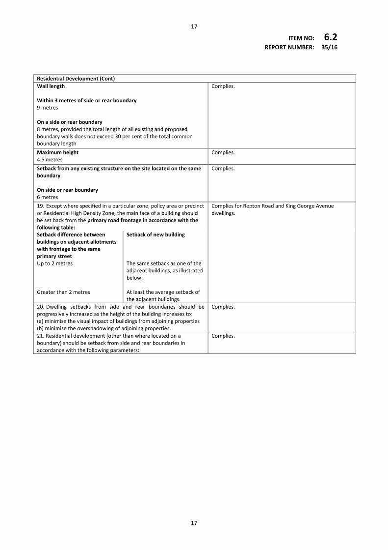
19. Except where specified in a particular zone, policy area or precinct or Residential High Density Zone, the main face of a building should be set back from the primary road frontage in accordance with the following table:
Complies for Repton Road and King George Avenue dwellings.
Setback difference between buildings on adjacent allotments with frontage to the same primary street Up to 2 metres Greater than 2 metres
Setback of new building The same setback as one of the adjacent buildings, as illustrated below: At least the average setback of the adjacent buildings.
20. Dwelling setbacks from side and rear boundaries should be progressively increased as the height of the building increases to: (a) minimise the visual impact of buildings from adjoining properties (b) minimise the overshadowing of adjoining properties.
Complies.
21. Residential development (other than where located on a boundary) should be setback from side and rear boundaries in accordance with the following parameters:
Complies.
17
18
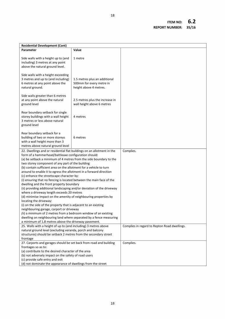
ITEM NO: 6.2 REPORT NUMBER: 35/16 Residential Development (Cont) Parameter Side walls with a height up to (and including) 3 metres at any point above the natural ground level. Side walls with a height exceeding 3 metres and up to (and including) 6 metres at any point above the natural ground. Side walls greater than 6 metres at any point above the natural ground level Rear boundary setback for single storey buildings with a wall height 3 metres or less above natural ground level Rear boundary setback for a building of two or more storeys with a wall height more than 3 metres above natural ground level
Value 1 metre 1.5 metres plus an additional 500mm for every metre in height above 4 metres. 2.5 metres plus the increase in wall height above 6 metres 4 metres 6 metres
22. Dwellings and or residential flat buildings on an allotment in the form of a hammerhead/battleaxe configuration should: (a) be setback a minimum of 4 metres from the side boundary to the two storey component of any part of the building (b) contain sufficient area on the allotment for a vehicle to turn around to enable it to egress the allotment in a forward direction (c) enhance the streetscape character by: (i) ensuring that no fencing is located between the main face of the dwelling and the front property boundary (ii) providing additional landscaping and/or deviation of the driveway where a driveway length exceeds 20 metres (d) minimise impact on the amenity of neighbouring properties by locating the driveway: (i) on the side of the property that is adjacent to an existing neighbouring garage, carport or driveway (ii) a minimum of 2 metres from a bedroom window of an existing dwelling on neighbouring land where separated by a fence measuring a minimum of 1.8 metres above the driveway pavement.
Complies.
25. Walls with a height of up to (and including) 3 metres above natural ground level (excluding veranda, porch and balcony structures) should be setback 2 metres from the secondary street frontage
Complies in regard to Repton Road dwellings.
27. Carports and garages should be set back from road and building frontages so as to: (a) contribute to the desired character of the area (b) not adversely impact on the safety of road users (c) provide safe entry and exit (d) not dominate the appearance of dwellings from the street
Complies.
18
19
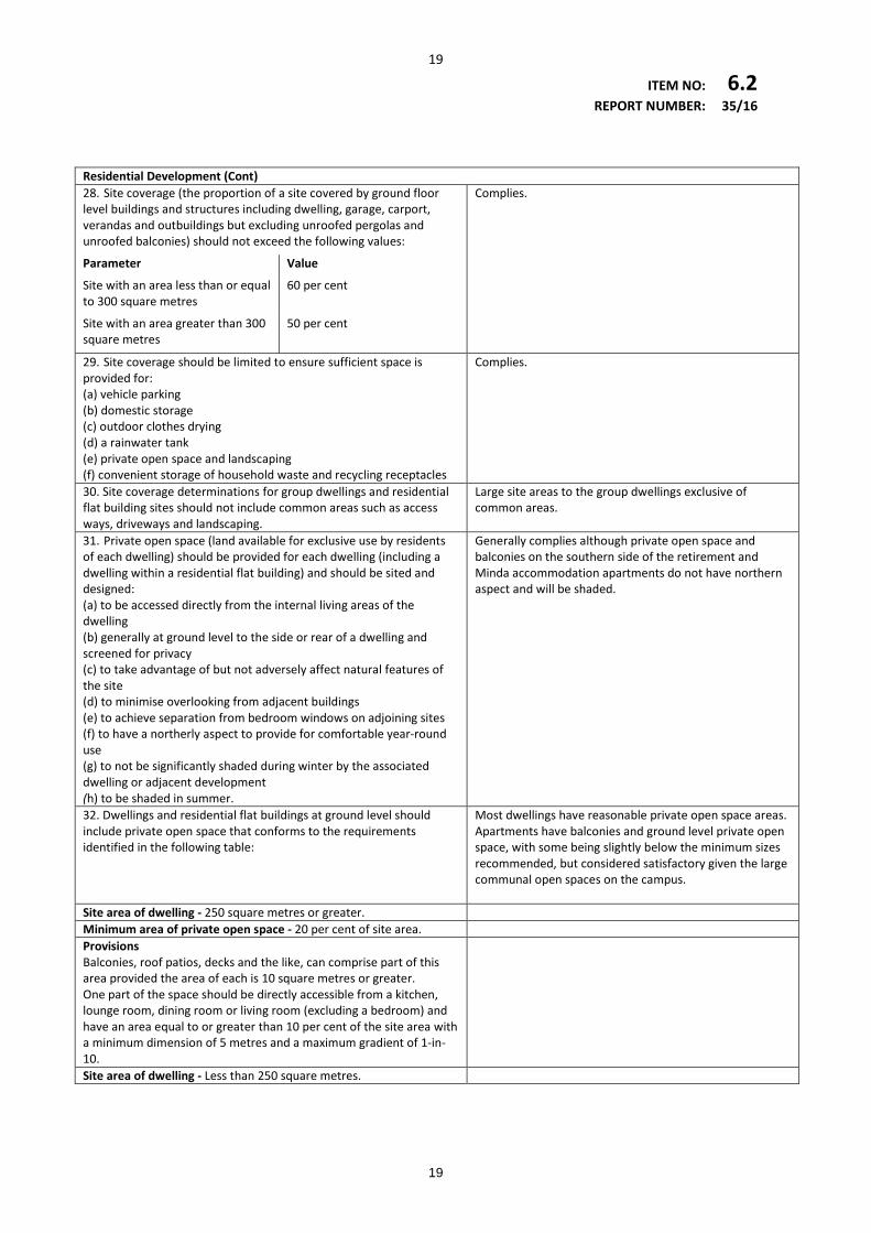
ITEM NO: 6.2 REPORT NUMBER: 35/16 Residential Development (Cont) 28. Site coverage (the proportion of a site covered by ground floor level buildings and structures including dwelling, garage, carport, verandas and outbuildings but excluding unroofed pergolas and unroofed balconies) should not exceed the following values:
Parameter Value
Site with an area less than or equal to 300 square metres
60 per cent
Site with an area greater than 300 square metres
50 per cent
Complies.
29. Site coverage should be limited to ensure sufficient space is provided for: (a) vehicle parking (b) domestic storage (c) outdoor clothes drying (d) a rainwater tank (e) private open space and landscaping (f) convenient storage of household waste and recycling receptacles
Complies.
30. Site coverage determinations for group dwellings and residential flat building sites should not include common areas such as access ways, driveways and landscaping.
Large site areas to the group dwellings exclusive of common areas.
31. Private open space (land available for exclusive use by residents of each dwelling) should be provided for each dwelling (including a dwelling within a residential flat building) and should be sited and designed: (a) to be accessed directly from the internal living areas of the dwelling (b) generally at ground level to the side or rear of a dwelling and screened for privacy (c) to take advantage of but not adversely affect natural features of the site (d) to minimise overlooking from adjacent buildings (e) to achieve separation from bedroom windows on adjoining sites (f) to have a northerly aspect to provide for comfortable year-round use (g) to not be significantly shaded during winter by the associated dwelling or adjacent development (h) to be shaded in summer.
Generally complies although private open space and balconies on the southern side of the retirement and Minda accommodation apartments do not have northern aspect and will be shaded.
32. Dwellings and residential flat buildings at ground level should include private open space that conforms to the requirements identified in the following table:
Most dwellings have reasonable private open space areas. Apartments have balconies and ground level private open space, with some being slightly below the minimum sizes recommended, but considered satisfactory given the large communal open spaces on the campus.
Site area of dwelling - 250 square metres or greater. Minimum area of private open space - 20 per cent of site area. Provisions Balconies, roof patios, decks and the like, can comprise part of this area provided the area of each is 10 square metres or greater. One part of the space should be directly accessible from a kitchen, lounge room, dining room or living room (excluding a bedroom) and have an area equal to or greater than 10 per cent of the site area with a minimum dimension of 5 metres and a maximum gradient of 1-in-10.
Site area of dwelling - Less than 250 square metres.
19
20
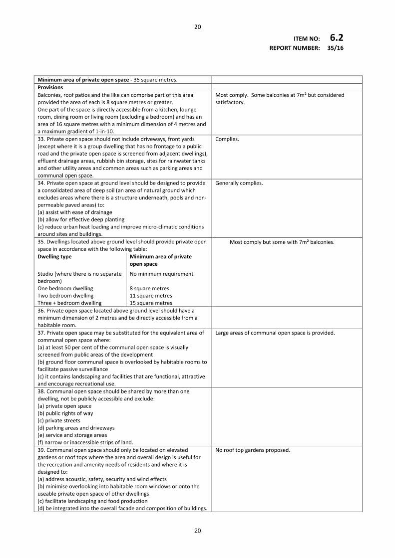
ITEM NO: 6.2 REPORT NUMBER: 35/16 Minimum area of private open space - 35 square metres. Provisions Balconies, roof patios and the like can comprise part of this area provided the area of each is 8 square metres or greater. One part of the space is directly accessible from a kitchen, lounge room, dining room or living room (excluding a bedroom) and has an area of 16 square metres with a minimum dimension of 4 metres and a maximum gradient of 1-in-10.
Most comply. Some balconies at 7m² but considered satisfactory.
33. Private open space should not include driveways, front yards (except where it is a group dwelling that has no frontage to a public road and the private open space is screened from adjacent dwellings), effluent drainage areas, rubbish bin storage, sites for rainwater tanks and other utility areas and common areas such as parking areas and communal open space.
Complies.
34. Private open space at ground level should be designed to provide a consolidated area of deep soil (an area of natural ground which excludes areas where there is a structure underneath, pools and non-permeable paved areas) to: (a) assist with ease of drainage (b) allow for effective deep planting (c) reduce urban heat loading and improve micro-climatic conditions around sites and buildings.
Generally complies.
35. Dwellings located above ground level should provide private open space in accordance with the following table:
Most comply but some with 7m² balconies.
Dwelling type Minimum area of private open space
Studio (where there is no separate bedroom)
No minimum requirement
One bedroom dwelling 8 square metres Two bedroom dwelling 11 square metres Three + bedroom dwelling 15 square metres
36. Private open space located above ground level should have a minimum dimension of 2 metres and be directly accessible from a habitable room.
37. Private open space may be substituted for the equivalent area of communal open space where: (a) at least 50 per cent of the communal open space is visually screened from public areas of the development (b) ground floor communal space is overlooked by habitable rooms to facilitate passive surveillance (c) it contains landscaping and facilities that are functional, attractive and encourage recreational use.
Large areas of communal open space is provided.
38. Communal open space should be shared by more than one dwelling, not be publicly accessible and exclude: (a) private open space (b) public rights of way (c) private streets (d) parking areas and driveways (e) service and storage areas (f) narrow or inaccessible strips of land.
39. Communal open space should only be located on elevated gardens or roof tops where the area and overall design is useful for the recreation and amenity needs of residents and where it is designed to: (a) address acoustic, safety, security and wind effects (b) minimise overlooking into habitable room windows or onto the useable private open space of other dwellings (c) facilitate landscaping and food production (d) be integrated into the overall facade and composition of buildings.
No roof top gardens proposed.
20
21
ITEM NO: 6.2 REPORT NUMBER: 35/16 Residential Development (Cont) 42. Noise generated by fixed noise sources such as air conditioning units and pool pumps should be located, designed and attenuated to avoid causing potential noise nuisance to adjoining landowners and occupiers.
Standard air-conditioning condition recommended.
43.External noise and artificial light intrusion into bedrooms should be minimised by separating or shielding these rooms from: (a) active communal recreation areas, parking areas and vehicle access ways (b) service equipment areas and fixed noise sources on the same or adjacent sites.
Generally complies.
45. Residential development on sites abutting established collector or higher order roads, or on a road indicated within the following table, should include front fences and walls that will supplement the noise control provided by the building façade.
Complies.
Collector roads: Adelphi Terrace, Glenelg North Cedar Avenue, Brighton Commercial Road, Brighton Cudmore Street, Somerton Park Dyson Street, Glenelg East Edwards Street, Brighton/South Brighton Elizabeth Street, Glenelg Grove Street, Glenelg East Harris Street, Glenelg East Highet Avenue, Brighton Jetty Road, Brighton King George Avenue, Hove Miller Street, Glenelg East Moore Street, Glenelg East Nile Street, Glenelg Old Tapleys Hill Road, Glenelg North Penzance Street, Glenelg Rugless Terrace, Glenelg East Scarborough Street, Somerton Park Sixth Avenue, Glenelg East Waterloo Street, Glenelg Wattle Avenue, Hove Wenlock Street, Brighton
Higher order roads: Augusta Street, Glenelg Bowker Street, North Brighton Cliff Street, Glenelg East Dunrobin Road, North Brighton Gordon Street, Glenelg King George Avenue, Somerton Park Lapthorne Street, Glenelg East Moseley Street, Glenelg Patawalonga Frontage, Glenelg North Partridge Street, Glenelg Pier Street, Glenelg Scholefield Road, Kingston Park Sherlock Road, Kingston Park The Crescent, Brighton The Broadway, Glenelg South Wheatland Street, Seacliff Whyte Street, Somerton Park
21
22
ITEM NO: 6.2 REPORT NUMBER: 35/16 Residential Development (Cont) 46. The number of dwellings sharing a common internal pedestrian entry within a residential flat building should be minimised to limit noise generation in internal access ways.
Complies.
47. Site facilities for group dwellings, residential parks and residential flat buildings and should include: (a) mail box facilities sited close to the major pedestrian entrance to the site (b) bicycle parking for residents and visitors (c) household waste and recyclable material storage areas away from dwellings (d) external clothes drying areas, which are readily accessible to each dwelling and complement the development and streetscape character for dwellings which do not incorporate ground level private open space (e) a storage area of not less than 8 square metres for each dwelling.
Complies.
Siting and Visibility 1. Development should be sited and designed to minimise its visual impact on: (a) the natural, rural or heritage character of the area (b) areas of high visual or scenic value, particularly rural and coastal areas (c) views from the coast, near-shore waters, public reserves, tourist routes and walking trails (d) the amenity of public beaches.
Accurate perspectives from several vantage points are required to determine visual impact on the public beach.
2. Buildings should be sited in unobtrusive locations and, in particular, should: (a) be grouped together (b) where possible be located in such a way as to be screened by existing vegetation when viewed from public roads as shown on Overlay Maps - Transport.
4. Buildings and structures should be designed to minimise their visual impact in the landscape, in particular: (a) the profile of buildings should be low and the rooflines should complement the natural form of the land (b) the mass of buildings should be minimised by variations in wall and roof lines and by floor plans which complement the contours of the land (c) large eaves, verandas and pergolas should be incorporated into designs so as to create shadowed areas that reduce the bulky appearance of buildings.
5. The nature of external surface materials of buildings should not detract from the visual character and amenity of the landscape.
7. Driveways and access tracks should be designed and surfaced to blend sympathetically with the landscape and to minimise interference with natural vegetation and landforms.
Location of access tracks and their impacts on the coastal dunes are still to be determined.
8. Development should be screened through the establishment of landscaping using locally indigenous plant species: (a) around buildings and earthworks to provide a visual screen as well as shade in summer, and protection from prevailing winds (b) along allotment boundaries to provide permanent screening of buildings and structures when viewed from adjoining properties and public roads (c) along the verges of new roads and access tracks to provide screening and minimise erosion.
Mostly complies.
22
23
ITEM NO: 6.2 REPORT NUMBER: 35/16 Supported Accommodation, Housing for Aged Persons and People with Disabilities 1. Supported accommodation (including nursing homes, hostels, retirement homes, retirement villages, residential care facilities and special accommodation houses) and housing for aged persons and people with disabilities should be: (a) located within walking distance of essential facilities such as convenience shops, health and community services and public and community transport (b) located where on-site movement of residents is not unduly restricted by the slope of the land (c) sited and designed to promote interaction with other sections of the community, without compromising privacy (d) of a scale and appearance that reflects the residential style and character of the locality (e) provided with public and private open space and landscaping.
Complies.
2. Supported accommodation and housing for aged persons and people with disabilities should be designed to provide safe, secure, attractive, convenient and comfortable living conditions for residents that include: (a) internal communal areas and private spaces (b) useable recreation areas for residents and visitors, including visiting children (c) spaces to accommodate social needs and activities, including social gatherings, internet use, gardening, keeping pets, preparing meals and doing personal laundry (d) storage areas for items such as boats, trailers ,caravans and specialised equipment (e) mail boxes and waste disposal areas within easy walking distance of all units.
Complies.
3. Access roads within supported accommodation and development incorporating housing for aged persons and people with disabilities should: (a) not have steep gradients (b) provide convenient access for emergency vehicles, visitors and residents (c) provide space for manoeuvring cars and community buses (d) include kerb ramps at pedestrian crossing points (e) have level-surface passenger loading areas.
Clarification needed as to whether the turning circles shown in the traffic plan can accommodate the intended 12.5 metre long commercial vehicles
4. Carparking associated with supported accommodation and housing for aged persons and people with disabilities should: (a) be conveniently located on site within easy walking distance of resident units (b) be adequate for residents, service providers and visitors (c) include covered and secure parking for residents’ vehicles (d) have slip-resistant surfaces with gradients not steeper than 1-in-40 (e) allow ease of vehicle manoeuvrability (f) be designed to allow the full opening of all vehicle doors (g) minimise the impact of car parking on adjacent residences owing to visual intrusion and noise (h) be appropriately lit to enable safe and easy movement to and from vehicles.
Generally sufficient parking spaces although there appears to be limited number of disabled spaces.
5. Supported accommodation should include: (a) ground-level access or lifted access to all units (b) an interesting and attractive outlook from units and communal areas for all residents including those in wheelchairs (c) adequate living space allowing for the use of wheelchairs with an attendant (d) storage for items such as small electric powered vehicles and other personal items, including facilities for recharging small electric powered vehicles
Complies.
23
24
ITEM NO: 6.2 REPORT NUMBER: 35/16 Supported Accommodation, Housing for Aged Persons and People with Disabilities (Cont) 6. Car parking associated with supported accommodation should: (a) have adequate identifiable provisions for staff (b) include private parking spaces for independent living units (c) include separate and appropriately marked places for people with disabilities and spaces for small electrically powered vehicles
No signage details for staff parking.
7. Residential development specifically for the aged and people with disabilities on sites larger than 1800 square metres may include higher density development at the centre of the site so long as low density development is situated on the perimeter of the site which is compatible with the scale and character of residential development in the locality.
Complies.
Transport and Access 8. Development should provide safe and convenient access for all anticipated modes of transport.
Confirmation required regarding adequate turning areas for 12.5 metre commercial vehicles.
9. Development at intersections, pedestrian and cycle crossings, and crossovers to allotments should maintain or enhance sightlines for motorists, cyclists and pedestrians to ensure safety for all road users and pedestrians.
Complies.
10. Driveway cross-overs affecting pedestrian footpaths should maintain the level of the footpath.
Details to be submitted.
11.Driveway crossovers should be separated and the number minimised to optimise the provision of on- street visitor parking (where on-street parking is appropriate).
Complies.
21.On-site secure bicycle parking facilities should be: (a) located in a prominent place (b) located at ground floor level (c) located undercover (d) located where surveillance is possible (e) well lit and well signed (f) close to well used entrances (g) accessible by cycling along a safe, well lit route.
No dedicated bicycle parking areas are shown the plans for the apartments or Lifestyle precinct.
22. Pedestrian and cycling facilities and networks should be designed and provided in accordance with relevant provisions of the Australian Standards and Austroads Guides.
Does not appear to be bicycle path inter-connectivity with broader road network.
24
25
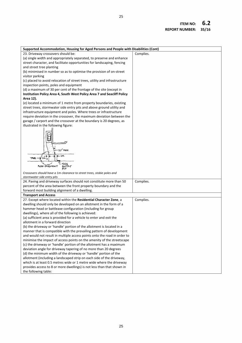
ITEM NO: 6.2 REPORT NUMBER: 35/16 Supported Accommodation, Housing for Aged Persons and People with Disabilities (Cont) 23. Driveway crossovers should be: (a) single width and appropriately separated, to preserve and enhance street character, and facilitate opportunities for landscaping, fencing and street tree planting (b) minimised in number so as to optimise the provision of on-street visitor parking (c) placed to avoid relocation of street trees, utility and infrastructure inspection points, poles and equipment (d) a maximum of 30 per cent of the frontage of the site (except in Institution Policy Area 4, South West Policy Area 7 and Seacliff Policy Area 12). (e) located a minimum of 1 metre from property boundaries, existing street trees, stormwater side entry pits and above ground utility and infrastructure equipment and poles. Where trees or infrastructure require deviation in the crossover, the maximum deviation between the garage / carport and the crossover at the boundary is 20 degrees, as illustrated in the following figure:
Complies.
Crossovers should have a 1m clearance to street trees, stobie poles and stormwater side entry pits
24. Paving and driveway surfaces should not constitute more than 50 percent of the area between the front property boundary and the forward most building alignment of a dwelling.
Complies.
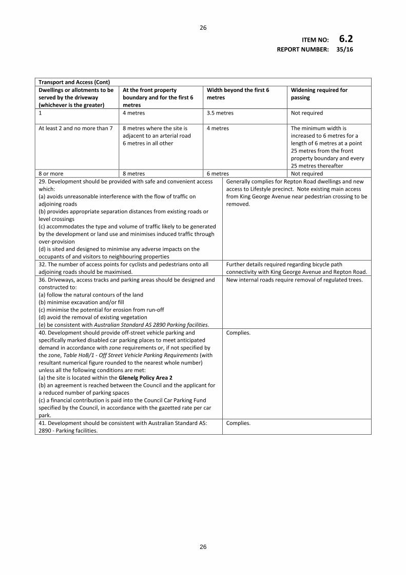
Transport and Access 27. Except where located within the Residential Character Zone, a dwelling should only be developed on an allotment in the form of a hammer head or battleaxe configuration (including for group dwellings), where all of the following is achieved: (a) sufficient area is provided for a vehicle to enter and exit the allotment in a forward direction (b) the driveway or ‘handle’ portion of the allotment is located in a manner that is compatible with the prevailing pattern of development and would not result in multiple access points onto the road in order to minimise the impact of access points on the amenity of the streetscape (c) the driveway or ‘handle’ portion of the allotment has a maximum deviation angle for driveway tapering of no more than 20 degrees (d) the minimum width of the driveway or ‘handle’ portion of the allotment (including a landscaped strip on each side of the driveway, which is at least 0.5 metres wide or 1 metre wide where the driveway provides access to 8 or more dwellings) is not less than that shown in the following table:
Complies.
25
26
ITEM NO: 6.2 REPORT NUMBER: 35/16 Transport and Access (Cont) Dwellings or allotments to be served by the driveway (whichever is the greater)
At the front property boundary and for the first 6 metres
Width beyond the first 6 metres
Widening required for passing
1
4 metres
3.5 metres
Not required
At least 2 and no more than 7
8 metres where the site is adjacent to an arterial road 6 metres in all other
4 metres
The minimum width is increased to 6 metres for a length of 6 metres at a point 25 metres from the front property boundary and every 25 metres thereafter
8 or more 8 metres 6 metres Not required 29. Development should be provided with safe and convenient access which: (a) avoids unreasonable interference with the flow of traffic on adjoining roads (b) provides appropriate separation distances from existing roads or level crossings (c) accommodates the type and volume of traffic likely to be generated by the development or land use and minimises induced traffic through over-provision (d) is sited and designed to minimise any adverse impacts on the occupants of and visitors to neighbouring properties
Generally complies for Repton Road dwellings and new access to Lifestyle precinct. Note existing main access from King George Avenue near pedestrian crossing to be removed.
32. The number of access points for cyclists and pedestrians onto all adjoining roads should be maximised.
Further details required regarding bicycle path connectivity with King George Avenue and Repton Road.
36. Driveways, access tracks and parking areas should be designed and constructed to: (a) follow the natural contours of the land (b) minimise excavation and/or fill (c) minimise the potential for erosion from run-off (d) avoid the removal of existing vegetation (e) be consistent with Australian Standard AS 2890 Parking facilities.
New internal roads require removal of regulated trees.
40. Development should provide off-street vehicle parking and specifically marked disabled car parking places to meet anticipated demand in accordance with zone requirements or, if not specified by the zone, Table HoB/1 - Off Street Vehicle Parking Requirements (with resultant numerical figure rounded to the nearest whole number) unless all the following conditions are met: (a) the site is located within the Glenelg Policy Area 2 (b) an agreement is reached between the Council and the applicant for a reduced number of parking spaces (c) a financial contribution is paid into the Council Car Parking Fund specified by the Council, in accordance with the gazetted rate per car park.
Complies.
41. Development should be consistent with Australian Standard AS: 2890 - Parking facilities.
Complies.
26
27
ITEM NO: 6.2 REPORT NUMBER: 35/16 Transport and Access (Cont) 42. Vehicle parking areas should be sited and designed in a manner that will: (a) facilitate safe and convenient pedestrian linkages to the development and areas of significant activity or interest in the vicinity of the development (b) include safe pedestrian and bicycle linkages that complement the overall pedestrian and cycling network (c) not inhibit safe and convenient traffic circulation (d) result in minimal conflict between customer and service vehicles (e) avoid the necessity to use public roads when moving from one part of a parking area to another (f) minimise the number of vehicle access points onto public roads (g) avoid the need for vehicles to reverse onto public roads (h) where practical, provide the opportunity for shared use of car parking and integration of car parking areas with adjoining development to reduce the total extent of vehicle parking areas and the requirement for access points (i) not dominate the character and appearance of a site when viewed from public roads and spaces (j) provide landscaping that will shade and enhance the appearance of the vehicle parking areas (k) include infrastructure such as underground cabling and connections to power infrastructure that will enable the recharging of electric vehicles.
Complies.
45. Parking areas should be sealed or paved in order to minimise dust and mud nuisance.
Complies.
46. To assist with stormwater detention and reduce heat loads in summer, vehicle parking areas should include soft (living) landscaping.
Complies.
48. On-site visitor parking spaces for group and multiple dwellings and residential flat buildings should be sited and designed to: (a) not dominate internal site layout (b) be clearly defined as visitor spaces not specifically associated with any particular dwelling (c) be accessible to visitors at all times.
Complies.
49. On-site vehicle parking should be provided having regard to: (a) the number, nature and size of proposed dwellings (b) proximity to centre facilities, public and community transport within walking distance of the dwellings (c) the anticipated mobility and transport requirements of the likely occupants, particularly groups such as aged persons. (d) availability of on-street car parking. (e) any loss of on-street parking arising from the development (e.g. an increase in number of driveway crossovers).
Complies.
27
28
ITEM NO: 6.2 REPORT NUMBER: 35/16 Transport and Access (Cont) 50. Vehicle parking areas servicing more than one dwelling should be of a size and location to: (a) serve users, including pedestrians, cyclists and motorists, efficiently, conveniently and safely (b) provide adequate space for vehicles, including emergency service vehicles, to manoeuvre between the street and the parking area (c) reinforce or contribute to attractive streetscapes.
Generally complies subject to appropriate bicycle parking and turning areas associated with commercial vehicles.
51. The provision of ground level vehicle parking areas, including garages and carports (other than where located along a rear lane access way), should: (a) not face the primary street frontage (b) be located to the rear of buildings with access from a shared internal laneway (c) ensure vehicle park entries are recessed at least 0.5 metres behind the main face of the building.
Does not comply for 2 bed dwellings facing Repton Road.
52. Undercroft and below ground garaging of vehicles should only occur where envisaged in the relevant zone or policy area or precinct and ensure: (a) the overall height and bulk of the undercroft structure does not adversely impact on streetscape character of the locality or the amenity of adjacent properties (b) vehicles can safely enter and exit from the site without compromising pedestrian or cyclist safety or causing conflict with other vehicles (c) the site slopes up from the street (d) driveway gradients provide for safe and functional entry and exit (e) driveways and adjacent walls, fencing and landscaping are designed to provide adequate sightlines from vehicles to pedestrians using the adjacent footpath (f) openings to undercroft areas are integrated with the main building so as to minimise visual impact (g) landscaping, mounding and/or fencing is incorporated to improve its presentation to the street and to adjacent properties (h) the overall streetscape character of the locality is not adversely impaired (e.g. visual impact, building bulk, front setbacks relative to adjacent development) (i) the height of the car park ceiling does not exceed 1 metre above the finished ground level.
Generally complies for Dune apartments but details of ramp profile/gradient required.
53. Buildings with four storeys or more above natural surface level should include provision for undercroft parking.
Complies.
54. Semi-basement or undercroft car parking should be suitably integrated with building form.
Complies.
55. In the case of undercroft and below ground car parks where cars are visible from public areas, adequate screening and landscaping should be provided.
Complies, although not viewed from public street.
28
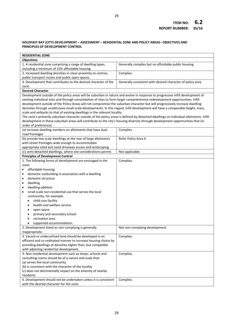
29
ITEM NO: 6.2 REPORT NUMBER: 35/16 HOLDFAST BAY (CITY) DEVELOPMENT – ASSESSMENT – RESIDENTIAL ZONE AND POLICY AREAS– OBJECTIVES AND PRINCIPLES OF DEVELOPMENT CONTROL RESIDENTIAL ZONE Objectives 1. A residential zone comprising a range of dwelling types, including a minimum of 15% affordable housing.
Generally complies but no affordable public housing.
2. Increased dwelling densities in close proximity to centres, public transport routes and public open spaces.
Complies.
3. Development that contributes to the desired character of the zone.
Generally consistent with desired character of policy area.
Desired Character Development outside of the policy areas will be suburban in nature and evolve in response to progressive infill development of existing individual sites and through consolidation of sites to form larger comprehensive redevelopment opportunities. Infill development outside of the Policy Areas will not compromise the suburban character but will progressively increase dwelling densities through unobtrusive small-scale developments. In this regard, infill development will have a comparable height, mass, scale and setbacks to that of existing dwellings in the relevant locality. The zone’s primarily suburban character outside of the policy areas is defined by detached dwellings on individual allotments. Infill development in these suburban areas will contribute to the city’s housing diversity through development opportunities that (in order of preference): (a) increase dwelling numbers on allotments that have dual road frontages
Complies.
(b) provide low scale dwellings at the rear of large allotments with street frontages wide enough to accommodate appropriate sited and sized driveway access and landscaping
Refer Policy Area 4.
(c) semi-detached dwellings, where site considerations permit. Not applicable. Principles of Development Control 1. The following forms of development are envisaged in the zone: • affordable housing • domestic outbuilding in association with a dwelling • domestic structure • dwelling • dwelling addition • small scale non-residential use that serves the local
community, for example: • child care facility • health and welfare service • open space • primary and secondary school • recreation area • supported accommodation.
Complies.
2. Development listed as non-complying is generally inappropriate.
Not non-complying development.
3. Vacant or underutilised land should be developed in an efficient and co-ordinated manner to increase housing choice by providing dwellings at densities higher than, but compatible with adjoining residential development.
Complies.
4. Non-residential development such as shops, schools and consulting rooms should be of a nature and scale that: (a) serves the local community (b) is consistent with the character of the locality (c) does not detrimentally impact on the amenity of nearby residents.
Complies.
6. Development should not be undertaken unless it is consistent with the desired character for the zone.
Complies.
29
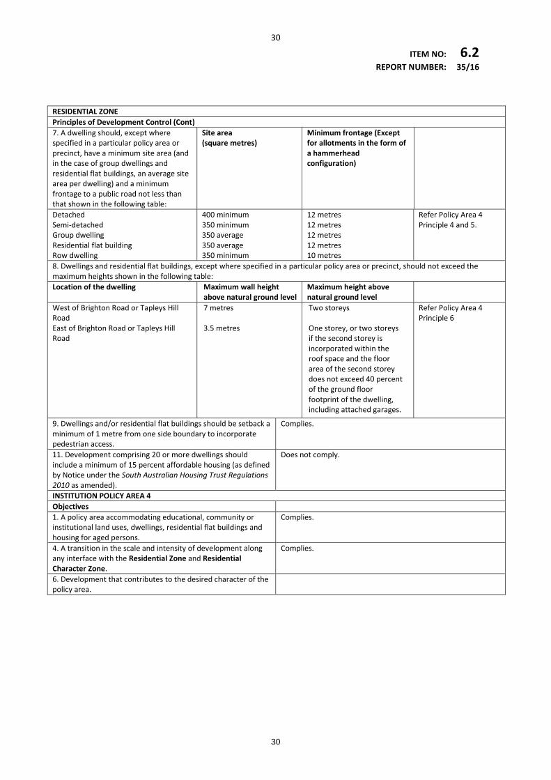
30
ITEM NO: 6.2 REPORT NUMBER: 35/16 RESIDENTIAL ZONE Principles of Development Control (Cont) 7. A dwelling should, except where specified in a particular policy area or precinct, have a minimum site area (and in the case of group dwellings and residential flat buildings, an average site area per dwelling) and a minimum frontage to a public road not less than that shown in the following table:
Site area (square metres)
Minimum frontage (Except for allotments in the form of a hammerhead configuration)
Detached Semi-detached Group dwelling Residential flat building Row dwelling
400 minimum 350 minimum 350 average 350 average 350 minimum
12 metres 12 metres 12 metres 12 metres 10 metres
Refer Policy Area 4 Principle 4 and 5.
8. Dwellings and residential flat buildings, except where specified in a particular policy area or precinct, should not exceed the maximum heights shown in the following table: Location of the dwelling Maximum wall height
above natural ground level Maximum height above natural ground level
West of Brighton Road or Tapleys Hill Road East of Brighton Road or Tapleys Hill Road
7 metres 3.5 metres
Two storeys One storey, or two storeys if the second storey is incorporated within the roof space and the floor area of the second storey does not exceed 40 percent of the ground floor footprint of the dwelling, including attached garages.
Refer Policy Area 4 Principle 6
9. Dwellings and/or residential flat buildings should be setback a minimum of 1 metre from one side boundary to incorporate pedestrian access.
Complies.
11. Development comprising 20 or more dwellings should include a minimum of 15 percent affordable housing (as defined by Notice under the South Australian Housing Trust Regulations 2010 as amended).
Does not comply.
INSTITUTION POLICY AREA 4 Objectives 1. A policy area accommodating educational, community or institutional land uses, dwellings, residential flat buildings and housing for aged persons.
Complies.
4. A transition in the scale and intensity of development along any interface with the Residential Zone and Residential Character Zone.
Complies.
6. Development that contributes to the desired character of the policy area.
30
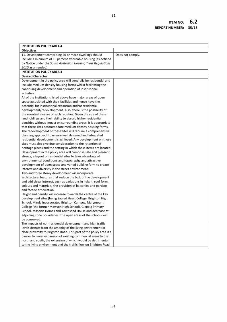
31
ITEM NO: 6.2 REPORT NUMBER: 35/16 INSTITUTION POLICY AREA 4 Objectives 11. Development comprising 20 or more dwellings should include a minimum of 15 percent affordable housing (as defined by Notice under the South Australian Housing Trust Regulations 2010 as amended).
Does not comply.
INSTITUTION POLICY AREA 4 Desired Character Development in the policy area will generally be residential and include medium-density housing forms whilst facilitating the continuing development and operation of institutional activities.
All of the institutions listed above have major areas of open space associated with their facilities and hence have the potential for institutional expansion and/or residential development/redevelopment. Also, there is the possibility of the eventual closure of such facilities. Given the size of these landholdings and their ability to absorb higher residential densities without impact on surrounding areas, it is appropriate that these sites accommodate medium density housing forms.
The redevelopment of these sites will require a comprehensive planning approach to ensure well designed and integrated residential development is achieved. Any development on these sites must also give due consideration to the retention of heritage places and the setting in which these items are located.
Development in the policy area will comprise safe and pleasant streets, a layout of residential sites to take advantage of environmental conditions and topography and attractive development of open space and varied building form to create interest and diversity in the street environment.
Two and three storey development will incorporate architectural features that reduce the bulk of the development and add visual interest, such as variations in height, roof form, colours and materials, the provision of balconies and porticos and facade articulation.
Height and density will increase towards the centre of the key development sites (being Sacred Heart College, Brighton High School, Minda Incorporated Brighton Campus, Marymount College (the former Mawson High School), Glenelg Primary School, Masonic Homes and Townsend House and decrease at adjoining zone boundaries. The open areas of the schools will be conserved.
The impacts of non-residential development and high traffic levels detract from the amenity of the living environment in close proximity to Brighton Road. This part of the policy area is a barrier to linear expansion of existing commercial areas to the north and south, the extension of which would be detrimental to the living environment and the traffic flow on Brighton Road.
31
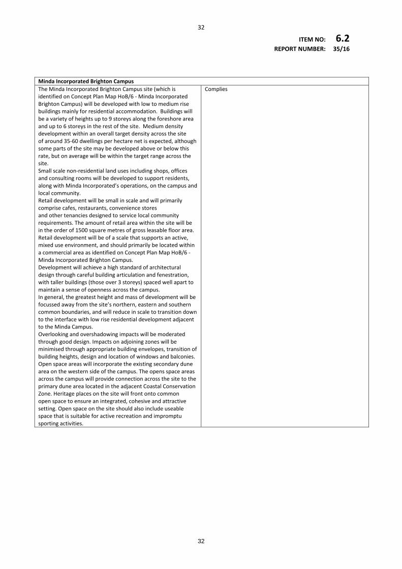
32
ITEM NO: 6.2 REPORT NUMBER: 35/16 Minda Incorporated Brighton Campus The Minda Incorporated Brighton Campus site (which is identified on Concept Plan Map HoB/6 - Minda Incorporated Brighton Campus) will be developed with low to medium rise buildings mainly for residential accommodation. Buildings will be a variety of heights up to 9 storeys along the foreshore area and up to 6 storeys in the rest of the site. Medium density development within an overall target density across the site of around 35-60 dwellings per hectare net is expected, although some parts of the site may be developed above or below this rate, but on average will be within the target range across the site. Small scale non-residential land uses including shops, offices and consulting rooms will be developed to support residents, along with Minda Incorporated’s operations, on the campus and local community. Retail development will be small in scale and will primarily comprise cafes, restaurants, convenience stores and other tenancies designed to service local community requirements. The amount of retail area within the site will be in the order of 1500 square metres of gross leasable floor area. Retail development will be of a scale that supports an active, mixed use environment, and should primarily be located within a commercial area as identified on Concept Plan Map HoB/6 - Minda Incorporated Brighton Campus. Development will achieve a high standard of architectural design through careful building articulation and fenestration, with taller buildings (those over 3 storeys) spaced well apart to maintain a sense of openness across the campus. In general, the greatest height and mass of development will be focussed away from the site’s northern, eastern and southern common boundaries, and will reduce in scale to transition down to the interface with low rise residential development adjacent to the Minda Campus.
Complies
Overlooking and overshadowing impacts will be moderated through good design. Impacts on adjoining zones will be minimised through appropriate building envelopes, transition of building heights, design and location of windows and balconies. Open space areas will incorporate the existing secondary dune area on the western side of the campus. The opens space areas across the campus will provide connection across the site to the primary dune area located in the adjacent Coastal Conservation Zone. Heritage places on the site will front onto common open space to ensure an integrated, cohesive and attractive setting. Open space on the site should also include useable space that is suitable for active recreation and impromptu sporting activities.
32
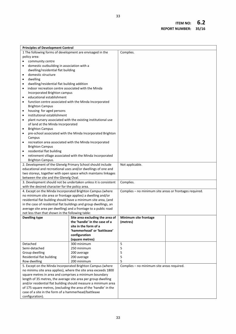
33
ITEM NO: 6.2 REPORT NUMBER: 35/16 Principles of Development Control 1 The following forms of development are envisaged in the policy area: • community centre • domestic outbuilding in association with a
dwelling/residential flat building • domestic structure • dwelling • dwelling/residential flat building addition • indoor recreation centre associated with the Minda
Incorporated Brighton campus • educational establishment • function centre associated with the Minda Incorporated
Brighton Campus • housing for aged persons • institutional establishment • plant nursery associated with the existing institutional use
of land at the Minda Incorporated • Brighton Campus • pre-school associated with the Minda Incorporated Brighton
Campus • recreation area associated with the Minda Incorporated
Brighton Campus • residential flat building • retirement village associated with the Minda Incorporated
Brighton Campus.
Complies.
2. Development of the Glenelg Primary School should include educational and recreational uses and/or dwellings of one and two storeys, together with open space which maintains linkages between the site and the Glenelg Oval.
Not applicable.
3. Development should not be undertaken unless it is consistent with the desired character for the policy area.
Complies.
4. Except on the Minda Incorporated Brighton Campus (where no minimum site area or frontage applies) a dwelling and/or residential flat building should have a minimum site area, (and in the case of residential flat buildings and group dwellings, an average site area per dwelling) and a frontage to a public road not less than that shown in the following table:
Complies – no minimum site areas or frontages required.
Dwelling type Site area excluding the area of the ‘handle’ in the case of a site in the form of a ‘hammerhead’ or ‘battleaxe’ configuration (square metres)
Minimum site frontage (metres)
Detached Semi-detached Group dwelling Residential flat building Row dwelling
300 minimum 250 minimum 200 average 200 average 200 minimum
5 5 5 5 5
5. Except on the Minda Incorporated Brighton Campus (where no minimu site area applies), where the site area exceeds 1800 square metres in area and comprises a minimum boundary length of 35 metres, the average site area per group dwelling and/or residential flat building should measure a minimum area of 175 square metres, (excluding the area of the ‘handle’ in the case of a site in the form of a hammerhead/battleaxe configuration).
Complies – no minimum site areas required.
33
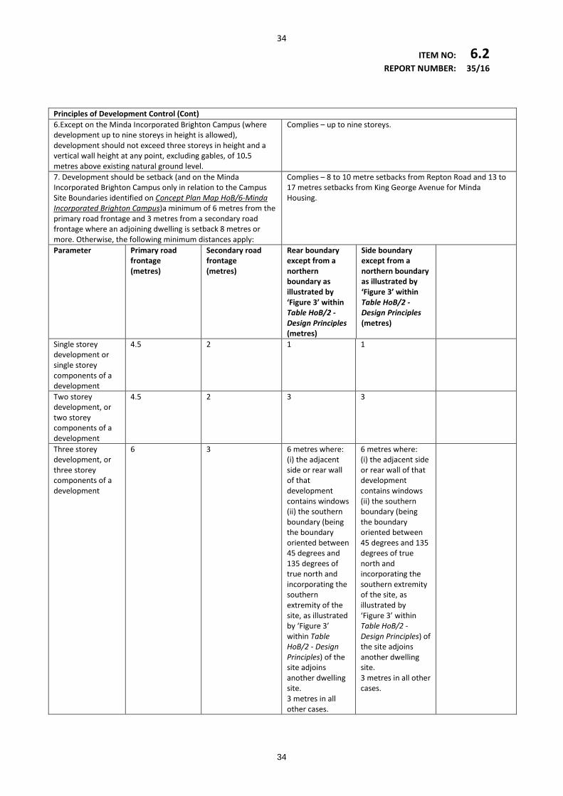
34
ITEM NO: 6.2 REPORT NUMBER: 35/16 Principles of Development Control (Cont) 6.Except on the Minda Incorporated Brighton Campus (where development up to nine storeys in height is allowed), development should not exceed three storeys in height and a vertical wall height at any point, excluding gables, of 10.5 metres above existing natural ground level.
Complies – up to nine storeys.
7. Development should be setback (and on the Minda Incorporated Brighton Campus only in relation to the Campus Site Boundaries identified on Concept Plan Map HoB/6-Minda Incorporated Brighton Campus)a minimum of 6 metres from the primary road frontage and 3 metres from a secondary road frontage where an adjoining dwelling is setback 8 metres or more. Otherwise, the following minimum distances apply:
Complies – 8 to 10 metre setbacks from Repton Road and 13 to 17 metres setbacks from King George Avenue for Minda Housing.
Parameter Primary road frontage (metres)
Secondary road frontage (metres)
Rear boundary except from a northern boundary as illustrated by ‘Figure 3’ within Table HoB/2 - Design Principles (metres)
Side boundary except from a northern boundary as illustrated by ‘Figure 3’ within Table HoB/2 - Design Principles (metres)
Single storey development or single storey components of a development
4.5 2 1 1
Two storey development, or two storey components of a development
4.5 2 3 3
Three storey development, or three storey components of a development
6 3 6 metres where: (i) the adjacent side or rear wall of that development contains windows (ii) the southern boundary (being the boundary oriented between 45 degrees and 135 degrees of true north and incorporating the southern extremity of the site, as illustrated by ‘Figure 3’ within Table HoB/2 - Design Principles) of the site adjoins another dwelling site. 3 metres in all other cases.
6 metres where: (i) the adjacent side or rear wall of that development contains windows (ii) the southern boundary (being the boundary oriented between 45 degrees and 135 degrees of true north and incorporating the southern extremity of the site, as illustrated by ‘Figure 3’ within Table HoB/2 - Design Principles) of the site adjoins another dwelling site. 3 metres in all other cases.
34
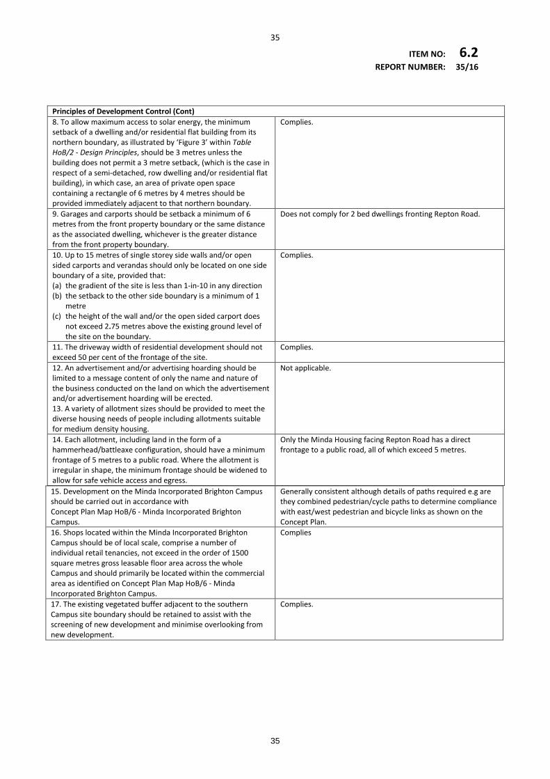
35
ITEM NO: 6.2 REPORT NUMBER: 35/16 Principles of Development Control (Cont) 8. To allow maximum access to solar energy, the minimum setback of a dwelling and/or residential flat building from its northern boundary, as illustrated by ‘Figure 3’ within Table HoB/2 - Design Principles, should be 3 metres unless the building does not permit a 3 metre setback, (which is the case in respect of a semi-detached, row dwelling and/or residential flat building), in which case, an area of private open space containing a rectangle of 6 metres by 4 metres should be provided immediately adjacent to that northern boundary.
Complies.
9. Garages and carports should be setback a minimum of 6 metres from the front property boundary or the same distance as the associated dwelling, whichever is the greater distance from the front property boundary.
Does not comply for 2 bed dwellings fronting Repton Road.
10. Up to 15 metres of single storey side walls and/or open sided carports and verandas should only be located on one side boundary of a site, provided that: (a) the gradient of the site is less than 1-in-10 in any direction (b) the setback to the other side boundary is a minimum of 1
metre (c) the height of the wall and/or the open sided carport does
not exceed 2.75 metres above the existing ground level of the site on the boundary.
Complies.
11. The driveway width of residential development should not exceed 50 per cent of the frontage of the site.
Complies.
12. An advertisement and/or advertising hoarding should be limited to a message content of only the name and nature of the business conducted on the land on which the advertisement and/or advertisement hoarding will be erected. 13. A variety of allotment sizes should be provided to meet the diverse housing needs of people including allotments suitable for medium density housing.
Not applicable.
14. Each allotment, including land in the form of a hammerhead/battleaxe configuration, should have a minimum frontage of 5 metres to a public road. Where the allotment is irregular in shape, the minimum frontage should be widened to allow for safe vehicle access and egress.
Only the Minda Housing facing Repton Road has a direct frontage to a public road, all of which exceed 5 metres.
15. Development on the Minda Incorporated Brighton Campus should be carried out in accordance with Concept Plan Map HoB/6 - Minda Incorporated Brighton Campus.
Generally consistent although details of paths required e.g are they combined pedestrian/cycle paths to determine compliance with east/west pedestrian and bicycle links as shown on the Concept Plan.
16. Shops located within the Minda Incorporated Brighton Campus should be of local scale, comprise a number of individual retail tenancies, not exceed in the order of 1500 square metres gross leasable floor area across the whole Campus and should primarily be located within the commercial area as identified on Concept Plan Map HoB/6 - Minda Incorporated Brighton Campus.
Complies
17. The existing vegetated buffer adjacent to the southern Campus site boundary should be retained to assist with the screening of new development and minimise overlooking from new development.
Complies.
35
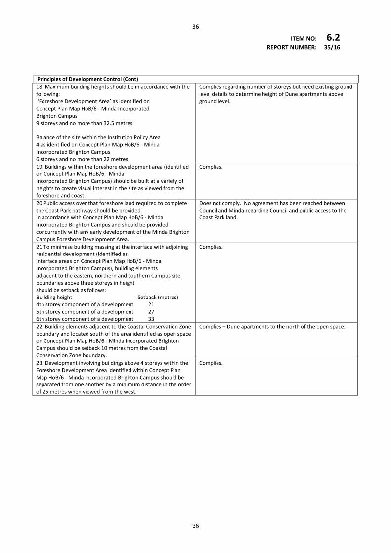
36
ITEM NO: 6.2 REPORT NUMBER: 35/16 Principles of Development Control (Cont) 18. Maximum building heights should be in accordance with the following: ‘Foreshore Development Area’ as identified on Concept Plan Map HoB/6 - Minda Incorporated Brighton Campus 9 storeys and no more than 32.5 metres Balance of the site within the Institution Policy Area 4 as identified on Concept Plan Map HoB/6 - Minda Incorporated Brighton Campus 6 storeys and no more than 22 metres
Complies regarding number of storeys but need existing ground level details to determine height of Dune apartments above ground level.
19. Buildings within the foreshore development area (identified on Concept Plan Map HoB/6 - Minda Incorporated Brighton Campus) should be built at a variety of heights to create visual interest in the site as viewed from the foreshore and coast.
Complies.
20 Public access over that foreshore land required to complete the Coast Park pathway should be provided in accordance with Concept Plan Map HoB/6 - Minda Incorporated Brighton Campus and should be provided concurrently with any early development of the Minda Brighton Campus Foreshore Development Area.
Does not comply. No agreement has been reached between Council and Minda regarding Council and public access to the Coast Park land.
21 To minimise building massing at the interface with adjoining residential development (identified as interface areas on Concept Plan Map HoB/6 - Minda Incorporated Brighton Campus), building elements adjacent to the eastern, northern and southern Campus site boundaries above three storeys in height should be setback as follows: Building height Setback (metres) 4th storey component of a development 21 5th storey component of a development 27 6th storey component of a development 33
Complies.
22. Building elements adjacent to the Coastal Conservation Zone boundary and located south of the area identified as open space on Concept Plan Map HoB/6 - Minda Incorporated Brighton Campus should be setback 10 metres from the Coastal Conservation Zone boundary.
Complies – Dune apartments to the north of the open space.
23. Development involving buildings above 4 storeys within the Foreshore Development Area identified within Concept Plan Map HoB/6 - Minda Incorporated Brighton Campus should be separated from one another by a minimum distance in the order of 25 metres when viewed from the west.
Complies.
36
37
ITEM NO: 6.2 REPORT NUMBER: 35/16 6. Summary of Assessment
Scale and Built Form The two and single storey heights of the Minda accommodation dwellings are consistent with the height limitations of the Policy Area, which allow for 6 storeys up to 22 metres, while providing a transition in scale to the site boundaries as identified on the Concept Plan Map HoB/6 and Principle 18 and Desired Character within Policy Area 4 of the Residential Zone. The retirement apartments comprise two towers. The western most tower comprises 7 storeys and is within the Foreshore Development Area (as shown on the Concept Plan Map) allowing up to 9 storeys. At 32.95 metres as stated within the Jensen report, the tower slightly exceeds the maximum height of 32.5 metres. The eastern 5 storey tower straddles the Foreshore Development Area and partly lies within the 6 storey height portion of the campus. Its height at 26 metres as stated within the Jensen report however is significantly greater than the maximum of 22 metres within that portion of the campus outside of the Foreshore Development Area. It is difficult however to determine the building heights as the existing ground level is not clearly shown on the submitted plans. Existing site levels should be shown on the elevations to enable an accurate assessment of the tower heights to be made. The boundary of the Foreshore Development Zone should also be superimposed to determine the extent of the eastern tower within that area. The development is consistent with setbacks stipulated within the Policy 4 Area. The retirement apartments are sited approximately 113 metres from Repton Road and approximately 42 metres to the south of the existing stage 1 retirement apartments (33 metres and 25 metres required respectively). The Minda accommodation dwellings facing Repton Road are setback approximately 8 to 10 metres from the road (6 metres required). Those dwellings have the appearance of detached and semi-detached dwellings. The four 2 bedroom dwellings facing Repton Road have garages in front of the dwellings, which is inconsistent with Principle 9 of the Policy Area. High timber slat front fences are proposed for each of the dwellings. Although the Policy Area is silent regarding front fences, Landscaping, Fences and Walls Principles 5 and 7 require more open front fencing. To improve streetscape appearance and resident outlook it is recommended that no garages be located forward of the dwellings and low fences with well landscaped front yards be provided adjacent Repton Road. The Minda accommodation dwellings to the south of the Campus and adjacent King George Avenue are setback between 13 and 17 metres from King George Avenue (6 metres required). The dwellings however are orientated internally with solid colorbond fencing on the King George Avenue elevation. To improve the King George Avenue streetscape and to open up the site to the wider community it is recommended that the dwellings be orientated to King George Avenue with low front fences. Some of these dwellings are on Council owned land comprising unmade road extension of Lynton Avenue. No minimum site area or frontage applies within the Minda Campus. The Desired Character however envisages medium density development with an overall target density across the site of around 35-60 dwellings per hectare, although some parts of the site may be developed above or below this rate, but on average will be within the target range. The Jensen report states that the dwellings adjacent King George Avenue and Repton Road have a net density of approximately 20 dwellings per hectare. The 3 storey residential flat buildings for Minda accommodation have a net density of 137 dwellings per hectare but exclude communal spaces, common parking and access areas which would significantly reduce this figure. The entire Brighton Dunes (retirement apartments) have a net density of 53 dwellings per hectare. It would be useful provide total calculations including proposed and existing dwellings/residential accommodation to ascertain overall dwelling densities.
37
38
ITEM NO: 6.2 REPORT NUMBER: 35/16
Generally the buildings are well articulated through the use of modulated facades, balconies and variations in materials and colours. Notwithstanding the design merit the Dune apartments, given their proximity to the coastal dunes and beach, require further attention to visual impact as detailed elsewhere in this report. Impact on Coastal Dunes and Beach There are a number of provisions in the Policy Area and Council Wide Objectives and Principles of the Development Plan regarding access and protection of sensitive coastal areas. In particular the development is at variance with Policy Area 4 Principle 20, which requires details of public access to complete the Coast Path pathway to be provided concurrently with any early development of the Minda Campus. No agreement has as yet been reached regarding public access to the future Coast Park land and access arrangements through the Minda site is to be confirmed. Other Coastal Areas policies in the Development Plan require the protection and enhancement of the natural coastal environment including sand dunes and native vegetation, prevention of inappropriate access and management to sustain the remaining natural coastal environment. Increased human traffic in such close proximity to the Conservation Zone will need to be appropriately managed through conservation fencing to prevent informal access paths and human impact on the dunes. The undeveloped portion of the secondary dunes should also be protected by conservation fencing along the western boundary. Although as stated within the Jensen report the retirement apartments lie within the Residential Zone, the siting of a 7 storey building within 1.5 metres of the Coastal Conservation Zone may have significant impacts on the ecology of the sensitive coastal dunes including the undeveloped portions of the secondary dunes from overshadowing, wind, excavation for basement etc. There are a number of plants of local importance or conservation status within the dunes and the site provides habitat for indigenous birds, reptiles and insects. The importance of the site is recognised in the Metropolitan Adelaide and Northern Coastal Action Plan (MANCAP). References to overshadowing in the Jensen report focus on impacts on adjacent development only and do not consider impacts on the dunes. The impact from taller buildings on the coastal dunes may be significant (e.g. reduced levels of sunlight may affect the viability of dunal plant species. Shading impacts may also be more pronounced on the undeveloped secondary dunes. It is recommended that an environmental impact study be undertaken to appropriately assess impacts on the coastal dunes. Only one perspective showing visual impact on the beach is provided and this may be misleading. At the policy setting stage of the Development Plan Amendment for the Minda redevelopment Council engaged GHD to prepare a Visual Impact Analysis based on Minda’ MasterPlan. This included perspectives from different vantage points and is at attachment 9. It is recommended that similar perspectives should be developed in support of the application to enable a more considered assessment regarding the visual impact of the Dune apartments along the foreshore.
38
39
ITEM NO: 6.2 REPORT NUMBER: 35/16
Access, Traffic and Parking Relevant Development Plan policies require safe and convenient access and parking arrangements (in accordance with Table HoB/1 – Off Street Parking), integration with existing transport networks, development at intersections to maintain and enhance sightlines for motorists, cyclists and pedestrians, provision of cycling networks and associated facilities. An assessment of access and parking has been undertaken by Tonkin Consulting on behalf of Minda. Having regard to previous surveys and Table HoB/1 the findings are as follows: • Day options and Lifestyle development generates 70 staff spaces , 89 spaces provided within
carpark and on internal road; • PKC Aged Care facility generates 20 staff and 5 visitor spaces, 42 spaces provided within new
car park; • Minda apartments generates 16 staff and 6 visitor spaces, 20 spaces provided within car park; • Minda dwellings generates 19 additional staff and 19 visitor spaces for all dwellings, 38
provided (13 within carports, remainder in driveways; • Brighton Dunes retirement apartments generates 75 spaces and 17 visitor spaces, 114 spaces
provided; • Total parking required 247 spaces, total provided 303 spaces; • Overall development will generate 1040 vehicles per day, of which only 250 are likely to be
additionsl to existing conditions; • The peak hour trips will be 30 vehicles per hour; • King George Avenue is likely to receive 50-100 additional vehicles per day (3% increase); • Repton Road (west of King George Avenue) is likely to receive 200 additional vehicles per day
(25% increase); • Other east-west roads connecting to Brighton Road will receive approximately 200 additional
vehicles per day.
Notwithstanding a slight shortfall for the Minda apartments, which can be made up by parking availability on the internal road network, there is sufficient parking provided across the total site. The traffic report expects only minor increases in delays and congestion in adjoining roads. Repton Road experiencing the largest increase will accommodate a total (including existing) of 1000 vehicles per day but is designed to cater for up to 1,500 vehicles per day. The existing access at the bend in King George Avenue will be closed and a new access servicing the Lifestyle Precinct will be provided just north of the pedestrian crossing. The traffic report confirms that it is designed with sufficient sight distances required by Austroads Standards and is suitable for its intended function and traffic capacities. Council’s City Asset’s Department have raised concerns/queries regarding general public pedestrian/bicycle access, appropriate on-site manoeuvring for 12.5 metre –long commercial vehicles, access by emergency vehicles and the number of disabled parking spaces. While the development does provide east-west paths in accordance with the Concept Plan Map HoB/6 it is recommended that the bicycle/pedestrian paths be appropriately signed to ensure use by the general public. It is also noted that the access arrangements have been varied from the Master Plan e.g a roundabout was to be constructed at the intersection of King George Avenue and Lynmouth Avenue.
39
40
ITEM NO: 6.2 REPORT NUMBER: 35/16
While the access as proposed with this development may be satisfactory there is some concern that it may comprise required public roadworks if needed to accommodate future development. It is further recommended that: • Details of appropriate bicycle parking and supporting facilities such as showers and lockers be
provided; • Further consideration be given to providing additional disabled parking; • Clarification be sought regarding the ability of the internal road network to accommodate 12.5
metre-long vehicles and that emergency vehicles can access the site without redesign of public roads;
• Confirmation from DPTI that shortcomings identified as part of the DPA consultation process presented to DPAC have been resolved.
Regulated Trees/Landscaping Objectives and Principles for Regulated Trees in the Development Plan require conservation for trees that provide important aesthetic or environmental benefit and should not be removed unless the tree has a short life expectancy, it poses an unacceptable risk, it is causing damage to a substantial building or development that is reasonable and expected would not otherwise be possible. Pursuant to the Jensen report there are a total of 90 regulated trees on the Campus of which 6 will be removed allegedly due to conflict with buildings, access roads or car park areas. The trees include two River Red Gums, a Bunya Pine and Olive tree in the vicinity of the Lifestyle Precinct development, a Flooded Gum in the vicinity of the southern Minda accommodation apartments and a Grey She-Oak in the vicinity of the King George Avenue Minda accommodation dwellings. Council’s City Asset’s Department recommends the retention of the two River Red Gums and the Bunya Pine. The Tree Environs Report (on behalf of the applicant) describes the two River Red Gums as being 10-20 metres tall, one having average health and structure the other good health and structure and both of moderate risk. Neither is recommended for removal by the arborist. The Lifestyle Precinct development is consistent with the Policy Area 4 provisions relating to the Minda Campus and are considered reasonable and expected. It is difficult however to determine the impact the trees have as the plans do not identify their location relative to the subject buildings, roadways and parking areas. It is recommended that regulated trees proposed to be removed be located and identified on the relevant site plans and where possible the two River Red Gum’s and Bunya Pine be retained. It is further recommended that any logs resulting from tree removals be utilised on-site to provide habitat logs. If they are not utilised on-site then Council should be given the logs to create habitat elsewhere. Council’s City Asset’s Department consider the species selection ideal and the numbers plentiful, which will help to achieve the maximum canopy coverage with the Resilient South Initiative. Stormwater Relevant Development Plan policies seek the collection and harvesting of stormwater to minimise downstream flows and to avoid flooding particularly the 1 in 100 year ARI flood event.
40
41
ITEM NO: 6.2 REPORT NUMBER: 35/16
The site is presently subject to flooding in a 1 in 100 year ARI event from external floodwaters to the east of the site. The proposed stormwater management plan builds on existing underground storm water infrastructure and retention basins that formed part of Stage 1. It is noted from the reports that: • Minda is not reliant on stormwater infrastructure beyond the site for stormwater generated
on the site; • All stormwater will continue to be captured and stored on-site in the retention basin with
flooding of surrounding areas likely to continue in the short term; • The on-going flood risk is accepted by Minda and • The conveyance of flows via designated overflow paths and placement of buildings above the 1
in 100 year flooding level will mitigate the risk. The planning report also notes that future works are proposed to connect the retention basin to the Repton Road outfall and are reliant on Council upgrading the public infrastructure north of the site. It further suggests this may be in place close to completion of Stage 2 and 3. This has not as yet been prioritised in Council’s current asset planning however. It is important therefore that the stormwater be managed to ensure any outflow from the site is no more than pre-development flows. Details of any increase in size of the wetlands as suggested in the Management Plan are needed to determine if a development application in its own right is required. A management plan for the wetlands should also be provided detailing how it is to be cleaned and maintained as any overflow will discharge into Council’s storm water system. Contamination The Development Plan seeks to ensure that the land is suitable for its intended purpose and there is no risk as a result of contamination. Various site history assessments and soil sampling has occurred across the site in the past and further soil sampling and ground water monitoring has occurred in association with the subject development. The sampling has identified some contaminants. Minda have engaged an Environmental Consultant who advises that the contamination can be remediated or managed as part of the development and is presently preparing a Remediation Action Plan. Minda has also engaged an accredited Contaminated Land Auditor who will monito and sign-off on the remediation works. It is recommended that if approved conditions require a certification from the Auditor that the site is appropriate for the proposed use prior to Development Approval and that any remediation works be undertaken prior to construction. Other The development site includes two unmade roads, which form extensions of Lynton and Lynmouth Avenues. Both are owned by Council. Some of the proposed Minda accommodation group dwellings in the southern part of the Campus and adjacent King George Avenue are proposed to be constructed over the unmade portion of Lynton Avenue. The Jensen report refers to negotiations with Council for the swapping of these land parcels for Minda owned land on which portion of the Somerton Surf Life Saving Club Building is constructed over. No formal agreement however has been reached regarding the transfer of ownership of the unmade roads. Until such transfer has been formalised no development plan consent for that portion of development on Council land should be
41
42
ITEM NO: 6.2 REPORT NUMBER: 35/16
granted. Given the uncertainty of Minda gaining control over that portion of land it can be argued that unless amended, the whole application is hypothetical and should not be considered (refer Environment, Resources and Development Court determination in Rampling v City of Holdfast Bay (2010) SAERDC 60. Conclusion The proposed land uses and for the most part the scale and siting of the buildings are generally consistent with the relevant provisions of the Development Plan. More detailed information however is required regarding existing ground levels, undercroft ramp profile/gradient and the location of the Foreshore Development Area 9 (as shown in Concept Plan Map HoB/6) in relation to the Dune apartments. This will enable a more informed assessment regarding building heights, particularly that part of the eastern tower outside of the Foreshore Development Area and compliance with relevant Australian Parking Standard . The development is at variance with the Policy Area 4 requirement to complete the Coast Park pathway concurrently to development within the Foreshore Development Area. No formal agreement has as yet been reached regarding its location. It is likely the Dune apartments will have an impact on the sensitive coastal dunes by overshadowing, access, basement excavation etc. Given the importance and conservation status of local plants and fauna within the dunes an environmental impact study should be submitted. Additional and accurate perspectives of the Dune apartments from a number of vantage points should also be submitted to fully appreciate the visual impact on the beach. Some of the Repton Road dwellings are at variance with the Development Plan by siting garages forward of the associated dwellings, which together with the proposed high front fences will impact resident outlook and streetscape. It is recommended that these aspects be redesigned. Similarly the inward orientation of the dwellings adjacent King George Avenue and high fences will impact the King George Avenue streetscape. It is recommended that those dwellings be designed to better address the public street. Access and parking is generally consistent with relevant Development Plan provisions. Pedestrian and bicycle paths should be adequately signed to ensure their use by the general public. Further details need to be submitted regarding bicycle parking and supporting facilities such as showers, lockers etc. Clarification is also required regarding turning areas for large commercial vehicles and access requirements for emergency vehicles. The proposed plant species and numbers as detailed in the landscape plan are appropriate and supported by Council. Clearer plans however are required showing the location of the three regulated trees to be removed in relation to the Lifestyle Precinct buildings and roads. If possible these should be retained. Supporting information regarding stormwater management advises that the development will be able to manage stormwater disposal on-site but at a future date will be connected to Council’s public infrastructure.The public infrastructure will need to be upgraded to accommodate additional flows and this has not as yet been prioritised in Council’s current asset planning. It is important therefore that stormwater outflow be maintained at predevelopment flows. A management plan for the wetlands should also be submitted giving details of how it is to be maintained and cleaned and any increase in size as indicated within the stormwater management plan.
42
43
ITEM NO: 6.2 REPORT NUMBER: 35/16
Portion of the development will be constructed on an unmade extension of Lynton Avenue, which is owned by Council. No approval from Council however has been obtained for development on that land. Until the relevant land owner approval has been obtained no development plan consent should be issued.
7. Recommendation
Following a detailed assessment of the proposal against the provisions of the Holdfast Bay (City) Development Plan, the Development Assessment Panel inform the Development Assessment Commission that: 1. No Council approval as land owner has been given for that portion of development over the
un-made portion of road forming an extension of Lynton Avenue. Unless amended no Development Plan Consent should be issued.
2. The development is challenged by the following provisions for the reasons mentioned: Coastal Areas Principle 2 The coast should be protected from development that would adversely affect the marine and onshore coastal environment, whether by pollution, erosion, damage or depletion of physical or biological resources, interference with natural coastal processes or any other means. • In that insufficient information has been provided to properly assess the likely impact
through shading, access excavation etc on the sensitive coastal dunes and to fully appreciate the visual impact on the beach.
Regulated Trees Principle 2 A regulated tree should not be removed or damaged other than where it can be demonstrated that one or more of the following apply: a) The tree is diseased and its life expectancy is short b) The tree represents an unacceptable risk to public or private safety c) The tree is causing damage to a substantial building or structure of value d) Development that is reasonable and expected would not otherwise be possible e) The work is required for the removal of dead wood, treatment of disease, or is in the general
interests of the tree. • In that pursuant to the Tree Environs report a) to c) are not applicable and there is no
detailed information regarding the impact the trees will have on the proposed development.
43
44
ITEM NO: 6.2 REPORT NUMBER: 35/16
Transport and Access Principle 20 Development should encourage and facilitate cycling as a mode of transport by incorporating end-of journey facilities including: a) Showers, changing facilities and secure lockers b) Signage indicating the location of bicycle facilities c) Secure bicycle parking facilities. • In that no details are provided regarding the location and numbers of bicycle parks and
associated facilities. Residential Zone Institution Policy Area 4 Principle 9 Garages and carports should be setback a minimum of 6 metres from the front boundary or the same distance as the associated dwelling, whichever is the greater distance from the front property boundary. • In that garages associated with two bedroom dwellings are in front of the associated dwellings. Principle 18 Maximum building heights should be in accordance with the following Foreshore development area - 9 storeys and no more than 32.5 metres Balance of the site - 6 Storeys and no more than 22 metres. • In that having regard to the submitted planning report portion of the eastern tower of the
Bright Dunes apartments that is within the balance of the site is 26 metres high. Clearer information is required to determine its height above ground level.
Principle 20 Public access over that foreshore land required to complete the Coast Park pathway should be provided in accordance with Concept Plan Map HoB/6 – Minda Incorporated Brighton Campus and should be provided concurrently with any early development of the Minda Brighton Campus Foreshore Development Area. • In that no formal agreement has been reached as to its location.
44
45
ITEM NO: 6.2 REPORT NUMBER: 35/16
3. The following additional information should be provided:
• Existing ground AHD levels to determine the Dune apartment building heights above existing ground level;
• Boundaries of the Foreshore Development Area as depicted on the Concept Plan Map HoB/6 to be shown on the site plans to assess height impacts;
• Ramp profile and gradient for the basement carpark associated with the Dune apartments to ensure compliance with the relevant Australian Standard;
• Clarification as to whether sufficient turning areas are available for 12.5 metre long commercial vehicles;
• An environmental impact statement assessing impacts on the coastal dune environment;
• Accurate perspectives of the Dune Apartment from several vantage points on the beach to assess visual impact on the beach;
• Detailed information from an arborist assessing whether the regulated trees in the vicinity of the Life Style Precinct can be retained.
4 The development Assessment Commission should ensure that:
• Stormwater outflow will be maintained at pre-development flows; • The bicycle/pedestrian paths are appropriately signed to facilitate public access; • Logs resulting from tree removals are retained on site as habitat or provided to
Council for use elsewhere; • That MFS are satisfied with access arrangements without alteration of the design of
existing public roads; • That the development will not compromise any alterations to public roads that may be
required as a result of future development of the Minda Campus.
45