Embed Size (px)
Citation preview
A program of WVU Extension Service 4-H and Agriculture andNatural Resources
A program of WVU Extension Service 4-H and Agriculture and Natural Resources
Guide 406R-HSRevised 2017
extension.wvu.edu/youth-family/youth-evaluation/landjudging
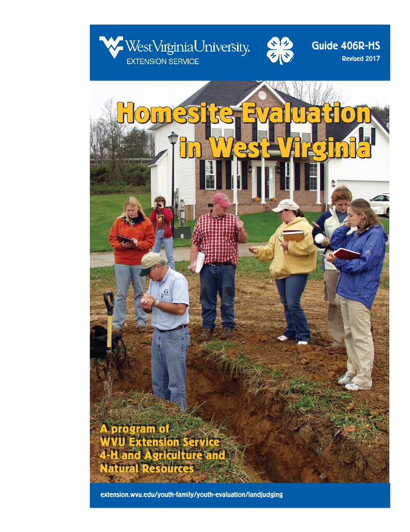
Homesite Evaluation in West Virginia
Homesite Evaluation in West Virginia
Homesite Evaluation in West Virginia /2
Homesite Evaluation in West Virginia (2017) was prepared by Dr. Jeff Skousen, WVU Extension Service Land Reclamation Specialist and Professor of Plant and Soil Science, 3112 Agricultural Sciences, West Virginia University, Morgantown, WV 26506-6108
The 2017 Land Judging Manual was developed from Land Judging materials and booklets prepared by George Sharpe (retired WVU Extension Specialist) and Richard Zimmerman (retired WVU Extension Specialist). The success and popularity of the Land Judging program in West Virginia can be attributed to the leadership of Mr. Sharpe and Dr. Zimmerman, and the continuing efforts of many dedicated FFA teachers and WVU extension agents throughout the state.
For more information, contact author: [email protected]
Reasonable accommodations will be made to provide this content in alternate formats upon request. Contact the WVU Extension Service Office of Communications at 304-293-4222.
WVU is an EEO/Affirmative Action Employer. Underrepresented class members are encouraged to apply. This includes: minorities, females, individuals with disabilities and veterans.
The WVU Board of Governors is the governing body of WVU. The Higher Education Policy Commission in West Virginia is responsible for developing, establishing and overseeing the implementation of a public four-year colleges and universities.
Homesite Evaluation in West Virginia /1
Why is Homesite Evaluation Important?Homesite Evaluation is a program that teaches basic principles of soil science and how these soil properties can influence the suitability of a site for home construction. In Homesite Evaluation, participants learn to look for things that make one soil different from another; why some soils are dry and others wet; how “mottling” is a clue to drainage; how soil texture is determined by rubbing soil between your fingers; and how to judge depth, erosion, slope, and permeability. These soil factors are used to evaluate whether the soil on the site is suitable for building foundations with basements, can grow plants for lawns and gardens, and if the soil can be used for on-site wastewater treatment systems. In Homesite Evaluation, the suitability of the soil and site are judged for the intended use of home construction.
Homesite Evaluation in West Virginia focuses on the soil’s suitability for the intended home site use. Many of the factors used in Land Judging are also applicable to evaluating sites where homes will be constructed. Homesite Evaluation is a natural extension of the Land Judging program and provides another dimension to soil and water conservation education in West Virginia.
How Homesite Evaluation Benefits the Homeowner and BuilderBuying a house is, for most people, the largest financial investment of their lives. Therefore, it is important for them to know about soil characteristics that make a site suitable for home construction or that may cause problems on an established homesite. Potential problems and costly mistakes can be avoided by the contractor and homeowner if a study of the soil at the site is made before construction begins or before a house is purchased.
For instance, there are several questions a homeowner or builder should know before buying land to build on or before buying an established home.
1. Are the soil properties favorable for establishing and maintaining lawns, shrubs,trees and gardens without extensive and expensive soil modifications?
2. Is there a flood hazard? Is the site on a floodplain?
3. Are there soil factors that prevent or limit the soil’s use for septic tank absorptionfields or sewage lagoons (if public sewer system is not available)?
. . . participants learn to look for things that make one soil different from another
Homesite Evaluation in West Virginia /2
4. If you are planning on installing a basement, will its construction be limited by suchfactors as:
a. High water table, either temporary or permanent
b. Depth to bedrock
c. Drainage – surface ponding or excessive runoff
d. Shrink-swell potential of subsoil
5. What is the slope surrounding the building site?
6. What are the erosion conditions and landslide potential? Previous erosion may havecaused gullies and/or limited the depth of topsoil requiring leveling and filling, andit will give a clue to the stability of soil on a slope uphill from the house.
Homesite Evaluation Rules and ProceduresMethods In Homesite Evaluation contests, a team is made up of three or four members. The total of the top three scores made by the individual members of the team is the team score. All team members are eligible for individual and team prizes. Team members judge four fields previously selected and scored by the judges.
Each site is marked off with wire flagging or other boundary markers. Within the boundaries, a pit or hole is dug, which exposes the soil profile. From this profile, contestants determine the texture, permeability, depth, slope, and degree of erosion of the soil. After these soil properties are determined, the degree of limitation imposed by the soil and site are classified for foundations with basements, lawns and gardens, and on-site wastewater treatment systems. At each site, two wooden stakes are set up in which the contestants measure slope.
Expectations The judges give any information that is needed about each site on a sign. This may include the original topsoil depth, total depth of the soil, water table information, or other factors. Unless otherwise announced, contestants have 30 minutes to judge the factors at each site and record them on scorecards. At the end of the allotted time, a group leader calls for the scorecards. There should be no talking at any time, except to the group leaders if a contestant has a question or needs clarification. In all contests, one or more judges score all fields. Their decisions are final.
Team members judge four fields.
Homesite Evaluation in West Virginia /3
Rules The following rules apply at Homesite Evaluation Contests.
1. Contestants are allowed to have the following pieces of equipment:
a. pencil(s) with an eraser
b. a clean clipboard with no markings (clear clipboards are preferred)
c. knife or screwdriver
d. towel or rag
e. scorecards or score sheet
2. Coaches are encouraged to focus on training the students in Homesite Evaluationprinciples and ethical competition.
3. Once the contest begins and contestants are at the field sites, no talking or comparinganswers by participants is allowed. Any contestant whispering or comparing answerswith another contestant will have his/her scorecard taken.
4. Group leaders should be briefed in a short meeting before the contest on possibleunethical practices by contestants. Group leaders have the authority to disqualifycontestants for any form of cheating, misuse of equipment, or other unethical practice.
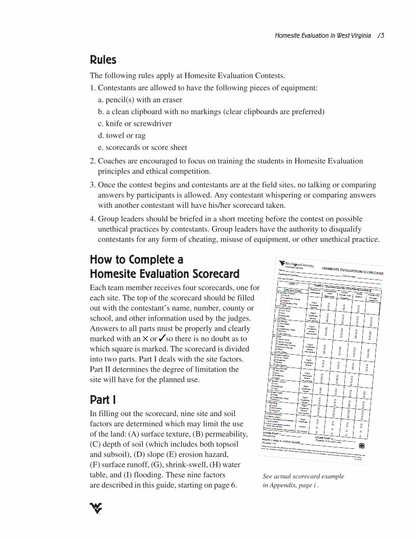
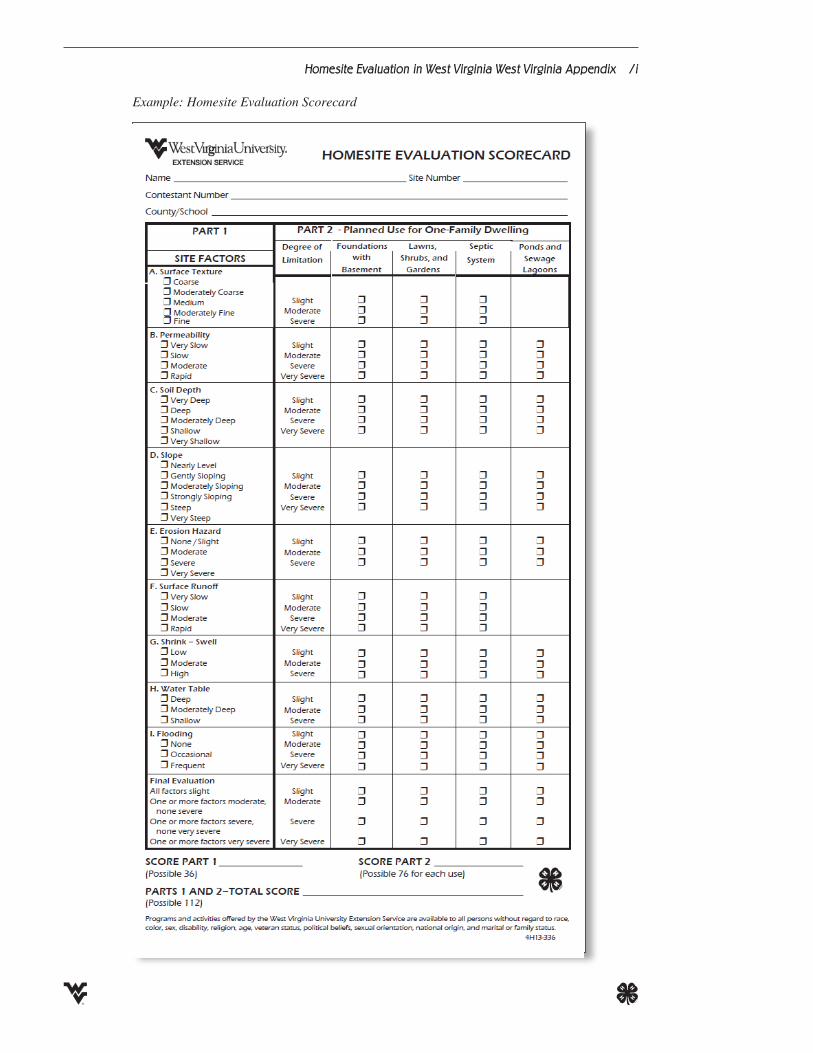
How to Complete a Homesite Evaluation Scorecard Each team member receives four scorecards, one for each site. The top of the scorecard should be filled out with the contestant’s name, number, county or school, and other information used by the judges. Answers to all parts must be properly and clearly marked with an 5 or 3 so there is no doubt as to which square is marked. The scorecard is divided into two parts. Part I deals with the site factors. Part II determines the degree of limitation the site will have for the planned use.
Part I In filling out the scorecard, nine site and soil factors are determined which may limit the use of the land: (A) surface texture, (B) permeability, (C) depth of soil (which includes both topsoil and subsoil), (D) slope (E) erosion hazard, (F) surface runoff, (G), shrink-swell, (H) water table, and (I) flooding. These nine factors are described in this guide, starting on page 6.
See actual scorecard example in Appendix, page i .
Homesite Evaluation in West Virginia /4
With the exception of shrink-swell and water table, the factors are similar to those for agricultural Land Judging. Caution should be exercised, however, in being too hasty in making a straight check off from Land Judging to the Homesite Evaluation scorecard. While the factors are the same, different separations are made.
Part IIIn Part II the evaluator must determine the degree of limitations that the existing soil conditions impose on the planned use as listed in Part II of the scorecard. The final evaluation of the site is determined by the factor that most limits the particular planned use.
Scoring Homesite Evaluation Contests When both Part I and Part II are completed by the contestants, the scorecards and sheets are collected and graded by the scorers. Points are awarded for each factor and practice. Each site (or soil pit) has a possible 112-point value. The cards are scored as follows: 36 points for Part I (4 points for each of the nine factors) and 76 points for Part II (20 points for foundations, 20 for lawns, 20 for septic systems, and 16 for lagoons).
In case of individual ties, Site 1 is used as a tie breaker. If necessary, the same method is continued with Sites 2, 3, and 4. In the case of team ties, the total score of the top three land judgers on a team for Site No. 1 is compared with the other team’s and used as a tie breaker. If necessary, the same method is continued with Sites 2, 3, and 4.
Eligibility and Qualifications Teams from 4-H groups attend the State 4-H Contest and compete against other 4-H teams. Each FFA region in the state holds a contest to qualify teams to participate in the State FFA Contest.
If the same FFA team wins both the Land Judging and Homesite Evaluation Contests at the regional level, that team will represent the region at the State FFA Contest. A second team from the region will be selected by totaling the team scores for both Land Judging and Homesite Evaluation Contests, and the team with the next highest point total will be eligible to participate in the State FFA Contest. This same process will govern the determination of teams to attend the National Contest in both 4-H and FFA State Contests.
The winning teams from the State FFA and State 4-H Contests (in both Land Judging and Homesite Evaluation) are eligible to participate in the National Land Judging Contest in Oklahoma the following spring. Anyone who has competed in the National Land Judging or Homesite Evaluation Contest is not eligible to compete in any later FFA region, conservation district, or state Land Judging Contest.
Homesite Evaluation in West Virginia /5
What the Informed Homesite Evaluator Needs to Know
Factors in Homesite EvaluationThe principles of Homesite Evaluation are similar to those in agricultural Land Judging. Soils are judged by the properties that may limit or prohibit a planned use. A favorable soil property may pose “no or slight limitations” to homesite development, but if it creates unfavorable conditions that require correction or a modification of the building plans, the limitation is classified as “moderate,” “severe,” or “very severe,” depending on the severity of the condition.
Definitions of Limitation Categories for Homesite EvaluationNo to Slight Limitations: Soil or site has properties favorable for the planned use and present few or no problems.
Moderate Limitations: Soil or site has properties only moderately favorable for the planned use. Limitations can be overcome or modified with special planning, design, or maintenance. Special treatment of the site for the desired use may be necessary.
Severe Limitations: Soil or site has one or more properties unfavorable for the planned use. Limitations are difficult and costly to modify or overcome for the desired use.
Very Severe Limitations: Soil or site has one or more features so unfavorable for a particular use that overcoming the limitation is very difficult and expensive. For the most part, these soils should not be used for the planned use.
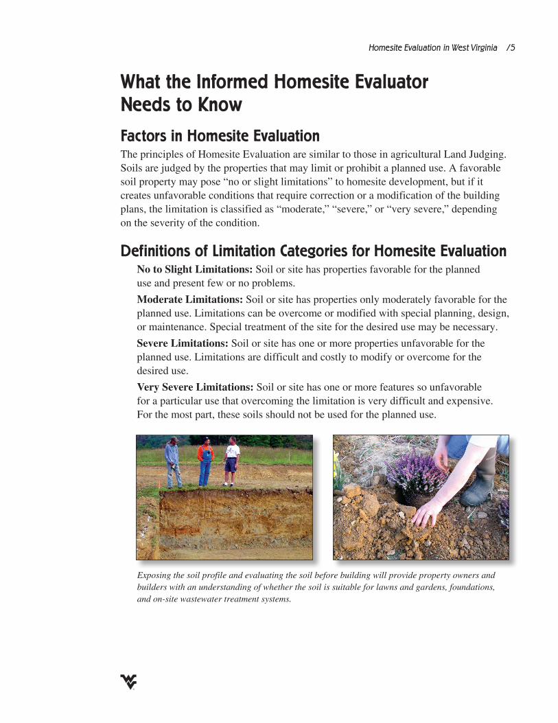
Exposing the soil profile and evaluating the soil before building will provide property owners and builders with an understanding of whether the soil is suitable for lawns and gardens, foundations, and on-site wastewater treatment systems.
Homesite Evaluation in West Virginia /6
How to Determine the Homesite Suitability for Planned UseThe final evaluation of a building site depends on the limitations of the individual soil properties. The soil property with the most severe limitations automatically classifies the site in the same category. For example, if all soil properties are rated as “slight” but one is “severe,” the site evaluation is also classified as severe. Hence, the building site is judged by its most limiting soil property.
To make a site evaluation, participants learn to judge the individual soil properties that affect homesite suitability. They are discussed below in the same order as they appear on the scorecard. Soil properties should be judged from a vertical soil pit or profile, deep and wide enough to show all soil features down to the depth where they may affect homesite preparation and construction (at least 3 to 4 feet).
Factors Affecting Soil Property Suitability for HomesiteSurface Texture
The texture of a soil is determined by the relative proportion of sand, silt, and clay particles. Coarse-textured soils are sandy. Medium-textured soils contain mainly silt and sand with smaller amounts of clay. Fine-textured soils have a high percentage of clay and less silt and sand. Texture is most easily determined in the field by pressing and rubbing moist soil between the fingers. The texture of the subsoil also should be examined because it is often different from that of the topsoil and aids in determining erosion, permeability, and internal drainage. Surface texture is not a factor for sewage lagoons because they are dug deep into the subsoil. Most of the surface soil is used in making the berm around the lagoon.
Coarse: Soil is loose and individual grains can be seen and felt. When squeezed between thumb and fingers, it feels gritty and will not ribbon or stain fingers. When dry, squeezing will cause it to fall apart. When moist, a mold may be formed which is unstable and crumbles as the soil is handled. Coarse-textured soils include sand and loamy sand. Washing and blowing may be a problem during construction. Coarse soil is easy to excavate and absorbs wastewater well. Moderate limitations for all uses.
Moderately Coarse: Soil feels gritty but contains enough silt and clay to make moist soil hold together. Individual sand grains can be felt and seen. Squeezed when dry or moist, it will form a mold which breaks apart when handled. When moist, it forms a very weak ribbon or none at all. Moderately coarse soils are sandy loam and fine sandy loam. No to slight limitations for all uses.
Medium: Soil feels smooth and floury. It will form a mold that can bear some handling. When moist, it will form a ribbon that is ½ inch to less than 1 inch in length. The ribbon breaks up easily and will scarcely take a polish. Medium-textured soils include silt, silt loam, and loam. No to slight limitations for all uses.
Homesite Evaluation in West Virginia /7
Moderately Fine: Soil is hard and breaks into clods when dry. When moist, soil can be squeezed between thumb and forefinger to form a ribbon from 1 to 2 inches in length with a shiny surface which will bend downward. Moderately fine soils are sandy clay loam, clay loam, and silty clay loam. No to slight limitations for all uses.
Permeability This refers to the rate of water or air movement through the most restrictive layer in the soil. The permeability of a soil is estimated by determining the texture, density, and structure of the most dense and tightest layer in the soil profile (from 0 to 36 inches in depth). Coloration of the subsoil may help in determining permeability but should be used with other indicators. If restrictive layers are encountered, permeability will be either slow or very slow, depending on the properties of the layer. Four classes of soil permeability are recognized in West Virginia.
Laterals for septic systems may be located below such layers in some soils. Restrictive layers should serve as a warning and final design should be based on the standard post hole method of determining permeability. It is an important factor when deciding between a septic tank system or a sewage lagoon. Soil percolation tests are required before making further plans.
Rapid: These soils have coarse or gravelly subsoils with little if any defined structure. Textures are loamy sand and sand. There is very little restriction of air and water movement. Permeability is >2.0 inches per hour. If subsoil texture is mostly sand or gravel, permeability is probably >6.0 inches per hour. Septic systems may not adequately filter effluent under rapidly permeable conditions, which would create a very severe limitation. Seepage from lagoons would make it difficult to maintain adequate depth of water and could contribute to pollution of ground water. Slight limitations for foundations with basements, moderate limitations for lawns and gardens, and very severe limitations for septic systems and sewage lagoons.
Restrictive layers should serve as a warning.
Fine: Soil is very hard and forms massive lumps or dense clods when dry, and are plastic and sticky when wet. When squeezed between thumb and forefinger when wet, it forms a ribbon 2 inches or longer with a shiny surface. It will “polish” when rubbed with the flat side of a knife. When pressed together several times, it becomes hard and difficult to press the thumb through it. Soil is sticky when wet, hard when dry, and difficult to work when used for flower beds, shrubs, and gardens. They may be droughty and require frequent watering for plant growth. The soil cracks when dry and swells when wet. Clayey soils often have high shrink-swell potential. Special planning and design are required for foundations. Fine-textured soils include clay, silty clay, and sandy clay. Severe limitations for all uses.
Homesite Evaluation in West Virginia /8
Moderate: These soils usually have medium-textured subsoils, such as loam, silt, silt loam, and sandy loam with good structure. They break apart easily. Clay skins may be present. Water and air movement is good. Plant roots are abundant and penetrate easily through the soil. Permeability ranges are 0.60 to 2 inches per hour. Moderate limitations for sewage lagoons and none to slight limitations for all other uses.
Slow: These soils have fairly tight subsoils with moderate to good structure. Textures may include sandy clay loam, clay loam, and silty clay loam with moderate to good structure. Clay skins may be present. These subsoils are firm when moist and hard when dry. Roots are common and may be found along ped faces. Fragipans, if encountered and noted on the field sign, are dense layers and are classified as slow. In wet periods, the soil may become waterlogged. Water movement can range from 0.06 to 0.60 inches per hour. Fragipans, if encountered and noted on the field sign, are dense layers with silt textures and are classified as slow. Problems are generally similar to the very slowly permeable soils, but the modifications required for use are not as great. Severe limitations for septic tank systems, moderate for foundations with basements and for lawns and gardens, and none to slight for sewage lagoons.
Very Slow: These soils have dense, heavy clay subsoil with little or no obvious structure, and very few visible pores. Textures may include clay, silty clay, and sandy clay. Clay skins may be present. After being firmly squeezed five to seven times, these subsoils become hard so that pushing your thumb through them is difficult. Roots are few, if they occur at all, and are restricted to ped faces and small pores. Water may stand on the surface of level land or run off and cause erosion on sloping land. Water movement is generally <0.06 inches per hour. This requires a prohibitively large field of lateral drains or costly modifications. Septic systems are generally not recommended. Shrink-swell potential is high. Very severe limitations for septic systems, no to slight limitations for sewage lagoons, severe limitations for foundations with basements and for lawns and gardens.
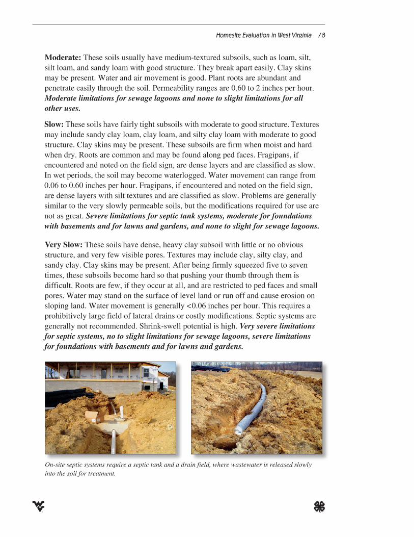
On-site septic systems require a septic tank and a drain field, where wastewater is released slowly into the soil for treatment.
Homesite Evaluation in West Virginia /9
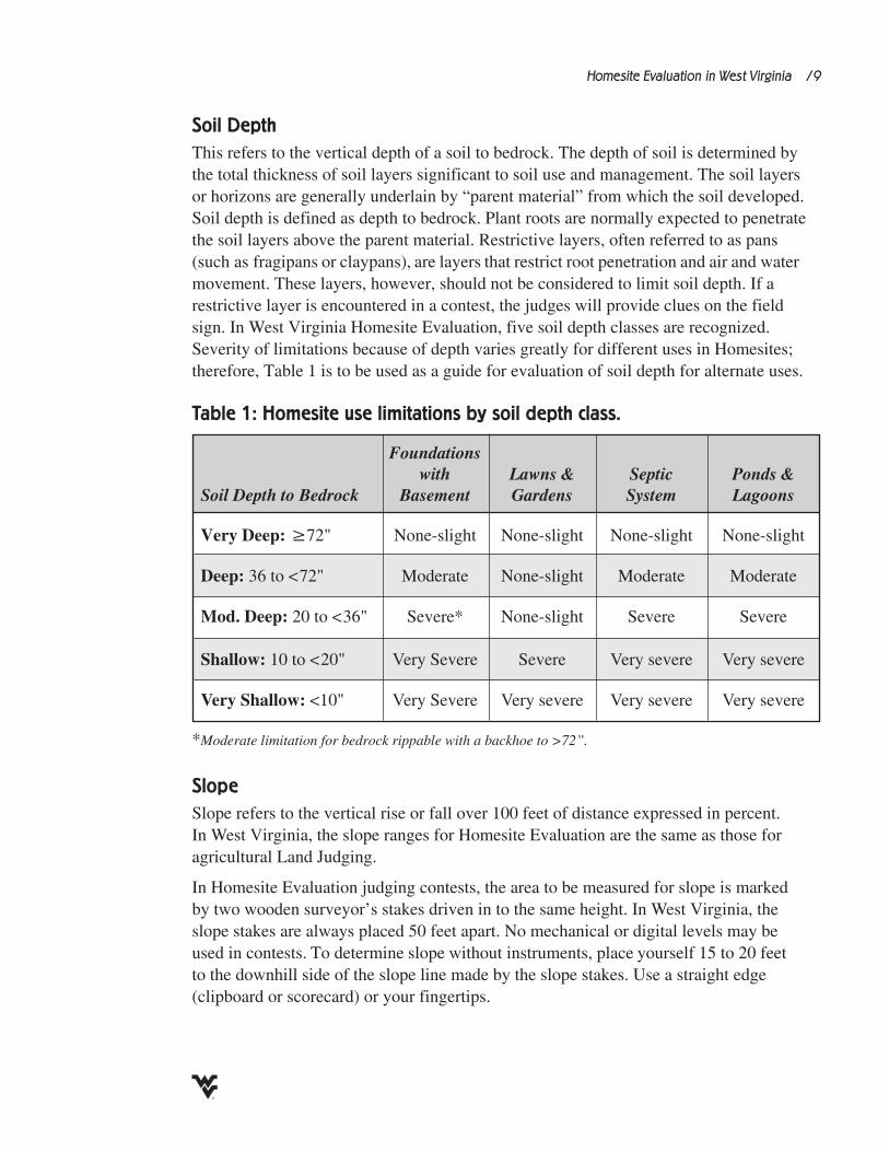
Soil Depth This refers to the vertical depth of a soil to bedrock. The depth of soil is determined by the total thickness of soil layers significant to soil use and management. The soil layers or horizons are generally underlain by “parent material” from which the soil developed. Soil depth is defined as depth to bedrock. Plant roots are normally expected to penetrate the soil layers above the parent material. Restrictive layers, often referred to as pans (such as fragipans or claypans), are layers that restrict root penetration and air and water movement. These layers, however, should not be considered to limit soil depth. If a restrictive layer is encountered in a contest, the judges will provide clues on the field sign. In West Virginia Homesite Evaluation, five soil depth classes are recognized. Severity of limitations because of depth varies greatly for different uses in Homesites; therefore, Table 1 is to be used as a guide for evaluation of soil depth for alternate uses.
Slope Slope refers to the vertical rise or fall over 100 feet of distance expressed in percent. In West Virginia, the slope ranges for Homesite Evaluation are the same as those for agricultural Land Judging.
In Homesite Evaluation judging contests, the area to be measured for slope is marked by two wooden surveyor’s stakes driven in to the same height. In West Virginia, the slope stakes are always placed 50 feet apart. No mechanical or digital levels may be used in contests. To determine slope without instruments, place yourself 15 to 20 feet to the downhill side of the slope line made by the slope stakes. Use a straight edge (clipboard or scorecard) or your fingertips.
Table 1: Homesite use limitations by soil depth class.
Foundations with Lawns & Septic Ponds &
Soil Depth to Bedrock Basement Gardens System Lagoons
Very Deep: ≥72" None-slight None-slight None-slight None-slight
Deep: 36to<72" Moderate None-slight Moderate Moderate
Mod. Deep: 20to<36" Severe* None-slight Severe Severe
Shallow: 10to<20" VerySevere Severe Verysevere Verysevere
Very Shallow: <10" VerySevere Verysevere Verysevere Verysevere
*Moderate limitation for bedrock rippable with a backhoe to >72”.
Homesite Evaluation in West Virginia /10
If you use a straight edge, hold the edge with the fingertips of both hands, clamping your elbows to your body, and sight the edge on the bottom of the higher stake. Turn your body from the waist, holding your arms and straight edge in a rigid position, until you can sight across the lower adjacent stake. At this point, you estimate the height from ground level to the highest point you estimated on the lower stake, and from there arrive at the percent slope.
If you use your arm, place yourself in the same position (15 to 20 feet downhill of slope line) and extend one of your arms until you can sight over your fingertips to ground level at the higher stake. Then, holding your arm rigid, turn your body from the waist until your line of sight is directly on the lower stake. Again, estimate the distance from ground level to the point you estimated on the lower stake. Judging slope correctly requires a great deal of practice. Table 2 will aid in Homesite Evaluation interpretation of the slope condition.
Erosion Erosion is the detachment and movement of soil from one place to another. Erosion depends on internal soil properties, degree of slope, and rate of surface runoff. Anything that protects the soil surface from exposure to rainfall impact and inhibits surface water runoff will reduce soil erosion and sediment loss into natural water courses and reservoirs.
Unlike natural and farmed lands with vegetative cover, construction sites are drastic man-made soil disturbances that deplete the future homesite of valuable topsoil and may create intolerable stream pollution and flooding problems in downstream communities. Since most erosion is the gradual surface removal of soil particles, it can be judged by looking at the thickness of the original dark topsoil. Because exposed soil tends to be very prone
Table 2: Homesite use limitations by slope class.
Foundations Soil Depth with Lawns & Septic Ponds & to Bedrock Range Basement Gardens System Lagoons
Nearly Level 0 to <3% None-slight None-slight None-slight None-slight
Gently Sloping 3 to <8% None-slight Moderate None-slight Moderate
Mod. Sloping 8 to <15% Moderate Moderate Moderate Severe
Strongly Sloping 15 to <25% Severe Severe Severe Very severe
Steep 25 to <35% Very Severe Very severe Very severe Very severe
Very Steep > 35% Very Severe Very severe Very severe Very severe
Homesite Evaluation in West Virginia /11
to erosion (especially subsoil), the classification of erosion hazard in relation to slope should be applied to the condition of the building site while construction is in progress or to the established homesite. The thickness of the original topsoil is given on the site sign so calculation of erosion is possible by determining the thickness of the present topsoil. For example, if 6 inches of topsoil are found in the pit and the original topsoil thickness on the sign is 10 inches, then 6/10 equals 0.6 or 60% and 100-60 is 40%. Therefore, 40% of the topsoil has been lost, resulting in an erosion class of Moderate. The definition of the classes is the same as that for agricultural Land Judging.
None / Slight: <25% of the original topsoil has been removed. No to slight limitations for any use.Moderate: 25% to <75% of the topsoil has been removed. No gullies are present. Slight limitations for all uses.Severe: 75% to 100% of the topsoil has been removed. Occasional gullies may be present. Severe limitations for lawns and gardens; moderate for all other uses. Very Severe: All the topsoil and some subsoil have been removed. Deep furrows and gullies may be present and actively eroding. This condition will require extensive filling and leveling, extra cost for septic systems, extensive modifications for landscaping, etc. Erosion control measures should be carried out during construction. Severe limitations for all uses.
Surface Runoff This is generally an important factor in connection with drainage, permeability, and erosion. Special attention needs to be given to surrounding areas. Runoff from adjacent areas onto planned or established homesites and the possibility of ponding and water accumulation around the homesite need to be considered. Surface runoff is not a factor for sewage lagoons because they will be protected from outside water by a dike or berm. Four classes are recognized in surface runoff based on the flow of water across the soil surface as determined by slope and characteristics of the soil profile (texture, permeability, and internal drainage).
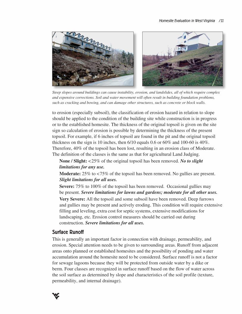
Steep slopes around buildings can cause instability, erosion, and landslides, all of which require complex and expensive corrections. Soil and water movement will often result in building foundation problems, such as cracking and bowing, and can damage other structures, such as concrete or block walls.
Homesite Evaluation in West Virginia /12
Rapid: Large amounts of water move rapidly over the surface of the soil. Generally, onlyasmallpartmovesintothesoilprofile.Occursonslopesof≥8%.Severe limitations for lawns and gardens. No to slight limitations for foundations with basements and for septic systems.Moderate: Applies to surface water when it flows slowly enough that a moderate portion of the water enters the soil. Water puddles on the surface for only short periods. Occurs on slopes of 1% to <8%. No to slight limitations for any use. Slow: Applies to surface water when it flows slowly enough that a moderate portion of the water enters the soil. Water puddles on the surface for only short periods. Occurs on nearly level areas (0% to <1% slope). Severe limitations for foundations with basements and for septic systems. No to slight limitations for other uses.Very Slow: Applies to surface water more or less standing for long periods in depressions on the surface. The depressions should be found between the slope stakes. Water on the surface has no outlet. Most of the water either passes through the soil or evaporates. On coarse-textured soils, water may enter the soil immediately and cause leaching. Occurs on level land (0% slope) on which water accumulates in depressions and has no surface outlet. Very severe limitations for foundations with basements and for septic systems. No to slight limitations for other uses.
Shrink-Swell of Subsoil Shrink-swell of the subsoil or finest textured soil layer in the subsoil is a property of the clay fraction in soils. Many clays swell when they absorb water and shrink when they dry. This characteristic is most noticeable in the subsoil where the fine-textured layers of the soil profile are usually found. The red clays of the central and western counties in West Virginia have a high shrink-swell potential, swelling to over twice their dry volume and causing very severe land use limitations. They tend to be prone to erosion and slide downhill on sloping sites. Swelling pressure of such clays may damage foundations and retaining walls, and cause restricted drainage and limited permeability. A close correlation is found among soil texture, shrink-swell potential, and soil permeability, but not all clays (fine-textured soils) demonstrate equal shrink-swell.
Low: Occurs in subsoils that have coarse textures (sands and loamy sands). The permeability is rapid. No to slight limitations for all uses.Moderate: Occurs in a wide range of subsoils that have loamy textures. The permeability is moderate or slow. Moderate limitations for all uses.High: Occurs in subsoils that have heavy clay textures. The permeability is very slow. Severe limitations for foundations with basements, septic systems, and lawns and gardens. No to slight limitations for sewage lagoons.
. . . not all clays demostrate equal shrink-swell.
Homesite Evaluation in West Virginia /13
Water Table The internal wetness of a soil is influenced by most of the factors previously discussed. The presence of a water table can cause limitations that restrict the soil for certain uses. For example, a water table within the depth of basement construction or septic tank/drain field installation may result in a wet basement or inadequate wastewater treatment unless special precautions are taken. Water table must be evaluated on the basis of both depth and permanence, frequently requiring measurements during different seasons of the year. Water table depth will be given on the site sign.
Deep: Thewatertableispresentatdepthsof≥72inches.No to slight limitations for all uses.
Moderately Deep: The water table is present at depths of 48 to <72 inches. Moderate limitations for all uses.
Shallow: The water table is present at depths of <48 inches. Severe limitations for all uses.
Flooding The occurrence of floods is a frequently overlooked factor. Flooding may not occur on an area for many years, but then a serious rainstorm can flood homes that were built during drier periods. Urban development in a watershed may increase runoff by up to 70% in streams, greatly increasing flood hazards. Soils can give an indication, but long-term rainfall and flooding records must be studied to determine the true condition. Position in the landscape and proximity to nearby streams are good indicators of frequency of flooding. In contests, flooding information is given on the site sign.
None: Frequency of flooding is <1 year in 4 years. No to slight limitations for all uses. Occasional: Floods 1 or 2 years in 4. Severe limitations for foundations with basements, septic system and sewage lagoons. Moderate limitations for lawns and gardens.Frequent Flooding: Floods >2 years in 4. Very severe limitations for all uses.
Final EvaluationIn making the final evaluation in a contest, you must determine the degree of limitation for each site factor as it applies to the planned use. For example, under septic system, if one or more factors are marked severe, but none are very severe, then the final evaluation limitation for septic system would be marked severe.
Homesite Evaluation in West Virginia /14
Example: Homesite Evaluation Scorecard
Homesite Evaluation in West Virginia West Virginia Appendix /i