Embed Size (px)
Citation preview
PLANNING DEPARTMENTTHE GOVERNMENT OF THE HONG KONG SPECIAL ADMINISTRATIVE REGION
HONG KONG PLANNINGSTANDARDS AND GUIDELINES
Chapter
10Conservation
CHAPTER 10 CONSERVATION
CONTENTS
1. Introduction 1
2. Principles of Conservation 1
3. Nature Conservation and Biodiversity 2
4. Conservation of Declared Monuments, Historic Buildings, 15
Sites of Archaeological Interest and Other Heritage Items
5. Enforcement 22
Figures
Figure 1 Country Parks and Special Areas
Figure 2 Marine Parks, Marine Reserve, Restricted Areas and Geopark
Figure 3 Sites of Special Scientific Interest
Figure 4 Declared Monuments
Appendices
Appendix 1 Legislation and Administrative Controls for Conservation
Appendix 2 Other Conservation Related Guidelines
________________________________________________________________________
(March 2020 Edition)

- 1 -
CONSERVATION
1 Introduction
1.1 Hong Kong has extensive undeveloped tracts of natural landscapes, which
contain diverse habitats supporting numerous native plant species and a
variety of wildlife, both resident and migratory. Hong Kong also boasts
rich geological resources which make up spectacular landforms. In
addition, there is a long history of human settlement and consequently a
variety of cultural relics are present.
1.2 This chapter explains the policies and measures in support of conservation
from the planning perspective in Hong Kong. Two major aspects are
covered: Nature Conservation and Biodiversity (Section 3) and Conservation
of Cultural Heritage (Section 4). Conservation is considered here in terms
of land use, which can be effected by various measures from legislative to
administrative means. Areas identified for conservation purposes can also
be shown by zoning on town plans. In such conservation zones, there is a
general presumption against development and the uses which are permitted
may be subject to the controls under the relevant Ordinances and the
imposition of appropriate conditions by the relevant authorities.
1.3 The chapter is divided into several parts. Firstly, some general principles
of conservation are reviewed. Secondly, there is a discussion of measures
to conserve natural landscapes and habitats, followed by measures to
conserve declared monuments, historic buildings, sites of archaeological
interest and other heritage items. To conclude the chapter, a brief review of
conservation enforcement is provided at the end.
2 Principles of Conservation
2.1 The following four principles should be adopted for the practical pursuit of
conservation in land use planning:
(i) retain significant landscapes, ecological and geological attributes and
heritage features as conservation zones;
(ii) restrict uses within conservation zones to those which sustain
particular landscapes, ecological and geological attributes and
heritage features;
(iii) ensure compatibility of adjoining uses to minimise adverse impacts
on conservation zones and optimise their conservation value; and
(iv) create, where possible, new conservation zones in compensation for

- 2 -
areas of conservation value, which are lost to development.
2.2 Items of value which merit conservation are identified in planning studies at
both strategic and district levels, special surveys undertaken by Government
and non-government organisations or as the result of public views.
However, plans that include conservation use have to be seen in a wider
context and take into account the need to provide adequate space for
development needs. The challenge is to integrate these different uses into
acceptable and realistic plans, which take account of territorial growth and
principles of sustainable development.
3 Nature Conservation and Biodiversity
3.1 Landscape Profile and Biodiversity of Hong Kong
Geologically, Hong Kong has a large variety of volcanic and sedimentary
rocks, ranging from 400 million to 55 million years old. Located on the
Pearl River Delta and coast of South China Sea, Hong Kong has a hilly and
rugged terrain, as well as a high crenulated coastline and more than 200
offshore islands. At present, some 47 percent of the land area (51 900 ha)
of the territory and about 2 percent of the marine area (3 400 ha) are
designated for various nature conservation uses.1 The natural landscapes of
Hong Kong are diverse. They comprise extensive uplands, agricultural
plains, valleys, indented coastline and areas of wetland. Such landscape
diversity provides a wide range of terrestrial and aquatic habitats which
support our rich diversity of fauna and flora including some species that are
endemic to Hong Kong. About 2 100 species of native vascular plants, 55
species of terrestrial mammals, over 550 species of birds, 90 species of
reptiles, 25 species of amphibians, over 180 species of freshwater fishes,
over 240 species of butterflies and 128 species of dragonflies have been
recorded.2
3.2 Target Natural Landscapes and Habitats
Conservation of natural landscapes and habitats is important not only for
preserving the key components of biodiversity, but for maintaining the
associated ecosystem services which provide innumerable benefits and
protections to humans, such as water provisioning, carbon sequestration, and
flood prevention. Some habitats, such as forests, wetlands (including
rivers), mangroves and mudflats, are generally known for their support of
rich biodiversity and therefore given due considerations in nature
conservation work.
1 The nature conservation related land area includes country parks and special areas, areas zoned Site of
Special Scientific Interest, Conservation Area or Coastal Protection Area on statutory town plans.
2 Source of data based from AFCD as at April 2019.
- 3 -
3.2.1 Forests
Forests are important habitats for wildlife and help safeguard water
catchments from soil erosion. Among the forested areas, fung shui
woods are of particular ecological interest, as they are remnants of
Hong Kong’s native lowland evergreen broad-leaved forests, and
support many rare tree species and thriving biodiversity.
3.2.2 Wetlands
Wetlands may be freshwater or intertidal, natural or
human-modified (e.g. fish ponds). They support a wide array of
wildlife and generally of high ecological value. Wetlands at the
internationally important Mai Po Inner Deep Bay Ramsar Site
support over 70% of the bird species recorded in Hong Kong, and
are important feeding and resting grounds for migratory birds.
3.2.3 Streams and rivers
There are over 2 500 km of natural streams and rivers in Hong
Kong, mostly located in hillsides remote from developed
areas. Many of these natural streams and rivers are good habitats
supporting a variety of wildlife. They have important ecological
functions and carry high aesthetic and landscape value.
3.2.4 Natural coasts, mangroves and mudflats
The coast is where the aquatic and terrestrial ecosystems interact.
Coastal habitats such as mangroves and mudflats in estuaries not
only stabilise sediments but also serve as important feeding and
nursery grounds for various aquatic life including waterbirds, fishes,
horseshoe crabs and other invertebrates. Natural coasts also carry
high aesthetic and landscape value.
3.3 Opportunities and Threats in Nature Conservation
3.3.1 Areas of good quality natural landscapes and valuable habitats may
be subject to pressure for change of use. This pressure for change
of use is often a consequence of economic change, particularly the
decline in traditional rural activities (which threatens existing
agricultural landscapes) and the expanding urban area of Hong
Kong (which threatens areas of natural coastline).
3.3.2 There are both opportunities and threats in terms of nature
conservation. The principal opportunities are:
(i) potential conservation areas, both terrestrial and marine,
which are not yet protected;
- 4 -
(ii) degraded and human-modified landscapes, which can be
reinstated or enhanced for new use; and
(iii) scenic areas that can accommodate quality residential,
recreation and tourism uses without prejudicing more
valuable conservation areas.
3.3.3 However, there are also significant threats to landscape quality and
natural habitats which must be either prevented or ameliorated:
(i) intrusion of urban development into otherwise scenic and
undeveloped areas;
(ii) derelict land which exists where traditional land use has
lapsed (e.g. agriculture) because it is not economically
attractive; and
(iii) coastal reclamation and working of marine deposits that have
effects on potential conservation areas.
3.4 Nature Conservation Policy and Biodiversity Strategy
3.4.1 Our nature conservation policy is to regulate, protect and manage
natural resources that are important for the conservation of
biological diversity of Hong Kong in a sustainable manner, taking
into account social and economic considerations, for the benefit and
enjoyment of the present and future generations of the community.
The principal measures which protect natural landscapes and
habitats are listed in Appendices 1 and 2.
3.4.2 In 2016, the Government released the first city-level Biodiversity
Strategy and Action Plan for Hong Kong, outlining the strategy and
actions to be taken for conserving biodiversity and supporting
sustainable development. Biodiversity is the variability among
living organisms and the ecological complexes of which they are
part; this includes diversity within species, between species, and of
ecosystems. It forms the foundation of the vast array of ecosystem
services that critically contribute to human well-being.
3.4.3 Biodiversity generally refers to diversity at three levels – genes,
species and ecosystems:
(i) Genetic diversity – refers to the variation among individuals
within the same species.
(ii) Species diversity – refers to all the different kinds of
organisms within a habitat or a region.
(iii) Ecosystem diversity – refers to the variety of habitats and

- 5 -
communities of organisms found within an area.
Biodiversity conservation can be achieved through protecting areas
or individual sites of ecological or landscape significance from
incompatible land uses, which is important in ensuring the
continued survival and thriving of species therein. Conservation
of biodiversity at the genetic level is indirectly assured as a result.
3.5 Protecting Natural Landscapes and Habitats
3.5.1 Protection of natural landscapes and habitats have mainly been
made through designation of ecologically important sites as
protected areas to comprehensively protect the ecosystems therein
and conserve wildlife in-situ, as well as administrative measures to
recognise the significance of valuable landscapes and ecologically
important habitats so that special attention is drawn to development
and activities that may adversely affect these areas. Natural
landscapes and habitats may be gazetted as Country Parks or
Special Areas, Marine Parks or Marine Reserve, Restricted Areas,
Water Gathering Grounds, or conservation zones in statutory town
plans. They may also be listed as Sites of Special Scientific
Interest (SSSIs) or Priority Sites for enhanced conservation.
(a) Country Parks and Special Areas – Country Parks and Special
Areas are designated under the Country Parks Ordinance (Cap 208)
and managed by the Agriculture, Fisheries and Conservation
Department (AFCD) on the advice of the Country and Marine
Parks Board (CMPB). At present, there are 24 Country Parks (43
467 ha) and 22 Special Areas, 11 of which (845 ha) are outside
Country Parks. The total area is about 44 312 ha and covers 40%
of the land area of Hong Kong. Country Parks are designated for
the purposes of nature conservation, countryside recreation and
nature education. Special Areas are areas of Government land
with special interest and importance by reason of their flora, fauna,
geological, cultural or archaeological features. The Country and
Marine Parks Authority (i.e. the Director of Agriculture, Fisheries
and Conservation) has established criteria for determining whether
or not a particular location is suitable for designation as a Country
Park or Special Area. The criteria include landscape quality,
recreation potential, conservation value, size, land status, land use
compatibility and the practicality of management. Designated
Country Parks and Special Areas outside Country Parks are shown
on Figure 1.
(b) Marine Parks and Marine Reserve – Marine Parks and Marine
Reserve are designated under the Marine Parks Ordinance (Cap 476)
and managed by the AFCD on the advice of the CMPB. At
present, there are 5 Marine Parks (Yan Chau Tong, Hoi Ha Wan,
Sha Chau & Lung Kwu Chau, Tung Ping Chau and The Brothers)
- 6 -
and 1 Marine Reserve (Cape D’Aguilar). They cover a total
marine area of 3 400 ha. The establishment of Marine Parks and
Marine Reserve is to protect and manage ecologically important
marine environment for the purposes of conservation, education and
recreation and to bring long-term benefit to the community through
conserving the marine environment. Designated Marine Parks and
Marine Reserve are shown on Figure 2.
(c) Restricted Areas – To protect the important wetland habitats,
the core part of the Mai Po Marshes, mangroves and inter-tidal
mudflat of Inner Deep Bay is scheduled as Restricted Area under
the Wild Animals Protection Ordinance (Cap 170). Three
Restricted Areas have been designated, namely the Mai Po Marshes,
Yim Tso Ha and Sham Wan of the Lamma Island. They are also
shown on Figure 2. The Ordinance restricts access to designated
areas of wildlife habitat. Access controls at the Restricted Areas
under the Ordinance are implemented by the AFCD. The Town
Planning Board has also designated special land use zones to
conserve these areas and issued guidelines for planning application
for developments within Deep Bay area to prevent adverse impact
of development projects on the wetland habitats. The
development control of these areas is further elaborated in
subsequent section on preparing plans to conserve natural
landscapes and habitats.
(d) Ramsar Site – In Mai Po Marshes and Inner Deep Bay, an
area of approximately 1 500 ha of wetland was listed as a Ramsar
Site under the Convention on Wetlands of International Importance
especially as Waterfowl Habitat (i.e. Ramsar Convention) on 4
September 1995. This Ramsar Site is an estuarine inter-tidal
mudflat backed by dwarf mangroves, shrimp ponds and fishponds.
Other habitats within the Ramsar Site include reedbeds, marshes,
rivers and channels. The listing of the wetland as Ramsar Site is a
formal recognition of the international importance of its special
value for maintaining the genetic and ecological diversity because
of the quality and peculiarities of the flora and fauna.
(e) Water Gathering Grounds – Water Gathering Grounds
comprise areas which are conserved for use as water catchment.
There are four broad categories, which may warrant different
controls on use and development. These are:
(i) Lower Direct Gathering Grounds;
(ii) Upper Direct Gathering Grounds;
(iii) Lower Indirect Gathering Grounds; and
(iv) Upper Indirect Gathering Grounds.
- 7 -
The Water Supplies Department (WSD) has specific
requirements to control or restrict development and land use
in Water Gathering Grounds. For planning and management
in Water Gathering Grounds, WSD should be consulted.
(f) Priority Sites – In 2004, the Government identified 12
Priority Sites3 for enhanced conservation under the New Nature
Conservation Policy (NNCP). Under the NNCP, new proactive
measures aiming to promote conservation of these sites in
collaboration with the private sector include the Management
Agreement Scheme (MA) and Public-Private Partnership Scheme
(PPP). Under the MA, non-government organisations (NGOs)
may apply for funding from the Government for entering into
management agreements with the landowners or tenants. The
NGOs can provide the landowners or tenants with financial
incentives in exchange for management rights over their land or
their cooperation in enhancing conservation of the sites concerned.
Under the PPP, development at an agreed scale would be allowed at
the ecologically less sensitive portion of a Priority Site provided
that the project proponent undertakes to conserve and manage, on a
long-term basis, the rest of the site that is ecologically more
sensitive. The proposal to develop is subject to assessment by the
Government and consideration by the Advisory Council on the
Environment (ACE).
(g) Geopark – The Hong Kong United Nations Educational,
Scientific and Cultural Organization (UNESCO) Global Geopark
(the Hong Kong UNESCO Global Geopark), with a total land area
of over 150 km2, is established to promote geo-conservation,
science popularization and local engagement activities within the
Geopark. It is managed by AFCD and protected under the Country
Parks Ordinance and the Marine Parks Ordinance. It comprises
the Sai Kung Volcanic Rock Region characterized by hexagonal
volcanic rock columns, and the Northeast New Territories
Sedimentary Rock Region representing the most comprehensive
stratigraphy of sedimentary rocks in Hong Kong. Location of the
Hong Kong UNESCO Global Geopark is shown on Figure 2.
(h) Sites of Special Scientific Interest – Sites of Special Scientific
Interest (“SSSIs”) may be land based or marine sites, which are of
special interest because of their flora, fauna, geographical or
geological features. “SSSIs” are identified by the AFCD. The
Planning Department maintains a register of “SSSIs”. Once
designated, the “SSSI” zones will be shown on statutory town plans
and non-statutory town plans where appropriate. Normally no
new development will be permitted within a “SSSI” zone unless it
3 The locations and profiles of the Priority Sites are available on the website of AFCD at www.afcd.gov.hk.
- 8 -
is necessary for conservation of the site. Departments concerned
with planning and development should be aware of the scientific
importance of “SSSIs” and should ensure that due consideration is
given to conservation when development at or near these sites is
proposed. AFCD should be consulted for any proposed
development at or in the proximity of any “SSSI”. The 67 existing
“SSSIs” are shown on Figure 3.
(i) Ecologically Important Streams4 – Ecologically Important
Streams (EIS) are natural streams or rivers with important
ecological functions such as providing habitats for diverse or rare
animal or plant communities. The EISs are identified and updated
from time to time by AFCD in respect to their naturalness, diversity,
and uniqueness based on the latest available ecological information.
For development projects that may affect EIS, prior consultation
with AFCD and other relevant authorities5 should be made.
(j) Town Plans – Areas of conservation use may be designated as
conservation zones on statutory town plans, i.e. Outline Zoning
Plans (OZPs) and Development Permission Area (DPA) Plans,
prepared by the Town Planning Board under the Town Planning
Ordinance (Cap 131), and non-statutory town plans i.e. Outline
Development Plans (ODPs) and Layout Plans (LPs) prepared by the
Planning Department. This process is further discussed in the
subsequent section on preparing plans to conserve natural
landscapes and habitats.
(k) Others – Apart from designating areas of conservation use,
other measures are in force to protect animals and plants. The
Forests and Countryside Ordinance (Cap 96) prohibits felling,
cutting, burning or destroying of trees and growing plants in forests
and plantations on Government land. Its subsidiary legislation, the
Forestry Regulations (Cap 96A), prohibits the picking, felling,
selling or possession of listed plant species. The Wild Animals
Protection Ordinance (Cap 170) mentioned in paragraph 3.5.1 (c)
above also contains provisions to protect local wildlife through both
the prohibition of hunting territory-wide and the possession of
scheduled protected wild animals or hunting appliances. In addition,
there are measures which cover the retention, removal and
replacement of trees, particularly old and valuable trees on
Government land, which are dealt with in more detail in Chapter 4
of the HKPSG. Should there be any works proposed on
4 The updated list of EIS including the map showing their distribution is available on the website of AFCD at
www.afcd.gov.hk.
5 Reference should be made to Environment, Transport and Works Bureau Technical Circular (Works) No.
5/2005 (on the website of DEVB at www.devb.gov.hk) for the authorities to be consulted and requirements to
be observed.

- 9 -
Government land or private land that have implications on
conservation or tree preservation aspects, the proponent should
approach relevant authorities for prior consent or approval before
commencement of any works.
3.6 Preparing Plans to Conserve Natural Landscapes and Habitats
3.6.1 The planning intention to conserve is derived from both planning
studies and inputs from Government and non-government
organisations. Suitable conservation proposals should be
formulated in relevant planning, development or topical studies so
as to form the basis for the preparation of statutory town plans and
assessment on nature conservation and consideration on
biodiversity should be included where appropriate. New
information on identification of areas of unique or significant
landscape and local fauna, flora and habitats are revealed constantly
through consultancy studies, academic researches and the work of
both Government and non-government organisations. Examples of
the studies include Habitat Mapping under the Sustainable
Development for the 21st Century and Landscape Value Mapping of
Hong Kong. These two studies have identified habitats of
ecological value and areas of unique or significant landscape quality
respectively. A number of inventories are kept both within
Government and concerned non-government organisations
providing information on conservation resources. It is important
that existing designated conservation areas are shown on plans
clearly and accurately, and that potential conservation areas are also
shown whenever possible so that opportunities to conserve are not
overlooked.
Statutory Town Plans
3.6.2 The Town Planning Ordinance empowers the Town Planning Board
to prepare town plans with statutory land use zones under section
4(1)(g) for ‘country parks, coastal protection areas, sites of special
scientific interest, green belts or other specified uses’ to promote
conservation or protection of the environment.
Some of the major conservation zones on statutory town plans i.e.
OZPs and DPA Plans include :
(i) “Country Park” To reflect a country park or special
area as designated under the Country
Parks Ordinance (Cap 208), where all
uses and developments require
consent from the Country and Marine
Parks Authority.
- 10 -
(ii) “Coastal Protection
Area”
To conserve, protect and retain the
natural coastlines and the sensitive
coastal natural environment, including
attractive geological features, physical
landform or area of high landscape,
scenic or ecological value, with a
minimum of built development; and to
cover areas which serve as natural
protection areas sheltering nearby
developments against the effects of
coastal erosion, with a general
presumption against development.
(iii) “Site of Special
Scientific Interest”
To conserve and protect the features
of special scientific interest such as
rare or particular species of fauna and
flora and their habitats, corals,
woodlands, marshes or areas of
geological, ecological or
botanical/biological interest which are
designated as SSSI and to deter
human activities or developments
within the SSSI, with a general
presumption against development.
(iv) “Conservation Area” To protect and retain the existing
natural landscape, ecological or
topographical features of the area for
conservation, educational and research
purposes and to separate sensitive
natural environment such as SSSI or
Country Park from the adverse effects
of development. There is a general
presumption against development in
this zone.
(v) “Green Belt” To primarily conserve the existing
natural environment amid the built-up
areas/at the urban fringe, to safeguard
it from encroachment by urban type
development, to define the limits of
urban and sub-urban development
areas by natural features, to contain
urban sprawl as well as to provide
passive recreational outlets, with a
general presumption against
development.
- 11 -
To avoid duplication of statutory authority, development control in
the “Country Park” is mainly carried out by the Land Authority (i.e.
Director of Lands) on advice from the Country and Marine Parks
Authority.
3.6.3 To regulate developments within the wetland area around Mai Po
Marshes and Inner Deep Bay near the Ramsar Site, the following
land use zones are introduced in the OZPs within these areas:
(i)
“Conservation Area” To discourage new development
unless it is required to support the
conservation of the ecological
integrity of the wetland ecosystem or
the development is an essential
infrastructure project with overriding
public interest.
(ii)
“Other Specified
Uses
(Comprehensive
Development and
Wetland
Enhancement Area)”
For conservation and enhancement
of ecological value and functions of
the existing fishponds or wetland
through consideration of application
for development or redevelopment
under the “private-public partnership
approach”. The “no-net-loss in
wetland” principle is adopted for any
change of use in this zone.
(iii) “Other Specified
Uses
(Comprehensive
Development to
include Wetland
Restoration Area)”
To provide incentive for the
restoration of degraded wetlands
adjoining existing fish ponds
through comprehensive residential
and/or recreational development to
include wetland restoration area, and
to phase out existing sporadic open
storage and port back-up uses on
degraded wetlands.
(iv) “Other Specified
Uses
(Comprehensive
Development and
Wetland Protection
Area)”
To allow consideration of
comprehensive low-density
residential development or
redevelopment provided that all the
existing continuous and contiguous
fish ponds within the zone are
protected and conserved. The
- 12 -
“no-net-loss in wetland” principle is
adopted for any change in use within
the zone.
Development within these zones should also comply with the Town
Planning Board Guidelines for Application for Developments
within Deep Bay Area under section 16 of the Town Planning
Ordinance (TPB PG-No. 12C)6.
Non-statutory Town Plans
3.6.4 Non-statutory town plans and supporting planning documents
should also be used to express the planning intention to protect
conservation zones. Broad conservation sites should be identified
and an overall framework of conservation should be reflected in
planning and development studies as appropriate. At the district
level, ODPs and LPs are prepared at scales which enable small sites
to be shown. Relevant symbol should be used to annotate the
following different categories of conservation sites:
(i) existing designated conservation zones; and
(ii) potential conservation zones.
3.7 Nature Conservation and Development Control
3.7.1 The development control measures, which can be used to protect
areas of conservation value, are contained in the legislations or
administrative provisions. The legislative provisions set out the
procedures and types of decision, which the decision-making
authorities must follow when considering issues that affect
designated areas. Administrative provisions are usually put into
practice through consultation amongst concerned departments and
discussion by an appropriate committee (e.g. District Planning
Conference).
3.7.2 There is a general presumption against development within areas
designated for conservation use. Conservation zones on statutory
town plans permit very few uses other than those that are necessary
to manage the resource, and some uses require the planning
permission from the Town Planning Board. Development in
Country Parks, Special Areas, Marine Parks and Marine Reserve
will be carefully considered by both the Country and Marine Parks
Authority and the Land Authority (in consultation with the Country
6 The Town Planning Board guidelines are available on the website of Town Planning Board at
www.tpb.gov.hk
- 13 -
and Marine Parks Authority). These authorities will ensure that
minimum impact on these areas be kept at a reasonable balance
between the legitimate interest of the land owners as well as the
country and marine park users. For major development proposals
involving country parks and marine parks, public consultation will
be conducted.
3.7.3 When town plans are being prepared, the wider implications of
conservation zones must be considered. Certain land uses are not
satisfactory neighbours, e.g. polluting industry next to natural
habitat; a SSSI designated as a wildlife habitat may only be
sustainable if the wider surroundings remain rural so as to provide
feeding grounds; and a wetland site may only be sustained if a
particular water source is protected. Where conservation zones are
involved, the compatibility of the proposed development with the
planning intention of the zoning of development site and that of the
adjoining land, as well as biodiversity in the local area, should all
be taken into consideration.
3.7.4 Development projects which are defined as Designated Projects
(DPs) under the Environmental Impact Assessment Ordinance
(EIAO) (Cap 499) are subject to the statutory EIA process:
(i) DPs specified under Schedules 2 and 3 of EIAO, unless
exempted, have to go through EIA process, but only those
listed in Schedule 2 require environmental permit (EP) for the
construction and operation (if applicable, and
decommissioning) of the project.
(ii) Impacts on flora, fauna and habitats, particularly of high
ecological / conservation value, will be assessed and
evaluated through the statutory EIA process in accordance
with the Technical Memorandum on EIA Process and EIA
Study Brief requirements.
(iii) Environmental Protection Department (EPD) will consult
AFCD for advice on the issues related to nature conservation
and ecological assessment. In the environmental permit
(EP), mitigation measures shall be set, where appropriate, as
conditions of implementing the projects. EPD, together with
the relevant authorities, also enforce the EP through site
inspections, review of environmental monitoring and audit
reports provided by qualified independent environmental
checkers that project proponents may engage under EP, to
ensure that the EP holders comply with EP conditions.
3.7.5 For government projects which are not DPs under the EIAO,
Preliminary Environmental Review may be required to identify
- 14 -
environmental impacts associated with the projects, confirm
environmental acceptability, determine the necessary mitigation
measures and ascertain the need for additional environmental
studies7.
3.7.6 Development should normally avoid declared or potential area for
conservation use. A proposal to amend a conservation zone or to
replace such areas with a different use which permits essential
development may only be considered in exceptional circumstances.
In these circumstances it must be clearly shown that alternative
development sites have been considered but have had to be rejected
for sound reasons (e.g. critical timing, prohibitive cost or technical
limitations). Salvage potential should be considered, together with
possible off-site compensatory provision. The relevant
Government departments should be consulted to ensure that the
possibility of off-site compensatory works has been fully explored
and that suitable sites have been proposed for such compensatory
works. Each application will be judged on its own merits by the
relevant advisory bodies (e.g. ACE or CMPB) and when
appropriate by the Town Planning Board. It is essential that the
background to each application is fully researched and that the
critical issues are identified.
7 Please refer to Environment, Transport and Works Bureau Technical Circular (Works) No. 13/2003,
Appendix A, (on the website of DEVB at www.devb.gov.hk) for the procedures for dealing with
environmental implications of government projects or proposals not covered by EIAO.

- 15 -
4. Conservation of Declared Monuments, Historic Buildings, Sites of
Archaeological Interest and Other Heritage Items
4.1 Hong Kong is rich in cultural heritage. It is important to rehabilitate and
preserve unique cultural heritage as this not only accords with our objective
of sustainable development but also facilitates the retention of the inherent
characteristics of different districts, and helps engender a sense of place and
belonging. Heritage conservation is the protection of declared monuments,
historic buildings, sites of archaeological interest and other heritage items
but in a wider sense implies respect for local activities, customs and
traditions. The concept is to conserve not only individual items but also
respecting their wider urban or rural setting. Though construction of new
buildings and replacement of old buildings may sometimes be inevitable for
various reasons, due consideration should be given in conservation of
cultural heritage as appropriate.
4.2 Heritage Conservation Policy
The policy statement on heritage conservation is “to protect, conserve and
revitalise as appropriate historical and heritage sites and buildings through
relevant and sustainable approaches for the benefit and enjoyment of present
and future generations. In implementing this policy, due regard should be
given to development needs in the public interest, respect for private
property rights, budgetary considerations, cross-sector collaboration and
active engagement of stakeholders and the general public.” The principal
measures for heritage conservation are reviewed below. Relevant
legislation and guidelines are listed in Appendices 1 and 2.
4.3 Declaration of Monuments
Under Section 3 of the Antiquities and Monuments Ordinance (Cap 53), the
Antiquities Authority (the Secretary for Development) may, after
consultation with the Antiquities Advisory Board (AAB) and with the
approval of the Chief Executive, “declare any place, building, site or
structure, which the Authority considers to be of public interest by reason of
its historical, archaeological or palaeontological significance, to be a
monument, historical building, archaeological or palaeontological site or
structure” (declared monument is legally a generic term for all four
categories). No person shall undertake acts on declared monuments that

- 16 -
are prohibited under section 6 of the Antiquities and Monuments Ordinance,
such as to excavate, carry out building or other works, or plant or fell trees,
without a permit granted by the Antiquities Authority8. A plan showing the
locations of declared monuments is at Figure 4. The up-to-date list of
declared monuments and their related details are available on the website of
the Antiquities and Monuments Office (AMO) of the Development Bureau
(DEVB) at www.amo.gov.hk or the Government website on heritage
conservation at www.heritage.gov.hk.
4.4 Identification and Recording of Historic Buildings, Sites of
Archaeological Interest and Other Heritage Items
4.4.1 The AMO is responsible for identifying, recording and researching
on buildings, sites of historical or archaeological interest and other heritage items. These efforts will facilitate the AAB to advise the Antiquities Authority on the declaration of monuments, measures to promote the restoration and conservation of historic buildings, the conservation and investigation of archaeological items, etc. A data record is maintained, updated and circulated to relevant Government departments. The identification and recording of heritage/archaeological items is an ongoing process and any new items discovered should be referred to the AMO for follow-up action.
Identification and Recording of Historic Buildings
4.4.2 The AMO periodically identifies historic buildings. Once identified
as having potential heritage value, buildings are entered into the record. In order to facilitate the AAB’s assessment of the historical and architectural merits of buildings and structures, criteria including historical interest, architectural merit, group value, social value and local interest, authenticity and rarity are taken into account.
Grading of Historic Buildings
4.4.3 The recorded historic buildings may be graded by the AAB. The
aim of the grading is to identify and compare the heritage value of historic buildings and to provide a guide for consideration on how a particular building should be preserved. Endorsed gradings may be subject to review and revision. Buildings that are graded are
8 Apart from “declared monuments”, the Antiquities and Monuments Ordinance also stipulates under Sections
2A to 2C that the Antiquities Authority may, after consultation with the AAB, declare any place, building, site
or structure as a “proposed monument”. This is to provide protection for the proposed monument during the
interim period when the Antiquities Authority considers whether it should be declared to be a monument or
not. The effective period is 12 months only. Similar statutory controls applicable to a declared monument are
also applicable to a proposed monument.

- 17 -
classified into the following categories:
(i) Grade 1 – Buildings of outstanding merit, which
every effort should be made to preserve if
possible.
(ii) Grade 2 – Buildings of special merit; efforts should be
made to selectively preserve.
(iii) Grade 3 – Buildings of some merit; preservation in
some form would be desirable and
alternative means should be considered if
preservation is not practicable.
The list of graded historic buildings is available on the website of
the AAB (www.aab.gov.hk), AMO or the Government website on
heritage conservation, the addresses of which are given in para.
4.3 above.
4.4.4 The grading system is an administrative mechanism carrying no
legal effect. Nevertheless, the list of Grade 1 buildings will be
regarded as providing a pool of highly valuable heritage buildings
for active consideration by the Antiquities Authority for possible
declaration as monuments under the Antiquities and Monuments
Ordinance. Subject to sufficient justifications, it is also possible for
the Antiquities Authority to suggest Grade 2, Grade 3 or even
ungraded buildings for declaration.
Recording of Sites of Archaeological Interest
4.4.5 Relics fashioned by man before 1800 (and discovered after 1976)
belong to the Government under the Antiquities and Monuments
Ordinance. The excavation and search for such relics require a
licence from the Antiquities Authority. Once identified as having
the potential for conservation, sites of archaeological interest are
entered into the record.
Recording of Other Heritage Items
4.4.6 The AMO also maintains a record of other heritage items including
structures and features of historic interest such as old street
furniture (e.g. lamp posts, fountains), commemorative tablets,
foundation stones, boundary stones, milestones, etc. They are of
varying degrees of historical significance but together they form a
body of rich historical data. The identification and recording of the
- 18 -
heritage items is an ongoing process and any new items discovered
should be referred to the AMO for follow-up action. When
preserved, they could enhance the local character, provide tangible
links with the historical past and be a major source of cultural
identity.
4.5 Preparing Plans to Conserve Declared Monuments, Historic Buildings,
Sites of Archaeological Interest and Other Heritage Items
Statutory Town Plans
4.5.1 The existing Town Planning Ordinance does not have provisions
for the protection of declared monuments, historic buildings, sites of archaeological interest and other heritage items. It is also generally not possible to indicate on the statutory town plans, i.e. OZPs and DPA Plans, anything other than the wider ‘use’ in which these heritage items are located, e.g. an ancestral hall within a “Village Type Development” zone or an archaeological relic within a “Conservation Area” zone. However, it is important that the information related to existing declared and proposed monuments, graded historic buildings, and sites of archaeological interest are reflected on the relevant statutory town plans by making reference to the website of the AAB (www.aab.gov.hk), AMO or the Government website on heritage conservation in the Explanatory Statements and that prior consultation with AMO is necessary for any developments or rezoning proposals affecting these sites or buildings and their immediate environment.
Non-statutory Town Plans
4.5.2 Non-statutory town plans and supporting planning documents
should be used to express the planning intention to protect declared monuments, historic buildings, sites of archaeological interest, and other heritage items. Declared monuments, historic buildings and sites of archaeological interest should be identified and an overall framework of conservation should be reflected in planning and development studies as appropriate. Layout Plans are prepared at scales which enable small sites to be shown. Hence, all these heritage items should be shown on such plans and annotated with relevant symbol to indicate the following:
(i) declared monuments; (ii) recorded sites of archaeological interest; (iii) graded historic buildings; and
(iv) other heritage items.

- 19 -
4.6 Heritage Conservation and Development Control
4.6.1 In the planning process, efforts should be made to protect and
preserve buildings of historical or architectural merits either in their
own right or as an integral part of a group or series of buildings.
Town planners play an important role in recommending appropriate
zonings and uses in achieving conservation, enhancing the
environment of historic buildings and integrating the buildings with
the surrounding developments through responsive design. Many
factors including ownership, land status, existing land use and
development rights should be taken into account in planning for the
conservation of declared monuments and historic buildings. The
AMO should be consulted for any land use or development
proposals which may affect a declared monument or a historic
building and its setting. Since not all the historic buildings are
declared under the Antiquities and Monuments Ordinance, in many
situations the existing town planning mechanisms may encourage
the owners to conserve the whole or part of a historic building
through administrative means. The Government recognises the need
for economic incentives in order to encourage and facilitate private
owners to preserve their historic buildings. Private owners are
encouraged to explore the possibility of
“preservation-cum-development” options to incorporate their
historic buildings in the future development. The Government is
willing to discuss with private owners to derive options for
preservation and possible economic incentives that are
commensurate with the heritage value of the historic buildings. In
implementing this policy, the Government aims to strike a proper
balance between preservation of historic buildings and respect for
private property rights. Given individual circumstances, the
requisite economic incentives to achieve the policy objective will be
considered on a case-by-case basis.
4.6.2 Planning in both rural and urban areas should recognise the value of
archaeological heritage as a cultural resource. In the planning
process, the preservation of sites of archaeological interest must be
given full and advance consideration. ‘Preservation by record’ (i.e.
through salvage excavation to extract the maximum data) will
normally only be considered in the most extreme cases. In such
cases it must be proved beyond reasonable doubt that no other
alternatives exist and that the socio-economic benefits of a project
demonstrably and significantly outweigh the cultural significance of
the site of archaeological interest and its integrity. Hence efforts
should be made to avoid encroachment of development onto sites of
archaeological interest by appropriate land use zoning e.g. to
conserve main deposit area(s) of the sites by turning them into

- 20 -
passive amenities areas. The AMO should be consulted for any land
use or development proposals which may affect a site of
archaeological interest and its setting. If disturbance of the sites of
archaeological interest and sites of archaeological potential is
unavoidable, a detailed Archaeological Impact Assessment (AIA)
conducted by a qualified archaeologist is required for development
works within the sites. The Archaeologist shall apply for a licence
to conduct the AIA under the Antiquities and Monuments
Ordinance. A proposal of the AIA shall be submitted to AMO for
agreement prior to applying for a licence.
4.6.3 A declared monument, a historic building or a heritage item is
directly related to the context, setting and visual spectrum within
which the site can be experienced. In the planning process, efforts
should be made to ensure that the setting of these sites could be
preserved with consideration given to the impact which
neighbouring land uses may have upon it. Such consideration
should take account of the visual impact, alteration of the landscape
(including impact on significant trees) and physical intrusion or
overshadowing of high buildings in adjacent developments,
compatibility between uses, air flow, buffer zones, etc.
4.6.4 Other heritage items such as lamp posts, boundary stones,
foundation stones etc. should be preserved at the early planning
stage. In formulating land use proposals, consideration should be
given to preserve these items in-situ by blending them with the
surrounding land use or creating suitable amenities areas around
them. When these features are affected by development proposals,
the AMO should be consulted on the appropriate means of
preserving these features either in-situ or otherwise.
4.6.5 In processing a redevelopment / conservation proposal for a
declared monument, recorded site or graded building, the concerned
Government departments including the AMO and the
Commissioner for Heritage’s Office (CHO) of the DEVB should be
consulted. In addition, for declared monuments, the provision in
the Antiquities and Monuments Ordinance on control of
monuments has to be strictly complied with. The requirement of
the EIAO on the need to carry out impact assessment studies will
also need to be observed. The requirement of keeping the
monuments intact, any alternative use of the site and its potential
for environmental improvements should be duly considered and
assessed. If a historic building falls within a larger redevelopment
site, the historic building should be incorporated into the
redevelopment scheme as far as possible. Expert advice from the
AMO and the Architectural Services Department (ArchSD) should
be sought on whether the new design could effectively blend in with
the old harmoniously in terms of character, scale and visual impact.

- 21 -
Where the original use of the building is no longer continued,
adaptive re-use of the building should be conscientiously
considered. New use should aim to conserve the heritage values
and significance of the historic building to ensure authenticity and
integrity of the cultural heritage.
4.6.6 Care must be taken to ensure, whenever possible, that declared
monuments, historic buildings, sites of archaeological interest and
recorded heritage items do not suffer damage as a side effect of
development. As outlined in para. 3.7.4 above, Designated Projects
are subject to the provisions of the EIAO. During the EIA process,
conservation assets are normally identified and specialist advice is
sought from relevant Government departments. If residual impacts
are considered acceptable, ameliorative measures may then be
agreed and the development proposal be amended to incorporate the
monument or recorded item as a fully integrated feature of the
development. The AMO is the executive arm of the Antiquities
Authority for issues concerning conservation of built and
archaeological heritage. Environmental planning in Hong Kong is
dealt with in more detail in Chapter 9 of the HKPSG.
4.6.7 When a change of use is proposed which permits the site to retain
its physical integrity, advice should be sought from concerned
departments on whether or not the proposal is acceptable.
Consultation may also be necessary through the District Offices and
with special interest groups outside Government. In general terms,
the intention to conserve must be the main consideration. It must,
however, be supported by the identification of a sustainable use for
the conserved site and a responsible management body.
4.6.8 The CHO of the DEVB provides a focal point as well as a central
point of contact for the Government’s heritage conservation work.
The Government has introduced a number of conservation
initiatives since the promulgation of the Heritage Conservation
Policy of 2007. Works agents of all new capital works projects are
required to check with the AMO whether their projects will affect
heritage sites and thus require the conduct of Heritage Impact
Assessment in accordance with the Development Bureau Technical
Circular (Works) No. 6/2009 - Heritage Impact Assessment
Mechanism for Capital Works Projects. Under the Revitalising
Historic Buildings Through Partnership Scheme, selected
Government-owned historic buildings are revitalised for adaptive
re-use by non-profit-making organisations with financial assistance
from the Built Heritage Conservation Fund (BHCF) of the DEVB.
As for privately-owned historic buildings, the Government actively
engages stakeholders in devising appropriate economic incentives
to encourage and facilitate private owners to preserve these
buildings. Moreover, the Financial Assistance for Maintenance
Scheme on Built Heritage under the BHCF, which provides grant to
- 22 -
encourage the maintenance of historic buildings, has been extended
to cover not only privately-owned graded historic buildings, but
also government-owned declared monuments and graded historic
buildings which are leased to non-profit-making organisations,
subject to certain conditions.
5. Enforcement
5.1 Conservation measures should be enforced under the most appropriate
ordinance. Within Country Parks, Marine Parks, Marine Reserve and
Special Areas, the Country and Marine Parks Authority and/or the Land
Authority (in consultation with the Country and Marine Parks Authority)
will take enforcement action. Enforcement of the Forests and Countryside
Ordinance and the Wild Animals Protection Ordinance are the
responsibilities of the AFCD. Enforcement action against offences under
the EIAO is the responsibility of the EPD. The Planning Authority (i.e. the
Director of Planning) is empowered under the Town Planning Ordinance to
take enforcement / prosecution actions against unauthorized developments
in areas covered by a DPA plan or an OZP which has replaced the DPA plan.
Stop Notices could be issued against the landowner, occupier or person
responsible for the unauthorized development if the development would
constitute a health or safety hazard; adversely affect the environment; or
make it impracticable or uneconomical to reinstate the land within a
reasonable period. Priority actions would be taken against unauthorized
developments within conservation zones, such as “SSSI” and “Conservation
Area” zones. Declared monuments are protected under the Antiquities and
Monuments Ordinance through the AMO. Close contact should be
maintained among the Planning Authority and the various conservation
authorities.


Appendix 1
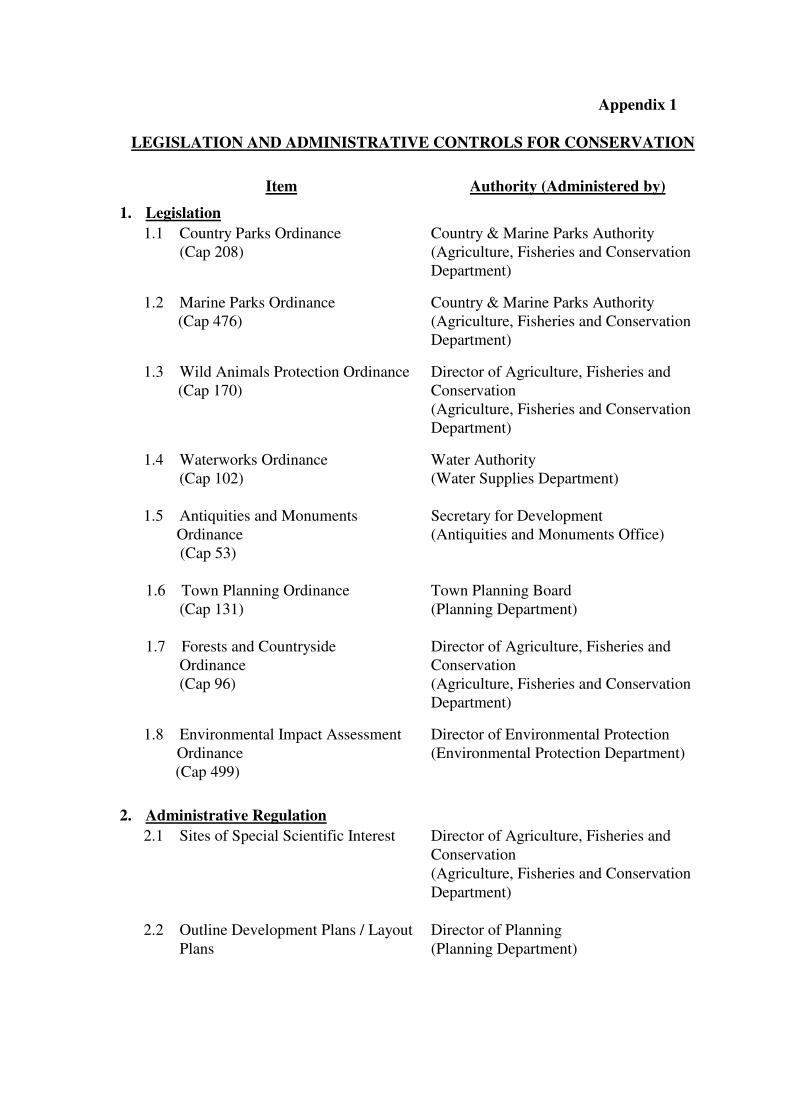
LEGISLATION AND ADMINISTRATIVE CONTROLS FOR CONSERVATION
Item Authority (Administered by)
1. Legislation
1.1 Country Parks Ordinance
(Cap 208)
Country & Marine Parks Authority
(Agriculture, Fisheries and Conservation
Department)
1.2 Marine Parks Ordinance
(Cap 476)
Country & Marine Parks Authority
(Agriculture, Fisheries and Conservation
Department)
1.3 Wild Animals Protection Ordinance
(Cap 170)
Director of Agriculture, Fisheries and
Conservation
(Agriculture, Fisheries and Conservation
Department)
1.4 Waterworks Ordinance
(Cap 102)
Water Authority
(Water Supplies Department)
1.5 Antiquities and Monuments
Ordinance
(Cap 53)
Secretary for Development
(Antiquities and Monuments Office)
1.6 Town Planning Ordinance
(Cap 131)
Town Planning Board
(Planning Department)
1.7 Forests and Countryside
Ordinance
(Cap 96)
Director of Agriculture, Fisheries and
Conservation
(Agriculture, Fisheries and Conservation
Department)
1.8 Environmental Impact Assessment
Ordinance
(Cap 499)
Director of Environmental Protection
(Environmental Protection Department)
2. Administrative Regulation
2.1 Sites of Special Scientific Interest Director of Agriculture, Fisheries and
Conservation
(Agriculture, Fisheries and Conservation
Department)
2.2 Outline Development Plans / Layout
Plans
Director of Planning
(Planning Department)
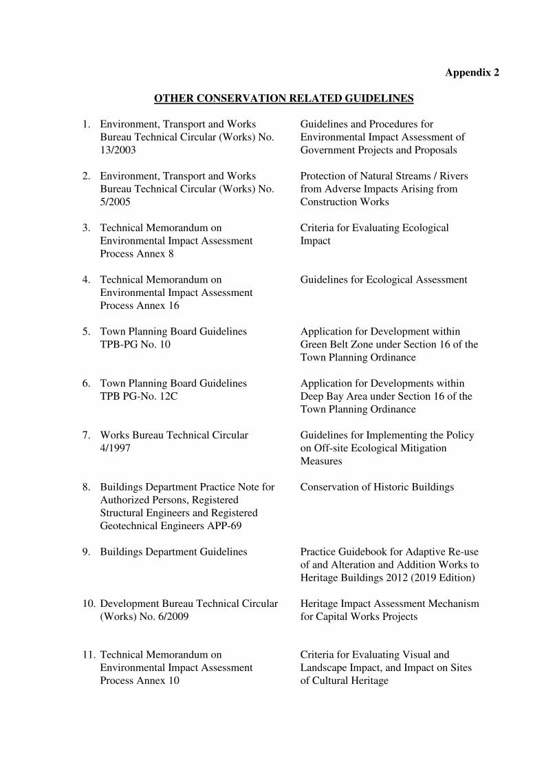
Appendix 2
OTHER CONSERVATION RELATED GUIDELINES
1. Environment, Transport and Works
Bureau Technical Circular (Works) No.
13/2003
Guidelines and Procedures for
Environmental Impact Assessment of
Government Projects and Proposals
2. Environment, Transport and Works
Bureau Technical Circular (Works) No.
5/2005
Protection of Natural Streams / Rivers
from Adverse Impacts Arising from
Construction Works
3.
Technical Memorandum on
Environmental Impact Assessment
Process Annex 8
Criteria for Evaluating Ecological
Impact
4.
Technical Memorandum on
Environmental Impact Assessment
Process Annex 16
Guidelines for Ecological Assessment
5. Town Planning Board Guidelines
TPB-PG No. 10
Application for Development within
Green Belt Zone under Section 16 of the
Town Planning Ordinance
6. Town Planning Board Guidelines
TPB PG-No. 12C
Application for Developments within
Deep Bay Area under Section 16 of the
Town Planning Ordinance
7. Works Bureau Technical Circular
4/1997
Guidelines for Implementing the Policy
on Off-site Ecological Mitigation
Measures
8.
Buildings Department Practice Note for
Authorized Persons, Registered
Structural Engineers and Registered
Geotechnical Engineers APP-69
Conservation of Historic Buildings
9.
Buildings Department Guidelines
Practice Guidebook for Adaptive Re-use
of and Alteration and Addition Works to
Heritage Buildings 2012 (2019 Edition)
10.
Development Bureau Technical Circular
(Works) No. 6/2009
Heritage Impact Assessment Mechanism
for Capital Works Projects
11.
Technical Memorandum on
Environmental Impact Assessment
Process Annex 10
Criteria for Evaluating Visual and
Landscape Impact, and Impact on Sites
of Cultural Heritage

12.
Technical Memorandum on
Environmental Impact Assessment
Process Annex 19
Guidelines for Assessment of Impact on
Sites of Cultural Heritage and Other
Impacts
13.
Environmental Impact Assessment
Ordinance-Guidance Notes of the
Assessment of Impact on Sites of Cultural
Heritage in Environmental Impact
Assessment Studies
Note: Users should refer to the latest version of the above documents.