Embed Size (px)
Citation preview
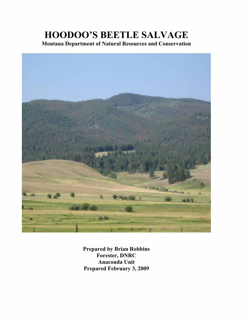
HOODOO’S BEETLE SALVAGE Montana Department of Natural Resources and Conservation
Prepared by Brian Robbins Forester, DNRCAnaconda Unit
Prepared February 3, 2009
STATEMENT OF FINDINGHoodoo’s Beetle Salvage Environmental Analysis
2-6-09
I. Proposed Action The Montana Department of Natural Resources and Conservation (DNRC), Southwestern Land Office, Anaconda Unit, proposes to salvage harvest timber from State owned School Trust Lands in parts of three sections, North of Deer Lodge, Montana. The proposed project area encompasses 1,913 acres of State School Trust Lands within T11N, R10W, Sections 16 (Baldy Mountain) and 36 (Warm Springs); it also includes T12N, R10W, Section 36 (No Name Creek). The proposed harvesting would salvage approximately 10 MMBF from 1,007 acres. To remove the timber 11.05 miles of new road would be constructed
Section Name Harvest Acres
Volume (MBF)
New Road Construction
Temporary Road Construction
Reconstruction
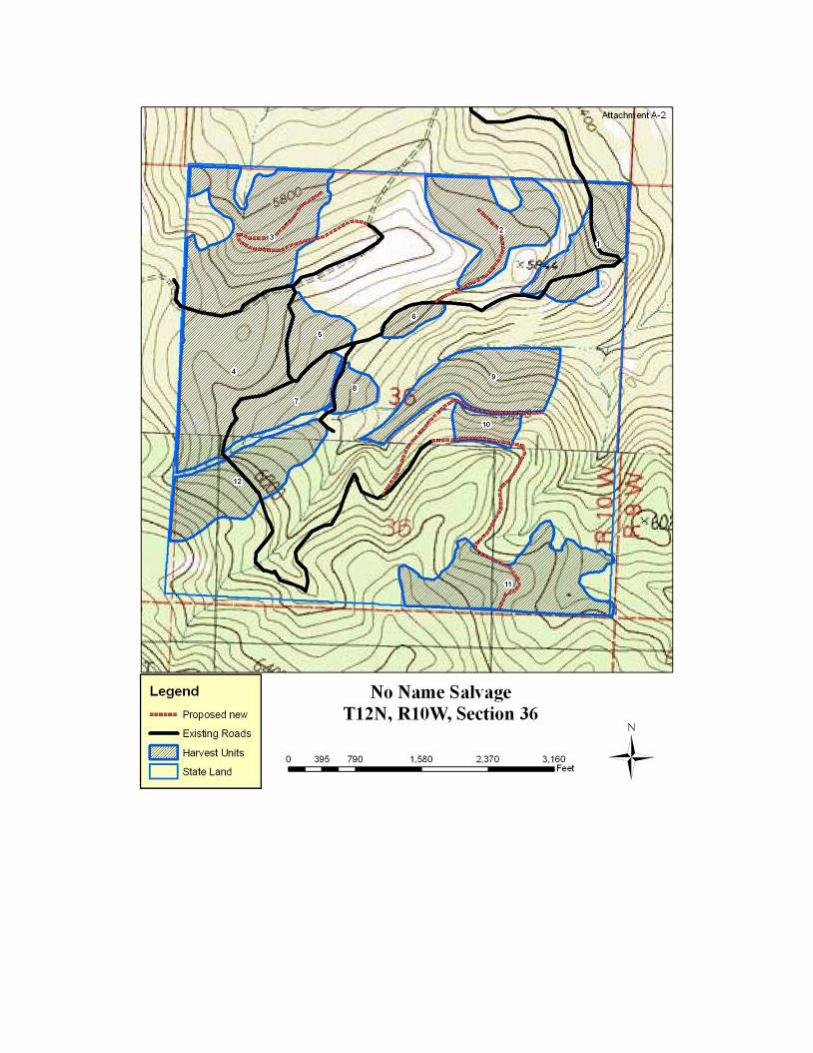
No Name (36 T12N R10W)
269 2,716 1.17 .87 0
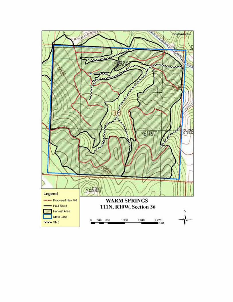
Warm Springs (36 T11N R10W)
475 4,493 3.03 1.48 .30
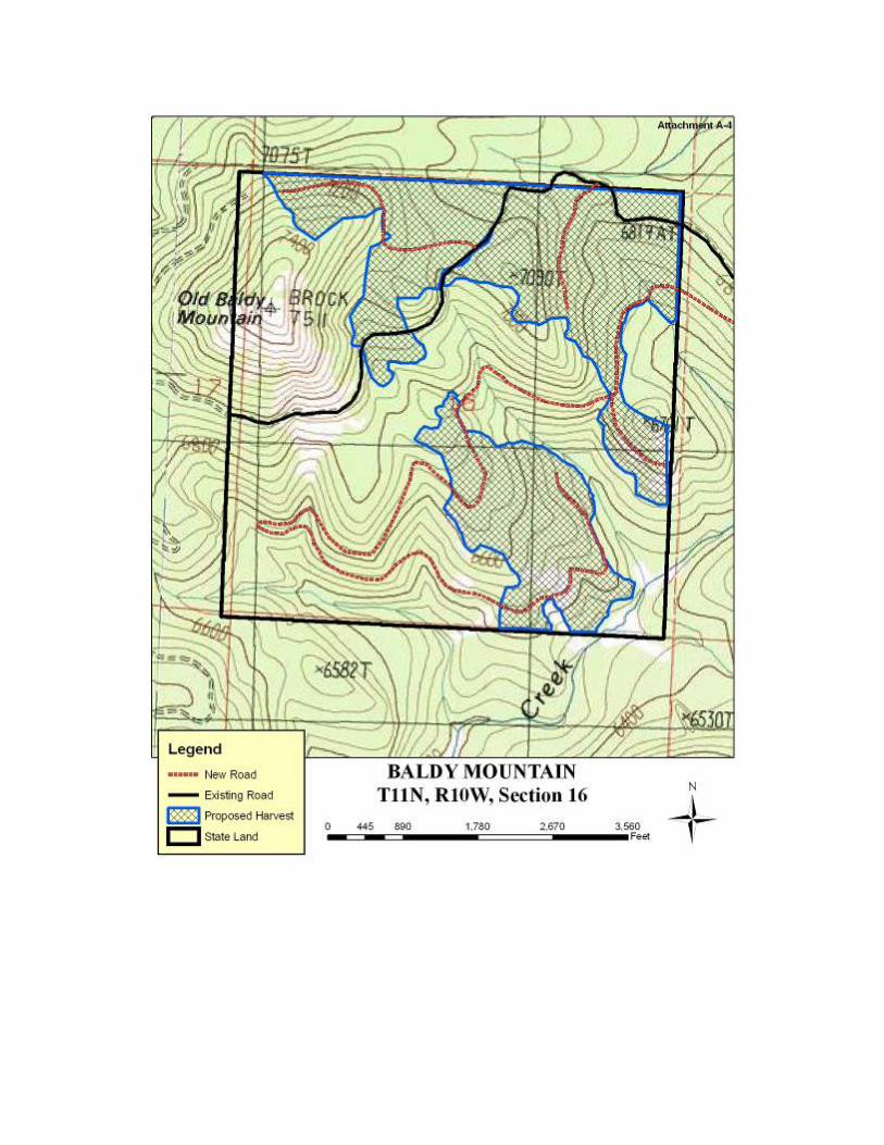
Baldy Mountain 263 2,523 3.4 1.1 0 Total 1,007 9,732 7.6 3.45 .3
If the action alternative is selected, three or more sales would be sold. The sales would occur in 2009, with each contract having up to two years duration. Associated hazard reduction and site preparation work could continue for up to two additional years. The State’s land is intermixed with private ranches, Stimson Lumber Co. and Bureau of Land Management ownership.
Most of the Lodge Pole pine, outside of the SMZ, is to be harvested on all three of the tracts which are being entered. Within the No Name Creek section approximately 40 percent of the Douglas-fir would be removed. Most of the harvested fir would be <15” in diameter at breast height (DBH). And would, typically be intermediate trees that are not believed to be contributing to overall stand health. In the Baldy Mountain and Warm Springs tracts, Douglas fir will be retained while removing all of the lodge pole pine within the harvest units.
II. Objectives: The Department has developed the following specific project objectives:
1. Salvage harvest dead and dying timber consistent with MCA 77-5-207 and Montana Administrative Rules for Forest Management (36.11.409)
2. Promote long-term production of timber for generating revenue to the Montana School Equalization Account.
III. Decisions to be made: The following decisions are to be made as a result of this Environmental Assessment:
1. Do the analyzed alternatives meet the stated project objectives? 2. Which alternative should be selected? 3. Does the selected alternative have significant impacts on the environment? 4. Is there need for further analysis (preparation of an EIS)
IV. Scoping, Public Involvement:
Scoping notices were sent, August of 2008, to the general public and specialists (both inside and outside DNRC) soliciting input for this Environmental Assessment.
V. Issues and Mitigations.

Issues were identified from concerns and comments expressed by individuals, special interest groups, along with internal and external agency specialists. Ten issues were identified and studied, with the following five being addressed in chapter 1:
1. Noxious weed introduction and spread on private and state land. 2. Timber harvest may have adverse impacts on other uses such as grazing, mineral exploration and
future development opportunities. 3. Roads will not be adequately maintained after the sale to ensure adverse impacts would not occur. 4. Threats to cultural resources. 5. The following species of concern were analyzed but eliminated from further study: Bald Eagle, Black-
Backed Woodpecker, White-tailed Deer, Black Bears (den site), Peregrine Falcon, Townsend’s Big-eared Bat, Coeur d’Alene Salamander, Northern Bog Lemming, Mountain Plover, Columbian Sharp-tailed Grouse
For additional information on any mitigation measures which relate to these concerns, refer to the Hoodoo Beetle Salvage Environmental Assessment document. Six issues received more in-depth analysis in chapters 3 & 4. These issues, along with the mitigations included in the action alternative follow:
1. The proposed action may negatively impact Threatened, Endangered or Sensitive Species.
Grizzly Bear Grizzlies are a year-round resident of the Hoodoo Mountains. Grizzly density
is low and sightings are uncommon. These bears are known to be more vulnerable to human interaction in areas with high open road densities or ineffective road closures. Under the action alternative open road density would be increased from 2.05 miles per square mile to 3.46 miles of open road per square mile, within the project area. New roads would be effectively closed with locked gates or road berms in the No Name and Baldy Mountain tracts. The increase in open road density may lead to short term avoidance by the bears but would likely produce long term benefits for the bears.
Canada Lynx Lynx are considered to be transient in the area and do not inhabit the area year-round. Of the
approximately 613 acres of suitable lynx habitat in the project area, the proposed action would treat approximately 346 of those acres, with substantive mitigations on the Baldy parcel to minimize fragmentation and maintain a habitat corridor. The mitigation measures would include maintaining a NW to SE corridor of mature foraging and other lynx habitat outside the harvest units that would connect habitat on adjoining BLM parcels and provide for islands of advance regeneration inside the harvest units that would provide snowshoe hare habitat in proximity to similar habitat on nearby BLM parcels.
Grey Wolf Wolf activity has been documented in the area, through direct observation of tracks. The action alternative would increase open road density from approximately 2.05 mi/sq. mi. to approximately 3.46 mi/sq. mi. and through timber harvest, would make prey more vulnerable to wolf predation. If a den or rendezvous site is located within one mile of the project area, a DNRC wildlife biologist would be consulted to develop appropriate mitigations and implement ARM 36.11.430 for conservation of such sites.
Pileated Woodpecker Under the action alternative, within potential pileated woodpecker habitat there would likely be a mosaic of new snags, and possibly entire stands that have succumbed to the bark beetle infestation. The resulting stands may be of reduced value to pileated woodpeckers and increase their vulnerability to predator. Creation of a mosaic would likely result in stands of reduced value of pileates. As such the effects of the infestation would increase the habitat potential of some stands, while reducing the potential of others. To mitigate for snag loss from harvesting, ARM’s 36.11.411 and 411 would be implemented. Given the effects of the mountain pine beetle infestation and previous timber harvest on private lands within the rest o the analysis area and that the proposed action would treat approximately 30% of the suitable pileated woodpecker habitat within the project area, the commensurate reduction in potential pileated woodpecker habitat, would likely result in low to moderate risk of cumulative effects to pileated woodpecker habitat.
Flammulated Owl The action alternative would treat 738 ac. of the 1,362 acres of flammulated owl preferred habitat types within the project area. Following harvest the resulting stands would likely have limited value for flammulated owls for 40-60 years. However, large patches of flammulated owl preferred habitat types
would remain unaffected by the proposed harvest. The likely result would be increases in habitat suitability for this species in stands unaffected by the proposed harvest.
FisherThe action alternative would treat approximately 667 aces of the approximately 1,171 acres of potential fisher habitat within the project area. On the Baldy parcel a NW to SE corridor of mixed species habitat outside the harvest units would be used to connect habitat on adjoining BLM parcels. Reduction of snags and coarse woody debris within harvested areas would be mitigated by implementation of 36.11.411 and 414. In addition a NW-SE corridor of mixed species habitat outside of the harvest units would be used to connect habitat on adjoining BLM parcels. The proposed action would further reduce the amount of suitable fisher habitat, but not beyond changes expected under the no action alternative.
Sharp-Shinned Hawk Within the 5007 ac. analysis area 76% of the forested stands have a canopy closure greater then 50%. Much of the forested area within the project area could be used by sharp-shinned hawks for either foraging or nesting habitat. The proposed harvest within the Baldy tract would produce clearcuts with reserves that would have little value for this species. The accelerated regeneration of the stands caused by harvesting, could prove beneficial to the hawks prey base. The resulting mix of regenerated lodgepole pine, existing snags and live Douglas fir, subalpine fir, and spruce, and approximately 237 acres of timber which are unaffected by the beetles or proposed action, would provide diverse habitats and prey species for nesting sharp-shinned hawks in the future. The benefit of the proposed harvest is that forest regeneration would likely be accelerated on the treated acres, thereby providing habitat for ground and shrub nesting birds that would provide a prey source for sharp-shinned hawks. While there were two potential sharp-shinned hawk nests located on the Baldy parcel, no sign of use of either nest were observed.
West-slope Cutthroat Trout See the write up for Fisheries, Bull Trout and Cutthroat
2. The proposed action may cause impacts to water quality
Several of the streams which flow through the tracts involved in this project are listed as 303(d) impaired waterbodies. These impaired stream reaches are described as not fully supporting aquatic life and cold water fisheries, no probable sources of the impairment are listed relative to the activities in the analysis areas. Land management activities such as timber harvest and road construction could impact water quality primarily by accelerating sediment delivery to local stream channels and draw bottoms. The following measures would be implemented to reduce potential transport of sediment:
Comply with the restrictions identified in Montana’s SMZ law. Implement all applicable BMP’s, Montana Administrative Rules for Forest Management and reasonable mitigation and erosion control practices during timber harvest, road maintenance, and road construction and road use activities. Clearly mark and maintain suitable water resource protection boundaries including SMZ, RMZ and WMZs adjacent to streams and wetlands consistent with State forest Land Management rules. Ground based skidding would be limited to slopes of 45% or less. Limit equipment operations to periods when soils are relatively dry (<20% soil moisture), frozen or snow covered to minimize soil rutting, compaction and maintain drainage features. Retain 5-15 tons/acre of woody debris. Existing road segments would be improved and maintained n association with the harvest activities. Road improvements would include installation of drainage features to prevent surface erosion and sediment delivery to the stream, ditching to improve road surface stability, gravel surfacing of selected segments to protect water quality and surface blading. Portions of existing roads that have inadequate drainage and do not comply with BMP’s will be reconstructed to improve drainage control and erosion and should have adequate drainage maintained during use. Road use will be limited to dry or frozen ground conditions to reduce rutting and erosion. New roads would be closed to motor vehicles upon completion of harvest activities. Slash would be place on main skid trails to protect soils and reduce erosion potential and potential unauthorized ATV us as needed.

Newly constructed or re-construed road cuts, fills and disturbed soils would be grass seeded immediately after excavation. All stream crossing installations and bank stabilization would meet the requirements of the FWP-124 permit issued for this project.
3. The proposed action may negatively impact Bull and west slope Cutthroat Trout.
The main areas of concern related to potential impacts to Bull and West slope Cutthroat Trout include sediment deposit, flow regime channel form and large woody debris recruitment. There would be a short term moderate impact to the population of west-slope cutthroat trout in the Warm Springs section by temporarily limiting connectivity to available habitats to only a portion of adult fish while a temporary culvert is in place. Fish habitat connectivity at road-stream crossings may be limited from minor passage impairments to complete barriers. However the exact existing status of fish species composition is uncertain in some parts of the analysis areas, and fish passage barriers may in some cases be beneficial to native West Slope “Cutthroat Trout. Native West Slope Cutthroat Trout and Sculpin populations may be severely impacted by nonnative fish through competitive displacement and predation of juvenile fish. Increased truck traffic can accelerate the mobilization and erosion of roadbed material at road-stream crossings. However, through the implementation of project specific BMPs and road maintenance the applicable road stream crossing sites would be expected to deliver most mobilized sediment away from the stream and road prism and filter eroded material through roadside vegetation. These actions are expected to substantially offset the risk of increase sedimentation due to the anticipated levels of project-specific vehicle traffic. Mitigation measures which would be implemented for the benefit of Cutthroat as well as other fish include:
Apply forestry BMP’s, Forest Management Administrative Rules for Fisheries, Soils and Wetland, Riparian management zones Apply SMZ law and Rules Monitor all road –stream crossings
Considering no impacts are anticipated to species presence or distribution, connectivity, and stream temperature, but a low risk of low impacts to channel forms is expected, an overall low risk of low additional cumulative impacts to fisheries resources is likely to occur beyond those described under the No action Alternative. The hydrology and soils analysis has determined that flow regimes in the analysis area would be affected by the proposed actions. These expected departures are to be minor and within the range of historic variability There will be a moderate risk of low impacts to large woody debris recruitment within the harvest area. Considering (1) a moderate temporary impact to species presence, distribution and connectivity, (2) a short term moderate impact to channel form, (3) a long term low impact to channel forms, and (4) a low to moderate risk of low impacts to stream temperature, an overall low risk of low additional cumulative impacts to fisheries resources I likely to occur.
4. Timber harvest will not consider the recruitment of protection of old growth.
Within the project area approximately 398 acres meet the Department old growth definitions. The following table identifies acreage, by species which appear, on a gross analysis, to meet the definition of old growth accepted by the Department.
Species Number of Acres which qualify as old growth from inventory data. Douglas fir 32 spruce 0 alpine fire 0 lodgepole pine 0 Mixed conifer 13 Totals 45
Of the 32 acres of Douglas fir and 13 acres of mixed conifer old growth, less than 5 acres is within harvest unit boundaries. Since the proposal is predominantly targeting lodgepole pine, no impacts to old growth is expected to occur as a result of either alternative. Mountain Pine Beetle infestation was inventoried in the late spring of 2008,
prior to beetle flight. This inventory determined that 40% of the lodgepole sawtimber had been infected. Following the 08 beetle flight it was occularly estimated that this number increased to 70%. It is unlikely that any of the lodgepole old growth stands will escape the infestation. These stands will likely no longer meet the Departments definition of old growth.
6. Timber harvesting may negatively impact big game (summer elk and mule deer) cover within the project area.
The dominate concern related to big game is the removal of cover which is important for reducing hunting vulnerability through forest management activities which could decrease mule deer, and elk populations locally. The action alternative would reduce hiding cover within the project are from approximately 1,800 acres to 821 acres through harvesting of insect infested lodgepole pine in addition the action alternative would construct approximately 11.05 miles of new road. Potential for impacts to elk and mule deer would be in the post action road density. Because of terrain it would likely be difficult to effectively close the proposed 4.51 miles of new road to motorized vehicles within the Warm Springs section. However, approximately 1.1 miles of the proposed 4.5 miles of new road on Baldy would be temporary and the remaining new road could be effectively closed with locked gates or other closure devices. The majority of the proposed 2.04 miles of new road on the No Name section could be effectively closed through closure devices. As a result post harvest total road density would increase from approximately 2.15 mi/sq. mi. to approximately 5.76 mi/sq. mi and open road density would increase from approximately 2.05 mi/sq. mi. to approximately 3.46 mi/sq. mi. During the fall, there would be a negligible increase in open road density due to seasonal road closures by the BLM that effect the Warm Springs parcel. As a result, there would likely be low to moderate risk of direct and indirect effects to elk and mule deer summer cover from the proposed action. The proposed action would further reduce hiding cover. Given these conditions, the proposed action may have low to moderate risk of cumulative effects to mule deer and elk summer cover. 7. The proposed actions may cause soil impacts and affect soil productivity, such as: mass movement in unstable soils, increased soil erosion rates, and increased soil compaction or disturbance.
The soils within the project area are derived from volcanic rock, sedimentary rocks and clay rich tertiary age valley fill deposits. The primary risks to long term soil productivity and hydrologic function are excessive impacts to soil properties caused by rutting, compaction and displacement of surface soils by equipment operation and road construction. To mitigate for a concern about soil of tree mortality has caused most needle and fine litter to fall to the forest floor or will cause it to happen during harvesting... Large woody debris would be maintained on the site with a goal of 5-15 tons/ac. Coarse wood will be well distributed throughout the units and trampled to help promote decay processes, maintain nutrient cycling for long term soil productivity and to encourage micro growing sites for reforestation. Improved tree spacing, reduce competition for nutrients and soil moisture, enhance growth of retained trees, and promote regeneration of conifers.
VI. Alternatives
Alternative A – No Action
This alternative would not salvage any of the trees killed, and at risk, by Mountain Pine Beetle. No new roads would be built and existing roads would not be improved. Continued mortality would be expected to occur until the insect infestation runs its course killing most of the lodgepole pine greater than 6” in diameter at breast height. The mortality would create a high fuel loading which would likely lead to a stand replacing fire. This would result in a loss of revenue to the school trust and additional environmental impacts. No new roads would be built and existing substandard roads and drainage features would not receive remedial measures decreasing sediment delivery to watercourses. There would be less ground disturbance in close proximity to waterways, reducing potential sediment sources and less potential for noxious weed introduction and spread.
Alternative B – Action
Alternative B would harvest up to 10,000 mbf of insect infested lodgepole pine and minor amounts of Douglas fir, Englemann spruce and alpine fir from approximately 1,007 aces of Common School Trust Land. Approximately 11.05 miles of new road would also be built to facilitate harvesting. Revenues to the Common
School Trust were estimated to be $1.5 million. In addition, employment is predicted to be 97 people with a labor income of $3.4 million. This alternative would reduce sediment delivery to streams in the project area and along access roads.
VII. Selected Alternative
After reviewing the Environmental analysis, I have decided to proceed with Alternative B, the action alternative. I have selected this alternative for the following reasons:
1. Financial Returns – The three sections of land identified in the E.A. currently generate a total annual revenue of $522.75 from grazing revenues. Only the No Name Creek section is leased out for grazing. Under the no action alternative there would be a minor upward change in this revenue for the foreseeable future, due to the inflation of cattle prices. The action alternative would increase the grazing capacity of the No Name section slightly because of increased forage production after harvest. In addition to the grazing approximately $1.5 million would be generated for the Common School Trust from timber receipts.
2. Long – term production of timber – Harvesting followed by stand regeneration will move the existing timber from a mature slow growing condition into one dominated by young fast growing trees. In addition a road system which has been designed for long term use will be constructed which will facilitate future access and management.
3. Reduction in stream sedimentation on existing roads – Existing roads within the Warm Springs and No Name Creek sections would receive maintenance work which will reduce existing problems of sediment delivery to waterways.
Finding
After reviewing the information provided in this environmental assessment, I have concluded that no significant impacts will occur from implementation of Alternative B and that further environmental analysis is not warranted. While this alternative will modify the vegetative components within these 3 tracts, selection of the no action alternative would have similar results. In addition, this alternative will generate a substantial income for the Common School Trust. This alternative meets the objectives identified at the beginning of the E.A. better then the no action alternative.
Alternative B is the selected alternative.
/s/ Fred Staedler Decision Maker Date: 2/3/2009 Fred E. Staedler Jr. Anaconda Unit Manager.
1.0 PURPOSE AND NEED1.1 PROPOSED ACTIONThe Department of Natural Resources and Conservation (DNRC), Southwestern Land Office, Anaconda Unit, proposes to salvage harvest dead and dying timber from State owned School Trust Lands in parts of three sections, north of Deer Lodge, MT. The proposed project area encompasses 1,913 acres of State land within T11N, R10W, Sections 16 (Baldy Mountain) and 36 (Warm Springs); and T12N, R10W, Section 36 (No Name Creek). DNRC proposes to salvage harvest approximately 10 MMBF from 1,007 acres of the project area. Harvest unit maps and a vicinity map indicating the general location of the project area are shown in Attachments A-1 through A-4.
If the action alternative is selected, up to three timber sales would be generated from this proposal and Environmental Analysis. The sales would be sold in 2009. Each timber sale could take up to two years to complete. Associated hazard reduction and site preparation work could continue for up to two additional years.
1.2 PURPOSE AND NEED FOR ACTIONSchool Trust Lands are held by the State of Montana in trust for the support of beneficiary institutions such as public schools, state colleges and universities, and other specific state institutions such as the School for the Deaf and Blind (Enabling Act of February 22, 1889; 1972 Montana Constitution, Article X, Section 11). The Board of Land Commissioners and the DNRC are required by law to administer these trust lands to produce the largest measure of reasonable and legitimate return, over the long run, for these beneficiary institutions (Section 77-1-202, MCA). The Board and the DNRC have broad discretion as to the best way to satisfy this legal mandate, subject to applicable state and federal law. For the lands involved in this project, the DNRC has determined that management for timber is the best way to satisfy this legal mandate for the foreseeable future. Lands involved in this project are held in support of the Common Schools.
The majority of the stands targeted for salvage within the project area are pure lodgepole pine, which have been heavily infested with Mountain Pine Beetle. Some stands are mixed species stands with lodgepole pine, Douglas-fir, subalpine fir and spruce. MCA 77-5-207, Salvage Timber Program states, “The Department shall establish a salvage timber program that provides for the timely salvage logging on state forests of dead or dying timber or timber that is threatened by insects, disease, fire, or windthrow”, and “The Department shall, to the extent practicable, harvest dead and dying timber before there is substantial wood decay and value loss”.
1.3 Objectives of the Proposed Action DNRC’s objectives of the proposed action would be to:
a. Capture value of dead and dying trees and prevent future value loss consistent with the Salvage Timber Program (MCA 77-5-207) and Montana Administrative Rules for Forest Management (ARM 36.11.409) The proposed project is expected to capture approximately $1,500,000 of revenue for the trust beneficiaries that would otherwise decay and lose value .
b. Promote long-term production of timber for generating revenue to the Montana School Equalization Account by restoring the forest to its income-generating potential.
The proposed silvicultural treatments are designed to salvage harvest dead and dying lodgepole pine. The predominant harvesting prescription would be clear-cuts with the majority of existing Douglas-fir left, where they occur, as reserve trees. In those stands within the project area that have a higher proportion of Douglas-fir, less healthy Douglas-fir trees would be selectively harvested. Emphasis would be placed on retaining healthy vigorous Douglas-fir, where it occurs. Regeneration is expected to occur quickly, which is evident on the surrounding landscape.
1.4 Scope of This Environmental Analysis
1.4.1 History of the Planning and Scoping process Scoping notices were distributed in August 2008. Comments from the general public and resource specialists (from inside and outside DNRC) were solicited as part of the planning process (Mailing list located in project
file). External Comments were received from the Montana Department of Fish, Wildlife and Parks, and Stoltze Land and Lumber.
1.4.2 Related EA’s, EIS’s, and Other Relevant Documents
In June 1996, DNRC began implementing the State Forest Land Management Plan (SFLMP). The SFLMP established the agency’s philosophy for management of forested trust lands. Management direction provided in the SFLMP comprises the framework within which specific project planning and activities take place. In March 2003, the State adopted the State Forest Land Management Rules. This project was developed in adherence to these rules.
The Plan and Rules also defines Resource Management Standards, which guided planning of this proposed action. The SFLMP philosophy and appropriate resource management standards have been incorporated into the design of the proposed action.
Other local, state, or federal agencies that have jurisdiction or review responsibility are listed below: -MT Dept. of Fish, Wildlife and Parks 124 permit (Stream Preservation act) -MT Dept.of Natural Resources and Conservation SMZ Law Compliance -MT Dept.of Environmental Quality Open Burn. Regs., 3A Permit
1.4.3 Identified Issues Issues were identified from concerns and comments expressed by individuals, special interest groups, along with internal and external agency specialists.
1. The proposed action may negatively impact wildlife, including Threatened, Endangered, and Sensitive Species.
The Montana Natural Heritage Program was contacted for information regarding species occurrence in the vicinity of the project area. A wildlife analysis was conducted by DNRC Wildlife Biologist, Mike McGrath. A fisheries analysis was conducted by DNRC Fisheries Biologist, Jim Bower. The following species will be analyzed in depth in Chapters 3 and 4:
Grizzly Bear There is a concern that the proposed action would interfere with grizzly bear use of the area due to increased road densities and project related activities.
Canada Lynx There is a concern that the proposed action would negatively effect and fragment Canada lynx habitat.
Gray Wolf There is a concern that the proposed action would conflict with Gray wolf denning or rendezvous sites.
Pileated Woodpecker There is concern that the proposed action would reduce the amount of suitable pileated woodpecker habitat within the project area beyond the potential effects from the insect infestation.
Flammulated Owl There is concern that the proposed action would negatively impact flammulated owl habitat within the project area.
FisherThere is concern that the proposed action would negatively effect and fragment fisher habitat within the project area.
Sharp-Shinned Hawk
There is concern that the proposed action may negatively impact nesting sharp-shinned hawks on the Baldy parcel.
The following species of concern were analyzed but eliminated from further study due to the unlikely risk of negative impacts:
Bald Eagle The nearest known bald eagle nest is located on the south side of Nevada Creek Reservoir, and would be approximately 1.3 miles from the nearest haul road or harvest unit. Because of the distance involved, there would likely be minimal risk of direct, indirect, or cumulative effects to this species from the proposed action and will not be analyzed further.
Black-backed WoodpeckerWhile this species does inhabit stands infested with bark beetles (Dendrocthonous spp.), black-backed woodpeckers’ preferred habitat consists of forested stands that have experienced stand replacing fire within the past 5 years. Since 2003, several large fires have occurred within a 50-mile radius of the parcel, most notably in 2003 and 2007. All totaled, approximately 343,167 ac have burned within a 50-mile radius of the project area since 2003. Given the abundance of recently created habitat within 50 miles of the project area, there would likely be minimal risk of direct, indirect, or cumulative effects to this species from the proposed action.
White-tailed DeerThe majority of the project area is rugged and primarily mule deer habitat. Additionally, the affected parcels are outside of white-tailed deer winter range. As a result, there would likely be minimal risk of direct, indirect, or cumulative effects to this species from the proposed action.
Black Bear DenA potential black bear den was located on the Baldy parcel by DNRC field personnel. The den site is located under several large diameter downed logs on the edge of a streamside management zone, and >100 yards from the edge of the nearest proposed harvest unit, and 75 yards from the nearest road (existing or proposed). In a Pennsylvania study regarding the reuse of black bear dens, researchers found only 27 (4.8%) cases of black bear den reuse in 568 den-years available between 1973 and 1983 (Stalmaster and Newman 1978). Of those 27 dens, 18 were reused only once, three were reused twice, and one was reused three times. Thus, due to the low likelihood of reuse, and that the affected den site is located >70 yards from the nearest road or harvest unit, there would likely be minimal risk of direct, indirect, or cumulative effects to this den site from the proposed action.
Other sensitive species that were considered but eliminated from detailed study due to lack of habitat present:
Peregrine Falcon, Townsend’s Big-eared Bat Coeur d’Alene Salamander Northern Bog Lemming Mountain Plover Columbian Sharp-tailed Grouse.
2. The proposed action may cause impacts to water quality. The proposed timber sale includes three different parcels of state ownership, northeast of Drummond, Montana that are located in the Brock Creek and Warm Springs Creek watersheds of the Clark Fork River Basin; and the No Name Creek watershed which lies in the Blackfoot River Basin. All roads accessing the proposed harvest areas are located in these same watersheds. A description of each State parcel and watershed affected will be addressed in Chapters 3 and 4.
3. The proposed action may negatively impact Bull trout and Westslope Cutthroat.

The proposed harvest area lies within watersheds supporting Westslope Cutthroat. It is unknown if Bull Trout are present, however for analysis purposes, it is assumed they may be present. This issue will be addressed further in Chapters 3 and 4.
4. Timber harvest may not consider impacts to old growth.
Stand Level Inventory identified 20 stands totaling 389 acres which meet the Department’s Old Growth definitions. However due to the Mountain Pine Beetle infestation, lodepole pine, these stands would no longer meet the Department’s old growth definition. This issue will be addressed in Chapters 3 and 4.
5. Timber harvesting may negatively impact summer elk and mule deer cover within the project area. No winter range has been identified and the concern is that the proposal would reduce summer elk and
mule deer cover within the project area. This issue will be addressed further in Chapters 3 and 4.
6. The proposed actions may cause soil impacts and affect soil productivity, such as: mass movement in unstable soils, increased soil erosion rates, and increase soil compaction or disturbance. A soil analysis was completed by DNRC Soil Scientist, Jeff Collins. The primary risks to long-term soil productivity are erosion, displacement and compaction of surface soils. This issue will be addressed further in Chapters 3 and 4.
7. Noxious weeds may be introduced or spread may be increased within the project area. Existing access roads and the project sections were reviewed for the occurrence of noxious weeds. Existing noxious weed outbreaks of mainly spotted knapweed (Centaurea maculosa) are established on the existing access roads and onto open hillsides across multiple ownerships in the lower to mid elevation Brock Creek area up to the Baldy and Warm Springs project sites. Canada thistle (Cirsium arvense) and houndstongue (Cynoglossum officinale) are also present in spots. On DNRC lands, noxious weed occurrence is small in area and localized where spotted knapweed is limited to a short segment (150 feet) of road in the Baldy section and occurs along existing roads in the No-Name section and NE corner of the Warm Springs section.
An Integrated Weed Management (IWM) approach was considered most effective by DNRC to focus on prevention, revegetation, and herbicide application on spot weed outbreaks. The small infestation of spotted knapweed in the Baldy MTN section can be treated with herbicide and would reduce the spread of knapweed. Prevention measures would be the primary emphasis on weed free areas, including requiring clean equipment and prompt revegetation. In the NE corner of the Warm Springs Section knapweed is more common on range/open forest sites and adjacent ownerships, and it is not feasible to chemically treat these larger infestations. These sites are candidates for biocontrol release. Implementation of the noxious weed mitigation and control measures (shown below) would reduce the existing weeds and limit the possible spread of noxious weeds. No further analysis of this issue is planned.
* All road construction and harvest equipment will be cleaned of plant parts, mud and weed seed to prevent the introduction of noxious weeds. Equipment will be subject to inspection by a forest officer prior to moving on site.
* All new disturbed soils on road cuts and fills will be promptly reseeded to site adapted grasses to reduce weed encroachment and stabilize roads from erosion.
* Weed occurrences on State Lands within the project area will be denoted and site specific control measures planned for. Where herbicide treatments are required, herbicide must be applied under the supervision of a licensed applicator following label directions in accordance with Department of Agricul-ture regulations, applicable laws and rules and regulations of the Powell County weed board.
8. Timber harvest may have adverse impacts on other uses such as grazing, mineral exploration or recreation.Grazing – Currently the No Name creek and Warm Springs creek sections are leased for grazing. The proposed timber harvest would not have any long-term negative affect on the grazing leases with either alternative. A minor increase in AUM’s may occur if the action alternative is selected.
Mineral exploration – Mineral exploration is not expected to change under either of the alternatives.
Recreation – Current recreational opportunities exist on all sections through federal lands and federal rights-of-way. Recreational opportunities are not expected to change in the foreseeable future, under either alternative.
No further analysis of this issue is planned.
9. Roads will not be adequately maintained after the sale to ensure adverse impacts would not occur.Permanent roads located on State lands in the project area would be scheduled for maintenance commensurate with expected road use and appropriate resource protection. Maintenance on both open and closed roads would be monitored by direct inspections of road and drainage structures every five years (ARM 36.11.421). Maintenance operations would be scheduled based on the results of these inspections (MT-DNRC State Forest Land Management Plan 1996; Roads RMS 15 and 17). Maintenance of these roads would comply with BMP’s. No further analysis of this issue is planned.
10. Threats to Cultural Resources. The Confederated Salish and Kootenai Tribal Historic Preservation Office and DNRC Archaeologist Patrick Rennie were contacted. No known Cultural sites occur in the project area. If any areas are found during project activities, a DNRC Archaeologist would be contacted and modifications made if necessary. No further analysis of this issue is planned.
1.5 Decisions to be Made From this Environmental Assessment
The following decisions are to be made as a result of this Environmental Assessment: 1. Does the proposed alternative presented meet the stated project objectives? 2. Which alternative was selected and why? 3. Does the selected alternative have significant impacts on the environment? 4. Is there need for further analysis (preparation of an EIS)?
2.0 Alternatives Including the Proposed Action 2.1 Introduction
This chapter describes Alternative A: No-action and Alternative B: Action. Then based on the descriptions of the relevant resources in Chapter 3: Affected Environment and the predicted effects of all alternatives in Chapter 4: Environmental Consequences, this chapter presents the predicted effects of all alternatives on the quality of the human environment in comparative form, together with a comparison of how well alternatives meet project objectives while providing a clear basis for choice among the options for the decision maker and the public.
This chapter has four sections: Alternative design, evaluation and selection criteria Alternatives considered but eliminated from detailed study Detailed descriptions of the Alternatives and proposed mitigations Summary of the comparison of the Effects of all the alternatives
2.2 Alternative Design, Evaluation, and Selection Criteria. In June 1996, the DNRC began a phased-in implementation of the State Forest Land Management Plan
(SFLMP). The SFLMP established the agency’s philosophy for the management of forested trust lands. The management direction provided in the SFLMP comprises the framework within which specified project planning and activities take place. In March of 2003, the plan was codified through the administrative rulemaking process.
The plan and rules define the Resource Management Standards (RMS) which guided the planning and development of the proposed action. The SFLMP philosophy and appropriate resource management standards have been incorporated into the design of the action alternative.
2.3 Alternatives Considered but Eliminated from Detailed Study There appear to be no additional alternatives that are likely to meet the goals and objectives of the proposal for
the following reasons: 1.) Salvage harvesting the dead and dying trees, and those at risk of dying , would generate substantial revenue for the school trust that would otherwise be lost revenue; 2.) The proposed action would ensure that long-term income from these sites would be available by successful regeneration and improving the forage potential for grazing use; 3.) Revisions were made to the initial proposal to mitigate unresolved conflicts, which could have generated additional alternatives.
2.4 DESCRIPTION OF ALTERNATIVES 2.4.1 Alternative A: No Action
This alternative would not salvage any of the trees killed or at risk of infestation by Mountain Pine Beetle. No new roads would be built and existing roads would not be improved. Future timber harvesting activities would not be excluded and current recreational uses would continue.
Alternative A, the no action alternative, would retain all current tree cover. Continued mortality would be expected to occur until the Mountain Pine Beetle infestation runs its course. Over time, the trees would fall over creating a high fuel load. This increased fuel loading could contribute to a wildfire of greater intensity than would have been expected to occur historically under normal circumstances.
No new roads would be built and existing substandard roads and drainage features would not receive remedial measures to decrease sediment delivery to watercourses.
Existing management activities (grazing leases) would continue. Timber harvest revenues to the school trust associated with the no-action alternative would not be realized at this time.
2.4.2 Alternative B: Proposed Action The proposed action alternative would salvage lodgepole pine killed or at risk of infestation from Mountain Pine Beetle on 1,007 acres of Common School Trust Land. Approximately 11.05 miles of new road would also be built to facilitate harvesting. As a general rule, in meeting ARM 36.11.411 for Snags and Snag Recruits, live Douglas-fir would be retained to meet the snag recruit criteria. Un-harvested trees within the SMZ would count towards a portion of the snag requirements. The remaining snag requirement would be met from older dead (needles gone) cull, and non-merchantable trees the purchaser would be required to leave through contract language. Portions of the harvest units may be jackpot burned to assist with site preparation to meet regeneration goals, which is successful regeneration 5 years post harvest. The following data shows harvest acres, volume and road miles per section.
Table 2.1 Section Acres Volume
(MBF) New Rd Temp Rd Reconstruct
No Name 269 2,716 1.17 .87 0 Warm Springs 475 4,493 3.03 1.48 .30 Baldy Mountain 263 2,523 3.4 1.1 0 TOTAL 1,007 9,732 7.6 3.45 .30
All newly constructed permanent roads deemed essential for long-term use would be closed by gates or other methods to prevent un-wanted use. Temporary roads would be ripped, slashed and re-vegetated. SMZ harvest is proposed only in three short class 3 stream segments of the Warm Springs section and a small site adjacent to the road in the Baldy Mountain section.
No Name CreekThe section is predominantly lodgepole pine with a proportion of Douglas-fir within some of the harvest units. For operability and overall stand health reasons, some Douglas-fir would be selectively removed through an individual tree harvest treatment. Approximately 40 percent of the Douglas-fir would be removed from the harvest area. The Douglas-fir harvested would pre-dominantly be <15” D.B.H. and would be typically intermediate trees that are not believed to be contributing to overall stand health. Access to the section is through 8.81 miles of BLM controlled road through the Braziel Creek Access
Road. The section currently has 3.44 miles of existing road. All existing roads currently meet BMP’s and only minor improvements are needed.
Warm Springs CreekThe harvest area is almost entirely lodgepole pine with a minor amount of Douglas-fir scattered throughout. No Douglas-fir would be targeted for removal and only those needing to be removed for skid trail planning, road construction and landings would be. There would be minimal (< 10%) harvest within the SMZ’s and Isolated Wetlands found within the section. To ensure retention of snags to meet ARM 36.11.411 some small (< .5 acres) reserve patches would be left in the western most portion of the harvest area. Access to the section is through the Brock Creek Road, which is controlled by county, private and BLM. Most of the road is in good shape and meets BMP’s but there are several segments that have sedimentation problems and need drainage improvements.
Baldy MountainThe harvest area is predominantly lodgepole pine with scattered Douglas-fir, Spruce and Alpine fir. No Douglas-fir is targeted for removal and only those necessary for skid trail planning, road construction and landings would be removed. Spruce and subalpine fir would be removed with the proposed treatment. On average, there is a dense understory of advanced subalpine fir regeneration. Generally this advanced regeneration would be removed, however, in certain areas the advanced regeneration would not be eradicated and left for other benefits. Access to the section is through the same road system as Warm Springs.
2.5 GENERAL MITIGATION MEASURES FOR THE ACTION ALTERNATIVE The following are to be applied to the action alternative, if selected: 1. If any threatened, endangered or sensitive species were encountered during project planning or
implementation, project related activities would cease until a DNRC wildlife biologist and the project leader determine if additional habitat protection measures are needed.
2. Implement and incorporate all Best Management Practices and Streamside Management Zone rules. 3. Use designated skid trails and Equipment Restriction Zones to avoid damage to areas with springs,
seeps, ephemeral draws and/or sensitive soils. 4. The majority of large diameter (> 21” DBH) trees would be retained for seed source, species diversity
and potential future snag recruits. 5. All road construction and harvesting equipment would be cleaned to prevent possible introduction of
noxious weeds. Equipment would be subject to inspection by the forest officer prior to moving equipment onsite.
6. Weed treatment, if necessary, may include spot herbicide treatments for identified noxious weeds. Herbicide treatment would be implemented by a certified applicator according to herbicide label directions and in accordance with applicable laws and rules of the Granite and Powell County Weed Boards and the State of Montana.
7. Snags would be retained per ARM 36.11.411 including cull trees for future snag recruitment. 8. Newly constructed “long term” roads would be closed by gate, earth berm.
9. Temporary roads would be ripped, slashed and re-vegetated 10. Prompt re-vegetation through grass seeding newly disturbed soils on road cuts and fill slopes. 11. Site would be monitored for potential noxious weed introduction during the sale and upon completion
of the sale. 12. Tractor harvesting would not be allowed on slopes greater than 45%.
13. Skidding operations would be limited to the following conditions. a. Frozen or dry conditions b. 12-18” loose, or 8” compacted snow cover. c. Soil Moisture content at 4” depth is less than 20%
2.6 Alternative Comparison Table 2.2
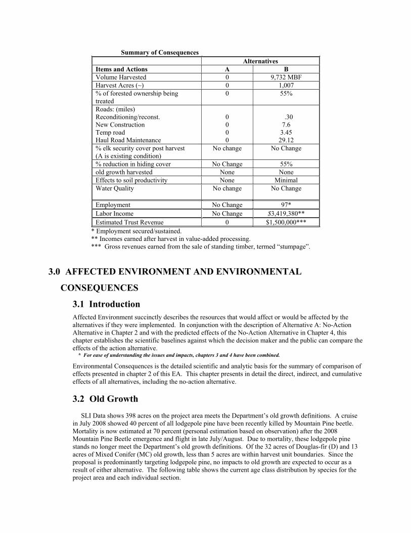
Summary of Consequences Alternatives Items and Actions A B Volume Harvested 0 9,732 MBF Harvest Acres (~) 0 1,007 % of forested ownership being treated
0 55%
Roads: (miles) Reconditioning/reconst. New Construction Temp road Haul Road Maintenance
0000
.30 7.6
3.45 29.12
% elk security cover post harvest (A is existing condition)
No change No Change
% reduction in hiding cover No Change 55% old growth harvested None None Effects to soil productivity None Minimal Water Quality No change No Change
Employment No Change 97*Labor Income No Change $3,419,380**Estimated Trust Revenue 0 $1,500,000***
* Employment secured/sustained. ** Incomes earned after harvest in value-added processing. *** Gross revenues earned from the sale of standing timber, termed “stumpage”.
3.0 AFFECTED ENVIRONMENT AND ENVIRONMENTAL
CONSEQUENCES
3.1 IntroductionAffected Environment succinctly describes the resources that would affect or would be affected by the alternatives if they were implemented. In conjunction with the description of Alternative A: No-Action Alternative in Chapter 2 and with the predicted effects of the No-Action Alternative in Chapter 4, this chapter establishes the scientific baselines against which the decision maker and the public can compare the effects of the action alternative. * For ease of understanding the issues and impacts, chapters 3 and 4 have been combined.
Environmental Consequences is the detailed scientific and analytic basis for the summary of comparison of effects presented in chapter 2 of this EA. This chapter presents in detail the direct, indirect, and cumulative effects of all alternatives, including the no-action alternative.
3.2 Old Growth
SLI Data shows 398 acres on the project area meets the Department’s old growth definitions. A cruise in July 2008 showed 40 percent of all lodgepole pine have been recently killed by Mountain Pine beetle. Mortality is now estimated at 70 percent (personal estimation based on observation) after the 2008 Mountain Pine Beetle emergence and flight in late July/August. Due to mortality, these lodgepole pine stands no longer meet the Department’s old growth definitions. Of the 32 acres of Douglas-fir (D) and 13 acres of Mixed Conifer (MC) old growth, less than 5 acres are within harvest unit boundaries. Since the proposal is predominantly targeting lodgepole pine, no impacts to old growth are expected to occur as a result of either alternative. The following table shows the current age class distribution by species for the project area and each individual section.
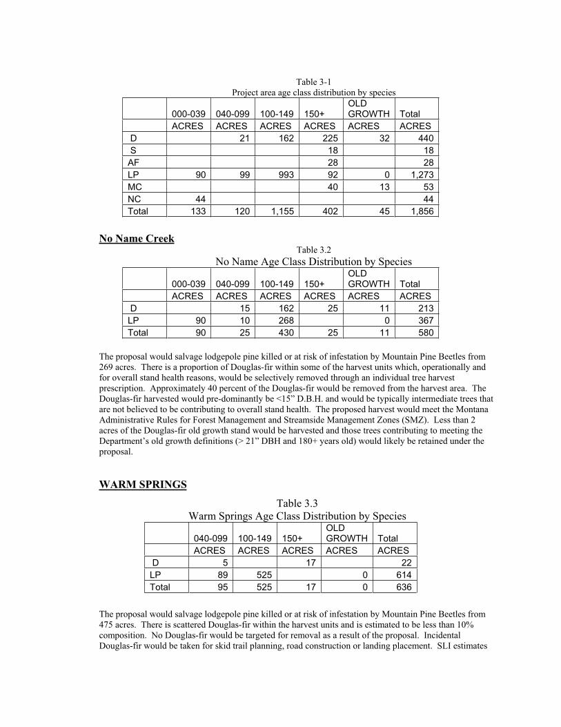
Table 3-1 Project area age class distribution by species
000-039 040-099 100-149 150+ OLDGROWTH Total
ACRES ACRES ACRES ACRES ACRES ACRES D 21 162 225 32 440 S 18 18 AF 28 28 LP 90 99 993 92 0 1,273 MC 40 13 53 NC 44 44 Total 133 120 1,155 402 45 1,856
No Name CreekTable 3.2
No Name Age Class Distribution by Species
000-039 040-099 100-149 150+ OLDGROWTH Total
ACRES ACRES ACRES ACRES ACRES ACRES D 15 162 25 11 213 LP 90 10 268 0 367 Total 90 25 430 25 11 580
The proposal would salvage lodgepole pine killed or at risk of infestation by Mountain Pine Beetles from 269 acres. There is a proportion of Douglas-fir within some of the harvest units which, operationally and for overall stand health reasons, would be selectively removed through an individual tree harvest prescription. Approximately 40 percent of the Douglas-fir would be removed from the harvest area. The Douglas-fir harvested would pre-dominantly be <15” D.B.H. and would be typically intermediate trees that are not believed to be contributing to overall stand health. The proposed harvest would meet the Montana Administrative Rules for Forest Management and Streamside Management Zones (SMZ). Less than 2 acres of the Douglas-fir old growth stand would be harvested and those trees contributing to meeting the Department’s old growth definitions (> 21” DBH and 180+ years old) would likely be retained under the proposal.
WARM SPRINGS
Table 3.3 Warm Springs Age Class Distribution by Species
040-099 100-149 150+ OLDGROWTH Total
ACRES ACRES ACRES ACRES ACRES D 5 17 22 LP 89 525 0 614 Total 95 525 17 0 636
The proposal would salvage lodgepole pine killed or at risk of infestation by Mountain Pine Beetles from 475 acres. There is scattered Douglas-fir within the harvest units and is estimated to be less than 10% composition. No Douglas-fir would be targeted for removal as a result of the proposal. Incidental Douglas-fir would be taken for skid trail planning, road construction or landing placement. SLI estimates

90 acres would likely have met the Department’s old growth definitions but due to mortality caused by MPB, there is no old growth present. A minor amount of trees would be removed from the SMZ and isolated wetlands found within the section. Live Douglas-fir trees, trees within the SMZ and isolated wetlands, and cull trees would be retained to meet the departments snag retention requirements (ARM 36.11.411). Some small patches (< .5 acres) may also be left to ensure retention requirements have been met.
BALDY MOUNTAIN
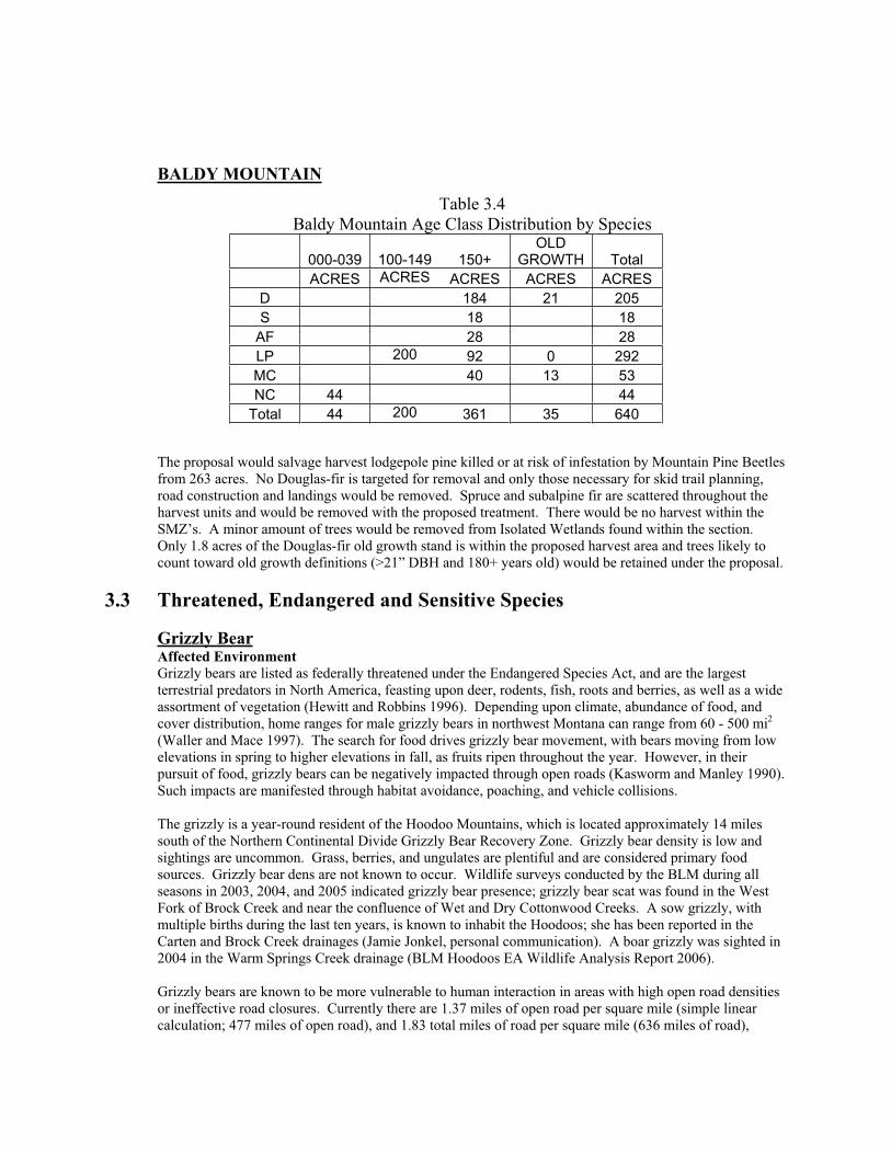
Table 3.4 Baldy Mountain Age Class Distribution by Species
000-039 100-149 150+ OLD
GROWTH Total ACRES ACRES ACRES ACRES ACRES
D 184 21 205 S 18 18
AF 28 28 LP 200 92 0 292 MC 40 13 53 NC 44 44
Total 44 200 361 35 640
The proposal would salvage harvest lodgepole pine killed or at risk of infestation by Mountain Pine Beetles from 263 acres. No Douglas-fir is targeted for removal and only those necessary for skid trail planning, road construction and landings would be removed. Spruce and subalpine fir are scattered throughout the harvest units and would be removed with the proposed treatment. There would be no harvest within the SMZ’s. A minor amount of trees would be removed from Isolated Wetlands found within the section. Only 1.8 acres of the Douglas-fir old growth stand is within the proposed harvest area and trees likely to count toward old growth definitions (>21” DBH and 180+ years old) would be retained under the proposal.
3.3 Threatened, Endangered and Sensitive Species
Grizzly Bear Affected Environment
Grizzly bears are listed as federally threatened under the Endangered Species Act, and are the largest terrestrial predators in North America, feasting upon deer, rodents, fish, roots and berries, as well as a wide assortment of vegetation (Hewitt and Robbins 1996). Depending upon climate, abundance of food, and cover distribution, home ranges for male grizzly bears in northwest Montana can range from 60 - 500 mi2(Waller and Mace 1997). The search for food drives grizzly bear movement, with bears moving from low elevations in spring to higher elevations in fall, as fruits ripen throughout the year. However, in their pursuit of food, grizzly bears can be negatively impacted through open roads (Kasworm and Manley 1990). Such impacts are manifested through habitat avoidance, poaching, and vehicle collisions.
The grizzly is a year-round resident of the Hoodoo Mountains, which is located approximately 14 miles south of the Northern Continental Divide Grizzly Bear Recovery Zone. Grizzly bear density is low and sightings are uncommon. Grass, berries, and ungulates are plentiful and are considered primary food sources. Grizzly bear dens are not known to occur. Wildlife surveys conducted by the BLM during all seasons in 2003, 2004, and 2005 indicated grizzly bear presence; grizzly bear scat was found in the West Fork of Brock Creek and near the confluence of Wet and Dry Cottonwood Creeks. A sow grizzly, with multiple births during the last ten years, is known to inhabit the Hoodoos; she has been reported in the Carten and Brock Creek drainages (Jamie Jonkel, personal communication). A boar grizzly was sighted in 2004 in the Warm Springs Creek drainage (BLM Hoodoos EA Wildlife Analysis Report 2006).
Grizzly bears are known to be more vulnerable to human interaction in areas with high open road densities or ineffective road closures. Currently there are 1.37 miles of open road per square mile (simple linear calculation; 477 miles of open road), and 1.83 total miles of road per square mile (636 miles of road),
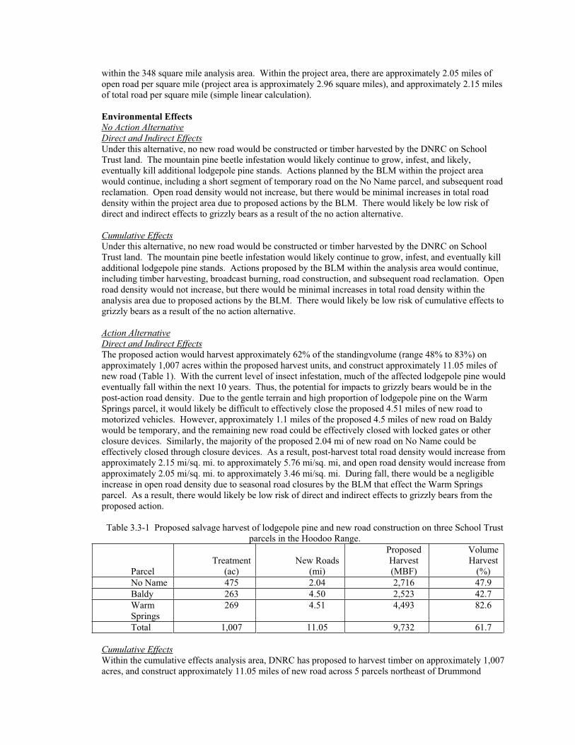
within the 348 square mile analysis area. Within the project area, there are approximately 2.05 miles of open road per square mile (project area is approximately 2.96 square miles), and approximately 2.15 miles of total road per square mile (simple linear calculation).
Environmental Effects No Action AlternativeDirect and Indirect EffectsUnder this alternative, no new road would be constructed or timber harvested by the DNRC on School Trust land. The mountain pine beetle infestation would likely continue to grow, infest, and likely, eventually kill additional lodgepole pine stands. Actions planned by the BLM within the project area would continue, including a short segment of temporary road on the No Name parcel, and subsequent road reclamation. Open road density would not increase, but there would be minimal increases in total road density within the project area due to proposed actions by the BLM. There would likely be low risk of direct and indirect effects to grizzly bears as a result of the no action alternative.
Cumulative EffectsUnder this alternative, no new road would be constructed or timber harvested by the DNRC on School Trust land. The mountain pine beetle infestation would likely continue to grow, infest, and eventually kill additional lodgepole pine stands. Actions proposed by the BLM within the analysis area would continue, including timber harvesting, broadcast burning, road construction, and subsequent road reclamation. Open road density would not increase, but there would be minimal increases in total road density within the analysis area due to proposed actions by the BLM. There would likely be low risk of cumulative effects to grizzly bears as a result of the no action alternative.
Action AlternativeDirect and Indirect EffectsThe proposed action would harvest approximately 62% of the standingvolume (range 48% to 83%) on approximately 1,007 acres within the proposed harvest units, and construct approximately 11.05 miles of new road (Table 1). With the current level of insect infestation, much of the affected lodgepole pine would eventually fall within the next 10 years. Thus, the potential for impacts to grizzly bears would be in the post-action road density. Due to the gentle terrain and high proportion of lodgepole pine on the Warm Springs parcel, it would likely be difficult to effectively close the proposed 4.51 miles of new road to motorized vehicles. However, approximately 1.1 miles of the proposed 4.5 miles of new road on Baldy would be temporary, and the remaining new road could be effectively closed with locked gates or other closure devices. Similarly, the majority of the proposed 2.04 mi of new road on No Name could be effectively closed through closure devices. As a result, post-harvest total road density would increase from approximately 2.15 mi/sq. mi. to approximately 5.76 mi/sq. mi, and open road density would increase from approximately 2.05 mi/sq. mi. to approximately 3.46 mi/sq. mi. During fall, there would be a negligible increase in open road density due to seasonal road closures by the BLM that effect the Warm Springs parcel. As a result, there would likely be low risk of direct and indirect effects to grizzly bears from the proposed action.
Table 3.3-1 Proposed salvage harvest of lodgepole pine and new road construction on three School Trust parcels in the Hoodoo Range.
ParcelTreatment
(ac)New Roads
(mi)
Proposed Harvest (MBF)
Volume Harvest
(%)No Name 475 2.04 2,716 47.9 Baldy 263 4.50 2,523 42.7 Warm Springs
269 4.51 4,493 82.6
Total 1,007 11.05 9,732 61.7
Cumulative EffectsWithin the cumulative effects analysis area, DNRC has proposed to harvest timber on approximately 1,007 acres, and construct approximately 11.05 miles of new road across 5 parcels northeast of Drummond
(Hoobert EA, MT DNRC, 2006), and the BLM has proposed a watershed management plan within the Hoodoos (Hoodoos Resource Management Projects EA, BLM, 2006; Table 3.3-2).
As discussed under direct and indirect effects, effective road closures could be implemented on the Baldy and No Name parcels, while it would be difficult to implement effective road closure, outside of the BLM’s seasonal road closure period, on the proposed new roads on Warm Springs. As a result, the proposed new road construction would likely result in an increase in seasonally open roads from approximately 1.37 mi/sq. mi. to approximately 1.38 mi/sq. mi. Proposed timber harvest would produce a short-term impact to grizzly bears due to increased sight distance, however, such action would likely improve hiding cover over time through tree regeneration. As a result, there may be a short term avoidance of the project area and nearby BLM treatments due to activity on the various projects, however, such activities would likely produce long term benefits for grizzly bears. Thus, there may be short term low risk of cumulative effects to grizzly bears from the proposed action.
Table 3.3-2 Summary of BLM Hoodoos Resource Management Projects. Type of Action Quantity Timber harvest & prescribed fire 675 ac. Prescribed burning 280 ac. Chipping, grinding, & prescribed burning 120 ac. Timber harvest & chipping 150 ac. Temporary road construction 10.5 mi. Permanent road construction 2.7 mi. Closure of permanent roads 0.9 mi.
Canada LynxAffected Environment Lynx are currently classified as threatened under the Endangered Species Act. In North America, lynx distribution and abundance is strongly correlated with snowshoe hares, their primary prey. Lynx foraging habitat has recently been characterized as having high horizontal cover, an abundance of shrub cover, large diameter trees during winter, and is typically in spruce-fir forest (Vinkey 2003). Typically, lynx inhabit early- to mid-successional lodgepole pine, subalpine fir, and Engelmann spruce forest. For denning sites, the primary component appears to be large woody debris, in the form of down logs, root wads, and rock piles (Koehler 1990) surrounded by high horizontal cover (Vinkey 2003, Squires and Laurion 2000, Mowat et al. 2000). These den sites are usually in mature, mesic forests on northeast aspects. Lynx also den along the edges of regenerating forests where trees have blown down into jackstrawed piles of woody debris (Vinkey 2003, Ruediger et al. 2000).
The lynx was historically present in the Hoodoo Mountains, but disappeared from the area years ago due to human pressures related to trapping and habitat modification. The lynx is currently considered transient and does not inhabit the area year-round. Lynx snow tracks and sightings are occasionally reported, but reports are thought to be dispersing sub-adults passing through the area (BLM Hoodoos EA Wildlife Analysis Report 2006). Elevations in the project area range from 5,640 to 7,511 feet, and approximately 613 acres of suitable habitat occur in the project area. There are approximately 184 acres of mature foraging, 6 acres of mapped denning/mature foraging habitat, 14 acres of young foraging, and approximately 409 acres of mapped other lynx habitat (SLI database 20080908 version). An isolated 16 acre patch of other lynx habitat occurs within the No Name parcel; five disjunct patches of other lynx habitat, totaling 136 acres occur throughout the Warm Springs parcel; and the remaining 461 acres of lynx habitat occurs as a solid block within the Baldy parcel. Snowshoe hares are important lynx prey and are associated with dense young lodgepole pine stands, as well as mature stands with subalpine fir understories. An approximately 44,165 acre analysis area was developed for lynx that encompassed Hoodoos Mountain and coincided with lynx habitat identified in the BLM Hoodoos EA (2006: Cottonwood and Gallagher LAUs Hoodoos Mountain map). Within this analysis area, there are approximately 15,383 acres of lynx habitat on BLM land, and approximately 957 acres on DNRC land. Finally, within the analysis area approximately 27,983 acres are managed by BLM, 12,121 acres by private lands, 2,960 acres by DNRC, and 1,048 by Stimson Timber Lands.
Environmental Effects No Action AlternativeDirect and Indirect EffectsUnder this alternative, no new road would be constructed or timber harvested by the DNRC on School Trust land. The mountain pine beetle infestation would likely continue to expand and likely, eventually kill additional lodgepole pine stands. Actions proposed by the BLM within the project area would continue, including a short segment of temporary road on the No Name parcel, and subsequent road reclamation. Where advanced regeneration is present, current mature foraging habitat would likely be converted to young foraging habitat due to mountain pine beetle-induced tree deaths. Where such conditions are absent, current “other” lynx habitat would likely be converted to temporary non-lynx habitat, until the forest regenerates. As a result, there would likely be a conversion of approximately 190 acres of mature foraging habitat to young foraging habitat, and approximately 409 acres of other lynx habitat converted to temporary non-lynx habitat. Under these base line conditions, there would likely be low to moderate risk of direct and indirect fragmentation of Canada lynx habitat within the project area.
Cumulative EffectsWithin the analysis area patch size and juxtaposition of forage and den habitat, and connectivity to other areas has been compromised due to private land timber harvest. This particularly affects lynx habitat on the Warm Springs parcel as half of its adjacent parcels are private land and have been heavily harvested. Additionally, the BLM has proposed treatments on ten parcels that provide connectivity among the School Trust parcels, and the analysis area is currently experiencing a widespread infestation of mountain pine beetles in lodgepole pine. Thus, a large portion (cannot currently be quantified because aerial detection surveys have not been conducted over the analysis area since 2005) of the analysis area would be affected by beetles, BLM action, or past timber harvest on private lands. As a result, there would likely be conversion of currently suitable habitat, which does not contain advanced regeneration, to unsuitable habitat. Where advanced regeneration is present in spruce/subalpine fir habitat types, there would likely be conversion from mature foraging to young foraging habitat, with potential den sites once lodgepole pine fall. Thus, there may be low to moderate risk of cumulative effects to Canada lynx habitat and further habitat fragmentation with the no action alternative.
Action AlternativeDirect and Indirect EffectsOf the approximately 613 acres of suitable lynx habitat in the project area, the proposed action would treat approximately 346 of those acres, with substantive mitigations on the Baldy parcel to minimize fragmentation and maintain a habitat corridor. Within the Baldy parcel’s approximately 461 acres of suitable lynx habitat, the proposed action would treat approximately 244 acres, while: 1) maintaining a NW-to-SE corridor of mature foraging and other lynx habitat outside of the harvest units that would connect habitat on adjoining BLM parcels; and 2) provide for islands of advanced regeneration inside the harvest units that would provide snowshoe hare habitat in proximity to similar habitat on nearby BLM parcels (Fig. 3.3-a). Within the islands of advanced regeneration: 1) where roads bisect the patches, retention areas would be within 100 yards of each other near the road to promote movement among patches by hares; 2) mechanical harvesting of the overstory would occur, thereby converting the patch from mature foraging to young foraging habitat; 3) skid trails would be identified and implemented on a 50-ft interval; and 4) slashing and burning would not occur within these patches. Post-harvest, areas of advanced regeneration throughout the harvest units on Baldy are expected to have lower snowshoe hare densities due to the reduced stem density resulting from trampling by equipment. The proposed mitigation units for advanced regeneration would likely serve as a refugia for affected snowshoe hares while providing potential foraging habitat for lynx within the proposed harvest units (Ausband and Baty 2005). As the mountain pine beetle infestation progresses, the proposed corridor would likely experience habitat changes as well, with lodgepole pines dying, eventually falling, and shifts in habitat evolving from mature foraging to other or young foraging lynx habitat. Given the proposed actions and concurrent habitat changes due to the mountain pine beetle infestation, effects of the proposed action and mitigations would likely not differ substantially from those in the no action alternative which would be low to moderate risk of direct and indirect fragmentation of Canada lynx habitat within the project area as a result of the proposed action..
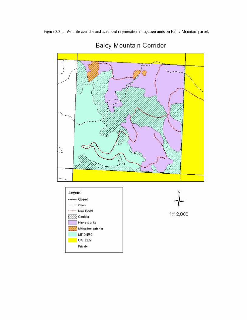
Figure 3.3-a. Wildlife corridor and advanced regeneration mitigation units on Baldy Mountain parcel.
Cumulative EffectsWithin the analysis area patch size and juxtaposition of forage and den habitat, and connectivity to other area has been compromised due to private land timber harvest. This particularly affects lynx habitat on the Warm Springs parcel as half of its adjacent parcels are private land and have been heavily harvested. Additionally, the BLM has proposed treatments on ten parcels that provide connectivity among the School Trust parcels, and the analysis area is currently experiencing a widespread infestation of mountain pine beetles in lodgepole pine. Thus, a large portion (cannot currently be quantified because aerial detection surveys have not been conducted over the analysis area since 2005) of the analysis area would be affected by beetles, BLM action, or past timber harvest on private lands. The proposed action would maintain habitat connectivity for lynx across the Baldy parcel, even if current mature foraging habitat in the corridor would be converted to young foraging habitat due to the effects of the beetle infestation. Approximately 95 of the approximately 136 acres of lynx habitat would be harvested on the Warm Springs parcel. Because the Warm Springs lynx habitat patches are disjunct, the proposed timber harvesting would not further fragment any existing corridor on the parcel. Rather, the proposed action would reduce the area covered by each patch and isolate them in a clearcut matrix, much like habitat on adjacent private lands. The proposed action would further reduce the amount of suitable lynx habitat, but not beyond changes expected under the no action alternative. Additionally, extant habitat corridors are proposed to be maintained under the action alternative. While the proposed action would convert approximately 346 acres of currently suitable lynx habitat to unsuitable, it would likely not exceed changes expected under the no action alternative. Thus, there would likely be low to moderate risk of cumulative effects to Canada lynx habitat and further fragmentation under the proposed action.
Gray Wolf Affected Environment Wolves north of Highway 12 west of Missoula and north of Interstate 90 were recently re-classified as endangered under the Endangered Species Act. Vegetative cover and road and prey densities likely have some influence on wolves. Wolf activity has been documented in the area by a pair of biologists, through direct observation or tracks. For cumulative effects analysis, the analysis area encompasses the current extent of the grizzly bear analysis area. Open road density within the cumulative effects analysis area is approximately 1.37 miles of open road per square mile (simple linear calculation; approximately 477 miles of open road). Currently, no known wolf den or rendezvous site is known to be located within 1 mile of the project area.
Environmental Effects No Action AlternativeDirect and Indirect EffectsNo change from current conditions would be expected under the no action alternative.
Cumulative EffectsNo change from current conditions would be expected under the no action alternative.
Action AlternativeDirect and Indirect EffectsOver the course of field preparations for this project, wolf tracks have been encountered by DNRC personnel, and wolves have been encountered by BLM personnel (J. Sparks, BLM wildlife biologist, personal communication, November 2008). The proposed action would increase open road density from approximately 2.05 mi/sq. mi. to approximately 3.46 mi/sq. mi., and through timber harvest, would make prey more vulnerable to wolf predation due to increased sight distances within the project area. Should a den or rendezvous site be located within one mile of the project area, a DNRC wildlife biologist would be consulted to develop appropriate mitigations and implement ARM 36.11.430 for conservation of such sites. As a result, there would likely be low risk of direct and indirect effects to gray wolf denning or rendezvous sites from the proposed action.
Cumulative EffectsAs previously discussed, there currently are no known den or rendezvous sites within a one mile radius of the proposed action. Should one be discovered within this area, a DNRC wildlife biologist would be
consulted to develop appropriate mitigations and implement ARM 36.11.430 for conservation of such sites. As a result, there would likely be low risk of cumulative effects to gray wolf denning or rendezvous sites from the proposed action.
Pileated Woodpecker Affected Environment The pileated woodpecker is one of the largest woodpeckers in North America (15-19 inches in length), feeding primarily on carpenter ants (Camponotus spp.) and woodboring beetle larvae (Bull and Jackson 1995). The pileated woodpecker nests and roosts in larger diameter snags, typically in mature to old-growth forest stands (Bull et al. 1992, McClelland et al. 1979). Due primarily to its large size, pileated woodpeckers require nest snags averaging 29 inches dbh, but have been known to nest in snags as small as 15 inches dbh in Montana (McClelland 1979). Pairs of pileated woodpeckers excavate 2-3 snags for potential nesting sites each year (Bull and Jackson 1995). Snags used for roosting are slightly smaller, averaging 27 inches dbh (Bull et al. 1992). Overall, McClelland (1979) found pileated woodpeckers to nest and roost primarily in western larch, ponderosa pine, and black cottonwood. The primary prey of pileated woodpeckers, carpenter ants, tend to prefer western larch logs with a large end diameter greater than 20 inches (Torgersen and Bull 1995). Thus, pileated woodpeckers generally prefer western larch and ponderosa pine snags > 15 inches dbh for nesting and roosting, and would likely feed on downed larch logs with a large end diameter greater than 20 inches.
The most abundant habitat type (Pfister et al. 1977) within the affected area is Douglas-fir/dwarf huckleberry (Stand Level Inventory database). Within the affected parcels, there are approximately 172 acres with an average stand diameter approximately 15 inches dbh that would be considered suitable pileated woodpecker habitat (crown cover > 40%; SLI database). The cumulative effects analysis area will encompass the project area and a one mile radius surrounding it. Initial cruise data from June 2008 indicated that 40% of lodgepole pine within the project area had been affected by mountain pine beetle. Subsequent beetle flights have increased the proportion of lodgepole pine affected by the infestation.
Environmental Effects No Action AlternativeDirect and Indirect EffectsAs previously discussed, the affected parcels have been heavily impacted by a mountain pine beetle infestation that has been killing mature lodgepole pine on the project area and the Hoodoo Range. As of June 2008, the infestation had impacted approximately 44 of the approximately 172 acres of pileated woodpecker habitat in the project area. As a result, canopy closure < 40% is expected, which would reduce the suitability of the stands for nesting by this species. However, there would be a large pulse of lodgepole pine snags, and eventually coarse woody debris, which could be used for foraging sites. The resulting stands may be of reduced value to pileated woodpeckers and increase their vulnerability to predation by avian predators. Thus, this alternative would likely have low to moderate risk of direct and indirect effects to pileated woodpecker habitat.
Cumulative EffectsApproximately 23% of the analysis area has been impacted by past timber harvest. Digital data for the mountain pine beetle infestation in 2007 and 2008 were not available to assess current infestation levels. As such, there have been reductions in canopy closure due to infestations in mature lodgepole pine within the analysis area, and possibly mortality in a portion of these stands. Under this alternative, within potential pileated woodpecker habitat there would likely be a mosaic of new snags, and possibly entire stands that have succumbed to the infestation. As such, the effects of the infestation would increase the habitat potential of some stands, while reducing the potential of others. Therefore, the no action alternative may have minimal to moderate risk of cumulative effects to pileated woodpecker habitat within the analysis area.
Action AlternativeDirect and Indirect EffectsThe proposed action would treat 52 acres of the approximately 172 acres of suitable pileated woodpecker habitat within the project area. As such, recruitment of snags and coarse woody debris that could be used
for potential nest and foraging sites, would be greatly reduced compared to the no action alternative, as ARMs 36.11.411 and 414 would be implemented. Although the habitat suitability for the affected stands would be greatly reduced, due to reduced canopy closure, under the no action alternative, it would still retain valuable habitat features (i.e., more snags and downed wood) that could eventually be used by this species. However, reduction in snag and downed wood retention under the proposed action may reduce pileated woodpecker vulnerability to avian predators because this species may not utilize the post-harvest stands. As a result, there may not be a difference in the range of effects to pileated woodpeckers from either alternative. The proposed action would likely result in low to moderate risk of direct and indirect effects to pileated woodpeckers.
Cumulative EffectsGiven the effects of the mountain pine beetle infestation, and previous timber harvest on private lands within the rest of the analysis area (see No Action Alternative Cumulative Effects discussion), and that the proposed action would treat approximately 30% of the suitable pileated woodpecker habitat within the project area, the commensurate reduction in potential pileated woodpecker habitat, due to the proposed treatment, would likely result in low to moderate risk of cumulative effects to pileated woodpecker habitat within the analysis area.
Flammulated OwlAffected Environment The flammulated owl is a tiny forest owl that inhabits warm-dry ponderosa pine and cool-dry Douglas-fir forests in the western United States and is a secondary cavity nester. Nest trees in 2 Oregon studies were 22-28 inches dbh (McCallum 1994). Habitats used have open to moderate canopy closure (30 to 50%) with at least 2 canopy layers, and are often adjacent to small clearings. It subsists primarily on insects and is considered a sensitive species in Montana. Periodic underburns may contribute to increasing habitat suitability for flammulated owls because low intensity fires would reduce understory density of seedlings and saplings, while periodically stimulating shrub growth. Within the project area there are approximately 1,362 acres of flammulated owl preferred habitat types. Initial cruise data from June 2008 indicated that 40% of lodgepole pine within the project area had been affected by mountain pine beetle. Subsequent beetle flights have increased the proportion of lodgepole pine affected by the infestation.
Environmental Effects No Action AlternativeDirect, Indirect, and Cumulative EffectsThe mountain pine beetle infestation would reduce canopy closure, create legacy lodgepole pine snags, and likely spur forest regeneration through the openings in the overstory that they create. Depending on the extent of the overstory mortality, the effects for flammulated owls could be variable under this alternative. In stands with limited to moderate overstory mortality, flammulated owl habitat could be improved within 15 years, provided forest regeneration occurs in the new openings. Stands that might experience more extensive mortality may suffer reductions in habitat suitability for this species, or may serve more as foraging areas. Thus, there may be minimal to low risk of direct, indirect, or cumulative effects for flammulated owls as a result of this alternative.
Action AlternativeDirect, Indirect, and Cumulative EffectsThe proposed action would treat approximately 738 of the approximately 1,362 acres of flammulated owl preferred habitat types within the project area. Post-harvest, some treatment areas would resemble clearcuts with reserves, while still others may resemble seed tree harvests with reserves. The resulting stands will likely have limited value for flammulated owls for 40 to 60 years post-harvest. However, large patches of flammulated owl preferred habitat types would remain unaffected by the proposed harvest, whereby snags would be recruited through the mountain pine beetle infestation in mixed species stands. The likely result would be increases in habitat suitability for this species in stands unaffected by the proposed harvest. As a result, there would likely be low to moderate risk of direct, indirect, or cumulative effects for flammulated owls as a result of the proposed action.
FisherAffected Environment The fisher is a medium-sized animal belonging to the weasel family. Fishers prefer dense, lowland spruce-fir forests with high canopy closure, and avoid forests with little overhead cover and open areas (Powell 1978, Powell 1977, Kelly 1977, Clem 1977, Coulter 1966). For resting and denning, fishers typically use hollow trees, logs and stumps, brush piles, and holes in the ground (Coulter 1966, Powell 1977).
Fishers may inhabit the Hoodoos, however, reports from state carnivore surveys have not recorded their presence. Thus, fishers may be transient species, rather than a resident, of the Hoodoos. A visit to the Baldy parcel by field personnel after a recent snow encountered a set of fisher tracks (M. McGrath, SWLO Wildlife Biologist, personal observation 2 September 2008).
Within a 1-mile radius of the project area, there are approximately 7,324 acres of fisher preferred habitat types, with approximately 1,171 acres on the affected parcels. Initial cruise data from June 2008 indicated that 40% of lodgepole pine within the project area had been affected by mountain pine beetle. Subsequent beetle flights have increased the proportion of lodgepole pine affected by the infestation.
Environmental Effects No Action AlternativeDirect and Indirect EffectsThe project area has been heavily impacted (>40% of lodgepole pine had been infested in June 2008) by a mountain pine beetle infestation that has been killing mature lodgepole pine on the project area and areas primarily south of Hwy 200. This infestation has impacted approximately 667 of the approximately 1,171 acres of potential fisher habitat in the project area. As a result, canopy closure < 40% is expected, which would reduce the suitability of the stands for this species. However, there would be a large pulse of lodgepole pine snags, and eventually coarse woody debris, which could be used for den and resting sites. The resulting stands may be of reduced value for fishers until mature stands can be re-established (approximately 60 years). Thus, this alternative would likely have low to moderate risk of direct and indirect effects to fishers.
Cumulative EffectsThe mountain pine beetle infestation has reduced canopy closure in many mixed species stands containing lodgepole pine, and would likely reduce canopy closure to near zero in pure lodgepole pine stands. Under this alternative, within potential fisher habitat there would likely be a mosaic of new snags, and likely entire stands that have succumbed to the infestation. As such, the effects of the infestation would increase the habitat potential of some stands, while reducing the potential of others. Therefore, the no action alternative may have low to moderate risk of cumulative effects to potential fisher habitat within the analysis area.
Action AlternativeDirect and Indirect EffectsThe proposed action would treat approximately 667 acres of the approximately 1,171 acres of potential fisher habitat within the project area. As such, recruitment of snags and coarse woody debris that could be used for potential den and resting sites, would be greatly reduced compared to the no action alternative, as ARMs 36.11.411 and 414 would be implemented. Although the habitat suitability for the affected stands would be greatly reduced, due to reduced canopy closure, under the no action alternative, it would still retain valuable habitat features (i.e., more snags and downed wood) that could eventually be used by this species. Additionally, there would be substantive mitigations on the Baldy parcel to minimize fragmentation and maintain a habitat corridor. A NW-to-SE corridor of mixed species habitat outside of the harvest units would be used to connect habitat on adjoining BLM parcels (Fig. 1). As the mountain pine beetle infestation progresses, the proposed corridor would likely experience habitat changes as well, with lodgepole pines dying, eventually falling, and shifts in habitat evolving from to include more snags and coarse woody debris. Given the proposed actions and concurrent habitat changes due to the mountain pine beetle infestation, effects of the proposed action and mitigations would likely not differ substantially from those in the no action alternative: low to moderate risk of direct and indirect fragmentation of fisher habitat within the project area.
Cumulative EffectsWithin the analysis area patch size and juxtaposition of fisher habitat, and connectivity to other areas has been compromised due to private land timber harvest. This particularly affects fisher habitat on the Warm Springs and Baldy parcels, as half of their adjacent parcels are private land and have been heavily harvested. Additionally, the BLM has proposed treatments on ten parcels that provide connectivity among the School Trust parcels, and the analysis area is currently experiencing a widespread infestation of mountain pine beetles in lodgepole pine. Thus, a large portion (cannot currently be quantified because aerial detection surveys have not been conducted over the analysis area since 2005) of the analysis area would be affected by beetles, BLM action, or past timber harvest on private lands. The proposed action would maintain habitat connectivity for fishers across the Baldy parcel, even if current habitat in the corridor would be converted to unsuitable habitat due to the effects of the beetle infestation. The proposed action would further reduce the amount of suitable fisher habitat, but not beyond changes expected under the no action alternative. Additionally, extant habitat corridors are proposed to be maintained under the action alternative. While the proposed action would convert approximately 667 acres of fisher preferred habitat types to unsuitable, it would likely not exceed changes expected under the no action alternative. Additionally, applicable portions of ARM 36.11.440 would be implemented where applicable. Thus, there would likely be low to moderate risk of cumulative effects to fisher habitat and further fragmentation under the proposed action.
Sharp-shinned HawkAffected Environment The sharp-shinned hawk is a forest habitat generalist whose primary prey consists of small songbirds (e.g., thrushes, warblers, and sparrows; approximately 70%) and small mammals (Johnsgard 1990). Sharp-shinned hawk nesting habitat is typically in younger forest stands, but may vary in average stand diameter (range: 4” to 11” dbh) and average tree height (range: 28 ft to 89 ft; (Siders and Kennedy 1996, Siders and Kennedy 1994, Moore and Henny 1983, Reynolds et al. 1982). In general, the sharp-shinned hawk will prey on species that inhabit all forest seral stages, and seems adaptable in its nesting habitat requirements. Two potential sharp-shinned hawk nests were located on the Baldy parcel after sighting of an adult sharp-shinned hawk (M. McGrath, SWLO Wildlife Biologist, personal observation, 26 August 2008). However, no sign of use of the nests were observed (M. McGrath, SWLO Wildlife Biologist, personal observation).
The analysis area for the sharp-shinned hawk is 5,007 acres in size. Within the analysis area, approximately 1,201 acres have been harvested on adjacent private and BLM land. Thus, approximately 3,806 acres of the analysis area (approximately 76%) have forested stands with canopy closure >50%. Much of the forested area within the project area could be used by sharp-shinned hawks for either foraging or nesting habitat.
Environmental Effects No Action AlternativeDirect and Indirect EffectsUnder the no action alternative, the proposed timber harvest would not occur on the Baldy parcel, and the mountain pine beetle infestation would continue to grow and affect lodgepole pine on the parcel. As a result, approximately 403 acres of lodgepole pine would likely suffer a large degree of mortality and eventually become snags and then coarse woody debris. While in a state of decay, these habitat features would likely provide habitat for woodpeckers and other cavity nesting birds. However, the loss of live canopy would reduce the availability of canopy nesting birds, thrushes, and warblers. As a result, there would likely be moderate to high risk of direct and indirect effects to a nesting pair of sharp-shinned hawks on the Baldy parcel from this alternative.
Cumulative EffectsWithin the analysis area, the approximately 403 acres of lodgepole pine on the Baldy parcel, and approximately 2,497 acres of lodgepole pine on adjacent BLM lands, in addition to the approximately 160 acres of planned timber harvest on the BLM’s section 22, would all likely be affected by mountain pine beetles or planned timber harvest. Thus, approximately 3,060 acres of the approximately 3,806 acres within the analysis area that have forested stands with canopy closure >50% may experience habitat change
within the next 5 years. As a result, much of the analysis area’s suitability for sharp-shinned hawks may be compromised under the no action alternative, largely due to the mountain pine beetle infestation. Thus, there would likely be moderate to high risk of cumulative effects to a nesting pair of sharp-shinned hawks on the Baldy parcel under this alternative.
Action AlternativeDirect and Indirect EffectsThe proposed action would harvest approximately 2.5 MMBF on approximately 263 acres on the Baldy parcel, while retaining approximately 135 acres of lodgepole pine. In the short term, the proposed harvest would produce clearcuts with reserves that would have little value for this species. However, the resulting mix of regenerated lodgepole pine in the proposed harvest area, approximately 135 acres with lodgepole pine snags and live Douglas-fir, subalpine fir, and spruce, and approximately 237 acres unaffected by the beetles or proposed action, would provide diverse habitats and prey species for nesting sharp-shinned hawks in the future. As a result, the proposed action may in the long term improve conditions for this species due to accelerated forest regeneration. Therefore, the proposed action may only have moderate risk of direct and indirect effects to a nesting pair of sharp-shinned hawks on the Baldy parcel.
Cumulative EffectsThe proposed action would treat approximately 268 acres within the analysis area. Given the aforementioned approximately 2,497 acres of lodgepole pine on adjacent BLM lands that are either currently infested or subject to infestation by mountain pine beetles, and the planned harvest of approximately 160 acres on the BLM’s section 22, a substantial amount of the remaining 3,806 acres of forested stands with canopy closure >50% could undergo habitat change within the next five years. The benefit of the proposed harvest is that forest regeneration would likely be accelerated on the treated acres, thereby providing habitat for ground and shrub nesting birds that could be a prey source for sharp-shinned hawks. It is likely that much of the analysis area’s suitability for sharp-shinned hawks may be compromised under either alternative, largely due to the mountain pine beetle infestation. Thus, there would likely be moderate to high risk of cumulative effects to a nesting pair of sharp-shinned hawks on the Baldy parcel under this alternative.
3.4 Water Quality
Affected Environment Analysis AreasThe analysis areas were designated using 6th code HUC scale or smaller watershed boundaries. The Baldy section is located in the Upper Clark Fork – Brock Creek drainage (HUC 170102010804) and the Warm Springs sections are located in the Upper Clark Fork – Warm Springs Creek drainage (HUC 170102010803) drainage. The No Name section lies within the Blackfoot River – Upper Nevada Creek (HUC 170102030407) drainage.
Initially eight adjacent watershed analysis areas were identified for this water resource assessment. However, three of the areas that are small parts of the Baldy project section, 1) Upper Hoover Creek (30 acres DNRC ownership), 2)Upper Wet Cottonwood Creek (19 acres DNRC ownership), and 3)Gallager Creek in the No-Name section (20 acres DNRC ownership) are dismissed from further analysis for the following reasons: (1) the minor extent of DNRC ownership, and (2) the proposed harvest units are on moderate slopes that are stable and temporary roads have low risk of off-site erosion and locations are not adjacent to streams or sites were sediment delivery could affect water quality. There are not expected to be any potential adverse impacts associated with the limited actions in the three dismissed analysis areas. The five analysis areas included in this assessment are; Brock Creek, Upper Warm Springs Creek and the western portion of Upper Nevada Creek watershed that includes No Name Creek, East Fork Braziel Creek, and Indian Creek, (see figure 3.4.1).
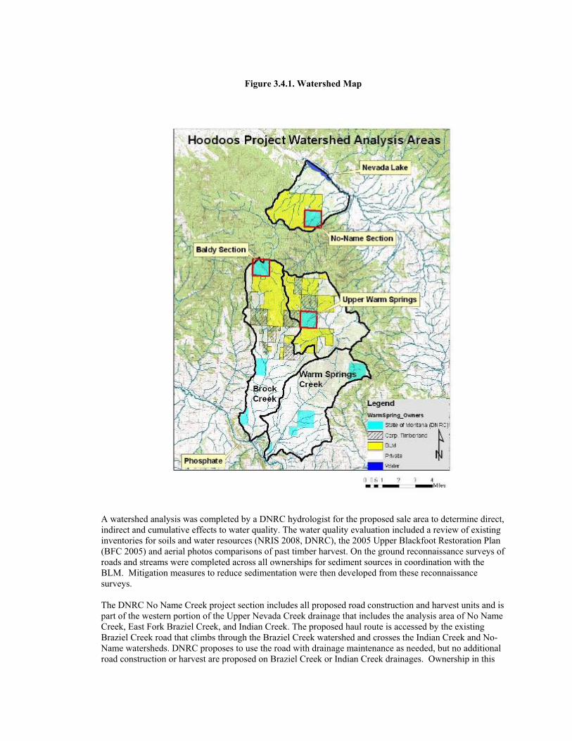
Figure 3.4.1. Watershed Map
A watershed analysis was completed by a DNRC hydrologist for the proposed sale area to determine direct, indirect and cumulative effects to water quality. The water quality evaluation included a review of existing inventories for soils and water resources (NRIS 2008, DNRC), the 2005 Upper Blackfoot Restoration Plan (BFC 2005) and aerial photos comparisons of past timber harvest. On the ground reconnaissance surveys of roads and streams were completed across all ownerships for sediment sources in coordination with the BLM. Mitigation measures to reduce sedimentation were then developed from these reconnaissance surveys.
The DNRC No Name Creek project section includes all proposed road construction and harvest units and is part of the western portion of the Upper Nevada Creek drainage that includes the analysis area of No Name Creek, East Fork Braziel Creek, and Indian Creek. The proposed haul route is accessed by the existing Braziel Creek road that climbs through the Braziel Creek watershed and crosses the Indian Creek and No-Name watersheds. DNRC proposes to use the road with drainage maintenance as needed, but no additional road construction or harvest are proposed on Braziel Creek or Indian Creek drainages. Ownership in this
drainage is a mixture noted in table W1 and DNRC forestlands represents a relatively small portion (8.7%) of this 7089 acre analysis area. No-Name Creek originates in springs at the headwaters within the DNRC section and flows east through a narrow canyon. Elevations in the analysis area range from 4600 feet at Nevada Lake to 6800 feet just west of the DNRC No-Name section. Average annual precipitation at the mouth of the creek are nearly desert conditions of 13 inches/yr supporting grasslands, and rises to a moderate 27inches/yr near the peak, occurring mainly as snow. Braziel Creek, Indian Creek and No-Name creek share similarities of volcanic bedrock with clay-rich soils in swales and concave slopes. The steep gradient streams and shallow soils can lead to flashy flow response during high precipitation events that exceed infiltration rates such as summer thunderstorms as indicated at the USGS gauging station on Nevada Creek above the lake.
The DNRC Baldy project section includes all proposed road construction and harvest units and is located at the headwaters of the Brock Creek drainage. Ownership in this drainage is a mixture as noted in table 3.4.2 and is comprised of both forest and rangelands on DNRC ownership represents a relatively small portion (7.9%) of the Brock Creek watershed. Brock Creek is a 3rd order stream that originates in springs at the headwaters below Old Baldy Mountain. The Brock Creek watershed including the East and West Forks of Brock Creek is 15,847 acres in size. Elevations in the Brock Creek watershed range from 4000 feet near Phosphate, MT to 7511 feet at Old Baldy Mountain. Average annual precipitation at the mouth of the creek near Phosphate is near desert conditions of 13 inches/yr supporting grasslands, and rises to a moderate 27inches/yr near the peak, occurring mainly as snow. Infiltration rates exceed most precipitation rates on these dry sites. The shallow soils can lead to flashy flow response in the perennial reaches during summer thunderstorms. There are several bedrock contacts and limestone sinks where stream segment go subsurface and flow is not connected in the upper drainage.
The DNRC Warm Springs project section includes all proposed road construction and harvest units and is located at the headwaters, referred to here as the Upper Warm Springs drainage. The upper watershed is 10,512 acres in size. Ownership in this drainage is a mixture as noted in table W1 and DNRC forestlands represents a relatively small portion (5.9%) of the Upper Warm Springs watershed. Upper Warm Springs Creek is a 3rd order stream that originates in springs at headwaters within the DNRC section and flows southeast through a narrow limestone canyon. Elevations in the watershed range from 4000 feet at the canyon above the mine to 6900 feet at Windy Rock Mountain. Average precipitation at the mouth of the creek near Phosphate is near desert conditions of 13 inches/yr supporting grasslands, and rises to a moderate 27inches/yr near the peak, occurring mainly as snow. The shallow soils can lead to flashy flow response during summer thunderstorms. Bedrock contacts and limestone sinks in the canyon divide the upper basin from the lower Warm Springs watershed and the stream goes subsurface during summer months.
Table 3.4.2 – Land Ownership within the project area watersheds
Land Ownership within the project watersheds
Brock Creek Upper Warm Springs No-Name (Braziel, Indian, No-
Name parts of Nevada Creek) Ownership Acres % Acres % Acres % BLM 3707 23.4 3867 36.8 3200 45.3 Corp. Timberlands & Private Lands 10885 68.7 6026 57.3 3270 46 State of Montana (DNRC) 1255 7.9 619 5.9 619 8.7 Total Acres 15847 100.0 10512 100 7089 100
Water Quality & Regulations
Nevada Creek downstream of the East Fork Braziel Creek, Indian Creek, and No Name Creek analysis areas (Figure 3.4.1) and Brock Creek including West Fork Brock Creek and East Fork and mainstem Brock Creek analysis areas are identified on the 2006 Montana 303(d) list as impaired waterbodies (see table 3.4.3). These impaired stream reaches are described as not fully supporting aquatic life and cold water fisheries, but no probable sources of the impairment are listed relative to the activities in the analysis areas.
East Fork Braziel Creek and Warm Springs Creek within the Upper Warm Springs Creek analysis area are also identified on the 2006 Montana 303(d) list as impaired waterbodies. These impaired stream reaches are described as not fully supporting aquatic life and cold water fisheries. Probable sources of impairment include impacts to streamside vegetation and sedimentation, which may be associated with related past, existing or proposed activities in the project area.
All the watershed areas listed in this report are classified as B-1 in the Montana Surface Water Quality Standards. The water quality standards for protecting beneficial uses in B-1 classified watersheds are described in ARM 17.30.623. The B-1 classification is for multiple use waters suitable for; domestic use after conventional treatment, growth and propagation of cold-water fisheries, associated aquatic life and wildlife, agricultural, and industrial uses. Other criteria for B-1 waters include; no increases are allowed above naturally occurring concentrations of sediment, which will prove detrimental to fish or wildlife and a maximum 1 degree Fahrenheit increase above naturally occurring water temperature is allowed within the range of 32 to 66 degrees Fahrenheit. Naturally occurring includes conditions or materials present from runoff or percolation on developed land, where all reasonable land, soil, and water conservation practices have been applied. Reasonable practices include methods, measures, or practices that protect present and reasonably anticipated beneficial uses. The State has adopted Forestry Best Management Practices through its Non-point Source Management Plan as the principle means of controlling non-point source pollution from silvicultural activities. Stream temperatures are discussed in detail in the fisheries section.
Table 3.4.3
A Total Max Daily Load (TMDL) analysis and restoration plan has been completed for the Nevada Creek watershed. Nevada Creek and its tributaries have a moderate priority for restoration. TMDL recommendations include improving fish passage and reducing sedimentation through implementation of Best Management Practices (BMPs) on land management projects. Within the Brock Creek and Warm Springs Creek watersheds, there are water quality impacts due to historic mining, sediment from roads that do not meet BMP’s and grazing impacts on stream channels.
No water rights or developments are listed within the state sections. Downslope beneficial uses in the watersheds described include: recreation, cold-water fisheries, agriculture, irrigation, wildlife and livestock watering.
Water Quality status of the streams on the Montana 303(d) list of impaired waterbodies in the analysis areas ( MTDEQ, 2006) Analysis Areas
Stream Segment Beneficial Uses Support and TMDL Status
Baldy Section
Brock Creek MT76G005-100 Headwaters to mouth. Drains Baldy Mtn. and includes Brock Creek access road to Baldy Mtn. & Warm Springs project sections
Full support of DWS, AG, IND. Partial support of PCR due to siltation from unidentified source(s). Other uses have not been not assessed. TMDL required. One or more uses are impaired
Upper Warm Springs
Warm Springs Creek MT76G005-111 Headwaters to R9W|R10W line.
Full support of DWS, AG, IND. Partial support of CWF, AL due to habitat alteration, riparian degradation, and siltation from roads,silviculture. TMDL required. One or more uses are impaired.
Braziel Creek MT76F003-040 From mouth to 2.8 miles upstream.
PCR, AG, IND, fully supported. Other uses not assessed. TMDL completed as part of the Middle Blackfoot River Area.
No-Name (Up Nevada Cr, west of Nevada Res.) No Name Creek & Indian Creek Not on 303(d) List.
DWS (Drinking Water Supply), PCR (Primary Contact Recreation), CWF (Cold Water Fishery), AL (Aquatic Life), AG (Agricultural), IND (Industrial),
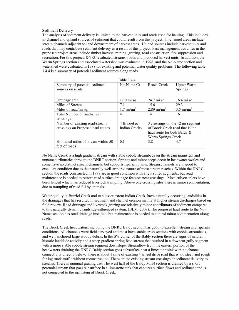
Sediment Delivery The analysis of sediment delivery is limited to the harvest units and roads used for hauling. This includes in-channel and upland sources of sediment that could result from this project. In-channel areas include stream channels adjacent to- and downstream of harvest areas. Upland sources include harvest units and roads that may contribute sediment delivery as a result of this project. Past management activities in the proposed project areas include timber harvest, mining, grazing, road construction, fire suppression and recreation. For this project, DNRC evaluated streams, roads and proposed harvest units. In addition, the Warm Springs section and associated watershed was evaluated in 1998, and the No-Name section and watershed were evaluated in 1988 for existing and potential water quality problems. The following table 3.4.4 is a summary of potential sediment sources along roads
Table 3.4.4 Summary of potential sediment sources on roads
No-Name Cr Brock Creek Upper Warm Springs
Drainage area 11.0 mi sq 24.7 mi sq 16.4 mi sq Miles of Stream 7.1 15.6 29.3 Miles of road/mi sq. 1.7 mi/mi2 2.89 mi/mi2 3.5 mi/mi2
Total Number of road-stream crossings
4 14 16
Number of existing road-stream crossings on Proposed haul routes
4 Braziel & Indian Creeks
3 crossings on the 12 mi segment of Brock Creek road that is the haul route for both Baldy & Warm Springs Creek.
Estimated miles of stream within 50 feet of roads
0.1 3.8 4.7
No Name Creek is a high gradient stream with stable cobble streambeds on the stream mainstem and unnamed tributaries through the DNRC section. Springs and minor seeps occur in headwater swales and some have no distinct stream channels, but supports riparian plants. Stream channels are in good to excellent condition due to the naturally well-armored nature of most stream reaches. Within the DNRC section the roads constructed in 1998 are in good condition with a few rutted segments, but road maintenance is needed to restore road surface drainage features near crossings. Most culvert inlets have been fenced which has reduced livestock trampling. Above one crossing sites there is minor sedimentation, due to trampling of road fill by animals.
Water quality in Braziel Creek and to a lesser extent Indian Creek, have naturally occurring landslides in the drainages that has resulted in sediment and channel erosion mainly at higher stream discharges based on field review. Road drainage and livestock grazing are relatively minor contributors of sediment compared to this naturally dynamic landslide-influenced system. (BLM 2008). The proposed haul route to the No-Name section has road drainage installed, but maintenance is needed to control minor sedimentation along roads.
The Brock Creek headwaters, including the DNRC Baldy section has good to excellent stream and riparian conditions. All channels were field surveyed and most have stable cross sections with cobble streambeds, and well anchored large woody debris. In the SW corner of the Baldy section there are signs of natural historic landslide activity and a steep gradient spring feed stream that resulted in a downcut gully segment with a more stable cobble stream segment downslope. Streamflow from the eastern portion of the headwaters draining the DNRC Baldy section goes subsurface near a limestone sink with no channel connectivity directly below. There is about 1 mile of existing 4 wheel drive road that is too steep and rough for log truck traffic without reconstruction. There are no existing stream crossings or sediment delivery to streams. There is minimal grazing use. The west half of the Baldy MTN section is drained by a short perennial stream that goes subsurface in a limestone sink that captures surface flows and sediment and is not connected to the mainstem of Brock Creek.
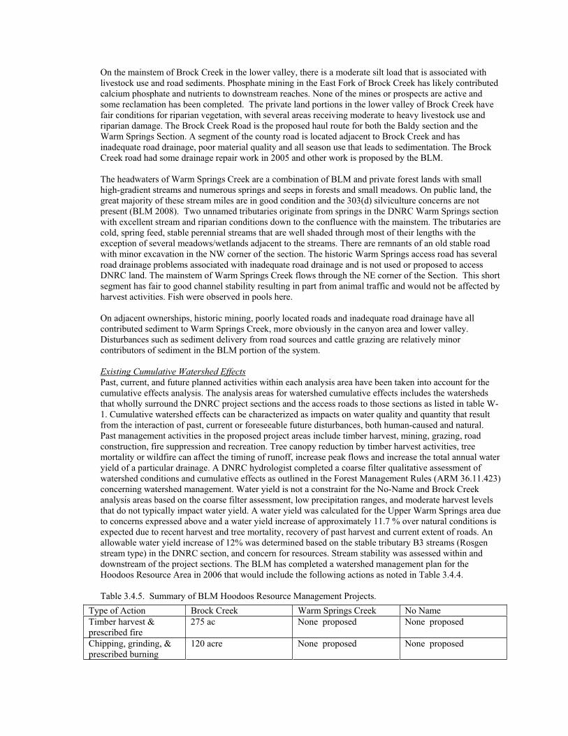
On the mainstem of Brock Creek in the lower valley, there is a moderate silt load that is associated with livestock use and road sediments. Phosphate mining in the East Fork of Brock Creek has likely contributed calcium phosphate and nutrients to downstream reaches. None of the mines or prospects are active and some reclamation has been completed. The private land portions in the lower valley of Brock Creek have fair conditions for riparian vegetation, with several areas receiving moderate to heavy livestock use and riparian damage. The Brock Creek Road is the proposed haul route for both the Baldy section and the Warm Springs Section. A segment of the county road is located adjacent to Brock Creek and has inadequate road drainage, poor material quality and all season use that leads to sedimentation. The Brock Creek road had some drainage repair work in 2005 and other work is proposed by the BLM.
The headwaters of Warm Springs Creek are a combination of BLM and private forest lands with small high-gradient streams and numerous springs and seeps in forests and small meadows. On public land, the great majority of these stream miles are in good condition and the 303(d) silviculture concerns are not present (BLM 2008). Two unnamed tributaries originate from springs in the DNRC Warm Springs section with excellent stream and riparian conditions down to the confluence with the mainstem. The tributaries are cold, spring feed, stable perennial streams that are well shaded through most of their lengths with the exception of several meadows/wetlands adjacent to the streams. There are remnants of an old stable road with minor excavation in the NW corner of the section. The historic Warm Springs access road has several road drainage problems associated with inadequate road drainage and is not used or proposed to access DNRC land. The mainstem of Warm Springs Creek flows through the NE corner of the Section. This short segment has fair to good channel stability resulting in part from animal traffic and would not be affected by harvest activities. Fish were observed in pools here.
On adjacent ownerships, historic mining, poorly located roads and inadequate road drainage have all contributed sediment to Warm Springs Creek, more obviously in the canyon area and lower valley. Disturbances such as sediment delivery from road sources and cattle grazing are relatively minor contributors of sediment in the BLM portion of the system.
Existing Cumulative Watershed Effects Past, current, and future planned activities within each analysis area have been taken into account for the cumulative effects analysis. The analysis areas for watershed cumulative effects includes the watersheds that wholly surround the DNRC project sections and the access roads to those sections as listed in table W-1. Cumulative watershed effects can be characterized as impacts on water quality and quantity that result from the interaction of past, current or foreseeable future disturbances, both human-caused and natural. Past management activities in the proposed project areas include timber harvest, mining, grazing, road construction, fire suppression and recreation. Tree canopy reduction by timber harvest activities, tree mortality or wildfire can affect the timing of runoff, increase peak flows and increase the total annual water yield of a particular drainage. A DNRC hydrologist completed a coarse filter qualitative assessment of watershed conditions and cumulative effects as outlined in the Forest Management Rules (ARM 36.11.423) concerning watershed management. Water yield is not a constraint for the No-Name and Brock Creek analysis areas based on the coarse filter assessment, low precipitation ranges, and moderate harvest levels that do not typically impact water yield. A water yield was calculated for the Upper Warm Springs area due to concerns expressed above and a water yield increase of approximately 11.7 % over natural conditions is expected due to recent harvest and tree mortality, recovery of past harvest and current extent of roads. An allowable water yield increase of 12% was determined based on the stable tributary B3 streams (Rosgen stream type) in the DNRC section, and concern for resources. Stream stability was assessed within and downstream of the project sections. The BLM has completed a watershed management plan for the Hoodoos Resource Area in 2006 that would include the following actions as noted in Table 3.4.4.
Table 3.4.5. Summary of BLM Hoodoos Resource Management Projects. Type of Action Brock Creek Warm Springs Creek No Name Timber harvest & prescribed fire
275 ac None proposed None proposed
Chipping, grinding, & prescribed burning
120 acre None proposed None proposed
The proposed BLM harvest is small in scale relative to the watershed areas and designed to mimic natural disturbances while retaining 50-75% of larger class Douglas-fir and 90-100% of larger ponderosa pine. The proposed harvest would not increase water yield above the natural range of variability. The BLM determined the proposed road construction and harvest presents would be unlikely to produce cumulative effects to hydrology.
In the Upper Warm Springs basin the mainstem stream channel stability is fair to good. In 1998, DNRC proposed approximately 300 acres of green harvest in the Upper Warm Springs drainage. As part of that proposed harvest in 1998, DNRC deferred action due to the poor road drainage condition of the Warm Springs lower canyon road segment, costly repairs needed to meet BMP’s, potential for water yield increases with green harvest and concern for the presence of fish.
Since our last assessment in 1998, DNRC acquired a new right of way to avoid the old lower road and portions of the older road system have been stabilized with water bars and several draw bottom roads abandoned which has reduced traffic associated sedimentation. A comparison of photos and site notes of 1998 with 2008 found little change in stream channel stability with high cobble/gravel bedload movement apparent during high stream discharge, and there is not a marked change in stability. The channel conditions are in part due to flood damage following the high runoff winter of 1997. As in Brock Creek, this area also has several limestone sink-holes which capture or isolate surface flow. The proposed haul route for this proposal would use the Brock Creek road and enter the Warm Springs drainage from the west and would not use the problematic lower Warm Springs road system.
The DNRC Warm Springs Creek and Baldy sections have not been harvested. There is extensive lodgepole pine with a high level of insect mortality that is expected to affect 90% or more of the lodgepole. Mountain Pine Beetle infestations have caused extensive tree mortality and associated loss of tree canopy, evapo-transpiration potential and snow interception. The current tree mortality is expected to increase water yield consistent with historic conditions of episodic insect mortality, but less or similar to a severe wildfire. The combination of moderate precipitation (avg. 25”/yr.) and well-drained soils allows for rapid water infiltration on most mountain sideslopes and surface runoff is unlikely except on bare soils or during very high precipitation events.
Stream channels in the DNRC project sections are in good to excellent condition, stable and functioning properly as discussed above. Normal sediment loads are being transported and the banks are well vegetated and stable. A trend towards more extensive infestations or possibly wildfire could considerably reduce tree canopy and may increase water yield in the future. A severe wildfire with canopy loss and burning of the forest litter layer would increase runoff and reflect the extreme in natural conditions that would promote even age re-growth of lodgepole pine and associated changes in hydrologic regime. Trees that may survive the insect damage will be suppressed, generally in poor health and not intercept or transpire moisture equivalent with healthy forest stands.
Environmental Effects Direct, Indirect, and Cumulative Effects of the No- Action Alternative on Water Quality and QuantityNo direct, indirect or cumulative effects to water quality or quantity would be expected to result other than those described under Existing Conditions. Sedimentation on existing roads would continue. Continued insect mortality or wildfire may increase runoff and water yield relative to increasing canopy loss.
Direct and Indirect Effects of the Action Alternative on Water Quality and Quantity
Timber harvest & chipping
150 acre None proposed None proposed
Temporary road construction
2 mi 2 .5 mi
Permanent road construction
1.4 mi Completed 1.3 mi None proposed
Culvert replacement 2
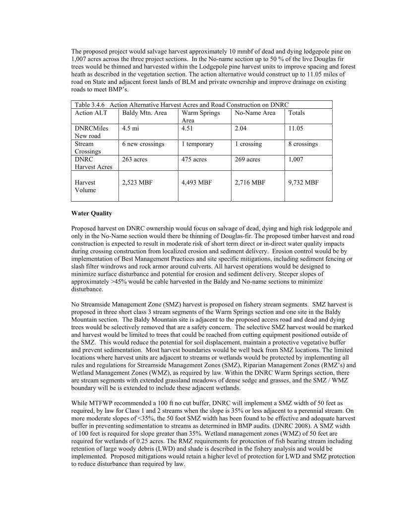
The proposed project would salvage harvest approximately 10 mmbf of dead and dying lodgepole pine on 1,007 acres across the three project sections. In the No-name section up to 50 % of the live Douglas fir trees would be thinned and harvested within the Lodgepole pine harvest units to improve spacing and forest heath as described in the vegetation section. The action alternative would construct up to 11.05 miles of road on State and adjacent forest lands of BLM and private ownership and improve drainage on existing roads to meet BMP’s.
Table 3.4.6 Action Alternative Harvest Acres and Road Construction on DNRC Action ALT Baldy Mtn. Area Warm Springs
AreaNo-Name Area Totals
DNRCMilesNew road
4.5 mi 4.51 2.04 11.05
Stream Crossings
6 new crossings 1 temporary 1 crossing 8 crossings
DNRCHarvest Acres
263 acres 475 acres 269 acres 1,007
Harvest Volume
2,523 MBF 4,493 MBF 2,716 MBF 9,732 MBF
Water Quality
Proposed harvest on DNRC ownership would focus on salvage of dead, dying and high risk lodgepole and only in the No-Name section would there be thinning of Douglas-fir. The proposed timber harvest and road construction is expected to result in moderate risk of short term direct or in-direct water quality impacts during crossing construction from localized erosion and sediment delivery. Erosion control would be by implementation of Best Management Practices and site specific mitigations, including sediment fencing or slash filter windrows and rock armor around culverts. All harvest operations would be designed to minimize surface disturbance and potential for erosion and sediment delivery. Steeper slopes of approximately >45% would be cable harvested in the Baldy and No-name sections to minimize disturbance.
No Streamside Management Zone (SMZ) harvest is proposed on fishery stream segments. SMZ harvest is proposed in three short class 3 stream segments of the Warm Springs section and one site in the Baldy Mountain section. The Baldy Mountain site is adjacent to the proposed access road and dead and dying trees would be selectively removed that are a safety concern. The selective SMZ harvest would be marked and harvest would be limited to trees that could be reached from cutting equipment positioned outside of the SMZ. This would reduce the potential for soil displacement, maintain a protective vegetative buffer and prevent sedimentation. Most harvest boundaries would be well back from SMZ locations. The limited locations where harvest units are adjacent to streams or wetlands would be protected by implementing all rules and regulations for Streamside Management Zones (SMZ), Riparian Management Zones (RMZ’s) and Wetland Management Zones (WMZ), as required by law. Within the DNRC Warm Springs section, there are stream segments with extended grassland meadows of dense sedge and grasses, and the SMZ / WMZ boundary will be is extended to include these adjacent wetlands.
While MTFWP recommended a 100 ft no cut buffer, DNRC will implement a SMZ width of 50 feet as required, by law for Class 1 and 2 streams when the slope is 35% or less adjacent to a perennial stream. On more moderate slopes of <35%, the 50 foot SMZ width has been found to be effective and adequate harvest buffer in preventing sedimentation to streams as determined in BMP audits. (DNRC 2008). A SMZ width of 100 feet is required for slope greater than 35%. Wetland management zones (WMZ) of 50 feet are required for wetlands of 0.25 acres. The RMZ requirements for protection of fish bearing stream including retention of large woody debris (LWD) and shade is described in the fishery analysis and would be implemented. Proposed mitigations would retain a higher level of protection for LWD and SMZ protection to reduce disturbance than required by law.
The action alternative would construct up to 11.05 miles of road and 8 stream crossing. Road maintenance and reconstruction would also improve drainage on existing roads where there are chronic sources of sediment and to implement all applicable BMP’s. Most new road construction would be located on moderate grades of stable hillsides and present low risk of sediment delivery to stream. The proposed roads in the Warm Springs section would be primarily on slopes less than 25% and involve minimal excavation, and while there is some potential increase in runoff from roads, it would be minor compared to the drainage areas involved. A summary of mitigations that would be implemented with the action include: 1) design of low standard temporary roads to minimize excavation, 2) temporary roads would be stabilized with drainage features, ripped to promote water infiltration and grass seeded to speed revegetation 3) as recommended by the MTFWP, a temporary culvert crossing would be installed on the Warm Springs Section which is the only crossing where fish may be temporarily affected. The temporary culvert would be in place for the shortest period possible during summer/fall and removed before winter and the channel profile restored and revegetated. All crossing sites would be designed and constructed to control erosion and minimize sedimentation. All roads would have adequate drainage installed and be grass seeded where soils are disturbed.
DNRC proposes a combined action with the BLM to restore road surface drainage on the Brock Creek access road and install adequate road drainage and rock/gravel surfacing on selected road segments where surface erosion and sediment delivery to Brock Creek are a chronic problem. This proposed maintenance and improved drainage on existing roads would reduce erosion and sediment sources along the Brock Creek and Braziel Creek roads. We expect a minor and short term pulse of sediment could occur during the crossing installations on the Baldy and Warm Springs project areas. During culvert installation, all requirements of 124 permit and erosion control measures (slash filter windrows, seeding) would be implemented, consistent with BMP’s to minimize erosion.
Stream bank erosion and sediment delivery at a crossing site in the No-Name Section would be reduced using sediment fencing at culvert inlet and slash barriers as appropriate. Temporary roads would be tilled/ripped and all roads would be grass seeded where soils are disturbed.
The combination of road drainage improvements would reduce chronic erosion and sediment sources and improve water quality compared to no-action. The action alternative should provide a long term reduction in stream sedimentation and improve water quality, but is dependent on continued maintenance. For all these listed reasons, there is low risk of direct or indirect impacts to water quality or downslope beneficial uses within the affected watershed.
Cumulative Effects Watershed of the Action Alternative on Water Quality and QuantityWithin the cumulative effects analysis area, DNRC has proposed to harvest timber on approximately 1,007 acres, and construct approximately 11.05 miles of new road across parcels in 3 watersheds. The proposed action includes measures of sediment reduction combined with minimal water yield increases which present low risk of cumulative impacts to water quality or beneficial uses. The BLM proposed harvest of roughly 545 acres in the Brock Creek drainage is discussed in the existing cumulative effects. The Baldy section presents low risk of cumulative hydrologic effects considering there has been no previous harvest in the section. There is low potential for water yield increase above levels of mortality; the project is in moderate precipitation zone and that more than half of the section drains to a limestone sink where the water goes subsurface.
The potential for increase in water yield resulting from the proposed harvest presents a moderate risk of low impacts, compared to no-action. Within the Upper Warm Springs Creek drainage, the action alternative will salvage harvest dead, dying and high risk lodgepole pine trees and retain live Douglas –fir trees. The proposed new road construction would very slightly increase water yield by approximately 0.1 % and the total WYI of 11.7 would still be less than the allowable 12% WYI. The combined action of DNRC and BLM proposals represent less than 5% of the Upper Warm Springs watershed and has low risk of increasing water yield compared to the no-action alternative and natural ranges associated with disturbances such as fire.
There is low risk of cumulative watershed impacts due to water and sediment yield increases occurring from this harvest proposal due to the following reasons: 1) the low to moderate precipitation zone (25”/yr) provides low runoff and subsoil moisture is typically at a deficit, 2) stream channels have excellent stability and will remain stable with low increased flows and removal of dead and dying trees. Most stream channels on the DNRC project sections are in excellent condition based on channel evaluations, and 3) the small area of the Upper Warm Springs Creek watershed analysis area would not noticeably increase water yield compared to the no-action of leaving dead and suppressed trees with lost canopy interception and evapotranspiration. The harvest with the action alternative would speed the regeneration of younger more actively growing trees that would intercept and transpire more water and lead to faster hydrologic recovery of the area within approximately 35 years.
Within the No-Name Creek drainage the action alternative is mainly salvage harvest of dead, dying and high risk lodgepole pine tree. Within the same harvest units, up to 50% of Douglas-fir trees would be harvested to improve spacing and promote healthy co-dominant trees. There is low risk of cumulative watershed impacts due to water and sediment yield increases occurring from this harvest proposal due to the following reasons. The moderate precipitation zone (25”/yr), low to moderate level of additional canopy removal, and small area of the No-Name creek watershed analysis area would not noticeably increase water yield compared to the no-action of leaving dead and suppressed trees with lost canopy interception and evapotranspiration. No SMZ harvest is proposed on No Name Creek, which would provide a non-harvest buffer to streams and source for additional large woody debris and shade to the stream network.
Mitigations for Protection of Water quality and soils* DNRC would implement all applicable BMP’s, Montana Administrative Rules for Forest Management and reasonable mitigation and erosion control practices during timber harvest, road maintenance, road construction and road use activities
* DNRC would locate, clearly mark and maintain suitable water resource protection boundaries including Streamside Management Zones (SMZ’s), Riparian Management Zones (RMZ’s), and Wetland Management Zones (WMZ’s) adjacent to streams and wetlands consistent with State Forest Land Management rules.
*The logger and sale administrator would agree to a general skidding plan prior to equipment operations on complex terrain or draw crossings. Ground based skidding would be limited to slopes of 45% or less.
* Limit equipment operations to periods when soils are relatively dry, frozen or snow covered to minimize soil rutting, compaction and maintain drainage features.
* On moderate to densely stocked stands, whole tree skidding can reduce slash hazard, but also remove a portion of nutrients from growing sites. Target coarse woody debris levels are to retain 5-15 tons/acre well distributed on site while meeting the requirements of the slash law. On the rock outcrop sites with lower basal area, retain large woody debris as feasible since it may not be possible to retain 5 tons/acre and the emphasis will be on providing additional CWD in the future.
* Existing road segments would be improved and maintained in association with the harvest activities. Road improvements would include installation of drainage features to prevent surface erosion and sediment delivery to the stream, ditching to improve road surface stability, gravel surfacing of selected segments to protect water quality and surface blading.
* Portions of existing roads that have inadequate drainage and do not comply with BMP's will be reconstructed to improve drainage control and erosion and should have adequate drainage maintained dur-ing use.
*Road use will be limited to dry or frozen ground conditions to reduce rutting and erosion. New road con-struction, including drainage features must be completed in the fall prior to freeze-up. Check snow/frozen ground conditions prior to operations.
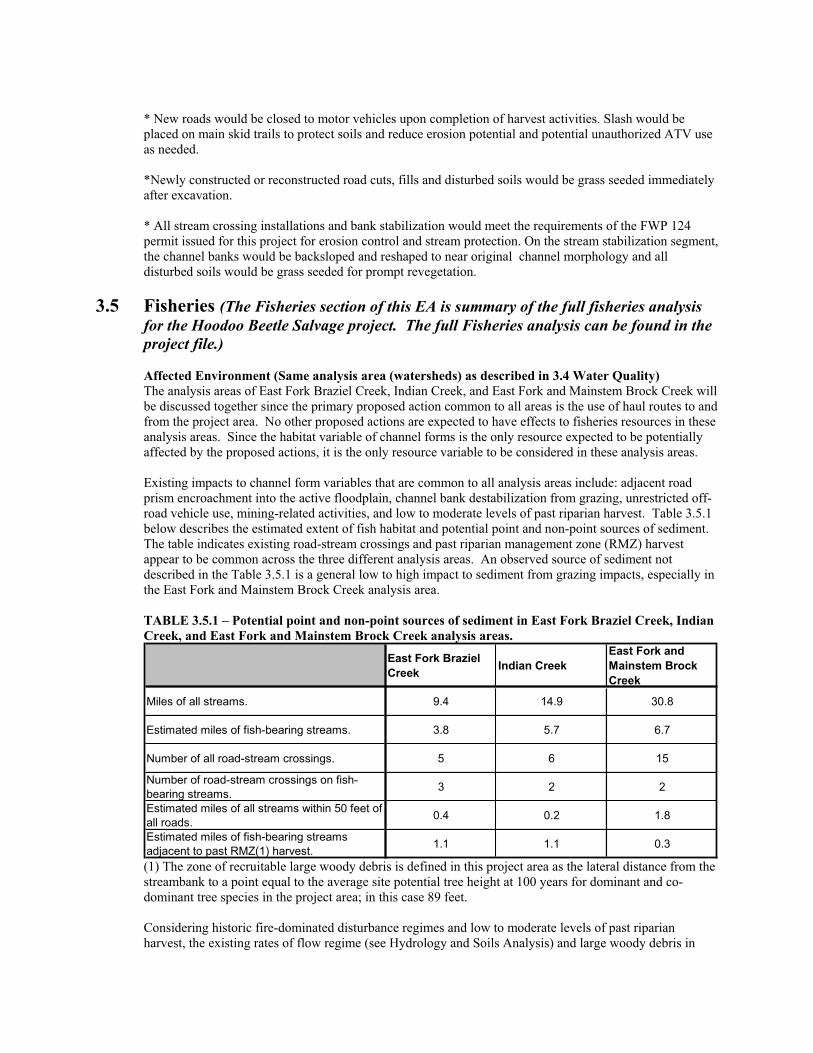
* New roads would be closed to motor vehicles upon completion of harvest activities. Slash would be placed on main skid trails to protect soils and reduce erosion potential and potential unauthorized ATV use as needed.
*Newly constructed or reconstructed road cuts, fills and disturbed soils would be grass seeded immediately after excavation.
* All stream crossing installations and bank stabilization would meet the requirements of the FWP 124 permit issued for this project for erosion control and stream protection. On the stream stabilization segment, the channel banks would be backsloped and reshaped to near original channel morphology and all disturbed soils would be grass seeded for prompt revegetation.
3.5 Fisheries (The Fisheries section of this EA is summary of the full fisheries analysis for the Hoodoo Beetle Salvage project. The full Fisheries analysis can be found in the project file.)
Affected Environment (Same analysis area (watersheds) as described in 3.4 Water Quality) The analysis areas of East Fork Braziel Creek, Indian Creek, and East Fork and Mainstem Brock Creek will be discussed together since the primary proposed action common to all areas is the use of haul routes to and from the project area. No other proposed actions are expected to have effects to fisheries resources in these analysis areas. Since the habitat variable of channel forms is the only resource expected to be potentially affected by the proposed actions, it is the only resource variable to be considered in these analysis areas.
Existing impacts to channel form variables that are common to all analysis areas include: adjacent road prism encroachment into the active floodplain, channel bank destabilization from grazing, unrestricted off-road vehicle use, mining-related activities, and low to moderate levels of past riparian harvest. Table 3.5.1 below describes the estimated extent of fish habitat and potential point and non-point sources of sediment. The table indicates existing road-stream crossings and past riparian management zone (RMZ) harvest appear to be common across the three different analysis areas. An observed source of sediment not described in the Table 3.5.1 is a general low to high impact to sediment from grazing impacts, especially in the East Fork and Mainstem Brock Creek analysis area.
TABLE 3.5.1 – Potential point and non-point sources of sediment in East Fork Braziel Creek, Indian Creek, and East Fork and Mainstem Brock Creek analysis areas.
East Fork Braziel Creek Indian Creek
East Fork and Mainstem Brock Creek
Miles of all streams. 9.4 14.9 30.8
Estimated miles of fish-bearing streams. 3.8 5.7 6.7
Number of all road-stream crossings. 5 6 15
Number of road-stream crossings on fish-bearing streams. 3 2 2
Estimated miles of all streams within 50 feet of all roads. 0.4 0.2 1.8
Estimated miles of fish-bearing streams adjacent to past RMZ(1) harvest. 1.1 1.1 0.3
(1) The zone of recruitable large woody debris is defined in this project area as the lateral distance from the streambank to a point equal to the average site potential tree height at 100 years for dominant and co-dominant tree species in the project area; in this case 89 feet.
Considering historic fire-dominated disturbance regimes and low to moderate levels of past riparian harvest, the existing rates of flow regime (see Hydrology and Soils Analysis) and large woody debris in

fish habitats of both analysis areas are likely to be within the expected ranges of variability. Potential impacts to sediment from streambank instability exacerbated by increased water yields were not observed to be outside the expected range of variability (see Hydrology and Soils Analysis).
The existing conditions of sediment, flow regime, and large woody debris variables contribute to a collective, low to moderate impact to channel forms in the East Fork Braziel Creek and Indian Creek analysis areas, which is primarily due to existing impacts to sediment. A moderate existing impact to channel forms occurs in the East Fork and Mainstem Brock Creek analysis area, which is also primarily due to existing impacts to sediment (see sources above).
Other impacts not related to the proposed project actions to be considered as part of the subsequent cumulative effects assessment include impacts to (1) populations, (2) stream temperatures, and (3) connectivity at the various road-stream crossings. Native westslope cutthroat trout and sculpin populations may be severely impacted by nonnative fish through competitive displacement and predation of juvenile fish. However, the exact status of fish species composition is uncertain in some parts of the analysis areas, and actual existing impacts to populations may range from none to high. Minor levels of past riparian harvest have occurred on adjacent ownerships in all analysis areas, and this activity is expected to have an existing low impact to stream shading and temperature. Fish habitat connectivity at road-stream crossings may be limited from minor passage impairments to complete barriers. However, the exact existing status of fish species composition is uncertain in some parts of the analysis areas, and fish passage barriers may in some cases be beneficial to native westslope cutthroat trout. Existing impacts to connectivity may therefore range from low to high.
NO NAME CREEK, WEST FORK BROCK CREEK, AND UPPER WARM SPRINGS CREEK ANALYSIS AREAS
The analysis areas of No Name Creek, West Fork Brock Creek, and Upper Warm Springs Creek will be discussed together since the primary proposed actions common to all areas is project-level timber harvest and the use of haul routes to and from the project area.
Existing impacts to channel form variables that are common to all analysis areas include: adjacent road prism encroachment into the active floodplain, channel bank destabilization from grazing, unrestricted off-road vehicle use, mining-related activities, and low to moderate levels of past riparian harvest. Table 3.5.2 below describes the estimated extent of fish habitat and potential point and non-point sources of sediment. The table indicates existing road-stream crossings and riparian management zone (RMZ) harvest appear to be common across the three different analysis areas. An observed source of sediment not described in the Table 3.5.2 is a general low to moderate impact to sediment from grazing impacts.
TABLE 3.5.2 – Potential point and non-point sources of sediment in No Name Creek, West Fork Brock Creek, and Upper Warm Springs Creek analysis areas.
No Name Creek West Fork Brock Creek
Upper Warm Springs Creek
Miles of all streams. 7.1 15.6 29.3
Estimated miles of fish-bearing streams. 3.0 7.3 9.3
Number of all road-stream crossings. 3 14 16
Number of road-stream crossings on fish-bearing streams. 0 4 7
Estimated miles of all streams within 50 feet of all roads. 0.1 1.3 3.2
Estimated miles of fish-bearing streams adjacent to past RMZ harvest. 0.1 3.8 4.7
Considering historic fire-dominated disturbance regimes and low to moderate levels of past riparian harvest, the existing rates of flow regime (see Hydrology and Soils Analysis) and large woody debris in
fish habitats of both analysis areas are likely to be within the expected ranges of variability. Potential impacts to sediment from streambank instability exacerbated by increased water yields were not observed to be outside the expected range of variability (see Hydrology and Soils Analysis).
The existing conditions of sediment, flow regime, and large woody debris variables contribute to a collective, low to moderate impact to channel forms in all analysis areas, which is primarily due to existing impacts to sediment (see sources above).
For practical purposes the zone of vegetation that is considered to have the greatest affect on stream shading in headwater streams in the project area is also generally confined to the area within the lateral extent of the average site potential tree height; in this case 89 feet. Although many different variables affect the natural fluctuations and ranges of stream temperatures (e.g. groundwater inflows, loss of flow, stream gradient, stream width to depth ratio, volume, beaver activity), stream shading is the variable that typically has the greatest effect on stream temperatures in valley-bottom, headwater streams and is also the variable most likely affected by management activities. As described above, low to moderate levels of past riparian harvest have occurred in all analysis areas, and this activity is expected to have an existing low impact to stream shading and temperature.
Other impacts not related to the proposed project actions to be considered as part of the subsequent cumulative effects assessment include impacts to (1) populations, (2) stream temperatures, and (3) connectivity at the various road-stream crossings. Native westslope cutthroat trout and sculpin populations may be severely impacted by nonnative fish through competitive displacement and predation of juvenile fish. However, the exact status of fish species composition is uncertain in some parts of the analysis areas, and actual existing impacts to populations may range from none to high. Minor levels of past riparian harvest have occurred in all analysis areas, and this activity is expected to have an existing low impact to stream shading and temperature. Fish habitat connectivity at road-stream crossings may be limited from minor passage impairments to complete barriers. However, the exact existing status of fish species composition is uncertain in some parts of the analysis areas, and fish passage barriers may in some cases be beneficial to native westslope cutthroat trout. Existing impacts to connectivity may therefore range from low to high.
Environmental Effects Direct and Indirect Effects of the No-Action Alternative to Fisheries No direct or indirect effects are expected to fisheries resources in the East Fork Braziel Creek, Indian Creek, and East Fork and Mainstem Brock Creek analysis areas beyond those described in the Existing Conditions.
Direct and Indirect Effects of the Action Alternative to FisheriesEffects to channel forms in the fish-bearing reaches will be addressed by evaluating the collective potential impacts to sediment only; the variables of flow regime and large woody debris would not be affected by the proposed actions. An increase in the proportion of fine substrates is an impact that would be expected to adversely affect channel forms (e.g. aggradation of pools, reduced spawning bed permeability, increased width to depth ratios, etc). Table 3.5.3 describes the expected changes in point and non-point sources of sediment as a result of the proposed actions. No changes in the frequency of potential sediment sources are expected as a result of the proposed actions.
TABLE 3.5.3 – Expected changes to point and non-point sources of sediment in East Fork Braziel Creek, Indian Creek, and East Fork and Mainstem Brock Creek analysis areas.
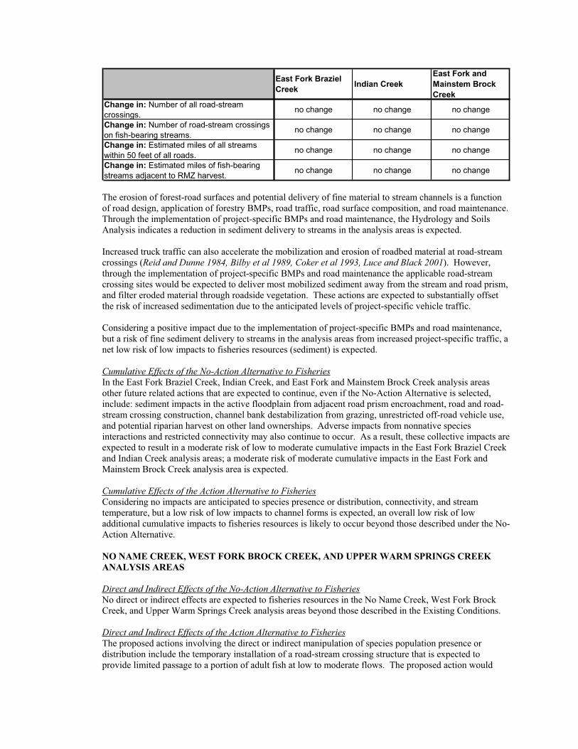
East Fork Braziel Creek Indian Creek
East Fork and Mainstem Brock Creek
Change in: Number of all road-stream crossings. no change no change no change
Change in: Number of road-stream crossings on fish-bearing streams. no change no change no change
Change in: Estimated miles of all streams within 50 feet of all roads. no change no change no change
Change in: Estimated miles of fish-bearing streams adjacent to RMZ harvest. no change no change no change
The erosion of forest-road surfaces and potential delivery of fine material to stream channels is a function of road design, application of forestry BMPs, road traffic, road surface composition, and road maintenance. Through the implementation of project-specific BMPs and road maintenance, the Hydrology and Soils Analysis indicates a reduction in sediment delivery to streams in the analysis areas is expected.
Increased truck traffic can also accelerate the mobilization and erosion of roadbed material at road-stream crossings (Reid and Dunne 1984, Bilby et al 1989, Coker et al 1993, Luce and Black 2001). However, through the implementation of project-specific BMPs and road maintenance the applicable road-stream crossing sites would be expected to deliver most mobilized sediment away from the stream and road prism, and filter eroded material through roadside vegetation. These actions are expected to substantially offset the risk of increased sedimentation due to the anticipated levels of project-specific vehicle traffic.
Considering a positive impact due to the implementation of project-specific BMPs and road maintenance, but a risk of fine sediment delivery to streams in the analysis areas from increased project-specific traffic, a net low risk of low impacts to fisheries resources (sediment) is expected.
Cumulative Effects of the No-Action Alternative to FisheriesIn the East Fork Braziel Creek, Indian Creek, and East Fork and Mainstem Brock Creek analysis areas other future related actions that are expected to continue, even if the No-Action Alternative is selected, include: sediment impacts in the active floodplain from adjacent road prism encroachment, road and road-stream crossing construction, channel bank destabilization from grazing, unrestricted off-road vehicle use, and potential riparian harvest on other land ownerships. Adverse impacts from nonnative species interactions and restricted connectivity may also continue to occur. As a result, these collective impacts are expected to result in a moderate risk of low to moderate cumulative impacts in the East Fork Braziel Creek and Indian Creek analysis areas; a moderate risk of moderate cumulative impacts in the East Fork and Mainstem Brock Creek analysis area is expected.
Cumulative Effects of the Action Alternative to FisheriesConsidering no impacts are anticipated to species presence or distribution, connectivity, and stream temperature, but a low risk of low impacts to channel forms is expected, an overall low risk of low additional cumulative impacts to fisheries resources is likely to occur beyond those described under the No-Action Alternative.
NO NAME CREEK, WEST FORK BROCK CREEK, AND UPPER WARM SPRINGS CREEK ANALYSIS AREAS
Direct and Indirect Effects of the No-Action Alternative to FisheriesNo direct or indirect effects are expected to fisheries resources in the No Name Creek, West Fork Brock Creek, and Upper Warm Springs Creek analysis areas beyond those described in the Existing Conditions.
Direct and Indirect Effects of the Action Alternative to FisheriesThe proposed actions involving the direct or indirect manipulation of species population presence or distribution include the temporary installation of a road-stream crossing structure that is expected to provide limited passage to a portion of adult fish at low to moderate flows. The proposed action would
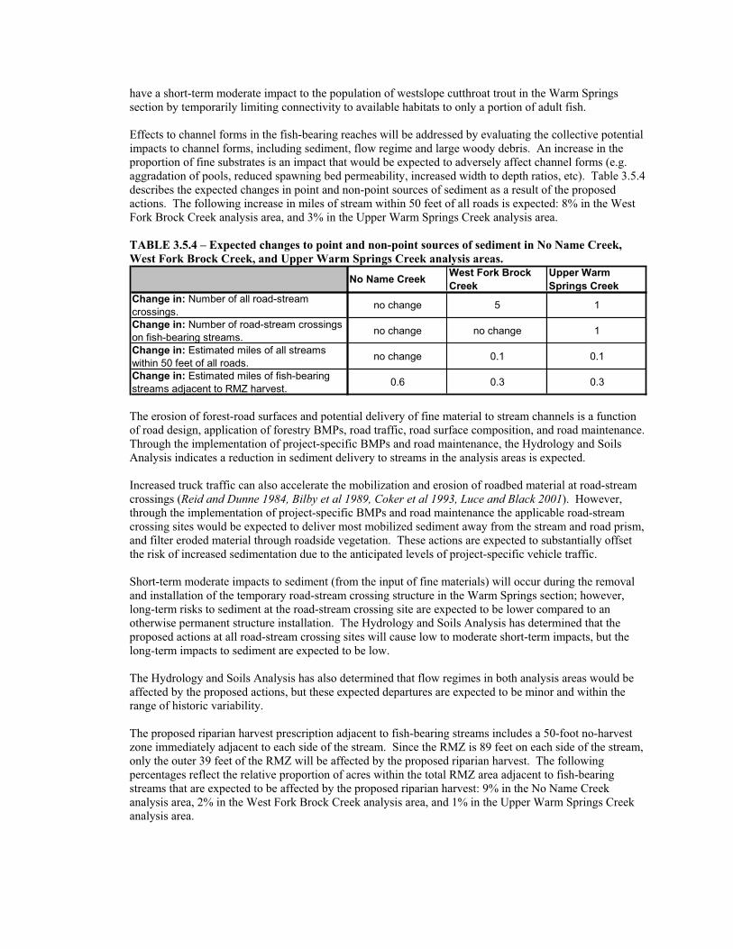
have a short-term moderate impact to the population of westslope cutthroat trout in the Warm Springs section by temporarily limiting connectivity to available habitats to only a portion of adult fish.
Effects to channel forms in the fish-bearing reaches will be addressed by evaluating the collective potential impacts to channel forms, including sediment, flow regime and large woody debris. An increase in the proportion of fine substrates is an impact that would be expected to adversely affect channel forms (e.g. aggradation of pools, reduced spawning bed permeability, increased width to depth ratios, etc). Table 3.5.4 describes the expected changes in point and non-point sources of sediment as a result of the proposed actions. The following increase in miles of stream within 50 feet of all roads is expected: 8% in the West Fork Brock Creek analysis area, and 3% in the Upper Warm Springs Creek analysis area.
TABLE 3.5.4 – Expected changes to point and non-point sources of sediment in No Name Creek, West Fork Brock Creek, and Upper Warm Springs Creek analysis areas.
No Name Creek West Fork Brock Creek
Upper Warm Springs Creek
Change in: Number of all road-stream crossings. no change 5 1
Change in: Number of road-stream crossings on fish-bearing streams. no change no change 1
Change in: Estimated miles of all streams within 50 feet of all roads. no change 0.1 0.1
Change in: Estimated miles of fish-bearing streams adjacent to RMZ harvest. 0.6 0.3 0.3
The erosion of forest-road surfaces and potential delivery of fine material to stream channels is a function of road design, application of forestry BMPs, road traffic, road surface composition, and road maintenance. Through the implementation of project-specific BMPs and road maintenance, the Hydrology and Soils Analysis indicates a reduction in sediment delivery to streams in the analysis areas is expected.
Increased truck traffic can also accelerate the mobilization and erosion of roadbed material at road-stream crossings (Reid and Dunne 1984, Bilby et al 1989, Coker et al 1993, Luce and Black 2001). However, through the implementation of project-specific BMPs and road maintenance the applicable road-stream crossing sites would be expected to deliver most mobilized sediment away from the stream and road prism, and filter eroded material through roadside vegetation. These actions are expected to substantially offset the risk of increased sedimentation due to the anticipated levels of project-specific vehicle traffic.
Short-term moderate impacts to sediment (from the input of fine materials) will occur during the removal and installation of the temporary road-stream crossing structure in the Warm Springs section; however, long-term risks to sediment at the road-stream crossing site are expected to be lower compared to an otherwise permanent structure installation. The Hydrology and Soils Analysis has determined that the proposed actions at all road-stream crossing sites will cause low to moderate short-term impacts, but the long-term impacts to sediment are expected to be low.
The Hydrology and Soils Analysis has also determined that flow regimes in both analysis areas would be affected by the proposed actions, but these expected departures are expected to be minor and within the range of historic variability.
The proposed riparian harvest prescription adjacent to fish-bearing streams includes a 50-foot no-harvest zone immediately adjacent to each side of the stream. Since the RMZ is 89 feet on each side of the stream, only the outer 39 feet of the RMZ will be affected by the proposed riparian harvest. The following percentages reflect the relative proportion of acres within the total RMZ area adjacent to fish-bearing streams that are expected to be affected by the proposed riparian harvest: 9% in the No Name Creek analysis area, 2% in the West Fork Brock Creek analysis area, and 1% in the Upper Warm Springs Creek analysis area.
Short-term and long-term negligible or very minor impacts to substrates comprising stream channel forms is not expected to occur as a result of adjacent riparian or upland harvesting near fish-bearing and contributing non fish-bearing streams (see hydrology and soils analyses)
The zone of recruitable large woody debris to fish-bearing streams is expected to extend approximately 75 feet from fish-bearing streams (since those sections of trees over 75 feet do not necessarily provide material which qualifies as large woody debris due to tapering). A portion of potentially recruitable large woody debris occurs between 50 and 75 feet away from the stream, however, the majority of actual large woody debris recruitment is expected to occur from within 25 feet of the stream. Consequently, a moderate risk of low impacts to large woody debris is expected in the analysis areas.
Considering potential effects to sediment, flow regime, and large woody debris recruitment, a moderate risk of moderate impacts to channel forms is expected in the short-term, but the long-term impacts are expected to be low.
For practical purposes, the zone of vegetation that is considered to have the greatest affect on stream shading in valley-bottom, headwater streams in the project area is generally confined to the area within the average lateral extent of mature riparian vegetation; in this case, approximately 89 feet. Considering the relative proportion of acres within the total RMZ area adjacent to fish-bearing streams that are expected to be affected by the proposed riparian harvest (above), a moderate risk of low impacts to stream temperature is expected in the No Name Creek analysis area; a low risk of low impacts is expected in the West Fork Brock Creek and Upper Warm Springs Creek analysis areas.
Cumulative Effects of the No-Action Alternative to Fisheries In the No Name Creek, West Fork Brock Creek, and Upper Warm Springs Creek analysis areas other future related actions that are expected to continue, even if the No-Action Alternative is selected, include: sediment impacts in the active floodplain from adjacent road prism encroachment, road and road-stream crossing construction, channel bank destabilization from grazing, unrestricted off-road vehicle use, and potential riparian harvest on other land ownerships. Adverse impacts from nonnative species interactions and restricted connectivity may also continue to occur. As a result, these collective impacts are expected to result in a moderate risk of low to moderate cumulative impacts in all three analysis areas.
Cumulative Effects of the Action Alternative to FisheriesConsidering (1) a moderate temporary impact to species presence, distribution and connectivity, (2) a short-term moderate impacts to channel forms, (3) a long-term low impact to channel forms, and (4) a low to moderate risk of low impacts to stream temperature, an overall low risk of low additional cumulative impacts to fisheries resources is likely to occur beyond those described under the No-Action Alternative.
3.6 Soils
Affected Environment The proposed harvest areas are located on low to moderate slopes with soils derived from volcanic rocks (gabbros, and basaltics), sedimentary rocks (limestone and shales), and clay rich tertiary age valley fill deposits. There is extensive reverse faulting throughout the area, which results in numerous unconformities of bedrock, mainly in the Brock and Warm Springs drainages. Bedrock outcrops are common in the Baldy and No-name parcels. Most of the rock exposures consist of fractured bedrock and should be rippable. No unique geologic features occur, except for some abrupt bedrock outcrops and mineral potential at depth. Shallow rock occurs near the ridgelines and upper slopes, but should be common excavation or rippable on the proposed road locations and do not limit proposed road construction.
Good quality gravel sources are rare, but potential rock sources were identified in each section where the access roads can be widened to provide material to armor some short clayey segments of road. Overall, slopes are stable in the project areas. Several old slumps have occurred in the area as part of geologic mountain building processes. Within the proposed project area, these localized areas of marginal slope stability occur on steep slopes and wet sites and do not show signs of recent movement. Slope stability is
not a concern based on avoiding the most unstable road construction locations and site specific mitigations for areas of marginal stability. Because of these factors, slope stability will be dismissed for further analysis.
No-Name T12N R 10W Section 36 The No-name section and adjacent lands are underlain by volcanic bedrock and local areas of higher clay content, tertiary age soils weathered from volcanic materials. Dominant soils in the forested harvest area are Worock gravelly loams and complex of Bignell, dry-Yreka soils, on moderate to steep slopes ( refer to Powell County Soil Survey). Worock soils have a gravelly loam surface over very gravelly clay loams from igneous bedrock. Worock has slight to moderate risk of erosion and moderate for windthrow, compaction and displacement. Worock soils have a slightly longer season of use. Bignell soils have similar deep gravelly clay loams forming in glacial till and alluvium from limestone and are slightly more productive than Worock soils. Bignell, has a cobbly suface with clayey subsoils, -Yreka soils have a gravelly loam surface over deep very gravelly clay loam. Bignell and Yreka soils tend to remain wet later in the spring and have a shorter season of dry use than Worock. Both soils have similar interpretations and risk hazards of the Worock soils. Both soils support Douglas-fir, lodgepole pine and ponderosa pine on well-drained sites. The site is adequately suited to conventional ground skidding if operations are avoided when soils are wet, (typically from March to June). There are naturally high levels of coarse woody debris on site. Sensitive soils occur on steep slopes over 45% and wet sites along No-Name Creek that are too small to delineate at the map scale. These areas are located predominantly near draws and require site specific review for mitigation design such as equipment restriction zones and removal of high risk trees by winch.
Approximately 80 acres of blowdown trees were salvage harvested in 1990. The previously harvested areas have regenerated well in 18 years and are now overstocked. Roads are stable but require mainetance to restore road surface drainage. No BMP departures were noted and minimal soil effects occurred on these previous harvest areas. The 1990 harvest sites would not be reentered with this entry. Historic harvest effects within the proposed units are minimal and limited to a few major skid trails that are still apparent on less than 10% of the proposed harvest units.
Warm Springs T11N R10W Section 36 The DNRC section is underlain by volcanic bedrock that has been uplifted and block faulted leaving some abrupt slopes and bedrock exposed on ridges and within the 96F map unit. There are some historic areas of tectonic block movements and localized slumps that occur adjacent to the stream that flows SW to the NE corner of the section. No recent signs of slope instability were observed. Most of the section is moderately sloping, ranging between10-45%, and is well suited for ground based harvest operations. The dominant soils in the forested harvest area are MU596D/E Worock gravelly loams on 8-35% slopes (described above and in Powell County Soil Survey) and MU387D Danaher-Loberg, soils on 15-35% slopes. The Worock gravelly loams occur on convex slopes and are well drained and have low erosion risks. Finer textured Loberg and Danaher soils occur on concave and flat slopes that includes small seeps and wet areas. The Danaher-Loberg complex consists of a surface of silt loam over a subsurface of very deep clay loam. Danaher soils have higher moisture retention which supports more productive sites. Equipment operations on Danaher-Loberg soils have a moderate hazard of displacement and erosion and a compaction hazrd is high if operated on when wet. Soils can remain wet well into June and the fine textured soils may require, extended operating restrictions, ditching/turnpiking and spot gravel to provide drainage and extend road use.
The slopes are well suited to tractor operations in the Warm Springs section. There is a high level of existing downed coarse woody debris on the site. Sensitive soils occur on steep slopes over 45% and wet sites adjacent to riparian areas. Slopes over 45% have a high risk of displacement and require cable harvest to minimize soil impacts. Implementing harvest BMP’s and standard road drainage can control erosion and avoid excessive soil impacts. Bands of alluvial soils occur adjacent to stream channels as a complex of cobbles and gravels with localized areas of deeper somewhat poorly drained clay rich materials adjacent to wetlands. These alluvial soils support some spruce sedges and deep sod grasslands. The deep sod provides a buffer that traps sediment and will revegetate quickly. These materials are fair to poor for road construction and may require turnpiking with more suitable fill for road crossings. These soils are subject to
rutting and compaction if operated on when wet though no harvest is planned on these alluvial soils. No previous harvest effects were observed within the Warm Springs section.
Baldy Mountain Sec. 16, T11N R10W The dominant soils in the forested harvest area are 696E Worock dry site ,well drained soils on 15-35% slope. This map unit on southerly aspects is more droughty than the other Worock map units and provides a long season of dry use. The map unit includes small areas of short steep slopes and wet sites, which will restrict equipment usage on them. These are resilient soils with a moderate risk of displacement, compaction and erosion for ground based operations on slopes up to 45%. Slopes >45% are subject to severe erosion and should be cable or winch skidded. No previous harvest has occurred within this section except for post cutting along the road and no detrimental soil effects were observed. Localized areas of slope instability occur within the section and were noted on the ground to be avoided. There are several larger wetlands approximately ¼ acre in size on the lower slopes of the section.
Environmental Effects No-Action Alternative effects on SoilsThe No-action alternative would have little effect on soil resources. Existing access roads with inadequate drainage would continue to erode without maintenance. Some of the localized areas of marginal slope stability may move if triggered by earthquake activity.
Action Alternative effects on SoilsThe primary risks to long term soil productivity and hydrologic function are excessive impacts to soil properties caused by rutting, compaction and displacement of surface soils by equipment operation and road construction. Most sensitive soils are small areas of steep slopes, erosive soils and wet sites which would be avoided or protected with mitigation measures.
For the proposed harvest, BMP’s and mitigations would be implemented to minimize the area and degree of detrimental soil impacts (displacement, erosion, and compaction). Mitigations include general skid trail planning, limit tractors to moderate slopes, avoiding wetlands and controlling soil disturbance to meet silvicultural goals to promote conifer regeneration. Ground based harvest operations would be limited to slopes less than 45%. Cable harvest would be used to minimize soil impacts on steeper slopes and protect areas adjacent to streamside management zones.
The tree mortality from insects has resulted in most trees shedding their needles, which helps return nutrients to the soil. Controlling the area of disturbance and retaining vegetative litter and woody debris helps to maintain nutrient cycling important to plant growth and control erosion on disturbed sites. It is desirable to maintain old and new coarse woody debris (>3” dia.) at ~10-15 tons/acre on the harvest units.
Based on DNRC soil monitoring on comparable sites (Collins 2004), implementation of BMP's and the recommended mitigation measures, harvest operations present low risk of detrimental impacts to soils if impacts are restricted to ~15% of the proposed harvest areas We expect that by protecting ~85% of a harvest area in non-detrimental soil impacts, soil properties important to soil productivity would be maintained.
DNRC focused road design and location efforts to minimize the extent of new road construction stream crossings and construction costs and included temporary use roads where feasible. Temporary use roads would be located for minimal construction and stabilized after use. Clay rich soils in portions of the No-Name and Warm Springs sections would require season of use limits to avoid rutting, erosion and maintain drainage features.
An inventory of existing roads requiring repairs, improvements and maintenance needs has been completed for the action alternative. The existing Brock Creek and No-Name-Braziel Creek access roads cross segments of clay rich soils that would limit access during spring thaw and wet periods. Season of use is limited to frozen ground or relatively dry summer months on the most limiting segments of clay-rich soils. The action alternative would have a short term increase in erosion while revegetation establishes on disturbed segments of new road and sites of road repair and reconstruction. New roads would be built to a
suitable standard to maintain slope stability and drainage. Road drainage improvements to existing roads would allow seasonal access to the area and reduce current erosion on inadequately drained roads. Temporary roads could result in some rutting and compaction where impacts but can be largely restored with ripping the soils surface and installing adequate drainage. Following use, temporary roads would be closed, stabilized with long-term drainage features installed and reseeding with site adapted grass to control erosion and compete with noxious weeds.
Sale administrators would monitor on-going harvest and road construction activities to meet contract requirements, BMP’S for soil and water protection and silvicultural objectives. For all of these reasons the proposed harvest operations and mitigation measures are expected to maintain soil properties important to plant growth and hydrologic function and present low risk of direct and indirect impacts to soils.
Cumulative effects to soils Cumulative effects to soils can occur from repeated ground skidding entries into the harvest area and additional road construction, depending on area and degree of detrimental impacts. Past harvest in the No-Name section have left minimal effect on the soils, with few trails still evident. Previous wind blowdown harvest occurred in the No-name parcel in 1990 and has recovered and revegetated. Field assessment is 10-15% of ground skidded areas were trafficked and detrimental effects are less than 10% of the area and no erosion problems were noted. We expect that effects would be similar for the proposed project. No harvest reentries are planned for the sites that were previously harvested in the No-Name section. No previous harvest has occurred in the Warm Springs or Baldy units proposed for harvest.
Considering nutrient cycling, the high level of tree mortality has caused most needle and fine litter would fall to forest floor or would during logging operations. Large woody debris would be maintained on the site with a goal of 5-15 tons/acre (Graham 1994). Coarse wood would be well distributed throughout the units and trampled to help promote decay processes, maintain nutrient cycling for long term soil productivity and to encourage micro growing sites for reforestation. Improved tree spacing would reduce competition for nutrients and soil moisture, enhance growth of retained trees, and promote regeneration of conifers. There is low risk of cumulative effects to soils with the proposed harvest based on minimal previous harvest in the proposed harvest units and implementation of skidding and slash disposal mitigation measures to limit the area impacted.
3.7 Big Game (Summer Elk and Mule Deer)
Affected Environment Densely stocked thickets of conifer regeneration and overstocked mature stands provide hiding cover for elk and mule deer. Such stands can reduce the impacts of human-caused disturbance and reduce the animal’s vulnerability to being harvested during the hunting season. Additionally, extensive (e.g., >250 acres) areas of forest cover >0.5 miles from open roads can serve as security cover. Thus, removing cover that is important for reducing hunting vulnerability through forest management activities could decrease mule deer and elk populations locally.
The project area contains approximately 1,800 acres of hiding cover, through stocked lodgepole pine stands and shade tolerant saplings. Within the approximately 216,436 acre cumulative effects analysis area (Hunting District 291), there is approximately 52,384 acres of hiding cover. Within the project area, there is no security cover due to insufficient area (i.e., <250 ac) covered by the qualifying hiding cover within the affected parcels. However, within the analysis area, there are approximately 15,645 acres of security cover (7.23% of cumulative effects analysis area).
Environmental Effects No Action AlternativeDirect and Indirect EffectsSince 2005 the project area has been impacted by a mountain pine beetle infestation that has been killing mature lodgepole pine on the affected parcels and areas primarily south of Hwy 200. This infestation has impacted elk and mule deer cover through killing stands of lodgepole pine, which provide screening cover
for big game species through decreased sight distance. As a result, reductions, or changes, in hiding cover would occur within the project area, as the affected lodgepole pine fall to the ground and would continue under this alternative. Thus, this alternative would likely continue to result in low to moderate direct and indirect effects to elk and mule deer hiding cover.
Cumulative EffectsUnder this alternative, no new road would be constructed or timber harvested by the DNRC on School Trust land. The mountain pine beetle infestation would likely continue to grow, infest, and likely, eventually kill additional lodgepole pine stands, thereby reducing summer cover and increasing sight distances. Actions proposed by the BLM within the analysis area would continue, including timber harvesting, broadcast burning, road construction, and subsequent road reclamation. Open road density would not increase, but there would be minimal increases in total road density within the analysis area due to proposed actions by the BLM. There would likely be low risk of cumulative effects to elk and mule deer summer cover as a result of the no action alternative.
Action AlternativeDirect and Indirect EffectsThe proposed action would reduce hiding cover within the project area from approximately 1,800 acres to approximately 821 acres through harvesting of insect-infested lodgepole pine, and would construct approximately 11.05 miles of new road. With the current level of bug infestation, much of the affected lodgepole pine would eventually fall within the next 10 years. Thus, the potential for impacts to elk and mule deer would be in the post-action road density. Due to the gentle terrain and high proportion of lodgepole pine on the Warm Springs parcel, it would likely be difficult to effectively close the proposed 4.51 miles of new road to motorized vehicles. However, approximately 1.1 miles of the proposed 4.5 miles of new road on Baldy would be temporary, and the remaining new road could be effectively closed with locked gates or other closure devices. Similarly, the majority of the proposed 2.04 mi of new road on No Name could be effectively closed through closure devices. As a result, post-harvest total road density would increase from approximately 2.15 mi/sq. mi. to approximately 5.76 mi/sq. mi, and open road density would increase from approximately 2.05 mi/sq. mi. to approximately 3.46 mi/sq. mi. During fall, there would be a negligible increase in open road density due to seasonal road closures by the BLM that effect the Warm Springs parcel. As a result, there would likely be low to moderate risk of direct and indirect effects to elk and mule deer summer cover from the proposed action.
Cumulative EffectsWithin the analysis area (hunting district 291), the proposed action would reduce the amount of hiding cover within the project area from approximately 52,384 acres to approximately 51,405 acres. The proposed harvests in Hoover and Bert Creeks, and a recent timber salvage on School Trust land within the Manley Ranch would further reduce hiding cover to approximately 50,187 acres. Additionally, the proposed harvest on BLM lands within the Hoodoos would reduce hiding cover to approximately 48,962 acres, bringing the proposed cumulative reduction in hiding cover to approximately 3,422 acres, or an approximately 6.5% reduction in hiding cover within the analysis area. The proposed action would not reduce security cover within the analysis area. Within the analysis area, approximately 60% (approximately 31,147 acres) of the hiding cover occurs on state and federally managed lands, while much of the same cover that has been reduced in recent years has occurred on privately managed lands that make up the majority of the analysis area. Of the 216,436 acre analysis area, approximately 124,400 acres (57%) is forested, and approximately 42% (52,384 acres) are currently providing hiding cover. The rest of the forested area has experienced timber harvest that resulted in loss of hiding cover for mule deer and elk. The proposed action would further reduce hiding cover. Given these conditions, the proposed action may have low to moderate risk of cumulative effects to mule deer and elk summer cover.
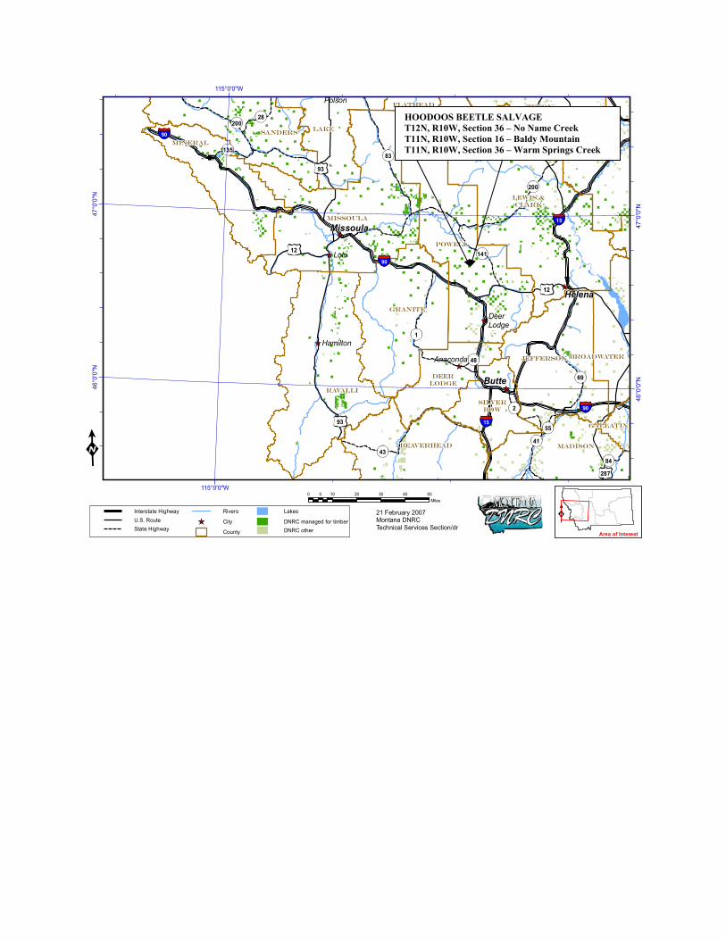
90
200
93
12
15
43
200
1
93
28783
90
15
287
69
14112
89
90
2
41
28
135
84
55
48
POWELL
LEWIS &CLARK
TETON
JEFFERSON
SILVERBOW
DEERLODGE
MADISONBEAVERHEAD
RAVALLI
GRANITE
MISSOULA
CASCADE
GALLATIN
BROADWATER
MINERAL
LAKESANDERS
FLATHEAD
Anaconda
Polson
Lolo
Hamilton
DeerLodge
Helena
Butte
Missoula
115°0'0"W
115°0'0"W47
°0'0
"N
47°0
'0"N
46°0
'0"N
46°0
'0"N
0 10 20 30 40 505Miles
21 February 2007Montana DNRCTechnical Services Section/dr
Area of Interest
Interstate HighwayU.S. RouteState Highway
Rivers
City
County
Lakes
DNRC managed for timberDNRC other
HOODOOS BEETLE SALVAGE T12N, R10W, Section 36 – No Name Creek T11N, R10W, Section 16 – Baldy Mountain T11N, R10W, Section 36 – Warm Springs Creek