Embed Size (px)
Citation preview

How can GIScience contribute to land change modelling?
Gilberto CâmaraDirector, National Institute for Space Research, Brazil
GIScience 2006, Munster, Germany

Motivation
Let’s start from a real problem….
Building a road in the Amazon rain forest

Área de estudo – ALAP BR 319 e entorno
ALAP BR 319Estradas pavimentadas em 2010Estradas não pavimentadasRios principais
Portos
new road

Source: Carlos Nobre (INPE)
Can we avoid that this….

Fire...
Source: Carlos Nobre (INPE)
….becomes this?

Amazonia Deforestation rate 1977-2004
Annual deforestation rate
0
5000
10000
15000
20000
25000
30000
35000
77/8
8 *
88/8
9
89/9
0
90/9
1
91/9
2
92/9
4 **
94/9
5
95/9
6
96/9
7
97/9
8
98/9
9
99/0
0
00/0
1
1/fe
v
02/0
3(*)
03/0
4(*)
Period
km
2 /ye
ar
?

BASELINE SCENARIO – Hot spots of change (1997 a 2020)
ALAP BR 319Estradas pavimentadas em 2010Estradas não pavimentadasRios principais
0.0 – 0.10.1 – 0.20.2 – 0.30.3 – 0.40.4 – 0.50.5 – 0.60.6 – 0.70.7 – 0.80.8 – 0.90.9 – 1.0
% mudança 1997 a 2020:

GOVERNANCE SCENARIO – Differences from baseline scenario
ALAP BR 319Estradas pavimentadas em 2010Estradas não pavimentadasRios principais
0.0 -0.50Less:0.0 0.10More:
Differences:Protection areas
Sustainable areas


“Give us some new problems” (Dimitrios Papadias, SSTD 2005)

“Give us some new problems”
What about saving the planet?


The fundamental question
How is the Earth’s environment changing, and what are the consequences for human civilization?
Source: NASA, IGBP

GIScience and change
We need a vision for extending GIScience to have a research agenda for modeling change

The Greek vision of spatial dataEuclid (x + y)2 = x2 + 2xy + y2
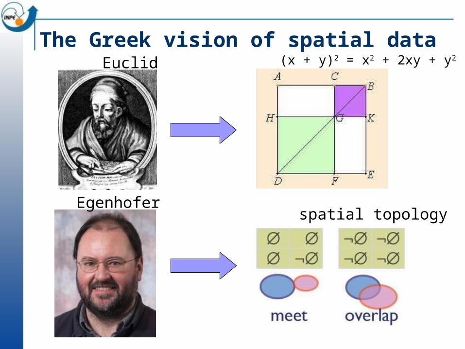
The Greek vision of spatial dataEuclid
Egenhofer
(x + y)2 = x2 + 2xy + y2
spatial topology

The Greek vision of spatial dataAristotle categories -

The Greek vision of spatial dataAristotle
Smith
categories -
SPAN ontologies

A challenge to GIScience
Time has come to move from Greece to the Renaissance!
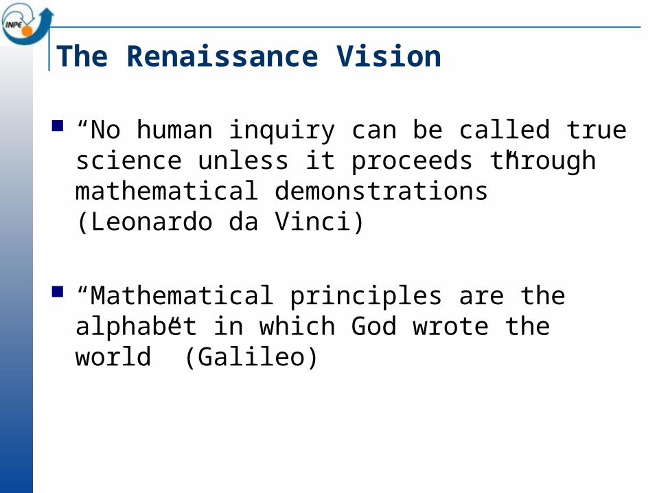
The Renaissance Vision
“No human inquiry can be called true science unless it proceeds through mathematical demonstrations” (Leonardo da Vinci)
“Mathematical principles are the alphabet in which God wrote the world” (Galileo)

The Renaissance vision for space
Rules and laws that enable:
Understanding how humans use space;
Predicting changes resulting from human actions;
Modeling the interaction between humans and the environment.

The Renaissance visionKepler

The Renaissance visionKepler
Frank

The Renaissance visionGalileo

The Renaissance visionGalileo
Batty

Challenge: How do people use space?
Loggers
Competition for Space
Soybeans
Small-scale Farming Ranchers
Source: Dan Nepstad (Woods Hole)

Statistics: Humans as clouds
Establishes statistical relationship with variables that are related to the phenomena under study
Basic hypothesis: stationary processes Exemples: CLUE Model (University of
Wageningen)
y=a0 + a1x1 + a2x2 + ... +aixi +E

Statistics: Humans as cloudsMODEL 7: R² = .86
Variables Description stb p-level
PORC3_ARPercentage of large farms, in terms of area 0,27 0,00
LOG_DENS Population density (log 10) 0,38 0,00
PRECIPIT Avarege precipitation -0,32 0,00
LOG_NR1Percentage of small farms, in terms of number (log 10) 0,29 0,00
DIST_EST Distance to roads -0,10 0,00
LOG2_FER Percentage of medium fertility soil (log 10) -0,06 0,01
PORC1_UC Percantage of Indigenous land -0,06 0,01
Statistical analysis of deforestation

The trouble with statistics
Extrapolation of current measured trends
How do we know if tommorow will be like today?
How do we incorporate feedbacks?

Agents and CA: Humans as ants
Old Settlements(more than 20 years)
Recent Settlements(less than 4
years)
Farms
Settlements 10 to 20 anos
Source: Escada, 2003
Identify different actors and try to model their actions

Agent model using Cellular Automata
1985
1997 1997Large farm environments:
2500 m resolution
Continuous variable:% deforested
Two alternative neighborhood relations:•connection through roads• farm limits proximity
Small farms environments:
500 m resolution
Categorical variable: deforested or forest
One neighborhood relation: •connection through roads

The trouble with agents
Many agent models focus on proximate causes directly linked to land use changes (in the case of deforestation, soil type, distance
to roads, for instance)
What about the underlying driving forces? Remote in space and time Operate at higher hierarchical levels Macro-economic changes and policy changes

Underlying Factorsdriving proximate causes
Causative interlinkages atproximate/underlying levels
Internal drivers
*If less than 5%of cases,not depicted here.
source:Geist &Lambin
5% 10% 50%
% of the cases
What Drives Tropical Deforestation?

Humans are not clouds nor ants!
“Third culture” Modelling of physical phenomena Understanding of human dimensions
How to model human actions? What makes people do certain things? Why do people compete or cooperate? What are the causative factors of human
actions?

Some promising approaches
Hybrid automata
Flexible neighbourhoods
Nested cellular automata
Game theory

Hybrid Automata
Formalism developed by Tom Henzinger (UC Berkeley)
Combines discrete transition graphs with continous dynamical systems
Infinite-state transition system
Control Mode A
Flow Condition
Control Mode B
Flow Condition
Jump condition
Event
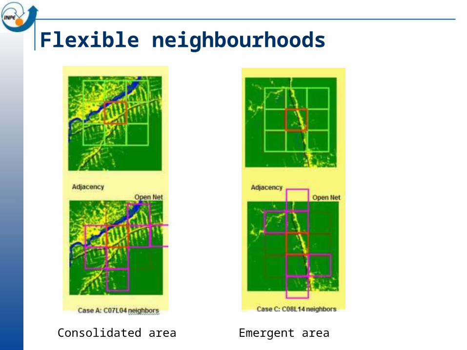
Flexible neighbourhoods
Consolidated area Emergent area
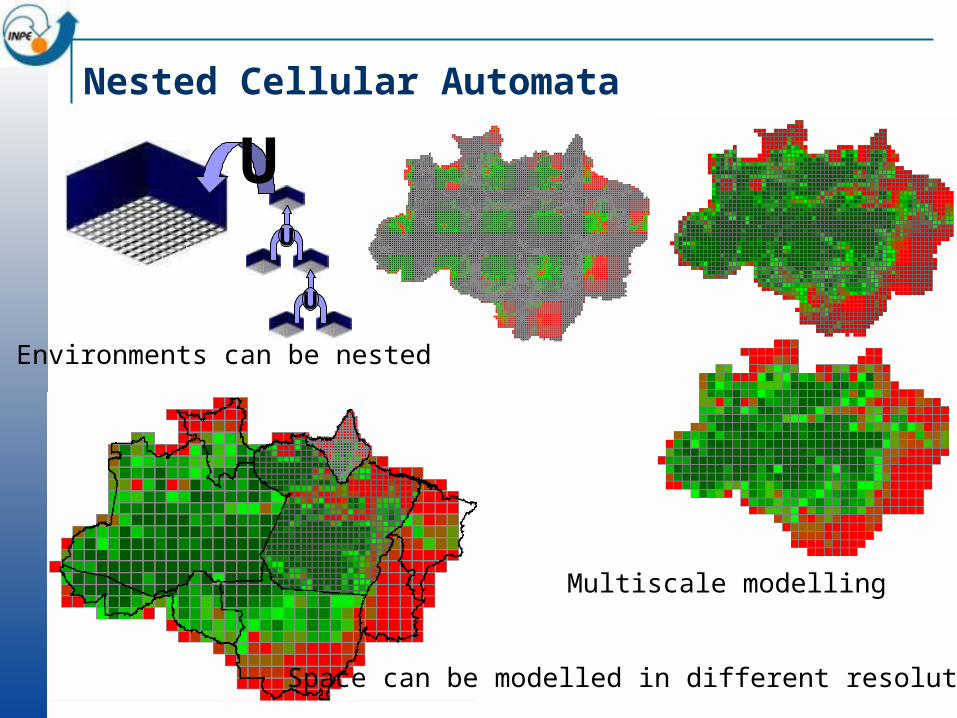
Nested Cellular Automata
UU
U
Environments can be nested
Space can be modelled in different resolutions
Multiscale modelling

Game theory and mobility
Two players get in a strive can choose shoot or not shoot their firearms.
If none of them shoots, nothing happens. If only one shoots, the other player runs
away, and then the winner receives $1. If both decide to shoot, each group pays
$10 due to medical cares.
B shoots B does not shoot
A shoots (-10,-10) (+1,-1)
A does not shoot (-1,+1) (0,0)

Game theory and mobility
A - ((10%;; $200; 0)B - ((50%;; $200; 0)C - ((100%;; $200;; 0))
Three strategies

Game theory and mobility
What happens when players can move?
If a player loses too much, he might move to an adjacent cell

Mobility breaks the Nash equilibrium!

The big challenge: a theory of scale

Scale
Scale is a generic concept that includes the spatial, temporal, or analytical dimensions used to measure any phenomenon.
Extent refers to the magnitude of measurement.
Resolution refers to the granularity used in the measures.
(Gibson et al. 2000)

Multi-scale approach

The trouble with current theories of scale
Conservation of “energy”: national demand is allocated at local level
No feedbacks are possible: people are guided from the above

The search for a new theory of scale
Non-conservative: feedbacks are possible Linking climate change and land change Future of cities and landscape integrate to
the earth system

Atmospheric Physics/Dynamics
Tropospheric Chemistry
Global Moisture
Ocean Dynamics
MarineBiogeochemistry
Terrestrial Ecosystems
Terrestrial Energy/Moisture
Climate Change
Pollutants
CO2
CO2
Soil
Land Use
Physical Climate System
Biogeochemical Cycles
Human Activities
(from Earth System Science: An Overview, NASA, 1988)
Earth as a system

Global Land Project•What are the drivers and
dynamics of variability and change in terrestrial human-environment systems?
•How is the provision of environmental goods and services affected by changes in terrestrial human-environment systems?
•What are the characteristics and dynamics of vulnerability in terrestrial human-environment systems?

The Renaissance visionNewton Principia

The Renaissance vision
Your picture here
Newton
????
Principia
Multiscale theory of space

Why is it so hard to model change?
source: John Barrow(after David Ruelle)
Complexity of the phenomenon
Un
cert
ain
ty o
n b
asic
eq
uati
on
s
Solar System DynamicsMeteorology
ChemicalReactions
HydrologicalModels
ParticlePhysics
Quantum Gravity
Living Systems
GlobalChange
Social and EconomicSystems

Towards a research agenda
Moving GIScience from Greece to the Renaissance….
GIScience – Formal and mathematical tools for dealing with space
GIScience tools are crucial for supporting earth system science
We have a lot of challenges ahead of us!!


References
Max Egenhofer Egenhofer, M., Franzosa, R.: Point-Set Topological
Spatial Relations. International Journal of Geographical Information Systems, 5 (1991) 161-174.
Egenhofer, M., Franzosa, R.: On the Equivalence of Topological Relations. International Journal of Geographical Information Systems, 9 (1995) 133-152.
Egenhofer, M., Mark, D.: Naive Geography. In: Frank, A., Kuhn, W.(ed.): Spatial Information Theory—A Theoretical Basis for GIS, International Conference COSIT '95, Semmering, Austria. Springer-Verlag, Berlin (1995) 1-15.

References
Barry Smith Smith, B., Mark, D.: Ontology and Geographic
Kinds. In: Puecker, T., Chrisman, N. (ed.): International Symposium on Spatial Data Handling. Vancouver, Canada (1998) 308-320.
Smith, B., Varzi, A.: Fiat and Bona Fide Boundaries. Philosophy and Phenomenological Research, 60 (2000).
Grenon, P., Smith, B.: SNAP and SPAN: Towards Dynamic Spatial Ontology. Spatial Cognition & Computation, 4 (2003) 69-104.

References
Andrew Frank Frank, A.: One Step up the Abstraction Ladder:
Combining Algebras - From Functional Pieces to a Whole. In: Freksa, C., Mark, D. (ed.): COSIT 1990- LNCS 1661. Springer-Verlag (1999) 95-108.
Frank, A.: Higher order functions necessary for spatial theory development. In: Auto-Carto 13 Vol. 5. ACSM/ASPRS, Seattle, WA (1997) 11-22.
Frank, A.: Ontology for Spatio-temporal Databases. In: Koubarakis, M., Sellis, T.(ed.): Spatio-Temporal Databases: The Chorochronos Approach. Springer, Berlin (2003) 9-78.

References
Mike Batty Batty, M. Cities and Complexity:
Understanding Cities Through Cellular Automata, Agent-Based Models, and Fractals. The MIT Press, Cambridge, MA, 2005.
Batty, M.; Torrens, P. M. “Modelling and Prediction in a Complex World”. Futures, 37 (7), 745-766, 2005.
Batty, M. Xie, Y. Possible Urban Automata. Environment and Planning B, 24, 175-192, 1996.

References
INPE’s recent work (see www.dpi.inpe.br/gilberto) Almeida, C.M., Monteiro, A.M.V., Camara, G., Soares-
Filho, B.S., Cerqueira, G.C., Pennachin, C.L., Batty, M.: “Empiricism and Stochastics in Cellular Automaton Modeling of Urban Land Use Dynamics” Computers, Environment and Urban Systems, 27 (2003) 481-509.
Ana Paula Dutra de Aguiar, “Modeling Land Use Change in the Brazilian Amazon: Exploring Intra-Regional Heterogeneity”. PhD in Remote Sensing, INPE, 2006.
Tiago Garcia de Senna Carneiro, “"Nested-CA: A Foundation for Multiscale Modelling of Land Use and Land Cover Change”. PhD in Computer Science, INPE, 2006.