Embed Size (px)
Citation preview
UNCLASSIFIED
Human Robotic InteractionDavid ThomasAssociate Director, Intelligent SystemsUS Army TARDEC
UNCLASSIFIED: Dist A. Approved for public release
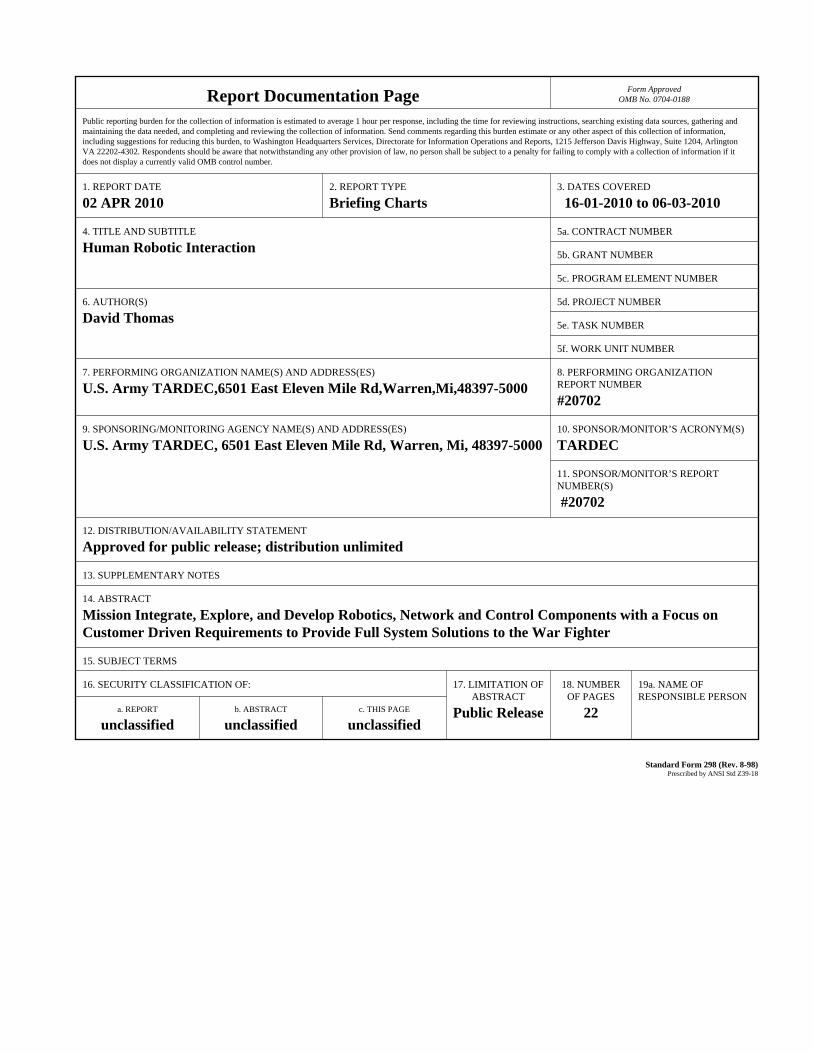
Report Documentation Page Form ApprovedOMB No. 0704-0188
Public reporting burden for the collection of information is estimated to average 1 hour per response, including the time for reviewing instructions, searching existing data sources, gathering andmaintaining the data needed, and completing and reviewing the collection of information. Send comments regarding this burden estimate or any other aspect of this collection of information,including suggestions for reducing this burden, to Washington Headquarters Services, Directorate for Information Operations and Reports, 1215 Jefferson Davis Highway, Suite 1204, ArlingtonVA 22202-4302. Respondents should be aware that notwithstanding any other provision of law, no person shall be subject to a penalty for failing to comply with a collection of information if itdoes not display a currently valid OMB control number.
1. REPORT DATE 02 APR 2010
2. REPORT TYPE Briefing Charts
3. DATES COVERED 16-01-2010 to 06-03-2010
4. TITLE AND SUBTITLE Human Robotic Interaction
5a. CONTRACT NUMBER
5b. GRANT NUMBER
5c. PROGRAM ELEMENT NUMBER
6. AUTHOR(S) David Thomas
5d. PROJECT NUMBER
5e. TASK NUMBER
5f. WORK UNIT NUMBER
7. PERFORMING ORGANIZATION NAME(S) AND ADDRESS(ES) U.S. Army TARDEC,6501 East Eleven Mile Rd,Warren,Mi,48397-5000
8. PERFORMING ORGANIZATIONREPORT NUMBER #20702
9. SPONSORING/MONITORING AGENCY NAME(S) AND ADDRESS(ES) U.S. Army TARDEC, 6501 East Eleven Mile Rd, Warren, Mi, 48397-5000
10. SPONSOR/MONITOR’S ACRONYM(S) TARDEC
11. SPONSOR/MONITOR’S REPORT NUMBER(S) #20702
12. DISTRIBUTION/AVAILABILITY STATEMENT Approved for public release; distribution unlimited
13. SUPPLEMENTARY NOTES
14. ABSTRACT Mission Integrate, Explore, and Develop Robotics, Network and Control Components with a Focus onCustomer Driven Requirements to Provide Full System Solutions to the War Fighter
15. SUBJECT TERMS
16. SECURITY CLASSIFICATION OF: 17. LIMITATION OF ABSTRACT
Public Release
18. NUMBEROF PAGES
22
19a. NAME OFRESPONSIBLE PERSON
a. REPORT unclassified
b. ABSTRACT unclassified
c. THIS PAGE unclassified
Standard Form 298 (Rev. 8-98) Prescribed by ANSI Std Z39-18
UNCLASSIFIEDUNCLASSIFIED
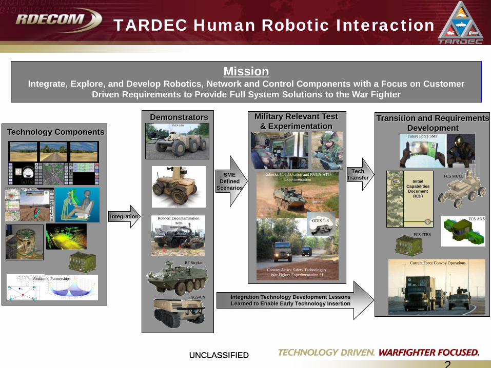
MissionIntegrate, Explore, and Develop Robotics, Network and Control Components with a Focus on Customer
Driven Requirements to Provide Full System Solutions to the War Fighter
Technology Components
R1
R2
R4
R3 Tref
Ta
Academic Partnerships
Initial Capabilities Document
(ICD)
Transition and Requirements Development
Integration
SME Defined
Scenarios
Integration Technology Development Lessons Learned to Enable Early Technology Insertion
Tech Transfer
TARDEC Human Robotic Interaction
Demonstrators
TAGS-CX
RF Stryker
Robotic Decontamination
Military Relevant Test & Experimentation
Robotics Collaboration and RVCA ATOExperimentation
Convoy Active Safety Technologies War Fighter Experimentation #1
FCS MULE
FCS ANS
Current Force Convoy Operations
Future Force SMI
FCS JTRS
ODIS T-3
2
UNCLASSIFIEDUNCLASSIFIED3
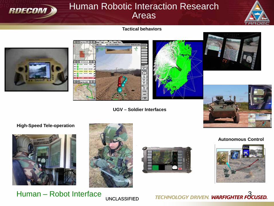
Human Robotic Interaction Research Areas
Human – Robot Interface
High-Speed Tele-operation
UGV – Soldier Interfaces
Tactical behaviors
Autonomous Control
UNCLASSIFIEDUNCLASSIFIED
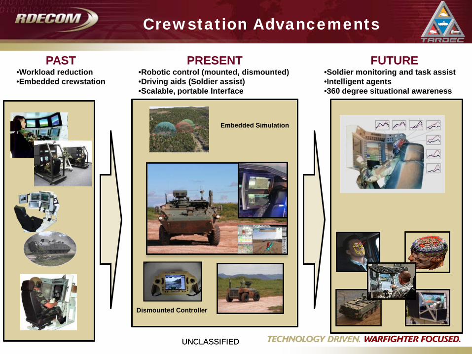
Crewstation Advancements
Dismounted Controller
Embedded Simulation
PAST•Workload reduction•Embedded crewstation
PRESENT•Robotic control (mounted, dismounted)•Driving aids (Soldier assist)•Scalable, portable Interface
FUTURE•Soldier monitoring and task assist•Intelligent agents•360 degree situational awareness
UNCLASSIFIED5
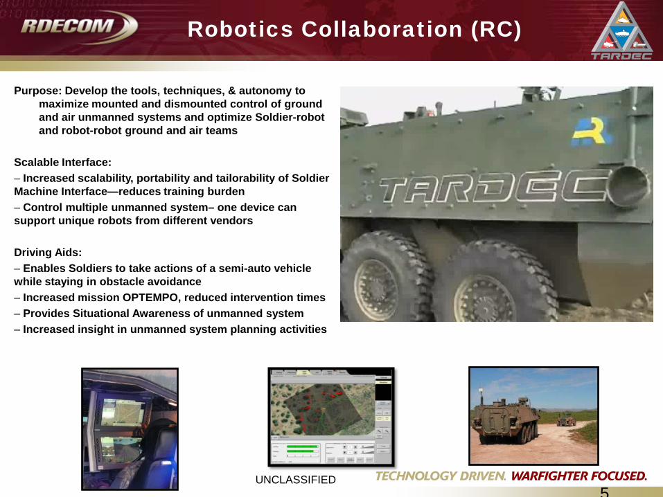
Robotics Collaboration (RC)
Purpose: Develop the tools, techniques, & autonomy to maximize mounted and dismounted control of ground and air unmanned systems and optimize Soldier-robot and robot-robot ground and air teams
Scalable Interface: – Increased scalability, portability and tailorability of Soldier Machine Interface—reduces training burden– Control multiple unmanned system– one device can support unique robots from different vendors
Driving Aids: – Enables Soldiers to take actions of a semi-auto vehicle while staying in obstacle avoidance– Increased mission OPTEMPO, reduced intervention times– Provides Situational Awareness of unmanned system– Increased insight in unmanned system planning activities
UNCLASSIFIEDUNCLASSIFIED
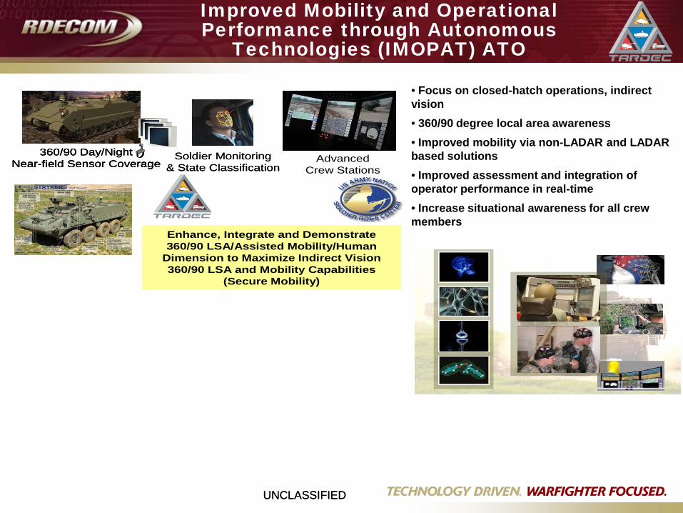
Improved Mobility and Operational Performance through Autonomous
Technologies (IMOPAT) ATO
• Focus on closed-hatch operations, indirect vision• 360/90 degree local area awareness• Improved mobility via non-LADAR and LADAR based solutions• Improved assessment and integration of operator performance in real-time• Increase situational awareness for all crew members
360/90 Day/NightNear-field Sensor Coverage
360/90 Day/NightNear-field Sensor Coverage
360/90 Day/NightNear-field Sensor Coverage Advanced
Crew StationsSoldier Monitoring
& State ClassificationSoldier Monitoring
& State Classification
Enhance, Integrate and Demonstrate360/90 LSA/Assisted Mobility/Human
Dimension to Maximize Indirect Vision360/90 LSA and Mobility Capabilities
(Secure Mobility)
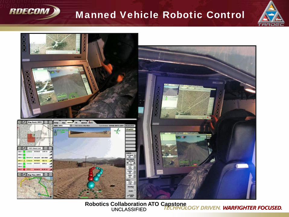
UNCLASSIFIEDUNCLASSIFIEDRobotics Collaboration ATO Capstone
Manned Vehicle Robotic Control

UNCLASSIFIEDUNCLASSIFIED
Improved Mobility and Operational Performance through Autonomous
Technologies (IMOPAT) ATO
• Focus on closed-hatch operations, indirect vision• 360/90 degree local area awareness• Improved mobility via non-LADAR and LADAR based solutions• Improved assessment and integration of operator performance in real-time• Increase situational awareness for all crew members
360/90 Day/NightNear-field Sensor Coverage
360/90 Day/NightNear-field Sensor Coverage
360/90 Day/NightNear-field Sensor Coverage Advanced
Crew StationsSoldier Monitoring
& State ClassificationSoldier Monitoring
& State Classification
Enhance, Integrate and Demonstrate360/90 LSA/Assisted Mobility/Human
Dimension to Maximize Indirect Vision360/90 LSA and Mobility Capabilities
(Secure Mobility)
UNCLASSIFIED9
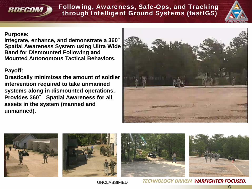
Following, Awareness, Safe-Ops, and Trackingthrough Intelligent Ground Systems (fastIGS)
Purpose: Integrate, enhance, and demonstrate a 360°Spatial Awareness System using Ultra Wide Band for Dismounted Following and Mounted Autonomous Tactical Behaviors.
Payoff:Drastically minimizes the amount of soldier intervention required to take unmanned systems along in dismounted operations.Provides 360° Spatial Awareness for all assets in the system (manned and unmanned).
UNCLASSIFIEDUNCLASSIFIED
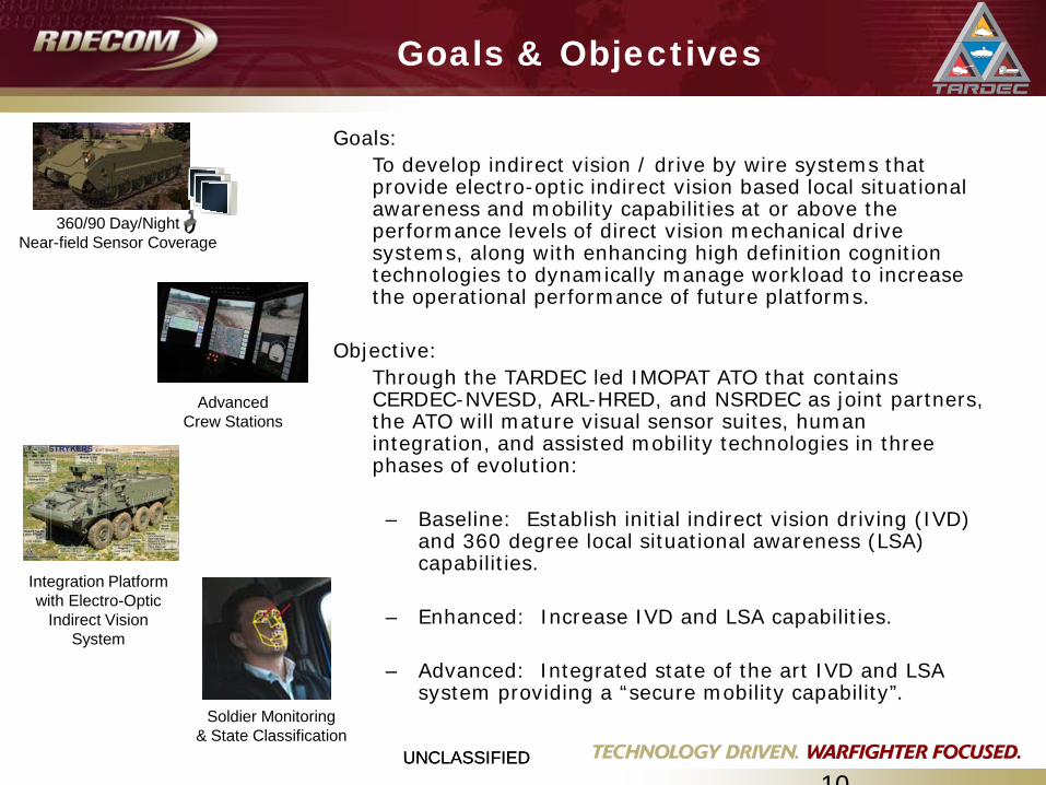
Goals & Objectives
10
Goals: To develop indirect vision / drive by wire systems that provide electro-optic indirect vision based local situational awareness and mobility capabilities at or above the performance levels of direct vision mechanical drive systems, along with enhancing high definition cognition technologies to dynamically manage workload to increase the operational performance of future platforms.
Objective: Through the TARDEC led IMOPAT ATO that contains CERDEC-NVESD, ARL-HRED, and NSRDEC as joint partners, the ATO will mature visual sensor suites, human integration, and assisted mobility technologies in three phases of evolution:
– Baseline: Establish initial indirect vision driving (IVD) and 360 degree local situational awareness (LSA) capabilities.
– Enhanced: Increase IVD and LSA capabilities.
– Advanced: Integrated state of the art IVD and LSA system providing a “secure mobility capability”.
360/90 Day/NightNear-field Sensor Coverage
Integration Platformwith Electro-Optic
Indirect Vision System
Advanced Crew Stations
Soldier Monitoring& State Classification
UNCLASSIFIEDUNCLASSIFIED
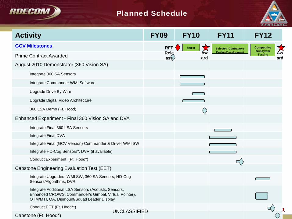
Planned Schedule
11
Activity FY09 FY10 FY11 FY12GCV Milestones
Prime Contract Awarded
August 2010 Demonstrator (360 Vision SA)
Integrate 360 SA Sensors
Integrate Commander WMI Software
Upgrade Drive By Wire
Upgrade Digital Video Architecture
360 LSA Demo (Ft. Hood)
Enhanced Experiment - Final 360 Vision SA and DVA
Integrate Final 360 LSA Sensors
Integrate Final DVA
Integrate Final (GCV Version) Commander & Driver WMI SW
Integrate HD-Cog Sensors*, DVR (if available)
Conduct Experiment (Ft. Hood*)
Capstone Engineering Evaluation Test (EET)
Integrate Upgraded: WMI SW, 360 SA Sensors, HD-Cog Sensors/Algorithms, DVR
Integrate Additional LSA Sensors (Acoustic Sensors, Enhanced CROWS, Commander’s Gimbal, Virtual Pointer), OTM/MTI, OA, Dismount/Squad Leader Display
Conduct EET (Ft. Hood**)
Capstone (Ft. Hood*)
SSEBRFP Release
Selected Contractors Design/Development
Competitive Subsytem
TestingAward
Award
UNCLASSIFIED
UNCLASSIFIEDUNCLASSIFIED
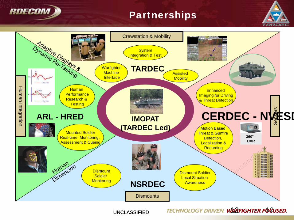
Partnerships
12 • 12
TARDEC
NSRDEC
ARL - HRED IMOPAT(TARDEC Led)
Enhanced Imaging for Driving& Threat Detection
Motion Based Threat & Gunfire
Detection, Localization &
Recording
Mounted SoldierReal-time Monitoring, Assessment & Cueing
Human PerformanceResearch &
Testing
DismountSoldier
Monitoring
Dismount SoldierLocal Situation
Awareness
Assisted Mobility
WarfighterMachineInterface
SystemIntegration & Test
Sen
sors
Dismounts
Hum
an Integration
Crewstation & Mobility
360°DVR
CERDEC - NVESD
UNCLASSIFIEDUNCLASSIFIED
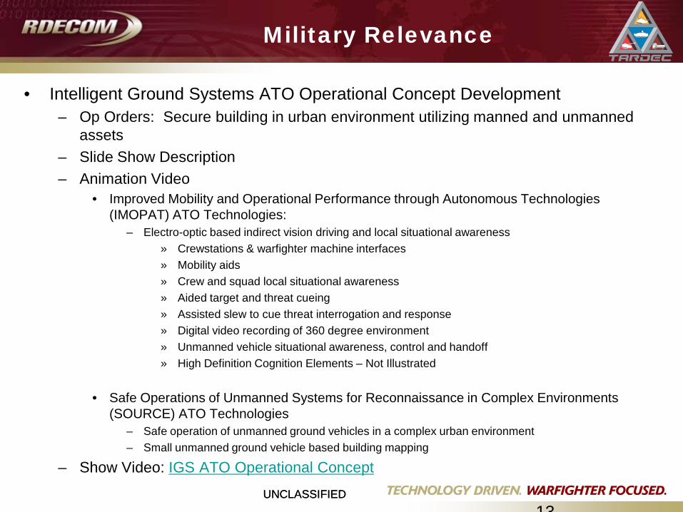
Military Relevance
13
• Intelligent Ground Systems ATO Operational Concept Development– Op Orders: Secure building in urban environment utilizing manned and unmanned
assets– Slide Show Description– Animation Video
• Improved Mobility and Operational Performance through Autonomous Technologies (IMOPAT) ATO Technologies:
– Electro-optic based indirect vision driving and local situational awareness» Crewstations & warfighter machine interfaces» Mobility aids» Crew and squad local situational awareness» Aided target and threat cueing» Assisted slew to cue threat interrogation and response» Digital video recording of 360 degree environment» Unmanned vehicle situational awareness, control and handoff » High Definition Cognition Elements – Not Illustrated
• Safe Operations of Unmanned Systems for Reconnaissance in Complex Environments (SOURCE) ATO Technologies
– Safe operation of unmanned ground vehicles in a complex urban environment– Small unmanned ground vehicle based building mapping
– Show Video: IGS ATO Operational Concept
UNCLASSIFIEDUNCLASSIFIED
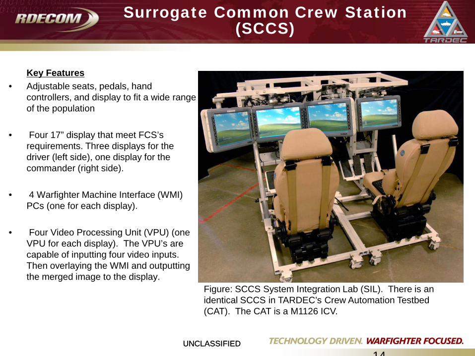
Surrogate Common Crew Station (SCCS)
14
Key Features• Adjustable seats, pedals, hand
controllers, and display to fit a wide range of the population
• Four 17” display that meet FCS’s requirements. Three displays for the driver (left side), one display for the commander (right side).
• 4 Warfighter Machine Interface (WMI) PCs (one for each display).
• Four Video Processing Unit (VPU) (one VPU for each display). The VPU’s are capable of inputting four video inputs. Then overlaying the WMI and outputting the merged image to the display.
Figure: SCCS System Integration Lab (SIL). There is anidentical SCCS in TARDEC’s Crew Automation Testbed (CAT). The CAT is a M1126 ICV.
UNCLASSIFIEDUNCLASSIFIED
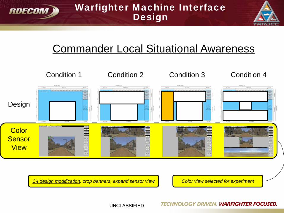
Warfighter Machine Interface Design
Condition 1
Design
ColorSensorView
Condition 2 Condition 3 Condition 4
Color view selected for experiment C4 design modification: crop banners, expand sensor view
Commander Local Situational Awareness
UNCLASSIFIEDUNCLASSIFIED
Use Case Development
16
• These reference documents were used to create IMOPAT Use Cases: – IMOPAT Operational Concept document – primary reference– IMOPAT ATO Charts– Role to (vehicle) position matrix– MGV Role White Paper– User Interface (UI) Spec List – FCS Target Audience Description– ARL FCS IMPRINT models– MGV UI Book
• After the reference materials were collected and studied, the IMOPAT Function/Task List and Roles were derived
• The Use Cases were created leveraging the function/task list and roles. A format was followed & change management was performed for each Use Case.
• 7 Use Case Types: – Mission Planning and Execution– Control Manned Vehicle– Command Vehicle– Local SA– Control Unmanned Vehicle– Communications– Enemy Engagement**

UNCLASSIFIEDUNCLASSIFIED
Closed Hatch Hemispherical Vision Integrated withThreat Cueing, Video Capture, and Slew to Cue Interrogation
High Frontal ResolutionClosed Hatch
360 Vision
Improved Driving and
Threat DetectionVirtual
Pointer in Weapon Sight for
target handoff between
SUGV and Dismounts
Target Handoff via Virtual
Pointer
Slew to Cue via High Resolution
Imager (e.g.Enhanced
RWS/CROWS)
WFOV Inset into 360° VisionWith Touch Screen GUI
WFOV Supports
OTMOperation
s
Rapid Slew to Cue from 360 Vision to High
Resolution Imager
Motion Based Cueing forPop Up/Close-In Target
Detection
Acoustic Gunfire
Detection
360° DVR with tagging
Threat Cueing & Image Capture Improved SA
and operator workload reduction
SUGV with SWIR Zoom
Crew andCommander
Driver
DismountingSoldiers
Sensors, System Processor,Controls and Displays
Commander’s Gimbal
w/Non-Lethal Suppression
Separate Stabilized Gimbal
(automatic &manual modes)
“Green” Laser
for Non-Lethal
Suppression
Enabler for Improved Survivability and Lethality
Urban Sensor Suite
UNCLASSIFIEDUNCLASSIFIED
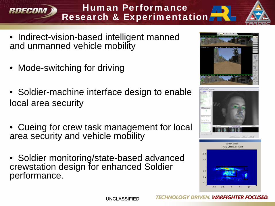
Human PerformanceResearch & Experimentation
• Indirect-vision-based intelligent manned and unmanned vehicle mobility
• Mode-switching for driving
• Soldier-machine interface design to enable local area security
• Cueing for crew task management for local area security and vehicle mobility
• Soldier monitoring/state-based advanced crewstation design for enhanced Soldier performance.
UNCLASSIFIED
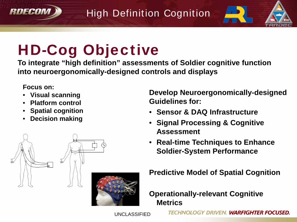
To integrate “high definition” assessments of Soldier cognitive function into neuroergonomically-designed controls and displays
HD-Cog Objective
High Definition Cognition
Focus on:• Visual scanning• Platform control• Spatial cognition• Decision making
Develop Neuroergonomically-designed Guidelines for:• Sensor & DAQ Infrastructure• Signal Processing & Cognitive
Assessment• Real-time Techniques to Enhance
Soldier-System Performance
Predictive Model of Spatial Cognition
Operationally-relevant Cognitive Metrics
UNCLASSIFIEDUNCLASSIFIED
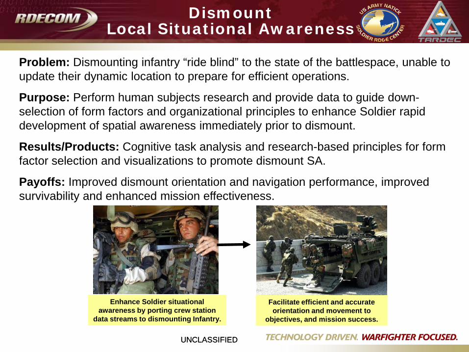
Facilitate efficient and accurate orientation and movement to
objectives, and mission success.
Enhance Soldier situational awareness by porting crew station
data streams to dismounting Infantry.
Problem: Dismounting infantry “ride blind” to the state of the battlespace, unable to update their dynamic location to prepare for efficient operations.
Purpose: Perform human subjects research and provide data to guide down-selection of form factors and organizational principles to enhance Soldier rapid development of spatial awareness immediately prior to dismount.
Results/Products: Cognitive task analysis and research-based principles for form factor selection and visualizations to promote dismount SA.
Payoffs: Improved dismount orientation and navigation performance, improved survivability and enhanced mission effectiveness.
DismountLocal Situational Awareness
UNCLASSIFIED
21
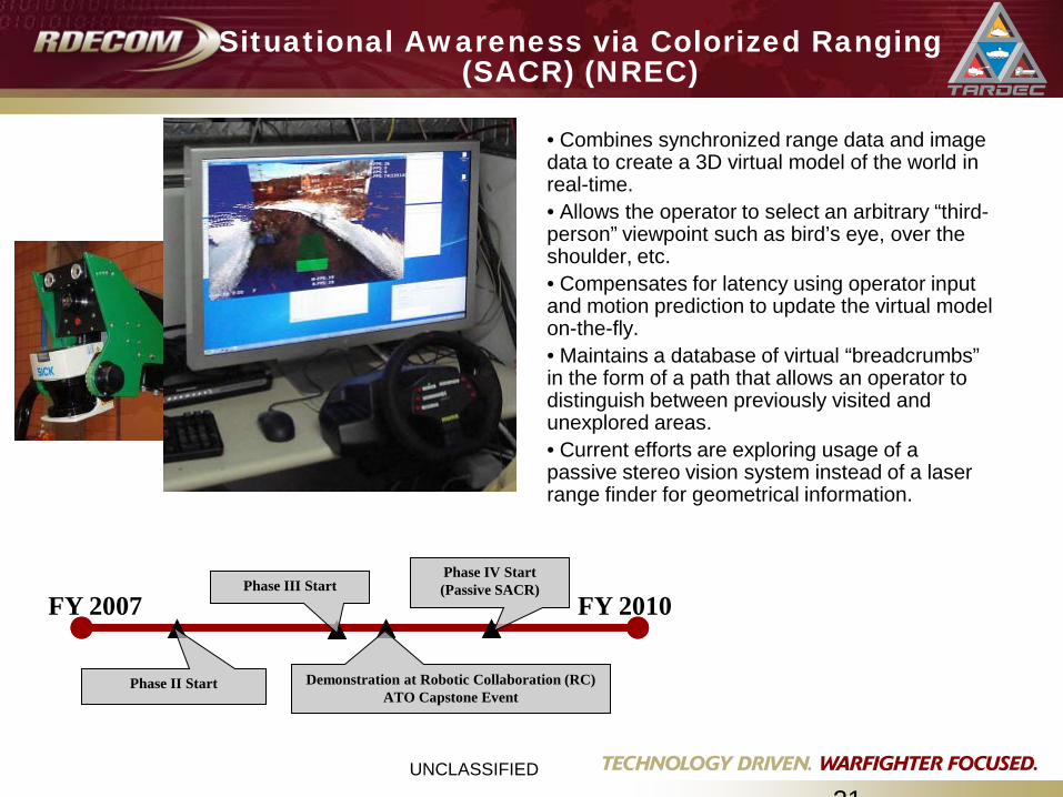
Situational Awareness via Colorized Ranging (SACR) (NREC)
• Combines synchronized range data and image data to create a 3D virtual model of the world in real-time.• Allows the operator to select an arbitrary “third-person” viewpoint such as bird’s eye, over the shoulder, etc.• Compensates for latency using operator input and motion prediction to update the virtual model on-the-fly.• Maintains a database of virtual “breadcrumbs” in the form of a path that allows an operator to distinguish between previously visited and unexplored areas.• Current efforts are exploring usage of a passive stereo vision system instead of a laser range finder for geometrical information.
FY 2007 FY 2010Phase III Start
Phase II Start Demonstration at Robotic Collaboration (RC) ATO Capstone Event
Phase IV Start(Passive SACR)
UNCLASSIFIEDUNCLASSIFIED
Questions