Embed Size (px)
Citation preview
HYDRO-ELECTRIC POWER IN WASHINGTON
To those familiar with the natural resources of Washingtonit is a well-known fact, that, aside from the land itself, the water resources-that is, water power and water for irrigationhead the list in future economic importance. In potential hydroelectric power Washington easily ranks first of all the States inthe Union. The latest estimate by the U. S. Geological Survey,
·released Feb. 11, 1928, credits Washington, with 11,225,000 H.P.or 18.9% of the total water power resources of the United States,on the basis of power used 50 per cent of the time and at 70per cent overall efficiency; an increase of 40 per cent on previousestimates. A recent compilation* by Mr. Glen L. Parker, Dis-.trict Engineer, U. S. Geological Survey, of power data on theColumbia river shows that this stream alone has within the borders of Washington, 6,568,000 H.P., or almost as much availablepower as has generally been credited to the whole State. Toreaders not directly concerned with hydro-electric power, a comparative statement may be more illuminating than a table of statistical data. Thus the Columbia river, proper, limited to the partlying with the borders of the State of Washington, and exclusiveof all its tributaries, has more than twenty-seven times the powerdeveloped by the famous Wilson Dam.
To gain insight into the hydroelectric power possibilities ofany region, as the Pacific Coast or the State of Washington, itis essential first to acquire clear concepts of three fundamentalfactors: (a) land elevation or topography; (b) annual and monthly precipitation; (c) natural and artificial water storage. Aftera broad and comprehensive view of the' region under consideration has been acquired, the more specific factors of stream flow,static head, available dam sites, and so on, pertaining to individualpower developments, can be studied to best advantage becausemodern power plants are not isolated units but parts of largesystems of inter-connected and, in a large measure, inter dependent power developments.
Topography.-:.Geographically, Washington may be consideredas consisting of eight fairly distinct districts: the Olympic Mountains, the Puget Sound Basin, the Willapa Hills, the Cascade
* Columbia River power possibilities between International boundary and tide~water.
U.S.G. 1925.
(90)
1
H yrdro-Electric Power in Walshington 91
comparatively small area in theThey are of irregular contour,
Mountains, the Columbia Plateau, the Okanogan Highlands, theSelkirk Mountains, and the Blue Mountains. ,
Over two-thirds of the land area in Washington is mountainous and for the greater part extremely rugged. The moun- ,tainous regions; having more than five hundred glaciers, vastsnowfields and timbered areas, form huge natural water-powerstorage systems, as the precipitation during the winter months isheld in congealed form until released by the summer heat. Mt.Rainier alone has twenty-two glaciers, which with extensive snowfields, form an enormous ice storage system that provides anunceasing flow of water and power to the White, Puyallup, Nisqually and Cowlitz rivers.
The Cascade Mountains form a huge ridge, dividing the Stateinto an eastern and a western section, having strikingly differentclimatological and physiographic characteristics. The crest of.the range varies from 3,500 to 6,500 feet in elevation, with anaverage of about 5,500 feet, but it has a number of higher peaksas Mt. Shuksan (9,038 feet), Mt. Stuart (9,470 feet), Star Peak(8,400 feet) Boston Peak (8,850 feet), Castle M;ountain (8,840feet), North Star Mountain (9,500 feet) etc. Rising above thegeologically mature range, stand, like young sentinels, five snowcapped volcanic cones: Mt. Baker (10,750 feet), Glacier Peak(10,436 feet), Mt. Adams (12,307 feet), Mt. St. Helens (9, 671feet) and Mt. Rainier (14,408 feet). The range varies in widthfrom 125 miles on the Canadian Border to about 50 miles on theColumbia river.
East of the Cascades along the northern border lie the Okanogan Highlands and, in the northeast corner, a small segmentof the Selkirk Mountains. The surface formation consists of aseries of ridges in a general north and south direction, having anelevation of from 5,000 to 6,000 feet.
In the southeast corner are the Blue Mountains, a spur ofthe Rocky Mountains, rising about 4,000 feet above the surrounding plateau and having an elevation of from 6,000 to 7,000feet above sea level.
In the western part of the State, the Olympic Mountainsform a well-defined geographic division having a general eleva
,tion of from 4,000 to 5,000 feet. Numerous peaks reach between6,000 and 7,000 feet and the summit, Mt. Olympus, is 8,150 feetabove sea level.
The Willapa Hills cover asouthwest corner of the State.
92 C. Edward Magnusson
heavily timbered, anI reach an elevation of about 3,000 feet. TheColumbia Plateau, which lies to the east of the Cascade Mountains, was formed by an immense lava flow that covered almostthe entire area; the beds in some places are 4,000 feet in thickness. .Later geologic changes have caused warpings in the lavabeds, which, with long-continued water and wind erosion, havedeveloped irregularities in the earlier unbroken surface. The Columbia, Spokane, and Snake rivers have cut great gorges, orcanyons, in places more than a thousand feet deep, through thelava beds. The Grand Coulee and other canyons and couleeswere produced by stream erosion, being the abandoned beds oflarge rivers.
Between the Olympics and the Cascades lies the Puget SoundBasin, the belt of lowlands extending from the Canadian Border
.to the Columbia river. In the northern and central parts of therolling plain the surface layer is glacial drift and comparativelylevel, while in the southern non-glacial section the topography ismore irregular. Geologically, the Puget Sound Basin was formedby a great structural down-warp between the Cascades and theOlympics, followed by a submergence in which the major valleys,Puget Sound, were flooded.
While all the streams in the State empty either directly, orthrough intermediate waters, into the Pacific Ocean, the landsurface is divided topographically into three watersheds or drainage areas: the Columbia river system, the Puget Sound Basinand the Pacific Coast Belt.
Precipit(JJtion.-More than passing notice must be given tothe distribution and the seasonal variations of rainfall in orderto appreciate fully the importance of water storage as a basicfactor for hydroelectric power developments in Washington.
Three outstanding features are to be observed:
(a) The great variation in the annual rainfall as recordedby the several U. S.· Weather Bureau stations: from over 137inches at the Quinault station on the western slope of the Olympic Mountains to less than 7 inches in the Columbia Basin andin the Yakima Valley ,east of the Cascade range. Stream-flowdata on the Quinault river indicate that in some areas in theOlympic Mountains the annual rainfall is more than 250 inches.
(b) The marked irregularity in the distribution of the annual rainfall even within regions of fairly uniform topography,as the lowlands of the Puget Sound Basin. Thus, the annual
\ Hydro-Electric Power in WalShington 93
rainfall in Olympia (54.96) is 60 per cent greater than in Seattle(34.0), while, in Everett (29.66), it is 13 per cent less.
( c) The large seasonal variation: in general, a wet-winterseason with the greatest precipitation in November, December,and January, and a dry-summer season with a minimum rainfall in July and August.
The underlying causes for the wide vanatlOns in the ramfall in Washington are found in three basic factors:
(a) That the moisture-bearing winds come from the Pacific Ocean, from a west south-westerly direction.
(b) That the belt of "prevailing westerlies" over the Pacific Ocean covers the coast of Washington during the wintermonths but that it moves northward reaching Alaska during thesummer.
( c) Topography: especially the geographic positions of boththe Olympic Mountains and the Cascade Mountains.
The first and third factors largely account for the widevariation in the annual rainfall, while the seasonal range is inthe main caused by the second factor. The moisture-laden windscoming from the Pacific Ocean pass up the western slopes ofthe Olympic and Cascade Mountains and, as the temperature decreases with elevation, this causes rapid condensation which produces heavy precipitation in these regions. On the eastern, leeward side, the air passing down the mountain slopes increases intemperature, with a corresponding rise in its moisture-carryingcapacity and, as a consequence, the rainfall is comparatively light.
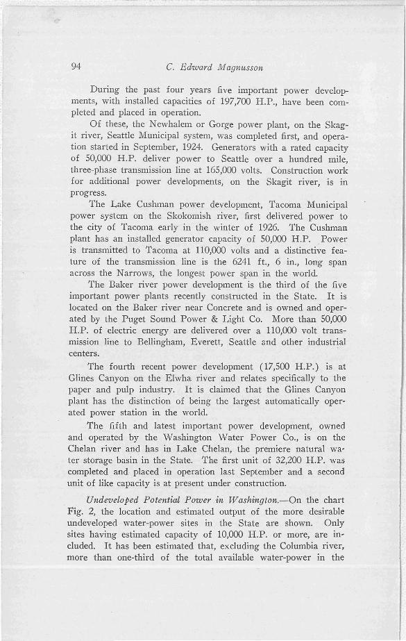
Developed Hydroelectric Power in Washington.-On the Chartmap, Fig. 1 are shown the location and installed capacity of hydroelectric power plants already constructed and in operation. Thesquares indicate the approximate location of the respective plantsand the figures indicate, in each case, the rated horse power of theinstalled water wheels. The total installed capacity as listed inthe figure is 699,367 horsepower, approximately 5 per cent of theavailable hydroelectric power in the State.
Power developments however desirable are of necessity limited to the amount of power that can be used economically. Thedemand for electric power in the State of Washington is, atpresent; increasing at the rate of approximately 50,000 H. P. ayear and it is self evident that on a sound economic basis thedevelopment of new power units can not proceed at a greaterrate than the increase in the consumption of electric power.
94 c. Edward Magnusson
During the past four years five important power developments, with installed capacities of 197,700 H.P., have been completed and placed in operation.
Of these, the Newhalem or Gorge power plant, on the Skagit river, Seattle Municipal system, was completed first, and operation started in September, 1924. Generators with a rated capacityof 50,000 H.P. deliver power to Seattle over a hundred mile,three-phase transmission line at 165,000 volts. Construction workfor additional power developments, on the Skagit river, is inprogress.
The Lake Cushman power development, Tacoma Municipalpower system on the Skokomish river, first delivered power tothe city of Tacoma early in the winter of 1926. The Cushmanplant has an installed generator capacity of 50,000 H.P. Poweris transmitte-d to Tacoma at 110,000 volts and a distinctive feature of the transmission line is the 6241 ft., 6 in., long spanacross the Narrows, the longest power span in the world.
The Baker river power development is the third of the fiveimportant power plants recently constructed in the State. It islocated on the Baker river near Concrete and is owned and operated by the Puget Sound Power & Light Co. More than 50,000H.P. of electric energy are delivered over a 110,000 volt transmission line to Bellingham, Everett, Seattle cmd other industrialcenters.
The fourth recent power development (17,500 H.P.) is atGlines Canyon on the Elwha river and relates specifically to thepaper and pulp industry. It is claimed that the Glines Canyonplant has the distinction of being the largest automatically operated power station in the world.
The fifth and latest important power development, ownedand operated by the Washington Water Power Co., is on theChelan river and has in Lake Chelan, the premiere natural water storage basin in the State. The first unit of 32,200 H.P. wascompleted and· placed in operation last September and a secondunit of like capacity is at present under construction.
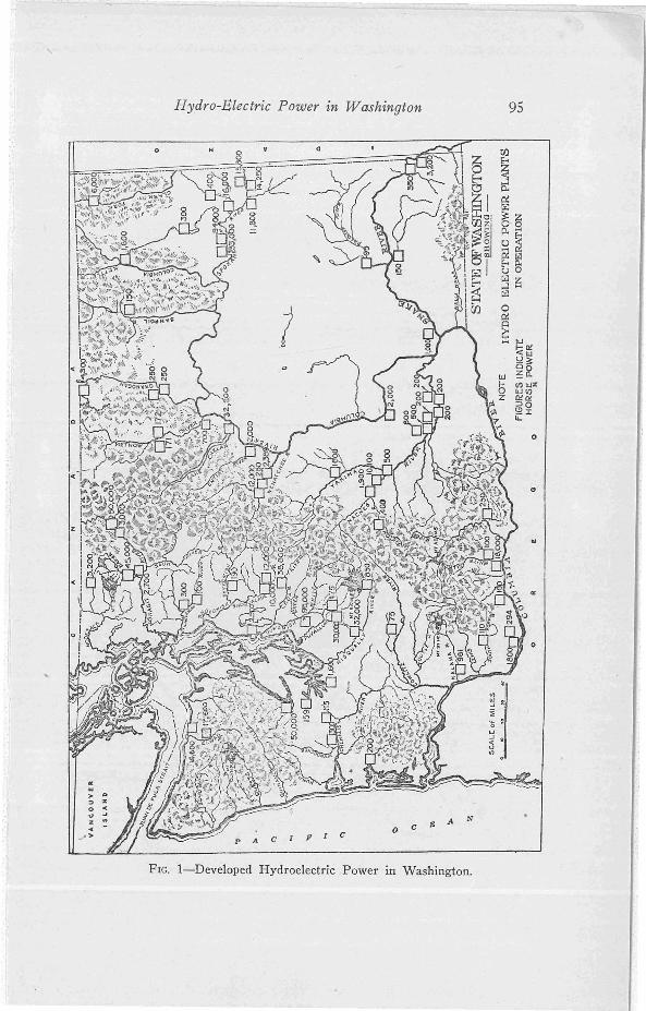
Undeveloped Potential Power in Washington.-On the chartFig. 2, the location and estimated output of the more desirableundeveloped water-power sites in the State are shown. Onlysites having estimated capacity of 10,000 H.P. or more, are included. It has been estimated that, excluding the Columbia river,more than one-third of the total available water-power in the
Hydro-Electric Power zn Washington 95
FIG. I-Developed Hydroelectric Power in Washington.
96 C. Edward Magnusson
a:LI> ":::> zo ..U .JZ .,«> p ;. c
I Fieo C E A N
z
o
"
o
FIG. 2-Undeveloped Potential Power in Washington.
Hypro-Electric Power in WalShington 97
State is found on sites having less than 10,000 horsepower, thelower limit on the output of plants included in the figure.
To estimate the probable power output on any given powersite that may be developed at a reasonable cost, is a difficult problem. To determine the location and cost of dam foundation, theextent of the storage facilities, and other factors, require extewsive borings and detailed investigations of "the geologic formationsand other factors for each proposed site. Different assumptionsas to available storage facilities, the cost of dam construction, andwhat should be considered a "reasonable cost" per horsepower,will often lead to widely differing estimates of the available power. Unfortunately, it has not been possible to coordinate theavailable data so as to use a common, clearly-defined basis forall sites. The figures attached to the power sites indicated onthe chart, Fig. 2, represent, in general, horsepower available 90per cent of the time at 70 per cent efficiency and, in some cases,without taking into consideration man-made storage.
Washington not only leads all other States in potential water power, but, what is likewise important, the concentration (water power per square mile of land area) is twice as great as inits nearest competitor-Oregon-more than two and a half timesthat of California, over ten times that of Wisconsin or Georgiaand more than twenty times that of Minnesota. Moreover thegeographic features are favorable for economic transportation ofelectric energy from all parts of the State to tidewater industrialcenters. The general contour of the land and, in particular, thegeographic lay of the Puget Sound Basin, in connection withthe Cascade Mountain passes, make feasible the construction oftrunk transmission lines by which it is possible to unite all thepower plants and distribution systems into a super-power systemcovering the entire State. Although less than five per cent ofthe available water power has as yet been developed, two 110,000volt transmission lines cross the Cascades, so that the generatorson the Spokane river, at the eastern end of the State, already oper-"ate in synchonism with power plants in the Puget Sound Basin.
Interconnection of power plants is in general desirable, andin Washington especially advantageous, as minima stream-flowsof the several rivers come at different seasons of the year. Thusall the rivers, except the Skagit, west of the Cascades, have maximum flow in the winter, the minimum in August and September,while conditions are essentially the reverse for the Skagit andthe Columbia. Therefore, when completely developed the inter-
98 C. Edward Magnusson
connected hydroelectric power plants will supplement each otherso as to provide a continuous unfailing supply of power duringthe entire year, with little, if any, need of auxilliary stand-bysteam plants.
While the natural water resources in Washington are verylarge and of basic economic importance, it must be kept in mindthat to develop these resources whether for irrigation or electricpower requires the expenditure of huge sums of money. It hasbeen estimated that merely to develop the available hydroelectricpower in the State, that is, generating stations and transmissionlines, will require a capital investment of over a billion dollars.In addition, large sums will be requil.'ed for substations and distribution systems necessary to retail the electric energy to individual customers. Concurrent with the development of thepower resources must of necessity be a corresponding expansionin industry within the State. Factories, mills and a wide varietyof industrial plants, requiring many times as much capital investment as the power developments, will be constructed andplaced in operation within the State because dependable poweris a prime requirement for present day industry.
Another important characteristic of hydroelectric power developments is the permanency Of the investment. Hydroelectricpower plants, transmission lines and distribution systems permanently increase the taxable wealth of the State. The permanenteconomic welfare of the people in the community served is closely interwoven with the best interests of hydroelectric power utilities. Gas, oil and even coal bring prosperity for a short periodonly, while water power is a permanent asset, everlasting as thehills. A golden key to Washington's future greatness and economic independence lies in the water resources that must be madeproductive through power developments and irrigation. Withevery year that passes hydroelectric power and irrigation in Washington, as measured by manufactured goods and agricultural products, will aid and supplement each other to a greater extent thanis possible in any other State.
C. EDWARD MAGNUSSON