Embed Size (px)
Citation preview

i
EVALUATION OF RAIN CELL MODELS USING INDONESIAN
METEOROLOGICAL RADAR DATA
RENY SAPUTRI
A project report submitted inpartial fulfilment of the
requirements for the award of the degree of
Master of Engineering (Eletrical-Electronics & Telecommunications)
Faculty of Electrical Engineering
Universiti Teknologi Malaysia
JUNE 2015

iii
Specially dedicated to Abi Adib, Mama, and Papa
Thanks for all of your support.
iv
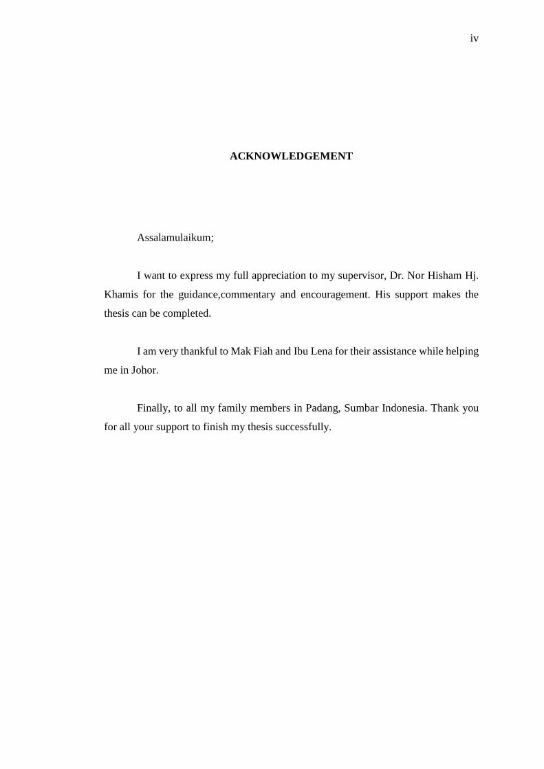
ACKNOWLEDGEMENT
Assalamulaikum;
I want to express my full appreciation to my supervisor, Dr. Nor Hisham Hj.
Khamis for the guidance,commentary and encouragement. His support makes the
thesis can be completed.
I am very thankful to Mak Fiah and Ibu Lena for their assistance while helping
me in Johor.
Finally, to all my family members in Padang, Sumbar Indonesia. Thank you
for all your support to finish my thesis successfully.

v
ABSTRACT
Frequencies above 10 GHz are strongly affected by attenuation phenomena
due to atmospheric impairments, among which rain plays the dominant role.
Horizontal structure of rain fields is very complex due to its high space-time
variability. Considering modelled cells which are described by a small number of
parameters that would allow reduced computing time, storage problems, and multiply
the system simulations to optimally define the system parameters. Radar image with
range bin pixel up to 200 m, 0.5 degrees of elevation angle and about 100 km from
radar site. Peak of rain intensity and the distances along elliptic shape of rain cells can
obtained and also each model parameters. The EXCELL and HYCELL model has
been fitted and compared to every rain cell. The result shows HYCELL model has
good performance than EXCELL model.

vi
ABSTRAK
Frekuensi melebihi 10 GHz amat dipengaruhi oleh fenomena pengecilan
disebabkan gangguan atmosfera, antaranya hujan memainkan peranan yang dominan.
Struktur mendatar bidang hujan adalah sangat kompleks kerana tinggi kepelbagaian
ruang-masa. Memandangkan sel dimodelkan yang digambarkan oleh sebilangan kecil
parameter yang akan membolehkan masa pengkomputeran dikurangkan, masalah
penyimpanan, dan membiak simulasi sistem secara optimum menentukan parameter
sistem. Imej radar dengan pelbagai bin piksel sehingga 200 m, 0.5 darjah sudut
ketinggian dan kira-kira 100 km dari tapak radar. Puncak keamatan hujan dan jarak di
sepanjang bentuk elips sel hujan boleh diperolehi dan juga setiap parameter model.
The EXCELL dan HYCELL model telah dipasang dan dibandingkan dengan setiap
sel hujan. Hasil kajian menunjukkan model HYCELL mempunyai prestasi yang baik
dari pada model EXCELL.

vii
TABLE OF CONTENTS
CHAPTER TITLE PAGE
DECLARATION ii
DEDICATION iii
ACKNOWLEDGEMENT iv
ABSTRACT v
ABSTRAK vi
TABLE OF CONTENTS vii
LIST OF TABLES x
LIST OF FIGURES xi
LIST OF ABBREVIATION xii
LIST OF SYMBOL xiv
LIST OF APPENDICES xv
1 INTRODUCTION 1
1.1 Introduction 1
1.2 Problem Statement 2
1.3 Research Objectives 3
1.4 Scope of Work 3
1.5 Thesis Outline 4
1.6 Summary of Work 4
2 LITERATURE REVIEW 6
2.1 Introduction 6
viii
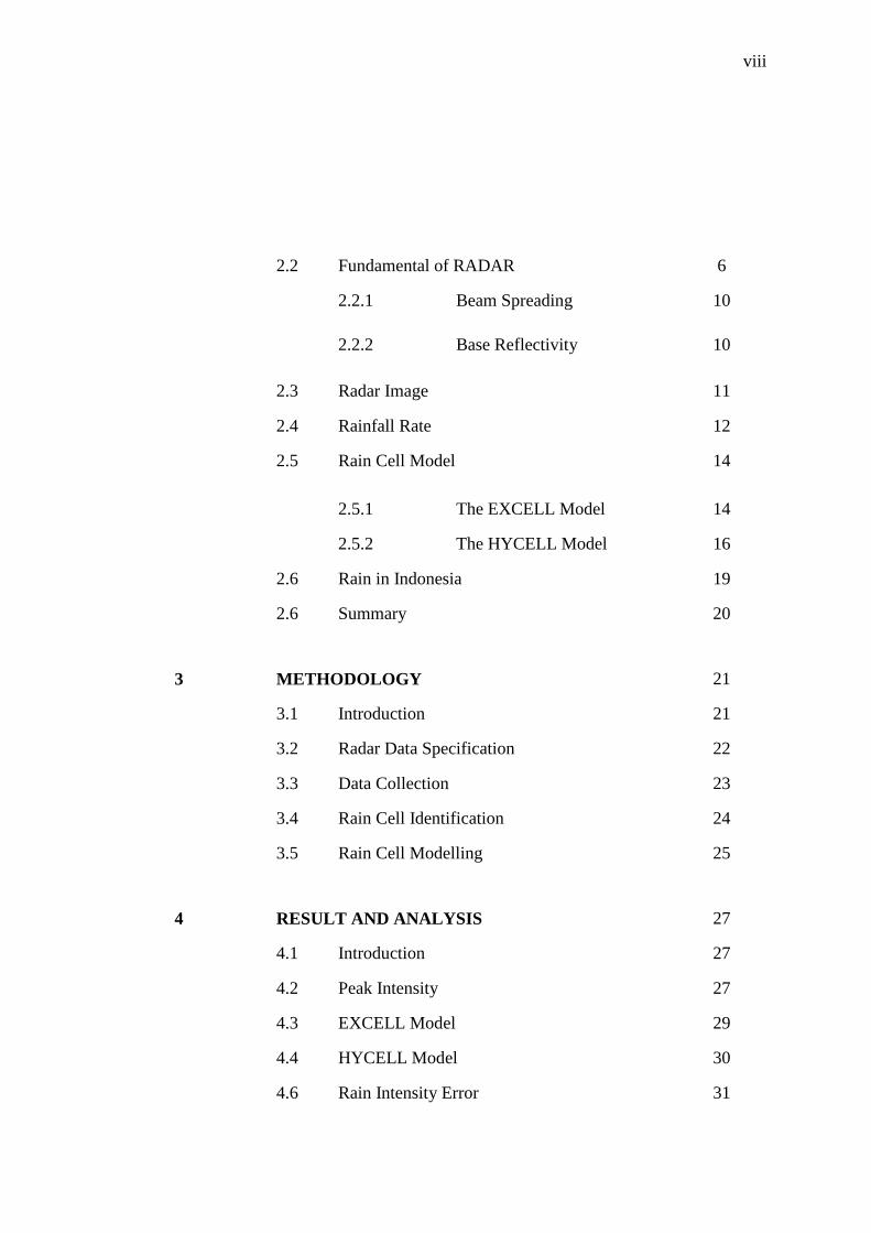
2.2 Fundamental of RADAR 6
2.2.1 Beam Spreading 10
2.2.2 Base Reflectivity 10
2.3 Radar Image 11
2.4 Rainfall Rate 12
2.5 Rain Cell Model 14
2.5.1 The EXCELL Model 14
2.5.2 The HYCELL Model 16
2.6 Rain in Indonesia 19
2.6 Summary 20
3 METHODOLOGY 21
3.1 Introduction 21
3.2 Radar Data Specification 22
3.3 Data Collection 23
3.4 Rain Cell Identification 24
3.5 Rain Cell Modelling 25
4 RESULT AND ANALYSIS 27
4.1 Introduction 27
4.2 Peak Intensity 27
4.3 EXCELL Model 29
4.4 HYCELL Model 30
4.6 Rain Intensity Error 31

ix
5 CONCLUSION AND FUTURE WORKS 32
5.1 Conclusion 32
5.2 Future Works 33
REFERENCES 34
Appendices A-C 36 - 77
x
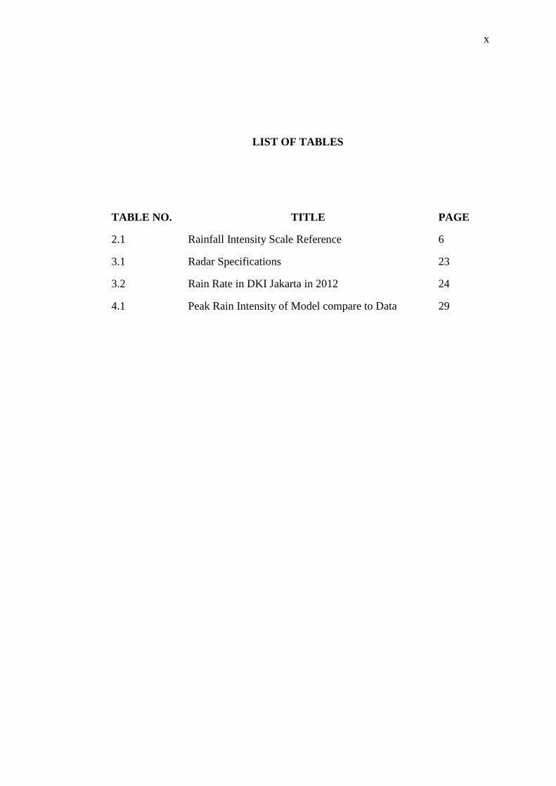
LIST OF TABLES
TABLE NO. TITLE PAGE
2.1 Rainfall Intensity Scale Reference 6
3.1 Radar Specifications 23
3.2 Rain Rate in DKI Jakarta in 2012 24
4.1 Peak Rain Intensity of Model compare to Data 29

xi
LIST OF FIGURES
FIGURE NO. TITLE PAGE
1.1 Project Schedule 5
2.1 The Electromagnetic Spectrum (Courtesy of
Wikipedia)
7
2.2 Radar Image of Base Reflectivity 8
2.3 Rainfall Intensity Chart (Stull, 2000) 12
2.4 The EXCELL model: the vertical plane through the
Ox axis. The Vertical axis is rain rate in mm/h; the
horizontal axis is distance in km
15
2.5 The HYCELL model: the vertical plane along the Ox
axis
18
2.6 Pattern of Rainfall in Indonesia (BMG) 20
3.1 Flow chart of research design 22
3.2 Radar image with rainy cells 25
4.1 Model of EXCELL rain cell with the parameter RE=
49 mm/h, aE=1.2 km, bE=2.2 km
30
4.2 Model of HYCELL rain cell with the parameter Rg=
39 mm/h, aG=2.42 km, bG=3.02 km
31
4.3 Rain intensity error HYCELL and EXCELL 32
xii
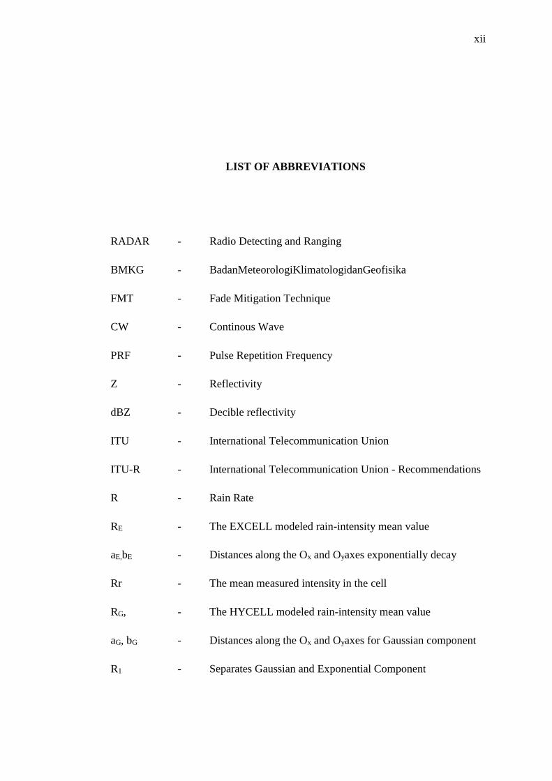
LIST OF ABBREVIATIONS
RADAR - Radio Detecting and Ranging
BMKG - BadanMeteorologiKlimatologidanGeofisika
FMT - Fade Mitigation Technique
CW - Continous Wave
PRF - Pulse Repetition Frequency
Z - Reflectivity
dBZ - Decible reflectivity
ITU - International Telecommunication Union
ITU-R - International Telecommunication Union - Recommendations
R - Rain Rate
RE - The EXCELL modeled rain-intensity mean value
aE,bE - Distances along the Ox and Oyaxes exponentially decay
Rr - The mean measured intensity in the cell
RG, - The HYCELL modeled rain-intensity mean value
aG, bG - Distances along the Ox and Oyaxes for Gaussian component
R1 - Separates Gaussian and Exponential Component
xiii
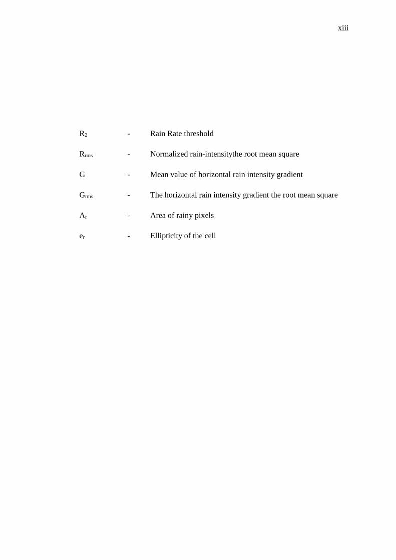
R2 - Rain Rate threshold
Rrms - Normalized rain-intensitythe root mean square
G - Mean value of horizontal rain intensity gradient
Grms - The horizontal rain intensity gradient the root mean square
Ar - Area of rainy pixels
er - Ellipticity of the cell

xiv
LIST OF SYMBOL
𝜉 - The average rain intensity error

xv
LIST OF APPENDICES
APPENDIX TITLE PAGE
A Matlab Program 36
B Radar Data Jakarta 43
C Rain Rate Jakarta 77
1
CHAPTER 1
INTRODUCTION
1.1 Introduction
Rain attenuation is the most significant atmospheric impairment for radio-
communication systems operating at frequencies above 10 GHz (Capsoni, et al.,
2006). A good knowledge of the structure of rain cells is important in the modeling
of rain-induced propagation effects, this kind of experimental work can be performed
only at few geographical locations, and for a limited number of frequencies and link
geometries. Still, telecommunication system are expected to provide real time
multimedia services, and consequently, to be reliable and guarantee the desired system
availability.
Strong signal fades can no longer be overcome by making use of static power
margins, but require the application of Fade Mitigation Techniques (FMTs) as a viable
solution. Such as Dynamic resource allocation from onboard antenna of satellite
(Paraboni et al., 2007) and site diversity are based on the knowledge of the rain fall
spatial distribution (Goldhirsh et al., 1997).
Weather or meteorological radar data represent a valuable alternative in order
to assess the performance of a desired FMT, as they inherently reflect the influence of
the local climatology and topography on the rain field

2
spatial distribution. The lack of worldwide comprehensive and reliable precipitation
data has pushed towards the development of models aiming to represent at best the
characteristics of the local rainfall process (Luinin and Capsoni, 2009).
Rain field modeling proposed among the various approaches so far in
meteorological, statical, stochastic, fractal models and relying on the cellular
representation of the rainfall process such as EXCELL and HYCELL are particularly
suitable for the analysis of the issues related to the radio propagation through the
atmosphere (Luini and Capsoni, 2009).
Tropical region suffers from heavy rainfall rates as compared to temperate
regions. Such as Indonesia, rainfall region consist of 3 types such as Monsoon,
Equatorial, and Local (Aldrian E., 2003). Department of Meteorological, Climatology
and Geophysics of Indonesia (BMKG) operated 24 C-Band radars. This project used
C-Band radar data of BMKG Kemayoran Jakarta.
1.2 Problem Statement
The followings are the problem statements for this project:-
i. Telecommunication links operating at frequencies above 10Ghz are
strongly affected by attenuation phenomena due to atmospheric
impairments, the application of Fade mitigation Technique (FMT)
become a viable solution.
ii. Site diversity based on the knowledge of the rainfall spatial
distribution, rain cell models represent the characteristics of the local
rainfall process.

3
iii. Short-term forecasting of rain rate to derive estimate of rain-field
attenuation, this can increase system uptime.
1.3 Research Objectives
The objectives of the project are:
i. To study available rain cell models.
ii. To compare the suitable of each models using meteorological radar
data.
iii. To choose and improve the most suitable rain cell size model for
tropical country e.g. Indonesia.
1.4 Scope of Work
The scope of study indicates the basic guidelines and techniques that this study
examined in achieving the objectives. It also ensures that the work done stays within
the intended study. Radar data gives the rainfall rate for a range-bin of 200 m each, up
to 100 km. The Radar data is obtained from weather radar Doppler C-Band
Kemayoran Jakarta Indonesia.

4
1.5 Thesis Outline
This thesis is systematized in FIVE (5) chapters. Chapter One gives an
overview and the introduction of the project.
Chapter two consist of literature review of the study, fundamental of RADAR
by focusing on beam spreading and base reflectivity, equation target of weather or
meteorological data which is used in this project.
Chapter three discussed about the methodology of the project. Radar data
format, determine the rain fall rates, and determine the rain cell models.
Chapter four represents the result and data analysis. Then, compare between
models which one is suitable for local area.
Chapter five concludes the results and suggest for future study.
1.6 Summary of Work
The project schedule shows in Figure 1.1. The project begins with the literature
review, followed by doing selecting data, simulation and evaluated the models
parameters using Matlab. The final step is presentation and thesis writing.

5
PROJECT SCHEDULE
MONTH FEBRUARY MARCH APRIL MAY
WEEK 1 2 3 4 5 6 7 8 9 10 11 12 13 14 15
Research on
related topic
Literature
review
Methodology
study
Presentation
Report writing
MONTH FEBRUARY MARCH APRIL MAY
WEEK 1 2 3 4 5 6 7 8 9 10 11 12 13 14 15 16
Collecting
Data
Simulations on
MATLAB
Presentation
Thesis writing
Figure 1.1: Project schedule.

34
References
1. A. Paraboni, P. Gabellini, A. Martellucci, C. Capsoni, M. Buti, S. Bertorelli,
N. Gatti, and P. Rinous, “Performance of a reconfigurable satellite antenna
front-end as a countermeasure against tropospheric attenuation,” presented at
the 13th Ka and Broadband Communications Conf., Torino, Italy, Sep. 2007.
2. V. Pastoriza, A. Nunez, P. Marino, F.P. Fontan, and U.-C. Fiebig, “Rain-Cell
Identification and Modeling for Propagation Studies from Weather Radar
Images”, IEEE Antennas and Propagation Magazine, 52, 5, October 2010, pp.
117-130.
3. Edde, B. (1993). RADAR Principles, Technology, Applications. United State of
America. PTR Prentice Hall, Inc.
4. J. Goldhirsh, B. H. Musiani, A. W. Dissanayake, and L. KuanTing, “Three-
site space-diversity experiment at 20 GHz using ACTS in the Eastern United
States,” Proc. IEEE, vol. 85, no. 6, pp. 970–980, Jun. 1997.
5. J. Awaka, "A Three-Dimensional Rain Cell Model for the Study of
Interference due to Hydrometer Scattering," Journal of the Communications
Research Laboratory, 36, 147, March 1989, pp. 13-44.
6. Aldrian E, Susanto D. (2003). Identification of Three Dominant Rainfall
Regions Within Indonesia and Their Relationship to Sea Surface Temperature.
International Journal of Climatology.

35
7. Roland B. Stull. (2000). Meteorology for Scientist and Engineers. University
of California. USA. Brooks/Cole.
8. Mesnard, F., and H. Sauvageot, Structural characteristics of rain fields, J.
Geophys., 108. Doi:10.1029/2002JD002808, in press, 2003.
9. Jeff, Duda. (2009). How to Use and Interpret Doppler Weather Radar.
Retrieved from
http://www.meteor.iastate.edu/~jdduda/portfolio/How%20to%20read%20and
%20interpret%20weather%20radar.pdf
10. Capsoni, C., F. Fedi, and A. Paraboni, “A comprehensive meteorologically
oriented methodology for the prediction of wave propagation parameters in
telecommunication applications beyond 10 GHz”, Radio Sci., 22(3), 387-393,
1987a.
11. Capsoni, C., F. Fedi, C. Magistroni, A. Paraboni, and A. Pawlina, “Data and
theory for new model of the horizontal structure of rain cells for propagation
applications”, Radio Sci., 22(3), 395-404, 1987b.