Embed Size (px)
Citation preview
I I I I I I I I I I I I I I I I I I I I
Q994.41 cx:M
Q994.41 CXM
HISTORICAL ARCHAEOLOGICAL SURVEY
- of -
SHEPHERDS GULLY, THE OLD GREAT NORTH ROAD (including The Original Line, Sternbecks
Gully Road and Shepherds Gully Road)
by Jillian Comber Adrienne Powell
Report to The NSW National Parks & Wildlife Service
and Australian Heritage Commission & NSW Department of Planning
July 1991
Jillian Com.ber P.O. Box 711, Leichhardt NSW 2040 Telephone (02) 560 6559 100'\'o Recycled Paper
Consultant Archaeologist
I I I I I
I
HISTORICAL ARCHAEOLOGICAL SURVEY
- of -
SHEPHERDS GULLY, THE OLD GREAT NORTH ROAD (including The Original Line, Sternbecks
Gully Road and Shepherds Gully Road)
by Jillian Comber Adrienne Pmvell
Report to The NSW National Parks & Wildlife Service
and
Q 9'7.:r ( cr- / C-Ch'"
Australian Heritage Commission & NSW Department of Planning
July 1991
I I I II II II l :I l II 11 I .
il .I
I .I
.I :I
I I I I I
ARCHAEOLOGICAL SURVEY: SHEPHERD'S GULLY
Acknowledgements i
1. 1.1 1.2 1.3
2.
3. 3.1 3.2
4. 4.1 4.2
4.3 4.4
INTRODUCTION Purpose Location of Study Area Aims
HISTORICAL BACKGROUND
ARCHAEOLOGICAL BACKGROUND Previous Work Archaeological features 3.2.1 General 3.2.2 Original Line 3.2.3 Sternbecks Gully Road 3.2.4 Sherpherd's Gully Road
ARCHAEOLOGICAL SURVEY Methodology The Data 4.2.1 The Original Line 4.2.2 Sternbeck's Gully Road 4.2.3 Shepherd's Gully Road The Survey Plans Condition of each section
5. STATUTORY & OTHER REQUIREMENTS 5.1 NSW Heritage Act 1977 5.2 National Trust of NSW
6. RECOMMENDATIONS
LIST OF FIGURES:
Figure 1: Figure 2: Figure 3:
Location of Study Area Location of Shepherd's Gully Modern Graffitti at 1403m
LIST OF APPENDICES:
Appendix !:Masonry Typology Appendix 2:Glossary Appendix 3:Cross-Reference
REFERENCES
1 1 1 1
2
4 4 4 4 5 5 6
7 7 8 8
11 23 41 54
55 55 55
56
58 59 60
61 62 64
65

I I I I I
jl ,I II I 11 .
,• I
;· I
,• :I I
I I I I I I
I I I I I
I I I I I I I I
I
Jill ian Comber Consultant Archaeologist July 1991
2. HISTORICAL BACKGROUND
The historical background of the Old Great North Road. including a brief mention of Shepherds Gully. has been well documented by Karskens (1985) and does not form part of the brief for this present survey and report.
However to provide a context for the archaeological evidence. a bri~f precis follows:
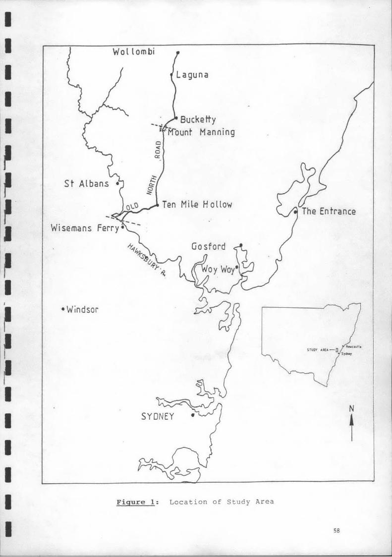
Construction began on the Great North Road in 1826 as the result of a petition to Governor Ralph Darling by settlers in the Hunter Valley. It commenced at Castle Hill running over diverse and often rugged terrain to various destinations in the Hunter Valley. branching at both Wollombi and Broke to Maitland (known then as Wallis Plains). Whittingham (Patrick's Plains) and to Warkworth in the Upper Hunter (Figure 1 ). Built entirely by convict labour it was completed in 1836. This road formed part of Governor Darling's extensive public works' program and consolidated his vision of "fine and all-encompassing roads" (Karskens 1982:197) which would transform a "wretched country" into one of unparallelled civilization (Karskens 1982:194).
The road through Shepherds Gully diverges from the Great North Road at the top of Devines Hill. Wisemans Ferry. Devines Hill was constructed between 1829 and 1832 along a line surveyed by Surveyor General Major Sir Thomas Mitchell when the original road ascent north of the Hawkesbury (Finchs Line) proved to be unsatisfactory due to its steepness and narrowness (Comber 1991 :2-3; Karskens 1985:1 06).
The remains of three distinct episodes of road construction can still be identified. descending from the summit of Devines Hill into the MacDonald River Valley. For the purposes of this report. these three roads are designated. in chronological order. Original Line; Sternbecks Gully (Upper and Lower) and Shepherds Gully.
Original Line
Settlement had been taking place along the Macdonald River since the early 1800's. The earliest use of the route to the MacDonald River Valley through Shepherds Gully dates to this period. A path was forged by the settlers from the top of Devines Hill. down the gully to Blaxlands Road (modern Settlers Road). thence to cross the river at Brooks Ferry and on to St Albans (Upton 1932:163: Karskens 1985: 154).
The road was described by Mr Surveyor Pitt when he surveyed it in 1864 as still only a bridle track (although an earlier writer in 1841 had mentioned improvements being carried out on the road by local people. and that more traffic was expected as a result of these improvements (Hutton-Neve 1978:111 )). Subsequently there was a gradual upgrading of the road to carry "vehicular traffic" (Upton 1932: 163).
Sternbecks Gully Road
This gradual upgrading probably resulted in the Stern becks Gully Road. which rougly follows the original line of track.
At the same time. a similar program of improvement was being carried out along a track between St Albans and Mt Manning to serve the settlers along 'Wollambine" Creek (Upton 1932:163). The upgrading of this track and the Sternbecks Gully Road provided an alternative route for travellers north. This alternate route north through Wisemans Ferry. St Albans via Devines Hill and Sternbecks Gully Road. and continuing through Wollombi. became the preferred route. After it was formally opened in 1884. the section of the Great North Road along the ridge top between Devines Hill and Mt Manning fell into disuse (Upton 1932:163: elf Comber 1990).
Archaeological Report: Shepherd's Gully Page 2
I I I I I
I I I I I I
-------
Jlllian Comber Consultant Archaeologist July 1991
3. ARCHAEOLOGICAL BACKGROUND
3.1 Previous Work
The Old Great North Road has been the subject of several studies. Grace Karskens (1985} unpublished MA Thesis. "The Grandest Improvement in the Country ... The Great North Road. 1825-1836" incorporates detailed historic research with an archaeological overview of the Old Great North Road. However. her archaeological survey did not include Shepherds Gully.
In 1988 Heather Burke was commissioned by the NPWS to undertake an archaeological survey. for management purposes of the section of The Old Great North Road between the upper gate of Devines Hill and Clares Bridge.
In 1990 and 1991 the present Consultant was also commissioned by the NPWS to undertake an archaeological survey of Devines Hill and the section of The Old Great North Road between Clares Bridge and Mt Manning (1990): and Finchs Une (1991 ).
Although the Old Great North Road between Wisemans Ferry and Mt Manning have been examined. this section between Devines Hill and Settlers Road (Shepherds Gully} has not been the topic of previous archaeological research. Therefore. this report sets out to provide a detailed recording of all archaeological features along the three roads within Shepherds Gully.
3.2 Archaeological Features
3.2.1 General
A brief description of the techniques used to construct The Great North Road is detailed below. Sections 3.2.2. 3.2.3 and 3.2.4 provide information on which of these features are to be found along each separate road constructed through Shepherds Gully.
Forming the Road
To form a level road on sloping terrain. such as on the ascent of Shepherds Gully. two processes were utilised. The lower side of the road was embanked with the higher sides often being cut down as well. On very steep slopes both cutting and filling would have been required with material from the cutting forming the embankment (Karskens 1985:2777}.
Quarrying
To reduce the slope it was hand cut with chisels or rock picks. when the area to be reduced was only small. On larger areas the stone was hewn by driving iron wedges into the rockface with a maul until the rock split along the line of the wedges. Pick marks (facing) and the remains of wedge pits can be seen on certain sections of the rocktace. as evidence of this type of quarrying.
Blasting was also utilised to reduce the slope. A jumper bar was driven into the rockface. blasting powder poured into the hole left by the jumper bar. a wick of touchpaper inserted and the top tamped down with clay. Once lit. the rock would be blasted off (Karskens 1985:195-196). Evidence of this type of quarrying now exists in the form of jumper bar marks left on the remaining rockface.
These various quarrying processes were commenced on the uphill side of the road with successive layers being dislodged until the road attained the correct depth.
As well as utilising the quarried material where necessary. for filling the embankment. it was used in forming the retaining walls. Generally. the shaped blocks were used without any further dressing. but occasionally they were dressed and shaped to the required size with picks and chisels.
Archaeological Report: Shepherd 's Gully Page 4
I I I
'
.I
I I I I I I
Jill ian Comber Consultant Archaeologist July 1991
this road and jumper marks. facing and wedge pits can be seen along most of the rock surfaces. At 573m major quarrying activities can be observed.
The road contains one large turning bay. approximately 13m wide. as the road winds around the escarpment at 573m.
No road surfacing can be discerned. and the road is very overgrown.
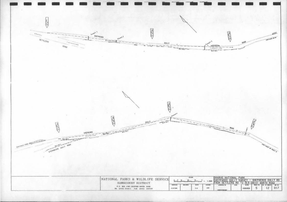
The remains of seven block and slab culverts were recorded. They have all collapsed and are no longer functioning.
The remains of one bridge. which crossed Shepherds Gully was also recorded. Stone abutments and small ramparts were recorded. but no decking remains.
No graffiti was recorded.
3.2.4 Shepherds Gully Road
This road is currently used by recreational 4-wheel driving enthusiasts. horse riders. cyclists and occasional bush walkers.
It contains retaining walls up to 10 courses high with· definite coursing. In some places the road is delineated by only 1 row of blocks. whilst on the upper parts of the road no edging was observed.
18 culverts were recorded. Most of them are no longer functioning. ·Some of these culverts are block and slab. several once contained wooden decking. whilst 3 were pipe culverts surrounded by masonry.
Quarrying occurred along this road. with jumper marks. facing and wedge pits being observed on most rock surfaces.
Two pieces of graffiti were recorded. but neither of them were identified as colonial.
According to former NPWS Senior Ranger lan Webb this road was used for logging access during the 1960's. It is possible that during the period the road was maintained by filling and bulldozing. A modern quarry that was probably used in respect of this maintenance was recorded at 1534m. According to Ranger Robyn Aitken. since 1975. Shepherd's Gully Road has been roughly graded by Hawkesbury Shire Council on three occasions. the last being c1981
The road surface was clear of vegetation yet evidence of any type of road surfacing was not observed. It may not have been surfaced after levelling. or the more recent maintenance may have destroyed such evidence.
Archaeological Report: Shepherd's Gully Page 6
I Jillian Comber Consultant Archaeologist July 1991
I I I I
4.2 THE DATA
Ill I ,I I j
II 4.2.1 THE ORIGINAL LINE i
I I
,I ,I I
!
I I .I
.I I il
I I I I I Archaeological Report: Sherpherd's Gully Page 8
I
I I I I I
I I .I
I I
I I I I I
Jill ian Comber Consultant Archaeologist July 1991
Map Distance (1) No. from lst peg
Description
====================================================================================================
3 2223-235
3 236.50-243
212.5-316
3 251
3 248-281
3 316-322
3 317-319
330
3 330
Rough retaining wall on LHS. Type 1a.
Rough retaining wall on LHS. Type 1a.
On RHS slight earthen embankment defining edge of road; becomes rockier until it ends at boulder.
On boulder on LHS, facing away from road, is a series of triangular pits in rock surface, averaging approx 12cm x 10cm wide, varying depths.
Edge of road on LHS defined by line of natural boulders, continues intermittently. Photograph 1.
On LHS boulders define edge of road; 1 has been chiselled.
Boulders on RHS, some possibly squared.
Collection of natural boulders on LHS, none shaped.
End of Original Line of Road.
Archaeological Report: Shepherd's Gully Page 10
I I I I I
.I
. I
.I I I I I I I I I I I I
Jillian Comber Consultant Archaeologist July 1991
Map Distance (m) No. from 1st peg
LOWER STERNBECKS GnLLY
Description
===================================================================================================
11 00
11 1.35-3.40
11 29-32
11 34
11 34-37
11 39-48
11 50-58
11 57
11 58-61
11 63
11 65.5-91
11 76-80
11 94-112
11 106
11 112
11 112.50
11 114
11 118-122
Lower Sternbecks Gully Road begins. Road surface obscured by vegetation.
Intermittent stone edging on RHS; one roughly shaped rectangular block at beginning. Photograph 2.
Edging on RHS of roughly shaped rectangular blocks.
One roughly shaped rectangular block off road on RHS, faced on one surface .
Retaining wall on RHS, 1-3 courses. Type 2a.
Retaining wall on RHS, 1-4 courses. Type 2a, some snecking. Two blocks have fallen off.
Retaining wall on RHS, 1-5 courses, snecked. Type 2b.
One jumper mark on large boulder on LHS.
Retaining wall on RHS, with some faced blocks, decreasing in height, 1-2 courses.
One jumper mark on boulder on LHS.
Retaining wall on RHS, 1-4 courses. Type 2a/b, some snecking.
Retaining wall on RHS, decreases in height to 1 course.
Intermittent rough stone edging on RHS. Some large blocks, occasionally shaped.
Two jumper marks on rockface on LHS.
Two jumper marks on rockface on LHS.
One jumper mark on boulder 3.4~ from edge of road.
One jumper mark on rockface on LHS.
Retaining wall on RHS, 1-4 courses, snecked. Type 2a.
Archaeological Report: Shepherd's Gully Page 12
I I
I I
I
I I I
Jill ian Comber Consultant Archaeologist July 1991
Map Distance (a) Mo. from lst peg
Description
====================================================================================================
11 231-241
11 241
Lower Sternbecks Gnlly Road retaining wall can still be distinguished from Shepherds Gully Road, which has been built on top of Sternbecks Gnlly Road. Sternbecks Gully Road is set out 7-15cm froa Shepherds Gully Road retaining wall. Sternbecks Gully Road retaining wall is Type 2b. Photograph 5.
Lower Sternbecks Gully Road can no longer be distinguished.
·.
Archaeological Report: Shepherd • s Gully Page 14
I I I I I ,I J
11 I
,I j
,I I I I . I I I I I I I I
Jill ian Comber Consultant Archaeologist July.1991
.Map Distance (1) No. froa 1st peg
Description
====================================================================================================
9 210
9 240
9 241
9 241
9 263
9 321
9 326
336
9 336
9 370
10 3 70
10 396
10 396
Retaining wall on LHS continues. 1-2 courses in deteriorated condition, covered in vegetation.
Culvert 1: Remains of culvert. All that can now be seen are two capping stones on LHS of road. No inlet or outlet could be found. Photograph 7.
Retaining wall on LHS is covered in soil and vegetation and can barely be seen.
Low earthern embankment on RHS.
Track curves around and heads north-west. Retaining wall not visibla on LHS. Thick vegetation on RHS.
Few blocks of low retaining wall in deteriorated state on LHS, continues north. Possibly Type 1a.
Retaining wall on LHS is now more defined and increasing to 2-3 courses. Type la/b.
Quarrying begins on RHS. Rockface has angular edges and jumper marks.
Retaining wall on LHS has increased to 4 large courses. Type 1b/2a .
Culvert 2: block and slab Outlet 34cm x 34cm. Stone invert. Lintel 66cm long x 15cm wide, set on one block on either side. One larger slab above lintel. On RHS of outlet is large stone outcrop. On LHS is retaining wall of 2 courses. Inlet: drop entry, 37cm deep x 30cm wide. Rough slab lintel 66cm x 15cm. Gutter appears to run into inlet from RHS.
No capping stones are visible.
Photographs 8-10.
Retaining wall on LHS continues of 2 courses increasing to 3 courses.
Retaining wall on LHS has increased to 3-4 courses with snecking. Type 2a.
Obvious quarrying activities on RHS have ceased.
Archaeological Report: Shepherd 's Gully Page 16
I I I I I
'~ II II ,I
II I
II 11 I
:I
I I I I I I
Jill ian Comber Consultant Archaeologist July 1991
Map Distance (a) No. from lst peg
Description
====================================================================================================
10 500
10 502-508
10 508
10 527-533
10 535
10 536-50
10 539-573
10 573
10 573
10 573
10 573
10 588
10 600
10 601
Photographs 12-13.
Retaining wall on LHS continues, decreasing to 5 courses. Type lb.
Stone edging on RHS.
Minor quarrying begins again on RHS.
On LHS large unused quarried blocks resting on large stone outcrop. Retaining wall obscured by soil and charcoal.
Two blocks of retaining wall can be observed froa under the soil and charcoal. They are on top of rock outcrop on LHS Outcrop has been chiselled out in two places, indicating a coping course may once have been set into outcrop. See Photograph 14.
Retaining wall on LHS continues after rock outcrop. 6-7 courses. Type 2a.
Large unused quarried blocks are strewn down the slope on LHS. Lower part of road can be seen below.
Retaining wall on LHS ends as road sweeps around in large turning bay, approximately 13m wide.
Major quarrying can be observed on rockface on RHS.
Road turns corner in large turning bay and heads south-west. Retaining wall begins on RHS as road sweeps around and the wall turns at right angle. It is 7 courses high. Type 2b with snecking. Photographs 15-16.
Unused quarried blocks are strewn down the slope on RHS.
Retaining wall on RHS is set on rock outcrop and is only 1-2 courses high, increasing to 3-4. Type 2b.
On LHS are rough pick marks on low rock outcrop.
Retaining wall continues on RHS. 3 courses, type 2b with snecking.
10 621 On RHS the retaining wall is set on rock outcrop.
Archaeological Report: Shepherd's Gully Page 18
;
I I I I
,I
I I I I I I I I I I
Jill ian Comber Consultant Archaeologist July 1991
Map Distance (a) No. from 1st peg
Description
====================================================================================================
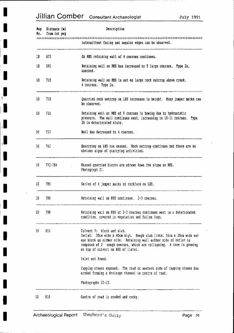
10 673
10 691
10 710
10 710
10 716
10 737
10 762
10 772-784
10 780
10 784
10 798
10 816
10 818
intermittent facing and angular edges can be observed.
On RHS retaining wall of 4 courses continues.
Retaining wall on RHS has increased to ~ large courses. Type 2a,. snecked.
Retaining wall on RHS is set on large rock outcrop above creek. 4 courses. Type 2a.
Quarried rock outcrop on LHS increases in height. Many jumper marks can be observed.
Retaining wall on RHS of 9 courses is bowing due to hydrostatic pressure. The wall continues east, increasing to 10-11 courses. Type 2b in deteriorated state.
Wall has· decreased to 4 causes. ·
Quarrying on LHS has ceased. Rock outcrop continues but there are no obvious signs of quarrying activities.
Unused quarried blocks are strewn down the slope on RHS. Photograph 21.
Series of 4 jumper marks on rockface on LHS.
Retaining wall on RHS continues. 2-3 courses.
Retaining wall on RHS of 2-3 courses continues west in a deteriorated condition, covered in vegetation and fallen logs.
Culvert 7: block and slab. Outlet: 30cm wide x 40cm high. Rough slab lintel 56cm x 20cm wide set one block on either side. Retaining wall either side of outlet is composed of 2 rough courses, which are collapsing. A tree is growing on top of culvert on RHS of lintel.
Inlet not found.
Capping stones exposed. The road on western side of capping stones has eroded forming a drainage channel in centre of road.
Photographs 22-23.
Centre of road is eroded and rocky.
Archaeological Report: Shepherd's Gully Page 20
I I I I I
I I I I I I I I I I
Jill ian Comber Consultant Archaeologist July 1991
Map Distance (m) No. from 1st peg
Description
::::::::::::::::::::::::::::::::::::::::::::::::::::::::::::::::::::::::::::::::::::::::::::::::::::
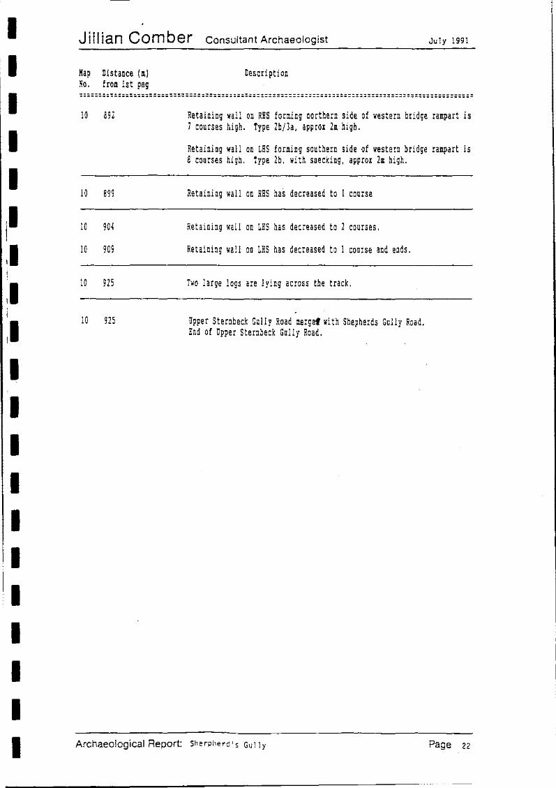
10 892
10 899
10 904
10 909
10 925
10 925
Retaining wall on RHS forming northern side of western bridge rampart is 7 courses high. Type 2b/3a, approx 2m high.
Retaining wall on LHS forming southern side of western bridge rampart is 8 courses high. Type 2b, with snecking, approx 2m high.
Retaining wall on RHS has decreased to 1 course
Retaining wall on LHS has decreased to 2 courses.
Retaining wall on LHS has decreased to 1 course and ends.
Two large logs are lying across the track.
Upper Sternbeck Gully Road mergef with Shepherds Gully Road. End of Upper Sternbeck Gully Road.
Archaeological Report: Sherpherd' s Gully Page 22
I I I I
I I I I I
Jiffian Comber Consultant Archaeologist July 1991
Map Distance (n) No. fran 1st peg
SHEPHERDS GULLY ROAD
Description
====================================================================================================
5
5
5
5 5
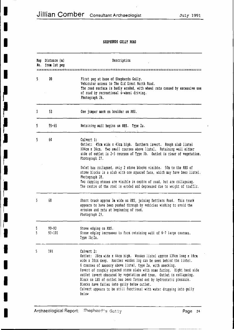
00
53
55-65
60
68
90-93 93-101
101
Archaeological Report:
First peg at base of Shepherds Gully. Vehicular access to The Old Great North Road. The road surface is badly eroded, with wheel ruts caused by excessive use of road by recreational 4-wheel driving. Photograph 26.
One junper mark on boulder on RHS.
Retaining wall begins on RHS. Type 2a.
Culvert 1: Outlet: 45cm wide I 43cm high. Earthern invert. Rough slab lintel 104cm x 36cm. Two small courses above lintel. Retaining wall either side of outlet is 2-3 courses of Type lb. Outlet is clear of vegetation. Photograph 27.
Inlet has collapsed, only 2 stone blocks visible; 50m to the RHS of stone blocks is a slab with one squared face, which may have been lintel. Photograph 28. Two capping stones are visible in centre of road, but are collapsing. The centre of the road is eroded and depressed due to weight of traffic.
Short track approx 3m wide on RHS, joining Settlers Road. This track appears to have been pushed through by vehicles wishing to avoid the erosion and ruts at beginning of road. Photograph 29.
Stone edging on RHS. Stone edging increases to form retaining wall of 6-7 large courses. Type lb/2a.
Culvert 2: Outlet: 28cm wide I 44cm high. Wooden lintel approx 139cm long x 18cm wide x 20cm deep. Another wooden log can be seen behind the lintel. 6 courses of masonry above lintel, type 2a, with snecking. Invert of roughly squared stone slabs with some facing. Right hand side outlet invert obscured by vegetation and tree. Outlet is collapsing. Block on LHS of outlet has been forced out by hydrostatic pressure. Blocks have fallen into gully below outlet. Culvert appears to be still functional with water dropping into gully below
Shepherd's Gully Page 24
I I I I I
I I I I I
Jill ian Comber Consultant Archaeologist July 1991
Map Distance (1) Ho. fro1 1st peg
Description
====================================================================================================
5
5
5
5
5
5
5
5
5
5
5
5
5
5
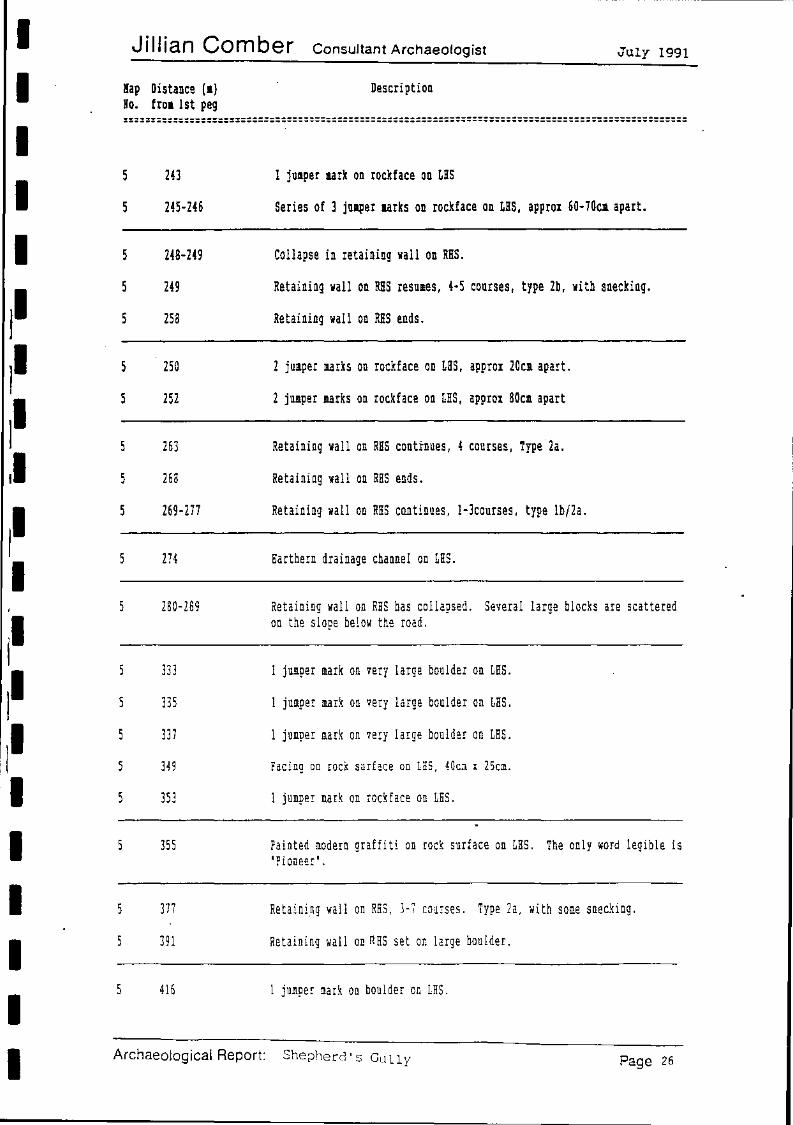
243
245-246
248-249
249
258
250
252
263
268
269-277
274
280-289
333
335
337
349
353
355
377
391
1 jumper aark on rockface on LHS
Series of 3 juJper aarks on rockface on LHS, approx 60-70ca apart.
Collapse in retaining wall on RHS.
Retaining wall on RHS resumes, 4-5 courses, type 2b, with snecking.
Retaining wall on RHS ends.
2 jumper marks on rockface on LHS, approx 20cm apart.
2 jumper narks on rockface on LHS, approx 80cm apart
Retaining wall on RHS continues, 4 courses, Type.2a.
Retaining wall on RHS ends.
Retaining wall on RHS continues, l-3courses, type lb/2a.
Earthern drainage channel on LHS.
Retaining wall on RHS has collapsed. Several large blocks are scattered on the slope below the road.
1 jumper mark on very large boulder on LHS.
1 jumper mark on very large boulder on LHS.
1 jumper mark on very large boulder on LHS.
Facing on rock surface on LHS, 40cm x 25cm.
1 jumper mark on rockface on LHS.
Painted modern graffiti on rock surface on LHS. The only word legible is 'Pioneer'.
Retaining wall on RHS, 3-7 courses. Type 2a, with some snecking.
Retaining wall on RHS set on large boulder.
416 1 jumper m.ark on boulder on LHS.
Archaeological Report: ShetJhercl' s Gully Page 26
I I I I I
I I I I I I
Jill ian Comber Consultant Archaeologist July 1991
Map Distance (a) Ko. from lst peg
Description
::::::::::::::::::::::::::::::::::::::::::::::::::::::::::::::::::::::::::::::::::::::::::::::::::::
5
5
5
5
5
5
5
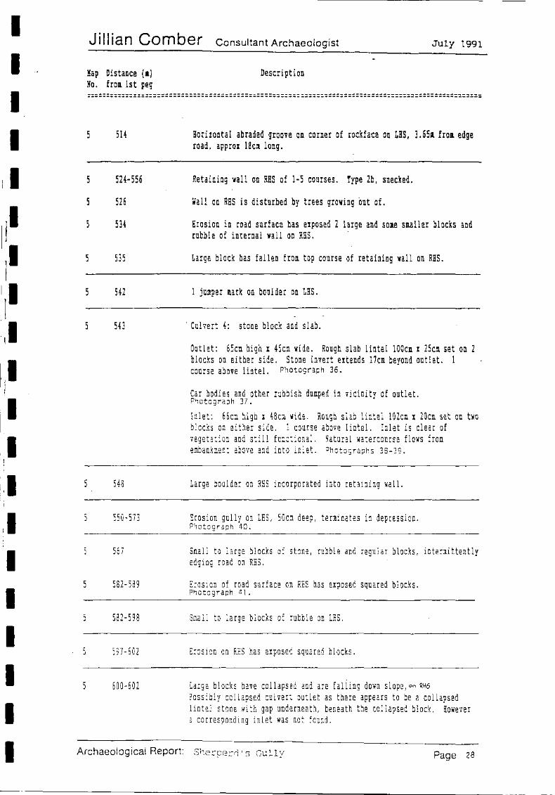
514
524-556
526
534
535
542
543
548
550-573
56 7
582-589
582-598
597-602
600-602
Archaeological Report:
Horizontal abraded groove on corner of rockface on LHS, 3.65a froa edge road, approx 18ca long.
Retaining wall on RHS of 1-5 courses. Type 2b, snecked.
Wall on RHS is disturbed by trees growing out of.
Erosion in road surface has exposed 2 large and some smaller blocks and rubble of internal wall on RHS.
Large block has fallen from top course of retaining wall on RHS.
1 jumper mark on boulder on LHS.
·Culvert 4: stone block and slab.
Outlet: 65c~ high I 4Scm wide. Rough slab lintel 100cm x 25cl set on 2 blocks on either side. Stone invert extends 17cm beyond outlet. 1 course above lintel. Photograph 36.
Car bodies and other rubbish dumped in vicinity of outlet. Photograph 37.
Inlet: 66c~ high x 48c~ wide. Rough slab lintel lOZc~ x 20cm set on two blocks on either side. 1 course above lintel. Inlet is clear of vegetation and still functional. natural watercourse flows from e!llbankment above and into inlet. Photograpf1s 38-39.
Large boulder on RHS incorporated into retaining wall.
Erosion gully on LHS, SOc~ deep, terminates in depression. Photograph 40.
S~all to large blocks of stone, rubble and regular blocks, intermittently edging road on RHS.
Erosion of road surface on RHS has exposed squared blocks. Photograph 41.
Small to large blocks of rubble on LHS.
Erosion on RHS has exposed squared blocks.
Large blocks have collapsed and are falling down slope, on R~
Possibly collapsed culvert outlet as there appears to be a collapsed lintel stone with gap underneath, beneath the collapsed block. However a corresponding inlet was not found.
S~erperrl's Gully Page 28
------------------------------------------~-~
I I· I I I
.I I i
I I I I I I I I I I
Jill ian Comber Consultant Archaeologist July 1991
Hap Distance (a) Ro. . froll lst peg
Description
====================================================================================================
6
6
6
6
6
6
6
6
6
6
6
6
6
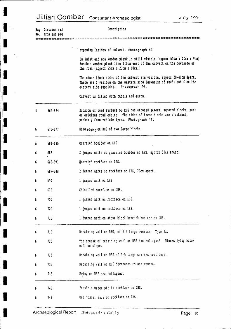
665-674
675-677
681-686
683
686-691
687-688
690
696
700
701
716
716
720
723
735
743
740
747
· exposing insides of culvert. Photograph 43
On inlet end one wooden plank is still visible (approx 6lca x llca-x 9ca) Another wooden plank lies 210ca west of the culvert on the downside of the road (approx 65ca x 23ca x lOca.)
The stone block sides of the culvert are visible, approx 20-40ca apart. There are 5 visible on the western side (downside of road) and 4 on the eastern side (upside). Photograph 44.
Culvert is filled with rubble and earth.
Erosion of road surface on RHS has exposed several squared blocks, part of original road edging. The sides of these blocks are blackened, probably froa vehicle tyres. P'1otograph 45.
Road edging on RHS of ho l?rge blocks.
Quarried boulder on LHS.
2 jumper marks on quarried boulder on LHS, approx 53cm apart.
Quarri~d rockface on LHS.
2 jumper marks on rockface on LHS, 70cm apart.
1 jumper mark on LHS.
Chiselled rockface on LHS.
1 jumper mark on rockface on LHS.
1 jumper mark on rockface on LHS.
1 jumper mark on stone block beneath boulder on LHS.
Retaining wall on RHS, of 3-5 large courses. Type 2a.
Top course of retaining wall on RHS has collapsed. Blocks lying below wall on slope.
Retaining wall on RHS of 3-5 large courses continues.
Retaining wall on RHS decreases to one course.
E~ng on RHS has collapsed.
Possible wedge pit in rockface on LHS.
One jumper mark on rockface on LHS.
Archaeological Report: Slterpeni • s Gully Page 30
I I I I I
I I -I I I I I II I I
J illian Comber Consultant Archaeologist July 1991
Map Distance (1) No. froa 1st peg
Description
::::::::::::::::::::::::::::::::::::::::::::::;:::::::::::::::::::::::::::::::::::::::::::::::::::::
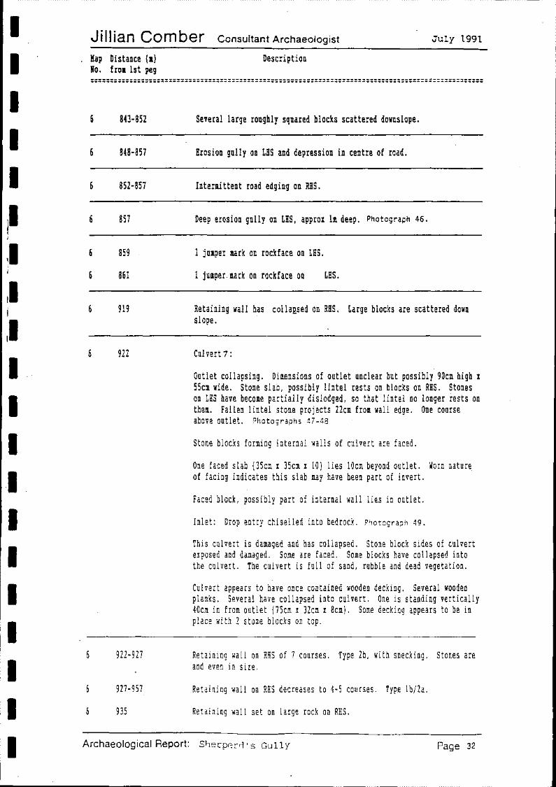
6 843-852
6 848-857
6 852-857
6 857
6 859
6 861
6 919
6 922
6 922-927
6 927-957
6 935
Several large roughly squared blocks scattered downslope.
Erosion gully on LHS and depression in centre of road.
Intermittent road edging on RHS.
Deep erosion gully on LHS, approx lm deep. Photograph 46.
1 jumper mark on rockface on LHS.
1 jumper.aark on rockface on LHS.
Retaining wall has collaQsed on RHS. Large blocks are scattered down slope.
Cui vert 1:
Outlet collapsing. Dimensions of outlet unclear but possibly 90ca high x 55cm wide. Stone slab, possibly lintel rests on blocks on RHS. Stones on LHS have become partially dislodged, so that lintel no longer rests on them. Fallen lintel stone projects 22cm from wall edge. One course above outlet. Photograp~1s 47-48
Stone blocks forming internal walls of culvert are faced.
One faced slab {35cm x 35cm I 10) lies lOcm beyond outlet. ~orn nature. of facing indicates this slab may have been part of invert.
Faced block, possibly part of internal wall lies in outlet.
Inlet: Drop entry chiselled into bedrock. Photograph 49.
This culvert is damaged and has collapsed. Stone block sides of culvert e!posed and damaged. Some are faced. Some blocks have collapsed into the culvert. The culvert is full of sand, rubble and dead vegetation.
Culvert appears to have once contained wooden decking. Several wooden planks. Several have collapsed into culvert. One is standing vertically 40cm in from outlet {75cm x 32cm I Bcm). Some decking appears to be in place with 2 stone blocks on top.
Retaining wall on RHS of 7 courses. Type 2b, with snecking. Stones are and even in size.
Retaining wall on RHS decreases to 4-5 courses. Type lb/2a.
Retaining wall set on large rock on RHS.
Archaeological Report: Sl-)erpr-:r:-d • s Gully Page 32
I I I I I
I I I I I I I I I I
J iII ian Comber Consultant Archaeologist July 1991
Map Distance (a) No. froa lst peg
Description
====================================================================================================
7
7
7
7
7
7
7
7
7
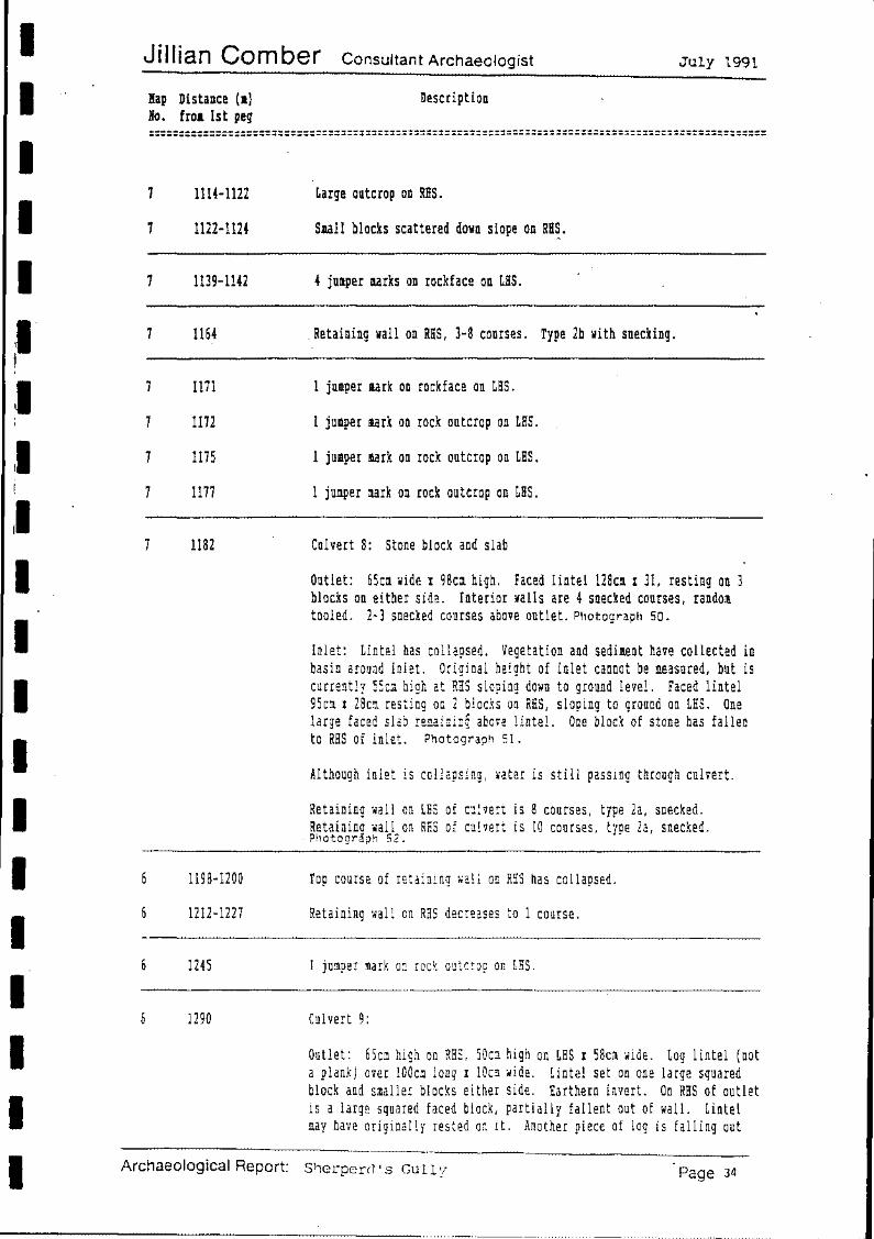
1114-1122
1122-1124
1139-1142
1164
1111
1172
1175
1177
1182
1198-1200
6 1212-1227
1245
6 1290
Archaeological Report:
Large outcrop on RHS.
Small blocks scattered down slope on RH~.
4 jumper marks on rockface on LHS.
. Retaining wall on RHS, 3-8 courses. Type 2b with snecking.
1 jumper mark on rockface on LHS.
1 jumper mark on rock outcrop on LHS.
1 jumper mark on rock outcrop on LHS.
1 jumper mark on rock outcrop on LHS.
Culvert 8: Stone block and slab
Outlet: 65cm wide I 98cm high. Faced lintel 128cm I 31, resting on 3 blocks on either side. Interior walls are 4 snecked courses, random tooled. 2-3 snecked courses above outlet. Photograph so.
Inlet: Lintel has collapsed. Vegetation and sediment have collected in basin around inlet. Original height of inlet cannot be measured, but is currently SSc1 high at RnS sloping down to ground level. Faced lintel 95cm x 28cm resting on 2 blocks on RHS, sloping to ground on LHS. One large faced slab re~aining above lintel. One block of stone has fallen to RHS of inlet. Photograph 51.
Although inlet is collapsing, •ater is still passing through culvert.
Retaining wall on LHS of culvert is 8 courses, type 2a, snecked. Retainina wall on RHS of culvert is 10 courses, tyoe 2a, snecked.
· Photogr&ph 52. ·
Top course of retaining ~all on RRS has collapsed.
Retaining wall on RHS decreases to 1 course.
1 jumper mark o~ rock outcrop on LHS.
Culvert 9:
Outlet: 65cm high on RHS, SOca high on LHS x 58clll ilide. Log lintel (not a plank) over lOOcm long x !Oc~ ilide. Lintel set on one large squared block and smal'ler blocks either side. Earthern invert. On RHS of outlet is a large squared faced block, partially fallent out of wall. Lintel may have originally rested or. it. Another piece of log is falling out
S~erperd's Gully Page 34
I I I I I
II II II ,I
II I :I II l :I II
, I I
II II I I
Jillian Comber Consultant Archaeologist July 1991
Map Distance (a) No. from lst peg
Description
==================================================================================================
6
6
6
6 6 6 6
7
7
7
7
7
1387-1438
1398-1438
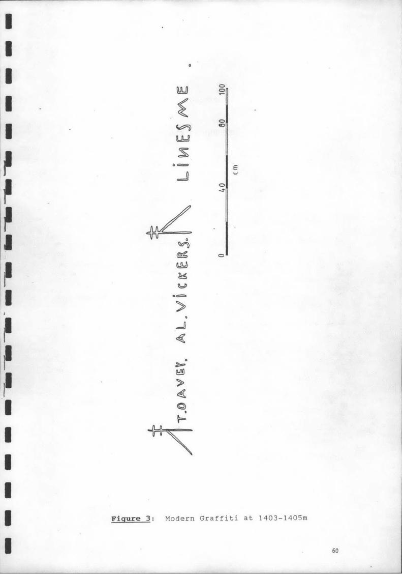
1403-1405
1424 1427 1431 1432
1437-1466
1444
1533-1563
1563
1583
Rabble edging on RHS.
Large amount of unused quarried blocks strewn over the slope. Photograph 53.
Graffiti on rockface on LHS: 1 T. DAvey. A L. Vickers Linesme• See Figure 3 and Photograph 54.
1 jumper mark on rockface on LHS. 1 jumper mark on rockface on LHS. 1 jumper mark on rockface on LHS. 1 jumper mark on rockface on LHS.
Retaining wall on RHS. }ype la~
Culvert 11: pipe culvert, 60cm diameter ..
Outlet: Rubble work surrounding pipe, type 1a. Two courses above outlet and 4 courses either side. Photograph 55.
Inlet: Blocks surrounding pipe inlet, 2 on RHS, 1 plus rubble on LHS and one course of large squared blocks above. Photograph 56.
Modern quarry on LHS; back wall 23m from edge of road; shale and sandstone rubble visible.Quarry previously used for road maintenance. Photograph 57.
Culvert 12: pipe culvert, 46cm diameter. Pipe may have been inserted into original block and slab culvert. Outlet: pipe framed by sandstone blocks, 2 on either side and one course above. Large stone block on LHS is squared and faced on two visible surfaces. See Photograph 58. Inlet: pipe surrounded by unsquared stones. One on each side and one course of rubble work on top. Photograph 59.
Culvert 13: block and slab: 5 snecked courses forming interior walls. Outlet: 60cm high x 88cm wide. Faced lintel 127cm x 47cm. Lintel set on 3 blocks on either side, which have been random tooled. Some fretting and cracking of blocks on RHS. One course above lintel. Photograph 60.
Archaeological Report: Shepherd's Gully Page 36
I I I I
Jillian Comber Consultant Archaeologist July 1991
Map Distance (a) No. from 1st peg
Description
::::::::::::::::::::::::::::::::::::::::::::::::::::::::::::::::::::::::::::::::::::::::::::::::::::
7 7 7
8
8
8
8
8
8
8
8
1779-1783 1792-1798 1801-1802
1835
1868
1869
1869-1877
1892-1897
1897
1399
1915
1918-1919
1920-1924
1932-1935
1937-1939
Retaining wall on RHS, type lb. Retaining wall on RHS, type 1a. Retaining wall on RHS, type la.
Culvert 17: block and slab. Interior walls are 3 faced, snecked courses.
Outlet: 60ca wide I 95cm high. Faced lintel 120ca I 37ca set on 3 faced blocks on either side. Photograph 68.
On LHS of outlet is 1a of retaining wall, type 2a. On RHS of outlet is 3m of retaining wall, type 1b/2a.
Inlet: completely blocked. Rough slab lintel 90ct I 7cm. Nothing else visible. Photograph 69.
1 jumper mark on rockface on LHS. ·
Chiselled rockface on LHS.
Rough stone edging on RHS, 1-2 courses, type la.
Intermittent stone edging on RHS.
Culvert 18:
Outlet: SOcm ~ide I 28cm high. Lintel 97cm I 30cm set on two blocks on LHS and one on RHS. No masonry above lintel. One stone block on LHS of outlet. Earthern invert.
Inlet not found.
Retaining wall on RHS increases to 6 courses. Type 2b, with snecking. Some blocks have been random tooled.
1 jumper mark on rockface on LHS.
Top course of retaining wall on RHS has collapsed.
Base of retaining wall on RHS projects approx 2m out from wall. Slight batter. Several loose large blocks at base of wall. Type lb/2a.
Retaining wall on RHS has collapsed. Several large blocks scattered down the slope.
Retaining wall on RHS has collapsed.
Archaeological Report: Sllerperd 's Gully Page 38
I I
~· 11 ,I I I I I I I
Jill ian Comber Consultant Archaeologist
Map Distance (1) Mo. froa 1st peg
Description
July 1991
::::::::::::::::::::::::::::::::::::::::::::::::::::::::::::::::::::::::::::::::::::::::::::::::::::
8 2153 1 jullper mark on rock face on RHS.
8 2158 1 jumper mark on rockface on RHS.
8 2161-2162 Chiselled rockface on RHS.
8 2167-2168 Chiselled rockface on RHS.
8 2171 1 jumper mark on rockface on RHS.
8 2206-2207 Chiselled rockface on LHS.
8 2217-2218 Chiselled rockface on LHS.
8 2221-2225 Chiselled rockface on LHS.
8 2225-2228 On RHS tops of 8 bktks visible 50cm from present road edge.
8 2230-2235 Retaining wall on RHS, 1-3 courses, type lb.
8 2233-2250 Several stone blocks scattered down the slope.
2235 Gate to Devine's Hill. Photograph 70.
Archaeological Report: 91erperd · s Gully Page 40
r:.J). ~
~ u f----1
~ > ~ ~ ~
~ r:.J).
~ z ~
~ 0 ~ f----1 f----1
1', I ......_
I I
~ Ill
I I I 1/
I I
I I
I
, ..................... .......
I I
I
.......
I I
.......
I I
.......
I I
I I
I
....... .......
.......
I
I I
I
....... .......
I
.......
I
' ....... .......
_. _.
I I
I I
I I
I I
I I
_. _.
I I
I I
I
I I
I
I I
. i
I I
I
----
I
/ I
I
_. _. \
\ \ a
h
~
d ~
V)
~ ~ h
~
~
d ~
~ ~
~ h
~ c..)
~ ~ a
~ h
>-:;:, ON >- . <O _;Z
>- >ww ww :I: :I: (J)(f)
a:; I.IJ OW LL. (/)
-
-"\ / \
/ '\ / '\
// ·~~ ,,. \\ ' ···~~ ',. '\
\ :, < '~ '\"'
\ " /\ " \ .. / \ '
'\ / / ·, \ / " \ ·• ,. ' J• " \ )'-.~ }-.> ,, 1< • '
" ·., ',, {' {' ' \ < •, / -•. <..... ; " \,.. <, " " ··.. .... )
'- I Y..._ ............ \
............ \ ............ \ '-, I ', ' " .... ~
(........ -;"~ ...... ~ V\
/ \ \. ~\. \ ........
, \ I
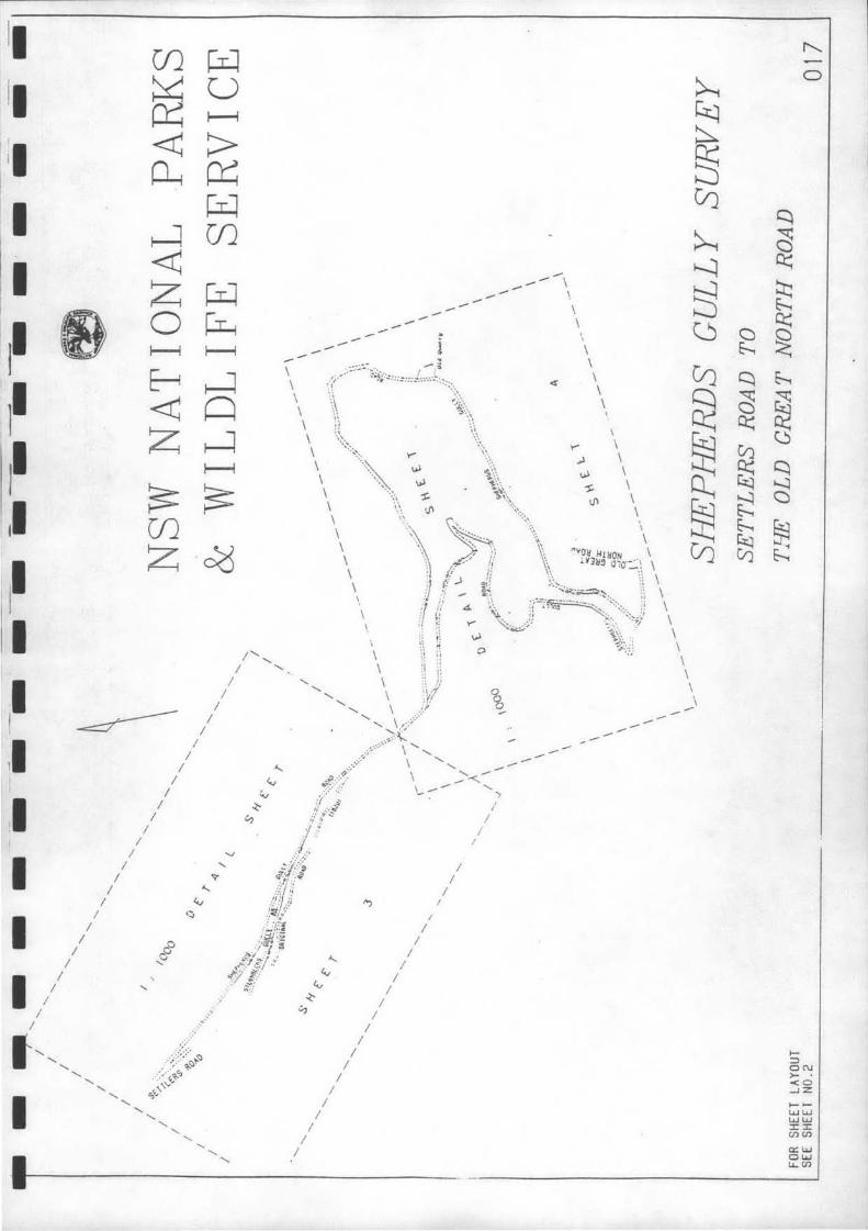
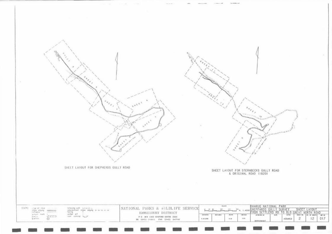
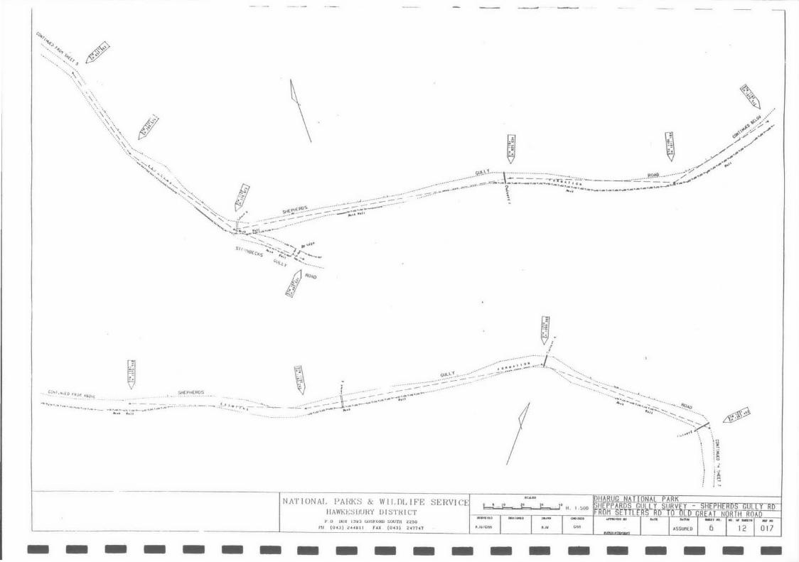
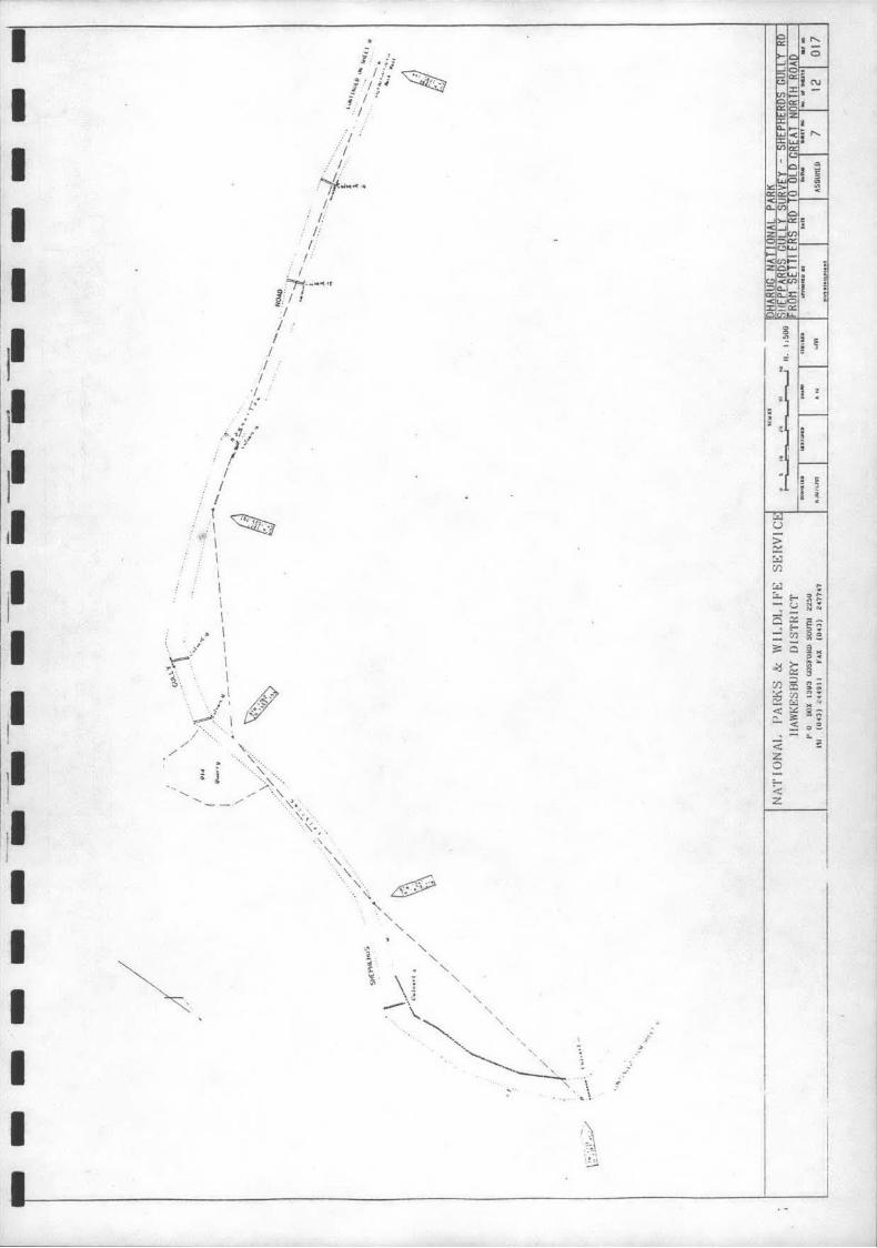
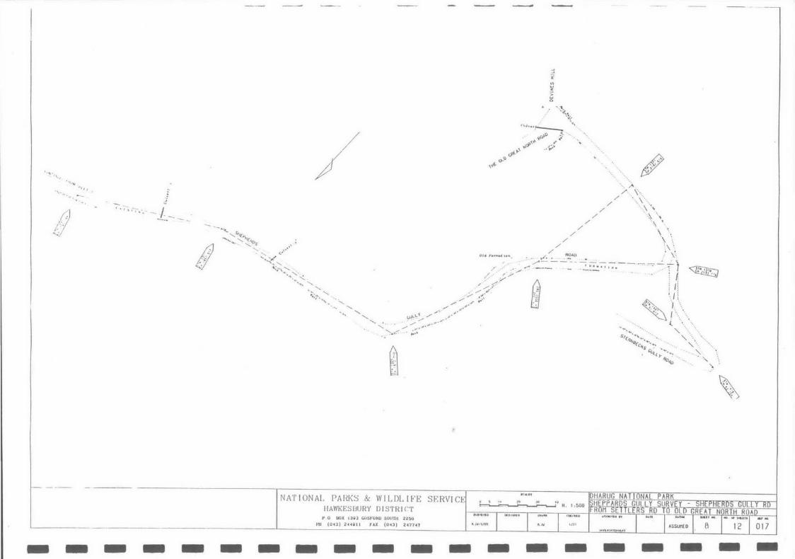
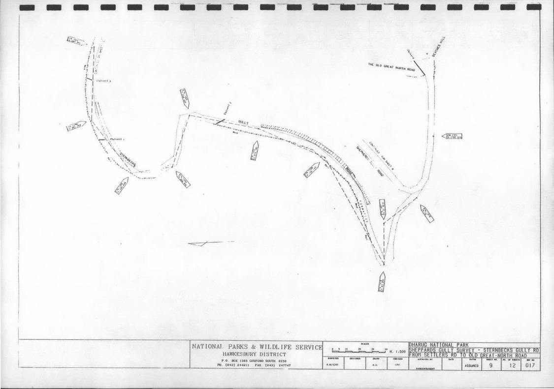
SHE ET LAYOUT FOR SHEPHERDS GULLY ROAD
/ /
/
/ /
\. \.
/ /
' /
~t:; /' '>~',( s' '-c~ , , '\<(' ........
I \ {', '- ..._ I .\ 1'-..._, , '-..._
I J.,. ..._ ..._ '- , I ·"-· .... ' .·... '...( ..._ I .,_ I ..._ .... ....
'....; ··. I -... I'-..._ ~. I '- ..._ I I
.... .... 01 .... '- s'+-"- 1 \ I -...
.... {' {' I·• ....
' ' ' I ; I '' .. ,,.,,_,_, ':._' '< I > • ' ' , . .. '' ..._1 ·'J {' {' ..._ .. ~·" !i
I ·:, , '" _,,><" :7' I . I :
.... 1'- :;', I ,, .... .... ~ : ..._-;... ..._ I ,f'
I I ..._ : I~~"""~'·'··-- ' ~·'''' ..._ L··· I ~~·""'- :o
I .. I./ I ... I l
I I .r.:' I C ( .:
I ····- J ·.~ '-..._ I '-..._ I
'-...I
SHEET LAYOUT FOR STERNBECKS GULLY ROAD ~ ORIGINAL ROAD 116201
I ( Ul N!! , .11jr o f ro.aJ ~lofl r t'dlj 1ng eutuu.uo tt~II • '-'H
JU" ""'' •1'1.!1 1\
f f' I .U111liJ Wdll t...T. l., r , .._ ull f rtJu ll .. u l \ l one t>dtJ •niJ o o ·-o c,. -D l•onq • WflhJ P pt l
Ni\'I'IONAL PAI?.KS & 1\' ILDLIFE SERVICE I!AWK~ S illJHY DISTRICT
10111 uu i HO~ "-.\...V' ~v•1 I I tJ:~/,"' {_' lJ QI.J /111 1 @)
P 0 UOX I JllJ GOSFOHO SOUTII 22~0
----'-------"-'_(_o_u_)_~.u o tt fAX . (04J) 2• '1747 I ,. ,w ,~M
- - - - - - - - - - - - - - - - - 017 - -
~ ~ ~ I I I
I
~ I
-I ~ I I. I I I
/
' ~ ·(
1: 1· li [ i:
.1: I' I 1.
? ,. < I, .
r .. v" l c;
. < -z 0
:.:: z
I I I
l i
LI------ ------------ l_j ------
(
r;;;.···, ... \ I,\
' !,~,<··.
\ ·\-":.\ y .·. ·'- i ···· ... r·• \,
- - -~
''<\~z- --- " ././-. ··if
- "' .... "c'_ -- • ._ "i!! ' ,. . _./ /".;:> -;;.L.;·"''" '""'""'";:;;; .:;:::~ .. #
···• ~- '"'·'- f::j '% \ "'"_;.,· I ·,
0 ·--· //" ::~~-:: , Y .. C ?;'':c - ; c' "' " _,-> --~;; :'- / ! )) S.. j? I ;.; -~-..v 1 ... :
· '· ~- I / ') '· , .... >. ~\ \t .· -~' ;: ', ~ \0 {ji \\\ 9 ;{~1'> \ } ~ ., _ , _....... . . / ·Y .· •' ~ / ;:::;< - ..::T.::_ ,..·· ·y '.J. !/
; -~_,, ... , .• , ·· ... ~ ;'' ,, "' . '" ~ . •'•' r• ,, ......... If':· ~·· J· :'"' '' . ' ' . .. . '
' ., . . -/\ ' ) ' J ' '. ·. .. . < ' ' I 1·- ~ ~- / .---.: -0 r ·' . . / , . , / .. o ·" . ' / .' . . ~ ·- < ' -- ~·: . // ... ·<
c; ~~ , / . . ... ~" . . .. > --·· . ' . .. ... --... I.' ~' -/.~;;:..:~ .,.,:.:-::::::1- :::- ••••
,1· . . ;/"'' f /' . . --'<; :.<'
~" j! ; -; .:.: .::,·;;:;"'"""'",_,_ - ' / ""' . .IJ_: l i .. , "'""""' jli .i;. · . ~~
!:' f .
, : i I ~ " ;f ~.!'-.. r1 /~ . ?.1
'"'·' ': .... :-·":.5;<" '/! : . : -:----\ <i;:;;"'j • /- . \.b~, : :>·- ..... _ '///.' "'<V
.. ! •l ~j .:cJ
\ · ·'/ a!'·
. .......
#-.,::-. ......
. ...... . .. (:) =~
Q ...... c:
J• !
. . ...... -·o,,. ' "'f.s
~,l(
L JNATIONAI. PARKS & WILDLIFE
HAWKESBURY OJSTHJCT P a oox 1JG:t cosroRD .sount ~ 2~o .,
_ 111 (043) C!HU II ~AX (04:1) 241147 •
- - - - - - - - - - - - - - - - - - - -
- - - - - .. ---- --- - - - - -~ ' .
~ .. I '
-~ •''' . ·1 .··· ·· :::::· ... ... .. ,;;.;; ....
. ... ····•···· ······ ,... . .. . •• ··--- - . - .:::·::c·::c .... •········ ... ........ , ••• ' '' •'·· . . . ... ·~ ... ······· ·· ··; ·;;•"' ··
. ·;; "'~~; - .. : ~ .... ~.::::;.::1:::." ':: ::: ":: 'iO!!-":\'t:::c"" :; :; ~"' ~ -.;.:;;:;;; :;;;;::.:..c'~;;;c ;;;:=~~;~~ :::: :::: :::: ::-.f.~:;."'.'::=.:_c::::.::-::/ ... IIO~o .... .. ..
' ~. ~
~ \] ,. ~ .,..C1~·>'·C'·C::3;:: · •';:;·cc·c:c········· ............. ;_;;:·..:-- - ............... t~-v.. . - .... ..
······· '"'-~~· -···· ··= = ············c::c·;; ;;:"·:.;.::.:;;:::..:C-·· ···········•"' . - ······ ::.::s:,::::·:: ········· ..... .. . .. ....... - - --- _....,~ ----· ...... .. .... - ... If! .• , .. ,. .... ~- ::~.,;:.;;:~~;;;_ .. ;:~ ····· .... --· ~-:'·~""' j ~-. f .,, .. •" .. ...... ::cf'·;--
..... .................... .......
. ...... , ... :~ .. ,:;:
NATIONAL PARKS & WILDLIFE SERVIC IIAIVKESOURY DISTRICT
P .O. OOX 13D3 COSFORO SOUnl 22~0
.,1. (043} ZHUit FAX . (043) 24'1747
b: b \!..__ !!__JL I ; 11500
t'..NICM LM
"o...l'l' · .. ........ ,.
-.:.~·.:<~~-~~' s
·------~~-~---.
_& 67
....... ~.\ .... ... \ · .
... >}-... Af ··-\·., & ···-.. ~--)_:~--- ...• ·
···-::--. ·· ... _
"~~ ·. " ~ .
l '
' .
ij v-~·~.--(· . _._. .·"/ .,
~ <#,,-F_.-;/ /
_,/"/·/'' ,- ·'
·~~<,
.... ...:_,·-.. , "'-<:~\'.... ··'!'! s ... ---~-- - --···::.::':;.":;.:·::.:: ·::. .. ::
........ , .. ,.. , S><LPII(~.--· ·······--- .~·~--
" "''.;;:<·· /.~ _:···:.:·-;:.·-;:.~-~---:::-~--:.--------...... ..
. ::::;:;;:::::::::::::::::'::::'::~y~::::..::.;:~::::=.~~~:~=--=-~~=--::.~~;::;;!5;.:~:.:-:::·'
c~ ... l.t.v£o fllon A&O~£
••"'.-............... ""'·"·· .. -
- -
~ SH(PttEROS
'-~-· --·~ ......... .......- ·· . --~~~---- .. ,. , ... s,r •,·.vBcc "-:-~~ ............ 1 ~
~s .... ~;~ ..... -..._ ... cvl tr ..... ....... __
I RoAD
. . .
~ . t .. • !
% .- "' "' "" ?''c' "'::; ;;;;;::.::: =z~~~-::::::'" ~ ::·- ::: . . ......... ~- .. :-~.~~ .. ~.,:._-:-. 7 •••••• • - - ---~~-~-~_r .. ;... ·:.:_::·.!:...--
' i .. .... - - -:. .. - . .. ~::--~ - ....... , ..... ~ ....... -···~·J:.:: . .::.:.-N:::. ,N~";;:;' ;/ '·;:;:-:::. ::::.::::_;·:_ ••... &# -=--,. ..... ,... ·-----;::;.<
.... ......... ·-····· ··-.. \ ..........
- - - - -NATIONAL PAW<S & WII.OLIFE SERVICE
IIAWI\i,;S IJUHY DISTHICT P 0 lklX I J~J CO!:WOlill SUUTII 01!2~0
111 {04:J) ~HU t I f'.U (04:.1) 24'1741
- - - - -
• 1n
.\ \I '
~
II.JIUCM
- - - - - - - -
I I I I I
·I l I
I I I I
.. . ~ -:1 · ,.~
.: )f : I
I :· I
.: I
/~ ~ I I I
I I I
• I . .../ \
~r~· \ ~ I
.~· /· ... .
' .. '\. \ ... ,. ·· .. \~ &
' ·.' " " " " " "
' '
!
~
u > c:: ~ r:/l
w (:.. -..J a ' -;;::::
Oi:!
r:/l v ~ < c..
~ z 0
< z
I
... (.)
.:!:: <-Cll
0 >-0:: :::> a: Cll c,J ~ ?= <1:
-
I--
~ ~
... . , ... ., ... "' . NN
i:;:; ::>. ge §!,. 0.
~· '"' -;:
" " g~ o!:.
;:
·· ~ ':\,,
-
Y, ...
.... ,, , ·· .. -
y / )'
"'
-
~
. . ·;;,-;-.. -._-._ I -~ = a-
- -
/ ,+~.-o-Q
-
-' :a:
~ z
~ 0
',"\ •-i>\,_
, ... , .... ~ ~~ ~'f,
~o..s> .~ ·. fi''+ .,.
~~'"' ... ·/ , ' ' . ;-""\· ..
/ ··. \ '· .. / ·· .. .\ ·,,
/ ·.\ \
--
// ·. \ '· ... / \ ·.
// ,,\ / :~ --, / - ' ) ,... . . .... . .. .... .. - ~~ - ------ . ~,,, -- -.:··~. . . . .. ,._ . .. /- ---- ..... ".. . ; ' ~ •. '~' , .. -·· /. > .. / -- - . --- . .. . : '
.. .... '· 0/ ',. '"··'- ~· ·· . ...- ~ i I i "•·· ' " "' ; . . I!
- - -
··-~, ,•'/; -;: ~ ) \ ... ~.~>, /.:.>'· .; ~ {' \
', ~·· // / ·...... ' \. .. ', . '/ --: ... --' ••,,;•....... '< ' / .. ,. .. .. , . ·- ··.. '
'-"' . ... "'·· ., . . ' -~'o'lll ··... \. ~
~ . .
DHARUG-NATTTINAL PARK NATIONAL PAI{J\S & WILDLIFE SP.RVICE' IIAWKESUURY DISTRICT
0 !I Ill lO JO 10 t----1 ~~H. 1 :500
., ...... I ......... I -~J HEPPARDS GULLY SURVtY - SHEPHERDS GULLY RD RTIM!StlTitRS RD TQ OLD GREAT NORTH ROAD
... m..... I .... I AS:;} -~·.. r Ml 2"1 0 I 7 P 0 OOX IJQ3 COS t'OHO SOUnt 22~0
111 (043) 2HQII t'.U (043) 24'1'141 II.JW / LM 1\111
- - - - - - - - - - - - -
- - - - - --------- --- -- - - lllil -
~ -'
---fl/~i: / I' .. : , ~ ..
: ~ i.~ · ~j '' ~ l ....... ,, j
1 f: :, 1\ :, 1\\\ ~· I : i \ \ ":J '·.t ••
4~0 i\ .. \ .' ~tf.~ ... : ·'. ~ ":\ · .. \''.
\ \···.\'-·~\.\ ~ ...... , } ·•. \: ' \ '\ . ., \~
~ - . ':_~11, ., .... " ··. ~l'c:
'•. \ '~ ...... ~, ·_·..,.,.::--. ......... .., ......... .
I . '
" ... '1.,
·-..
; ... . ~
' \
I II<£ OlD CRfAI N<Jf!IH RoAD ,!
~ ...... .. .. \ \
' -. .:
' .
r_(""~~~:::.~:':'_~~2':'~~ - ~ ~·\ ! ;I fj .., ~-_,.,_,_~~"- ~~;:·; · ···C~,_ ; / .f ·~ Y.~~ ...... ··· ... ···-~-~~ ' I ' ' · Jl '··I·, ··.. ' ~~ · .d~ :'"·' \"<\:t ~' .:/\·~ ~ \ \'{; \ :: ·< . . ....
\ .,._: .( .'
'\~\ (/// \\ \ I : '
_ . ./_.../ ;
--=-:::7
NATIONAl. PARKS & WILDLIFE SERVIC HAWKESBURY DISTRICT
P 0 . OOX 13i3 COSfOHO SOUnl 22~0
,, ... i
,~ -..... I ! ~\ -... .. I !
-~, .... -,_1/ .... \ 't ; ....... -... .
Q CYJ
I
<~!·l :::· •. J
II..N/ c;M Ptl. (oca) 2441U 1 r.u (043) 247141 ,.,, .. ,u ... w-., - · ·
~
-
·· .. :;_, ····:".-..--lh
·- .•• _s-
-
· .. _ I . /
tUl L 'f ················· ........... r.~~~----- · · ______ _ , .... _ ... ____ _
· ........ -,.. . . -....._..~::-"--
\ \
-·
- .......... · ..... , Sr-td, .... '"'_"'• . '.e;j- ; ,...... sHRHB(CKS ... ~~·~·~~·-·-·~w· .....:':!:l Y
l~>.:.:.:~::::·:~'""~~~~·~--~~~~~:.::~2~-:.:. ~~-=l.-.-:: .... ~ .. =.:~ .... ;~i~~;;;·.:.---~:::·-·-· -. {ll '
- - - -
' .. : . / .. .,._,., ..... , ... ~ ..... -·-. ~\ ~ ~ .'( ;·-- ... :-- ....... ___ .. .r ;s . I. I .'·'i":·.-:: ....._....._~ .,.....,.:;. •u ·/ • '•.,, f.l fl'q · · ' .. i>': ...... ..·:.· /II ...-
. -':?;:... "\ / /..··1 .. ;:/ . /),'. ,.. -~ i' /' '' .t /
....... i>, ... <t->l/.-··;,1 ...... \:- \ . / --:.i _,! _/ \ " \ '; •,l / i ll ... \ "" :f. ~·'/ ./ P; /
\ \. -~ JY :/ }; 1/
·.. " '.// / l;,· :'
~ ·····~·::~~\···· ...... !.~< .......
'
!:r'/
'
! ;, f
......... .._ .. .,.......--... _. I .}A .. JD.......- - __:::.· :.:_~ ..... - ...... -.... .. .,.,..J _ __ ...... L·?fi·''~·· ; .. , .. ,....... - - -:..u:.. ... JA./
~'-- ----·ib a..t ... . ;t ·/·1 : 1,/.'1.'1 :y-:,··;·-···· ···· ~-.. .-··' "'''''-+ ,., .. , . .. -;:ij' t.fl ... I :t·, :··--... .--···
./' / .. ··{j;:P' • CULLy . · I : f :;i;·J."!]"'i'f···; j) c..o""''l' / .. ·:~> ) • • ~ •·
·" .;.:-f:l' /
·' .&0~·) !.<./' • ./II' y:-''0
·' •• ·fY ..,,~ ,.., ,' 4,Y
'r·'/ ·' /:' ·"/ ... " ..... • x' ~ \\ \ '·\"~ ' . · .. ~ ... "t.. ·.. \ · .... .
·•· .•• \ '·· ••. 'l>
b) \ :~'' q
NATIONAL PAHKS & WILDLIFE SERVICE IIAIVKES8URY D I STRICT
1~ o . oox ugJ cosroKD sount 22~0
I'll (04 3 } 2 Hiitll t' .U: (0<13) 2 4"17-41 ICJV/ CM
- - - - - - - - - - - - -
- - - - - - - - - - - - ----- -
..... ~ -.....
I ...... ,. .. ,.,._ ·-·· ·. ~rr:~t~rll<c
~ --- ~~~</}: ::~::.:__~~::::::::::::'~::_~,:::~;.~~~-;~~~:~:~?:: •••:•\:~'' · .(_ . . ~ ----·-·--·4 ....... ,.,. - . '-~ . ····· .. -· - ... ----........ "" --~- -.. . , . ' ------...... . ~. :' ··-._,
NATIONAL PARKS & WILDLIFE SERVICE IIAWKES 13UHY J) I STRICT
P.o oox 13UJ cosroKD sount 22~0
I'll (0<3) 2 .. 011 I"AX . (043) 247747 II:JVtcnn
- - -
-
DRIGINA[
··-. .... .. .. --~-~~<~:-;~-;- ..
I - ~ --~ . -~, .. i ~ i ~ -----=-.::. ::.::_ :::::_ =~~ ';;:::; ~ ~"''.;;;;:_::; -- .
, ~~- ::::·-.. , ··· -!'."" if -.....:-"'=-::!;! ~- ~ , ...... .... _
... · .. ---~- - :.::.-~:~-- --- ... , ......
j_J '"<:::: ..... _ .$1 "~:;·<:, ..
----- -··--
- -NATIONAL Pi\lti\S & WILDLIF'E SERV I CE
IIAIVKE:SOlJHY DISTHICT P 0 llJX I :JQJ t:O~t'O IU) SOUnl O:!l!)O
1\JII / l.M 111 (UU) ~ 441.111 t'U (04:S) l41H7 __________ L_ ___ ------ - - - - - - - - - - - -
{,) ij
- - - -
I I I I I
I I I I I I I I I I
Jillian Comber ConsultantArchaeologist July 1991
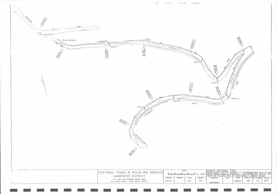
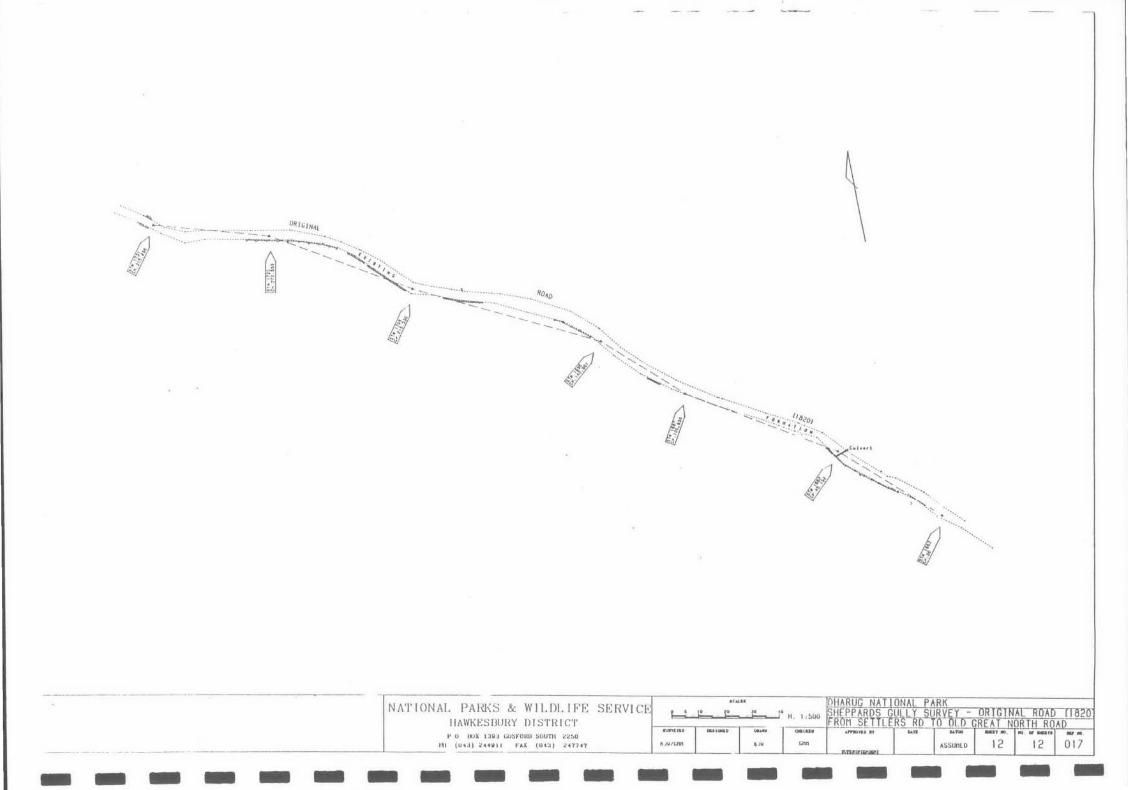
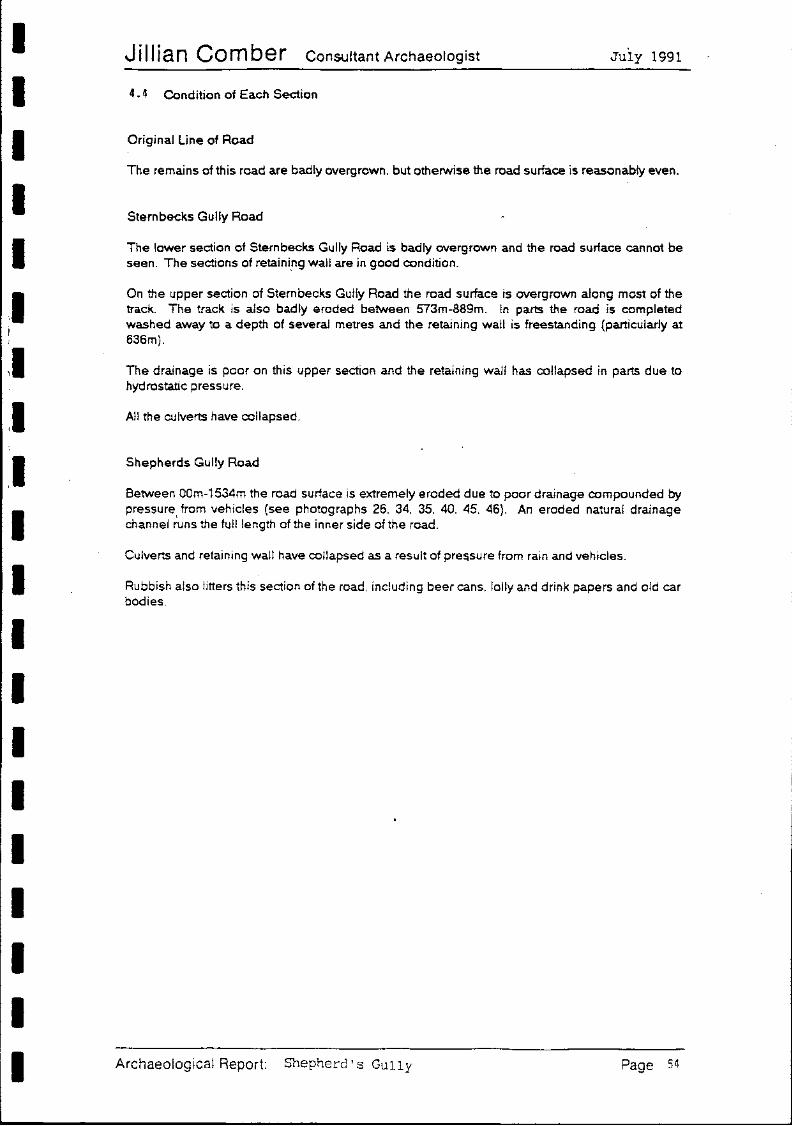
4. 4 Condition of Each Section
Original Line of Road
The remains of this road are badly overgrown. but otherwise the road surface is reasonably even.
Stern becks Gully Road
The lower section of Sternbecks Gully Road is badly overgrown and the road surface cannot be seen. The sections of retaini.ng wall are in good condition.
On the upper section of Stern becks Gully Road the road surface is overgrown along most of the track. The track is also badly eroded between 573m-889m. In parts the road is completed washed away to a depth of several metres and the retaining wall is freestanding (particularly at 636m).
The drainage is poor on this upper section and the retaining wall has collapsed in parts due to hydrostatic pressure.
All the culverts have collapsed.
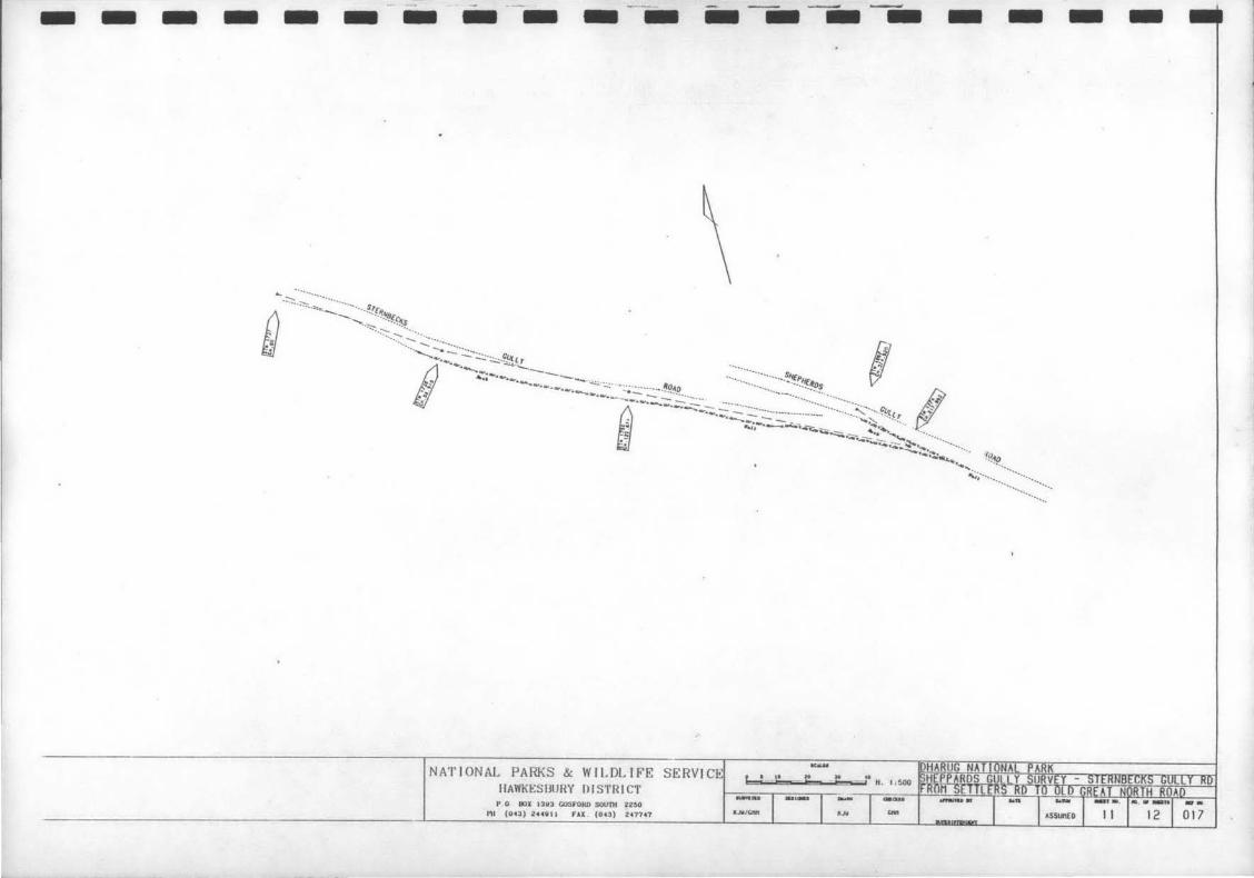
Shepherds Gully Road
Between 00m-1534m the road surface is extremely eroded due to poor drainage compounded by pressure from vehicles (see photographs 26. 34. 35. 40. 45. 46). An eroded natural drainage channel ~uns the full length of the inner side of the road.
Culverts and retaining wall have collapsed as a result of pre~sure from rain and vehicles.
Rubbish also litters this section of the road. including beer cans. lolly and drink papers and old car bodies.
Archaeological Report: Shepherd's Gully Page 54
I I I I I I
I ''
I I I I I I I I I I I I I I
Jillian Comber ConsultantArchaeologist July 1991
6. RECOMMENDATIONS
The following recommendations are made on the basis of the archaeological survey outlined in Section 4 of this report and the requirements of the NSW Heritage Act 1977.
6.1 Original Line of Road
The remains of this road could be cleared and an interpretive program designed which would allow this road to be utilised as an historicwalking track.
6.2 Sternbecks Gully Road
Similarly, both Upper and Lower Sternbecks Gully Road could be cleared and incorporated into an interpreted walking track.
The Upper Sternbecks Gully Road would require quite an amount of work. The road surface is overgrown and washed out in sections. The road would need to be cleared of all vegetation. the road drained. filled and recambered. with care being taken not to damage the retaining walls during this process.
The culverts could be cleared of all debris and repaired. using existing materials.
Once this road has been recambered. natural runoff into the gully may be sufficient for drainage purposes. in conjuction with the cleared and repaired culverts. However. this will need to be monitored and corrective action implemented. if necessary. Such action may mean the construction of a suitable drainage system. Such a drainage system should not compromise the historic fabric of the road.
Please note. that a permit under Section 140 of the Heritage Act will be required before any clearing. repairs or enhancement works can commence.
6.3 Shepherds Gully Road
This road should be closed to all but emergency vehicles. The present use of this road by recreational 4-wheel drivers is contributing to the erosion of the road surface and undermining archaeological features. '
Once closed the road could be included in any interpretive program in respect of an historic walking track.
The road surface needs to be drained. filled and recambered. A suitable drainage system. that will not compromise the historic fabric of the road. will need to be incorporated into such repairs.
A permit under Section 140 of the Heritage Act will be required before any clearing. repairs or enhancement works can commence.
The graffiti identified at 1403m should be included ·in the detailed recording and conservation program recommended for colonial graffiti on Devine's Hill (Recommendation 4. Comber 1990)
6.4 General
6.4.1 These three roads could be included in an interpretive program combining Devines Hill and Finchs Line.
6.4.2 Once these roads have been repaired an ongoing maintenance program should be instituted. Incorporated into this maintenance program should be a monitoring program. Using
Archaeological Report: Shepherd's Gully Page 56
I I I I I
~ ~ ~ ·
I
~ I I
~ ~ ~ I I I I I I
Wi semans
• Windsor
Wollombi
Bucketty Ffount Manning
Ten Mil-e Hollow
SYDNEY
Figure 1: Loc at i on of Study Area
Hwcutle STUDY AREA-Q
Sydney
N
t
58
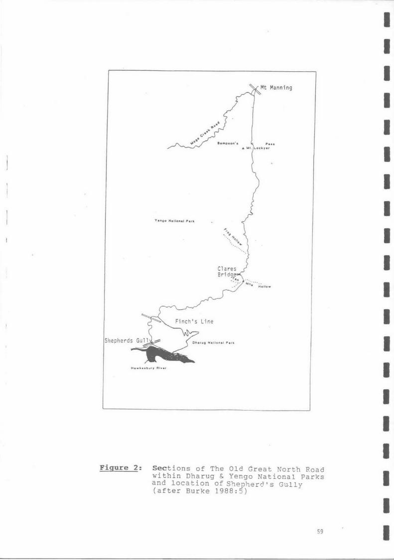
Mt Manning
...... • ""' ocllyer
Figure 2: Sections of The Old Great North Road within Dharug & Yengo National Parks and location of Shepherd's Gu-lly (after Burke 1988:5)
59
I I I I I I I I I I I I I I I I I I I I I I
I I
0
il w 0
0 .-
I ~ 0
I ~ c:c
U:J
I ~ ~
o= E
d u
~ 0 ...:t
~ ~ I ~
I ~ 0
~ w ~ ~!:::=!>
I oc=:a
)> I
II "
..=:ll ~
II 0
~
II ~
> ~
I Q) •
t=-
I ~ I I I Figure 3: Modern Graffiti at 1403-1405m
I 60
I l
! J
1a
1b
2a
2b
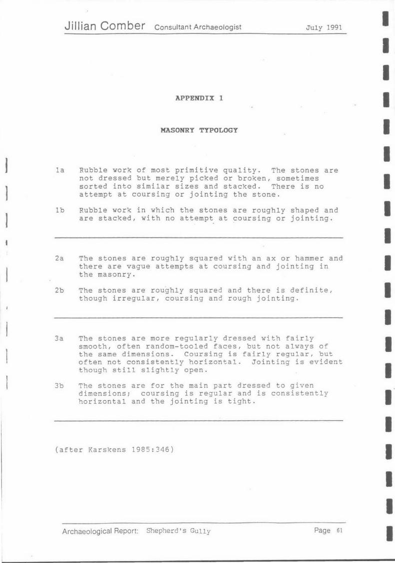
Jillian Comber Consultant Archaeologist July 1991
APPENDIX 1
MASONRY TYPOLOGY
Rubble work of most primitive quality. The stones are not dressed but merely picked or broken, sometimes sorted into similar sizes and stacked. There is no attempt at coursing or jointing the stone.
Rubble work in which the stones are roughly shaped and are stacked, with no attempt at coursing or jointing.
The stones are roughly squared with an ax or hammer and there are vague attempts at coursing and jointing in the masonry.
The stones are roughly squared and there is definite, though irregular, coursing and rough jointing.
3a The stones are more regularly dressed with fairly smooth, often random-tooled faces, but not always of the same dimensions. Coursing is fairly regular, but often not consistently horizontal. Jointing is evident though still slightly open.
3b The stones are for the main part dressed to given dimensions; coursing is regular and is consistently horizontal and the jointing is tight.
(after Karskens 1985:346)
Archaeological Report: Shepherd's Gully Page 61
I I I I I I I I I I I I I I I I I I I I
?
I I I I I
,I I I I I I I
Jillian Comber Consultant Archaeologist July 1991
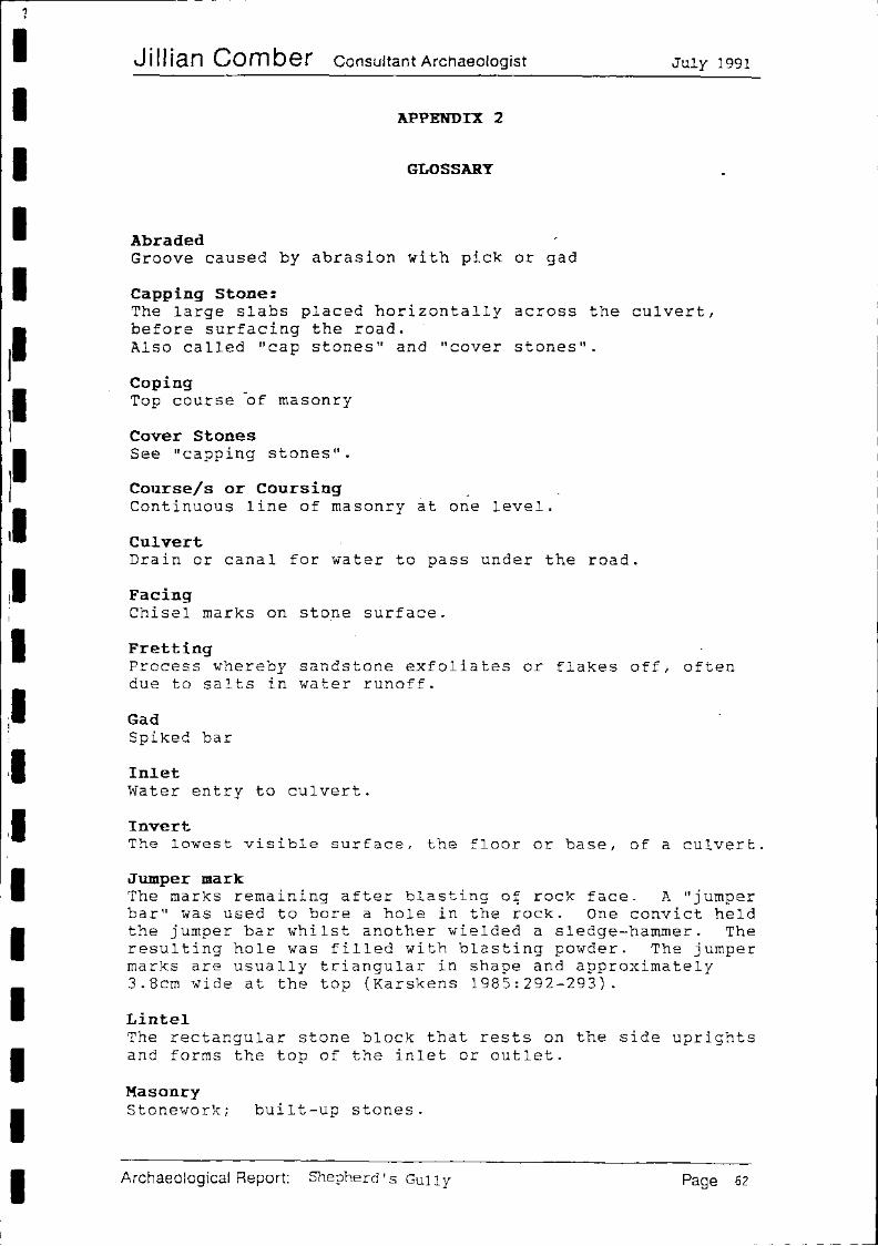
APPENDIX 2
GLOSSARY
Abraded Groove caused by abrasion with pick or gad
Capping Stone: The large slabs placed horizontally across the culvert, before surfacing the road. Also called "cap stones" and "cover stones".
Coping Top course ~f masonry
Cover Stones See "capping stones".
Course/s or Coursing Continuous line of masonry at one level.
Culvert Drain or canal for water to pass under the road.
Facing Chisel marks on stone surface.
Fretting Process whereby sandstone exfoliates or flakes off, often due to salts in water runoff.
Gad Spiked bar
Inlet Water entry to culvert.
Invert The lowest visible surface, the floor or base, of a culvert.
Jumper mark The marks remaining after blasting o~ rock face. A "jumper bar" was used to bore a hole in the rock. One convict held the jumper bar whilst another wielded a sledge-hammer. The resulting hole was filled with blasting powder. The jumper marks are usually triangular in shape and approximately 3.8cm wide at the top (Karskens 1985:292-293).
Lintel The rectangular stone block that rests on the side uprights and forms the top of the inlet or outlet.
Masonry Stonework; built-up stones.
Archaeological Report: Shepherd's Gully Page 62
I I : I I I
I~ I~
~ I II
, I
I il '
11 I I
ll I I I I I I
Jill ian Comber Consultant Archaeologist
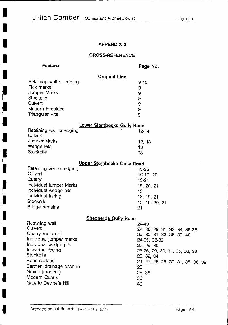
Feature
Retaining wall or edging Pick marks · Jumper Marks Stockpile Culvert Modem Fireplace Triangular Pits
APPENDIX 3
CROSS. REFERENCE
Original Line
. Page No.
9-10 9 9 9 9 9 9
Lower Sternbecks Gully Road Retaining wall or edging 12-14 Culvert Jumper Marks Wedge Pits Stockpile
12, 13 13 13
Upper Sternbecks Gully Road Retaining wall or edging 15-22 Culvert 16-17, 20 Quarry 15-21 Individual jumper Marks 15, 20, 21 Individual wedge pits 15 Individual facing 18, 19, 21 Stockpile 15, 18, 20, 21 Bridge remains 21
Shepherds Gully Road 24-40
July 1991
Retaining wall Culvert Quarry (colonial) Individual jumper marks Individual wedge pits Individual facing Stockpile
24, 28, 29, 31' 32, 34, 35-38 25, 30, 31, 33, 36, 39, 40 24-35, 38-39
Road surface Earthen drainage channel Grafitti (modem) Modern Quarry Gate to Devine's Hill
Archaeological Report: Sherpherd' s Gu 11 y
27, 29, 30 25-26, 29, 30, 31' 35, 38, 39 29, 32, 34 24, 27, 28, 29, 30, 31, 35, 38, 39 26 26, 36 36 40
Page 64