Embed Size (px)
Citation preview
This article has been accepted for inclusion in a future issue of this journal. Content is final as presented, with the exception of pagination.
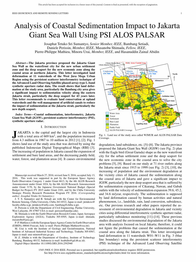
IEEE GEOSCIENCE AND REMOTE SENSING LETTERS 1
Analysis of Coastal Sedimentation Impact to JakartaGiant Sea Wall Using PSI ALOS PALSAR
Josaphat Tetuko Sri Sumantyo, Senior Member, IEEE, Bambang Setiadi,Daniele Perissin, Member, IEEE, Masanobu Shimada, Fellow, IEEE,
Pierre-Philippe Mathieu, Minoru Urai, Member, IEEE, and Hasanuddin Zainal Abidin
Abstract—The Jakarta province proposed the Jakarta GiantSea Wall as the waterfront city for the new urban settlementzone and the deep seaport for the new economic zone along thecoastal areas at northern Jakarta. This letter investigated landdeformation at 11 watersheds of the West Java Mega UrbanRegion using the persistent scatterer interferometry technique ofthe Advanced Land Observing Satellite phased-array-type L-bandsynthetic aperture radar data. The result shows that land defor-mation at the study area, particularly the Bandung city area givesa significant impact to sedimentation velocity along the easternJakarta strait, particularly the deep seaport for 43 years later.This letter recommends to evaluate land conservation at uplandwatersheds and the well management of artificial canals to reducethe impact of sedimentation at the Jakarta strait, particularly thenew depth seaport.
Index Terms—Coastal sedimentation, interferometry, JakartaGiant Sea Wall (JGSW), persistent scatterer interferometry (PSI),synthetic aperture radar.
I. INTRODUCTION
JAKARTA is the capital and the largest city in Indonesiawith a total area of 669 km2, and the population increased
from 4.3 million in 1967 to 10 million in 2012 [1], [2]. Fig. 1shows land use of the study area that was derived by using thepublished Indonesian Digital Topographical Maps (RBI) [3].The increasing of population in Jakarta caused the expansion ofsettlement and bare land areas, and the decreasing paddy field,water, forest, and plantation areas [4]. It causes environmental
Manuscript received March 27, 2016; revised June 9, 2016; accepted July 13,2016. This work was supported in part by the European Space AgencyEarth Observation Category 1 under Grant 6613, by the 4th ALOS ResearchAnnouncement under Grant 1024, by the 6th ALOS Research Announcementunder Grant 3170, by the Japanese Government National Budget (SpecialBudget for Project) FY 2015 under Grant 2101, and by the Chiba UniversityStrategic Priority Research Promotion Program FY 2016. (Correspondingauthor: Josaphat Tetuko Sri Sumantyo.)
J. T. S. Sumantyo and B. Setiadi are with the Center for EnvironmentalRemote Sensing, Chiba University, Chiba 263-8522, Japan (e-mail: [email protected]; [email protected]; [email protected]).
D. Perissin is with the Department of Civil Engineering, Purdue University,West Lafayette, IN 47907 USA (e-mail: [email protected]).
M. Shimada is with the Earth Observation Research Center, Japan AerospaceExploration Agency (JAXA), Tsukuba 305-8505, Japan (e-mail: [email protected]).
P.-P. Mathieu is with the European Space Agency Centre for Earth Observation(ESRIN), 00044 Frascati, Italy (e-mail: [email protected]).
M. Urai is with the Institute of Geology and Geoinformation, NationalInstitute of Advanced Industrial Science and Technology, Tsukuba 305-8567,Japan (e-mail: [email protected]).
H. Z. Abidin is with the Department of Geodesy, Institute of TechnologyBandung, Bandung 40132, Indonesia (e-mail: [email protected]).
Digital Object Identifier 10.1109/LGRS.2016.2592940
Fig. 1. Land use of the study area called WJMUR and ALOS PALSAR DataCoverage.
degradation, land subsidence, etc. [5]–[8]. The Jakarta provinceproposed the Jakarta Giant Sea Wall (JGSW) (see Fig. 2) planwith the Eagle bird (Great Garuda) shape as the new waterfrontcity for the urban settlement zone and the deep seaport forthe new economic zone in the coastal area to solve the cityproblems [5], [9]. Based on our study at 71 river outlets alongthe Jakarta strait since 1915 to 1999 (see Fig. 2) [3], [10], theincreasing of population and the environment degradation atthe vicinity cities of Jakarta caused the sedimentation alongthe coastal area of Jakarta and gave a significant impact toJGSW, particularly the new deep seaport area that is suffered bythe sedimentation expansion of Cikarang, Nawan, and Gabahoutlets with the velocity of sedimentation expansion 39.6, 45.2,and 34.6 m/year, respectively. The sedimentation is supposedby land deformation caused by human activities and naturalphenomenon, i.e., landslide, rain, land conversion, subsidence,etc. Our previous research and other papers reported the as-sessment of environmental degradation in Jakarta and vicinitycities using differential interferometric synthetic aperture radar,particularly subsidence monitoring [11]–[14]. These previousstudies discussed the environmental degradation of the Jakartaarea with analysis focused on local Jakarta; therefore, it couldnot figure the problems that caused the sedimentation at thecoastal area along the Jakarta strait. This letter investigatedland deformation in 11 watersheds W01–W11 in Fig. 3 (blueline boundary) using the persistent scatterer interferometry(PSI) technique of the Advanced Land Observing Satellite
1545-598X © 2016 IEEE. Personal use is permitted, but republication/redistribution requires IEEE permission.See http://www.ieee.org/publications_standards/publications/rights/index.html for more information.

This article has been accepted for inclusion in a future issue of this journal. Content is final as presented, with the exception of pagination.
2 IEEE GEOSCIENCE AND REMOTE SENSING LETTERS
Fig. 2. Bathymetry and expanding distance of sedimentation at 71 river outlets in the period of 1915 to 1999 around the JGSW.
Phased Array type L-band Synthetic Aperture Radar (ALOSPALSAR) data observed in 2007 to 2011 in the West JavaMega Urban Region (WJMUR) (see Fig. 1). The ALOS satellitewas launched on 24 January 2006 by the Japan AerospaceExploration Agency (JAXA) and terminated in April 2011.
II. STUDY AREA
A. Watershed, Land Use, and Contour
The study area WJMUR covers 24 regencies and 11 water-sheds (12 671 km2) (see Fig. 3). In this letter, we derived the
watershed area using RBI [3] and acquired watersheds namedW01–W11, (see Fig. 3). Nine watersheds W01–W09 along theJakarta strait has 71 river outlets in northern Jakarta, where 46river outlets contribute sedimentation or coastal line expansionat Jakarta Strait. Positive value on the graph in Fig. 2 showsthe distance of sedimentation expansion from the coastal line in1915 [10] to 1999 [3] or within 84 years. This expansion of sedi-mentation is considered for the suffering JGSW, particularly thedeep seaport and the economic zone at the eastern Jakarta strait,where it recently remains 1715 m from outlet of the Cikarangriver.
This article has been accepted for inclusion in a future issue of this journal. Content is final as presented, with the exception of pagination.
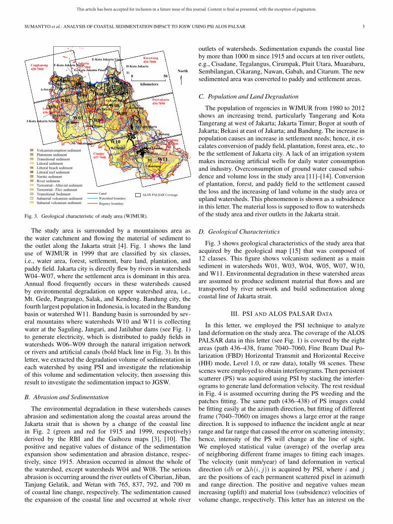
SUMANTYO et al.: ANALYSIS OF COASTAL SEDIMENTATION IMPACT TO JGSW USING PSI ALOS PALSAR 3
Fig. 3. Geological characteristic of study area (WJMUR).
The study area is surrounded by a mountainous area asthe water catchment and flowing the material of sediment tothe outlet along the Jakarta strait [4]. Fig. 1 shows the landuse of WJMUR in 1999 that are classified by six classes,i.e., water area, forest, settlement, bare land, plantation, andpaddy field. Jakarta city is directly flew by rivers in watershedsW04–W07, where the settlement area is dominant in this area.Annual flood frequently occurs in these watersheds causedby environmental degradation on upper watershed area, i.e.,Mt. Gede, Pangrango, Salak, and Kendeng. Bandung city, thefourth largest population in Indonesia, is located in the Bandungbasin or watershed W11. Bandung basin is surrounded by sev-eral mountains where watersheds W10 and W11 is collectingwater at the Saguling, Jangari, and Jatiluhur dams (see Fig. 1)to generate electricity, which is distributed to paddy fields inwatersheds W06–W09 through the natural irrigation networkor rivers and artificial canals (bold black line in Fig. 3). In thisletter, we extracted the degradation volume of sedimentation ineach watershed by using PSI and investigate the relationshipof this volume and sedimentation velocity, then assessing thisresult to investigate the sedimentation impact to JGSW.
B. Abrasion and Sedimentation
The environmental degradation in these watersheds causesabrasion and sedimentation along the coastal areas around theJakarta strait that is shown by a change of the coastal linein Fig. 2 (green and red for 1915 and 1999, respectively)derived by the RBI and the Gaihozu maps [3], [10]. Thepositive and negative values of distance of the sedimentationexpansion show sedimentation and abrasion distance, respec-tively, since 1915. Abrasion occurred in almost the whole ofthe watershed, except watersheds W04 and W08. The seriousabrasion is occurring around the river outlets of Ciburian, Jiban,Tanjung Gelatik, and Wetan with 765, 837, 792, and 700 mof coastal line change, respectively. The sedimentation causedthe expansion of the coastal line and occurred at whole river
outlets of watersheds. Sedimentation expands the coastal lineby more than 1000 m since 1915 and occurs at ten river outlets,e.g., Cisadane, Tegalangus, Cirumpak, Pluit Utara, Muarabaru,Sembilangan, Cikarang, Nawan, Gabah, and Citarum. The newsedimented area was converted to paddy and settlement areas.
C. Population and Land Degradation
The population of regencies in WJMUR from 1980 to 2012shows an increasing trend, particularly Tangerang and KotaTangerang at west of Jakarta; Jakarta Timur; Bogor at south ofJakarta; Bekasi at east of Jakarta; and Bandung. The increase inpopulation causes an increase in settlement needs; hence, it es-calates conversion of paddy field, plantation, forest area, etc., tobe the settlement of Jakarta city. A lack of an irrigation systemmakes increasing artificial wells for daily water consumptionand industry. Overconsumption of ground water caused subsi-dence and volume loss in the study area [11]–[14]. Conversionof plantation, forest, and paddy field to the settlement causedthe loss and the increasing of land volume in the study area orupland watersheds. This phenomenon is shown as a subsidencein this letter. The material loss is supposed to flow to watershedsof the study area and river outlets in the Jakarta strait.
D. Geological Characteristics
Fig. 3 shows geological characteristics of the study area thatacquired by the geological map [15] that was composed of12 classes. This figure shows volcanism sediment as a mainsediment in watersheds W01, W03, W04, W05, W07, W10,and W11. Environmental degradation in these watershed areasare assumed to produce sediment material that flows and aretransported by river network and build sedimentation alongcoastal line of Jakarta strait.
III. PSI AND ALOS PALSAR DATA
In this letter, we employed the PSI technique to analyzeland deformation on the study area. The coverage of the ALOSPALSAR data in this letter (see Fig. 1) is covered by the eightareas (path 436–438, frame 7040–7060, Fine Beam Dual Po-larization (FBD) Horizontal Transmit and Horizontal Receive(HH) mode, Level 1.0, or raw data), totally 98 scenes. Thesescenes were employed to obtain interferograms. Then persistentscatterer (PS) was acquired using PSI by stacking the interfer-ograms to generate land deformation velocity. The rest residualin Fig. 4 is assumed occurring during the PS weeding and thepatches fitting. The same path (436–438) of PS images couldbe fitting easily at the azimuth direction, but fitting of differentframe (7040–7060) on images shows a large error at the rangedirection. It is supposed to influence the incident angle at nearrange and far range that caused the error on scattering intensity;hence, intensity of the PS will change at the line of sight.We employed statistical value (average) of the overlap areaof neighboring different frame images to fitting each images.The velocity (unit mm/year) of land deformation in verticaldirection (dh or Δh(i, j)) is acquired by PSI, where i and jare the positions of each permanent scattered pixel in azimuthand range direction. The positive and negative values meanincreasing (uplift) and material loss (subsidence) velocities ofvolume change, respectively. This letter has an interest on the

This article has been accepted for inclusion in a future issue of this journal. Content is final as presented, with the exception of pagination.
4 IEEE GEOSCIENCE AND REMOTE SENSING LETTERS
Fig. 4. Result of PSI analysis. Velocity of volume change in study area.
material loss that is considered to affect sedimentation velocityalong Jakarta coastal area.
The velocity of volume change of each pixel can becalculated by multiplying this velocity in vertical direction(unit: m/year) with resolution of each pixel in azimuth directionRaz(i, j) and range direction Rrg(i, j). Fig. 4 shows the veloc-ity of volume change in the study area with a unit of m3/year.Fig. 5 shows statistics of volume change classes of land use andgeological areas in each watershed that is derived in Figs. 1, 3,and 4. The velocity of volume change in each class of land useand geological areas is derived by the following:
Vclass =
∫
WN
dVclass =
∫
WN
RazRrgdh
≈N∑
i=1∈WN
M∑j=1∈WN
Raz(i, j)Rrg(i, j)Δh(i, j)
where Vclass is velocity of volume change of each class of landuse or geological area in watershed WN or W01 to W11.
IV. RESULT AND DISCUSSION
A. Confirmation of PSI and GPS GCP Results
We employed 13 of GPS ground control point (GCP) datameasured in 2007–2011 of the study area to confirm the ve-locity of land deformation in vertical direction calculated byPSI (unit: mm/year). The location of each GCP in Fig. 4 thatwas collected at Jakarta and Bandung city. Fig. 6 shows a goodagreement between PSI result and GCP that has mean error is5 mm/year; therefore, the accuracy assessment is consideredhas enough accuracy. It causes significant land deformation atthe study area, particularly the area with GCPs of MJL1 andMJL2 at eastern Bandung and CMHI at Cimahi.
B. Discussion
Volume loss of each class in each watershed is derived byusing (1). The result in Fig. 5(a) and (b) shows that a large
amount of material loss occurred at watershed W03, W04,W05, W10, and W11 that give significant contribution for sedi-mentation at river outlets at Jakarta coastal area. The materialloss in W10 and W11 is considered to produce sedimentmaterial that flows to W07–W09 or outlets rivers No. 48–71in Fig. 2 through rivers or artificial canals and generate sed-imentation along the coastal line around the Jakarta strait,particularly at the outlets of Cikarang, Nawan, and Gabah. Thesedimentation expansion of these rivers from 1915 to 1999 was3327, 3798, and 2910 m or sedimentation velocity is 39.6,45.2, and 34.6 m/year, respectively. It shows the volume andvelocity of sedimentation at these outlets depend on the amountof land deformation at the study area or upland watersheds.These outlets are influencing to the deep seaport as a neweconomic zone of about 1715 m from the recent coastal line.The sedimentation needs 43 years to reach the new seaport andgive serious impact for new deep port.
Fig. 5(a) shows that land deformation seriously happens inthe water area, forest, settlement, bare land, plantation, andpaddy field of watersheds W03, W04, and W05. The phenom-enon in this area is considered to have no direct influenceto the coastal area at north Jakarta, but the material createdsedimentation along coastal line of northern Tangerang, par-ticularly Cisadane 1324 m (16 m/year), Tegalangus 1509 m(18 m/year), and Cirumpak 1018 m (12 m/year). The resultdoes not show significant land deformation in watershed W07,but Fig. 2 shows that outlet of Sembilangan and Cikarangat northern Bekasi show expansion of sedimentation 1029 m(12 m/year) and 3327 m (40 m/year), respectively. Based onthe artificial canal network, the material is assumed to be trans-ported from watersheds W08–W11 and seriously sedimented atriver outlets of Nawan and Gabah.
Based in Fig. 5(b), land deformation on each geologicalclass in the study area, the land deformation seriously occurredin watersheds W03, W04, W05, W10, and W11. Volcanismsubaerial sediment covers at the southern part of the watershedW03, where this sediment is distributed from Mt. Salak andMt. Pangrango. The sediment material in this area is sedimentat the outlet of the Cisadane, Tegalangus, and Cirumpak rivers,and the total annual volume of sediment is 35 806 m3/year.
The increasing of population at Bandung and Kota Bandung,particularly after opening of highway between Jakarta andBandung caused an increase in settlement and industry devel-opment at the Bandung area intensely. It caused massive envi-ronmental change, destruction of infrastructure. Fig. 4 showsthat land the deformation is seriously occurring at the center ofBandung city and vicinity, and the southern area at the foot ofMt. Wayang, Patuha, Puntang, and Kendang. The geologicalmaterial loss in this watershed is supposed to flow to the mainriver called Citarum that flows to Saguling dam. This water andsedimentation flow through Jangari and Jatiluhur dams, thenflow to watershed W07, W08, and W09 through artificial canalsto outlets at these watersheds. The total annual volume of thematerial loss in this area is considered to give serious impact toJGSW, particularly the deep seaport and economic zone.
V. SUMMARY
In this letter, we have investigated land deformation usingthe PSI technique of the ALOS PALSAR data at 11 watershedsthat is supposed to influence sedimentation volume and velocity

This article has been accepted for inclusion in a future issue of this journal. Content is final as presented, with the exception of pagination.
SUMANTYO et al.: ANALYSIS OF COASTAL SEDIMENTATION IMPACT TO JGSW USING PSI ALOS PALSAR 5
Fig. 5. Volume change of land use and geological classes in each watershed. (a) Volume change of land use classes in each watershed. (b) Volume change ofgeological classes in each watershed.
Fig. 6. PSI and GPS confirmation (subsidence velocity).
at outlets along coastal areas of Jakarta strait. The land defor-mation is considered to be caused by natural phenomenon andhuman activities, where the land deformed material is consid-ered to flow to outlets at the coastal area through hydrologicalnetwork or watershed in the study area. Therefore, the volumeand velocity of sedimentation at outlets depend to the amountof land deformation at the study area. The result of PSI andGPS GCP has a good agreement in vertical direction with themean error 5 mm/year. The analysis result of PSI, land use, andgeological data shows that land deformation or material loss atJawa Barat province, particularly Bandung and its vicinity gavesignificant impact to sedimentation volume and velocity at theoutlets of the eastern Jakarta strait, where the sedimentationat the Cikarang outlet with the velocity of the coastal lineexpansion 39.6 m/year, that has a serious impact to the deepseaport and new economic zone of JGSW within 43 years.
REFERENCES
[1] “Djakarta Dalam Angka Tahun 1967,” Statist. Office (BPS) Kantor SensusStatist. DCI jakarta, Indonesia, p. 5, Mar. 1967.
[2] “Jakarta in Figures 2013,” Statist. Office (BPS) DKI, Jakarta, Indonesia,p.1, Mar. 2014.
[3] “Peta Rupa Bumi Digital Indonesia (Indonesian Digital TopographicalMaps, RBI), 1:25,000 scale, Badan Koordinasi Survey dan PemetaanNasional (Bakosurtanal),” Bakosurtanal, Cibinong, Indonesia, 1999.
[4] J. T. Sri Sumantyo et al., “Analysis of land deformation velocity usingPSI ALOS Palsar: Impact of coastal sedimentation to future Jakarta GiantSeaWall and Waterfront City,” in Proc. IEEE 5th APSAR, Sep. 1–4, 2015,pp. 516–521.
[5] P. R. M. Sianipar, “NCICD Report: From Masterplanning to Implementa-tion,” Nat. Capital Integr. Coastal Develop., Jakarta, Indonesia, pp. 1–43,Apr. 2014.
[6] B. T. S. Soegijoko, “Evolution of urban spatial form in Jabotabek Region:Characteristics and its policy implications for regional development plan-ning,” in Proc. Cambridge Conf. Global City Regions, Evol. Manage.,Sep. 17–19, 1995, pp. 1–30.
[7] P. Susanti, “Measurements in climate change in Jakarta,” Int. Sem. Cli-mate Change Role Local Govern., Dhaka, Bangladesh, Nov. 2011.
[8] “Report: Status Lingkungan Hidup Daerah Provinsi Daerah KhususIbukota Jakarta,” Jakarta Province Office, Jakarta, Indonesia, Mar. 2014.
[9] Kuiper, (accessed Aug. 24, 2015). [Online]. Available: http://www.kuiper.nl/en/news/the-great-garuda-to-save-jakarta/
[10] Japanese Army, “Former Japanese Army Military Maps (Gaihozu),1:50,000 scale, Collection of Josaphat Microwave Remote Sensing Labo-ratory (JMRSL),” Chiba Univ., Chiba, China, 1915.
[11] L. Bayuaji, J. T. Sri Sumantyo, and H. Kuze, “ALOS/PALSAR D-InSARfor land subsidence mapping in Jakarta City, Indonesia,” Can. J. RemoteSens., vol. 36, no. 1, pp. 1–8, Feb. 2010.
[12] E. Chaussard, F. Amelung, H. Abidin, and S. H. Hong, “Sinking cities inIndonesia: ALOS PALSAR detects rapid subsidence due to groundwaterand gas extraction,” Remote Sens. Environ., vol. 128, pp. 150–161, 2013.
[13] J. T. Sri Sumantyo, M. Shimada, P. P. Mathieu, and H. Abidin, “Long-termconsecutive DInSAR for volume change estimation of land deformation,”IEEE Trans. Geosci. Remote Sens., vol. 50, no. 1, pp. 259–270, Jan. 2012.
[14] H. Abidin, I. Gumila, H. Andreas, D. Murdohardono, and Y. Fukuda, “Oncauses and impacts of land subsidence in Bandung Basin, Indonesia,”Environ. Earth Sci., vol. 68, pp. 1545–1553, 2013.
[15] P. Geologi, Digital Geological Map of Indonesia, Indonesian GeologyDevelopment and Research Center (Puslitbang Geologi), 1995.