Embed Size (px)
Citation preview
8/13/2019 IJRET - Structures and Hydrocarbon Prospects in Emi Field, Offshore Niger Delta
http://slidepdf.com/reader/full/ijret-structures-and-hydrocarbon-prospects-in-emi-field-offshore-niger-delta 1/8
IJRET: International Journal of Research in Engineering and Technology eISSN: 2319-1163 | pISSN: 2321-7308
__________________________________________________________________________________________
Volume: 02 Issue: 08 | Aug-2013, Available @ http://www.ijret.org 84
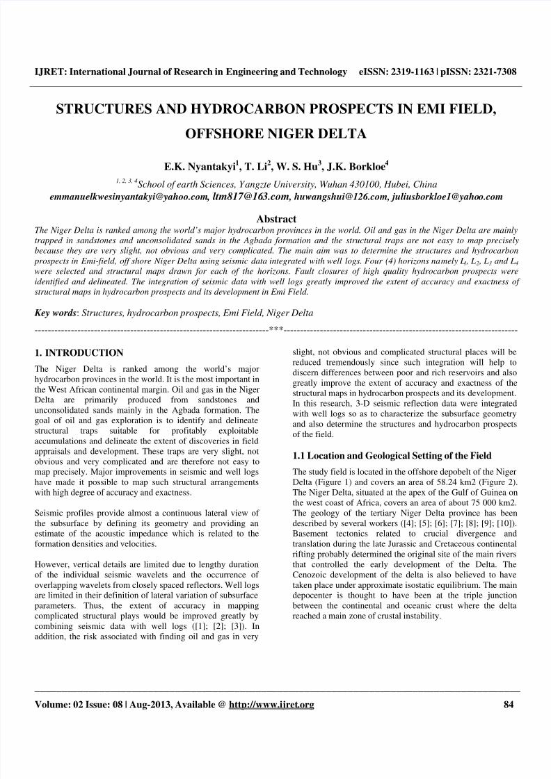
STRUCTURES AND HYDROCARBON PROSPECTS IN EMI FIELD,
OFFSHORE NIGER DELTA
E.K. Nyantakyi1, T. Li
2, W. S. Hu
3, J.K. Borkloe
4
1, 2, 3, 4School of earth Sciences, Yangzte University, Wuhan 430100, Hubei, China
[email protected] , [email protected] , [email protected], [email protected]
AbstractThe Niger Delta is ranked among the world’s major hydrocarbon provinces in the world. Oil and gas in the Niger Delta are mainly
trapped in sandstones and unconsolidated sands in the Agbada formation and the structural traps are not easy to map precisely
because they are very slight, not obvious and very complicated. The main aim was to determine the structures and hydrocarbon
prospects in Emi-field, off shore Niger Delta using seismic data integrated with well logs. Four (4) horizons namely L1 , L2 , L3 and L4
were selected and structural maps drawn for each of the horizons. Fault closures of high quality hydrocarbon prospects wereidentified and delineated. The integration of seismic data with well logs greatly improved the extent of accuracy and exactness of
structural maps in hydrocarbon prospects and its development in Emi Field.
Key words: Structures, hydrocarbon prospects, Emi Field, Niger Delta
-----------------------------------------------------------------------***-----------------------------------------------------------------------
1. INTRODUCTION
The Niger Delta is ranked among the world’s major
hydrocarbon provinces in the world. It is the most important in
the West African continental margin. Oil and gas in the Niger
Delta are primarily produced from sandstones and
unconsolidated sands mainly in the Agbada formation. Thegoal of oil and gas exploration is to identify and delineate
structural traps suitable for profitably exploitable
accumulations and delineate the extent of discoveries in field
appraisals and development. These traps are very slight, not
obvious and very complicated and are therefore not easy to
map precisely. Major improvements in seismic and well logs
have made it possible to map such structural arrangements
with high degree of accuracy and exactness.
Seismic profiles provide almost a continuous lateral view of
the subsurface by defining its geometry and providing an
estimate of the acoustic impedance which is related to the
formation densities and velocities.
However, vertical details are limited due to lengthy duration
of the individual seismic wavelets and the occurrence of
overlapping wavelets from closely spaced reflectors. Well logs
are limited in their definition of lateral variation of subsurface
parameters. Thus, the extent of accuracy in mapping
complicated structural plays would be improved greatly by
combining seismic data with well logs ([1]; [2]; [3]). In
addition, the risk associated with finding oil and gas in very
slight, not obvious and complicated structural places will be
reduced tremendously since such integration will help to
discern differences between poor and rich reservoirs and also
greatly improve the extent of accuracy and exactness of the
structural maps in hydrocarbon prospects and its development.
In this research, 3-D seismic reflection data were integrated
with well logs so as to characterize the subsurface geometry
and also determine the structures and hydrocarbon prospects
of the field.
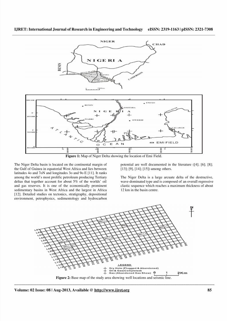
1.1 Location and Geological Setting of the Field
The study field is located in the offshore depobelt of the Niger
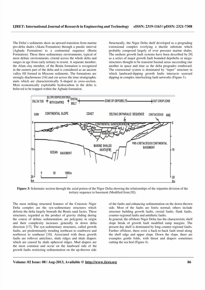
Delta (Figure 1) and covers an area of 58.24 km2 (Figure 2).
The Niger Delta, situated at the apex of the Gulf of Guinea on
the west coast of Africa, covers an area of about 75 000 km2.
The geology of the tertiary Niger Delta province has been
described by several workers ([4]; [5]; [6]; [7]; [8]; [9]; [10]).
Basement tectonics related to crucial divergence and
translation during the late Jurassic and Cretaceous continentalrifting probably determined the original site of the main rivers
that controlled the early development of the Delta. The
Cenozoic development of the delta is also believed to have
taken place under approximate isostatic equilibrium. The main
depocenter is thought to have been at the triple junction
between the continental and oceanic crust where the delta
reached a main zone of crustal instability.
8/13/2019 IJRET - Structures and Hydrocarbon Prospects in Emi Field, Offshore Niger Delta
http://slidepdf.com/reader/full/ijret-structures-and-hydrocarbon-prospects-in-emi-field-offshore-niger-delta 2/8
IJRET: International Journal of Research in Engineering and Technology eISSN: 2319-1163 | pISSN: 2321-7308
__________________________________________________________________________________________
Volume: 02 Issue: 08 | Aug-2013, Available @ http://www.ijret.org 85
Figure 1: Map of Niger Delta showing the location of Emi Field.
The Niger Delta basin is located on the continental margin of
the Gulf of Guinea in equatorial West Africa and lies betweenlatitudes 4o and 7oN and longitudes 3o and 9o E [11]. It ranks
among the world’s most prolific petroleum producing Tertiary
deltas that together account for about 5% of the worlds’ oil
and gas reserves. It is one of the economically prominent
sedimentary basins in West Africa and the largest in Africa
[12]. Detailed studies on tectonics, stratigraphy, depositional
environment, petrophysics, sedimentology and hydrocarbon
potential are well documented in the literature ([4]; [6]; [8];
[13]; [9], [14]; [15]) among others.
The Niger Delta is a large arcuate delta of the destructive,
wave-dominated type and is composed of an overall regressive
clastic sequence which reaches a maximum thickness of about
12 km in the basin centre.
Figure 2: Base map of the study area showing well locations and seismic line.
8/13/2019 IJRET - Structures and Hydrocarbon Prospects in Emi Field, Offshore Niger Delta
http://slidepdf.com/reader/full/ijret-structures-and-hydrocarbon-prospects-in-emi-field-offshore-niger-delta 3/8
IJRET: International Journal of Research in Engineering and Technology eISSN: 2319-1163 | pISSN: 2321-7308
__________________________________________________________________________________________
Volume: 02 Issue: 08 | Aug-2013, Available @ http://www.ijret.org 86
The Delta’s sediments show an upward transition from marine
pro-delta shales (Akata Formation) through a paralic interval
(Agbada Formation) to a continental sequence (BeninFormation). These three sedimentary environments, typical of
most deltaic environments, extend across the whole delta and
ranges in age from early tertiary to resent. A separate member,
the Afam clay member, of the Benin formation is recognized
in the eastern part of the delta and is considered as an ancient
valley fill formed in Miocene sediments. The formations are
strongly diachronous [16] and cut across the time stratigraphic
units which are characteristically S-shaped in cross-section.
Most economically exploitable hydrocarbon in the delta is
believed to be trapped within the Agbada formation.
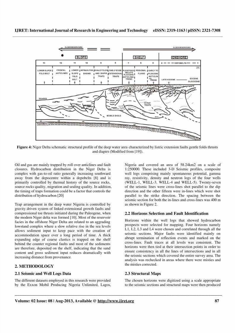
Structurally, the Niger Delta shelf developed as a prograding
extensional complex overlying a ductile substrate which
probably composed largely of over pressure marine shales.The onshore growth fault systems have been described by [9]
as a series of major growth fault bounded depobelts or mega-
structures thought to be transient basinal areas succeeding one
another in space and time as the delta progrades southward.
The extensional system is dominated by “tepee” structure in
which landward-dipping growth faults intersects seaward
dipping in complex interlocking fault networks (Figure 3).
Figure 3: Schematic section through the axial potion of the Niger Delta showing the relationships of the tripartite division of the
tertiary sequence to basement (Modified from [9]).
The most striking structural features of the Cenozoic NigerDelta complex are the syn-sedimentary structures which
deform the delta largely beneath the Benin sand facies. These
structures, regarded as the product of gravity sliding during
the course of deltaic sedimentation, are polygenic in origin
and their complexity increases generally in down delta
direction [17]. The syn-sedimentary structures, called growth
faults, are predominantly trending northeast to southwest andnorthwest to southeast [18]. Associated with these growth
faults are rollover anticlines, shale ridges and shale diapers
which are caused by shale upheaval ridges. Mud diapers are
the most common and occur on the landward side of the
growth faults restricting sedimentation on the up-thrown side
of the faults and enhancing sedimentation on the down-thrownside. Most of the faults are listric normal; others include
structure building growth faults, crestal faults, flank faults,
counter-regional faults and antithetic faults.
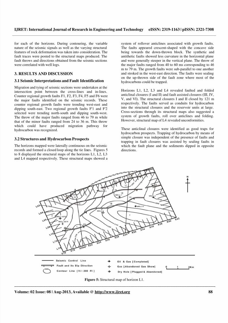
In general, the offshore Niger Delta has the characteristic shelf
slope break of growth fault modified ramp margins. The
present day shelf is dominated by long counter regional faults.
Further offshore, there exist a back-to-back fault trend alongthe shelf edge and upper slope. Down the slope, there are
examples gentle folds, with thrust and diapers sometimes
cutting the sea bed (Figure 4).
8/13/2019 IJRET - Structures and Hydrocarbon Prospects in Emi Field, Offshore Niger Delta
http://slidepdf.com/reader/full/ijret-structures-and-hydrocarbon-prospects-in-emi-field-offshore-niger-delta 4/8
8/13/2019 IJRET - Structures and Hydrocarbon Prospects in Emi Field, Offshore Niger Delta
http://slidepdf.com/reader/full/ijret-structures-and-hydrocarbon-prospects-in-emi-field-offshore-niger-delta 5/8
IJRET: International Journal of Research in Engineering and Technology eISSN: 2319-1163 | pISSN: 2321-7308
__________________________________________________________________________________________
Volume: 02 Issue: 08 | Aug-2013, Available @ http://www.ijret.org 88
for each of the horizons. During contouring, the variable
nature of the seismic signals as well as the varying structural
features of rock deformation was taken into consideration. The
fault traces were posted to the structural maps produced. Thefault throws and directions obtained from the seismic sections
were correlated with well logs.
3. RESULTS AND DISCUSSION
3.1 Seismic Interpretations and Fault Identification
Migration and tying of seismic sections were undertaken at the
intersection point between the cross-lines and in-lines.
Counter regional growth faults F1, F2, F3, F4, F5 and F6 were
the major faults identified on the seismic records. These
counter regional growth faults were trending west-east and
dipping south-east. Two regional growth faults F'1 and F'2
selected were trending north-south and dipping south-west.The throw of the major faults ranged from 46 to 79 m while
that of the minor faults ranged from 24 to 36 m. This throw
which could have produced migration pathway forhydrocarbon was recognized.
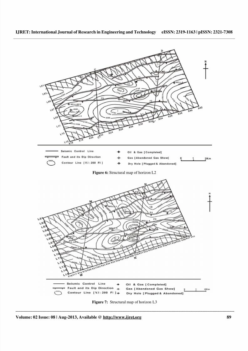
3.2 Structures and Hydrocarbon Prospects
The horizons mapped were laterally continuous on the seismic
records and formed a closed loop along the tie lines. Figures 5
to 8 displayed the structural maps of the horizons L1, L2, L3
and L4 mapped respectively. These structural maps showed a
system of rollover anticlines associated with growth faults.
The faults appeared crescent-shaped with the concave side
being towards the down-thrown block. The synthetic and
antithetic faults showed less curvature in the horizontal planeand were generally steeper in the vertical plane. The throw of
the major faults ranged from 40 to 60 ms corresponding to 46
m to 79 m. The growth faults were sub-parallel to one another
and stroked in the west-east direction. The faults were sealing
on the up-thrown side of the fault zone where most of the
hydrocarbons could be trapped.
Horizons L1, L2, L3 and L4 revealed faulted and folded
anticlinal closures (I and II) and fault assisted closures (III, IV,
V, and VI). The structural closures I and II closed by 121 m
respectively. The faults served as conduits for hydrocarbon
into the structural closures and the reservoir units at large.
Cross-sections through its structural maps also suggested asystem of growth faults, roll over anticlines and folding.
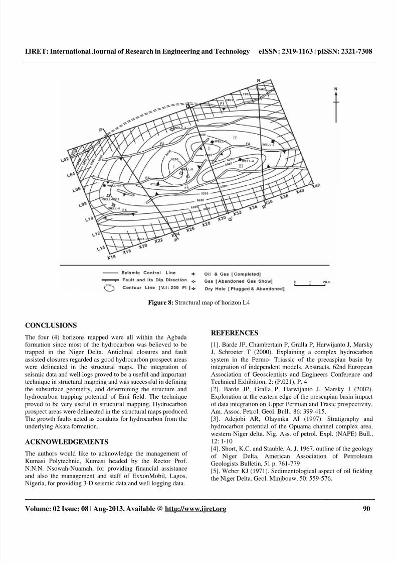
However, structural map of L4 revealed unconformities.
These anticlinal closures were identified as good traps for
hydrocarbon prospects. Trapping of hydrocarbon by means of
simple closure was independent of the presence of faults and
trapping in fault closures was assisted by sealing faults in
which the fault plane and the sediments dipped in opposite
directions.
Figure 5: Structural map of horizon L1.
8/13/2019 IJRET - Structures and Hydrocarbon Prospects in Emi Field, Offshore Niger Delta
http://slidepdf.com/reader/full/ijret-structures-and-hydrocarbon-prospects-in-emi-field-offshore-niger-delta 6/8
IJRET: International Journal of Research in Engineering and Technology eISSN: 2319-1163 | pISSN: 2321-7308
__________________________________________________________________________________________
Volume: 02 Issue: 08 | Aug-2013, Available @ http://www.ijret.org 89
Figure 6: Structural map of horizon L2
Figure 7: Structural map of horizon L3
8/13/2019 IJRET - Structures and Hydrocarbon Prospects in Emi Field, Offshore Niger Delta
http://slidepdf.com/reader/full/ijret-structures-and-hydrocarbon-prospects-in-emi-field-offshore-niger-delta 7/8
IJRET: International Journal of Research in Engineering and Technology eISSN: 2319-1163 | pISSN: 2321-7308
__________________________________________________________________________________________
Volume: 02 Issue: 08 | Aug-2013, Available @ http://www.ijret.org 90
Figure 8: Structural map of horizon L4
CONCLUSIONS
The four (4) horizons mapped were all within the Agbada
formation since most of the hydrocarbon was believed to be
trapped in the Niger Delta. Anticlinal closures and fault
assisted closures regarded as good hydrocarbon prospect areas
were delineated in the structural maps. The integration of
seismic data and well logs proved to be a useful and important
technique in structural mapping and was successful in defining
the subsurface geometry, and determining the structure and
hydrocarbon trapping potential of Emi field. The techniqueproved to be very useful in structural mapping. Hydrocarbon
prospect areas were delineated in the structural maps produced.
The growth faults acted as conduits for hydrocarbon from the
underlying Akata formation.
ACKNOWLEDGEMENTS
The authors would like to acknowledge the management of
Kumasi Polytechnic, Kumasi headed by the Rector Prof.
N.N.N. Nsowah-Nuamah, for providing financial assistance
and also the management and staff of ExxonMobil, Lagos,
Nigeria, for providing 3-D seismic data and well logging data.
REFERENCES
[1]. Barde JP, Chambertain P, Gralla P, Harwijanto J, Marsky
J, Schroeter T (2000). Explaining a complex hydrocarbon
system in the Permo- Triassic of the precaspian basin by
integration of independent models. Abstracts, 62nd European
Association of Geoscientists and Engineers Conference and
Technical Exhibition, 2: (P.021), P. 4
[2]. Barde JP, Gralla P, Harwijanto J, Marsky J (2002).
Exploration at the eastern edge of the prescapian basin impactof data integration on Upper Permian and Trasic prospectivity.
Am. Assoc. Petrol. Geol. Bull., 86: 399-415.
[3]. Adejobi AR, Olayinka AI (1997). Stratigraphy and
hydrocarbon potential of the Opuama channel complex area,
western Niger delta. Nig. Ass. of petrol. Expl. (NAPE) Bull.,
12: 1-10
[4]. Short, K.C. and Stauble, A. J. 1967. outline of the geology
of Niger Delta, American Association of Petrroleum
Geologists Bulletin, 51 p. 761-779
[5]. Weber KJ (1971). Sedimentological aspect of oil fielding
the Niger Delta. Geol. Minjbouw, 50: 559-576.
8/13/2019 IJRET - Structures and Hydrocarbon Prospects in Emi Field, Offshore Niger Delta
http://slidepdf.com/reader/full/ijret-structures-and-hydrocarbon-prospects-in-emi-field-offshore-niger-delta 8/8
IJRET: International Journal of Research in Engineering and Technology eISSN: 2319-1163 | pISSN: 2321-7308
__________________________________________________________________________________________
Volume: 02 Issue: 08 | Aug-2013, Available @ http://www.ijret.org 91
[6]. Weber, K.J. and Daukoro, E.M. 1975. Petroleum
geological aspects of the Niger Delta. Tokyo, 9th world
Petroleum Congress Proceedings, 5 ( 2), p. 209-221
[7]. Weber KJ, Mandi J, Pilaar WF, Lehner E, Precious RG(1978). The role of faults in hydrocarbon migration and
trapping in Nigeria growth fault structures. 10th Annual
Offshore Technology Conference Proceedings, 4: 2643-2653.
[8]. Evamy, B.O., Herembourne, j., Kameline, P., Knap, W.A.,
Molloy, F.A. and Rowlands, P.H. 1978. Hydrocarbon habitat
of Tertiary Niger Delta, American Association of Petroleum
Geologists Bulletin, 62, p.1-39
[9]. Doust H, Omatsola E (1990). Niger Delta in
divergent/passive margin basins, in J. D. Edwards and P. A.
Santogrossied, eds., Am. Assoc. Petrol. Geol. Memoir, 48:
201-238.[10], Haack RC, Sundararaman P, Diedjomahor JO, Xiao H,
Gant NJ, May ED, Kelsch K (2000). Niger Delta petroleumsystems, Nigeria, in M. R. Mello and B. J. Katz, eds.,
Petroleum systems of South Atlantic margins: Am. Assoc.
Petrol. Geol. Memoir, 73: 213-231.
[11]. Whiteman, A., 1982, Nigeria: Its Petroleum Geology,
Resources and Potential: London, Graham and Trotman, 394 p.
[12]. Reijers, T.J.F., 1996. Selected Chapters on Geology ,
SPDC of Nigeria, Copporate Reprographic Services, Warri,
197p
[13]. Knox, G. J. & Omatsola, M. E. (1989):Development of
the Cenozoic Niger Delta in terms of the escalator regression
model and impact on hydrocarbon distribution, In:
[14]. Nton, M.E. and Adebambo, B.A., 2009 Petrophysical
evaluation and depositional environments of reservoir sands of
X- field, offshore Niger delta ., Mineral Wealth Vol. 150 pp 1-
12
[15]. Nton, M.E. and Adesina, A. D., 2009. Aspects ofstructures and depositional environment of sand bodies within
tomboy field, offshore western Niger Delta, Nigeria RMZ –
Materials and Geoenvironment, Vol. 56, No. 3, pp. 284–303
[16]. Murat RC (1970). Stratigraphy and Paleogeography of
the Cretaceous and Lower Tertiary in Southern Nigerian. 1stConference on African Geology Proceedings, Ibadan
University Press, pp. 251-266.
[17]. Merki PJ (1972). Structural geology of the Cenozoic
Niger Delta: 1st Conference on African Geology Proceedings,
Ibadan University Press, pp. 635-646.
[18]. Hosper J (1971). The geology of the Niger Delta area, inthe Geology of the East Atlantic continental margin, Great
Britain, Institute of Geological Science, Report, 70(16): 121-
141
[19]. Ojo AO (1996). Pre-drill prospect evaluation in deep
water Nigeria. Nig. Assoc. Petrol. Explo. Bull., 11: 11-22.
[20]. Chukwueke CC (1997). Factors controlling hydrocarbon
distribution in the central swamp deposit of the Niger Delta.
Nig. Assoc. Petrol. Explorat. Bull., 12: 41-45.
BIOGRAPHIES
Emmanuel Kwesi Nyantakyi is a PhD Student at the
Structural Geology Department, School of Earth Sciences,Yangtze University, Wuhan-China. He holds an MSc. in Road
and Transportation Engineering. His research areas are Oil and
Gas Storage and Transportation, Structural Geology, Seismic
Interpretation, Petroleum Geology and Geochemistry. He is a
Member of American Association of Petroleum Geologists
(AAPG).
Li Tao is a Lecturer at the Geology Department, School of
Earth Sciences, Yangtze University, Wuhan-China. He holds a
PhD in Structural Geology and his research areas are
Structural Geology, Petroleum Geology and Seismic
Interpretation.
Wangshui Hu is a professor of Structural Geology, School ofEarth Sciences, Yangtze University, Wuhan-China. He holds a
PhD in Structural Geology and his research areas are
Structural Geology, Sedimentology, Seismic Interpretation
and Petroleum Geology.
Julius Kwame Borkloe is a PhD Student at the StructuralGeology Department, School of Earth Sciences, Yangtze
University, Wuhan-China. He holds an MSc. in Structural
Engineering. His research areas are Geophysics, Structural
Geology, Seismic Interpretation and Geochemistry. He is a
Member of American Association of Petroleum Geologists
(AAPG) and Ghana Institution of Engineers (GhIE)