Embed Size (px)
Citation preview

LIGHTNING WARNING AND ANALYSIS OF LIGHTNING THREATS RISKS FOR HUMAN LIFE PROTECTION IN BRAZIL
K. P. Naccarato*; O. Pinto Jr.
Instituto Nacional de Pesquisas Espaciais (INPE) - Brazil
1. INTRODUCTION
The Atmospheric Electricity Group (ELAT) from INPE developed, in the last 6 years (the first work on this subject was presented by Naccarato and Pinto. 2007), a methodology for cloud-to-ground (CG) lightning warning with up to 1h time in advance (nowcasting) for regions smaller than 100km
2. This approach is
particularly attractive because, presently in Brazil, thunderstorm warning systems are mainly based on numerical models or satellite products, which work better for large areas. For small areas (as city neighborhoods, stadiums, refineries, airports, power plants, construction areas, etc) those lightning warning systems still do not present a satisfactory accuracy in both space and time domains. Nowadays, the more powerful computational resources allow increasing the prediction model time and spatial resolution also adding cloud microphysics calculations in the forecast. However, there is usually a great effort to gather model initialization data at the same spatial and time resolutions. Moreover, local convective storms present highly changeable dynamics and strong dependency on the regional conditions (like the topography, wind circulation, humidity, etc). Therefore, these particular dynamics tend to be neglected by the present meteorological models due to the lake of high resolution initialization data leading to significant errors in the forecast.
This work intends to show that the present lightning warning methodology can be used as a powerful tool for human life protection since it can be an alternative way to predict lightning occurrence over a particular small area. Moreover, according to the Brazilian (ABNT NBR-5419:2005), the U.S. (NFPA-780 Ed 2008)
* Corresponding author address: Dr. Kleber P. Naccarato,
Instituto Nacional de Pesquisas Espaciais (INPE), Centro de Ciência do Sistema Terrestre (CCST), Atmospheric Electricity Group (ELAT), São José dos Campos, SP, Brazil, P.O. Box 515, 12245-970, e-mail: [email protected]
and International (IEC 62305 Ed2.0) Standards there is still no effective protection systems for people in outdoor activities. Thus it is also presented a simplified risk analysis of lightning threats over Brazil based on CG lightning flash densities computed from LIS historical data.
2. SIMPLIFIED CALCULATION OF LIGHTNING THREAT RISK (LTR)
According to the IEC 62305-2 Standard (Ed 2.0), the typical tolerable risk (RT) for loss of human life or permanent injuries is
RT = 10
-5 yr
-1 (1)
Pinto et al. (2010) showed that the
annual rate of fatalities caused by lightning in Brazil is about 0.7 per million. Based on this result and from non-official statistics, it can be estimated that about 500 persons are struck by lightning per year in Brazil. Assuming that the country has almost 200 million habitants, the risk of a Brazilian citizen to be struck by a lightning generally is
R = 2.5 x 10
-6 yr
-1 (2)
Now considering that the Brazilian
average CG lightning flash rate is around 6 flashes km
-2 y
-1 (Naccarato et al. 2011), the
risk of a person working outdoors 8h a day, 7 days a week, to be struck by a lightning is
R = 2.5 x 10
-3 yr
-1 (3)
assuming a lightning strike up to 20m
from the person. It can be stated that a risk of lightning
threat for a person working outdoors 8h a day, 7 days a week is 1,000 times higher than the risk for a person doing its regular activities. And the risk for the same person working outdoors is 250 times higher than the typical tolerable risk given by (1). Therefore, we concluded that to protect
people working outdoors every day, it is required a CG lightning tracking and warning system that tells them when to go indoors safely before the onset of the CG lightning activity over the area.
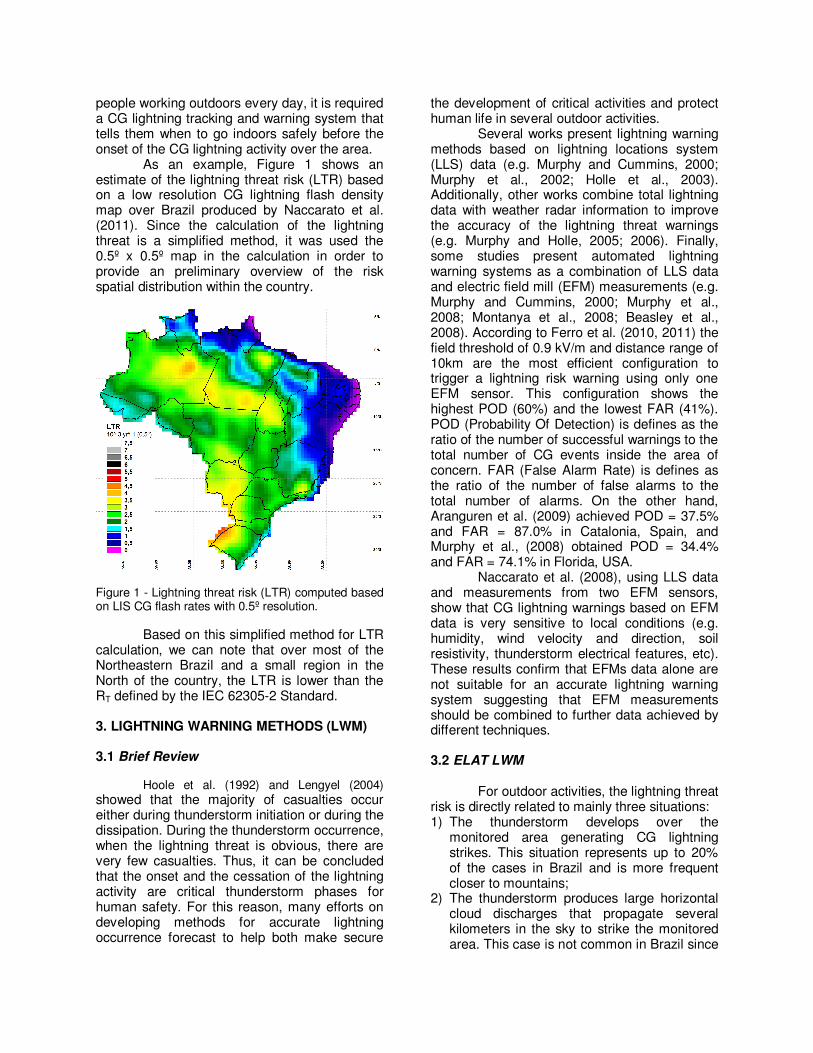
As an example, Figure 1 shows an estimate of the lightning threat risk (LTR) based on a low resolution CG lightning flash density map over Brazil produced by Naccarato et al. (2011). Since the calculation of the lightning threat is a simplified method, it was used the 0.5º x 0.5º map in the calculation in order to provide an preliminary overview of the risk spatial distribution within the country.
Figure 1 - Lightning threat risk (LTR) computed based on LIS CG flash rates with 0.5º resolution.
Based on this simplified method for LTR calculation, we can note that over most of the Northeastern Brazil and a small region in the North of the country, the LTR is lower than the RT defined by the IEC 62305-2 Standard. 3. LIGHTNING WARNING METHODS (LWM) 3.1 Brief Review
Hoole et al. (1992) and Lengyel (2004)
showed that the majority of casualties occur either during thunderstorm initiation or during the dissipation. During the thunderstorm occurrence, when the lightning threat is obvious, there are very few casualties. Thus, it can be concluded that the onset and the cessation of the lightning activity are critical thunderstorm phases for human safety. For this reason, many efforts on developing methods for accurate lightning occurrence forecast to help both make secure
the development of critical activities and protect human life in several outdoor activities.
Several works present lightning warning methods based on lightning locations system (LLS) data (e.g. Murphy and Cummins, 2000; Murphy et al., 2002; Holle et al., 2003). Additionally, other works combine total lightning data with weather radar information to improve the accuracy of the lightning threat warnings (e.g. Murphy and Holle, 2005; 2006). Finally, some studies present automated lightning warning systems as a combination of LLS data and electric field mill (EFM) measurements (e.g. Murphy and Cummins, 2000; Murphy et al., 2008; Montanya et al., 2008; Beasley et al., 2008). According to Ferro et al. (2010, 2011) the field threshold of 0.9 kV/m and distance range of 10km are the most efficient configuration to trigger a lightning risk warning using only one EFM sensor. This configuration shows the highest POD (60%) and the lowest FAR (41%). POD (Probability Of Detection) is defines as the ratio of the number of successful warnings to the total number of CG events inside the area of concern. FAR (False Alarm Rate) is defines as the ratio of the number of false alarms to the total number of alarms. On the other hand, Aranguren et al. (2009) achieved POD = 37.5% and FAR = 87.0% in Catalonia, Spain, and Murphy et al., (2008) obtained POD = 34.4% and FAR = 74.1% in Florida, USA.
Naccarato et al. (2008), using LLS data and measurements from two EFM sensors, show that CG lightning warnings based on EFM data is very sensitive to local conditions (e.g. humidity, wind velocity and direction, soil resistivity, thunderstorm electrical features, etc). These results confirm that EFMs data alone are not suitable for an accurate lightning warning system suggesting that EFM measurements should be combined to further data achieved by different techniques. 3.2 ELAT LWM
For outdoor activities, the lightning threat risk is directly related to mainly three situations: 1) The thunderstorm develops over the
monitored area generating CG lightning strikes. This situation represents up to 20% of the cases in Brazil and is more frequent closer to mountains;
2) The thunderstorm produces large horizontal cloud discharges that propagate several kilometers in the sky to strike the monitored area. This case is not common in Brazil since

it is strongly related to large convective systems, which occurs only in the Southwestern part of the country;
3) An active thunderstorm moves towards the monitored area. This is the most frequent situation in Brazil which corresponds to about 80-90% of the cases. Usually these thunderstorms are associated to frontal systems in the Midsouthern of the country and to the Intertropical Convergence Zone (ITCZ) in the Northearn part. This feature is in agreement with the results of Murphy et al. (2008) in USA. Analyzing 4-years of CG lightning data provided by the NLDN over the Dallas-Fort Worth metropolitan area, the authors found that 88.5% of the 87 observed local storms move in from elsewhere and 11.5% develop overhead.
The ELAT LWM was improved from the
previous works (Naccarato and Pinto Jr. 2007; Naccarato et al. 2008) by including data from the WRF (Weather Research & Forecast) mesoscale model. The WRF is an atmospheric numerical weather prediction system, regional and non-hydrostatic designed to serve both operational forecasting and atmospheric research needs (Michalakes et al., 2004). The WRF can to be used in different spatial scales from some meters to thousands of kilometers (Skamarock et al., 2008). For initialization data, we have been using the analysis data from the GFS (Global Forecast System) atmospheric model provided by National Centers for Environmental Prediction (NCEP) with horizontal resolution of 0.5º. The WRF runs 24 hours of simulation over 2 domains: the largest with 15km horizontal resolution (main) and a smaller one with 5km (nesting) as shown Figure 2.
Since the ELAT LWM is been proposed to help protect human life from lightning threats outdoors, it must deal with the two most common thunderstorm cases in Brazil (discussed previously by items 1 and 3). It was seen that EFM measurements can help predict the onset of the lightning activity because we can track the increase of the local static electric field related to the thunderstorm electrification enhancement. However, due to their large variations, the EFM data usually lead to a low accurate lightning warning system (FAR higher than 40-50%). Thus, to predict the 1st situation, it is required look for further measurements. To deal with the 3rd situation is easier since we can use radar images and/or total lightning data
(from LLS) in real-time to track thunderstorms development and displacement.
Figure 2 – WRF domains: The main (15km) and the nesting (5km).
As discussed previously, nowcasting the CG lightning activity over a particular region with relative high accuracy (FAR lower than 30-40%) requires a joint analysis of several data sources. Due to the very distinct nature of the data source formats, automating the nowcast process demands a great effort on integrating all the available information within a unique interface. Therefore, in this paper no automation was implemented since the focus now is to first evaluate whether the improved methodology (and consequently the selected data sources) is able to provide an accurate CG lightning nowcast. For this reason, in this preliminary study, the process is been doing manually by a meteorologist who observes the different data sources to estimate the probability of occurrence of a thunderstorm (and consequently the CG lightning activity) over the monitored area with about 1h time in advance. The data sources employed in this study are: 1) The radar reflectivity at different CAPPI
(updated each 15 or 30min), which are related to the amount of precipitation in the atmosphere;
2) The satellite infrared (IR) images (updated every 15 or 30min), which are related to the vertical development of the thunderstorms (cloud height tops);
3) The total lightning (TL) activity around the monitored area (in real-time). The higher the number of developing and active thunderstorms, the higher the probability that one of them reaches the area;

4) The local atmospheric instability measured by three different stability indices provided hourly by the WRF model. These indices will be discussed later;
5) The experience of the meteorologist, who has to combine and analyze all data sources identifying the individual thresholds which will trigger a CG lightning warning for the area with about 1h time in advance. This is the most important part of the study: define the threshold levels of each data source and how they correlate in space and time. These rules will then allow computationally automate the nowcast process in a second phase.
Convective instability usually takes place
when the lower portion of the atmosphere is warm and moist and the remainder of the atmosphere above the boundary layer rapidly dries out. Stability indices can be arranged according to these definitions of stability above and by their originally-intended or traditional purpose. There are several indices that are the most widely used in forecasting today and have been used for many decades since the early 1950s. For a more detailed description of each stability indice please refer to Peppler (1988) and the tutorial of Convective Parameters and Indices from the National Weather Service (Louisville Weather Forecast Office) at http:// www.crh.noaa.gov/lmk/soo/docu/indices.php. In this work, we will use only three of them as a first evaluation: the Total-Totals Index (TT), the Showalter Index (SI) and the K Index (KI).
The TT (Miller, 1967) accounts for both static stability and 850mb moisture, but would be unrepresentative in situations where the low-level moisture resides below the 850 mb level. In addition, convection may be inhibited despite a high TT value if a significant capping inversion is present. In general (TS = thunderstorms):
45 to 50 TS possible.
50 to 55 TS more likely, possibly severe.
55 to 60 Severe TS most likely.
The KI (George, 1960) is a measure of
thunderstorm potential based on the vertical temperature lapse rate, and the amount and vertical extent of low-level moisture in the atmosphere. Since the KI includes the dewpoint depression at 700mb, dry air at this level will cause a low K value. However, given moisture below 700mb, unstable air, and a lifting mechanism, strong or severe organized
thunderstorms, and even heavy rain, can still occur. In general (SW = severe weather; HR = heavy rain):
< 30 TS with HR or SW possible.
> 30 Better potential for TS with HR.
= 40 Best potential for TS with very HR.
The SI (Showalter, 1953) is based on
the properties of the 850 and 500mb levels. The SI is calculated by lifting a parcel dry adiabatically from 850mb to its LCL, then moist adiabatically to 500mb, and comparing the the parcel versus environmental temperatures at 500mb. The SI may be better than the Lifted Index (LI) in showing instability aloft given a shallow low-level cool air mass. However, the SI is unrepresentative and inferior to the LI in showing instability if the low-level moisture does not extend up to the 850mb level. In general:
> 0 Stable or weak convection
0 to -3 Moderately unstable.
-4 to -6 Very unstable.
< -6 Extremely unstable.
4. RESULTS AND DISCUSSIONS
In order to evaluate the ELAT LWM, we have chosen a particular area of State of São Paulo with a high lightning activity throughout the thunderstorm season in Southeastern Brazil (from October to March). Figure 3 shows the location of this area which is outlined by the red solid line. Figure 4 magnifies the monitored area showing the reference path and the buffers. The background of Figure 4 corresponds to the CG lightning flash density provided by LIS (Naccarato et al., 2011). We can observe that this region presents CG flash rates from 4 up to 10 flashes km
-2 yr
-1, which is higher than the
average CG flash rate of the whole country. The buffers are defined at 4km (red),
10km (orange) and 20km (green) distance from the reference path (shown by the solid blue line). They are used to guide the nowcasting process. Once a thunderstorm crosses the 20km buffer, the meteorologist starts to evaluate all the available data in order to assess the probability that this thunderstorm can reach the path. When a thunderstorm crosses the 10km buffer, then a CG lightning warning is eminent. If the joined analysis of all data suggests that the thunderstorm has potential to reach the path,

then an alert is issued. Since the 4km buffer is called the critical distance, no thunderstorm is allowed to develop over or to reach this area without having a earlier warning. That is to avoid issuing a warning with a small time in advance.
Figure 3 - The red rectangle shows the monitored area for the present study. The diamonds represent the 75 BTLN sensors, of which 34 are already operational (in green) and 41 will be installed by July 2012 (in magenta).
Figure 4 - Monitored area in details showing the buffers (red, orange and green lines). The background colors correspond to the CG flash rates obtained by LIS based on 12 years of data (0.25º resolution).
Based on the ELAT lightning warning methodology, the Thunderstorm Tracking and Nowcasting (TTN) Project for the area shown in Figure 4 started at 09/09/2011 and will continue until 04/30/2012. Figure 5 shows the monthly distribution of all CG lightning alerts that were issued for the reference path (a total of 531 warnings) from 09/02/2011 to 02/27/2012.
Figure 5 - Number of CG lightning warnings issued monthly for the monitored area from Sep, 02 2012 to Feb, 27 2012.
The next figures show how the ELAT LWM have been used for thunderstorm tracking and CG lightning nowcasting. This particular case started at 20UT of 02/11 and ended at 02UT of 02/12. For this period of time (total duration of 06h), it was issued 07 CG lightning warnings for the studied area (Figure 4). All events were successful (i.e. it had been detected CG lightning activity over the 4km buffer) and the average time in advance was 48 minutes.
Figure 6 and 7 show the CG and IC lightning strokes detected by the Brazilian Total Lightning Detection Network (BTLN) which has 34 operational sensors today installed in 8 States of Brazil (Figure 3) covering entirely the Southeastern Brazil and partially the surrounding regions. More details of BTLN can be found in Naccarato and Osmar (2011). From the maps, we can see that a high activity of CG and IN lightning were registered over the monitored area. For the 20km buffer around the reference path, BTLN detected 1,720 CG strokes and 13,716 IN discharges which were concentrated mostly in the southern portion of the area (dark red rectangle). For the critical distance (4km buffer), it was detected 367 CG strokes and 2,180 IN discharges.
Figure 8 shows the time evolution of the TL stroke rate (strokes min
-1) which peaked at
21:30UT, about 1,5h after the first CG lightning warning was issued.

Figure 6 - CG lightning activity over the monitored area (the dark red rectangle) from 20UT of 02/11 to 02UT of 02/12. Within the 20km and 4km buffers it was detected 1,720 and 367 CG strokes, respectively.
Figure 7 - IN activity over the monitored area (dark red rectangle) from 20UT of 02/11 to 02UT of 02/12. Within 20km and 4km buffers it was detected 13,716 and 2,180 IN discharges, respectively.
Figure 8 - Total lightning stroke rate (min
-1) as a
function of time for the monitored area (dark red in Figures 6 and 7).
We used the infrared (IR) image of the GOES-12 satellite (Figure 9) and the reflectivity levels (dBz) from the MAXCAPPI 400km product of São Roque radar (Figure 10).
Figure 9 - IR image of GOES-12 satellite at 22UT. The cloud top heights are represented by brightness temperatures. The red rectangle is the monitored area
Figure 10 - Image of the MAXCAPPI 400km product from São Roque radar at 22:06UT. The reflectivity levels (dBZ) are integrated in height. The monitored area is outlined by the white rectangle.
Figures 11, 12, and 13 show the stability indices (KI, SI, and TT, respectively) which are computed hourly by the WRF numerical model for the Midsouthern Brazil.

Figure 11 - KI computed by WRF at 22UT. The monitored area is outlined by the black rectangle.
Figure 12 - SI computed by WRF at 22UT. The monitored area is outlined by the white rectangle.
Figure 13 - TT computed by WRF at 22UT.
Table 1 summarizes the typical values that have been generally obtained for almost all CG lightning warnings conditions. Those values can be cleared observed also for the particular case of Feb, 11 2012 (Figures 6 to 12). Table 1 - Typical values of the different data sources used by ELAT LWM for CG lightning nowcasting
Data Source Typical Values
Total Lighting Stroke Rate (min-1
) > 30
Radar Reflectivity @ 6km (dBz) > 50
Temperature of Cloud Tops (ºC) < -60
K Index (KI) > 39
Showalter Index (SI) < -3
Total Totals Index (TT) > 52
We can note from Table 1 that the KI, SI and TT indices are in close agreement with the expected values described in Section 3.2. Radar reflectivity and satellite cloud top temperatures are also in the typical range during thunderstorm enhancement. Finally, the TL stroke rate is lower than what was found by Betz et. al. (2008) in Germany but agrees with the findings of Liu and Heckman (2008) in USA.
Table 2 shows the preliminary results of the TTN project (from 09/02/11 to 02/27/12) which employs the ELAT LWM.
Table 2 - Preliminary results of the TTN project.
CG Lightning Warning Avg Values ± Var
Warning Durations 02:50h ± 00:25
Time of the Warnings (LT) 15:30h ± 01:30
Times in Advance 01:05h ± 00:20
Figure 14 shows the distribution of the
time of the warnings, which peaks from 15h to 19h (LT). We can see that the CG lightning alerts occur basically during afternoon (around 15:30h LT), reflecting the well-known diurnal variation of the thunderstorms. Warnings issued early in the morning usually are due to winter thunderstorms associated to frontal systems, which are common early in the morning during the winter season (Andrade. 2007).
Figure 15 shows the distribution of the warning durations, which peaks from 2h to 4h. This duration is expected since most of the local thunderstorms have a life cycle of about 01h to 01:30h. Assuming an average time in advance
of 01h and about 30min to 1h for thunderstorm complete cessation, we will get a total duration of 02h to 03:30h. Of course that the warning duration has a large variability (Figure 15) due to the complex nature of thunderstorms.
Figure 14 - Diurnal variation of the CG lightning warnings issued by the TTN project.
Figure 15 - Total duration of the CG lightning warnings issued by the TTN project.
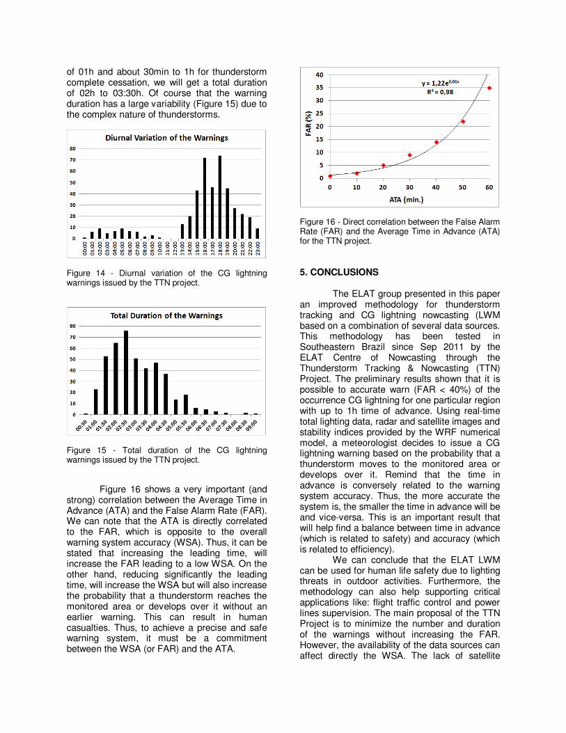
Figure 16 shows a very important (and strong) correlation between the Average Time in Advance (ATA) and the False Alarm Rate (FAR). We can note that the ATA is directly correlated to the FAR, which is opposite to the overall warning system accuracy (WSA). Thus, it can be stated that increasing the leading time, will increase the FAR leading to a low WSA. On the other hand, reducing significantly the leading time, will increase the WSA but will also increase the probability that a thunderstorm reaches the monitored area or develops over it without an earlier warning. This can result in human casualties. Thus, to achieve a precise and safe warning system, it must be a commitment between the WSA (or FAR) and the ATA.
Figure 16 - Direct correlation between the False Alarm Rate (FAR) and the Average Time in Advance (ATA) for the TTN project.
5. CONCLUSIONS
The ELAT group presented in this paper an improved methodology for thunderstorm tracking and CG lightning nowcasting (LWM based on a combination of several data sources. This methodology has been tested in Southeastern Brazil since Sep 2011 by the ELAT Centre of Nowcasting through the Thunderstorm Tracking & Nowcasting (TTN) Project. The preliminary results shown that it is possible to accurate warn (FAR < 40%) of the occurrence CG lightning for one particular region with up to 1h time of advance. Using real-time total lighting data, radar and satellite images and stability indices provided by the WRF numerical model, a meteorologist decides to issue a CG lightning warning based on the probability that a thunderstorm moves to the monitored area or develops over it. Remind that the time in advance is conversely related to the warning system accuracy. Thus, the more accurate the system is, the smaller the time in advance will be and vice-versa. This is an important result that will help find a balance between time in advance (which is related to safety) and accuracy (which is related to efficiency).
We can conclude that the ELAT LWM can be used for human life safety due to lighting threats in outdoor activities. Furthermore, the methodology can also help supporting critical applications like: flight traffic control and power lines supervision. The main proposal of the TTN Project is to minimize the number and duration of the warnings without increasing the FAR. However, the availability of the data sources can affect directly the WSA. The lack of satellite

and/or radar images or even the stability indices reduces significantly the WSA but still make possible the nowcasting. However, the lack of total lightning data together with any other data source prevents the warning system from the minimal acceptable accuracy.
In the near future, after concluding the TTN Project, the nowcasting process will be automated. This work includes integrating all data within an unique database and then develop a computational system that will issue the CG lightning warnings based on pre-defined parameters. All the data provided by the TTN Project will be used to define the parameters of the computational system that will allow it make their own decisions and issue the warnings.
Due to the simplified methodology employed and the low resolution of the LTR map for Brazil, it is planned in a future work to create a high resolution (0.1º) LTR map for Brazil and to improve the methodology for risk calculation. This new methodology must consider the risk variations as a function of the type of outdoor activity, its duration and the availability (or not) of nearby lightning protection systems.
6. ACKNOWLEDGMENTS
The authors thank all meteorologists and technicians from the ELAT Centre of Nowcasting for their support to the Thunderstorm Tracking and Nowcasting Project. 7. REFERENCES Andrade, K. M., 2007: Climatology and behaviour of frontal systems in South America. MsC. Dissertation, INPE-14056-TDI/1067, in Portuguese. Aranguren, D.; J. Montanya; G. Sola; V. March; D. Romero; H. Torres, 2009: On the lightning hazard warning using electrostatic field: analysis of summer thunderstorms in Spain. Atmospheric Research, doi:10,1016/j.elstat.2009.01.023. Beasley, W. H.; D. E. Williams; P. T. Hyland, 2008: Analysis of surface electric-field contours in relation to cloud-to-ground lightning flashes in air-mass thunderstorms at the Kennedy Space Center. 20th International Lightning Detection Conference (ILDC), Tucson, USA. Betz, H. D.; K. Schmidt; W. P. Oettinger; B. Montag, 2008: Cell-tracking with lightning data from LINET. Adv. Geosci., 17, 55–61.
Ferro, M. A. S.; J. Yamasaki; D. R. M. Pimentel; K. P. Naccarato; M. M. F. Saba, 2010: Cloud-to-ground lightning warnings based on electric field-mill measurements in Brazil. Proceedings of the 30th International Conference on Lightning Protection (ICLP), Cagliari, Italy. Ferro, M. A. S.; J. Yamasaki; D. R. M. Pimentel; K. P. Naccarato; M. M. F. Saba, 2011: An electric field-mill network in Southeastern Brazil for lightning warnings. XIV International Conference on Atmospheric Electricity (ICAE), Rio de Janeiro, Brazil. George, J. J., 1960: Weather Forecasting for Aeronautics. New York, Academic Press, 407-415. Holle, R. L.; L. J. Lopez; R. Ortiz; A. I. Watson; D. L. Smith; D. M. Decker; C. H. Paxton, 1992: Cloud-to-ground lightning related to deaths, injuries, and property damage in Central Florida”. Proceedings of the International Aerospace and Ground Conference on Lightning and Static Electricity, Atlantic City, USA Holle, R. L.; M. J. Murphy; R. E. Lopez, 2003: Distances and times between cloud-to-ground flashes in a storm. Proceedings of the International Conference on Lightning and Static Electricity (ICOLSE), Blackpool, UK. Lengyel, M. M., 2004: Lightning casualties and their proximity to surrounding cloud-to-ground lightning. M.S. Thesis. University of Oklahoma Liu, C; S. Heckman, 2010: The application of total lightning detection and cell tracking for severe weather prediction. WMO Technical Conference on Meteorological and Environmental Instruments and Methods of Observation (TECO), Helsinki, Finland. Naccarato, K. P.; O. Pinto Jr., 2007: Methodology for accurate CG lightning forecast. Proceedings of the IX International Symposium on Lightning Protection (SIPDA), Foz do Iguaçú, Brazil Naccarato, K. P.; O. Pinto Jr.,; H. H. Ferreira Jr., 2008: "Cloud-to-ground lightning forecast based on lightning location system information and electric field-mill data”. Proceedings of the International Conference on Grounding and Earthing (GROUND' 2008) & 3th International Conference on Lightning Physics and Effects (LPE), Florianópolis, Brazil. Naccarato, K. P; R. I. Albrecht; O. Pinto Jr., 2011: Cloud-to-ground lightning density over Brazil based on high-resolution lightning imaging sensor (LIS) data. XIV International Conference on Atmospheric Electricity (ICAE), Rio de Janeiro, Brazil Naccarato, K. P.; O. Pinto Jr., 2011: A trial Brazilian Total Lightning Network (BTLN) in Southeastern Brazil: first results. XIV International Conference on Atmospheric Electricity (ICAE), Rio de Janeiro, Brazil

Peppler, R., 1988: A review of static stability indices and related thermodynamic parameters. The Illinois State Water Survey Division, Department of Energy and Natural Resources, SWS Miscellaneous Publication 104. Pinto, I.R.C.A.; I. Cardoso; O. Pinto Jr.; N. Geier, 2010: Lightning fatalities in Brazil in the last decade. 21st International Lightning Detection Conference (ILDC) & 3rd International Lightning Meteorology Conference (ILMC), Orlando, USA. Michalakes, J., J. Dudhia, D. Gill, T. Henderson, J. Klemp, W. Skamarock; W. Wang, 2004: The Weather Reseach and Forecast Model: Software Architecture and Performance, Proceedings of the 11th ECMWF Workshop on the Use of High Performance Computing In Meteorology, Reading, U.K. Miller, R. C, 1967: Notes on analysis and severe storm forecasting procedures of the Military Weather Warning Center. Tech. Report 200, AWS, USAF. [Headquarters, AWS, Scott AFB, 1L 62225] Montanya. J.; D. Aranguren; N. Pineda; G. Sola; D. Romero; V. March, 2008: Total lightning, electrostatic field and meteorological radar applied to lightning hazard warning. 20th International Lightning Detection Conference (ILDC), Tucson, USA. Murphy, M. J.; K. L. Cummins, 2000: Early detection and warning of cloud-to-ground lightning at a point of interest. Proceedings of the 2nd Symposium on Environmental Applications, p. 172-177, Long Beach, USA. Murphy, M. J.; N. W. S. Demetriades; K. L. Cummins, 2002: Probabilistic early warning of cloud-to-ground lightning at an airport. Proceedings of the 16th Conference on Probability and Statistics in the Atmospheric Sciences, p. 126-131, Orlando, USA. Murphy, M. J.; R. L. Holle, 2005: A warning method for the risk of cloud-to-ground lightning based on total lightning and radar information. Proceedings of the International Conference on Lightning and Static Electricity (ICOLSE), Seattle, USA. Murphy, M. J.; R. L. Holle, 2006: Warnings of cloud-to-ground lightning hazard based on combinations of lightning detection and radar information. 19th International Lightning Detection Conference (ILDC), Tucson, USA. Murphy, M. J.; R. L. Holle; N. W. S. Demetriades, 2008: Cloud-to-ground lightning warnings using electric field mill and lightning observations. 20th International Lightning Detection Conference (ILDC). Tucson, USA.
Showalter, A. K., 1953: A stability index for thunderstorm forecasting. Bull. Amer. Meteor. Soc. 34. 250-252. Skamarock, W. C.; M. L. Weisman, 2008: The impact of positive-definite moisture transport on NWP precipitation forecasts. Monthly Weather Review, v.137, p.488-494.