Embed Size (px)
Citation preview

Community Development Block Grant Program
Impact Determination Guide for Environmental Review

Table of Contents Sample Cover Letters ....................................................................................................................................................... 1 NEPA Related Laws & Authorities ................................................................................................................................... 4
Historic Preservation ............................................................................................................................................. 4 Flood Insurance ..................................................................................................................................................... 7 Floodplain Management ........................................................................................................................................ 8 Wetlands Protection ............................................................................................................................................ 11 8-Step Decision Making Process .......................................................................................................................... 11 Airport Hazards .................................................................................................................................................... 14 Endangered Species ............................................................................................................................................. 15 Wild and Scenic Rivers ......................................................................................................................................... 17 Farmland Protection ............................................................................................................................................ 18 Noise Abatement and Control ............................................................................................................................. 19 Explosive and Flammable Facilities ..................................................................................................................... 21 Air Quality ............................................................................................................................................................ 22 Contamination and Toxic Materials ..................................................................................................................... 24 Environmental Justice .......................................................................................................................................... 25
Additional Environmental Factors for Environmental Assessments ............................................................................. 27 Conformance with Plans ...................................................................................................................................... 27 Compatible Land Use and Zoning ........................................................................................................................ 27 Scale & Urban Design ........................................................................................................................................... 28 Soil Suitability ...................................................................................................................................................... 29 Slope .................................................................................................................................................................... 30 Erosion ................................................................................................................................................................. 31 Drainage/ StormWater Runoff ............................................................................................................................ 32 Hazards and Nuisances/ Including Site Safety and Noise .................................................................................... 33 Energy Consumption............................................................................................................................................ 34 Employment and Income Patterns ...................................................................................................................... 35 Demographic Character Changes ........................................................................................................................ 36 Displacement ....................................................................................................................................................... 36 Educational and Cultural Facilities ....................................................................................................................... 37 Commercial Facilities ........................................................................................................................................... 38 Health Care .......................................................................................................................................................... 38 Social Services ...................................................................................................................................................... 39 SolidWaste Disposal/Recycling ............................................................................................................................ 40 Waste Water/Sanitary Sewers ............................................................................................................................. 40 Water Supply ....................................................................................................................................................... 41 Public Safety - Police, Fire and Emergency Medical ............................................................................................ 42 Parks, Open Space and Recreation ...................................................................................................................... 42 Transportation and Accessibility ......................................................................................................................... 43 Unique Natural Features ..................................................................................................................................... 44 Water Resources .................................................................................................................................................. 45 Vegetation ........................................................................................................................................................... 46 Wildlife ................................................................................................................................................................. 47
1 November 2019
Sample Cover Letters
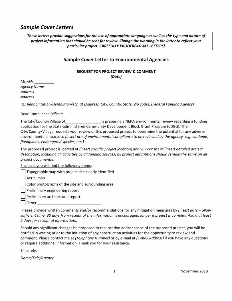
Sample Cover Letter to Environmental Agencies
REQUEST FOR PROJECT REVIEW & COMMENT
(Date) Mr./Ms. Agency Name Address Address
RE: Rehabilitation/Demolition/etc. at (Address, City, County, State, Zip code), (Federal Funding Agency)
Dear Compliance Officer:
The City/County/Village of is preparing a NEPA environmental review regarding a funding application for the State-administered Community Development Block Grant Program (CDBG). The City/County/Village requests your review of this proposed project to determine the potential for any adverse environmental impacts to (insert are of environmental compliance to be reviewed by the agency- e.g. wetlands, floodplains, endangered species, etc.)
The proposed project is located at (insert specific project location) and will consist of (insert detailed project description, including all activities by all funding sources; all project descriptions should remain the same on all project documents). Enclosed you will find the following items:
Topographic map with project site clearly identified Aerial map Color photographs of the site and surrounding area Preliminary engineering report Preliminary architectural report Other
Please provide written comments and/or recommendations for any mitigation measures by (Insert date – allow sufficient time, 30 days from receipt of the information is encouraged, longer if project is complex. Allow at least 5 days for receipt of information.)
Should any significant changes be proposed to the location and/or scope of the proposed project, you will be notified in writing prior to the initiation of any construction activities for the opportunity to review and comment. Please contact me at (Telephone Number) or by e-mail at (E-mail Address) if you have any questions or require additional information. Thank you for your assistance.
Sincerely,
Name/Title/Agency
These letters provide suggestions for the use of appropriate language as well as the type and nature of project information that should be sent for review. Change the wording in the letter to reflect your
particular project. CAREFULLY PROOFREAD ALL LETTERS!
2 November 2019
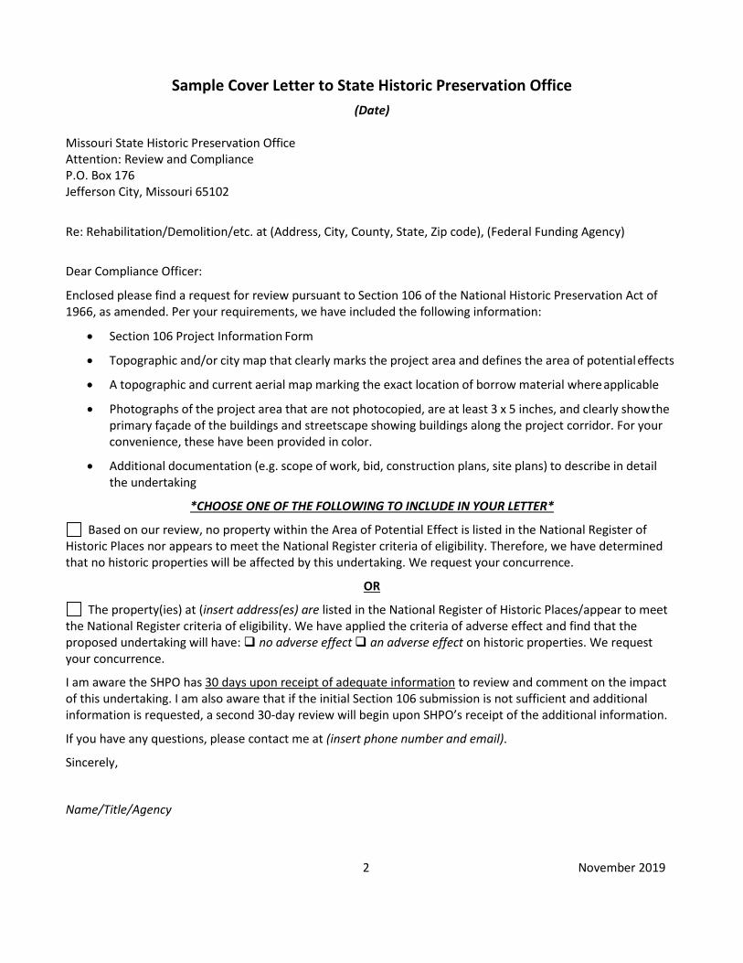
Sample Cover Letter to State Historic Preservation Office (Date)
Missouri State Historic Preservation Office Attention: Review and Compliance P.O. Box 176 Jefferson City, Missouri 65102
Re: Rehabilitation/Demolition/etc. at (Address, City, County, State, Zip code), (Federal Funding Agency)
Dear Compliance Officer:
Enclosed please find a request for review pursuant to Section 106 of the National Historic Preservation Act of 1966, as amended. Per your requirements, we have included the following information:
• Section 106 Project Information Form
• Topographic and/or city map that clearly marks the project area and defines the area of potential effects
• A topographic and current aerial map marking the exact location of borrow material where applicable
• Photographs of the project area that are not photocopied, are at least 3 x 5 inches, and clearly show the primary façade of the buildings and streetscape showing buildings along the project corridor. For your convenience, these have been provided in color.
• Additional documentation (e.g. scope of work, bid, construction plans, site plans) to describe in detail the undertaking
*CHOOSE ONE OF THE FOLLOWING TO INCLUDE IN YOUR LETTER*
Based on our review, no property within the Area of Potential Effect is listed in the National Register of Historic Places nor appears to meet the National Register criteria of eligibility. Therefore, we have determined that no historic properties will be affected by this undertaking. We request your concurrence.
OR
The property(ies) at (insert address(es) are listed in the National Register of Historic Places/appear to meet the National Register criteria of eligibility. We have applied the criteria of adverse effect and find that the proposed undertaking will have: no adverse effect an adverse effect on historic properties. We request your concurrence.
I am aware the SHPO has 30 days upon receipt of adequate information to review and comment on the impact of this undertaking. I am also aware that if the initial Section 106 submission is not sufficient and additional information is requested, a second 30-day review will begin upon SHPO’s receipt of the additional information.
If you have any questions, please contact me at (insert phone number and email).
Sincerely,
Name/Title/Agency

3 November 2019
Sample Cover Letter to Indian Tribes *Should be on RE letterhead and come directly from the RE*
REQUEST FOR PROJECT REVIEW & COMMENT (Date)
Title of Official Tribal Representative (Titles differ – ensure use of the appropriate title) & Name Tribal Name Address Address
RE: Rehabilitation/Demolition/etc. at (Address, City, County, State, Zip code), (Federal Funding Agency)
Dear (Title of Official Tribal Representative and Name),
The County/City/Village of is interested in submitting an application to the Missouri Department of Economic Development (MO DED) requesting Community Development Block Grant funds (CDBG) to assist with our proposed project. CDBG funds are granted to the MO DED by the US Department of Housing and Urban Development (HUD). An environmental review is required pursuant to the National Environmental Policy Act (NEPA) and HUD’s environmental regulation, 24 CFR Part 58. The County/City/Village would like to invite you to be a consulting party in this review to help identify historic properties in the project area that may havereligious and cultural significance to your tribe, and if such properties exist, to help assess how the project might affect them. If the project might have an adverse effect, we would like to discuss possible ways to avoid, minimize or mitigate potential adverse effects.
Enclosed is a map that shows the project area and, if applicable, an additional area of potential indirect effects. The purpose and need of the project is to (Provide an explanation as to why this proposed project is needed, the objectives it will fulfill, and who would benefit. Also enclose topographic and aerial maps, color photographs, and a PER/PAR, as necessary.)
To meet project timeframes, if you would like to be a consulting party on this project, please let us know of your interest within 30 days. If you have any initial concerns with impacts of the project on religious or cultural properties, please note them in your response.
If you do wish to consult, please include in your reply the name and contact information for the tribe’s principal representative in the consultation. Thank you very much. We value your assistance and look forward to consulting further if there are historic properties of religious and cultural significance to your tribe that may be affected by this project. The project as proposed consists of (Detailed description of project including all activities proposed by all funding sources – refer to the engineering/architectural report and funding application – all project descriptions should remain the same on all project documents).
If you require more time for review of this project, have questions, or would like more information, please contact me at the address above, or by telephone at (Telephone Number), or by e-mail at (E-mail Address). Should any significant changes be proposed to the location and/or scope of the proposed project, you will be notified in writing prior to the initiation of any construction activities for the opportunity to review and comment on any such changes. Thank you for your interest and assistance.
Sincerely,
Name/Title - Presiding Commissioner, Mayor, or Village Chairperson
4 November 2019
NEPA Related Laws & Authorities
Historic Preservation Introduction HUD programs support and facilitate the use of historic properties for affordable housing, economic development, and community revitalization. HUD encourages the rehabilitation of historic buildings and the preservation of irreplaceable resources like archeological sites that convey centuries of human cultural activity. The National Historic Preservation Act (NHPA) directs each Federal agency, and those Tribal, State, and Local governments that assume Federal agency responsibilities, to protect historic properties and to avoid, minimize, or mitigate possible harm that may result from agency actions. The review process, known as Section 106 review, is detailed in 36 CFR Part 800. Early consideration of historic places in project planning and full consultation with interested parties are key to effective compliance with Section 106. The State Historic Preservation Officer (SHPO) and/or Tribal Historic Preservation Officer (THPO) are primary consulting parties in the process. A qualified historic preservation consultant may assist with the technical components of the Section 106 review process.
Historic properties are those that are listed in or eligible for listing in the National Register of Historic Places (NR). The National Register is a list of districts, sites, buildings, structures, and objects that have been determined by the National Park Service to be significant in American history, architecture, archeology, engineering, and culture, at the local, state or national level. Generally, a property must be at least 50 years old to qualify, but there are exceptions. The grantee should consult the National Register database, existing state and local inventories, local historical and preservation organizations, and local planning departments to identify properties that are listed in or eligible for the National Register.
All assisted activities require Section 106 review except projects that are exempt or ‘categorically excluded not subject to’ under HUD regulations or that are determined by HUD to have “No potential to Affect Historic Properties” as defined at 36 CFR 800.3.
HUD Guidance The Section 106 Process consists of four basic steps. After determining the need to do a Section 106 review, the HUD official or Responsible Entity initiates consultation with statutory and other interested parties (Step 1), identifies and evaluates historic properties (Step 2), assesses effects of the project on properties listed on or eligible for the National Register of Historic Places (Step 3), and resolves any adverse effects through project design modifications or mitigation (Step 4). Note that consultation continues through all phases of the review.
Step 1. Initiate Consultation The following parties are entitled to participate in Section 106 reviews: Advisory Council on Historic Preservation; State Historic Preservation Officers (SHPOs); federally recognized Indian tribes/Tribal Historic Preservation Officers (THPOs); Native Hawaiian Organizations; local governments; and project grantees. The general public and individuals and organizations with a demonstrated interest in a project may also participate as consulting parties. Participation varies with the nature and scope of a project. Refer to resources on this site for guidance on consultation, including the required timeframes for response. Consultation should begin early to enable full consideration of preservation options. See the SHPO website for state-specific guidance for consulting with them.
See below for “Consulting with Indian Tribes…” information.
Step 2. Identify and Evaluate Historic Properties Define the Area of Potential Effect (APE). Gather information about known historic properties in the APE. Historic buildings, districts and archeological sites may have been identified in local, state, and national surveys and registers, local historic districts, municipal plans, town and county histories, and local history websites. Tribes may identify
5 November 2019
historic properties of religious and cultural significance to them. If not already listed on the National Register of Historic Places, identified properties are then evaluated to see if they are eligible for the National Register.
Step 3. Assess Effects on Historic Properties Only properties that are listed on or eligible for the National Register of Historic Places receive further consideration under Section 106. Assess the effect(s) of the project by applying the Criteria of Adverse Effect. (See 36 CFR 800.5). Consider direct and indirect effects as applicable.
Step 4. Resolve Adverse Effects Work with consulting parties to try to avoid, minimize or mitigate adverse effects. The Advisory Council on Historic Preservation must be notified and given an opportunity to participate in the consultation. Refer to 36 CFR 800.6 and 800.7. Resolution of adverse effects generally results in a Memorandum of Agreement that spells out how the adverse effects will be minimized and/or mitigated. If adverse effects cannot be satisfactorily mitigated, the HUD official or Responsible Entity may disapprove a project.
Compliance and Documentation It is important to remember that the environmental review record (ERR) must show that Section 106 review was completed before approval is given to proceed with HUD assisted projects.
The environmental review record should contain documentation on one of these types of findings: 1. No Historic Properties Affected
• Letter from SHPO (or THPO on tribal lands*) that concurs with HUD’s or the Responsible Entity’s determination of “no historic properties affected”
• With documentation on 1) the undertaking and the APE (including photographs, maps, and drawings, as necessary), 2) steps taken to identify historic properties, 3) the basis for determining that no historic properties are present or affected, 4) evidence of tribal consultation if required; and 5) copies or summaries of any views provided by consulting parties and the public
• If the SHPO has not responded to a properly documented request for concurrence within 30 days of receipt of the request, document the request and lack of response as part of the record
2. No Adverse Effect
• Letter from SHPO (or THPO on tribal lands*) that concurs with HUD’S or the Responsible Entity’s finding of “no adverse effect”
• With documentation on 1) the undertaking and the APE (including photographs, maps, and drawings, as necessary), 2) steps taken to identify historic properties, 3) affected historic properties(including characteristics qualifying them for the NR), 4) the undertaking’s effects on historic properties, 5) why the criteria of adverse effect were not applicable (§800.5), 6) evidence of tribal consultation if required, and 7) copies or summaries of any views provided by consulting parties and the public
• If the SHPO has not responded to a properly documented request for concurrence within 30 days of receipt of the request, document the request and lack of response as part of the record
3. Adverse Effect
• Notification of adverse effect sent to Advisory Council on Historic Preservation • Letter from SHPO (or THPO on tribal lands*) that concurs with a finding of “adverse effect” • With documentation on 1) the undertaking and the APE (including photographs, maps, and drawings, as
necessary), 2) steps taken to identify historic properties, 3) affected historic properties(including characteristics qualifying them for the NR), 4) the undertaking’s effects on historic properties, 5) why the criteria of adverse effect are applicable (§ 800.5), 6) evidence of tribal consultation if required, and 7) copies or summaries of any views provided by consulting parties and the public

6 November 2019
• A Memorandum of Agreement (MOA) or a Programmatic Agreement (PA) signed by the HUD official or Responsible Entity, SHPO/THPO, the Advisory Council on Historic Preservation if participating, and other signatory and concurring parties
• If resolution is not reached in an MOA or PA, provide correspondence and comments between the Advisory Council on Historic Preservation and HUD Secretary (for Part 50 projects) or Responsible Entity’s chief elected local official (for Part 58 projects)
Consulting with Indian Tribes during the Section 106 Review Process REs must make reasonable, good faith efforts to identify and contact Indian tribes as part of the Section 106 Process. Tribes should be provided a draft scope of the project during planning stages, clearly identifying the proposed Area of Potential Effect (APE). Consultation should be respectful of tribal sovereignty in a manner that recognizes and is sensitive to tribal preservation interests. Contact and consultation without thoughtful regard to tribal interests and sensitivity to tribal sovereignty could result in mistrust and miscommunication, resulting in a prolonged review.
There are no federally-recognized Indian reservations in the State of Missouri. However, because the National Historic Preservation Act (NHPA) does not restrict tribal consultation to federally-recognized tribal lands alone, consultation is also required for off tribal lands. Off tribal lands may be the ancestral homelands of tribes containing historic properties of religious and cultural significance.
Tribal Historic Preservation Officers, or THPOs, are the counterpart to the State Historic Preservation Officers (SHPOs). There are currently no THPOs in the State of Missouri. As a result, these tribes designate who will represent them in consultation for proposed undertakings off tribal lands. Tribes without THPOs off tribal lands have the same rights as tribes with THPOs, to serve as consulting parties in the Section 106 Process.
HUD Tribal Directory Assessment Tool (TDAT) REs must access HUD’s Tribal Directory to identify interested tribes and to obtain tribal contact information. The directory indicates tribes and their counties of interest in a particular state. Consult the database each time a Section 106 Review is initiated as information in the directory is subject to change. HUD Tribal Directory Assessment Tool (TDAT).
Determine If Tribal Consultation Is Required Consultation with tribes is required when a project includes activities that have the potential to affect historic properties of religious and cultural significance to tribes. Use the “Determination to Consult with Tribes under Section 106” Form to determine if the project includes these types of activities. If not, tribal consultation is not required. Keep a copy of the checklist in the Environmental Review Record (ERR) within the Historic Properties section. If needed, you may seek technical assistance from State CDBG staff. If consultation is required, follow the steps below.
Government-To-Government Consultation Consultation with tribes should be initiated by the RE’s Certifying Officer through a letter to the leadership of each tribe. The Certifying Officer is the person who has jurisdiction over the undertaking and takes legal responsibility for Section 106 compliance. Other persons (i.e. regional planning commissions and councils of governments, private grant consultants, local government staff persons, etc.) may assist the Certifying Officer in preparing submittals to tribes and in carrying out consultations, but must not sign letters or attempt to carry out tribal consultation on their own. The Certifying Officer should provide tribes the same information provided to the SHPO including land, buildings, and structures that may be affected by proposed undertakings. The Section 106 Review must be complete before approving and/or committing funds to a project.
Timeframes:
7 November 2019
The agency official should allow no less than 30 days for response for tribes upon receipt of project information. It is acceptable to submit project information by email or regular mail. If a Tribe does not respond to the initial request for comment, a second attempt may be made, particularly for projects that involve ground-disturbing activities on undeveloped land, large-scale complex projects, and/or projects that are controversial in nature, but is not required.
• Email: An RE may assume that an emailed letter is received the date it is sent. It is highly encouraged to send emails with a “read receipt” option, if available. All project information, including necessary attachments, must be included with the email.
• Regular Mail: For regular mail, it is suggested to begin the 30-day response period no less than 7 days after the day information is mailed. It is highly encouraged that the RE mail letters via certified mail to ensure a tribe’s receipt of the information. If a tribe has not responded within the designated time frame indicated in the RE’s initial letter, it may be assumed that the tribe has no comment about the proposed project undertakings. An RE may submit a second letter to the tribe allowing at least 14 additional days as a second opportunity to comment and participate. If any Indian tribe responds with concerns, recommendations and/or mitigation measures, contact the SHPO and/or CDBG for guidance and consult in cooperation with the Indian tribe(s)
Discoveries during Construction: Whenever previously unknown below ground historic properties of religious and cultural significance are discovered during construction, excavation in the area of the resources must immediately stop until tribal consultation can occur. The RE must notify tribes, the Advisory Council on Historic Preservation, and the SHPO within 48 hours of the discovery.
If the discovery includes human remains, they should be respectfully covered over and secured, and the RE should contact law enforcement authorities as well as tribes and other consulting parties. If the human remains are determined to be Indian burials, the RE should follow the guidance in the “Advisory Council on Historic Preservation Policy Statement Regarding Treatment of Burial Sites, Human Remains and Funerary Objects” - Treatment of Burial Sites, Human Remains, & Funerary Objects.
Resources
• Judith Deel, Archaeology: 573/751-7862; [email protected] • Amanda Burke, Architecture: 573/522-4641; [email protected] • HUD MEMO: Process for Tribal Consultation • HUD Historic Preservation Page (with many additional resources)
Flood Insurance Introduction The Flood Disaster Protection Act of 1973 (42 U.S.C. 4012a) requires that projects receiving federal assistance and located in an area identified by the Federal Emergency Management Agency (FEMA) as being within a Special Flood Hazard Areas (SFHA) be covered by flood insurance under the National Flood Insurance Program (NFIP). In order to be able to purchase flood insurance, the community must be participating in the NFIP. If the community is not participating in the NFIP, federal assistance cannot be used in those areas.
Guidance Exceptions to this requirement include: Self-insured state-owned property within states approved by the Federal Insurance Administrator consistent with 44 CFR 75.11, small loans ($5,000 or less), and assisted leasing that is not used for repairs, improvements, or acquisition. If the community is not participating in NFIP (and it is not excepted from the requirements), or if its participation has been suspended, federal assistance may not be used for projects in the Special Flood Hazard Area.
8 November 2019
CDBG Grant - Owners of buildings located in a floodplain that are included in the project must maintain flood insurance for the life of the building, regardless of transfer of ownership. The amount of coverage must at least equal the total project cost or the maximum coverage limit of the National Flood Insurance Program, whichever is less.
CDBG Loan – Owners of buildings located in floodplain that are included in the project must maintain flood insurance for the term of the loan, in the amount at least equal to the outstanding principal balance of the loan or the maximum limit of coverage made available under the National Flood Insurance Program, whichever is less.
Compliance and Documentation The environmental review record should contain one of the following:
• Documentation supporting the determination that the project does not require flood insurance or is excepted from flood insurance
• A FEMA Flood Insurance Rate Map (FIRM) showing that the project is not located in a Special Flood Hazard Area
• A FEMA Flood Insurance Rate Map (FIRM) showing that the project is located in a Special Flood Hazard Area along with a copy of the flood insurance policy declaration or a paid receipt for the current annual flood insurance premium and a copy of the application for flood insurance in the review
Resources
• FEMA Map Service Center • MO Local Floodplain Managers (Subject to change) • HUD Flood Insurance FAQs • FEMA NFIP Website
Floodplain Management Introduction Executive Order 11988 - Floodplain Management requires Federal activities to avoid impacts to floodplains and to avoid direct and indirect support of floodplain development to the extent practicable. The Federal Emergency Management Agency (FEMA) designates floodplains. The FEMA Map Service Center provides this information in the form of FEMA Flood Insurance Rate Maps (FIRMs).
HUD Guidance Use a Federal Emergency Management Agency (FEMA) Flood Insurance Rate Map (FIRM) to make the determination.
For projects in areas not mapped by the FEMA, use the best available information to determine floodplain information. Include in your documentation a discussion of why this is the best available information for the site.
Sources which merit investigation include the files and studies of other federal agencies, such as the U. S. Army Corps of Engineers, the Tennessee Valley Authority, the Soil Conservation Service and the U. S. Geological Survey. These agencies have prepared flood hazard studies for several thousand localities and, through their technical assistance programs, hydrologic studies, soil surveys, and other investigations have collected or developed other floodplain information for numerous sites and areas. Information on the availability of floodplain data may be obtained by contacting the appropriate agency officer listed in Appendix A of this document. States and communities are also sources of information on past flood 'experiences within their boundaries and are particularly knowledgeable about areas subject to high risk flood hazards such as alluvial fans, high velocity flows, mudflows and mudslides, ice jams, subsidence and liquefaction. For further information, see Further Advice on Executive Order 11988 Floodplain Management (Interagency Task Force on Floodplain Management).
9 November 2019
• 100-year floodplain means the floodplain of concern for this part and is the area subject to a one percent or greater chance of flooding in any given year. The area is designated on a Flood Insurance Rate Map (FIRM) under FEMA regulations as Zone A1–30, AE, A, AH, AO, AR, or A99.
• 500-year floodplain means the minimum floodplain of concern for Critical Actions and is the area subject to inundation from a flood having a 0.2 percent chance of occurring in any given year. The area is designated on a Flood Insurance Rate Map (FIRM) under FEMA regulations as Zone B or a shaded Zone X.
• Floodway means that portion of the floodplain which is effective in carrying flow, where the flood hazard is generally the greatest, and where water depths and velocities are the highest. The term “floodway” as used here is consistent with “regulatory floodways” as identified by FEMA.
• Coastal high hazard area means the area subject to high velocity waters, including but not limited to hurricane wave wash or tsunamis. The area is designated on a Flood Insurance Rate Map (FIRM) under FEMA regulations as Zone V1–30, VE, or V.
Inapplicability of 24 CFR Part 55 to certain categories of proposed actions (those in italics are most likely to apply to MO CDBG)
• Question 5 on worksheet- Steps 2, 3, and 7 do not apply to: o the purchase or refinancing of existing multifamily housing projects (including hospitals, nursing
homes, board and care facilities, and intermediate care facilities) in communities that are in good standing under the NFIP
o HUD mortgage insurance actions for the repair, rehabilitation, modernization or improvement of existing multifamily housing projects (including nursing homes, board and care facilities and intermediate care facilities) and existing one- to four-family properties, in communities that are in the Regular Program of the NFIP and are in good standing, provided that the number of units is not increased more than 20 percent, the action does not involve a conversion from nonresidential to residential land use, and the footprint of the structure and pavedareas is not significantly increased.
• Question 1 on Worksheet -The Decision Making Process is not required, even if the project lies in the floodplain, for:
o HUD’s mortgage insurance actions and other financial assistance for the purchasing, mortgaging or refinancing of existing one- to four-family properties in communities that are in the Regular Program of the National Flood Insurance Program (NFIP) and in good standing (i.e., not suspended from program eligibility or placed on probation under 44 CFR 59.24), where the action is not a critical action and the property is not located in a floodway or coastal high hazard area
o Financial assistance for minor repairs or improvements on one- to four- family properties that do not meet the thresholds for ‘‘substantial improvement’’ under § 55.2(b)(8)
o HUD actions involving the disposition of individual HUD-acquired, one- to four-family properties o HUD guarantees under the Loan Guarantee Recovery Fund Program (24 CFR part 573) of loans that
refinance existing loans and mortgages, where any new construction or rehabilitation financed by the existing loan or mortgage has been completed prior to the filing of an application under the program, and the refinancing will not allow further construction or rehabilitation, nor result in any physical impacts or changes except for routine maintenance.
• Question 1 on Worksheet- The project is exempt from HUD’s floodplain management regulations in Part 55, if it is:
o HUD-assisted exempt activities described in 24 CFR 58.34; o Policy level actions described at 24 CFR 50.16 that do not involve site-based decisions; o HUD’s implementation of the full disclosure and other registration requirements of the Interstate
Land Sales Disclosure Act (15 U.S.C. 1701– 1720); o An action involving a repossession, receivership, foreclosure, or similar acquisition of property to
protect or enforce HUD’s financial interests under previously approved loans, grants, mortgage insurance, or other HUD assistance;

10 November 2019
o A minor amendment to a previously approved action with no additional adverse impact on or from a floodplain;
o HUD’s approval of a project site, an incidental portion of which is situated in an adjacent floodplain, but only if: (i) The proposed construction and landscaping activities (except for minor grubbing, clearing of debris, pruning, sodding, seeding, etc.) do not occupy or modify the 100-year floodplain or the 500-year floodplain (for Critical Actions); (ii) Appropriate provision is made for site drainage; and (iii) A covenant or comparable restriction is placed on the property’s continued use to preserve the floodplain;
o An action for interim assistance, assistance under the section 232(i) Fire Safety Equipment Loan Insurance Program, or emergency activities involving imminent threats to health and safety, and limited to necessary protection, repair or restoration activities to control the imminent risk or damage;
o HUD’s approval of financial assistance for a project on any site in a floodplain for which FEMA has issued: (i) A final Letter of Map Amendment (LOMA) or final Letter of Map Revision (LOMR) that removed the property from a FEMA-designated floodplain location; or (ii) A conditional LOMA or conditional LOMR if the HUD approval is subject to the requirements and conditions of the conditional LOMA or conditional LOMR;
o HUD’s acceptance of a housing subdivision approval action by the Department of Veterans Affairs or Farmers Home Administration in accordance with section 535 of the Housing Act of 1949 (42 U.S.C. 1490o);
o An action that was, on May 23,1994, already approved by HUD (or a grant recipient subject to 24 CFR part 58) and is being implemented (unless approval is requested for a new reviewable action), provided that §§ 55.21 and 55.22 apply where the covered transactions under those sections have not yet occurred, and that any hazard minimization measures required by HUD (or a grant recipient subject to 24 CFR part 58) under its implementation of Executive Order 11988 before May 23,1994 shall be completed;
o Issuance or use of Housing Vouchers, Certificates under the Section 8 Existing Housing Program, or other forms of rental subsidy where HUD, the awarding community, or the public housing agency that administers the contract awards rental subsidies that are not project-based (i.e., do not involve site-specific subsidies); and
o Secondary mortgage operations of the Government National Mortgage Association (GNMA).
Compliance and Documentation If applicable, attach a copy of the local jurisdiction’s floodplain ordinance and permitting information. Mark project boundaries on all maps.
The environmental review record should contain one of the following: • Documentation supporting the determination that an exception at 55.12(c) applies. • A FEMA map showing the project is not located in a Special Flood Hazard Area. • A FEMA map showing the project is located in a Special Flood Hazard Area along with documentation of
the 8-Step Process and required notices. If the 5-Step Process is applicable, provide documentation of the 5-Step Process and indicate the applicable citation. If the 8-Step Process is inapplicable, indicate the applicable citation and document the determination.
Resources
• HUD Floodplain Management Page (with many additional resources)

11 November 2019
Wetlands Protection Introduction Executive Order 11990: Protection of Wetlands requires Federal activities to avoid adverse impacts to wetlands where practicable. As primary screening, HUD or grantees must verify whether the project is located within wetlands identified on the National Wetlands Inventory () or else consult directly with the Department of Interior- Fish and Wildlife Service (FWS) staff. If FWS staff is unavailable, HUD or grantees are to consult with the USDA/NRCS National Soils Survey or the U.S. Army Corp of Engineers (ACE). Consult a HUD Environmental Officer for details.
Guidance The term "wetlands" means those areas that are inundated by surface or ground water with a frequency sufficient to support, and under normal circumstances does or would support, a prevalence of vegetative or aquatic life that requires saturated or seasonally saturated soil conditions for growth and reproduction. Wetlands generally include swamps, marshes, bogs, and similar areas such as sloughs, potholes, wet meadows, river overflows, mud flats, and natural ponds.
Compliance and Documentation The environmental review record should contain one of the following:
• Documentation supporting the determination that an exception at 55.12(a)(3), 55.12(a)(4), 55.12(c)(3), 55.12(c)(7), or 55.12(c)(10) applies.
• Documentation supporting the determination that the project does not involve new construction (as defined in Executive Order 11990), expansion of a building’s footprint, or ground disturbance.
• A map or other relevant documentation supporting the determination that the project does not impact an on- or off-site wetland.
• A completed 8-Step Process, including a map and the early and final public notices.
Resources • IPac Official Species List • National Wetlands Inventory
8-Step Decision Making Process Introduction
Executive Order 11990, Protection of Wetlands, requires Federally assisted activities avoid adverse impacts to wetlands where practicable. Executive Order 11988, Floodplain Management, requires Federal assisted activities avoid impacts to floodplains and to avoid direct and indirect support of floodplain development to the extent practicable. The 8-Step Decision Making Process (24 CFR Part 55.20) requires the analysis of practicable alternatives, public notices, and mitigation to address impacts to floodplains and wetlands.
Guidance Note: This guidance does not supersede the federal regulatory requirements of 24 CFR Part 55, Floodplain Management and Wetlands Protection.
1. DETERMINE IF PROPOSAL IS IN A FLOODPLAIN OR WETLAND: Use FEMA mapping products including but not limited to Flood Insurance Rate Maps (FIRM), Advisory Base Flood Elevations, Preliminary Flood Insurance Rate Maps, Flood Insurance Studies, and Flood hazard Boundary Maps. Advisory Base Flood Elevations and Preliminary FIRMs shall be used when the base flood elevations on one of those products are higher than those on the existing FIRM. The FIRM community panel number and date should be referenced, the flood zone described, and the FEMA map itself included
12 November 2019
showing the project boundaries marked on the map. If no FEMA mapping product exists for the proposed location, the Responsible Entity should utilize flood hazard information from state, county or local emergency management agencies, USDA web soil survey maps, Army Corps of Engineers Flood Hazard Inventory (annual), and any other relevant information. The wetlands location should be referenced using a National Wetlands Inventory map and with the project boundaries marked on the map. Where the National Wetlands Inventory map or other information indicates the potential presence of wetlands that may be impacted, a professional wetlands delineation is required and its documentation included in this step.
2. INVOLVE PUBLIC IN DECISION-MAKING PROCESS (NOTICE): Using the notice forms attached, notify the public by publishing in the newspaper of widest circulation as a display advertisement. The notice must also be mailed to Tribes, if applicable, and environmental agencies. The notice may be submitted to the Missouri CDBG Environmental Review Specialist for review prior to publication. A minimum 15-day comment period begins one day after the date of publication and prior to publishing the Notice of Explanation (second floodplain notice). Obtain the affidavit of publication and/or tear sheet. Maintain proof of distribution to environmental agencies.
3. DETERMINE PRACTICABLE ALTERNATIVES TO LOCATING IN FLOODPLAIN/WETLAND: Identify and evaluate at least three alternatives, including alternative sites located outside the floodplain or wetland, alternative actions, and the “no action” option. Practicability of alternative sites should be addressed in light of natural values such as topography, habitat, and hazards; social values such as aesthetics, historic and cultural values, land use patterns, and environmental justice; and economic values such as the cost of space, construction, services, and relocation.
4. IDENTIFY ADVERSE AND BENEFICIAL IMPACTS: The floodplain evaluation for the proposed action should focus on the adverse impacts to lives and property and on natural and beneficial floodplain values. Natural and beneficial values include: (1) Water resources such as natural moderation of floods, water quality maintenance, and groundwater recharge; (2) Living resources such as flora and fauna; (3) Cultural resources such as archaeological, historic, and recreational aspects; and (4) Agricultural, aquacultural, and forestry resources.
The wetland evaluation shall consider factors relevant to a proposal's effect on the survival and quality of the wetland. Analyze the following factors: (1) Public health, safety, and welfare (water supply, quality, recharge, discharge, pollution, flood and storm hazards, sediment, and erosion); (2) Maintenance of natural systems (conservation and long-term productivity of existing flora and fauna, species and habitat diversity and stability; natural hydrologic function; wetland type; fish, wildlife, timber, and food and fiber resources; (3) Cost increases attributed to wetland-required new construction and mitigation measures to minimize harm to wetlands that may result from such use; and (4) Other uses of wetlands in the public interest (recreational, scientific, and cultural uses).
Include direct and indirect support of other floodplain and wetland development that might result from the project.
5. MITIGATE ADVERSE IMPACTS: Design or modify the proposed action to minimize the adverse impacts and to restore and preserve the natural and beneficial values served by floodplains and wetlands. Describe the mitigation/minimization measures. Minimization techniques for floodplain and wetland purposes include but are not limited to the use of permeable surfaces, natural landscape enhancements that maintain or restore natural hydrology through infiltration, native plant species, bioswales, evapotranspiration, stormwater capture and reuse, green or vegetative roofs with drainage provisions, and Natural Resource Conservation Service conservation easements. Floodproofing and elevating structures, including added freeboard above the required base flood elevations, are also minimization techniques for floodplain purposes.
Appropriate and practicable compensatory mitigation is recommended for unavoidable adverse impacts to more than one acre of wetland. Compensatory mitigation includes but is not limited to permittee-responsible mitigation, mitigation banking, in-lieu fee mitigation, the use of preservation easements or protective covenants, and any form of mitigation promoted by state or Federal agencies. The use of compensatory mitigation may not substitute for the requirement to

13 November 2019
avoid and minimize impacts to the maximum extent practicable.
List mitigation measures in the Conditions of Approval section of the environmental review as well as the Summary of Findings and Conclusions.
6. RE-EVALUATE PROPOSED ACTION: Re-evaluate the proposed action relative to the cost and feasibility to minimize impacts and in light of the alternatives to determine if the proposed action is still practicable. Compare adverse impacts of alternatives. If new construction is to be located in a floodplain or wetland, apply accepted floodproofing and other measures. To achieve flood protection, wherever practicable elevate the structures above the flood level rather than fill in land. The reevaluation of alternatives shall include the potential impacts avoided or caused inside and outside the floodplain or wetland area. The impacts should include the protection of human life, real property, and the natural and beneficial functions and values served by the floodplain or wetland. A reevaluation of alternatives under this step should include a discussion of economic costs. For floodplains, the cost estimates should include savings or the costs of flood insurance, where applicable; flood proofing; replacement of services or functions of critical actions that might be lost; and elevation to at least the base flood elevation for sites located in floodplains. For wetlands, the cost estimates should include the cost of filling the wetlands and mitigation.
7. EXPLAIN DECISION TO THE PUBLIC (NOTICE): Using the notice forms attached, notify the public by publishing in the newspaper of widest circulation as a display advertisement. The notice must also be mailed to Tribes, if applicable, and environmental agencies. The notice may be submitted to the Missouri CDBG Environmental Review Specialist for review prior to publication. A minimum 7-day comment period begins the day after the date of publication and may be published concurrent with the Notice of Intent to Request Release of Funds (NOI) or the Combined Notice (NOI/FONSI), whichever is applicable to the project. Obtain the affidavit of publication and/or tear sheet. Maintain proof of distribution to environmental agencies.
8. IMPLEMENT PROPOSAL WITH APPROPRIATE MITIGATION: Ensure that all applicable agreements and design and construction documents contain the required mitigation measures determined by the decision. Review during site visits that mitigation measures and permit requirements, as appropriate, are fully implemented. Document all mitigation measures used and submit to CDBG for monitoring.
Compliance and Documentation
The environmental review record should contain documentation of each of the above steps.
Resources
• Floodplain Management 8 Step Decision Making Process Case Study • Floodplain Management 8 Step Decision Making Process Flow Chart • Natural and Beneficial Functions of Floodplains • EPA Green Infrastructure: Managing Wet Weather • EPA National Menu of Stormwater Best Management Practices • EPA Stormwater Management Low Impact Development Strategies • Executive Order 11988 - Floodplain Management • Executive Order 11990: Protection of Wetlands • 24 CFR Part 55 - Floodplain Management and Protection of Wetlands • 78 FR 68719 - Floodplain Management and Protection of Wetlands: • Notice for Interpreting the Limits of the Floodway for Linear Infrastructure Projects Complying with HUD
Floodplain Management Regulations, 24 CFR Part 55 • HUD Memo: Directional Boring Beneath Wetlands and E.O. 11900
14 November 2019
Airport Hazards Introduction Some types of development are incompatible for locations in the immediate vicinity of airports and airfields. Potential aircraft accident problems pose a hazard to end users of these development projects. If the proposed project is located near an airport or in the immediate area of the landing and approach zones, additional information is necessary to determine whether this issue is a concern and if so, how to mitigate it.
It is HUD’s policy to apply standards to prevent incompatible development around civil airports and military airfields. See 24 CFR 51, Subpart D . The policy does not apply to research demonstration projects which do not result in new construction or reconstruction, flood insurance, interstate land sales registration, or any action or emergency assistance under disaster assistance provisions or appropriations which are provided to save lives, protect property, protect public health and safety, remove debris and wreckage, or assistance that has the effect of restoring facilities substantially as they existed prior to the disaster.
HUD Guidance HUD funds may not be used for assistance, subsidy, or insurance for construction, land development, community development, or redevelopment designed to make land available for construction, or rehabilitation that significantly prolongs the life of existing facilities in designated Runway Protection Zones (RPZ) at civil airports or Protection Zones (PZ) at military airfields and Accident Potential Zone (APZ) at military airfields, except where written assurances are made that the project proposed for development will not be frequently used by people, and where written assurances are provided by the airport operator indicating no plans exist to purchase the property as part of a RPZ, PZ, or APZ acquisition program.
If CDBG funds are proposed for development in proximity to these areas, documentation must be provided that the program will comply with the requirements referenced above.
If the project involves the acquisition or sale of an existing property that will be frequently used or occupied by people, you must provide written notice to the prospective buyer to inform them of the potential hazards from airplane accidents as well as the potential for the property to be purchased as part of an airport expansion project in accordance with 24 CFR 51.303(a)(3). The written notice should inform the prospective property buyer of: (i) the potential hazards from airplane accidents, which are more likely to occur within clear zones than in other areas around the airport/airfield; and (ii) the potential acquisition by airport or airfield operators, who may wish to purchase the property at some point in the future as part of a clear zone acquisition program.
Compliance and Documentation The environmental review record should contain one of the following:
• Documentation that the rule is not applicable to the proposed project (i.e., acquisition of an existing building, “minor” rehabilitation, or emergency action)
• A map showing the site is not within 15,000 feet of a military airport or within 2,500 feet of a civilian airport • If within 15,000 feet of a military airport, a map showing the site is not within a designated APZ or a letter
from the airport operator stating so • If within 2,500 feet of a civilian airport, a map showing the site is not within a designated RPZ/CZ or a letter
from the airport operator stating so • If the site is in a designated APZ, documentation of consistency with DOD Land Use Compatibility Guidelines • If the site is in a designated RPZ/CZ and the project does not involve any facilities that will be frequently used
or occupied by people, and a determination of such and a written assurance from the airport operator that there are no plans to purchase the land as part of a RPZ/CZ program
• If the site is in a designated RPZ/CZ and the project involves the acquisition or sale of an existing property

15 November 2019
that will be frequently used or occupied by people, a copy of the notice to prospective buyers signed by the prospective buyer
Resources
• AirNav Listing of Airports • CARES Interactive Maps
• FAA List of National Plan of Integrated Airport Systems Airports (NAIPS) • FAA NAIPS State Maps • Sample Notice to Prospective Buyers
Endangered Species Introduction The Endangered Species Act (ESA) of 1973, as amended, and its implementing regulations were designed to protect and recover species in danger of extinction and the ecosystems that they depend upon. When passed, the ESA spoke specifically to the value - tangible and intangible - of conserving species for future generations. In passing the Act, Congress recognized another key fact that subsequent scientific understanding has only confirmed: the best way to protect species is to conserve their habitat. Under Section 7 of the ESA, the federal government and each of its agencies have a statutory mandate to use their powers for the conservation of species. Each agency must ensure that any action it authorizes, funds, or carries out is not likely to jeopardize the continued existence of a listed species in the wild or destroy or adversely modify its critical habitat.
The ESA is jointly administered by the Secretaries of the Interior and Commerce. The U.S. Fish and Wildlife Service (FWS) and the National Marine Fisheries Service (NMFS), collectively referred to as the Services, are responsible for listing species under their authority as threatened or endangered as appropriate. If an agency determines that a proposed action may affect one or more listed species, it must formally consult with the Service office or offices responsible for the affected species.
The environmental review must consider potential impacts of the HUD-assisted project to endangered and threatened species and critical habitats. The review must evaluate potential impacts not only to any listed but also to any proposed endangered or threatened species and critical habitats. This responsibility is cited in environmental procedures at 24 CFR 58.5(e) and 24 CFR 50.4 (e).

16 November 2019
Guidance To determine whether there are federally listed species or designated critical habitats in the action area, first define the action area. For purposes of the ESA, the “action area” includes all areas that your project will affect either directly, indirectly, and/or cumulatively, and is not merely the immediate area involved in the project. (50 CFR 402.02) Next, use this area to generate an IPac Official Species List.
If there are no federally listed species or designated critical habitats in the action area, you may make a determination that the project will have No Effect and is in compliance with the ESA. This finding is appropriate if the species list indicates that there are no listed species in the project area, or if there is no potential habitat in the project area (i.e. the project is urban infill). The ERR should include all documents used to make this determination, including letters from the Services, species lists from the Services’ websites, surveys and/or other documents and analysis showing that there are no species in the action area.
If federally listed species or designated critical habitats do exist in the action area, use USFWS’s Effect Determination Tool to determine if the project may adversely affect these species or habitats.
If the project will have No Effect on listed species or critical habitats, there is no need to consult with the Services. The ERR should contain evidence the habitat will not be altered or species be affected (e.g. species list; habitat assessment conducted by a qualified expert; letter from local planning or natural resource departments; contracted study).
If the project May Affect listed species and/or critical habitats, consultation is required. Initiate consultation by preparing a biological evaluation or assessment and sending it to the appropriate Service office or offices with a request for consultation.
• Informal consultation is required if the project is found Not Likely to Adversely Affect. The Services may either concur with the finding or find that formal consultation is required. If the Services concur with the finding that the project is Not Likely to Adversely Affect, consultation is complete. The ERR should contain all documentation, including the biological evaluation and concurrence(s).
• Formal consultation is required if the project is found Likely to Adversely Affect. Work with the Services to ensure that the project is not likely to jeopardize listed species or destroy or adversely modify critical habitat. Incorporate all appropriate mitigation measures into project plans, and include in the ERR all documentation, including the biological evaluation or assessment and biological option(s) issued by the Services.
The Responsible Entity is responsible for interacting with the Fish and Wildlife Service, making the determination, and conducting all consultation. It is not appropriate for a consultant or other non-federal entity
17 November 2019
to consult directly with the Services, although they may provide information to the federal agency for it to make its determination.
Compliance and Documentation The environmental review record should contain one of the following determinations and supporting documentation:
• No Effect, including a determination that the project does not involve any activities that have a potential to affect species or habitats, evidence that there are no federally listed species in the area, or other analysis supporting a No Effect finding
• May Affect, Unlikely to Adverse Affect, including all correspondence with the Fish and Wildlife Service or the National Marine Fisheries Service
• Likely to Adversely Affect, including all correspondence with the Fish and Wildlife Service or the National Marine Fisheries Service
Resources
• US Fish & Wildlife Service Columbia, MO Field Office • MDC Website • USFWS IPac Tool • Missouri Natural Heritage Report • USFWS Effect Determination Tool
Wild and Scenic Rivers Introduction The Wild and Scenic Rivers Act (16 U.S.C. 1271-1287) provides federal protection for certain free-flowing, wild, scenic, and recreational rivers designated as components or potential components of the National Wild and Scenic Rivers System (NWSRS). The National Wild and Scenic Rivers System (NWSRS) was created by Congress in 1968 (Public Law 90-542; 16 U.S.C. 1271 et seq., as amended) to preserve certain rivers with outstanding natural, cultural, and recreational values in a free-flowing condition for the enjoyment of present and future generations. The Act is notable for safeguarding the special character of these rivers, while also recognizing the potential for their appropriate use and development. It encourages river management that crosses political boundaries and promotes public participation in developing goals for river protection.
Each river or river segment in the National Wild and Scenic Rivers System is administered with the goal of protecting and enhancing the values that caused it to be eligible for inclusion in the system. Designated rivers need not include the entire river and may include tributaries.
Four primary federal agencies are charged with protection and managing our wild and scenic rivers: the National Park Service, Bureau of Land Management, U.S. Forest Service and U.S. Fish and Wildlife Service. Each river segment is administered by generally one of these federal agencies and/or a state agency and, in some cases, a tribe or in coordination with local government. Boundaries for protected rivers generally extend one-quarter mile from either bank in the lower 48 states and one-half mile on rivers outside national parks in Alaska in order to protect river- related values.
The environmental review must evaluate the potential to impact any listed Wild and Scenic River when the assisted project is within proximity to a listed natural resource.
18 November 2019
HUD Guidance A water resources project is a federally assisted project that could affect the free-flowing condition of a wild and scenic river. Examples include dams, water diversion projects, bridges, roadway construction or reconstruction, boat ramps, and activities that require a Section 404 permit from the Army Corps of Engineers.
If the project could have a direct and adverse effect within wild and scenic river boundaries, invade the area or unreasonably diminish the river outside wild and scenic river boundaries, or have an adverse effect on the natural, cultural, and/or recreational values of an NRI segment, consultation with the appropriate federal, state, local, and/or tribal Managing Agency is required to determine if the proposed project may have an adverse effect on a wild and scenic river or a study river and, if so, to determine the appropriate avoidance or mitigation measures. The Managing Agency for a particular river segment generally is the National Park Service, the Bureau of Land Management, U.S. Forest Service, or U.S. Fish and Wildlife Service; for some river segments, a state agency, tribe, or a local government may also be a Managing Agency. For rivers listed in the NRI, the National Park Service (NPS) is the point of contact. Under Section 5 of the Act, the NPS can provide recommendations that the Responsible Entity must take into account in protecting the listed river segment.
Compliance and Documentation The environmental review record should contain one of the following:
• Evidence the proposed action is not within proximity to a designated Wild, Scenic, or Recreational River • Documentation that contact was made with the Federal (or state) agency that has administrative
responsibility for management of the river and that the proposed action will not affect river designation or is not inconsistent with the management and land use plan for the designated river area
Resources
• Wild and Scenic Rivers • Study Rivers • Nationwide Rivers Inventory
Farmland Protection Introduction The importance of farmlands to the national and local economy requires the consideration of the impact of activities on land adjacent to prime or unique farmlands. The purpose of the Farmland Protection Policy is to minimize the effect of Federal programs on the unnecessary and irreversible conversion of farmland to nonagricultural uses.
The Act does not apply to projects already in or committed to urban development or those that could otherwise not convert farmland to non-agricultural uses. However, land that meets the definition of prime or unique farmlands or is determined to be of statewide or local significance (with concurrence by the U.S. Secretary of Agriculture) is subject to the Act. In some states agricultural lands are protected from development by agricultural districting, zoning provisions, or special tax districts.
HUD Guidance Federal projects are subject to FPPA requirements if they may irreversibly convert farmland to a non-agricultural use. A finding of compliance with the requirements of the Farmland Protection Policy Act of 1981 must be made for assisted new construction activities, the acquisition of undeveloped land, and conversion projects.
Farmland subject to FPPA requirements does not have to be currently used for cropland. Note that land “zoned” for development, i.e. non-agricultural use, does not exempt a project from compliance with the FPPA.
Important Farmland includes prime farmland, unique farmland, and/or land of statewide or local importance.
19 November 2019
• “Prime farmland” is land that has the best combination of physical and chemical characteristics for producing food, feed, fiber, forage, oilseed, and other agricultural crops with minimum inputs of fuel, fertilizer, pesticides, and labor, and without intolerable soil erosion, as determined by the Secretary of Agriculture. Prime farmland includes land that possesses the above characteristics but is being used currently to produce livestock and timber. It does not include land already in or committed to urban development or water storage.
• “Unique farmland” is land other than prime farmland that is used for production of specific high-value food and fiber crops, as determined by the Secretary. It has the special combination of soil quality, location, growing season, and moisture supply needed to economically produce sustained high quality or high yields of specific crops when treated and managed according to acceptable farming methods. Examples of such crops include citrus, tree nuts, olives, cranberries, fruits, and vegetables.
• Farmland of statewide or local importance has been determined by the appropriate State or unit of local government agency or agencies to be significant.
Preparers of HUD environmental review records must complete Parts I, III, V, VI, and VII of form AD-1006. NRCS will complete Parts II and IV of the form. Part VII combined scores over 160 points require the evaluation of at least one alternative project site. NRCS has 45 days to make a determination. NRCS will return form AD-1006 to you. Corridor projects that go over several tracts, such as railroads, utility lines, highways, etc, require completion of form NRCS- CPA-106.
Work with NRCS to minimize the impact of the project on the protected farmland. When you have finished your analysis, return a copy of Form 1006 to the USDA-NRCS State Soil Scientist or his/her designee informing them of your determination.
Compliance and Documentation Documentation of all correspondence with NRCS, including the completed AD-1006 and a description of the consideration of alternatives and means to avoid impacts to Important Farmland.
The environmental review record should contain one of the following: • A determination that the project does not include any activities, including new construction, acquisition of
undeveloped land, or conversion, that could potentially convert one land use to another • Evidence that the exemption applies, including all applicable maps • Evidence supporting the determination that “Important Farmland,” including prime farmland, unique
farmland, or farmland of statewide or local importance regulated under the FPPA does not occur on the project site
Resources
• USDA Natural Resources Conservation Service’s (NRCS) Web Soil Survey • Check with your city or county’s planning department and ask them to document if the project is on land
regulated by the FPPA (note that zoning important farmland as non-agricultural does not exempt it from FPPA requirements)
• Contact NRCS at the local USDA service center or your NRCS state soil scientist for assistance • NRCS Service Center Locator for MO
Noise Abatement and Control Introduction The purpose of the HUD Noise Regulation is to encourage suitable separation between noise sensitive land uses and major noise sources and establishes standards, requirements, and guidelines for noise control and abatement for

20 November 2019
HUD-assisted projects. If other funding sources are assisting the project also requiring noise control, comply with the strictest noise standards.
For proposed new construction in high noise areas, the project must incorporate noise mitigation features. Consideration of noise applies to the acquisition of undeveloped land and existing development as well.
All sites whose environmental or community noise exposure exceeds the day night average sound level (DNL) of 65 decibels (dB) are considered noise-impacted areas. For new construction that is proposed in high noise areas, grantees shall incorporate noise attenuation features to the extent required by HUD environmental criteria and standards contained in Subpart B (Noise Abatement and Control) of 24 CFR Part 51. The interior standard is 45dB.
The "Normally Unacceptable" noise zone includes community noise levels from above 65 decibels to 75 decibels. Approvals in this noise zone require a minimum of 5 dB additional sound attenuation for buildings having noise- sensitive uses if the day-night average sound level is greater than 65 dB but does not exceed 70 dB, or a minimum of 10 decibels of additional sound attenuation if the day-night average sound level is greater than 70 dB but does not exceed 75 dB.
Locations with day-night average noise levels above 75 dB have “Unacceptable” noise exposure. For new construction, noise attenuation measures in these locations require the approval of the Assistant Secretary for Community Planning and Development (for projects reviewed under Part 50) or the Responsible Entity’s Certifying Officer (for projects reviewed under Part 58). The acceptance of such locations normally requires an environmental impact statement.
In "Unacceptable" noise zones, HUD strongly encourages conversion of noise-exposed sites to land uses compatible with the high noise levels.
Guidance Site Acceptability Standards
Noise Zone Day-night average sound level (in decibels) Special approvals and requirements
Acceptable Not exceeding 65 dB
None
Normally Unacceptable Above 65 dB but not exceeding 75 dB
• Environmental assessment and attenuation required for new construction
• Attenuation strongly encouraged for major rehabilitation
Note: An environmental impact statement is required if the project site is largely undeveloped or will encourage incompatible development.
Unacceptable Above 75 dB • Environmental impact statement required • Attenuation required for new construction with
approval by the Assistant Secretary of CPD or Certifying Officer
Compliance and Documentation The environmental review record should contain one of the following:
• Documentation the proposed action is not within 1000 feet of a major roadway, 3,000 feet of a railroad, or 15 miles of a military or FAA-regulated civil airfield
• If within those distances, documentation showing the noise level is Acceptable (at or below 65 DNL) • If within those distances, documentation showing that there’s an effective noise barrier (i.e., that provides
sufficient protection)

21 November 2019
• Documentation showing the noise generated by the noise source(s) is Normally Unacceptable (66 – 75 DNL) and identifying noise attenuation requirements that will bring the interior noise level to 45 DNL and/or exterior noise level to 65 DNL
Resources
• FAA Railroad Crossing Inventory Query • HUD Noise Abatement & Control • HUD Noise Guidebook • HUD Day/Night Noise Level Electronic Assessment Tool
Explosive and Flammable Facilities Introduction There are inherent potential dangers associated with locating HUD-assisted projects near hazardous facilities which store, handle, or process hazardous substances of a flammable or explosive nature. Project sites located too close to facilities handling, storing or processing conventional fuels, hazardous gases or chemicals of an explosive or flammable nature may expose occupants or end-users of a project to the risk of injury in the event of an explosion.
Blast overpressure and thermal radiation standards are used as a basis for calculating acceptable separation distances (ASDs) for HUD-assisted projects from specific, stationary hazardous operations which store, handle, or process substances of fire or explosive prone nature. HUD-assisted projects must meet ASDs or else mitigation measures must be undertaken.
Guidance When considering explosive and flammable facilities in the context of HUD-assisted projects, two lines of inquiry are appropriate:
For a list of common industrial fuels, consult Appendix I of the Regulation and HUD’s guidebook “Acceptable Separation Distance.” Stationary aboveground containers that store natural gas and have floating tops are excluded from 24 CFR 51, Subpart C as well as underground storage containers, mobile conveyances (tank trucks, barges, rail road tank cars), and pipelines, such as high pressure natural gas transmission pipelines or liquid petroleum pipelines. If your project is a single family (1-4 unit) FHA-insured property, do not include/identify tanks that are ancillary to the operation of your project (e.g., comfort heating, cooking, water heating) because they are excluded from 24 CFR 51, Subpart C.
The Acceptable Separation Distance (ASD) can be calculated based on the volume of the container, the contents, and whether or not the container is diked. A diked container is not the same as a double walled container. A doubled- walled container, for ASD calculations, is a container without a dike, and it shall be evaluated as a single-walled container. The regulation only considers storage tank contents that are products classified as flammable or combustible. This information can be found in the Material Safety Data Sheet. Once the volume of the container (gallons), dike dimensions, and phase of state of the product (liquid or gas) are known, the ASD can be calculated by either using the electronic calculator.
The ASD is measured from the center of the assessed container to the perimeter of the proposed HUD–assisted project site. If the ASD is not met, mitigation is required, or another site must be considered. Options to mitigation are discussed in the HUD guidebook Acceptable Separation Distance.
If the separation distance is not acceptable, a barrier is required to mitigate the project. Otherwise, the project should be moved to a different location. Work with a licensed engineer to determine whether an existing barrier (natural or man-made) is sufficient mitigation or to design a barrier. For more guidance on barriers and mitigation, contact Nelson Rivera, a licensed engineer at HUD, at [email protected] or 202-402-4455.

22 November 2019
Compliance and Documentation The environmental review record should include: One of the following on aboveground storage tanks:
• A determination that the project does not include development, construction, rehabilitation that will increase residential densities, or conversion
• Evidence that within one mile of the project site there are no current or planned stationary aboveground storage containers of more than 100-gallon capacity containing common liquid industrial fuels or of any capacity containing hazardous liquids or gases that are not common liquid industrial fuels
• A determination along with all supporting documentation that the separation distance of such containers from the project is acceptable
• Documentation of the existing or planned barrier that would serve as sufficient mitigation, including correspondence with a licensed engineer
AND one of the following on hazardous facilities: • A determination that the project does not include a hazardous facility • A determination along with all supporting documentation that the hazardous facility is located at an
acceptable separation distance from residences and any other facility or area where people may congregate or be present
• Documentation of the existing or planned barrier that would serve as sufficient mitigation, including correspondence with a licensed engineer
Resources • ASD User Guide • ASD Flow Chart • Siting of HUD-Assisted Projects Near Hazardous Facilities Guidebook’ • Maps with distances of the project site(s) to any explosive and hazardous operations • Fire marshal, fire department, fire prevention agencies • City, county, or project engineer • Documented interviews with owners of aboveground fuel storage tanks/explosive and hazardousoperations • Current aboveground tank inspection reports • HUD ASD Powerpoint
Air Quality Introduction The Clean Air Act was implemented to remedy the damaging effects that bad air quality can have on human health and the environment. Although it is a federal act applied nationally, much of the work and planning is done at the state and local level to tailor air quality requirements to local needs. The Act was most recently revised in 1990, when major changes were enacted.
The Clean Air Act is administered by the U.S. Environmental Protection Agency (EPA), which sets National Ambient Air Quality Standards (NAAQS). These are limits on certain “criteria” air pollutants, including limits on how much of these pollutants can be in the air anywhere in the United States. Geographic areas that are in compliance with standards are called “attainment areas,” while areas that do not meet standards are called “nonattainment” areas. The location of areas designated by U.S. EPA as polluted under the Clean Air Act is documented in the U.S. EPA’s Green Book on Nonattainment Areas for Criteria Pollutants.
In addition to the EPA, the Clean Air Act is administered by state, tribal, and local agencies, which are responsible for developing local solutions to air quality problems. States must develop State Implementation Plans (SIPs) to regulate their state air quality.
23 November 2019
In order to show compliance with the NAAQS, projects funded by HUD must demonstrate that they conform to the appropriate SIP.
HUD Guidance In a nonattainment or maintenance area, a conformity determination is required for each pollutant where the project’s total direct and indirect emissions exceed de minimis levels. You can contact your Air Quality District for help with making this determination and to obtain documentation, or you may make the determination yourself by locating the applicable de minimis levels and estimating the levels of your project.
Refer to EPA’s Conformity determination thresholds at 40 CFR 93.153 to determine the de minimis level for each nonattainment or maintenance level pollutant. Emissions modeling sites, such as caleemod.com, as well as EPA Conformity determination thresholds at 40 CFR 93.153 may assist with determining estimated emissions levels of your project. Again, you may also contact your Air Quality District for assistance. Correspondence from the Air Quality District may serve as documentation for purposes of this question.
To determine estimated emissions levels, refer to EPA Conformity determination thresholds, utilize an emission modeling site, or contact the local Air Quality District for assistance. If the estimated levels are below de minimis levels for all nonattainment or maintenance pollutants, the project is in compliance with the Clean Air Act and no further action is required. Record all estimated emissions levels as well as all documents used to make your determination in the Environmental Review Record.
If the estimated emissions levels exceed de minimis levels, determine whether the project can be brought into compliance with the SIP through modification or mitigation. If the project cannot be brought into compliance with the SIP, it cannot proceed as designed.
Compliance and Documentation The environmental review record should contain one of the following:
• A determination that the project does not include new construction or conversion of land use facilitating the
development of public, commercial, or industrial facilities OR five or more dwelling units • Documentation that the project’s county or air quality management district is not in nonattainment or
maintenance status for any criteria pollutants • Evidence that estimated emissions levels for the project do not exceed de minimis emissions levels for the
nonattainment or maintenance level pollutants • A determination that the project can be brought into compliance with the State Implementation Plan (SIP)
through modification or mitigation, including documentation on how the project can be brought into compliance
Resources
• EPA’s Green Book on Nonattainment Areas for Criteria Pollutants • DNR Asbestos Unit – 573/751-4817 • EPA Asbestos in Drinking Water • State Asbestos Rules 10 CSR 10-6.240, 6.241, 6.250 • Management of Non-Friable ACMs • DNR Asbestos Information & Forms • EPA Asbestos Information • Environmental Regulations for Demolition Project Checklist • OSHA Asbestos Standards • Asbestos Requirements for Demolition & Renovation

24 November 2019
Contamination and Toxic Materials Introduction It is HUD policy, as described in 24 CFR Part 50.3(i) and 24 CFR 58.5(i)(2), that:
1. All property proposed for use in HUD programs be free of hazardous materials, contamination, toxic chemicals and gasses, and radioactive substances, where a hazard could affect the health and safety of occupants or conflict with the intended utilization of the property.
2. Environmental review of multifamily and non-residential properties shall include evaluation of previous uses of the site and other evidence of contamination on or near the site, to assure that occupants of proposed sites are not adversely affected by the hazards.
3. Particular attention should be given to any proposed site on or in the general proximity of such areas as dumps, landfills, industrial sites, or other locations that contain, or may have contained, hazardous wastes.
4. The responsible entity shall use current techniques by qualified professionals to undertake investigations determined necessary
It is therefore essential that responsible entities, potential grant applicants, and other HUD program participants become familiar with the potential environmental issues involving property before leasing, optioning, and/or acquiring the property. Unknowing individuals or parties that acquire contaminated property with good intentions could face liability for clean-up costs under the Comprehensive Environmental Response, Compensation, and Liability Act (CERCLA), third party lawsuits, and costly delays in implementing the project.
Guidance Identify the potential for hazardous substances or materials that may affect the health and safety of the users of the property as follows:
• Review databases maintained by U.S. EPA and state, local, and tribal environmental quality departments or agencies to screen for potential on-site and off-site facilities that could pose health and safety problems and toxic clean-up sites that are presently under analysis or remediation.
• Utilize EPA’s Enviromapper and state/tribal databases to identify nearby dumps, junk yards, landfills, hazardous waste sites, and industrial sites, including EPA National Priorities List Sites (Superfund sites), CERCLA or state-equivalent sites, RCRA Corrective Action sites with release(s) or suspected release(s) requiring clean-up action and/or further investigation. Additional supporting documentation may include other inspections and reports.
• Investigate previous uses of the site. Site inspections and building and use permit records as well as Sanborn Co. maps show previous land uses which could have left toxic residues. Other methods of evaluation include performing a site walk, interviewing property owners or managers and local officials, and analyzing local land use records, permits, and violations.
• When site conditions indicate that the subject property is contaminated or likely contaminated by toxic substances, hazardous materials or petroleum products, one shall provide an ASTM certified Phase I ESA report, or other studies where applicable. Any hazards that are identified should be evaluated for the potential to affect the health and safety of the occupants and end-users. Contact your local HUD field environmental officer for further technical assistance in this regard.
Use mitigation to prevent the hazard from affecting the health and safety or project occupants, or remediate the contaminated property and work with the appropriate state agency.
Compliance and Documentation The environmental review record should contain one of the following:
25 November 2019
• Evidence the site is not contaminated (for multifamily housing projects this includes on site and off site contamination and previous uses of the site); a Phase I Environmental Site Assessment is strongly encouraged for multifamily and non-residential projects
• Evidence supporting a determination the hazard will not affect health and safety of the occupants or conflict with the intended use of the site, including any mitigation measures used
• Documentation the site has been cleaned up according to EPA or state standards for residentialproperties, which requires a letter of “No Further Action” (NFA) required from the appropriate state department/agency, or a RAO letter from the LSRP
Resources
• DHSS Lead Licensing Program – 573/526-5873; toll free 888/837-0927 • EPA Lead Main Page • MO Licensed Lead Professionals • EPA Renovation, Repair, and Painting Program • RSMO 701.300-701.338 • MO Dept. of Health & Senior Services Lead Licensing Main Page • HUD Radon Main Page • EPA Radon Main Page • EPA - Radon in MO • MO DNR Hazardous Waste Program • DNR Brownfields/Voluntary Cleanup Program • Association for Standards & Testing Methods (ASTM)
Environmental Justice Introduction Environmental justice means ensuring that the environment and human health are protected fairly for all people regardless of race, color, national origin, or income. Executive Order 12898, "Federal Actions to Address Environmental Justice in Minority Populations and Low-income Populations" (2/94) requires certain federal agencies, including HUD, to consider how federally assisted projects may have disproportionately high and adverse human health or environmental effects on minority and low-income populations. Environmental justice is an integral part of HUD's mission. The Department works with multiple stakeholders and other federal agencies in its efforts to assure environmental justice concerns are addressed.
HUD Guidance HUD strongly encourages starting the Environmental Justice analysis only after all other laws and authorities, have been completed.
Compliance and Documentation Review land use plans, census information and the U.S. EPA Environmental Justice webpage (EJ View). Consider local government sources such as the health department or school district that may be more current or focused on the neighborhood as their unit of analysis.
The environmental review record should contain one of the following:
• Evidence that the site or surrounding neighborhood does not suffer from adverse environmental conditions and evidence that the proposed action will not create an adverse and disproportionate environmental impact or aggravate an existing impact. (Describe how the proposed action will not have a disproportionate adverse impact on minority or low-income populations.)

26 November 2019
• Evidence that the project is not in an environmental justice community of concern (demographics, income, etc.) or evidence that the project does not disproportionately affect a low-income or minoritypopulation
• If there are adverse effects on low-income or minority populations, documentation that that the affected community residents have been meaningfully informed and involved in a participatory planning process to address (remove, minimize, or mitigate) the adverse effect from the project and the resulting change

27 November 2019
Additional Environmental Factors for Environmental Assessments The following are questions to take into consideration when evaluating whether the following environmental assessment factors have an environmental impact under NEPA. Do not limit the review to only the questions provided, and address each question as applicable. Please provide details and documentation where necessary.
Conformance with Plans Overview It is important that a proposed project be consistent with a community's long-range goals and policies as articulated in its comprehensive plans. Most cities and communities, and even some neighborhoods, have medium (5-year) to long-range (25-year) plans that express the community’s vision for development.
Comprehensive or land use plans are intended to encompass plans and goals relating to a wide variety of areas including, but not limited to, transportation, housing improvement, recreation, adequate capacity in schools, sufficient emergency service levels, coastal zone restrictions, health, economic development, and utilities; and serve as a basis for rezoning or special use requests. These plans are prepared by a variety of agencies and boards, including municipal and county government, special districts, area-wide planning agencies and state agencies. These and potentially other municipal interests may have overlapping land use requirements; meaning, the need to comply with all appropriate land use reviews may entail approvals from more than just a single unit of government. An assessment of the degree of conflict or consistency with local and regional plans must take into account the decentralized preparation and implementation of plans, both on a geographic and an administrative or governmental basis. Some communities require that local zoning be consistent with adopted plans.
Experts to Contact
• Local and Regional Planning Agency • Zoning Review Officer or Administrator • Planning Commission/Director • State Planning Office
Questions to Consider 1. Consider how the proposed project is consistent with the community’s comprehensive plan. Where
appropriate, provide the plan’s name, date of approval, and upload the relevant page(s). 2. Will the project be unduly influenced by a planned transition of land uses?
Compatible Land Use and Zoning Overview The man-made environment consists of differing types of land use: commercial, industrial, residential, recreation, and open space. It also takes place in areas of differing land use density. Central city areas, particularly along the East Coast, contain higher densities of development than rural areas, small towns or newer western communities. In terms of residential uses, density is measured by number of dwelling units or people per unit per land area (people/unit/acre). In most communities density is governed by the local zoning ordinance. Issues to consider under this category are:
• Urban impact—certain types of federally assisted activities can have an adverse impact on the economic viability of a city's central business district. For example, situating a HUD-assisted shopping center at the fringe of a city could undermine the financial stability of downtown commercial establishments. Similarly, HUD-funded infrastructure improvements made at the edge of an urbanized area (e.g. sewer and water lines) could induce sprawled development in undeveloped portions of a community resulting in environmental and social costs. The impacts of induced development to achieve managed growth through the efficient use of available and publically-funded infrastructure are consistent with federal sustainability objectives. HUD-
28 November 2019
funded infrastructure improvements made in the inner city may stimulate private investment and thereby help revitalize a lagging section of a community.
• Land use compatibility—certain types of land uses may be incompatible with one another. For example, it may be incompatible to locate a new housing development in a newly industrialized area.
A community's zoning ordinance is the principal legal tool available for the implementation of its comprehensive plan and for the definition of the community's land use policies. Zoning regulates development patterns including construction, alteration, and use of buildings, structures, or land.
Land uses are single-family (1-4 unit) residential, multi-family residential, office, commercial, light industrial, heavy industrial, institutional (e.g., hospital, city hall), recreational, agricultural, or open space. Existing land uses do not always conform to the current zoning classification and may indicate the need to obtain local approval. For example, a vacant gas station (commercial use) may be currently zoned for residential use; a proposed commercial use may not be currently compatible with the existing land use.
A proposed project may not be in conformance with existing zoning but may be consistent with the community’s general development plans and policies. Such projects may require either a change in the zoning or a special permit through an appeals process. The need for a change in the zoning should not, by itself, be interpreted as an adverse environmental effect. However, failure to thoroughly secure appropriate land use approval by municipal interests will prevent development from proceeding.
Certain land uses are inherently incompatible and, in some circumstances and when co-located without adequate buffering and mitigation, could cause a significant impact. HUD-funded projects must consider how the project will be adversely impacted by ill-suited land uses or, alternatively, how the project itself could impose or create adverse impacts. An example of this is - if the proposed project is an industrial use, locating it near residential uses could impose noise, odors, and other adverse impacts upon the residential uses.
Experts to Contact
• Local and Regional Planning Agency • Zoning Review Officer or Administrator • Planning Commission/Director • State Planning Office
Questions to Consider 1. What is the current zoning classification of the project location? 2. What is the existing land use at the project location? 3. How does the project relate to the existing land uses of the adjacent and surrounding properties?
Scale & Urban Design Overview Visual quality can be defined as the impact of the project on the visual character of its surroundings and ultimately, on the residents, users and/or visitors of the project. Visual quality derives from the way elements of the natural and built environment relate to each other to create a sense of harmony. Ideally, the overall effect of these elements is to give the viewer a sense of orientation and comprehension, and to enable the viewer to orient himself in the area. Visual impact should be examined in terms of the surrounding area of the project. Examine the project in view of how it fits in with its man-made and natural surroundings. Will the project add to the attractiveness of the area or detract from it? Where changes are required, beneficial effects should be designed into the project (e.g., landscaping).
Elements that comprise the natural environment include the natural contours of the land, bodies of water, vistas of the sky, and trees and plants. These provide contrast to the built environment and create visual interest.
29 November 2019
Any kind of physical construction related to the project will affect the natural elements. Construction which is not adapted to the contours of the land is out of character with the site. Buildings that block views or cast shadows, cut and fill operations that ignore natural contours, the filling of wetlands, removal of trees and vegetation are other examples of site use insensitivity.
Elements of the built environment include the surrounding buildings and streets. The different styles and types of buildings and their materials, colors, shapes, sizes, facades, details and density all add to the character of the area. Their placement in relation to the street and to each other can help provide a sense of harmony or create interesting skylines and views.
Streets and streetscapes are another major component of the built environment. Variables here are the size, width, paving and curb materials, lighting fixtures, signs and street furniture such as benches. The vitality of activity strongly affects the character of an area. Projects that are closed, windowless or undifferentiated at the sidewalk level may seriously mar the public perception of safety and livability of the surrounding area.
A number of factors should be examined in determining the compatibility of a new building with the existing area. Buildings which open up views or block or degrade them or which become themselves focal points will affect the visual quality. Other factors include the size, design, materials, and siting of the building or buildings. However, buildings which do not copy their neighbors in materials or design are not necessarily incompatible.
Experts to Contact
• City Architect, Urban Design staff • Local American Institute of Architects, American Society of Landscape Architects or American Planning
Association • Local Conservation and Historic Commissions
Questions to Consider 1. How will the project alter the land form? Will the project demonstrably destroy or alter the natural or man-
made environment? For example, will there be clearance of trees or buildings or alteration of the geomorphic form of the land?
2. How does the project “fit” or conforms within the surrounding and established built environment, in terms of overall scale, density, size, and mass?
3. Will there be intrusion of elements out of character or scale with the existing physical environment? 4. Does the proposed building represent a significant change in size, scale, placement, or height in relation to neighboring structures in an inappropriate manner?
4. Does the project affect building density in the community? 5. Are the changes resulting from any induced development regarded by the community as beneficial or
negative? 6. How does the project’s design relate to the context of its surroundings? 7. Are levels of activity reduced or detrimentally increased? Does the project enhance street-level activity and
community interaction? 8. Is signage and street furniture in character with existing architectural styles? Does it differ in materials, color,
or style from its neighbors in an inappropriate manner? 9. Does the project conform to locally adopted design guidelines?
Soil Suitability Overview Soil suitability is the physical capacity of a soil to support a particular land use. To be suitable for a building, for example, the soil must be capable of adequately supporting its foundation without settling or cracking. The soil should be well drained so that basements remain dry and septic systems can be installed in localities not served by

30 November 2019
sewers. Soil depth is an important factor and must be adequate for the excavation of basements, sewers, and underground utility trenches. Surface soils need to be capable of supporting plantings. How well a soil is able to support development is a function of several factors including its composition, texture, density, moisture content, depth, drainage, and slope. Surface and bedrock geological conditions also affect site suitability for development.
Development Issues: Some soils have poor drainage or poor permeability qualities. Some soils have high shrink-swell, frost action, or side seepage potential. Each of these characteristics may cause problems for development if appropriate mitigation measures are not included in project design. Problems for development can also arise with soil characteristics combined with other features of the site including height of the water table, slope stability, and potential of subsidence or settling of soils due to the extraction of mineral and geological deposits beneath the surface.
Soil conditions which are adverse to development can be overcome by installation of drainage, replacement with structural fill, or use of special foundations; however, these measures can significantly add to project costs or conflict with resource management goals such a preservation of floodplains or farmlands. In certain urban areas the high cost of available land may justify the high cost and potential resource impacts associated in with these measures. In suburban and rural localities these factors may justify the selection of an alternative development site.
Resources to Reference/Experts to Contact
• USDA Soil Survey available at the county/parish USDA service center or online at http://websoilsurvey.nrcs.usda.gov/app/HomePage.htm
• Architect/engineer - local building department, HUD field office • Soil conservationist - Soil Conservation Service county office • Highway department soils engineer • Geologist-Soils specialist
Questions to Consider 1. Is there evidence of ground subsidence, seismic activity, a high water table, or other unusual conditions on
the site? 2. Is there any visible evidence of soil problems (foundation cracking or settling, basement flooding, etc.) in the
neighborhood of the project site? 3. Were structural borings or a dynamic soil analysis / geotechnical study needed and conducted? If so, please
discuss the findings of the report. 4. Are there visual indications of filled ground? If your answer is yes, was a 79(g) report / analysissubmitted? 5. Will the project site significantly affect or be affected by unsuitable soil conditions? 6. Will the project significantly affect soils that may be better suited for natural resource management activities
such as farming, forestry, unique natural area preservation, etc.?
Slope Overview Slope refers to changes in the physical features of the land: elevation, orientation, and topography. Such alteration is associated with construction on hillsides where changes in the visual character of the site may occur and where instability, erosion, slope and/or drainage problems may result. In some localities, hillsides are likely to house native plant communities which could be lost as a result of topographic alteration.
Improper grading will often alter the surface water flow and may cause flooding for the site and the surrounding property owners. Excessive grading will often alter the groundwater level, which may cause the slow death of trees and ground cover and in turn destroy wildlife habitat.
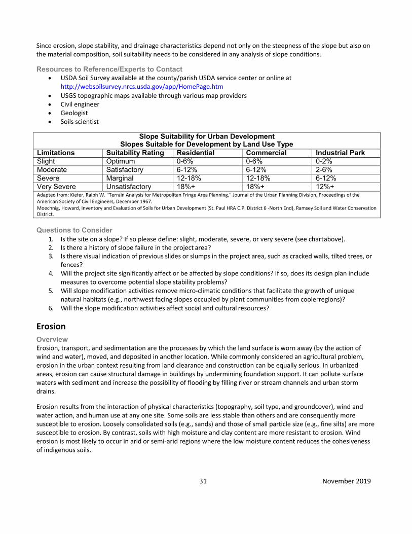
31 November 2019
Since erosion, slope stability, and drainage characteristics depend not only on the steepness of the slope but also on the material composition, soil suitability needs to be considered in any analysis of slope conditions.
Resources to Reference/Experts to Contact
• USDA Soil Survey available at the county/parish USDA service center or online at http://websoilsurvey.nrcs.usda.gov/app/HomePage.htm
• USGS topographic maps available through various map providers • Civil engineer • Geologist • Soils scientist
Slope Suitability for Urban Development
Slopes Suitable for Development by Land Use Type Limitations Suitability Rating Residential Commercial Industrial Park Slight Optimum 0-6% 0-6% 0-2% Moderate Satisfactory 6-12% 6-12% 2-6% Severe Marginal 12-18% 12-18% 6-12% Very Severe Unsatisfactory 18%+ 18%+ 12%+ Adapted from: Kiefer, Ralph W. "Terrain Analysis for Metropolitan Fringe Area Planning," Journal of the Urban Planning Division, Proceedings of the American Society of Civil Engineers, December 1967. Moechnig, Howard, Inventory and Evaluation of Soils for Urban Development (St. Paul HRA C.P. District 6 -North End), Ramsey Soil and Water Conservation District.
Questions to Consider
1. Is the site on a slope? If so please define: slight, moderate, severe, or very severe (see chart above). 2. Is there a history of slope failure in the project area? 3. Is there visual indication of previous slides or slumps in the project area, such as cracked walls, tilted trees, or
fences? 4. Will the project site significantly affect or be affected by slope conditions? If so, does its design plan include
measures to overcome potential slope stability problems? 5. Will slope modification activities remove micro-climatic conditions that facilitate the growth of unique
natural habitats (e.g., northwest facing slopes occupied by plant communities from coolerregions)? 6. Will the slope modification activities affect social and cultural resources?
Erosion Overview Erosion, transport, and sedimentation are the processes by which the land surface is worn away (by the action of wind and water), moved, and deposited in another location. While commonly considered an agricultural problem, erosion in the urban context resulting from land clearance and construction can be equally serious. In urbanized areas, erosion can cause structural damage in buildings by undermining foundation support. It can pollute surface waters with sediment and increase the possibility of flooding by filling river or stream channels and urban storm drains.
Erosion results from the interaction of physical characteristics (topography, soil type, and groundcover), wind and water action, and human use at any one site. Some soils are less stable than others and are consequently more susceptible to erosion. Loosely consolidated soils (e.g., sands) and those of small particle size (e.g., fine silts) are more susceptible to erosion. By contrast, soils with high moisture and clay content are more resistant to erosion. Wind erosion is most likely to occur in arid or semi-arid regions where the low moisture content reduces the cohesiveness of indigenous soils.

32 November 2019
A key factor in erosion is the land cover. Undisturbed vegetated areas are less susceptible to erosion than surfaces which have been exposed. Steep slopes (often defined as 123/4 +) increase the velocity of runoff, so erosion is more likely with greater slope.
Resources to Reference/ Experts to Contact
• USDA Soil Survey available at the county/parish USDA service center or online at http://websoilsurvey.nrcs.usda.gov/app/HomePage.htm
• City or county engineer • Soil conservationist—Soil conservation service county office • Landscape architect • Soils engineer—State or local highway department
Questions to Consider 1. Is there evidence of erosion or sedimentation? 2. If site clearance is required, explain if it includes removal or vegetation, its effects, and how erosion will be
managed and controlled. 3. Is an erosion control plan included as part of construction and the construction contract? 4. Will the project site significantly affect or be affected by erosion or sedimentation conditions? If so, does the
design plan include measures to overcome potential erosion problems?
Drainage/ StormWater Runoff Overview Stormwater management and its relationship to a proposed new development can be an essential determinant of whether a project is to be constructed. Stormwater is usually removed from an impermeable surface (e.g., pavement and buildings) by natural flow, storm sewers, or combined (storm and sanitary) sewers. It is discharged into a surface water body, a permeable recharge area, or temporary storage areas. In assessing impacts to stormwater service facilities, two factors must be considered: 1) the proximity of the system to the site and 2) the capacity of the system to accommodate the project.
Resources to Reference/ Experts to Contact
• USDA Soil Survey available at the county/parish USDA service center or online at http://websoilsurvey.nrcs.usda.gov/app/HomePage.htm
• USGS topographic maps available through various map providers. • Engineer—City/county public works or engineering department or local/district stormwater
management/disposal agency • Engineer/planner—HUD field office or local planning department • State and regional natural resource management agencies
Questions to Consider 1. Are there indications of cross-lot runoff, swales, or drainage flows on the property? 2. Are there visual indications of filled ground, active rills, or gullies on site? 3. Will existing or planned storm water disposal and treatment systems adequately service the proposed
development? Will the proposed project be adversely affected by proximity to thesefacilities? 4. If the public storm sewer is not available, how will storm water drainage be handled? 5. Is state/regional/local permitting required to control stormwater run-off, e.g., a National Pollution Discharge
Elimination System (NPDES) permit? If so, what conditions will be required by the permit? 6. Will the project itself cause or substantially contribute to off-site pollution by stormwater run-off, leaching of
chemicals, or other pollutants? 7. Will the project site significantly affect or be affected by drainage and stormwater conditions? If so, does its
design plan include measures to overcome potential runoff problems?
33 November 2019
Hazards and Nuisances/ Including Site Safety and Noise Overview This category is concerned with ensuring that a project is located and designed in a manner which reduces any potential risk to the public or project users from both natural and man-made risks to people or property damage. Accordingly, a number of possible hazards to health and safety have been identified below. Many of these hazards may be subject to municipal regulation. For example, standards for adequate light and air, building density, construction materials, structural integrity, maintenance, and cleanliness are contained in local zoning, building, and health codes. Their enforcement is often independent of environmental assessment procedures. The environmental assessment should particularly include those areas which are not covered by code requirements. Many can be corrected through proper siting, sound planning, and good project design.
Experts to Contact
• Seismologist • District officers of the Army Corps of Engineers or Federal Emergency Management Agency(FEMA) • Local fire departments
Questions to Consider 1. Will the project be affected by any of the following hazards?
• Natural hazards, including, but not limited to: Earthquakes - faults, fracture Volcanoes Landslides Fire-prone areas Droughts Floods Cliffs, bluffs, crevices Wind / sand storm concerns Hazardous terrain Poisonous plants, insects, animals
• Man-made site hazards, including, but not limited to: Recreational areas located next to freeway or other high traffic way Dangerous intersection Inadequate separation of pedestrian / vehicle traffic Hazardous cargo transportation routes Unfenced railroads or highways Unfenced water bodies Unfenced construction sites Shadows Inadequate street lighting Uncontrolled access to lakes and streams Improperly screened drains or catchment areas Quarries or other excavations Dumps/sanitary landfills or mining Reclaimed phosphate land (radioactive) Hazards in vacant lots Chemical tank-car terminals Other hazardous chemical storage High-pressure gas or liquid petroleum transmission lines on site Overhead transmission lines

34 November 2019
Oil or gas wells Industrial operations Gas, smoke, or fumes
• Air pollution generators, including but not limited to: Heavy industry Incinerators Power generating plants Rendering plants Fugitive dust Cement plants Large parking facilities (1000 or more cars) Heavy travelled highway (6 or more lanes) Oil refineries
2. Will the project be affected by any of the following nuisances? • Gas, smoke, fumes • Odors • Vibration • Glare from lighting from industrial or commercial uses or parking lots • Vacant / boarded-up buildings • Unsightly land uses • Front lawn parking • Abandoned vehicles • Vermin infestation
3. Is the project itself a noise-generating facility in a noise-sensitive area, such as a site in close proximity to schools and housing?
Energy Consumption Overview Energy is a scarce and valuable resource. It has become increasingly important to both design and to locate new facilities in a way which minimizes energy usage.
Maximizing opportunities for energy efficiency can be incorporated in nearly all phases of project planning, location selection, site planning, and building design. The location of new facilities in central areas with close proximity to mass transportation, employment, shops, schools and services can reduce energy consumed for transportation. The reuse of existing buildings can both cost less and save more energy than new construction. Site planning should take into account the role which trees and topography can play in sheltering a structure from climatic extremes (wind, heat, and cold). Southwardfacing sites receive maximum solar input, an important consideration in northern climates during the colder months. The final consideration is the incorporation of energy saving measures in building design, such as the usage of extra insulation, use of efficient heating, cooling, and hot water systems (possibly solar), use of double-glazed windows which open and close, and use of fluorescent rather than incandescent lights. Other measures include the reduction in the number of parking spaces provided to encourage carpooling and/or transitusage.
Experts to Contact It may be necessary to consult with an engineer, architect and/or energy auditor/rater to determine if the design fully exploits potential energy saving measures. Qualified energy efficiency consultants may include those certified under the Home Energy Rating System (HERS) training and certification program. Direct contact with utility companies is suggested to determine the availability of rebates and incentives. Local utility companies and, in some cases, public works staff can assist in determining adequacy of available power service to meet the need of the proposal.

35 November 2019
Questions to Consider 1. If the project entails residential new construction or substantial rehabilitation of single-family housing or
multi-family buildings up to three-stories, is the project being designed and constructed to meet the current version of the Energy Star performance standard?
2. Have the architectural plans and building orientation taken full advantage of potential energy saving measures related to climate, sun and wind? Will Energy Star appliances, lighting heating, cooling and hot water systems be installed? Does the project include programmable thermostats, occupancy sensors in common areas, water filters, insulated hot water pipes, and/or point-of-use/ tankless hot waterheaters?
3. Is the proposal being rated under LEED, Enterprise Green Communities, or other green standard or sustainability program?
4. Is the location of the project in close proximity to transit, shopping, services and employment locations? 5. Are state and federal rebates, tax incentives for energy efficiency strategies, and renewable energy
components being considered? 6. For multi-family projects, is there individual metering for utilities or a tenant energy efficiency education
program? 7. Is there an opportunity to enter into an energy performance contract? 8. What is the estimated energy consumption of the proposal, and are the energy resources of the utility
provider sufficient to support the proposal? 9. Are renewable energy strategies being implemented in this project? If this is a rural project, was onsite
energy generation considered (wind, fuel cell, or solar) in lieu of or in addition to a gridconnection? 10. What are the projected greenhouse gas (GHG) emissions of the project upon full occupancy? Are they
significant? 11. Does the estimated energy consumption of the proposal require a significant increase in energy production
for the energy provider?
Employment and Income Patterns Overview Employment-related impacts of a project can be grouped into three broad categories: temporary jobs created in construction, permanent jobs created and the job requirements of new residents.
Employment and income patterns can be measured by identifying the occupations and income levels characteristic of an area's resident population or by identifying major employers within the area. Some of the measures commonly used include resident income, resident occupational distribution, unemployment levels, and job types of major employers.
Experts to Contact
• Local industrial development authority • Economist at state employment service • Planner/administrator at local planning or employment agency • Chamber of Commerce
Questions to Consider 1. Will the project either significantly increase or decrease temporary and/or permanent employment
opportunities? 2. What is the profile of new jobs created by the project? What is the distribution across the skills and income
scale? How do these relate to the skills and income profile of project area residents? 3. Will the new jobs likely go to area residents, low-income, unemployed, and minority groupmembers? 4. If the jobs don’t go to area residents, where are the new employees likely to come from (i.e., inner city,
suburbs)?

36 November 2019
Demographic Character Changes Overview Community is a term which commonly refers to people living within a defined geographic area such as a neighborhood or a small town. Communities can be highly diverse or highly homogeneous places, they can be strictly residential or characterized by mixed land uses. HUD programs are primarily intended to benefit low- and moderate- income households with the objective of increasing housing opportunities for low-income/minority households.
Central to the definition of community is both the presence of a residential population and a sense of common bond and collective identity which defines the community as distinct from other neighborhoods or communities. Community is often a difficult term to define because it carries a physical, social, and a psychological dimension. The physical dimensions are the quality and type of housing units and commercial, public, and social services. The social dimensions include demographic characteristics such as the population size, density, age, ethnic and minority composition, household size and composition, and income and employment characteristics. Much of this data is found in the U.S. Census.
Another dimension of community is the residents' sense of community—their perceived relationship with their surroundings. It can be measured from resident attitudes, and the strength of organizational ties, both formal and informal. It should be observed, however, that change per se is not a negative or positive thing. In doing this assessment, it is important to be aware of the social networks and institutions which characterize a neighborhood. In many cities neighborhoods exist where residents have strong ties to the area, each other, local stores, and institutions. Often these are ethnic areas where residents share a common cultural and religious heritage. It is important that HUD activities not destroy the social networks and institutional ties in these areas.
Experts to Contact
• Neighborhood planner at local planning department • Director of local neighborhood organizations • Housing code compliance office/local health or building department • Local community action agencies • Local advocacy groups and/or organizations
Questions to Consider 1. What is/are the identifiable community(ies) within the sphere of likely impact of the proposed project?What
are the factors which contribute to the character of the community(ies)? 2. Does the proposed project contribute to reducing or significantly altering the racial, ethnic, or income
segregation of the area’s housing? 3. Will the proposed project result in physical barriers or difficult access which will isolate a particular
neighborhood or population group, making access to local services, facilities, and institutions or other parts of the city more difficult?
4. Does the proposed project at this site create a concentration of low income or disadvantaged people, in violation of HUD site and neighborhood standards and HUD Environmental Justice policies?
Displacement Overview Displacement refers to the dislocation of people, businesses, institutions, or community facilities as a result of a project. Direct displacement is involuntary displacement of a person who occupies property that is acquired, rehabilitated, or demolished for a HUD-funded activity, vacated to comply with HUDassisted code enforcement, or specifically identified in a grant application as the site of a leveraged activity. Only displacement as a result of acquisition by a public agency is covered by the Uniform Relocation Act. Indirect displacement is involuntary displacement caused by an activity or event that is not HUD-assisted but which is supported by concentrated HUD
37 November 2019
activities. For example, this would include displacement caused by rapidly increasing rents made possible by revitalization of an area in which HUD-funded rehabilitation or street improvements are taking place.
Experts to Contact
• Relocation specialist at local community development agency • Relocation specialist at HUD Field Office
Questions to Consider 1. Will the project directly displace individuals or families? How many persons? Is the displacement covered by
the Uniform Relocation Act and are funds available for payment? 2. Will the project destroy or relocate existing jobs, community facilities, or any business establishments? Is the
displacement covered by the Uniform Relocation Act, and are funds available for payments? 3. Are replacement facilities or housing units available within the community or in a nearby neighborhood?
What will be the effect of the relocation on these neighborhoods? 4. Will the project result in probable indirect displacement? If so, have measures been planned to alleviate the
hardship on those affected whose displacement is not covered under the Act?
Educational and Cultural Facilities Overview There are two fundamental considerations regarding a HUD activity's relationship to and/or impact on elementary, junior, and senior high schools: adequate capacity for children in the school(s) and safe access.
In order to accurately establish the extent to which these two criteria should apply, an initial calculation must be made detailing the projected increase in student population to be created by the proposed development. This calculation can be accomplished by contacting the developer or sponsor for mix of unit types (i.e., 1-bedroom, 2- bedroom dwellings), and contacting the school administrator or superintendent for an estimated average number of school-age children per unit type.
If the proposed project will overcrowd the schools consider such alternative options as:
• Building additions to existing schools • Locating classroom space in nearby buildings (i.e., community centers or other commercial facilities, possibly
owned by the developer) • Providing transportation to other schools Safe access takes into account the possible need for transportation
to school and attention to potential traffic hazards. Specific issues include: • Existence of all-weather walking paths and proximity to bus stop(s), schools, and crosswalks • Crossing guards (especially for elementary school children) • Clearly marked intersections near school or bus stop(s)
Experts to Contact • School superintendent • Developer or sponsor of proposed HUD project • Traffic department
Questions to Consider 1. What is the projected increase in student population to be created by the proposed development? 2. Will the additional school age children exceed the capacity of the existing or planned school facilities? If so,
what measures will be taken to resolve potential problems/conflicts? 3. Does the potentially affected school(s) have adequate and safe access facilities (i.e. walking paths, bus routes,
crosswalks and guards) given any calculations done for projected population increase? Are these adequate both in terms of safety and access?
4. Will additional or alternative facilities have to be provided to ensure safety and suitable access?

38 November 2019
Commercial Facilities Overview There are two key considerations in assessing commercial facilities. The first is an evaluation of the adequacy of existing commercial facilities to service the development. Are these facilities located conveniently to the proposed development? Are the available retail goods within the income capacity of the proposed project users or residents? Are there serious gaps in range of available goods and services?
The second analysis involves the impact which a proposed development will likely have on surrounding commercial establishments. For example, a new commercial development might displace existing small scale retail establishments which become uncompetitive when compared to new and larger enterprises.
There are generally three types of retail areas which are recognized by type and function. Any of these might be affected by the proposed project.
Neighborhood—consists of small businesses usually within 5-10 minutes travel time which include food, drug, cleaners, and convenience stores. The neighborhood shopping site is usually organized around a supermarket.
Community (or central business district)—contains multi-functional economic and service enterprises (banks, specialty stores, etc.) with access provided either by auto or public transit. In larger metropolitan areas, a food store is often not included.
Regional—may be either the central business district of a metropolitan area or may be a regional shopping center, usually with two or more department stores and various specialty stores.
Experts to Contact
• Local chamber of commerce • Commercial realtor • Commercial development specialist • Local planning agency
Questions to Consider 1. Do local retail services meet the needs of project occupants/users? Are they affordable, and is the range of
services adequate? 2. Is there adequate and convenient access to retail services? In the case of elderly, this means that shopping
for essential items as food and medicine is within three blocks and banks and other convenience shopping are within walking distance.
3. In areas not readily serviced by retail services, is public transportation that can carry commuters to retail services within one-half hour available? If public transportation is not available will readily available transportation services be provided?
4. Will existing retail and commercial services be adversely impacted or displaced by the proposed project?
Health Care Overview Relevant issues to be considered regarding a proposed project's impact on health care services are:
• Adequate access to hospitals, emergency facilities, clinics, and physician services • Potential effect of the proposed development on existing health care services' capacity and ability to
accommodate an increase in use • Adequate health services to accommodate the special needs of a potentially diverse population, i.e., families,
elderly, and handicapped.
39 November 2019
Health care services can be defined as those regular and emergency dental and medical care services provided for by private doctors, dentists, and other trained medical staff at a hospital, outpatient clinic, public, private or community health facility, home-care medical programs, or an emergency treatment facility (trauma unit, special cardiac pulmonary resuscitation [CPR] unit).
Experts to Contact
• Area health systems agency—can provide the area-wide health system plan which is an inventory of institutional health services and projected demand within the area.
• Local public health department—can provide information on local demand for, and quality ofhealthcare. • Council on aging—can provide information on size and location of the local elderly population. • Local Red Cross—can be valuable resource for medical needs of the area.
Questions to Consider 1. Will the increase in population from the proposed development increase the need for area healthcare
services beyond current capacities? 2. Are non-emergency health care services located within a reasonable proximity to the proposed project (less
than a half-hour drive or commute away)? 3. Are emergency health services available within approximately three to five minutes? Such services can often
be provided by police and fire personnel as well as by ambulance staff. 4. Is the number of doctors, dentist, nurses, and other trained medical staff realistic in proportion to an increase
in residents/users? If not, can provisions be made for additional skilled staff? 5. Will project residents/users require special medical services or skills such as geriatricclinics?
Social Services Overview Social services can be defined as those services provided by governmental social service agencies or public or private groups, including but not limited to programs for drug addiction, alcoholism, and mental disorders; halfway houses and drop-in centers, family counseling centers, day care centers; services for senior citizens and the handicapped; nutrition centers,Meals on Wheels; income maintenance, and manpower programs, etc.
Social services by definition must cater to, and be easily accessible to, those who need them. Therefore, access and adequacy are important considerations. Factors to consider regarding a proposed project's impact on an area's social services include:
• Availability and accessibility of day care, elderly centers, and neighborhood centers to accommodate existing and future residents.
• If appropriate social services centers are not located within a reasonable proximity to the proposed development, alternate space and services may need to be developedto accommodate new residents/users.
Experts to Contact
• Planner—local planning department • Administrator/planner—social services department • Administrator/planner—public welfare office • Administrator/planner—council on aging • Administrator/planner—Social Security Office • Administrator/planner—half-way house(s) in area • Administrator/planner—drop-in center(s) in area • Administrator—child care or daycare center • Administrator/planner—Local Council of Voluntary Human Service Agencies
Questions to Consider

40 November 2019
1. Are the social services located onsite or within a convenient and reasonable distance to residents of the proposed project? Or, is adequate public transportation available from the project to these services?
2. Will social services be overtaxed or negatively impacted by the proposed project? 3. Will the provision of additional social services at this site create a concentration of the disadvantaged in
violation of HUD site and neighborhood standards?
SolidWaste Disposal/Recycling Overview Solid waste disposal is regarded as an essential service in urban areas. Its availability for supporting a newly proposed development can be an essential determinant of whether a project can be constructed. Solid waste materials are generally transported by trucks to a common, usually remote site for either recycling, incineration (where allowed), or burial/disposal in a sanitary landfill.
For proposed demolition projects, the ability of the solid waste centers to contain the demolition material should be considered. In some cases the material from the demolition activity may overwhelm the existing solid waste capacity and the need to obtain additional solid waste capacity may justify the cost of rehabilitating the structure, particularly if the structure serves as an important historic or cultural resources.
For all projects, proper disposal of hazardous material should be considered. This may include solid porous materials, such as cement, that may have absorbed hazardous materials.
Experts to Contact
• Engineer—Local solid waste disposal agency, or city/county engineering department • Engineer/planner—HUD field office or local planning department • Engineer, planner/environmental specialist—Regional EPA office
Questions to Consider Construction Period
1. What types and amounts of waste are to be generated as construction debris? 2. What solid waste disposal system or company will handle the construction debris? Does it have the capacity
to handle the amount of debris? Solid Waste Disposal/Recycling
3. What types of solid waste (including hazardous waste, if any) will be generated by the completedproject? 4. What is the name of the solid waste servicing company or landfill and what is the distance from the proposed
project site? 5. Is solid waste permitting required for the project, and/or will the completed project require solid waste
permitting and when? 6. If hazardous waste, does the servicing company/landfill accept hazardous waste? If yes, attach
documentation. 7. What organization will handle garbage collection, composting, and recycling? 8. Does this organization have the capacity to handle the garbage, composting and recycling, and is the service
affordable? 9. Will the waste from the proposal exceed the capacity of the waste system or landfill?
Waste Water/Sanitary Sewers Overview Wastewater treatment and disposal is an essential service for all new development. The availability of adequate wastewater disposal service can be a determinant of whether or not a project is constructed. Wastewater is usually collected in urban areas through a system of sanitary sewers which convey the waste to a treatment facility located

41 November 2019
"downstream" from the city. After treatment the effluent is either recycled (rarely) or is discharged into surface water or a permeable recharge area for an underground aquifer. In less developed areas, on-site septic systems or package treatment plants are used. Generally, 80 gallons of sewage is generated per capita per day.
Resources to Reference/ Experts to Contact
• For areas where septic systems may be required the USDA Soil Survey available at the county/parish USDA service center or online at http://websoilsurvey.nrcs.usda.gov/app/HomePage.htm can be used to identify areas that are likely to be unsuited for septic systems.
• Engineer—local sanitary district/agency, city/county engineering department, 208 planning agency • Engineer/planner—local planning department • Soils scientist—U.S. Soil Conservation Service • Engineer—state health and/or environmental quality agency
Questions to Consider 1. What kind of wastewater/sewer system will provide satisfactory service to the proposal? 2. Does the existing or proposed sewer system have the capacity to adequately service the proposed
development? On-site septic systems
3. If the sanitary sewers and wastewater disposal systems are non-municipal, has an acceptable system been approved or permitted by appropriate authorities and agencies?
4. Has a report of the soil conditions suitable for on-site septic systems been submitted? 5. Are soil conditions suitable for on-site septic systems? Is there a large variance in the water table elevation?
(A high seasonal water table can prevent proper functioning of septic tanks drain fields). 6. Have septic disposal systems been properly designed, installed, and maintained, as appropriate, to prevent
effluent from contaminating soil or groundwater, including sole source aquifers?
Water Supply Overview Adequate water supply refers to the delivery to a project site of sufficient quantities of potable water under adequate pressure at affordable cost. Approximately 100 gallons per day is the average urban domestic per capita water consumption rate.
Experts to Contact
• Municipal or private utility water supply planners and engineers • Local public health agency staff
Questions to Consider 1. What private company or public organization or system will provide sufficient quantity of clean water needed
for the proposal? 2. Will either the municipal or private water utility or on-site water supply be adequate to serve the proposed
project? 3. Is the water supply quality safe from a chemical and bacteriological standpoint? 4. If the water supply is non-municipal, has an acceptable system been approved by appropriate authorities and
agencies? 5. Will the project water requirements of the proposal result in a significant consumption of the community’s
available water supply or result in a significant deterioration of water quality?

42 November 2019
Public Safety - Police, Fire and Emergency Medical Overview Fire, police, and ambulance services are concerns that should be considered in terms of the adequacy of existing services for the project site. Although many communities have sophisticated protective services, the consistency of adequate service is different from place to place. Within communities, one site may be better served than another.
Factors in the variability of protective services include the availability of funds for additional coverage and the degree to which building and growth are coordinated with provision of new municipal services. Key variables within each city are emergency equipment, emergency service personnel, response time, and access. These factors influence the availability and adequacy of emergency services that may be required at a proposed project.
Experts to Contact
• Chief of local fire department • Local chapter or national Office of the National Fire Protection Association (NFPA) • Chief of local police department • Administrator of local emergency medical agency such as the ambulance corps in the • Department of Health or the local rescue squad • Local medical society
Questions to Consider 1. What police services are located within reasonable proximity to the proposed project? What is the
approximate response time? 2. What fire fighting protection located within reasonable proximity to the proposed project? What is the
approximate response time? 3. Is the fire fighting protection service adequate and equipped to service the project? 4. What emergency health care providers are located within reasonable proximity to the proposed project?
What is the approximate response time? 5. Will the project create a significant burden on police, fire or health care providers in terms of manpower
and/or equipment?
Parks, Open Space and Recreation Overview The development of community services such as open space and recreational and cultural resources has become a necessary component of community development. These facilities can be operated by government, such as public parks and libraries, or they can be operated by private entities such as YMCAs and privately owned museums.
Recreation and open space resources include active recreation such as ballfields, passive recreation such as nature trails, and gardens. Cultural resources include art galleries, libraries, dance facilities, museums, theatres, community centers and other facilities for artistic and cultural purposes. These usually receive both public and private support.
Demand and supply for both specific recreation and cultural facilities is a function of factors which include the size of the community, density of development, income, and demography. Wealthier communities have these services and facilities more often than poorer communities. Communities with a large percentage of children have greater needs for active recreational facilities than communities with a large number of elderly or handicapped persons who may prefer passive recreation. High density communities with little private open space have a greater need for access to public parks and recreation areas than small towns with ample open spaces or suburban areas where the homes have large yards.
Experts to Contact
• Planner at local parks and recreation department • Administrator of social services agency
43 November 2019
• Administrator of local cultural commission
• Local American Society of Landscape Architects • State arts office or association • Administrators of agencies such as YMCAs, YWCAs, museums, libraries, etc. • State liaison officer • Heritage Conservation & Recreation Service • Department of Interior • National Park Service • Bureau of Land Management
Questions to Consider 1. Are open space and recreational and cultural facilities within reasonable walking distance to the project area,
or is adequate public transportation available from the project to these facilities? 2. Are there special recreational/cultural needs of certain population groups to be satisfied, such as small
children, the elderly, or the handicapped? 3. If the development is family housing, has space for informal play for children been included on-site? Have
areas for recreation for adults and elderly been provided including places for passive recreation? 4. Will the proposed project overload existing open space, recreational or cultural facilities?
Transportation and Accessibility Overview Assessing transportation impacts involves analyzing four sub-elements of transportation. These are:
• Access—The user must be able to reach a destination within reasonable limits of time, cost and convenience.
• Balance—A balanced transportation system offers and encourages choice of travel mode, namely, by automobile, bicycle, walking, public transit or combination thereof.
• Safety—System design plays a strong role in safety, particularly elements such as traffic signals, turning lanes, bicycle lanes and signage, and railroad grade crossings.
• Level of Service—LOS measures operational factors including speed, travel delay, freedom to maneuver, safety, and frequency/hours of operation.
Experts to Contact
• Planner at the regional transportation planning agency • Planner at regional transportation authority • Planner at the state highway department • Local transit authority • Local traffic department • Local parking authority • Federal Highway Administration Division Office in each state • Urban Mass Transportation Administration Regional Office
44 November 2019
Questions to Consider 1. Does the project require a traffic study? Has one already been performed? Are there any actions identified in
the study that need to be taken? 2. Is the project served by safe and adequate public transportation services? 3. Is the project safely accessible to vehicles and is vehicle parking adequate, including parking for moving
vans/trucks? 4. Does the project facilitate pedestrian movement (e.g., sidewalks, pavement markings, landscaping,
pedestrian-activated signal lights or pedestrian overpasses)? 5. Is the project area served by bicycle lanes or trails and does the project provide parking for bicycles, including
covered, secure parking for employees and residents? 6. Overall, will the existing and reasonably foreseeable transportation facilities and services be adequate to
meet the needs of the project? 7. Will the project itself cause a significant adverse impact on the local or regional transportation system (e.g.,
by reducing the level of service of roadways)? 8. Are there any barriers to emergency vehicle access? 9. Is the project accessible to the elderly and disabled (e.g., wheelchair ramps, traffic light timing, handicapped
parking, shuttle services)? 10. Are there special transportation issues (e.g., bridge clearances for trucks) which have not been adequately
addressed?
Unique Natural Features Overview Unique natural features are primarily geological features which are unique in the sense that their occurrence is infrequent or they are of special social/cultural, economic, educational, aesthetic, or scientific value. Development on or near them may render them inaccessible to investigators or visitors or otherwise limit potential future use and appreciation of these resources.
Examples of unique natural features include: sand dunes, waterfalls, unique rock outcroppings, caves with limestone or gypsum deposits, canyons, and petrified forests. Also included are unique stands of trees, such as redwoods, or unique colonies of animals, such as a prairie dog town.
The key criterion in defining a unique natural feature is the comparative rareness of the feature, a characteristic often recognized by local landmarks. Another characteristic is information content. Some unique natural features contain a great deal of information concerning natural history, such as geologic evolution.
Experts to Contact
• State and federal park service, naturalists and/or geologists • State natural heritage programs • State wildlife resource management agencies • Local university natural scientists, geologists, and Sierra Club or Audubon Society Representatives • State resource conservationist • Natural Resources Conservation Service (NRCS) - USDA • District conservationist, NRCS • County planner, county planning department or conservation district
45 November 2019
Questions to Consider 1. Will the project location, construction, or its users adversely impact unique or locally important natural
features on or near the site (e.g., caves, cliffs, vistas/viewsheds, canyons, waterfalls, sand dunes, or tree stands)?
2. Will the project destroy or isolate from public or scientific access the unique natural feature?
Water Resources Overview Water resources can be divided into two subcategories: ground water and surface water.
Groundwater refers to all of the water found below the ground's surface. While most groundwater comes directly from rainwater, some results from seepage from the sides and bottoms of lakes and streams. The water usually passes down through a layer of partially saturated material to a zone of saturation in which all of the pore spaces between the soil or rock particles are filled with water. The water table is the upper level at which this saturation occurs. The area in which the groundwater is stored is called an aquifer. Aquifers vary widely in size and depth, some cover hundreds of miles and are used extensively for drinking water and irrigation, such as the Ogallala Aquifer in the Great Plains. The supply of groundwater depends upon a balance between the amount of water entering the ground and the amount being withdrawn. Urban land development reduces recharge to aquifers by precipitation. Excessive pumping can cause wells to run dry, increased concentration of dissolved minerals, salt water intrusion if near the ocean, and land subsidence. The depth of the water table can vary tremendously from year to year and seasonally depending on the amount of rainfall. High water tables can result in basement flooding and surface puddles. Discharge from poorly designed, installed, or maintained septic systems to drinking water wells can cause health hazards.
Some areas have experienced ground subsidence due to the pumping of ground water and the dewatering of the underground strata including aquifers. In Gulf Coast communities such as New Orleans excessive pumping has lowered the ground level and has made the area more prone to coastal flooding.
In many types of surficial geological formations, groundwater quantity and quality is related to the quality and presence of surface waters. Excessive well pumping can induce infiltration from streams and ponds, causing surface water levels to drop. If these surface waters are polluted, groundwater quality will be degraded. Often, groundwater flows discharge to streams. Polluted groundwater can thus degrade the quality of otherwise unaffected surface waters.
Surface water plays an important role in nearly every community, as a source of drinking water, as a means of transportation, as a recreational resource, as a source of water for irrigation, and as a fishery.
Surface waters can range from very large rivers and lakes to small ponds and streams. Urban development can, however, have a serious negative impact on water quality. Surface waters, chiefly rivers and large lakes, frequently suffer from the effects of pollution generated by factories, urban sewerage systems, power plants, and agricultural runoff. Degraded surface water quality can have short-term and long-term human health implications, affect aquatic habitats and species, and have aesthetic and olfactory consequences.
While most water quality problems are due to effluents from sewerage treatment plants, sewer system overflows, and industrial waste outfalls, new commercial and residential developments can also have an adverse effect on surface water quality. The chief source of such pollution is from urban runoff, chiefly from impervious surfaces such as streets, parking lots, and sidewalks from which oil and gasoline are carried by rain into surface water. Landscaped areas treated with insecticides and fertilizer can also introduce polluted runoff into surface water. Also, failing septic
46 November 2019
systems and other sources of polluted groundwater (landfills and waste disposal areas) can seep untreated sewage and other wastes to surface waters.
Experts to Contact
• Planner and/or engineer—“Section 208” area-wide planning agency • Water Quality Scientist – “Section 401” water quality agency • Hydrologist—USGS Geological Survey or State Geological Survey • Soil scientist—U.S. Soil Conservation Service • State wildlife resource management agency • State natural heritage program • Engineer—city and/or county engineering department
Questions to Consider 1. Is the site subject to rapid water withdrawal problems that change the depth or character of the water table
or aquifer? Are there a large number of wells or wells that pump large quantities of water from the water table near the proposed project site?
2. Will the project use groundwater for its water supply? If so, is the groundwater safe for use for the intended purposes?
3. Will the project use a septic system? If so, is the system in proximity to sensitive natural receptors (e.g., wetlands) that could be adversely impacted by the design or location? Is there a large variance in the water table? (A high seasonal water table can prevent proper functioning of septic tank drain fields.)
4. Are there visual or other indications of water quality problems on or near the site (e.g., algae blooms or state listing as an impaired stream/waterway)? Will the riparian buffer (i.e., natural wooded buffer adjacent to a stream) be maintained in a conservation easement or, conversely, diminished, damaged or destroyed?
5. Will the project involve a substantial increase in impervious surface area? Have runoff control measures and/or permeable surfaces been included in the design?
6. Will the project substantially reduce groundwater recharge due to increase in impervious surface area? If so, are sensitive groundwater dependent features (e.g., rare wetlands) present that could be affect? If yes, have appropriate measure been included in the design to promote groundwater recharge.
7. Is the project located in a state or locally designated sensitive watershed area? If so, have appropriate run-off control measures been included in the design (e.g., the storm-year design is increased from 10-years to 25- years, buffers are placed along surface waters, etc.)
8. Is the project located in the watershed of a particularly sensitive natural area (e.g., a unique wetland). If so, have additional run-off control measures been included in the design (e.g., the storm-year design is increased from 10-years to 50-years, buffers are placed along surface waters, etc.)
Vegetation Overview The abundance and survival of both plant and animal species is dependent upon the existence of a favorable environment and their ability to adjust to conditions created by man. Urbanization has seriously altered natural ecosystems. In and near heavily urbanized areas, much of the native plant and animal species have been destroyed and have been replaced by species which are more successful in the urban environment, to the extent that it is often inappropriate to talk of native species in urban environments.
The impact of man on the environment through urbanization often results in water, air, and land pollution endangering many natural plant and animal species. Development which changes a sensitive ecosystem may adversely affect the diversity of species present, the productivity of the system, or the rate of nutrient recycling.

47 November 2019
Experts to Contact It is often best to consult an expert such as a biologist/ecologist from either a university or a state natural resources agency, or state natural heritage program. In more rural areas representatives of the state forestry department or the USDA Soil Conservation Service may also provide useful expert judgment.
Questions to Consider
• Will the project create problems by introducing nuisance or non-indigenous species of vegetation that may be ecologically disruptive, be invasive, threaten survival of indigenous plant habitats, or disrupt agricultural or silvicultural activities
• Will the project damage or destroy existing remnant or endemic plant communities, especially those containing nationally, regionally or locally rare species (e.g., prairie grasslands, ice-age disjuncts, local soil- type endemics, etc.)?
• Will the project damage or destroy plant species that are legally protected by state or local ordinances? • Will the project damage or destroy trees without replacement and landscaping?
Wildlife Overview An animal's habitat is the environment in which it normally lives and the one which meets its basic need for food, water, cover, breeding space, and group territory. Urbanization has generally been at odds with the maintenance of natural habitats. Urban habitats are often found in neglected and unused areas such as along riverbanks and railroad alignments, in parks, institutional grounds, and in vacant tracts of land. The protection of wildlife habitats can be at odds with urban development. However, certain actions can be taken to avoid undue disruption and to protect species, particularly those of concern to local, state, tribal of the federal government. Please note that species listed as proposed, threatened or endangered by the federal government must be considered under the Endangered Species Act. However, compliance with certain federal statutes should be considered under this factor, including, for example, the Migratory Bird Treaty Act and the Bald Eagle Protection Act.
Experts to Contact Technical studies can be supplemented with field observation of the site for signs of the likely presence of particular species. Consultation with biologists/ecologists with either local, tribal, state or Federal agencies may be helpful. The Fish &Wildlife Service of the Department of Interior can also be contacted for information.
Questions to Consider The questions on animal life encompass the five following topics: disruption, habitat alteration or removal, rare species (including those that are considered threatened or endangered), pest species, and game species.
• Will the project create special hazards for animal life? What types and numbers of animals will be affected and how?
• Will the project impact migratory birds? (Most birds protected by the federal Migratory Bird Treaty Act are not included in the Endangered Species Act, yet are protected by similar protections against a “taking” of bird nest or eggs. Consultation with the U.S. Fish and Wildlife Service may be required. Construction activities should occur outside the migratory bird nesting season; alternatively, the site should be surveyed for migratory bird nest prior to construction.)
• Does the project site host any species that are monitored or listed by local, state, tribal or the federal government?
• Will the project damage or destroy existing wildlife habitats (e.g., removal or blockage of wildlife corridors, such as a riparian buffer?)
• Will excessive grading alter the groundwater level and thus cause death of trees and ground cover which in turn diminishes animal habitat?

48 November 2019
• Will the project damage game fish habitat or spawning grounds? When answering this question off-site damage resulting from erosion and stormwater run-off should be considered.
• Will the project create conditions favorable to the proliferation of pest species? • Will the project create conditions (e.g., generate excessive noise, introduce pesticide usage) that could harm
or harass wildlife species that are nationally, regionally or locally rare or protected by state or local ordinance.

49 November 2019