Embed Size (px)
Citation preview

Muaitheabhal Wind Farm Repower
Environmental Impact Assessment
Scoping Report
Prepared by LUC
April 2018

Project Title: Muaitheabhal Wind Farm Repower
Client: Lewis Wind Power
Version Date Version Details Prepared by Checked by Approved by
V1 March 2018 First Draft
Template
J. Ormiston J. Cottin K. Wigley
A4 Portrait Report Last saved: 23/04/2018 12:29
Muaitheabhal Wind Farm Repower
Environmental Impact Assessment
Scoping Report
Prepared by LUC
April 2018
Planning & EIA Design Landscape Planning Landscape Management Ecology GIS & Visualisation
LUC GLASGOW 37 Otago Street Glasgow G12 8JJ T +44 (0)141 334 9595 [email protected]
Offices also in: Bristol Edinburgh Lancaster London Manchester
FS 566056 EMS 566057
Land Use Consultants Ltd Registered in England Registered number: 2549296 Registered Office: 43 Chalton Street London NW1 1JD
LUC uses 100% recycled paper
Muaitheabhal Wind Farm Repower
Environmental Impact Assessment Scoping Report
1 April 2018
Contents
1 Introduction 3 Project Background 3 Application for Section 36 Consent 3 Document Structure 4
2 The Environmental Impact Assessment 6 The Environmental Impact Assessment Process 6
3 Project and Site Description 9 The Site and Surrounding Area 9 Project Description 9 Key questions for Consultees 11
4 Planning and Legislative Context 12 Legislative Background 12 National Planning Policy 12 Local Planning Policy 13 Key questions for Consultees 14
5 Landscape and Visual Effects 15 Introduction 15 Design Considerations 17 Proposed Surveys and Assessment Methodology 17 Approach to Mitigation 19 Consultation Proposals 19 Key Questions for Consultees 20
6 Hydrology and Peat 21 Introduction 21 Existing Conditions 21 Design Considerations 22 Proposed Surveys and Assessment Methodologies 22 Approach to Mitigation 24 Consultation Proposals 24 Key Questions for Consultees 25
7 Ecology 26 Introduction 26 Existing Conditions 26 Proposed Surveys and Assessment Methodologies 27 Potential Effects on Ecology 28 Approach to Mitigation 28 Consultation Proposals 29 Key Questions for Consultees 29
8 Ornithology 30 Introduction 30 Existing Conditions 30 Proposed Surveys and Assessment Methodologies 31
Muaitheabhal Wind Farm Repower
Environmental Impact Assessment Scoping Report
2 April 2018
Potential Ornithological Effects 33 Cumulative Assessment 33 Approach to Mitigation 33 Consultation Proposals 34
9 Noise 35 Introduction 35 Existing Conditions 35 Design Considerations 35 Proposed Surveys and Assessment Methodologies 35 Potential Noise and Vibration Effects 37 Approach to Mitigation 37 Consultation Proposals 38
10 Cultural Heritage 39 Introduction 39 Existing Conditions 39 Proposed Surveys and Assessment Methodologies 40 Potential Effects on Archaeology and Cultural Heritage 41 Approach to Mitigation 41 Consultation Proposals 42
11 Traffic and Transport 43 Introduction 43 Existing Conditions 43 Proposed Surveys and Assessment Methodologies 43 Potential Effects on Traffic and Transport 44 Approach to Mitigation 44 Consultation Proposals 45
12 Socio-Economics, Tourism and Recreation 46 Introduction 46 Existing Conditions 46 Proposed Surveys and Assessment Methodologies 47 Study Areas 47 Potential Effects 48 Approach to Mitigation 48 Consultation Proposals 49
13 Other Issues 50 Carbon Balance 50 Aviation and Telecommunications 50 Shadow Flicker 50 New Topics 51 Consultation Proposals 51
Appendix 1: List of Consultees
Appendix 2: Proposed Outline Content of the Environmental Impact Assessment Report
Appendix 3: Questions for Consultees
Muaitheabhal Wind Farm Repower
Environmental Impact Assessment Scoping Report
3 April 2018
1 Introduction
Project Background
1.1 Lewis Wind Power (LWP) (a joint venture between EDF Energy Renewables and Wood Group) is
proposing to develop Muaitheabhal Wind Farm Repower (hereinafter referred to as ‘the proposed
development’) on the Eisgein (Eishken) Estate in the south-east of the Isle of Lewis. The
proposed development is located on the site of the three consented Muaitheabhal Wind Farms
(hereinafter referred to as ‘the consented developments’) which was acquired by LWP (via lease)
in September 2016. The location of the site is illustrated on Figure 1.1.
1.2 The consented developments comprise 45 turbines and associated infrastructure under three
separate consents granted by the Scottish Government under Section 36 of the Electricity Act
1989:
In January 2010 the Scottish Government consented the 33 turbine Muaitheabhal Wind Farm
(tip height 145 m).
A six turbine ‘East’ extension to the 33 turbine scheme was consented by the Scottish
Government in December 2011 (tip height 150 m).
A further application for a ‘South’ extension, comprising six turbines was consented in
September 2015 (tip height 150 m; with one turbine limited to 130 m).
1.3 In combination the three Section 36 Consents (each with accompanying Deemed Planning
Permission), comprise 45 turbines, of varying tip heights, and with a maximum megawatt output
of 162 MW. The layout of the consented developments is illustrated on Figure 1.2.
1.4 In 2015 a two year extension to the period within which the development must commence under
Condition 2 of the S36 Consents was secured, for the Muaitheabhal Wind Farm and East
Extension, which expired on the 28th December 2017. The Section 36 Consent for the South
Extension is due to expire on the 8th September 2020.
1.5 In addition to the three wind farm consents, there is consent for a dedicated berthing facility for
the direct delivery of wind turbine components on the north shore of Loch Sealg. The berthing
facility was subject to a planning application submitted to Comhairle nan Eilean Siar (CnES)
(Western Isles Council) and Marine Scotland and was consented in 2012. The planning permission
was renewed in August 2015 but is due to expire in August 2018.
Application for Section 36 Consent
1.6 Following a review of both technical and economic considerations of the consented developments,
including the wind yield at the site, LWP considers that there is a need to ensure the consented
developments maintain and enhance their available capacity and maximise the opportunity to
contribute to current renewable energy targets. LWP intends to maximise the potential for these
consents through a ‘repower’1 of the consented developments which will require rationalisation
and redesign of the proposed development and submission of an application to the Scottish
Government for a new Section 36 Consent. As the principle of a wind farm on the site is already
considered acceptable in this regard, the previous consents are considered to be a material
consideration to the new application.
1.7 The proposed development is for 20 turbines with a maximum blade tip height of 200 m. An
indicative turbine layout is shown in Figure 1.3. Initial feasibility work has been undertaken that
1 The term repowering is defined in the Scottish Government Onshore Wind Policy Statement (January 2017) as taking many forms,
“…but is simply an application for a new onshore wind development on a site where onshore wind represents the established land use
or forms part of the planning history of the site”.

Muaitheabhal Wind Farm Repower
Environmental Impact Assessment Scoping Report
4 April 2018
has informed the scoping layout, informed primarily by the potential landscape and visual effects
of the scheme and the known ornithological interest on the site as detailed further below. The
layout will be subject to modification as the design of the site progresses, further environmental
considerations are identified, and taking account of responses from stakeholders. The approach
to design will seek to rationalise the design of the consented developments taking account of the
increased turbine heights and will seek to align the design with current best practice, e.g. by
avoiding or reducing previously reported effects whilst maximising electricity output.
1.8 As the proposed development will have a generating capacity of greater than 50 MW, LWP will
submit an application for consent to the Scottish Government’s Energy and Consents Unit (ECU)
under Section 36 of the Electricity Act 1989. In addition, a direction will be sought for deemed
planning permission under section 57 of the Town and Country Planning (Scotland) Act 1997, as
amended. It is acknowledged that the proposed development should be subject to an
Environmental Impact Assessment (EIA) under the Electricity Works (Environmental Impact
Assessment) (Scotland) Regulations 2017 (‘the EIA Regulations’), and the application for Section
36 consent will be accompanied by an EIA Report.
1.9 There are currently two options being considered for delivery of wind turbine components and
other elements to site:
via sea to a berthing facility to be developed close to the properties at Eisgein (Eishken) as
noted above; and
via the existing minor public road (which would require upgrading) between the A859 south of
Balallan and Eisgein.
1.10 The proposals for the consented berthing facility will be reviewed to ensure that it is capable of
handling larger blades associated with the candidate wind turbine for the proposed development.
This will be assessed in the EIA and an application for a licence will be made to Scottish Ministers
via the Marine Scotland Licensing Operations Team (MS-LOT) under the Marine (Scotland) Act
2010 in tandem with the application for consent for the proposed development under Section 36
of the Electricity Act 1989.
1.11 The EIA Regulations provide for obtaining a Scoping Opinion from Scottish Ministers as to the
environmental effects to be considered in the EIA (Regulation 8(1)). This document forms LWP’s
written request to the Scottish Government for a ‘Scoping Opinion’ as to which environmental
effects are to be considered in the EIA. It provides details of the proposed development, the site
and surrounding area, and the environmental survey work undertaken to date. Likely significant
effects as a result of the proposed wind farm are identified and the proposed approach to
assessing these is outlined.
1.12 Whilst not a statutory requirement for Section 36 applications, provision of a Design and Access
Statement is regarded as good practice, given that such documents are required to support major
planning applications for wind farms between 20 and 50 MW. A Design and Access Statement will
therefore be prepared, within which the design evolution from the consented to the revised
scheme will be presented in a coherent and transparent to clearly explain the comparative change
between the schemes.
Document Structure
1.13 The remainder of this report is structured as follows:
Chapter 2 provides information on the EIA process;
Chapter 3 provides a brief description of the nature and purpose of the proposed
development;
Chapter 4 describes the policy and legislation relevant to the proposed development;
Chapters 5-13 outline the topic areas to be considered in the EIA.
1.14 Appendix 1 details the consultees that will be approached by the Scottish Government Energy
Consents Unit (ECU) to inform the scope of the EIA, as well as those that will be approached for

Muaitheabhal Wind Farm Repower
Environmental Impact Assessment Scoping Report
5 April 2018
information to inform the EIA. Appendix 2 provides an outline of the proposed content of the EIA
Report.
1.15 The Scoping Report is submitted to confirm the approach to the EIA and a number of specific
questions are embedded within the Scoping Report to seek to inform consultee responses. These
are collated in Appendix 3.
Question 1.1:
Confirmation is sought that the proposed approach to the application for the berthing facility is appropriate.
Muaitheabhal Wind Farm Repower
Environmental Impact Assessment Scoping Report
6 April 2018
2 The Environmental Impact Assessment
The Environmental Impact Assessment Process
2.1 EIA is the process of systematically compiling, evaluating and presenting all the likely significant
environmental effects, both positive and negative, of a proposed development, to assist the
determining authority in considering the application. It enables the significance of these effects,
and the scope for reducing negative, or enhancing positive, effects to be clearly understood. The
information compiled during the EIA is presented within an EIA Report to accompany the
application for consent. Early detection of potentially adverse environmental effects informs
iterations to the design of the proposed development to avoid or reduce effects.
2.2 EIA is an iterative process and runs in tandem with project design. As potential effects are
identified, the design of the proposed development will be adjusted to reduce or avoid adverse
effects where possible, and mitigation measures will be proposed as appropriate.
2.3 The EIA will be conducted in accordance with current Scottish Government regulations, policy and
guidance, including:
The Electricity Works (Environmental Impact Assessment) (Scotland) Regulations 2017;
Scottish Government Web Based Guidance on wind turbines (updated in May 2014);
Scottish Planning Policy (SPP) (June 2014);
Planning Advice Note (PAN) 3/2010 Community Engagement (2010);
Planning Circular 3 2013 Development Management Procedures;
Scottish Natural Heritage (SNH) (2013) (4th Edition), A Handbook on Environmental Impact
Assessment;
Institute of Environmental Management and Assessment (2004) Guidelines for Environmental
Impact Assessment; and
PAN 1/2013 Environmental Impact Assessment (updated June 2017).
Scoping
2.4 The purpose of scoping is to focus the EIA on the likely significant environmental effects of
relevance to the proposed development. Therefore, on the basis of the work undertaken to date,
the professional judgement of the assessment team, experience from other similar projects, as
well as policy, guidance and standards of relevance, each topic-based section within this report
outlines both:
Potentially significant effects associated with the construction and/or operation of the
proposed development, identified for detailed consideration within the EIA Report.
Effects considered unlikely to be significant and requiring no further assessment. These topics
will fall outside of the scope of assessment, but will be referred to in turn within the EIA
Report.
2.5 Additional objectives of the Scoping Report are:
to establish the availability of baseline environmental data and its source;
to define a survey and assessment framework from which a comprehensive overall
assessment can be produced;
to invite consultees to identify any concerns that they might have in relation to the proposed
development;
to comment on the proposed methodology;

Muaitheabhal Wind Farm Repower
Environmental Impact Assessment Scoping Report
7 April 2018
to provide and receive information relevant to the proposed development; and
to consider the way in which the findings are presented in the EIA Report.
2.6 A list of consultees is provided as Appendix 1.
2.7 Prior to the submission of the Scoping Report, a pre-scoping meeting was held between LWP, LUC
and key consultees including the ECU, SNH, SEPA and HES to inform the proposed scope of the
EIA.
Baseline Conditions
2.8 The EIA Regulations require that the aspects of the environment, which are likely to be
significantly affected by the proposed development, be defined within the EIA Report. To achieve
this, it is necessary to gather environmental information on each of the topics proposed for
consideration as part of the EIA, i.e. ‘baseline conditions’.
2.9 Whilst a considerable amount of data is already held for the site given the work that was
undertaken for the consented developments, it will be necessary for further baseline surveys to
be undertaken to ensure that the data upon which the EIA is based is up to date. This will be
informed by the existing data, details of which are included below.
2.10 For the purposes of the assessment, the baseline will be considered to be the existing site which
is currently undeveloped. Information will also be provided which will compare the consented
developments with the proposed development, but this will not form part of the EIA and it is
proposed that this is included with the Planning Statement that will accompany the EIA Report.
Assessment of Effects
2.11 The assessment of potential effects, using a range of appropriate methodologies, will take into
account the construction and operation of the proposed development in relation to the site and its
environs.
2.12 An assessment will be made of the likely significant cumulative effects of the proposed
development in combination with other wind farms including:
schemes which have been submitted to the relevant authorities but not yet determined;
schemes which are consented;
schemes which are under construction or operational.
2.13 The scope and methodology for the cumulative assessment will be agreed with the relevant
statutory consultees.
2.14 Study areas will be defined separately for each topic assessed in the EIA to reflect the likely
extent of potential effects.
Mitigation and Monitoring
2.15 Part 7 of Schedule 4 of the EIA Regulations notes that the EIA Report should include “A
description of the measures envisaged to avoid, prevent, reduce or, if possible, offset any
identified significant adverse effects on the environment and, where appropriate, of any proposed
monitoring arrangements (for example the preparation of a post-project analysis). That
description should explain the extent, to which significant adverse effects on the environment are
avoided, prevented, reduced or offset, and should cover both the construction and operational
phases”. These measures will be termed mitigation measures and will be included for each topic
area, where appropriate.
2.16 The EIA will identify and assess potentially significant effects prior to mitigation, and, where
mitigation measures are proposed, their likely effectiveness will be examined and the significance
of the ‘residual’ effect then assessed. LWP will be committed to implementing all the mitigation
measures identified in the EIA Report.
2.17 Given accepted good practice during the construction and operation of schemes such as this, and
the current regulatory context, a number of measures are not considered ‘mitigation’ as such but
rather an integral part of the design/construction process, and will be taken into account prior to
Muaitheabhal Wind Farm Repower
Environmental Impact Assessment Scoping Report
8 April 2018
assessing the likely impacts of the proposed development. Further tailored mitigation measures
will then be proposed prior to determining the likely significance of residual effects.
2.18 On the assumption that a number of good practice measures will be assumed to be in place, it
may be appropriate to scope out the potential for a number of potential effects on this basis. This
will be detailed in the relevant chapters of the EIA Report as appropriate.
2.19 Where appropriate, the mitigation measures implemented will be monitored for effectiveness.
Where monitoring is proposed, this will be “whether monitoring measures are proportionate to the
nature, location and size of the proposed development and the significance of its effects on the
environment having regard in particular to the type of parameters to be monitored and the
duration of the monitoring” as detailed in Part 7 (22) (2) (a) of the EIA Regulations.
Uncertainty
2.20 The EIA process is designed to enable good decision-making based on the best possible
information about the environmental effects of a proposed development. There will, however,
always be some uncertainty as to the exact scale and nature of the effects. These may arise
through shortcomings in available information or due to the limitations of the professional
judgement process. As required in Schedule 4, Part 6 of the EIA Regulations, it is important that
such uncertainty is explicitly recognised and that the EIA Report includes “A description of the
forecasting methods or evidence, used to identify and assess the significant effects on the
environment, including details of difficulties (for example technical deficiencies or lack of
knowledge) encountered compiling the required information and the main uncertainties involved”.
Muaitheabhal Wind Farm Repower
Environmental Impact Assessment Scoping Report
9 April 2018
3 Project and Site Description
The Site and Surrounding Area
3.1 The site is located in the Outer Hebrides, in the south-east of Lewis, in the north of the Park
(Pairc) peninsula. The peninsula is defined by two long and narrow sea lochs, Loch Erisort
(Eireasort) to the north, and Loch Seaforth (Shiophoirt) to the south, the latter forming part of
the boundary between Lewis and Harris.
3.2 The site occupies the northern part of the Eisgein (Eishken) Estate and covers a total area of
approximately 17 km2. The site is approximately 20 km south west of Stornoway.
3.3 An estate track passes through the site from the A859 in the north-west, to Eisgein (Eishken), in
the south-east, where Eishken Lodge and associated buildings sit by the shores of Loch Sealg
(Shell). Eishken Lodge is available to hire and is used as luxury sporting accommodation. The
nearest settlements are to the north and east of the site, where the Park (Pairc) peninsula adjoins
the rest of the island: Arivruach (Airidh a Bhruaich) and Balallan (Baile Ailein) on the A859 road,
as well as small crofting townships along the B8060 road to the north and east (between Habost
and Orinsay). There are also a series of smaller lochs within the site including: Loch Shromois,
Loch Airgigh Thormoid, Clar Loch, Loch nam Breac, Loch Braigh an Fhorsa, Loch Fath, and Loch
Raoineabhat. A number of rivers and streams cross the site and feed into the various lochs. The
site location and context are illustrated on Figures 1.1 and 1.2.
Project Description
Wind Turbines and Associated Infrastructure
3.4 The main elements of the proposed development comprise:
20 turbines up to 200 m to blade tip;
turbine foundations including associated transformer plinths and enclosures (if required to be
housed externally);
an electrical substation;
a battery storage system;
a site access point;
power cables linking the turbines, laid in underground trenches;
access tracks to turbines and other infrastructure which are likely to be a mixture of graded
stone and floating tracks;
borrow pits for sourcing local materials for tracks and hardstandings;
steel tower anemometer masts for wind turbine performance monitoring; and
temporary site construction compounds and associated infrastructure.
Grid Connection
3.5 As noted above, the proposed wind turbines would be connected to the onsite substation by
underground cabling between each turbine. Each of these cables would meet at the substation
compound which would comprise an area of hardstanding on which a single storey building would
be sited. The building would house switchgear, metering, protection and control equipment as
well as welfare facilities. The substation would then be connected to the national grid
transmission system.
Muaitheabhal Wind Farm Repower
Environmental Impact Assessment Scoping Report
10 April 2018
3.6 The grid connection is subject to a separate consenting regime and is the responsibility of the
electricity grid network operator, Scottish and Southern Energy Networks (SSEN). Information on
the route of the grid connection will be set out in the EIA Report but this will not form part of the
assessment or be included in the application for consent.
Battery Storage
3.7 A battery storage facility is proposed on the site. The facility would be able to both import and
export power to the network as required, providing a ‘security buffer’ to cope with supply and
demand events. The battery storage facility would provide back-up power to National Grid for the
benefit of providing stability to the electricity supply network and the integration of more
renewable energy generation.
3.8 The battery storage facility will be located adjacent to the substation compound. The batteries
would be housed in structures very similar to shipping containers. These would be arranged in
tandem i.e. two containers on a combined plinth with a shared transformer unit and coolers. A
separating wall between the pair of containers is the highest elevated point at 3.8 m.
Access
3.9 The proposed site access and delivery route for construction traffic is anticipated to be from the
A859 south of Balallan and Eisgein. This may also be used for the delivery of turbine components
however consideration is being given to use of the berthing facility as detailed below. A network
of new and upgraded tracks for construction and maintenance of the proposed development once
operational will also be required.
The Berthing Facility
3.10 In addition to the consented developments, there is consent for a dedicated berthing facility for
the direct delivery of wind turbine components on the north shore of Loch Sealg. The berthing
facility was subject to a planning application submitted to CnES and Marine Scotland and was
consented in 2012. The berthing station was not subject to EIA but will be included as part of the
EIA for the proposed development.
3.11 The consented berthing facility comprises:
A slipway ramp and conventional slipway which would enable landing craft and barges to
unload (including a crane for lifting the turbines ashore). These could be used also during
construction by boats bringing construction workers and some HGV traffic for the proposed
development and could be retained to service maintenance activities.
An ‘A’ frame fender berthing facility against which vessels delivering the turbines would berth.
A crane hardstanding from where the crane would unload the turbines from the delivery
vessels; a heavy storage and blade storage area.
An access track to the closest part of the site.
3.12 If included in the EIA and Section 36 application for the proposed development, the berthing
facility proposal and design will be reviewed to ensure that it is capable of handling larger blades
associated with the candidate wind turbine for the proposed development and further consultation
will be undertaken to ensure that any required surveys are undertaken at the appropriate time.
Borrow Pits
3.13 Where possible, the stone required for the tracks, turbine bases and hardstandings will be
predominantly sourced from onsite borrow pits. This approach will minimise transportation
movements of stone to the site. However, depending on the quality of stone found, it may be
necessary to import stone into the site for use as a capping material for the access tracks and
hardstandings. The transport implications of this will be assessed fully in the EIA Report.
3.14 The location, design and reinstatement of borrow pits will be considered as part of the design/EIA
process. The borrow pits will be reinstated after use, using the excess overburden and excavated
material from the track building process where possible.
Muaitheabhal Wind Farm Repower
Environmental Impact Assessment Scoping Report
11 April 2018
Vehicle Movements
3.15 The predicted number and type of vehicle movements will be assessed as part of the EIA process
once the turbine and infrastructure layout is finalised. A Traffic Management Plan (TMP) will be
agreed in consultation with the CnES roads department.
Construction Details
3.1 It is expected that the construction of the proposed development will be completed over a period
of up to 24 months and will consist of the following principal activities:
construction of the temporary construction compound;
extraction of stone from the borrow pits for track and turbine base construction;
construction of the berthing facility (if included as part of the proposals);
construction of site access tracks, passing places and any watercourse crossings;
construction of culverts under tracks to facilitate drainage and maintain existing hydrology;
construction of turbine foundations and transformer plinths;
construction of an onsite substation and battery storage facility infrastructure;
excavation of trenches and cable laying adjacent to site tracks;
movement onto site and erection of wind turbines and installation of battery systems;
commissioning of the site; and
restoration of borrow pits and temporary construction compounds.
3.2 Many of these operations will be carried out concurrently, although predominantly in the order
identified. This will reduce the overall length of the construction programme. In addition,
development will be phased such that, at different parts of the site, the civil engineering works
will be continuing whilst wind turbines are being erected. Site restoration will be programmed and
carried out to allow restoration of disturbed areas progressively and as early as possible.
Operational Maintenance
3.3 Maintenance work will involve visiting the site regularly to undertake scheduled maintenance and
operational checks. Annual servicing will involve the undertaking of non-essential repairs on
blades, gearboxes and generators.
Decommissioning
3.4 The proposed development would have an operational life of 25 years. At the end of this period, it
will be decommissioned and the turbines removed. Alternatively, a new application may be made
to extend the life of the proposed development or replace the turbines.
3.5 The EIA Report will include high level information on the likely process that will be undertaken to
decommission the proposed development at the end of its lifespan. However, it is not proposed
to undertake a detailed assessment of the decommissioning effects associated with the proposed
development as the future baseline conditions (environmental and other developments) cannot be
predicted accurately at this stage and the proposals for refurbishment/decommissioning are not
known at this stage.
Key questions for Consultees
3.6 The following question relates to the proposed approach to consideration of the planning and
legislative context.
Question 3.1:
Confirmation is sought that the proposed approach to decommissioning is considered appropriate.

Muaitheabhal Wind Farm Repower
Environmental Impact Assessment Scoping Report
12 April 2018
4 Planning and Legislative Context
Legislative Background
4.1 As the generating capacity of the proposed development will be greater than 50 MW, an
application for consent will be sought under Section 36 of the Electricity Act, including deemed
planning permission under Section 57 of the Town and Country Planning (Scotland) Act 1997 (as
amended).
4.2 The EIA Regulations are accompanied by Schedules which outline thresholds for determining EIA
requirements based upon the likelihood of ‘significant environmental effects’ occurring. Schedule
1 of the EIA Regulations lists types of development for which EIA is mandatory. Schedule 2
highlights types of development for which the need for EIA is judged by the Scottish Ministers on
a case-by-case basis in the context of the Schedule 3 Screening Criteria.
4.3 The proposed development is a Schedule 2 development as it is “a generating station” of a type
not listed in Schedule 1. It is therefore acknowledged that an EIA will be required to accompany
the application for consent, giving due regards to the criteria in Schedule 3 in relation to the
characteristics, location, and potential effects of the proposed development.
National Planning Policy
National Planning Framework 3
4.4 National Planning Framework 3 (‘NPF3’) serves as the long term planning strategy for Scotland
and captures a spatial expression of the Government’s economic strategy, and plans for
development and investment in infrastructure. Planning decisions are expected to support delivery
of the aims and objectives of NPF3.
4.5 The key themes of the vision are to ensure, through development, that Scotland is a successful,
sustainable place, a leader in low carbon energy generation, a natural and resilient place and a
connected place. NPF3 recognises that to ensure that Scotland is a sustainable place and a leader
in low carbon energy generation, renewable energy will continue to make a significant
contribution to the diversification of energy supplies.
4.6 NPF3 is a material consideration when determining applications and, as such, will be a
consideration in determining the application for the proposed development.
Scottish Planning Policy
4.7 Scottish Planning Policy (SPP) was published in 2014 and sets out national planning policies which
reflect the strategic priorities for operation of the planning system and for the proposed
development and use of land, whilst being cognisant of the flexibility required to reflect local
circumstances. SPP directly relates to the preparation of development plans, the design of
development and the determination of planning applications and appeals.
4.8 SPP recognises that considerations relating to the determination of planning applications will be
relative to the scale and characteristics of the proposal and area, including for instance the net
economic impacts (positive/negative) of the proposal.
4.9 SPP also recognises the need to maintain and enhance existing capacity. This is particularly
important where the principle of a wind farm is considered acceptable.

Muaitheabhal Wind Farm Repower
Environmental Impact Assessment Scoping Report
13 April 2018
Planning Advice Notes and Specific Advice Sheets
4.10 Planning Advice Notes (PANs) and Specific Advice Sheets set out detailed advice from the Scottish
Government in relation to a number of planning issues. Relevant PANs and Specific Advice Sheets
are likely to include the following:
PAN 1/2013 Environmental Impact Assessment (as amended);
PAN 60 Planning for Natural Heritage;
PAN 68 Design Statements;
PAN 75 Planning for Transport;
PAN 79 Water and Drainage;
PAN 3/10 Community Engagement;
PAN 1/2011 Planning and Noise;
PAN 2/2011 Planning and Archaeology; and
Specific Advice Sheet: Onshore Wind Turbines.
National Energy Policy
4.11 The Scottish Government have published three energy policy documents:
The Climate Change Plan (2018);
The Scottish Energy Strategy ‘The Future of Energy in Scotland’ (2017); and
The Onshore Wind Policy Statement (2017).
4.12 Together, these three policy documents represent the Government’s intended energy and climate
change strategy for the period to 2050.
Local Planning Policy
Outer Hebrides Local Development Plan
4.13 Whilst consent will be sought under Section 36 of the Electricity Act, deemed planning consent is
also sought through section 57 of the Town and Country Planning (Scotland) Act as amended. It
is now well established that in the case of an electricity licence application, under Section 36 of
the Electricity Act 1989, deemed planning permission is ‘directed’ and therefore not considered to
be ‘determined’ and in this respect, proposals cannot be determined under the Local Development
Plan (LDP). It is recognised however, that the LDP plays an important role in ensuring that
environmental commitments are upheld at a regional level. Whilst the LDP will form a key
material consideration, this will not hold primacy in the determination under Section 36. The
relevant development plan for the site is the Outer Hebrides LDP which was adopted in November
2012.
4.14 Policy 19: Energy Resources is the main renewable energy and states that the council will support
“…proposals that contribute to meeting the targets and objectives of the National Planning
Framework 2, the Climate Change Act, and the National Renewables Infrastructure Plan in relation
to electricity grid reinforcement, infrastructure and renewable energy generation”.
4.15 The policy sets out the criteria against which wind turbine applications will be assessed and also
highlights that the council will prepare a spatial framework for onshore wind farms (see below).
Emerging Outer Hebrides Local Development Plan 2
4.16 CnES is in the final stages of preparing the new LDP, known as the Outer Hebrides Local
Development Plan 2 (LDP2). LDP2 was published for consultation in January 2017 and then
submitted to the Scottish Ministers for Examination in July 2017. It is understood that it is nearing
the end of the Examination process, and is intended to be complete by June 2018 and will
therefore be in place when the application for consent for the proposed development is made.
Muaitheabhal Wind Farm Repower
Environmental Impact Assessment Scoping Report
14 April 2018
Policy EI 8: Energy and Heat Resources states “Development proposals for all scales of onshore
wind energy development will be assessed against the Supplementary Guidance for Wind Energy
Development.”
Outer Hebrides Supplementary Guidance
4.17 The spatial framework was published in 2016 as ‘Outer Hebrides Local Development Plan
Supplementary Guidance for Wind Energy Development’. As indicated within the Supplementary
guidance Map 1- Comhairle Spatial Strategy for Wind Farms, and Map 2- SPP Spatial Framework
and Other Considerations, the site is located within an area of constraint with potential for wind
farms in some certain circumstances, within an SPP Group 2 area with carbon rich soils classes 1
and 2. It is noted that the existing consents for the site predate the publishing of the current
spatial framework. It should also be noted that Map 2 shows the site as a ‘consented
development’ under ‘other constraints’.
Key questions for Consultees
4.18 The following question relates to the proposed approach to consideration of the planning and
legislative context.
Question 4.1:
Confirmation is sought that the identified planning and legislative context is appropriate and to identify any further considerations likely to be material to the proposed development.

Muaitheabhal Wind Farm Repower
Environmental Impact Assessment Scoping Report
15 April 2018
5 Landscape and Visual Effects
Introduction
5.1 The Landscape and Visual Impact Assessment (LVIA) will consider direct and indirect effects on
landscape resources, landscape character, designated landscapes and wild land. It will examine
the nature and extent of effects on existing views and visual amenity. The effects of the
proposed turbines, as well as the ancillary infrastructure (access track, masts, transformers etc.)
will be assessed during construction and operation of the proposed development. The LVIA will
also consider cumulative effects i.e. the incremental effects of the proposed development in
combination with other wind farm developments.
5.2 The LVIA will inform modifications and refinements to the layout design and will be undertaken
following the approach set out in Guidelines for Landscape and Visual Impact Assessment: Third
Edition (Landscape Institute and Institute of Environmental Management and Assessment, 2013).
The assessment will also draw upon current good practice guidance issued by SNH and the
Landscape Institute.
The Study Area and Site
5.3 The site forms part of a remote moorland landscape which extends to Loch Sgiobacleit and the
inner reaches of Loch Seaforth in the north, and to Loch Sealg in the south, and contains a
network of smaller lochs within the site boundary. A number of rivers and streams cross the site
and feed into the various lochs. The site covers a series of small rugged peaks, including
Feiriosbhal (326 m) and Beinn Mheadhanach (288 m) in the west, and Cleite Catriona (139 m)
and Creag na Beirghe (236 m) in the south.
5.4 A study area of 45 km from the outermost turbines in all directions is proposed for the LVIA as
recommended in current guidance for turbines over 150 m to blade tip2.
Zone of Theoretical Visibility (ZTV)
5.5 Theoretical inter-visibility with the proposed development (ZTV coverage) will be described and
used as a means of identifying which landscape and visual receptors require assessment, and
which can be scoped out because they are unlikely to be affected by the proposed development.
The following figures are provided to illustrate the theoretical visibility of the proposed
development:
Figure 5.1 Comparative Blade Tip Height ZTV for Consented Muaitheabhal Turbines and
proposed Muaitheabhal Wind Farm Repower Turbines3;
Figure 5.2 Maximum Blade Tip Height 200 m ZTV and Suggested Viewpoint Locations; and
Figure 5.3 Maximum Hub Height (112.5 m) ZTV and Suggested Viewpoint Locations.
Landscape Baseline
Landscape Character
5.6 The LCTs within up to 45 km of the proposed development will be described in the LVIA. Those
with theoretical inter-visibility with the proposed development (ZTV coverage) will be assessed
where it is identified that significant effects could occur.
5.7 The site lies predominantly within the Rocky Moorland Landscape Character Type (LCT) in the
east, and Mountain Massif (One) LCT to the west, as defined by the Western Isles Landscape
2 SNH (2014) Visual Representation of Windfarms. Version 2.
3 This is provided for context only. A comparison of effects between the consented developments and the proposed development will
not form part of the EIA, but will be included with the Planning Statement that will accompany the application and the EIA Report.
Muaitheabhal Wind Farm Repower
Environmental Impact Assessment Scoping Report
16 April 2018
Character Assessment4 and shown on Figure 5.4. A small area to the south-east includes part of
the Crofting Three LCT and corresponds to the Eisgein (Eishken) estate.
5.8 Further information regarding the landscape character of the area is set out in the Landscape
Capacity Study for Onshore Wind Energy Development in the Western Isles (2004) published by
SNH. This study assesses the capacity of the landscape of the Western Isles to accommodate
wind farm development at a strategic scale. Whilst based on the published LCA, in some instances
it further sub-divides the landscape character types identified in the Western Isles LCA (1998)
into sub-types. None of the LCTs listed above have been sub-divided within the report. The
report will form a further source of information with regards to landscape character, sensitivity
and capacity.
5.9 The character of the Hebridean coastline and seascape will also be considered within the LVIA,
due to the proximity of the proposed development to Loch Sealg, on the east coast of Lewis, and
the potential for coastal elements of infrastructure (i.e. the berthing facility). The SNH report ‘An
assessment of the sensitivity and capacity of the Scottish seascape in relation to windfarms’5
examines character at a national scale, North East Lewis (Area 12) and The Little Minch (Area 14)
being nearest to the proposed development. Furthermore, an SNH commissioned pilot study,
‘Landscape/seascape capacity for aquaculture: Outer Hebrides’, describes in more detail part of
the coastline, within the Lewis and Harris: Lochs Seaforth, Claidh & Bhrolluim Pilot Study Area.
Designated Landscapes
5.10 Nationally designated landscapes within the study area are listed in Table 5.1 and shown on
Figure 5.5; there are no locally designated landscapes. As with LCTs, the theoretical inter-
visibility with the proposed development will be described in the LVIA, and used as a means of
identifying which designated areas require further assessment.
Table 5.1 Designated Landscapes within the Study Area
Name Designation Approximate Distance from the Proposed Development
South Lewis, Harris and North Uist NSA National Scenic Area 1.5 km south of site boundary
Trotternish NSA National Scenic Area 40 km south of site boundary (located on the Isle of Skye)
Wild Land
5.11 Wild Land Areas are not statutory designations, but NPF3 recognises wild land as a “nationally
important asset” (NPF3, p.42), while SPP notes that development plans “should identify and
safeguard the character of areas of wild land as identified on the 2014 SNH map of wild land
areas” (SPP, p.47) and lists areas of wild land as Group 2: Areas of Significant Protection (SPP,
Table 1, p.39).
5.12 Wild Land Areas (WLA) within the study area are listed in Table 5.2 and shown on Figure 5.5.
As shown in Figure 5.5, the south-west boundary of the site is directly adjacent to the Eisgein
Wild Land Area. An assessment of effects on both the Eisgein and Harris – Uig Hills Wild Land
Areas will be undertaken as part of the LVIA, in accordance with published guidance.6
Table 5.2 Wild Land Areas within the Study Area
Wild Land Area Approximate Distance from the Proposed Development
Eisgein (31) WLA Directly adjacent to site
Harris – Uig Hills (30) WLA 1.2 km from access/8 km from closest turbine
4 Richards, J (1998) Western Isles Landscape Character Assessment. SNH Review No. 92.
5 Scott, K.E., Anderson, C., Dunsford, H., Benson, J.F. and MacFarlane, R. (2005). An assessment of the sensitivity and capacity of the
Scottish seascape in relation to offshore windfarms. SNH Commissioned Report No.103. 6 SNH (2007, with notes added October 2014) Assessing the impacts on wild land – interim guidance note.

Muaitheabhal Wind Farm Repower
Environmental Impact Assessment Scoping Report
17 April 2018
Design Considerations
5.13 Landscape and visual considerations, including the appearance of the proposed development from
key viewpoint locations, will play a major role in design of the proposed development. The
findings and feedback received on the consented developments, the baseline study, and initial
field survey will identify potential sources of landscape and visual effects, which will inform an
iterative design process. The design will be continually reconsidered as it develops, to prevent and
reduce potential landscape and visual effects. A clear set of objectives will be established based
on best practice guidance, including the SNH publication, Siting and Designing Wind Farms in the
Landscape7.
Proposed Surveys and Assessment Methodology
Landscape and Visual Impact Assessment (LVIA) Methodology
Landscape Effects
5.8 Predicted changes on both the physical landscape of the site and landscape character within the
45 km study area will be identified. Effects will be considered in terms of the magnitude and type
of change to the landscape, including its key characteristics as set out in published landscape
character assessments. The sensitivity of the landscape will also be taken into account,
acknowledging value placed on the landscape through designation.
Visual Effects
5.14 Visual effects are experienced by people at different locations around the study area, at static
locations (for example settlements or viewpoints) and transitional locations (such as sequential
views from routes, including roads, foot paths and ferry routes). Visual receptors are the people
who will be affected by changes in views at these places, and they are usually grouped by what
they are doing at those places (for example residents, motorists, recreational users etc.).
5.15 GLVIA38 states that the nature of visual receptors, commonly referred to as their sensitivity,
should be assessed in terms of the susceptibility of the receptor to change in views/visual
amenity and the value attached to particular views. The nature of the effect should be assessed
in terms of the size and scale, geographical extent, duration and reversibility of the effect. These
aspects will all be considered, to form a judgement regarding the overall significance of effect.
5.16 Assessment of the visual effects of the proposed development will be based on analysis of the
ZTVs, field studies and assessment of representative viewpoints. Figure 5.2 shows a turbine
blade tip height (200 m) ZTV of the current turbine layout with proposed assessment viewpoint
locations. Figure 5.3 shows the hub height (112.5 m) ZTV. The assessment viewpoint locations
have been selected to provide a representative range of viewing distances and viewing
experiences, including views from settlements, points of interest and sequential views from
routes. A list of proposed viewpoints for the assessment is set out in Table 5.3 below. With the
exception of the viewpoints indicated with a ‘*’ all viewpoints were used for assessment of the
consented developments.
Table 5.3 Proposed Assessment Viewpoints
VP Viewpoint Name Grid Reference Distance9 Reasons for Selection
1 Beinn Mhòr 125426 909554 3.8 km High point on edge of NSA and within WLA.
2 A859 near Liurbost
135528 927362 13.1 km Sequential views from main road route south from Stornoway, representative of views from scattered settlement.
3 Uisinis 133706 906757 5 km High point on edge of NSA and within WLA.
7 SNH (2017) Siting and Designing Wind Farms in the Landscape, Version 3a
8 Guidelines for Landscape and Visual Impact Assessment – Third Edition (GLVIA3) (2013) Landscape Institute & Institute of
Environmental Management & Assessment. 9 Distance measured to the nearest turbine.

Muaitheabhal Wind Farm Repower
Environmental Impact Assessment Scoping Report
18 April 2018
VP Viewpoint Name Grid Reference Distance9 Reasons for Selection
4 Leumrabhagh 138076 911889 4.8 km One of the nearest settlements to wind farm site.
5 Elevated section of the B8060
137337 913237 4 km Road route to settlements north of Loch Sealg.
6 Liuthaid 117625 913566 11.5 km Location in the large WLA west of the A859.
7 Todun 121039 903070 11.3 km Hill summit within NSA.
8 Baile Ailein 128005 920508 6.7 km Settlement on A859, with direct views to wind farm site.
9 An Cliseam 115465 907280 14 km Hill summit within NSA.
10 Scalpaigh Heritage Trail
124379 895275 16.5 km Accessible area within NSA with views north.
11 Luirbost 137776 925719 12.4 km Settlement within hub height ZTV.
12 Acha Mòr 131407 929314 14.6 km Well used road & settlement in hub height ZTV with views towards Harris hills.
13 Calanais Standing Stones
121312 933011 20.8 km Popular visitor location with views to the Harris hills.
14* Harris Ferry 124278 885877 25.7 km Ferry route to Harris, within ZTV.
15* A859 near Cleit Ard
119517 909565 9.5 km View from roadside layby within NSA offering elevated views across Loch Seaforth.
16* Ravenspoint Visitor Centre, Kershader
134134 920313 6 km OS marked visitor centre and memorial, local settlement, B8060 route.
17* Laxay (Lacasaigh) parking + cemetery
134251 922123 7.7 km OS marked car park, large cemetery, offering
'gateway' view of the sleeping beauty10
.
18 Eye Peninsula 149186 931458 23.8 km Representative of views from settlement on the Eye Peninsula across intervening seascape.
19* Airidh a Bruach - Bonnie Prince Charlie Monument
125088 917655 6.5 km Nearest larger settlement to wind farm with direct open views to site. View of the sleeping beauty profile of hills clearly visible.
20 Taobh a’ Ghlinne 137780 915754 5 km Views south-west to site representative of views from settlement and school.
5.17 The assessment will be focused on daytime visibility; however consideration will also be given to
dusk/night time views from a select number of the representative viewpoints, in the event that
visible lighting is required in the interest of aviation safety due to their height. At this stage,
consideration will be given to the provision of night time visualisations from the following
locations:
A859 near Liurbost / junction with A858;
Leumrabhagh;
Settlements/roads within NSA (subject to visibility of final design)
Settlements along the A859 and north of site (e.g. Airidh a Bhruaich, Baile Ailein, etc.); and
Calanais Standing Stones.
Cumulative LVIA (CLVIA) Methodology
5.18 The cumulative landscape and visual assessment (CLVIA) will be carried out in accordance with
the principles contained in SNH’s Assessing the Cumulative Impact of Onshore Wind Energy
Developments (March 2012).
10
Hill range in the form of a woman lying on her back when viewed from a number of locations, including Calanais Standing Stones.
Locally this hill range is known as the ‘Sleeping Beauty’ (or ‘Cailleach na Mointeach’ which translates as ‘The Old Woman of the Moors’).
Muaitheabhal Wind Farm Repower
Environmental Impact Assessment Scoping Report
19 April 2018
5.19 A review of patterns of development will be provided for operational, consented and proposed
wind farms which are the subject of a valid planning application, up to 60 km from the site,
following SNH guidance.
5.20 The CLVIA will focus on wind energy developments considered to have potential to give rise to
significant cumulative effects. This is likely to be those wind farms within 45 km of the site but
will be subject to more detailed consideration. Turbines under 50 m to tip and single turbines
beyond 5 km from the site will not be included. Figure 5.6 illustrates the locations of operational,
consented and proposed wind farms within 45 km of the site.
5.21 The LVIA will consider the potential effects of the addition of the proposed development to the
existing landscape, against a baseline that includes existing wind farms and those under
construction. The CLVIA will consider the potential additional effects of the proposed
development, against a baseline that includes wind farms that may or may not be present in the
landscape in the future (i.e. including wind farms that are consented but unbuilt, or undetermined
planning applications). Consideration will also be given to 'total' cumulative effects (assessment
which considers all current and future proposals, including the proposed development). Wind farm
proposals that have been refused but that are going to appeal will also be considered in the
assessment. Schemes at scoping stage will not be included in the cumulative assessment unless
specifically requested by statutory consultees.
Residential Visual Amenity
5.22 There are no properties located within a 2km radius of the turbines of the consented
developments (outside those under ownership of the Eisgein estate), as such no assessment of
effects on residential visual amenity will be undertaken.
Visualisations
5.23 Wireframes and photomontages will be used to consider and illustrate changes to views.
Photomontages will involve overlaying computer-generated perspectives of the proposed
development over the photographs of the existing situation to illustrate how the views will change
against the current baseline. Other (cumulative) wind farms visible from each of the viewpoints
will be shown on the wireframes. Visualisations will be prepared in accordance with SNH (2017)
visualisation guidance11.
5.24 Ancillary elements such as permanent anemometer masts, access tracks and the on-site
substation will be shown in photomontages for viewpoints within 5 km when they would be
visible. Beyond 5 km it is considered unlikely that these ancillary elements would form more than
a minor element of the entire development when compared to the turbines.
Approach to Mitigation
5.25 The primary form of mitigation for landscape and visual effects is through iterative design of the
layout of the turbines and infrastructure, as seen from key viewpoints. Design development will
be set out in detail in the design strategy that will form part of the EIA Report.
Consultation Proposals
5.26 It is proposed to consult the following stakeholders in relation to the LVIA assessment:
CnES; and
SNH.
5.27 It is proposed that pre-application design workshops to inform the approach to the design of the
proposed development will be held during the EIA process, and LWP will invite the input of
statutory consultees to input to the design process.
11
Visual Representation of Wind Farms Guidance – Version 2.2 (February 2017) SNH

Muaitheabhal Wind Farm Repower
Environmental Impact Assessment Scoping Report
20 April 2018
Key Questions for Consultees
5.28 The following questions relate to the proposed approach and methodologies to the LVIA and
CLVIA.
Question 5.1:
Are there any comments on the overall methodology proposed to assess effects on landscape and visual receptors, or to assess cumulative effects?
Question 5.2:
Are there any comments on the proposed list of assessment viewpoint locations, including the proposed locations for night time visualisations?
Question 5.3:
Are there any further wind farm sites, to those shown on Figure 5.6, to consider as part of the cumulative
assessment?
Question 5.4:
Has the consultee identified any further landscape or visual receptors to be considered within the assessment (i.e. where it is expected that significant effects may occur)?
Question 5.5:
Are there any other relevant consultees who should be consulted with respect to the LVIA?
Muaitheabhal Wind Farm Repower
Environmental Impact Assessment Scoping Report
21 April 2018
6 Hydrology and Peat
Introduction
6.1 This chapter sets out the proposed approach to the assessment of potential effects of the
proposed development on geology, hydrology, hydrogeology and peat during construction and
operation of the proposed development.
Existing Conditions
6.2 The topography of the site is generally hilly and rocky in the west with a maximum altitude of
328 m AOD, and flatter and wetter in the east with numerous watercourses, lochs and small
water bodies, reaching sea level to the south, approximately 10 m AOD to the north, and 50 m
AOD in the east. The western section of the site comprises the Feirisbhal ridge line (328 m AOD)
running approximately north to south, and in the southern section of the site the Creaig na
Beirigh (236 m AOD) / Druim Airigh Ruairidh ridge line runs approximately west to east.
6.3 There are a number of water bodies within the site and surface water runoff is generally towards
the east and south-east into the Abhain Cheothaidail in the southern section of the site. The
Abhain Cheothaidail discharges to Loch Feoir then Loch Eisglein which discharges to become River
Eiskhin before discharging to the sea loch, Loch Sealg. The northern north eastern section of the
site runoff flows into Abahin Ghlas and Loch Sgliobacleit. Loch Sgliobacleit discharges to the
Abhain Shìphiort before discharging to the sea Loch Shìphiort to the north east. The extreme
southern section of the site drains south to Loch Sealg. The whole site falls within the catchment
of The Lewis and Harris Coastal Waters and several of the lochs on site and in the vicinity of the
site are used for fishing.
6.4 The SEPA flood risk mapping shows the rivers, lochs and sea lochs all have localised flood risk
areas within and downgradient of the site. No properties are shown to be at risk of flooding.
6.5 The Abhain Cheothaidail is classified as high quality status and Loch Sgliobacleit and its main
tributaries are classified as being of good quality status under SEPA’s River Basin Management
Plan (RBMP). Loch Sealg sea loch and coastal waters to the east and Loch Shìphiort to the
northwest are classified as good status under the SEPA RBMP.
6.6 No public water supply sources within the site boundary were identified when the consented
developments were assessed however this will be confirmed through consultation with Scottish
Water. It is understood that the water supply for Eisgein Lodge and the surrounding properties is
sourced from a spring above the lodge, on the side of the hill Sidhean nan Caorach. The water
supply to the estate property at Shiphoirt Head is sourced on the hillside north of the house,
above the existing road. This will be reconfirmed through consultation.
6.7 The geology mapping shows no superficial deposits across the majority of the site with an
exception of a localised area of peat superficial deposit in the south-western section of the site.
However, survey work undertaken for the consented developments indicate a greater coverage of
the site with peat deposits. Furthermore, the SNH Carbon and Peatland 2016 map indicates that
the majority of the site is Class 2 peatland12 with pockets of Class 113 peatland located to the east
and south of the site.
6.8 Broadly speaking, the site can be divided into three regions: the north-south aligned Feiriosbhal
ridge; adjacent lowlands to the east running to the Eisgein Estate road; and the east-west aligned
12
Nationally important carbon-rich soils, deep peat and priority peatland habitat; areas likely to be of high conservation value. 13
Nationally important carbon-rich soils, deep peat and priority peatland habitat; areas of potentially high conservation value and
restoration potential.

Muaitheabhal Wind Farm Repower
Environmental Impact Assessment Scoping Report
22 April 2018
Airigh Ruairidh ridge which is bounded to the south by Loch Sealg and to the north by the
Cheothadail valley. Peat lies in pockets between rock outcrops and is generally thinner (0.0-2.0
m) on the Feiriosbhal ridge than in the more continuous areas of low lying peat to the east where
previous surveys indicate it may be up to 4 m deep. Peat depths on the Airigh Ruairidh ridge vary
considerably but may also be 4-5 m locally. Previous assessments indicate a small debris slide
below Creag na Beirighe but otherwise no peat instability features within the site boundary.
Figure 6.1 illustrates the peat depths across the site based on the information that was obtained
for the consented developments.
6.9 Information on the presence of Ground Water Dependent Terrestrial Ecosystems (GWDTEs) is not
present for the majority of the site as potential effects on these receptors was not required to be
considered at the time of the EIA for the original 33 turbine Muaitheabhal Wind Farm. However,
GWDTEs were found to be present on the site of the East Extension and the South Extension and
therefore are likely to be present across the site.
Design Considerations
6.10 Where possible, the proposed development will be designed to avoid sensitive water features and
sensitive habitats including GWDTEs. Watercourse crossings will be kept to a minimum. The
primary design considerations with respect to peat will be to minimise the overlap between
infrastructure and the deepest areas of peat on site, avoid the areas identified as most susceptible
to peat instability, and minimise disruption to natural drainage pathways.
Proposed Surveys and Assessment Methodologies
Study Area
6.11 The study area will primarily comprise the site for potential effects on peat and the catchment
areas downstream of the site where applicable for potential effects on hydrology.
Desk and Field Survey Method
6.12 The scope of works relating to the assessment of effects on geology, hydrology, hydrogeology and
peat, informed by work undertaken as part of the EIAs for the consented developments, will
include:
The existing data obtained for the consented developments will be verified through reviewing
information on geology, water features, designated sites, fisheries, flooding, climate and issue
of private water supply questionnaires to nearby properties.
Peat survey data from previous site specific probing will be supplemented with additional
probing in accordance with ‘Peat Surveys - Guidance on Developments on Peatland’ (Scottish
Government, SNH & SEPA, 2017). The 100 m grid recommended in the guidance may be
optimised in areas of rock outcrop to better represent ponded rather than continuous peat,
and to take account of the peat depth data already held which covers a considerable area of
the site as illustrated on Figure 6.1. A sub-sample of probe locations will be cored and logged
on site to provide information on the composition of the peat/soil column. Other pertinent
information will be collected at each probe location to inform general understanding of the site
and related assessments.
Following design iteration a hydrological survey will be completed to examine the exact
locations of all proposed infrastructure and the access tracks routes with respect to water
features and water crossings. Further peat probing will be undertaken to ensure that all
infrastructure locations and routes have sufficient peat depth information to support related
studies on peat instability and peat excavation and re-use.
Muaitheabhal Wind Farm Repower
Environmental Impact Assessment Scoping Report
23 April 2018
Assessment Method
6.13 Based on the information obtained from the review of existing data and the site surveys an
assessment of the potential effects of the proposed development will be undertaken. Where
potential significant effects are identified mitigation measures will be proposed.
6.14 The EIA Report will include a detailed water features map along with a photographic inventory of
all watercourse crossings.
6.15 An assessment of Ground Water Dependent Terrestrial Ecosystems (GWDTE) will be undertaken
based on the NVC mapping undertaken by the ecologist. If significant areas of moderate or high
GWDTE are located in proximity to proposed site infrastructure additional studies would be
undertaken to define whether these are truly groundwater dependent, refine their extent,
conceptualise the hydrogeology and assess if there are any potential effects to them. Where
possible, the design will be modified to minimise potential effects on these features.
6.16 Lewis has been subject to at least three naturally occurring peat failures in the past and the
relevance (or otherwise) of these will be considered when assessing the proposed development.
A peat landslide hazard and risk assessment (PLHRA) will be undertaken in accordance with the
Scottish Government Peat Landslide Hazard & Risk Assessments: Best Practice Guide for Proposed
Electricity Generation Developments (Scottish Government, 2017). The PLHRA will be informed by
the peat depth model, site walkover and detailed geomorphological mapping and terrain
classification. The assessment will utilise both qualitative and quantitative analyses and consider
the likelihood of peat instability, the consequences should it occur and mitigation measures
appropriate to calculated risk levels.
6.17 A peat management plan (PMP) will be prepared in accordance with ‘Guidance on the Assessment
of Peat Volumes, Reuse of Excavated Peat and the Minimisation of Waste’ (Scottish Renewables,
SEPA, 2012). The PMP will be informed by peat depth probing described above and by a full site
appraisal of potential re-use opportunities (e.g. mapping of drainage ditches, informal and
industrial peat turbary14, landscaping requirements associated with infrastructure). Where
opportunities are identified to integrate the PMP with wider environmental enhancement
measures, for example for peat restoration, the PMP will indicate the volume and type of peat
(acrotelm / catotelm) to be used for this activity.
Potential Effects on Geology, Hydrology, Hydrogeology and Peat
6.18 Potential effects associated with the construction and/or operation of the proposed development,
prior to implementation of any avoidance or mitigation measures, include:
pollution of public/private drinking water supplies and high levels of suspended solids and
turbidity in watercourses caused by sedimentation from excavated/stockpiled material during
wind farm construction;
pollution of surface water and groundwater, including drinking water supplies, through
operation of machinery (e.g. spillage of fuels, oils etc.) during construction and as a result of
maintenance activities associated with the operation of the site;
modifications to natural drainage patterns, changes to runoff rates and volumes and a
consequent increase in flood risk during construction and operation of the proposed
development due to increased areas of temporary and permanent hardstanding;
loss of/disturbance to peat/carbon rich soils;
loss of/disruption to GWDTEs;
reductions in natural flows arising should any temporary abstractions be required; and
localised flooding and bank erosion caused by impediments to flow, particularly in conditions
of high discharge.
14
The traditional right to cut peat turf as domestic fuel.
Muaitheabhal Wind Farm Repower
Environmental Impact Assessment Scoping Report
24 April 2018
6.19 On the basis of the work undertaken to date, the professional judgement of the assessment team
and experience from other similar projects, it is considered likely that the following effects can be
scoped out:
increased flood risk caused by impediments to flow in watercourses during operation and
maintenance of the proposed development;
effects on solid geology during construction and operation of the proposed development; and
cumulative impacts due to the absence of proposed development on adjoining hillsides or
within the same hydrological catchments to the proposed development.
Approach to Mitigation
6.20 Given LWP’s commitment to, and prior experience of, implementing accepted good practice during
construction and operation of wind farm developments, and the current regulatory context, it is
anticipated that many potential effects on the water environment can be avoided or reduced.
With respect to the current regulatory context, since the Water Environment (Controlled
Activities) (Scotland) Regulations 2005 and 2011 came into force, CAR authorisation will be
required in relation to a number of activities, e.g. engineering works in inland waters and
wetlands. Consultation with SEPA will be undertaken throughout the EIA process in relation to
those activities for which a licence or registration is required.
6.21 As a consequence, a number of measures are not considered to be mitigation as such, but rather
an integral part of the design/construction process and it is proposed that these will be taken into
account prior to assessing the likely effects of the proposed development. However, where
appropriate, more tailored mitigation measures will be identified prior to determining the likely
significance of residual effects.
6.22 Given the extent of peat within the proposed development site as illustrated on Figure 6.1, it is
unlikely to be possible to avoid the placement of infrastructure on areas of peat. However, use of
a development-wide peat depth model will enable the areas of deepest peat to be considered
during layout design, and where possible avoided (subject to other key environmental
constraints). Once fixed, there may be opportunities to reduce the amount of peat excavated
according to choice of design (e.g. floating versus excavated track and piled versus gravity
turbine foundation). While some excavated peat will be used in landscaping, every effort will be
made to minimise this volume and to re-use in restoration or in support of wider environmental
enhancement measures where opportunities to do so can be identified.
6.23 Both infrastructure specific mitigation and site-wide good practice measures will be specified
within the PLHRA and carried forward into the Construction Environmental Management Plan
(CEMP) and Geotechnical Risk Register (GRR). In addition to mitigation through design of the
layout, implementation of good practice construction measures and controls included within a
CEMP, as noted above, it is envisaged that localised mitigation measures may be required and
these will be identified through the EIA process.
Consultation Proposals
6.24 It is proposed to consult the following stakeholders in relation to the assessment:
CnES;
SEPA;
SNH;
Marine Scotland;
The Association of Salmon Fisheries Board;
Outer Hebrides Fisheries Trust; and
Scottish Water.

Muaitheabhal Wind Farm Repower
Environmental Impact Assessment Scoping Report
25 April 2018
Key Questions for Consultees
6.25 The following questions relate to the proposed approach to the assessment, and are included to
ensure that the assessment is undertaken in a robust manner and to the satisfaction of the
determining authorities.
Question 6.1:
Are the survey methods for assessing likely effects on peat considered to be suitable?
Question 6.2:
Confirmation is sought that the potential impacts proposed to be scoped out of the assessment are considered appropriate?
Question 6.3:
Are there any other relevant consultees who should be consulted with respect to the assessment of effects on hydrology and peat?
Muaitheabhal Wind Farm Repower
Environmental Impact Assessment Scoping Report
26 April 2018
7 Ecology
Introduction
7.1 This chapter sets out the proposed approach to the assessment of potential effects of the
proposed development on flora and fauna during both construction and operation. Potential
impacts on birds are considered separately in Chapter 8: Ornithology.
7.2 The assessment will be undertaken in line with relevant European and national legislation, policy
and guidance.
Existing Conditions
Designated Sites
7.1 Table 7.1 details the statutory designated sites located within 5 km of the proposed development
that have an ecological (non-ornithological) interest. The location of the Lewis Peatlands is shown
on Figure 8.1.
Table 7.1: Statutory Nature Conservation Designations within 5 km of the Proposed Development
Distance from the site Designated Site Qualifying Features
800 m from the site access with the A859
Lewis Peatlands SSSI, SPA, SAC and RAMSAR Blanket bog
7.2 The head of Loch Seaforth (Marine Consultation Area15) is directly adjacent to the site access. It is
considered unlikely that the proposed development will affect the loch, therefore it is proposed
that potential effects on this designation are scoped out of detailed assessment.
7.3 The Inner Hebrides and the Minches Candidate Special Area of Conservation (cSAC16) is located
over 7 km from the location of the site of the consented berthing facility. The qualifying feature
for which it is proposed to be designated is harbour porpoise. Given the distance of the cSAC to
the site, it is proposed that potential effects on this designation can be scoped out of detailed
assessment.
Habitats
7.4 Extensive ecological survey work has been carried out within the proposed development site and
associated study areas from 2004-2012, as part of the applications for the consented
developments. In relation to habitats this included:
Extended Phase 1 habitat surveys (May 2012, May 2010, June, July and September 2004);
National Vegetation Classification (NVC) habitat surveys (May 2012, May 2010, June, July and
September 2004);
7.5 The results of previous extended phase 1 habitat surveys indicate a dominance of peat greater
than 50 cm in depth within the study area; although the undulating nature of the bedrock means
that peat depth is rarely consistent within a habitat patch, creating a mosaic of wet dwarf shrub
heath and bog habitats. Wet heath habitats occurring on the shallower peats of the valley sides
15
Marine Consultation Areas are identified by SNH as deserving particular distinction in respect of the quality and sensitivity of the
marine environment within them. Their selection encourages coastal communities and management bodies to be aware of marine
conservation issues in the area. 16
cSACs are sites that have been submitted to the European Commission, but not yet formally adopted.

Muaitheabhal Wind Farm Repower
Environmental Impact Assessment Scoping Report
27 April 2018
support the nationally scarce moss Campylopus shawii. Areas of dry dwarf shrub heath were
recorded but were more limited in extent.
7.6 Valley mire was widely recorded, with a number of mires classified as blanket bog present in
valley bottoms where the gradient is low, but also in areas with steeper gradients than is normal
for the habitat. Blanket bog and wet dwarf-shrub heath are listed under the Habitats Directive as
Annex 1 habitats17.
7.7 Around Eisgein Lodge, broad-leaved and conifer planted woodlands, ornamental shrubs, and
semi-improved neutral grassland were recorded. Grassland habitats were recorded but tend to be
restricted to elevated and exposed locations. Scrub and woodland habitats are rare on Eisgein and
the Isle of Lewis more generally. The only area recorded with trees of sufficient height to be
classified as woodland is along the Allt Gil Bhiogurra.
7.8 As noted above, GWDTEs are known to be present across the site.
Protected Species
7.9 The site is known to support habitats and features that could be used by a range of protected
species including otter, reptiles, fish, and invertebrates. Seals and cetaceans are also known to
be present in the coastal waters around the site. As noted above, the site has been surveyed
extensively to date, including:
Electrofishing survey (August 2012, August 2010);
Freshwater Pearl Mussel survey (November 2012, August 2010); and
Protected species survey- Otter (July 2012, August 2010, July 2009, June 2008, March 2008,
June 2004).
7.10 Protected species surveys focused on and recorded the presence of otter (spraints, sightings and
shelters); however signs were recorded for any other protected species present or potentially
present due to habitat suitability (e.g. seals, cetaceans and reptiles).
7.11 The geographic location, on the Isle of Lewis, and lack of sheltered foraging areas make it unlikely
any bats would be found within the site. Any bat species expected to be found on Lewis would be
restricted to common pipistrelle Pipistrellus pipistrellus, and likely to be confined around
Stornoway.
Proposed Surveys and Assessment Methodologies
Proposed Surveys
7.12 Given the extensive surveys undertaken to date as referred to above, as well as the lack of any
apparent development of the site in the intervening period, it is proposed that a ground-truthing
exercise is undertaken to confirm the current habitat baseline against previous data.
7.13 Protected species surveys will focus on otters, as the site is dominated by small watercourses and
lochans, and given the past survey results confirming their presence on many of the
watercourses.
7.14 Although it is considered that bats are unlikely to be present as receptors to the proposed
development a simple driven transect survey of the existing road will be undertaken to support
this assumption.
7.15 The information provided with the license application indicates that there would be no significant
effects on terrestrial or marine ecology as a result of the installation and operation of the berthing
facility. As was the case for the consented berthing facility, it is proposed that baseline littoral
and sublittoral surveys are undertaken. No marine mammal surveys will be undertaken but data
will be obtained from the Sea Mammal Research Unit and used to inform the assessment.
17
As defined by the Council Directive 92/43/EEC on the Conservation of natural habitats and of wild fauna and flora – the ‘Habitats
Directive’.

Muaitheabhal Wind Farm Repower
Environmental Impact Assessment Scoping Report
28 April 2018
Assessment Methodology
7.16 A desk study is being undertaken to inform the assessment and supplement the existing field
surveys by gathering flora and faunal information (including information on relevant designated
sites) from a variety of online sources and consultation with conservation organisations.
7.17 The assessment of potential effects on ecological interests will follow guidelines published by the
Chartered Institute of Ecology and Environmental Management18 and will take into account
national legislation and policy and the aims of the European Habitats Directive.
7.18 Nature Conservation Value is defined on the basis of the geographic scale and it is necessary to
consider each receptor’s conservation status, its distribution and its population trend (species)
based on available historical records. The significance of potential effects is determined by
integrating the assessments of Nature Conservation Value and Magnitude in a reasoned way19.
7.19 A set of pre-defined significance criteria will be used in assessing the effects of the proposed
development on ecology. It requires to be established whether there will be any effects which will
be sufficient to adversely affect the receptor to the extent that its conservation status
deteriorates above and beyond that which would be expected should baseline conditions remain
(i.e. the ‘do nothing’ scenario). Furthermore, these predictions will be given with a level of
confidence relative to the effect being assessed where required.
7.20 An assessment of cumulative effects will be undertaken following published guidance. Cumulative
effects require the assessment of effects when the proposed development is considered in
combination with other wind farms. The context in which these effects are considered is heavily
dependent on the ecology of the receptor assessed but in all cases will involve consideration of
the cumulative effects upon the receptor extents/populations relevant to that receptor.
Potential Effects on Ecology
7.21 The assessment will concentrate on the effects of construction and operation of the proposed
development upon those ecological receptors identified during survey work and as advised by
consultees. Effects upon the following will be assessed:
Sensitive terrestrial habitats: effects include direct (i.e. derived from land-take) and indirect
(i.e. changes caused by effects to supporting systems such as groundwater or overland flow);
Aquatic habitats: effects are limited to the ecological impacts of changes in water conditions
through potential pollution effects. Hydrological effects are considered in Chapter 6.
Protected species: effects considered include direct (i.e. loss of life as a result of the proposed
development; loss of key habitat; displacement from key habitat; barrier effects preventing
movement to/from key habitats; and general disturbance) and indirect (i.e. loss/changes of/to
food resources; population fragmentation; degradation of key habitat e.g. as a result of
pollution). The key species that will be assessed is otter as noted above, with consideration
given to potential effects on bats.
7.22 At this stage, it is proposed to scope out potential effects on designated sites and all protected
species with the exception of bats and otter.
Approach to Mitigation
7.23 LWP is committed to implementing measures within the conceptual design process where possible
to avoid or reduce potential effects on ecology. Good practice during construction and operation of
the proposed development will also be implemented by way of mitigation.
7.24 Where likely significant effects on ecology are identified, measures to prevent, reduce and where
possible offset these adverse effects will be proposed.
18
https://www.cieem.net/technical-guidance-series-tgs- 19
https://www.cieem.net/ecia-guidelines-terrestrial-
Muaitheabhal Wind Farm Repower
Environmental Impact Assessment Scoping Report
29 April 2018
Consultation Proposals
7.25 The consultees below will be approached for information to inform the EIA. A number of these
consultees may also be contacted by the Scottish Government regarding the scope of the EIA:
CnES;
SNH;
SEPA;
Marine Scotland;
Scottish Wildlife Trust;
Hebridean Whale and Dolphin Trust;
Sea Mammal Research Unit;
The Outer Hebrides Fisheries Trust; and
The Association of Salmon Fisheries Board.
Key Questions for Consultees
7.26 The following questions relate to the proposed approach to the assessment, and are included to
ensure that the assessment is undertaken in a robust manner and to the satisfaction of the
determining authorities.
Question 7.1:
Confirmation of the appropriateness of these surveys is requested and identification of any further surveys deemed necessary based on the information set out above, including in relation to the berthing facility.
Question 7.2:
Confirmation of the proposed approach to the ecological assessment is sought.
Question 7.3:
Are there any other relevant consultees who should be consulted with respect to the assessment of effects on ecology?
Muaitheabhal Wind Farm Repower
Environmental Impact Assessment Scoping Report
30 April 2018
8 Ornithology
Introduction
8.1 This chapter sets out the proposed approach to the evaluation of the ornithological interest of the
site, and to the assessment of potential effects on birds.
8.2 The ornithological assessment will be carried out in line with relevant legislation and standards, as
well as having due regard to the following guidance:
SNH Assessing the cumulative impact of onshore wind farm developments (2012);
SNH Survey methods for use in assessing the impacts of onshore wind farms on bird
communities (2014);
SNH Assessing Significance of Impacts from Onshore Wind Farms Outwith Designated Areas
(2018);
European Commission (2010), Wind Energy Developments and Natura 2000.
Existing Conditions
Designated Sites
8.3 Table 8.1 lists the sites designated for their ornithological features within 20 km of the site and
these are also shown in Figure 8.1.
Table 8.1: Designated Sites within 20 km of the proposed development
Designation Name Designated For Distance from
Site Boundary (km)
SPA
Lewis Peatlands Breeding black-throated diver, red-throated diver, golden eagle, merlin, golden plover, dunlin and greenshank
7 km north-west
SPA North Harris Mountains Breeding golden eagle 12.4 km west
SPA Shiant Islands Breeding seabird assemblage, fulmar, guillemot, kittiwake, puffin, razorbill and shag; non-breeding Greenland barnacle goose
10.3 km south-east
SSSI Shiant Islands Breeding seabird colony, fulmar, guillemot, puffin, razorbill and shag; non-breeding Greenland barnacle goose
14.8 km south-east
Species
8.4 Ornithological surveys for the consented developments were undertaken over a number of years
between 2003-2011. The site is known to be important for both breeding golden eagles and
breeding white tailed eagles. This has been confirmed through initial vantage point surveys
undertaken between September and November 2017. Merlin, red throated divers, and black
throated divers are also known to be present. This recent survey work has fed into the design of
the scoping layout presented in this report.
Muaitheabhal Wind Farm Repower
Environmental Impact Assessment Scoping Report
31 April 2018
Proposed Surveys and Assessment Methodologies
8.5 Informed by the findings of surveys undertaken to date and knowledge of the conditions of the
site, SNH guidance (SNH, 2014) was used for initial survey design and a range of ornithological
surveys commenced within the site and surrounding area in September 2017. These are
currently scheduled to continue until the end of August 2019, providing two years of survey data.
However, given that extensive bird survey data is available from the consented developments, it
is proposed that this will be reviewed after one year of data has been collected in consultation
with SNH.
8.6 The study area has been defined with reference to the proposed development and encompasses a
series of buffers of up to 6 km radius from the site, with buffer size dependent on the sensitivity
of key species to potential effects associated with the proposed development (Figure 8.2).
8.7 The assessment will be informed by the following surveys, on the assumption that two years of
surveys will be required:20
Breeding Bird Surveys (four visits, April to July 2018 and 2019; within site and 500 m buffer);
Scarce Breeding Bird surveys (February to July 2018 and 2019; within site and buffer
extending up to 6 km depending on species);
Flight activity (vantage point) (VP) surveys (September 2017 – ongoing monthly within site
and 500 m buffer) until end of August 2019; and
Winter walkovers (September 2017 to March 2018 and September 2018 to March 2019;
within site and 500 m buffer).
8.8 Survey methods follow contemporary best practice guidance; further details of the survey
methods are provided below.
Breeding Bird Surveys
8.9 Breeding Bird Surveys (BBS) will be carried out on the site between April and July to gain a
preliminary insight into the bird assemblage and possible sensitivities. The survey area for these
included the site and a 500 m buffer zone (Figure 8.2).
8.10 The Brown and Shepherd (1993)21 method for surveying upland waders will be modified to
provide reliable estimates for some breeding moorland passerines by undertaking some surveys
during the first few hours of daylight.
8.11 Surveys will be conducted four times to allow for differences in detection rates between early and
late breeding species.
8.12 Priority will be given to detecting the species considered most likely to occur: black-throated diver
(Gavia arctica), red-throated diver (G. stellata), golden eagle (Aquila chrysaetos), white-tailed
eagle (Haliaeetus albicilla) and merlin (Falco columbarius). Surveys will focus on areas or sites
suitable for nesting and foraging within a buffer of between 2 km and 6 km of the proposed
development. The survey methods to be used for each species are described below.
Diver Species
8.13 The methods described in Gilbert et al. (1998)22 for surveying breeding diver species will be used.
All potential breeding sites within 2 km of the proposed development will be checked for suitability
and, if deemed to be required, further checks for occupancy will be made at least twice per
calendar month in May-July (Figure 8.2). Wherever possible, lochs will be scanned from a
distance to search for incubating birds or other evidence of breeding.
20
As noted above, is proposed that given the amount of data held for the site, the requirement for two years of bird surveys will be
reviewed in consultation with SNH after one year of data has been collected. 21
Brown, A.F. and Shepherd, K.B. (1993) A method for censusing upland breeding waders. Bird Study 40: 3 pp189 -195. 22
Gilbert, G., Gibbons, D.W. and Evans, J. (1998) Bird monitoring methods. RSPB Sandy, Bedfordshire.

Muaitheabhal Wind Farm Repower
Environmental Impact Assessment Scoping Report
32 April 2018
Eagle Species
8.14 Survey methods given in Hardy et al. (2013)23 will be followed. Targeted watches and searches
focusing on sites known to have been used for nesting in previous years will be undertaken. In
addition, areas potentially suitable for nesting and roosting within 6 km of the proposed
development will be searched for signs of recent activity (Figure 8.2).
Merlin
8.15 Survey methods given in Hardey et al. (2013) will be followed. Within suitable habitats, old crow
nests (which could be re-used by merlin), fence-posts, hummocks, bushes and trees within 2 km
of the proposed development (Figure 8.2) will be checked for signs of occupation (e.g. plucked
prey, moulted feathers, pellets and faeces). Emphasis will be given to heath bog habitats with
stands of heather >0.4 m tall.
Flight Activity Surveys
8.16 Information on bird flight activity will be collected during timed watches from strategic VPs using
the methods described by Band et al. (2007)24. The flight activity survey area is defined by the
500 m buffer of the proposed development as illustrated on Figure 8.2.
8.17 Informed by the vantage point surveys undertaken for the consented developments, a total of five
VPs were selected through a mix of GIS analysis and field trials, with the aim of maximising
ground visibility within the site using the minimum number of points. Viewsheds are derived using
a 20 m vertical cut-off and are truncated horizontally to 2 km as shown on Figure 8.3.
8.18 Watches from these VPs will not exceed three hours in length and will be timed to ensure each VP
has observations spread throughout daylight hours each month.
8.19 The height above ground level of flights by target and secondary species will be judged to be
within one of several bands so that an estimate can be made of flight activity within the zone
where turbine blades would be operating. The height bands used in the flight activity surveys are
<20 m, 20-150 m, 150-200 m, 200-250 m and >250 m.
Winter Walk-over Surveys
8.20 Walk-over surveys took place between September 2017 and March 2018 and will be undertaken
again in September 2018 to March 2019. These surveys are designed to complement surveys of
breeding birds undertaken during the spring and summer, and occur within the 500 m survey
buffer (Figure 8.2).
8.21 Walk routes are designed to meander to closely examine as much ground as practical, in
particular features of potential ornithological importance such as cliffs/crags, lochs /bog pools,
bogs/mires, isolated trees/scrub and streams. Where practicable observers will use a different
route on each visit to maximise the eventual spatial coverage of the survey area. Observers will
frequently pause to scan for birds.
Assessment
8.22 Impacts will be assessed in relation to species’ population, range and distribution. Emphasis will
be given to the national and regional populations of the species. Slight or inconsequential effects
will be excluded Key considerations will include territory occupancy, breeding success, foraging
success and ranging behaviour. The assessment will:
Evaluate the nature conservation importance of the bird interest in a systematic manner; and
Estimate the magnitude of likely effects on each species as a result of the proposal.
8.23 The significance of each potential effect will be judged by integrating scales relating to ecological
value, behavioural sensitivity and effects magnitude in a reasoned way, in the context of the
23
Hardey, J., Crick, H., Wernham, C., Riley, H., Etheridge, B. and Thompson, D. (2013). Raptors, a field guide to survey and
monitoring. The Stationery Office, Edinburgh. 24
Band, W., Madders, M. & Whitfield, D.P. (2007) Developing field and analytical methods to assess avian collision risk at wind farms.
In de Lucas, M, Janss, G.F.E. and Ferrer, M. (Eds.) Birds and Wind Farms: Risk assessment and Mitigation, pp. 259 - 275. Quercus,
Madrid.

Muaitheabhal Wind Farm Repower
Environmental Impact Assessment Scoping Report
33 April 2018
status of, and trends within, species’ regional populations (as defined by SNH Natural Heritage
Zone [NHZ]25). If required, measures will be presented to mitigate any effects deemed to be
significant in terms of the EIA Regulations.
Potential Ornithological Effects
8.24 Particular consideration will be given in the assessment to potential effects on bird species whose
populations are of moderate to high conservation concern and that belong to taxonomic groups
that are considered to be particularly susceptible to impacts from the proposed development.
These include:
Species listed on Annex 1 of European Council Directive 2009/147/EC on the conservation of
wild birds (i.e. 'Annex 1' species), in particular those that may be associated with populations
of species that are qualifying interests of SPAs in the wider area;
Species listed in Schedule 1 to the Wildlife and Countryside Act 1981, as amended (i.e.
'Schedule 1' species); and
Species of national conservation concern, not included within the above categories, but that
are present within the study area in nationally or regionally important numbers (e.g. species
on the UK Red List of Birds of Conservation Concern26).
8.25 Taking account of the findings of the work undertaken to date, whilst still adopting a
precautionary approach, potential ornithological effects associated with construction and/or
operation of the proposed development include:
Disturbance and/or displacement from supporting habitats during construction works;
Loss/degradation of habitats through construction works, permanent structures and access
tracks;
Displacement from and disturbance to foraging, nesting, roosting habitat from the operational
Development;
Mortality from collision with wind turbine blades; and
The potential for cumulative effects arising from the combined effects of other existing and
proposed developments within the NHZ.
8.26 On the basis of the work undertaken to date, the professional judgement of the assessment team
and experience from other similar projects, species of low conservation concern (e.g. green-listed
Birds of Conservation Concern), or those not considered sensitive to wind farm developments are
proposed to be scoped out of the assessment, as per SNH guidance (SNH, 2018).
Cumulative Assessment
8.27 The effects of the proposed development will be assessed in isolation and in combination with
predicted effects of other wind farm developments in the same NHZ. The assessment of
cumulative effects will be undertaken following published guidance (SNH, 2012).
Approach to Mitigation
8.28 A number of mitigation measures will be considered to minimise the effect of the proposed
development on bird species. Where possible, the findings of the survey work will be used to
inform the detailed scheme design.
25
NHZ 3 Coll, Tiree and the Western Isles. 26
Eaton MA, Aebischer NJ, Brown AF, Hearn RD, Lock L, Musgrove AJ, Noble DG, Stroud DA and Gregory RD. (2015). Birds of
Conservation Concern 4: the population status of birds in the United Kingdom, Channel Islands and Isle of Man. British Birds 108, 708–
746.
Muaitheabhal Wind Farm Repower
Environmental Impact Assessment Scoping Report
34 April 2018
8.29 The review of construction timing and land management regimes will also be considered as
appropriate, in consultation with the appropriate statutory consultees.
8.30 The need for, and scope of, further monitoring of bird activity in relation to the proposed
development will also be defined as part of the assessment process and survey results will be
taken into consideration in the process of finalising the proposed development layout.
Consultation Proposals
8.31 It is proposed to consult the following stakeholders in relation to the assessment:
SNH;
The Royal Society for the Protection of Birds (RSPB); and
The Lewis and Harris Raptor Study Group.
Question 8.1:
Confirmation of the approach to the ornithological assessment is requested.
Question 8.2:
Are there any other relevant consultees who should be consulted with respect to the ornithology assessment?

Muaitheabhal Wind Farm Repower
Environmental Impact Assessment Scoping Report
35 April 2018
9 Noise
Introduction
9.1 The assessment will consider the potential noise effects of construction and operation of the
proposed development on the residents of nearby dwellings.
9.2 The noise assessment will be carried out in line with relevant legislation and standards, as well as
having regard to the following guidance:
Planning Advice Note PAN 1/2011: ‘Planning and Noise’;
Web Based Renewables Advice: ‘Onshore Wind Turbines’ (last updated May 2014);
ETSU-R-97 ‘The Assessment and Rating of Noise from Wind Farms’ (ETSU-R-97);
ISO9613: 1996 ‘Acoustics – Attenuation of sound during propagation outdoors Part 2: General
method of calculation’;
Institute of Acoustics ‘A Good Practice Guide to the Application of ETSU-R-97 for the
Assessment and Rating of Wind Turbine Noise’ (2013) (IOA GPG);
BS5228-1: 2009+A1:2014 ‘Code of practice for noise and vibration control on construction
and open sites - Noise’;
The Design Manual for Roads and Bridges.
Existing Conditions
9.3 The proposed development is located in an area of very low population density. The noise
environment in the surrounding area is expected to be dominated by ‘natural’ sources, such as
wind disturbed vegetation, water courses (in places), birds and farm animals.
9.4 The baseline environment will be assessed by measuring background noise levels as a function of
site wind speed at the nearest neighbours (or at a representative sample of the nearest
neighbours), as required under ETSU-R-97. Although baseline noise measurements were
previously undertaken at the site in 2004, it is proposed to undertake an updated baseline survey.
9.5 This survey will take into account the additional guidance set out in the Institute of Acoustics’
Good Practice Guide (IOA, 2013), which will be referenced throughout the assessment of the
proposed development.
Design Considerations
9.6 Mitigation of operational noise would be achieved through the design of the project, such that the
relevant ETSU-R-97 noise limits can be achieved at the surrounding properties with commercially
available wind turbines, taking into account the noise emissions from cumulative wind farms in
the area.
Proposed Surveys and Assessment Methodologies
Assessment Methodology
9.7 A detailed assessment of construction and operational noise effects will be undertaken as part of
the EIA. The study area will comprise noise sensitive receptors considered to be representative of
Muaitheabhal Wind Farm Repower
Environmental Impact Assessment Scoping Report
36 April 2018
residential dwellings that may experience noise effects from construction or operation of the
proposed development.
9.8 ETSU-R-97 recommends that wind farm noise for the quiet daytime periods in rural locations
should be limited to 5 dB(A) above the prevailing background or a fixed minimum level within the
range 35-40 dB LA90,10min, whichever is the higher, and a fixed limit of 43dB(A) for night-time.
The precise choice of criterion level within the range 35-40 dB(A) depends on a number of
factors, including the number of dwellings nearby (relatively few dwellings suggest a figure
towards the upper end), the effect of noise limits on the number of kWh generated (larger sites
tend to suggest a higher figure) and the duration and level of exposure to any noise.
9.9 The Supplementary Guidance for Wind Energy Development adopted by CnES in 2016 proposes
more stringent minimum noise limits and these will also be referenced.
9.10 The ETSU-R-97 methodology will be adopted for the assessment of operational noise impact. In
summary, the assessment will:
Specify the type and noise emission characteristics of the wind turbines proposed for the site;
Calculate noise emission levels due to the operation of the wind turbines as a function of site
wind speed at the nearest noise sensitive receptors;
Determine the quiet day time and night time noise limits from the measured background noise
levels at the nearest noise sensitive receptors, following exclusion of atypical and rainfall
periods (using measured data from a rain gauge);
Compare the calculated wind farm noise emission levels with the derived noise limits and
assess in the light of relevant planning requirements.
9.11 The acceptable limits for wind turbine operational noise are clearly defined in the ETSU-R-97
document and these limits should not be breached. Consequently, the test applied to operational
noise is whether or not the calculated wind farm noise emission levels at nearby noise sensitive
properties lie below the noise limits derived in accordance with ETSU-R-97. Depending on the
levels of background noise the satisfaction of the ETSU-R-97 derived limits can lead to a situation
whereby, at some locations under some wind conditions and for a certain proportion of the time,
noise from the proposed development may be audible. However, noise levels at the properties in
the vicinity of the proposed development will still be within levels considered acceptable in terms
of the guidance commended by planning policy for the assessment of wind farm noise, and
therefore considered not significant in EIA terms.
9.12 In assessing the impact of construction noise and vibration, it is usual to accept that the
associated works are of a temporary nature. The assessment of these temporary effects is
primarily aimed at understanding the need for dedicated management measures and, if so, the
types of measures that are required.
9.13 The assessment of potential effects due to noise emissions during construction will be undertaken
in accordance with the BS5228:2009 British Standard guidance. Predictions of construction noise
will be made referencing typical activity emission levels and likely variations in noise levels at
surrounding receiver locations, using the methodology set out in BS5228:2009. This assessment
will identify if, and when, predicted noise levels may be above standard guideline limits, taking
into account the rural character of the area and the different construction activities used
throughout the construction programme.
9.14 Construction noise management procedures will also be determined. Consideration will also be
given to the potential impact of construction traffic on sensitive receptors in the area. Reference
will be made to the criteria set out in the Design Manual for Roads and Bridges (DMRB).
Cumulative Assessment
9.15 As noted above, there are no known wind farms in such proximity to the proposed wind farm
which would warrant the assessment of cumulative operational noise effects. This will however be
reviewed closer to submission of the application for consent.
9.16 The noise limits derived according to ETSU-R-97 guidance, for each noise-sensitive receptor,
apply to the total noise produced by all wind farms. Therefore, potential cumulative operational

Muaitheabhal Wind Farm Repower
Environmental Impact Assessment Scoping Report
37 April 2018
noise levels, including existing, consented and application wind turbines in the area, must be
assessed relative to these limits.
9.17 Cumulative construction noise effects are generally unlikely to be significant but would be
assessed if there is a likelihood that the construction programmes and the location of the works
(and/or access tracks) are likely to overlap significantly.
Survey Methodology
9.18 Representative background noise survey locations will be chosen through consultation with an
Environmental Health Officer from CnES. At this stage, it is likely that noise monitoring would be
undertaken at two properties, Sideabhal and Eisgen, for a minimum period of 2 to 4 weeks
(Figure 9.1).
9.19 In this regard, it is necessary to establish the relationship between wind speed on the site and
background noise levels at the nearest noise sensitive receptors. The existing background noise
levels would be measured in accordance with the procedures set out in ETSU-R-97 and IOA GPG.
Wind data would be obtained on site at a representative location in line with IOA GPG guidance.
Potential Noise and Vibration Effects
9.20 During construction, noise could arise from both on-site activities, such as the construction of on-
site access tracks, turbine foundations, the control building (substation) etc., and also from the
movement of construction related traffic both on-site and travelling on public roads to and from
the site.
9.21 Traffic volumes associated with operation of the proposed development are expected to be
relatively low. Similarly, given the nature of works involved in the construction of a wind farm and
distances to neighbouring dwellings, the risk of significant effects relating to ground borne
vibration during construction is generally very low. These potential impacts will however be
assessed as set out below.
9.22 During their operation, wind farms have the potential to create noise effects through both
aerodynamic noise and mechanical noise. Aerodynamic noise would be caused by the interaction
of the turbine blades with the air. Mechanically generated noise would be caused by the operation
of internal components, such as, the gearbox and generator, which are housed within the nacelle
of the turbine. However, the level of mechanical noise radiated from current technology wind
turbines is generally engineered to a low level.
9.23 Possible noise and vibration effects associated with the construction and/or operation of the
proposed development include:
effects of construction noise on receptors in the area surrounding the site, taking account of
the construction works programme and construction traffic routes to, from, and on, site; and
effects of operational turbine noise on receptors in the area surrounding the site.
9.24 The assessment of operational noise would include the cumulative effects of other turbines in the
area; however, at this stage there are no known developments in sufficient proximity of the
proposed wind farm to warrant a detailed cumulative assessment.
9.25 On the basis of the work undertaken to date, the professional judgement and experience from
other similar projects, it is considered likely that effects of vibration during operation of the site
on receptors in the area surrounding the site can be scoped out.
Approach to Mitigation
9.26 Where significant construction noise and vibration effects are identified, measures to prevent,
reduce, and where possible offset, these adverse effects will be proposed. Measures which may
be utilised during construction of the proposed wind farm include:
restricted hours of infrastructure works to avoid sensitive periods;
Muaitheabhal Wind Farm Repower
Environmental Impact Assessment Scoping Report
38 April 2018
the fitting of equipment with appropriate noise control measures (e.g. silencers, mufflers and
acoustic hoods);
the positioning of temporary site compounds as far as practicably possible from neighbouring
residential properties; and
additional good practice measures as set out in BS5228:2009.
Consultation Proposals
9.27 The baseline noise survey would be undertaken in consultation with CnES.
Question 9.1:
Confirmation is sought that the proposed background noise survey locations are considered to be appropriate.
Question 9.2:
Confirmation is sought that it is considered appropriate to scope out operational effects of vibration.
Question 9.3:
Are there any other relevant consultees who should be consulted with respect to the noise assessment?

Muaitheabhal Wind Farm Repower
Environmental Impact Assessment Scoping Report
39 April 2018
10 Cultural Heritage
Introduction
10.1 The ‘cultural heritage’ of an area comprises archaeological sites, historic buildings, historic
landscapes and other historic environment features, gardens and designed landscapes, historic
battlefields and other sites, features or places in the landscape that have the capacity to provide
information about past human activity, or which have cultural relevance due to associations with
folklore or historic events. Sites of cultural heritage interest may also be informed by their
‘setting’ within the wider landscape.
10.2 Historic landscape is not treated as a heritage asset for the purposes of this assessment except
where a defined area of landscape has been designated for its heritage interest (including
Conservation Areas and areas included in the Inventory of Gardens and Designed Landscapes). It
is recognised that all landscapes have an historic dimension and this will be considered as part of
the assessment of Landscape Character (covered in Chapter 5: Landscape and Visual
Effects).
10.3 The assessment will be carried out with reference to the following policy and guidance:
Scottish Planning Policy (SPP) 2014;
Standard and Guidance for Historic Environment Desk-Based Assessment (Chartered Institute
for Archaeologists (CIfA 2014);
Standard and guidance for commissioning work or providing consultancy advice on
archaeology and the historic environment (CIfA 2014)
Planning Advice Note (PAN) 2/2011: Planning and Archaeology;
Historic Environment Scotland Policy Statement 2016 (HESPS);
Historic Environment Circular 1 (2016); and
Managing Change in the Historic Environment: Setting (Historic Environment Scotland (HES)
2016).
10.4 It is important to note that, although any effects on the significance of heritage assets due to
change in their setting are likely to be visual in nature, the assessment of these visual effects is
distinct from the assessment of visual change in the LVIA. The assessment of effects on setting
may be informed by visualisations prepared as part of the LVIA but the conclusions reached
regarding visual change in the setting of a heritage asset are distinct.
Existing Conditions
10.5 Informed by the work undertaken for the consented developments and an updated review of
available baseline information, two study areas have been used for the identification of heritage
assets that may be affected by the proposed development:
the inner study area (ISA) which corresponded to the extent of the site (including the
proposed access route from the A859); and
the outer study area (OSA) which extended to 20 km from the turbines of the scoping layout
to identify any designated heritage assets whose setting could be affected, acknowledging the
presence of key features key features within this distance, notably Calanais Standing Stones
Scheduled Monument (SM90054).
Muaitheabhal Wind Farm Repower
Environmental Impact Assessment Scoping Report
40 April 2018
Inner Study Area
10.6 There are no designated heritage assets recorded within the ISA (Figure 10.1). A study of the
previously gathered data and the Pastmap website and the Canmore database has identified at
least 55 undesignated heritage assets recorded within the ISA. These mostly comprise features
and structures associated with crofting and animal husbandry including field boundaries, relic field
systems, houses and other buildings, and shieling huts. The baseline of the assessment will be
informed by reference to the CnES Historic Environment Record (HER). A digital extract will be
obtained from the HER to ensure that the most up-to-date version of the data is used and a walk
over survey will be undertaken to confirm the presence of known features within the site
boundary once the layout has progressed and likely infrastructure locations have been identified.
10.7 The distribution of known archaeology in the surrounding area strongly indicates that previously
unidentified archaeological remains are more likely to be found at lower elevations and/or close to
the principal watercourses. The land west of Loch Eisgein towards Loch na Beiringhe and north of
Loch Eisgein towards Gleann Sgrihascro are therefore considered to be areas of low archaeological
potential. Other areas of gentle gradient below 300 m are considered of low potential while areas
of steep land, and areas above 300 m are considered of negligible potential.
Outer Study Area
10.8 There are no Inventory Battlefields or World Heritage Sites in the OSA.
10.9 There is one Scheduled Monument within 5 km of the Scoping layout as illustrated on Figure
10.2. It comprises the partial remains of a stone circle (SM5351) at Sideval, west of the proposed
access route corridor.
10.10 In the wider OSA (Figure 10.3), there is one Category A Listed Building within 20 km of the
turbines, one Inventory Garden and Designed Landscape (IGDL), and 17 Scheduled Monuments
(an eighteenth Scheduled Monument, SM90054, is 21km from the turbines but has been included
due the sensitivity of wider views from it).
10.11 The Listed Building is a lighthouse at Scalpay, 16.9 km south of the turbines. The IGDL comprises
the grounds of Lews Castle in Stornoway.
10.12 The Scheduled Monuments comprise 13 prehistoric settlement and funerary sites including duns,
brochs, forts and houses, as well as cairns, standing stones and stone circles. five other
Scheduled Monuments comprise a medieval church, two shieling sites, a whaling station and a
Second World War coastal gun emplacement.
10.13 Of the Scheduled Monuments beyond 5 km from the Site Boundary, only one (Callanish standing
stones, SM90054 and also a Property in Care) is considered to be of particular sensitivity to
impacts upon long-distance views.
Proposed Surveys and Assessment Methodologies
Study Area
10.14 The ISA corresponds to the site boundary, including the proposed access road corridor from the
A859, and the potential location of the berthing station. Within this area, all heritage assets will
be assessed for construction and operational effects.
10.15 The OSA extends to 20 km from the proposed turbines, which is taken as the maximum extent of
potentially significant effects on the settings of heritage assets. Within the OSA, assets will be
included in the assessment based on the level of importance assigned to the asset within the
assessment’s methodology, so as to ensure that all significant effects are recognised:
Up to 2 km from proposed turbines: and any undesignated asset of local importance which
has a wider landscape setting that contributes substantially to its cultural significance.
Up to 20 km from proposed turbines: any asset which is considered exceptionally important,
and where long-distance views from or towards the asset are thought to be particularly
sensitive, in the opinion of the assessor or consultees.

Muaitheabhal Wind Farm Repower
Environmental Impact Assessment Scoping Report
41 April 2018
Field Survey
10.16 A site walkover survey will be carried out targeting all areas of potential ground disturbance.
Given the availability of existing data and knowledge of the site already held, it is proposed that
the walkover survey will be undertaken once the layout of the proposed development has
progressed and likely infrastructure locations have been identified. The aims of the site walkover
would be to assess the potential of direct and indirect impacts upon known heritage assets and to
check for evidence any further unknown heritage assets within the ISA.
10.17 Visits to designated and undesignated heritage assets within the OSA would also be undertaken to
evaluate their setting where appropriate. The findings of the walkover will be taken into account
during the final design of the proposed development to prevent or reduce effects as far as it is
reasonably practicable.
Assessment Methodology
10.18 All heritage assets within the ISA will be assessed for both construction and operational effects.
Based on existing knowledge of the site, it is not anticipated that any of the known heritage
assets within the ISA will constitute a key constraint. Appropriate mitigation measures will be
considered to minimise potential effects upon heritage assets within the ISA.
Potential Effects on Archaeology and Cultural Heritage
10.19 Designated heritage assets within 5 km will be assessed for potential operational effects where
they are likely to have intervisibility with the proposed development. The location of the Sideabhal
standing stones (SM5351), on the shore of Loch Seaforth, indicates that they were likely to have
been erected with reference to the views across and along the loch. Long-distance views towards
the land in the east and south-east are unlikely to be of particular sensitivity. Furthermore,
SM5351 is not within the ZTV of the Scoping layout, and no significant operational effects are
anticipated. It is therefore proposed to scope this out of detailed assessment.
10.20 Although within the ZTV of the Scoping layout, at a distance of 21km from the nearest turbine no
significant operational effects are anticipated upon the Calanais stones (SM90054). However, they
will be included in the assessment due to the sensitivity of their wider setting. Reference will be
made to the visualisations prepared for the LVIA.
10.21 As illustrated on the ZTV on Figure 10.3, no operational effects are anticipated upon the
remaining 16 Scheduled Monuments (eight of which are outside the ZTV), or the IGDL, and the
Listed Building at Scalpay, and these heritage assets are likely to be scoped out of the full
assessment.
10.22 To inform the assessment of effects on setting, visualisations will be produced from key cultural
heritage features considered, in consultation with Historic Environment Scotland and the CnES
Archaeologist. As noted above, this will include the photomontage for Calanais (SM90054)
prepared for the LVIA.
Approach to Mitigation
10.23 LWP is committed to implementing accepted good practice during the design, construction and
operation of the proposed development, thereby ensuring that many potential effects on cultural
heritage can be avoided or reduced.
10.24 Where adverse effects on cultural heritage are identified, measures to prevent, reduce, and/or
where possible offset, these effects will be proposed. Measures which may be adopted include:
the micro-siting of site components away from sensitive locations;
the fencing-off or marking out of sites or features in proximity to working areas;
an archaeological watching brief, if required, during construction activities in, or in proximity
to, areas of particular concern;
Muaitheabhal Wind Farm Repower
Environmental Impact Assessment Scoping Report
42 April 2018
survey, excavation and recoding of features directly affected by the proposed wind farm;
implementation of a working protocol should unrecorded archaeological features be
discovered; and
the undertaking of all archaeological fieldwork in line with a written scheme of investigation
agreed with the local authority archaeologist.
10.25 Setting effects will be avoided or reduced where possible through design.
Consultation Proposals
10.26 The consultees below will be approached for information to inform the EIA. These consultees may
also be contacted by the Scottish Government regarding the scope of the EIA:
The CnES Archaeologist;
Historic Environment Scotland; and
Local archaeological interest groups (as appropriate).
Question 10.1:
Are there any other visualisations that should be provided to inform the assessment?
Question 10.2:
Confirmation is sought that the study area for the assessment of effects on setting is appropriate.
Question 10.3:
Are there any other relevant consultees who should be consulted with respect to the cultural heritage assessment?
Muaitheabhal Wind Farm Repower
Environmental Impact Assessment Scoping Report
43 April 2018
11 Traffic and Transport
Introduction
11.1 This chapter considers the potential environmental effects associated with increased road traffic
generated during the construction and operational phases of the proposed development, including
access routes and measures to minimise disruption to the local road network.
11.2 The assessment will be based on guidance provided by the Institute of Environmental Assessment
(1993) (now the Institute of Environmental Management and Assessment), guidelines prepared
by the Institution of Highways and Transportation for Traffic Impact Assessment (1994) and
‘Transport Assessment Guidelines’ published by Transport Scotland, 2012.
Existing Conditions
11.3 The study area for the traffic and transport assessment will effectively be the public road network
in the vicinity of the proposed development which will be used during the construction phase to
transport materials, plant and staff. The main road providing strategic access to the proposed
development is the A859 which runs from Stornoway to the north-east to Tarbert, Leverburgh and
Rodel to the south. Turbines may be delivered to the berthing station or to the port at Arnish and
transported along the A859 as illustrated on Figure 11.1. The road passes through some small
settlements such as Balallan to the north-east of the proposed site access and the settlement can
be considered as a potential sensitive receptor. There are also isolated dwellings that take access
from the road.
11.4 Local access will be taken from an unclassified road that meets the A859 just to the south-west of
the A859/B8060 junction. The road is a single track with passing places and runs south-east from
the A859 into the site and will require to be upgraded in order to serve the proposed development
as will the access junction from the A859. There are some isolated dwellings accessed from the
road.
11.5 Turbine deliveries will be by road or via the proposed berthing facility to be developed close to the
properties at Eisgein.
Proposed Surveys and Assessment Methodologies
Proposed Surveys
11.6 The scope of survey and assessment works relating to traffic and transport will include the desk
based collation of traffic count data sourced from CnES.
11.7 If suitable traffic count data is not available, it may be necessary to undertake further traffic
count surveys. The location and details of any new surveys would be agreed with CnES in
advance but it is likely that any new counts would be 7-Day ATC surveys. It is proposed to
obtain or collect data for the A859 road both north and south of the proposed site access
(locations to be agreed).
11.8 An access study/site visit will be undertaken to examine the access route in more detail and
verify the findings of the desk-based work on the ground, including the need for any road
improvements to accommodate abnormal loads.
11.9 The findings of the access study will be discussed with CnES. An Abnormal Loads Assessment
report will be prepared and submitted as a Technical Appendix to the main EIA Report. The
report will detail the proposed route from the port of entry to the site and will identify any

Muaitheabhal Wind Farm Repower
Environmental Impact Assessment Scoping Report
44 April 2018
potential pinch points on the route. Swept path plans will be prepared to investigate the impact
of transporting abnormal loads and mitigation measures will be detailed where necessary.
11.10 Further detailed assessment will be undertaken to assess the requirements for local widening, or
verge strengthening, temporary removal of street furniture and any potential impacts on bridge
structures on the delivery route.
Assessment Methodology
11.11 In accordance with the IEMA Guidelines, the method used for assessing environmental effects of
increased traffic will be based on a comparison between predicted traffic flows on potentially
affected roads with and without the proposed development traffic, in percentage terms.
11.12 Criteria are applied to the percentage increases to establish whether significant environmental
effects are likely. These criteria take into account the sensitivity of the receptors or the resources
likely to be affected and any changes in the composition of traffic, specifically if an increase in
HGVs is anticipated. The guidelines suggest that, in order to determine the scale and extent of the
assessment and the level of impact which the proposed development will have on the surrounding
road network, the following two ‘rules’ should be applied:
Include highways links where flows are predicted to increase by more than 30% (10% if
affecting a sensitive area) or where the number of heavy goods vehicles (HGVs) is predicted
to increases by more than 30%; and
Include any other specifically sensitive areas where traffic flows are predicted to increase by
10% or more.
11.13 The significance of the effects on receptors will therefore be evaluated against the IEMA
Guidelines and, where possible, in line with the criteria used for the other environmental topic
areas covered in the EIA Report. These criteria are subjective but take into account the numbers
of receptors affected, their sensitivity, the length of the period for which they will be affected and
professional judgement.
Cumulative Assessment
11.14 There are a number of other proposed wind farm developments on the Isle of Lewis. While it is
unlikely that there will be any significant cumulative traffic impacts associated with these
developments commencing in tandem with the proposed scheme, this will be discussed with CnES
during consultation and cumulative impacts will be assessed in the EIA Report if required.
Potential Effects on Traffic and Transport
11.15 The potential effects of the development include effects of construction traffic on existing traffic
flows and the local road network (which will be quantified through comparison of existing traffic
flows and vehicle composition (baseline data) with the flows predicted as a result of the
construction of the proposed development). Cumulative effects of construction traffic with other
developments on traffic flow will also be assessed.
11.16 On the basis of the work undertaken to date, professional judgement and experience from other
similar projects, it is considered likely that the effect of operational and maintenance vehicles on
existing traffic flows and the local road network can be scoped out of detailed assessment.
Approach to Mitigation
11.17 A Traffic Management Plan (TMP) will be produced for the construction phase of the proposed
development, which will detail mitigation measures to be adopted during construction to reduce
traffic effects where practicable. These will typically be:
Restrictions on construction working hours and delivery times so that traffic does not conflict
with the peak local network traffic.

Muaitheabhal Wind Farm Repower
Environmental Impact Assessment Scoping Report
45 April 2018
No parking of construction plant, equipment and vehicles off-site on public roads.
Consultation Proposals
11.18 It is proposed to consult with Transport Scotland and with the Technical Services team of CnES in
relation to the assessment and in relation to the movement of Abnormal Loads.
Question 11.1:
Confirmation on the acceptability of scoping out operational effects is requested.
Question 11.2:
Are there any other relevant consultees who should be consulted with respect to the assessment of effects on traffic and transport?

Muaitheabhal Wind Farm Repower
Environmental Impact Assessment Scoping Report
46 April 2018
12 Socio-Economics, Tourism and Recreation
Introduction
12.1 This chapter will consider potential socio-economic, tourism and recreation effects that may occur
from the proposed development. This will involve identification of the existing socio-economic,
tourism and recreation baseline conditions in the site and surrounding area, and consideration of
potential direct or indirect impacts on employment, recreation and tourism and the local
population in terms of community benefit.
Existing Conditions
Socio-Economics
12.2 There are some 26,900 people living in the CnES area, 60% of whom are aged between 16 and
64. This is below the Scottish average (65%)27. Despite this, economic activity is higher than in
Scotland (83 % compared to 77% in Scotland)28. According to Experian projections, the
population is expected to continue falling and the proportion of people of working age is set to
decrease to 51% from 2018 to 2038, below anticipated levels in Scotland (59%). The contraction
in the working age is likely to affect economic activity.
12.3 The qualifications profile of local authority residents is not notably different than Scotland and
unemployment is lower than the Scottish average. The largest employing industries in the CnES
area are health, education and public administration and defence29.
12.4 The majority of business (84%) are ‘micro-businesses’, with fewer than 10 employees. A quarter
of these are in agriculture, forestry and fishing. Only 17% of businesses have more than 10
employees, most of which are in retail, accommodation and food services, education and health.
This profile of local business contrasts Scotland where, while a similar proportion of businesses
are micro-businesses, 18% of these are in professional, scientific and technical activities.30
12.5 In summary, the Eilean Siar area is characterised by:
a declining, ageing population;
a continued reduction in the working age population by 23% from 2018 to 2038;
higher economic activity than the national average;
agriculture as an important sector; and
a higher proportion of construction workers than the national average.
Tourism
12.6 Tourism is one of the key industries and growth sectors for the Outer Hebrides. Tourism
generates £53 million in economic value for the islands and sustains 1000 FTE jobs31. There are
218,000 visitors per year to the Outer Hebrides.
12.7 Ravenspoint Visitor Centre is approximately 5 km to the north of the proposed site boundary,
Harris Gin Distillery is located approximately 16 km south-west of the site, and Calanais Visitor
27
Nomis, 2016 28
As of August 2017, Nomis (accessed 03/04/2018) 29
BRES, 2016 30
UK Business Counts, 2017. Available through Nomis. 31
Tourism Outer Hebrides 2020

Muaitheabhal Wind Farm Repower
Environmental Impact Assessment Scoping Report
47 April 2018
Centre, which is one of the top attractions in the Outer Hebrides, is located approximately 20 km
from the site and features the Calanais Standing Stones.
Recreation
12.8 The lodge at the Eishken Estate is available as a holiday rental and a number of recreational
activities are offered on the estate including stalking and shooting, fishing and water sports.
There are also numerous opportunities to hike and go wildlife watching within the estate and
wider area.
Proposed Surveys and Assessment Methodologies
Assessment Methodologies
Socio-economic
12.9 The assessment will consider the likely socio-economic impacts of construction and operation of
the proposed development, including identifying quantitative and qualitative effects.
12.10 The methodology for socio-economic impact assessment follows guidance in Her Majesty's
Treasury's 'Green Book for Economic Appraisal and Evaluation'32, and good practice guidance for
economic assessment used by the Scottish Government and Scottish Enterprise33. It is also
similar to the approach employed in other development projects elsewhere in Scotland.
Tourism
12.11 The assessment of tourism effects will follow the generally accepted industry standard set out in
the recommendations of the Scottish Government’s 2008 ‘Economic Effects of Wind Farms on
Scottish Tourism Study’ research.
12.12 The methodology employed for the tourism and recreation assessment has been used for a
number of other development projects across Scotland. The approach has been robustly tested
and accepted as valid throughout the proposed development process and at public inquiry.
12.13 The views of this scoping assessment and further consultation with relevant stakeholders will
inform the baseline assessment and assist the impact assessment of quantitative and qualitative
factors.
12.14 A tourism business survey will provide a specific quantification of potential impact (positive and
negative) within the local economy potentially affected by the proposed development. An
assessment of likely impacts on users of tourist attractions will be carried out. This will include a
review of public perceptions of wind farms and comparative research evidence on the pre and
post-development effects of wind farms on the tourist economy.
Recreation
12.15 There is no formal guidance for the assessment of recreation effects and this will be informed by
the experience and professional judgement of the team.
12.16 The assessment of effects on recreation will be primarily desk based, informed by consultation
with relevant bodies, including the owner of Eisgen Lodge and any local recreation groups
identified through the consultation process.
Study Areas
12.17 The following study areas are proposed for the assessment:
Socio-economic study area: The study area for the socio-economic assessment will be based
on the local area of Lewis and Harris and the wider area of Eilean Siar.
32
https://www.gov.uk/government/uploads/system/uploads/attachment_data/file/685903/The_Green_Book.pdf 33
Scottish Enterprise Additionality & Economic Impact Assessment Guidance Note

Muaitheabhal Wind Farm Repower
Environmental Impact Assessment Scoping Report
48 April 2018
Tourism study area: The study area for the tourism and recreation assessment is defined by a
15 km radius from the proposed development. Facilities or notable points of focus for visitor
attraction within this area will be reviewed and consideration given to those with visibility of
the proposed development as informed by the ZTV. If any significant tourism facilities are
located just outside the boundary of the study area, these will also be included.
Recreation study area: The study area for the assessment of potential effects on recreation
will focus on the site itself. Consideration will also be given to effects on users identified as
key recreational receptors in the LVIA.
Potential Effects
12.18 Potential socio-economic, tourism and recreation effects could include:
Direct economic effects (positive and negative): jobs and gross value added (GVA) wholly or
largely related to construction, operation and maintenance of the proposed development;
consideration of potential displacement effects on employment and GVA.
Indirect economic effects (positive and negative): jobs and GVA generated in the study area
economy in the chain of suppliers of goods and services to the direct activities.
Induced economic impacts: jobs and GVA created by direct and indirect employees’ spending
in the study area or in the wider economy.
Effects on visitor infrastructure, including attractions, accommodation and other facilities and
destinations.
Effects on recreational activities within the site and surrounding area.
Approach to Mitigation
12.19 LWP is committed to implementing accepted good practice measures during construction and
operation of the proposed wind farm, thereby ensuring that many potential adverse social and
economic effects can be avoided or reduced.
12.20 Possible mitigation and enhancement measures may include:
Transport of abnormal loads would be programmed wherever practicable to avoid peak visitor,
or other busy periods to mitigate the effect of the proposed development on particularly
sensitive locations, tourist/visitor viewpoints, and road corridors.
Where possible, construction materials would be sourced locally to avoid importation or
exportation of materials, limiting traffic movements on the surrounding road network and
hence minimising related adverse impacts upon visitors.
12.21 It is considered that there are opportunities to enhance positive effects resulting from the
proposed development, including:
Local promotion of contract and supply chain opportunities in the construction and operation
phases to maximise the use of local business and labour resources.
Skills development and training programmes to increase local take up of training,
apprenticeship and employment opportunities associated with the proposed development.
Establishing effective linkages with local job centres, employability programmes and partners.
Promotion of the wider area and its opportunities as part of the marketing of the proposed
development.
12.22 All relevant mitigation and enhancement measures will be identified within the impact assessment
prior to the predicted residual effects of the proposed development being reported.
Muaitheabhal Wind Farm Repower
Environmental Impact Assessment Scoping Report
49 April 2018
Consultation Proposals
12.23 The organisations below will be consulted to inform the socio-economic and tourism assessment.
These consultees will be contacted by email to agree the proposed methodology.
CnES (Economic Development/Tourism);
Visit Scotland (as national tourism lead body);
Western Isles Tourist Board;
The Scottish Rights of Way and Access Society (ScotWays);
The Mountaineering Council of Scotland;
The John Muir Trust;
Any local recreation and tourism groups.
Question 12.1:
Are there any other relevant consultees who should be consulted with respect to the assessment of effects on socio-economics, tourism and recreation?

Muaitheabhal Wind Farm Repower
Environmental Impact Assessment Scoping Report
50 April 2018
13 Other Issues
13.1 In addition to the assessments above, the ES will also include:
a carbon balance calculation;
an assessment of the potential effects of the proposed development on aviation, defence and
telecommunications interests;
an assessment of shadow flicker effects; and
information on the new topics introduced by the The Electricity Works (Environmental Impact
Assessment) (Scotland) Regulations 2017, namely:
o climate change;
o human health; and
o the potential for major accidents and disasters.
Carbon Balance
13.2 A carbon balance assessment for the proposed development will be undertaken using Scottish
Government guidance produced by Aberdeen University and the Macaulay Land Use Research
Institute and the latest version of the carbon calculator spreadsheet produced by the Scottish
Government (currently version 1.4.0). The main aims of the calculation are: to quantify sources
of carbon emissions associated with the proposed development (i.e. from construction, operation
and transportation of materials, as well as loss of peat); to quantify the carbon emissions which
will be saved by operating the proposed development; and to calculate the length of time for the
project to become a ‘net avoider’, rather than a ‘net emitter’ of carbon dioxide emissions.
Aviation and Telecommunications
13.3 Wind turbines produce electromagnetic radiation which can potentially cause interference to
telecommunication system signals such as terrestrial fixed microwave links, terrestrial radio
telemetry links and television broadcasts. Furthermore, wind turbines can affect navigation and
surveillance systems (including RADAR) and other equipment and the use of aerodromes.
13.4 An assessment of civil and military aviation, defence and telecommunication issues will be
undertaken and will include consultation with the organisations listed below. Input will be
obtained from specialist consultants should any issues be identified that require mitigation.
13.5 It is current Civil Aviation Authority (CAA) policy that aviation warning lights are required to be
fitted to wind turbines greater than 150 m tall. The implications of this for visual amenity will be
considered in the EIA Report as detailed in Chapter 5 above.
13.6 As effects relate to the location of the turbines and their design and only occur during the
operational phase of the proposed development due to the movement of the turbine blades, it is
proposed to scope out construction effects.
Shadow Flicker
13.7 Shadow flicker can occur when the shadow of a moving wind turbine blade passes over a small
opening (e.g. a window), briefly reducing the intensity of light within the room, and causing a
flickering to be perceived. Shadow flicker effects occur only within ten rotor diameters of a

Muaitheabhal Wind Farm Repower
Environmental Impact Assessment Scoping Report
51 April 2018
turbine. Whilst the candidate turbine for the proposed development has yet to be confirmed,
based on the scoping layout, shadow flicker will require to be assessed for Eishken Lodge.
New Topics
13.8 The Electricity Works (EIA) (Scotland) Regulations 2017 introduced the requirement to consider
the potential effects of a development on climate change, human health and the risk of major
accidents and disasters. The approach to consideration of these topics is set out below.
Climate Change
13.9 Whilst, by its very nature, the proposed development will provide mitigation for climate change by
reducing demand for fossil fuel electricity generation, further consideration of this topic will be
given in the EIA. This will include the identification of the likely consequences of climate change
for baseline conditions/assessment findings and the resilience of proposed mitigation measures to
any projected changes in extreme weather, including heavy rainfall events.
Human Health
13.10 Potential effects of the proposed development will be considered in relation to noise, recreation
and socio-economic effects, particular attention will need to be paid to any particularly vulnerable
populations or individuals who could be susceptible to potential health effects.
Major Accidents and Disasters
13.11 The proposed development is not located in an area with a history of natural disasters such as
extreme weather events, and the construction and operation of the proposed development would
be managed within the requirements of a number of health and safety related Regulations,
including the Construction (Design and Management) Regulations 2015 and the Health and Safety
at Work etc. Act 1974. However, a screening exercise would be undertaken to identify further
detail may need to be provided (in relation to flood risk or peat slide risk for example).
Consultation Proposals
13.12 The consultees below will be approached for information to inform the EIA. These consultees may
also be contacted by the Scottish Government regarding the scope of the EIA:
Atkins Global;
Airwave Solutions (responsible for communications for the emergency services);
Arqiva;
British Telecom (BT);
The Civil Aviation Authority (CAA);
The Joint Radio Company (JRC);
The UK Office of Communications (Ofcom) (Scotland) and any other relevant
telecommunication operators identified by Ofcom.The Defence Infrastructure Organisation
(DIO);
NATS (National Air Traffic Services);
Highlands and Islands Airport;
Stornoway Airport;
Question 13.1:
Are there any other relevant consultees who should be consulted with respect to the assessments of effects on other issues?

Muaitheabhal Wind Farm Repower
Environmental Impact Assessment Scoping Report
April 2018
Appendix 1: List of Consultees The following organisations will be contacted by the ECU regarding the scope of the EIA:
Comhairle nan Eilean Siar internal teams
Scottish Natural Heritage
The Scottish Environment Protection Agency
Scottish Water
Historic Environment Scotland
Transport Scotland
The Scottish Wildlife Trust (SWT)
The Royal Society for the Protection of Birds (RSPB)
Marine Scotland
Visit Scotland
The Defence Infrastructure Organisation (DIO)
NATS (National Air Traffic Services)
The Civil Aviation Authority (CAA)
Scottish Rights of Way and Access Society (ScotWays)
The John Muir Trust
The Mountaineering Council for Scotland
The Association of Salmon Fisheries Board
British Telecom (BT)
Joint Radio Company (JRC)
Community Councils and associated Community Development Trusts
Forestry Commission Scotland
The British Horse Society
The Coal Authority
The Crown Estate
The following organisations will be contacted for information to inform the EIA:
Local recreational and tourism groups (as appropriate)
UK Office of Communications (Ofcom) (Scotland) and any identified telecommunication operators
Atkins Global
Airwave Solutions (responsible for communications for the emergency services)
Arqiva
The Lewis and Harris Raptor Study Group
Outer Hebrides Fisheries Trust
Hebridean Whale and Dolphin Trust
Sea Mammal Research Unit
Highlands and Islands Airport
Stornoway Airport
Western Isles Tourist Board

Muaitheabhal Wind Farm Repower
Environmental Impact Assessment Scoping Report
April 2018
Appendix 2: Proposed Outline Content of the
Environmental Impact Assessment Report
Preface
Non-Technical Summary
1. Introduction
Background to the Proposed Development
Legislative Requirements for EIA
Responsibilities for the ES
Structure of the ES
2. Approach to the EIA
Introduction
The EIA Process
Scope of the ES
3. Site Selection and Design Strategy
Introduction
Rationale for the Development
Do-nothing Scenario
Site Selection in Scotland
4. Project Description
Introduction
Site Description
Description of the Surrounding Area
Development Description
Operational Details
5. Planning Policy Context
Introduction
Planning Policy Context
Overview of Relevant Policies
6-14. Technical Chapters
(Landscape and Visual Amenity; Geology, Hydrology Hydrogeology and Peat; Ecology; Ornithology; Noise; Archaeology and Cultural Heritage; Access, Traffic and Transport; Socio-
Economics; Other Considerations including aviation, telecommunications, climate, health, and risk
of major accidents and disasters):
Introduction;
Assessment Methodology;
Planning Context;
Existing Conditions;
Modifications to Development Design;
Proposed Good Practice Measures;
Assessment of Construction Effects;
Assessment of Operational Effects;
Mitigation and Future Monitoring;
Residual Effects;
Summary and Conclusions.
15. Summary of Key Effects

Muaitheabhal Wind Farm Repower
Environmental Impact Assessment Scoping Report
April 2018
Appendix 3: Questions for Consultees
Question 1.1: Confirmation is sought that the proposed approach to the application for the berthing facility is appropriate.
Question 3.1: Confirmation is sought that the proposed approach to decommissioning is considered appropriate.
Question 4.1: Confirmation is sought that the identified planning and legislative context is appropriate and to identify any further considerations likely to be material to the proposed development.
Question 4.2: Add question here about consents as material considerations – check with Kate
Question 5.1: Are there any comments on the overall methodology proposed to assess effects on landscape and visual receptors, or to assess cumulative effects?
Question 5.2: Are there any comments on the proposed list of assessment viewpoint locations, including the proposed locations for night time visualisations?
Question 5.3: Are there any further wind farm sites, to those shown on Figure 5.6, to consider as part of the cumulative assessment?
Question 5.4: Has the consultee identified any further landscape or visual receptors to be considered within the assessment (i.e. where it is expected that significant effects may occur)?
Question 5.5: Are there any other relevant consultees who should be consulted with respect to the LVIA?
Question 6.1: Are the survey methods for assessing likely effects on peat considered to be suitable?
Question 6.2: Confirmation is sought that the potential impacts proposed to be scoped out of the assessment are considered appropriate?
Question 6.3: Are there any other relevant consultees who should be consulted with respect to the assessment of effects on hydrology and peat?
Question 7.1: Confirmation of the appropriateness of these surveys is requested and identification of any further surveys deemed necessary based on the information set out above, including in relation to the berthing facility.
Question 7.2: Confirmation of the proposed approach to the ecological assessment is sought.
Question 7.3: Are there any other relevant consultees who should be consulted with respect to the assessment of effects on ecology?
Question 8.1: Confirmation of the approach to the ornithological assessment is requested.
Question 8.2: Are there any other relevant consultees who should be consulted with respect to the ornithology assessment?
Question 9.1: Confirmation is sought that the proposed background noise survey locations are considered to be appropriate.
Question 9.2: Confirmation is sought that it is considered appropriate to scope out operational effects of vibration.
Question 9.3: Are there any other relevant consultees who should be consulted with respect to the noise assessment?
Question 10.1: Are there any other visualisations that should be provided to inform the assessment?
Question 10.2: Confirmation is sought that the study area for the assessment of effects on setting is appropriate.
Question 10.3: Are there any other relevant consultees who should be consulted with respect to the cultural heritage assessment?
Question 11.1: Confirmation on the acceptability of scoping out operational effects is requested.
Question 11.2: Are there any other relevant consultees who should be consulted with respect to the assessment of effects on traffic and transport?
Question 12.1: Are there any other relevant consultees who should be consulted with respect to the assessment of effects on socio-economics, tourism and recreation?
Question 13.1: Are there any other relevant consultees who should be consulted with respect to the assessments of effects on other issues?
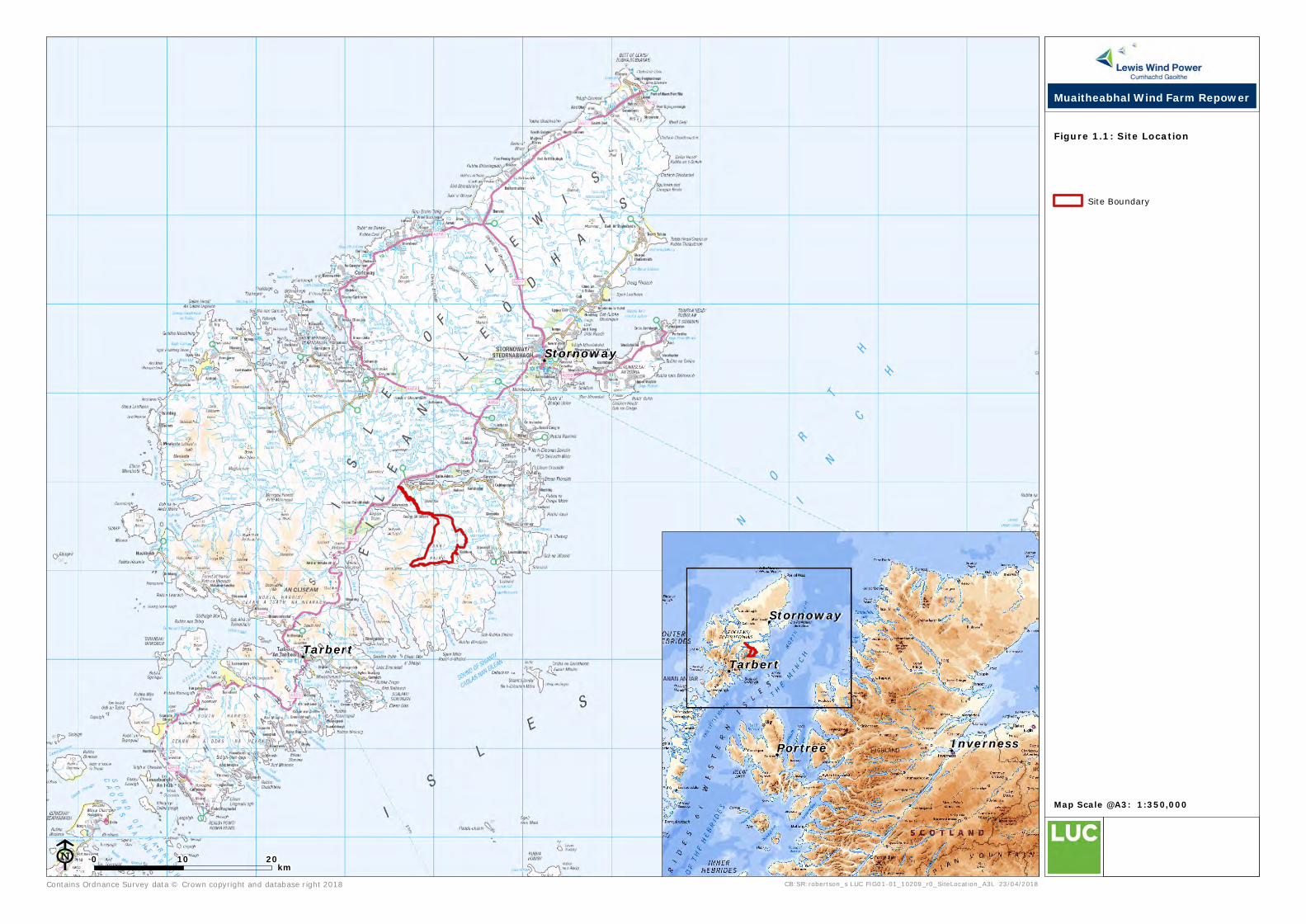
!
!
!
!
!
Stornoway
Tarbert
Contains Ordnance Survey data © Crown copyright and database right 2018 CB:SR:robertson_s LUC FIG01-01_10209_r0_SiteLocation_A3L 23/04/2018
Map Scale @A3: 1:350,000
E
Site Boundary
Figure 1.1: Site Location
0 10 20km
Muaitheabhal Wind Farm Repower
!
!
!
!
!
Portree
Stornoway
Tarbert
Inverness