Embed Size (px)
Citation preview
Clough, Harbour & Associates LLP
5-1
I-95 Corridor
Feasibility Study
5
Improvement Concepts Analysis
This chapter presents the potential improvement concepts that were investigated to address the transportation-related deficiencies along the I-95 corridor that were presented in Chapters 2 and 3 of this report. The overall feasibility, derived benefits, construction costs and impacts were evaluated for each of these improvement concepts. The following sections will include discussion regarding these potential improvements which include transit enhancements, mainline capacity improvements and interchange and intersection improvements within the study area. Recommended improvements have been developed with input from the study advisory committee, affected regional planning agencies and municipalities, the Transportation Strategy Board and the general public.
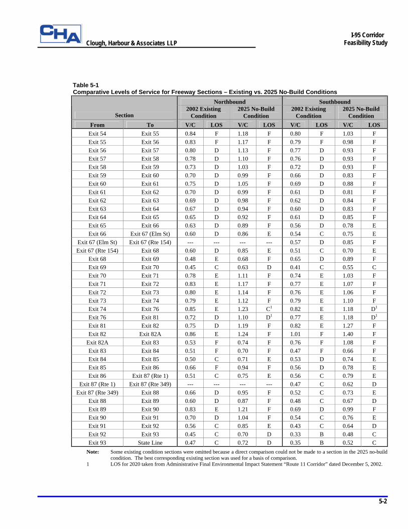
5.1 Future Demand vs. Capacity
Traffic demand along the I-95 corridor within the study area is projected to increase by approximately 43% in the peak hour between 2002 and 2025. Table 5-1 illustrates the effects of this increase on the existing I-95 roadway mainline sections by comparing the existing and future levels of service (LOS) for each of the mainline sections. As Table 5-1 shows, approximately 35% of the northbound and southbound sections experience operational deficiencies at LOS E or LOS F in the 2002 existing condition. By 2025, this percentage will increase to approximately 80% if existing travel trends and roadway conditions do not change and existing capacity is maintained. This level of congestion translates into potentially significant delays for motorists using the I-95 corridor.
Clough, Harbour & Associates LLP
5-2
I-95 Corridor
Feasibility Study
Table 5-1 Comparative Levels of Service for Freeway Sections – Existing vs. 2025 No-Build Conditions
Northbound Southbound
Section 2002 Existing
Condition 2025 No-Build
Condition 2002 Existing
Condition 2025 No-Build
Condition From To V/C LOS V/C LOS V/C LOS V/C LOS
Exit 54 Exit 55 0.84 F 1.18 F 0.80 F 1.03 F Exit 55 Exit 56 0.83 F 1.17 F 0.79 F 0.98 F Exit 56 Exit 57 0.80 D 1.13 F 0.77 D 0.93 F Exit 57 Exit 58 0.78 D 1.10 F 0.76 D 0.93 F Exit 58 Exit 59 0.73 D 1.03 F 0.72 D 0.93 F Exit 59 Exit 60 0.70 D 0.99 F 0.66 D 0.83 F Exit 60 Exit 61 0.75 D 1.05 F 0.69 D 0.88 F Exit 61 Exit 62 0.70 D 0.99 F 0.61 D 0.81 F Exit 62 Exit 63 0.69 D 0.98 F 0.62 D 0.84 F Exit 63 Exit 64 0.67 D 0.94 F 0.60 D 0.83 F Exit 64 Exit 65 0.65 D 0.92 F 0.61 D 0.85 F Exit 65 Exit 66 0.63 D 0.89 F 0.56 D 0.78 E Exit 66 Exit 67 (Elm St) 0.60 D 0.86 E 0.54 C 0.75 E
Exit 67 (Elm St) Exit 67 (Rte 154) --- --- --- --- 0.57 D 0.85 F Exit 67 (Rte 154) Exit 68 0.60 D 0.85 E 0.51 C 0.70 E
Exit 68 Exit 69 0.48 E 0.68 F 0.65 D 0.89 F Exit 69 Exit 70 0.45 C 0.63 D 0.41 C 0.55 C Exit 70 Exit 71 0.78 E 1.11 F 0.74 E 1.03 F Exit 71 Exit 72 0.83 E 1.17 F 0.77 E 1.07 F Exit 72 Exit 73 0.80 E 1.14 F 0.76 E 1.06 F Exit 73 Exit 74 0.79 E 1.12 F 0.79 E 1.10 F Exit 74 Exit 76 0.85 E 1.23 C1 0.82 E 1.18 D1 Exit 76 Exit 81 0.72 D 1.10 D1 0.77 E 1.18 D1 Exit 81 Exit 82 0.75 D 1.19 F 0.82 E 1.27 F Exit 82 Exit 82A 0.86 E 1.24 F 1.01 F 1.40 F
Exit 82A Exit 83 0.53 F 0.74 F 0.76 F 1.08 F Exit 83 Exit 84 0.51 F 0.70 F 0.47 F 0.66 F Exit 84 Exit 85 0.50 C 0.71 E 0.53 D 0.74 E Exit 85 Exit 86 0.66 F 0.94 F 0.56 D 0.78 E Exit 86 Exit 87 (Rte 1) 0.51 C 0.75 E 0.56 C 0.79 E
Exit 87 (Rte 1) Exit 87 (Rte 349) --- --- --- --- 0.47 C 0.62 D Exit 87 (Rte 349) Exit 88 0.66 D 0.95 F 0.52 C 0.73 E
Exit 88 Exit 89 0.60 D 0.87 F 0.48 C 0.67 D Exit 89 Exit 90 0.83 E 1.21 F 0.69 D 0.99 F Exit 90 Exit 91 0.70 D 1.04 F 0.54 C 0.76 E Exit 91 Exit 92 0.56 C 0.85 E 0.43 C 0.64 D Exit 92 Exit 93 0.45 C 0.70 D 0.33 B 0.48 C Exit 93 State Line 0.47 C 0.72 D 0.35 B 0.52 C
Note: Some existing condition sections were omitted because a direct comparison could not be made to a section in the 2025 no-build condition. The best corresponding existing section was used for a basis of comparison.
1 LOS for 2020 taken from Administrative Final Environmental Impact Statement “Route 11 Corridor” dated December 5, 2002.
Clough, Harbour & Associates LLP
5-3
I-95 Corridor
Feasibility Study
5.2 Alternatives to Reduce Demands
When the delays experienced by motorists become significant enough to affect typical travel behaviors, one or more of the following mechanisms is usually triggered to naturally reduce traffic demands on an interstate facility:
§ Peak spreading – i.e. motorists alter typical travel times to avoid congested periods § Motorists divert to alternate routes in the region § Motorists divert to alternate modes of transportation where available § Motorists decide not to travel
Experience has shown that motorists, in general, will not decide to forego travel plans in order to avoid traffic congestion. Therefore, only the other three mechanisms will be discussed and evaluated for their potential to effectively reduce demands in the I-95 corridor. Peak Spreading Peak spreading can occur when a corridor experiences defined peak travel periods during the course of a travel day. For example, in areas where the peak periods are defined by heavy volumes of commuter traffic, motorists can adjust their morning and evening travel times to avoid the heaviest periods of congestion. When significant numbers of motorists resort to traveling “off-peak,” the duration of the peak period increases. Conversely, the magnitude of the peak traffic volume decreases as does the average delay experienced along the corridor. This is peak spreading. The I-95 corridor, as described in the 1999 Southeastern Connecticut Corridor Study, exhibits several traffic patterns unique to the corridor that prevent effective peak spreading from occurring. The peak daily travel period begins in the early morning and continues throughout the day until late in the evening. This is particularly true in the summer months when there is no mid-day decline in traffic volumes. In addition, weekly peak periods occur on Friday evening in the northbound direction and on Sunday in the southbound direction. These high volume patterns are indicative of a combination of though-State, recreational, and commuter traffic, as opposed to the more common pattern of predominantly local commuter traffic. Because it would be difficult for motorists to alter their travel times to avoid these long and unusual peak periods, peak spreading is not an effective mechanism for reducing demand within the I-95 corridor. Alternate Routes – US Route 1 The main alternative travel route for northbound (eastbound) and southbound (westbound) traffic in the southern Connecticut region is US Route 1. This roadway primarily serves local, commercial and recreational traffic and is characterized in many locations by high density commercial development along the route. The route is also characterized by heavy traffic volumes and congestion, frequent traffic signals and high accident rates in many areas. The 1999 Southeastern Connecticut Corridor Study examined the traffic conditions along US Route 1 and concluded that this roadway exhibits daily and weekly traffic patterns similar to the I-95 corridor. As a result, motorists choosing to divert to US Route 1 during peak periods of congestion along I-95 would experience similar congested conditions on US Route 1. For this reason, US Route 1 is an unlikely alternative route to I-95 and is a non-factor in reducing traffic demands on the interstate.
Clough, Harbour & Associates LLP
5-4
I-95 Corridor
Feasibility Study
Alternate Modes – Transit Service Enhancements Analysis As part of this study, an in-depth evaluation of potential transit service enhancements in the I-95 corridor was conducted. The purpose of this evaluation was to determine whether local and regional transit improvements could effectively reduce peak traffic demands on the I-95 mainline. Transit enhancements that were considered included: § Extension of Shore Line East (SLE) service east to Westerly, RI including new seasonal stops in
Mystic and Niantic, and additional weekday and weekend service § Expansion of Commuter Connection bus service in New Haven in conjunction with SLE § Additional trips on the DATTCO commuter bus service between Hartford and Old Saybrook § Additional service on CT Transit Route S between Old Saybrook and New Haven § New bus service between Madison and Old Saybrook to complement existing Shoreline Shuttle service § New regional bus service between New London and Hartford via Norwich and Colchester offering rail
and bus connections north of Hartford and east of New London The complete evaluation of these enhancements is included in the Transit Service Enhancements Analysis located in the appendix of this report. The overall analysis concluded that the transit service enhancements listed above could divert less than one percent of the peak hour vehicle-miles traveled on I-95 to a combination of existing and enhanced transit services. Essentially, this level of diversion, which equates to less than one year’s traffic growth, would provide minimal relief of the peak hour congestion in 2025. The conclusions drawn from the analysis do however suggest that benefits derived from transit service enhancements in southeastern Connecticut should be considered an important component of the overall transportation improvements in the corridor. These enhancements could serve as a possible means of maintaining mobility through the corridor during construction of the recommended roadway improvements to be discussed in subsequent sections of this report.
5.3 Mainline Improvement Concepts to Increase Capacity
The information presented in the previous sections demonstrates that no mechanism or combination of mechanisms will sufficiently reduce the future traffic demands in the I-95 corridor such that acceptable levels of service (LOS) will be attained in the design year with the roadway as currently configured. As a result, it will be necessary to increase the capacity of the overall corridor in areas where deficient LOS exists in order to meet the 2025 traffic demands. This will require widening of the corridor to accommodate the addition of a third travel lane in the northbound and southbound directions. The need to expand the existing facility is supported not only by the analyses performed under this study, but also by the recommendations outlined in the 1999 Southeastern Connecticut Corridor Study. The conclusions drawn in that report mandated that an I-95 corridor study be performed to assess the physical and economical feasibility of providing a third travel lane along I-95 between Branford and the Rhode Island state line.
Clough, Harbour & Associates LLP
5-5
I-95 Corridor
Feasibility Study
5.3.1 Approach to Mainline Widening Analysis
Analysis of the mainline widening improvement concept was approached by the study team in three basic steps. The first step was to identify, using the results from the future conditions analysis in Chapter 3, the mainline sections within the study area that will exhibit an unacceptable LOS in the 2025 design hour and will therefore require additional capacity. The next step was to develop design criteria for the conceptual typical section and develop strategies for implementing the widening in each of the mainline sections. The final step in the process was to assess the overall feasibility, economic cost, environmental impacts and overall transportation benefits associated with the widening in each of the mainline sections.
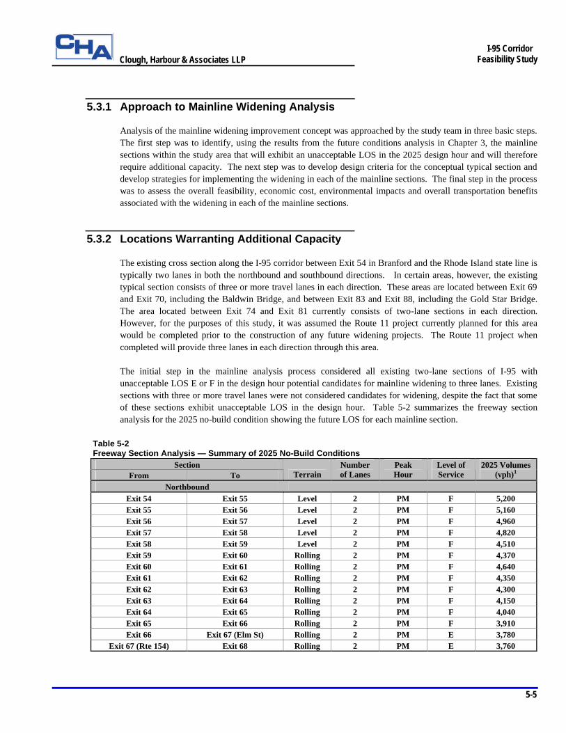
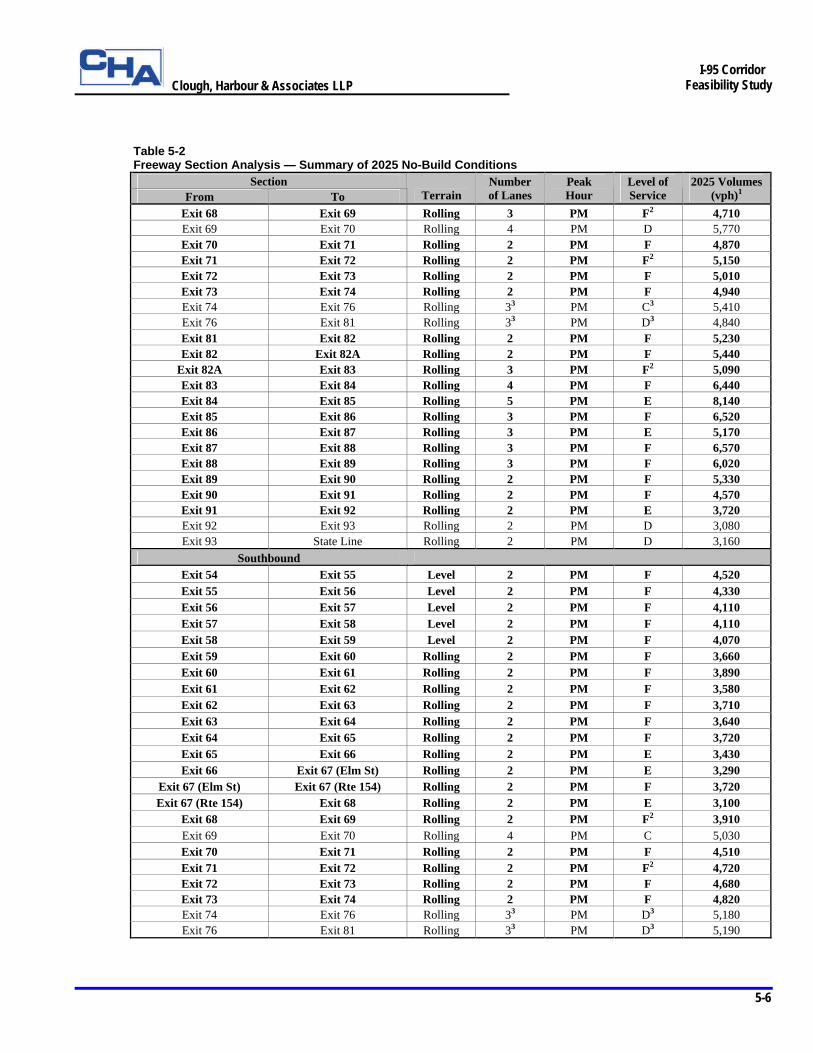
5.3.2 Locations Warranting Additional Capacity
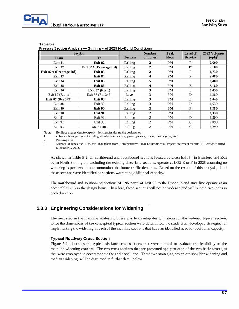
The existing cross section along the I-95 corridor between Exit 54 in Branford and the Rhode Island state line is typically two lanes in both the northbound and southbound directions. In certain areas, however, the existing typical section consists of three or more travel lanes in each direction. These areas are located between Exit 69 and Exit 70, including the Baldwin Bridge, and between Exit 83 and Exit 88, including the Gold Star Bridge. The area located between Exit 74 and Exit 81 currently consists of two-lane sections in each direction. However, for the purposes of this study, it was assumed the Route 11 project currently planned for this area would be completed prior to the construction of any future widening projects. The Route 11 project when completed will provide three lanes in each direction through this area. The initial step in the mainline analysis process considered all existing two-lane sections of I-95 with unacceptable LOS E or F in the design hour potential candidates for mainline widening to three lanes. Existing sections with three or more travel lanes were not considered candidates for widening, despite the fact that some of these sections exhibit unacceptable LOS in the design hour. Table 5-2 summarizes the freeway section analysis for the 2025 no-build condition showing the future LOS for each mainline section.
Table 5-2 Freeway Section Analysis — Summary of 2025 No-Build Conditions
Section From To Terrain
Number of Lanes
Peak Hour
Level of Service
2025 Volumes (vph)1
Northbound Exit 54 Exit 55 Level 2 PM F 5,200 Exit 55 Exit 56 Level 2 PM F 5,160 Exit 56 Exit 57 Level 2 PM F 4,960 Exit 57 Exit 58 Level 2 PM F 4,820 Exit 58 Exit 59 Level 2 PM F 4,510 Exit 59 Exit 60 Rolling 2 PM F 4,370 Exit 60 Exit 61 Rolling 2 PM F 4,640 Exit 61 Exit 62 Rolling 2 PM F 4,350 Exit 62 Exit 63 Rolling 2 PM F 4,300 Exit 63 Exit 64 Rolling 2 PM F 4,150 Exit 64 Exit 65 Rolling 2 PM F 4,040 Exit 65 Exit 66 Rolling 2 PM F 3,910 Exit 66 Exit 67 (Elm St) Rolling 2 PM E 3,780
Exit 67 (Rte 154) Exit 68 Rolling 2 PM E 3,760
Clough, Harbour & Associates LLP
5-6
I-95 Corridor
Feasibility Study
Table 5-2 Freeway Section Analysis — Summary of 2025 No-Build Conditions
Section From To Terrain
Number of Lanes
Peak Hour
Level of Service
2025 Volumes (vph)1
Exit 68 Exit 69 Rolling 3 PM F2 4,710 Exit 69 Exit 70 Rolling 4 PM D 5,770 Exit 70 Exit 71 Rolling 2 PM F 4,870 Exit 71 Exit 72 Rolling 2 PM F2 5,150 Exit 72 Exit 73 Rolling 2 PM F 5,010 Exit 73 Exit 74 Rolling 2 PM F 4,940 Exit 74 Exit 76 Rolling 33 PM C3 5,410 Exit 76 Exit 81 Rolling 33 PM D3 4,840 Exit 81 Exit 82 Rolling 2 PM F 5,230 Exit 82 Exit 82A Rolling 2 PM F 5,440
Exit 82A Exit 83 Rolling 3 PM F2 5,090 Exit 83 Exit 84 Rolling 4 PM F 6,440 Exit 84 Exit 85 Rolling 5 PM E 8,140 Exit 85 Exit 86 Rolling 3 PM F 6,520 Exit 86 Exit 87 Rolling 3 PM E 5,170 Exit 87 Exit 88 Rolling 3 PM F 6,570 Exit 88 Exit 89 Rolling 3 PM F 6,020 Exit 89 Exit 90 Rolling 2 PM F 5,330 Exit 90 Exit 91 Rolling 2 PM F 4,570 Exit 91 Exit 92 Rolling 2 PM E 3,720 Exit 92 Exit 93 Rolling 2 PM D 3,080 Exit 93 State Line Rolling 2 PM D 3,160
Southbound Exit 54 Exit 55 Level 2 PM F 4,520 Exit 55 Exit 56 Level 2 PM F 4,330 Exit 56 Exit 57 Level 2 PM F 4,110 Exit 57 Exit 58 Level 2 PM F 4,110 Exit 58 Exit 59 Level 2 PM F 4,070 Exit 59 Exit 60 Rolling 2 PM F 3,660 Exit 60 Exit 61 Rolling 2 PM F 3,890 Exit 61 Exit 62 Rolling 2 PM F 3,580 Exit 62 Exit 63 Rolling 2 PM F 3,710 Exit 63 Exit 64 Rolling 2 PM F 3,640 Exit 64 Exit 65 Rolling 2 PM F 3,720 Exit 65 Exit 66 Rolling 2 PM E 3,430 Exit 66 Exit 67 (Elm St) Rolling 2 PM E 3,290
Exit 67 (Elm St) Exit 67 (Rte 154) Rolling 2 PM F 3,720 Exit 67 (Rte 154) Exit 68 Rolling 2 PM E 3,100
Exit 68 Exit 69 Rolling 2 PM F2 3,910 Exit 69 Exit 70 Rolling 4 PM C 5,030 Exit 70 Exit 71 Rolling 2 PM F 4,510 Exit 71 Exit 72 Rolling 2 PM F2 4,720 Exit 72 Exit 73 Rolling 2 PM F 4,680 Exit 73 Exit 74 Rolling 2 PM F 4,820 Exit 74 Exit 76 Rolling 33 PM D3 5,180 Exit 76 Exit 81 Rolling 33 PM D3 5,190
Clough, Harbour & Associates LLP
5-7
I-95 Corridor
Feasibility Study
Table 5-2 Freeway Section Analysis — Summary of 2025 No-Build Conditions
Section From To Terrain
Number of Lanes
Peak Hour
Level of Service
2025 Volumes (vph)1
Exit 81 Exit 82 Rolling 2 PM F 5,600 Exit 82 Exit 82A (Frontage Rd) Rolling 2 PM F2 6,180
Exit 82A (Frontage Rd) Exit 83 Rolling 2 PM F 4,730 Exit 83 Exit 84 Rolling 4 PM F 6,080 Exit 84 Exit 85 Rolling 5 PM E 8,480 Exit 85 Exit 86 Rolling 4 PM E 7,180 Exit 86 Exit 87 (Rte 1) Rolling 3 PM E 5,430
Exit 87 (Rte 1) Exit 87 (Rte 349) Level 3 PM D 4,280 Exit 87 (Rte 349) Exit 88 Rolling 3 PM E 5,040
Exit 88 Exit 89 Rolling 3 PM D 4,630 Exit 89 Exit 90 Rolling 2 PM F 4,350 Exit 90 Exit 91 Rolling 2 PM E 3,330 Exit 91 Exit 92 Rolling 2 PM D 2,800 Exit 92 Exit 93 Rolling 2 PM C 2,090 Exit 93 State Line Rolling 2 PM C 2,290
Note: Boldface entries denote capacity deficiencies during the peak period. 1 vph – vehicles per hour, including all vehicle types (e.g. passenger cars, trucks, motorcycles, etc.) 2 Weaving area 3 Number of lanes and LOS for 2020 taken from Administrative Final Environmental Impact Statement “Route 11 Corridor” dated
December 5, 2002.
As shown in Table 5-2, all northbound and southbound sections located between Exit 54 in Branford and Exit 92 in North Stonington, excluding the existing three-lane sections, operate at LOS E or F in 2025 assuming no widening is performed to accommodate the future traffic demands. Based on the results of this analysis, all of these sections were identified as sections warranting additional capacity. The northbound and southbound sections of I-95 north of Exit 92 to the Rhode Island state line operate at an acceptable LOS in the design hour. Therefore, these sections will not be widened and will remain two lanes in each direction.
5.3.3 Engineering Considerations for Widening
The next step in the mainline analysis process was to develop design criteria for the widened typical section. Once the dimensions of the conceptual typical section were determined, the study team developed strategies for implementing the widening in each of the mainline sections that have an identified need for additional capacity. Typical Roadway Cross Section Figure 5-1 illustrates the typical six-lane cross sections that were utilized to evaluate the feasibility of the mainline widening concept. The two cross sections that are presented apply to each of the two basic strategies that were employed to accommodate the additional lane. These two strategies, which are shoulder widening and median widening, will be discussed in further detail below.
Clough, Harbour & Associates LLP
5-8
I-95 Corridor
Feasibility Study
The typical cross sections were designed to meet or exceed 1999 Connecticut Highway Design Manual (HDM) and 2001 AASHTO design standards for travel lane widths and clear zone widths. The recommended mainline travel lane width is 12 feet. The minimum desirable clear zone width is 30 feet for a typical 1:4 side slope with no guiderail. The minimum inside and outside shoulder width recommended in the HDM for a three-lane facility with high truck volumes is 12 feet. However, for the purposes of this study, the Connecticut Department of Transportation (ConnDOT) recommended the use of a 14 foot shoulder width along the entire I-95 corridor within the study area, including along the existing three-lane sections. The additional shoulder width is intended to ensure public safety during an incident management situation by facilitating the unimpeded response of emergency vehicles. In addition, the 14 foot shoulder width will aid traffic flow during normal maintenance operations conducted along the roadway. ConnDOT also recommended a 10 foot wide concrete median barrier be provided in areas where positive barrier protection is needed for the separation of northbound and southbound traffic. The 10 foot barrier is designed to accommodate bridge piers, overhead lighting poles and overhead sign structures within the limits of the barrier without the need to locally reduce the shoulder width in order to provide for these features. Shoulder Widening One strategy utilized by the study team for incorporating the mainline widening improvement concept was shoulder widening. This strategy refers to the provision for widening beyond the outside shoulder of the existing roadway cross section. Shoulder widening can potentially cause significant impacts to abutting right-of-way and building structures, environmental resources and adjacent roadway facilities, including interchange ramps and frontage roads. This course of action was considered only where the existing median width can not accommodate widening into the median. The shoulder widening strategy was implemented in two distinct geographical areas along the I-95 corridor. These areas will be referred to throughout the remaining text as Area 1 and Area 2 (Area 3 is another distinct geographical area that will be discussed separately below). Area 1 is geographically defined as the section of roadway located between the southern project limit at Exit 54 in Branford and the Connecticut River just north of Exit 69 in Old Saybrook. This portion of roadway typically consists of two northbound and southbound lanes separated by an existing concrete median barrier. Area 2 is geographically defined as the section of I-95 located between the Connecticut River just south of Exit 70 in Old Lyme and the Thames River near Exit 84 in New London. This portion of roadway typically consists of two northbound and southbound lanes separated by a narrow grassed median. Because the existing median in Areas 1 and 2 is relatively narrow, it was necessary to accommodate the mainline widening beyond the outside shoulder utilizing the shoulder widening strategy.

Clough, Harbour & Associates LLP
5-9
I-95 Corridor
Feasibility Study
Median Widening Where there is sufficient space in the existing median to accommodate the additional pavement width for the mainline widening improvement concept, a median widening strategy was used. This strategy refers to the provision for widening beyond the inside shoulder into the median of the existing roadway cross section. Median widening typically causes no impacts to abutting right-of-way since the median space is owned by the State of Connecticut. Impacts to adjacent interchange ramps and frontage roads are also minimal when this strategy is utilized. The median widening strategy was implemented in Area 3 along the I-95 corridor. Area 3 is geographically defined within the study corridor as the section of roadway located between the Thames River just south of Exit 85 and the northern project limit at the Rhode Island state line. This portion of roadway typically consists of two northbound and southbound lanes separated by a relatively wide natural median. Other Engineering Considerations Several other major components of the overall design strategy were considered independent of which widening strategy was employed to accommodate the mainline widening typical section. General design assumptions were developed to establish a consistent design approach to the feasibility analysis. A brief discussion of the other major engineering considerations and design assumptions used by the study team to complete the feasibility analysis is provided below:
Ø Bridge Structures – The three major multi-span structures and their approaches, including the Baldwin Bridge over the Connecticut River, the Gold Star Bridge over the Thames River and the Groton Reservoir structure, will not require any modification because these structures currently carry six or more travel lanes. The Leetes Island Road structure at Exit 56, which was recently reconstructed in 2003, and the Cross Road structure at Exit 81, which is currently under construction and scheduled for completion in 2005, also will not require any modification because these overpass structures provide sufficient vertical and lateral clearance to accommodate the widened section. In addition, it was assumed that several structures located in Areas 2 and 3 will not require any modification because these structures currently overpass existing six-lane sections of I-95. All other major bridge structures and box culverts affected by the mainline widening were assumed to be completely reconstructed for purposes of estimating construction costs and impacts associated with the widening concept. This assumption provides a worst-case scenario for likely structure costs to be incurred when the widened facility is constructed. A summary table presenting the locations and areas of all the affected bridge structures is provided in the appendix.
Ø Cut and Fill Slopes – Typical cut and fill slopes as recommended in the HDM were used to determine slope limits for the mainline widening concepts along the I-95 corridor. Fill slopes range from 1:6 (V:H) to a maximum of 1:2 depending on the height of the fill section. Earth cut slopes beyond the clear zone are a maximum of 1:2. Rock cut slopes, assumed to be 2:1, were used solely in major rock cut areas. Although significant portions of the existing corridor utilize curb and guiderail to reduce slope impacts, it was assumed for purposes of determining conservative slope limits and associated environmental and right-of-way impacts that modifications to the typical slope treatments would be limited. However in some particularly sensitive and constrained areas, 1:2 fill slopes and retaining wall structures were utilized to prevent impacts to abutting properties and environmental resources. Future design phases will consider the use of curb, guiderail, steeper slopes and retaining walls in all environmentally sensitive and physically constrained areas to help minimize the impacts associated with the mainline widening concept.
Clough, Harbour & Associates LLP
5-10
I-95 Corridor
Feasibility Study
Ø Widening of Existing Shoulders – The existing sections with three or more travel lanes in each direction typically have four foot inside and 10 foot outside shoulders. Because the recommended typical section utilizes 14 foot shoulders, it was assumed that these areas would be reconstructed to incorporate the wider shoulder widths to provide continuity through the study corridor. It was also assumed that this reconstruction would include full-depth reconstruction of the mainline lanes as well as the shoulders in order to provide a conservative cost estimate for likely future rehabilitation needs when the widened shoulders are implemented. Future design phases will consider pavement recycling and other cost-effective pavement rehabilitation strategies to help minimize the overall costs associated with this work.
Ø Environmental Resources – Impacts to environmental resources, including freshwater and field wetlands, tidal wetlands, water bodies, and socio-economic and cultural resources, are important considerations in evaluating the feasibility of the mainline widening improvement concept. Locations of all pertinent environmental resources located within the study area were previously identified in Chapter 4. A qualitative and quantitative evaluation of the impacts to these resources will be presented in Section 5.3.4.
Ø Land Use – Impacts to abutting properties and building structures are also important considerations in evaluating the feasibility of the mainline widening improvement concept. A qualitative evaluation of the impacts to the adjacent land uses will be presented in Section 5.3.4. In addition, an estimate of the right-of-way impact areas and costs associated with the entire project will be presented and discussed in further detail in Section 5.6.
Ø Route 11 Construction – It is anticipated that the planned Route 11 improvements will be in place prior to the implementation of the mainline widening concept. This project, which is currently undergoing environmental review, includes the reconstruction of the I-95/I-395/Route 11 interchange located between Exit 74 and Exit 81 in the towns of East Lyme and Waterford. The widened section matches the six lane section along I-95 that is proposed under the Route 11 project in this area.
Ø Rest Areas/Weigh Stations – Several public rest areas and state police-operated weigh stations are located within the study area. Where possible, access to these facilities has been maintained in conjunction with the mainline widening. However, where it was not possible to maintain the existing facility, a potential alternate site for the facility has been recommended. Impacts to the existing rest areas and weigh stations are evaluated in Section 5.3.4.
Ø Park and Ride Lots – An inventory conducted by ConnDOT identified 19 existing Park and Ride facilities at 18 interchanges within the study corridor. In conjunction with this inventory, ConnDOT also identified potential sites for future lots to both mitigate impacts to existing spaces caused by the recommended improvements and to provide for expansion of the Park and Ride program. Impacts to the existing Park and Ride facilities and the recommended sites for new lots are presented in Section 5.4.
Ø Interchange Improvements – In areas where a shoulder widening strategy was implemented to accommodate the mainline widening concept, significant modifications to the mainline and ramp connections were necessary to match the outside edge of the additional travel lane. Other geometric improvements including provisions for standard acceleration and deceleration lanes were provided in all interchange locations in conjunction with the mainline capacity improvements. Interchange improvements are discussed and presented in detail in Section 5.4.
Clough, Harbour & Associates LLP
5-11
I-95 Corridor
Feasibility Study
5.3.4 Analysis of Mainline Widening Concept
The final step in the mainline analysis process was to assess the overall feasibility, environmental impacts, transportation benefits and construction costs associated with the widening concept. The overall feasibility and environmental impacts are discussed in this section. A detailed cost analysis showing the estimated roadway, bridge, right-of-way and environmental mitigation costs for each mainline section is presented in Section 5.6. Interchange improvements and their associated impacts and costs will be presented and discussed in detail in Section 5.4.
5.3.4.a Overall Feasibility
Figure 5-2 (Sheets 1 to 124) presents the mainline widening concept overlaid on 200-scale existing aerial mapping of the I-95 corridor within the study area (Figure 5-2i (Sheets 1 to 4), which precedes Figure 5-2, provides a sheet index). Bridge structures, cut and fill slope limits, wetlands and approximate existing right-of-way boundaries are also shown. In general, the mainline widening improvement concept can be accommodated within the existing I-95 right-of-way in all three major geographic areas. This means minimal amounts of additional rights-of-way would need to be acquired in order to accommodate the mainline widening improvements. In isolated areas where the approximate slope limits extend beyond the existing right-of-way boundaries, it is likely additional refinements of the side slope and edge treatments during final design could minimize or eliminate right-of-way impacts in some of these areas.
5.3.4.b Area 1 – Exit 54 to Connecticut River (Exit 69)
The mainline in Area 1 typically consists of two northbound and southbound lanes separated by an existing concrete median barrier. The inside and outside shoulders, which are approximately 12 feet wide, were upgraded under previous safety improvement projects completed in this section. The section of roadway located within the Exit 69 interchange area and terminating at the Baldwin Bridge consists of three travel lanes in each direction. The conceptual typical section with a 10 foot wide median barrier and 14 foot wide shoulders is transitioned through this area to match the existing cross section at the bridge. As discussed previously, mainline widening is accommodated beyond the outside shoulder in this section due to the absence of available space in the median. The overall increase in roadway width to provide six travel lanes and 14 foot shoulders is approximately 40 feet. That is, approximately 20 feet of new pavement is required beyond the outside shoulders of both the northbound and southbound lanes. In addition, 45 bridge structures require replacement to provide sufficient width, or sufficient vertical and lateral clearance, to accommodate the mainline widening. Four major culverts also require replacement to accommodate the widening. Access ramps to two rest areas located on the northbound and southbound sides of I-95 between Exit 61 and Exit 62 in the Town of Madison are maintained so that operations at both areas are relatively unaffected by the widening. Access to the Welcome Center located on the southbound side of I-95 between Exit 65 and Exit 66 in the Town of Westbrook can not be maintained due to site constraints at its existing location.

Clough, Harbour & Associates LLP
5-12
I-95 Corridor
Feasibility Study
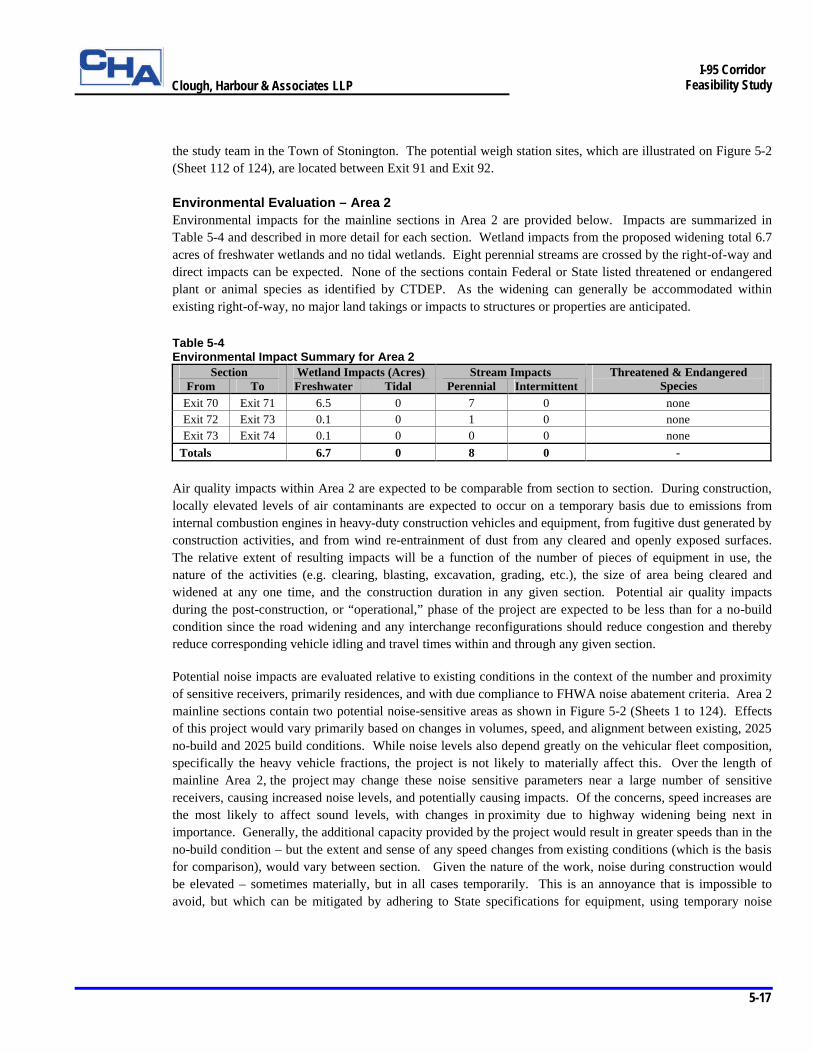
Environmental Evaluation – Area 1 (Note: For simplicity in reporting areas of impacts and for consistency with the presentation of recommended improvement concepts, the environmental impacts along the mainline sections are presented with the analysis of the mainline widening improvement concept in this section of the report. The environmental impacts within the interchange areas are presented with the analysis of the interchange improvement concepts in Section 5.4.3. A summary of environmental impacts in both the mainline and interchange areas is presented in Section 5.5.) Environmental impacts associated with the mainline sections in Area 1 are provided below. Impacts are summarized in Table 5-3 and described in more detail for each section. Wetland impacts from the proposed widening total almost 16 acres, 15.6 acres of freshwater and 0.4 acres of tidal wetlands. Eighteen perennial and five intermittent streams are crossed by the highway and construction impacts such as culverting and stream relocation can be expected. Four of the sections contain state-listed threatened or endangered plant or animal species that were identified by CTDEP. As the widening can generally be accommodated within the existing right-of-way, no major land takings or impacts to structures or properties are anticipated.
Table 5-3 Environmental Impact Summary for Area 1
Section Wetland Impacts (Acres) Stream Impacts From To Freshwater Tidal Perennial Intermittent
Threatened & Endangered Species
Exit 54 Exit 55 2.0 0 2 0 none Exit 55 Exit 56 0.0 0 1 0 none Exit 56 Exit 57 4.4 0 5 0 none Exit 57 Exit 58 0.0 0 0 0 none Exit 58 Exit 59 0.4 0 0 0 none Exit 59 Exit 60 0.2 0.3 1 0 state threatened/special concern birds Exit 60 Exit 61 0.5 0 0 0 none Exit 61 Exit 62 0.6 0 1 1 none Exit 62 Exit 63 1.7 0 3 3 none Exit 63 Exit 64 2.4 0.1 1 1 state special concern plant Exit 64 Exit 65 1.9 0 3 0 state special concern invertebrate Exit 65 Exit 66 0.8 0 0 0 none Exit 66 Exit 67 0.1 0 0 0 none Exit 67 Exit 69 0.6 0 1 0 state threatened bird
Totals 15.6 0.4 18 5 -
Air quality impacts within Area 1 are expected to be comparable from section to section. During construction, locally elevated levels of air contaminants are expected to occur on a temporary basis due to emissions from internal combustion engines in heavy-duty construction vehicles and equipment, from fugitive dust generated by construction activities, and from wind re-entrainment of dust from any cleared and openly exposed surfaces. The relative extent of resulting impacts will be a function of the number of pieces of equipment in use, the nature of the activities (e.g. clearing, blasting, excavation, grading, etc.), the size of area being cleared and widened at any one time, and the construction duration in any given section. Potential air quality impacts during the post-construction, or “operational,” phase of the project are expected to be less than for a no-build condition since the road widening and any interchange reconfigurations should reduce congestion and thereby reduce corresponding vehicle idling and travel times within and through any given section.
Clough, Harbour & Associates LLP
5-13
I-95 Corridor
Feasibility Study
Potential noise impacts are evaluated relative to existing conditions in the context of the number and proximity of sensitive receivers, primarily residences, and with due compliance to FHWA noise abatement criteria. Area 1 mainline sections contain 49 potential noise-sensitive areas as shown in Figure 5-2 (Sheets 1 to 124). Effects of this project would vary primarily based on changes in volumes, speed, and alignment between existing, 2025 no-build and 2025 build conditions. While noise levels also depend greatly on the vehicular fleet composition, specifically the heavy vehicle fractions, the project is not likely to materially affect this. Over the length of mainline Area 1, the project may change these noise sensitive parameters near a large number of sensitive receivers, causing increased noise levels, and potentially causing impacts. Of the concerns, speed increases are the most likely to affect sound levels, with changes in proximity due to highway widening being next in importance. Generally, the additional capacity provided by the project would result in greater speeds than in the no-build condition – but the extent and sense of any speed changes from existing conditions (which is the basis for comparison), would vary between sections. Given the nature of the work, noise during construction would be elevated – sometimes materially, but in all cases temporarily. This is an annoyance that is impossible to avoid, but which can be mitigated by adhering to State specifications for equipment, using temporary noise containment structures or barriers, where feasible, providing warning to the community for particularly onerous portions of the work, and controlling work hours.
Ø Exit 54 to Exit 55 – Portions of eight freshwater wetlands, totaling 2.0 acres, would be affected by widening in this section. The existing bridge over the Branford River would be widened by 36 linear feet and the widening would alter 320 linear feet of Pisgah Brook. A total of 1,400 linear feet of floodplain associated with these two water bodies would be impacted along the toe of slope. Approximately 600 feet of this section is within the boundaries of the Coastal Zone although the project would not impact any coastal resources. The Branford River Wildlife Area is a potential Section 4(f) property adjacent to the right-of-way for a distance of 200 feet. It would be unaffected by the proposed widening of I-95. Unsurveyed areas with a high to moderate archeological potential are present in this section. This section contains five potential noise-sensitive areas consisting of four single family residential areas and one townhouse area.
Ø Exit 55 to Exit 56 – Implementation of widening in this section would affect 25 feet of an unnamed, perennial stream. Impacts to other environmental resources would be minimal.
Ø Exit 56 to Exit 57 – Twenty-one freshwater wetlands, including several ponds and unnamed streams on either side of I-95 would sustain a total of 4.4 acres of impacts. Approximately 471 linear feet of stream courses (Hoadley Creek and four unnamed, perennial streams) would be altered and the project would encroach on floodplains along the toes of slope for 900 linear feet of floodplain area that is crossed by the right-of-way. Two community wells are located 500 feet north of I-95 on Granite Road. Numerous Prime and Statewide Important farmland soil areas are encountered but they are in areas already within the existing highway right-of-way. Unsurveyed areas with a high to moderate archeological potential are present in this section. This section contains seven potential noise-sensitive areas consisting of several single family residences.
Ø Exit 57 to Exit 58 – Approximately 130 feet of this section traverses an aquifer protection area (Guilford wellfield) and there are two active farms adjacent to the right-of-way. No impacts are expected to either resource. This section contains two potential noise-sensitive areas consisting of single family residences. Impacts to other environmental resources would be minimal.
Ø Exit 58 to Exit 59 – Roadway widening would have minor impacts (0.4 acres) to portions of three freshwater wetlands. This section also crosses 200 feet of the Guilford wellfield aquifer protection area.
Clough, Harbour & Associates LLP
5-14
I-95 Corridor
Feasibility Study
The Guilford Historic Town Center Historic District is adjacent to the south side of the right-of-way for a distance of 1,800 feet, the entire length of the section. No direct impact to the historic district is anticipated. Impacts are limited to potential visual and noise impacts at the southern boundary of the historic district. Two active farms, one on either side of the highway, are adjacent to the right-of-way. Because the widening does not extend beyond the existing right-of-way, no impacts to these resources are expected. This section contains two potential noise-sensitive areas consisting of single family residences.
Ø Exit 59 to Exit 60 – There are three wetlands located along the right-of-way that would be impacted by new construction. Two are tidal wetlands associated with the East River. Approximately 0.3 acres of tidal wetlands and 0.2 acres of freshwater wetlands would be filled to accommodate the widening. The East River, which is tidally influenced, is spanned by 40 feet of the highway and 50 linear feet would also be affected. There are 2,400 feet of floodplain associated with the East River that is crossed by this section. An 8,000 foot portion of the section is within the Coastal Zone. Tidal wetland resources are located on both sides of the right-of-way for a span of approximately 900 feet. Three areas of potential endangered species habitat are found along the section. The areas on the southern (western) end of the section in Guilford contain one threatened and one state special concern bird species. According to CTDEP, neither species should be affected by the project. There is one active farm north of the right-of-way and numerous encounters with Prime and Statewide Important farm land soils. None of these farm resources would be impacted since no construction outside the right-of-way is anticipated. A small portion of the town of Guilford’s Dudleytown Historic District is adjacent to the north of the highway. No direct impact to the historic district is anticipated. Impacts are limited to potential visual and noise impacts at the southern boundary of the historic district. Another potential Section 4(f) resource is the East River Wildlife Area, 800 feet of which parallels the north side of the highway. Unsurveyed areas with a high to moderate archeological potential are present in this section.
Ø Exit 60 to Exit 61 – Roadway widening would have minor impacts to portions of two freshwater wetland areas (approximately 0.5 acre). Game Farm Pond is located adjacent and south of the right-of-way and two community wells are located 200 feet south of the right-of-way. Approximately 1,600 feet of this section is located within the Coastal Zone Boundary. This section contains two potential noise-sensitive areas consisting of single family residences to the south.
Ø Exit 61 to Exit 62 – The widening would impact portions of five freshwater wetlands, totaling almost 0.6 acres. Fence Creek and one unnamed intermittent stream are crossed. Approximately 105 linear feet of these watercourses would be affected by proposed construction. The highway crosses the Rettich wellfield aquifer protection area for a distance of 2,000 feet. There are no public wells within 500 feet. The I-95 southbound rest area has been reported in the CTDEP Site Discovery and Assessment and the Leachate and Wastewater Discharge databases. A commercial parcel adjacent to the right-of-way has been reported in the leaking underground storage tank tracking system, the PCB Activity database system, and the FIFRA/TSCA system. This section contains five potential noise-sensitive areas consisting of single family residences.
Ø Exit 62 to Exit 63 – A total of 1.7 acres at 14 wetlands would be affected by the widening. Six unnamed streams would be affected for a total of 315 linear feet of perennial and 280 linear feet of intermittent stream impacts. Approximately 1,000 linear feet of floodplain along the toes of the slope, and 700 feet of the Rettich wellfield aquifer protection area are crossed by the highway. Approximately 6,500 linear feet of the highway is located within the Coastal Zone Boundary. Unsurveyed areas of high to moderate archeological potential that could be directly impacted are present in this section. This section contains seven potential noise-sensitive areas consisting of single family residences.
Clough, Harbour & Associates LLP
5-15
I-95 Corridor
Feasibility Study
Ø Exit 63 to Exit 64 – Direct impacts to seven freshwater wetlands (2.4 acres) and two tidal wetlands (0.1 acres) totaling 2.5 acres along this section would result from the highway widening. The existing bridge over the Menunketesuck River would be widened by 40 feet, and 95 linear feet of one unnamed intermittent stream would be affected. Floodplain area (400 linear feet) associated with the river is crossed by the highway. No public water supply wells are within 500 feet of the highway, although the right-of-way crosses 2,000 feet of the Clinton wellfield aquifer protection area. Approximately 4,000 feet of the right-of-way is located within the Coastal Zone Boundary. Three areas of potential endangered species habitat are found along the section. One area includes a state-listed plant of special concern in the area of the Menunketesuck River. According to CTDEP, “the use of best management practices with special attention to erosion and siltation control should prevent indirect negative affects to the species.” CTDEP-owned land is adjacent and north of the right-of-way that provides water access to the Menunketesuck River. The areas north and south of current I-95 and west of Menunketesuck River are considered unsurveyed areas of high to moderate archeological potential that could be directly impacted. This section contains eight potential noise-sensitive areas consisting of single family residences.
Ø Exit 64 to Exit 65 – Ten freshwater wetlands totaling 1.9 acres would be affected by the widening. Gatchen Creek is located within the right-of-way and south of the highway. It parallels the highway for a distance of approximately 1,000 feet. Two unnamed perennial streams cross the right-of-way and approximately 460 linear feet of these streams would be affected. Approximately 800 linear feet of floodplain area is located along the toes of slope of the highway. Approximately 3,000 feet of this section is within the Coastal Zone, although no coastal zone resources have been identified within or adjacent to the right-of-way. One active farm is located north of the right-of-way and would be unaffected by the project. A potential Section 4(f) property, the Cockaponset State Forest, is adjacent to the north side of the right-of-way for a distance of 1,000 feet. One area of potential endangered species habitat is found along the section. The area south of the section contains one state special concern invertebrate species. According to CTDEP, the “…invertebrate species is associated with freshwater wetlands. If freshwater wetlands are going to be impacted during the course of improvements in Westbrook this species may be impacted too.” Unsurveyed areas of high to moderate archeological potential that could be directly impacted are present in this section. This section contains five potential noise-sensitive areas consisting of single family residences.
Ø Exit 65 to Exit 66 – Portions of four freshwater wetlands (0.8 acres) and one vacant parcel outside the present right-of-way would be impacted by encroachment due to widening the highway. Privately owned open space, the YMCA’s Valley Shore facility, is located north of the right-of-way. This section contains one potential noise-sensitive area consisting of single family residences.
Ø Exit 66 to Exit 67 – Roadway widening would have minor impacts to portions of two freshwater wetlands (approximately 0.1 acre). Minor encroachment to almost 1,000 feet of vacant privately owned land occurs south of the right-of-way. Unevaluated architectural resources that could be potentially impacted are located at Hill Road #2 and Elm Street (north side) at Exit 67. This section contains three potential noise- sensitive areas consisting of single family residences.
Ø Exit 67 to Exit 69 – The Exit 68 northbound on-ramp to I-95 and the I-95 southbound off-ramp will be eliminated. New ramps at Exit 67 at Route 154 will replace these ramps. A total of 0.6 acres at six wetlands would be affected by highway widening and reconfiguration. Ragged Rock Creek is crossed by the existing highway; about 30 feet of this waterway would be culverted. Approximately 1,400 feet of the right-of-way is located within the Coastal Zone. One area of potential state threatened species habitat is found along the section. The area south of the highway in Ragged Rock Creek contains a habitat for one state threatened bird species. According to CTDEP, “if Ragged Rock Creek is going to be impacted by
Clough, Harbour & Associates LLP
5-16
I-95 Corridor
Feasibility Study
erosion, sedimentation or siltation discharged, or if there are to be polluted runoff such as chemicals or fertilizer discharged into the river, resulting from this project that can contaminate the water then the species may be impacted.” Eliminating the Exit 68 ramps would result in access impacts for local businesses and residences. Unsurveyed areas of high to moderate archeological potential that could be directly impacted are present in this section. This section contains two potential noise-sensitive areas consisting of single family residences.
5.3.4.c Area 2 – Connecticut River (Exit 70) to Thames River (Exit 84)
The I-95 mainline in Area 2 typically consists of two northbound and southbound lanes separated by a narrow grassed median. The existing inside and outside shoulder widths are typically 4 feet and 10 feet, respectively, although they vary slightly in some locations along the section. The section of roadway located within the Exit 70 interchange area beginning at the Baldwin Bridge and terminating at the Lieutenant River structure consists of three travel lanes in each direction. The existing section at the Baldwin Bridge is transitioned to the conceptual typical section with a 10 foot wide median barrier and 14 foot wide shoulders through this area. As discussed previously, mainline widening is accommodated beyond the outside shoulder in Area 2 due to the absence of available space in the median. The overall increase in roadway width to provide six travel lanes and 14 foot shoulders is approximately 50 feet. That is, approximately 25 feet of additional pavement is required beyond the outside shoulders of both the northbound and southbound lanes. In addition, 15 bridge structures require replacement to provide sufficient width, or sufficient vertical and lateral clearance, to accommodate the mainline widening. Three major culverts also require replacement to accommodate the widening. The planned Route 11 construction project, which is currently undergoing environmental review, is located within the limits of Area 2. It is anticipated that the Route 11 improvements will be in place prior to the widening in this section. In order to match the mainline widening to the three-lane sections of I-95 proposed for the Route 11 project in the area of the Route 11/I-395/I-95 interchange, it is necessary to modify the mainline alignment near both the southern and northern limits of that project. This requires the reconstruction of a short section of both Route 11 project limits to provide an appropriate transition to the mainline widening improvement concept. In general, there are no additional impacts associated with the slight realignment of the mainline in these locations. Mainline alignment modifications are also required in the Exit 82/82A area in the Town of Waterford to accommodate the mainline widening, existing frontage roads and interchange improvement concepts in this area. Because the majority of impacts occur beyond the limits of the frontage road systems, they are discussed in detail in Section 5.4.3 Analysis of Interchange Improvement Concepts. The section of roadway located north of Exit 82A to the Thames River consists of three lanes in the northbound and southbound directions. This area requires a continuation of the 14 foot shoulders that are transitioned to match the existing cross section just south of the interchange ramps for Exit 84. Access to two weigh stations, which are located on the northbound and southbound sides of I-95 between Exit 81 and Exit 82 in the Town of Waterford, can not be maintained due to existing site constraints that are compounded by the mainline widening. Potential relocation sites for the two weigh stations were identified by
Clough, Harbour & Associates LLP
5-17
I-95 Corridor
Feasibility Study
the study team in the Town of Stonington. The potential weigh station sites, which are illustrated on Figure 5-2 (Sheet 112 of 124), are located between Exit 91 and Exit 92. Environmental Evaluation – Area 2 Environmental impacts for the mainline sections in Area 2 are provided below. Impacts are summarized in Table 5-4 and described in more detail for each section. Wetland impacts from the proposed widening total 6.7 acres of freshwater wetlands and no tidal wetlands. Eight perennial streams are crossed by the right-of-way and direct impacts can be expected. None of the sections contain Federal or State listed threatened or endangered plant or animal species as identified by CTDEP. As the widening can generally be accommodated within existing right-of-way, no major land takings or impacts to structures or properties are anticipated. Table 5-4 Environmental Impact Summary for Area 2
Section Wetland Impacts (Acres) Stream Impacts From To Freshwater Tidal Perennial Intermittent
Threatened & Endangered Species
Exit 70 Exit 71 6.5 0 7 0 none Exit 72 Exit 73 0.1 0 1 0 none Exit 73 Exit 74 0.1 0 0 0 none
Totals 6.7 0 8 0 -
Air quality impacts within Area 2 are expected to be comparable from section to section. During construction, locally elevated levels of air contaminants are expected to occur on a temporary basis due to emissions from internal combustion engines in heavy-duty construction vehicles and equipment, from fugitive dust generated by construction activities, and from wind re-entrainment of dust from any cleared and openly exposed surfaces. The relative extent of resulting impacts will be a function of the number of pieces of equipment in use, the nature of the activities (e.g. clearing, blasting, excavation, grading, etc.), the size of area being cleared and widened at any one time, and the construction duration in any given section. Potential air quality impacts during the post-construction, or “operational,” phase of the project are expected to be less than for a no-build condition since the road widening and any interchange reconfigurations should reduce congestion and thereby reduce corresponding vehicle idling and travel times within and through any given section.
Potential noise impacts are evaluated relative to existing conditions in the context of the number and proximity of sensitive receivers, primarily residences, and with due compliance to FHWA noise abatement criteria. Area 2 mainline sections contain two potential noise-sensitive areas as shown in Figure 5-2 (Sheets 1 to 124). Effects of this project would vary primarily based on changes in volumes, speed, and alignment between existing, 2025 no-build and 2025 build conditions. While noise levels also depend greatly on the vehicular fleet composition, specifically the heavy vehicle fractions, the project is not likely to materially affect this. Over the length of mainline Area 2, the project may change these noise sensitive parameters near a large number of sensitive receivers, causing increased noise levels, and potentially causing impacts. Of the concerns, speed increases are the most likely to affect sound levels, with changes in proximity due to highway widening being next in importance. Generally, the additional capacity provided by the project would result in greater speeds than in the no-build condition – but the extent and sense of any speed changes from existing conditions (which is the basis for comparison), would vary between section. Given the nature of the work, noise during construction would be elevated – sometimes materially, but in all cases temporarily. This is an annoyance that is impossible to avoid, but which can be mitigated by adhering to State specifications for equipment, using temporary noise

Clough, Harbour & Associates LLP
5-18
I-95 Corridor
Feasibility Study
containment structures or barriers, where feasible, providing warning to the community for particularly onerous portions of the work, and controlling work hours. Ø Exit 70 to Exit 71 – The mainline widening would affect 34 freshwater wetland areas for a total of
approximately 6.5 acres. This section crosses seven watercourses; three named (Black Hall, Sawmill, and Armstrong Rivers) and four unnamed perennial streams. The stream lengths that would be impacted total 605 feet and range from 45 feet to 185 linear feet. Minor floodplain encroachment along 600 linear feet at the toe of slope would occur along the section. Approximately 6,000 feet of the section falls within the Coastal Zone, although no coastal zone resources would be directly impacted by roadway widening. One area of potential endangered species habitat is located along the section. Unsurveyed areas of high to moderate archeological potential that could be directly impacted are present in this section. This section contains one potential noise-sensitive area consisting of a single family residence.
Ø Exit 72 to Exit 73 – Mainline widening would impact approximately 0.1 wetland acres at three wetland areas in this section. One stream, Brides Brook, would be impacted for approximately 140 feet. Approximately 200 feet of the Brides Lake wellfield aquifer protection area is crossed by the right-of-way. There are no public wells within 500 feet of the right-of-way. There would be no impacts to farmland soils or active farms, although one farm is located adjacent to and north of the right-of-way. The Gates Correctional Facility is located to the south and adjacent to the highway. Approximately 1,200 feet of the section’s right-of-way borders the correctional facility. Because the correctional facility is the predominant land use in Census Tract 716101, Block Groups 2 and 4, the ethnic and income make-up of the prison population qualifies these block groups as potential Environmental Justice areas. This section contains one potential noise-sensitive area consisting of single family residences.
Ø Exit 73 to Exit 74 – There would be relatively few environmental impacts within this section. Two wetlands totaling approximately 0.1 acres would be affected by the widening and 2,000 feet of the Gorton’s Pond wellfield aquifer protection area would be crossed, although no public wells are located within 500 feet of the right-of-way.
5.3.4.d Area 3 – Thames River (Exit 85) to Rhode Island State Line
The I-95 mainline in Area 3 typically consists of two northbound and southbound lanes separated by a wide natural median. However, the section of roadway located between the Gold Star Bridge and Exit 88 consists of three travel lanes in each direction. The existing inside and outside shoulder widths in both areas are typically four feet and 10 feet, respectively. As discussed previously, mainline widening in the two-lane sections within Area 3 is accommodated within the existing median. The overall increase in the pavement width of each barrel to provide three travel lanes and 14 foot shoulders is approximately 26 feet. That is, approximately 22 feet of additional pavement is required on the median side, and 4 feet of additional pavement is required on the outside of both the northbound and southbound lanes. The existing three-lane section of I-95 located between the Gold Star Bridge and Exit 88 requires the incorporation of 14 foot inside and outside shoulders. In addition, 28 bridge structures require replacement to provide sufficient width, or sufficient vertical and lateral clearance, to accommodate the mainline widening. One major culvert also requires replacement to accommodate the widening.
Clough, Harbour & Associates LLP
5-19
I-95 Corridor
Feasibility Study
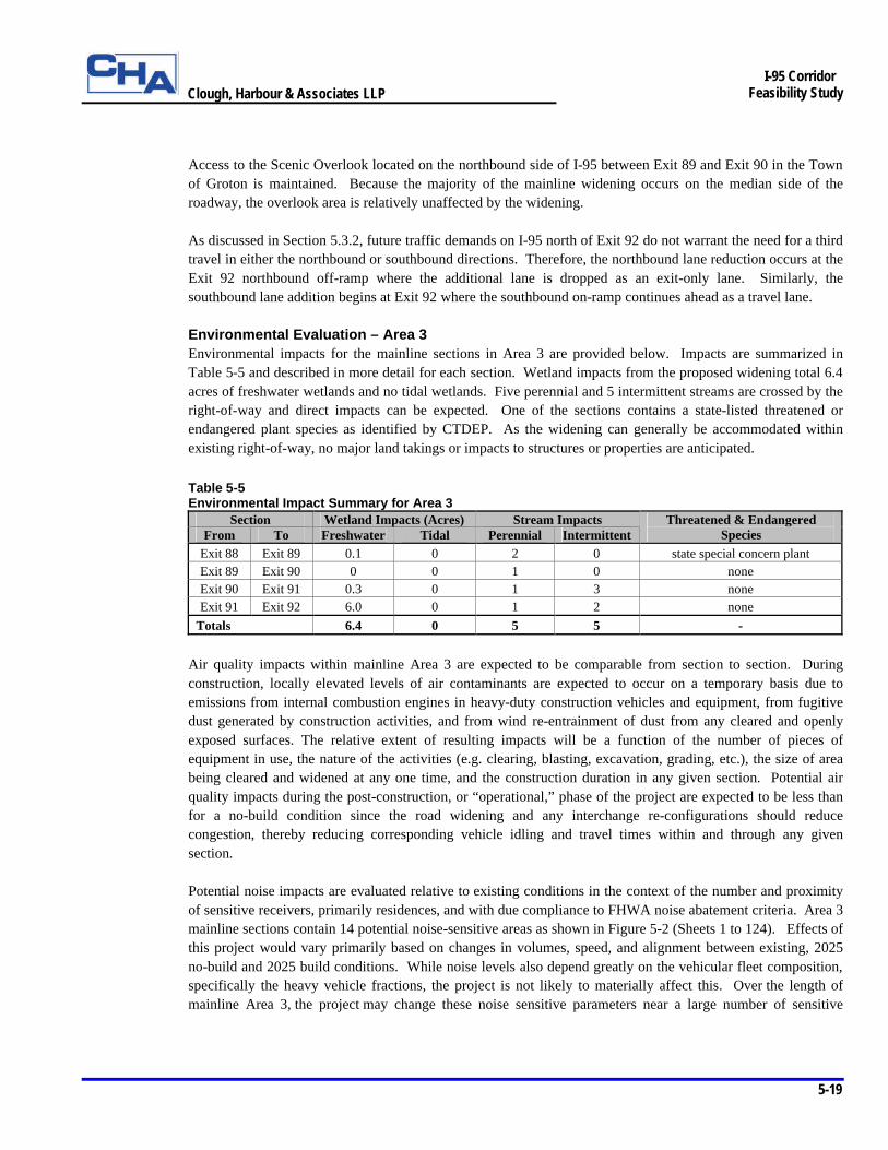
Access to the Scenic Overlook located on the northbound side of I-95 between Exit 89 and Exit 90 in the Town of Groton is maintained. Because the majority of the mainline widening occurs on the median side of the roadway, the overlook area is relatively unaffected by the widening. As discussed in Section 5.3.2, future traffic demands on I-95 north of Exit 92 do not warrant the need for a third travel in either the northbound or southbound directions. Therefore, the northbound lane reduction occurs at the Exit 92 northbound off-ramp where the additional lane is dropped as an exit-only lane. Similarly, the southbound lane addition begins at Exit 92 where the southbound on-ramp continues ahead as a travel lane. Environmental Evaluation – Area 3 Environmental impacts for the mainline sections in Area 3 are provided below. Impacts are summarized in Table 5-5 and described in more detail for each section. Wetland impacts from the proposed widening total 6.4 acres of freshwater wetlands and no tidal wetlands. Five perennial and 5 intermittent streams are crossed by the right-of-way and direct impacts can be expected. One of the sections contains a state-listed threatened or endangered plant species as identified by CTDEP. As the widening can generally be accommodated within existing right-of-way, no major land takings or impacts to structures or properties are anticipated. Table 5-5 Environmental Impact Summary for Area 3
Section Wetland Impacts (Acres) Stream Impacts From To Freshwater Tidal Perennial Intermittent
Threatened & Endangered Species
Exit 88 Exit 89 0.1 0 2 0 state special concern plant Exit 89 Exit 90 0 0 1 0 none Exit 90 Exit 91 0.3 0 1 3 none Exit 91 Exit 92 6.0 0 1 2 none
Totals 6.4 0 5 5 -
Air quality impacts within mainline Area 3 are expected to be comparable from section to section. During construction, locally elevated levels of air contaminants are expected to occur on a temporary basis due to emissions from internal combustion engines in heavy-duty construction vehicles and equipment, from fugitive dust generated by construction activities, and from wind re-entrainment of dust from any cleared and openly exposed surfaces. The relative extent of resulting impacts will be a function of the number of pieces of equipment in use, the nature of the activities (e.g. clearing, blasting, excavation, grading, etc.), the size of area being cleared and widened at any one time, and the construction duration in any given section. Potential air quality impacts during the post-construction, or “operational,” phase of the project are expected to be less than for a no-build condition since the road widening and any interchange re-configurations should reduce congestion, thereby reducing corresponding vehicle idling and travel times within and through any given section. Potential noise impacts are evaluated relative to existing conditions in the context of the number and proximity of sensitive receivers, primarily residences, and with due compliance to FHWA noise abatement criteria. Area 3 mainline sections contain 14 potential noise-sensitive areas as shown in Figure 5-2 (Sheets 1 to 124). Effects of this project would vary primarily based on changes in volumes, speed, and alignment between existing, 2025 no-build and 2025 build conditions. While noise levels also depend greatly on the vehicular fleet composition, specifically the heavy vehicle fractions, the project is not likely to materially affect this. Over the length of mainline Area 3, the project may change these noise sensitive parameters near a large number of sensitive
Clough, Harbour & Associates LLP
5-20
I-95 Corridor
Feasibility Study
receivers, causing increased noise levels, and potentially causing impacts. Of the concerns, speed increases are the most likely to affect sound levels, with changes in proximity due to highway widening being next in importance. Generally, the additional capacity provided by the project would result in greater speeds than in the no-build – but the extent and sense of any speed changes from existing conditions (which is the basis for comparison), would vary between sections. Given the nature of the work, noise during construction would be elevated – sometimes materially, but in all cases temporarily. This is an annoyance that is impossible to avoid, but which can be mitigated by adhering to State specifications for equipment, using temporary noise containment structures or barriers, where feasible, providing warning to the community for particularly onerous portions of the work, and controlling work hours.
Ø Exit 88 to Exit 89 – Minimal impact to four freshwater wetlands (0.1 acre) would result from the proposed widening. Fishtown, Eccleston and Fort Hill Brooks are crossed by the highway along the northern (eastern) end of this section with approximately 128 linear feet of these waterways expected to be impacted. One area of state listed plant species of special concern is located further to the south (west) of this section in an area that has not been proposed for re-design or widening. Should work be conducted in this area, CTDEP would require “the use of best management practices with special attention to erosion and siltation control” to “prevent indirect negative affects to the species.” Impacts to other environmental resources would be minimal. This section contains four potentially noise sensitive areas consisting of single family residences.
Ø Exit 89 to Exit 90 – There would be no impacts to wetland resources in this section. The highway crosses the Mystic River, which is tidal at this location. The existing Mystic River Bridge would be widened by 36 feet. Approximately 3,000 feet of this section is within the Coastal Zone in the vicinity of the Mystic River. This portion of the river is classified as an estuarine embayment by the Coastal Zone Management program and 200 feet of this resource would be spanned by the additional 36 foot bridge width. A scenic overlook on the northbound side of I-95 provides views toward Mystic Seaport. This section contains three potential noise-sensitive areas consisting of single family residences.
Ø Exit 90 to Exit 91 – Portions of four freshwater wetlands totaling 0.2 acres would be impacted by new construction. Approximately 18 linear feet of the Pequotsepos Brook and 36 linear feet of three unnamed intermittent streams would be impacted by the right-of-way. The existing bridge over Copps Brook would be widened by 36 feet. The Dean’s Mill and Palmer Reservoirs are located north and south of the right-of-way. These reservoirs are connected by Copps Brook. The widening concept shows no encroachment into the reservoirs or the small floodplain area associated with them. Approximately 6,000 feet of the right-of-way is located within a GA quality groundwater area that is associated with the reservoirs. A larger floodplain area, 1,500 linear feet (measured along the toe of slope) associated with Stony Brook, is located further to the east. Conceptual plans indicate widening to the north away from the floodplain area. This would result in minimal impact to the floodplain. One farm is located 200 feet south of the right-of-way. This section contains five potential noise-sensitive areas consisting of single family residences.
Ø Exit 91 to Exit 92 – The proposed widening would impact portions of fifteen freshwater wetlands, totaling almost 6.0 acres. According to the conceptual plans, some wetlands over an acre in size would be backfilled. Most of these wetlands are located within the median and would be affected by backfilling into the median area. Anguilla Brook is crossed by the highway but no impacts are expected. Approximately 670 feet of two unnamed intermittent streams would be affected to accommodate the widening. The right-of-way passes over 3,000 feet of the Pawcatuck River sole source aquifer. Numerous encounters with Prime and Statewide Important farmland soils occur and two active farms are adjacent to the right-of-way. However, no impacts to farmland resources are expected from the widening, as all new construction is
Clough, Harbour & Associates LLP
5-21
I-95 Corridor
Feasibility Study
expected to be within existing right-of-way. Unsurveyed areas of high to moderate archeological potential that could be directly impacted are present in this section. This section contains two potential noise- sensitive areas consisting of single family residences.
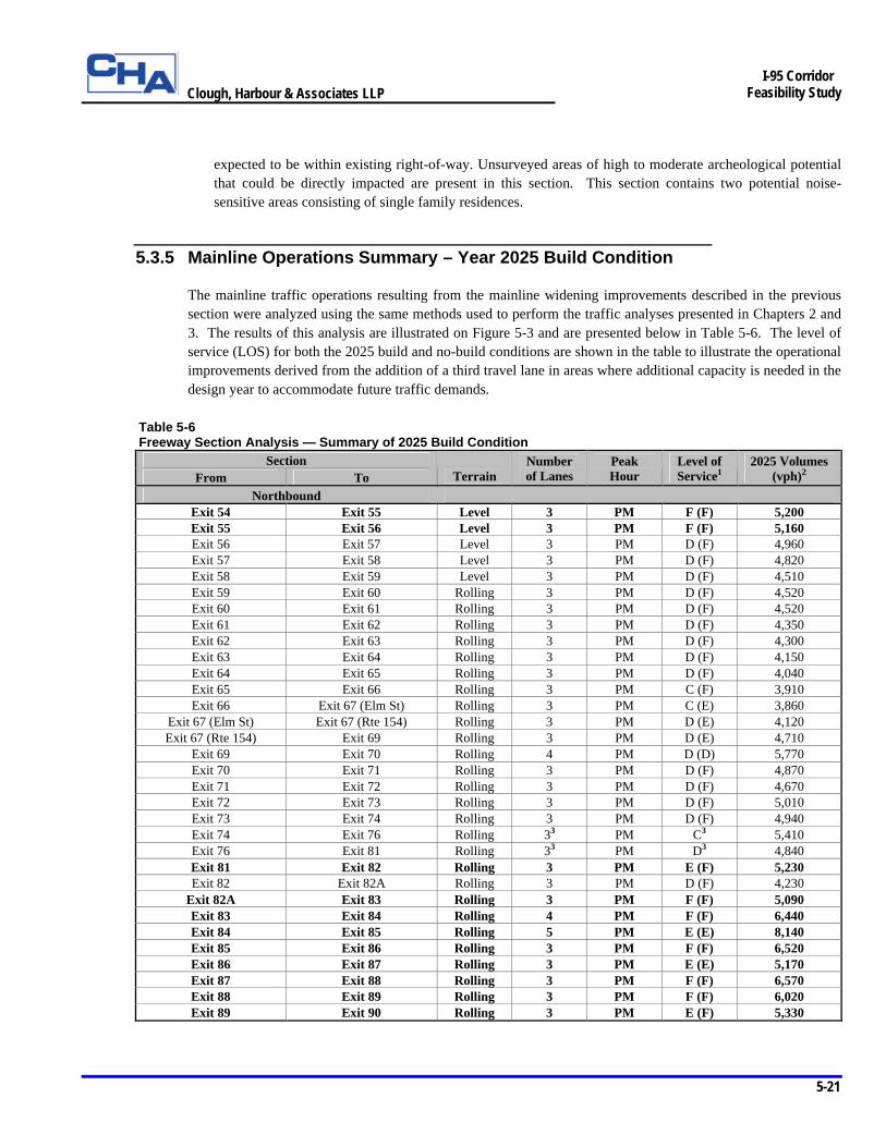
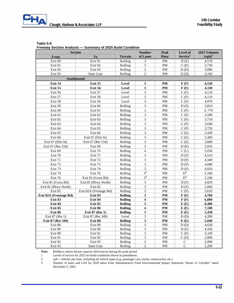
5.3.5 Mainline Operations Summary – Year 2025 Build Condition
The mainline traffic operations resulting from the mainline widening improvements described in the previous section were analyzed using the same methods used to perform the traffic analyses presented in Chapters 2 and 3. The results of this analysis are illustrated on Figure 5-3 and are presented below in Table 5-6. The level of service (LOS) for both the 2025 build and no-build conditions are shown in the table to illustrate the operational improvements derived from the addition of a third travel lane in areas where additional capacity is needed in the design year to accommodate future traffic demands.
Table 5-6 Freeway Section Analysis — Summary of 2025 Build Condition
Section From To Terrain
Number of Lanes
Peak Hour
Level of Service1
2025 Volumes (vph)2
Northbound Exit 54 Exit 55 Level 3 PM F (F) 5,200 Exit 55 Exit 56 Level 3 PM F (F) 5,160 Exit 56 Exit 57 Level 3 PM D (F) 4,960 Exit 57 Exit 58 Level 3 PM D (F) 4,820 Exit 58 Exit 59 Level 3 PM D (F) 4,510 Exit 59 Exit 60 Rolling 3 PM D (F) 4,520 Exit 60 Exit 61 Rolling 3 PM D (F) 4,520 Exit 61 Exit 62 Rolling 3 PM D (F) 4,350 Exit 62 Exit 63 Rolling 3 PM D (F) 4,300 Exit 63 Exit 64 Rolling 3 PM D (F) 4,150 Exit 64 Exit 65 Rolling 3 PM D (F) 4,040 Exit 65 Exit 66 Rolling 3 PM C (F) 3,910 Exit 66 Exit 67 (Elm St) Rolling 3 PM C (E) 3,860
Exit 67 (Elm St) Exit 67 (Rte 154) Rolling 3 PM D (E) 4,120 Exit 67 (Rte 154) Exit 69 Rolling 3 PM D (E) 4,710
Exit 69 Exit 70 Rolling 4 PM D (D) 5,770 Exit 70 Exit 71 Rolling 3 PM D (F) 4,870 Exit 71 Exit 72 Rolling 3 PM D (F) 4,670 Exit 72 Exit 73 Rolling 3 PM D (F) 5,010 Exit 73 Exit 74 Rolling 3 PM D (F) 4,940 Exit 74 Exit 76 Rolling 33 PM C3 5,410 Exit 76 Exit 81 Rolling 33 PM D3 4,840 Exit 81 Exit 82 Rolling 3 PM E (F) 5,230 Exit 82 Exit 82A Rolling 3 PM D (F) 4,230
Exit 82A Exit 83 Rolling 3 PM F (F) 5,090 Exit 83 Exit 84 Rolling 4 PM F (F) 6,440 Exit 84 Exit 85 Rolling 5 PM E (E) 8,140 Exit 85 Exit 86 Rolling 3 PM F (F) 6,520 Exit 86 Exit 87 Rolling 3 PM E (E) 5,170 Exit 87 Exit 88 Rolling 3 PM F (F) 6,570 Exit 88 Exit 89 Rolling 3 PM F (F) 6,020 Exit 89 Exit 90 Rolling 3 PM E (F) 5,330
Clough, Harbour & Associates LLP
5-22
I-95 Corridor
Feasibility Study
Table 5-6 Freeway Section Analysis — Summary of 2025 Build Condition
Section From To Terrain
Number of Lanes
Peak Hour
Level of Service1
2025 Volumes (vph)2
Exit 90 Exit 91 Rolling 3 PM D (F) 4,570 Exit 91 Exit 92 Rolling 3 PM C (E) 3,720 Exit 92 Exit 93 Rolling 2 PM D (D) 3,080 Exit 93 State Line Rolling 2 PM D (D) 3,160
Southbound Exit 54 Exit 55 Level 3 PM F (F) 4,520 Exit 55 Exit 56 Level 3 PM F (F) 4,330 Exit 56 Exit 57 Level 3 PM C (F) 4,110 Exit 57 Exit 58 Level 3 PM C (F) 4,110 Exit 58 Exit 59 Level 3 PM C (F) 4,070 Exit 59 Exit 60 Rolling 3 PM D (F) 3,810 Exit 60 Exit 61 Rolling 3 PM C (F) 3, 770 Exit 61 Exit 62 Rolling 3 PM C (F) 3,580 Exit 62 Exit 63 Rolling 3 PM C (F) 3,710 Exit 63 Exit 64 Rolling 3 PM C (F) 3,640 Exit 64 Exit 65 Rolling 3 PM C (F) 3,720 Exit 65 Exit 66 Rolling 3 PM C (E) 3,430 Exit 66 Exit 67 (Elm St) Rolling 3 PM C (E) 3,360
Exit 67 (Elm St) Exit 67 (Rte 154) Rolling 3 PM C (E) 3,600 Exit 67 (Rte 154) Exit 69 Rolling 3 PM D (E) 3,910
Exit 69 Exit 70 Rolling 4 PM C (C) 5,030 Exit 70 Exit 71 Rolling 3 PM D (F) 4,510 Exit 71 Exit 72 Rolling 3 PM D (F) 4,340 Exit 72 Exit 73 Rolling 3 PM D (F) 4,680 Exit 73 Exit 74 Rolling 3 PM D (F) 4,820 Exit 74 Exit 76 Rolling 33 PM D3 5,180 Exit 76 Exit 81 (Cross Rd) Rolling 33 PM D3 5,190
Exit 81 (Cross Rd) Exit 81 (Pkwy North) Rolling 3 PM D (F) 4,820 Exit 81 (Pkwy North) Exit 82 Rolling 3 PM D (F) 5,060
Exit 82 Exit 82A (Frontage Rd) Rolling 3 PM C (F) 3,610 Exit 82A (Frontage Rd) Exit 83 Rolling 3 PM F (F) 4,760
Exit 83 Exit 84 Rolling 4 PM F (F) 6,080 Exit 84 Exit 85 Rolling 5 PM E (E) 8,480 Exit 85 Exit 86 Rolling 4 PM E (E) 7,180 Exit 86 Exit 87 (Rte 1) Rolling 3 PM E (E) 5,430
Exit 87 (Rte 1) Exit 87 (Rte 349) Level 3 PM D (D) 4,280 Exit 87 (Rte 349) Exit 88 Rolling 3 PM E (E) 5,040
Exit 88 Exit 89 Rolling 3 PM D (D) 4,630 Exit 89 Exit 90 Rolling 3 PM D (F) 4,350 Exit 90 Exit 91 Rolling 3 PM C (E) 3,330 Exit 91 Exit 92 Rolling 3 PM C (D) 2,800 Exit 92 Exit 93 Rolling 2 PM C 2,090 Exit 93 State Line Rolling 2 PM C 2,290
Note: Boldface entries denote capacity deficiencies during the peak period. 1 Levels of service for 2025 no-build conditions shown in parentheses. 2 vph – vehicles per hour, including all vehicle types (e.g. passenger cars, trucks, motorcycles, etc.) 3 Number of lanes and LOS for 2020 taken from Administrative Final Environmental Impact Statement “Route 11 Corridor” dated
December 5, 2002.

Clough, Harbour & Associates LLP
5-23
I-95 Corridor
Feasibility Study
Northbound Freeway Sections Of the 36 total sections shown in Table 5-6, 24 will require a third travel lane to provide additional capacity along northbound I-95. The analysis showed that 22 of the 24 widened sections will experience an improved LOS in the evening peak hour. In addition, 19 of these 22 sections will operate acceptably under the peak hour traffic demands at LOS D or better. Overall, 24 of the 36 sections will operate acceptably at LOS D or better should the recommended mainline widening improvements be implemented. This is an improvement over the five sections that would operate acceptably if no capacity improvements are provided. Southbound Freeway Sections Of the 38 total sections shown in Table 5-6, 25 will require a third travel lane to provide additional capacity along southbound I-95. The analysis showed that 23 of the 25 widened sections will experience an improved LOS in the evening peak hour. In addition, all of these 23 sections will operate acceptably under the peak hour traffic demands at LOS D or better. Overall, 30 of the 38 sections will operate acceptably at LOS D or better should the recommended mainline widening improvements be implemented. This is an improvement over the eight sections that would operate acceptably if no capacity improvements are provided.
5.4 Interchange Improvement Concepts
As presented in Chapter 2 of this report, approximately half of the interchange ramps located within the project study area currently operate at unacceptable levels of service. In 2025, the fraction of ramps experiencing operational deficiencies would increase to approximately 9 out of every 10 if no capacity or geometric improvements are made to accommodate the future traffic demands. The combination of increasing traffic demands and operational deficiencies at these ramps also affect mainline and secondary roadway operations, leading to serious safety implications in many interchange locations. In addition, mainline widening to incorporate a third travel lane and 14 foot wide inside and outside shoulders will substantially impact the horizontal and vertical geometries of the existing interchange ramps in many locations. This is mainly the case in Areas 1 and 2 west of the Thames River where the widening will generally be accommodated at the outside shoulder as described in Section 5.3. In some locations, such as Exit 66 in Old Saybrook where the existing ramp geometry is dictated by particularly restrictive site constraints, more substantial realignment of the existing ramp configuration is required to both accommodate the mainline widening, and provide standard horizontal and vertical geometry. The interchange improvement concepts described in the following sections are developed to provide improved safety and operations for anticipated 2025 traffic demands, as well as accommodate the proposed typical section. These are generalized improvements that will be provided at every interchange. In addition to these generalized interchange improvements, the study team has evaluated interchange-specific improvements at certain locations that involve more substantial geometric alterations to enhance safety and operations. The process of identifying these locations, and developing and screening improvement concepts at each of these locations, is described in detail in Section 5.4.2. Detailed analyses of both the generalized and interchange-specific improvements for each interchange within the study area are presented in Section 5.4.3.

Clough, Harbour & Associates LLP
5-24
I-95 Corridor
Feasibility Study
5.4.1 Generalized Interchange Improvements
The general safety and operational improvements recommended at each interchange are designed to address the existing geometric deficiencies identified previously in Chapter 2 and the future operational deficiencies identified in Chapter 3. These improvements include standardizing acceleration and deceleration (speed-change) lanes, providing standard horizontal and vertical geometry at ramp junctions, and providing adequate intersection capacity and improved intersection geometry at deficient ramp and secondary roadway intersections. Each type of improvement is discussed in detail below. Speed-Change Lanes Speed-change lanes are auxiliary lanes utilized by vehicles for accelerating or decelerating as they enter or exit the mainline. Deceleration lanes are designed to provide sufficient length for a vehicle, once removed from the mainline traffic stream, to decelerate to a safe speed for entering the initial ramp curve. Acceleration lanes are designed to provide sufficient length for a vehicle to reach mainline speeds and merge into the mainline traffic stream. When acceleration or deceleration lanes provide less than adequate space for a vehicle to make the necessary speed change, the vehicle must utilize a portion of the mainline to execute the speed change, thus disrupting the flow of through traffic. The combination of nonstandard speed-change lanes and disrupted traffic flow not only results in operational deficiencies at the ramp merge and diverge points, but also results in serious safety concerns for all roadway users. Review of the existing geometric conditions conducted under Chapter 2 showed that approximately 80% of speed-change lanes throughout the study area are deficient based on 2001 AASHTO design standards. Many of these deficient lanes were designed and constructed in the 1960’s and 1970’s to meet less stringent criteria. Because of this, lanes meeting the design criteria set forth in 2001 AASHTO have been designed under this study and evaluated for their overall feasibility. Ramp Junctions The mainline widening required to accommodate a third travel lane and 14 foot wide inside and outside shoulders significantly affects the existing horizontal and vertical ramp geometries at the mainline and ramp junctions. As a result, it was necessary to evaluate the effects of the widening at each ramp junction and modify the horizontal and vertical alignment of the ramp as required to match the widened section. Each modified exit ramp junction was designed in accordance with the 1999 Connecticut Highway Design Manual (HDM), which requires a tapered deceleration lane and exit ramp configuration. In general, the exit curve and corresponding deceleration lane length were designed to accommodate minimum exit speeds of 35 mph. This is in accordance with current AASHTO guidelines that state ramp design speeds should be equal to at least one-half the mainline design speed. However, due to existing site constraints in some locations, the exit ramp curvature was designed to accommodate speeds less than 35 mph. In these cases, extended deceleration lane lengths corresponding to the higher standard speed reduction lengths were provided. Each modified entrance ramp junction was also designed in accordance with HDM design standards, which require a tapered approach with a minimum parallel acceleration length of 300 feet. In general, the entrance curve and corresponding acceleration lane length were designed to accommodate minimum ramp entrance speeds of 35 mph. Again, due to existing site constraints in some locations, the entrance ramp curvature and acceleration length were designed to accommodate speeds less than 35 mph.
Clough, Harbour & Associates LLP
5-25
I-95 Corridor
Feasibility Study
In all cases, the above improvements were designed to minimize impacts to the existing ramp alignment, local landscape and environmental resources. Weaves Weaving occurs when merging and diverging vehicles traveling in the same direction are required to cross paths in order to execute moves to and from closely spaced exit and entrance ramps. Several existing weaving sections located within the study area were identified in Chapter 2. The improvement concepts at these locations were designed to minimize the effects of weaving movements on the mainline traffic stream where possible by increasing the separation distance between ramp junctions, by separating the traffic streams or by providing auxiliary lanes connecting closely spaced ramps. Ramp and Secondary Roadway Intersections Intersection capacity analyses were performed in Chapter 3 at all signalized and unsignalized ramp and secondary roadway intersections in order to identify deficient locations in the 2025 evening peak hour. Improvement concepts were then developed at each of these locations and re-analyzed to determine their effectiveness in improving future operations. Recommended improvement concepts at signalized intersections include provisions for signal timing improvements, additional left and right turn lanes, additional through lanes on secondary roadways, increased storage lengths for queued vehicles, standard lane tapers and other geometric improvements. New traffic signals are also recommended at existing unsignalized intersections in many locations to improve intersection LOS, traffic flow and safety. Improvement concepts at unsignalized intersections that do not become signalized also include provisions for additional turn lanes and other geometric improvements to improve intersection LOS. The generalized improvement concepts, which include intersection, speed-change lane and ramp junction improvements for each interchange within the study area, are illustrated on Figure 5-2 and described in detail in Section 5.4.3. A summary of the future ramp and intersection operations for the 2025 build condition is presented in Section 5.4.4.
Clough, Harbour & Associates LLP
5-26
I-95 Corridor
Feasibility Study
5.4.2 Interchange-Specific Improvements Interchange-specific improvement concepts were developed and evaluated by the study team in 11 interchange areas. The majority of these areas were identified early in the study through the public involvement process. During this process, the study team solicited input from the stakeholders regarding specific areas that currently experience identified safety and operational problems. The 11 interchange areas identified through public involvement include: § Exit 59 – SR 718 (Goose Lane), Town of Guilford § Exit 60 – Mungertown Road, Town of Madison § Exit 62 – SR 450 (Hammonasset Connector), Town of Madison § Exit 63 – Route 81 (Killingworth Turnpike), Town of Clinton § Exit 67 – Elm Street, Town of Old Saybrook § Exits 67/68 – Route 154 (Middlesex Turnpike) and US Route 1, Town of Old Saybrook § Exit 70 – US Route 1 (Halls Road) and Route 156 (Neck Road), Town of Old Lyme § Exits 71/72 – Four Mile River Road and SR 449 (Rocky Neck Connector), Towns of Old Lyme and
East Lyme § Exit 74 – Route 161 (Flanders Road), Town of East Lyme § Exits 81/82/82A – Cross Road, Parkway North, Route 85 (Broad Street) and Frontage Roads, Town of
Waterford § Exit 90 – Route 27, Town of Stonington
The following paragraphs describe the process followed by the study team to develop and evaluate viable concept improvements in each of the 11 locations that would address the identified deficiencies. The specific improvement recommendations are illustrated on Figure 5-2 and are described in detail in Section 5.4.3. Concept Development/Screening Process Once the problem areas were identified, the study team initiated development of the preliminary improvement concepts. The first step of the development process consisted of a field evaluation conducted in each area by members of the study team. The field evaluation provided an opportunity for the team to observe the existing physical site conditions and constraints as well as the typical traffic patterns through the area. The information obtained during the field evaluation phase was then used to recommend potential improvement concepts in each of the eleven areas. The preliminary layouts for these potential improvements were identified and developed at design charrettes conducted by the study team. Attendees of the charrettes included representatives from the Federal Highway Administration, ConnDOT’s offices of design, planning, traffic, and safety, district maintenance representatives, and the consultant design team. The preliminary layouts developed at the charrettes typically consisted of several different potential improvement concepts in each area that addressed the problems identified during the public involvement process. Concepts that incorporated ConnDOT and AASHTO design standards were later developed from these preliminary layouts and presented to the Advisory Committee (AC) for review. The AC members were given the opportunity to review the conceptual improvements, suggest revisions and recommend a preferred improvement concept in each area. Several local outreach meetings were conducted with each of the corridor towns representatives to either identify alternative improvement concepts or to further discuss the concepts
Clough, Harbour & Associates LLP
5-27
I-95 Corridor
Feasibility Study
relative to the town’s long-term development plans. In most cases, this screening process narrowed the number of alternative improvement concepts in each of the eleven areas to one or two preferred concepts. Refinement of Improvement Concepts The preferred improvement concepts recommended by the AC members during the initial screening process were further refined to better determine the transportation benefits, impacts and costs associated with each concept. This refinement involved assuming capacity requirements and lane usage along the ramps and secondary roadways within each area. Qualitative evaluations based on these assumptions were performed to determine the transportation-related benefits derived from the revised traffic patterns and redistributed traffic volumes. In addition, slope limits were determined to identify significant areas of environmental and right-of-way impacts. A preliminary evaluation of the environmental and right-of-way impacts was also conducted so that additional refinements to the preliminary horizontal and vertical alignments could be made to minimize these impacts. When the refinement phase was completed, a preliminary construction cost estimate for the entire study area was developed. This estimate, which was exclusive of right-of-way and environmental mitigation costs, included all roadway and bridge structure costs associated with the mainline widening improvements, generalized interchange improvements, and the interchange-specific improvements in the identified problem areas. The refined improvement concepts were then presented with preliminary construction cost estimates to the AC members for their review and concurrence. Any additional recommendations made by the committee at this time were considered and incorporated into the improvement concepts where appropriate. ConnDOT also conducted an exhaustive internal review of the interchange improvement concepts and their associated construction cost estimates. ConnDOT’s review weighed the transportation and safety-related benefits derived from each improvement against the overall cost and impacts. The results of this cost-benefit analysis were used to recommend several modifications to the preferred improvement concepts.
5.4.3 Analysis of Interchange Improvement Concepts
The interchange improvement concepts, which consist of both generalized improvements and interchange-specific improvements as described above, were developed to address the safety and operational deficiencies identified in Chapter 2, as well as specific problems identified through the public outreach process. The overall feasibility, economic cost, environmental impacts and overall transportation benefits associated with these improvements have been analyzed and a summary of this analysis is provided on the following fact sheets. Fact sheets were developed for each interchange within the study area and provide a brief description of the interchange improvements, a list of issues and solutions associated with each interchange area, and a summary table for the estimated construction costs. Environmental impacts in the interchange areas are discussed in greater detail in the section following the fact sheets. In addition, near-term improvements have been identified for many of the interchange areas and are noted on the fact sheets. Chapter 6 provides further discussion regarding these recommended near-term improvements.
Clough, Harbour & Associates LLP
5-28
I-95 Corridor
Feasibility Study
Exit 54 – SR 740 (Cedar Street), Town of Branford Exit 54 is a diamond interchange located in the Town of Branford at the southern (western) limit of the project study area. This interchange provides access to both local residential development in the area and significant commercial development along Cedar Street and US Route 1, which is located just south of Exit 54. The existing northbound off-ramp and southbound on-ramp define the northern (eastern) limits of ConnDOT’s current New Haven Harbor Crossing Corridor Improvements, Contract D project along the I-95 corridor. This project, scheduled for completion in 2004, will provide a third general purpose travel lane in the northbound and southbound directions. Figure 5-2 (Sheet 1 of 124) presents the recommended long-term improvement concept at Exit 54. Improvements to all four ramp termini and Cedar Street are being constructed under the current ConnDOT project. As a result, the improvement concept at this interchange is limited to providing standard acceleration and deceleration lanes and minor geometric improvements to the ramp merge and diverge areas at the northbound on-ramp and southbound off-ramp. The gore nose at the southbound off-ramp is shifted north along I-95 to provide adequate deceleration length to the back of the traffic queue in the design hour. Issues Ø Poor LOS along NB and SB I-95 Ø Poor LOS at NB on-ramp merge and SB off-ramp diverge Ø Nonstandard acceleration and deceleration lane lengths at NB on-ramp and SB off-ramp junctions Ø High accident location Ø Poor LOS at intersection of NB ramps and Cedar Street Ø Poor LOS at intersection of SB ramps and Cedar Street Ø Poor LOS at intersection of Cedar Knolls Drive and Cedar Street Ø Poor LOS at intersection of Cedar Street and US Route 1 Solutions Ø Provide mainline widening to three lanes NB and SB through interchange area Ø Standardize NB acceleration and SB deceleration lanes to improve safety and operations at ramp merge and diverge locations Ø Signalize intersection of Cedar Knolls Drive and Cedar Street to improve intersection operations Ø Confirm that lane usage at NB ramps, SB ramps and US Route 1 intersections with Cedar Street being reconstructed under
current ConnDOT project meet anticipated 2025 traffic demands Construction Costs (2004 $)
Roadway $ 5,100,000Bridge Structures $ 6,500,000Right-of-Way $ 25,000Environmental Mitigation (0.32 acres) $ 60,000Other $ 4,915,000Total $ 16,600,000
Near-Term Improvement Opportunities Ø Acceleration lane improvements at the NB on-ramp are low priority Ø Signal timing/phasing modifications at the intersection of US Route 1 and Cedar Street are low priority Ø Signalization of the intersection of Cedar Street and Cedar Knolls Drive is low priority
Clough, Harbour & Associates LLP
5-29
I-95 Corridor
Feasibility Study
Exit 55 – US Route 1 (East Main Street), Town of Branford Exit 55, located in the Town of Branford, provides access to both local residential development in the area and several commercial developments along US Route 1. Route 139 (North Branford Road) is located off US Route 1 just north of Exit 55 and provides access to North Branford from I-95. An existing Park & Ride lot is located on the southbound side of US Route 1 opposite the northbound off-ramp intersection and provides parking space for approximately 70 vehicles. Figure 5-2 (Sheet 5 of 124) presents the recommended long-term improvement concept at Exit 55. Right-turn lanes are provided on the northbound and southbound off-ramp approaches to US Route 1 and additional northbound and southbound travel lanes are provided along US Route 1 to improve intersection capacities through this area. Standard acceleration and deceleration lanes are also provided at each ramp junction with I-95. Issues Ø Poor LOS along NB and SB I-95 Ø Poor LOS at all ramp merge and diverge locations Ø Nonstandard acceleration and deceleration lane lengths at all ramp junctions Ø Poor LOS at intersection of NB ramps and US Route 1 Ø Poor LOS at intersection of SB ramps and US Route 1 Solutions Ø Continue mainline widening to three lanes NB and SB through interchange area Ø Standardize all acceleration and deceleration lanes to improve safety and operations at ramp merge and diverge locations Ø Provide right-turn lane on NB off-ramp approach to US Route 1 Ø Provide right-turn lane on SB off-ramp approach to US Route 1 Ø Provide an additional NB and SB travel lane along US Route 1 through interchange area Ø Improve traffic signal timing/phasing at NB and SB ramp intersections with US Route 1 Construction Costs (2004 $)
Roadway $ 12,900,000 Bridge Structures $ 6,400,000 Right-of-Way $ 500,000 Environmental Mitigation (0.5 acres) $ 100,000 Other $ 8,500,000 Total $ 28,400,000
Near-Term Improvement Opportunities Ø Acceleration lane improvements at the NB on-ramp are medium priority Ø Acceleration lane improvements at the SB on-ramp are low priority Ø Intersection improvements at the SB ramps intersection with US Route 1 are low priority Other Considerations Ø Relocate the existing Park & Ride lot to mitigate the loss of 70 existing spaces
Clough, Harbour & Associates LLP
5-30
I-95 Corridor
Feasibility Study
Exit 56 – Leetes Island Road, Town of Branford Exit 56 is a newly reconstructed interchange located in the Town of Branford that provides access to both commercial and industrial development located along East Industrial Road and Leetes Island Road. US Route 1 is located just north of Exit 56 and provides direct connections to Route 139 (North Branford Road) and Route 22 (Norton Hill Road) in the area. An existing Park & Ride lot is located on the northbound side of Leetes Island Road just south of the northbound on-ramp and provides parking space for approximately 40 vehicles. Figure 5-2 (Sheet 7 of 124) presents the recommended long-term improvement concept at Exit 56. The improvement concept at this location primarily consists of providing standard acceleration and deceleration lanes at each substandard ramp junction. Intersection and secondary roadway improvements completed in 2003 under a separate ConnDOT project provide sufficient intersection capacity for 2025 peak hour volumes at this interchange. In addition, the Leetes Island Road overpass was reconstructed under this previous project and provides sufficient lateral and vertical clearance to accommodate future widening of the mainline to six lanes. Issues Ø Poor LOS along NB and SB I-95 Ø Poor LOS at NB and SB ramp merge and diverge locations Ø Nonstandard acceleration and deceleration lane lengths at NB ramp junctions and SB on-ramp from Leetes Island Road Solutions Ø Continue mainline widening to three lanes NB and SB through interchange area Ø Standardize all deficient acceleration and deceleration lanes to improve safety and operations at ramp merge and diverge
locations Construction Costs (2004 $)
Roadway $ 7,500,000 Bridge Structures $ 0 Right-of-Way $ 25,000 Environmental Mitigation (0.91 acres) $ 180,000 Other $ 3,095,000 Total $ 10,800,000
Near-Term Improvement Opportunities Ø Acceleration and deceleration lane improvements at the SB on-ramp from Leetes Island Road and the NB off-ramp are medium
priority Ø Acceleration lane improvements at the NB on-ramp are low priority Other Considerations Ø No impacts to the existing Park & Ride lot
Clough, Harbour & Associates LLP
5-31
I-95 Corridor
Feasibility Study
Exit 57 – US Route 1 (Boston Post Road), Town of Guilford Exit 57, located in the Town of Guilford, provides access to US Route 1. Several commercial developments are located off US Route 1 in this area and local residential development is also nearby. An existing Park & Ride lot is located on the southbound side of US Route 1 adjacent to the southbound on-ramp and provides parking space for approximately 20 vehicles. Figure 5-2 (Sheet 14 of 124) presents the recommended long-term improvement concept at Exit 57. The improvement concept primarily consists of providing standard acceleration and deceleration lanes at each ramp junction with I-95 and minor intersection improvements. Separate right and left turn lanes are provided on the southbound and northbound off-ramp approaches to US Route 1 and US Route 1 is widened to provide a northbound left-turn lane to the northbound on-ramp. Issues Ø Poor LOS along NB and SB I-95 Ø Poor LOS at all ramp merge and diverge locations Ø Nonstandard acceleration and deceleration lane lengths at all ramp junctions Ø Poor LOS at intersection of NB ramps and US Route 1 Ø Poor LOS at intersection of SB ramps and US Route 1 Solutions Ø Continue mainline widening to three lanes NB and SB through interchange area Ø Standardize all acceleration and deceleration lanes to improve safety and operations at ramp merge and diverge locations Ø Provide right-turn lane on NB off-ramp approach to US Route 1 Ø Widen US Route 1 to provide NB left-turn lane to NB on-ramp Ø Provide right-turn lane on SB off-ramp approach to US Route 1 Construction Costs (2004 $)
Roadway $ 8,300,000 Bridge Structures $ 7,400,000 Right-of-Way $ 700,000 Environmental Mitigation (0.42 acres) $ 80,000 Other $ 6,720,000 Total $ 23,200,000
Near-Term Improvement Opportunities Ø Acceleration and deceleration lane improvements at the NB and SB ramps are low priority Other Considerations Ø No impacts to the existing Park & Ride lot
Clough, Harbour & Associates LLP
5-32
I-95 Corridor
Feasibility Study
Exit 58 – Route 77 (Church Street), Town of Guilford Exit 58 is located in the Town of Guilford and provides access to Route 77. This exit also provides access to US Route 1 located off Route 77 to the south and to the Shore Line East railroad station located approximately 1.5 miles south of the interchange off Route 77. Existing Park & Ride lots are located on the northbound and southbound sides of Route 77 within the interchange and provide parking space for approximately 158 vehicles. Figure 5-2 (Sheet 16 of 124) presents the recommended long-term improvement concept at Exit 58. The improvement concept primarily consists of providing standard acceleration and deceleration lanes at each ramp junction with I-95 and secondary roadway and ramp intersection improvements. Northbound and southbound right-turn lanes are provided on Route 77 at the northbound and southbound ramp intersections. Route 77 is also widened to provide left-turn lanes at each of these intersections to improve intersection capacities and operations through the interchange area. Issues Ø Poor LOS along NB and SB I-95 Ø Poor LOS at all ramp merge and diverge locations Ø Nonstandard acceleration and deceleration lane lengths at all ramp junctions Ø Poor LOS at intersection of NB ramps and Route 77 Solutions Ø Continue mainline widening to three lanes NB and SB through interchange area Ø Standardize all acceleration and deceleration lanes to improve safety and operations at ramp merge and diverge locations Ø Signalize intersection of SB ramps and Route 77 Ø Improve signal timing/phasing at NB ramps intersection with Route 77 Ø Provide NB right-turn lane on Route 77 to NB on-ramp Ø Provide SB right-turn lane on Route 77 to SB on-ramp Ø Widen Route 77 to provide left-turn lanes to NB and SB on-ramps Construction Costs (2004 $)
Roadway $ 7,000,000 Bridge Structures $ 6,800,000 Right-of-Way $ 1,000,000 Environmental Mitigation (0.47 acres) $ 90,000 Other $ 6,010,000 Total $ 20,900,000
Near-Term Improvement Opportunities Ø Acceleration and deceleration lane improvements at the SB ramps are low priority Other Considerations Ø Impacts to the Park & Ride lots result in approximately 55 lost spaces
Clough, Harbour & Associates LLP
5-33
I-95 Corridor
Feasibility Study
Exit 59 – SR 718 (Goose Lane), Town of Guilford Exit 59, located in the Town of Guilford, provides access to both local residential development in the area and significant commercial development along US Route 1 and Goose Lane. This interchange also provides access to the Yale-New Haven Hospital Shoreline Medical Center that was recently constructed on Goose Lane. The Town of Guilford, through the public outreach process of this study, has also noted that a considerable volume of local traffic destined for Madison via US Route 1 utilizes Exit 59 due to the limited northbound and southbound access at Exit 60 located in Madison. An existing Park & Ride lot is located on the southbound side of Goose Lane within the interchange and provides parking space for approximately 58 vehicles. Figure 5-2 (Sheet 19 of 124) presents the recommended long-term improvement concept at Exit 59. The improvement concept relocates the northbound ramps to intersect US Route 1 in a button-hook configuration approximately 800 feet west of the existing US Route 1, Goose Lane and Soundview Road intersection. The location of this intersection aligns with the Wendy’s restaurant commercial drive located on the northbound side of US Route 1 to form a four-legged signalized intersection. This configuration is designed to eliminate the operational problems caused by the existing location of the northbound ramps intersection. Southbound traffic queuing on Goose Lane at the intersection of Goose Lane and US Route 1 interferes with the operation of the northbound off-ramp, which is located approximately 100 ft to the north, causing significant delays. Widening is required on US Route 1 to accommodate additional turn lanes and an additional eastbound and westbound travel lane in this area. Intersection improvements are also provided at the intersections of the southbound ramps and Goose lane; Goose Lane and Clapboard Hill Road; and Goose Lane and US Route 1 in order to improve operations through this area. One other improvement concept was evaluated at Exit 59. This concept relocated the northbound off-ramp to US Route 1 as described above, however the northbound on-ramp was maintained at its existing location. The ultimate consolidation of the northbound ramps at one location is preferred because the complete elimination of the closely spaced northbound ramps and US Route 1 intersections maximizes the transportation-related benefits in this area. Issues Ø Poor LOS along NB and SB I-95 Ø Poor LOS at all ramp merge and diverge locations Ø Nonstandard acceleration and deceleration lane lengths at NB off-ramp and SB ramp junctions Ø High accident location at US Route 1, Goose Lane and Soundview Road intersection Ø Poor LOS at intersection of SB ramps and Goose Lane Ø Poor LOS at intersection of Goose Lane and Clapboard Hill Road Ø Poor LOS at intersection of US Route 1, Goose Lane and Soundview Road Ø Inadequate separation distance between NB ramps and US Route 1 intersections with Goose Lane Solutions Ø Continue mainline widening to three lanes NB and SB through interchange area Ø Standardize all deficient acceleration and deceleration lanes to improve safety and operations at ramp merge and diverge
locations Ø Signalize intersection of SB ramps and Goose Lane Ø Improve intersection geometry of SB off-ramp approach to Goose Lane and provide right-turn lane Ø Widen Goose Lane to provide NB left-turn lane and SB right-turn lane to SB on-ramp Ø Signalize intersection of Goose Lane and Clapboard Hill Road Ø Reconfigure NB ramps and relocate NB ramps intersection to US Route 1 Ø Provide EB and WB left-turn lanes and WB right-turn lane on US Route 1 at NB ramps intersection Ø Provide additional EB and WB travel lanes along US Route 1 through interchange area Ø Provide NB left-turn lane and additional NB travel lane on Soundview Road at US Route 1 intersection Ø Provide SB right-turn lane on Goose Lane at US Route 1 intersection Ø Improve traffic signal timing/phasing at intersection of US Route 1 and Goose Lane
Clough, Harbour & Associates LLP
5-34
I-95 Corridor
Feasibility Study
Exit 59 – SR 718 (continued) Construction Costs (2004 $)
Roadway $ 9,300,000 Bridge Structures $ 3,800,000 Right-of-Way $ 5,000,000 Environmental Mitigation (1.0 acre) $ 200,000 Other $ 5,600,000 Total $ 23,900,000
Near-Term Improvement Opportunities Ø Relocation of the NB off-ramp is a high priority interchange improvement Ø Acceleration lane improvements at the SB on-ramp are low priority Ø Deceleration lane improvements at the NB off-ramp are low priority Ø Intersection improvements at the US Route 1, Goose Lane, Soundview Road intersection are high priority Ø Intersection improvements at the SB ramps intersection with Goose Lane are low priority Other Considerations Ø No impacts to the existing Park & Ride lot Ø Relocation of the Department of Transportation’s salt shed is required. Potential relocation site identified in the vicinity of the
existing NB off-ramp which is to be removed. Ø Potential realignment or intersection geometry improvements at the Boston Street approach to US Route 1 are recommended
for consideration in conjunction with near or long-term improvements along US Route 1.
Clough, Harbour & Associates LLP
5-35
I-95 Corridor
Feasibility Study
Exit 60 – Mungertown Road, Town of Madison Exit 60 is an existing half-diamond interchange located in the Town of Madison. The interchange consists of a northbound on-ramp and southbound off-ramp that provide access from I-95 to primarily local residential development in the area. Mungertown Road via Exit 60 also provides access to US Route 1 located to the south of the interchange. Figure 5-2 (Sheets 22 and 23 of 124) presents the recommended long-term improvement concept at Exit 60. The improvement concept at this location provides a northbound off-ramp and southbound on-ramp at Wildwood Avenue located approximately one half mile west of Mungertown Road. The addition of these ramps creates a full-service, split diamond interchange at Exit 60 in this area. A signed route directing motorists from one half of the interchange to the other can be provided from Wildwood Avenue to Mungertown Road via Green Hill Road and Nortontown Road. An alternative connection can be provided via US Route 1, however potential low clearance issues at the railroad overpass on Mungertown Road would need to be addressed. The addition of the ramps at Wildwood Avenue results in fewer impacts than completing the diamond interchange at Mungertown Road. The Town of Guilford in cooperation with the Town of Madison requested that full access be accommodated at Exit 60 to help relieve congestion at Exit 59 created by motorists traveling to and from North Madison and Killingworth. No other major improvement concepts were considered by the study team at this location. Issues Ø Poor LOS along NB and SB I-95 Ø Poor LOS at ramp merge and diverge locations Ø Nonstandard acceleration and deceleration lane lengths at NB on-ramp and SB off-ramp junctions Ø Significant traffic demand at Exit 59 in the Town of Guilford caused by limited access at Exit 60 Solutions Ø Continue mainline widening to three lanes NB and SB through interchange area Ø Standardize acceleration and deceleration lanes to improve safety and operations at ramp merge and diverge locations Ø Provide NB off-ramp and SB on-ramp at Wildwood Avenue to create a full-service interchange at Exit 60 Construction Costs (2004 $)
Roadway $ 12,200,000 Bridge Structures $ 3,900,000 Right-of-Way $ 30,000 Environmental Mitigation (3.61 acres) $ 720,000 Other $ 6,650,000 Total $ 23,500,000
Near-Term Improvement Opportunities Ø Acceleration and deceleration lane improvements at the NB on-ramp and SB off-ramp are low priority
Clough, Harbour & Associates LLP
5-36
I-95 Corridor
Feasibility Study
Exit 61 – Route 79 (Durham Road), Town of Madison Exit 61 is located in the Town of Madison and provides access to Route 79 (Durham Road). This exit also provides access to US Route 1 located off Durham Road to the south and to the Shore Line East railroad station in Madison located south of the interchange off Bradley Road. An existing Park & Ride lot is also located on the southbound side of Route 79 within the interchange and provides parking space for approximately 197 vehicles. Figure 5-2 (Sheets 25 and 26 of 124) presents the recommended long-term improvement concept at Exit 61. Right-turn lanes are provided on the southbound off-ramp approach, Woodland Road approach and Old Route 79 approaches to Route 79. A new traffic signal is provided at the northbound ramp intersection and southbound left-turn lanes are provided on Route 79 at the southbound ramp, northbound ramp and Old Route 79 intersections. An additional northbound travel lane is also provided along Route 79 to improve intersection capacities through this area. Issues Ø Poor LOS along NB and SB I-95 Ø Poor LOS at ramp merge and diverge locations Ø Nonstandard acceleration and deceleration lane lengths at NB off-ramp and SB ramp junctions Ø Poor LOS at intersection of NB ramps and Route 79 Ø Poor LOS at intersection of SB ramps and Route 79 Ø Poor LOS at intersection of Route 79 and Woodland Road Ø Poor LOS at intersection of Route 79 and Park & Ride lot drive Solutions Ø Continue mainline widening to three lanes NB and SB through interchange area Ø Standardize deficient acceleration and deceleration lanes to improve safety and operations at ramp merge and diverge locations Ø Improve intersection geometry and signalize intersection of NB ramps and Route 79 Ø Provide right-turn lane on SB off-ramp approach to Route 79 Ø Improve signal timing/phasing at SB ramps intersection with Route 79 and coordinate with new traffic signal at NB ramps Ø Widen Route 79 to accommodate additional NB travel lane and SB left-turn lanes to SB on-ramp, NB on-ramp, Old Route 79 Ø Provide right-turn lane on Woodland Road approach to Route 79 Ø Provide right-turn lane on Old Route 79 approach to Route 79 Construction Costs (2004 $)
Roadway $ 10,500,000 Bridge Structures $ 2,500,000 Right-of-Way $ 450,000 Environmental Mitigation (0.61 acres) $ 120,000 Other $ 5,830,000 Total $ 19,400,000
Near-Term Improvement Opportunities Ø Deceleration lane improvements at the NB off-ramp are low priority Ø Acceleration and deceleration lane improvements at the SB ramps are low priority Ø Signalization of the NB ramps intersection with Route 79 is low priority Other Considerations Ø Potential Park & Ride lot expansion for approximately 50 new spaces can be accommodated to mitigate the loss of
approximately 80 existing spaces
Clough, Harbour & Associates LLP
5-37
I-95 Corridor
Feasibility Study
Exit 62 – SR 450 (Hammonasset Connector)/Hammonasset State Park, Town of Madison Exit 62 is located in the Town of Madison and provides direct access to Hammonasset State Park via SR 450 (Hammonasset Connector). US Route 1, located south of Exit 62, is also accessible from Hammonasset Connector. Figure 5-2 (Sheet 29 of 124) presents the recommended long-term improvement concept at Exit 62. The improvement concept realigns the southbound ramps in a button-hook configuration. The reconfigured ramps intersect Duck Hole Road approximately 900 feet east of the intersection of Duck Hole Road and Hammonasset Connector. The elimination of the southbound ramps intersection from Hammonasset Connector and the new traffic signal at the Duck Hole Road and northbound ramps intersections improve traffic operations along the connector. A westbound right-turn lane is provided on Duck Hole Road at the intersection with Hammonasset Connector. Auxiliary lanes are also provided in both directions along I-95 between the rest areas and Exit 62 ramps in order to improve weaving operations. The other improvement concept considered at Exit 62 relocated the southbound ramps intersection opposite New Road and provided a cul-de-sac for Duck Hole Road near the existing Hammonasset River crossing. This concept was ultimately deemed infeasible due primarily to the significant volume of traffic carried by Duck Hole Road. Issues Ø Poor LOS along NB and SB I-95 Ø Poor LOS at ramp merge and diverge locations Ø Nonstandard acceleration and deceleration lane lengths at all ramp junctions Ø Nonstandard spacing between ramps for NB and SB rest areas and ramps for Exit 62 Ø Poor LOS at intersection of SB ramps and Hammonasset Connector Ø Closely spaced intersections of Duck Hole Road and SB ramps along Hammonasset Connector Ø Intersection of NB off-ramp offset from intersection of NB on-ramp along Hammonasset Connector Solutions Ø Continue mainline widening to three lanes NB and SB through interchange area Ø Standardize acceleration and deceleration lanes to improve safety and operations at ramp merge and diverge locations Ø Provide auxiliary lane between NB rest area on-ramp and NB Exit 62 off-ramp Ø Provide auxiliary lane between SB Exit 62 on-ramp and SB rest area off-ramp Ø Reconfigure SB ramps and relocate SB ramps intersection to Duck Hole Road to eliminate intersection along Hammonasset
Connector Ø Signalize intersection of Duck Hole Road and Hammonasset Connector Ø Provide WB right-turn lane on Duck Hole Road at Hammonasset Connector Ø Realign NB off-ramp to eliminate offset from NB on-ramp and improve NB on-ramp intersection geometry Construction Costs (2004 $)
Roadway $ 7,000,000 Bridge Structures $ 10,500,000 Right-of-Way $ 35,000 Environmental Mitigation (0.10 acres) $ 20,000 Other $ 7,345,000 Total $ 24,900,000
Other Considerations Ø Potential new Park & Ride lot can be accommodated on the EB side of New Road providing approximately 100 new spaces Ø Potential new Park & Ride lot can be accommodated on the EB side of Duck Hole Road where the existing SB ramps are
removed providing approximately 100 new spaces
Clough, Harbour & Associates LLP
5-38
I-95 Corridor
Feasibility Study
Exit 63 – Route 81 (Killingworth Turnpike), Town of Clinton Exit 63, located in the Town of Clinton, provides access to local residential development in the area and numerous commercial developments along Route 81. This exit also provides access to US Route 1 located to the south and to the Shore Line East railroad station in Clinton also located south of the interchange off Route 81. Morgan High School and Clinton Crossing outlet mall are located along Route 81 immediately north of the interchange. An existing Park & Ride lot is located on the southbound side of Route 81 within the interchange providing parking space for approximately 135 vehicles. Figure 5-2 (Sheet 34 of 124) presents the recommended long-term improvement concept at Exit 63. The improvement concept consists of relocating the northbound off-ramp intersection with North High Street approximately 200 feet southwest of its existing location. This improves intersection operations by increasing the separation distance between the successive double left-turning movements from the northbound off-ramp to North High Street and Route 81. The ramp relocation also provides additional storage space for queuing vehicles on North High Street at the Route 81 intersection. The improvement concept at this interchange also consists of providing a northbound left-turn lane on Route 81 at North High Street and providing southbound right-turn lanes on Route 81 at the southbound ramp and North High Street intersections. A right-turn lane is provided on the northbound off-ramp approach to North High Street. An additional southbound travel lane is also provided along Route 81 to improve intersection capacities through this area. Several other major improvement concepts were evaluated by the study team at Exit 63, each of which focused on eliminating or improving the operations of the successive double left turning movements from the northbound off-ramp to North High Street and to Route 81. These improvements considered relocating Glenwood Road over I-95 to intersect with North High Street and providing button-hook northbound ramps west of Route 81; relocating North High Street over I-95 to intersect with Glenwood Road and relocating the northbound off-ramp to directly intersect Route 81; and replacing the signalized intersection of Route 81, North High Street and the northbound ramps with a two-lane roundabout. These concepts were generally rejected due to the overall estimated construction costs, the severity of environmental impacts and the extent of right-of-way requirements. Issues Ø Poor LOS along NB and SB I-95 Ø Poor LOS at ramp merge and diverge locations Ø Nonstandard acceleration and deceleration lane lengths at all ramp junctions Ø Poor LOS at intersection of NB on-ramp, Route 81 and North High Street Ø Poor LOS at intersection of SB ramps and Route 81 Ø Poor LOS at intersection of Route 81 and Glenwood Road Ø Inadequate separation distance between intersection of NB off-ramp and North High Street and intersection of North High
Street and Route 81 Ø Successive double left-turns from NB off-ramp to North High Street to NB Route 81 Solutions Ø Continue mainline widening to three lanes NB and SB through interchange area Ø Standardize acceleration and deceleration lanes to improve safety and operations at ramp merge and diverge locations Ø Relocate NB off-ramp intersection with North High Street approximately 200 feet southwest of existing location Ø Provide right-turn lane on NB off-ramp approach to North High Street Ø Provide NB left-turn lane and SB right-turn lane on Route 81 to North High Street Ø Provide SB right-turn lane on Route 81 to SB on-ramp Ø Provide additional SB travel lane along Route 81 through interchange area
Clough, Harbour & Associates LLP
5-39
I-95 Corridor
Feasibility Study
Exit 63 – Route 81 (Continued) Construction Costs (2004 $)
Roadway $ 10,700,000 Bridge Structures $ 5,800,000 Right-of-Way $ 3,000,000 Environmental Mitigation (2.31 acres) $ 460,000 Other $ 7,040,000 Total $ 27,000,000
Near-Term Improvement Opportunities Ø Acceleration and deceleration lane improvements at the NB ramps are low priority Ø Signal timing/phasing improvements at the NB on-ramp intersection with Route 81 are low priority Ø Intersection improvements at the SB ramps intersection with Route 81 are low priority Other Considerations Ø Minor impacts to the existing Park & Ride lot will not result in lost parking spaces Ø Positive barrier protection is recommended along the east side of the Park & Ride lot adjacent to Route 81 to channel
pedestrians leaving the lot to the crosswalks that cross Route 81 at Glenwood Road and the high school driveway Ø Recommended consideration given to combining the Ethan Allen furniture store drive with a full-access Clinton Crossing drive
to eliminate the store access located on Route 81 immediately north of the SB ramps intersection with Route 81
Clough, Harbour & Associates LLP
5-40
I-95 Corridor
Feasibility Study
Exit 64 – Route 145 (Horse Hill Road), Town of Westbrook Exit 64 is located in the Town of Westbrook and provides access to primarily residential development in the area via Route 145 (Horse Hill Road). Route 145 south of Exit 64 connects to SR 625 which links to the Grove Beach section of Westbrook. An existing Park & Ride lot is located on the northbound side of Route 145 immediately south of the northbound on-ramp and provides parking space for approximately 23 vehicles. Figure 5-2 (Sheet 38 of 124) presents the recommended long-term improvement concept at Exit 64. New traffic signals are provided on Route 145 at the northbound and southbound ramp intersections to improve traffic operations through the interchange area. Right-turn lanes are also provided on the northbound and southbound off-ramp approaches to Route 145 and Route 145 is widened to accommodate northbound and southbound left-turns lanes at the ramp intersections. The alignment of Route 145 is shifted slightly to the east to accommodate a southbound right-turn lane while minimizing impacts to a residential property located in the northwest quadrant of the intersection of Route 145 and the southbound ramps. Separate southbound left and right turn lanes are also provided on Route 145 at the intersection of Old Clinton Road to improve operations. Issues Ø Poor LOS along NB and SB I-95 Ø Poor LOS at ramp merge and diverge locations Ø Nonstandard acceleration and deceleration lane lengths at all ramp junctions Ø Poor LOS at intersection of SB ramps and Route 145 Ø Poor LOS at intersection of Route 145 and Old Clinton Road Solutions Ø Continue mainline widening to three lanes NB and SB through interchange area Ø Standardize acceleration and deceleration lanes to improve safety and operations at ramp merge and diverge locations Ø Signalize intersection of NB ramps and Route 145 Ø Provide right-turn lane on NB off-ramp approach to Route 145 Ø Provide NB right-turn lane on Route 145 to NB on-ramp Ø Signalize intersection of SB ramps and Route 145 Ø Provide right-turn lane on SB off-ramp approach to Route 145 Ø Provide SB right-turn lane on Route 145 to SB on-ramp Ø Widen Route 145 to accommodate NB and SB left-turn lanes to NB and SB on-ramps Ø Provide separate SB left and right turn lanes on Route 145 at intersection of Old Clinton Road Construction Costs (2004 $)
Roadway $ 9,200,000 Bridge Structures $ 3,200,000 Right-of-Way $ 40,000 Environmental Mitigation (0.86 acres) $ 170,000 Other $ 5,290,000 Total $ 17,900,000
Near-Term Improvement Opportunities Ø Acceleration and deceleration lane improvements at the NB ramps and SB off-ramp are low priority Ø Intersection improvements at the NB and SB ramps intersections with Route 145 are high priority Other Considerations Ø Relocate the existing Park & Ride lot and provide approximately 50 new spaces to mitigate the loss of 23 existing spaces
Clough, Harbour & Associates LLP
5-41
I-95 Corridor
Feasibility Study
Exit 65 – Route 153 (Essex Road), Town of Westbrook Exit 65, located in the Town of Westbrook, provides access to Route 153 (Essex Road) and US Route 1 located to the south. This exit also provides access to the Westbrook Tanger Outlet Center and the Shore Line East railroad station in Westbrook, both located off Route 153 south of the interchange. An existing Park & Ride lot is also located off Flat Rock Place immediately south of the northbound on-ramp and provides parking space for approximately 50 vehicles. Figure 5-2 (Sheet 43 of 124) presents the recommended long-term improvement concept at Exit 65. The lane configurations at the ramp intersections with Route 153 remain unchanged. However, standard acceleration and deceleration lanes are provided at each ramp connection with I-95. The gore nose at the southbound off-ramp is shifted north along I-95 to provide adequate deceleration length to the back of the traffic queue in the design hour. Issues Ø Poor LOS along NB and SB I-95 Ø Poor LOS at ramp merge and diverge locations Ø Nonstandard acceleration and deceleration lane lengths at SB on-ramp and NB ramp junctions Solutions Ø Continue mainline widening to three lanes NB and SB through interchange area Ø Standardize deficient acceleration and deceleration lanes to improve safety and operations at ramp merge and diverge locations Ø Modify traffic signal timing/phasing at ramp intersections with Route 153 Construction Costs (2004 $)
Roadway $ 6,600,000 Bridge Structures $ 4,900,000 Right-of-Way $ 25,000 Environmental Mitigation (1.01 acres) $ 200,000 Other $ 4,975,000 Total $ 16,700,000
Near-Term Improvement Opportunities Ø Acceleration and deceleration lane improvements at the NB ramps are low priority Ø Acceleration lane improvements at the SB on-ramp are low priority Other Considerations Ø Minor impacts to the existing Park & Ride lot will result in a loss of approximately 20 parking spaces
Clough, Harbour & Associates LLP
5-42
I-95 Corridor
Feasibility Study
Exit 66 – Route 166 (Spencer Plain Road), Town of Old Saybrook Exit 66 is located in the Town of Old Saybrook and provides access to residential, commercial and industrial development along Route 166 (Spencer Plain Road). Route 166 connects US Route 1 located to the south and Route 153 located to the northwest. Figure 5-2 (Sheet 46 of 124) presents the recommended long-term improvement concept at Exit 66. The improvement concept primarily consists of providing standard acceleration and deceleration lanes at each ramp junction with I-95 and secondary roadway and ramp intersection improvements. Right-turn lanes are provided on the northbound and southbound off-ramp approaches to Route 166 and Route 166 is widened to accommodate a northbound left-turn lane at the northbound ramp intersection. This widening requires the replacement of the bridge structure over the Amtrak/Providence and Worcester Railroad. Issues Ø Poor LOS along NB and SB I-95 Ø Poor LOS at ramp merge and diverge locations Ø Nonstandard acceleration and deceleration lane lengths at NB off-ramp and SB ramp junctions Ø Poor LOS at intersection of NB ramps and Route 166 Ø Poor LOS at intersection of SB ramps and Route 166 Ø Short-radius horizontal curvature on NB on-ramp and SB on-ramp Solutions Ø Continue widening to three lanes NB and SB through interchange area Ø Standardize deficient acceleration and deceleration lanes to improve safety and operations at ramp merge and diverge locations Ø Signalize intersection of NB ramps and Route 166 Ø Provide right-turn lane on NB off-ramp approach to Route 166 Ø Signalize intersection of SB ramps and Route 166 Ø Provide right-turn lane on SB off-ramp approach to Route 166 Ø Widen Route 166 to accommodate NB left-turn lane to NB on-ramp Ø Slightly realign NB and SB ramps to accommodate minimum horizontal curvature Construction Costs (2004 $)
Roadway $ 8,900,000 Bridge Structures $ 2,500,000 Right-of-Way $ 250,000 Environmental Mitigation (2.81 acres) $ 560,000 Other $ 4,790,000 Total $ 17,000,000
Near-Term Improvement Opportunities Ø Deceleration lane improvements at the SB off-ramp are low priority Other Considerations Ø Realign a portion of a local roadway to accommodate the SB ramps realignment and to maintain access to residential properties Ø Reconstruct the Route 166 bridge over the Amtrak/Providence and Worchester Railroad to accommodate the additional left-
turn lane
Clough, Harbour & Associates LLP
5-43
I-95 Corridor
Feasibility Study
Exit 67 – Elm Street, Town of Old Saybrook Exit 67 is an existing split interchange located in the Town of Old Saybrook. The southern (western) half of the interchange consists of a northbound on-ramp and southbound off-ramp that provide access to and from Elm Street. The northern (eastern) half of the interchange consists of a northbound off-ramp and two southbound on-ramps that access Route 154. Due to the nature of the improvement concepts in these two locations, the specific improvements at Elm Street and Route 154 are presented under separate headings in the following discussion. Figure 5-2 (Sheet 49 of 124) presents the recommended long-term improvement concept at Exit 67 (Elm Street). The improvement concept provides a northbound off-ramp to Ingham Hill Road and a southbound on-ramp from Elm Street to create a full-service diamond interchange at this location. The northbound off-ramp intersects Ingham Hill Road approximately 700 ft west of the intersection of Ingham Hill Road and Elm Street. In order for the FHWA to endorse the construction of a full-diamond interchange at Elm Street, low clearance issues associated with the existing Amtrak bridge over Elm Street south of the intersection must be addressed to eliminate potential safety concerns at this location. The local municipality would be responsible for committing the funds to reconstruct this bridge to current design standards. No other major improvement concepts were considered by the study team at this location. Issues Ø Poor LOS along NB and SB I-95 Ø Poor LOS at ramp merge and diverge locations Ø Nonstandard acceleration lane length at NB on-ramp junction Ø Poor LOS at intersection of NB on-ramp, Ingham Hill Road and Elm Street Solutions Ø Continue widening to three lanes NB and SB through interchange area Ø Provide NB off-ramp and SB on-ramp to create full-service diamond interchange Ø Standardize acceleration and deceleration lanes to improve safety and operations at ramp merge and diverge locations Ø Signalize intersection of NB on-ramp, Ingham Hill Road and Elm Street Ø Signalize intersection of SB ramps and Elm Street Ø Widen Elm Street to accommodate NB left-turn lanes to Ingham Hill Road and SB on-ramp Construction Costs (2004 $)
Roadway $ 8,600,000 Bridge Structures $ 4,600,000 Right-of-Way $ 400,000 Environmental Mitigation (3.32 acres) $ 660,000 Other $ 5,440,000 Total $ 19,700,000
Near-Term Improvement Opportunities Ø Acceleration lane improvements at the NB on-ramp are low priority
Clough, Harbour & Associates LLP
5-44
I-95 Corridor
Feasibility Study
Exit 67 – Route 154 (Middlesex Turnpike), Town of Old Saybrook Exit 68 – US Route 1 (Boston Post Road), Town of Old Saybrook Exit 67 is an existing split interchange located in the Town of Old Saybrook. The southern (western) half of the interchange consists of a northbound on-ramp and southbound off-ramp that provide access to and from Elm Street. The northern (eastern) half of the interchange consists of a northbound off-ramp and two southbound on-ramps that access Route 154. Due to the nature of the improvement concepts in these two locations, the specific improvements at Elm Street and Route 154 are presented separately. Exit 68 consists of a northbound on-ramp from US Route 1 and a southbound off-ramp to US Route 1 via Springbrook Road. Both Exit 67 and Exit 68 function to provide access to residential development in the area and commercial development concentrated along US Route 1. Figure 5-2 (Sheet 51 and 53 of 124) presents the recommended long-term improvement concept at Exit 67 (Route 154) and Exit 68. The improvement concept at Exit 67 (Route 154) reconfigures the existing ramps to provide a full-service diamond interchange at this location. The provisions for a northbound on-ramp and a southbound off-ramp serve to replace the existing ramps at Exit 68. These ramps are eliminated due to a combination of factors including the northbound and southbound weaves between Exits 68 and 69 and site constraints at the existing Exit 68 ramp locations created by the addition of a third lane and the proximity of Exit 69. Other improvement concepts considered at these interchanges included a single-point diamond interchange (SPDI) to minimize environmental and right-of-way impacts at Exit 67 (Route 154) and the reconfiguration of the existing ramps at Exit 68. The SPDI design was eliminated from further consideration due to operational and maintenance concerns. The reconfigured ramps at Exit 68 were eliminated from further investigation due to the extent of right-of-way impacts the reconfigured ramps caused to numerous residential and commercial properties in the area. Issues Ø Poor LOS along NB and SB I-95 Ø Poor LOS at all ramp merge and diverge locations at both exits Ø Nonstandard acceleration and deceleration lane lengths at all Exit 67 (Route 154) ramp junctions Ø Poor LOS at intersection of NB off-ramp and Route 154 Ø Nonstandard interchange spacing SB and weaving sections NB and SB between Exit 68 and Exit 69 Solutions Ø Continue widening to three lanes NB and SB through interchange area Ø Provide NB on-ramp and SB off-ramp to create full-service diamond interchange at Exit 67 (Route 154) Ø Standardize acceleration and deceleration lanes to improve safety and operations at deficient ramp merge and diverge locations Ø Signalize intersection of NB ramps and Route 154 Ø Signalize intersection of SB ramps and Route 154 Ø Eliminate NB on-ramp and SB off-ramp at Exit 68 Ø Improve intersection geometry at Springbrook Road and Boston Post Road intersection
Clough, Harbour & Associates LLP
5-45
I-95 Corridor
Feasibility Study
Exits 67 and 68 (continued) Construction Costs (2004 $)
Roadway $ 10,700,000 Bridge Structures $ 4,700,000 Right-of-Way $ 50,000 Environmental Mitigation (2.67 acres) $ 530,000 Other $ 6,420,000 Total $ 22,400,000
Near-Term Improvement Opportunities Ø Acceleration and deceleration lane improvements at the SB on-ramp from SB Route 154 and the NB off-ramp are low priority Ø Signalization of the NB off-ramp intersection with Route 154 is low priority Other Considerations Ø With the elimination of Exit 68, signing modifications will be required to direct US Route 1 traffic to and from Exit 67 at Route
154. Currently, traffic is directed to and from I-95 through Exit 68 to accommodate crossing of the Connecticut River over the Baldwin Bridge. As a result of the signing modifications, Boston Post Road located between Route 154 and Exit 68 will no longer be designated US Route 1.
Clough, Harbour & Associates LLP
5-46
I-95 Corridor
Feasibility Study
Exit 69 – Route 9, Town of Old Saybrook Exit 69 is a freeway-to-freeway interchange connecting I-95 and Route 9. This interchange is located immediately west of the Connecticut River in the Town of Old Saybrook. Figure 5-2 (Sheet 54 of 124) presents the recommended long-term improvement concept at Exit 69. The improvement concept consists of providing standard acceleration and deceleration lane lengths and standard geometry at the ramp junctions for the northbound off-ramp and southbound on-ramp. Several major improvement concepts were investigated by the study team at Exit 69 that were subsequently rejected for a variety of reasons including the extent of additional right-of-way impacts, cost, aesthetic considerations and overall feasibility. Each of these improvement concepts focused on providing a freeway-to-freeway interchange with high-speed ramps in order to improve operations within the interchange. Issues Ø Poor LOS at NB on-ramp merge Ø Poor LOS at SB ramp merge and diverge locations Solutions Ø Standardize ramp merge and diverge geometry Ø Standardize SB acceleration lane and NB deceleration lane to improve safety and operations at ramp merge and diverge
locations Construction Costs (2004 $)
Roadway $ 6,800,000 Bridge Structures $ 4,100,000 Right-of-Way $ 0 Environmental Mitigation (0 acres) $ 0 Other $ 4,600,000 Total $ 15,500,000
Near-Term Improvement Opportunities Ø Deceleration lane improvements at the NB off-ramp are low priority Other Considerations Ø Existing three-lane section begins immediately south (west) of Exit 69 therefore no widening is required through the
interchange area Ø Transition from 14 foot inside and outside shoulder widths to existing shoulder widths at the Baldwin Bridge through the
interchange area
Clough, Harbour & Associates LLP
5-47
I-95 Corridor
Feasibility Study
Exit 70 – US Route 1/Route 156, Town of Old Lyme Exit 70 is a split diamond interchange located immediately east of the Connecticut River in the Town of Old Lyme. The southern (western) half of the diamond consists of a northbound off-ramp and southbound on-ramp that provide access to and from Route 156 and US Route 1. The northern (eastern) half of the diamond is located in the historic district of Old Lyme and consists of a northbound on-ramp and southbound off-ramp that provide access to and from US Route 1 and Lyme Street. An existing Park & Ride lot is located on the northbound side of Route 156 opposite the southbound on-ramp and provides parking space for approximately 50 vehicles. Figure 5-2 (Sheets 56 and 58 of 124) presents the recommended long-term improvement concept at Exit 70. The improvement concept at this interchange maintains the existing split diamond configuration, however approximately 500 feet of Old Bridge Road is improved and slightly realigned with US Route 1 to create a four-legged intersection with Route 156. The southbound on-ramp is also realigned in a button-hook configuration to intersect the improved section of Old Bridge Road. This realignment eliminates the southbound on-ramp and Route 156 intersection so that traffic destined for southbound I-95 from US Route 1 is directed straight across Route 156. Currently, this traffic from US Route 1 is required to make a left turn onto Route 156 and then a right turn onto the ramp, which is located approximately 250 feet south of US Route 1. The improvement concept is targeted at eliminating the operational problems associated with these closely spaced intersections. The northern ramps at Lyme Street and US Route 1 are also slightly realigned to provide adequate sight distance and queuing distance at the intersection of Lyme Street and US Route 1. Two other improvement concepts were also considered at this location. Both concepts focused on providing full-service access at Route 156 in order to eliminate the ramps at Lyme Street. Both concepts were subsequently eliminated from further consideration due to extensive impacts to existing residential properties located in the vicinity of the northbound off-ramp intersection with Route 156. Issues Ø Poor LOS along NB and SB I-95 Ø Abrupt NB lane reduction immediately south of Lieutenant River crossing Ø Poor LOS at NB off-ramp and SB ramp merge and diverge locations Ø Nonstandard acceleration and deceleration lane lengths at NB on-ramp and SB off-ramp junctions Ø High accident location Ø Intersection of SB on-ramp and Route 156 offset from intersection of US Route 1 and Route 156 Ø Poor LOS at intersection of SB on-ramp and Route 156 Ø Poor LOS at intersection of US Route 1 and Route 156 Ø Poor LOS at intersection of SB off-ramp and US Route 1 Solutions Ø Continue widening to three lanes NB and SB through interchange area and across Lieutenant River to eliminate “bottleneck”
effect Ø Standardize acceleration and deceleration lanes to improve safety and operations at deficient ramp merge and diverge locations Ø Realign SB on-ramp with US Route 1 to eliminate offset intersections and improve LOS Ø Modify signal timing at NB off-ramp and Route 156 intersection to improve capacity and LOS Ø Provide additional EB left-turn lane on US Route 1 (Halls Road) at Lyme Street/SB off-ramp intersection Ø Provide SB right-turn lane on US Route 1 (Boston Post Road) at Lyme Street/SB off-ramp intersection Ø Widen Lyme Street/US Route 1 (Boston Post Road) to accommodate NB left-turn lane to US Route 1 (Halls Road)
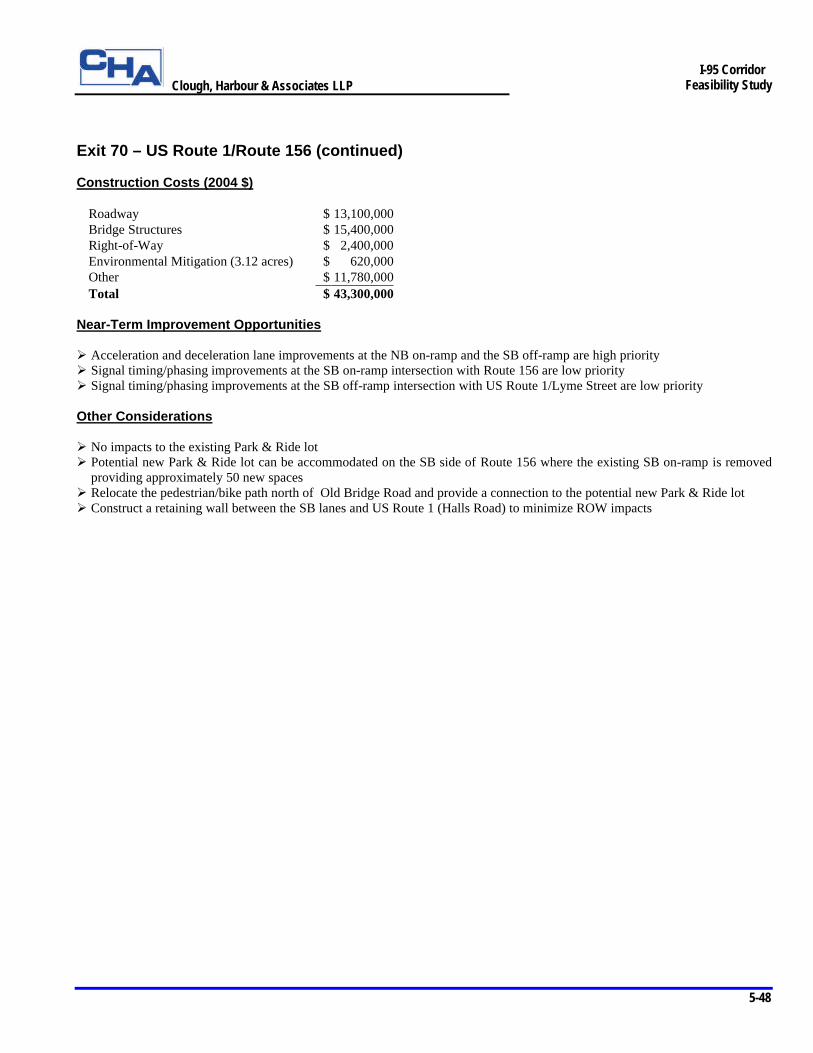
Clough, Harbour & Associates LLP
5-48
I-95 Corridor
Feasibility Study
Exit 70 – US Route 1/Route 156 (continued) Construction Costs (2004 $)
Roadway $ 13,100,000 Bridge Structures $ 15,400,000 Right-of-Way $ 2,400,000 Environmental Mitigation (3.12 acres) $ 620,000 Other $ 11,780,000 Total $ 43,300,000
Near-Term Improvement Opportunities Ø Acceleration and deceleration lane improvements at the NB on-ramp and the SB off-ramp are high priority Ø Signal timing/phasing improvements at the SB on-ramp intersection with Route 156 are low priority Ø Signal timing/phasing improvements at the SB off-ramp intersection with US Route 1/Lyme Street are low priority Other Considerations Ø No impacts to the existing Park & Ride lot Ø Potential new Park & Ride lot can be accommodated on the SB side of Route 156 where the existing SB on-ramp is removed
providing approximately 50 new spaces Ø Relocate the pedestrian/bike path north of Old Bridge Road and provide a connection to the potential new Park & Ride lot Ø Construct a retaining wall between the SB lanes and US Route 1 (Halls Road) to minimize ROW impacts
Clough, Harbour & Associates LLP
5-49
I-95 Corridor
Feasibility Study
Exit 71 – Four Mile River Road, Town of Old Lyme Exit 72 – Rocky Neck State Park/SR 449 (Rocky Neck Connector), Town of East Lyme Exit 71 is located in the towns of Old Lyme and East Lyme. This interchange provides access to several industrial developments along Four Mile River Road and Hatchetts Hill Road in the area. An existing Park & Ride lot is located on the northbound side of Four Mile River Road immediately north of the Exit 71 southbound off-ramp. Exit 72 is a trumpet interchange located several hundred feet north (east) of Exit 71 in the Town of East Lyme. Exit 72 provides access to Rocky Neck State Park via SR 449 (Rocky Neck Connector). Because the operations of both interchanges are significantly influenced by their proximity to each other, they have been considered an interchange “system” for the purposes of conducting this study and are presented together in the following discussion. Figure 5-2 (Sheets 65 and 66 of 124) presents the recommended long-term improvement concept at Exit 71 and Exit 72. The improvement concept incorporates a “scissors ramp” configuration in both the northbound and southbound directions to eliminate the mainline weaves between the two interchanges. In this configuration, northbound traffic to Rocky Neck Connector exits with northbound traffic to Four Mile River Road south (west) of Exit 71 and crosses over the northbound on-ramp from Four Mile River Road thus separating individual entering and exiting traffic movements. Similarly, southbound traffic to Four Mile River Road exits with southbound traffic to Rocky Neck Connector north (east) of Exit 72 and crosses over the southbound on-ramp from Rocky Neck Connector.
Numerous other improvement concepts were evaluated at this location, all of which addressed the safety and operational concerns associated with the mainline weaving conditions between the two interchanges. One concept considered eliminating access to Four Mile River Road via Exit 71 by removing the existing ramps. This concept was rejected by the study team because a significant volume of truck traffic would be forced to re-route across low volume roadways in order to access industrial developments along Four Mile River Road. Several other concepts incorporated northbound and southbound collector-distributor (CD) roads to remove the weaving conditions from the mainline. These concepts were later rejected on the basis that the scissors ramp configurations completely removed the weaving conditions between the interchanges, whereas the CD road configurations simply relocated the weaving conditions off the mainline. Issues Ø Poor LOS along NB and SB I-95 Ø Nonstandard interchange spacing NB and SB Ø Weaving sections NB and SB Ø Nonstandard acceleration and deceleration lane lengths at Exit 71 SB on-ramp and NB ramp junctions Ø Nonstandard acceleration and deceleration lane lengths at Exit 72 NB on-ramp and SB ramp junctions Ø High accident location Ø Poor LOS at intersection of Rocky Neck Connector and Route 156 Solutions Ø Continue widening to three lanes NB and SB through interchange area Ø Standardize acceleration and deceleration lanes to improve safety and operations at deficient ramp merge and diverge locations Ø Construct combined NB and SB off-ramps for Exits 71 and 72 to eliminate mainline weaving conditions Ø Provide additional SB left-turn lane on Rocky Neck Connector at intersection of Route 156
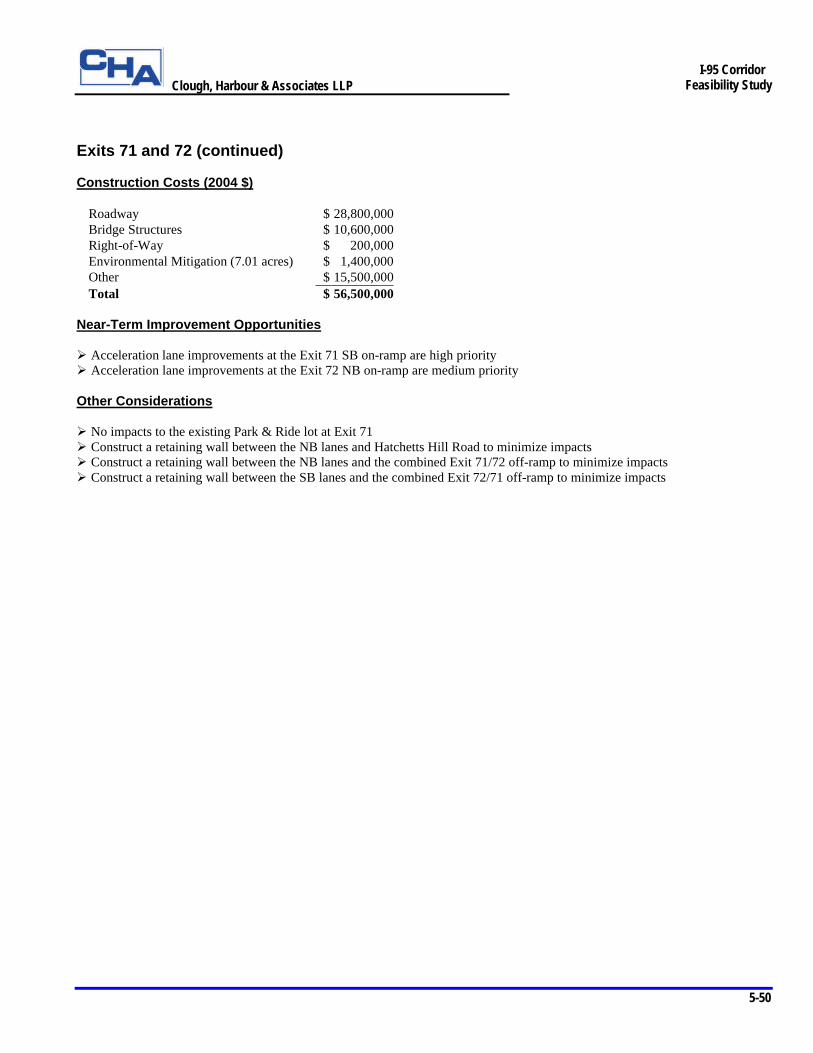
Clough, Harbour & Associates LLP
5-50
I-95 Corridor
Feasibility Study
Exits 71 and 72 (continued) Construction Costs (2004 $)
Roadway $ 28,800,000 Bridge Structures $ 10,600,000 Right-of-Way $ 200,000 Environmental Mitigation (7.01 acres) $ 1,400,000 Other $ 15,500,000 Total $ 56,500,000
Near-Term Improvement Opportunities Ø Acceleration lane improvements at the Exit 71 SB on-ramp are high priority Ø Acceleration lane improvements at the Exit 72 NB on-ramp are medium priority Other Considerations Ø No impacts to the existing Park & Ride lot at Exit 71 Ø Construct a retaining wall between the NB lanes and Hatchetts Hill Road to minimize impacts Ø Construct a retaining wall between the NB lanes and the combined Exit 71/72 off-ramp to minimize impacts Ø Construct a retaining wall between the SB lanes and the combined Exit 72/71 off-ramp to minimize impacts
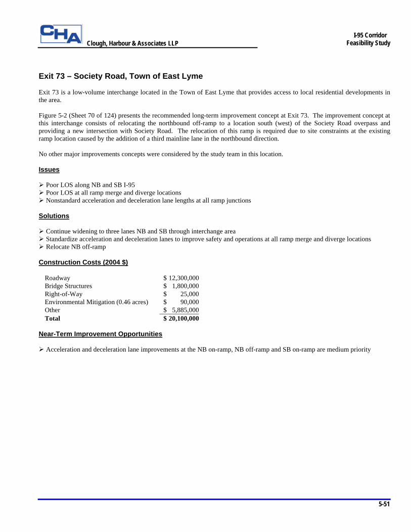
Clough, Harbour & Associates LLP
5-51
I-95 Corridor
Feasibility Study
Exit 73 – Society Road, Town of East Lyme Exit 73 is a low-volume interchange located in the Town of East Lyme that provides access to local residential developments in the area. Figure 5-2 (Sheet 70 of 124) presents the recommended long-term improvement concept at Exit 73. The improvement concept at this interchange consists of relocating the northbound off-ramp to a location south (west) of the Society Road overpass and providing a new intersection with Society Road. The relocation of this ramp is required due to site constraints at the existing ramp location caused by the addition of a third mainline lane in the northbound direction. No other major improvements concepts were considered by the study team in this location. Issues Ø Poor LOS along NB and SB I-95 Ø Poor LOS at all ramp merge and diverge locations Ø Nonstandard acceleration and deceleration lane lengths at all ramp junctions Solutions Ø Continue widening to three lanes NB and SB through interchange area Ø Standardize acceleration and deceleration lanes to improve safety and operations at all ramp merge and diverge locations Ø Relocate NB off-ramp Construction Costs (2004 $)
Roadway $ 12,300,000 Bridge Structures $ 1,800,000 Right-of-Way $ 25,000 Environmental Mitigation (0.46 acres) $ 90,000 Other $ 5,885,000 Total $ 20,100,000
Near-Term Improvement Opportunities Ø Acceleration and deceleration lane improvements at the NB on-ramp, NB off-ramp and SB on-ramp are medium priority
Clough, Harbour & Associates LLP
5-52
I-95 Corridor
Feasibility Study
Exit 74 – Route 161 (Flanders Road), Town of East Lyme
Exit 74 is located in the Town of East Lyme and functions as an important link between I-95 and numerous commercial developments located along Route 161 (Flanders Road) in this area. Two existing Park & Ride lots are located near the northbound on-ramp and provide parking space for approximately 68 vehicles. Exit 74 abuts the southern (western) limit of the planned Route 11 construction project that includes the reconstruction of the I-395/I-95 interchange and provides three NB and SB travel lanes along I-95 between Exit 74 and Exit 81.
Figure 5-2 (Sheet 73 of 124) presents the recommended long-term improvement concept at Exit 74. The improvement concept at this interchange provides standard horizontal curvature for the southbound ramps. The alignment of the ramps and their intersection with Route 161 maximize the separation distance between intersections along Route 161 while maintaining consistency with the Town of East Lyme’s plan for future development. This concept maintains the northbound off-ramp at its existing location and shifts the northbound on-ramp intersection approximately 50 feet south to accommodate the addition of a third northbound lane. These improvements are consistent with the planned Route 11 improvements in this area.
Several other improvement concepts were developed at this interchange that focused on maximizing the separation distance between intersections along Route 161 in order to improve traffic flow through the area. All of the concepts utilized similar southbound ramp improvements as described above, however a variety of northbound ramp and secondary road configurations were explored. These concepts were generally rejected for a combination of reasons including limited feasibility of the improvements and limited benefits derived from complex alignments.
Issues Ø Poor LOS along NB and SB I-95 Ø Nonstandard acceleration and deceleration lane lengths at all ramp junctions Ø Nonstandard horizontal curvature on SB ramps Ø Poor LOS at intersection of NB off-ramp, Route 161 and King Arthur Drive Solutions Ø Continue widening to three lanes NB and SB through interchange area Ø Standardize acceleration and deceleration lanes to improve safety and operations at all ramp merge and diverge locations Ø Realign SB ramps to improve geometry and increase separation distance between intersections along Route 161 Ø Signalize intersection of SB ramps and Route 161 Ø Improve intersection geometry and traffic signal timing/phasing at intersection of NB off-ramp and Route 161 Construction Costs (2004 $)
Roadway $ 7,500,000 Bridge Structures $ 7,600,000 Right-of-Way $ 2,800,000 Environmental Mitigation (1.52 acres) $ 300,000 Other $ 6,600,000 Total $ 24,800,000
Near-Term Improvement Opportunities Ø Acceleration and deceleration lane improvements at the NB on-ramp, NB off-ramp and SB off-ramp are medium priority Ø Acceleration lane improvements at the SB on-ramp are high priority Other Considerations Ø Relocate the existing Park & Ride lot and provide approximately 100 new to mitigate the loss of 68 existing spaces Ø Potential new Park & Ride and/or Information Center can be accommodated where the existing SB ramps are removed
Clough, Harbour & Associates LLP
5-53
I-95 Corridor
Feasibility Study
Exit 81 – Cross Road, Town of Waterford Exit 82 – Route 85 (Broad Street), Town of Waterford Exit 82A – Frontage Road, Town of Waterford and City of New London Exits 81, 82 and 82A are located in the Town of Waterford between the northern (eastern) limit of the planned Route 11/I-395/I-95 interchange improvement project and the Thames River. Because the operations of these interchanges are significantly influenced by their proximity to each other, they have been considered an interchange “system” for the purposes of conducting this study and are presented together in the following discussion.
Exit 81 at Cross Road, which provides access to a number of commercial developments located along Parkway North and Parkway South in the area, is being reconstructed under a current ConnDOT improvement project. Planned for completion in 2005, the reconstructed interchange will provide northbound buttonhook ramps to a realigned Parkway South and maintain the existing slip ramps to and from I-95. These slip ramps include the northbound on-ramp and southbound off-ramp both located in the vicinity of the northbound and southbound weigh stations, and the southbound on-ramp from Parkway South located just west of Cross Road. It should be noted that the new overpass structure being constructed under this project provides sufficient lateral and vertical clearance to accommodate future widening of the mainline to six lanes.
Exit 82 at Route 85 functions as an important link between I-95 and major commercial development in the area including a number of shopping malls located north along Route 85. This exit also provides access to downtown Waterford from I-95.
Exit 82A links I-95 to the northbound and southbound frontage roads, providing access to a number of commercial developments and downtown New London.
Figure 5-2 (Sheets 81 through 85 of 124) presents the recommended long-term improvement concept at Exits 81, 82 and 82A. The improvement concept within this interchange system eliminates the existing northbound and southbound mainline weaves between Exit 82 and Exit 82A by extending the frontage road system to Route 85 and relocating direct access to and from I-95 and the frontage roads. The northbound frontage road off-ramp is relocated upstream to a point south (west) of Route 85 such that traffic is removed from I-95 onto a frontage road serving Route 85 and Vauxhall Street. To replace existing access to southbound I-95 from Vauxhall Street, buttonhook ramps are provided at Vauxhall Street to the southbound frontage road system, which intersects Route 85 at grade. A two-way frontage road is provided west of Route 85 connecting to the existing Parkway North facility. A pair of buttonhook ramps linking Parkway North to southbound I-95 is located between existing Exit 81 and Route 85. These ramps replace the southbound off-ramp to Parkway North and the southbound on-ramp from Route 85. Access to Vauxhall Street from the northbound frontage road is eliminated because the existing and projected design traffic volumes do no warrant provisions for access at this location. Slip ramps to and from southbound I-95 and a slip ramp to northbound I-95 are located along the southbound and northbound frontage roads to control traffic volumes along the frontage road system.
In developing the improvement concept for this interchange system, the study team was able to consider the Town of Waterford’s plans for future development in the area and assure that the design of the concept improvements would not preclude identified improvements in the Town’s plan. These identified improvements include the potential extension of Parkway South to Route 85 and the potential for an alternative connection between Parkway North and Route 85. Issues Ø Poor LOS along NB and SB I-95 Ø Substandard acceleration and deceleration lane lengths at Exit 81 NB on-ramp and SB off-ramp junctions (near weigh stations) Ø Nonstandard acceleration and deceleration lane lengths at Exit 82 ramp junctions Ø Nonstandard acceleration and deceleration lane lengths at Exit 82A ramp junctions Ø Nonstandard interchange terminal spacing NB and SB between Exit 82 and Exit 82A Ø Poor LOS in weaving section SB between Exit 82A and Exit 82 Ø Poor LOS at intersection of NB ramps and Route 85 at Exit 82 Ø Poor LOS at intersection of US Route 1 and Vauxhall Street Ø Poor LOS at intersection of US Route 1 and Route 85
Clough, Harbour & Associates LLP
5-54
I-95 Corridor
Feasibility Study
Exits 81, 82 and 82A (continued) Solutions Ø Continue widening to three lanes NB and SB through interchange areas Ø Standardize acceleration and deceleration lanes to improve safety and operations at ramp merge and diverge locations Ø Extend frontage road system to Route 85 to eliminate the mainline weaves between Exit 82 and Exit 82A Ø Extend Parkway north to Route 85 and provide access between SB I-95 and Parkway North Ø Relocate NB on-ramp at Exit 82 to west side of Route 85 to eliminate SB left-turn movement at this intersection Ø Provide two travel lanes in each direction along Route 85 through the Exit 82 NB ramps intersection Ø Provide a SB right-turn lane at the intersection of Route 85 and the NB ramps at Exit 82 Ø Eliminate access to Vauxhall Street from the NB frontage road near Exit 82A Ø Provide EB right-turn lane and additional WB through lane at intersection of US Route 1 and Vauxhall Street Ø Widen US Route 1 to provide NB and SB left-turn lanes at intersection of US Route 1 and Route 85 Ø Widen Route 85 to provide left and right-turn lanes in WB and EB directions at intersection of Route 85 and US Route 1 Construction Costs (2004 $)
Roadway $ 40,100,000Bridge Structures $ 22,400,000Right-of-Way $ 13,775,000Environmental Mitigation (4.11 acres) $ 820,000Other $ 26,105,000Total $ 103,200,000
Near-Term Improvement Opportunities Ø Extension of Parkway North to Route 85 and construction of SB ramps at Exit 81 are low priority interchange improvements Ø Relocation of the NB ramps at Exit 82 is a high priority interchange improvement Ø Acceleration and deceleration lane improvements at the Exit 81 SB ramps are medium priority Ø Acceleration lane improvements at the Exit 81 NB on-ramp are low priority Ø Acceleration lane improvements at the Exit 82 NB on-ramp are low priority Ø Deceleration lane improvements at the Exit 82A NB off-ramp are low priority Ø Signal timing/phasing modifications at the SB ramps intersection with Route 85 are high priority Ø Signal timing/phasing modifications at the intersection of US Route 1 and Route 85 are high priority Ø Signal timing/phasing modifications at the NB ramps intersection with Route 85 are low priority Other Considerations Ø Provide a retaining wall along the north side of the SB frontage road off-ramp to Vauxhall Street to minimize impacts to the
hotel in this area Ø Provide a cul-de-sac at the northern end of Vauxhall Street Extension Ø Potential new Park & Ride lot can be accommodated at Exit 81 adjacent to the NB off-ramp providing approximately 100 new
spaces
Clough, Harbour & Associates LLP
5-55
I-95 Corridor
Feasibility Study
Exit 83 – US Route 1 / Route 32 / Frontage Roads, City of New London Exit 84 – Route 32, City of New London Exits 83 and 84 are located just west of the Thames River in the City of New London. Exit 83 provides access to northbound I-95 from southbound Route 32, the south frontage road and Briggs Street in downtown New London. Exit 83 also provides access to the north frontage road and US Route 1 from southbound I-95. Exit 84 provides access to northbound I-95 from downtown New London and connects southbound I-95 to Route 32. Because no major interchange improvements are being recommended at either of these interchanges, they are presented together in this section. Figure 5-2 (Sheet 86 of 124) presents the long-term improvement concept at Exit 83. Essentially, the recommended improvements are limited to reconstructing the existing ramp connections to I-95 in conjunction with the mainline reconstruction in this area with no major geometric improvements being made to the ramps or ramp junctions. No mainline or ramp improvements are required in the vicinity of Exit 84. The mainline reconstruction stops west of this interchange at the southern (western) limits of the viaduct approaches to the Gold Star Bridge. Issues Ø Poor LOS along NB and SB I-95 through interchange area Ø Poor LOS at all ramp merge and diverge locations Solutions Ø Provide standard merge and diverge geometry where required Construction Costs (2004 $)
Roadway $ 3,400,000Bridge Structures $ 0Right-of-Way $ 0Environmental Mitigation (0 acres) $ 0Other $ 1,400,000Total $ 4,800,000
Other Considerations Ø No mainline widening improvements are being recommended through the interchange area to improve either mainline capacity
or the capacity and operations at the merge and diverge locations because both the NB and SB sections already consist of three or more travel lanes in this area

Clough, Harbour & Associates LLP
5-56
I-95 Corridor
Feasibility Study
Exit 85 – US Route 1, Town of Groton Exit 86 – Route 184, Town of Groton Exit 87 – US Route 1 / Route 349, Town of Groton Exits 85, 86 and 87 are located just east of the Thames River in the Town of Groton. Exit 85 provides access to US Route 1 from I-95. Exit 86 provides access to northbound Route 184 and Route 12 from northbound I-95, and access to southbound I-95 from Route 184 and Route 12. Exit 87 provides full access to Route 349 and US Route 1. All three interchanges serve primarily commercial and residential development in this area. Because no major interchange improvements are being recommended at any of these three interchanges, they are presented together in this section. Figure 5-2 (Sheets 89 through 92 of 124) presents the long-term improvement concepts at Exits 85, 86 and 87. Essentially, the recommended improvements are limited to reconstructing the existing ramp connections to I-95 in conjunction with the mainline reconstruction in this area with no major geometric improvements being made to the ramps or ramp junctions. The mainline reconstruction resumes just west of Exit 85 at the northern (eastern) limits of the approaches to the Gold Star Bridge and consists of providing 14 foot inside and outside shoulders along the mainline sections. Issues Ø Poor LOS along NB and SB I-95 through interchange area except NB between Exits 86 and 87 Ø Poor LOS at all ramp merge and diverge locations except SB off-ramp to US Route 1 at Exit 87 Ø Poor LOS at intersection of US Route 1 and Bridge Street Solutions Ø Provide standard merge and diverge geometry where required Ø Modify traffic signal timing/phasing at intersection of US Route 1 and Bridge Street Construction Costs (2004 $)
Roadway $ 12,300,000 Bridge Structures $ 15,900,000 Right-of-Way $ 0 Environmental Mitigation (0 acres) $ 0 Other $ 11,800,000 Total $ 40,000,000
Other Considerations Ø No mainline widening improvements are being recommended through the interchange area to improve either mainline
capacity or the capacity and operations at the merge and diverge locations because both the NB and SB sections already consist of three or more travel lanes in this area
Clough, Harbour & Associates LLP
5-57
I-95 Corridor
Feasibility Study
Exit 88 – Route 117 (North Road), Town of Groton Exit 88 is located in the Town of Groton and provides access to Route 117 (North Road) and commercial and residential development in the area. North Road also provides access to US Route 1 to the south and Route 184 to the north of the interchange. An existing Park & Ride lot is located on the northbound side of Route 117 just north of the interchange. Figure 5-2 (Sheet 95 of 124) presents the recommended long-term improvement concept at Exit 88. The improvement concept at this interchange provides a double right-turn lane on the northbound off-ramp approach to US Route 1 to improve the LOS at this intersection. In addition, a southbound left-turn lane to the southbound on-ramp is provided on US Route 1 and a right-turn lane is provided on the southbound off-ramp approach to US Route 1. The turning roadway connecting northbound US Route 1 to the southbound on-ramp is removed to provide a potential site for a new Park & Ride lot in this area. Issues Ø Poor LOS along NB and SB I-95 through interchange area Ø Poor LOS at all ramp merge and diverge locations Ø Nonstandard acceleration and deceleration lane lengths at all ramp junctions Ø Poor LOS at intersection of NB ramps and US Route 1 Solutions Ø Standardize acceleration and deceleration lanes to improve safety and operations at ramp merge and diverge locations Ø Provide double right-turn lanes on NB off-ramp approach to US Route 1 Ø Provide right-turn lane on SB off-ramp approach to US Route 1 Ø Provide SB left-turn lane on US Route 1 to SB on-ramp Ø Remove turning roadway connecting northbound US Route 1 to SB on-ramp and improve intersection geometry Construction Costs (2004 $)
Roadway $ 7,400,000 Bridge Structures $ 7,200,000 Right-of-Way $ 0 Environmental Mitigation (0 acres) $ 0 Other $ 6,200,000 Total $ 20,800,000
Near-Term Improvement Opportunities Ø Acceleration and deceleration lane improvements at the NB and SB ramps are low priority Other Considerations Ø No mainline widening improvements in addition to the recommended shoulder widening improvements are being
recommended through the interchange area to improve either mainline capacity or the capacity and operations at the merge and diverge locations because both the NB and SB sections already consist of three travel lanes in this area
Ø Potential new Park & Ride lot can be accommodated on the NB side of US Route 1 within the interchange providing approximately 80 new spaces
Clough, Harbour & Associates LLP
5-58
I-95 Corridor
Feasibility Study
Exit 89 – SR 614 (Allyn Street/Mystic Street), Town of Groton Exit 89, located in the Town of Groton, provides access to SR 614 and primarily local residential development. Exit 89 also provides access to development along the west bank of the Mystic River and Mystic Harbor. SR 614 intersects US Route 1 to the south and Route 184 to the north of the interchange. Figure 5-2 (Sheet 100 of 124) presents the recommended long-term improvement concept at Exit 89. This improvement concept provides traffic signals at the northbound and southbound ramp intersections with SR 614 to improve the LOS at these intersections. In addition, SR 614 is widened to accommodate southbound left-turn lanes to the northbound and southbound on-ramps. A right-turn lane is also provided on the southbound off-ramp approach to SR 614. An auxiliary lane is provided between the northbound on-ramp from Exit 89 and the northbounds off-ramp to the Scenic Overlook to mitigate the effects of the weave condition on the mainline. Issues Ø Poor LOS along NB and SB I-95 through interchange area Ø Poor LOS at all ramp merge and diverge locations Ø Substandard acceleration and deceleration lane lengths at NB on-ramp and SB ramp junctions Ø Mainline weaving conditions between NB on-ramp and NB off-ramp to Scenic Overlook Ø Poor LOS at intersection of NB ramps and SR 614 Ø Poor LOS at intersection of SB ramps and SR 614 Solutions Ø Continue widening to three lanes NB and SB through interchange area Ø Standardize acceleration and deceleration lanes to improve safety and operations at ramp merge and diverge locations Ø Provide auxiliary lane between Exit 89 and Scenic Overlook to improve weaving operations Ø Signalize intersection of NB ramps and SR 614 and improve intersection geometry Ø Signalize intersection of SB ramps and SR 614 Ø Provide right-turn lane on SB off-ramp approach to SR 614 Ø Widen SR 614 to provide SB left-turn lanes to NB on-ramp and SB on-ramp Construction Costs (2004 $)
Roadway $ 5,800,000 Bridge Structures $ 6,700,000 Right-of-Way $ 0 Environmental Mitigation (0.30 acres) $ 60,000 Other $ 5,240,000 Total $ 17,800,000
Near-Term Improvement Opportunities Ø SB acceleration lane improvements are low priority Ø Signalization of the NB ramps intersection with SR 614 is low priority Ø Signalization of the SB ramps intersection with SR 614 is low priority
Clough, Harbour & Associates LLP
5-59
I-95 Corridor
Feasibility Study
Exit 90 – Route 27 (Greenmanville Road/White Hall Avenue), Town of Stonington Exit 90 is located in the Town of Stonington and provides access to commercial development and recreational attractions in the area via Route 27. These attractions include Mystic Aquarium, Old Mystik Village and Mystic Seaport. Route 27 also intersects Route 234 to the north and US Route 1 to the south of the interchange. Figure 5-2 (Sheet 103 of 124) presents the recommended long-term improvement concept at Exit 90. The primary improvement at this interchange addresses the need to discourage northbound motorists who are exiting I-95 from utilizing Coogan Boulevard to access Mystic Aquarium. This is aimed at reducing the number of accidents at the intersection of Route 27 and Coogan Boulevard, which is a high accident location. Access to the aquarium is provided directly across from the northbound off-ramp approach to Route 27. This improvement concept provides a two-lane northbound exit and improved overhead destination signage to reduce driver confusion at critical decision points and provide ample opportunity for motorists to maneuver to the correct lane for their destination. A separate ConnDOT project planned for completion in 2004 will provide a new traffic signal and southbound left-turn lane at the intersection of Route 27 and the southbound ramps. The improvement concept at Exit 90 provides additional intersection geometry improvements and a right-turn lane on the southbound off-ramp approach to Route 27 at this location. Issues Ø Poor LOS along NB and SB I-95 through interchange area Ø Poor LOS at all ramp merge and diverge locations Ø Nonstandard acceleration and deceleration lane lengths at NB off-ramp and SB ramp junctions Ø Mainline weaving conditions between NB on-ramp from Scenic Overlook and NB off-ramp Ø Poor LOS at intersection of NB ramps and Route 27 Ø Poor LOS and high accident location at intersection of Route 27 and Coogan Boulevard Solutions Ø Continue widening to three lanes NB and SB through interchange area Ø Standardize acceleration and deceleration lanes to improve safety and operations at ramp merge and diverge locations Ø Provide auxiliary lane between Scenic Overlook and NB off-ramp to improve weaving operations Ø Provide two-lane exit to NB off-ramp and eliminate one through-lane at NB off-ramp approach to Route 27 Ø Provide overhead destination signing improvements along auxiliary lane and NB off-ramp to reduce driver confusion at
decision points Ø Provide WB double right-turn lane on Coogan Boulevard approach to Route 27 Ø Provide NB right-turn lane on Route 27 at NB ramps intersection Ø Improve intersection geometry at intersection of Route 27 and SB ramps and provide right-turn lane on SB off-ramp approach
to Route 27

Clough, Harbour & Associates LLP
5-60
I-95 Corridor
Feasibility Study
Exit 90 – Route 27 (continued) Construction Costs (2004 $)
Roadway $ 6,900,000 Bridge Structures $ 4,300,000 Right-of-Way $ 1,000,000 Environmental Mitigation (0 acres) $ 0 Other $ 4,700,000 Total $ 16,900,000
Near-Term Improvement Opportunities Ø Provide a two-lane exit and supplemental overhead destination signage in conjunction with a review of the existing overhead
destination signage at the NB off-ramp. These are recommended high priority interchange improvements Ø Acceleration lane improvements at the SB on-ramp are high priority Ø Deceleration lane improvements at the SB off-ramp are low priority. Ø Signal timing/phasing improvements at the intersection of Route 27 and Coogan Boulevard are high priority Ø Signal timing/phasing improvements at the NB off-ramp intersection with Route 27 is low priority
Clough, Harbour & Associates LLP
5-61
I-95 Corridor
Feasibility Study
Exit 91 – Route 234 (Pequot Trail), Town of Stonington Exit 91, located in the Town of Stonington, provides access to Route 234, Taugwonk Road, and primarily residential development in the area. Taugwonk Road provides access to Route 184 to the north and Route 234 provides access to US Route 1 to the east of the interchange. An existing Park & Ride lot is located on the southbound side of Taugwonk Road immediately south of the southbound ramps intersection and provides parking for approximately 38 vehicles. Figure 5-2 (Sheet 109 of 124) presents the recommended long-term improvement concept at Exit 91. The improvement concept primarily consists of providing standard acceleration and deceleration lanes at each ramp junction with I-95 and secondary roadway and ramp intersection improvements. A left-turn lane is provided on the northbound off-ramp approach to Route 234. In addition, Taugwonk Road is widened to provide a southbound left-turn lane at the Route 234 and northbound off-ramp intersection. Issues Ø Poor LOS along NB and SB I-95 Ø Poor LOS at NB diverge and SB merge locations Ø Nonstandard acceleration and deceleration lane lengths at all ramp junctions Ø Poor LOS at intersection of NB off-ramp and Route 234 Solutions Ø Continue widening to three lanes NB and SB through interchange area Ø Standardize acceleration and deceleration lanes to improve safety and operations at ramp merge and diverge locations Ø Provide left-turn lane on NB off-ramp approach to Route 234 Ø Improve intersection geometry at the Route 234 and Taugwonk Road intersection Ø Provide SB left-turn lane on Taugwonk Road to Route 234 Construction Costs (2004 $)
Roadway $ 6,900,000 Bridge Structures $ 3,600,000 Right-of-Way $ 0 Environmental Mitigation (0.26 acres) $ 50,000 Other $ 4,350,000 Total $ 14,900,000
Near-Term Improvement Opportunities Ø Acceleration and deceleration lane improvements at the NB and SB ramps are low priority Ø Signal timing/phasing improvements at the Route 234, Taugwonk Road and NB off-ramp intersection are high priority Other Considerations Ø No impacts to the existing Park & Ride lot
Clough, Harbour & Associates LLP
5-62
I-95 Corridor
Feasibility Study
Exit 92 – Route 2 / Route 49, Towns of Stonington and North Stonington Exit 92 is a split diamond interchange located in the towns of Stonington and North Stonington. The southern (western) half of the diamond consists of a northbound off-ramp and southbound on-ramp that provide access to and from Route 2. The northern (eastern) half of the diamond consists of a northbound on-ramp and southbound off-ramp that provide direct access to and from Route 49 and indirect access to and from Route 2 via Route 617. Route 2 provides access to Foxwoods Casino located to the north of the interchange. A rest area and Park & Ride lot are also located in the vicinity of Exit 92. The Park & Ride lot provides parking space for approximately 250 vehicles. Figure 5-2 (Sheet 116 through 118 of 124) presents the long-term improvement concept at Exit 92. The southern half of the interchange defines the northern terminus of the mainline widening improvements. The southbound on-ramp continues ahead as the third southbound travel lane and the third northbound travel lane ends at the northbound off-ramp as an exit only lane. No other major long-term improvements are recommended under this study beyond the limits of the mainline widening improvements. However, ConnDOT is evaluating potential improvements to the ramp intersections with Route 2 under the planned Route 2/Route 2A/Route 32 project as part of an on-going project. Issues Ø Poor LOS at NB ramp diverge Ø Nonstandard acceleration and deceleration lane lengths at all ramp junctions Ø High accident location Ø Poor LOS at intersection of NB off-ramp and Route 2 Ø Poor LOS at intersection of SB on-ramp and Route 2 Ø Poor LOS at intersection of SB off-ramp and Route 49 Solutions Ø Standardize ramp merge and diverge geometry at NB off-ramp and SB on-ramp Ø Recommend near-term acceleration and deceleration lane improvements at all ramp junctions Ø Improve traffic signal timing/phasing at intersection of NB off-ramp and Route 2 Ø Improve traffic signal timing/phasing at intersection of SB on-ramp and Route 2 Ø Improve traffic signal timing/phasing at intersection of SB off-ramp and Route 49 Construction Costs (2004 $)
Roadway $ 900,000Bridge Structures $ 0Right-of-Way $ 0Environmental Mitigation (0 acres) $ 0Other $ 500,000Total $ 1,400,000
Near-Term Improvement Opportunities Ø Acceleration and deceleration lane improvements at the NB and SB ramps are high priority Ø Signal timing/phasing improvements at the SB on-ramp intersection with Route 2 is low priority Ø Additional analysis recommended to evaluate potential guide signing improvements Other Considerations Ø No impact to the existing Park & Ride lot Ø Potential Park & Ride lot expansion for approximately 80 new spaces can be accommodated in vicinity of the existing lot area Ø Current ConnDOT project planned for Routes 2 / 2A / 32 to address intersection deficiencies at NB and SB ramps at Route 2
Clough, Harbour & Associates LLP
5-63
I-95 Corridor
Feasibility Study
Exit 93 – Route 216, Town of North Stonington Exit 93 is located in the Town of North Stonington immediately south (west) of the Rhode Island state line at the northern (eastern) limit of the project study area. This exit provides access to Route 216 and local commercial and industrial development in the area including a truck stop located just north of the interchange at the intersection of Route 216 and Route 184. An existing Park & Ride lot is located along southbound Route 184 immediately east of the intersection of Route 184 and Route 216 and provides parking space for approximately 43 vehicles. No long-term improvements are recommended at Exit 93. However, several concepts were evaluated during the course of this study to address the operational problems at the intersection of Route 216 and Route 184 caused by the proximity of the northbound ramps to the intersection and the significant volume of large trucks accessing the truck stop in this area. One concept considered the relocation of the northbound ramps to directly intersect Route 184 in button-hook configurations such that the existing tight maneuvers to these ramps would be eliminated. Another concept, which was recommended by the Town of North Stonington, considered incorporating a roundabout at the intersection of Route 216 and Route 184 to improve operations. Both of these concepts were subsequently rejected because the low traffic volumes, minor operational deficiencies and lack of safety issues at this intersection did not warrant the need to make unnecessary and costly improvements. Recent improvements were completed by district maintenance forces to improve the intersection geometry at the Exit 93 northbound off-ramp intersection with Route 216. These improvements included increasing the guiderail offset to the outside edge of pavement in order to provide additional pavement surface to accommodate the right-turning movements of trucks from the northbound off-ramp to Route 216. Issues Ø Nonstandard acceleration and deceleration lane lengths at all ramp junctions Ø Poor LOS at intersection of Route 216 and Route 184 Solutions Ø Recommend near-term acceleration and deceleration lane improvements at NB off-ramp and SB ramp junctions Near-Term Improvement Opportunities Ø Acceleration and deceleration lane improvements at the NB off-ramp and SB ramps are low priority Ø Additional analysis recommended to evaluate potential guide signing improvements Other Considerations Ø No impact to the existing Park & Ride lot
Clough, Harbour & Associates LLP
5-64
I-95 Corridor
Feasibility Study
Environmental Evaluation – Interchange Improvement Concepts A summary of the environmental impacts for the interchange sections is provided below. Interchange sections include both mainline widening within the limits of the interchange sections as well as any proposed ramp reconfigurations. Impacts are summarized in Table 5-7 and described in more detail for each section. Wetland impacts from the proposed widening total 32 acres of freshwater wetlands and 6 acres of tidal wetlands. Thirty-one perennial and 6 intermittent streams are crossed by the right-of-way and construction impacts can be expected. Five of the sections contain a state listed threatened or endangered plant or animal species as identified by the CTDEP. As several of the interchange improvements can not be accommodated within existing right-of-way, land use impacts would include 29 displaced structures and 99 property impacts. Historic resource (and Section 4(f)) impacts would occur at Interchange 70. Roadway redesign would require property alterations to the Florence Griswold Museum grounds and the Old Lyme Historic District. There is potential for archeological impacts at Exit 62. Air quality impacts within the interchanges are expected to be generally comparable from section to section, varying principally as a function of traffic volumes at each. Localized air quality may improve where interchanges are eliminated (i.e. Exit 68) or ramps removed. Also, where new ramps are constructed (i.e. Exit 60, Exit 67) localized air quality may be temporarily affected by construction activities. During construction, locally elevated levels of air contaminants can be expected on a temporary basis due to emissions from internal combustion engines in heavy-duty construction vehicles and equipment, from fugitive dust generated by construction activities, and from wind re-entrainment of cleared and openly exposed surfaces. The relative extent of resulting impacts will be a function of the number of pieces of equipment in use, and the size of area being cleared and constructed at any one time. Potential air quality impacts during the post-construction, or “operational,” phase of the project are expected to be less than for a no-build condition since the interchange reconfigurations should reduce congestion and corresponding vehicle idling and travel times within and through any given interchange. Potential noise impacts are evaluated relative to existing conditions in the context of the number and proximity of sensitive receivers, primarily residences. In total, there are 80 potential noise-sensitive areas within the interchange sections as shown in Figure 5-2 (Sheets 1 to 124). Effects of this project would vary primarily based on changes in volumes, speed, and alignment between existing, 2025 no-build and 2025 build conditions. While noise levels also depend greatly on the vehicular fleet composition, specifically the heavy vehicle fractions, the project is not likely to materially affect this. Over its length, the project would change these noise sensitive parameters near a large number of sensitive receivers, causing increased noise levels, and potentially causing impacts. Of the concerns, speed increases are the most likely to affect sound levels, with changes in alignment at specific interchanges being next in importance. Generally, the additional capacity provided by the project would result in greater speeds than in the no-build condition – but the extent and sense of any speed changes from existing conditions (which is the basis for comparison), would vary between sections. Some of the I-95 interchanges (i.e., Exits 59, 60, and 67 (Elm Street)) are subject to the greatest changes in alignment, increasing possible changes in noise and resulting in potential impacts. Given the nature of the work, noise during construction would be elevated – sometimes materially, but in all cases temporarily. This is an annoyance that is impossible to avoid, but which can be mitigated by adhering to State specifications for equipment, using temporary noise containment structures or barriers, where feasible, providing warning to the community for particularly onerous portions of the work, and controlling work hours.
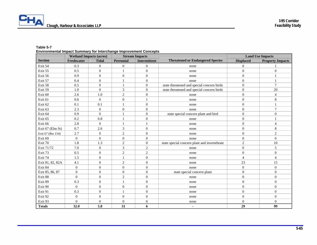
Clough, Harbour & Associates LLP
5-65
I-95 Corridor
Feasibility Study
Table 5-7 Environmental Impact Summary for Interchange Improvement Concepts
Wetland Impacts (acres) Stream Impacts Land Use Impacts Section Freshwater Tidal Perennial Intermittent Threatened or Endangered Species Displaced Property Impacts Exit 54 0.3 0 0 0 none 0 1 Exit 55 0.5 0 1 0 none 0 0 Exit 56 0.9 0 0 0 none 0 1 Exit 57 0.4 0 1 0 none 0 1 Exit 58 0.5 0 1 0 state threatened and special concern birds 0 7 Exit 59 1.0 0 3 0 state threatened and special concern birds 0 20 Exit 60 2.6 1.0 2 0 none 0 4 Exit 61 0.6 0 0 1 none 0 8 Exit 62 0.1 0.1 1 0 none 0 1 Exit 63 2.3 0 0 0 none 0 7 Exit 64 0.9 0 1 0 state special concern plant and bird 0 0 Exit 65 0.2 0.8 1 0 none 0 1 Exit 66 2.8 0 1 1 none 0 4 Exit 67 (Elm St) 0.7 2.6 3 0 none 0 8 Exit 67 (Rte 154) 2.7 0 2 0 none 0 2 Exit 69 0 0 0 0 none 0 0 Exit 70 1.8 1.3 2 0 state special concern plant and invertebrate 2 10 Exit 71/72 7.0 0 3 2 none 0 5 Exit 73 0.5 0 2 2 none 0 0 Exit 74 1.5 0 1 0 none 4 4 Exit 81, 82, 82A 4.1 0 2 0 none 23 15 Exit 84 0 0 0 0 none 0 0 Exit 85, 86, 87 0 0 0 0 state special concern plant 0 0 Exit 88 0 0 2 0 none 0 0 Exit 89 0.3 0 1 0 none 0 0 Exit 90 0 0 0 0 none 0 0 Exit 91 0.3 0 1 0 none 0 0 Exit 92 0 0 0 0 none 0 0 Exit 93 0 0 0 0 none 0 0 Totals 32.0 5.8 31 6 - 29 99
Clough, Harbour & Associates LLP
5-66
I-95 Corridor
Feasibility Study
Ø Exit 54 – Portions of three freshwater wetlands would be impacted by new construction (less than 0.3 acres). Encroachment associated with widening the ramps would result in minor property impacts to one residence. Potential unevaluated architectural resources are present in this section, but no direct impacts are anticipated. There are two potential noise-sensitive areas at this interchange consisting of single family residences and a mobile home park.
Ø Exit 55 – Approximately one-half acre from four separate wetlands would be impacted by the widening of I-95. Minor (100 feet) impacts to an unnamed perennial stream may result. North of the highway the Branford River Wildlife Area, a potential Section 4(f) resource, abuts the right-of-way for 2,800 feet adjacent to the southbound on-ramp at Exit 55. No impacts are expected from the proposed mainline widening as presently designed. Potential environmental risk sites include two gas stations adjacent to the right-of-way that have been reported for leaking underground storage tanks. There are four potential noise- sensitive areas at this interchange consisting of single family residences and townhouses.
Ø Exit 56 – Portions of seven wetland areas (including six drainage swales) totaling 0.9 acres would be affected by the proposed widening. There would be one minor property impact as slope limits would encroach on the ConnDOT maintenance facility on Leetes Island Road. Environmental risk sites adjacent to the Exit 56 right-of-way include two gas stations with reported leaking underground storage tanks and the ConnDOT facility, which is listed in the CT Leachate and Wastewater Discharge Location database. Potential unevaluated architectural resources are present in this section, but no direct impacts are anticipated. Unsurveyed areas of high to moderate archeological potential that could be directly impacted are present in this section. There is one potential noise-sensitive area at this interchange consisting of single family residences.
Ø Exit 57 – The widening would impact portions of seven freshwater wetlands, totaling 0.4 acres. Spinning Mill Brook bisects the right-of-way and 340 linear feet of the brook would be impacted by ramp reconfiguration. Approximately 500 linear feet of floodplain (measured along the highway) associated with Spinning Mill Brook is within this section. Minor property impacts to one residential property are required to improve the geometry of the southbound off-ramp. There are two potential noise-sensitive areas at this interchange consisting of single family residences.
Ø Exit 58 – Roadway widening would have minor impacts on portions of two freshwater wetlands (one-half acre). The highway crosses the West River and approximately 40 linear feet would be affected by widening activities. Approximately 300 linear feet of floodplain are associated with the West River where crossed by the highway. The right-of-way also crosses 3,550 feet of the Guilford wellfield aquifer protection area. The Guilford Historic Town Center Historic District abuts the south side of the right-of-way for a distance of 3,000 feet. No direct impact to the historic district is anticipated. Impacts are limited to potential visual and noise impacts at the northern boundary of the historic district. A potential Section 4(f) resource, the Guilford Jr. High School playfields, also borders the south side of the right-of-way along the northbound on-ramp. Because the highway widening does not extend beyond existing right-of-way, no impacts to these resources are expected. The area northeast of the interchange contains one threatened and one state special concern bird species. According to CTDEP, neither species should be affected by the project. Minor property impacts to three businesses and four residential properties would result from widening Church Street. There are five potential noise-sensitive areas at this interchange consisting of single family residences.
Clough, Harbour & Associates LLP
5-67
I-95 Corridor
Feasibility Study
Ø Exit 59 – This section includes the relocation of the I-95 northbound on and off-ramps at Exit 59. These ramps are relocated approximately 500 feet west of the existing ramps and would be constructed on existing ConnDOT property at the Guilford maintenance facility. Northbound I-95 access and egress would move from SR 718 (Goose Lane) to US Route 1. Portions of five wetland areas totaling approximately one acre would be affected by the proposed widening and ramp reconfiguration. Three unnamed perennial streams would be affected for a total of 425 linear feet including one stream that is within the area of the proposed on and off-ramps. Approximately 600 linear feet of floodplain is crossed by the highway. This section includes 2,000 feet of highway that is within the Coastal Zone, as well as the area to be used for the new on and off-ramps. The area to the east of the interchange contains one threatened and one state special concern bird species. According to CTDEP, neither species should be affected by the project. The soils at the ConnDOT maintenance facility are considered Prime and Statewide Important farmland soils. However, they are already dedicated to non-farm (transportation) use. A small portion of the Guilford Historic Town Center Historic District (500 feet) is adjacent to the south side of the right-of-way west of this exit. There would be major property impacts to the ConnDOT maintenance facility. The salt storage shed would be displaced to accommodate the ramps, although the land is presently owned by the State. The adjacent restaurant property does not appear to be affected by the interchange improvement concept. In order to accommodate the new ramp locations, Boston Post Road would be widened from two to four lanes. This would result in right-of-way impacts to 15 business properties. Goose Lane would be widened from two to three lanes to improve access to the southbound on and off-ramps. One residential and four business properties would be affected. Environmental risk sites that are within the new right-of-way include the ConnDOT facility, which is listed in the CT Leachate and Wastewater Discharge Location database as well as having been reported for a leaking underground storage tank. There is one potential noise-sensitive area at this interchange consisting of single family residences.
Ø Exit 60 – Approximately 3.6 acres of wetlands at eight wetland areas would be impacted by the widening of I-95. These areas include six freshwater (2.6 acres) and two tidal (1.0 acre) wetlands. The greatest impact would be to accommodate new ramps at Wildwood Avenue. Neck River and Bailey Creek are crossed by the right-of-way and approximately 140 feet of these perennial streams would be affected by construction. Also, 600 linear feet of floodplain associated with Neck River are crossed by the highway. Approximately 1,700 feet of highway is within the Coastal Zone. Minor property impacts to four residential properties would be required to accommodate the two new ramps at Wildwood Avenue. Potential unevaluated architectural resources are present in this section, but no direct impacts are expected. Unsurveyed areas of high to moderate archeological potential that could be directly impacted are present in this section. There are eight potential noise-sensitive areas at this interchange consisting of single family residences and a residential care facility.
Ø Exit 61 – The widening would impact portions of four wetlands totaling 0.6 acres. An unnamed intermittent stream crosses under both the northbound and southbound ramps and 60 linear feet of this stream course would be impacted. The interchange improvements would also encroach on the commuter parking lot and the Madison Senior Center, with a potential loss of parking spaces at each location. Minor impacts to four commercial and two residential properties would also result from the proposed reconstruction of the interchange. Potential unevaluated architectural resources are present in this section, but no direct impacts are anticipated. There are four potential noise-sensitive areas at this interchange consisting of single family residences.
Clough, Harbour & Associates LLP
5-68
I-95 Corridor
Feasibility Study
Ø Exit 62 – Minimal impact to four wetlands (three tidal and one freshwater) totaling 0.1 acres would result from the reconfiguration of Exit 62. The existing bridge over the Hammonasset River would be widened by 40 feet. Minimal floodplain area (200 linear feet measured along the highway) is associated with the river. The highway would pass through 3,300 feet of the Rettich wellfield aquifer protection area. The right-of-way includes 1,700 feet of the Coastal Zone Boundary. No new right-of-way would be required to accommodate the reconfiguration, although minor impacts to one residential property would result from the reconfiguration. The proposed build alternative would potentially have minimal direct impacts on one potentially eligible archaeological site (Site 27-9). However, this site may have been previously destroyed by construction of the existing I-95 bridge over the Hammonasset River. The build alternative would involve filling of nearby areas to the west of River Road and cutting of nearby areas to the east of the river. The potential impacts of these construction activities on Site 27-9 could be mitigated as follows: the site could be field checked by a qualified archaeologist to see if any of the site remains intact. If the site is intact, it could be marked for avoidance during construction activities. If avoidance is not possible, mitigation measures should be developed in coordination with the Connecticut State Archaeologist or SHPO. Unsurveyed areas of high to moderate archeological potential that could be directly impacted are also present in this section. There are two potential noise-sensitive areas at this interchange consisting of single family residences.
Ø Exit 63 – Moderate highway reconfiguration is proposed for this section. Existing northbound ramps are realigned and a roundabout is incorporated on Route 81. Portions of eight freshwater wetlands totaling 2.3 acres would be impacted by the proposed reconfiguration of this interchange. Approximately 700 linear feet of floodplain and 4,600 feet of the Clinton wellfield aquifer protection area are crossed by the highway. The highway crosses 3,600 feet of the Coastal Zone. Roadway widening of Route 81 would result in property encroachment impacts to four businesses and the Clinton High School on Route 81. Two residences on North High Street would also be affected. Unevaluated architectural resources that could be potentially impacted are located at Route 81 and North High Street. Direct impacts are not anticipated. Unsurveyed areas of high to moderate archeological potential that could be directly impacted are present in this section. There are six potential noise-sensitive areas at this interchange consisting of single family residences.
Ø Exit 64 – Roadway widening would have minor impacts to portions of seven freshwater wetlands (approximately 0.9 acres). Gatchen Creek is located east of Exit 64 and 60 feet of the brook would be impacted by widening within the right-of-way. Approximately 1,200 feet of floodplain associated with Gatchen Creek is crossed by the highway. Approximately 1,700 feet of the highway is located within the Coastal Zone, although no coastal resources would be affected by the widening. There are no anticipated direct impacts to archeological resources. Two areas of potential state listed species habitat are found along the section. One area includes a state listed plant species of special concern in the area of the Menunketesuck River. According to CTDEP, “the use of best management practices with special attention to erosion and siltation control should prevent indirect negative affects to the species.” The area near the Menunketesuck River also contains one state special concern bird species. According to CTDEP, “if the Menunketesuck River is going to be impacted by erosion, sedimentation or siltation discharges, or if there are to be polluted runoff such as chemicals or fertilizer discharged into the river resulting from this project that can contaminate the water, then the species may be impacted.” Potential unevaluated architectural resources are present in this section, but no direct impacts are anticipated. There are three potential noise-sensitive areas at this interchange consisting of single family residences.
Clough, Harbour & Associates LLP
5-69
I-95 Corridor
Feasibility Study
Ø Exit 65 – Approximately 0.8 acres of tidal wetlands (at three locations) and 0.2 acres of a freshwater wetland would be filled by widening the highway. The tidal wetland resources are part of the Patchogue River. The highway would be widened for a distance of 50 feet at this location. There is approximately 300 linear feet of Patchogue River floodplain in the section. The section also includes 2,300 feet within the Coastal Zone. There would be minor impact to one residential property due to highway widening. Potential unevaluated architectural resources are present in this section, but no direct impacts are anticipated. Unsurveyed areas of high to moderate archeological potential that could be directly impacted are present in this section.
Ø Exit 66 – Portions of ten freshwater wetlands totaling 2.8 acres would be affected by widening this section of I-95. Cold Spring Brook and the northbound on and off-ramps for I-95 pass under the highway. Approximately 70 feet of this brook would be impacted by construction. Further to the north (east) of the interchange, 80 feet of an unnamed perennial stream would be culverted to accommodate the widening. Minor floodplain encroachment along 400 linear feet of highway would occur with the widening. Minor encroachment impacts to four properties (one residential, one business and two vacant) outside the right-of-way would occur to accommodate mainline widening and the slight realignment of the northbound and southbound ramps. Potential unevaluated architectural resources are present in this section, but no direct impacts are anticipated.
Ø Exit 67 (Elm Street) – Major interchange ramp reconfigurations are proposed for this section. A new northbound off-ramp to Ingham Hill Road and a new southbound on-ramp are added at Exit 67 (Elm Street) and the existing northbound on-ramp and southbound off-ramp at this location are modified. A total of 3.3 acres at nine wetlands (five freshwater and four tidal) would be impacted by highway widening and interchange reconfiguration. One major impact would be to 2.6 acres of tidal marsh east of Elm Street to accommodate a longer northbound on-ramp. The remaining impacts would be to freshwater wetlands (totaling 0.7 acres). Fishing Brook and two unnamed perennial streams are crossed by the right-of-way totaling 245 linear feet of impact. Approximately 1,500 linear feet of floodplain is impacted including the filling of more than two acres of floodplain to accommodate the widening north of Exit 67. Approximately 4,200 feet of the highway is located in the Coastal Zone and over two acres of tidal marsh would be filled. Reconfiguring Exit 67 would require new right-of-way to accommodate the northbound on-ramp and the two new ramps at Elm Street. Minor property impacts outside the existing right-of-way would affect two businesses and six residences. Potential unevaluated architectural resources are present in this section, but no direct impacts are anticipated. Unsurveyed areas of high to moderate archeological potential that could be directly impacted are present in this section. There are two potential noise-sensitive areas at this interchange consisting of single family residences.
Ø Exit 67 (Route 154) and Exit 68 – Major interchange ramp reconfigurations are proposed for this combined section. Exit 68 is eliminated, a new southbound off-ramp and northbound on-ramp are added at Route 154 and the existing southbound on-ramp and northbound off-ramp at Exit 67 are realigned. A total of five freshwater wetlands with 2.7 acres would be modified by highway widening and reconfiguration, the largest of which would be the loss of 2.2 acres in order to construct a new northbound on-ramp for Exit 67. Oyster River and one unnamed perennial stream are crossed by the highway, impacting about 180 linear feet of the waterways. Floodplain impacts include 2,000 linear feet of right-of-way. The Connecticut Valley Railroad State Park Trail crosses under I-95 just west of Exit 67. Widening I-95 would require replacement of this bridge. Reconfiguring Exit 67 would require new right-of-way to
Clough, Harbour & Associates LLP
5-70
I-95 Corridor
Feasibility Study
accommodate the northbound on-ramp. This land is vacant wetland. Minor property impacts (one residential and one vacant) would result from the proposed work. Potential unevaluated architectural resources are present in this section, but no direct impacts are anticipated. Unsurveyed areas of high to moderate archeological potential that could be directly impacted are present in this section.
Ø Exit 69 – No wetlands or streams would be modified by highway widening in this section. Floodplain impacts include 600 linear feet of right-of-way. Approximately 2,300 feet of the highway is located in the Coastal Zone. Multiple encounters with potential areas of state listed species habitat occur around Exit 69 adjacent to the Connecticut River. National Register Historic Sites include the Jedidiah Dudley and the John Whittlesey Jr. houses. Both properties are outside the right-of-way and no direct impact to the historic properties is anticipated. Impacts are limited to potential visual and noise impacts. Potential unevaluated architectural resources are present in this section, but no direct impacts are anticipated. There are four potential noise-sensitive areas at this interchange consisting of single family residences.
Ø Exit 70 – Portions of 11 wetlands totaling 3.1 acres would be impacted by the reconfiguration of Exit 70 and the mainline widening through the interchange area. Four of the wetland areas (1.3 acres) are tidal wetlands associated with the Lieutenant River and the remainder (1.8 acres) are freshwater wetlands. One river and one perennial stream would be crossed. There are two non-community wells within 500 feet of the right-of-way. The entire section, approximately 6,600 feet, is within the Coastal Zone. The entire section passes through multiple locations that have been identified as areas of potential state listed species. The area south of Exit 70 adjacent to the Connecticut River includes a state listed invertebrate of special concern. According to CTDEP, “If the Great Island marshes are going to be impacted by erosion, sedimentation or siltation discharges, or if there are to be polluted runoff such as chemicals or fertilizer discharged into the river resulting from this project that can contaminate the water, then this species may be impacted.” The section also includes a state listed plant of special concern located to the south of Exit 70. According to CTDEP, “the use of best management practices with special attention to erosion and siltation control should prevent indirect negative affects to the species.”
As currently configured, three sites of cultural resources would be adversely impacted by the proposed improvements. The right-of-way bisects the Old Lyme Historic District and the proposed reconfiguration on the north side of I-95 will require the taking of land associated with the Florence Griswold Museum and the Old Lyme Inn properties, resulting in direct impacts as well as noise and visual impacts to the historic district. One business property north of I-95 and three properties south of I-95 would receive minor property impacts due to backfilling for the realigned roadways. Because historic resources qualify as Section 4(f) resources, there would also be Section 4(f) impacts. Based on the conceptual design, approximately 20,000 square feet of direct impact to the Florence Griswold Museum grounds and 13,000 square feet of direct impact to the Old Lyme Inn grounds, as well as additional indirect impacts due to the highway’s proximity to these areas will result. A substantial reconfiguration of the southbound on-ramp at Exit 70 is proposed. Additional right-of-way extending approximately 250 feet north of the existing right-of-way will be needed to accommodate the reconfigured ramp that provides southbound access. Two single family residences north of I-95 would be displaced and new access would be provided to five residential properties off of Route 156. Potential unevaluated architectural resources are present in this section. Unsurveyed areas of high to moderate archeological potential that could be directly impacted are present in this section. There are four potential noise-sensitive areas at this interchange consisting of single family residences.
Clough, Harbour & Associates LLP
5-71
I-95 Corridor
Feasibility Study
Ø Exits 71 and 72 – Portions of twenty-one freshwater wetlands totaling approximately 7.0 acres would be impacted by the proposed roadway interchange and mainline improvements. Surface water impacts include approximately 310 feet of Four Mile River and 50 feet of Three Mile River and minor impacts to three unnamed streams (one perennial and two intermittent). Approximately 400 linear feet of floodplain associated with Four Mile River would be encroached upon by widening the highway and modifying the exit ramps. There are four non-community wells within 500 feet of this section and 4,000 feet of the Brides Lake wellfield aquifer protection area is traversed by the highway. Property impacts to five businesses due to encroachment that extends beyond the existing right-of-way would result from the project. Unsurveyed areas of high to moderate archeological potential that could be directly impacted are present in this section.
Ø Exit 73 – Minimal impacts to twelve freshwater wetland areas totaling 0.5 acres would result from the proposed widening and interchange reconfiguration. The highway crosses one named stream, Beaver Dam Brook, and three unnamed streams, two of which are intermittent. In total, 60 linear feet of perennial and 390 linear feet of intermittent watercourse will be culverted. This section traverses two aquifer protection areas, Brides Lake wellfield (3,000 feet) and Gorton’s Pond wellfield (300 feet). One active farm is located north of the right-of-way but no impacts are expected. The Gates Correctional Facility is located to the south adjacent to the highway. Approximately 4,600 feet of this section’s right-of-way borders the correctional facility. Because it is the predominant land use in Census Tract 716101, Block Groups 2 and 4, the ethnic and income make-up of the prison population qualifies these block groups as potential environmental justice areas. Unsurveyed areas of high to moderate archeological potential that could be directly impacted are present in this section. There are two potential noise-sensitive areas at this interchange consisting of single family residences.
Ø Exit 74 – Portions of five freshwater wetlands totaling approximately 1.5 acres would be impacted along this section. The existing Pattagansett River Bridge would be widened by approximately 40 feet. Approximately 800 linear feet of the associated floodplain would be traversed. There are no public wells within 500 feet of the right-of-way although the section crosses 3,400 feet of an aquifer protection area associated with the Gorton’s Pond wellfield. Substantial land use impacts would result from the proposed reconfiguration of the interchange. Four properties (2 residential and 2 businesses) would be displaced; one residential property’s access would be impacted; and three minor property encroachments would result. New right-of-way, extending approximately 300 feet north of the existing right-of-way, would be required in order to accommodate the reconfigured ramps to and from southbound I-95. Unsurveyed areas of high to moderate archeological potential include the area to be graded south of I-95 immediately west of the Pattagansett River, the new ramp north of I-95 west of Route 161 and grading along this new ramp (from parking lot’s west edge through grassy driving range to cluster of buildings on south). One environmental risk site, which has been reported for a leaking underground storage tank, is immediately adjacent to the south end of the right-of-way on Route 161. There are two potential noise-sensitive areas at this interchange consisting of single family residences.
Clough, Harbour & Associates LLP
5-72
I-95 Corridor
Feasibility Study
Ø Exits 81, 82 and 82A – Substantial impacts to wetland resources could result from the proposed widening as portions of 22 freshwater wetland areas, totaling 4.1 acres, would be impacted by the highway’s widening and ramp reconfiguration. A total of 535 linear feet of water course associated with Jordan Brook and Nevins Brook would be affected by the widening. A public water supply reservoir, Lake Brandegee, is located north of the right-of-way near Exit 82A. Substantial land use impacts can be expected based on the conceptual design (new on and off-ramps for Exit 81 and a reconfigured ramp at Exit 82). As many as 19 residential properties and three businesses would be displaced. Residential properties would be displaced on Gilead Road, Route 85, and Lois Avenue south of Exit 82 and off of Vauxhall Street on both sides of Exit 82A. The displaced businesses include an abandoned motel site on Harvey Avenue north of Exit 82 and two business properties on Route 85. Property encroachments beyond the right-of-way to accommodate the widening would also affect one cemetery located on Parkway South and potentially the relocated water tower east of Exit 82. There would be access and property impacts to one business property on Vauxhall Street and a Town of Waterford pumping station on Harvey Avenue. Property impacts associated with earthwork operations would affect four residences and seven businesses. The proposed improvements at the intersection of Coleman and Broad Street, south of the right-of-way, would displace one building and likely involve additional minor property impacts. Unevaluated architectural resources that could be potentially impacted are located at the south side of the interchange and unevaluated architectural resources at Vauxhall Road appear to be directly impacted by the proposed ramps. Unevaluated architectural resources on Vauxhall Street Extension at the north side of the interchange also appear to be directly impacted by the proposed ramps for Exit 82A. Unsurveyed areas of high to moderate archeological potential that could be directly impacted are present in this section.
Seven hazardous waste spill incidents have been recorded within the right-of-way. Approximately 3,000 feet of the 13,100 foot length of this section is with the city of New London. This portion of the right-of-way is within Census Tract 690100, Block Group 3 (north of the right-of-way) and Census Tract 690300, Block Group 4 (south of the right-of-way). Census data indicates that these areas contain populations with the ethnic and income make-up that could qualify the block groups as potential Environmental Justice areas. There are fourteen potential noise-sensitive areas at this interchange consisting of single family residences.
Ø Exit 83 – Minimal environmental impacts are associated with this section. Approximately 200 linear feet of the section are located within the Coast Zone. An historic property, Winthrop Mill, is located under the I-95 bridge as it elevates prior to crossing the Thames River. This portion of the right-of-way is within Census Tract 690100, Block Group 1 - 3 and Census Tract 690300, Block Group 1 south of the right-of-way. Census data indicates that these areas contain populations with the ethnic and income make-up that could qualify the block groups as potential Environmental Justice areas.
Ø Exits 85, 86, 87 – No wetland or water resources would be impacted by new construction. Approximately 400 feet of Poquonnock Reservoir is crossed by the highway. Minimal impact to this reservoir is expected as the highway consists of three lanes in each direction at this location. The section crosses approximately 600 feet of the Coastal Zone. One area of potential state listed species habitat, a state listed special concern plant species habitat, is found along the section in the area of the Poquonnock Reservoir. According to CTDEP “the use of best management practices with special attention to erosion and siltation control should prevent indirect negative affects to the species.” There are six potential noise-sensitive areas at this interchange consisting of single family residences.
Clough, Harbour & Associates LLP
5-73
I-95 Corridor
Feasibility Study
Ø Exit 88 – Two water resources, Hatching House Brook and Fort Hill Brook, are crossed by this section. There would be approximately 30 linear feet of Fort Hill Brook impacted by the proposed widening. Approximately 1,400 feet of Poquonnock Reservoir is crossed by the existing highway. However, since no major widening is proposed along this section, no construction impacts are expected. There is one potential noise-sensitive area at this interchange consisting of single family residences.
Ø Exit 89 – A portion of one freshwater wetland would be impacted by new construction (0.3 acres). Approximately 100 feet of Bindloss Brook is crossed by the existing highway north (east) of Exit 89. One area of potential state listed species habitat is found along the section.
Ø Exit 90 – There are no wetland or water resource impacts in this section. Approximately 1,000 feet of the right-of-way is within the Coastal Zone. There is one encounter with prime farmland soils but no right-of-way impact to these resources is expected. The Whitehall Mansion historic property is located 250 feet north of the Exit 90 interchange. The property is outside the right-of-way and no direct impact is anticipated. Impacts are limited to potential visual and noise impacts. There are two potential noise- sensitive areas at this interchange consisting of single family residences.
Ø Exit 91 – Portions of four freshwater wetlands totaling 0.3 acres would be impacted by the project. Approximately 20 linear feet of Stony Brook would be culverted by the highway. There would be minimal impacts to other environmental resources in this section. Potential unevaluated architectural resources are present in this section, but no direct impacts are anticipated. There are two potential noise-sensitive areas at this interchange consisting of single family residences.
Ø Exit 92 – Most of this section would remain unchanged with no new construction taking place. The highway passes over the Shunock River and 9,000 feet of the Pawcatuck River sole source aquifer. Several encounters with Prime and Statewide Important farmland soils occur and two active farms are adjacent to the right-of-way, but no impacts to farmland resources are expected. Potential unevaluated architectural resources are present in this section, but no direct impacts are anticipated. There are two potential noise- sensitive areas at this interchange consisting of a single family residence and a recreational vehicle park
Ø Exit 93 – No new construction would take place in this section. The existing highway passes over 4,700 feet of the Pawcatuck River sole source aquifer.
Park and Ride Lot Summary Table 5-8 summarizes the anticipated impacts to the 19 existing Park and Ride facilities located within the I-95 study corridor. Locations that are suitable for potential relocation or expansion opportunities are also shown in the table. Expansion would consist of enlarging existing lots and relocation would consist of constructing new lots where no facilities currently exist. The cost of mitigating impacts by relocating or expanding existing lots is approximately $3.64 million.
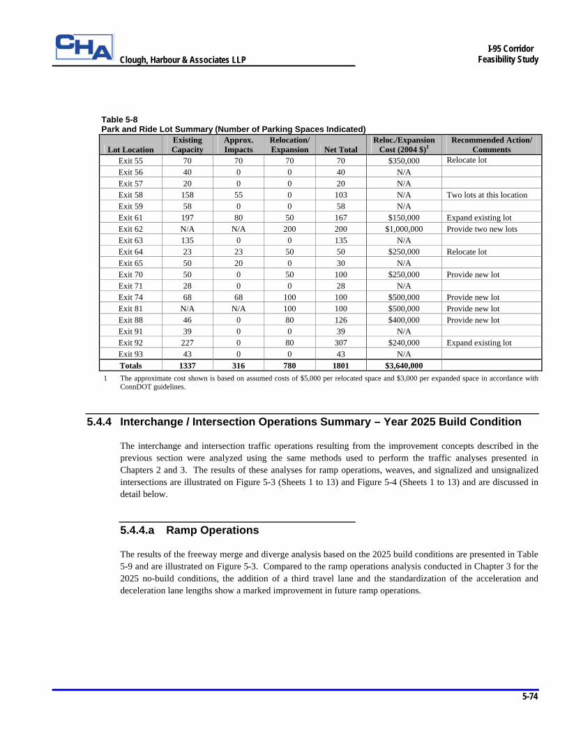
Clough, Harbour & Associates LLP
5-74
I-95 Corridor
Feasibility Study
Table 5-8 Park and Ride Lot Summary (Number of Parking Spaces Indicated)
Lot Location Existing Capacity
Approx. Impacts
Relocation/Expansion Net Total
Reloc./Expansion Cost (2004 $)1
Recommended Action/ Comments
Exit 55 70 70 70 70 $350,000 Relocate lot Exit 56 40 0 0 40 N/A
Exit 57 20 0 0 20 N/A Exit 58 158 55 0 103 N/A Two lots at this location Exit 59 58 0 0 58 N/A Exit 61 197 80 50 167 $150,000 Expand existing lot Exit 62 N/A N/A 200 200 $1,000,000 Provide two new lots Exit 63 135 0 0 135 N/A Exit 64 23 23 50 50 $250,000 Relocate lot Exit 65 50 20 0 30 N/A Exit 70 50 0 50 100 $250,000 Provide new lot Exit 71 28 0 0 28 N/A Exit 74 68 68 100 100 $500,000 Provide new lot Exit 81 N/A N/A 100 100 $500,000 Provide new lot Exit 88 46 0 80 126 $400,000 Provide new lot Exit 91 39 0 0 39 N/A Exit 92 227 0 80 307 $240,000 Expand existing lot Exit 93 43 0 0 43 N/A Totals 1337 316 780 1801 $3,640,000
1 The approximate cost shown is based on assumed costs of $5,000 per relocated space and $3,000 per expanded space in accordance with ConnDOT guidelines.
5.4.4 Interchange / Intersection Operations Summary – Year 2025 Build Condition
The interchange and intersection traffic operations resulting from the improvement concepts described in the previous section were analyzed using the same methods used to perform the traffic analyses presented in Chapters 2 and 3. The results of these analyses for ramp operations, weaves, and signalized and unsignalized intersections are illustrated on Figure 5-3 (Sheets 1 to 13) and Figure 5-4 (Sheets 1 to 13) and are discussed in detail below.
5.4.4.a Ramp Operations
The results of the freeway merge and diverge analysis based on the 2025 build conditions are presented in Table 5-9 and are illustrated on Figure 5-3. Compared to the ramp operations analysis conducted in Chapter 3 for the 2025 no-build conditions, the addition of a third travel lane and the standardization of the acceleration and deceleration lane lengths show a marked improvement in future ramp operations.
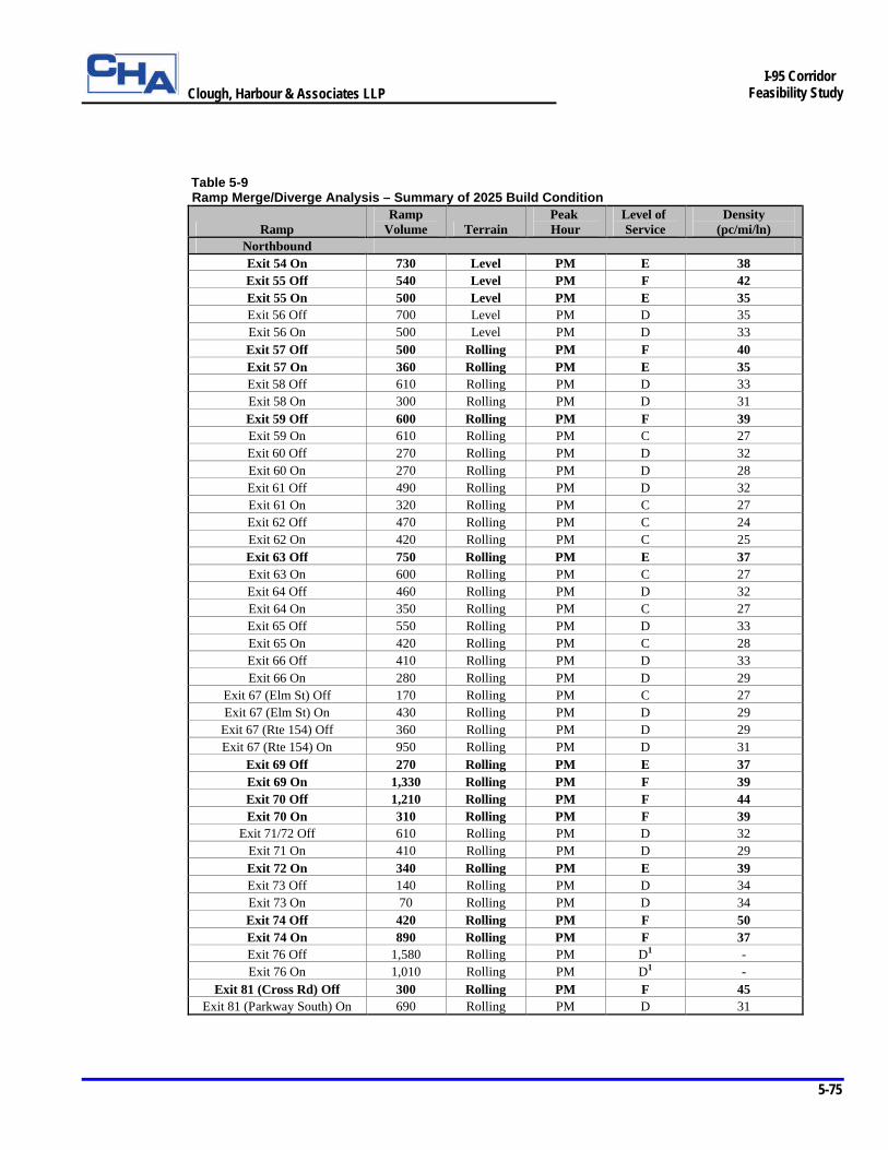
Clough, Harbour & Associates LLP
5-75
I-95 Corridor
Feasibility Study
Table 5-9 Ramp Merge/Diverge Analysis – Summary of 2025 Build Condition
Ramp Ramp
Volume Terrain Peak Hour
Level of Service
Density (pc/mi/ln)
Northbound Exit 54 On 730 Level PM E 38 Exit 55 Off 540 Level PM F 42 Exit 55 On 500 Level PM E 35 Exit 56 Off 700 Level PM D 35 Exit 56 On 500 Level PM D 33 Exit 57 Off 500 Rolling PM F 40 Exit 57 On 360 Rolling PM E 35 Exit 58 Off 610 Rolling PM D 33 Exit 58 On 300 Rolling PM D 31 Exit 59 Off 600 Rolling PM F 39 Exit 59 On 610 Rolling PM C 27 Exit 60 Off 270 Rolling PM D 32 Exit 60 On 270 Rolling PM D 28 Exit 61 Off 490 Rolling PM D 32 Exit 61 On 320 Rolling PM C 27 Exit 62 Off 470 Rolling PM C 24 Exit 62 On 420 Rolling PM C 25 Exit 63 Off 750 Rolling PM E 37 Exit 63 On 600 Rolling PM C 27 Exit 64 Off 460 Rolling PM D 32 Exit 64 On 350 Rolling PM C 27 Exit 65 Off 550 Rolling PM D 33 Exit 65 On 420 Rolling PM C 28 Exit 66 Off 410 Rolling PM D 33 Exit 66 On 280 Rolling PM D 29
Exit 67 (Elm St) Off 170 Rolling PM C 27 Exit 67 (Elm St) On 430 Rolling PM D 29
Exit 67 (Rte 154) Off 360 Rolling PM D 29 Exit 67 (Rte 154) On 950 Rolling PM D 31
Exit 69 Off 270 Rolling PM E 37 Exit 69 On 1,330 Rolling PM F 39 Exit 70 Off 1,210 Rolling PM F 44 Exit 70 On 310 Rolling PM F 39
Exit 71/72 Off 610 Rolling PM D 32 Exit 71 On 410 Rolling PM D 29 Exit 72 On 340 Rolling PM E 39 Exit 73 Off 140 Rolling PM D 34 Exit 73 On 70 Rolling PM D 34 Exit 74 Off 420 Rolling PM F 50 Exit 74 On 890 Rolling PM F 37 Exit 76 Off 1,580 Rolling PM D1 - Exit 76 On 1,010 Rolling PM D1 -
Exit 81 (Cross Rd) Off 300 Rolling PM F 45 Exit 81 (Parkway South) On 690 Rolling PM D 31
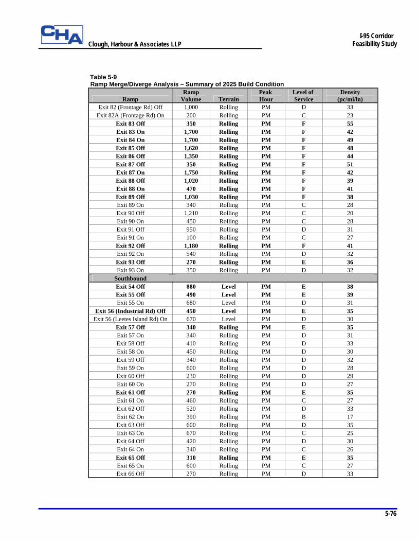
Clough, Harbour & Associates LLP
5-76
I-95 Corridor
Feasibility Study
Table 5-9 Ramp Merge/Diverge Analysis – Summary of 2025 Build Condition
Ramp Ramp
Volume Terrain Peak Hour
Level of Service
Density (pc/mi/ln)
Exit 82 (Frontage Rd) Off 1,000 Rolling PM D 33 Exit 82A (Frontage Rd) On 200 Rolling PM C 23
Exit 83 Off 350 Rolling PM F 55 Exit 83 On 1,700 Rolling PM F 42 Exit 84 On 1,700 Rolling PM F 49 Exit 85 Off 1,620 Rolling PM F 48 Exit 86 Off 1,350 Rolling PM F 44 Exit 87 Off 350 Rolling PM F 51 Exit 87 On 1,750 Rolling PM F 42 Exit 88 Off 1,020 Rolling PM F 39 Exit 88 On 470 Rolling PM F 41 Exit 89 Off 1,030 Rolling PM F 38 Exit 89 On 340 Rolling PM C 28 Exit 90 Off 1,210 Rolling PM C 20 Exit 90 On 450 Rolling PM C 28 Exit 91 Off 950 Rolling PM D 31 Exit 91 On 100 Rolling PM C 27 Exit 92 Off 1,180 Rolling PM F 41 Exit 92 On 540 Rolling PM D 32 Exit 93 Off 270 Rolling PM E 36 Exit 93 On 350 Rolling PM D 32
Southbound Exit 54 Off 880 Level PM E 38 Exit 55 Off 490 Level PM E 39 Exit 55 On 680 Level PM D 31
Exit 56 (Industrial Rd) Off 450 Level PM E 35 Exit 56 (Leetes Island Rd) On 670 Level PM D 30
Exit 57 Off 340 Rolling PM E 35 Exit 57 On 340 Rolling PM D 31 Exit 58 Off 410 Rolling PM D 33 Exit 58 On 450 Rolling PM D 30 Exit 59 Off 340 Rolling PM D 32 Exit 59 On 600 Rolling PM D 28 Exit 60 Off 230 Rolling PM D 29 Exit 60 On 270 Rolling PM D 27 Exit 61 Off 270 Rolling PM E 35 Exit 61 On 460 Rolling PM C 27 Exit 62 Off 520 Rolling PM D 33 Exit 62 On 390 Rolling PM B 17 Exit 63 Off 600 Rolling PM D 35 Exit 63 On 670 Rolling PM C 25 Exit 64 Off 420 Rolling PM D 30 Exit 64 On 340 Rolling PM C 26 Exit 65 Off 310 Rolling PM E 35 Exit 65 On 600 Rolling PM C 27 Exit 66 Off 270 Rolling PM D 33
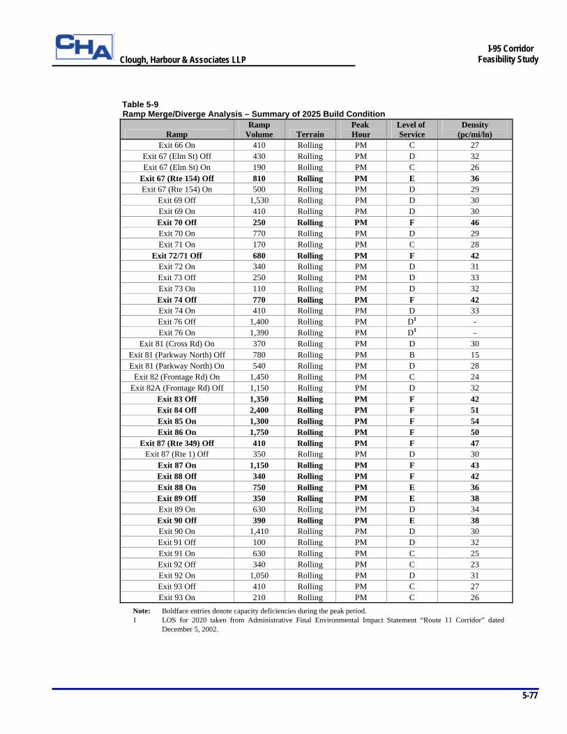
Clough, Harbour & Associates LLP
5-77
I-95 Corridor
Feasibility Study
Table 5-9 Ramp Merge/Diverge Analysis – Summary of 2025 Build Condition
Ramp Ramp
Volume Terrain Peak Hour
Level of Service
Density (pc/mi/ln)
Exit 66 On 410 Rolling PM C 27 Exit 67 (Elm St) Off 430 Rolling PM D 32 Exit 67 (Elm St) On 190 Rolling PM C 26
Exit 67 (Rte 154) Off 810 Rolling PM E 36 Exit 67 (Rte 154) On 500 Rolling PM D 29
Exit 69 Off 1,530 Rolling PM D 30 Exit 69 On 410 Rolling PM D 30 Exit 70 Off 250 Rolling PM F 46 Exit 70 On 770 Rolling PM D 29 Exit 71 On 170 Rolling PM C 28
Exit 72/71 Off 680 Rolling PM F 42 Exit 72 On 340 Rolling PM D 31 Exit 73 Off 250 Rolling PM D 33 Exit 73 On 110 Rolling PM D 32 Exit 74 Off 770 Rolling PM F 42 Exit 74 On 410 Rolling PM D 33 Exit 76 Off 1,400 Rolling PM D1 - Exit 76 On 1,390 Rolling PM D1 -
Exit 81 (Cross Rd) On 370 Rolling PM D 30 Exit 81 (Parkway North) Off 780 Rolling PM B 15 Exit 81 (Parkway North) On 540 Rolling PM D 28
Exit 82 (Frontage Rd) On 1,450 Rolling PM C 24 Exit 82A (Frontage Rd) Off 1,150 Rolling PM D 32
Exit 83 Off 1,350 Rolling PM F 42 Exit 84 Off 2,400 Rolling PM F 51 Exit 85 On 1,300 Rolling PM F 54 Exit 86 On 1,750 Rolling PM F 50
Exit 87 (Rte 349) Off 410 Rolling PM F 47 Exit 87 (Rte 1) Off 350 Rolling PM D 30
Exit 87 On 1,150 Rolling PM F 43 Exit 88 Off 340 Rolling PM F 42 Exit 88 On 750 Rolling PM E 36 Exit 89 Off 350 Rolling PM E 38 Exit 89 On 630 Rolling PM D 34 Exit 90 Off 390 Rolling PM E 38 Exit 90 On 1,410 Rolling PM D 30 Exit 91 Off 100 Rolling PM D 32 Exit 91 On 630 Rolling PM C 25 Exit 92 Off 340 Rolling PM C 23 Exit 92 On 1,050 Rolling PM D 31 Exit 93 Off 410 Rolling PM C 27 Exit 93 On 210 Rolling PM C 26
Note: Boldface entries denote capacity deficiencies during the peak period. 1 LOS for 2020 taken from Administrative Final Environmental Impact Statement “Route 11 Corridor” dated
December 5, 2002.
Clough, Harbour & Associates LLP
5-78
I-95 Corridor
Feasibility Study
Northbound Ramps Of the 65 total northbound ramp junctions shown in Table 5-9, 47 are located in areas where a third travel lane is required to provide additional capacity along northbound I-95. The analysis showed that 36 of these 47 merge and diverge areas will experience an improved LOS in the evening peak hour. In addition, 31 of these 47 areas will operate at acceptable levels under the peak hour traffic demands at LOS D or better. Overall, 38 of the 65 northbound ramp junction areas will operate acceptably at LOS D or better should the recommended mainline and interchange improvements be implemented. This is an improvement over the four areas that will operate at acceptable levels if no improvements are provided. Southbound Ramps Of the 66 total southbound ramp junctions shown in Table 5-9, 48 are located in areas where a third travel lane is required to provide additional capacity along northbound I-95. The analysis showed that 39 of these 48 merge and diverge areas will experience an improved LOS in the evening peak hour. In addition, 32 of these 48 areas will operate at acceptable levels under the peak hour traffic demands at LOS D or better. Overall, 46 of the 66 southbound ramp junction areas will operate acceptably at LOS D or better should the recommended mainline and interchange improvements be implemented. This is an improvement over the ten areas that will operate at acceptable levels if no improvements are provided.
5.4.4.b Weaves
The results of the weaving sections analysis based on the 2025 build condition are presented in Table 5-10 and are illustrated on Figure 5-3. Due to the recommended improvement concepts at several interchanges, the following weaving sections are eliminated in the 2025 build condition: § Northbound between Exits 68 and 69 § Northbound between Exits 71 and 72 § Southbound between Exits 69 and 68 § Southbound between Exits 72 and 71 § Southbound between Exits 82A (Frontage Road on-ramp) and 82
In addition, although the northbound weaving sections located between Exit 89 and the Scenic Overlook and between the Scenic Overlook and Exit 90 were not included in the 2025 no-build analysis, an analysis of these areas is included here because concerns were raised during the development of the improvement concepts regarding the effects of these weaves on mainline operations.
Table 5-10 Weaving Sections Analysis – Summary of 2025 Build Condition
Section Description Weave
Length (ft) Peak Hour
Level of Service
Density (pc/mi/ln)
Northbound Exit 82A to Exit 83 2400 PM C 23
Exit 89 to Scenic Overlook 1550 PM C 25 Scenic Overlook to Exit 90 1850 PM D 28
Clough, Harbour & Associates LLP
5-79
I-95 Corridor
Feasibility Study
5.4.4.c Signalized Intersections
The results of the signalized intersection analysis based on the 2025 build condition are presented in Table 5-11 and are illustrated on Figure 5-4. Due to the 2025 traffic demands, signalization of the following unsignalized intersections is recommended to improve intersection capacity and reduce delay in the build condition:
§ SR 740 (Cedar Street) at Cedar Knolls Drive § Clapboard Hill Road at SR 718 (Goose Lane) § Exit 61 northbound ramps at Route 79 (Durham Road) § Exit 58 southbound ramps at Route 77 (Church Street) § Exit 64 northbound ramps at Route 145 § Exit 64 southbound ramps at Route 145 § Exit 66 northbound ramps at Route 166 § Exit 66 southbound ramps at Route 166 § Exit 67 (Elm Street) northbound on-ramp at Elm St/Ingham Hill Rd § Exit 67 (Elm Street) southbound ramps at Elm Street § Exit 67 (Route 154) northbound ramps at Route 154 § Exit 67 (Route 154) southbound ramps at Route 154 § Exit 89 southbound ramps at SR 614 § Exit 89 northbound ramps at SR 614 § Exit 88 northbound ramps at Route 117 (North Rd)
As shown in Table 5-11, the recommended intersection improvements provide a LOS D or better at all of the signalized intersections included in the study in the 2025 build condition. These improvements include signal timing and phasing improvements, additional left and right turn lanes, additional through lanes on secondary roadways, increased storage lengths for queued vehicles and other geometric improvements. Table 5-11 Signalized Intersection Analysis – Summary of 2025 Build Condition
Signalized Intersection Peak Hour
Level of Service V/C1 Delay2
Exit 54 NB Ramps at SR 740 (Cedar St) PM A 0.68 6 Exit 54 SB Ramps at SR 740 (Cedar St) PM B 0.84 18 SR 740 (Cedar St) at Cedar Knolls Dr PM A 0.62 3 US Rte 1 (Main St) at SR 740 (Cedar St) PM C 0.90 29 Exit 55 NB Ramps at US Rte 1 (East Main St) PM A 0.72 9 Exit 55 SB Ramp at US Rte 1 (East Main St) PM A 0.72 8 Exit 57 NB Ramps at US Rte 1 (Boston Post Rd) PM B 0.74 14 Exit 58 NB Ramps at Rte 77 (Church St) PM B 0.74 14 Exit 58 SB Ramps at Rte 77 (Church St) PM B 0.78 12 Exit 59 NB Ramps at US Rte 1 (Boston Post Rd) PM B 0.81 19 Exit 59 SB Ramps at SR 718 (Goose Lane) PM A 0.77 8 US Rte 1 at SR 718 (Goose Lane) PM C 0.90 21 Clapboard Hill Rd at SR 718 (Goose Lane) PM A 0.63 7 Exit 61 NB Ramps at Rte 79 (Durham Rd) PM A 0.55 4 Exit 61 SB Ramps at Rte 79 (Durham Rd) PM A 0.70 8 Rte 79 (Durham Rd) at Old Rte 79/Woodland Rd PM A 0.67 7 Exit 62 NB Ramps at SR 450 (Hammonasset Connector) PM B 0.70 17
Clough, Harbour & Associates LLP
5-80
I-95 Corridor
Feasibility Study
Table 5-11 Signalized Intersection Analysis – Summary of 2025 Build Condition
Signalized Intersection Peak Hour
Level of Service V/C1 Delay2
Exit 62 SB Ramps at Duck Hole Rd PM B 0.61 11 Duck Hole Rd at SR 450 (Hammonasset Connector) PM B 0.63 12 Exit 63 SB Ramps at Rte 81 (Killingworth Turnpike) PM B 0.90 14 Rte 81 (Killingworth Turnpike) at Glenwood Rd PM A 0.78 9 Exit 64 NB Ramps at Rte 145 PM B 0.63 10 Exit 64 SB Ramps at Rte 145 PM B 0.62 14 Rte 145 at Old Clinton Rd PM B 0.78 13 Exit 65 NB Ramps at Rte 153 (Essex Rd) PM B 0.89 12 Exit 65 SB Ramps at Rte 153 (Essex Rd) PM B 0.69 12 Rte 153 at Norris Ave/Flat Rock Pl (Westbrook Mall Entrance) PM C 0.89 28 Exit 66 NB Ramps at Rte 166 PM A 0.59 8 Exit 66 SB Ramps at Rte 166 PM A 0.56 8 Exit 67 (Elm St) NB On-Ramp at Elm St/Ingham Hill Rd PM A 0.66 9 Exit 67 (Elm St) SB Ramps at Elm St PM B 0.59 16 Exit 67 (Rte 154) NB Ramps at Rte 154 PM A 0.69 4 Exit 67 (Rte 154) SB Ramps at Rte 154 PM B 0.79 12 Exit 70 NB Off-Ramp at Rte 156 (Neck Rd) PM B 0.79 17 Exit 70 SB On-Ramp at Rte 156/US Rte 1 (Halls Rd) PM B 0.75 11 Exit 70 SB Off-Ramp at US Rte 1(Boston Post Rd) PM C 0.79 24 SR 449 (Rocky Neck Connector) at Rte 156 PM B 0.57 12 Exit 74 NB Off-Ramp at Rte 161 (Flanders Rd) PM B 0.89 17 Exit 74 SB Ramps at Rte 161 (Flanders Rd) PM B 0.79 13 Exit 81 SB Ramps at Parkway North PM B 0.59 11 Exit 82 NB Ramps at Rte 85 (Broad St) PM A 0.70 7 Exit 82 SB Ramps at Rte 85 (Hartford Tpke) PM B 0.91 17 US Rte 1 (Coleman St) at Rte 85 (Broad St) PM D 0.56 42 Vauxhall St at US Rte 1 (Coleman St) PM B 0.82 11 US Rte 1 at Bridge St PM B 0.85 11 Exit 88 NB Ramps at Rte 117 (North Rd) PM C 0.78 20 Exit 88 SB Ramps at Rte 117 (North Rd) PM B 0.73 12 Exit 89 NB Ramps at SR 614 PM B 0.79 17 Exit 89 SB Ramps at SR 614 PM A 0.65 9 Exit 90 NB Ramps at Rte 27 (White Hall Ave) PM B 0.84 26 Exit 90 SB Ramps at Rte 27 (White Hall Ave) PM C 0.93 30 Rte 27 (White Hall Ave) at Coogan Blvd PM B 0.93 20 Exit 91 NB Ramps at Rte 234 (Pequot Trail) PM B 0.74 17 Exit 92 NB Off-Ramp at Rte 2 (Liberty St) PM B 0.87 16 Exit 92 SB On-Ramp at Rte 2 (Liberty St) PM B 0.69 11 Exit 92 SB Off-Ramp at Rte 49 (Pendleton Hill Rd) PM B 0.55 15
1 V/C - Volume to Capacity Ratio 2 Delay - Average stopped delay to all vehicles entering the intersection in seconds per vehicle.
Clough, Harbour & Associates LLP
5-81
I-95 Corridor
Feasibility Study
5.4.4.d Unsignalized Intersections
The results of the unsignalized intersection analysis based on the 2025 build condition are presented in Table 5-12 and are illustrated on Figure 5-4. As shown in Table 5-12, the recommended intersection improvements provide a LOS D or better at 19 of the 21 unsignalized intersections included in the study in the 2025 build condition. These improvements mainly included additional left and right turn lanes, increased storage lengths for queued vehicles and other geometric improvements. Table 5-12 Unsignalized Intersection Analysis – Summary of 2025 Build Condition
Unsignalized Intersections Movement Demand1 Delay2 Level of Service
Exit 57 SB Ramps at US Rte 1 (Boston Post Rd) Westbound Left 70 38 E Westbound Right 270 18 C Westbound 22 C Southbound 30 9 A Rte 77 at Commuter Lot Drive Northbound 10 9 A Eastbound 20 40 E Southbound 0 10 A Exit 58 NB Off-Ramp at North River St Westbound 80 9 A Northbound 110 15 B Exit 60 SB Off-Ramp at Mungertown Rd Northbound 50 8 A Westbound 230 15 C Exit 60 SB Off-Ramp at Mungertown Rd (continued) Eastbound 80 9 A Exit 60 NB Off-Ramp at Wildwood Ave Eastbound 270 18 C Exit 60 NB On-Ramp at Fort Path Rd Northbound 70 10 B Mungertown Rd at Fort Path Rd Westbound 40 10 A Southbound 90 8 A Rte 79 at Commuter Lot Drive Westbound Left 10 21 C Westbound Right 20 24 C Westbound 23 C Southbound 10 13 B Exit 63 NB Ramps at Rte 81 (Killingworth Tpke) Roundabout 2,790 8 B Exit 69 SB Off-Ramp at Essex Rd Northbound 80 10 B Exit 71 NB Ramps at Four Mile River Rd Southbound 220 9 A Westbound 130 21 C Exit 71 SB Ramps at Four Mile River Rd Northbound 130 8 A Westbound 380 33 D Four Mile River Rd at Hatchetts Hill Rd Northbound 30 8 A Eastbound 220 17 C Exit 73 SB Ramps at West Society Rd Northbound 10 A Northbound Left 0 9 A Northbound Right 250 10 A Exit 73 NB Ramps at Society Rd Northbound 140 10 A Exit 74 NB On-Ramp at Rte 161 (Flanders Rd) Southbound Left 130 2 C Exit 90 NB Ramps at Clara Dr (Aquarium) Northbound 190 13 B
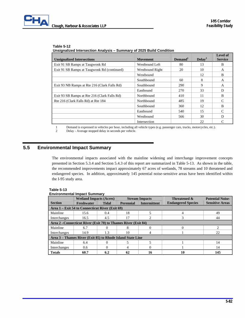
Clough, Harbour & Associates LLP
5-82
I-95 Corridor
Feasibility Study
Table 5-12 Unsignalized Intersection Analysis – Summary of 2025 Build Condition
Unsignalized Intersections Movement Demand1 Delay2 Level of Service
Exit 91 SB Ramps at Taugwonk Rd Westbound Left 80 13 B Exit 91 SB Ramps at Taugwonk Rd (continued) Westbound Right 20 10 A Westbound 12 B Southbound 60 8 A Exit 93 NB Ramps at Rte 216 (Clark Falls Rd) Southbound 290 9 A Eastbound 270 33 D Exit 93 SB Ramps at Rte 216 (Clark Falls Rd) Northbound 410 11 B Rte 216 (Clark Falls Rd) at Rte 184 Northbound 485 19 C Southbound 360 12 B Eastbound 540 15 C Westbound 566 30 D Intersection 22 C 1 Demand is expressed in vehicles per hour, including all vehicle types (e.g. passenger cars, trucks, motorcycles, etc.). 2 Delay - Average stopped delay in seconds per vehicle.
5.5 Environmental Impact Summary
The environmental impacts associated with the mainline widening and interchange improvement concepts presented in Section 5.3.4 and Section 5.4.3 of this report are summarized in Table 5-13. As shown in the table, the recommended improvements impact approximately 67 acres of wetlands, 78 streams and 10 threatened and endangered species. In addition, approximately 145 potential noise-sensitive areas have been identified within the I-95 study area.
Table 5-13 Environmental Impact Summary
Wetland Impacts (Acres) Stream Impacts Section Freshwater Tidal Perennial Intermittent
Threatened & Endangered Species
Potential Noise-Sensitive Areas
Area 1 – Exit 54 to Connecticut River (Exit 69) Mainline 15.6 0.4 18 5 4 49 Interchanges 16.5 4.5 17 2 3 44 Area 2 –Connecticut River (Exit 70) to Thames River (Exit 84) Mainline 6.7 0 8 0 0 2 Interchanges 14.9 1.3 10 4 1 22 Area 3 – Thames River (Exit 85) to Rhode Island State Line Mainline 6.4 0 5 5 1 14 Interchanges 0.6 0 4 0 1 14 Totals 60.7 6.2 62 16 10 145
Clough, Harbour & Associates LLP
5-83
I-95 Corridor
Feasibility Study
5.6 Conceptual Construction Cost Estimate
A detailed construction cost estimate for the mainline and interchange improvement concepts presented previously in this chapter was developed in accordance with Connecticut Department of Transportation (ConnDOT) and Federal Highway Administration (FHWA) guidelines for preliminary cost estimating. Table 5-14 presents a summary of the estimated construction costs for each mainline and interchange section within the study area. Costs developed for each section consist of roadway, bridge, right-of-way and environmental mitigation costs associated with the mainline widening and interchange and intersection improvements within each section. These costs were estimated using unit pricing information developed by ConnDOT and are presented in both 2004-dollars and program year-dollars (based on the anticipated year of expenditure) that are adjusted for inflation. A cost associated with the relocation of existing utilities was also developed by ConnDOT for the entire study area. The total cost adjusted for inflation to implement the recommended improvement concepts is approximately $1.57 billion. Additional details regarding the specific components of the estimate, and the methodology and assumptions used to develop the construction cost estimate are provided in the following section.
5.6.1 Estimating Methodology and Assumptions
A brief discussion of the major assumptions and methodologies used to develop the conceptual construction cost estimate shown in Table 5-14 is provided below:
Ø Full-Depth Reconstruction – It was assumed that full-depth reconstruction is required in all pavement areas where the existing pavement edges or roadway alignments are modified. This includes the entire I-95 mainline where additional pavement width is being provided. Interchange ramps and secondary roads also require full-depth reconstruction within the modified pavement edges as shown on Figure 5-2. Full-depth reconstruction consists of replacing the existing pavement structure with new aggregate base material and Superpave bituminous concrete pavement. This assumption provides a worst-case scenario for likely costs to be incurred when the improvements are constructed. Future design phases will consider pavement reclamation, recycling, pavement overlays and other cost-effective pavement rehabilitation strategies where appropriate to help minimize the overall costs associated with the improvements. In addition, a life cycle cost analysis will be performed during subsequent design phases to determine which pavement type, Superpave or Portland cement concrete, will provide the most cost-effective mainline pavement design over the design life of the improvements.

Clough, Harbour & Associates LLP
5-84
I-95 Corridor
Feasibility Study
Table 5-14 Conceptual Construction Cost Estimate Summary – Improvement Concepts
Estimated Construction Costs (2004 $) Section
Length
(mi) Roadway Bridge
Structures Right-of-
Way Environ.
Mitigation Other1 Total
Anticipated Year
of Expenditure Annual
Inflation Rate
Adjusted Cost Area 1 – Exit 54 to Connecticut River (Exit 69) Exit 54 0.45 $5,100,000 $6,500,000 $25,000 $60,000 $4,915,000 $16,600,000 2014 ~ 2016 2.75% $22,400,000 Exits 54 to 55 1.09 $9,400,000 $6,600,000 $25,000 $400,000 $6,675,000 $23,100,000 2014 ~ 2016 2.75% $31,100,000 Exit 55 0.96 $12,900,000 $6,400,000 $500,000 $100,000 $8,500,000 $28,400,000 2014 ~ 2016 2.75% $38,300,000 Exits 55 to 56 0.22 $2,300,000 $2,800,000 $0 $0 $2,100,000 $7,200,000 2014 ~ 2016 2.75% $9,700,000 Exit 56 0.86 $7,500,000 $0 $25,000 $180,000 $3,095,000 $10,800,000 2014 ~ 2016 2.75% $14,600,000 Exits 56 to 57 2.25 $20,700,000 $5,100,000 $25,000 $890,000 $10,885,000 $37,600,000 2014 ~ 2016 2.75% $50,700,000 Exit 57 0.68 $8,300,000 $7,400,000 $700,000 $80,000 $6,720,000 $23,200,000 2014 ~ 2016 2.75% $32,100,000 Exits 57 to 58 0.22 $2,500,000 $2,800,000 $0 $0 $2,200,000 $7,500,000 2014 ~ 2016 2.75% $10,400,000 Exit 58 0.70 $7,000,000 $6,800,000 $1,000,000 $90,000 $6,010,000 $20,900,000 2014 ~ 2016 2.75% $28,900,000 Exits 58 to 59 0.35 $2,400,000 $0 $0 $80,000 $1,020,000 $3,500,000 2014 ~ 2016 2.75% $4,800,000 Exit 59 0.80 $9,300,000 $3,800,000 $5,000,000 $200,000 $5,600,000 $23,900,000 2014 ~ 2016 2.75% $33,100,000 Exits 59 to 60 0.77 $6,100,000 $11,300,000 $40,000 $90,000 $7,370,000 $24,900,000 2014 ~ 2016 2.75% $34,500,000 Exit 60 1.40 $12,200,000 $3,900,000 $30,000 $720,000 $6,650,000 $23,500,000 2016 ~ 2018 2.75% $33,400,000 Exits 60 to 61 0.49 $3,800,000 $2,700,000 $0 $90,000 $2,710,000 $9,300,000 2016 ~ 2018 2.75% $13,200,000 Exit 61 0.78 $10,500,000 $2,500,000 $450,000 $120,000 $5,830,000 $19,400,000 2016 ~ 2018 2.75% $27,600,000 Exits 61 to 62 1.04 $10,000,000 $4,100,000 $0 $110,000 $5,790,000 $20,000,000 2016 ~ 2018 2.75% $28,500,000 Exit 62 0.63 $7,000,000 $10,500,000 $35,000 $20,000 $7,345,000 $24,900,000 2016 ~ 2018 2.75% $35,400,000 Exits 62 to 63 1.22 $10,100,000 $1,600,000 $0 $350,000 $4,950,000 $17,000,000 2016 ~ 2018 2.75% $24,200,000 Exit 63 0.93 $10,700,000 $5,800,000 $3,000,000 $460,000 $7,040,000 $27,000,000 2016 ~ 2018 2.75% $39,500,000 Exits 63 to 64 1.42 $15,400,000 $5,900,000 $25,000 $500,000 $8,875,000 $30,700,000 2016 ~ 2018 2.75% $44,900,000 Exit 64 0.68 $9,200,000 $3,200,000 $40,000 $170,000 $5,290,000 $17,900,000 2016 ~ 2018 2.75% $26,200,000 Exits 64 to 65 1.74 $14,800,000 $4,300,000 $25,000 $370,000 $8,005,000 $27,500,000 2016 ~ 2018 2.75% $40,200,000 Exit 65 0.59 $6,600,000 $4,900,000 $25,000 $200,000 $4,975,000 $16,700,000 2016 ~ 2018 2.75% $24,400,000 Exits 65 to 66 0.61 $4,700,000 $0 $35,000 $160,000 $2,005,000 $6,900,000 2018 ~ 2020 2.75% $10,400,000 Exit 66 0.74 $8,900,000 $2,500,000 $250,000 $560,000 $4,790,000 $17,000,000 2018 ~ 2020 2.75% $25,500,000 Exits 66 to 67 (Elm) 0.73 $7,100,000 $3,800,000 $25,000 $0 $4,575,000 $15,500,000 2018 ~ 2020 2.75% $23,300,000 Exit 67 (Elm) 0.82 $8,600,000 $4,600,000 $400,000 $660,000 $5,440,000 $19,700,000 2018 ~ 2020 2.75% $29,600,000 Exits 67 (Rte 154) 0.77 $10,700,000 $4,700,000 $50,000 $530,000 $6,420,000 $22,400,000 2018 ~ 2020 2.75% $33,600,000 Exits 67 (Rte 154) to 69 0.60 $5,900,000 $4,500,000 $0 $130,000 $4,170,000 $14,700,000 2018 ~ 2020 2.75% $22,100,000 Exit 69 0.73 $6,800,000 $4,100,000 $0 $0 $4,600,000 $15,500,000 2018 ~ 2020 2.75% $23,300,000
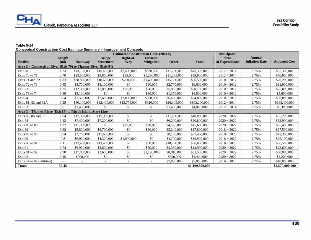
Clough, Harbour & Associates LLP
5-85
I-95 Corridor
Feasibility Study
Table 5-14 Conceptual Construction Cost Estimate Summary – Improvement Concepts
Estimated Construction Costs (2004 $) Section
Length
(mi) Roadway Bridge
Structures Right-of-
Way Environ.
Mitigation Other1 Total
Anticipated Year
of Expenditure Annual
Inflation Rate
Adjusted Cost Area 2 – Connecticut River (Exit 70) to Thames River (Exit 84) Exit 70 1.23 $13,100,000 $15,400,000 $2,400,000 $620,000 $11,780,000 $43,300,000 2012 ~ 2014 2.75% $55,300,000 Exits 70 to 71 2.70 $23,500,000 $3,800,000 $25,000 $1,290,000 $11,285,000 $39,900,000 2012 ~ 2014 2.75% $50,900,000 Exits 71 and 72 1.83 $28,800,000 $10,600,000 $200,000 $1,400,000 $15,500,000 $56,500,000 2010 ~ 2012 2.75% $70,200,000 Exits 72 to 73 0.45 $3,700,000 $3,100,000 $0 $30,000 $2,770,000 $9,600,000 2010 ~ 2012 2.75% $11,900,000 Exit 73 1.25 $12,300,000 $1,800,000 $25,000 $90,000 $5,885,000 $20,100,000 2010 ~ 2012 2.75% $25,000,000 Exits 73 to 74 0.39 $3,100,000 $0 $0 $30,000 $1,370,000 $4,500,000 2010 ~ 2012 2.75% $5,600,000 Exit 74 0.64 $7,500,000 $7,600,000 $2,800,000 $300,000 $6,600,000 $24,800,000 2010 ~ 2012 2.75% $30,800,000 Exits 81, 82 and 82A 3.28 $40,100,000 $22,400,000 $13,775,000 $820,000 $26,105,000 $103,200,000 2012 ~ 2014 2.75% $135,400,000 Exit 83 0.51 $3,400,000 $0 $0 $0 $1,400,000 $4,800,000 2012 ~ 2014 2.75% $6,300,000 Area 3 – Thames River (Exit 85) to Rhode Island State Line Exits 85, 86 and 87 2.04 $12,300,000 $15,900,000 $0 $0 $11,800,000 $40,000,000 2020 ~ 2022 2.75% $65,200,000 Exit 88 1.12 $7,400,000 $7,200,000 $0 $0 $6,200,000 $20,800,000 2020 ~ 2022 2.75% $33,900,000 Exits 88 to 89 1.82 $11,000,000 $0 $25,000 $20,000 $4,555,000 $15,600,000 2020 ~ 2022 2.75% $25,400,000 Exit 89 0.68 $5,800,000 $6,700,000 $0 $60,000 $5,240,000 $17,800,000 2018 ~ 2020 2.75% $27,500,000 Exits 89 to 90 0.54 $3,700,000 $15,600,000 $0 $0 $8,100,000 $27,400,000 2018 ~ 2020 2.75% $42,300,000 Exit 90 0.8 $6,900,000 $4,300,000 $1,000,000 $0 $4,700,000 $16,900,000 2018 ~ 2020 2.75% $26,100,000 Exits 90 to 91 2.11 $12,400,000 $13,400,000 $0 $50,000 $10,750,000 $36,600,000 2018 ~ 2020 2.75% $56,500,000 Exit 91 0.74 $6,900,000 $3,600,000 $0 $50,000 $4,350,000 $14,900,000 2020 ~ 2022 2.75% $23,600,000 Exits 91 to 92 2.90 $17,800,000 $3,600,000 $0 $1,190,000 $8,910,000 $31,500,000 2020 ~ 2022 2.75% $50,000,000 Exit 92 0.15 $900,000 $0 $0 $0 $500,000 $1,400,000 2020 ~ 2022 2.75% $2,200,000 Exits 54 to 92 (Utilities) - - - - - $7,000,000 $7,000,000 2016 ~ 2018 2.75% $10,000,000 Totals 50.45 $1,109,800,000 $1,570,000,000
Clough, Harbour & Associates LLP
5-86
I-95 Corridor
Feasibility Study
Ø Replacement/Reconstruction of Affected Bridge Structures – It was assumed that three major multi-span structures and their approaches, including the Baldwin Bridge over the Connecticut River, the Gold Star Bridge over the Thames River and the Groton Reservoir structure, will not require modifications as discussed in Section 5.3.3. The Leetes Island Road structure at Exit 56, which was recently reconstructed in 2003, and the Cross Road structure at Exit 81, which is currently under construction and scheduled for completion in 2005, also will not require modifications because these overpass structures provide sufficient vertical and lateral clearance to accommodate the widened section. In addition, it was assumed that several structures located in Areas 2 and 3 will not require modifications. All other major bridge structures and box culverts affected by the mainline widening were assumed to be completely reconstructed for purposes of estimating construction costs. This assumption provides a worst-case scenario for likely structure costs to be incurred when the widened facility is constructed. A summary table presenting the locations and areas of all the affected bridge structures is provided in the appendix.
Ø Year of Expenditure and Escalation Factor – ConnDOT and FHWA estimating guidelines require construction cost estimates in current-year dollars be inflated by an escalation factor to better reflect the actual costs of projects in the anticipated year of expenditure. In accordance with ConnDOT guidelines, the assumed annual escalation factor is 2.75%. The anticipated year of expenditure for each section shown in Table 5-14 is the approximate year in which construction will be at the mid-point of completion based on the long-term implementation plan presented in Section 6.3.2.
Ø Utilities – Any major anticipated utility impacts within the study area have been identified. In accordance with FHWA estimating guidelines, costs associated with relocating these impacted utilities are included in the construction cost estimate.
Ø Right-of-Way – Any major right-of-way impacts associated with the mainline widening and interchange improvements have been identified and their areas have been calculated. In accordance with FHWA estimating guidelines, costs associated with each property acquisition are included in the construction cost estimate for each section.
Ø Environmental Mitigation – Any major wetland impacts associated with the mainline widening and interchange improvements have been identified and their areas have been calculated. In accordance with FHWA estimating guidelines, direct and indirect costs associated with mitigating these impacts are included in the construction cost estimate for each section.
5.7 Managed Lane Feasibility Analysis
As part of this study, an in-depth evaluation was conducted to determine the potential effectiveness of a managed, or value-priced, lane in the I-95 corridor between Exit 54 in Branford and the Rhode Island state line. Value-pricing is a generic term for congestion-related charges imposed on new lanes constructed for additional capacity in a corridor where a free facility of the same functional class already exists. A barrier-separated managed lane would be located parallel to the existing highway in both the northbound and southbound directions and entrance and exit points would be strategically located throughout the corridor. Motorists would be charged a variable fee to use the managed lane based on time savings. These fees would be collected automatically utilizing electronic toll collection technology.
Clough, Harbour & Associates LLP
5-87
I-95 Corridor
Feasibility Study
The Feasibility of Managed (‘Value-Priced’) Lanes report located in the appendix provides a complete evaluation of the potential effectiveness of a managed lane in the study area. The analysis concluded that motorists on a facility with one managed lane and two general purpose lanes would experience more total delay than motorists on a facility with three general purpose lanes. Furthermore, the additional cost to construct the managed lanes was estimated to be approximately $600 million more than the cost to construct a third general purpose lane in each direction. Over their lifetime, the managed lanes would only generate enough revenue to offset approximately one-fifth of this additional cost. In general, it was concluded that a managed lane facility located within the study area would be less effective in addressing the anticipated future traffic demands than the recommended widening improvements. This is primarily due to the absence of a clear operational benefit to the average user resulting from the managed lane, as well as the overall cost and environmental impacts associated with the wider managed lane typical section.