Embed Size (px)
Citation preview
In-stream gravel mining impacts and environmental degradation feedback associated with gravel mining on the Rio Tigre of the OSA
Peninsula, Costa Rica, and the proposed ADI Jimenez Gravel Mining Concession
An environmental impact summary and hydrographic analysis of the ADI Jimenez Gravel Mining Proposal Environmental Impact Statement
July, 2009
Prepared by:
Bruce Melton, P.E.
Melton Engineering Services Austin 8103 Kirkham
Austin, Texas 78736
Table of Contents 0.0 Purpose and Content of Report 1.0 Introduction (Include a key sentence on the degradation feedback effect, no references, Bruce’s
analysis – KEY POINT OF ANALYSIS) 1.1 Historic Regulatory Protection 1.2 Currently Accepted Gravel Mining Practices 1.3 General Impacts of In-Stream Mining 1.4 Detailed Description of Specific Impacts of In-Stream Mining
1.4.1 Impacts on Water Clarity and Submerged Gravel Beds 1.4.2 Impacts on Water Quality 1.4.3 Impacts on the River Channel 1.4.4 Impacts on Channel Depth 1.4.5 Impacts from Loss of Large Stones and Woody Debris 1.4.6 Impacts Upstream and Downstream
2.0 Greater Effects of In-Stream Mining on the Regional Environment 3.0 Analysis of Hydrologic Calculations of the ADI Jimenez Mining Proposal and Issues Relative to
3.1 Averaging Produces Conservative Results in the Watershed of the Rio Tigre 3.2 Runoff Coefficient is Inaccurate 3.3 Averaging of Slopes Results in Conservative Assumptions 3.4 Hypsometric Curve Assumptions is Inaccurate 3.5 Inaccurate Assumption of the Change in Height of the Watershed 3.6 Summary of the Effects of the ADI Jimenez Hydrographic Assumptions in the Rio Tigre
Basin 4.0 Analysis of ADI Jimenez Mitigation, Restoration and Miscellaneous Assumptions
4.1 No Limits to Project Development Listed Under “Range of Indirect Influence (AII)” 4.2 Bank Armoring with Groins (Rock layers and rock and wire baskets) 4.3 Increase in Channel Width and Natural Restoration of the River Channel 4.4 Damage is Only Partially Restorable
5.0 Degradation Feedback Effect 5.1 The Myth of the Replenishment Rate Concept 5.2 General Effects of Degradation Feedback 5.3 Nickpoint Erosion 5.4 Impacts Reaching the Headwaters 5.5 The Multiplying Effect of Continual Gravel Mining Concessions
6.0 Alternatives to In-stream Mining and Suggestions for Research 6.1 Uplands Gravel Mining 6.2 Mining Gravel Adjacent to the River Channel
7.0 Suggestions for Research 8.0 Conclusions
FINAL DRAFT 072109 In-stream gravel mining impacts and environmental degradation
feedback associated with gravel mining on the Rio Tigre of the OSA Peninsula, Costa Rica, and the proposed ADI Jimenez Gravel Mining Concession
In-stream gravel mining is a practice that has been found to have extreme impacts, not only to riverine ecosystems, but also to areas the size of entire watersheds and larger. This practice commonly sees the complete removal of the river geometry and associated habitat from bank to bank. The practice has been known to be very damaging for nearly a century in other parts of the world and is increasingly being banned entirely. The extensive damage to the ecosystem that is caused by this type gravel mining is not easily repaired, either by nature or by man’s efforts. The damages therefore persist for decades or longer. Much of the world has adopted environmental regulations that do not allow, or significantly restrict in0stream mining like is proposed for the Rio Tigre. Alternatives to in-stream mining exist that are not only significantly less damaging to the environment, but are often more cost efficient in their operation.
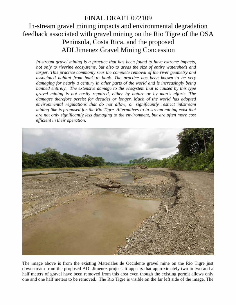
The image above is from the existing Materiales de Occidente gravel mine on the Rio Tigre just downstream from the proposed ADI Jimenez project. It appears that approximately two to two and a half meters of gravel have been removed from this area even though the existing permit allows only one and one half meters to be removed. The Rio Tigre is visible on the far left side of the image. The
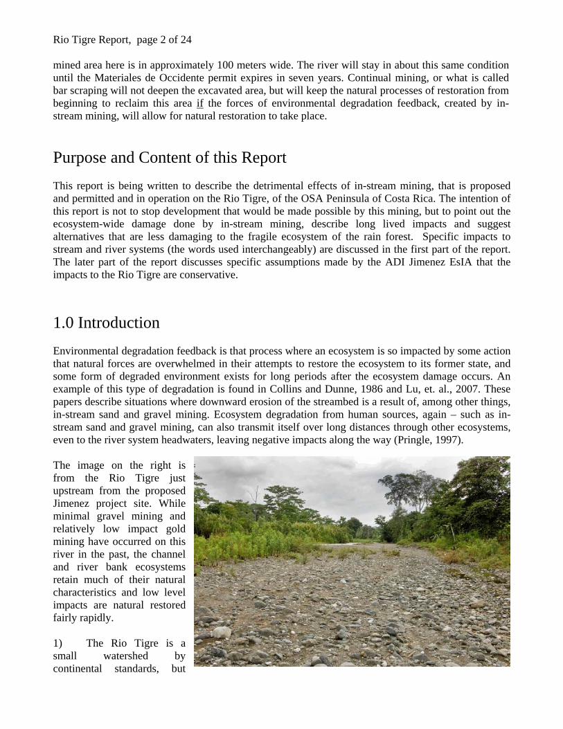
Rio Tigre Report, page 2 of 24 mined area here is in approximately 100 meters wide. The river will stay in about this same condition until the Materiales de Occidente permit expires in seven years. Continual mining, or what is called bar scraping will not deepen the excavated area, but will keep the natural processes of restoration from beginning to reclaim this area if the forces of environmental degradation feedback, created by in-stream mining, will allow for natural restoration to take place. Purpose and Content of this Report This report is being written to describe the detrimental effects of in-stream mining, that is proposed and permitted and in operation on the Rio Tigre, of the OSA Peninsula of Costa Rica. The intention of this report is not to stop development that would be made possible by this mining, but to point out the ecosystem-wide damage done by in-stream mining, describe long lived impacts and suggest alternatives that are less damaging to the fragile ecosystem of the rain forest. Specific impacts to stream and river systems (the words used interchangeably) are discussed in the first part of the report. The later part of the report discusses specific assumptions made by the ADI Jimenez EsIA that the impacts to the Rio Tigre are conservative. 1.0 Introduction Environmental degradation feedback is that process where an ecosystem is so impacted by some action that natural forces are overwhelmed in their attempts to restore the ecosystem to its former state, and some form of degraded environment exists for long periods after the ecosystem damage occurs. An example of this type of degradation is found in Collins and Dunne, 1986 and Lu, et. al., 2007. These papers describe situations where downward erosion of the streambed is a result of, among other things, in-stream sand and gravel mining. Ecosystem degradation from human sources, again – such as in-stream sand and gravel mining, can also transmit itself over long distances through other ecosystems, even to the river system headwaters, leaving negative impacts along the way (Pringle, 1997). The image on the right is from the Rio Tigre just upstream from the proposed Jimenez project site. While minimal gravel mining and relatively low impact gold mining have occurred on this river in the past, the channel and river bank ecosystems retain much of their natural characteristics and low level impacts are natural restored fairly rapidly. 1) The Rio Tigre is a small watershed by continental standards, but
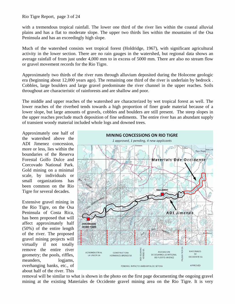
Rio Tigre Report, page 3 of 24 with a tremendous tropical rainfall. The lower one third of the river lies within the coastal alluvial plains and has a flat to moderate slope. The upper two thirds lies within the mountains of the Osa Peninsula and has an exceedingly high slope. Much of the watershed consists wet tropical forest (Holdridge, 1967), with significant agricultural activity in the lower section. There are no rain gauges in the watershed, but regional data shows an average rainfall of from just under 4,000 mm to in excess of 5000 mm. There are also no stream flow or gravel movement records for the Rio Tigre. Approximately two thirds of the river runs through alluvium deposited during the Holocene geologic era (beginning about 12,000 years ago). The remaining one third of the river is underlain by bedrock . Cobbles, large boulders and large gravel predominate the river channel in the upper reaches. Soils throughout are characteristic of rainforests and are shallow and poor. The middle and upper reaches of the watershed are characterized by wet tropical forest as well. The lower reaches of the riverbed tends towards a high proportion of finer grade material because of a lower slope, but large amounts of gravels, cobbles and boulders are still present. The steep slopes in the upper reaches preclude much deposition of fine sediments. The entire river has an abundant supply of transient woody material included whole logs and downed trees. Approximately one half of the watershed above the ADI Jimenez concession, more or less, lies within the boundaries of the Reserva Forestal Golfo Dulce and Corcovado National Park. Gold mining on a minimal scale, by individuals or small organizations has been common on the Rio Tigre for several decades. Extensive gravel mining in the Rio Tigre, on the Osa Peninsula of Costa Rica, has been proposed that will affect approximately half (50%) of the entire length of the river. The proposed gravel mining projects will virtually if not totally remove the entire river geometry; the pools, riffles, meanders, logjams, overhanging banks, etc., of about half of the river. This removal will be similar to what is shown in the photo on the first page documenting the ongoing gravel mining at the existing Materiales de Occidente gravel mining area on the Rio Tigre. It is very
Rio Tigre Report, page 4 of 24 important to note that once the river geometry is removed, it is very difficult to replace whether by mans action or the actions of Mother Nature. The proposed mining areas, or concessions, are located between the coastal area and the mountains along a nearly continuous stretch of river nearly ten kilometers long (over six miles). The mining method that is proposed is in-stream mining that will remove approximately one and a half meters (five feet) of sediment from the entire river width in the mining areas. Association de Desarrollo Integral De Puerto Jimenez (ADI Jimenez) The specific concession that this report addresses is the Association de Desarrollo Integral De Puerto Jimenez (ADI Jimenez) Specific comments in this report address the EsIA submitted for approval for the mining permit for ADI Jimenez. This type of mining will remove the existing river ecosystem along with much of the accompanying river edge vegetation, almost in its entirety. Historic study has shown that the impacts of this type of mining include: loss or degradation of spawning beds and juvenile rearing habitat, migration blockages, channel widening, river shallowing, ponding, loss of river channel stability, loss of pool and riffle structure, increased turbidity and sediment transport, increased bank erosion and or streambed downcutting, and loss or degradation of riparian habitat (NMFS, 2005). Riverbed mining such as is proposed on the Rio Tigre has impacts that reach further than just the bed of the river. The U.S. National Marine Fisheries National Gravel Extraction Policy states that:
Individual gravel extraction operations must be judged in the context of their spatial and temporal cumulative impacts.
Three words are important in this concept:
Spatial refers to the action of the gravel mining on the environmental around it – on the space around it. The river is the heart and circulatory system of an ecosystem. If the river is damaged, or removed in this case, the damage has impacts on the ecosystem around it. Temporal refers to the time dimension of the impacts of river mining. The impacts of the removal of the river itself do not go away when the mining stops. Because the damage is so difficult to restore, the impacts last for a long time, and can become more damaging with time. Cumulative refers to what happens when impacts are added together. An example of cumulative impacts is what happens with the shallowing of the river. Gravel mining in a river channel spreads out the river water. This shallowing causes increased sideways erosion resulting in bank collapse. Bank collapse increases the amount of fine sediment in the river, decreases the amount of shading and increases the temperature of the water. Together, all of these impacts are greater than just the impacts of the shallowing of the river.
The U.S. National Marine Fisheries Gravel Extraction Policy continues:
… potential impacts to habitat should be viewed from a watershed management perspective.
Rio Tigre Report, page 5 of 24 This concept, of considering the impacts of gravel mining to be a part of the entire watershed, is very important when understanding the complete impacts of this sort of mining. 1.1 Historic Regulatory Protection Gold mining during the gold rush was carried out on a very large scale in river channels in Western North America. This type of mining was called “placer mining” and involved changes to the river environment very similar to what with in-stream gravel mining. In placer mining, the entire riverbed is excavated and sifted for gold, similar to what is proposed for the Rio Tigre. This work destroys the pools, riffles, cut banks, log piles, etc, and replaces the original river with one that is very difficult to restore, again, either by man or nature. Many impacts from in-stream mining have persisted since the 1880s (Kondolf, 1994 a, b, 2002). The results have been that most of the States in Western North America where placer mining occurred have programs in place to restore the impacts of mining on streams and rivers that were mined over 100 years ago. Even the U.S. National Forest Service has a program in place to try and restore the damage from in-stream mining. Mining within the river channel has become increasingly more around the world over the last 100 years because of regulations protecting the waterways from damage. These regulations have been created through much trial and error. This trial and error more often involves minimizing impacts to the growth of society, including economic as well as infrastructure development. The challenge to those areas around the world that still allow significant mining in streams and rivers is to be able to apply the learned knowledge from the rest of the world to the benefit of their social and economic growth. In the U.S., these regulations have been developed by state governments, the U.S. Fish and Wildlife Service and the U. S. Army Corp of Engineers. Specific national regulations include those adopted by the Clean Water Act, Endangered Species Act, Fish and Wildlife Conservation Act, and the National Environmental Policy Act. 1.2 Currently Accepted Gravel Mining Practices One of the reasons why the U.S. has developed its quality of living and economic prosperity can be traced directly back to environmental protection. Minimizing the effects of any activity on the environment, overall, enhances the economic, industrial, commercial and social sectors and produces a more prosperous society. The preferred method of gravel mining has now become one where gravel is obtained from pits that are either adjacent to the river and not within the river channel, or are located in the uplands in pre-historic deposits of gravel. It is important to note however that the mining of gravel adjacent to the river is also damaging to the environment and the best alternative is to go to the uplands, or river terraces to obtain gravel materials. This is an area where damages can be minimized. Adjacent and cumulative impacts are less than either in-stream mining or mining directly adjacent to, but not within the river channel.
Rio Tigre Report, page 6 of 24 Many upland areas across the world, including the eastern shores of the Golfo Dulce, are underlain by the very same gravel deposits that can be found in the river channels. These deposits are covered by a small amount of soil and are easily removed with virtually the same mining techniques that are proposed to be used in the river channel on the Rio Tigre. In many cases this source of gravel can be mined more economically than the river channel because the materials are closer to the place of use and the costs of transportation are less. 1.3 General Impacts of In-Stream Mining The removal of sand and gravel materials from and immediately adjacent to river channels has direct negative impacts on the stream’s habitat including channel shape, streambed stability and composition, the amount of woody material in the channel, water depth, velocity, turbidity, flow amount and water temperature (Rundquist 1980, Pauley et. al., 1989, Kondolf, 1994a, b, Rivier and Seguier, 1985; OWRRI 1995). These impacts are described further in the following:
Channel shape flattens – In-stream mining basically removes the channel of the river from the riverbed. It leaves behind a flat, featureless plain with virtually no place left for many, if not most of the river fauna to exist. Streambed stability decreases – River mining decreases the streambed stability because of the removal of streambed armoring. Streambed stability is the single most important aspect of a river system’s ecology. The streambed is made up of variable curves and straight sections (meanders), deep holes with slow water movement, shallow riffles with fast water movement, log or woody debris jams, long pools with slow water movement and overhanging banks. A natural stream develops what is called armoring along its bottom and sides. This armoring is developed over many years or decades. The process t consolidates, or strengthens the bed of the river where it meets the flowing water. This armoring is stronger than the gravels beneath and helps protect the stream or river from erosion due to flooding. Without this armoring, even small rises in normal river level can create erosion that damages the river. The removal of this armoring by mining is difficult to restore naturally or with man’s assistance and can continue to impact the river long after mining is completed. Removal of woody material from the channel – the first thing that happens with gravel mining is that all of the tree trunks, branches and organic material are removed from the stream. This means that the fauna that lived in and around these materials no longer have a place to live. This woody material also provides the stream with a way to build bars and pools. As river water stacks up in front of these debris and rushes around or over them in different ways, sand, gravel and sediment are deposited, thus creating river features. When the gravel removal is completed, the increased water velocity during floods tends to wash these materials downstream much faster and reduces the chance that they will catch and build back the bars and holes that benefit the stream. This process is self-continuing, that is, without these normal obstructions in the channel, the formation of the structures that capture the woody materials never occurs and the waterway stays shallow without holes and bars.
Rio Tigre Report, page 7 of 24
Water depth decreases – The flattening of the river channel resulting from in-stream mining allows the river water to spread out over a larger area creating a much shallower water depth than would normally be present. River fauna that require greater water depth can no longer exist in the shallower water. Velocity increases – When the natural channel of a river is destroyed, water spreads out over a larger area, its speed increases, relative to the stream bottom. A given amount of water can therefore erode a larger amount of streambed. If the water was confined to a deep channel, that same amount of water flowing in the deep channel that is not directly in contact with the streambed has little or no impacts on the erosion of the streambed. Turbidity increases – The effects of increased erosion creates greater turbidity, (cloudiness or murkiness) of the river water overall. When a stream or river is deep, the flow slows down and sand and gravel and fine sediments drop to the bottom where they remain until a large runoff event occurs that increases the bottom water velocity. With a shallower river, the higher bottom water speeds occur more often and so there is more fine sediment in the water more often. This changes the character of the stream from a clear stream to a murky stream and those fauna that require clear water can no longer survive. Temperature increases – Temperature also increases from in-stream mining due to several reasons. Shallower water is able to heat up more rapidly. Removal of the streamside vegetation allows more sun to hit the water allowing more heating. The streamside vegetation removal from the initial mining is aggravated by increased erosion of the banks of the river from the increased speed of the water over a greater area. This further removes riverbank vegetation causing more sunlight to hit the water and more heating.
When these things are changed in any stream or river, including one like the Rio Tigre, the impacts to the stream or river and the riverbank vegetation have been proven to be negative (Sandecki, 1999). 1.4 Detailed Description of Specific Impacts of In-Stream Mining The following is a more detailed analysis of the impacts of gravel mining: 1.4.1 Impacts on Water Clarity and Submerged Gravel Beds Gravel extraction increases suspended fine sediment, sediment transport, water turbidity and gravel siltation (OWWRI, 1995: Cordone and Kelly, 1961; Rundquist, 1980). Increased velocity resulting from river shallowing and removal of streambed armoring creates a larger amount of fine sediment, more frequently, in streams that have been mined than in streams with natural depths and armoring. This increases the movement of finer sediments in particular because they are exposed to the higher water speeds more often with smaller rises in water level. The results are that stream waters are murky more often, or there are a greater number of days per year that the water is murkier than it would be if the mining had not occurred. The fine sediments become more predominant in the upper surface of stream gravels, which in particularly has a negative impact
Rio Tigre Report, page 8 of 24 on incubating fish eggs and insect larvae in streams, which are a significant food source in the ecosystem. The settling and accumulation of fine sediment (silt and clay as well as sand and fine gravel) into the pore spaces in river gravel acts to impede inter-gravel water flow and reduce oxygen levels, vital to insect larvae and other fauna that live in the gravel (Chapman, 1988). The reduction of inter-gravel water flow can result from the surface gravel becoming capped by sand, which forms an impermeable layer preventing water flow through the gravel (Sear, 1993). Many, if not most of the fauna that live in streams rely significantly on the insect population that lives within the upper surface of the submerged river gravel. Many other animals also rely on this important food source for some, or a majority of their food supply. Submerged river gravel is also an important place for fish eggs to incubate, as well as providing some habitat for very young and or very small fishes. 1.4.2 Impacts on Water Quality An increase in the amount of fine sediments increases the amount of sediment-associated nutrients (especially phosphorus) and contaminants in the river water. This increases the amount of water quality degradation caused by excessive nutrients with the resulting negative impacts to aquatic life. (Johnes and O’Sullivan, 1989, Owens and Walling, 2002b, Correll, 1998). Nutrients from various sources (nitrogen, phosphorus, etc.) attached themselves chemically and physically to sediment particles, or are carried along by the sediment as particles of decayed or decaying organic material. Over time, these nutrients build up in the river gravels. While this build up is taking place, chemical changes occur to the nutrients, or decay proceeds with the organic particles. The result is that nutrient levels in the sediments and gravels increase over time. When the river gravels are disturbed, these nutrient become more mobile in the environment, that is, they are released from the sediments into the water column. Excessive nutrients in the water promote increased algal growth with associated decreases in water clarity and water quality. Down cutting of the river channel through continued erosion after mining has stopped continues to release nutrients with continued impacts on the river. 1.4.3 Impacts on the River Channel Decreased flow depth, increased water speed and the resulting increase in erosion forces create an unstable river channel that moves around within the river bed, or meanders, much more rapidly than a natural river channel (Collins and Dune, 1999; Rundquist; 1980 Moulton, 1980; Kondolf, 1984a, b: OWWRI, 1995). The removal of the riverbed armoring that occurs in stream mining and the flattening of the stream bed creates a rapidly changing and unstable environment for a stream. This type of action is even more prominent in streams with a high variability of water level such as the Rio Tigre. Without the protection of the stream armoring, and with increased water speed, streams tend to braid within their channels. That is, they form numerous smaller channels instead of fewer larger channels. These smaller channels move sideways within the overall river bed more quickly with water level rises after heavy rains and tend to combine and recombine in different configurations more rapidly than in streams that have not been mined. Deep holes are not allowed to form because more material is being washed around in the more rapidly moving water. Less sand, gravel and sediment is captured in these deep holes and instead, remains suspended in the water flow where it can be redeposited in shallower areas. These events occur more
Rio Tigre Report, page 9 of 24 frequently because a smaller rainfall event is now required to mobilize the sediment. (The smaller rainfall events occur more often.) The greater movement of the more numerous smaller channels within the overall streambed pushes more water (more often) against a larger amount of the stream bank. This increases the sideways erosion of the stream bank adding, in general, a larger amount of finer sediments to the river flow. This is because, in general, finer sediments have been deposited along the banks of the river before the mining took place. These sediments contribute sediment to the river in addition to those sediments that are more frequently disturbed by the higher speed of the shallower flows. A shallower stream, subject to large changes in water level, can also form small holes that trap fish that then die in the dry season as the water holes disappear. 1.4.4 Impacts on Channel Depth Analysis of extensively mined river channels has shown that downward erosion of the riverbed is a result of intensive mining (Collins and Dunne, 1986). The downward erosion rate has been estimated to be 30 mm per year. These impacts are compounded because larger flood events can be accommodated in the deeper channel, increasing the amount of erosion that occurs within the channel rather than having that extra floodwater dispersed across the flood plain (which decreases the amount of in-stream erosion). The increased bed erosion also decreases further the stability of the riverbanks. 1.4.5 Impacts from Loss of Large Stones and Woody Debris The removal or disturbance of in-stream roughness elements (large stones and boulders, tree trunks, branches, woody debris) during gravel mining has a negative effect on the amount and quality of fish habitat (Naiman, et. al.; Franklin 1992; Franklin, et. al., 1995, OWRRI, 1995). Fish need calm water and hiding places in order to survive. If these places are removed from a river, along with the river armoring, they are very difficult to reestablish because of increased erosion and stream channel movement. 1.4.6 Impacts Upstream and Downstream These impacts are not limited to the original mining site and reach far upstream and downstream (Kondolf, 2002, Pringle, 1997). Downstream impacts result from increased amounts of floodwater and increased floodwater speeds. When gravel mining deepens the channel, less floodwaters are forced into the flood plain because the channel holds more water. This increase in the amount of water in the channel increases the speed of water above that experienced before the mining occurred. This increased water speed is what causes erosion. The downstream river channel deepens because of the erosion. This effect is first felt immediately downstream from the mined area, but as the erosion extends further downstream, the same impacts are repeated and the erosion becomes self-sustaining. Upstream impacts also occur in the form of what is called nickpoint erosion. This happens when river waters flow from the natural unmined stream into the deepened stream where the gravel was removed. At the point where the natural streambed changes to the mined area, the water speed increases as it drops down. This increase in water speed increases the erosion and the channel deepens. This process too is self-perpetuating and proceeds upstream under its own power.
Rio Tigre Report, page 10 of 24 2.0 Greater Effects of In-Stream Mining on the Regional Environment Of great significance in this discussion is the cumulative effect of multiple mining concessions. At present there are five proposed concessions on the Rio Tigre that involve about 10 kilometers of continuous river length. The combined impacts of these concessions is something that must be taken into consideration in the decisions regarding in0stream mining on this river. The basic result of in-stream mining is the removal of the natural river system. The natural river system is replaced with an unstable, difficult to restore and relatively unproductive ecosystem, often with vastly different characteristics from the natural river. The loss of this ecosystem effects the overall environment in many and far reaching ways. Food sources are obviously impacted. Many fauna rely directly, or in part, on food sources in the river to survive. Depriving these fauna of their food sources not only drives them to other areas to attempt to feed, but places a greater amount of stress on other fauna that may be more dependent on those other places for their food. This reaction happens like a row of toppling dominoes as the impacts move further and further from the water, impacting more and more fauna and distinct habitats. The riverbanks are a special ecosystem that develops, with the extra water and extra sunshine found on the rivers edge, in ways that cannot be replicated elsewhere. When the banks collapse from increased sideways erosion of the river channel, these ecosystems are lost. When the riverbed is deepened, less sediment accumulates on riverbanks in floods so the natural rebuilding of the banks is decreased. The riverbanks are not only a unique habitat, but they supply wildlife with a road to the river to reach food and water. Many species find it difficult to cross open areas because of the risk of predation. Those that do cross are in danger of greater predation because of this increased risk. In-stream mining from these mining proposals will also impact the Golfo Dulce. These impacts will continue, like most of the other impacts, long after the mining has concluded. The increased transport of fine sediments will likely extend downstream to the Golfo Dulce and is virtually unstopped because of current existing and proposed mining downstream of the proposed site. Increased sand, gravel and fine sediment deposition at the mouth of the Rio Tigre will impact coral reefs in the area. The closest reefs will be impacted the most. There are two reefs in the general vicinity of the mouth of the Rio Tigre. One is immediately to the north and the other is immediately adjacent to the south. Mangroves at the mouth of the river are affected as well. Sediment transported to the mouth of the river overflows into the mangrove swamps where it accumulates. This impacts the transport of oxygen to and from the soils in the affected area, negatively impacting the existing fauna. In-stream mining also impacts diversity. When the in-stream mining removes or alters the river and riverbank habitat, the number of individual species that once lived in those habitats declines. Diversity is one of the single most important aspects of life on the Rio Tigre, the upper reaches of which are included in the Corcovado National Park.
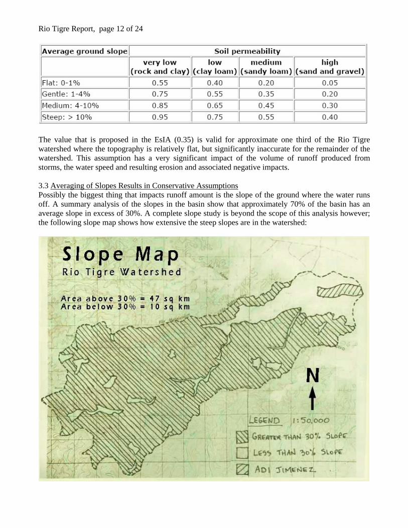
Rio Tigre Report, page 11 of 24 The direct impacts of habitat degradation are reflected in the diversity and general health of the adjacent habitats. As the diversity and general health of these adjacent habitats are impacted, the chain reaction proceeds in an ever widening circle to impact even more the greater diversity and health of the environment of the region. 3.0 Analysis of Hydrologic Calculations of the ADI Jimenez Mining Proposal and Issues Relative to Environmental Impacts on the Rio Tigre and Golfo Dulce The hydrologic analysis (the study of the rainfall / runoff relationship) found in the EsIA for the ADI Jimenez proposal could produce conservative estimates of the frequency of peak runoff river elevations, volume and flow for a number of reasons. These reasons are mostly related to the way in which the variables for runoff were calculated. When determining peak runoff, numerous variables are assumed to determine approximately how much runoff will arrive at a given point along a river at a given time. These variables include things like the watershed size, slope of the channel, slope of the non-channel areas, soil types and rainfall intensity (how much rain falls over a given time period). If it rains harder (more rain falls in a shorter period of time), all other things being equal, more runoff will be produced at a given point compared to a rainfall event where less water falls from the sky in the same amount of time. The same assumptions are true for a watershed with steep slopes compared to one with less steep slopes. The steeper sloped watershed will see the rainfall run off faster than the less steeply sloped watershed and the runoff. This puts more water in the river faster and higher flood elevations result. 3.1 Averaging Produces Conservative Results in the Watershed of the Rio Tigre The calculation parameters used to perform the hydrologic analysis for the Rio Tigre basin were based on averaging the different land types and slopes of the basin together into one number. This one number was then used to generalize the physical conditions of the entire basin. This type of calculation works for some basins, but not for the Rio Tigre. The real world runoff produced is greater than what ADI Jimenez proposes. Two issues are detailed in this section that demonstrate this concept: the first is an understanding of the accuracy of the assumptions used in the ADI Jimenez report, the second is an understanding of the impacts of averaging. 3.2 Runoff Coefficient is Inaccurate The runoff coefficient is that number that is given to the portion of the water flow calculation that looks at friction vs. water flow speed. Greater friction means the water flows more slowly. The friction coefficient used for the report is 0.35. Watkins and Fiddes, 1991, Highway and Urban Hydrology in the Tropics, says that this value, in humid regions, should be 0.95 for steep slopes over 10% in rocky areas:
Rio Tigre Report, page 12 of 24
The value that is proposed in the EsIA (0.35) is valid for approximate one third of the Rio Tigre watershed where the topography is relatively flat, but significantly inaccurate for the remainder of the watershed. This assumption has a very significant impact of the volume of runoff produced from storms, the water speed and resulting erosion and associated negative impacts. 3.3 Averaging of Slopes Results in Conservative Assumptions Possibly the biggest thing that impacts runoff amount is the slope of the ground where the water runs off. A summary analysis of the slopes in the basin show that approximately 70% of the basin has an average slope in excess of 30%. A complete slope study is beyond the scope of this analysis however; the following slope map shows how extensive the steep slopes are in the watershed:
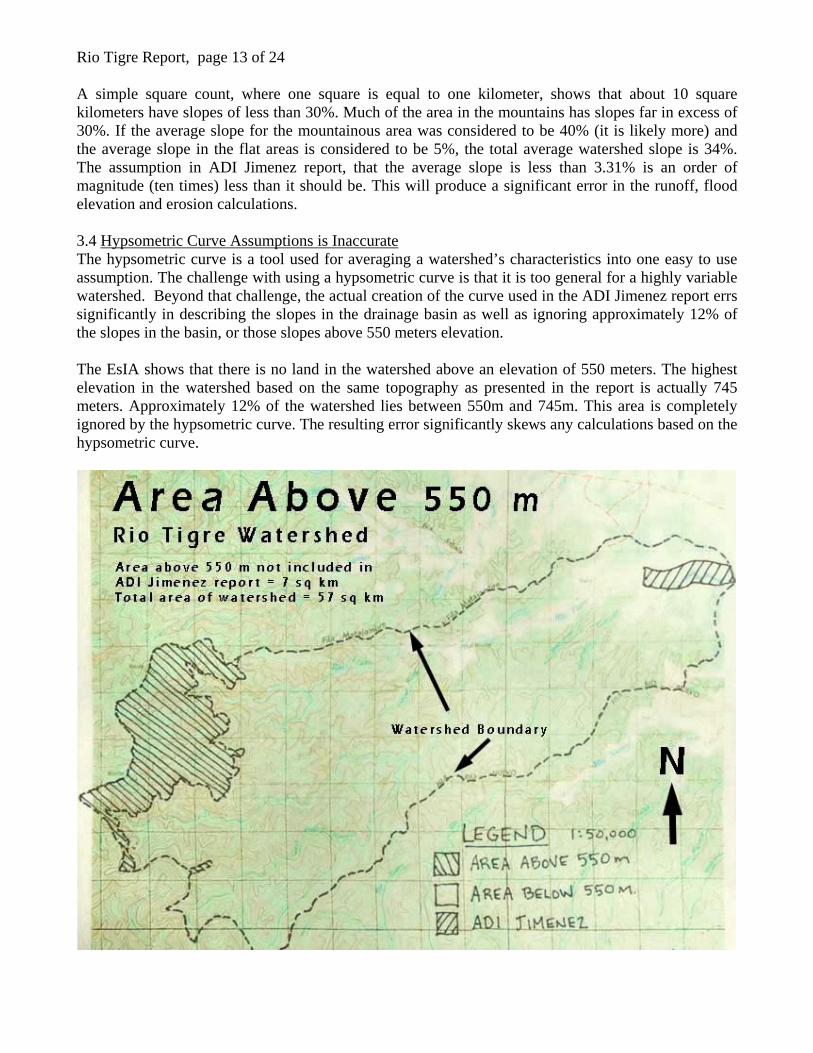
Rio Tigre Report, page 13 of 24 A simple square count, where one square is equal to one kilometer, shows that about 10 square kilometers have slopes of less than 30%. Much of the area in the mountains has slopes far in excess of 30%. If the average slope for the mountainous area was considered to be 40% (it is likely more) and the average slope in the flat areas is considered to be 5%, the total average watershed slope is 34%. The assumption in ADI Jimenez report, that the average slope is less than 3.31% is an order of magnitude (ten times) less than it should be. This will produce a significant error in the runoff, flood elevation and erosion calculations. 3.4 Hypsometric Curve Assumptions is Inaccurate The hypsometric curve is a tool used for averaging a watershed’s characteristics into one easy to use assumption. The challenge with using a hypsometric curve is that it is too general for a highly variable watershed. Beyond that challenge, the actual creation of the curve used in the ADI Jimenez report errs significantly in describing the slopes in the drainage basin as well as ignoring approximately 12% of the slopes in the basin, or those slopes above 550 meters elevation. The EsIA shows that there is no land in the watershed above an elevation of 550 meters. The highest elevation in the watershed based on the same topography as presented in the report is actually 745 meters. Approximately 12% of the watershed lies between 550m and 745m. This area is completely ignored by the hypsometric curve. The resulting error significantly skews any calculations based on the hypsometric curve.
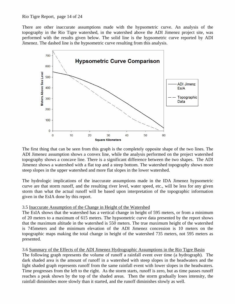
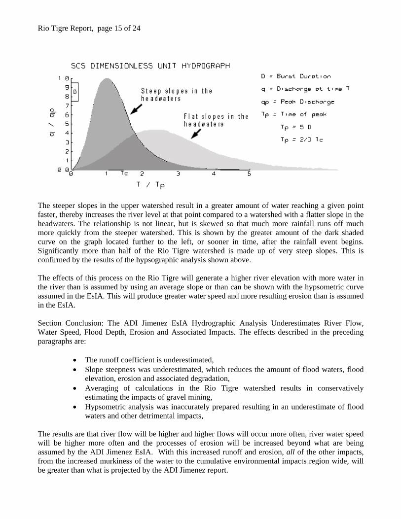
Rio Tigre Report, page 14 of 24 There are other inaccurate assumptions made with the hypsometric curve. An analysis of the topography in the Rio Tigre watershed, in the watershed above the ADI Jimenez project site, was performed with the results given below. The solid line is the hypsometric curve reported by ADI Jimenez. The dashed line is the hypsometric curve resulting from this analysis. The first thing that can be seen from this graph is the completely opposite shape of the two lines. The ADI Jimenez assumption shows a convex line, while the analysis performed on the project watershed topography shows a concave line. There is a significant difference between the two shapes. The ADI Jimenez shows a watershed with a flat top and a steep bottom. The watershed topography shows more steep slopes in the upper watershed and more flat slopes in the lower watershed. The hydrologic implications of the inaccurate assumptions made in the IDA Jimenez hypsometric curve are that storm runoff, and the resulting river level, water speed, etc., will be less for any given storm than what the actual runoff will be based upon interpretation of the topographic information given in the EsIA done by this report. 3.5 Inaccurate Assumption of the Change in Height of the Watershed The EsIA shows that the watershed has a vertical change in height of 595 meters, or from a minimum of 20 meters to a maximum of 615 meters. The hypsometric curve data presented by the report shows that the maximum altitude in the watershed is 550 meters. The true maximum height of the watershed is 745meters and the minimum elevation of the ADI Jimenez concession is 10 meters on the topographic maps making the total change in height of the watershed 735 meters, not 595 meters as presented. 3.6 Summary of the Effects of the ADI Jimenez Hydrographic Assumptions in the Rio Tigre Basin The following graph represents the volume of runoff a rainfall event over time (a hydrograph). The dark shaded area is the amount of runoff in a watershed with steep slopes in the headwaters and the light shaded graph represents runoff from the same rainfall event with lower slopes in the headwaters. Time progresses from the left to the right. As the storm starts, runoff is zero, but as time passes runoff reaches a peak shown by the top of the shaded areas. Then the storm gradually loses intensity, the rainfall diminishes more slowly than it started, and the runoff diminishes slowly as well.
Rio Tigre Report, page 15 of 24
The steeper slopes in the upper watershed result in a greater amount of water reaching a given point faster, thereby increases the river level at that point compared to a watershed with a flatter slope in the headwaters. The relationship is not linear, but is skewed so that much more rainfall runs off much more quickly from the steeper watershed. This is shown by the greater amount of the dark shaded curve on the graph located further to the left, or sooner in time, after the rainfall event begins. Significantly more than half of the Rio Tigre watershed is made up of very steep slopes. This is confirmed by the results of the hypsographic analysis shown above. The effects of this process on the Rio Tigre will generate a higher river elevation with more water in the river than is assumed by using an average slope or than can be shown with the hypsometric curve assumed in the EsIA. This will produce greater water speed and more resulting erosion than is assumed in the EsIA. Section Conclusion: The ADI Jimenez EsIA Hydrographic Analysis Underestimates River Flow, Water Speed, Flood Depth, Erosion and Associated Impacts. The effects described in the preceding paragraphs are:
• The runoff coefficient is underestimated, • Slope steepness was underestimated, which reduces the amount of flood waters, flood
elevation, erosion and associated degradation, • Averaging of calculations in the Rio Tigre watershed results in conservatively
estimating the impacts of gravel mining, • Hypsometric analysis was inaccurately prepared resulting in an underestimate of flood
waters and other detrimental impacts, The results are that river flow will be higher and higher flows will occur more often, river water speed will be higher more often and the processes of erosion will be increased beyond what are being assumed by the ADI Jimenez EsIA. With this increased runoff and erosion, all of the other impacts, from the increased murkiness of the water to the cumulative environmental impacts region wide, will be greater than what is projected by the ADI Jimenez report.
Rio Tigre Report, page 16 of 24 4.0 Analysis of ADI Jimenez Mitigation, Restoration and Miscellaneous Assumptions The following are some additional inaccurate assumptions made by the ADI Jimenez proposal: 4.1 No Limits to Project Development Listed Under “Range of Indirect Influence (AII)” The project EsIA for ADI Jimenez, under the heading of “Range of Indirect Influence” states that that there are no impacts to the National System of Protected Forest Areas. Pringle, 1997 and Collins and Dunne, 1986, have stated that impacts due to activities of this sort can be directly traced to impacts far downriver. The impacts tend to follow the course of the impacted river beyond the site of the impacts and can even range as far as the headwaters of the impacted river. The Corcovado National Park lies within the headwaters of the Rio Tigre. The possibility of these impacts is discussed further in Section 5.0. 4.2 Bank Armoring with Groins (Rock layers and rock and wire baskets) The proposed mining will use groins, or espigones, to stabilize riverbanks from the increased erosion caused by this operation. These groins are typically made of large metal chain link baskets filled with rock, or simple layers of large rock. The theory is that this manmade armoring is much stronger than the erosion forces and will keep the riverbanks from eroding. This practice does not allow for the natural restoration of a local riparian habitat. In other words, the groins create an artificial environmental where the local fauna will find less habitat (or none at all) to survive. A river is a dynamic natural phenomenon. Controlling lateral erosion is an important part of development in and around rivers. Bridges are a good example of where this kind of erosion control is very beneficial. But to restore and maintain a natural environment, the river needs to be able to meander within it banks. This meandering, or sideways movement, produces overhanging banks that provide habitat for many species. Without this specific habitat, the ecosystem is incomplete and less diverse than it would be naturally. The construction of this type of riverbank protection has two other major negative impacts on the natural ecosystem. They often promote even greater erosion immediately above and below the protected area because the speed of the water along the rock protected area is faster than that above and below. The rock is smoother than a riverbank where trees and brush are present. The trees and brush and logs and etc. slow the water and prevent erosion. Without these things on the riverbank, water flow is faster and erosion occurs. The other major impact of groins is the resulting water speed in the main river channel. The increased water speed along the banks of the river translates into the center of the river. A natural river exhibits several different flow characteristics across the channel width. Flow is lower in places because of natural obstruction (such as trees and brush along the banks and the river gravel, cobble, boulders and bars within the main channel). These obstructions slow the water. Water movement that is not directly against the obstructions is faster. This is demonstrated by the flow of large floating debris in the river channel during a flood. In the center of the river channel, the logs and branches flow much faster than along the edges. The same thing is happening along the bottom of the river bed. The friction along sides and bottom of the river is slowing the water. Less friction allows for faster water speed.
Rio Tigre Report, page 17 of 24 4.3 Increase in Channel Width and Natural Restoration of the River Channel The project EsIA for ADI Jimenez proposes to directly widen the channel and maintain that channel width through the length of the project. This widening is in addition to the natural widening that the processes of in-stream mining contributes to the river channel (As described in section 1.2 and 1.3 of this report). The ESIA goes on to describe the “natural” way that redeposition of gravels from upstream will rebuild the natural channels and bars within the river channel. The difficulty of this assumption occurring is also described in Sections 1.2 and 1.3 of this report. Because the river channel is flattened and widened, the river flow spreads out and increases its speed. This action does not generally allow for the reformation of natural river features and promotes downward and lateral erosion. All of these actions compound the negative impacts to the environment. 4.4 Damage is Only Partially Restorable The ADI Jimenez EsIA states that the damage done to the river by gravel extraction is only partially restorable. This is another critical piece of this and is the reason that this type of mining is not regularly done in most developed countries. When we irreplaceable destroy an ecosystem, that ecosystem is lost, and so are the benefits that that ecosystems provides to society. 5.0 The Degradation Feedback Effect 5.1 The Myth of the Replenishment Rate Concept A common approach to gravel mining assumptions is that a river can be mined without environmental degradation as long as the removal rate is less than or equal to the replenishment rate of gravel moving downstream into the mined area. Without taking into consideration the difficulty of the restoration of streambed geometry given the decreased channel stability and increased erosive effects of in-stream gravel mining, the concept fails to estimate the impacts to downstream river segments. In a perfect world, inflowing sand, gravel and fine sediment from upstream would replace that being removed in the gravel mine. This leaves the downstream segment of the river starved for sand, gravel and fine sediment. The results are an increase of erosive circumstances downstream along with all of the negative impacts of increased erosion (Kondolf, 2002). This is one example of the degradation feedback. This degradation feedback phenomena occurs when an impact in one area creates another impact in another area. In this case, the downstream river segment is affected because of the impacts of in-stream mining upstream – even though the upstream impacts are supposedly mitigated by the background sediment transport. This is the myth. The replenishment concept is, in general, not valid (Kondolf, 2002). 5.2 General Effects of Degradation Feedback Discussions in Section 1.2 and 1.3 demonstrate how the removal of gravel from a river removes armoring, which decreases river depth, increases river speed, decreases streambed stability and increases lateral erosion. These impacts are all started by the removal of the first loads of gravel. The loss of the streambed armoring that is contained in those first loads of gravel destabilizes the remaining gravels that then erode more easily – especially with the increase speed of the stream once the natural bars and meanders are compromised.
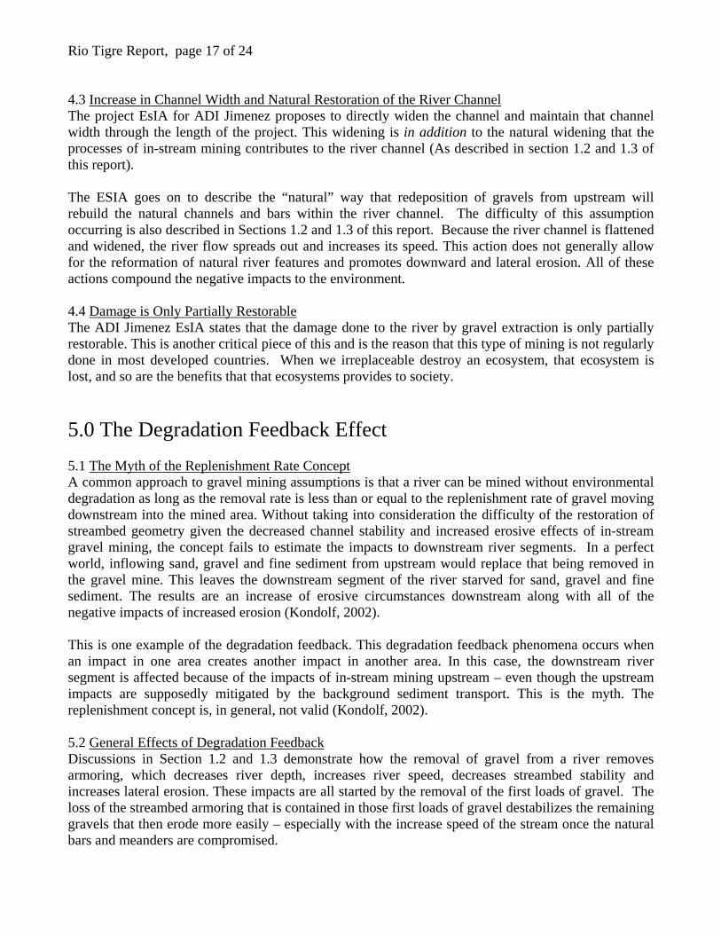
Rio Tigre Report, page 18 of 24 These reactions feed upon themselves to perpetuate the impacts, even with additional input of gravel from upstream, the decreased stability of the streambed decreases the opportunity of any inflowing gravels to stabilize and form armor because of the increased erosive forces. These effects apply even if the natural low flow channel remains intact because the high flow channel, where most of the gravel is removed, is destabilized. This destabilization can weaken or destroy the low flow channel during flood events and erase any mitigated efforts to save the natural channel: The ADI Jimenez proposal is plans to leave the natural channel intact on the Rio Tigre. Because there are so many interconnected and difficult to control reactions to in-stream gravel mining, continued and significant degradation feedback could occur (Kondolf, 1982, Lu, et. al., 2007). 5.3 Nickpoint Erosion This is an upstream erosion effect that occurs in gravel-mined streams that is described in Section 1.3.6. The lowered elevation of the streambed produced by gravel mining tends to propagate its way upstream under its own power (Kondolf 1982). A specific example of this kind of erosion can be found occurring now on the Materiales Occidente Concession in operation on the Rio Tigre. At the upstream end of the concession, excessive erosion is apparent as shown in the following photos. The first is the streambed area immediately upstream from the active mine. The photo shows fresh erosion along the artificially steepened segment of river that has resulted from the natural river channel eroding its way down to the mined section.
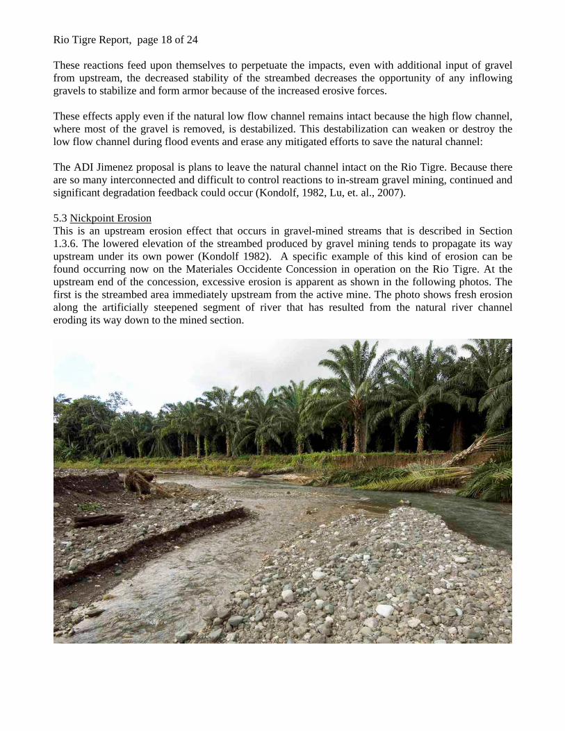
Rio Tigre Report, page 19 of 24 The second photo shows a palm oil plantation, also at the upper reaches of the Materiales Occidente Mine, where excessive erosion appears to have toppled more palm oil trees into the river than evidence on the banks of previous events shows.
It is important to note that the ADI Jimenez proposal suggests that there will be no impacts outside of the immediate area of the gravel mining operation. Evidence shown here of the Materiales Occidente mine does not support this assumption. 5.4 Impacts Reaching the Headwaters Section 1.3.6 describes the ancillary effects of river and riparian degradation on adjacent watersheds. This effect represents another degradation feedback. A paper published in 1997 titled: Exploring How Disturbance Is Transmitted Upstream: Going against the Flow (Pringle, 1997) describes how even the headwaters of a river system can be impacted by gravel mining far down on the river. The importance of the Costa Rican environment to the community, the country and to the world cannot be under emphasized. Much of the middle reaches of the Rio Tigre river system lie within the Reserva Forestal de Golfo Dulce and the Corcovado National Park lies within the headwaters of the Rio Tigre. Degradation to these valuable resource should be considered carefully in management decisions concerning the Rio Tigre. 5.5 The Multiplying Effect of Continual Gravel Mining Concessions There are currently five gravel mining concessions under consideration on the Rio Tigre and one concession in operation totally about 10 kilometers of the river’s approximate 21 km reach. The concessions run for four or five kilometers adjacent to the Reserva Forestal Golfo Dulce boundaryand end where the Reserva crosses the river and encompasses both banks. Several kilometers upstream of this boundary lays the Corcavado National Park Boundary. The cumulative effect of nearly half of the river being mined for gravel could make the degradation feedback effect work even more efficiently. Alternatives to this form of mining have been practiced worldwide for decades because of impacts like could be seen on the Rio Tigre. Special consideration should be given to any management decisions that allow such broad scale environmental degradation. Impacts like these, that are ongoing for well over a decade as in the case of the ADI Jimenez proposal (15 years) could see especially significant impacts because of the long-lived nature of the activity.
Rio Tigre Report, page 20 of 24 6.0 Alternatives to In-stream Mining and Suggestions for Research As discussed previously, even mining gravel in the flood plain immediately adjacent to the river channel is preferable to the in-stream mining proposed by ADI Jimenez. Impacts to the riparian zone still occur, but the greater impacts to the river channel itself are much minimized. 6.1 Uplands Gravel Mining There exists a superior alternative however. This alternative is the gravel mining operation of choice in the much of the developed world and it is very likely applicable to the Osa Peninsula region. It is the best alternative in other regions of the world because it produces fewer negative environmental impacts than in-stream mining and government agencies prefer that this alternative be used when considering permit applications. The obvious drawbacks of upland mining are increased costs. Land has to be purchased for the mining to occur, overburden (topsoil) must be removed; additional processing of materials may be needed. So the costs to society that arise, when considering the economic growth of a community and the construction of infrastructure improvements, are now greater than if the mining was done on “state” owned land within the river channel. Can the direct costs for land be compared to the indirect costs of environmental degradation? Other regions of the world have implemented strict watershed protection regulations to restrict or prevent in-stream mining based on this same cost benefit analysis, so it appears that there is a benefit to society. Information from Bullard, 1995 and Gardner, 1992, show that abundant sand and gravel sedimentary deposits border the shores of the Golfo Dulce and extending to several kilometers inland. Overburden, (topsoil) above the gravel deposits is minimal. The character of these deposits varies but significant sand and gravel deposits are shown in the data. Anecdotal evidence also reveal that abundant water bearing gravels are in the area to a depth of 7 meters. One of the great benefits of mining gravel from upland regions is that transportation costs are minimal. A pit can be located adjacent to or near the intended development site. Over time, and especially with larger projects, transportation of heavy materials such as sand and gravel tends to outweigh the other costs of procuring those materials so there may be an actual decrease in the cost of gravel mining in upland areas vs. the same costs of in-stream gravel mining.
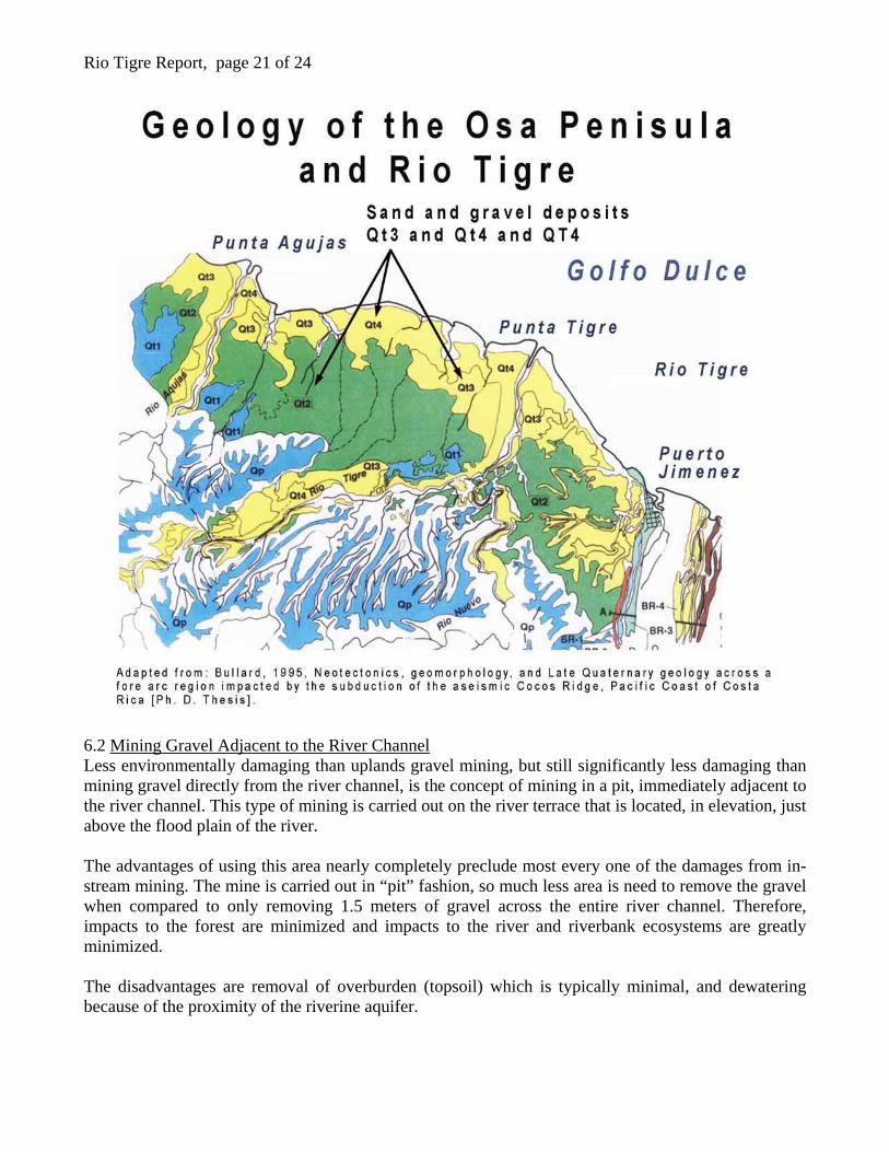
Rio Tigre Report, page 21 of 24
6.2 Mining Gravel Adjacent to the River Channel Less environmentally damaging than uplands gravel mining, but still significantly less damaging than mining gravel directly from the river channel, is the concept of mining in a pit, immediately adjacent to the river channel. This type of mining is carried out on the river terrace that is located, in elevation, just above the flood plain of the river. The advantages of using this area nearly completely preclude most every one of the damages from in-stream mining. The mine is carried out in “pit” fashion, so much less area is need to remove the gravel when compared to only removing 1.5 meters of gravel across the entire river channel. Therefore, impacts to the forest are minimized and impacts to the river and riverbank ecosystems are greatly minimized. The disadvantages are removal of overburden (topsoil) which is typically minimal, and dewatering because of the proximity of the riverine aquifer.
Rio Tigre Report, page 22 of 24 7.0 Suggestions for Research The suitability of upland gravel deposits should be researched fully. The existence of the deposits on the Eastern shore of the Osa Peninsula is certain, and their suitability is likely. If these resources could be efficiently developed, untold damages to the environment of the Osa Peninsula could be prevented. Analysis of additional sources of upland river gravels should be undertaken before management decisions concerning the Rio Tigre are made. Other materials besides sand and gravel from riverbeds are certainly suitable for road building, concrete construction and other construction uses. These materials are widespread across the world and are used very commonly in place of river gravels. Analysis of additional sources of upland river gravels should be undertaken before management decisions concerning the Rio Tigre are made. The following map shows the location of sand and gravel sediments on the Osa Peninsula in addition to those found in riverbeds. 8.0 Conclusions Statements in the ADI Jimenez EsIA concerning the ability of the Rio Tigre to becoming restored to any conditions similar to the pre-mining state cannot be substantiated by the hydrologic analysis presented in the report. The hydrologic evaluation done in the report is deficient in assumptions pertaining to watershed runoff volume and flow. These deficiencies will likely result in greater erosional and stream bed destabilization impacts than assumed in the report. Repeated statements throughout the EsIA, that there are no impacts beyond the immediate work area (AID and AII), are not substantiated. Numerous references in this paper come to the conclusion that there are demonstrable impacts to the surrounding area and that these impacts can extend from the receiving waters of the river (Golfo Dulce) to the headwaters of the watershed (National Forest and Corcovado National Park). The report acknowledges that negative impacts due to the mining operation will extend for the duration of the project. The duration of operations that the ADI Jimenez concession has requested is fifteen (15) years. This extended length of time, that the river is in a damaged state, allows the degradation feedback effect to work in an ever-increasing radius around the project. The project EsIA states that the areas of direct and indirect influences (AID and AII) will be the same. This is not supported in the scientific literature, as is explained in this report. Research of alternative sources for sand and gravel used in construction should be undertaken before management decisions are made on the gravel mining issues related to the Rio Tigre. References
1) USGS History, History of the United States Geological Survey, http://pubs.usgs.gov/circ/c1050/index.htm
Rio Tigre Report, page 23 of 24
2) NMFS, 2005, U. S. National Marine Fisheries Service Gravel Extraction Policy, U.S. Department of Commerce, U.S. Army Corp of Engineers.
3) Rundquist, L.A. 1980. Effects of gravel removal on river hydrology and hydraulics. In: Woodward-Clyde Consultants, ed. Gravel removal studies in arctic and subarctic floodplain in Alaska - technical report; pp. 67-140. U.S. Fish Wildl. Serv., Biological Services Program, FWS/OBS-80/08. 403 pp.
4) Pauley, G.B., G.L. Thomas, D.A. Marino, and D.C. Weigand. 1989. Evaluation of the effects of gravel bar scalping on juvenile salmonids in the Puyallup River drainage. Final Report to the Washington Department of Fisheries, Service Contract No. 1620. Coop. Fish. Res. Unit, Univ. Wash., Seattle, WA. 150 pp.
5) Kondolf, et. al., 2002, Freshwater Gravel Mining and Dredging Issues, Washington Department of Fish and Wildlife.
6) Kondolf, G.M. 1994a. Geomorphic and environmental effects of instream gravel mining. Landscape Urban Plann. 28: 225-243.
7) Kondolf, G.M. 1994b. Environmental planning in regulation and management of instream gravel mining in California. Landscape Urban Plann. 29: 185-199.
8) OWWRI, Oregon Water Resources Research Institute. 1995. Gravel disturbance impacts on salmon habitat and stream health. A report for the Oregon Division of State Lands. Vol 1: Summary Report. 52 pp. Vol 2: Technical background report. 225 pp.
9) Sandecki, M. 1989. Aggregate mining in river systems. Calif. Geol. 42: 88-94. 10) Cordone, A.J. and D.W. Kelley. 1961. The influences of inorganic sediment on the aquatic life
of streams. Calif. Fish Game 47: 189-228. 11) Collins, B., and Dunne, T. 1986. Gravel transport and gravel harvesting in the Humptulips,
Wynoochee, and Satsop rivers, Grays Harbor County, Washington. 12) Rivier, B. and J. Seguier. 1985. Physical and biological effects of gravel extraction in river
beds. In: Alabaster, J.S., ed. Habitat modification and freshwater fisheries; pp. 131-146. Butterworths, London.
13) Watkins and Fiddes, 1991, Highway and Urban Hydrology in the Tropics, Surface Water Drainage for Low-Income Communities, United Nations Environmental Program - World Health Organization, 98 p.
14) Owens et. al., 2005, Fine-grained sediment in river systems environmental: significance and management issues, River Research and Applications, 21, 693-717.
15) Johnes PJ, O’Sullivan PE. 1989. Nitrogen and phosphorus losses from the catchment of Slapton Ley, Devon—an export coefficient approach, Field Studies 7: 285–309.
16) DEFRA (Department for Environment, Food and Rural Affairs). 2003. Strategic Review of Diffuse Water Pollution from Agriculture. Discussion Document. DEFRA: London.
17) Owens PN, Walling DE. 2002b. The phosphorus content of fluvial sediment in rural and industrialized river basins. Water Research 36: 685–701.
18) Correll DL. 1998. The role of phosphorus in the eutrophication of receiving waters: a review. Journal of Environmental Quality 27: 261–266.
19) Chapman DW. 1988. Critical review of variables used to define effects of fines in redds of large salmonids. Transactions of the American Fisheries Society 117: 1–21.
20) Baxter CV, Hauer FR. 2000. Geomorphology, hyporheic exchange, and selection of spawning habitat by bull trout (Salvelinus confluentus), Canadian Journal of Fisheries and Aquatic Sciences 57: 1470–1481.
21) Sear DA. 1993. Fine sediment infiltration into gravel spawning beds within a regulated river experiencing floods: ecological implications for salmonids. Regulated Rivers: Research and Management 8: 373–390.

Rio Tigre Report, page 24 of 24
22) Pringle, 1997, Exploring How Disturbance Is Transmitted Upstream: Going against the Flow, The North American Benthological Society, p 425.
23) Gardner, et. al., 1992, Quaternary uplift astride the aseismic Cocus Ridge, Geological Society of America Bulletin, p. 219-232.
24) Bullard, 1995, Neotectonics, geomorphology, and Late Quaternary geology across a fore arc region impacted by the subduction of the aseismic Cocos Ridge, Pacific Coast of Costa Rica [Ph. D. Thesis], 775pp.
25) Holdridge, 1967, Life ZoneEcology, Rev ed. San Jose: Tropical Science Center