Embed Size (px)
Citation preview
IN THE UNITED STATES COURT OF FEDERAL CLAIMS In re UPSTREAM ADDICKS AND BARKER (TEXAS) FLOOD-CONTROL RESERVOIRS
Sub-Master Docket No. 17-9001L
Judge Charles F. Lettow
THIS DOCUMENT APPLIES TO: ALL UPSTREAM CASES
PLAINTIFFS’ OPPOSITION TO THE UNITED STATES’ MOTION TO DISMISS
Case 1:17-cv-09001-CFL Document 99 Filed 03/19/18 Page 1 of 50
i
TABLE OF CONTENTS
INTRODUCTION ...........................................................................................................................1
FACTUAL BACKGROUND ..........................................................................................................5
I. The Addicks and Barker Dams ............................................................................................5
II. The Government’s Land Acquisitions .................................................................................6
III. Tropical Storm Harvey ........................................................................................................8
ARGUMENT .................................................................................................................................10
I. The Government’s Asserted Justifications For Its Actions Are Irrelevant Under The Just Compensation Clause. .........................................................................................11
A. The Government’s “Emergency” And “No-Win Situation” Arguments Misconceive Plaintiffs’ Claims And Ignore The Man-Made Aspect Of Plaintiffs’ Flooding. ...............................................................................................12
B. There Is No “Health and Safety” Exception To Liability For Physical Takings. ..................................................................................................................15
II. Plaintiffs’ Claims Are Based On Affirmative Government Action And Are Timely. ...............................................................................................................................17
III. Plaintiffs Have Cognizable Property Rights In What Was Taken From Them. ................19
A. Texas Law Recognizes Plaintiffs’ Rights In Their Private Property, Including Against Government-Induced Flooding. ...............................................19
B. The Pre-Existence Of Addicks And Barker Does Not Bar Plaintiffs’ Claims. ...................................................................................................................22
1. The Significance Of Post-Construction Title Transfer Is A Federal Question, And Federal Law Precludes The Government’s Theory. ..........22
2. In Any Event, Texas Law Does Not Immunize The Government For Injuries Caused By Pre-Existing Structures. .......................................25
C. The Flood Control Act Does Not Extinguish Plaintiffs’ Takings Claims. ............27
D. Plaintiffs Have Adequately Identified The Property Interests At Issue, And None Involves Consequential Damages. ...............................................................28
IV. Plaintiffs’ Claims Do Not Sound In Tort. ..........................................................................30
Case 1:17-cv-09001-CFL Document 99 Filed 03/19/18 Page 2 of 50
ii
A. The Government’s Argument That Plaintiffs Have Only Alleged A Tort Does Not Implicate This Court’s Jurisdiction. ......................................................30
B. Plaintiffs Have Plausibly Alleged That The Flooding At Issue Represents A Taking, Not A Tort. ............................................................................................32
1. Arkansas Game Precludes Resolving This Case On A Motion To Dismiss. ......................................................................................................32
2. Plaintiffs’ Allegations Satisfy The Ridge Line And Arkansas Game Tests. ..........................................................................................................33
C. In The Alternative, Plaintiffs Have Adequately Established All Disputed “Jurisdictional” Facts. ............................................................................................37
CONCLUSION ..............................................................................................................................40
Case 1:17-cv-09001-CFL Document 99 Filed 03/19/18 Page 3 of 50
iii
TABLE OF AUTHORITIES
CASES
Acceptance Insurance Cos. v. United States, 583 F.3d 849 (Fed. Cir. 2009) ................................18
AN Collision Center of Addison, Inc. v. Town of Addison, 310 S.W.3d 191 (Tex. App.—Dallas 2010, no pet.) ..........................................................................................................25, 26
Arkansas Game & Fish Commission v. United States, 568 U.S. 23 (2012) ............4, 10, 12, 20, 24 25, 32, 35, 37, 39
Arkansas Game & Fish Commission v. United States, 736 F.3d 1364 (Fed. Cir. 2013) .........20, 33
Arkansas Game & Fish Commission v. United States, 87 Fed. Cl. 594 (2009) ......................16, 32
Bachmann v. United States, 134 Fed. Cl. 694 (2017) ....................................................................17
Banks v. United States, 49 Fed. Cl. 806 (2001), rev’d on other grounds, 314 F.3d 1304 (Fed. Cir. 2003) ........................................................................................................................23
Bartz v. United States, 633 F.2d 571 (Ct. Cl. 1980) ................................................................20, 34
Bass v. Taylor, 90 S.W.2d 811 (Tex. 1936) .............................................................................21, 22
Big Oak Farms, Inc. v. United States, 105 Fed. Cl. 48 (2012) ................................................27, 29
Bowditch v. City of Boston, 101 U.S. 16 (1879) ............................................................................13
Brazos River Authority v. City of Graham, 354 S.W.2d 99 (Tex. 1961) ................................. 20-21
Brinston v. Koppers Industries, Inc., 538 F. Supp. 2d 969 (W.D. Tex. 2008) ..............................25
Briseno v. United States, 83 Fed. Cl. 630 (2008) ..........................................................................31
Bunch v. Thomas, 49 S.W.2d 421 (Tex. 1932) ..............................................................................26
California v. United States, 271 F.3d 1377 (Fed. Cir. 2001) .........................................................27
Cedars-Sinai Medical Center v. Watkins, 11 F.3d 1573 (Fed. Cir. 1993) .....................................38
City of Dallas v. Winans, 262 S.W.2d 256 (Tex. App.—Dallas 1953, no writ) ............................25
City of Tyler v. Likes, 962 S.W.2d 489 (Tex. 1997) ................................................................26, 27
Cooper v. United States, 827 F.2d 762 (Fed. Cir. 1987) ...............................................................23
CTS Corp. v. Waldburger, 134 S. Ct. 2175 (2014) ........................................................................18
Case 1:17-cv-09001-CFL Document 99 Filed 03/19/18 Page 4 of 50
iv
Dietrich v. Goodman, 123 S.W.3d 413 (Tex. App.—Houston [14th Dist.] 2003, no pet.) .....21, 22
First English Evangelical Lutheran Church of Glendale v. Los Angeles County, 482 U.S. 304 (1987) ................................................................................................................................11
Franconia Assocs. v. United States, 536 U.S. 129 (2002) .............................................................18
George Family Trust ex rel. George v. United States, 91 Fed. Cl. 177 (2009) .......................31, 32
Gulf, Colorado & Santa Fe Railway Co. v. Fuller, 63 Tex. 467 (1885) .......................................21
Hansen v. United States, 65 Fed. Cl. 76 (2005) .............................................................................33
Harris County Flood Control District v. Kerr, 499 S.W.3d 793 (Tex. 2016) ...........................3, 20
Hartwig v. United States, 202 Ct. Cl. 801 (1973) ..........................................................................36
Heimeshoff v. Hartford Life & Accident Insurance Co., 571 U.S. 99 (2013)................................18
Horne v. Department of Agriculture, 135 S. Ct. 2419 (2015) .................................................16, 19
Ideker Farms, Inc. v. United States, No. 14-183L, __ Fed. Cl. __, 2018 WL 1282417 (Fed. Cl. Mar. 13, 2018) ........................................................................................................18, 33, 35
Jan’s Helicopter Service, Inc. v. FAA, 525 F.3d 1299 (Fed. Cir. 2008) ........................................31
John R. Sand & Gravel Co. v. United States, 552 U.S. 130 (2008) ..............................................18
Kimball Laundry Co. v. United States, 338 U.S. 1 (1949) ............................................................29
Kraft v. Langford, 565 S.W.2d 223 (Tex. 1978)............................................................................22
Loretto v. Teleprompter Manhattan CATV Corp., 458 U.S. 419 (1982) .......................................17
Lucas v. South Carolina Coastal Council, 505 U.S. 1003 (1992) .................................................16
Meuth v. City of Seguin, No. 04-16-183, 2017 WL 603646 (Tex. App.—San Antonio Feb. 15, 2017, pet. denied) ...............................................................................................................26
Mildenberger v. United States, 643 F.3d 938 (Fed. Cir. 2011) .....................................................21
Miller v. Schoene, 276 U.S. 272 (1928) ...................................................................................14, 16
Moden v. United States, 404 F.3d 1335 (Fed. Cir. 2005) ....................................................4, 30, 31
Mugler v. Kansas, 123 U.S. 623 (1887) ..................................................................................15, 16
Murr v. Wisconsin, 137 S. Ct. 1933 (2017) ...................................................................................13
Case 1:17-cv-09001-CFL Document 99 Filed 03/19/18 Page 5 of 50
v
Narramore v. United States, 960 F.2d 1048 (Fed. Cir. 1992) .........................................................7
Nicholson v. United States, 77 Fed. Cl. 605 (2007) .......................................................................34
North Counties Hydro-Electric Co. v. United States, 151 F. Supp. 322 (Ct. Cl. 1957) ................36
Northwest Louisiana Fish & Game Preserve Commission v. United States, 446 F.3d 1285 (Fed. Cir. 2006) ........................................................................................................................18
Palazzolo v. Rhode Island, 533 U.S. 606 (2001) .....................................................................24, 25
Portsmouth Harbor Land & Hotel Co. v. United States, 260 U.S. 327 (1922) .............................35
Pumpelly v. Green Bay Co., 80 U.S. (13 Wall.) 166 (1872) ..........................................................10
Quebedeaux v. United States, 112 Fed. Cl. 317 (2013) ...........................................................36, 37
Ridge Line, Inc. v. United States, 346 F.3d 1346 (Fed. Cir. 2003) ........................29, 32, 33, 34, 35
Scranton v. Wheeler, 179 U.S. 141 (1900) ....................................................................................28
St. Bernard Parish Government v. United States, 121 Fed. Cl. 687 (2015) ..................................33
Stockton v. United States, 214 Ct. Cl. 506 (1977) .........................................................4, 11, 34, 36
Stueve Brothers Farms, LLC v. United States, 737 F.3d 750 (Fed. Cir. 2013) .......................18, 19
Tahoe-Sierra Preserve Council, Inc. v. Tahoe Regional Planning Agency, 535 U.S. 302 (2002) .......................................................................................................................................16
Tarrant Regional Water District v. Gragg, 151 S.W.3d 546 (Tex. 2004) .....................................20
Thomas v. Bunch, 41 S.W.2d 359 (Tex. App. 1931), aff’d, 49 S.W.2d 421 (Tex. 1932) ..............26
TrinCo. Inv. Co. v. United States, 722 F.3d 1375 (Fed. Cir. 2013) ...............................................13
Turner v. United States, 23 Cl. Ct. 447 (1991) ..............................................................................11
Turner v. United States, 17 Cl. Ct. 832 (1989), rev’d on other grounds, 901 F.2d 1093 (Fed. Cir. 1990) ...........................................................................................................................27, 28
United States v. Cress, 243 U.S. 316 (1917) .................................................................................10
United States v. Dickinson, 331 U.S. 745 (1947) ........................................................10, 22, 23, 24
United States v. Sponenbarger, 308 U.S. 256 (1939) ..............................................................18, 19
Wood v. United States, 91 Fed. Cl. 569 (2009) ..............................................................................36
Case 1:17-cv-09001-CFL Document 99 Filed 03/19/18 Page 6 of 50
vi
CONSTITUTIONAL PROVISIONS, STATUTES, AND RULES
U.S. Const. amend. V.......................................................................................................................1
28 U.S.C. § 2501 ............................................................................................................................18
33 U.S.C. § 702c ............................................................................................................................27
Tex. Water Code § 11.086 .......................................................................................................21, 22
Tex. Water Code § 11.086(a) .........................................................................................................21
Tex. Water Code § 11.086(c) ...................................................................................................21, 28
Rules of the Court of Federal Claims
RCFC 8(a) ................................................................................................................................28
RCFC 9(i).................................................................................................................................28
RCFC 12(b)(1) .........................................................................................................................31
RCFC 12(b)(6) ...................................................................................................................30, 37
RCFC 12(d) ..............................................................................................................................40
RCFC 12(e) ..............................................................................................................................29
OTHER AUTHORITIES
Brief of the United States, Arkansas Game & Fish Commission v. United States, No. 11-597 (U.S. Aug. 27, 2012), 2012 WL 3680423 .........................................................................11
Brief for United States, St. Bernard Parish Government v. United States, No. 16-2301 (Fed. Cir. Dec. 9, 2016) ...................................................................................................1, 7, 28
Frequently Asked Questions, Nat’l Geodetic Survey, NOAA (last modified May 16, 2017), https://www.ngs.noaa.gov/faq.shtml#WhatVD29VD88 ................................................6
Motion To Dismiss, In re Downstream Addicks and Barker (Texas) Flood-Control Reser-voirs, No. 1:17-cv-9002 (Fed. Cl. Feb. 20, 2018), ECF No. 48 ..............................................21
Case 1:17-cv-09001-CFL Document 99 Filed 03/19/18 Page 7 of 50
INTRODUCTION
When the government takes private property for the public’s benefit, it must fairly com-
pensate the owner. U.S. Const., amend. V. These “upstream” cases call for the Court to enforce
that rule in a setting nearly as familiar as the rule itself. As the United States recently explained,
“when the water impounded in [a] reservoir created by a government-constructed dam submerges
private property,” such flooding is a “classic taking” and “a form of recurring flooding long un-
derstood to be compensable.” Brief for United States at 24, 44-45, St. Bernard Par. Gov’t v. United
States, No. 16-2301 (Fed. Cir. Dec. 9, 2016), ECF No. 25 (“U.S. Katrina Br.”). Exactly so.
Here, the U.S. Army Corps of Engineers (“Corps”) built permanent dams and reservoirs
which, as an intentional, direct, and natural result of their existence and standard operation, flooded
upstream property—including Plaintiffs’ property—located within the intended design pools be-
hind the dams. On this motion to dismiss, it is taken as true that flooding property in the dams’
design pools was a predictable (and oft-predicted) consequence of the dams themselves. The re-
sulting damage was unquestionably severe. Thousands of homes were flooded; businesses
destroyed; property devalued; and cars, clothing, furniture, toys, books, pictures, and other me-
mentos washed away forever. Under longstanding precedent of the Supreme Court, the Federal
Circuit, and the Court of Federal Claims, Plaintiffs’ allegations describe a textbook physical taking
by floodwaters, and Plaintiffs have stated a valid claim for just compensation.
The government’s principal line of attack is simple misdirection. No takings claim is avail-
able, the government insists, because the Corps did the best it could during the emergency it faced
in Tropical Storm Harvey. But that is irrelevant. The government’s assertions of the reasonable-
ness of its actions during the storm might be (ironically) a defense to a tort suit, but they provide
no defense to the taking alleged by Plaintiffs here.
Indeed, in arguing that Harvey presented the Corps with an unforeseen emergency or an
Case 1:17-cv-09001-CFL Document 99 Filed 03/19/18 Page 8 of 50
2
insoluble dilemma (Mot. 11-14),1 the government fails to face the reality that its own actions
caused any predicament. According to Plaintiffs’ allegations—drawn from the Corps’ own docu-
ments—the government was well aware that the dams would inundate the upstream suburban
property within the reservoirs’ design pools when a storm like Harvey came; indeed, the govern-
ment designed the dams to impound even more water than Harvey deposited. Impounding water
in this fashion was in fact the purpose of building the dams to their respective heights—yet the
government deliberately chose not to obtain any rights in the private upstream land located within
the design pools by eminent domain. The government cannot claim to have been caught off-guard
when the storm it predicted materialized and the man-made dams, operating as designed, sub-
merged the same property the government had opted not to lawfully condemn.
Nor can the government prevail in these upstream cases by extoling the benefits of the
dams in helping downstream communities in Houston to thrive over the last 70 years or by pointing
to downstream property allegedly saved by the dams (Mot. 5-7, 13). There is no dispute that the
dams themselves are valuable public works with substantial public benefits. But the cost of the
dams’ public benefits has been borne by the private landowners behind the dams. The very point
of the Just Compensation Clause is to require the government to pay compensation when, by taking
private property, the government imposes costs on the few to pay for benefits enjoyed by the many.
When it comes to Plaintiffs’ actual legal theory, the government has remarkably little to
say. It makes four basic points. First, it argues that the statute of limitations expired before any
flooding occurred, because the dams were built many years ago. But as the government readily
concedes elsewhere in its brief (Mot. 32), no cause of action for a taking accrues until flooding
1 “Mot.” refers to the government’s motion to dismiss (ECF 59). “Compl.” refers to the master amended complaint for upstream plaintiffs (ECF 18).
Case 1:17-cv-09001-CFL Document 99 Filed 03/19/18 Page 9 of 50
3
actually occurs. That was (at the earliest) in 2016, when the reservoir pools first exceeded gov-
ernment-owned land. Plaintiffs’ claims are thus timely.
Second, the government argues that Plaintiffs lack cognizable property rights in what was
taken from them. There is of course no dispute that Plaintiffs own (or have similar interests in)
the land and other property at issue. As the government would have it (Mot. 15-19), however, the
government may construct and operate a dam, and thus submerge one person’s land for the benefit
of others, without infringing any property rights, all in the name of “flood control.” Neither Texas
law nor federal takings jurisprudence supports that extraordinary assertion of authority. Indeed,
the Texas Supreme Court has recently reaffirmed the obvious point that “when a government
builds a flood-control dam knowing that certain properties will be flooded by the resulting reser-
voir[,] … of course the government must compensate the owners who lose their land to the
reservoir.” Harris Cty. Flood Control Dist. v. Kerr, 499 S.W.3d 793, 807 (Tex. 2016).
Third, the government argues that Plaintiffs’ takings claims fail because the dams were
there when Plaintiffs obtained their land. But the Supreme Court has rejected that idea both in the
flooding context and beyond, and it finds no support in Texas law either. And for good reason.
Under the government’s proposed rule, when (as here) a takings claim does not accrue until years
after the government’s action, property transfers in the intervening years would give the govern-
ment a free pass, allowing it to pay nothing for the property it took. That is not the law; instead,
the owner of the rights in the land when the taking actually accrues may bring the takings claim.
Fourth, the government devotes the last few pages of its brief to an argument that Plaintiffs’
claims amount only to potential torts, and not to takings. But while the government asserts that
this tort/takings issue is jurisdictional, it concedes (Mot. 28 n.24) that, under Federal Circuit prec-
edent, jurisdiction is established so long as the takings claim is not “so insubstantial … as not to
Case 1:17-cv-09001-CFL Document 99 Filed 03/19/18 Page 10 of 50
4
involve a federal controversy.” Moden v. United States, 404 F.3d 1335, 1341-42 (Fed. Cir. 2005).
The government does not even suggest that Plaintiffs fail to meet that standard here.
Considered as grounds for dismissal under RCFC 12(b)(6), as they must be, the govern-
ment’s arguments on the tort/takings distinction lack substance. Hoping to bypass any detailed
factual inquiry of the sort this Court undertook in Arkansas Game, the government offers a cate-
gorical rule: the Just Compensation Clause does not permit recovery when a plaintiff has suffered
only one actual flood—no matter how severe, no matter if intended, and no matter whether the
government project responsible remains in place unchanged. But the Supreme Court in Arkansas
Game overturned the Federal Circuit’s bright-line rule that temporary flooding could not constitute
a taking, holding that the Constitution supplies no such “magic formula” and instead requires “sit-
uation-specific factual inquiries.” Ark. Game & Fish Comm’n v. United States, 568 U.S. 23, 31-
32 (2012). The government simply ignores the import of that decision and seeks to impose a magic
formula of its own. Moreover, this case demonstrates why the government’s “multiple-flood” rule
cannot be right: It would yield the absurd result that impounding 177,000 acre feet of water—more
than 50 billion gallons—on more than 10,000 private properties for 10 days (see Compl. ¶¶ 1, 4,
76) is not a “severe” or “substantial” enough interference with private property to warrant any
compensation. The Just Compensation Clause should not be read to license that abuse of govern-
ment power. In fact, the Court of Claims has already held that “only one actual flooding is enough
when,” as here, “the property is upstream of the dam and below the contour line to which the dam
is designed to impound water.” Stockton v. United States, 214 Ct. Cl. 506, 518-19 (1977). At least
at the motion-to-dismiss stage, Plaintiffs have alleged facts sufficient to establish a taking.
In the end, Plaintiffs’ claims require this Court to break no new ground. Plaintiffs do not
Case 1:17-cv-09001-CFL Document 99 Filed 03/19/18 Page 11 of 50
5
ask this Court to make the government an “insurer,” and Plaintiffs do not seek to hold the govern-
ment liable for difficult decisions made in emergency conditions. Plaintiffs’ claims instead are
simpler and rooted in centuries of takings jurisprudence. The point of inverse-condemnation law
is to make sure individuals are compensated when the government puts their property to public
use but, for whatever reason, declines to condemn the land and pay a fair price. As Plaintiffs’
complaint makes clear, that is this case. Flooding that occurs behind (and as an intended, direct,
and natural consequence of) a government-constructed dam is a “classic taking” and “a form of
recurring flooding long understood to be compensable.” The motion to dismiss should be denied.
FACTUAL BACKGROUND
I. The Addicks and Barker Dams
This case centers on the Addicks and Barker dams, massive structures constructed by the
Corps seventeen miles west of downtown Houston. See Compl. ¶¶ 32, 35, 38, 44-45. Both dams
were erected in the 1940s in the wake of severe storms, which caused devastating flooding of
Buffalo Bayou, a major watercourse that flows through Houston and into the San Jacinto Bay. Id.
¶¶ 26-32. The dams are strategically located upstream of Buffalo Bayou and are designed to limit
the flow of several watercourses (creeks and bayous) into that major channel. Id. ¶ 32. By ob-
structing the flow of the upstream creeks and bayous into Buffalo Bayou during rain events, the
dams impound water headed downtown into reservoir pools behind the dams, protecting down-
stream communities in Houston from flooding. For decades, the dams have served their protective
function, conferring a substantial public benefit on downstream communities. Id. ¶¶ 5, 32, 88.
The Corps originally designed each dam to ensure that, in the event of an anticipated “de-
sign storm,” it would hold back enough water to help protect downstream property from
unmanageable flooding. Id. ¶ 39. In order to effectively serve that purpose during the worst fore-
seeable storm, the Corps concluded, the dams would need to store water up to specific pool
Case 1:17-cv-09001-CFL Document 99 Filed 03/19/18 Page 12 of 50
6
elevations in their respective reservoirs—about 108 feet above sea level behind Addicks, and about
102 feet above sea level behind Barker. The dams were built several feet higher than those eleva-
tions to ensure they would not be overtopped. See id. ¶¶ 39-41.2
In the 1980s, the Corps reevaluated and redesigned the dams in anticipation of even more
severe storms and in light of updated dam-safety criteria. The Corps estimated that the “Probable
Maximum Precipitation” facing the area was in fact significantly greater than it had originally
predicted. Id. ¶ 46. In light of that new projection, the Corps concluded, the dams should be
configured and modified to store water up to 115 feet of elevation behind Addicks, and up to 108
feet of elevation behind Barker. Id. ¶ 47. These are known as the “Maximum Design Pool” ele-
vations for the dams. Id. To meet these new specifications, the Corps raised the tops of both dams
by several feet and made other structural changes. Id. ¶ 43.
The dams also include floodgates that allow the Corps to release water from the reservoirs
into Buffalo Bayou. See id. ¶¶ 36, 38. Under the Corps’ standard operating procedures, the gates
are closed during significant rain events so that the dams provide the intended protection for down-
stream communities in Houston. Id. ¶ 65. The gates are then opened as needed to optimize the
storage capacity of the reservoirs and avert any risk to the integrity of the dams themselves. Id.
¶ 66.
II. The Government’s Land Acquisitions
Because dams are designed to store water in their reservoirs, the Corps customarily ac-
quires either the fee or a flowage easement in the land behind its dams. As the United States
recently advised the Federal Circuit, “[t]he Corps’ property-acquisition policy has long required
2 These elevation figures are based on the National Geodetic Vertical Datum of 1929 (NGVD). All subsequent elevation figures are based on the North American Vertical Datum of 1988 (NAVD). See generally Frequently Asked Questions, Nat’l Geodetic Survey, NOAA (last modi-fied May 16, 2017), https://www.ngs.noaa.gov/faq.shtml#WhatVD29VD88.
Case 1:17-cv-09001-CFL Document 99 Filed 03/19/18 Page 13 of 50
7
acquisition-in-fee of backwater land lying below the level that will be permanently inundated,”
and the same policy provides for the acquisition of easements “in more remote upstream areas
where backwaters may form in connection with operations that raise the reservoir level.” U.S.
Katrina Br. at 44-45 (citing 43 C.F.R. §§ 8.1(b), 8.3(b); 32 C.F.R. § 644.4(b)(2)(iii) and (v)); see,
e.g., Narramore v. United States, 960 F.2d 1048, 1049 (Fed. Cir. 1992) (describing the Corps’
acquisition of flowage easements for upstream land that would flood only when the reservoir
“would reach full capacity,” and thus “only occasionally”).
In the case of the Addicks and Barker projects, however, the Corps acquired an interest in
far less land than it designed its dams to flood. Specifically, the government only acquired rights
in the land within roughly the “100-year flood pool”—that is, the property that has at least a 1%
risk of dam-induced flooding every year (or a 55% chance of flooding over the course of 80 years).
Compl. ¶ 51. This zone of government-owned property extends up to roughly 103 feet of elevation
behind the Addicks dam, and up to about 95 feet of elevation behind the Barker dam. Id. ¶¶ 52,
53; see id. ¶ 72 (illustration). But that land is sufficient to hold only about half of the rain associ-
ated with the projected storm that guided the dams’ designs. Id. ¶ 51. The dams are thus built to
ensure that, in the event of an anticipated severe storm, they will impound water headed for down-
town Houston on private upstream land that would not have been subject to severe flooding except
for the government-constructed dams and in which the government holds no rights.
The Corps has long been aware of this misalignment between the design pools of the dams
and the extent of the government’s property rights. See id. ¶¶ 54-64. Perhaps most notably, a
1986 design memorandum specifically observed that, given the design pools, “homes in adjacent
subdivisions may be flooded,” and “[t]his could result in lawsuits against the Corps of Engineers
for flooding private lands.” Id. ¶ 57. The Corps considered acquiring all of the land its dams were
Case 1:17-cv-09001-CFL Document 99 Filed 03/19/18 Page 14 of 50
8
designed to flood, or at least acquiring flowage easements and limiting development in these areas,
but opted to do neither. Id. ¶¶ 58-59. Thus, despite the redesign of the dams and expansion of
the design pools that took place in the 1980s, the Corps made no related effort to acquire rights in
any additional property. In 1995, the Corps again studied the problem and again opted not to
remedy it. See id. ¶ 60. And in 2009, the Corps acknowledged that, while none of the severe
storms in the area over the past several decades had produced flood pools that “exceeded the limits
of government-owned land,” there were some close calls: “[H]ad some of these [storms] been
centered” closer to the reservoirs, “the combined rainfall and runoff could have resulted in flood
pools exceeding the limits of government owned land.” Id. ¶ 61.
III. Tropical Storm Harvey
That long-anticipated scenario finally came to pass in 2017, to devastating effect, with
Tropical Storm Harvey.3 Harvey brought several days of extreme rainfall to the region in late
August 2017. During the storm, the water levels in the Addicks and Barker reservoirs rose to about
109 and 102 feet of elevation, respectively. Id. ¶¶ 70-71. Those levels fall well below the gov-
ernment’s intended maximum design pools of 115 feet and 108 feet—but they far exceed the limits
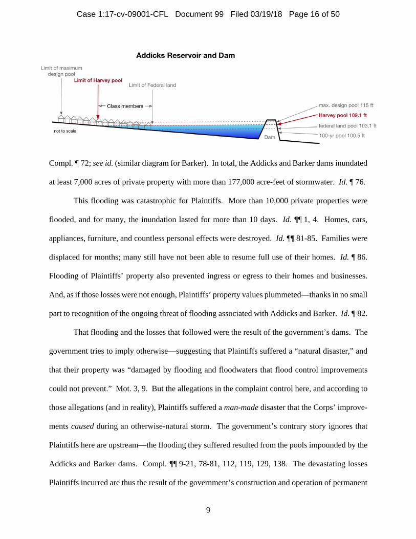
of federally-owned land, which ends at approximately 103 feet and 95 feet. Id.; see supra, at 7.
The dams thus operated as designed and intended: They ensured that, when a storm of Harvey’s
magnitude hit, large quantities of water were impounded and stored on Plaintiffs’ property.
The following diagram illustrates the relevant elevations for the Addicks project:
3 Flooding first extended beyond government-owned land the prior year, during the “Tax Day” flood of April 2016. See Compl. ¶ 78.
Case 1:17-cv-09001-CFL Document 99 Filed 03/19/18 Page 15 of 50
9
Compl. ¶ 72; see id. (similar diagram for Barker). In total, the Addicks and Barker dams inundated
at least 7,000 acres of private property with more than 177,000 acre-feet of stormwater. Id. ¶ 76.
This flooding was catastrophic for Plaintiffs. More than 10,000 private properties were
flooded, and for many, the inundation lasted for more than 10 days. Id. ¶¶ 1, 4. Homes, cars,
appliances, furniture, and countless personal effects were destroyed. Id. ¶¶ 81-85. Families were
displaced for months; many still have not been able to resume full use of their homes. Id. ¶ 86.
Flooding of Plaintiffs’ property also prevented ingress or egress to their homes and businesses.
And, as if those losses were not enough, Plaintiffs’ property values plummeted—thanks in no small
part to recognition of the ongoing threat of flooding associated with Addicks and Barker. Id. ¶ 82.
That flooding and the losses that followed were the result of the government’s dams. The
government tries to imply otherwise—suggesting that Plaintiffs suffered a “natural disaster,” and
that their property was “damaged by flooding and floodwaters that flood control improvements
could not prevent.” Mot. 3, 9. But the allegations in the complaint control here, and according to
those allegations (and in reality), Plaintiffs suffered a man-made disaster that the Corps’ improve-
ments caused during an otherwise-natural storm. The government’s contrary story ignores that
Plaintiffs here are upstream—the flooding they suffered resulted from the pools impounded by the
Addicks and Barker dams. Compl. ¶¶ 9-21, 78-81, 112, 119, 129, 138. The devastating losses
Plaintiffs incurred are thus the result of the government’s construction and operation of permanent
Case 1:17-cv-09001-CFL Document 99 Filed 03/19/18 Page 16 of 50
10
dams that took a large portion of the flooding risk to which downstream communities in Houston
are inherently vulnerable, concentrated it, and transferred it to Plaintiffs.
ARGUMENT
Plaintiffs’ legal theory is straightforward. The Corps built dams whose existence and nor-
mal operation subjects Plaintiffs’ upstream property to inevitable reservoir-pool flooding when the
region experiences heavy enough rainfall—flooding that would not otherwise occur. For several
decades, despite several near-misses, no severe storm was centered close enough to Addicks and
Barker to put the dams fully to work, and Plaintiffs were therefore spared any actual pool flooding.
But that changed in 2017: The storm the government had planned for came, and, as expected, the
dams impounded huge quantities of water on Plaintiffs’ property in order to protect downtown
Houston. The constitutional taking of Plaintiffs’ property was then complete. And so Plaintiffs
are now seeking the “just compensation” the Constitution guarantees.
This takings theory is hardly “unprecedented” (Mot. 3). “[G]overnment-induced flooding
can,” of course, “constitute a taking.” Ark. Game, 568 U.S. at 32. And, for at least a century, it
has also been settled that “[t]here is no difference of kind … between a permanent condition of
continual overflow by backwater and a permanent liability to intermittent but inevitably recurring
overflows.” United States v. Cress, 243 U.S. 316, 328 (1917); see United States v. Dickinson, 331
U.S. 745, 751 (1947) (affirming finding of a taking for “an easement for intermittent flooding of
land above the new permanent level” of a reservoir). Accordingly, when the government opts not
to acquire property interests in the land that its permanent structures subject to flooding (be that
flooding continuous or periodic), courts consistently award compensation under the Fifth Amend-
ment. See, e.g., Dickinson, 331 U.S. at 746-47, 751; Cress, 243 U.S. at 328 (upholding finding of
a taking where upstream land was intermittently submerged because of a government lock and
dam); Pumpelly v. Green Bay Co., 80 U.S. (13 Wall.) 166, 181 (1872) (holding that flooding of
Case 1:17-cv-09001-CFL Document 99 Filed 03/19/18 Page 17 of 50
11
upstream land behind a dam was a taking); Stockton v. United States, 214 Ct. Cl. 506, 519 (1977)
(finding a taking where reservoir behind government dam flooded private land); Turner v. United
States, 23 Cl. Ct. 447, 457 (1991) (finding a taking where modifications to river caused recurring
flooding); see also Brief of the United States, Arkansas Game & Fish Comm’n v. United States,
No. 11-597, at 18-19 (U.S. Aug. 27, 2012) (explaining that “the inundation of land by backwaters
behind a dam” is “now recognized as the archetypal taking by floodwaters”).
Because Plaintiffs’ complaint alleges a fact pattern long recognized as a paradigmatic tak-
ing, the government cannot plausibly contend that those allegations do not withstand a motion to
dismiss. Seeking to bypass the relevant fact-intensive inquiries, however, the government urges a
series of proposals for sweeping exemptions from the Just Compensation Clause. None has merit.
I. The Government’s Asserted Justifications For Its Actions Are Irrelevant Under The Just Compensation Clause.
The government’s lead argument is that the Corps responded to Harvey conscientiously
under trying circumstances (Mot. 11-14). Indeed, the government repeatedly complains that Plain-
tiffs have not pointed to anything the Corps should have done differently when Harvey hit. Mot.
3, 13. Even if relevant, the government’s insistence on the reasonableness of its actions would be
a factual assertion to be tested, not a basis for dismissal. More important, the government’s com-
plaints betray a basic misconception of the nature of a takings claim. The government often has
excellent reasons for taking private property and repurposing it for a public use—from construct-
ing highways and railroads, to redirecting watercourses, to building a federal hospital or state
capital. But none of those important objectives relieves the government of the obligation to pay
just compensation. See First English Evangelical Lutheran Church of Glendale v. Los Angeles
Cty., 482 U.S. 304, 315 (1987) (explaining that the Just Compensation Clause serves “to se-
cure compensation in the event of otherwise proper interference amounting to a taking”).
Case 1:17-cv-09001-CFL Document 99 Filed 03/19/18 Page 18 of 50
12
In a series of variations on the same mistaken theme, the government argues for what
amounts to a “health and safety” exception to the Just Compensation Clause. Thus, the govern-
ment contends that there can be no takings liability here because (1) Harvey presented an
“emergency”; (2) that emergency created a “no-win” situation for the government; and (3) the
government actions at issue aimed to promote public safety. But the government’s “emergency”
and “no-win” arguments ignore the reality that the government itself built the Addicks and Barker
dams to impound floodwaters on Plaintiffs’ property. And, under settled law, a public safety ra-
tionale is no excuse for making Plaintiffs “bear public burdens which, in all fairness and justice,
should be borne by the public as a whole.” Ark. Game, 568 U.S. at 31 (quoting Armstrong v.
United States, 364 U.S. 40, 49 (1960)).
A. The Government’s “Emergency” And “No-Win Situation” Arguments Mis-conceive Plaintiffs’ Claims And Ignore The Man-Made Aspect Of Plaintiffs’ Flooding.
The government’s focus on the “emergency” it faced when Harvey hit cannot excuse tak-
ings liability here. As noted, the government’s characterization of its actions during the storm
turns on undeveloped facts and thus is not properly the basis of a motion to dismiss. Moreover,
the government’s “emergency” excuse fails to grapple with the allegations of the upstream com-
plaint. The principal government action at issue here is not any of the Corps’ decisions during
Harvey, but rather the building of the Addicks and Barker dams, structures that were designed to
and predictably would flood the land within their design pools to protect downstream communities
in Houston. See Compl. ¶¶ 69, 73, 106, 132; see also Mot. 24 (acknowledging that Plaintiffs’
claims focus on the construction of the dams). That massive infrastructure project was hardly a
measure taken “during the emergency of a hurricane” (Mot. 14). To the contrary, over a span of
many years, the Corps studied, designed, built, reevaluated, redesigned, and augmented the dams,
all along planning for a storm well in excess of one like Harvey. Supra, at 5-8. The Corps’
Case 1:17-cv-09001-CFL Document 99 Filed 03/19/18 Page 19 of 50
13
longstanding procedures for operating the dams were likewise designed to ensure that the dams
would effectively carry out their purpose when such a storm came. Supra, at 6. And when Harvey
did come, the dams functioned as intended, impounding and storing huge quantities of water
headed for downtown Houston on Plaintiffs’ property. That long-contemplated and intended result
cannot possibly be compared to a “‘temporary, unplanned’” measure taken “under exigent circum-
stances.” Mot. 13 (quoting Nat’l Bd. of YMCA v. United States, 395 U.S. 85, 92-93 (1969)).
Furthermore, the government does not dispute that it could have averted any “crisis” by
acquiring property interests in the relevant land decades ago, when the Corps decided to include
that land within the design pools of its dams. See supra, at 5-8. The government cites no case in
which a purported emergency has excused a taking where the government had predicted the “emer-
gency” for many decades and could have averted it by condemning the affected property in the
ordinary course. Cf. TrinCo. Inv. Co. v. United States, 722 F.3d 1375, 1379 (Fed. Cir. 2013)
(limiting the necessity defense described in Bowditch v. City of Boston, 101 U.S. 16 (1879), to
actions taken in the face of an “actual emergency with immediate and impending danger”). Re-
lieving the government of its obligation to pay compensation under these circumstances would
subvert the values of “‘fairness and justice’” that form the “central purpose” of the Just Compen-
sation Clause. Murr v. Wisconsin, 137 S. Ct. 1933, 1950 (2017). And, going forward, a rule that
allows the government to wait until an emergency develops, and then to take any property it needs
for free, would eliminate the incentive to acquire needed property, with compensation, in ad-
vance—draining the Clause of its protective force.4
4 The government’s observation that failing to acquire property is a form of “inaction” is irrelevant (Mot. 4, 22-23). The government’s “inaction” is not the basis for Plaintiffs’ claims. Rather, the government’s decision not to acquire rights in the property that it intended to flood—a decision reflected in documents spanning many years—vitiates the government’s “emergency” defense and demonstrates that the result was not “an unpredictable and unforeseeable” occurrence (Mot. 32).
Case 1:17-cv-09001-CFL Document 99 Filed 03/19/18 Page 20 of 50
14
The government’s related contention that it was exempt from takings liability because it
was “[c]aught between a rock and a hard place” during Harvey is no more persuasive. Mot. 14.
The government rests this argument on a purported “Miller doctrine” tracing to Miller v. Schoene,
276 U.S. 272 (1928) (Mot. 12-13). Just as the State in Miller had either to order the destruction of
infected cedar trees or to condone the demise of the neighboring apple orchard, the government
says, the Corps had to operate the Addicks and Barker dams so as to flood either upstream or
downstream land-owners. But the two scenarios are fundamentally different. In Miller, private
decisions about where to grow different kinds of trees, together with the misfortune that the plain-
tiff’s trees became infected with a communicable disease, left the State with a difficult regulatory
choice. Here, by contrast, any dilemma the government faced during Harvey was a consequence
of its own decision to build dams to impound water headed for downtown Houston on Plaintiffs’
property upstream. That makes the Addicks and Barker dams entirely unlike a plant disease.
Nothing in Miller suggests that, having dragged bystanders into the path of harm, the government
can later deny them compensation for their injuries on the ground that the government was then
forced to choose between the bystanders and the original victims.
At bottom, both the government’s “emergency” argument and its “no-win” argument ask
the Court to focus exclusively on the Corps’ choice whether “to close the floodgates or not” (Mot.
13)—as if the dams themselves were natural phenomena that appeared unbidden on the landscape
in 2017. But the construction of those dams, each crafted to create just the scenario the government
later encountered, is at the heart of these upstream cases. See supra, at 5-6. The purported “emer-
gency” and “dilemma” that arose when Harvey struck therefore cannot justify denying Plaintiffs
compensation for a deliberate choice—previously made by the government—to sacrifice Plain-
tiffs’ property for the public good.
Case 1:17-cv-09001-CFL Document 99 Filed 03/19/18 Page 21 of 50
15
B. There Is No “Health and Safety” Exception To Liability For Physical Tak-ings.
Once the government’s untenable assertions about an “emergency” or “dilemma” are
stripped away, the true scope of the government’s proposed exception to the Just Compensation
Clause becomes clear. According to the government, the Addicks and Barker dams cannot effect
a taking because “even the destruction or seizure of property is not generally viewed as a compen-
sable taking so long as the government is acting to protect public health or safety.” Mot. 11; see
id. at 11-12 (“[N]o taking occurs when the government’s action incidentally results in damage to
private property as the government seeks to protect the public from harm.”). Plaintiffs understand
why the government finds such a broad “health and safety” exception attractive—it would free the
government from paying for the land it takes when it builds any structure with a public-safety
purpose, be it a dam, a road, or a police station. But to deny compensation for a physical taking
because the government was acting pursuant to its “police power” or seeking to “protect the public
from harm” (Mot. 11-12) would eviscerate the Just Compensation Clause.
To no surprise, none of the cases the government cites even hints at this far-reaching ex-
emption. In Mugler v. Kansas, 123 U.S. 623 (1887), the government’s first case (Mot. 11), the
Supreme Court rejected a challenge to a state law that prohibited manufacturing alcoholic bever-
ages and thereby interfered with the use of the plaintiff’s brewery. Id. at 657. As the Court
explained, the challenged law simply prohibited “the use of property for purposes that are declared,
by valid legislation, to be injurious.” Id. at 667-68. Accordingly, the case involved only “the
police powers of the state,” and the Court concluded that it could not, “in any just sense,” be
analogized to a physical taking—such as “the overflowing of the plaintiff’s land by water.” Id. at
667-69. Far from supporting the government, then, Mugler demonstrates the deep roots of the
constitutional distinction between regulatory restrictions on specific land uses, on the one hand,
Case 1:17-cv-09001-CFL Document 99 Filed 03/19/18 Page 22 of 50
16
and physical invasions (by floods or otherwise), on the other.
Miller, the case on which the government puts the most weight (Mot. 4, 11-12), builds on
Mugler and is to the same effect. As earlier noted, the Supreme Court upheld the State’s authority
to prohibit maintaining infected cedar trees in “dangerous proximity” to apple orchards. Miller,
276 U.S. at 279-80. But as the Court has since observed, Miller, like Mugler, is part of “a long
line of this Court’s cases sustaining against Due Process and Takings Clause challenges the State’s
use of its ‘police powers’ to enjoin a property owner from activities akin to public nuisances.”
Lucas v. S.C. Coastal Council, 505 U.S. 1003, 1022 (1992). The government-friendly analysis in
that line of cases, the Court explained, was “simply the progenitor” of the modern rubric for as-
sessing regulatory takings claims—a framework in which even land-use rules that greatly diminish
the value of a plaintiff’s property generally do not require compensation. Id. at 1023-24.
That framework has no relevance here. As this Court noted in Arkansas Game, “superin-
duced flows of water would constitute a physical, not a regulatory, taking.” Ark. Game & Fish
Comm’n v. United States, 87 Fed. Cl. 594, 616 (2009), aff’d, 736 F.3d 1364 (Fed. Cir. 2013). And
time and again, the Supreme Court has underscored the distinctness of these two lines of takings
cases and refused to extend the more lenient analysis governing regulatory prohibitions to physical
invasions. See, e.g., Horne v. Dep’t of Agric., 135 S. Ct. 2419, 2427 (2015) (“Our cases have
stressed the ‘longstanding distinction’ between government acquisitions of property and regula-
tions.”); Tahoe-Sierra Pres. Council, Inc. v. Tahoe Reg’l Planning Agency, 535 U.S. 302, 323
(2002) (“Th[e] longstanding distinction between acquisitions of property for public use, on the one
hand, and regulations prohibiting private uses, on the other, makes it inappropriate to treat cases
involving physical takings as controlling precedents for the evaluation of a claim that there has
Case 1:17-cv-09001-CFL Document 99 Filed 03/19/18 Page 23 of 50
17
been a ‘regulatory taking,’ and vice versa.” (footnote omitted)); Loretto v. Teleprompter Manhat-
tan CATV Corp., 458 U.S. 419, 432 (1982) (stressing that “physical invasion cases are special”
(emphasis omitted)). Miller, like Mugler, is thus beside the point.
Finally, Bachmann v. United States, 134 Fed. Cl. 694 (2017), is far afield (Mot. 12-13).
Relying on Mugler and Miller, the court explained that, because the plaintiff’s house was being
used for criminal activity, the damage it suffered in a police raid was simply “a consequence of
the harmful use it was being put to”; indeed, that damage was “incident to securing the safety and
welfare of … [the] plaintiffs’ [own] property.” Id. at 696-98. Here, of course, Plaintiffs and their
property have never posed any threat to anyone, nor was the dam built to secure the safety and
welfare of Plaintiffs’ own property. Because building structures that would flood Plaintiffs’ prop-
erty is not an exercise of the government’s regulatory or law-enforcement authority, the ordinary
requirements of the Just Compensation Clause apply with full force.
II. Plaintiffs’ Claims Are Based On Affirmative Government Action And Are Timely.
The government next contends that Plaintiffs “have not clearly identified what government
action they believe effected a taking.” Mot. 22. That contention is hard to take seriously. As
explained above, and as set forth in detail in the complaint, the government built the Addicks and
Barker dams so that they would impound floodwaters on Plaintiffs’ property. See supra, at 5-6.
Then, consistent with their design and intent, and with longstanding Corps procedures, the dams
did just that.5 There is thus no substance to the suggestion that Plaintiffs have alleged that their
property was taken by “government inaction” or by a “vague and uncertain” process (Mot. 22)—
Plaintiffs’ property was taken by the Corps’ construction, operation, and ensuing use of the dams
5 Whether the government could theoretically have averted a taking by keeping the floodgates open throughout Harvey (thereby flouting the Corps’ longstanding policies) makes no difference. The Corps did close the gates, as intended, when the rain commenced. See Compl. ¶¶ 65-67.
Case 1:17-cv-09001-CFL Document 99 Filed 03/19/18 Page 24 of 50
18
to flood their property. And it is easy to “pinpoint” the “step in the sequence of events” that
triggered a taking here. Acceptance Ins. Cos. v. United States, 583 F.3d 849, 855 (Fed. Cir. 2009)
(quotation marks omitted). Under Federal Circuit and Supreme Court precedent, the taking was
complete when Plaintiffs suffered the government-induced flooding. See Stueve Bros. Farms, LLC
v. United States, 737 F.3d 750, 754 (Fed. Cir. 2013) (holding that a plaintiff may sue for a taking
when he has “‘actually experienced’” flooding and not before); United States v. Sponenbarger,
308 U.S. 256, 267-68 (1939). The government’s feigned confusion is thus easily dispelled.6
In a single paragraph, the government also asserts that, insofar as Plaintiffs’ claims rest on
the design and construction of the dams, those claims are foreclosed by the Tucker Act’s six-year
statute of limitations (Mot. 24). But the timeliness of Plaintiffs’ claims depends entirely on when
Plaintiffs’ cause of action “first accrue[d].” 28 U.S.C. § 2501. A claim “accrues” when “the
plaintiff can file suit and obtain relief,” not when the challenged acts or omissions occurred.
Heimeshoff v. Hartford Life & Accident Ins. Co., 134 S. Ct. 604, 610 (2013); see Nw. La. Fish &
Game Pres. Comm’n v. United States, 446 F.3d 1285, 1290-91 (Fed. Cir. 2006); see also CTS
Corp. v. Waldburger, 134 S. Ct. 2175, 2182 (2014) (explaining the difference between a statute of
limitations, which runs from the time of “accrual,” and a statute of repose, which runs “from the
date of the last culpable act or omission of the defendant”).7 Here, as just noted, Plaintiffs could
not sue based on the existence of the dams until they had “‘actually experienced’” flooding. Stueve
6 Moreover, in the recent Ideker Farms decision, the Court of Federal Claims clarified that Ac-ceptance’s “pinpointing” requirement pertains only to regulatory takings cases, and not to flood-based, physical takings cases. Ideker Farms, Inc. v. United States, No. 14-183L, __ Fed. Cl. __, 2018 WL 1282417, at *16 (Fed. Cl. Mar. 13, 2018). 7 Although the government says the Tucker Act should be “strictly construed” (Mot. 24), the Su-preme Court has specifically rejected the notion that § 2501 “embodies a special, earlier-than-normal, rule as to when a claim first accrues.” John R. Sand & Gravel Co. v. United States, 552 U.S. 130, 138 (2008); see Franconia Assocs. v. United States, 536 U.S. 129, 145 (2002).
Case 1:17-cv-09001-CFL Document 99 Filed 03/19/18 Page 25 of 50
19
Bros. Farms, 737 F.3d at 754; see Sponenbarger, 308 U.S. at 267-68. In fact, the government
itself argues that “apprehension of future flooding” does not support a takings claim. Mot. 32.
Thus, Plaintiffs’ claims are timely: They accrued, at the earliest, when the reservoirs first exceeded
government-owned land and invaded Plaintiffs’ property in 2016 and 2017. See supra, at 8 & n.3.
III. Plaintiffs Have Cognizable Property Rights In What Was Taken From Them.
The government also claims that no compensation is due because Plaintiffs never “pos-
sess[ed] the ‘stick’ that was purportedly taken from their bundle of real property rights.” Mot. 15.
In other words, as the government reads Texas and federal law, there was nothing to “take,” be-
cause private landowners have no rights against being flooded by a government dam that protects
others. This is a close cousin of the government’s “health and safety” exception, see supra, at 15-
17, and the implications are no less startling. The government apparently believes that if the Corps
built a new dam in Texas tomorrow, it would have no obligation to pay for even the land immedi-
ately behind the dam—land that could be inundated permanently. That is not the law, in Texas or
anywhere else. And the government’s alternative argument that there can be no taking because
the dams predate Plaintiffs’ property interests is foreclosed by controlling precedent.
A. Texas Law Recognizes Plaintiffs’ Rights In Their Private Property, Including Against Government-Induced Flooding.
As an initial matter, the government misunderstands the respective roles of state and federal
law in the takings analysis. To state a physical taking claim, a plaintiff need only have ownership
of (or similar rights in) the property that the government took. See, e.g., Horne, 135 S. Ct. at 2431
(explaining that because raisins are “private property,” not “public things subject to the absolute
control of the state,” “[a]ny physical taking of them for public use must be accompanied by just
compensation”). There is no dispute that Plaintiffs have property rights under Texas law in the
land and other property that the government invaded or destroyed with floodwaters. There is no
Case 1:17-cv-09001-CFL Document 99 Filed 03/19/18 Page 26 of 50
20
claim, for example, that this property belongs to somebody else. Accordingly, Plaintiffs have
“property” at stake under the Fifth Amendment, and the only question is whether the government
actions at issue constitute a taking of that property, a question of federal law. See Bartz v. United
States, 633 F.2d 571, 577 (Ct. Cl. 1980) (explaining that the “issue of what constitutes a ‘taking’
is a federal question governed entirely by federal law” (quotation marks omitted)). In conducting
that federal-law inquiry, moreover, Arkansas Game made clear that state “water-rights law” is one
factor that may “inform[ ]” the fact-intensive assessment of a “property owner’s distinct invest-
ment-backed expectations.” 568 U.S. at 38; see also Ark. Game & Fish Comm’n v. United States,
736 F.3d 1364, 1375 (Fed. Cir. 2013) (treating government’s argument “that under Arkansas water
rights law the [plaintiff] has no legal right against flooding by an upstream property owner” as a
facet of the “reasonable investment-backed expectations” analysis) (capitalization omitted). The
government thus errs (Mot. 14) in defining Plaintiffs’ property rights here by looking to the scope
of Plaintiffs’ state-law rights against flooding.
In any event, the government’s core argument—that Texas law recognizes a governmental
prerogative to flood citizens at will and for free—is flatly contradicted by numerous decisions of
the Texas Supreme Court. As that court recently reiterated: “[W]here the government made a
conscious decision to subject particular properties to inundation so that other properties would be
spared, as happens when a government builds a flood-control dam knowing that certain properties
will be flooded by the resulting reservoir[,] … of course the government must compensate the
owners who lose their land to the reservoir.” Harris Cty. Flood Control Dist. v. Kerr, 499 S.W.3d
793, 807 (Tex. 2016); see, e.g., Tarrant Reg’l Water Dist. v. Gragg, 151 S.W.3d 546, 555 (Tex.
2004) (finding a taking where “the extensive damage the [plaintiff] experienced was the inevitable
result of the reservoir’s construction and of its operation as intended”); Brazos River Auth. v. City
Case 1:17-cv-09001-CFL Document 99 Filed 03/19/18 Page 27 of 50
21
of Graham, 354 S.W.2d 99, 105 (Tex. 1961) (explaining that “decent regard for private property
rights” requires compensation for flooding caused by “flood control and improvement agencies”).
This body of case-law leaves no doubt that Texas (like the rest of the country) recognizes
that private property rights are at stake when the government floods some to protect others. See
Gulf, Colo. & Santa Fe Ry. Co. v. Fuller, 63 Tex. 467, 469 (1885) (“The word ‘property,’ as used
in the [Texas Constitution’s Takings Clause], is doubtless used in its legal sense, and means not
only the thing owned, but also every right which accompanies ownership and is its incident.”).
Furthermore, the Federal Circuit has made clear that, insofar as state law is relevant in defining a
plaintiff’s property interests, it is state takings law, not other law, that speaks to that issue. See
Mildenberger v. United States, 643 F.3d 938, 949 (Fed. Cir. 2011). The Court need not (and should
not) dig any deeper into Texas law to resolve the federal takings claims asserted here.8
The government, however, reaches deep into state law, resting its theory on an irrelevant
provision of the Water Code that recognizes a cause of action for unlawful diversions of diffuse
surface water (Mot. 16). See Tex. Water Code § 11.086(a), (c). Even if Texas’s statutory law
were relevant here (and it is not), § 11.086 is addressed to an entirely different problem and says
nothing about the rights at issue in this case. The cause of action afforded by § 11.086(a) is limited
to “diffused” surface water—that is, water that forms a sheet flow across property and has not yet
“‘reache[d] some bed or channel in which water is accustomed to flow.’” Dietrich v. Goodman,
123 S.W.3d 413, 419 (Tex. App.—Houston [14th Dist.] 2003, no pet.). The dams at issue here,
by contrast, function to obstruct the flow of natural watercourses on their way to Buffalo Bayou.
See supra, at 5; see also Bass v. Taylor, 90 S.W.2d 811, 815 (Tex. 1936) (explaining that “the
8 Although the government makes an argument in the downstream cases based on Texas law re-garding an “Act of God,” it omits any such argument here. Cf. Mot. To Dismiss, at 16-17, No. 1:17-cv-9002 (Fed. Cl. Feb. 20, 2018), ECF No. 48.
Case 1:17-cv-09001-CFL Document 99 Filed 03/19/18 Page 28 of 50
22
flood waters of a river” cannot “be likened to [diffuse] surface water”). Thus, even apart from the
language on which the government relies, § 11.086 does not apply to diversions of the kind at issue
in this case at all. See Dietrich, 123 S.W.3d at 419 (noting that “a landowner might divert the
entire Brazos River across his neighbor’s property without subjecting himself to liability under
Section 11.086”). That does not mean Texas landowners have no rights against rampant diversions
of watercourses onto their property; it just means they would not turn to § 11.086 as the source of
those rights. Most important, when a government floods Texas landowners by diverting a water-
course, they can avail themselves of the settled body of takings law described above. See supra,
at 20-21; Kerr, 499 S.W.3d at 807.9 The government’s appeal to § 11.086 is thus founded on a
misunderstanding of both Texas law and the role of state law in federal takings jurisprudence.
B. The Pre-Existence Of Addicks And Barker Does Not Bar Plaintiffs’ Claims.
Shifting gears, the government argues that Plaintiffs have no cognizable rights under Texas
law against the flooding they suffered because the dams were in place before plaintiffs acquired
their property. Mot. 16-17. Once again, this claim about state law is both irrelevant and mistaken.
Federal law governs, and it makes clear that a takings claim may be brought by the person who
owns the land when the taking is complete, regardless of when that person obtained the property.
And even if it were relevant, Texas law is the same.
1. The Significance Of Post-Construction Title Transfer Is A Federal Question, And Federal Law Precludes The Government’s Theory.
One of the Supreme Court’s seminal flooding cases, United States v. Dickinson, 331 U.S.
745 (1947), makes clear that whether a title transfer postdating a government action precludes
takings liability is a federal-law question—and that a transfer of that kind is no bar to a takings
9 In the case of a private defendant, a plaintiff has common-law remedies as well. See, e.g., Kraft v. Langford, 565 S.W.2d 223, 229 (Tex. 1978) (explaining that § 11.086 “is additional to the com-mon law remedies for interferences with interests in real property”); Bass, 90 S.W.2d at 816.
Case 1:17-cv-09001-CFL Document 99 Filed 03/19/18 Page 29 of 50
23
claim. In Dickinson, the plaintiff acquired land upstream of a dam after the government had fin-
ished construction and the land at issue had begun to flood. Id. at 747. When the plaintiff sued
for a taking a few years later, the government argued that, even if his claim was timely, it was
“barred because he acquired the land after” the dam was in place and the flooding commenced.
Id. The Court rejected that argument because “the taking which was the basis of these suits was
not complete … at a time preceding [the plaintiff’s] ownership.” Id. at 749 (emphasis added).
Rather, the claim accrued later on—and it was enough that the plaintiff owned the land at that
time. See id. In two respects, that analysis is fatal to the government’s argument here. First, the
Supreme Court resolved the issue without any regard for state law. And second, the Court held
that the pre-existence of the dam did not defeat the plaintiff’s claim, even though his property had
already begun to flood when he acquired it. It follows a fortiori that the latent threats posed by
Addicks and Baker cannot preclude Plaintiffs’ claims either.
The Federal Circuit and the Court of Federal Claims have both followed Dickinson’s anal-
ysis. In Cooper v. United States, 827 F.2d 762 (Fed. Cir. 1987), the court of appeals explained
that, although the plaintiff “did not acquire legal title to the Cooper [timber] farm until after the
physical events causing the taking began,” that fact was “no impediment to recovery” because the
plaintiff “had a property interest in the timber when the taking of the timber became complete.”
Id. at 764. And in Banks v. United States, 49 Fed. Cl. 806 (2001), rev’d on other grounds, 314
F.3d 1304 (Fed. Cir. 2003), the Court of Federal Claims reaffirmed that, under Dickinson and
Cooper, whether a person may bring a takings claim depends on whether he owned the property
“at the time of claim accrual.” Id. at 825-26. Like Dickinson, Cooper and Banks gave no weight
to any state-law rules regarding the significance (or not) of ownership at any time prior to accrual.
In addition, Palazzolo v. Rhode Island, 533 U.S. 606 (2001), independently precludes any
Case 1:17-cv-09001-CFL Document 99 Filed 03/19/18 Page 30 of 50
24
carve-out from takings liability for government actions preceding a plaintiff’s ownership. In
Palazzolo, a property-owner sought to develop a waterfront parcel but was stymied by state wet-
lands regulations. The state court, “couch[ing its decision] in terms of background principles of
state property law,” held that there could be no regulatory taking because the landowner took title
to the property after the wetlands regulations were in effect. Id. at 626. The Supreme Court instead
applied federal law and condemned the state court’s decision as inconsistent with “essential Tak-
ings Clause principles.” Id. at 627-30. For one thing, the rule would be “capricious in effect,”
because it would subject similarly situated owners to disparate treatment. Id. at 628. But most
importantly, the rule would impermissibly foreclose takings claims that had not ripened at the time
of transfer. As the Court explained: “It would be illogical, and unfair, to bar a regulatory takings
claim because of the postenactment transfer of ownership where the steps necessary to make the
claim ripe were not taken, or could not have been taken, by a previous owner.” Id.
The government’s argument here suffers from just the same illogic and unfairness. There
is nothing prior owners of upstream property could have done to ripen their latent takings claims,
see supra, at 18-19, so the government’s position would permit the government to take private
property without ever paying compensation to anyone. That result is no more acceptable here than
in Palazzolo. See 533 U.S. at 627-28.
Although the government principally relies on state law here, it argues in a footnote (Mot.
18 n.19) that the pre-existence of the dams matters under federal law because it speaks to Plaintiffs’
“reasonable investment-backed expectations,” a factor in the takings analysis outlined by Arkansas
Game. 568 U.S. at 39. Dickinson and its progeny preclude that argument. See supra, at 22-23.
But even if they did not, Arkansas Game drew the “investment-based expectations” concept from
Palazzolo, see 568 U.S. at 39, and Palazzolo makes clear that, at the most, the pre-existence of the
Case 1:17-cv-09001-CFL Document 99 Filed 03/19/18 Page 31 of 50
25
dams could be one non-dispositive factor to be weighed against others in assessing Plaintiffs’ rea-
sonable expectations. Compare Palazzolo, 533 U.S. at 637 (Scalia, J., concurring) (arguing that
the transfer of title in itself “should have no bearing” in the takings analysis), with id. at 634-35
(O’Connor, J., concurring) (suggesting that a transfer may sometimes be considered as one “fac-
tor” among others in assessing investment-backed expectations). Other facts are surely also
relevant to that inquiry, including various facts speaking to what a reasonable investor would (or
would not) have understood about the threat posed by Addicks and Barker. In the scheme of the
overall takings analysis, moreover, investment-backed expectations represent at most “one factor”
that is not “talismanic” or “dispositive.” Id. at 634 (O’Connor, J., concurring); see Ark. Game,
568 U.S. at 39. For all of these reasons, the bare fact that the dams pre-existed Plaintiffs’ invest-
ments provides no basis for dismissal, especially at this stage of the proceedings.
2. In Any Event, Texas Law Does Not Immunize The Government For Injuries Caused By Pre-Existing Structures.
Even if it were relevant—which it is not—Texas law does not support the government’s
view that no takings liability can arise from a pre-existing structure. Two of the Texas cases the
government cites simply state and apply the rule that a claim for a permanent nuisance accrues to
“the owner of the property at the time the injury occurred,” rather than to “a subsequent purchaser.”
City of Dallas v. Winans, 262 S.W. 2d 256, 259 (Tex. App.—Dallas 1953, no writ); see Brinston
v. Koppers Indus., Inc., 538 F. Supp. 2d 969, 977 (W.D. Tex. 2008). That is the same rule adopted
by Dickinson, Cooper, and Banks under federal law, so state law would not alter the analysis even
if it had any bearing. Supra, at 22-23. And in this case, of course, it is Plaintiffs who held rights
in the land at the time it was invaded and the injury (i.e., the flooding) occurred. Supra, at 18-19.
The government’s assorted other authorities are no more helpful. In AN Collision Center
Case 1:17-cv-09001-CFL Document 99 Filed 03/19/18 Page 32 of 50
26
of Addison, Inc. v. Town of Addison, 310 S.W.3d 191 (Tex. App.—Dallas 2010, no pet.), for ex-
ample, the court held that the defendant town was not liable for a taking because it had done
nothing to cause or increase an airport’s flood-inducing tendencies. Id. at 192, 194-96.10 Thomas
v. Bunch, 41 S.W.2d 359 (Tex. Civ. App.—Fort Worth 1931), aff’d, 49 S.W.2d 421 (Tex. 1932),
is also irrelevant. The Texas Supreme Court’s decision in Bunch did not rely on the timing of any
property acquisition; rather, it held that the defendant was entitled to redirect and protect himself
from incoming water because the water, rather than arriving in its “natural diffused state,” was
already being concentrated by others’ unlawful diversions along the way. Bunch v. Thomas, 49
S.W.2d 421, 423-24 (1932).11
City of Tyler v. Likes, 962 S.W.2d 489 (Tex. 1997), is similarly beside the point (Mot. 17-
18). Likes involved an “open drainage channel” that traversed the plaintiff’s property and flowed
into culverts, beyond her property, owned by the city. See id. at 492-93. When the channel over-
flowed during a heavy rain and flooded the plaintiff’s home, she sued the city; she alleged that the
city’s negligent failure to keep the downstream culverts clear had backed up the flow of her water,
and she also brought claims for (among other things) intentional nuisance. Id. at 504-05. The
court rejected the intentional nuisance theory, holding that the city did not “intentionally do any-
thing to increase the amount of water in the watershed in which [the plaintiff’s] home was located.”
Id. at 504. That was so because “[t]he culvert system was substantially completed before 1940,
more than ten years before Likes’s home was built, and the city has made no improvements since
10 Meuth v. City of Seguin, No. 04-16-183, 2017 WL 603646 (Tex. App.—San Antonio Feb. 15, 2017, pet. denied), is the same (Mot. 19). The court denied relief because the city had not done anything to cause any additional flooding; the city had merely annexed an already-problematic drainage pipe. Id. at *4. 11 The Texas Supreme Court affirmed only the judgment below in Bunch and expressly superseded the intermediate appellate opinion on which the government relies. Bunch, 49 S.W.2d at 424. In any event, that opinion did not support the government’s position either. See 41 S.W.2d at 363.
Case 1:17-cv-09001-CFL Document 99 Filed 03/19/18 Page 33 of 50
27
then to increase the amount of water in the watershed.” Id.
The government views this as an indication that Texas recognizes “no property right vis-
à-vis a pre-existing flood control structure” (Mot. 17). But the government simply misunderstands
the Texas Supreme Court’s discussion. The question for the intentional nuisance claim was
whether the city had done anything to “increase the amount of water in the watershed in which
Likes’s claim was located,” that is, whether the city had increased the flow of water into the “open
drainage channel” that traversed the plaintiff’s property. A claim for any increased water flow
across the property accrued the moment the flow of water into the channel increased. Ms. Likes
could not recover for flows that had commenced (and thus claims that had accrued) before she
bought the land. But that says nothing about whether Texas law permits claims of the kind at issue
here, where the damage did not occur (and thus the claim did not accrue) until years after the
construction. As to that situation, the government has nothing to say.
C. The Flood Control Act Does Not Extinguish Plaintiffs’ Takings Claims.
For its next proposed exception to the Just Compensation Clause, the government appeals
to a provision of the Flood Control Act, 33 U.S.C. § 702c, that disavows federal liability for “dam-
age from or by floods or flood waters at any place.” But the government admits (Mot. 19-20 n.20)
that circuit precedent forecloses any argument that § 702c limits or modifies this Court’s jurisdic-
tion to hear takings claims. See California v. United States, 271 F.3d 1377, 1383 (Fed. Cir. 2001);
Big Oak Farms, Inc. v. United States, 105 Fed. Cl. 48, 53 & n.3 (2012). Nor could Congress
extinguish substantive liability under the Just Compensation Clause by disclaiming it in a statute.
See Turner v. United States, 17 Cl. Ct. 832, 834-35 (1989), rev’d on other grounds, 901 F.2d 1093
(Fed. Cir. 1990).
Seeking yet another route to the same result, the government proposes that § 702c be
treated as part of the “backdrop” that determines what property rights are cognizable in the first
Case 1:17-cv-09001-CFL Document 99 Filed 03/19/18 Page 34 of 50
28
place (Mot. 21). This novel idea is untenable. For one thing, it is just a convoluted way of saying
that § 702c eliminates liability for takings claims, which, as just noted, no statute could do. See
Turner, 17 Cl. Ct. at 834-35; see also Scranton v. Wheeler, 179 U.S. 141, 153 (1900). For another,
although the government focuses this portion of its argument on property acquired after a dam has
been constructed (Mot. 20-21), its theory supports no such limiting principle. Rather, if “[s]ection
702c constitutes an established background principle” in the manner the government suggests
(Mot. 21), the government is free to build a new dam adjacent to anyone’s property and pay no
compensation for any flooding that results, so long as the injured property-owner took title at any
time after the enactment of the Flood Control Act in 1928. So much for the “classic taking” the
government (properly) acknowledged just a few short months ago. U.S. Katrina Br. 44.
D. Plaintiffs Have Adequately Identified The Property Interests At Issue, And None Involves Consequential Damages.
Finally, the government makes two glancing objections to the property interests claimed in
the complaint. First, the government charges that Plaintiffs have not sufficiently identified the
“specific property interest[s]” at issue. Mot. 25 (citing RCFC 9(i)). But the complaint specifically
and systematically describes each such interest, including permanent and temporary flowage ease-
ments (Counts I and IV); the rights to “use and occupancy of [Plaintiffs’] land, immovable
property, and personal property for personal and commercial purposes” (Count II); and “interests
in [Plaintiffs] homes, their improvements, their personal property, and the value of their land”
(Count III). Compl. ¶¶ 107, 115, 123, 139.
Although it is not clear just what additional details would satisfy the government, the gov-
ernment appears to believe that each subtype or item of personal property should be separately
enumerated for each plaintiff (Mot. 26). The government, however, provides no authority for that
demanding interpretation of RCFC 9(i), cf. RCFC 8(a) (requiring only “a short and plain statement
Case 1:17-cv-09001-CFL Document 99 Filed 03/19/18 Page 35 of 50
29
of the claim showing that the pleader is entitled to relief”), and it makes little sense. After all, the
details the government requests have no bearing on the government’s ability to raise and develop
its defenses at this stage of litigation; it is not as if there are different legal rules for takings of air
conditioners, computers, and books. And, in any event, this Court already rejected the govern-
ment’s demand for more details when the government sought to impose it through the short-form
complaint. See 2/14/18 Hr’g Tr. 24-25 (this Court explaining that “[i]t is necessary to identify and
differentiate between real and personal property,” but more granular information about subclasses
of personal property is “just not necessary”); see also Order (Feb. 1, 2018), ECF No. 36 (denying
government’s RCFC 12(e) motion). There is no reason why the plaintiffs named in the master
complaint should be held to a higher standard of specificity in listing their possessions than those
who participate in this litigation via the short-form complaints.
The government also argues that lost rental income and lost profits are not compensable
(Mot. 26). But the only case the government cites, Big Oak Farms, Inc. v. United States, 105 Fed.
Cl. 48 (2012), did not so much as mention any of these categories of property interests. Rather,
Big Oak Farms simply held that a flood that deposited sand on the plaintiff’s property did not rise
to the level of a taking under Ridge Line, Inc. v. United States, 346 F.3d 1346 (Fed. Cir. 2003).
See Big Oak Farms, 105 Fed. Cl. at 58; cf. infra, at 33-37 (explaining why Ridge Line is satisfied
here). By contrast, when a government action does rise to the level of a taking, and when it tem-
porarily deprives someone of his “opportunity to profit” from his ongoing business, the
government owes compensation for that aspect of the taking. Kimball Laundry Co. v. United
States, 338 U.S. 1, 14 (1949). In any event, the valuation of Plaintiffs’ various losses should be
resolved at the damages phase, rather than on a motion to dismiss.
Case 1:17-cv-09001-CFL Document 99 Filed 03/19/18 Page 36 of 50
30
IV. Plaintiffs’ Claims Do Not Sound In Tort.
The government’s final argument for dismissal is that Plaintiffs have alleged only potential
torts. That argument fails at every level. First, as the government appears to concede, Federal
Circuit precedent makes clear that the government’s arguments do not call into question this
Court’s subject-matter jurisdiction; accordingly, the only question at this stage is whether Plain-
tiffs’ allegations state a plausible takings claim under RCFC 12(b)(6). Second, Plaintiffs have
plausibly alleged that the government’s actions here constitute a taking, rather than a mere tort.
And third, in an abundance of caution, Plaintiffs have furnished declarations with this response
that are more than sufficient on each issue of purportedly jurisdictional fact that the government
disputes. The bottom line is one this Court well understood in Arkansas Game—the tort/taking
distinction depends critically on the facts, and resolving that issue on a motion to dismiss is thus
neither necessary nor appropriate.
A. The Government’s Argument That Plaintiffs Have Only Alleged A Tort Does Not Implicate This Court’s Jurisdiction.
The government asserts that Plaintiffs’ allegations on the tort/taking issue “are not entitled
to a presumption of truth” because, in its view, that issue goes to subject-matter jurisdiction. Mot.
29-30. But the government then admits, as it must, that the Federal Circuit rejected its position in
Moden v. United States, 404 F.3d 1335 (Fed. Cir. 2005). As the government notes, Moden “treated
a motion to dismiss a flooding-related takings case based on the tort-taking distinction as a motion
for failure to state a claim under RCFC 12(b)(6), rather than a dismissal for lack of subject matter
jurisdiction under RCFC 12(b)(1).” Mot. 28-29 n.24; see 2/20/18 Hr’g Tr. 28-29 (counsel’s state-
ment that Moden “held that it [i.e., the tort/taking issue] was not jurisdictional”).
Indeed, Moden could hardly have been clearer. The trial court had dismissed for lack of
jurisdiction on the ground that the plaintiffs “failed to satisfy Ridge Line’s” test for distinguishing
Case 1:17-cv-09001-CFL Document 99 Filed 03/19/18 Page 37 of 50
31
takings from torts. Moden, 404 F.3d at 1339. The Federal Circuit explained that, in so doing, the
trial court revealed its “misunderstanding” of the distinction between jurisdictional and merits is-
sues. Id. at 1340. “Confusion may have arisen,” the court of appeals explained, because the Tucker
Act limits this Court’s jurisdiction to “‘cases not sounding in tort.’” Id. at 1341 (quoting 28 U.S.C.
§ 1491(a)(1)). Dispelling the confusion, the court of appeals made explicit that, in order for a
takings case to clear the Tucker Act’s jurisdictional threshold, it is only necessary for the plaintiff
to “have a nonfrivolous takings claim founded upon the Fifth Amendment.” Id.; see id. at 1341-
42 (jurisdiction exists “because [plaintiffs’] claim is neither frivolous nor so insubstantial, implau-
sible, foreclosed by prior decisions, or otherwise completely devoid of merit as not to involve a
federal controversy”). Thus, “Moden removes [the tort/taking] question from this court’s jurisdic-
tional inquiry regarding a takings claim.” Briseno v. United States, 83 Fed. Cl. 630, 633-34 (2008).
In fact, since Moden, the court of appeals has only lowered the jurisdictional bar further.
In Jan’s Helicopter Service, Inc. v. FAA, 525 F.3d 1299 (Fed. Cir. 2008), the court clarified that
“a plaintiff’s claim as a whole” need not even be “nonfrivolous” to establish jurisdiction. Id. at
1308 & n.9. Rather, “we read Moden as holding that the plaintiff must make a nonfrivolous alle-
gation that it is within the class of plaintiffs entitled to recover under the money-mandating source
of law.” Id. If so, “[t]here is no further jurisdictional requirement that the court determine whether
the additional allegations of the complaint state a nonfrivolous claim.” Id. at 1309.
The government has of course not claimed that Plaintiff’s takings claim is frivolous. To-
gether with the failure of the government’s statute-of-limitations argument, see supra at 18-19,
that should dispose of the government’s motion insofar as it is brought under RCFC 12(b)(1).12
12 To the extent the Government defends its assertion that the tort/taking issue should be resolved as a matter of jurisdiction, it appears to rely on George Family Trust ex rel. George v. United States, 91 Fed. Cl. 177 (2009). But George Family Trust did not involve a tort/taking question at
Case 1:17-cv-09001-CFL Document 99 Filed 03/19/18 Page 38 of 50
32
B. Plaintiffs Have Plausibly Alleged That The Flooding At Issue Represents A Taking, Not A Tort.
Setting any jurisdictional dispute aside, Plaintiffs have plausibly alleged that their injury
“rise[s] to the level of a taking”—as distinguished from “an incidental or consequential injury”
that would be, at most, “compensable as a tort.” Ridge Line, 346 F.3d at 1356-57.
1. Arkansas Game Precludes Resolving This Case On A Motion To Dis-miss.
As an initial matter, the government dramatically understates the significance of the Su-
preme Court’s decision in Arkansas Game (Mot. 30). It is true that the Court’s core holding was
only that temporary flooding can be a taking. See 568 U.S. at 38. But, in reaching that conclusion,
the Court repeatedly denounced categorical carve-outs from takings liability in flooding cases. As
the Court explained, “most takings claims turn on situation-specific factual inquiries”; a court must
“weigh carefully the relevant factors and circumstances in each case”; there is “no magic formula”
for resolving flood cases; and the law does not “set[] flooding apart from all other government
intrusions on property.” Id. at 31-32, 36. In short, “[f]looding cases, like other takings cases,
should be assessed with reference to the particular circumstances of each case, and not by resorting
to blanket exclusionary rules.” Id. at 37 (internal quotation marks omitted).
The course of proceedings in Arkansas Game illustrates the point. This Court made exten-
sive factual findings to support the conclusion that a taking (and not just a tort) had occurred. See
87 Fed. Cl. at 625-34. The court of appeals short-circuited the appropriate detailed analysis and
applied a categorical prohibition, and then the Supreme Court reversed unanimously, holding that
a case-specific assessment of the alleged taking was required. See 568 U.S. at 38-39. On remand,
the Federal Circuit then relied extensively on this Court’s “comprehensive opinion” and myriad
all; it concerned a fact-intensive dispute about the Tucker Act’s statute of limitations, which im-poses a distinct jurisdictional requirement not linked to the merits. See id. at 190-96.
Case 1:17-cv-09001-CFL Document 99 Filed 03/19/18 Page 39 of 50
33
“factual findings” to resolve whether the facts, taken as a whole, rose to the level of a taking. See
736 F.3d at 1368, 1371, 1374. The Arkansas Game litigation thus makes clear that the tort/taking
question should be resolved based on a developed factual record that will allow this Court to weigh
all of the relevant considerations. See also St. Bernard Par. Gov’t v. United States, 121 Fed. Cl.
687, 719-20, 740-41 (2015) (resolving tort/takings issue after discovery and trial); Ideker Farms,
Inc. v. United States, No. 14-183L, __ Fed. Cl. __, 2018 WL 1282417, at *13-21 (Fed. Cl. Mar.
13, 2018) (same). That is reason enough to deny the government’s motion to dismiss.
2. Plaintiffs’ Allegations Satisfy The Ridge Line And Arkansas Game Tests.
Under the facts alleged, Plaintiffs’ claims easily here satisfy the analysis set forth in both
Ridge Line and Arkansas Game.13 Under Ridge Line’s first element, for example, treatment as a
taking is only appropriate when either “the government intends to invade a protected property
interest or the asserted invasion is the direct, natural, or probable result of an authorized activity.”
346 F.3d at 1355-56 (internal quotation marks omitted). As that language indicates, the test is
disjunctive: “[T]he individual sub-parts (intent or causation) are each sufficient grounds upon
which to predicate a takings claim.” Hansen v. United States, 65 Fed. Cl. 76, 117 (2005). The
Arkansas Game analysis similarly takes into account whether “the invasion is intended or is the
foreseeable result of authorized government action.” 568 U.S. at 39 (emphasis added).
Plaintiffs have plausibly alleged that this first element is satisfied twice over. First, ac-
cording to Plaintiffs’ detailed factual allegations, storing water on Plaintiffs’ property in the event
of a severe storm was the very purpose of constructing the dams with the heights and other speci-
fications that the Corps employed. See supra, at 5-6. The requisite connection between the
13 Because Plaintiffs’ allegations satisfy both Ridge Line and Arkansas Game, the Court need not resolve at this early stage which test governs with respect to the factual scenario and specific alle-gations here, nor how exactly the relationship between the two tests is best understood.
Case 1:17-cv-09001-CFL Document 99 Filed 03/19/18 Page 40 of 50
34
government and the injury is necessarily present when, as in this case, “the result [wa]s only that
which the engineers intended the dam to achieve.” Stockton, 214 Ct. Cl. at 518-19; see Ridge Line,
346 F.3d at 1355-56. Second, and in the alternative, Plaintiffs have plausibly alleged that flooding
Plaintiffs’ land was a direct and objectively foreseeable consequence of erecting the dams. See
supra, at 7-9. Flooding within the dams’ maximum design pools cannot be described as an “inci-
dental” side-effect not “‘reasonably to be anticipated by the government.’” Ridge Line, 346 F.3d
at 1356 (quoting Sanguinetti v. United States, 264 U.S. 146, 150 (1924)); see id. at 1356-57 (con-
trasting the denial of takings liability where the effect “could not have been foreseen or foretold,”
with the imposition of such liability where “[i]f engineers had studied the question in advance they
would … have predicted what occurred” (quotation marks omitted)). For this reason, too, the
government’s action bears the necessary connection to the flooding that resulted.
Neither of the cases the government cites casts any doubt on the adequacy of the causal
connection here (Mot. 27-28). In Nicholson v. United States, 77 Fed. Cl. 605 (2007), the plaintiffs
alleged that the government’s negligent design and maintenance of flood walls left the plaintiffs
inadequately protected against Hurricane Katrina—a paradigmatic tort theory. See id. at 611. The
court concluded that the government’s failure to build better flood protection “did not in the least
cause the flood.” Id. at 618. Here, by contrast, Plaintiffs have plausibly alleged that the dams are
an intentional, direct, and but-for cause of the flooding Plaintiffs suffered. The government’s sec-
ond case, Bartz v. United States, 633 F.2d 571 (Ct. Cl. 1980), is even less helpful to the
government. There, the case went to trial and the evidence revealed that “the operation of the dam
and [r]eservoir had no influence in producing the conditions of which the [upstream] plaintiffs
complain[ed].” Id. at 577. Here, Plaintiffs have alleged otherwise, and those allegations are not
only plausible but undoubtedly correct. See supra, at 9.
Case 1:17-cv-09001-CFL Document 99 Filed 03/19/18 Page 41 of 50
35
Both Ridge Line and Arkansas Game also take into account the severity or substantiality
of the interference with a plaintiff’s property rights. See Ark. Game, 568 U.S. at 39 (“Severity of
the interference figures in the calculus as well.”); Ridge Line, 346 F.3d at 1355 (asking “whether
the government’s actions were sufficiently substantial to justify a takings remedy”). The Federal
Circuit clarified in its remand opinion in Arkansas Game that it is appropriate to “measure the
severity of the interference with a property owner’s rights by looking to the effects of the interfer-
ence.” Ark. Game, 736 F.3d at 1375. Plaintiffs have alleged extensive damage to their real and
personal property and profound interference with their rights to use and enjoy it. See supra, at 9.
At the motion-to-dismiss stage, those eminently plausible allegations are dispositive. Indeed, the
Court of Federal Claims recently held that—even at the first phase of a merits trial—“for purposes
of establishing severity, it is sufficient for plaintiffs to show that government-induced flooding has
interfered with plaintiffs’ ability to use their land for its intended purposes.” Ideker Farms, 2018
WL 1282417, at *20. By that standard, Plaintiffs’ allegations surely withstand a motion to dismiss.
The government’s only argument that the severity or substantiality standard is unsatisfied
as a matter of law is that flooding must be “frequent” to constitute a taking, and that “one or two
floods” are thus “unlikely” to qualify. Mot. 31; see Mot. 27-28, 30-32. But the government cites
no case holding that the severity or substantiality of the interference with property rights—the
ultimate issue—can only be proved by some numerical minimum frequency. Cf. Portsmouth Har-
bor Land & Hotel Co. v. United States, 260 U.S. 327, 329 (1922) (explaining that if the government
set up artillery “with the admitted intent to fire across the claimants’ land at will,” and then “should
fire a single shot,” “it well might be that the taking of a right would be complete”). And for obvious
reasons: When the government’s permanent dams directly cause severe flooding that invades thou-
sands of private properties, appropriating a benefit to the public while destroying homes and
Case 1:17-cv-09001-CFL Document 99 Filed 03/19/18 Page 42 of 50
36
possessions, why should the victims have to prove exactly when and how often the government
will subject them to the same catastrophe again in order to be compensated for the current damage?
It simply cannot be that the storage of 177,000 acre feet of water on more than 10,000 private
properties for 10 days does not constitute a taking because it has not yet been repeated.
It comes as no surprise, then, that a numerical floor has repeatedly been rejected in flooding
cases of the kind at issue here. Stockton v. United States, 214 Ct. Cl. 506 (1977), is perhaps the
clearest example. In a passage that could have been written for this case, the Court of Claims
debunked the government’s “multiple flood” rule when a dam floods upstream property:
We further believe that only one actual flooding is enough when the property is upstream of the dam and below the contour line to which the dam is designed to impound water. Then, even if there has been but one flooding, the result is only that which the engineers intended the dam to achieve. Cases saying that “one flood-ing does not constitute a taking,” Hartwig v. United States, 202 Ct. Cl. 801, 809 (1973) and cases therein cited, are cases where the property flooded is downstream of the dam and the damage is an unintended and unwanted result of changes ef-fected by the dam in the downstream flow or consequential and indirect upstream flooding. Cases such as we have here do not often occur because the engineers do not often fail, as here, to acquire all the land below the contour line of the designed and intended pool.
Stockton, 214 Ct. Cl. at 518-19 (emphasis added). Court of Claims decisions are binding precedent
for this Court, see Wood v. United States, 91 Fed. Cl. 569, 573 (2009), so Stockton controls here.14
A more recent decision of the Court of Federal Claims is to the same effect. In Quebedeaux
v. United States, 112 Fed. Cl. 317 (2013), the government opened a permanent spillway during an
“extreme flood event[]” in order to prevent flooding downriver. Id. at 319-20. But in so doing,
the government inundated other private property. The injured landowners brought suit, and the
court held that their allegations stated a valid takings claim even though there had been only a
14 The government relies (Mot. 31) on Fromme v. United States, 412 F.2d 1192 (Ct. Cl. 1969), and N. Ctys. Hydro-Electric Co. v. United States, 151 F. Supp. 322 (Ct. Cl. 1957), but both are among the cases collected in Hartwig, 202 Ct. Cl. at 809-810, and then distinguished in Stockton.
Case 1:17-cv-09001-CFL Document 99 Filed 03/19/18 Page 43 of 50
37
single flood. As the court explained, “[c]ounting floods is not the controlling consideration”; ra-
ther, flooding cases “focus on periodicity only as one indication as to whether defendant has
appropriated an interest for itself in the affected property.” Id. at 323-24 (emphasis added). “While
a single flooding may indicate that such an interest has not been taken, that conclusion depends
upon whether the flooding was truly an isolated invasion, as opposed to an event that characterizes
a permanent liability to intermittent but inevitably recurring overflows.” Id. at 323 (internal quo-
tation marks omitted). Accordingly, the court explained, the government “has been found liable
in a variety of cases involving permanent flood control facilities.” Id. Noting that the inquiries
under Arkansas Game and Ridge Line are “heavily imbued … with factual considerations,” the
court found it untenable to adopt “a bright-line rule that would require this court to dismiss plain-
tiffs’ complaint—which avers that the invasion here was intended, the flooding foreseeable, and
the damages severe—simply because it cites only a single recent flooding event.” Id. at 325.
So, too, here. Plaintiffs deserve an opportunity to prove that the flooding they suffered
during Harvey—whether conceived as a single temporary taking, as one manifestation of their
permanent exposure to recurring overflows, or as both—amounted to an appropriation of their
property for which the Constitution promises them fair compensation.15
C. In The Alternative, Plaintiffs Have Adequately Established All Disputed “Ju-risdictional” Facts.
As explained above, Plaintiffs’ nonfrivolous allegations suffice to establish this Court’s
subject-matter jurisdiction. See supra, at 30-31. Accordingly, the Court should evaluate the gov-
ernment’s tort/taking argument under the standard of RCFC 12(b)(6)—and should reject it for the
15 Arkansas Game indicates that Plaintiffs’ “reasonable investment-backed expectations,” a con-sideration not addressed by Ridge Line, can figure in the takings analysis as well. 568 U.S. at 39. But the government contests this issue in its motion only on the ground that the dams predated Plaintiffs’ property interests (Mot. 18 n.19). That argument is addressed above. Supra, at 24-25.
Case 1:17-cv-09001-CFL Document 99 Filed 03/19/18 Page 44 of 50
38
reasons just given. But if the Court determines that the tort/taking inquiry must be resolved to
establish jurisdiction, Plaintiffs can readily meet their burden to support with evidence the “pred-
icate jurisdictional facts” that the government has disputed. Cedars-Sinai Med. Ctr. v. Watkins,
11 F.3d 1573, 1584 (Fed. Cir. 1993). Here, the government has raised only two factual issues
relating to the tort/taking distinction: whether the intrusion on Plaintiffs’ property interests is se-
vere enough to constitute a taking, and, relatedly, whether flooding is likely enough to recur. See
Mot. 27-28; see also 2/20/18 Hr’g Tr. 28 (“What we raised are those [factual issues] relating to
the recurrence or severity of flooding.”). Plaintiffs submit with this brief two expert declarations
that address these issues and briefly summarize them below.
Severity. Both experts address the severity of the flooding and the attendant interference
with Plaintiffs’ property rights. Dr. Philip Bedient, a distinguished environmental and civil engi-
neer specializing in hydrology, explains in detail the magnitude of the flooding Plaintiffs suffered.
See Ex. A, ¶¶ 29-31. As he reports, relying on the Corps’ own document, more than 15,000 house-
holds are estimated to have flooded due to the impounding of floodwaters. Id. ¶ 31. The duration
of the inundation for these 15,000 properties ranged from one to eleven days. Id. ¶ 29. Dr. Bedient
explains that the effects of having floodwater stored on one’s property for more than a day “are
very dramatic and destructive” and that flooding of this duration “would therefore be considered
severe.” Id. ¶ 30. In addition, a homeowner will generally be trapped in the home (or excluded
from it if evacuated) for at least the period of inundation, and often longer. Id.
Dr. Randall Bell, an expert appraiser, also addresses the severity of the impact on Plaintiffs’
property caused by the government’s action in storing Harvey stormwater on their land and in their
homes. See Ex. B. Dr. Bell visited the Addicks and Barker reservoirs and examined numerous
homes, as well as various public and commercial structures, that suffered flooding. Id. ¶ 14. He
Case 1:17-cv-09001-CFL Document 99 Filed 03/19/18 Page 45 of 50
39
explains how floodwater “will (and did) permeate the walls and soak the wood frame” of affected
houses, requiring extensive repairs, and he reports that many of the houses remained uninhabitable
even six months after the flooding. Id. ¶¶ 17-20. Dr. Bell further explains that a home is most
people’s largest asset, and that flooding thus necessarily has a severe economic impact on a home-
owner who is thereafter required to repair their home, and often must sell it at a significant discount
to the pre-flood fair market value. Id. ¶ 16. Furthermore, Dr. Bell affirms that property-owners
lost personal property and the access and use of their property, as well as suffering other losses
that he is “accustomed to seeing in the circumstance of severe flooding.” Id. ¶ 22. And he notes
that the “odious nature of the water involved” has compounded the problem. Id. ¶ 19. Specifically,
“[h]omeowners have reported mold growth in their structures, and news reports as well as home-
owner comments have confirmed that the floodwaters were contaminated with sewage due to
overflowing treatment plants,” further contributing to “the unfavorable market perception associ-
ated with the affected properties.” Id. Based on his analysis, Dr. Bell concludes that “property
owners in the Addicks and Barker reservoirs whose property was inundated by Harvey floodwaters
suffered substantial damages and devaluation of those properties,” and that “all the inundated prop-
erties (and homeowners) were severely impacted by the flooding.” Id. ¶ 23; see id. ¶ 29.16
Recurrence. Dr. Bedient addresses the factual issues relating to the likely recurrence of
government-induced flooding.17 See Ex. A ¶¶ 32-37. Based on his analysis of the dams and of
flooding patterns in the region, Dr. Bedient concludes that the flooding Plaintiffs suffered “was
16 Dr. Bell’s opinion is corroborated by the government’s recognition of the severe damages that would result from a storm event like Harvey to properties behind the dams. See Ex. B ¶¶ 24-28. 17 Although the evidence suffices to conclude that flooding will inevitably recur, Plaintiffs do not concede that a non-recurring flooding event would not constitute a taking under the circumstances here. See Ark. Game, 568 U.S. at 38. Moreover, as noted above, when a dam has flooded property and the dam remains in place, nothing in law, logic, or basic fairness requires Plaintiffs to prove exactly how often such flooding will recur to obtain compensation for the property taken.
Case 1:17-cv-09001-CFL Document 99 Filed 03/19/18 Page 46 of 50
40
easily foreseeable” and that future flooding “is, as a factual matter, inevitable.” Id. ¶¶ 32, 35. As
he explains, the volume of rain during Harvey (between 30 and 35 inches in the Addicks and
Barker watersheds) is significantly less than the volume of rain deposited by other storms in recent
decades within just a few dozen miles. Id. ¶ 32. Such severe rainfalls are common in this part of
Texas, especially in connection with tropical storms and hurricanes. Id. ¶ 35. Indeed, just the year
before Harvey, the “Tax Day” flood of April 2016 brought new record pool elevations in Addicks
and Barker and flooded streets in upstream neighborhoods. Id. ¶ 32. Furthermore, Dr. Bedient
explains that Harvey’s rainfall was “much less” than the quantity the Corps itself projected in
designing the dams. Id. at ¶ 17. Dr. Bedient further confirms that Plaintiffs suffered extensive
flooding that “was due solely to the rising reservoir pools,” and that the dams functioned as de-
signed in impounding this floodwater on Plaintiffs’ property. Id. ¶ 28. Thus, even if inevitable
recurrence were considered dispositive of severity, there is every reason to believe that comparable
weather events will recur and that, when they do, the government’s dams will have exactly the
same devastating effect on these upstream plaintiffs.18
CONCLUSION
The Addicks and Barker dams performed precisely as intended during Tropical Storm Har-
vey, impounding a massive amount of stormwater upstream of the dams. Flooding Plaintiffs’
property was an intentional, direct, and natural consequence of the dams. And that flooding was
undoubtedly severe—both in terms of the sheer physical quantities of water, and in terms of the
devastating economic loss and destruction that ensued. Because flooding behind a government-
constructed dam is a “classic taking,” the government’s motion to dismiss should be denied.
18 Plaintiffs object to any effort by the government to convert its motion to dismiss into a motion for summary judgment by citing exhibits and facts outside the pleadings. Cf. RCFC 12(d). Sum-mary judgment would be entirely premature. Accordingly, Plaintiffs ask the Court to exclude the government’s exhibits and disregard all facts that do not implicate jurisdiction.
Case 1:17-cv-09001-CFL Document 99 Filed 03/19/18 Page 47 of 50

41
Dated: March 19, 2018 Respectfully Submitted,
/s Ian Heath Gershengorn Ian Heath Gershengorn
Co-Lead Counsel for Upstream Plaintiffs as to Jurisdic-tional Discovery, Motion to Dismiss, and Scheduling
Benjamin M. Eidelson Jenner & Block, LLP 1099 New York Ave NW, Suite 900 Washington, DC 202-639-6000 [email protected] Larry Vincent
Co-Lead Counsel for Upstream Plaintiffs as to Jurisdic-tional Discovery, Motion to Dismiss, and Scheduling
Daniel Charest Co-Lead Counsel, Upstream Pre-Trial Discovery and Dispositive Motions
Burns & Charest LLP 900 Jackson Street, Suite 500 Dallas, Texas 75202 469-904-4550 [email protected] [email protected] Charles Irvine
Co-Lead Counsel, Upstream Pre-Trial Discovery and Dispositive Motions
Irvine & Conner PLLC 4709 Austin Street Houston, Texas 77004 713-533-1704 [email protected] Edwin Armistead “Armi” Easterby
Co-Lead Counsel, Upstream Pre-Trial Discovery and Dispositive Motions
Williams Kherkher Hart Boundas, LLP 8441 Gulf Freeway, Suite 600 Houston, Texas 77017 713-230-2200 [email protected] Vuk S. Vujasinovic
Of Counsel for Upstream Plaintiffs as to Jurisdictional
Case 1:17-cv-09001-CFL Document 99 Filed 03/19/18 Page 48 of 50
42
Discovery, the Government’s Motion to Dismiss, and Scheduling
VB Attorneys, PLLC 6363 Woodway Dr., Suite 400 Houston, Texas 77057 713-224-7800 [email protected]
Case 1:17-cv-09001-CFL Document 99 Filed 03/19/18 Page 49 of 50
CERTIFICATE OF SERVICE
I hereby certify that a true and correct copy of the foregoing Opposition to the United
States’ Motion to Dismiss was served upon all counsel of record via the Court’s ECF system in
Docket No. 17-9001L on March 19, 2018.
March 19, 2018 /s Ian Heath Gershengorn Ian Heath Gershengorn Jenner & Block, LLP 1099 New York Ave NW, Suite 900 Washington, DC 20001 202-639-6000 [email protected] Co-Lead Counsel for Upstream Plaintiffs as to Jurisdictional Discovery, Motion to Dis-miss, and Scheduling
Case 1:17-cv-09001-CFL Document 99 Filed 03/19/18 Page 50 of 50
EXHIBIT A
Expert Declaration of Dr. Philip Bedient
Case 1:17-cv-09001-CFL Document 99-1 Filed 03/19/18 Page 1 of 57
Case 1:17-cv-09001-CFL Document 99-1 Filed 03/19/18 Page 2 of 57
2
1. Pursuant to 28 U.S.C. § 1746, I submit this expert declaration in support of the upstream plaintiffs’ Opposition to the United States’ Motion to Dismiss this action.
QUALIFICATIONS
2. I am the Herman Brown Professor of Engineering in the Department of Civil and Environmental Engineering at Rice University, where I have served since 1975. From 1992 to 1999, I served as Chair of Environmental Engineering at Rice University. In 2006, I was elected as a Fellow to the American Society of Civil Engineers (“ASCE”).
3. I have a Ph.D. (1975) in Environmental Engineering Sciences from the University of Florida, an M.S. (1972) in Environmental Engineering from the University of Florida, and a B.S. (1969) in Physics from the University of Florida.
4. I teach and perform research in surface water hydrology, groundwater hydrology, floodplain analysis, flood prediction systems, coastal resiliency and disaster management, and storm water quality control. I have directed 60 research projects over the past 40 years.
5. I have been working with regulated reservoirs, including both federal (USACE-operated) and non-federal reservoir projects, since the mid-1970s. As part of my Ph.D. work at the University of Florida, I analyzed the channelization and associated reservoirs on the Kissimmee River in south-central Florida. More recently, I was involved in the analysis of the 2010 flood in Nashville, Tennessee, on the system of USACE reservoirs along the Cumberland River; my analysis was particularly focused on the role of the associated dams within the Cumberland River reservoir system and comparing the operational plans with how the dams operated during the flood event. Most recently, I testified on behalf of the State of Georgia against the State of Florida regarding reservoir operations by the Corps of Engineers along the Chattahochee River. I have also been involved with two non-federal reservoirs located in Houston, including a flood warning-related analysis of Lake Conroe (a flood storage, recreational, and water supply project) as well as various water quality-related studies associated with Lake Houston (a water supply and recreational project). I have also worked on river and lake projects near Austin, Texas, including analysis on Lake Austin and Lake Travis with respect to flows, storage, and environmental impacts.
6. I have extensive experience working with USACE Hydrologic Engineering Center (“HEC”) software packages including HEC-1, HEC-2, HEC-HMS, HEC-RAS, HEC-ResSim, and HEC-FIA.
7. I have been analyzing complex hydrologic systems, and developing and running advanced hydrologic and hydraulic models, my entire career. I have worked in dozens of large urban and rural watersheds across the United States on issues involving flood and drought flows, urban impacts, and associated flow statistics. I have modeled lakes, rivers, and watersheds throughout the South and Southeast, including: the Kissimmee River and Lake Okeechobee in Florida; and the San Jacinto River (10 urban basins in the Houston area), the Colorado River, the Trinity River, the Brazos River, Lake Austin, and Lake Travis in Texas. I have also performed similar
Case 1:17-cv-09001-CFL Document 99-1 Filed 03/19/18 Page 3 of 57
3
work in California, Louisiana, and Michigan. These studies have included both flood and hydrologic response studies over multi-year time periods. I have also performed long-term statistical analyses of rainfall and low flow runoff in Texas related to environmental flows.
8. In 1998, I invented the first real-time flood warning system (FAS) used in the United States. FAS was developed for the Texas Medical Center using NEXRAD radar and real-time hydrologic prediction. The system has been in place for almost 20 years. When Tropical Storm Allison hit Houston in 2001 causing $5 billion in flood damage, I was involved for over five years with the redesign of the infrastructure to manage flood flows based on HEC models and SWMM simulations.
9. In 2006, I formed the Severe Storm Prediction (“SSPEED”) Center with funding from Texas after Hurricanes Katrina and Rita impacted the Gulf Coast. Since 2007, I have been the director of the Center, which consists of a team of five universities and 15 investigators from the Gulf Coast dedicated to improving severe storm prediction, education, and evacuation from disaster. SSPEED has received major funding from the Houston Endowment since 2009 and is currently developing the Houston-Galveston Area Protection System for mitigating storm surge in the region.
10. I have written over 180 articles in journals and conference proceedings. I have also authored four textbooks, and I am the lead author on Hydrology and Floodplain Analysis (Prentice Hall, 6th ed., 2018), which is one of the leading hydrology textbooks used in over 75 universities across the United States.
11. In 2007, I received the prestigious C.V. Theis Award from the American Institute of Hydrology. I also received the Shell Distinguished Chair in Environmental Science (1988–1993). I am also a Fellow with the American Society of Civil Engineers.
12. A full copy of my CV is provided in Appendix A.
MATERIALS REVIEWED
Master Amended Complaint For Upstream Plaintiffs
13. I have reviewed the Master Amended Complaint for the Upstream Plaintiffs that was filed on January 16, 2018 in Case 1:17-cv-09001-CFL. (Dkt 18.) Based on my review of various Corps of Engineers’ documents regarding the Addicks and Barker Reservoirs/Dams, and my long familiarity with Buffalo Bayou, I agree with the descriptions of the dams, how they have been designed and operated, and how they operated during Harvey, as represented in that Master Amended Complaint. In addition, based on my review of rainfall data associated with Harvey from the National Weather Service (NWS), I agree with the description of the Harvey rainfall event, as represented in that Master Amended Complaint.
Production by the United States of America
14. I have also reviewed some of the documents produced by the United States of America in this matter. A list of the bates numbers of the produced documents that I specifically relied upon for this Declaration are listed, some of which are attached to this declaration in Appendix B.
Case 1:17-cv-09001-CFL Document 99-1 Filed 03/19/18 Page 4 of 57
4
HARVEY RAINFALL
15. Based on NWS records, between 30 and 35 inches of rain fell over the Addicks and Barker Reservoir watersheds during Harvey, from August 25 to August 29, 2017. The heaviest rains fell during the three-day period from August 26-28. Even more rain fell over other parts of the Houston area, especially on the eastern portions of Harris County.
16. This 30+ inches of rain is less than the amount of rain that fell in Alvin, Texas from Tropical Storm Claudette in 1979, during which 43 inches of rain fell in a period of 24 hours. Alvin is 50 miles southeast of the Addicks and Barker Reservoirs. Similarly, during Tropical Storm Allison in June 2001, 36 inches of rain fell over portions of northeast Harris County over a 5-day period. Alison was centered 50 miles northeast of Addicks and Barker. USACE016098. Thus, the 30+ inches of Harvey rainfall in the Addicks and Barker watersheds were less than other heavy tropical storm events that had previously occurred in the Houston area.
17. In addition, this Harvey rainfall was also much less than what was used by the Corps of Engineers to design the Addicks and Barker Dams and their spillways (being about 45 inches of rain in three days). USACE016345.
ADDICKS AND BARKER DAMS/RESERVOIRS
Original Design
18. Following the flood of 1935, that caused extensive damage to downtown Houston, the Corps of Engineers was instructed by Congress to conduct an investigation. That investigation showed “that flood control structures were necessary to protect life and property.” (see Dkt. 59 at 5–6). The Corps of Engineers was thereafter authorized by Congress to construct Addicks and Barker Dams for a public benefit, including the protection of the City of Houston. The United States purchased the land necessary to build the Addicks dam, and an additional approximately 12,460 acres of land behind Addicks Dam to be used to store storm and flood waters. USACE016309; USACE016402. Likewise, the United States purchased the land necessary to build the Barker dam, and an additional approximately 12,060 acres of land behind Barker Dam to be used to store storm and flood waters. USACE016309; USACE016402. Both dams were designed exclusively for flood control; the reservoirs are typically dry, detaining water only during significant storms. USACE016308.
19. The Maximum Design Pool elevation for Addicks and Barker Dams/Reservoirs was originally based on a rain event of about 30 inches in three days. USACE016345. The design analyses conducted by the Corps of Engineers also looked at the 1935 storm (assumed to be about 15 inches of rain), as well as a storm having 50% more rain than the 1935 storm (being about 22 inches of rain). USACE013288.
20. The analyses of the storms used for designing Addicks and Barker Dams assumed that the majority (about 90%) of the rainfall would become runoff and enter the reservoir. USACE013322–013323; USACE010329. This high runoff rate is consistent with the assumption of full development in the watershed, even though at that time there was very little development in the watershed. Also, the Addicks Dam/Reservoir analyses conducted in 1945
Case 1:17-cv-09001-CFL Document 99-1 Filed 03/19/18 Page 5 of 57
5
included expected overflow of water from Cypress Creek, since the levee that had been proposed across this overflow area was determined not to be cost-effective by the Corps of Engineers and thus was not built. USACE010330; USACE013287.
Updated Design
21. In the 1980s, the Corps of Engineers re-evaluated the original design of the Addicks and Barker Dams/Reservoirs and determined they could not safely handle the then current maximum design storm, which had increased to be about 45 inches of rain in three days. Thus, portions of the dams were raised and concrete-lined emergency spillways were provided at each end of the dam. USACE016312; USACE019770. However, no additional lands within these reservoirs were purchased beyond what was originally acquired.
22. At Addicks, the lowest spillway was on the northern portion of the dam at an elevation of about 112 feet NAVD 88. USACE016576. The government-owned land extends to about 103 feet NAVD 88 within Addicks Reservoir. The new Maximum Design Pool for Addicks Dam/Reservoir has been identified by the Corps of Engineers to now be 115 feet NAVD 88, much higher than the original maximum design pool, and higher than the maximum pool reached during Harvey (i.e. 109.1 feet NAVD 88). The dam was redesigned and reconstructed to handle much more rainfall than what fell during Harvey.
23. At Barker too, the concrete-lined emergency spillways at each end of the dam are at an elevation of about 106 feet NAVD 88. USACE016578. The government-owned land extends to about 95 feet NAVD 88 within Barker Reservoir. The new Maximum Design Pool for Barker Dam/Reservoir has been identified by the Corps of Engineers to now be 108 feet NAVD 88, much higher than the original maximum design pool, and higher than the maximum pool reached during Harvey (i.e. 101.5 feet NAVD 88). The dam was redesigned and reconstructed to handle much more rainfall than what fell during Harvey.
24. Acquisition of real estate was based on the original design. USACE016335. Even though the dams were re-designed and reconstructed during the 1980s, the Corps did not make an effort to acquire more private property as part of the government-owned land, or to acquire flowage easements over any private property. The Corps recognized the potential for upstream reservoir impacts, stating in the 2012 Water Control Manual that “pool levels in excess of Government-owned land will damage residential developments adjacent to Government-owned lands.” USACE016335.
UPSTREAM FLOODING AT ADDICKS AND BARKER DURING HARVEY
Flooding during Harvey Caused by Federal Dams
25. During Harvey, the Addicks and Barker Dams were operated by the Corps of Engineers by closing the floodgates in a manner consistent with the 2012 Water Control Manual. USACE016338. In doing so, the Addicks and Barker Dams captured the incoming flood and storm waters and stored them behind/upstream of the dams, as planned and intended by the Corps of Engineers. As water was being stored behind the dams, the pool levels rose and extended beyond the Federal Government-Owned Lands (“GOL”). This flooding of the
Case 1:17-cv-09001-CFL Document 99-1 Filed 03/19/18 Page 6 of 57
6
upstream properties was a man-made situation directly resulting from the Corps’ design, construction, and operation of Addicks and Barker.
26. At Addicks, the pool elevation approximating the extent of the GOL is 103 feet (NAVD 1988, 2001 adj.). USACE016576. The maximum pool elevation that was reached during Harvey within the Addicks Reservoir was about 109.1 feet (NAVD 1988, 2001 adj.), about 6 feet lower than the Maximum Design Pool elevation of 115 feet NAVD 88. USACE016689. This pool elevation of 109.1 occurred on August 30, before the pool began to recede as the outflows from the dam exceeded the inflows. USACE006034.
27. At Barker, the pool elevation approximating the extent of the GOL is 95 feet (NAVD 1988, 2001 adj.). USACE016578. The maximum pool elevation that was reached during Harvey within the Barker Reservoir was about 101.5 feet (NAVD 1988, 2001 adj.), about 6.5 feet lower than the Maximum Design Pool elevation of 108 feet NAVD 88. USACE016689. This maximum pool elevation of about 101.5 feet occurred on August 30, before the pool began to recede as the outflows from the dam exceeded the inflows. USACE006034.
28. Prior to reaching the maximum Harvey flood pool elevations within the Addicks and Barker reservoirs on August 30, the rains had stopped. The peak flooding of the Plaintiffs’ properties on the 30th of August 2017 (depicted in publicly available aerial photos of the reservoirs) was due solely to the rising reservoir pools reaching their peak. Any property within the federal reservoirs with floodwater on the 30th was flooded by the reservoir pool and not for some other reason.
Duration and Severity of the Inundation
29. The duration of the inundation of private properties within the reservoirs of Addicks and Barker during Harvey ranged from about 1 day to about 11 days. USACE005906–005907. According to the Corps’ records, the following timeline shows the duration of inundation of private property within the Addicks and Barker Reservoirs:
Event Date and Time
Barker Pool Leaves Government Owned Land 28 Aug. 2017, 0400 hrs
Addicks Pool Leaves Government Owned Land 28 Aug. 2017, 1300 hrs
Barker Pool Reaches Peak Elevation 30 Aug. 2017, 0800 hrs
Addicks Pool Reaches Peak Elevation 30 Aug. 2017, 1200 hrs
Addicks Pool Returns to Government Owned Land 08 Sep. 2017, 0300 hrs
Barker Pool Returns to Government Owned Land 09 Sep. 2017, 1500 hrs
The data from this table comes from a spreadsheet produced by the Defendant. USACE189180. More generally, the Corps also has conducted an analysis of impacts that occur at various pool elevations, including for example, the elevations at which the first homes are inundated upstream. USACE016576-016579.
30. I am familiar with the effects and damage caused by flooding. The effects of having water in a home or business or otherwise on a person’s property for about a day or more are very dramatic and destructive, and flooding of that duration would therefore be considered severe flooding.
Case 1:17-cv-09001-CFL Document 99-1 Filed 03/19/18 Page 7 of 57
7
The flooding at issue caused evacuations, necessitated boat rescues, displaced people from their homes, trapped people in their homes, and limited access to private property for extended periods, from days to months. This disruption continued even after the rains stopped and the flood pool began to recede. Often, a homeowner can be trapped in a home (or excluded from a home) longer than the period of the flooded private property because flooded streets generally sit at lower elevations, and thus the pool takes longer to recede in order for the property owner to re-gain access.
31. As compared to other flood events that I have reviewed and analyzed, the flooding of thousands of homes and thousands of acres of private property in each of the Addicks and Barker reservoirs was particularly dramatic and destructive. My opinion and analysis are confirmed in documents produced by the Corps, showing that approximately 9,439 households would flood in Addicks and 6,380 would flood in Barker at the pool elevations of 109 in Addicks and 102 in Barker (the approximate Harvey flood pool levels). USACE150448 (reproduced in part below); USACE150449.
FORESEEABILITY OF HARVEY FLOODING FOR UPSTREAM PROPERTIES AND INEVITABILITY OF RECURRING FLOODING
32. The amount of rainfall that fell during Harvey over the watersheds of Addicks and Barker Dams/Reservoirs was foreseeable. Harvey produced about 30+ inches of rain over a 3-5 day period that fell across these watersheds. This amount of rain was easily foreseeable and was not unprecedented relative to other storms that hit this part of Texas (indeed the Corps designed Addicks and Barker to handle even more water than fell during Harvey). As stated in Paragraph 16, back in 1979, Tropical Storm Claudette dropped more than 40 inches of rain in 24 hours in Alvin, Texas, which is just 50 miles southeast of Addicks and Barker. Also, Tropical Storm Allison in 2001 dropped about 35 inches of rain in five days over portions of northeast Harris County. The Corps of Engineers discussed these two tropical storm events and recognized that if they had occurred over the watersheds of Addicks and Barker Dams/Reservoirs, the pool levels would have exceeded the government-owned land, inundated private property, and possibly exceeded the capacity of the Addicks and Barker dams. USACE016098–16100 (2009 Master Plan, App. B). Additionally, on April 18, 2016 (the so-called Tax Day flood), the Addicks and Barker watersheds actually received between 10-17 inches of rain during a 24-hour period. USACE207227. This rainfall caused new record pool elevations in both Addicks and Barker, causing streets in the upstream neighborhoods to be inundated by the reservoir flood pool for the first time. Id. Thus, not only did two huge storms miss the Addicks and Barker watersheds, but another huge storm hit the watersheds just sixteen months prior to Harvey—all underscoring the inevitability of future flooding beyond GOL onto private property.
Case 1:17-cv-09001-CFL Document 99-1 Filed 03/19/18 Page 8 of 57
8
33. In addition, the rainfall from Harvey was reasonably anticipated, both from the storm events
mentioned above as well as from the fact that much more rain was used to redesign these dams in the 1980s by the Corps of Engineers to arrive at the Maximum Design Pool. All large dams in Texas since the 1970s are designed based on the Probable Maximum Precipitation (PMP), which in this Houston area is about 45 inches of rain in 24 hours, far more than occurred during Harvey. USACE016345.
34. The flooding of the upstream property owners was both inevitable and man-made. The flooding of Plaintiffs’ properties within the reservoirs’ pools during Harvey was the direct, natural and probable result of the design, construction and operation of the Addicks and Barker Dams/Reservoirs and was intended by the Corps of Engineers. The two dams were constructed and maintained as man-made barriers to the flow of storm and flood waters traveling downstream along the creeks and bayous that drain into Buffalo Bayou, capturing and storing such waters behind them, and they are operated, as such, according to the Corps’ 2012 Water Control Manual.
35. Due to the existence of the Addicks and Barker Dams/Reservoirs, and the heavy storms that come through this part of Texas, future flooding of the private property that lies within the reservoirs’ maximum design pools is, as a factual matter, inevitable. Specifically, the dams are designed to store water behind them during significant rain events up to the Maximum Design Pool elevation. The Maximum Design Pool elevation is based on a rainfall of over 40 inches in three days, far greater than what occurred during Harvey. And, severe rainfall and heavy storms are common in this part of the Texas coast, especially associated with tropical storms and hurricanes. Examples were given in paragraph 32. With regard to Harvey in particular, even the Federal Government admits that the “flooding from Harvey was inevitable given the amount, duration and location of the rainfall.” (Dkt. 59 at 14).
36. Further, my review of the relevant documents confirms that the Corps foresaw the flooding of upstream property owners—not only decades ago, and then a few years ago, but also in the days before Harvey. For example, in 1986 Master Plan Update, the Corps acknowledged that, due to the maximum design pool elevations, subdivisions adjacent to the government-owned land could flood. USACE001030. In the 2009 Master Plan, the Corps acknowledged that had some of the recent severe storms been centered in the Addicks and Barkers watersheds, then flooding would have occurred for upstream landowners. USACE016099–016100. Further, in the days immediately before Harvey, the Corps made predictions about the inevitability of the flooding upstream of Addicks and Barker dams. Specifically, I have reviewed the CWMS reports produced by the Corps of Engineers, which show that the Corps predicted in the days before Harvey that the floodwaters would exceed the federal government-owned land and impact private property. USACE005862–006024. I have also reviewed projected inundation maps produced by the Corps that show inundation of private property for the projected pool elevations within both Addicks and Barker Reservoirs. USACE177943–177951. In short, the Corps’ own predictions spanning decades, and up to the hours immediately before Harvey, underscore the continued foreseeability and inevitability of future flooding.
37. Finally, for many years, the Corps has evaluated the flooding risk of the private property located within the maximum design pool of the Addicks and Barker Reservoirs. E.g.
Case 1:17-cv-09001-CFL Document 99-1 Filed 03/19/18 Page 9 of 57
9
USACE131033_1311034 (1986 Master Plan Update); USACE015134–015137 (1995 Section 216 Reconnaissance Report). The Corps evaluated their options to address the inevitable flooding that the private property faced. Among the options that the Corps evaluated was the purchase of private land in fee simple, or condemnation by flowage easement. USACE015136–015137. The Corps rejected these options; rather than take action, the Corps decided to assume the risk of flooding and the risk of litigation. USACE015137; USACE015148.
Case 1:17-cv-09001-CFL Document 99-1 Filed 03/19/18 Page 10 of 57
APPENDIX A
Case 1:17-cv-09001-CFL Document 99-1 Filed 03/19/18 Page 11 of 57
September, 2017
Philip B. Bedient, Ph.D., P.E. Curriculum Vitae
ADDRESS: Herman Brown Professor of Engineering Department of Civil and Environmental Engineering Rice University/MS - 317 6100 Main St. / Houston, Texas 77005 (713) 348-4953 or fax (713) 348-5239 Email – [email protected] P.B. Bedient and Associates, Inc. 13910 Wilde Forest Court Sugar Land, TX 77498 (281) 491-3911 EDUCATION: B.S. Physics, University of Florida, Gainesville, Florida, 1969 M.S. Environmental Engineering, University of Florida, 1972 Ph.D. Environmental Engineering Sciences, University of Florida, 1975 PROFESSIONAL EXPERIENCE:
Herman Brown Professor of Engineering - Civil and Environmental Engineering- Rice University - July 2001 to present.
Professor - Environmental Engineering - Rice University - 1986 to 2001. Professor and Chair - Department of Environmental Science and Engineering, Rice University,
Houston, Texas, 1992 - 1999. Associate Professor - Environmental Engineering – 1980 - 1986. Assistant Professor - Environmental Engineering – 1975 - 1980. SCIENTIFIC SOCIETIES: American Society of Civil Engineers American Institute of Hydrology American Water Resources Association Association of Environmental Engineering Professors American Academy of Water Resources Engineers American Geophysical Union HONORS:
Diplomate - Water Resources Engineer, American Academy of Water Resources Engineers (2008) C.V. Theis Award from the American Institute of Hydrology (April 2007)
Fellow – American Society of Civil Engineers (April, 2006) Endowed Chair – Herman Brown Professor in Engineering (July, 2001) Shell Distinguished Chair in Environmental Science (1988-93) Phi Beta Kappa PROFESSIONAL COMMITTEES: SSPEED Center Committee 2007-2014 Expert Panel – “Impacts of Climate Change on Transportation Systems and Infrastructure in the
Gulf Coast” USDOT and USGS, 2005 - 2006 TS Allison Recovery Project - Technical Advisory Committee - 2002-2003 Harris County Flood Control District - Brays Bayou Federal Project Com – 1998- 2002 National Academy of Engineers (National Research Council)
Case 1:17-cv-09001-CFL Document 99-1 Filed 03/19/18 Page 12 of 57
2
Committee on DoE Environmental Management Technologies (CEMT) - 1995-96 Committee on In-Situ Bioremediation - 1992-93 UNIVERSITY COMMITTEES: Undergraduate Curriculum Committee, 2005-2012 Accreditation (ABET/SACS) Committee, 2005-2012 Events and Reception Committee (Chair) 2012 Mentorship Committee 2012 Space Planning Committee, 2005-2012 CEE Student-Group Advisors 2012 BSCE Advisor 2012
Center for Civic Engagement Committee, 2007-2012 Parking Committee, 1998-2012
Search Committee, Civil and Environmental Engineering, (2001-2002) Chair, Dean of Engineering Search Committee, (1988) Computer Committee, Athletics Committee, 1998-2000 Advisory Council, School of Engineering, LICENSES: Professional Engineer, State of Texas, Environmental Engineering (45626) Professional Hydrologist, American Institute of Hydrology RESEARCH INTERESTS: Flood & Surge Mitigation As the director of the Severe Storm Prediction Center (SSPEED) at Rice
University (since 2007) Dr. Bedient leads a team of five universities and 15 investigators
from Gulf Coast universities dedicated to improving storm prediction, education, and
evacuation from disaster. The Center was approved by the Texas Legislature and has
been funded at over $8.0 million for 8 years from the Houston Endowment (Hurricane
Ike Lessons Learned and Future Steps). A book, “Lessons from Hurricane Ike” was
published by TAMU press in June 2012. The SSPEED Center has taken a unique approach
to surge mitigation by addressing in bay residual surge impacts related to hurricanes in
the Gulf. Flood Alert Systems with Radar - The development of a real-time flood ALERT system (FAS3) for
Brays Bayou and the Texas Medical Center in Houston, TX has been completed. The FAS3 currently uses NEXRAD radar for application to flood prediction and real-time flood alert systems. TMC, FEMA, and TXDOT funded FAS improvements from 1998 thru 2010. Analysis of the severe storm impacts in urban watershed areas has been completed using radar rainfall data, combined with GIS techniques for digital terrain and hydraulic modeling in Houston and other coastal areas in Texas.
Groundwater Contaminant Transport - Monitoring and modeling of groundwater hydrology and
contaminant movement from various waste sources, numerical and analytical methods for transport with biodegradation. Development and application of tracer studies and models for groundwater transport with biodegradation in a controlled release tank (ECRS), for studying degradation of PCE and TCE plumes and for ethanol in fuel spills. Analysis of plume dynamics at sites in California, Texas and Florida.
Hazardous Waste Site Evaluation - Monitoring and modeling of waste plumes associated with 35
hazardous waste sites nationally. Identification of extent of contamination, transport mechanisms, and control strategies. MODFLOW and RT3D modeling of transport and aquifer restoration
Case 1:17-cv-09001-CFL Document 99-1 Filed 03/19/18 Page 13 of 57
3
using withdrawal-treatment and microbial degradation methods. Analysis of hazardous waste sites in California, Texas and Florida.
COURSES and STUDENTS:
• CEVE 412 - Hydrology and Watershed Analysis • CEVE 512 - Hydrologic Design Laboratory • CEVE 101 - Fundamentals of Civil and Environmental Engineering • CEVE 415/515 - Water Resources Planning and Management (50%) • 13 Ph.D. and 60 M.S. degrees since 1975
RESEARCH STATEMENT:
Dr. Philip B. Bedient is also Herman Brown Professor of Engineering in the Dept of Civil and Environmental Engineering at Rice University. He teaches and performs research in surface and ground water hydrology, disaster management, and flood prediction systems. He served as Chair of Environmental Engineering from 1992 to 1999. He has directed 60 research projects over the past 36 years, has written over 180 articles in journals and conference proceedings. He is lead author on a text on “Hydrology and Floodplain Analysis” (Prentice Hall, 5th ed., 2012) used in over 75 universities across the U.S. Dr. Bedient received the Herman Brown endowed Chair of Engineering in 2002 at Rice University. He was elected to Fellow ASCE in 2006 and received the prestigious C.V. Theis Award from the American Institute of Hydrology in 2007. He earlier received the Shell Distinguished Chair in Environmental Science (1988 to 1993). He is the director of the Severe Storm Prediction Center (SSPEED) at Rice University (since 2007) consisting of a team of seven universities and 15 investigators from Gulf coast universities dedicated to improving storm prediction, education, and evacuation from disaster. The Center was approved by the Texas Legislature and is currently funded by the Houston Endowment (Hurricane Ike Lessons Learned and Future Steps). A book has been developed and published by TAMU press titled “Lessons from Hurricane Ike” published in June 2012. The SSPEED Center has taken a zone approach to developing mitigation strategies and has identified four zones of interest in the Houston-Galveston region: the Houston Ship Channel, West Bayshore, Galveston Island and a Coastal Recreation Area. Dr. Bedient has over 37 years of experience working on flood and flood prediction problems in the U.S. He has evaluated flood issues in Texas, California, Florida, Louisiana, and Tennessee. He has worked on some of the largest and most devastating floods to hit the U.S. including the San Jacinto River flood of 1994, T.S. Frances in 1998, T.S. Allison in 2001, Hurricane Katrina in 2005, Hurricane Rita in 2005, Hurricane Ike in 2008, and the Nashville, TN flood of 2010. He routinely runs computer models such as HEC-HMS, HEC-RAS, SWMM, and VFLO for advanced hydrologic analysis. He developed one of the first radar based rainfall flood alert systems (FAS-3) in the U.S. for the Texas Medical Center. The SSPEED Center has put on a number of conferences, meetings, and training courses since 2007. Prominent national speakers have been invited to these conferences, which include attendees from academia, industry, consulting, and emergency managers. These conferences provide a forum for public discussion and response for decision and policy makers, and stakeholders. As a result of this work, we have received a large number of Rice News stories over the past several years, in the form of both video interviews with the media as well as newspaper coverage.
Dr. Bedient has been involved in the technology transfer area for more than two decades through the teaching of short courses for government, university, and private sectors. He has recently organized five conferences on Severe Storm flooding and recovery projects in 2001, 2003, and 2005, 2006, and 2007 on the Rice University campus. In 2008 he organized a new major conference on “Severe Storms Prediction and Global Climate in the Gulf Coast” in October 2008 which hosted speakers who experienced first hand the impacts of both hurricanes Katrina and Ike this past summer. More than 125 people attended on the
Case 1:17-cv-09001-CFL Document 99-1 Filed 03/19/18 Page 14 of 57
4
Rice campus and the conference was highlighted with over 60 talks including the keynote from the director of the National Hurricane Center.
SURFACE WATER PROJECT
“SSPEED Center Proposal to the Houston Endowment -- Environmental Studies of Various Gal Bay Surge Mitigation Strategies, 2017-2019”, Houston Endowment, $2,200,000 (Expected to be funded). Shell Center Award (Padgett and Bedient) -- $50,000 for one year. 2015-2016. NSF PIRE award “Coastal Flood Risk Reduction Program: Integreated, Multi-scale Approaches for Understanding how to Reduce Vulnerability to Damaging Events, (2015-2020), $100,000 per year for 5 years shared with Jamie Padgett. (50%). (Dutch Exchange Program for students).
Shell Center Award "Stress Nexus of Coastlines: Population Development, Infrastructure Security, and Morpohological Dynamics of the Upper Texas Gulf Coast" (2014-2016). With others ($20,000).
“SSPEED Center Proposal to the Houston Endowment 2014-2017,” Houston Endowment $3,200,000. Last year funding level of $500,000.
“SSPEED Center Proposal to the Houston Endowment Coastal Integrated”, Houston Endowment, 2011-2014, $3,195,451
“FAS3- Operational Support”, Texas Medical Center, 2012-2017, $96,000 per year for 5 years. Supports the operation and research related to TMC Flood Alert System Analysis
“Urban Resilience: Flooding in the Houston-Galveston Area”, Kinder. 2009-2012, $240,003
“White Oak Bayou BMP Demonstration Project – Cottage Grove Subdivision”, City of Houston, 2009-2013, $165,000.
“Residential Storm Surge Damage Assessment for Galveston County”, Texas General Land Office (GLO), 2012-2013, $100,000
“Rice University FEMA: Food Analysis”, Rice, 2011-2012, $70,000
“Amendment to Expand Development and Validation of the Online Storm Risk Calculator Tool for Public Usage”, City of Houston, 2011, $388,030
“Hurricane Ike: Lessons Learned and Steps to the Future”, Houston Endowment, 2009-2012, $1,250,000
“Libya AEL Training Grant”, AECOM, 2008-2010. $1.7 million over 2 years.
“Texas OEM SSPEED Training” University of Texas, 2008, $90,000
“Watershed Information Sensing and Evaluation System”. Houston Endowment (with UH), 2007-2010, $400,000.
Case 1:17-cv-09001-CFL Document 99-1 Filed 03/19/18 Page 15 of 57
5
“Advanced Flood Alert System for the TXDOT for Bridge Control at 288”. HGAC, 2007-2011 $200,000.
“Civil and Environmental Engineering for the 21st Century”. NSF Dept Reform Grant, 2005-2007, $100,000.
“CASA – Collaborative Adaptive Sensing of the Atmosphere – the Houston Testbed”. NSF, 2003 – 2009, $110,000, ($90,000 for 2006-07).
“FAS2 - Operational Support”, Texas Medical Center, 2003-2012, $69,000 .
“Flood Alert System (FAS2) for the Texas Medical Center and Brays Bayou”. FEMA, 2002-2003, $300,000.
“Multi-Purpose Water Management Technology for the Texas Mexico Border”, Advanced Technology Program, 2000-2001, $129,000.
“Analysis of Clear Creek Watershed,” Galveston Bay Preservation Foundation, 1999-2000, $15,000.
“Flood Alert System - Maintenance and Support”. Texas Medical Center, 1998-2002, $271,000.
“Flood Prediction System for the Texas Medical Center”. Texas Medical Center, 1997-1998, $262,000.
“The Effects of Changing Water Quality and Market Inefficiencies on Water Resource Allocation in the Lower Rio Grande Valley”. Energy and Environmental Systems Institute, Rice University, 1996-1997, $12,000.
"Characterization of Laguna Madre Contaminated Sediments", Environmental Protection Agency, 1995, $68,500.
"Role of Particles in Mobilizing Hazardous Chemicals in Urban Runoff". Environmental Protection Agency, 1992-95, $240,000. (P. B. Bedient, Co-P.I.).
"Galveston Bay Characterization Report", Galveston Bay National Estuary Program, 1991-1992, $35,000.
"Characterization of Non-Point Sources and Loadings to Galveston Bay". Galveston Bay National Estuary Program, 1990-1991, $125,000.
"Linkages between Sewage Treatment Plant Discharges, Lake Houston Water Quality, and Potable Water Supply during Storm Events". City of Houston, 1984-1985, $42,200.
"Plan of Study for Upper Watershed Drainage Improvements and Flood Control - San Jacinto River Basin", subcontract from R. Wayne Smith, Engineer, 1984-85, $120,260.
"Harris Gully Sub watershed Study", South Main Center Association, 1983-1984. $15,000.
"Sedimentation and Nonpoint Source Study of Lake Houston". Houston-Galveston Area Council, 1981-1982, $55,000.
"Environmental Study of the Lake Houston Watershed - Phase II", Houston-Galveston Area Council, 1980-1981, $30,000.
Case 1:17-cv-09001-CFL Document 99-1 Filed 03/19/18 Page 16 of 57
6
"Evaluation of Effects of Storm water Detention in Urban Areas", matching grant with City of Houston Health Department, Office of Water Research and Technology (OWRT), Washington, D.C., and City of Houston Public Health Engineering, 1980-81, $116,000.
"Environmental Management of the Lake Houston Watershed", Funded by City of Houston, Dept. of Public Health, 1978-80, $80,000.
"A Preliminary Feasibility Report for Bear Creek, Texas, Local Protection Project", Grant to Southwest Center for Urban Research, Funded by U.S. Army Corps of Engineers, 1977-78, $47,000.
"Environmental Study of New Iberia Navigation Port and Channel, Louisiana", Funded to Rice Center, 1979, $50,000.
"Strategies for Flood Control on Cypress Creek, Texas", Funded by U.S. Corps of Engineers, Galveston, Texas, 1977, $9,500.
"Water Quality Automatic Monitoring and Data Management Information System", Funded by City of Houston, Dept. of Public Health, 1977-1978, $62,414.
"Maximum Utilization of Water Resources in a Planned Community", The Woodlands Project, 1975-1976.
GROUNDWATER PROJECTS
“A Large-Scale Experimental Investigation of the Impact of Ethanol on Groundwater Contamination”, (P.J.J. Alvarez – Co-P.I.) American Petroleum Institute, 2004-2007, $120,000.
“A Large-Scale Experimental Investigation of the Impact of Ethanol on Groundwater Contamination”, Gulf Coast Hazardous Substances Research Center, 2004-2005, $45,000.
“A Large-Scale Experimental Investigation of the Impact of Ethanol on Groundwater Contamination”, Gulf Coast Hazardous Substances Research Center, 2003-2004, $95,000.
"Chlorinated Solvent Impact and Remediation strategies in the Dry Cleaning Industry”, Gulf Coast Hazardous Substances Research Center, 2000 – 2003, $149,400.
"Design Manual for the Extraction of Contaminants from Subsurface Environments", Environmental Protection Agency, 1994-2002, $4,500,000.
"Development of Data Evaluation/Decision Support System for Bioremediation of Subsurface Contamination", Environmental Protection Agency, 1993-1996, $450,000.
Shell Distinguished Chair in Environmental Science, Shell Oil Company Foundation, 1988-1993, $750,000.
"Evaluation of Nitrate-Based Bioremediation: Eglin Air Force Base", Environmental Protection Agency, 1992-1993, $120,000.
"Decision Support System for Evaluating Remediation Performance with Interactive Pump-and-Treat Simulator", Environmental Protection Agency, 1992-1994, $250,000.
Case 1:17-cv-09001-CFL Document 99-1 Filed 03/19/18 Page 17 of 57
7
"Characterization of Oil and Gas Waste Disposal Practices and Assessment of Treatment Costs", Department of Energy, 1992-94, $200,000.
"Subsurface Monitoring Data for Assessing In-Situ Biodegradation of Aromatic Hydrocarbons (BTEX) in Groundwater", American Petroleum Institute, 1991-93, $170,000.
"System 9 GIS System", Prime Computers, 1989-90, $50,000.
"Effects of Various Pumping and Injection Schemes and Variable Source Loading on Biorestoration", American Petroleum Institute, 1988-90, $186,000.
"Parameter Estimation System for Aquifer Restoration Model", U.S. Environmental Protection Agency, 1987-89, $400,000.
"Distribution of BIOPLUME II", National Center for Ground Water Research (EPA), 1987-88, $40,000.
"Development and Application of a Groundwater Modeling Data Base for Hazardous Waste Regulation", American Petroleum Institute, 1987-88, $40,000.
"Practical Procedures for Evaluating Attenuation of Ground Water Contaminants Due to Biotransformation Process", National Center for Ground Water Research (EPA), 1986-87, $150,000.
"Modeling and Field Testing of Contaminant Transport with Biodegradation and Enhanced In Situ Biochemical Reclamation", National Center for Ground Water Research (EPA), 1985-88, $249,000.
"Ground Water Modeling for the Houston Water Plant", City of Houston, subcontracts from Law Engineering & Testing Co., 1985-86, $127,000.
"Environmental Fate and Attenuation of Gasoline Components in the Subsurface", American Petroleum Institute, 1984-86, $78,300.
"Simulation of Contaminant Transport Influenced by Oxygen Limited Biodegradation", National Center for Ground Water Research (EPA), 1984-85, $25,500.
"Ground Water Pollutant Transport along Flow Lines for Hazardous Waste Sites", National Center for Ground Water Research (EPA), 1983-85, $167,000.
"Math Models for Transport and Transformation of Chemical Substances in the Subsurface", National Center for Ground Water Research (EPA), Subcontract from Oklahoma State University, 1982-83, $15,000.
"Characterization of Ground Water Contamination from Hazardous Waste Sites", National Center for Ground Water Research (EPA), 1982-83, $113,000.
"Characterization of Ground Water Contamination from Hazardous Waste Sites". National Center for Ground Water Research (EPA), 1980-82, $45,000.
LIST OF HAZARDOUS WASTE SITE PROJECTS (since 2000)
2001 The Dickson County Landfill, Dickson, TN
2002 Celanese Engineering Resins, Inc., Bishop, TX
2002 GB Biosciences, Houston, TX
Case 1:17-cv-09001-CFL Document 99-1 Filed 03/19/18 Page 18 of 57
8
2003 DOW Plaquemine, LA
2004 Ciba-Geigy, McIntosh, AL
2004 Amoco, Independence, MO
2004 Olin-Geigy, McIntosh, AL
2006 Crazy Horse Landfill, Monterey County, CA
2008 Mid-Valley Sanitary Landfill, Rialto, CA
2010 Pratt-Whitney, West Palm Beach, FL
2013 Monsanto, Mystic River, MA
2013 San Jacinto River Waste Pits, San Jacinto River, TX0
2015 LCP Chemicals Site, Brunswick, GA
2015 North Carolina Steam Stations, NC
PUBLICATIONS AND PRESENTATIONS
A. Books or Related Chapters
1. Bedient, P. B. and W. C. Huber, 2017, “Hydrology and Floodplain Analysis”, 6th Ed.
Prentice-Hall Publishing Co., Upper Saddle River, NJ, February 2017, TBA.
2. Fang, Z., Sebastian A., and Bedient, P.B. 2014. “Modern Flood Prediction and Warning Systems.” Handbook of Engineering Hydrology: Fundamentals and Applications (Chapter 21), Vol. 1, Taylor & Francis Inc. ISBN-10:1466552417.
3. Bedient, P. B. and W. C. Huber, 2012, “Hydrology and Floodplain Analysis”, 5th Ed. Prentice-Hall Publishing Co., Upper Saddle River, NJ, February 2012, 800 page textbook.
4. Bedient, P. B., 2012 “Lessons learned from Hurricane Ike” Ed. Philip Bedient. College Station, TX: Texas A&M University Press, College Station, TX: 2012, 194 Pages
5. Rifai H.S., Borden R.C., Newell C.J. and Bedient P.B., “ Modeling Remediation of Chlorinated solvent plumes” In Situ Remediation of Chlorinated solvent Plumes, Chapter 6, H.F. Stroo, C.H. Ward Editors, Springer, N.Y. 2010, 145 pp.
6. Fang, Z., Safiolea, E., Bedient, P.B. (2006) “Enhanced Flood Alert and Control Systems for Houston.” In Chapter 16, Coastal Hydrology and Processes, Ed. By Vijay P. Singh and Y. Jun Xu, Water Resource Publications, LLC, pp. 199-210
7. Capiro, N.L. and Bedient P.B. "Transport of Reactive Solute in Soil and Groundwater" The Water Encyclopedia (2005): 524-531.
8. Horsak, R.D., Bedient, P.B., Thomas, F.B., and Hamilton, C. "Pesticides”, Environmental Forensics (2005).
Case 1:17-cv-09001-CFL Document 99-1 Filed 03/19/18 Page 19 of 57
9
9. Thompson, J.F. and Bedient, P.B. “Urban Storm Water Design and Management,” The Engineering Handbook, Chapter 94, CRC Press, 2004, 21 pp.
10. Bedient, P. B., Rifai H. S., and Newell C. J., “Ground Water Contamination: Transport and Remediation”, 2nd Ed. PTR Publ., Upper Saddle River, NJ, 1999, 605 pages.
11. Charbeneau, R. J., Bedient, P. B. and Loehr R. C., “Groundwater Remediation”, Technomic Publishing Co., Inc., Lancaster, PA 1992, 188 pages.
B. Peer Reviewed Journal Publications
1. Juan, A., Hughes, C., Fang, Z., and Bedient, P., 2016. Hydrologic Performance of Watershed-
scale Low Impact Development (LID) in a High Intensity Rainfall Region. Journal of Irrigation and Drainage Engineering, doi: 10.1061/(ASCE) IR.1943-4774.0001141.
2. Bass, B., Juan, A., Gori, A., Fang, Z., and Bedient, P. (2016). 2015 Memorial Day Flood Impacts for Changing Watershed Conditions in Houston, TX. Natural Hazards Review. DOI: 10.1061/(ASCE)NH.1527-6996.0000241.
3. Torres, J.M., Bass, B., Irza, J.N., Proft, J., Sebastian, A., Dawson, C., and Bedient, P (2017).
Modeling the Hydrodynamic Performance of a Conceptual Storm Surge Barrier System for the Galveston Bay Region. J. of Waterway, Port, Coastal, and Ocean Engineering. DOI: 10.1061/(ASCE)WW.1943-5460.0000389.
4. Torres, J., Bass, B., Irza, N., Fang, Z., Proft, J., Dawson, C., Kiani, M., and Bedient, P (2015). Characterizing the hydraulic interactions of hurricane storm surge and rainfall-runoff for the Houston-Galveston region. Coastal Engineering 106, 7-19. DOI: http://dx.doi.org/10.1016/j.coastaleng.2015.09.004.
5. Juan, A, Fang, Z., and Bedient, P.B. "Developing a Radar-Based Flood Alert System for Sugar Land, Texas." Journal of Hydrologic Engineering (2015).
6. Brody, S.D., Sebastian, A., Blessing, R., & Bedient, P.B. (2015). Case-study results from
southeast Houston, Texas: Identifying the impacts of residential location on flood risk and loss. Journal of Flood Risk Management, (accepted for publication). doi: 10.1111/jfr3.12184
7. Fang, N., Dolan G., Sebastian, A., & Bedient, P.B. (2014). Case Study of Flood Mitigation and
Hazard Management at the Texas Medical Center in the Wake of Tropical Storm Allison in 2001. ASCE Natural Hazards Review, 15(3). doi: 10.1061/(ASCE)NH.1527-6996.0000139.
8. Christian, J, Fang, Z., Torres, J., Deitz, R. and Bedient, P.B. "Modeling the Hydraulic Effectiveness of a Proposed Storm Surge Barrier System for the Houston Ship Channel during Hurricane Events." Natural Hazards Review 16, no. 1 (2014): 04014015
9. Burleson, Daniel W., Hanadi S. Rifai, Jennifer K. Proft, Clint N. Dawson, and Philip B. Bedient. "Vulnerability of an industrial corridor in Texas to storm surge." Natural Hazards 77, no. 2 (2015): 1183-1203.
10. Sebastian, A., Proft, J., Dawson, C., & Bedient, P.B. (2014). Characterizing hurricane storm surge
behavior in Galveston Bay using the SWAN+ADCIRC model. Coastal Engineering, 88, 171-181. doi: http://dx.doi.org/10.1016/j.coastaleng.2014.03.002.
Case 1:17-cv-09001-CFL Document 99-1 Filed 03/19/18 Page 20 of 57
10
11. Brody, S.D., Blessing, R., Sebastian, A., & Bedient, P.B. (2014). Examining the impact of land use/land cover characteristics on flood losses. Journal of Environmental Planning and Management, 57(8), 1252-1265. doi: 10.1080/09640568.2013.802228.
12. Brody, S.D., Blessing, R., Sebastian, A., and Bedient, P.B. (2013). “Delineating the Reality of Flood Risk and Loss in Southeast, TX.” ASCE Natural Hazards Review, 14, 89-97.doi: 10.1061/(ASCE) NH.1527-6996.0000091.
13. Fang, Z., Sebastian A., and Bedient, P.B. 2014. “Modern Flood Prediction and Warning Systems.” Handbook of Engineering Hydrology: Fundamentals and Applications (Chapter 21), Vol. 1, Taylor & Francis Inc. ISBN-10:1466552417.
14. Teague, A., J. Christian, and P. Bedient. (2013) “Use of Radar Rainfall in an Application of Distributed Hydrologic Modeling for Cypress Creek Watershed, Texas”. Journal of Hydrologic Engineering. DOI: 10.1061/(ASCE) HE.1943-5584.000056.
15. Doubleday, G., Sebastian, A., Luttenschlager, T., and Bedient, P.B. (2013). “Modeling
Hydrologic Benefits of Low Impact Development: A Distributed Hydrologic Model of The Woodlands, TX.” Journal of American Water Resources, 1-13. doi: 10.1111/jawr.12095.
16. Christian, J., A. Teague, L. Dueñas-Osario, Z. Fang, and P. Bedient, (2012). “Uncertainty in Floodplain Delineation: Expression of Flood Hazard and Risk in a Gulf Coastal Watershed.” Journal of Hydrological Processes, doi: 10.1002/hyp.9360.
17. Ray, T., Stepinski, E., Sebastian, A., Bedient, P.B. (2011)“Dynamic Modeling of Storm Surge and Inland Flooding in Texas Coastal Floodplain” ”, Journal of Hydraulic Engineering, ASCE, Vol. 137, No.10, October 2011, ISSN 0733-9429/2011/10-1103-1110
18. Fang, Z., Bedient, P. B., and Buzcu-Guven, B. (2011). “Long-Term Performance of a Flood Alert System and Upgrade to FAS3: A Houston Texas Case Study”. Journal of Hydrologic Engineering, ASCE Vol. 16, No. 10, October 1, 2011, ISSN 1084-0699/2011/10-818-828.
19. Teague, A., Bedient, P. and Guven, B. (2010). “Targeted Application of Seasonal Load Duration Curves using Multivariate Analysis in Two Watersheds Flowing into Lake Houston” (JAWRA-10-0003-P.R1). Journal of American Water Resources Association. Accepted.
20. Fang, Z, Zimmer, A., Bedient, P. B, Robinson, H., Christian, J., and Vieux, B. E. (2010). “Using a Distributed Hydrologic Model to Evaluate the Location of Urban Development and Flood Control Storage”. Journal of Water Resources Planning and Management, ASCE, Vol. 136, No. 5, September 2010, ISSN 0733-9496/2010/5-597-601.
21. Fang, Z., Bedient, P. B., Benavides J.A, and Zimmer A. L. (2008). “Enhanced Radar-based Flood Alert System and Floodplain Map Library”. Journal of Hydrologic Engineering, ASCE, Vol. 13, No. 10, October 1, 2008, ISSN 1084-0699/2008/10-926-938.
22. Gomez, D. E., De Blanc, P. C., Rixey, W., Bedient, P.B., Alvarez, P. J.J. (2008), “Evaluation of Benzene Plume Elongation Mechanisms Exerted by Ethanol Using RT3D with a General Substrate Interaction Module” Water Resource Research Journal, Vol. 44, May.
23. Rifai, H.S., Borden, R. C., Newell, C. J., and Bedient, P.B. “Modeling Dissolved Chlorinated Solvents in Groundwater and Their Remediation,” in SERDP monograph on Remediation of Dissolved Phase Chlorinated Solvents in Groundwater, (accepted) 2007.
Case 1:17-cv-09001-CFL Document 99-1 Filed 03/19/18 Page 21 of 57
11
24. Bedient, P. B., Holder, A., and Thompson, J. F., and Fang, Z. (2007). “Modeling of Storm water Response under Large Tailwater Conditions – Case Study for the Texas Medical Center”. Journal of Hydrologic Engineering, Vol. 12, No. 3, May 1, 2007.
25. Capiro, N.L., Stafford, B.P., Rixey, W.G., Alvarez, P.J.J. and Bedient, P.B. "Fuel-Grade Ethanol Transport at the Water Table Interface in a Pilot-Scale Experimental Tank" Water Research, 41(3), pp. 656-654, 2007.
26. Bedient, P.B., Rifai, H.S., Suarez, M.P., and Hovinga, R.M. “Houston Water Issues” Chapter in Water for Texas. Jim Norwine and J.R. Giardino, Eds. pp. 107-121, 2005.
27. Characklis, G.W., Griffin, R.C., and Bedient, P.B. "Measuring Long-term Benefits of Salinity Reduction" Journal of Agricultural and Resource Economics, 30 (1) (2005): 69-93.
28. Bedient, P.B., Horsak, R.D., Schlenk, D., Hovinga, R.M., and Pierson, J.D. "Environmental Impact on Fipronil to Louisiana Crawfish Industry" Environmental Forensics (2005): 289-299.
29. Characklis, G. W., Griffin, R.C., and Bedient, P.B. "Measuring the Long-term Benefits of Salinity Reduction" Journal of Agricultural and Resource Economics, 30(1), pp.69-93, 2005.
30. Vieux, B.E. and Bedient, P.B. “Assessing urban hydrologic prediction accuracy through event reconstruction” Journal of Hydrology, 299(3-4), pp. 217-236. Special Issue on Urban Hydrology, 2004.
31. Thompson, J.F. and Bedient, P.B. “Urban Storm Water Design and Management” The Engineering Handbook, Chapter 94, CRC Press, 2004, 21 pp.
32. Capiro, N.L. and Bedient P.B. “Transport of Reactive Solute in Soil and Groundwater” The Encyclopedia of Water, John Wiley and Sons, Inc., New York, NY, USA pp. 524-531, 2005.
33. Bedient, P.B., Holder, A., and Benavides, J. “Advanced Analysis of T.S. Allison’s Impacts” submitted to Jn. of American Water Resources Assn., 2004.
34. Bedient, P. B., A. Holder, J. Benavides, and B. Vieux “Radar-Based Flood Warning System applied to TS Allison, ASCE Journal of Hydrologic Engineering, 8(6), pp 308-318, Nov, 2003.
35. Glenn, S., Bedient, P.B., and B. Vieux “Ground Water Recharge Analysis Using NEXRAD in a GIS Framework” submitted to Ground Water, October 2002.
36. Bedient, P.B., Vieux, B.E., Vieux, J.E., Koehler, E.R., and H.L. Rietz “Mitigating Flood Impacts of Tropical Storm Allison” accepted by Bulletin of American Meteorological Society, 2002.
37. El-Beshry, M., Gierke, J.S., and P.B. Bedient “Practical Modeling of SVE Performance at a Jet-Fuel Spill Site” ASCE Journal of Environmental Engineering pp. 630-638, (127) 7, July 2001.
38. El-Beshry, M.Z., Gierke, J.S., and P.B. Bedient “Modeling the Performance of an SVE Field Test” in Chapter 7, Vadose Zone Science and Technology Solutions, Brian B. Looney and Ronald W. Falta Editors, Vol. II, pp. 1157-1169, (2000).
39. Rifai, H.S., Brock, S.M. Ensor, K.B., and P.B. Bedient "Determination of Low-Flow Characteristics for Texas Streams" ASCE Journal of Water Resources Planning and Management, (126)5, pp.310-319, September-October 2000.
40. Bedient, P.B., Hoblit, B.C., Gladwell, D.C., and B.E. Vieux “NEXRAD Radar for Flood Prediction in Houston” ASCE Journal of Hydrologic Engineering, 5(3), pp. 269-277, July 2000.
41. Hamed, M.M., Nelson, P.D., and P.B. Bedient “A Distributed Site Model for Non-equilibrium Dissolution of Multicomponent Residually Trapped NAPL” Environmental Modeling and Software, (15), pp. 443-450, September 2000.
42. Holder, A.W., Bedient, P.B., and C.N. Dawson “FLOTRAN, a Three-dimensional Ground Water Model, with Comparisons to Analytical Solutions and Other Models” Advances in Water Resources, pp. 517-530. 2000.
Case 1:17-cv-09001-CFL Document 99-1 Filed 03/19/18 Page 22 of 57
12
43. Rifai, H.S., Bedient, P.B., and G.L. Shorr “Monitoring Hazardous Waste Sites: Characterization and Remediation Considerations” Journal of Environmental Monitoring, 2(3), pp. 199-212, June 2000.
44. Hoblit, B.C., Baxter, E.V., Holder, A.W., and P.B. Bedient “Predicting With Precision” ASCE Civil Engineering Magazine, 69(11), pp. 40-43, November 1999.
45. Bedient, P.B., Holder, A.W., Enfield, C.G., and A.L. Wood “Enhanced Remediation Demonstrations at Hill Air Force Base: Introduction” Innovative Subsurface Remediation: Field Testing of Physical, Chemical, and Characterization Technologies, Mark L. Brusseau, et al., eds., pp. 36-48, American Chemical Society, Washington, DC, 1999.
46. Holder, A.W., Bedient, P.B., and J.B. Hughes “Modeling the Impact of Oxygen Reaeration on Natural Attenuation” Bioremediation Journal, 3(2): 137-149, June 1999.
47. Characklis, G.W., Griffin, R.C., and P.B. Bedient “Improving the Ability of a Water Market to Efficiently Manage Drought” Water Resources Research, (35) 3, 823-831, March 1999.
48. Vieux, B.E. and P.B. Bedient “Estimation of Rainfall for Flood Prediction from WSR-88D Reflectivity: A Case Study, 17-18 October 1994” Weather and Forecasting, 1998 American Meteorological Society, 13:2, 407-415, June 1998.
49. Bedient, P.B. “Hydrology and Transport Processes” Subsurface Restoration, C.H. Ward, J.A. Cherry and M.R. Scalf, editors, Ann Arbor Press, Chelsea, MI, 59-73, 1997.
50. Hamed, M.M. and P.B. Bedient “On the Performance of Computational Methods for the Assessment of Risk from Ground-Water Contamination” Ground Water, 35(4), 638-646, July-August 1997.
51. Hamed, M.M. and P.B. Bedient “On the Effect of Probability Distributions of Input Variables in Public Health Risk Assessment” Risk Analysis, 17(1), 97-105, 1997.
52. Hamed, M.M., Bedient, P.B., and J.P. Conte “Numerical Stochastic Analysis of Groundwater Contaminant Transport and Plume Containment” Journal of Contaminant Hydrology, 1996, 24 pp.
53. Hamed, M.M., Bedient, P.B., and C.N. Dawson “Probabilistic Modeling of Aquifer Heterogeneity Using Reliability Methods” Advances in Water Resources, 19(5), 277-295, 1996.
54. Sweed, H., Bedient, P.B., and S.R. Hutchins "Surface Application System for In-Situ Bioremediation: Site Characterization and Modeling" Groundwater Journal, 34(2), 211-222, 1996.
55. Hamed, M.M., Conte, J.P., and P.B. Bedient "Uncertainty Analysis of Subsurface Transport of Reactive Solute Using Reliability Methods" Groundwater Models for Resources Analysis and Management, CRC Press, Inc., Chapter 8:123-135 1995.
56. Hamed, M.M., Conte, J.P., and P.B. Bedient "Probabilistic Screening Tool for Groundwater Contamination Assessment" ASCE Journal of Environmental Engineering, 121(11): 767-775, (1995).
57. Rifai, H.S. and P.B. Bedient "A Review of Biodegradation Models: Theory and Applications" Groundwater Models for Resources Analysis and Management, CRC Press, Inc., Chapter 16:295-312 (1995).
58. Rifai, H. S., Newell, C. J., Bedient, P.B., Shipley, F.S., and R.W. McFarlane, The State of the Bay, The Galveston Bay National Estuary Program, Webster, TX, 232 pp. (1994).
59. Rifai, H.S. and P.B. Bedient "Modeling Contaminant Transport and Biodegradation in Ground Water" Advances in Environmental Science Groundwater Contamination, Volume I: Methodology and Modeling, Springer-Verlag, New York, NY (1994).
60. Bedient, P.B. and H.S. Rifai "Modeling in Situ Bioremediation" In Situ Bioremediation, When
Case 1:17-cv-09001-CFL Document 99-1 Filed 03/19/18 Page 23 of 57
13
Does It Work?” National Academy Press, pp. 153-159 (1993).
61. Rifai, H. S., Bedient, P.B., Hendricks, L.A., and K. Kilborn "A Geographical Information System (GIS) User Interface for Delineating Wellhead Protection" Ground Water, 31:3, pp. 480-488 (1993).
62. H. S. Rifai, Newell, C. J., and P.B. Bedient "Getting to the Nonpoint Source with GIS" Civil Engineering, June, pp. 44-46 (1993).
63. H. S. Rifai, Newell, C. J., and P.B. Bedient "GIS Enhances Water Quality Modeling" GIS World, August, pp. 52-55 (1993).
64. Bedient, P.B., Schwartz, F.W., and H.S. Rifai "Hydrologic Design for Groundwater Pollution Control" Handbook of Hydrology, McGraw Hill, pp. 29.1-29.47 (1993).
65. Wise, W.R., Robinson, G.C., and P.B. Bedient "Chromatographic Evidence for Nonlinear Partitioning of Aromatic Compounds Between Petroleum and Water" Ground Water, 30(6): 936-944. (Nov. - Dec. 1992).
66. Charbeneau, R.J., Bedient, P.B., and R.C. Loehr, Groundwater Remediation, Technomic Publishing Co., Inc., Lancaster, PA, 188 pages (1992).
67. Bedient, P.B. and H.S. Rifai "Ground Water Contaminant Modeling for Bioremediation: A Review" Journal of Hazardous Materials, 32:225-243 (1992).
68. Kilborn, K., Rifai, H.S., and P. B. Bedient "Connecting Groundwater Models and GIS" Geo Info Systems, pp. 26-31, (February 1992).
69. Rifai, H. S. and P. B. Bedient "Modeling Contaminant Transport and Biodegradation in Ground Water" To be published in Textbook: Advances in Environmental Science Groundwater Contamination, Volume I: Methodology and Modeling, Springer Verlag, (In Press) (September 1991).
70. Newell, C.J., Rifai, H.S., and P.B. Bedient "Characterization of Non-Point Sources and Loadings to Galveston Bay" Galveston Bay National Estuary Program, Houston, Texas, 150 pp (October 1991).
71. Rifai, H.S., Long, G.P., and P.B. Bedient "Modeling Bioremediation: Theory and Field Application" In Situ Bioreclamation Applications and Investigations for Hydrocarbon and Contaminated Site Remediation, Ed. by R. E. Hinchee and R. F. Olfenbuttel, Battelle Memorial Institute, Butterworth-Heinemann, Boston, (1991).
72. Kilborn, K., Rifai, H.S., and P.B. Bedient "The Integration of Ground Water Models with Geographic Information Systems (GIS)" 1991 ACSM/ASPRS 10 Annual Convention, Baltimore, Maryland, In Technical Papers, vol. 2, pp. 150-159, (March 1991).
73. Wise, W.R., Chang, C.C., Klopp, R.A., and P. B. Bedient "Impact of Recharge Through Residual Oil Upon Sampling of Underlying Ground Water" Ground Water Monitoring Review, pp. 93-100 (Spring 1991).
74. Rifai, H.S. and P.B. Bedient "Comparison of Biodegradation Kinetics with an Instantaneous Reaction Model for Ground Water" Water Resource. Res. 26:637-645 (1990).
75. Newell, C.J., Hopkins, L.P., and P.B. Bedient "A Hydrogeologic Database for Ground Water Modeling" Ground Water 28:703-714 (1990).
76. Newell, C.J., Haasbeek, J.F., and P.B. Bedient "OASIS: A Graphical Decision Support System for Ground Water Contaminant Modeling" Ground Water 28:224-234 (1990).
77. Chiang, C.Y., Wheeler, M.F., and P.B. Bedient "A Modified Method of Characteristics Technique and Mixed Finite Elements Method for Simulation of Ground Water Contaminant Transport" Water Resource. Res. 25:1541-1549 (1989).
Case 1:17-cv-09001-CFL Document 99-1 Filed 03/19/18 Page 24 of 57
14
78. Todd, D.A., Bedient, P.B., Haasbeek, J.F., and J. Noell "Impact of Land Use and NPS Loads on Lake Water Quality" ASCE J. Environmental Engr. Div. 115:633-649 (1989).
79. Borden, R.C., Lee, M.D., Thomas, J.M., Bedient, P.B., and C.H. Ward “In Situ Measurement and Numerical Simulation of Oxygen Limited Biotransformation" Ground Water Monitoring Review. Rev. 9:83-91 (1989).
80. Rifai, H.S., Bedient, P.B., Wilson, J.T., Miller, K.M., and J.M. Armstrong "Biodegradation Modeling at an Aviation Spill Site" ASCE J. Environmental Engr. Div. 114:1007-1019 (1988).
81. Satkin, R.L. and P.B. Bedient "Effectiveness of Various Aquifer Restoration Schemes under Variable Hydrogeologic Conditions" Ground Water Monitoring Review. , 26:488-498 (1988).
82. Todd, D.A. and P B. Bedient "Stream Dissolved Oxygen Analysis and Control" (Closure), ASCE J. Environmental Engr. Div. 113:927-928 (1987).
83. Freeberg, K.M., Bedient, P.B., and J.A. Connor "Modeling of TCE Contamination and Recovery in a Shallow Sand Aquifer" Ground Water Monitoring Review. 25:70-80 (1987).
84. Borden, R.C. and P.B. Bedient "In Situ Measurement of Adsorption and Biotransformation at a Hazardous Waste Site" Water Resources Report. Bull. 23(4): 629-636 (1987).
85. Borden, R.C., Bedient, P.B., Lee, M.D., Ward, C.H., and J.T. Wilson " Transport of Dissolved Hydrocarbons Influenced by Oxygen Limited Biodegradation: 2. Field Application" Water Resources Report. Res. 22:1983-1990 (1986).
86. Borden, R.C. and P.B. Bedient "Transport of Dissolved Hydrocarbons Influenced by Reaeration and Oxygen Limited Biodegradation: 1. Theoretical Development" Water Resources Report. Res. 22:1973-1982 (1986).
87. C.H. Ward, Tomson, M.B., Bedient, P.B., and M.D. Lee "Transport and Fate Processes in the Subsurface" In R. C. Loehr, and J.F. Malina, Jr., eds., Land Treatment, A Hazardous Waste Management Alternative, Center for Research in Water Resources, University of Texas, Austin, TX, pp. 19-39. (1986).
88. Wilson, J.T., McNabb, J.F., Cochran, J.W., Wang, T.H., Tomson, M.B., and P.B. Bedient "Influence of Microbial Adaptation on the Fate of Organic Pollutants in Ground Water" Environ. Toxicol. Chem. 4:721-726 (1985).
89. Bedient, P.B. "Overview of Subsurface Characterization Research" In Ward, C.H., Giger, W., and P. L. McCarty, eds., Ground Water Quality, John Wiley & Sons, Inc., New York, NY, pp. 345-347 (1985).
90. Bedient, P.B., Flores, A., Johnson, S., and P. Pappas "Floodplain Storage and Land Use Analyses at the Woodlands, Texas" Water Resources Research. Bull. 21:543-551 (1985).
91. Hutchins, S.R., Tomson, M.B., Bedient, P.B., and C.H. Ward "Fate of Trace Organics During Land Application of Municipal Wastewater" CRC Crit. Rev. Environ. Control 15:355-416 (1985).
92. Todd, D.A. and P.B. Bedient "Stream Dissolved Oxygen Analysis and Control" ASCE J. Environmental Engr. Div. 111:336-352 (June 1985).
93. Chiang, C.Y. and P.B. Bedient "PIBS Model for Surcharged Pipe Flow" ASCE J. Hydraulics Div. 112:181-192 (1985).
94. Bedient, P.B., Borden, R.C., and D.I. Leib "Basic Concepts for Ground Water Transport Modeling" In Ward, C.H., Giger, W., and P.L. McCarty, eds., Ground Water Quality, John Wiley & Sons, Inc., New York, NY, pp. 512-531, (1985).
95. Bedient, P.B., Rodgers, A.C., Bouvette, T.C., and M.B. Tomson "Ground Water Quality at a Creosote Waste Site" Ground Water 22:318-319 (1984).
Case 1:17-cv-09001-CFL Document 99-1 Filed 03/19/18 Page 25 of 57
15
96. Bedient, P.B. and P.G. Rowe, eds., Urban Watershed Management: Flooding and Water Quality, Rice University Studies, 205 pp. (March 1979).
97. Bedient, P.B., Huber, W.C., and J. Heaney “Environmental Model of the Kissimmee River Basin” ASCE Water Resources Planning and Management, Vol. 103, No. WR2, (1977).
Conference Proceedings and Other Technical Publications (since 1995)
1. Juan, A., Fang, Z., and Bedient, P. B. (2012). “Flood Warning Indicator: Establish a Reliable Radar-Based Flood Warning System for Sugar Land, Texas”, American Geophysical Union (AGU) 2012 Fall Meeting, San Francisco, CA, December 3-7.
2. Deitz, R., Christian, J. K., Wright, G., Fang, Z., and Bedient, P. B. (2012). “Linkage of Rainfall-Runoff and Hurricane Storm Surge in Galveston Bay”, American Geophysical Union (AGU) 2012 Fall Meeting, San Francisco, CA, December 3-7.
3. Bedient, P. B., Doubleday, G., Sebastian, A., and Fang, Z. (2012). “Distributed Hydrologic Modeling of LID in the Woodlands, Texas”, American Geophysical Union (AGU) 2012 Fall Meeting, San Francisco, CA, December 3-7.
4. Burcham, M., Bedient, P. B., McGuire, T., Adamson, D.,. New Ch., (2012) Occurrence of Sustained Treatment Following Enhanced Anaerobic Bioremediation at Chlorinated Solvent Sites, AGU Fall Meeting, San Francisco, California, December 3-7 2012
5. Fang, Z. and Bedient, P., Performance Evaluation of a NEXRAD-Based Flood Warning during
Recent Events in 2012, AGU Fall Meeting, San Francisco, California, December 3-7 2012
6. Juan, A., Fang, Z. and Bedient, P., Radar-based Flood Warning Indicator for the Upper Oyster Creek Watershed in Sugar Land, Texas AGU Fall Meeting, San Francisco, California, December 3-7 2012
7. Environmental and Water Res. Inst. (EWRI) 2012 Congress, Organized three sessions for
SSPEED research results. Albuquerque, New Mexico, May 20-24 2012.
8. Fang, Z. and Bedient, P. B. (2012). “Creating Flood Alert Systems in Coastal Areas”, SSPEED Conference – Gulf Coast Hurricanes: Mitigation and Response, Houston, Texas, April 10.
9. Fang, Z. and Bedient, P. B. (2012). “Advanced Radar-Based Flood Warning System for Urban Areas and its Performance Evaluation”, SSPEED Conference – Gulf Coast Hurricanes: Mitigation and Response, Houston, Texas, April 11.
10. Teague, A, and Bedient, P. B. (2011). “Visualization of Hydrologic Simulations with Pollutant Load Estimation for Cypress Creek Watershed, Houston, Texas”. 2011 World Environmental and Water Resources Congress. Palm Springs California 22-26 May 2011.
11. Christian, J. K., Fang, Z., and Bedient, P. B. (2011). “Probabilistic Floodplain Delineation”, 2011 World Environmental and Water Resources Congress, Palm Springs, California. May 22-26
12. Fang, Z., Juan, A., Bedient, P. B., Kumar, S., and Steubing, C. (2011). “Flood Warning Indicator: Establishing a Reliable Radar-Based Flood Warning System for the Upper Oyster Creek Watershed”, ASCE/TFMA, TFMA 2011 Annual Conference, Sugar Land, Texas, April 11- 14.
13. Bedient, P. B. and Fang, Z. (2010). "Advanced Radar-based Flood Warning System for Hurricane-prone Urban Areas and Performance during Recent Events", 2nd International
Case 1:17-cv-09001-CFL Document 99-1 Filed 03/19/18 Page 26 of 57
16
Conference on Flood Recovery, Innovation and Response (FRIAR), Milano, Italy, May 26-28.
14. Fang, Z., Juan, A., Bedient, P. B., Kumar, S., and Steubing, C. (2010). "Flood Alert System for Upper Oyster Creek Watershed in Sugar Land, Texas using NEXRAD, HEC-HMS, HEC-RAS, and GIS", ASCE/TFMA, TFMA 2010 Annual Conference, Fort Worth, Texas, June 7- 10.
15. Fang, Z. and Bedient, P. B. (2010). "Radar Applications in Flood Warning System for an Urban Watershed in Houston, Texas", Remote Sensing and Hydrology 2010 Symposium - Special Session on Flood Forecasting and Management with Remote Sensing and GIS, Jackson Hole, WO, September 27 -30.
16. Bedient, P. B., Fang, Z., and Vieux, B. E. (2010). "Radar-based Flood Warning System for the Texas Medical Center and Performance Evaluation", National Flood Workshop, Houston, Texas, October 24-26.
17. Teague, A. and Bedient, P. 2010. “Distributed Modeling of Water Quality in Cypress Creek Watershed, Houston, Texas”. 21st Century Watershed Technology: Improving Water Quality and the Environment, EARTH University, Costa Rica, February 21-24, 2010.
18. Teague, A. and Bedient, P. 2010. “Visualization of Hydrologic Simulations in Support of Water Quality Applications for Cypress Creek, Houston, Texas”. Conference Proceedings. Annual Water Resources Conference, American Water Resources Association. November 1-4, 2010, Philadelphia, PA.
19. Teague, A. and Bedient, P. 2010. “Distributed Water Quality Modeling for a Drinking Water Source Watershed for the City of Houston, Texas”. Conference Proceedings. World Environmental and Water Resources Congress. May 16-20, 2010, Providence, RI.
20. Fang, Z. and Bedient, P.B. (2009). “Radar-based Flood Warning System for Houston and Its Performance Evaluation”. American Geophysical Union (AGU) 2009 Fall Meeting, December 14-18, San Francisco, CA.
21. Fang, Z. and Bedient, P.B. (2009). “Radar-based Flood Alert System for Coastal Area and Collaborated Efforts for Disaster Prevention and Risk Management”. IRCD 34th Annual Natural Hazards Research and Applications Workshop – Hazards and the Economy: Challenges and Opportunity, July 15-18, Boulder, CO.
22. Fang, Z. and Bedient, P.B. (2009). “Flood Inundation Prediction and Performance during Hurricane Ike”. Proceedings of World Environmental & Water Resources Congress 2008, Environmental and Water Resources Institute (EWRI), ASCE, Kansas City, Missouri, May 17-21.
23. Robinson, H., Fang, Z. and Bedient, P.B. (2009). “Distributed Hydrologic Modeling of the Yuna River Watershed in the Dominican Republic”. Proceedings of World Environmental & Water Resources Congress 2008, Environmental and Water Resources Institute (EWRI), ASCE, Kansas City, Missouri, May 17-21.
24. Ray, T., Fang, Z., and Bedient, P.B. (2009). “Assessment of Flood Risk Due to Storm Surge in Coastal Bayous Using Dynamic Hydraulic Modeling”. Proceedings of World Environmental & Water Resources Congress 2008, Environmental and Water Resources Institute (EWRI), ASCE, Kansas City, Missouri, May 17-21.
25. Fang, Z. and Bedient, P.B. (2009). “Advanced Radar-based Flood Forecasting Systems for a Highly Urbanized Coastal Area and SSPEED Center”, ASCE/TFMA Flood Awareness and Flood Response Workshop, April 29, San Marcos, TX.
Case 1:17-cv-09001-CFL Document 99-1 Filed 03/19/18 Page 27 of 57
17
26. Fang, Z. and Bedient, P.B. (2009). “Flood Warning Systems for Urban Flooding”. Grand Challenges in Coastal Resiliency I: Transforming Coastal Inundation Modeling to Public Security, January 20-21, Baton Rouge, LA.
27. Fang, Z. and Bedient, P.B. (2008). “NEXRAD Radar-based Hydraulic Flood Prediction System for a Major Evacuation Routes in Houston”. American Geophysical Union 2008 Fall Meeting, December 15-19, San Francisco, CA.
28. Fang, Z. and Bedient, P.B. (2008). “Advanced Flood Alert System with Hydraulic Prediction for a Major Evacuation Route in Houston”. Proceedings of American Water Resources Association (AWRA) Annual Conference 2008, New Orleans, Louisianan, November 17-20.
29. Fang, Z. and Bedient, P.B. (2008). “Flood Inundation Prediction and Performance during Hurricane Ile”. Proceedings of Severe Storm Prediction and Global Climate Impact in the Gulf Coast Conference 2008, Houston, Texas, October 28-31.
30. Bedient, P.B. and Fang, Z. (2008). “Predicting and Managing Severe Storms in the Gulf Coast through University Research”. Proceedings of Severe Storm Prediction and Global Climate Impact in the Gulf Coast Conference 2008, Houston, Texas, October 28-31.
31. Robinson, H., Fang, Z. and Bedient, P.B. (2008). “Distributed Hydrologic Model Development in the Topographically Challenging Yuna River Watershed, Dominican Republic”. Proceedings of Severe Storm Prediction and Global Climate Impact in the Gulf Coast Conference 2008, Houston, Texas, October 28-31.
32. Ray, T., Fang, Z. and Bedient, P.B. (2008). “Assessment of Flood Risk Due to Storm Surge in Coastal Bayous Using Dynamic Hydraulic Modeling”. Proceedings of Severe Storm Prediction and Global Climate Impact in the Gulf Coast Conference 2008, Houston, Texas, October 28-31.
33. Fang, Z. and Bedient, P.B. (2008). “Floodplain Map Library (FPML): Innovative Method for Flood Warning System for Urban Watershed in Houston, TX”. Proceedings of World Environmental & Water Resources Congress 2008, Environmental and Water Resources Institute (EWRI), ASCE, Honolulu, Hawaii, May 13-16.
34. Bedient, P.B., “Foresight Panel on Environmental Effects” Houston-Galveston Area Council, Houston, Texas, February 5, 2008
35. Bedient, P.B., Fang, Z., Hovinga, R, M., “Flood Warning System (FAS2) Rice University Training, Houston, Texas, January 15, 2008
36. Bedient, P.B., Fang, Z., Hovinga, R, M., SSPEED Meeting, Houston, Texas, November 16, 2007
37. Fang, Z. and Bedient, P.B. “Real-time Hydraulic Prediction Tool – Floodplain Map Library (FPML)”. American Water Resources Association 2007 Annual Conference, Albuquerque, New Mexico, November 12-15, 2007
38. Fang, Z. and Bedient, P.B. “Enhanced NEXRAD Radar-based Flood Warning System with Hydraulic Prediction Feature: Floodplain Map Library (FPML)”. American Geophysical Union 2007 Fall Meeting, San Francisco, CA. December 10-14, 2007
39. Fang, Z. and Bedient, P.B. “The Future of Flood Prediction in Coastal Areas” Severe Storm Prediction, Evacuation, and Education from Disasters Conference, Rice University, Houston Texas, May 8-10, 2007
Case 1:17-cv-09001-CFL Document 99-1 Filed 03/19/18 Page 28 of 57
18
40. Bedient, P.B. and Fang, Z. “Radar-based Flood Warning System Using Dynamic Floodplain Map Library.” Proceedings of World Environmental & Water Resources Congress 2007, Environmental and Water Resources Institute (EWRI), ASCE, Tampa, Florida, May 15-19, 2007
41. Bedient, P.B., and C. Penland “A Radar Based FAS for Houston’s Texas Medical Center” IDRC Conference, Davos, Switzerland, Aug 2006.
42. Safiolea, E. and P.B. Bedient "Comparative Analysis of the Hydrologic Impact of Land Use Change and Subsidence in an Urban Environment" Proceedings of AWRA GIS Conference, Houston, TX, May 8-10, 2006.
43. Bedient, P.B., Fang, Z., and R. Hovinga "Prediction for Severe Storm Flood Levels for Houston Using Hurricane Induced Storm Surge Models in GIS Frame" Proceedings of AWRA GIS Conference, Houston, TX, May 8-10, 2006.
44. Fang, Z., Safiolea, E., and P.B. Bedient "Enhanced Flood Alert and Control Systems for Houston" Proceedings of 25th American Institute of Hydrology Conference, Baton Rouge, LA, May 21-24, 2006.
45. Gordon, R. and P.B. Bedient "Rice University Engineers Without Borders: An Exercise in International Service Learning" Proceedings of the ASE Education Conference, Chicago, June 18-21, 2006.
46. Gordon, R., Benavides, J.A., Hovinga, R., Whitko, A.N., and P.B. Bedient "Urban Floodplain Mapping and Flood Damage Reduction Using LIDAR, NEXRAD, and GIS" Proceedings of the 2006 AWRA Spring Specialty Conference: GIS and Water Resources IV, Houston, TX, May 8-10, 2006.
47. Fang, Z. and P.B. Bedient "IP2 Houston Flood Alert and Response-2006" CASA Meeting, Estes Park, Co, October 16-17, 2006.
48. Safiolea, E., Bedient, P.B., and B.E. Vieux "Assessment of the Relative Hydrologic Effects of Land Use Change and Subsidence Using Distributed Modeling" (July 2005).
49. Holder, A.W., Hoblit, B., Bedient, P.B., and B.E. Vieux “Urban Hydrologic Forecasting Application Using the NEXRAD Radar in Houston” Proceedings of the Texas Section American Society of Civil Engineers, Austin, TX, pp. 279-288, April 5-8, 2000.
50. Benavides, J.A., Pietruszewski, B., Stewart, E., and P.B. Bedient “A Sustainable Development Approach for the Clear Creek Watershed” Proceedings of the Texas Section American Society of Civil Engineers, Austin, TX, pp. 269-278, April 5-8, 2000.
51. Bedient, P.B., Rifai, H.S., and C.W. Newell "Decision Support System for Evaluating Pump-and-Treat Remediation Alternatives" Pollution Modeling: Vol. 1, Proceedings for Envirosoft 94, November 16-18, 1994, San Francisco, CA, Edited by P. Zannetti, Computational Mechanics Publications, Wessex Inst of Technology, Southampton, UK.
52. Hamed M.M. and P.B. Bedient “Uncertainty Analysis of Natural Attenuation in Groundwater Systems,” Proceedings of the In Situ and On-Site Bioremediation Symposium, New Orleans, LA, 1997, 1:43-48.
53. Hamed, M.M., Holder, A.W., and P.B. Bedient “Evaluation of Reaeration Using a 3-D Groundwater Transport Model” Proceedings of the In Situ and On-Site Bioremediation Symposium, New Orleans, LA, 1997, 1:75-80.
Case 1:17-cv-09001-CFL Document 99-1 Filed 03/19/18 Page 29 of 57
19
54. Holder, A.W., Bedient, P.B., and J.B. Hughes “TCE and 1,2-DCE Biotransformation Inside a Biologically Active Zone” Proceedings of the First International Conference on Remediation of Chlorinated and Recalcitrant Compounds, Monterey, CA, May 18-21, 1:219-224, 1998.
55. Hamed M.M. and P.B. Bedient “Uncertainty Analysis of Natural Attenuation in Groundwater Systems” Proceedings of the In Situ and On-Site Bioremediation Symposium, New Orleans, LA, 1997, 1:43-48.
56. Hamed, M.M., Holder, A.W., and P.B. Bedient “Evaluation of Reaeration Using a 3-D Groundwater Transport Model” Proceedings of the In Situ and On-Site Bioremediation Symposium, New Orleans, LA, 1997, 1:75-80.
57. Hamed, M.M., Bedient, P.B., and J.P. Conte “Probabilistic Modeling of Contaminant Transport in the Subsurface” Proceedings of the International Association of Hydro geologists Conference Solutions ‘95”, Edmonton, Canada, June 4-10, 1995.
Invited Lectures (Recent)
1. The Resilience and Adaptation to Climate Risks Workshop: NASA Johnson Space Center and the Houston/Galveston Area, March 8, 2012, Houston, Texas
2. Bedient, P.B., SSPEED Conference. Chair and Organizer, “Hurricane Ike, Revisited,” September 14, 2009, Houston, Texas.
3. Bedient, P.B., SSPEED Conference. Chair and Organizer, “Severe Storm Prediction and Global Climate Impact in the Gulf Coast,” Sponsored by American Institute of Hydrology. October 29-31, 2008, Houston, Texas. (Attended by over 150 guests and speakers).
4. Bedient, P.B., SSPEED Conference. Chair and Organizer, “Severe Storm Prediction and Global Climate Impact in the Gulf Coast,” Sponsored by American Institute of Hydrology. October 29-31, 2008, Houston, Texas. (Attended by over 150 guests and speakers).
5. Bedient, P.B., Robinson, and H., Fang, Z. (2008). “Distributed Hydrologic Model Development in the Topographically Challenging Yuna River Watershed, Dominican Republic”. Meeting in Dominican Republic before the President October 20, 2008.
6. Bedient, P.B. (June, 2008) Plan for the Dominican Republic Flood Study, before the Ministers of Education, Environment, and Economic Development.
7. Bedient, P.B. "Advanced Flood Alert Systems in Texas" International Disaster Response Conference, Daves, Switzerland, August 28, 2006.
8. Bedient, P.B. "IP2 Flood Alert System for Houston" CASA Meeting NSF Review, UMASS. April, 2006.
9. Bedient, P.B. "Severe Storm Impacts in the Gulf Coast" Severe Storm Impacts and Disaster Response in Gulf Coast, Houston, Rice University, March 15-16, 2006.
10. Bedient, P.B. "Living with Severe Storms in the Gulf Coast- Scientia Lecture" Rice University, Houston, TX. (September 2005).
11. Bedient, P.B., Fang, Z., Safiolea, E., and B.E. Vieux "Enhanced Flood Alert System for Houston" 2005 National Hydrologic Council Conference: Flood Warning Systems, Technologies and Preparedness, Sacramento, California. (May 16-20)
Case 1:17-cv-09001-CFL Document 99-1 Filed 03/19/18 Page 30 of 57
20
12. Fang, Z. and Bedient, P.B. “Enhanced Flood Alert and Control Systems for Houston” Proceedings of the 25th American Institute of Hydrology Conference: Challenges of Coastal Hydrology and Water Quality. Baton Rouge, Louisiana, May 21-24, 2006.
13. Fang, Z., Bedient, P.B., and R. Hovinga “Prediction of Severe Storm Flood Levels for Houston Using Hurricane Induced Storm Surge Models in a GIS Frame” Proceedings of AWRA 2006 Spring Specialty Conference: GIS and Water Resources IV. Houston, Texas, May 8-10, 2006.
14. Bedient, P.B. "Impacts of Climate Change on Transportation Systems and Infrastructure” Gulf Coast Study, Lafayette, LA. (May 2005)
15. Capiro, N.L., Da Silva, M.L.B., Stafford, B.P., Alvarez, P.J.J., and P.B. Bedient "Changes in Microbial Diversity Resulting from a Fuel-Grade Ethanol Spill" Eighth International Symposium on In Situ and On-Site Bioremediation, Baltimore, MD. (June 2005).
16. Safiolea, E. and P. B. Bedient "Assessment of the Relative Hydrologic Effect of Land Use Change and Subsidence Using Distributed Modeling” EWRI Watershed Management Conference, Williamsburg, VA. (July 9-22, 2005)
17. Capiro, N.L., Stafford, B., He, X., Rixey, W.G., and P.B. Bedient “A Large-Scale Experimental Investigation of Ethanol Impacts on Groundwater Contamination” Presentation at the Fourth International Conference on Remediation of Chlorinated and Recalcitrant Compounds; Monterey, CA; May 2004.
18. Capiro, N.L., Da Silva, M.L.B., Stafford, B.P., Alvarez, P.J.J., and P.B. Bedient “Changes in Microbial Diversity Resulting from a Fuel-Grade Ethanol Spill” Accepted for Presentation at The Eighth International Symposium on In Situ and On-Site Bioremediation; Baltimore, MD. June 2005.
19. Safiolea, E. and P.B. Bedient “Analysis of Altered Drainage Patterns and Subsidence Impact Using a Distributed Hydrologic Model” AWRA Annual Water Resources Conference in Orlando FL, November 2004.
20. Safiolea, E. and Philip B. Bedient ” Assessment of the Relative Hydrologic Effect of Land Use Change and Subsidence using Distributed Modeling” EWRI Watershed Management Conference in Williamsburg VA, Jul19-22, 2005.
21. Bedient, P.B. and J.A. Benavides “Use of QPE and QPF for Flood Alert (FAS2) in the Houston, TX Test Bed“ CASA NSF ERC Conference, “ Estes Park, CO, October, 2004.
22. Capiro, N.L., Adamson, D.T., McDade, J.M., Hughes, J.B., and P.B. Bedient “Spatial Variability of Dechlorination Activity Within a PCE DNAPL Source Zone” Presentation The 7th International Symposium In Situ and On-Site Bioremediation; Orlando, FL; June 2003
23. Benavides, J.A. and P.B. Bedient "Improving the Lead-Time and Accuracy of a Flood Alert System in an Urban Watershed" 2003 AWRA Annual Conference, San Diego, California, November 2003.
24. Whitko, A.N. Bedient, P.B., and S. Johnson "Sustainable Flood Control Strategies in the Woodlands – Thirty Years Later" 2003 AWRA Annual Conference, San Diego, California, November 2003.
25. Safiolea E., Hovinga, R., and P.B. Bedient " Impact of Development Patterns on Flooding in Northwest Houston using LIDAR Data” 2003 AWRA Annual Conference, San Diego, California, November 2003
Case 1:17-cv-09001-CFL Document 99-1 Filed 03/19/18 Page 31 of 57
21
26. Benavides, J.A. and P.B. Bedient "Improving the Performance of a Flood Alert System Designed for a Rapidly Responding Urban Watershed" 2003 Conference on Flood Warning Systems Technologies and Preparedness, Dallas, Texas. October 2003.
27. Bedient, P.B., Holder, A., and Baxter Vieux “A Radar-Based Flood Alert System (FAS) Designed for Houston, TX” International Conference on Urban Storm Drainage, Portland, OR, September 2002.
28. Holder, A., Stewart, E., and P.B. Bedient “Modeling an Urban Drainage System with Large Tailwater Effects under Extreme Rainfall Conditions” International Conference on Urban Storm Drainage, Portland, OR, September 2002.
29. Glenn, S., Bedient, P.B., and B. Vieux “Analysis of Recharge in Ground Water Using NEXRAD in a GIS Format” AWRA Summer Specialty Conference, Keystone, CO, July, 2002.
30. Bedient, P.B. “Flood ALERT System (FAS) for Brays Bayou and the TMC” T.S. Allison: A Brays Bayou Event, Rice University Conference Presentation, and November 13, 2001.
31. Bedient, P.B. “Flood ALERT System for the Texas Medical Center” Hurricanes and Industry, Houston Conference Presentation, November 7, 2001.
32. Bedient, P.B. and J.A. Benavides "Analyzing Flood Control Alternatives for the Clear Creek Watershed in a Geographic Information Systems Framework" presented at ASCE's EWRI Spring 2001 World Water & Environmental Resources Congress Conference.
33. Hoblit, B.C., Bedient, P.B., B.E. Vieux, and A. Holder “Urban Hydrologic Forecasting: Application Issues Using WSR-88D Radar” Proceedings American Society of Civil Engineers Water Research, Planning and Management 2000 Conference, Minneapolis, MN, August 2000.
34. Spexet, A., Bedient, P.B., and M. Marcon “Biodegradation and DNAPL Issues Associated with Dry Cleaning Sites” Proc. Natural Attenuation of Chlorinated Solvents, Petroleum and Hydrocarbons Conference, Bruce Alleman and Andrea Leeson Eds., 5(1), pp. 7-11, Battelle Press, Columbus, Ohio, 1999.
Case 1:17-cv-09001-CFL Document 99-1 Filed 03/19/18 Page 32 of 57
APPENDIX B
Case 1:17-cv-09001-CFL Document 99-1 Filed 03/19/18 Page 33 of 57
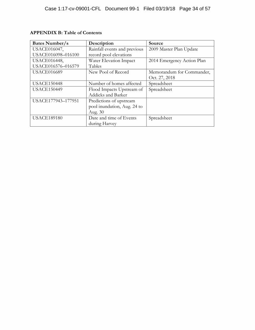
APPENDIX B: Table of Contents
Bates Number/s Description Source
USACE016047, USACE016098–016100
Rainfall events and previous record pool elevations
2009 Master Plan Update
USACE016448, USACE016576–016579
Water Elevation Impact Tables
2014 Emergency Action Plan
USACE016689 New Pool of Record Memorandum for Commander, Oct. 27, 2018
USACE150448 Number of homes affected Spreadsheet
USACE150449 Flood Impacts Upstream of Addicks and Barker
Spreadsheet
USACE177943–177951 Predictions of upstream pool inundation, Aug. 24 to Aug. 30
USACE189180 Date and time of Events during Harvey
Spreadsheet
Case 1:17-cv-09001-CFL Document 99-1 Filed 03/19/18 Page 34 of 57
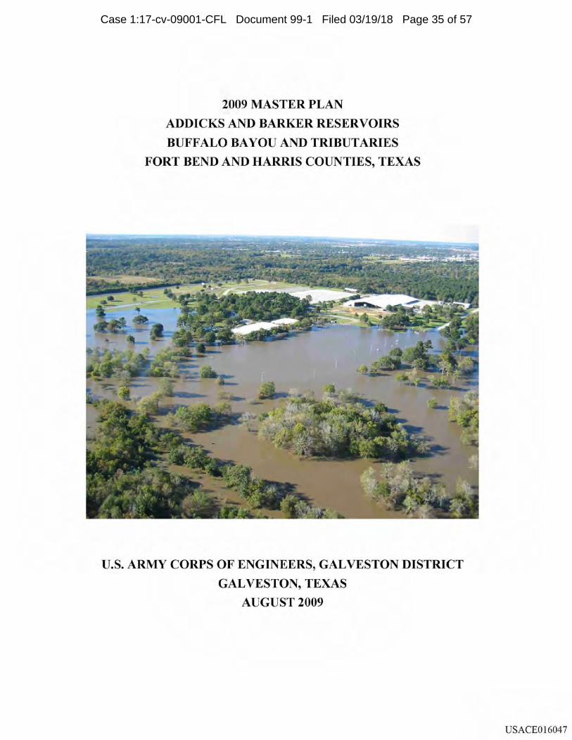
2009 MASTER PLAN
ADDICKS AND BARKER RESERVOIRS
BUFFALO BAYOU AND TRIBUTARIES
FORT BEND AND HARRIS COUNTIES, TEXAS
U.S. ARMY CORPS OF ENGINEERS, GALVESTON DISTRICT
GALVESTON, TEXAS
AUGUST 2009
USACE016047
Case 1:17-cv-09001-CFL Document 99-1 Filed 03/19/18 Page 35 of 57
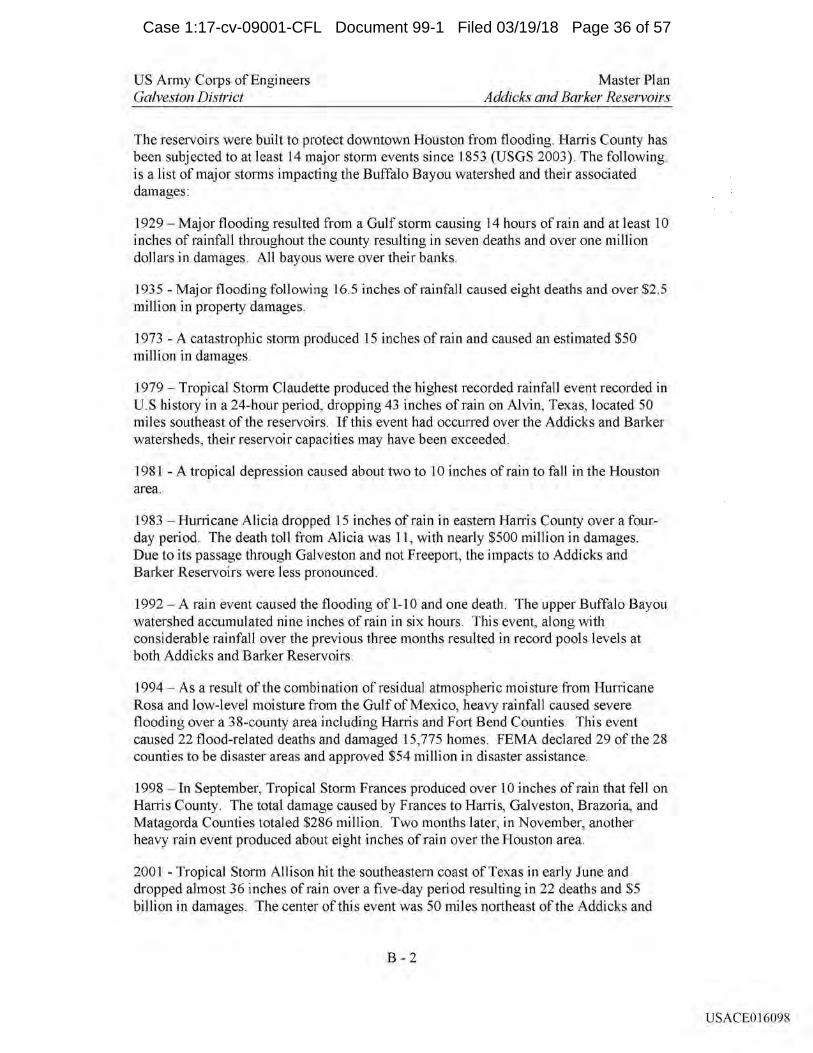
US Army Corps of Engineers Galveston District
Master Plan Addicks and Barker Reservoirs
The reservoirs were built to protect downtown Houston from flooding. Harris County has been subjected to at least 14 major storm events since 1853 (USGS 2003). The following is a list of major storms impacting the Buffalo Bayou watershed and their associated damages:
1929 - Maj or flooding resulted from a Gulf storm causing 14 hours of rain and at least 10 inches of rainfall throughout the county resulting in seven deaths and over one million dollars in damages. All bayous were over their banks.
1935 - Major flooding following 16.5 inches of rainfall caused eight deaths and over $2.5 million in property damages.
1973 - A catastrophic storm produced 15 inches of rain and caused an estimated $50 million in damages.
1979 - Tropical Storm Claudette produced the highest recorded rainfall event recorded in U. S history in a 24-hour period, dropping 43 inches of rain on Alvin, Texas, located 50 miles southeast of the reservoirs. If this event had occurred over the Addicks and Barker watersheds, their reservoir capacities may have been exceeded.
1981 - A tropical depression caused about two to 10 inches of rain to fall in the Houston area.
1983 -Hurricane Alicia dropped 15 inches of rain in eastern Harris County over a fourday period. The death toll from Alicia was 11, with nearly $500 million in damages. Due to its passage through Galveston and not Freeport, the impacts to Addicks and Barker Reservoirs were less pronounced.
1992 - A rain event caused the flooding of 1-10 and one death. The upper Buffalo Bayou watershed accumulated nine inches of rain in six hours. This event, along with considerable rainfall over the previous three months resulted in record pools levels at both Addicks and Barker Reservoirs.
1994 - As a result of the combination of residual atmospheric moisture from Hurricane Rosa and low-level moisture from the Gulf of Mexico, heavy rainfall caused severe flooding over a 38-county area including Harris and Fort Bend Counties. This event caused 22 flood-related deaths and damaged 15,775 homes. FEMA declared 29 of the 28 counties to be disaster areas and approved $54 million in disaster assistance.
1998 - In September, Tropical Storm Frances produced over 10 inches of rain that fell on Harris County. The total damage caused by Frances to Harris, Galveston, Brazoria, and Matagorda Counties totaled $286 million. Two months later, in November, another heavy rain event produced about eight inches of rain over the Houston area.
2001 - Tropical Storm Allison hit the southeastern coast of Texas in early June and dropped almost 36 inches of rain over a five-day period resulting in 22 deaths and $5 billion in damages. The center of this event was 50 miles northeast of the Addicks and
B-2
USACE016098
Case 1:17-cv-09001-CFL Document 99-1 Filed 03/19/18 Page 36 of 57
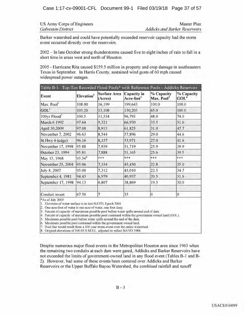
US Army Corps of Engineers Galveston District
Master Plan Addicks and Barker Reservoirs
Barker watershed and could have potentially exceeded reservoir capacity had the storm event occurred directly over the reservoirs.
2002 - In late October strong thunderstorms caused five to eight inches of rain to fall in a short time in areas west and north of Houston.
2005 - Hurricane Rita caused $159.5 million in property and crop damage in southeastern Texas in September. In Harris County, sustained wind gusts of 60 mph caused widespread power outages.
*As of July 2009 1. Elevation of water surface is in feet-NA VD, Epoch 2001. 2. One acre-foot of water is one acre of water, one foot deep. 3. Percent of capacity of maximum possible pool before water spills around end of darn. 4. Percent of capacity of maximum possible pool contained within the government owned land (GOL ). 5. Maximum possible pool before water spills around the end of the dam. 6. Maximum possible pool contained within the government owned land. 7. Pool that would result from a 100 year storm event over the entire watershed. 8. Original elevations ofl00.03 ft MS.L. adjusted to reflect NA VD 1988.
Despite numerous major flood events in the Metropolitan Houston area since 1963 when the remaining two conduits at each dam were gated, Addicks and Barker Reservoirs have not exceeded the limits of government-owned land in any flood event (Tables B-1 and B-2). However, had some of these events been centered over Addicks and Barker Reservoirs or the Upper Buffalo Bayou Watershed, the combined rainfall and runoff
B - 3
USACE016099
Case 1:17-cv-09001-CFL Document 99-1 Filed 03/19/18 Page 37 of 57
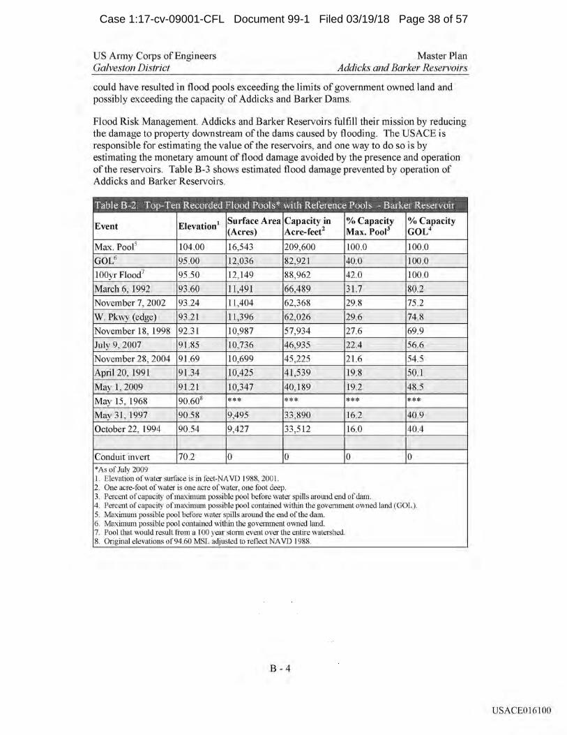
US Army Corps of Engineers Galveston District
Master Plan Addicks and Barker Reservoirs
could have resulted in flood pools exceeding the limits of government owned land and possibly exceeding the capacity of Addicks and Barker Dams.
Flood Risk Management. Addicks and Barker Reservoirs fulfill their mission by reducing the damage to property downstream of the dams caused by flooding. The USACE is responsible for estimating the value of the reservoirs, and one way to do so is by estimating the monetary amount of flood damage avoided by the presence and operation of the reservoirs. Table B-3 shows estimated flood damage prevented by operation of Addicks and Barker Reservoirs.
*As of July 2009 1. Elevation of water surface is in feet-NA VD 1988, 2001. 2. One acre-foot of water is one acre of water, one foot deep. 3. Percent of capacity of maximum possible pool before water spills around end of darn. 4. Percent of capacity of maximum possible pool contained within the government owned land (GOL ). 5. Maximum possible pool before water spills around the end of the dam. 6. Maximum possible pool contained within the government owned land. 7. Pool that would result from a 100 year storm event over the entire watershed. 8. Original elevations of94.60 MSL adjusted to reflect NA VD 1988.
B-4
USACE016100
Case 1:17-cv-09001-CFL Document 99-1 Filed 03/19/18 Page 38 of 57
CESWG PLAN 500-1-3 22 May 2014
ANNEX I (ADDICKS & BARKER EMERGENCY ACTION PLAN) TO EMERGENCY OPERATIONS PLAN
EMERGENCY ACTION PLAN
ADDICKS RESERVOIR NID # TX00018
AND
BARKER RESERVOIR NID # TX00019
BUFFALO BAYOU AND TRIBUTARIES
US ARMY ENGINEER DISTRICT, GALVESTON
CORPS OF ENGINEERS
GALVESTON, TEXAS
FOR OFFICIAL USE ONLY (FOUO)
USACE016448
Case 1:17-cv-09001-CFL Document 99-1 Filed 03/19/18 Page 39 of 57
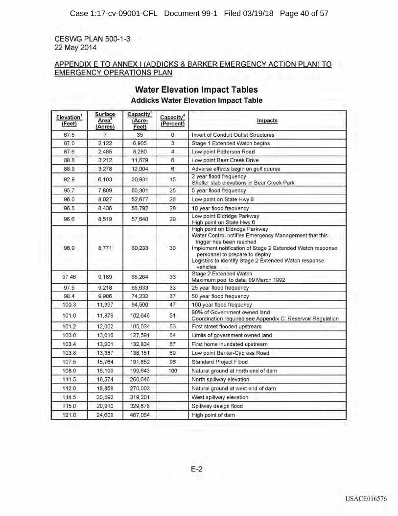
CESWG PLAN 500-1-3 22 May 2014
APPENDIX E TO ANNEX I (ADDICKS & BARKER EMERGENCY ACTION PLAN) TO EMERGENCY OPERATIONS PLAN
Elevation 1 Surface Area3
(Feet) LAcresJ
67.5 7
87.0 2,122
87.6 2,465
88.8 3,212
88.9 3,278
92.9 6,103
95.7 7,809
96.0 8,027
96.5 8,436
96.6 8,519
96.9 8,771
97.46 9,189
97.5 9,218
98.4 9,906
100.3 11,397
101.0 11,879
101.2 12,002
103.0 13,016
103.4 13,201
103.8 13,387
107.5 15,764
108.0 16, 199
111.5 18,574
112.0 18,858
114.5 20,592
115.0 20,910
121.0 24,609
Water Elevation Impact Tables Addicks Water Elevation Impact Table
CaE!acity--:i-CaE!acitl (Acre- lmE!acts {Percent}
Fee[
35 0 Invert of Conduit Outlet Structures
6,905 3 Stage 1 Extended Watch begins
8,280 4 Low point Patterson Road
11,679 6 Low point Bear Creek Drive
12,004 6 Adverse effects begin on golf course
30,931 15 2 year flood frequency Shelter slab elevations in Bear Creek Park
50,301 25 5 year flood frequency
52,677 26 Low point on State Hwy 6
56,792 28 10 year flood frequency
57,640 29 Low point Eldridge Parkway Hl.g_h _e_oint on State Hw_y_ 6 High point on Eldridge Parkway Water Control notifies Emergency Management that this
trigger has been reached 60,233 30 Implement notification of Stage 2 Extended Watch response
personnel to prepare to deploy Logistics to identify Stage 2 Extended Watch response
vehicles
65,264 33 Stage 2 Extended Watch Maximum _Q_ool to date, 09 March 1992
65,633 33 25 year flood frequency
74,232 37 50 year flood frequency
94,500 47 100 year flood frequency
102,646 51 80% of Government owned land Coordination r~uired see A..EE_endix C: Reservoir Re_g_ulation
105,034 53 First street flooded upstream
127,591 64 Limits of government owned land
132,834 67 First home inundated upstream
138,151 69 Low point Barker-Cypress Road
191,652 96 Standard Project Flood
199,643 100 Natural ground at north end of dam
260,646 North spillway elevation
270,003 Natural ground at west end of dam
319,301 West spillway elevation
329,676 Spillway design flood
467,064 High point of dam
E-2
USACE016576
Case 1:17-cv-09001-CFL Document 99-1 Filed 03/19/18 Page 40 of 57
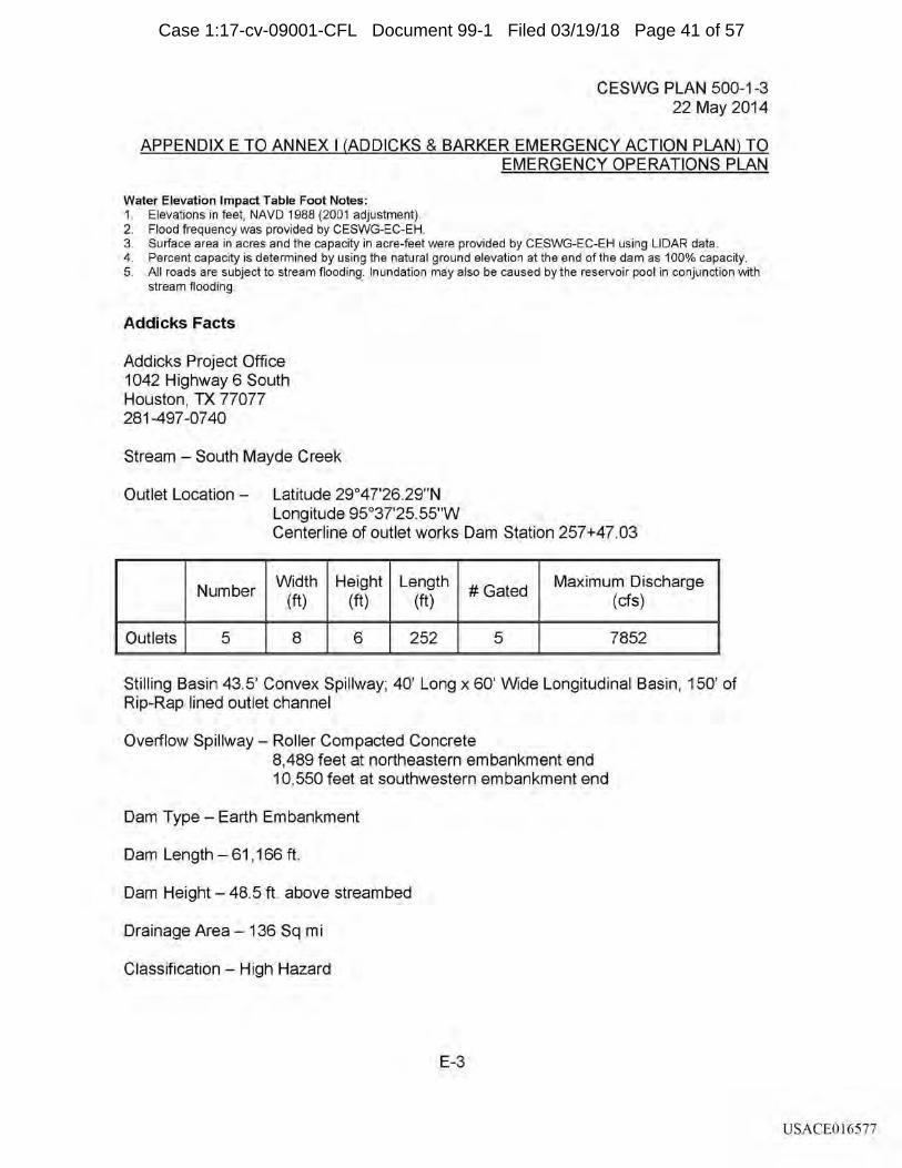
CESWG PLAN 500-1-3 22 May 2014
APPENDIX E TO ANNEX I (ADDICKS & BARKER EMERGENCY ACTION PLAN) TO EMERGENCY OPERATIONS PLAN
Water Elevation Impact Table Foot Notes: 1. Elevations in feet, NAVO 1988 (2001 adjustment). 2. Flood frequency was provided by CESWG-EC-EH. 3. Surface area in acres and the capacity in acre-feet were provided by CESWG-EC-EH using LIDAR data. 4. Percent capacity is determined by using the natural ground elevation at the end of the dam as 100% capacity. 5. All roads are subject to stream flooding. Inundation may also be caused by the reservoir pool in conjunction with
stream flooding.
Addicks Facts
Addicks Project Office 1042 Highway 6 South Houston, TX 77077 281-497 -07 40
Stream - South Mayde Creek
Outlet Location - Latitude 29°47'26.29"N Longitude 95°37'25.55"W Centerline of outlet works Dam Station 257+47.03
Number Width Height Length
#Gated Maximum Discharge
(ft) (ft) (ft) (cfs)
Outlets 5 8 6 252 5 7852
Stilling Basin 43.5' Convex Spillway; 40' Long x 60' Wide Longitudinal Basin, 150' of Rip-Rap lined outlet channel
Overflow Spillway - Roller Compacted Concrete 8,489 feet at northeastern embankment end 10,550 feet at southwestern embankment end
Dam Type - Earth Embankment
Dam Length - 61, 166 ft.
Dam Height - 48.5 ft. above streambed
Drainage Area - 136 Sq mi
Classification - High Hazard
E-3
USACE016577
Case 1:17-cv-09001-CFL Document 99-1 Filed 03/19/18 Page 41 of 57
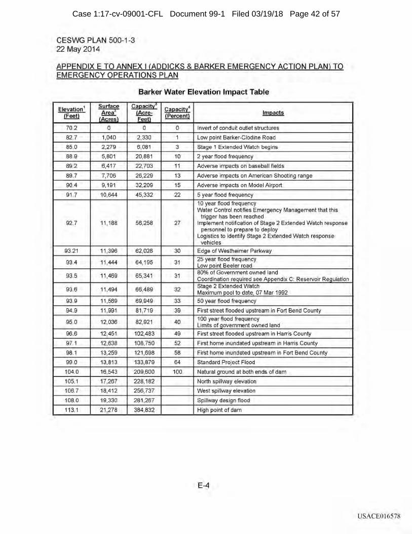
CESWG PLAN 500-1-3 22 May 2014
APPENDIX E TO ANNEX I (ADDICKS & BARKER EMERGENCY ACTION PLAN) TO EMERGENCY OPERATIONS PLAN
Barker Water Elevation Impact Table
Elevation 1 Surface Ca12acitl Ca12acity4 Area3 !Acre- lm12acts (Feet) {Percent} LAcresj Fee!l
70.2 0 0 0 Invert of conduit outlet structures
82.7 1,040 2,330 1 Low point Barker-Clodine Road
85.0 2,279 6,081 3 Stage 1 Extended Watch begins
88.9 5,801 20,881 10 2 year flood frequency
89.2 6,417 22,703 11 Adverse impacts on baseball fields
89.7 7,706 26,229 13 Adverse impacts on American Shooting range
90.4 9, 191 32,209 15 Adverse impacts on Model Airport
91.7 10,644 45,332 22 5 year flood frequency
1 O year flood frequency Water Control notifies Emergency Management that this
trigger has been reached 92.7 11, 188 56,258 27 Implement notification of Stage 2 Extended Watch response
personnel to prepare to deploy Logistics to identify Stage 2 Extended Watch response
vehicles
93.21 11,396 62,026 30 Edge of Westheimer Parkway
93.4 11,444 64, 195 31 25 year flood frequency Low_Q_oint Beeler road
93.5 11,469 65,341 31 80% of Government owned land Coordination re_g_uired see Appendix C: Reservoir Re_g_ulation
93.6 11,494 66,489 32 Stage 2 Extended Watch Maximum _£_ool to date, 07 Mar 1992
93.9 11,569 69,949 33 50 year flood frequency
94.9 11,991 81,719 39 First street flooded upstream in Fort Bend County
95.0 12,036 82,921 40 100 year flood frequency Limits of_g_overnment owned land
96.6 12,451 102,483 49 First street flooded upstream in Harris County
97.1 12,638 108,750 52 First home inundated upstream in Harris County
98.1 13,259 121,698 58 First home inundated upstream in Fort Bend County
99.0 13,813 133,879 64 Standard Project Flood
104.0 16,543 209,600 100 Natural ground at both ends of dam
105.1 17,267 228, 182 North spillway elevation
106.7 18,412 256,737 West spillway elevation
108.0 19,330 281,267 Spillway design flood
113.1 21,278 384,832 High point of dam
E-4
USACE016578
Case 1:17-cv-09001-CFL Document 99-1 Filed 03/19/18 Page 42 of 57
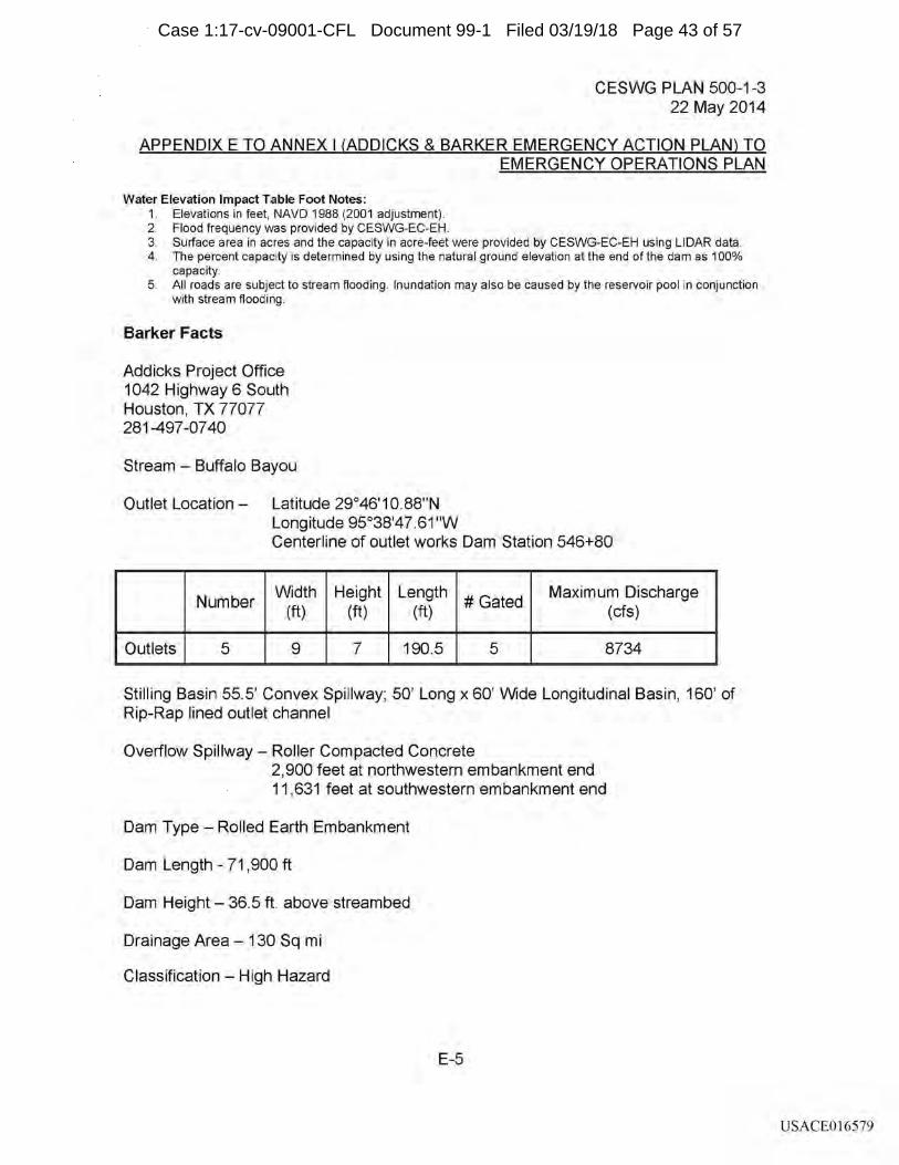
CESWG PLAN 500-1-3 22 May 2014
APPENDIX E TO ANNEX I (ADDICKS & BARKER EMERGENCY ACTION PLAN) TO EMERGENCY OPERATIONS PLAN
Water Elevation Impact Table Foot Notes: 1. Elevations in feet, NAVO 1988 (2001 adjustment). 2. Flood frequency was provided by CESWG-EC-EH. 3. Surface area in acres and the capacity in acre-feet were provided by CESWG-EC-EH using LIDAR data. 4. The percent capacity is determined by using the natural ground elevation at the end of the dam as 100%
capacity. 5. All roads are subject to stream flooding. Inundation may also be caused by the reservoir pool in conjunction
with stream flooding.
Barker Facts
Addicks Project Office 1042 Highway 6 South Houston, TX 77077 281-497 -07 40
Stream - Buffalo Bayou
Outlet Location - Latitude 29°46'10.88"N Longitude 95°38'47.61 "W Centerline of outlet works Dam Station 546+80
Number Width Height Length
#Gated Maximum Discharge
(ft) (ft) (ft) (cfs)
Outlets 5 9 7 190.5 5 8734
Stilling Basin 55.5' Convex Spillway; 50' Long x 60' Wide Longitudinal Basin, 160' of Rip-Rap lined outlet channel
Overflow Spillway - Roller Compacted Concrete 2,900 feet at northwestern embankment end 11,631 feet at southwestern embankment end
Dam Type - Rolled Earth Embankment
Dam Length - 71 , 900 ft
Dam Height - 36.5 ft above streambed
Drainage Area - 130 Sq mi
Classification - High Hazard
E-5
USACE016579
Case 1:17-cv-09001-CFL Document 99-1 Filed 03/19/18 Page 43 of 57
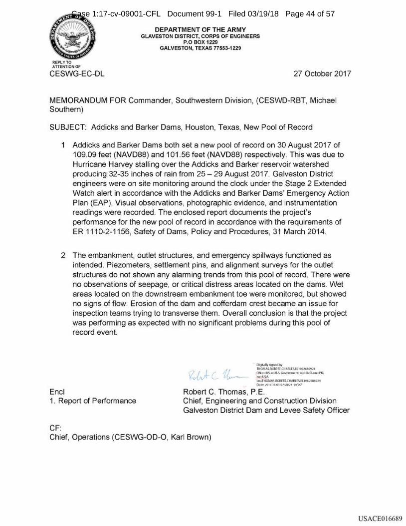
REPLY TO ATIENTIONOF
CESWG-EC-DL
DEPARTMENT OF THE ARMY GLAVESTON DISTRICT, CORPS OF ENGINEERS
P.O BOX 1229 GALVESTON, TEXAS 77553-1229
27 October 2017
MEMORANDUM FOR Commander, Southwestern Division, (CESWD-RBT, Michael Southern)
SUBJECT: Addicks and Barker Dams, Houston, Texas, New Pool of Record
1 Addicks and Barker Dams both set a new pool of record on 30 August 2017 of 109.09 feet (NAVD88) and 101 .56 feet (NAVD88) respectively. This was due to Hurricane Harvey stalling over the Addicks and Barker reservoir watershed producing 32-35 inches of rain from 25 - 29 August 2017. Galveston District engineers were on site monitoring around the clock under the Stage 2 Extended Watch alert in accordance with the Addicks and Barker Dams' Emergency Action Plan (EAP). Visual observations, photographic evidence, and instrumentation readings were recorded. The enclosed report documents the project's performance for the new pool of record in accordance with the requirements of ER 1110-2-1156, Safety of Dams, Policy and Procedures, 31 March 2014.
2 The embankment, outlet structures, and emergency spillways functioned as intended. Piezometers, settlement pins, and alignment surveys for the outlet structures do not shown any alarm ing trends from this pool of record. There were no observations of seepage, or critical distress areas located on the dams. Wet areas located on the downstream embankment toe were monitored, but showed no signs of flow. Erosion of the dam and cofferdam crest became an issue for inspection teams trying to transverse them. Overall conclusion is that the project was performing as expected with no significant problems during this pool of record event.
Encl 1. Report of Performance
CF:
°""""""""" lltQMS.AOllERl.(HAftlES.1 l I 00~2'1 Ott c• US. 0>0U.S.. GcM:rrnlent, w 1<1NO,w• P'IQ. ou~USA <n:TtQMSJ'.:lflfflf.(t!AAl(SJl,IOi~Jol lMt~ JOl/.lUll 01'.l'll:J.J-O>W
Robert C. Thomas, P E Chief, Engineering and Construction Division Galveston District Dam and Levee Safety Officer
Chief, Operations (CESWG-OD-0, Karl Brown)
USACE016689
Case 1:17-cv-09001-CFL Document 99-1 Filed 03/19/18 Page 44 of 57
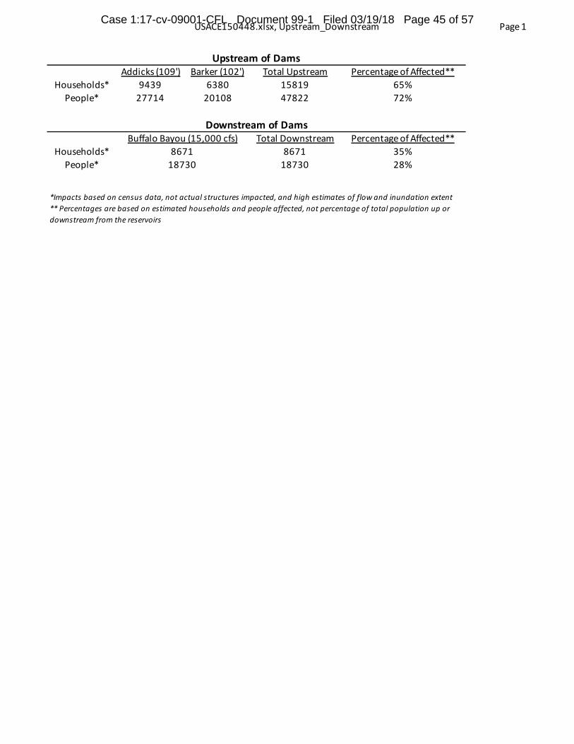
USACE150448.xlsx, Upstream_Downstream Page 1
Addicks (109') Barker (102') Total Upstream Percentage of Affected**Households* 9439 6380 15819 65%
People* 27714 20108 47822 72%
Total Downstream Percentage of Affected**Households* 8671 35%
People* 18730 28%
*Impacts based on census data, not actual structures impacted, and high estimates of flow and inundation extent** Percentages are based on estimated households and people affected, not percentage of total population up or downstream from the reservoirs
867118730
Upstream of Dams
Downstream of DamsBuffalo Bayou (15,000 cfs)
Case 1:17-cv-09001-CFL Document 99-1 Filed 03/19/18 Page 45 of 57
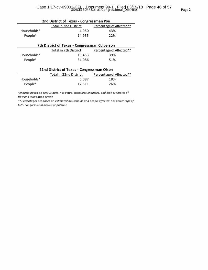
USACE150448.xlsx, Congressional_Districts Page 2
Total in 2nd District Percentage of Affected**Households* 4,950 43%
People* 14,955 22%
Total in 7th District Percentage of Affected**Households* 13,453 39%
People* 34,086 51%
Total in 22nd District Percentage of Affected**Households* 6,087 18%
People* 17,511 26%
2nd District of Texas - Congressman Poe
7th District of Texas - Congressman Culberson
*Impacts based on census data, not actual structures impacted, and high estimates of flow and inundation extent** Percentages are based on estimated households and people affected, not percentage of total congressional district population
22nd District of Texas - Congressman Olson
Case 1:17-cv-09001-CFL Document 99-1 Filed 03/19/18 Page 46 of 57
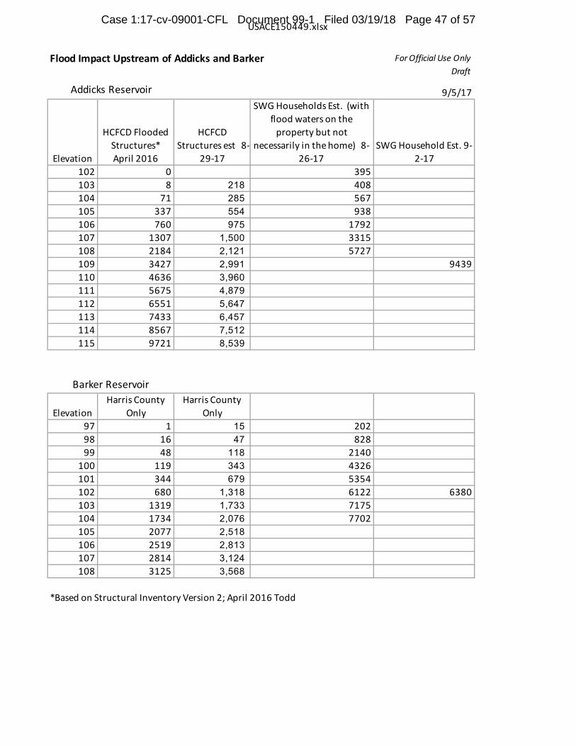
USACE150449.xlsx
Flood Impact Upstream of Addicks and Barker For Official Use Only Draft
9/5/17
Elevation
HCFCD Flooded Structures* April 2016
HCFCD Structures est 8-
29-17
SWG Households Est. (with flood waters on the
property but not necessarily in the home) 8-
26-17SWG Household Est. 9-
2-17102 0 395103 8 218 408104 71 285 567105 337 554 938106 760 975 1792107 1307 1,500 3315108 2184 2,121 5727109 3427 2,991 9439110 4636 3,960 111 5675 4,879 112 6551 5,647 113 7433 6,457 114 8567 7,512 115 9721 8,539
ElevationHarris County
OnlyHarris County
Only97 1 15 20298 16 47 82899 48 118 2140
100 119 343 4326101 344 679 5354102 680 1,318 6122 6380103 1319 1,733 7175104 1734 2,076 7702105 2077 2,518 106 2519 2,813 107 2814 3,124 108 3125 3,568
*Based on Structural Inventory Version 2; April 2016 Todd
Addicks Reservoir
Barker Reservoir
Case 1:17-cv-09001-CFL Document 99-1 Filed 03/19/18 Page 47 of 57

Case 1:17-cv-09001-CFL Document 99-1 Filed 03/19/18 Page 48 of 57
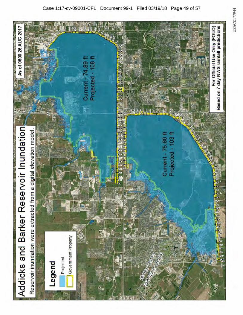
Case 1:17-cv-09001-CFL Document 99-1 Filed 03/19/18 Page 49 of 57
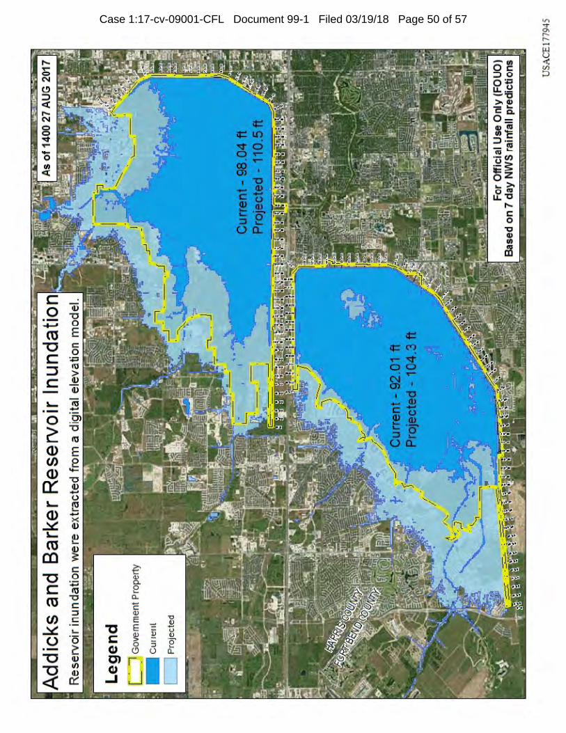
Case 1:17-cv-09001-CFL Document 99-1 Filed 03/19/18 Page 50 of 57
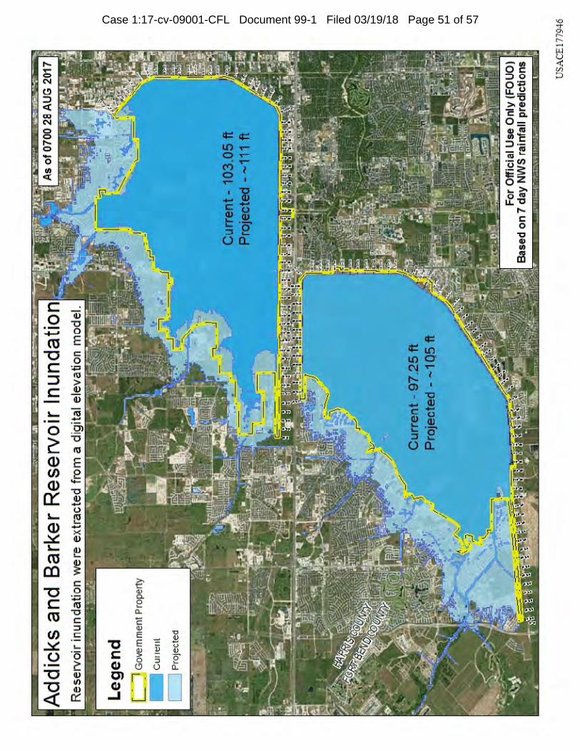
Case 1:17-cv-09001-CFL Document 99-1 Filed 03/19/18 Page 51 of 57
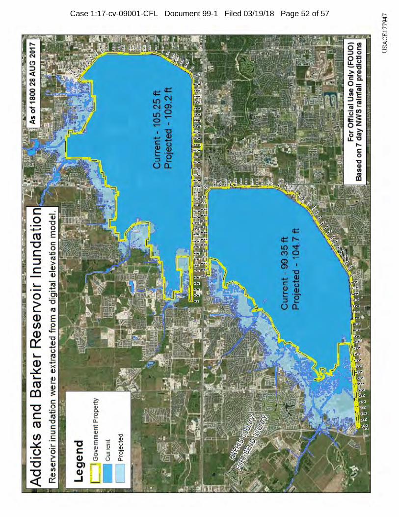
Case 1:17-cv-09001-CFL Document 99-1 Filed 03/19/18 Page 52 of 57
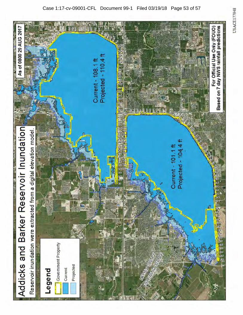
Case 1:17-cv-09001-CFL Document 99-1 Filed 03/19/18 Page 53 of 57
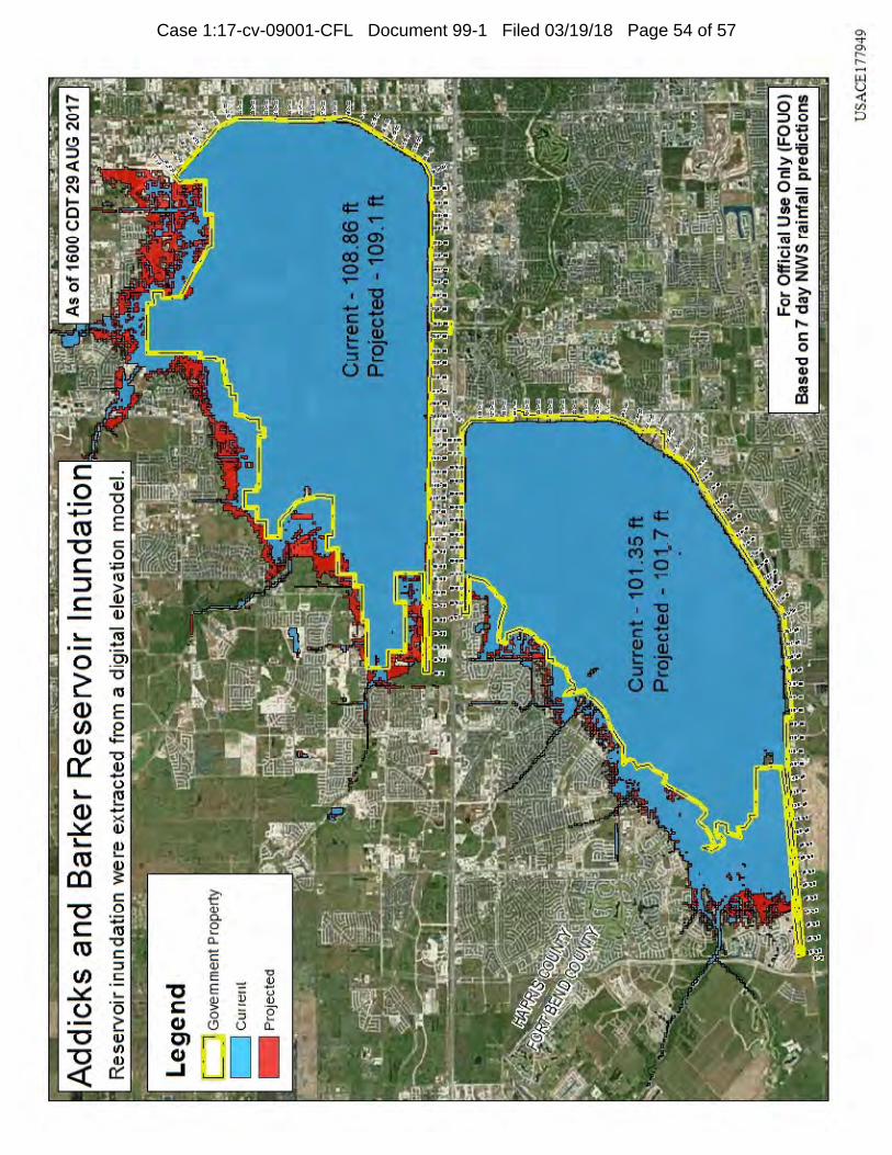
Case 1:17-cv-09001-CFL Document 99-1 Filed 03/19/18 Page 54 of 57
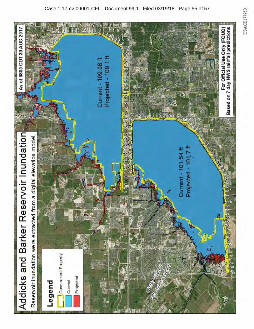
Case 1:17-cv-09001-CFL Document 99-1 Filed 03/19/18 Page 55 of 57
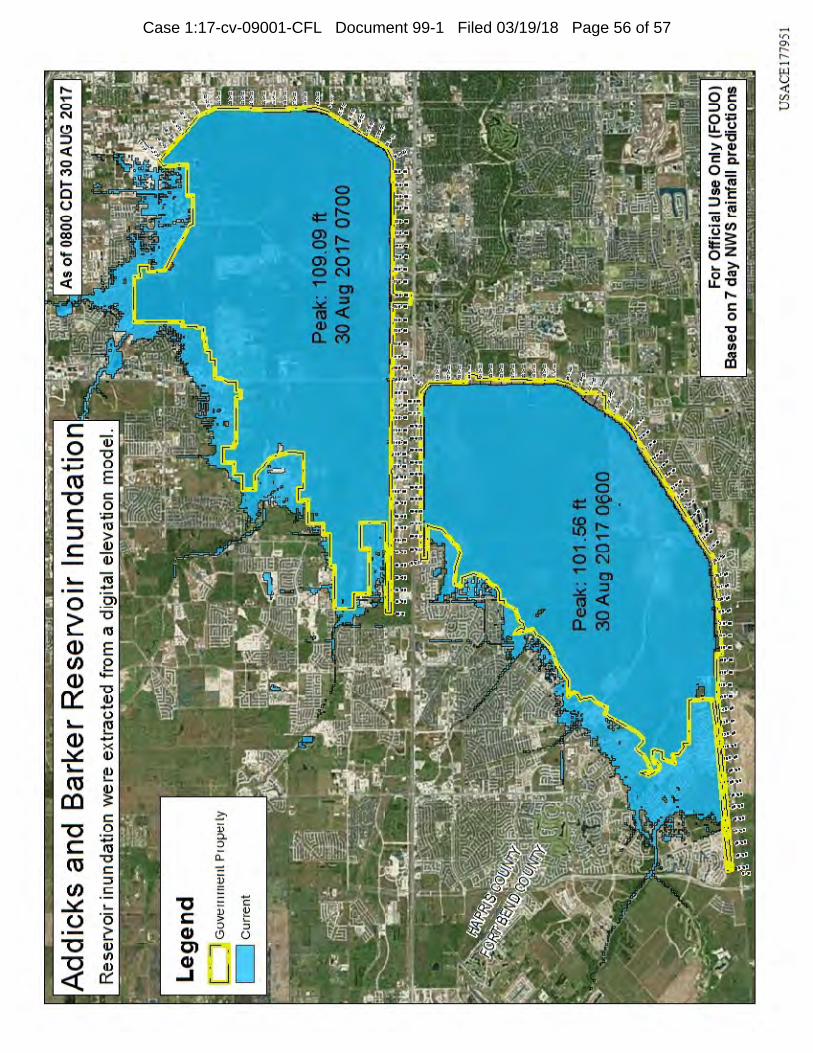
Case 1:17-cv-09001-CFL Document 99-1 Filed 03/19/18 Page 56 of 57
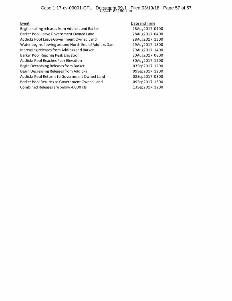
USACE189180.xlsx
Event Date and TimeBegin making releases from Addicks and Barker 28Aug2017 0100Barker Pool Leave Government Owned Land 28Aug2017 0400Addicks Pool Leave Government Owned Land 28Aug2017 1300Water begins flowing around North End of Addicks Dam 29Aug2017 1300Increasing releases from Addicks and Barker 29Aug2017 1400Barker Pool Reaches Peak Elevation 30Aug2017 0800Addicks Pool Reaches Peak Elevation 30Aug2017 1200Begin Decreasing Releases from Barker 03Sep2017 1200Begin Decreasing Releases from Addicks 09Sep2017 1200Addicks Pool Returns to Government Owned Land 08Sep2017 0300Barker Pool Returns to Government Owned Land 09Sep2017 1500Combined Releases are below 4,000 cfs 13Sep2017 1200
Case 1:17-cv-09001-CFL Document 99-1 Filed 03/19/18 Page 57 of 57
EXHIBIT B
Expert Declaration of Randall Bell
Case 1:17-cv-09001-CFL Document 99-2 Filed 03/19/18 Page 1 of 20
IN THE UNITED STATES COURT OF FEDERAL CLAIMS
In re UPSTREAM ADDICKS AND BARKER (TEXAS) FLOOD-CONTROL RESERVOIRS
Sub-Master Docket No. 17-9001L
Judge Charles F. Lettow
THIS DOCUMENT APPLIES TO:
ALL UPSTREAM CASES
EXPERT DECLARATION OF RANDALL BELL, PhD, MBA, MAI
1. Pursuant to 28 U.S.C.§ 1746, I submit this Expert Declaration in support of the upstreamplaintiffs’ Opposition to the United States’ Motion to Dismiss in this action.
2. My name is Randall Bell. This Declaration is based upon my personal knowledge andexperience which I obtained by my personal investigation and independent researchsurrounding the events and impacts of Tropical Storm Harvey on the residents of theHarris and Fort Bend County, Texas, along with my prior experience as discussed belowand set forth in my CV, which is attached as Exhibit A to this Declaration.
3. I have been retained in the above-styled matter to provide my opinion regarding theproper methodology and an assessment of the damages suffered by certain individualsand entities whose property was inundated by floodwaters captured within the Addicksand Barker Reservoirs during Tropical Storm Harvey.
Education, Licenses, and Memberships
4. I received my B.S. degree in Finance and Accounting from Brigham Young University;my Masters in Business Administration with an emphasis on real estate studies from theUniversity of California, Los Angeles; and my Doctoral degree in Human andOrganizational Systems from Fielding Graduate University. My dissertation was titled: PostTraumatic Behaviors: The Socioeconomic Reasoning of Homeowners Who VoluntarilyRemained in the Aftermath of Hurricane Katrina.
5. I am a Certified General Real Estate Appraiser (AG1672), as well as and MAI as designatedby the Appraisal Institute (Designation M9360). I am also a licensed real estate broker in theState of California (Lic. No. 01111436).
6. I am an Advisory Board Member of the Bureau of National Affairs (BNA), a Member of theAmerican Statistical Association, a Member of the Econometric Society, a Member of theAmerican Economics Association, and a Member of the Association of SocialEconomics.
Case 1:17-cv-09001-CFL Document 99-2 Filed 03/19/18 Page 2 of 20
7. I have served as an Instructor for Continuing Education Requirements for the Appraisal Institute, and was previously appointed to its Regional Ethics and Counseling Panel and elected to its Advisory Council. I have served as the Chairman of the Appraisal Institute Litigation Seminar Committee, served as a Member of its Task Force on Advanced Education Standards, served as a Member of its Committee for Statistical & Survey Standards, served as a Member of its National Strategic Planning Committee, and was twice the Recipient of the Swango Award as author of the Year’s Outstanding Article in the Appraisal Journal.
Books and Articles
8. A complete listing of the books, chapters, seminars, essays, articles, and other publications regarding the appraisal of real estate that I have authored is provided on Exhibit A. A selected few of those items specifically pertinent to my work in this matter includes:
a. Real Estate Damages (3rd ed.) – Appraisal Institute – Chicago, Illinois – Author
b. The Appraisal of Real Estate (14th ed.) – Appraisal Institute - Chicago, Illinois – Contributing Author
c. Real Estate Valuation in Global Markets (2nd ed.) – Appraisal Institute – Chicago, Illinois – Contributing Author
d. Applications in Litigation Valuation – Appraisal Institute – Chicago, Illinois – Contributing Author
e. Valuing Contaminated Properties – Appraisal Institute – Chicago, Illinois – Contributing Author
f. Real Estate Research, published in The Appraisal Journal
g. The Scientific Method and the Valuation Process, published in Environmental Due Diligence
h. The Impact of Detrimental Conditions on Property Values, published in The Appraisal Journal
i. Diminishing Diminution: A Trend in Environmental Stigma, published in Environmental Claims Journal
j. Basic Due Diligence, published in Environmental Claims Journal
k. Ten Standard Classifications of Detrimental Conditions, published in Right of Way Magazine
Case 1:17-cv-09001-CFL Document 99-2 Filed 03/19/18 Page 3 of 20
l. Quantifying The Diminution In Value Due To Detrimental Conditions: The Theory and Application to Environmentally Contaminated Properties, published in Environmental Claims Journal
m. Assessing Diminution in Value – A Methodology for Categorizing Detrimental Conditions, published in Right of Way
n. Valuation of Contaminated Property, published in The Bureau of National Affairs, Inc.
o. Contaminated Waterways and Property Valuation The Appraisal Journal
p. Detrimental Conditions Seminar. I was the author and instructor of a one-day seminar published and sponsored by the Appraisal Institute. This seminar illustrates a valuation methodology for categorizing numerous Detrimental Conditions (i.e., environmental contamination, natural disasters, geotechnical issues, construction defects, market conditions, imposed conditions, etc.) and quantifying the diminution in value. It was approved in all 50 states by each appraisal licensing agency and the California State Bar for continuing education credit, and has been taught nationwide and internationally.
Prior Appraisal Experience
9. I have previously appraised fee simple interests, leased fee interests, leasehold interests, and both majority and minority fractional interests.
10. I have appraised such interests in a number of difference circumstances and for a variety of assignments including: Absorption Studies; Acquisition; Assessor Disputes; Bankruptcy; Bond Financing; Construction Loans; Diminution in Value; Disposition; Divorce Settlement; Donation; Environmental Effect Studies; Estate Settlement; Excess Land; Exchanges; Fair Value Issues; Feasibility Studies; Foreclosure; Fraud; Ground Lease Renewal; Highest and Best Use Analysis; Income Tax Appeal; Investment Analysis; Judicial Foreclosure; Review Appraisal; Lease Negotiations; Lease Renewals; Litigation Support; Loan Review; Market Trend Studies; Mortgage Lending; Negotiation; Partnership Dissolution; Portfolio Evaluation; Property Tax Appeal; Redevelopment Zone Studies; and Refinancing.
11. A listing of my prior assignments concerning appraisal and valuation is provided on Exhibit A. A few of those items specifically pertinent to my work in this matter includes:
a. Bikini Atoll Nuclear Testing Sites: Retained by the Nuclear Claims Tribunal to determine the damages caused by radioactive contamination and nuclear fallout as a result of nuclear testing on the Bikini Atoll in the Marshall Islands. This is the largest environmental contamination case in the history of the world. Involved radioactive, cultural resource and natural damage issues. Testified before the Nuclear Claims Tribunal on two occasions.
Case 1:17-cv-09001-CFL Document 99-2 Filed 03/19/18 Page 4 of 20
b. World Trade Center Site – New York: Retained by the Lower Manhattan Development Corporation (an entity created by the City and State of New York) to determine the value of the WTC site in the aftermath of the September 11th tragedies.
c. United Flight 93 Crash Site: Computed the impact on value of the coal mining fields where Flight 93 crashed on September 11th. Retained by the property owner.
d. Hurricane Katrina: Retained as a consulting expert on the Murphy Oil Spill case in the aftermath of the hurricane, which resulted in oil contamination over large portions of Saint Bernard’s Parish. Retained by Murphy Oil Company.
e. BP Oil Spill: Retained as a consulting expert on the BP Oil Spill case, the largest oil spill in United States history.
f. Caribbean Resort Hurricane Damage: Retained as a consulting expert to compute the impact on value of a major Caribbean hotel resort as a result of extensive damage from Hurricane Omar.
g. LA Metro Mall Landfill: Estimated the effect of an encapsulated landfill on present and future commercial property values. The proposed retail development was to have been constructed on top of a contaminated solid waste landfill.
h. Straight Lane Texas House: Case involving the largest house in the United States. Calculated the diminution in value resulting from a massive explosion and subsequent fire. The property is located on what is informally called, “Billionaire Row” in the Dallas Texas area. Field work included inspecting the nation’s largest estate homes from coast to coast.
i. Cooper Cameron, Texas: Measured the impact, if any that offsite TCE groundwater contamination had on value that had migrated underneath a high-end neighborhood in the Houston, Texas area.
j. Ko Loco Hawaii Dam Failure: This major dam failure caused fatalities and millions of dollars of property damage to a small village. Assigned to estimate the residual effect of the dam failure on local residential property values.
k. Northridge Earthquake: Retained to estimate the damages to numerous properties in several cases resulting from the earthquake. One assignment included determining the diminution in value to high-rise properties in downtown Los Angeles due to weld fracturing and alleged construction defects.
l. LA Riots: Retained to compute fire damages to numerous properties in one of the worst civil uprisings in the history of the United States.
m. Crime Scene Stigma: Consulted and calculated economic damages caused by various crime scenes, including the Jon Benet Ramsey house, the Heaven’s Gate Mansion in Rancho Santa Fe, the OJ Simpson and Nicole Brown Simpson Condominium, and the Andrew Luster House.
Case 1:17-cv-09001-CFL Document 99-2 Filed 03/19/18 Page 5 of 20
n. Nebraska Floods: Estimated damages caused by residential construction within a flood zone.
Opinion Regarding Severity of Harvey Flooding
12. As noted above, I have been retained in this matter to provide my opinion regarding the proper methodology and an assessment of the damages suffered by certain individuals and entities whose property was inundated by floodwaters retained by the Addicks and Barker Reservoirs during Tropical Storm Harvey (“Harvey”). I have been asked to provide in this Declaration an opinion regarding the severity of damage suffered by property owners located in the Addicks and Barker Reservoirs.
13. In preparation for providing the opinions in this Declaration, I have reviewed (and for purposes of providing the opinions in this Declaration, I accept as true and correct) the factual allegations contained in the Master Amended Complaint for the Upstream Plaintiffs that was filed on January 16, 2018 in Case 1:17-cv-09001-CFL.
14. In February 2018, I personally toured areas contained within the Addicks and Barker Reservoirs. I personally visited several neighborhoods with affected homes, and inspected the interior and exterior of numerous flooded homes. I also toured and inspected various public and commercial building and structures.
15. Though I am in the preliminary stages of my property reviews and damages calculations, I have seen a sufficient number of homes and properties, as well as the damage to those homes and properties, to render an opinion regarding the overall severity of the damages suffered by property owners located within the Addicks and Barker reservoirs as a result of the flooding during Harvey from the reservoir flood pools.
16. I have extensive experience with regard to examining and evaluating the damage to a structure caused by flooding. The real estate owned by many individuals living in the United States will be primarily limited to their homes. As most people’s single largest financial asset, the flooding of their home necessarily creates a severe economic impact to a homeowner who is thereafter required to repair their home, or must sell it at a significant discount to the pre-flood fair market value.
17. The typical residential structure in the subject area (and the ones I toured) consists of a wood-framed residence, with brick or stucco exterior and sheetrock interior walls. This means that floodwater, even when in a house for only a short duration, will (and did) permeate the walls and soak the wood frame. To prevent permanent damage to the wood frame, the owners must remove the interior walls, insulation, electrical wiring, carpet, and fixtures such as kitchen cabinets as soon as possible, then they must dry out the wood frame for weeks with dehumidifiers and fans to prevent warping and mold formation.
18. I saw such efforts being undertaken during my time touring the area in February 2018— some six (6) months after the event, for some homeowners. Many houses I saw were still empty and uninhabitable even that long after the flooding. The displacement from a primary residence for such a period of time is, in my opinion, a severe impact on the homeowner. Others were also impacted when forced to, for example, live upstairs in a
Case 1:17-cv-09001-CFL Document 99-2 Filed 03/19/18 Page 6 of 20
two-story home or live in a confined space in a single-story home, and therefore enjoy limited use of their dwellings.
19. Of particular note regarding the flooding of the properties within the Addicks and Barker Reservoirs is the odious nature of the water involved. Homeowners have reported mold growth in their structures, and news reports as well as homeowner comments have confirmed that the floodwaters were contaminated with sewage due to overflowing treatment plants. I have encountered such circumstances previously and in my experience the foul nature of the water associated with the Harvey flooding only furthers the unfavorable market perception associated with the affected properties, thereby increasing the severity of the economic impact on the homeowners.
20. And even after the “drying out” of the stricture is finally completed, the building then needs a mold inspection, and if necessary, mold treatment before reconstruction can begin. Thereafter, there will be an additional period the homeowner is deprived of the use of their property, and additional repair and reconstruction costs will be incurred.
21. Also, in addition to the significant cost to inspect, evaluate, and repair a flooded home, there remains the devaluation of the property even with such repairs. This permanent loss in value once again adds to the severity of the impact on those homeowners flooded in the Addicks and Barker Reservoirs.
22. Finally, these property owners also suffered personal losses such as the loss of personal property (often emotionally cherished items and heirlooms), along with the loss of access and use of their property, as well as other losses that I am accustomed to seeing in the circumstance of severe flooding.
23. Based on my review of the affected areas and my prior experience with properties devalued by a natural or man-made disaster such as Harvey, I agree with the statements in the Master Amended Complaint that property owners in the Addicks and Barker reservoirs whose property was inundated by Harvey floodwaters suffered substantial damages and devaluation of those properties, and that such damage and devaluation is severe. It is my opinion that all the inundated properties (and homeowners) were severely impacted by the flooding.
24. In order to corroborate my independent assessment and analysis, I also reviewed government documents projecting the likely scale of the damage in the event of a storm like Harvey. As described below, those documents predicted very severe damage, in line with my own assessment after the fact.
25. For instance, the U.S. Army Corps of Engineers (the “Corps”) prepared a May 1992 Special Report on Flooding regarding the Addicks and Barker Reservoirs “to provide general background information on the existing operational conditions at Addicks and Barker reservoirs and given an overview of the order of magnitude of the anticipated flooding damages which could occur off of Government property assuming different flood events.” The report noted that between the 1940s and 1992, “the extensive urban growth of the western portion of the Houston metropolitan area has resulted in both
Case 1:17-cv-09001-CFL Document 99-2 Filed 03/19/18 Page 7 of 20
reservoirs being surrounded by intense commercial and residential development.” Based on calculations derived from the reservoir capacities from a Buffalo Bayou & Tributaries, Texas Feasibility Report completed in May 1988, and an appraisal by the Appraisal Branch of the Real Estate Division of Galveston Corps office, the 1992 Special Report concluded that “an SPF [Standard Project Flood] and a 100-year event would cause $420 million and $95 million [in damage to private property], respectively.”
26. Likewise, a January 1993 memorandum addressing appropriations for a 1994Reconnaissance Study of the dams provided by the Corps to Senators Lloyd Bentsen andPhil Gramm and Representative Bill Archer of Texas, discussed the design criteria forAddicks and Barker Dams and the impact of anticipated flooding of the reservoirs:
Preliminary estimates of potential flood damages upstream of Addicks and Barker Reservoirs were developed in 1992 using aerial photographs and real estate appraisals. These estimates determined that single occurrence damages for the Probable Maximum Flood would affect over 4,000 structures valued at approximately $725 million and cause damages of $425 million. The Standard Project Flood would impact 2,800 structures worth $400 million and cause $100 million in damages.
27. In the May 1994 Organizational Team Meeting memorandum for that Section 216Reconnaissance Study of Addicks and Barker Reservoirs, the government acknowledgedthat a 1988 “Buffalo Bayou & Tributaries, Texas Feasibility Report determined thatsingle occurrence damages from a 100-year flood event would affect over 2,750structures worth approximately $490 million and cause damage of $114 million.”
28. Finally, my research has shown that during the period from 1988, 1992, and 1994 whenthese estimates were developed, and the August 2017 flooding event, development in theAddicks and Barker Reservoirs proceeded and the number of structures (and their value)significantly increased—thereby significantly increasing the government’s estimates ofthe severe economic damage that would be (and was) caused by the inundation of theproperties within the Addicks and Barker Reservoirs.
29. Therefore, as an overall conclusion, it is my opinion that all the inundated properties (andhomeowners) in the Addicks and Barker reservoirs suffered substantial and severeimpacts and damage from the floodwaters retained by the Addicks and Barker Reservoirsduring Tropical Storm Harvey.
Signed: March 16, 2018.
___________________________ Randall Bell
Case 1:17-cv-09001-CFL Document 99-2 Filed 03/19/18 Page 8 of 20
APPENDIX A
Case 1:17-cv-09001-CFL Document 99-2 Filed 03/19/18 Page 9 of 20
RANDALL BELL, PhD, MBA, MAI
PROFESSIONAL BACKGROUND
Dr. Randall Bell is the author of Real Estate Damages: 3rd Edition, which is published by the Appraisal Institute. He specializes in damage economics and valuation, including environmental, geotechnical, construction defects, natural disasters and eminent domain issues. He is experienced in complex valuation and diminution-in-value studies for governments, corporations, oil and utility companies and property owners. He is licensed in various states and has testified as an expert in multiple courts.
Dr. Bell leads the Landmark Research Group, LLC. He served as the CEO of Bell Anderson and Sanders, LLC for 15 years and led the Real Estate Damages practice of Price Waterhouse, which later merged to become PricewaterhouseCoopers.
Dr. Bell consulted on the World Trade Center, the Flight 93 Crash Site, Hurricane Katrina, the BP Oil Spill, the Bikini Atoll Nuclear Test Sites, the Sargent Yokoi Cave in Guam, the San Bruno Pipeline Explosion, the Anniston Alabama spill, the Heaven’s Gate Mansion, the Canadian Government UXO site, the OJ Simpson Crime Scene, the Tulum Mexico Resort, the Sandy Hook School Shooting and many others. His career has been profiled by the Wall Street Journal, the Los Angeles Times, the Associated Press, The San Francisco Chronicle, People Magazine, and The Chicago Tribune and on various television broadcasts by all major networks and CNN. He has been quoted by USA Today, the New York Times, Harper’s Magazine, Time Magazine, and US News and World Report, as well as the media in Europe, Australia and Japan.
EDUCATION
Doctoral Studies: Fielding Graduate University - PhD Degree - Human and Organizational Systems - Dissertation: Post Traumatic Behaviors: The Socioeconomic Reasoning of Homeowners Who Voluntarily Remained in the Aftermath of Hurricane Katrina
Graduate Studies: UCLA - MBA Degree - Real Estate Emphasis
Professional Studies: Appraisal Institute - MAI, UCLA Extension - Certificate in Real Estate
Undergraduate Studies: BYU - BS Degree - Finance and Accounting
LICENSES AND MEMBERSHIPS
Certified General Real Estate Appraiser (AG1672) Appraisal Institute – MAI Designation (M9360) State of California – Real Estate Broker (01111436) Bureau of National Affairs (BNA) – Advisory Board Member American Statistical Association – Member Econometric Society – Member American Economics Association (AEA) – Member Association of Social Economics – Member
Case 1:17-cv-09001-CFL Document 99-2 Filed 03/19/18 Page 10 of 20
EXPERT WITNESS
United States District Court, Court Appointed Appraiser, State Superior Courts, Assessor’s Boards, United States Bankruptcy Court, Arbitration & Mediation
APPRAISAL INSTITUTE
Instructor - Continuing Education Requirements Current
Appointed to the Regional Ethics and Counseling Panel Elected to the Advisory Council, 1996, 1997
Chairman - Litigation Seminar Committee, 1994, 1995
Member - Task Force on Advanced Education Standards, 1999
Member - Committee for Statistical & Survey Standards, 1999-2002
Recipient of Year’s Outstanding Article in the Appraisal Journal - Swango Award, 2002, 2008
Member - National Strategic Planning Committee, 2013-2014
BOOK AUTHOR
Real Estate Damages – 3rd Edition – Appraisal Institute – Chicago, Illinois – Author
The Appraisal of Real Estate – 14th Edition Appraisal Institute - Chicago, Illinois – Contributing Author
Real Estate Investing for Dummies – 3rd Edition – John Wiley & Sons – Hoboken, New Jersey – Technical Editor
Real Estate Valuation in Global Markets – 2nd Edition – Appraisal Institute – Chicago, Illinois – Contributing Author
Applications in Litigation Valuation – Appraisal Institute – Chicago, Illinois – Contributing Author
Valuing Contaminated Properties – Appraisal Institute – Chicago, Illinois – Contributing Author
Me We Do Be: The Four Cornerstones of Success – Leadership Institute Press - Laguna Beach, California – Author
Conversations On Success – Insight Publishing – Sevierville, Tennessee – Contributing Author
Owner’s Manual Series: Quick-Ref, Home, Property, and Business – Owners Manual Press – Laguna Beach, California – Author
Disasters: Wasted Lives, Valuable Lessons – Tapestry Press – Irvine, Texas – Co-Author
Case 1:17-cv-09001-CFL Document 99-2 Filed 03/19/18 Page 11 of 20
ARTICLES AND PAPERS
Real Estate Research The Appraisal Journal
The Scientific Method and the Valuation Process Environmental Due Diligence
Real Estate Statistics Valuation Strategies
Project Delay Economics The Appraisal Journal
Analysis of Environmental Case Studies The Appraisal Journal
The Impact of Detrimental Conditions on Property Values The Appraisal Journal
Diminishing Diminution: A Trend in Environmental Stigma Environmental Claims Journal
Basic Due Diligence Environmental Claims Journal
The Impact of Airport Noise on Residential Real Estate The Appraisal Journal
The Impact of Megan’s Law on Real Estate Values Valuation Insights and Perspectives
Ten Standard Classifications of Detrimental Conditions Right of Way Magazine
Quantifying The Diminution In Value Due To Detrimental Conditions: The Theory and Application to Environmentally Contaminated Properties Environmental Claims Journal
Medical Office Building Appraisal the Appraisal Journal
Assessing Diminution in Value – A Methodology for Categorizing Detrimental Conditions Right of Way
Valuation of Contaminated Property The Bureau of National Affairs, Inc.
Contaminated Waterways and Property Valuation The Appraisal Journal
The Impact of Asbestos on Real Estate Values The Appraisal Journal
Climate Change and Real Estate Economics The Bureau of National Affairs, Inc.
Case 1:17-cv-09001-CFL Document 99-2 Filed 03/19/18 Page 12 of 20
SEMINAR AUTHOR
Real Estate Disclosure Seminar: Author and instructor of a one-day seminar published and sponsored by the Appraisal Institute that addresses the responsibility of appraisers, brokers and agents to make a full disclosure of the known conditions associated with a property.
Detrimental Conditions Seminar: Author and instructor of a one-day seminar published and sponsored by the Appraisal Institute.
This seminar illustrates a valuation methodology for categorizing numerous Detrimental Conditions (i.e., environmental contamination, natural disasters, geotechnical issues, construction defects, market conditions, imposed conditions, etc.) and quantifying the diminution in value.
It was approved in all 50 states by each appraisal licensing agency and the California State Bar for continuing education credit, and has been taught nationwide and internationally.
DIMINUTION-IN-VALUE ISSUES
ADA; Absorption; Airport Noise; Asbestos; Benign Issues; Bonds; Condemnation; Construction Defects; Crime Scene Stigma; Deferred Maintenance; Easements; Earthquake; Economic Decline; EMF; Environmental Contamination; Flood Damage; Geotechnical; Landfills; Litigation; Market Conditions; Natural Disasters; Neighboring Construction; Pipeline Explosion, Riots; Sewage Treatment Plant; Soil Subsidence; Traffic Noise; Tunneling; View Diminution
INTERESTS APPRAISED
Fee Simple Interest; Leased Fee Interest; Lease Hold Interest; Sandwich; Interest; Majority & Minority Fractional Interests
FUNCTIONS OF APPRAISALS
Absorption Studies; Acquisition; Assessor Disputes; Bankruptcy; Bond Financing; Construction Loans; Diminution in Value; Disposition; Divorce Settlement; Donation; Environmental Effect Studies; Estate Settlement; Excess Land; Exchanges; Fair Value Issues; Feasibility Studies; Foreclosure; Fraud; Ground Lease Renewal; Highest and Best Use Analysis; Income Tax Appeal; Investment Analysis; Judicial Foreclosure; Review Appraisal; Lease Negotiations; Lease Renewals; Litigation Support; Loan Review; Market Trend Studies; Mortgage Lending; Negotiation; Partnership Dissolution; Portfolio Evaluation; Property Tax Appeal; Redevelopment Zone Studies; Refinancing SELECTED ASSIGNMENTS
Bikini Atoll Nuclear Testing Sites: Retained by the Nuclear Claims Tribunal to determine the damages caused by radioactive contamination and nuclear fallout as a result of nuclear testing on the Bikini Atoll in the Marshall Islands. This is the largest environmental contamination case in the history of the world. Involved radioactive, cultural resource and natural damage issues. Testified before the Nuclear Claims Tribunal on two occasions.
Case 1:17-cv-09001-CFL Document 99-2 Filed 03/19/18 Page 13 of 20
World Trade Center Site – New York: Retained by the Lower Manhattan Development Corporation (an entity created by the City and State of New York) to determine the value of the WTC site in the aftermath of the September 11th tragedies.
United Flight 93 Crash Site: Computed the impact on value of the coal mining fields where Flight 93 crashed on September 11th. Retained by the property owner.
Hurricane Katrina: Retained as a consulting expert on the Murphy Oil Spill case in the aftermath of the hurricane, which resulted in oil contamination over large portions of Saint Bernard’s Parish. Retained by Murphy Oil Company.
BP Oil Spill: Retained as a consulting expert on the BP Oil Spill case, the largest oil spill in United States history.
Caribbean Resort Hurricane Damage: Retained as a consulting expert to compute the impact on value of a major Caribbean hotel resort as a result of extensive damage from Hurricane Omar.
Tulum, Mexico: Computed the damages caused by a National Park overlay being placed by the Federal Government on a large ocean-front proposed resort site.
Little Gas Shack Oil Spill – Kauai, Hawaii: Computed the damages, if any, caused to multiple commercial properties as a result of a gasoline and oil spill in a resort bay. Retained by an oil company.
LA Metro Mall Landfill: Estimated the effect of an encapsulated landfill on present and future commercial property values. The proposed retail development was to have been constructed on top of a contaminated solid waste landfill.
Honeywell New Jersey Landfill: Computed the proximity damages, if any, resulting from landfill site, in the process of remediation, on adjacent property values. Retained by Honeywell.
Stringfellow: Determined the diminution in value on nearby properties that are in proximity to Stringfellow, which is the largest inactive liquid disposal hazardous waste facility in California.
Property Tax Assessment Boards: Retained both as an agent and appraiser in numerous assessment hearings, including overseeing a portfolio valued in the hundreds of millions of dollars. Tiverton Rhode Island Gas Company: Measured the diminution in value, if any, of nearby residential properties with a site with 1800’s historic and non-recurrent buried coal gasification waste materials which caused ground water contamination below actionable levels.
Doe Run Lead Contamination – Missouri: Class action suit involving Doe Run, which operates the world’s largest secondary lead smelter. Calculated the diminution in value, if any, caused by surface soil contamination which resulted in numerous residential properties in being razed.
Straight Lane Texas House: Case involving the largest house in the United States. Calculated the diminution in value resulting from a massive explosion and subsequent fire. The property is located on what is informally called, “Billionaire Row” in the Dallas Texas area. Field work
Case 1:17-cv-09001-CFL Document 99-2 Filed 03/19/18 Page 14 of 20
included inspecting the nation’s largest estate homes from coast to coast.
City of Chico Landfill: Measured any diminution in value from groundwater contamination from burn ash on nearby developments.
Cooper Cameron, Texas: Measured the impact, if any that offsite TCE groundwater contamination had on value that had migrated underneath a high-end neighborhood in the Houston, Texas area.
Jack Brown Cleaners, Austin Texas: Measured the impact of PCE and TCE groundwater that had migrated under a condominium project.
Lennar LNR Bankruptcy: Appraised a major portfolio of numerous subdivisions and commercial developments in California, New Jersey, Florida, Texas, Nevada and Arizona for bankruptcy purposes.
Gasoline Pipeline Transfer Site – Arkansas: Studied the impacts, if any, that MTBE soils contamination had on an adjoining property owner.
SunCal Development – Palm Springs Area: Conducted market trends related to a breach of contract case involving a large subdivision.
BFI Landfill – Los Angeles Area: Estimated the value of an operating landfill as if with and without permits using three historical dates. This is one of the largest operational landfills in the Los Angeles area.
Staples Center: Retained by the City of Los Angeles to appraise numerous parcels being acquired through eminent domain for the assemblage and development of the Staples Center.
FBI Identified Terrorist Target: Calculated the damages, if any, caused to a large landmark property in the Southern California area which had been identified by the FBI as a specific terrorist target in the aftermath of the attacks of September 11, 2001.
Dole Pineapple Plantation – Hawaii: Computed the diminution in value, if any, resulting from the State’s largest contamination case involving pesticides.
Chevron Service Station: Computed the diminution in value, if any, resulting from a leaking underground storage tank (LUST) in the San Diego area. Retained by Chevron.
Monsanto: Retained as a consulting expert in a case where toxins were illegally disposed in a creek and spread throughout a town. Many homes, churches, businesses and schools were deserted or razed. This is considered by some to be the most notorious environmental contamination case in the history of the United States.
Passaic River, New Jersey: Studied the impact of contaminated sediments in a major waterway on the surrounding economy. This case involved an NPL Superfund site.
Whitaker Bermite: Analyzed the effect of unexploded ordinance and perchlorate contamination on development property and proximal neighborhoods. Retained by the facility.
ATK Rocket Facility: Analyzed the effect of perchlorates and other chemicals on rural residential
Case 1:17-cv-09001-CFL Document 99-2 Filed 03/19/18 Page 15 of 20
property valuations. The facility produces solid-fuel rocket bodies for the Space Shuttle. The contamination impacts the air and soils surrounding the facility. Retained by the facility.
Ko Loco Hawaii Dam Failure: This major dam failure caused fatalities and millions of dollars of property damage to a small village. Assigned to estimate the residual effect of the dam failure on local residential property values.
Big Rock Nuclear Power Plant: Analyzed the impact, if any, that a safe-storage nuclear fuel storage system had on surrounding property values at a decommissioned nuclear power generating facility. Retained by the U.S. Justice Department.
GM - Delphi Plant, Michigan: Involved an underground TCE plume migrating from an auto parts manufacturing facility to a nearby home neighborhood. Analyzed historic market trends and regression data, as well as developed case studies to estimate the impacts, if any, on value. Retained by Delphi.
Paducah Kentucky Radioactive Contamination: Developed regression data for neighborhoods in proximity to a gaseous diffusion plant which had released radioactive contamination.
Luke Walton Home: Determined the damages, if any, caused to neighbors from parties hosted by NBA player Luke Walton. Retained by Luke Walton.
East Chicago Hazardous Landfill: Computed the value of a hazardous waste landfill in Indiana which is licensed to receive hazardous waste. Included a complete cash flow analysis of the landfill over the expected life of the operations.
Northridge Earthquake: Retained to estimate the damages to numerous properties in several cases resulting from the earthquake. One assignment included determining the diminution in value to high-rise properties in downtown Los Angeles due to weld fracturing and alleged construction defects.
LA Riots: Retained to compute fire damages to numerous properties in one of the worst civil uprisings in the history of the United States.
Guam Landfill: Computed the damages caused by the condemnation of the Tolofufu Falls and Sergeant Youki Cave site for the purpose of constructing the only operational landfill in Guam. Involved cultural resource and natural damage issues, and involved market research in Guam and Saipan.
Milwaukee Baseball Stadium: Studied the impact on a proposed development resulting from a superfund site associated with a baseball stadium. Field research involved visiting and documenting the surrounding uses at every major-league baseball stadium in the United States and Canada.
MID Power Lines, Modesto California: Appraised numerous properties on a power line corridor for eminent domain purposes. Research included issues of EMF, crop dusting impairment, agricultural impacts, conservation easements and hindrance of future development. Retained by the utility company.
Estate Home Construction Defects: Determined the diminution in value caused by various construction defects of large estate homes and condominiums in Beverly Hills, Bel Air, Holmby Hills, Santa Monica and West Los Angeles.
Case 1:17-cv-09001-CFL Document 99-2 Filed 03/19/18 Page 16 of 20
Ft Lauderdale Florida Condo Construction Defects: Determined the diminution in value caused by fire pipe leakage and related mold allegations.
Disneyland: Computed the part-take damages caused to Disneyland as a result of a freeway widening project. Retained by Cal-Trans.
Getty Museum: Determined the diminution in value, if any, to a neighboring property of the newly constructed Getty Museum in Los Angeles. Retained by the Getty Museum.
Avila Beach Oil Spill: Computed damages caused by a 300,000 gallon spill. According to a front page article in the Los Angeles Times, Avila Beach is one of California’s largest contamination cases. Contacted by both the plaintiff and defendant in the case.
Via Estoril Landslides in Laguna Niguel: Computed damages caused by the sudden 125-foot landslide that destroyed seven ocean view homes.
Crime Scene Stigma: Consulted and calculated economic damages caused by various crime scenes, including the Jon Benet Ramsey house, the Heaven’s Gate Mansion in Rancho Santa Fe, the OJ Simpson and Nicole Brown Simpson Condominium, and the Andrew Luster House.
Nebraska Floods: Estimated damages caused by residential construction within a flood zone.
Airport Noise Diminution in Value Studies: Calculated the diminution in value caused by the proposed construction of airports in Hawaii, Washington, California and Texas.
Oil Refinery: Studied the diminution in value resulting from an oil refinery leak in Long Beach. Retained by ARCO. New Jersey Durham Woods Pipeline Explosion: Researched the attributes of market resistance (stigma) associated with a catastrophic pipeline explosion that destroyed eight apartment buildings. Hawaii Tank Farm Leak: Computed the diminution in value resulting from a tank farm leak in Maui, Hawaii. Retained by Chevron, Shell and Unocal.
Case 1:17-cv-09001-CFL Document 99-2 Filed 03/19/18 Page 17 of 20
SPEECHES AND SYMPOSIUM PRESENTATIONS
Dr. Bell has spoken at numerous events throughout the United States, Canada, South America and Asia. Following are some examples of these presentations:
Analyzing the Effects of Environmental Contamination on Real Property Appraisal Institute, Dallas, Texas
Environmental Damage Economics American Bar Association, New Orleans, Louisiana
The Rebuttal of Junk Science in the Courtroom Appraisal Institute, Newport Beach, California
Exposing & Attacking Junk Science Appraisal Institute, Reno, Nevada
Airport Noise & Property Values FAA National Conference, Ft. Lauderdale, Florida
Socio-Economics & Real Estate University of Utah, Salt Lake City, Utah
Assessing the Damages: Valuing Stigmatized Properties BC Land Summit, Vancouver, BC Canada
Property Valuation & Tax Appeals IPT Property Tax Symposium, Palm Springs, California
Real Estate Damage Economics Councilors of Real Estate National Convention, San Antonio, Texas
Statistics & Real Estate Damage Economics Appraisal Institute National Meeting, Indianapolis, Indiana
Environmental Damage Economics Princeton Real Estate Conference, Princeton, New Jersey
Detrimental Conditions & The Uniform Standards of Professional Appraisal Practice Appraisal Foundation, San Francisco, California
Project Delay Economics Environmental Bankers Association, New Orleans, Louisiana
Stigma and Its Impact or Real Estate Values Keynote Speaker, The National Association of Real Estate Editors, Las Vegas, Nevada
The Valuation of Environmentally-Impacted Properties Brownsfield Symposium, Irvine California
Detrimental Conditions – A Profile of Valuation Methodologies with Environmental, Crime Scene Stigma and Natural Disaster Case Studies The National Symposium of the Appraisal Institute, Washington, DC
Case 1:17-cv-09001-CFL Document 99-2 Filed 03/19/18 Page 18 of 20
Property Damage Analysis for a REO Portfolio Western States Loan Servicing Conference California Mortgage Bankers Association, Las Vegas, NV
The Analysis of Detrimental Conditions Keynote Presentation – International Conference Union Panamericana de Asociaciones de Valuacion, Cusco, Peru
High-Profile Disasters and the Impact on Real Estate Values The National Symposium of the Appraisal Institute, San Antonio, Texas
Real Estate Damages: Analytical Tools and Their Application to High-Profile Case Studies International Real Estate Society Conference, Kuala Lumpur, Malaysia
Standardized Approaches to Valuing Contaminated Properties Los Angeles County Bar Association
Expert Witness Testimony Involving Contaminated Properties Appraisal Institute – Southern California Chapter
Contamination, Natural Disasters & Crime Scene Stigma Orange County Bar Association
Ethics and the Appraiser Appraisal Institute – Southern California Chapter
Diminution in Value: A Focus on Environmental Contamination, Natural Disasters and Stigma Damages San Diego Bar Association
Researching and Reporting Detrimental Conditions Multiple lectures to COMPS, Inc. nationwide
Real Estate Investment Strategies Newport Beach Rotary Club
Environmental Contamination & Natural Disasters Workshop Appraisal Institute – Southern California Chapter
The Valuation of Environmentally Impacted Properties Block Environment & Jeffer, Mangels, Butler & Marmaro
The Impact of an International Airport on Real Estate Values El Toro Reuse Planning Authority
The Financial Analysis of Investment Grade Properties Guest Lecturer at Cal-State Fullerton
The Valuation of Asbestos-Contaminated Properties International Right of Way Association
Airports, Stigma and Property Values Trabuco Canyon Community Association
Technical Aspects of the Appraisal of Medical Properties Appraisal Institute – Los Angeles Chapter
Case 1:17-cv-09001-CFL Document 99-2 Filed 03/19/18 Page 19 of 20
The Appraisal of Estate Homes Appraisal Institute – Southern California, San Diego and Ventura Chapters
Market Resistance Towards Damaged Properties Appraisal Institute – Fresno Chapter
Real Estate Damages Valuation Methodologies Summer Seminar Spectacular – Disneyland Hotel, Southern California Chapter of the Appraisal Institute
High Profile Disasters and Property Damages Orange County Appraisal Society, Orange County Assessor’s Office
The Appraisal: Diminution in Value Methodologies Chicago Title Company, Western Division Claims Conference
Project Delay Economics Southern California Chapter, Appraisal Institute
Due Diligence The Center for Advanced Property Economics Symposium on Property and Environmental Damages, Toronto, Canada
CORRESPONDENCE
Randall Bell, PhD, MAI Landmark Research Group, LLC 496 Broadway Street Laguna Beach, California 92651
Office: 949-497-7600 Fax: 949-497-7601 Direct: 949-497-7607
Case 1:17-cv-09001-CFL Document 99-2 Filed 03/19/18 Page 20 of 20