Embed Size (px)
Citation preview
Project ID: NTC2015-SU-R-10
INCORPORATING FREIGHT AND TRADE IN THE
COMPREHENSIVE PLAN: A MEGAREGION CASE STUDY
Final Report
by
Bethany M. Stich, PhD
University of New Orleans
James Amdal
University of New Orleans
Peter Webb MA, MSUS
University of New Orleans
for
National Transportation Center at Maryland (NTC@Maryland)
1124 Glenn Martin Hall
University of Maryland
College Park, MD 20742


iii
ACKNOWLEDGEMENTS
This project was funded by the National Transportation Center (NTC) @ Maryland. The authors
wish to thank Timothy Jackson AICP, Wendell DuFour, Kim Mosby MURP, and Kyle Griffith,
PhD.
DISCLAIMER
The contents of this report reflect the views of the authors, who are solely responsible for the
facts and the accuracy of the material and information presented herein. This document is
disseminated under the sponsorship of the U.S. Department of Transportation University
Transportation Centers Program and The University of Maryland Transportation Center in the
interest of information exchange. The U.S. Government and The University of Maryland
Transportation Center assume no liability for the contents or use thereof. The contents do not
necessarily reflect the official views of the U.S. Government or The University of Maryland
Transportation Center. This report does not constitute a standard, specification, or regulation.


1
TABLE OF CONTENTS
1.0 INTRODUCTION................................................................................................................ 3
2.0 LITERATURE REVIEW ................................................................................................... 5 2.1 HISTORY OF REGIONAL PLANNING ...................................................................... 6
2.1.1 From Independent Ideals to Public Plans ............................................................... 6 2.1.2 Expansion of Regional Planning and the Transition to Transportation ............. 7
2.2 WHAT IS REGIONAL PLANNING TODAY AND WHO IS RESPONSIBLE ........ 8 2.2.1 Freight Transportation and National Policy .......................................................... 8
2.3 GULF COAST MEGAREGION ..................................................................................... 9 2.3.1 Economies of Scale .................................................................................................... 9 2.3.2 Development of the Gulf Coast Megaregion .......................................................... 9
2.4 REGIONAL PLANNING IN SOUTH LOUISIANA .................................................. 10 2.4.1 Freight Transportation in the New Orleans Region ............................................ 10
3.0 METHODOLODY ............................................................................................................. 14
4.0 FINDINGS .......................................................................................................................... 19
5.0 DISCUSSION ..................................................................................................................... 20
6.0 CONCLUSIONS & RECOMMENDATIONS FOR FUTHER STUDY ...................... 22
7.0 REFERENCES CITED ..................................................................................................... 24
LIST OF TABLES AND FIGURES
FIGURE 1: THE NEW ORLEANS-BATON ROUGE MEGAREGION ............................... 4
FIGURE 2: PARISHES INCLUDED IN THIS STUDY ......................................................... 10
FIGURE 3: THE PORT OF NEW ORLEANS MARSHALING YARD .............................. 11
FIGURE 4: PARISHES IN THE NORPC................................................................................ 12
TABLE 1: RELATIVE FREQUENCIES OF PTE’S .............................................................. 16
TABLE 2: ANOVA ..................................................................................................................... 16
FIGURE 5: HISTOGRAM OF DISTRIBUTION OF PLANNING ELEMENTAL
THEMES BY PARISH ............................................................................................................... 17

2
Executive Summary
As a unit of analysis for freight transportation and global trade, the megaregion has
eclipsed the nation state. In the context of the United States, the trade and transportation barriers
traditionally used as components of the boundaries of the 50 states impede our nation’s economic
progress. The result of these barriers is the blunting of our effectiveness in the global economy.
The understanding of the Gulf Coast of the United States as an example of a megaregion is
gaining acceptance among people involved in freight transportation studies. This research is a
case study focusing on a selected component of one megaregion, the Gulf Coast. It is composed
of eleven counties, known within the state of Louisiana as “parishes,” along with fifty-nine other
counties in Louisiana, Texas, Mississippi, Alabama, and Florida. In this analysis, our case study
area of focus includes the metropolitan planning organizations of Baton Rouge, New Orleans,
and the parishes between them. As a preliminary investigation of the Gulf Coast megaregion, we
performed a one-way independent sample ANOVA investigation of the relationship between the
metropolitan planning elements of land-use, transportation, economic development, and quality
of life and the geographic locations of eleven parishes (counties) in southern Louisiana. We
applied this analysis to summaries prepared by professional planners of these regions’
metropolitan plans. The intent of this study was to discover the potential for our target parishes
to effectively integrate their freight-related planning elements into the megaregion. The research
indicates that while freight transportation is becoming an important federal topic, state and local
governments have yet to fully plan for freight growth and expansion. This failure to plan leads to
outdated transportation systems, inefficiency, congestion, and a loss of attainable federal funding
for such projects.

3
1.0 INTRODUCTION
Increased global connectivity and expanding domestic markets around major
metropolitan hubs have led to a spatial reorganization of regional economies towards a higher
level of scale referred to as the megaregion. A megaregion, for the purposes of our research,
consists of “a large network of metropolitan regions that share environmental and infrastructure
systems, topography, economic linkages, settlement and land use patterns. A megaregion must
be a contiguous, lighted area with more than one major city center, have a population of 5
million or more and must produce more than $100 billion in goods and services.” (Federal
Highway Administration, 2016). These megaregions’ trade networks rely on a complex mix of
metropolitan areas, freight and telecommunications infrastructure, low trade barriers, and
international business and social networks, facilitating the rapid exchange of knowledge, goods,
and services composing the world economy today. Megaregion economic development focuses
on internal resources and assets to gain competitiveness in the global market. This is achieved by
the inter-jurisdictional cooperation initiatives within a region that strengthen economic
competitiveness (McFarland et al., 2011; Ross & Barringer, 2008).
Unfortunately, megaregion leaders often lack comprehensive information on what they
trade, with whom, and how goods are moved from one place to another. Trade statistics are often
only presented at the national level, focusing on country-to-country trade. This not only ignores
the primacy of metro-to-metro trade within megaregions on the global stage but also fails to
capture the scale of domestic trade between metro areas within the United States (US). As a
result, current attempts at freight planning at the federal level in the US are disjointed endeavors,
as state governments plan strategies using national data rather than more representative units of
measurement. Consequently, metropolitan leaders, particularly those in areas that make up
megaregions, are unable to fully understand their role in domestic and global trade networks
(Tomer et al., 2013).
Because these economic development strategies and transportation planning and corridor
prioritization methods are often disparate and inefficient, policymakers have a responsibility to
recognize the relationship between economies and freight. National policies should reflect the
domestic and global environments in which megaregions now compete.
This research is a case study focusing on a selected component of one megaregion, the
Gulf Coast. It is composed of eleven counties, known within the state of Louisiana as “parishes,”
along with fifty-nine other counties in Louisiana, Texas, Mississippi, Alabama, and Florida. In
this analysis, our case study area of focus includes the metropolitan planning organizations of
Baton Rouge, New Orleans, and the parishes between them. The research indicates that while
freight transportation is becoming an important federal topic, state and local governments have
yet to fully plan for freight growth and expansion. This failure to plan leads to outdated
transportation systems, inefficiency, congestion, and a loss of attainable federal funding for such
projects.

4
Figure 1: The New Orleans-Baton Rouge megaregion is located in the southeastern portion of
Louisiana, the New Orleans-Baton Rouge megaregion the state, and consists of is comprised of
the following fourteen Parishes: East & West Baton Rouge; Livingston; Ascension; Tangipahoa;
St. Tammany; St. John the Baptist; St. James; Lafourche; St. Charles; Jefferson; Orleans; St.
Bernard and Plaquemines parishes.

5
2.0 LITERATURE REVIEW
Historically, a prime factor in the selection of sites for cities has been geography- locations
well suited to commerce. Transportation intrinsically linked with economic and leisure activities
is also a key deciding factor in how a city expands and adjusts to various economic and
technological advances. “In a market economy, location is the outcome of a constrained choice
where many issues are being considered, transportation being one of them. The goal is to find a
suitable location that would maximize the economic returns for this activity” (Rodrigue, 2013).
The classic example of this dynamic at work for the Gulf Coast megaregion is the siting of the
port of New Orleans at its particular geography on the Mississippi River (Lewis 2002).
Economic activities for an area are often linked to the availability of natural resources.
Coastal cities usually capitalize on their locations near water to encourage and grow port related
shipping activities. Likewise, cities located near mineral deposits, fertile soil, and favorable
climates tend to capitalize in industries related to mining and agriculture. These types of
activities are characterized “by the most basic location factors but have a strong reliance on
transportation since their locations are rarely close to markets and they usually concern
ponderous goods (Rodrigue, 2013). Since the industrial revolution, cities are no longer restricted
to areas naturally well situated for commerce. Technological advancements as well as
infrastructure improvements have vastly improved the means in which freight is transported
globally.
Prior to the industrial revolution, water was the most convenient way to transport freight and
people. Cities developed along rivers and oceans due to their ability to access trade routes and
participate in global commerce. Beginning in the 1760’s, freight shipping canals like the
Bridgewater Canal in England and the Erie Canal in the United States helped build a more
comprehensive waterway system by engineering a system of locks to bypass changes in
elevation (Rodrigue, 2013). In 1803, the United States acquired the crucial port city of New
Orleans, fundamentally strategic for its location relative to the nation’s inland waterway system.
For New Orleans, the major transportation innovation was the steamboat, introduced in 1812.
This revolutionized inland waterway transport and made cotton “King.” This made the city one
of the top three nodes for import/export prior to the Civil War. Maritime transportation evolved
again in the 20th century with the introduction of the containership model of transport. The Port
Authority of New York/New Jersey created the first container-capable terminal and assisted in
establishing the first container line between the United States and Europe in 1965 (Rodrigue,
2013). Since its introduction, shipping container transport has “transformed the maritime
industry” and become a prevalent part of regional and international transit systems (Rodrigue,
2013).
The industrial revolution ushered in many technological advancements that changed the
transportation industry. One of the main additions during the initial phase of the revolution was
the invention of railway technology and the introduction of the railway system. Railway
technology, especially the steam engine, was first introduced as a mechanism to efficiently
transport coal in 1814 (Rodrigue, 2013). Eventually, the technology became vital for the
expansions that claimed and settled territories in the American west. As the railway system
expanded across the country, people and goods were able to travel and access areas previously
unattainable or undesirable for settlement. After the advancements made by the introduction of
the railway system, the development of the automobile was another major change in

6
transportation technology. The automobile, and subsequently the creation of the trucking
industry and the development of the modern interstate system, allowed people to move away
from cities or traditional hubs of habitation while still remaining connected to vital resources and
trade.
Since the automobile, air travel has become the new technology changing the transportation
industry. Initially, transport services related to air travel were limited to mail due to limitations in
carrying capacity (Rodrigue, 2013). The first commercial air transport service occurred in 1919
between England and France but it was not until 1958 that passenger travel by air became a
viable option (Rodrigue, 2013). This new capability enabled trade between states and countries
with regards to time-sensitive goods and perishables (Rodrigue, 2013).
While technological advancements helped the human population expand across the globe, the
needs for city planning became apparent as new modes of transit and settlement changed city
landscapes. While early planning efforts sought to keep up with the rapid changes happening in
the transportation industry, modern planning seeks to adapt existing urban frameworks into a
more cohesive unit to maximize efficiency and profitability.
2.1 HISTORY OF REGIONAL PLANNING
In practice, the comprehensive plan is a financially constrained vision of the future for a
community. Written primarily at the metropolitan level, the comprehensive plan is practical in
that it lays out a series of objectives that the metropolitan government realistically intends to
accomplish over the coming years. The plan also reflects a vision that encapsulates the
community’s goals and aspirations.
The plan typically contains sections, sometimes called “elements,” that address major
subjects influencing the community’s development. They generally include land use,
transportation, environmental resource protection, infrastructure, housing, and economic
development. Other sections may include sustainability, historic preservation, community
character, and public safety (e.g., disaster preparedness). Taken together, the sections of the plan
should provide a picture of what the metropolitan area will look like at the end of the selected
planning horizon.
The subjects contained in many comprehensive plans overlap. Land use, transportation,
economic development, and infrastructure all impact “freight.” Therefore, planning the future of
communities has to take into account the importance of freight in the economy, to ensure the
right infrastructure is in place for freight operations, and to provide an adequate workforce.
Given today’s reality, these local plans should be coordinated at the megaregional level to
account for the global environment in which they operate.
2.1.1 From Independent Ideals to Public Plans
“Regional planning began with Patrick Geddes” around the turn of the twentieth century
(Hall, 1988). In 1915, he coined the term “conurbation” to refer to “city-regions,” like London,
that were beginning to sprawl and in need of conscious planning (Geddes, 1915). Geddes’ ideas
on regionalism caught on with a group of planners in New York City who founded the Regional
Planning Association of America (RPAA) in 1923. These types of groups were often privately
sponsored organizations performing independent studies. In 1928, the Standard City Planning
Enabling Act (SCPEA) changed regional planning, providing a model for public regional

7
planning which authorized the establishment of a regional planning commission to create a
“master regional plan for the physical development of the region” (Advisory Committee on City
Planning and Zoning, 1928).
2.1.2 Expansion of Regional Planning and the Transition to Transportation
President Franklin D. Roosevelt’s New Deal programs of the 1930s helped legitimize
comprehensive planning at the metropolitan level and greatly encouraged regional planning. As a
result, the number of metropolitan and county planning bodies grew from 85 in 1934 to 506 in
just three years (U.S. Advisory Commission on Intergovernmental Relations, 1973). In the 1950s
and 1960s, Congress began adding regional planning requirements to federal assistance programs.
They began with section 701 of the Housing Act of 1954, which authorized the dissemination of
federal funding for “planning work in metropolitan and regional areas to official State,
metropolitan, or regional planning agencies empowered under state or local laws to perform such
planning.” The Federal-Aid Highway Act of 1962 established metropolitan planning
organizations (MPOs) and tied regional planning to metropolitan transportation planning, stating
that “projects in any urban area of more than fifty thousand… [should be] based on a continuing
comprehensive transportation planning process carried on cooperatively by states and local
communities” (United States Congress, 1962). In 1965, four federal laws signed into action
amplified the growth of regional planning (the Housing and Community Development Act, the
Public Works and Economic Development Act, the Appalachian Region Development Act, and
the Water Resources Planning Act). These acts took control of regional planning commissions
away from powerful private citizens, leading to Council of Governments (COGs) and
Metropolitan Planning Organizations (MPOs). In 1961, only 36 COGs existed; by 1966, there
were 119 COGs (Wannop, 1995).
The expansion of COGs and MPOs continued into the 1970s when regional planning
became required and funded by the federal government under Title 23 of the United States Code,
which outlines the roles of highways. In 1971, there were 247 federally designated metropolitan
areas with official regional planning bodies. By 1978, there were 292 metropolitan areas with a
total of 649 COGs across the country (Wannop, 1995). In the 1980s, the Reagan administration
dismantled many federal programs funding regional planning and shifted responsibility to states.
Regional planning agencies survived to almost exclusively deal with transportation planning for
federally funded projects. Regional planning expert Bruce McDowell states, "of the thirty-nine
programs designed and enacted during the preceding two decades to promote regional
organization, only one — metropolitan transportation planning — remained relatively unscathed
by this sudden reversal of federal policy” (McDowell, 1995). Because transportation planning
and land use regulation are inextricably linked, regional planning has become increasingly
important for metropolitan sprawl. Daniel Mandelker, a pioneering authority on land use law,
explains, “the importance of transportation facilities, such as highways, to land use and
development and the availability of federal funding has made transportation planning the most
important planning function regional agencies exercise today” (Mandelker, 2011).

8
2.2 WHAT IS REGIONAL PLANNING TODAY AND WHO IS
RESPONSIBLE
Today, the two primary regional planning agencies are COGs and MPOs. COGs are also
known in certain areas as Regional Councils (RCs) or Regional Planning Commissions (RPCs).
The National Association of Regional Councils (NARC) defines a COG as “a multi-service
entity with state and locally-defined boundaries that delivers a variety of federal, state, and local
programs while carrying out its function as a planning organization, technical assistance provider,
and ‘visionary’ to its member local governments” (National Association of Regional Councils,
2013). COGs are typically either voluntary or state-mandated organizations of local governments.
MPOs, on the other hand, are mandated by the federal government for all metropolitan regions
with a population over 50,000 (National Association of Regional Councils, 2013).
While COGs have a wide range of focus guided by their local member governments,
MPOs are federally mandated only for transportation. The Federal Transit Administration
defines an MPO as “the policy board of an organization created and designated to carry out the
metropolitan transportation planning process” (Federal Transit Administration). MPOs were
introduced by the Federal-Aid Highway Act of 1962, which required the formation of an MPO
for any urbanized area (UZA) with a population greater than 50,000. However, both COGs and
MPOs are essentially the same in the planning process, “technical assistance to local
governments; maintenance of forums for exploring and resolving intergovernmental issues;
development of regional plans to guide, direct, and/or coordinate local planning; articulation of
local interests and perspectives to other levels of government; and establishment of two-way
conduits between local governments and other agencies” (National Association of Regional
Councils, 2013). Though COGs and MPOs have structural differences, there is often overlap
between them as “nearly half of MPOs operate as part” of COGs for similar geographic areas,
which is the case for the New Orleans region whose COG is known as the New Orleans Regional
Planning Commission (NORPC) (National Association of Regional Councils, 2013).
2.2.1 Freight Transportation and National Policy
Historically, regional transportation planning focused on moving people, but over the
past twenty-five years, the federal government has slowly increased the focus on freight. Freight
was largely disregarded in regional planning until the Intermodal Surface Transportation
Efficiency Act (ISTEA) of 1991, which added it as a factor for MPOs to consider. In 1998, the
Transportation Equity Act of the 21st Century (TEA-21) emphasized incorporating freight
transportation stakeholders in the planning process. The next transportation bill, known as the
Safe, Accountable, Flexible, Efficient Transportation Equity Act: A Legacy for Users
(SAFETEA-LU), in 2005, furthered the focus on integrating freight into regional transportation
planning.
Freight became a serious consideration in federal legislation with 2012’s Moving Ahead
for Progress in the 21st Century Act (MAP-21), which included prioritizing improvements to the
freight transportation network. MAP-21 also required states to report on the condition of their
infrastructure, create transportation plans, and establish targets on a four-year schedule. Targets
required by MAP-21 include highway and bridge conditions, safety, air quality, congestion, and
freight movement (United States Congress, 2012). MAP-21 is the first major overhaul of federal
transportation policy since 1991 and the first attempt at the creation of an integrated

9
collaborative effort between states and the federal government on a national transportation plan.
Additionally, MAP-21 called for the creation of transportation planning organizations at the
regional level, as opposed to relying on MPOs and State planning organizations (United States
Congress, 2012). This provided federal recognition to the growing importance of regional data
for understanding and planning for freight transportation. Included in the provisions of MAP-21
were new policies that required establishing a National Freight Network, developing a national
freight strategic plan, and requiring performance reports. Furthermore, the United States
Department of Transportation (USDOT) is now responsible for creating a National Strategic Plan
for future demands for freight transport and improving infrastructure on a biannual basis (United
States Congress, 2012). While previous acts such as MAP-21 often dealt with freight
transportation ambiguously, the latest transportation bill, Fixing America’s Surface
Transportation Act (FAST Act), provides long-term funding for transportation planning with
provisions specifically tailored to investments critical to the intermodal freight network (United
States Congress, 2015). In addition to expanding freight related funding, FAST requires a
National Freight Strategic Plan with the specific goal of implementing the new National
Multimodal Freight Network and National Highway Freight Plan. This plan will assess the
performance of the system, identifying ways to improve intermodal connectivity and
performance (United States Congress, 2015).
2.3 GULF COAST MEGAREGION
2.3.1 Economies of Scale
The global economy is based upon trade at all scales: international, national,
megaregional, regional, and local. Understood in this holistic context, freight transportation
policy in the United States has lagged behind, being based primarily on individual states
(America 2050, 2016). Consequently, transportation plans have historically been too
compartmentalized to fit in with a national paradigm.
The megaregional scale of global commerce requires the nation to cultivate a strategy
that incorporates all modes, expands economic connectivity, and upgrades trade network
analytics at the scale of the megaregion. Our newest national trade policy, however, is notable
for how it targets achieving this at the metropolitan level. Put simply, America is only now
awakening to the concept of a national freight policy (Georgia Tech, n.d.). For the United States
to begin actively operating at the scale of the megaregion, a robust and coherent freight policy at
the national level is a necessary, but insufficient, condition. The FAST Act is an enactment of
federal policies that have the potential to bring a national level freight policy to being.
2.3.2 Development of the Gulf Coast Megaregion
The Gulf Coast megaregion consists of parishes and counties in Texas, Louisiana,
Mississippi, Alabama, and Florida (Stich et al., 2015). While the counties and parishes in the
Gulf Coast megaregion span multiple states, they remain connected by economic activity, a
shared transportation infrastructure, and shared exposure to natural hazards. Houston, New
Orleans, and Baton Rouge support the megaregion. Geographically, the Gulf Coast megaregion
also includes the Mississippi Gulf Coast and the Mobile metropolitan areas. Vital to the success

10
of the megaregion, the Gulf Coast also provides access to the Mississippi and Tennessee-
Tombigbee rivers which are vital inland waterways for freight transportation (Stich et al., 2015).
While the Gulf Coast megaregion has access to many natural resources, it must also contend with
a lack of political cohesion across state lines (Federal Highway Administration, 2016).
Figure 2: The parishes included in this study are outlined in white: East Baton Rouge, West
Baton Rouge, Livingston, Ascension, Tangipahoa, St. Tammany, St. John the Baptist, St. James,
Lafourche, St. Charles, Jefferson, Orleans, St. Bernard, and Plaquemines.
2.4 REGIONAL PLANNING IN SOUTH LOUISIANA
2.4.1 Freight Transportation in the New Orleans Region
The city of New Orleans, founded in 1718, is located where it is for the great advantages
in domestic as well as international trade afforded by its access to the Mississippi River and
proximity to Lake Pontchartrain and the Gulf of Mexico. The New Orleans region is a national
and global leader in shipping due in large part to this geographic location. The region is the
southernmost urbanized area on the Mississippi River, which connects to the heartland of the
country through an extensive network of inland waterways. It is no coincidence that the New
Orleans region boasts five major ports, six class I railroads, one public short line railroad, two
major airports and four interstate roadways. It is “the world’s busiest port complex,” which

11
includes the ports of South Louisiana, New Orleans, St. Bernard Parish, and Plaquemines Parish.
Today, “sixty percent of all U.S. grain exports pass through this complex via the Port of South
Louisiana, the nation’s top port by tonnage, while the Port of New Orleans is a national leader in
rubber, coffee, and steel imports” (Regional Planning Commission, 2014). Due largely to this
abundance of maritime commerce in the region, New Orleans’ rail and trucking networks have
steadily grown to make the city an integral intermodal node in national and international freight
transportation.
Figure 3: The Port of New Orleans Marshaling Yard
Louisiana’s participation with federal transportation planning policy began with the ISTEA
in 1992, when the USDOT awarded the state a multi-million-dollar grant to develop a Statewide
Intermodal Transportation Plan (SITP). There were no statewide models for this type of
document in effect at the time. The Louisiana Department of Transportation and Development
(LDOTD), in partnership with the Louisiana Department of Economic Development (LED),
initiated development of a recommended twenty-five year statewide intermodal transportation
plan in response. Under the SITP, LDOTD recognized the importance of non-highway forms of
transportation and addressed freight transportation issues. The SITP was adopted by the
Secretary of LDOTD in the Spring of 1996. It has been subsequently updated every five years.

12
Figure 4: Parishes in the NORPC
Locally, the NORPC is generally responsible for regional planning in the metropolitan
area including the six parishes of Jefferson, Orleans, Plaquemines, St. Bernard, St. Tammany,
and Tangipahoa (See Figure 4). This Commission is governed by a board of local elected
officials and citizen members from each parish, as well as the Louisiana Secretary of
Transportation (Regional Planning Commission, n.d. a). As is often the case with regional
planning commissions, the NORPC serves a number of overlapping roles in the south Louisiana
region. Among other designations, the NORPC serves as the MPO for four urbanized areas
(UZAs) designated by the U.S. Census Bureau, including three UZAs (Covington/Mandeville,
Slidell, and South Tangipahoa) on the north shore of Lake Pontchartrain and the Greater New
Orleans Transportation Management Area (TMA) on the south shore (Regional Planning
Commission, 2010a). The Greater New Orleans TMA is the largest in the state in terms of
population and includes Jefferson, Orleans, Plaquemines, St. Bernard, St. Charles, and St. John
parishes.
Due to the increased acknowledgment of freight transportation in regional planning, the
NORPC began a Freight Roundtable in March 2014. The creation of the Roundtable by the
NORPC “facilitates regional partnerships and helps to reconcile local, state and federal laws to
advance progressive, sustainable, [and] economically-viable freight transportation strategies”

13
(Regional Planning Commission, 2014). More importantly, the Freight Roundtable offers the
opportunity “to bring public and private sector freight based entities together to share
information, identify needs and inform the MPO planning and project prioritization process”
(Regional Planning Commission, (n.d. b). Recent presentations have included an overview of the
NORPC’s designation as a Metropolitan Planning Organization, its Transportation Improvement
Program, a new Port of South Louisiana connector roadway under study by consultants to the
NORPC, a new Peters Road freight rail relocation project serving Jefferson and Plaquemines
Parishes, and other major projects within the region. The Roundtable helps to guide the NORPC
Transportation Policy Committee, which allots federal funding for freight projects. The
NORPC’s Transportation Policy Committee is made up of all the aforementioned NORPC board
members plus a variety of entities representing different modes of transportation, including the
Regional Transit Authority, Jefferson Parish Transit, the Port of New Orleans, the New Orleans
Public Belt Railroad, the Greater New Orleans Expressway Commission, the Louisiana Motor
Transport Association, Armstrong New Orleans International Airport, the Parish Presidents of St.
Charles and St. John parishes, and the mayors of Slidell, Mandeville, Covington, and Hammond
(Regional Planning Commission, 2010b).
Critical to the city of New Orleans, the NORPC has assisted in advocating for funding
increases to the LDOTD’s Ports Priority Plan (PPP). The PPP currently receives $20M per year
in state funding. However, for the past twenty years it has been recommended to the state that the
funding should be increased to $40M per year. During the most recent legislative session, newly
elected governor John Bel Edwards has supported efforts to increase the annual allotment for the
PPP to $40M. This increase would serve as recognition of the statewide impact of maritime
commerce and Louisiana’s thirty-three deep-water, shallow draft, and coastal ports. This reversal
in attitude from the state legislature is concrete evidence that the state is beginning to realize the
needs of its freight transportation system for robust investment in its supporting infrastructure.

14
3.0 METHODOLODY
The purpose of this pilot study was to explore the potential for freight-related
components of the metropolitan plans in target parishes to advance the megaregions paradigm as
it is manifested in the Gulf Coast. We set out to answer the following research question: How do
the geographic locations of the parishes impact the freight elements in the comprehensive plans
of the parishes, specifically in relationship to the megaregion? We based this question on the
observation that historically, settlement patterns are reflective of geographically determined
capacities for freight transportation, as is the case in the choice of siting for the city of New
Orleans.
We utilized a four-part research methodology. First, a member of our research team,
Timothy Jackson AICP, summarized the master plans of the 11 parishes under study in order to
gauge the freight-relatedness of these plans. Jackson is a professional planner with over 24 years
of experience in both the public and private sectors. At the time these comprehensive plans were
collected and summarized, he was a Senior Research Associate with the Department of Planning
and Urban Studies, Division of Planning at the University of New Orleans. He worked as a
planner for the City of Kenner, LA and was Planning Director in Mandeville, LA and Slidell, LA.
He also spent 14 years as a planning, land use and zoning consultant. His professional focus has
been land use planning, development of regulations and public policy at the local government
level. In 2001 Jackson was appointed to the New Orleans City Planning Commission and served
eight years, including three years as Chairman. During his service with the Planning
Commission, Jackson helped guide the city through the comprehensive planning process, which
successfully culminated in the adoption, in January 2010, of the City of New Orleans’ first
comprehensive plan.
Second, to determine the degree to which freight is addressed in the planning strategies of
the targeted parishes in this portion of the Gulf Coast megaregion, we did a content analysis of
the concentration of freight related themes in a purposive sample of the summaries of the
comprehensive plans of the following 11 parishes: Orleans, Lafourche, Tangipahoa, St. James,
Jefferson, Plaquemines, St. Charles, St. Tammany, St. Bernard, and the City of Hammond. We
chose to evaluate the city of Hammond’s metropolitan plan summary separately from that of its
parish – Tangipahoa – due to the population density of this municipality, and the fact that this
individual metropolitan plan has parish-wide implications. In purposive sampling, “…the units to
be observed are selected on the basis of the researcher’s judgement about which ones will be the
most useful or representative” (Babbie, 2013). Our units of observation were the 11 parish
master plan summaries. Our units of analysis were the four themes land use, transportation,
economic development, and quality of life, whenever these themes were found by concentrations
of “word-groups” (see Colby 1966, p. 375) to be specifically freight related. Our themes were
determined to be specifically freight related – as opposed to, for example real estate, work transit,
or tourist related – by concentrations of word-groups within the plan summaries. Some examples
of these word-groups are:
Theme: Freight Land Use-
“Seek to increase value-added manufacturing and distribution activities on port [of New
Orleans]-owned industrial land”;

15
“The existing industrial areas [in St. Bernard parish] are envisioned in the Future Land
Use Map to remain unchanged”;
“…future land use map for Plaquemines identifies several key freight components on the
map”
Theme: Freight Transportation-
“…Enhancing freight rail service also will affect the City of Hammond’s economy”;
“The Parish [St. James] straddles the Mississippi River and has access to Interstate
Highway 10. It is therefore ideally positioned to handle freight”;
“St. Charles Parish is one of the three River Parishes (with St. James Parish and St. John
the Baptist Parish) that hold port sites under the Port of South Louisiana…”
Theme: Freight Oriented Economic Development-
“The Mississippi bisects St. John [the Baptist Parish] and provides existing as well as
tremendous future economic…”;
“…created a railroad development district covering the territory of Jefferson Parish and
Plaquemines Parish for the primary object and purpose of promoting and encouraging
development of rail service in the area of the two (2) parishes; to stimulate the economy
through renewed commerce…”;
“…half of the top 6 employers in [Tangipahoa] Parish are distribution centers…”
Theme: Freight as it Relates to Quality of Life-
“… ‘overwhelming’ other neighborhoods and streets [in Orleans parish] especially with
high volumes of truck traffic”;
“Conflict between economic needs and quality of life. Giving away more than [St. James]
parish is getting back”;
“Ensure that zoning and other [St. Charles] Parish regulations are consistent with
applicable noise contours”
This was a blend of manifest and latent coding strategies (Babbie 2013). We relied both
on the number of appearance of certain words, such as “freight,” “rail,” “ports,” and “interstate,”
and on the overall sense of freight focus communicated in these summaries by the way the
specific words were deployed in the larger phrases, or “word-groups” given in the examples
above (Colby 1966, p. 375). These simulated conceptual areas will be hereafter referred to
simply as word-groups. Our coding had more emphasis on validity – a close relationship, as
subjectively determined by the coder, between the word-groups chosen and the theme to which
they were assigned – than reliability. The lesser coding emphasis on reliability stems from the
fact that a different coder might have chosen different word-groups to represent the same themes.
We chose to prioritize validity due to instances in which a very close relationship between the
plan and the theme of, for example, freight transportation, was described in the summary, but
with a relatively low occurrence of the actual words “freight transportation” appearing in the text.
The reverse was also true, in that in the process of delineating just how far a given plan deviated

16
from the theme of freight transportation, Jackson at times used those two words more frequently
in that particular summary.
Third, we performed a one-way Analysis of Variance (ANOVA) in Excel 2016 to
investigate the presence or absence of a relationship between the location of a parish and the
frequency of freight-related themes in the master plan summary. ANOVA is used to detect
whether or not statistically significant differences exist between the means (averages) of a given
number of values which represent different factors within a population. Our independent factor
was Parish, at eleven levels (one for each parish). Our dependent factor, at four separate levels
(freight related land use, transportation, economic development, and quality of life), was
Planning Thematic Element (PTE). To code our data, we used an open source online cloud-
based system called QCAmap. Our null hypothesis was that the frequency of planning elemental
themes in the metropolitan plan summaries is not related to geographic parish location. Our
research hypothesis was that the frequency of planning elemental themes in the metropolitan
plan summaries is related to geographic parish location.
Finally, we used Excel 2016 to compose a histogram (bar graph) indicating the relative
frequencies of theme occurrence for each parish.
TABLE I- Relative frequencies of PTEs in summaries of parish Metropolitan plans
Parish
Theme Pla
quem
ines
Orl
eans
Ham
mon
d
Laf
ourc
he
Tan
gipah
oa
St C
har
les
St Ja
mes
St T
amm
any
SJB
P
Jeff
erso
n
St B
ernar
d
land use 0.667 0.069 0.250 0.000 0.000 0.278 0.063 0.321 0.250 0.176 0.400
transportation 0.333 0.483 0.750 0.727 0.667 0.278 0.813 0.393 0.450 0.529 0.200
economic development 0.000 0.172 0.000 0.273 0.333 0.222 0.000 0.179 0.250 0.294 0.400
quality of life 0.000 0.276 0.000 0.000 0.000 0.222 0.125 0.107 0.050 0.000 0.000
Table 1: Relative Frequencies of PTEs
H0: Frequency of planning elemental themes in metropolitan plan summaries is not related to
geographic parish location.
H1: Frequency of planning elemental themes in metropolitan plan summaries is related to
geographic parish location.
TABLE II- ANOVA
Source of Variation SS df MS F P-value F crit
Between Groups 5E-07 10 5E-08 7.31592E-07 1 2.132504
Within Groups 2.255356 33 0.068344
Total 2.255356 43
Table 2: ANOVA

17
We performed a one-way independent sample ANOVA with the fixed factor Parish (eleven
levels: Plaquemines, Orleans, Lafourche, Tangipahoa, St Charles, St James, St Tammany, Saint
John the Baptist, Jefferson, St Bernard, and the City of Hammond) and the random factor
planning elemental theme frequency (four levels: Land Use, Transportation, Economic
Development, Quality of Life). There was no significant geographic effect of Parish (F 10, 33) =
7.315, p > 0.05; fail to reject the null hypothesis (H0).
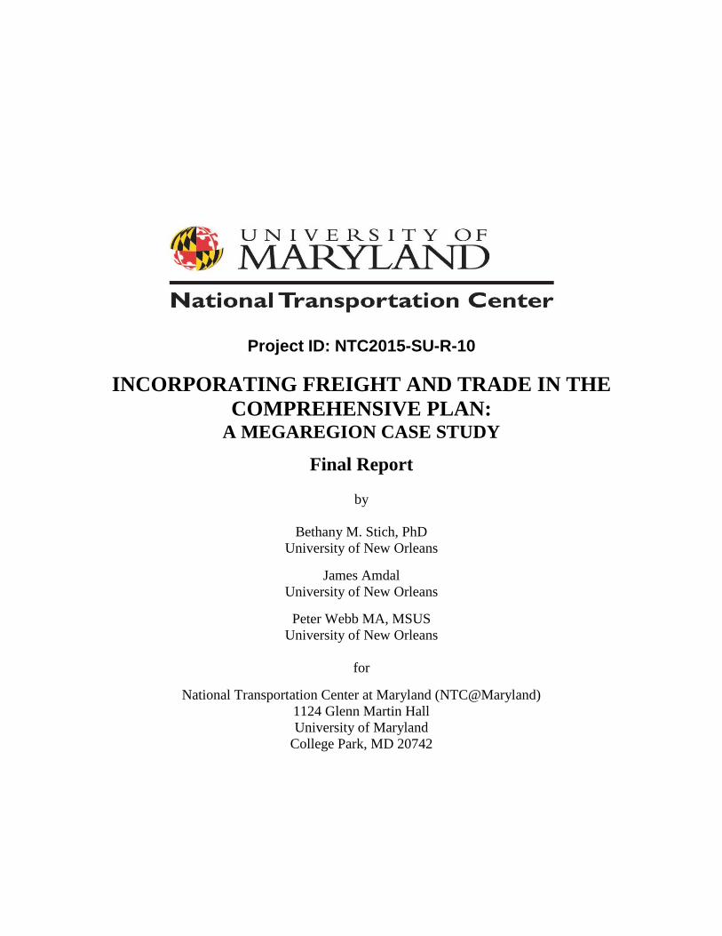
Figure 5: Histogram of distribution of planning elemental themes by parish


19
4.0 FINDINGS
The Transportation theme occurred in all eleven of the parishes. It was the most frequent in eight
of them (Orleans, Lafourche, Tangipahoa, St. James, St. Tammany, St. John the Baptist,
Jefferson, and the City of Hammond). Land Use was the second most frequently occurring theme.
It appears in nine of the eleven parishes and is absent from Lafourche and Tangipahoa. It was the
most frequent theme in only one parish, Plaquemines. However, it was more frequent in four of
the nine in which it occurs- St. Charles, St. Tammany, St. John the Baptist, and St. Bernard.
Economic Development was the third most frequently occurring theme. It appears in six of the
eleven parishes- Orleans, St. Charles, St. Tammany, St. John the Baptist, Jefferson, and St.
Bernard. Jefferson and St. Bernard are where it occurred most frequently out of the six, and of
those two, it was most frequently represented in St. Bernard. Quality of Life was the least
frequently occurring theme. It appears in five of the 11 parishes- Orleans, St. Charles, St. James,
St. Tammany, and St. John the Baptist in descending order. Of these five, it appears most
frequently in Orleans and is interestingly present rather than economic development in St. James
Parish. St. Charles, St. Tammany, and St. John the Baptist have more even representations of
freight-related themes in their summaries than the other parishes.
There was no correlation between a parish’s geographic location and the concentration of
freight related themes in its comprehensive plan summary. Therefore, in this study, geographic
location is not a predictor of the intensity of freight consideration in a parish’s planning strategy-
a policy key to a parish’s megaregional functionality. There was some degree of correlation
between the evenness of freight theme representation in a parish’s comprehensive plan summary
and the concentration of potential freight transportation infrastructure within that parish.
“Evenness of freight theme representation” refers to the degree of equal occurrence of each of
the four themes within a given parish plan summary, as indicated by the histograms (bar graphs).
That is, the more themes which a parish had represented, with fewer outliers occurring, the more
even was that parish’s freight representation. The presence of or potential for freight
transportation infrastructure was correlated with a wider balance of freight themed discussion in
the comprehensive plan summaries.

20
5.0 DISCUSSION
It was not the geographic location of a parish in this portion of the Gulf Coast that indicated the
possibility of its functioning as a megaregional component. Rather, it was the functional capacity
of a parish’s freight transportation infrastructure – or potential for the development of such
infrastructure – which was the relevant factor revealed by this study.
The summarized comprehensive plans in our study do not reflect either MAP-21 or the
FAST Act. The only original plans addressed by the summaries which were adopted after 2012
are those for Lafourche and St. Bernard parishes in 2014. It is safe to say that even the plans of
Lafourche and St. Bernard parishes are reflective of the pre-2012 issues that they address. MAP-
21 and FAST prioritize freight projects that improve safety or freight movement, and the
possibility now exists for expansion of project eligibility. This is key to addressing one of the
repeated issues which came up in the summaries, namely freight-related land use policy. Some
plans which expressed a desire to either cultivate or expand upon multimodal capacity through
land-use policy at interstate highway interchanges, as well as the expansion of port related
freight transportation, were depicted in the summaries as legislatively blocked. For example,
when the metropolitan plan summary for St. Tammany Parish discussed how the plan addresses
congestion in key freight related areas, we read “Although such improvements have been
contemplated for the last 20 years, the Louisiana Department of Transportation and Development
has not placed a high priority on these improvements. Since most of the major arterials in the
parish are state highways, parish and local officials cannot control the timing of improvements.”
FAST has the potential to address some of these deficiencies.
Currently in Louisiana, leaders at the state and local level sometimes do not consider
economic development strategies that incorporate trade. This failure to consider trade related
development causes the state and its metropolitan areas to lose out on funding and critical
infrastructure enhancements. In Orleans Parish, for example, economic development plans often
center around tourism and opportunities for growth related to markets in business and leisure
travel within the city. Notwithstanding the fact that the city exists because of its geographically
derived access to the freight transportation capacity of the Mississippi River, since the mid 1960s
residents have opposed many projects that could improve and grow freight transit operations
within the city and provide needed revenue streams detached from tourism. Examples of this
were the debate over development of a surface roadway running from Elysian Fields Avenue to
Canal Boulevard, or the expansion of container capacity at the Louisiana Avenue wharf (see
Gillis, 1982; Katz, 1984). Often, these oppositions to freight transportation growth are framed in
historic preservation concerns, rooted in the 1967 Elevated Riverfront Expressway defeat (see
Baumbach, 1981), and the restriction of freight access to and from the Port of New Orleans (see
Parsons, 2015). Regarding freight Port-related freight expansions in Orleans Parish for example,
dialogue between preservationists, the NORPC, and other interested parties must occur.
A notable exception to this pattern concerns the impact of Hurricane Katrina on regional
transportation policy. For the Gulf Coast megaregion, Hurricane Katrina was a profound
influence. Within three weeks, Hurricane Rita followed. For the Gulf Coast megaregion, these
storms reinforced the relationship between Baton Rouge and New Orleans. In fact, the mutuality
between the two cities within the megaregion was created by necessity from their impact. In the
New Orleans region, the last ten years have represented a challenging decade, formative for the
megaregion. Before the storms, the megaregion was a conceptual framework; after the storms, it

21
was an operative reality shared by both Baton Rouge, New Orleans, and other Gulf Coast
communities within the megaregion. This was in the solidification of a regional economic unit
we refer to as the New Orleans-Baton Rouge Petrochemical Corridor. It is a “megaregion sub-
region” within the wider Gulf Coast megaregion, composed of Baton Rouge, New Orleans, and
the parishes that line both sides of the Mississippi River between the two cities, the economic
and freight transportation hub of Louisiana's petrochemical industry. As such, it is analogous to
the Texas Triangle – Houston, Austin, and Dallas – as the freight transportation hub of Texas.
Relative to the development of comprehensive plans within the megaregion, given the
unique circumstances surrounding Hurricane Katrina and the extent of its impact on Orleans
Parish, no other city or parish has undertaken such an exhaustive planning process over the last
decade. However, regarding freight transportation, the ongoing updates of the Statewide
Intermodal Transportation Plan are the most relevant, especially as they relate to the respective
MPOs and issues affecting the Louisiana portion of the Gulf Coast megaregion.

22
6.0 CONCLUSIONS & RECOMMENDATIONS FOR FUTHER
STUDY
For the US to begin actively incorporating the scale of the megaregion into its freight
transportation planning policy, a robust and coherent freight policy at the national level is a
necessary first condition. FAST has the potential to facilitate a national freight policy.
One way FAST does this is through attempts to open “policy bottlenecks” which have slowed
down developments and improvements in freight transportation. These bottlenecks revolved
around the length of time for permitting, regarding environmental and historic preservation
issues (United States Congress, 2015). In addition, FAST promotes “codifying the online system
to track projects and interagency coordination processes” (United States Congress, 2015). Per the
American Association of Port Authorities (AAPA), the delay in developments and improvements
stems from a failure to clarify the federal government’s definition of “freight” or “freight
projects” (American Association of Port Authorities, 2015). Because of this, government and
private sector stakeholders do not coordinate funding efforts (United States Congress, 2015).
Consequently, freight projects often compete with non-freight for limited funding and support.
FAST uses freight policies to target serious challenges the nation will be facing twenty-five years
in the future.
For example, under MAP-21, the American freight network was still largely defined in
terms of truck movements. However, even though the maritime industry accounts for more than
three-fourths of the weight and nearly one-half of the value of American international goods
traded, the riverine infrastructure of locks, dams, and bridges is in dire need of repair and
upgrade. FAST makes a specific strategic commitment to “address the conditions and
performance of the multimodal freight system, identify strategies and best practices to improve
intermodal connectivity and performance of the national freight system, and mitigate the impacts
of freight movement on communities” (United States Congress, 2015). It earmarks a portion of
future federal highway funds for projects dedicated to intermodal freight transportation, rather
than focusing solely on trucking. FAST also increases the federal government’s role and
coordination throughout the planning process. This involves focusing “local governments on the
needs of freight transportation providers…[Collecting] performance measures for leading U.S.
maritime ports,” and facilitating funding applications “to eliminate freight bottlenecks and
improve critical freight movements” (United States Congress, 2015).
Our research indicated that greater concentrations of the intermodal freight transportation
infrastructure, combined with land for potential expansion – each of which are key to robust
participation in the Gulf Coast megaregion – were correlated with a more even discussion of
freight related themes in the summaries of the metropolitan plans. This is policy-relevant. When
seen in combination with the pre-MAP-21 and FAST Act dates of these plans, it indicates the
degree of legislative impediment to effective freight transportation planning prior to any
incorporation of these two pieces of legislation by state lawmakers. If these plans were updated
to reflect the infrastructure development possibilities facilitated by MAP-21 and the Fast Act,
perhaps another content analysis would reveal a more balanced distribution of these themes in all
of the parishes, reflecting enhanced goals to increase freight transportation capacity, thereby
facilitating Louisiana’s economic participation in the Gulf Coast megaregion.
Ultimately, without communication between the state and metropolitan areas concerning
freight or trade related growth, the state will continue to miss vital opportunities to use available

23
federal funding under national policies like FAST to improve its infrastructure. When freight
related opportunities for growth are ignored, the state limits its potential for economic growth
and its ability to compete in a global economy. The FAST Act facilitation of regional planning
policy that focuses on freight transportation by expanding upon existing infrastructure – such as
concentrations of interstate access nodes, rail terminals, or port access – and the land available to
cultivate new infrastructure is crucial to the Louisiana Gulf Coast parishes megaregional
potential. For example, the parishes of St. Charles, St. Tammany, and St. John the Baptist are all
portrayed in their summaries as being poised for significant economic growth due to major
freight-related industries – such as the petrochemical industry – or the robust multimodal nature
of their freight transportation networks (facilitated by available land for expansion of the same),
or some combination of both factors. New Orleans, by contrast, has no land on which to expand.
Its intermodal access is truncated. Truck arterials are constricted by concerns of both quality of
life and historic preservation. The Mississippi River Gulf Outlet (MRGO) – an artificial channel
created to be a shortcut between the Gulf of Mexico and the port of New Orleans – has been
closed due to concerns of disaster mitigation (it was closed after Hurricane Katrina; see Moore
2015).
One way to further evaluate the openness and commitment of the stakeholders in these
eleven areas is by performing this content analysis on the original SITP from Spring of 1996, as
well as the 2000 Statewide Transportation Plan Update. The freight thematic concentrations
within the original plans themselves could then be compared to those within the 1996 SITP as
well as the update, to see how well the plans reflect a statewide evaluation of freight
transportation capacity and potential for expansion. In-person semi-structured interviews with a
broad representation of freight related stakeholders, both within the policy realm and the industry,
would be productive. These stakeholders could include, but are not limited to: Port, railroad, and
airport officials; Economic Development organizations; Carriers – trucking, air cargo, and
related companies; Trade (freight or cargo) associations; and local, state, and/or federal
government officials. An investigation of freight policy planning goals for those empowered to
act upon them, and the extent of legislative constraints on their actions in the current
environment of MAP-21/FAST Act, is essential to better addressing freight and cargo in local
comprehensive plans.
Performing a similar analysis across all the parishes and counties connected by freight
transportation infrastructure within the Gulf Coast area could indicate what further legislation is
needed to develop freight transportation policies at the megaregional level. That is, for each Gulf
Coast megaregional state, analyze the state and regional transportation plans of those
communities which either contain or have the potential for the necessary freight transportation
infrastructure. Include the views of the stakeholders. Evaluate at what points the concerns of the
stakeholders and the written policies intersect and diverge, seeing how the FAST Act could most
efficiently address any deficiencies. Policy modifications could then be cultivated to foster
cohesion for the megaregional freight transportation infrastructure.
The megaregional scale of global commerce requires the cultivation of a holistic strategy
that incorporates all modes, expands economic connectivity, and upgrades trade network
analytics at the scale of the megaregion. Yet even the FAST Act is notable for how it targets
achieving this at the metropolitan level. America is only now adopting one necessary condition
for a national freight policy (metropolitan-level freight planning). The modern, globalized
economy necessitates policy planned and implemented at the scale of the megaregion.

24
7.0 REFERENCES CITED
Advisory Committee on City Planning and Zoning. (1928) A Standard City Planning Enabling
Act. Available from: https://planning-org-uploaded-
media.s3.amazonaws.com/legacy_resources/growingsmart/pdf/CPEnabling%20Act1928.
pdf.
America 2050. (2016) Megaregions. Available from:
http://www.america2050.org/content/megaregions.html.
American Association of Port Authorities. (2015) Port Surface Transportation Infrastructure
Survey: The State of Freight. Available from: http://aapa.files.cms-
plus.com/StateofFreight_Report_final.pdf.
Babbie, E. (2013) The Practice of Social Research. 13th ed. Belmont, Wadsworth.
Baumbach, R. O. (1981) The second battle of New Orleans: a history of the Vieux Carré
riverfront expressway controversy / Borah, William E.,; 1937- ; joint author. University:
Published for the Preservation Press, National Trust for Historic Preservation in the United States
by University of Alabama Press.
Colby, B.N. (1966) The Analysis of Culture Content and the Patterning of Narrative Concern in
Texts. American Anthropologist. 68, 374–388.
EconWorks. (2005) Project: Tchoupitoulas Corridor. Available from:
https://planningtools.transportation.org/290/view-case-study.html?case_id=66.
Federal Highway Administration. (2016) Megaregions. Available from:
https://www.fhwa.dot.gov/planning/megaregions/what_are/.
Geddes, P. (1915) Cities in Evolution. London, Williams and Norgate.
Georgia Tech. (n.d.) Megaregions. Available from:
http://www.cqgrd.gatech.edu/research/megaregions/overview.
Gillis, J. (1982) ‘New quarter road idea’, The Times Picayune/The States-Item. Wednesday, 14
April, p. 13.
Hall, P. (1988) Cities of Tomorrow: An intellectual history of urban planning and design in the
twentieth century. 3rd ed. Oxford, Blackwell.
Katz, A. (1984) ‘Uptown site sought for container terminal’, Times Picayune. Friday, 9 March,
pp. 1, 4.
25
Lewis, P.F. (2002) New Orleans: The Making of an Urban Landscape. Expanded ed. Berkeley,
Univ of California.
Mandelker, D. R. (2011) Planning and Control of Land Development: Cases and Materials. 8th
ed. Newark, LexisNexis.
Mayring, P. & Fenzl, T. (2014) QCAmap // a Software for Qualitative Content Analysis.
Available from: https://www.qcamap.org/.
McDowell, B. (1995) "Regionalism: What It Is, Where We Are, and Where It May Be Headed.
Annual Conference of the Virginia and National Capital Area Chapters of the American
Planning Association. Falls Church, VA, December 4, 1995.
McFarland, C., McConnell, K., & Geary, C. (2011) Small Business Growth: U.S. Local Policy
Implications. Available from
http://www.nlc.org/documents/Find%20City%20Solutions/Research%20Innovation/Econ
omic%20Development/small-business-growth-us-local-policy-implications-rbr-oct11.pdf.
Moore, A. (2015) 10 Years Post Katrina - Where Have You Gone, Mr. Go? Restore the
Mississippi River Delta. Available from:
http://www.mississippiriverdelta.org/blog/2015/06/08/10-years-post-katrina-where-have-
you-gone-mr-go/,
National Association of Regional Councils. (2013) Regional Councils, COGs & MPOs.
Available from: http://narc.org/about-narc/cogs-mpos/.
Parsons, K. (1997) The Tchoupitoulas Corridor: A Case Study of a Multi-jurisdictional
Transportation Infrastructure Implementation Problem. Masters Thesis. University of New
Orleans, College of Urban and Public Affairs.
Parsons, K. (2015) Port of New Orleans Access- Themes & Findings. Available from:
http://www.norpc.org/assets/pdf-documents/studies-and-
plans/Port%20of%20New%20Orleans%20Access%20Findings%20&%20Themes.pdf.
Regional Planning Commission (n.d. a) Commission Members. Availabel from:
http://www.norpc.org/commission_members.html.
Regional Planning Commission. (n.d. b) Freight. Available from:
http://www.norpc.org/freight.html.
Regional Planning Commission. (2014) Freight Facts & Figures: An Overview of the New
Orleans Regional Freight Transportation System. Available from:
http://www.norpc.org/assets/pdf-documents/studies-and-
plans/2014%20Freight%20Facts_New%20Orleans.pdf.

26
Regional Planning Commission. (2010a) Regional Overview. Available from:
http://www.norpc.org/regional_overview.html.
Regional Planning Commission. (2010b) Transportation Policy Committee. Available from:
http://www.norpc.org/transportation_policy_committee.html.
Rodrigue, J. (2013) The Geography of Transportation Systems. Available from:
https://people.hofstra.edu/geotrans/eng/ch2en/conc2en/ch2c1en.html.
Ross, C., & Barringer, J. (2008) Megaregions literature review of the implications for U.S.
infrastructure investment and transportation planning. Available from:
https://www.fhwa.dot.gov/planning/megaregions/reports/megaregions_report_2008/mega
regions.pdf.
Stich, B., Griffith, K. & Webb, P. (2015) The Gulf Coast Megaregion: In Search of a New Scale
to Understand Freight Transportation and Economic Development. Available from:
http://www.cqgrd.gatech.edu/research/megaregions/overview.
Tomer, A., Kane, J., & Puentes, R. (2013) Metro Freight: The Global Goods Trade that Moves
Metro Economies. Available from
http://www.brookings.edu/~/media/Research/Files/Reports/2013/10/21-metro-
freight/SrvyMetroFreight.pdf?la=en.
Tulane School of Architecture. (n.d) The Riverfront Expressway is Defeated. Available from:
http://architecture.tulane.edu/preservation-project/timeline-entry/956.
U.S. Advisory Commission on Intergovernmental Relations. (1973) Regional Decision Making:
New Strategies for Substate Districts; Substate Regionalism and the Federal System. (Vol.
1). Washington, D.C, Government Publishing Office.
United States Congress. (1962) Federal-Aid Highway Act of 1962. 23 U.S.C. §134.
United States Congress. (2012). Moving Ahead for Progress in the 21st Century 2012 (MAP-21),
Pub. L. 112-141.
United States Congress. (2015) Fixing America’s Surface Transportation Act (FAST). Pub. L.
114-194.
Wannop, U. (1995) The Regional Imperative: Regional Planning and Governance in Britain,
Europe, and the United States. London, Jessica Kingsley Publishers.

27