Embed Size (px)
Citation preview
The initial environmental examination is a document of the borrower. The views expressed herein do not necessarily represent those of ADB’s Board of Directors, Management, or staff, and may be preliminary in nature.
Initial Environmental Examination: Churu Urban Transport and Roads Sub - Project Project Number: 40031 September 2008
India: Rajasthan Urban Sector Development Investment Program
Prepared by Local Self Government Department
For the Government of Rajasthan Rajasthan Urban Infrastructure Development Project
Environmental Assessment Report

ABBREVIATION
ADB - Asian Development Bank
DSC - Design and Supervision Consultancy
EA - Executing Agency
EAC - Expert Appraisal Committee
FI - Financial Intermediary
GLSR - Ground Level Service Reservoir
GoI - Government of India
GoR - Government of Rajasthan
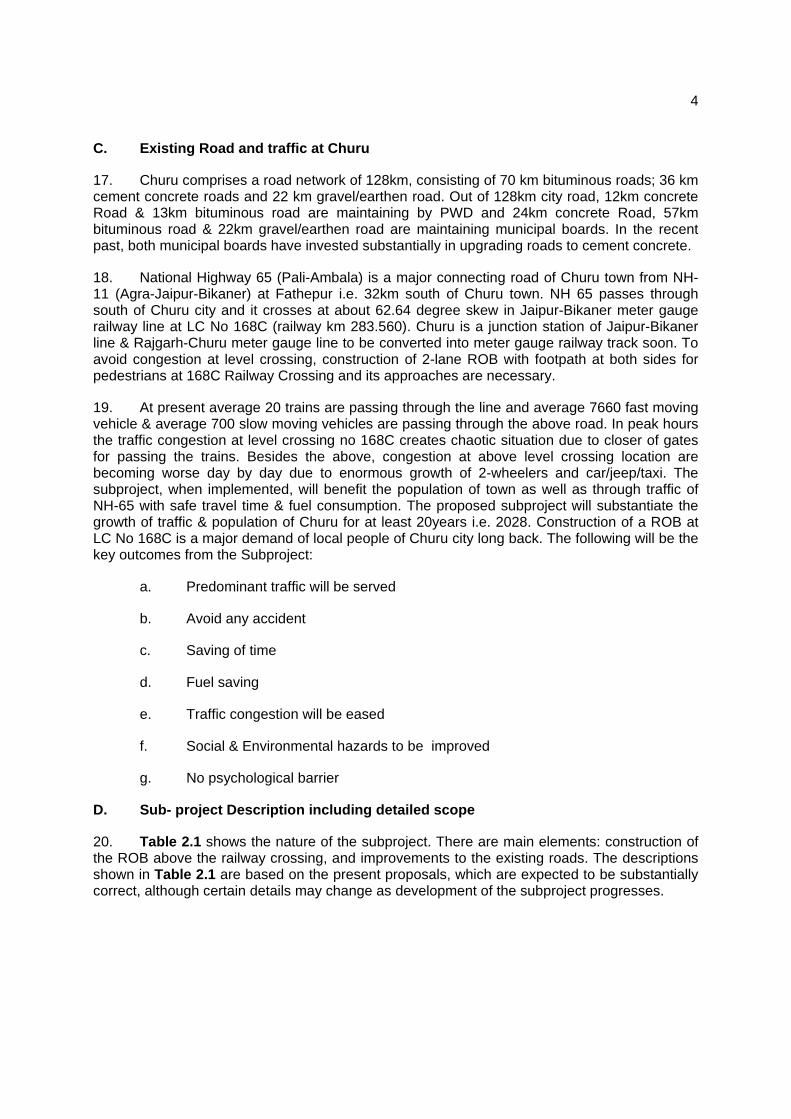
GSI - Geological Survey of India
IA - Implementing Agency
IEE - Initial Environmental Examination
IPMC - Investment Programme Management Consultancy
IPMU - Investment Programme Management Unit
JNNURM - Jawaharlal Nehru National Urban Renewal Mission
LSGD - Local Self-Government Department
MFF - Multitranche Financing Facility
MoEF - Ministry of Environment and Forests
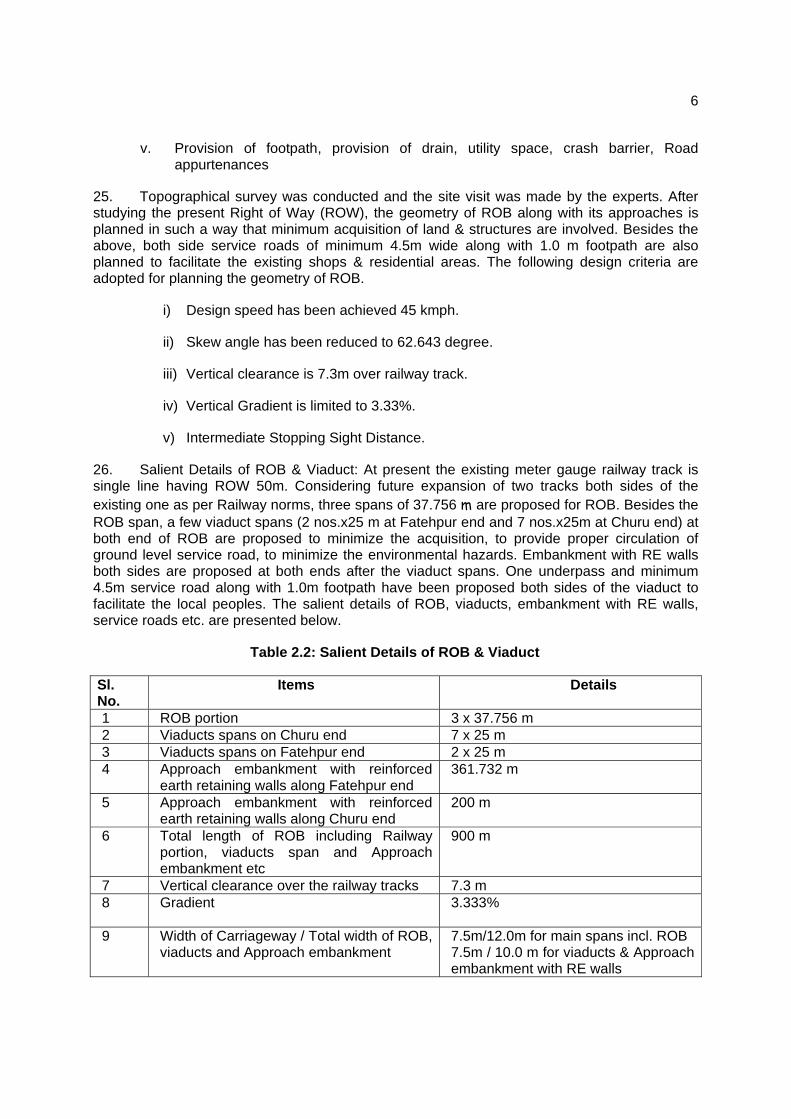
NAAQS - National Ambient Air Quality Standards
OD - Outer Diameter
OHSR - Over Head Service Reservoir
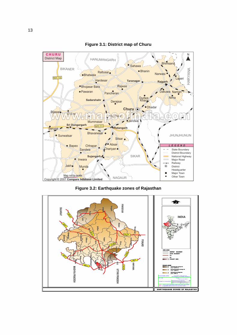
OM - Operations Manual
PHED - Public Health Engineering Department
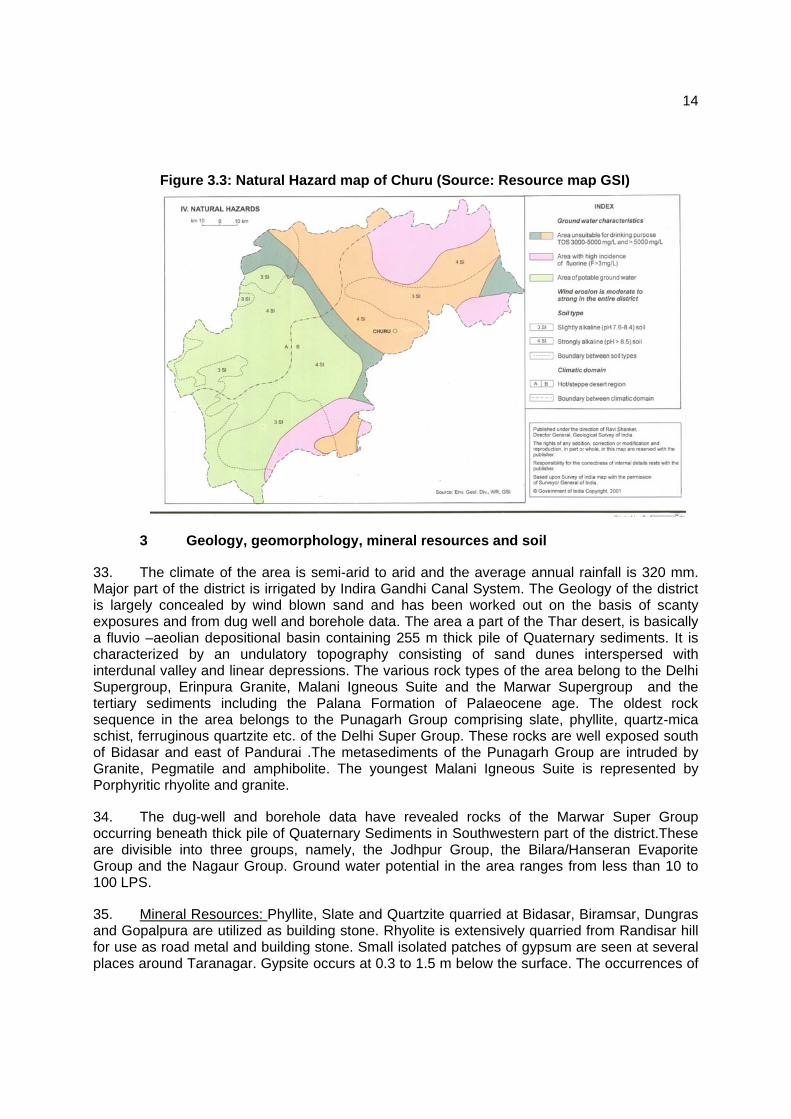
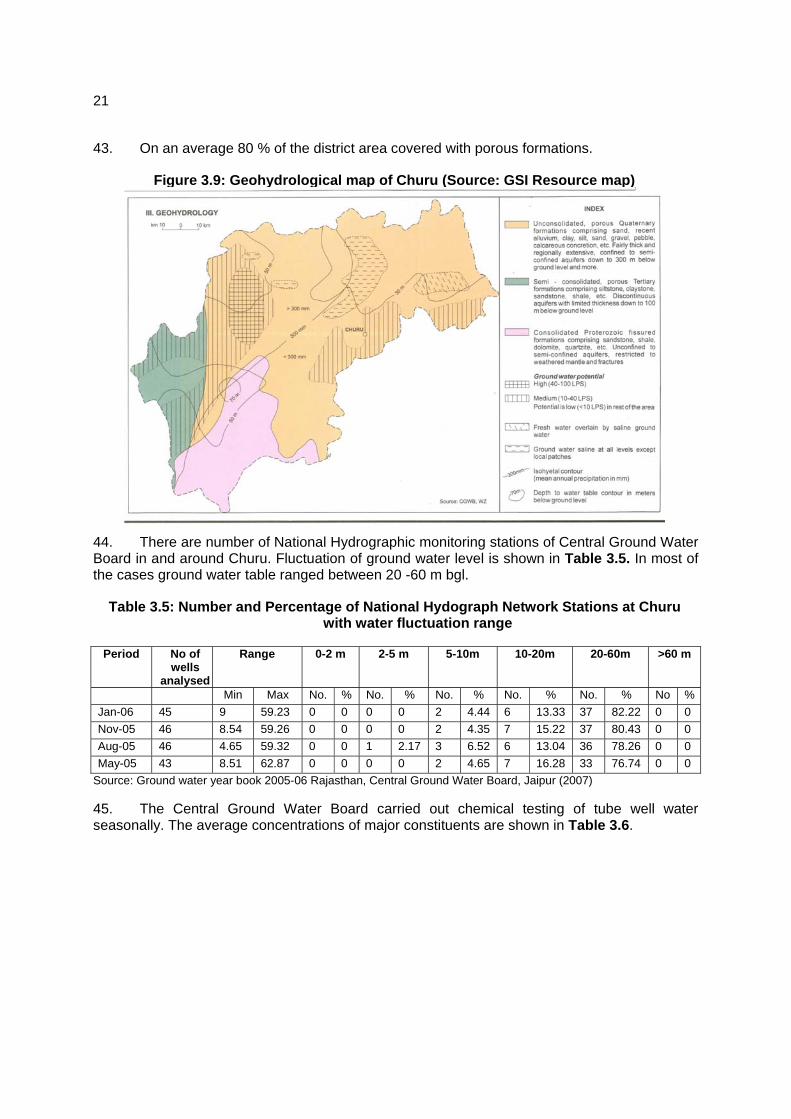
PMU - Project Management Unit
RCC - Reinforced Cement Concrete
ROW - Right of Way
RPCB - Rajasthan State Pollution Control Board
RSPM - Respirable Suspended Particulate Matter
RUIDP - Rajasthan Urban Infrastructure Development Project
RUSDIP - Rajasthan Urban Sector Development Investment Program
SPM - Suspended Particulate Matter
STP - Sewerage Treatment Plant
ToR - Terms of Reference
UA - Urban Agglomeration
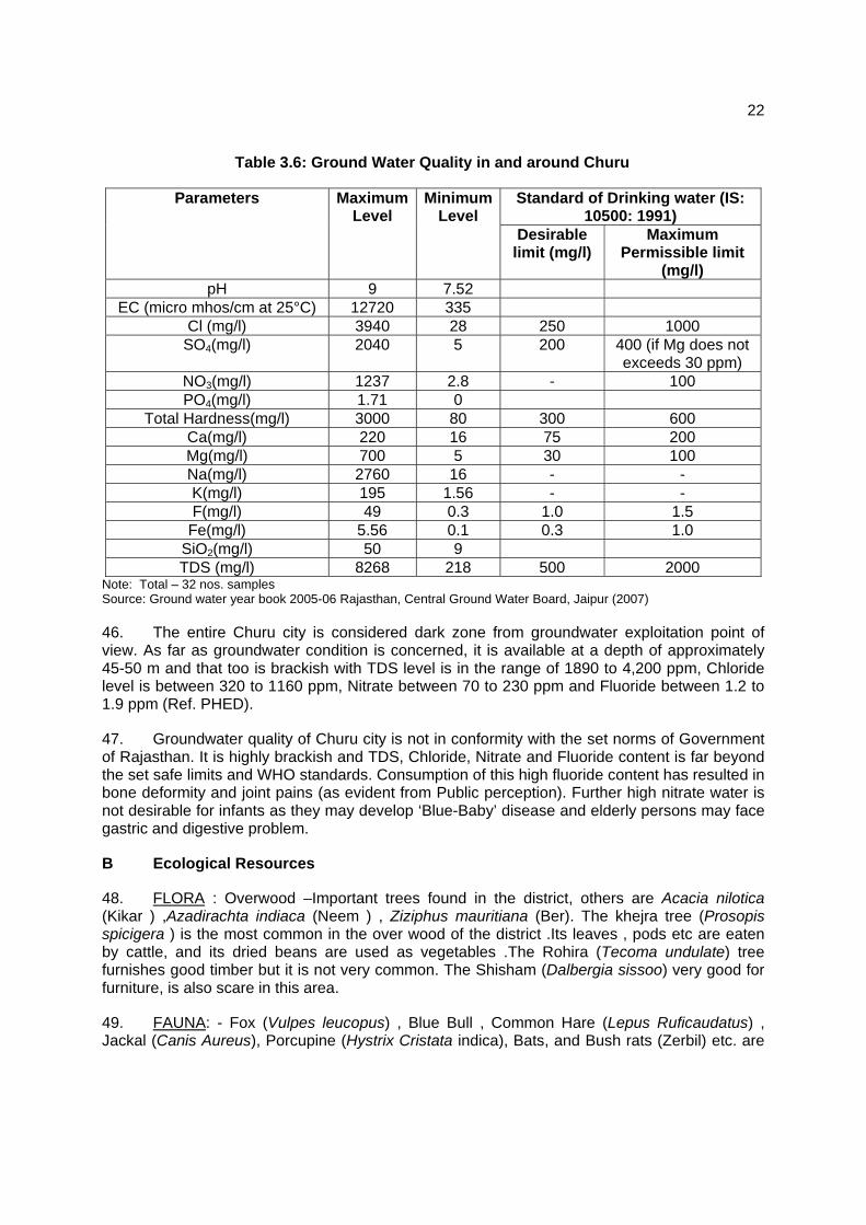
UIDSSMT - Urban Infrastructure Development Scheme for Small and Medium Towns
USEPA - United States Environmental Protection Agency

WEIGHTS AND MEASURES
lakh – 100 thousand = 100,000
crore – 100 lakhs = 10,000,000
µg/m3 – micrograms per cubic meter
km – kilometer
lpd – liters per day
m – meter
mg/l – milligrams per liter
mm – millimeter
ppm – parts per million
NOTE{S}
(i) In this report, "$" refers to US dollars. (ii) “INR” and “Rs” refer to Indian rupees

CONTENTS
I. INTRODUCTION 1
A. Purpose of the report 1
B. Extent of the IEE study 1
II. DESCRIPTION OF THE PROJECT 3
A. Type, Category and Need 3
B. Location, Size and Implementation Schedule 3
C. Existing Road and traffic at Churu 4
D. Sub- project Description including detailed scope 4
III. DESCRIPTION OF THE ENVIRONMENT 12
A. Physical Resources 12
B Ecological Resources 22
C. Economic Development 23
D. Social and Cultural Resources 31
IV. ENVIRONMENTAL IMPACTS AND MITIGATION MEASURES: LOCATION AND DESIGN 35
V. POTENTIAL ENVIRONMENTAL IMPACTS AND MITIGATION MEASURES: INFRASTRUCTURE CONSTRUCTION 35
A. Screening out areas of no significant impact 35
B. Road over Bridge (RoB) 36
VI. POTENTIAL ENVIRONMENTAL IMPACTS AND MITIGATION MEASURES: OPERATION AND MAINTENANCE 42
A. Screening out areas of no significant impact 42
B. Operation and maintenance of the new ROB 42

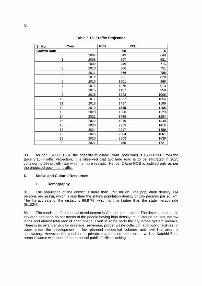
C. Environmental impacts and benefits of the operating ROB 42
VII. INSTITUTIONAL REQUIREMENTS AND ENVIRONMENTAL MONITORING PLAN 44
A. Summary of environmental impacts and mitigation measures 44
B. Institutional arrangements for project implementation 44
C. Environmental Monitoring Plan 50
D. Environmental management and monitoring costs 51
VIII. PUBLIC CONSULTATION AND INFORMATION DISCLOSURE 54
A. Project stakeholders 54
B. Consultation and disclosure to date 54
C. Major Issues discussed during Public consultation are 55
D. Future consultation and disclosure 56
IX. FINDINGS AND RECOMMENDATIONS 57
A. Findings 57
B. Recommendations 60
X. CONCLUSIONS 60
Appendixs
APPENDIX – 1 PHOTOGRAPHS 61
APPENDIX – 2 RAPID ENVIRONMENTAL ASSESSMENT (REA) CHECKLIST 62
APPENDIX – 3 PUBLIC CONSULTATION- ENVIRONMENT 65

1
I. INTRODUCTION
A. Purpose of the report
1. Rajasthan Urban Sector Development Investment Program (RUSDIP) is intended to optimize social and economic development in 15 selected towns in the State, particularly district headquarters and towns with significant tourism potential. This will be achieved through investments in urban infrastructure (water supply; sewerage and sanitation; solid waste management; urban drainage; urban transport and roads), urban community upgrading (community infrastructure; livelihood promotion) and civic infrastructure (art, culture, heritage and tourism; medical services and health; fire services; and other services). RUSDIP will also provide policy reforms to strengthen urban governance, management, and support for urban infrastructure and services. The assistance will be based on the State-level framework for urban reforms, and institutional and governance reforms recommended by the Government of India (GoI) through the Jawaharlal Nehru National Urban Renewal Mission (JNNURM) and Urban Infrastructure Development Scheme for Small and Medium Towns (UIDSSMT).
2. RUSDIP Phase II to be implemented over a seven year period beginning in 2008, and will be funded by a loan via the Multi-tranche Financing Facility (MFF) of the ADB. The Executing Agency (EA) is the Local Self-Government Department (LSGD) of the Government of Rajasthan (GoR); and the Implementing Agency (IA) is the Project Management Unit (PMU) of the Rajasthan Urban Infrastructure Development Project (RUIDP), which is currently in the construction stage.
3. RUSDIP will improve infrastructure through the design and implementation of a series of subprojects, each providing improvements in a particular sector (water supply, sewerage, solid waste etc) in one town. RUSDIP has been classified by ADB as environmental assessment category B (some negative impacts but less significant than category A). The impacts of subprojects prepared according to ADB Environment Policy (2002) and Environmental Assessment Guidelines (2003).
B. Extent of the IEE study
4. Indian law and ADB policy require that the environmental impacts of development projects are identified and assessed as part of the planning and design process, and that action is taken to reduce those impacts to acceptable levels. This is done through the environmental assessment process, which has become an integral part of lending operations and project development and implementation worldwide.
1 ADB Policy
5. ADB’s Environment Policy requires the consideration of environmental issues in all aspects of the Bank’s operations, and the requirements for Environmental Assessment are described in Operations Manual (OM) 20: Environmental Considerations in ADB Operations. This states that ADB requires environmental assessment of all project loans, programme loans, sector loans, sector development programme loans, financial intermediation loans and private sector investment operations.
6. The nature of the assessment required for a project depends on the significance of its environmental impacts, which are related to the type and location of the project, the sensitivity, scale, nature and magnitude of its potential impacts, and the availability of cost-effective

2
mitigation measures. Projects are screened for their expected environmental impacts and are assigned to one of the following categories:
Category A: Projects that could have significant environmental impacts. An Environmental Impact Assessment (EIA) is required.
Category B: Projects that could have some adverse environmental impacts, but of less significance than those for category A. An Initial Environmental Examination (IEE) is required to determine whether significant impacts warranting an EIA are likely. If an EIA is not needed, the IEE is regarded as the final environmental assessment report.
Category C: Projects those are unlikely to have adverse environmental impacts. No EIA or IEE is required, although environmental implications are reviewed.
Category FI: Projects that involve a credit line through a financial intermediary (FI) or an equity investment in a FI. The FI must apply an environmental management system, unless all subprojects will result in insignificant impacts.
7. The Bank has categorised this program as Category B and following normal procedure for MFF loans has determined that one Environmental Examination will be conducted for each subproject, with a subproject being the infrastructure improvements in a particular sector (water supply, sewerage, etc) in one town.
2 National Law
8. The GoI EIA Notification of 2006 (replacing the EIA Notification of 1994), sets out the requirement for Environmental Assessment in India. This states that Environmental Clearance (EC) is required for specified activities/projects, and this must be obtained before any construction work or land preparation (except land acquisition) may commence. Projects are categorised as A or B depending on the scale of the project and the nature of its impacts.
9. Categories A projects require Environmental Clearance from the National Ministry of Environment and Forests (MoEF). The proponent is required to provide preliminary details of the project in the form of a Notification, after which an Expert Appraisal Committee (EAC) of the MoEF prepares comprehensive Terms of Reference (ToR) for the EIA study, which are finalized within 60 days. On completion of the study and review of the report by the EAC, MoEF considers the recommendation of the EAC and provides the EC if appropriate.
10. Category B projects require environmental clearance from the State Environment Impact Assessment Authority (SEIAA). The State level EAC categorizes the project as either B1 (requiring EIA study) or B2 (no EIA study), and prepares TOR for B1 projects within 60 days. On completion of the study and review of the report by the EAC, the SEIAA issues the EC based on the EAC recommendation. The Notification also provides that any project or activity classified as category B will be treated as category A if it is located in whole or in part within 10 km from the boundary of protected areas, notified areas or inter-state or international boundaries.
11. The only type of infrastructure provided by the RUSDIP that is specified in the EIA Notification is solid waste management, where EC is required for all Common Municipal Solid
3
Waste Management Facilities (facilities that are shared by more than one town)1. EC is thus not required for the road/ bridge sub-project that is the subject of this Environmental Examination.
3 Review and Approval Procedure
12. For Category B projects the Draft Environmental Status report and its summary (SIEE) are reviewed by ADB’s Regional Department sector division and Environment and Social Safeguards Division, and by the Executing Agency, and additional comments may be sought from project affected people and other stakeholders. All comments are incorporated in preparing the final documents, which are reviewed by the Executing Agency and the national environmental protection agency (MoEF in this case). The EA then officially submits the IEE and SIEE reports to ADB for consideration by the Board of Directors. Completed reports are made available worldwide by ADB, via the depository library system and the ADB website.
4 Scope of Study
13. This is the IEE for the Churu road sector. It discusses the generic environmental impacts and mitigation measures relating to the location, design, construction and operation of physical works proposed under this subproject.
II. DESCRIPTION OF THE PROJECT
A. Type, Category and Need
14. This is a transportation sub-project, and as explained above it has been classified by ADB as Category B, because it is not expected to have major negative environmental impacts. Under ADB procedures such projects require an IEE to identify and mitigate the impacts, and to determine whether further study or a more detailed EIA may be required. The sub-project is needed to help alleviate road congestion in the town, where the capacity of the network has not expanded to cope with increased traffic demand. It will provide a road over bridge (flyover) on NH 65, Churu- Fatehpur road at chainage 32.75 Km to replace Level crossing no. 168C passing through the centre of the town, which currently have to be closed for substantial time in a day to allow the passage of trains. This is one of a series of subprojects designed by the RUSDIP that are intended to raise the standards of the municipal infrastructure and services of Churu and the other urban centres to those expected of modern Asian towns.
B. Location, Size and Implementation Schedule
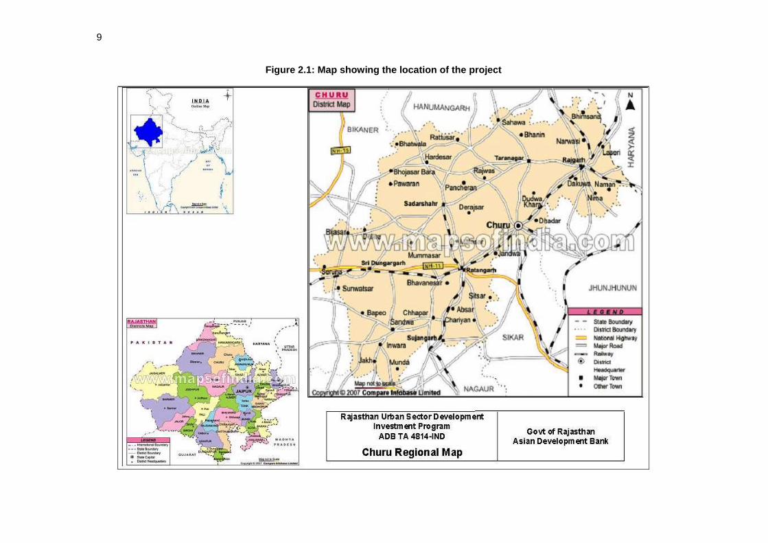
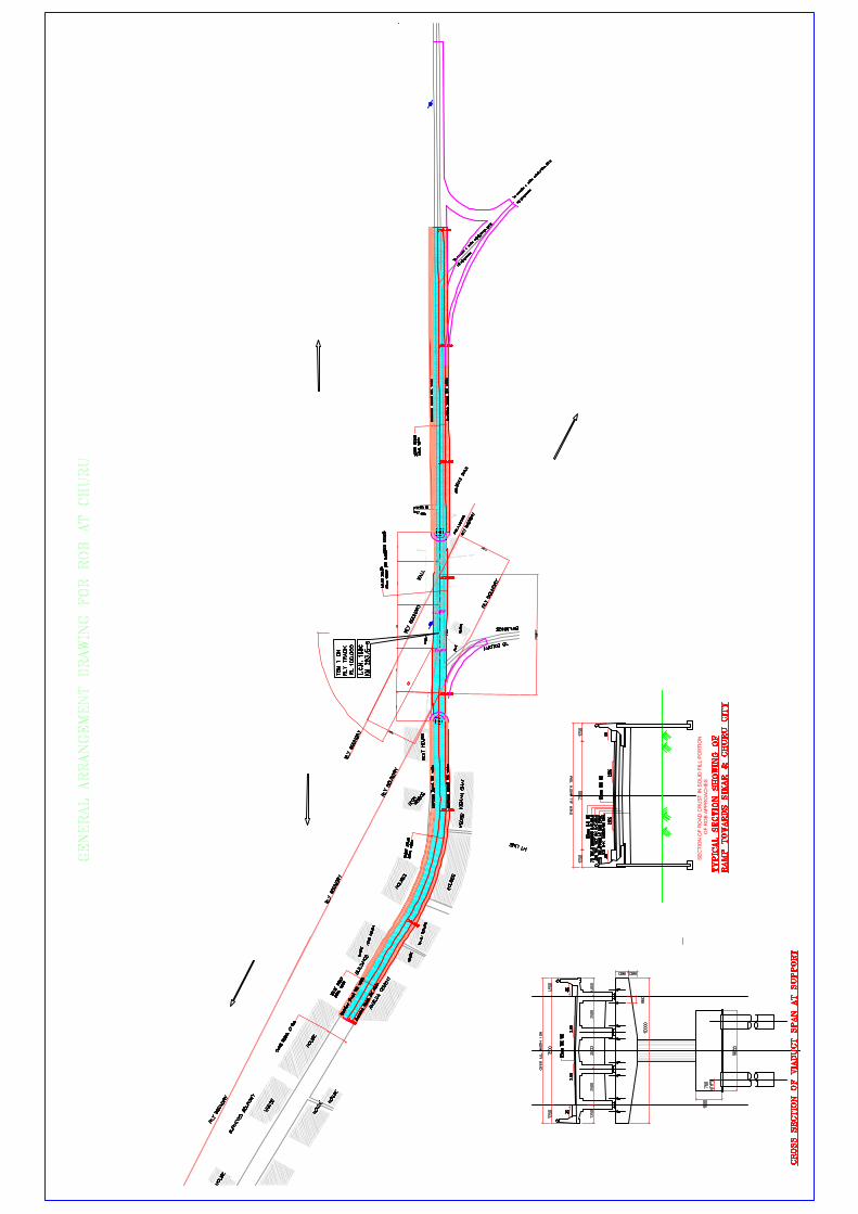
15. The sub-project is located in Churu, the headquarters town of Churu district, in the middle portion of north east of Rajasthan (Figure 2.1). The infrastructure will consist of Road Over Bridge (ROB) over railway crossing no. 168 C. Figure 2.2 and 2.3 shows cross section and location of ROB.
16. Detailed design will begin in the middle of 2008 and construction would be completed by the end of the 2009.
Photographs of the project area are attached as Appendix 1
1 According to the Rajasthan State Pollution Control Board, the MoEF intends to issue a clarification to the EIA Notification in due course, which will add all landfill facilities and Sewage Treatment Plants to the list of projects specified as requiring EC under the Notification. This has not yet been issued, so the text above indicates the correct legal position at the time of writing
4
C. Existing Road and traffic at Churu
17. Churu comprises a road network of 128km, consisting of 70 km bituminous roads; 36 km cement concrete roads and 22 km gravel/earthen road. Out of 128km city road, 12km concrete Road & 13km bituminous road are maintaining by PWD and 24km concrete Road, 57km bituminous road & 22km gravel/earthen road are maintaining municipal boards. In the recent past, both municipal boards have invested substantially in upgrading roads to cement concrete.
18. National Highway 65 (Pali-Ambala) is a major connecting road of Churu town from NH-11 (Agra-Jaipur-Bikaner) at Fathepur i.e. 32km south of Churu town. NH 65 passes through south of Churu city and it crosses at about 62.64 degree skew in Jaipur-Bikaner meter gauge railway line at LC No 168C (railway km 283.560). Churu is a junction station of Jaipur-Bikaner line & Rajgarh-Churu meter gauge line to be converted into meter gauge railway track soon. To avoid congestion at level crossing, construction of 2-lane ROB with footpath at both sides for pedestrians at 168C Railway Crossing and its approaches are necessary.
19. At present average 20 trains are passing through the line and average 7660 fast moving vehicle & average 700 slow moving vehicles are passing through the above road. In peak hours the traffic congestion at level crossing no 168C creates chaotic situation due to closer of gates for passing the trains. Besides the above, congestion at above level crossing location are becoming worse day by day due to enormous growth of 2-wheelers and car/jeep/taxi. The subproject, when implemented, will benefit the population of town as well as through traffic of NH-65 with safe travel time & fuel consumption. The proposed subproject will substantiate the growth of traffic & population of Churu for at least 20years i.e. 2028. Construction of a ROB at LC No 168C is a major demand of local people of Churu city long back. The following will be the key outcomes from the Subproject:
a. Predominant traffic will be served
b. Avoid any accident
c. Saving of time
d. Fuel saving
e. Traffic congestion will be eased
f. Social & Environmental hazards to be improved
g. No psychological barrier
D. Sub- project Description including detailed scope
20. Table 2.1 shows the nature of the subproject. There are main elements: construction of the ROB above the railway crossing, and improvements to the existing roads. The descriptions shown in Table 2.1 are based on the present proposals, which are expected to be substantially correct, although certain details may change as development of the subproject progresses.

5
Table 2.1: Improvements in transportation infrastructure proposed in Churu
Infrastructure Function Description Location Road in Churu To make ease of
Traffic movement
ROB at Railway line on NH-65
Level crossing no. 168C at NH-65 Churu-Fatehpur Road at 32.75 Km.
21. It is proposed a ROB on the NH 65 connecting Churu to Fatehpur within the municipal area of Churu. To avoid congestion at level crossing, construction of 2-lane ROB with footpath at both sides for pedestrians and its approaches are necessary. PWD had prepared a GAD considering a central ROB span of 30m.
22. MC and PWD are responsible for planning, construction and maintenance of the city’s transport network and the traffic police is responsible for traffic control and daily traffic management issues. After preliminary study and subsequent discussion with MC & PWD, 2-lane ROB including both end approaches/service roads at level crossing location are identified to implement in phase –II of RUSDIP. Other issues shall be taken care of MC and PWD as per their jurisdictions. From traffic/safety/environmental point of view, the construction of ROB is most important for Churu Town.
23. Demand assessment: As per IRC 62:1976, if the product of ADT (fast moving vehicles only) and nos. of trains per day i.e. Average Train Vehicle Unit (ATVU) exceeds 50,000 for last 5 years, the construction of ROB is necessary.
Average Daily Traffic (fast moving vehicles only) = 7660 nos.
Number of Trains passing per day = 20 nos.
Average Train Vehicle Unit (ATVU) = 153200 units > 50000
Hence ROB is absolutely necessary as per calculated Average Train Vehicle Unit (ATVU) which exceeds the value as mentioned in IRC 62:1976.
24. Scope and components of the works consist of construction of ROB span, both side viaduct spans, embankment with RE (Reinforced Earth) wall, service road, footpath, provision of drain & utility space etc. Details of major works are as under;
i. Construction of one ROB span of 3x37.756 m at 62.643 degree skew
ii. Construction of 2 nos. 25m viaduct spans at Fatehpur end and 7 nos. 25 m viaduct spans at Churu end.
iii. Construction of 361.732 m length of embankment of varying height with both sides RE wall at Fatehpur end and 200m length of embankment of varying height with both sides RE wall at Churu end
iv. Construction of Service road at both sides of ROB approaches.
6
v. Provision of footpath, provision of drain, utility space, crash barrier, Road appurtenances
25. Topographical survey was conducted and the site visit was made by the experts. After studying the present Right of Way (ROW), the geometry of ROB along with its approaches is planned in such a way that minimum acquisition of land & structures are involved. Besides the above, both side service roads of minimum 4.5m wide along with 1.0 m footpath are also planned to facilitate the existing shops & residential areas. The following design criteria are adopted for planning the geometry of ROB.
i) Design speed has been achieved 45 kmph.
ii) Skew angle has been reduced to 62.643 degree.
iii) Vertical clearance is 7.3m over railway track.
iv) Vertical Gradient is limited to 3.33%.
v) Intermediate Stopping Sight Distance.
26. Salient Details of ROB & Viaduct: At present the existing meter gauge railway track is single line having ROW 50m. Considering future expansion of two tracks both sides of the existing one as per Railway norms, three spans of 37.756 m are proposed for ROB. Besides the ROB span, a few viaduct spans (2 nos.x25 m at Fatehpur end and 7 nos.x25m at Churu end) at both end of ROB are proposed to minimize the acquisition, to provide proper circulation of ground level service road, to minimize the environmental hazards. Embankment with RE walls both sides are proposed at both ends after the viaduct spans. One underpass and minimum 4.5m service road along with 1.0m footpath have been proposed both sides of the viaduct to facilitate the local peoples. The salient details of ROB, viaducts, embankment with RE walls, service roads etc. are presented below.
Table 2.2: Salient Details of ROB & Viaduct
Sl. No.
Items Details
1 ROB portion 3 x 37.756 m 2 Viaducts spans on Churu end 7 x 25 m 3 Viaducts spans on Fatehpur end 2 x 25 m 4 Approach embankment with reinforced
earth retaining walls along Fatehpur end 361.732 m
5 Approach embankment with reinforced earth retaining walls along Churu end
200 m
6 Total length of ROB including Railway portion, viaducts span and Approach embankment etc
900 m
7 Vertical clearance over the railway tracks 7.3 m 8 Gradient
3.333%
9 Width of Carriageway / Total width of ROB, viaducts and Approach embankment
7.5m/12.0m for main spans incl. ROB 7.5m / 10.0 m for viaducts & Approach embankment with RE walls

7
Sl. No.
Items Details
10 Footpath
1.5 m on either side for main span 0.5 m kerb on either side for viaduct span & approach embankments
11 Crash Barriers & Railing
Standard Railing as per MORTH Drawings.
12 Approaches Approach embankment beyond viaduct spans with reinforced Earth retaining walls
13 Specification for Embankment a) Earth fill b) Sub-grade 500 mm c) G.S.B. d) WMM e) DBM f) BC
Soil shall have fines of 75 micron not exceeding 10%. Sub- grade fill shall have CBR of 8% 250mm 250mm 115mm(65+50) 40 mm
14 Wearing coat over concrete decking 40 mm B.C + 25 mm mastic asphalt.
15 Structural details of Railway portion & viaduct spans. (i) Railway Portion (Super-structure) PSC Pre-cast T- Beam and RCC cast in-situ Deck slab (ii) Via duct spans (Super-structure) PSC Pre-cast T- Beam and RCC cast in-situ Deck slab (iii) Sub-structure for Railway Portion and viaduct spans (iv) Foundations (v) Reference IRC Codes (vi) Seismic Zone (vii) Bearings (viii) Expansion joints
3 x 37.756 m 9 x25 m Solid Circular Type Piers with rectangular pier cap 1000mm, dia. piles of 25 m depth with 1800mm thick pile cap. a) IRC – 5 – 1998 b) IRC – 6 – 2000 c) IRC – 18 – 2000 d) IRC – 21 – 2000 e) IRC – 37 - 2001 f) IRC – 78 – 2000 ZONE - II Elastomeric Bearings. Strip seal expansion joints
16 Service Roads 4.5 m wide service roads along with 1.0 m footpath are proposed on all

8
Sl. No.
Items Details
along the length of ROBs on either side except railway track portion.
17 Electrification Provision has been made electrification of during night time to facilitate proper movement of traffic.
18 Shifting of utilities Electric Post and Telephone Post, 132 KV transmission lines have to be shifted to suitable location.
19 Tree felling Few tree felling will be required 19 Diversion road 6.5 km existing road to be
strengthened and widened 20 Drainage Drainage spouts, drain pipes to be
provided in ROB, viaduct & RE wall portion and box/pipe drains to be provided below footpath
9
Figure 2.1: Map showing the location of the project

10
Figure 2.2: Plan and cross section of Churu ROB

11
Figure 2.3: ROB location Churu

12
III. DESCRIPTION OF THE ENVIRONMENT
A. Physical Resources
1 Location
27. The Urban Agglomeration (UA) of Churu district is located in the north-eastern Rajasthan. It is surrounded by Hanumangarh district in the north, Nagaur, Sikar and Jhunjhunu districts in the sourth. Hissar (Haryana) district in the east and Bikaner in the west. The total area of the district is 16,830 sq.km. (4.92% of the State). Churu city is the administrative headquarter of the district. The district has been divided into 5 sub-divisions viz. Churu, Sujangarh, Ratangarh, Sardarsahar, and Rajgarh. There are six tehsil headquarter in this district. Viz. Churu, Sujangarh, Ratangarh, Sardarsahar, Rajgarh and Taranagar. For implementation and coordination of various developmental schemes there are six blocks (Panchayat Samities), one each at tehsil headquarters.
28. Churu is well connected by road network and is connected with Jaipur, Bikaner, Delhi and other important cities. The National Highway 65 (Pali-Ambala) passes through the town, whole NH-11 (Agra-Bikaner) lies about 30 km south of the town. The near by towns of Sikar, Jhunjhunu, Hanumangarh, Ratehpur, Sardarshahar are very well connected with town by regional roads.
29. The town is directly connected by meter gauge rail with Delhi, Jaipur, Bikaner, Sriganganagar. It is about 282 Kms from Delhi, 198 Kms from Jaipur and 180 Kms from Bikaner by rail. The nearest Airport is at Jaipur (206 km). District map of Churu is shown in Figure 3.1
2 Topography, Natural hazard and Drought
30. Topography: Churu the district headquarter. It is located in the eastern part of the “Thar” Desert and in the middle portion of the north–east Rajasthan at latitude 28o18’ north and longitude 74o58’ east, at a height of about 286m above the mean sea level.
31. Natural Hazards- Earthquake: Churu town lies in Low damage risk Zone – II. The area is less prone to earthquakes as it is located on relatively stable geological plains based on evaluation of the available earthquake zone information. Figure 3.2 depicts the earthquake zones of Rajasthan. Figure 3.3 shows natural hazard zone.
32. Drought: Low rainfall coupled with erratic behavior of the monsoon in the State makes Rajasthan the most vulnerable to drought. Based upon the discussion with PHED officials the water table in the City continuously decreases by 1-2 meter on an annual basis combined with significant drawdown conditions.
13
Figure 3.1: District map of Churu
Figure 3.2: Earthquake zones of Rajasthan
14
Figure 3.3: Natural Hazard map of Churu (Source: Resource map GSI)
3 Geology, geomorphology, mineral resources and soil
33. The climate of the area is semi-arid to arid and the average annual rainfall is 320 mm. Major part of the district is irrigated by Indira Gandhi Canal System. The Geology of the district is largely concealed by wind blown sand and has been worked out on the basis of scanty exposures and from dug well and borehole data. The area a part of the Thar desert, is basically a fluvio –aeolian depositional basin containing 255 m thick pile of Quaternary sediments. It is characterized by an undulatory topography consisting of sand dunes interspersed with interdunal valley and linear depressions. The various rock types of the area belong to the Delhi Supergroup, Erinpura Granite, Malani Igneous Suite and the Marwar Supergroup and the tertiary sediments including the Palana Formation of Palaeocene age. The oldest rock sequence in the area belongs to the Punagarh Group comprising slate, phyllite, quartz-mica schist, ferruginous quartzite etc. of the Delhi Super Group. These rocks are well exposed south of Bidasar and east of Pandurai .The metasediments of the Punagarh Group are intruded by Granite, Pegmatile and amphibolite. The youngest Malani Igneous Suite is represented by Porphyritic rhyolite and granite.
34. The dug-well and borehole data have revealed rocks of the Marwar Super Group occurring beneath thick pile of Quaternary Sediments in Southwestern part of the district.These are divisible into three groups, namely, the Jodhpur Group, the Bilara/Hanseran Evaporite Group and the Nagaur Group. Ground water potential in the area ranges from less than 10 to 100 LPS.
35. Mineral Resources: Phyllite, Slate and Quartzite quarried at Bidasar, Biramsar, Dungras and Gopalpura are utilized as building stone. Rhyolite is extensively quarried from Randisar hill for use as road metal and building stone. Small isolated patches of gypsum are seen at several places around Taranagar. Gypsite occurs at 0.3 to 1.5 m below the surface. The occurrences of

15
gypsum near Baen, Bhanin, Deogarh and Satyun are promising .Potash minerals such as polyhalite and sylvite have been intersected around 550 m depth in a number of boreholes drilled by the Geological Survey of India at and around Lakhasar, Jhanjheu etc in halite –bearing evaporate sequence of the Hanseran Evaporite Group. Limestone occurrences are located near Asrasar and NW of Mundra. Occurrences of salt are reported from south of Pandurai. Efflorescence of salt petre (Potassium Nitrate) is found on the soil in some places in Rajgarh tehsil. They also contain some amount of sodium chloride and sodium sulphate. Besides these copper mineralization is also observed in the Biramsar hill and in Bidasar area.
36. Geology and mineral map of Churu shown in Figure 3.4, while geomorphological map of Churu depicted in Figure 3.5.

16
Figure 3.4: Geology and mineral map of Churu district (Source: GSI Resource map)

17
Figure 3.5: Geomorphology of Churu district (source: GSI Resource map)
37. Soil characteristics: Soil of the region falls within rainfall zone of 100-350 mm. The soil is desert type. Sand dunes Aeolian soil is loamy coarse in texture and calcareous. Table 3.1 shows nutrient level in the Churu soil including area coverage of sodic soil. The nutrient status of the Churu soil is graded as very low to medium level.
Table 3.1: Fertility status – major nutrients and problematic soils of Churu district
Nutrient Saline
Soil(Ha) Sodic or
Alkali(Ha) N P K Status VL M M 250
(Source: Vital Agricultural Statistics 2004-05, Directorate of Agriculture, Rajasthan)
4 Climate
38. The climate of Churu city is hot and arid with large variation in temperature. Rainfall is scanty. The average temperature variation in summers and winters are 37.54o to 24.94o C and 29.05o to 9.15oC respectively. The maximum and minimum temperature recorded is 47.2oC in summer and 0.5o C in winter. The south-west monsoon is active in the region from July to mid September, recording an annual rainfall of 377 mm. Dust storm and thunder storm occur all through the summer and are particularly active in pre-monsoon period. In summer mean humidity as 60%. The predominant wind direction is from west and south-west.

18
39. The rainfall over Churu is scanty and is concentrated over four month i.e. from June to September. The rains are erratic and so is the distribution of the rainfall. However agriculture and the animal wealth are dependent on rains to large extent. Seasonal Rainfall data for the recent year (2005-2006) shown in Table 3.2. Figure 3.6 shows yearly variation (1997-2007) of rainfall at Churu.
Table 3.2: Rainfall at Churu in recent years (2005-06)
S.No. Months Rainfall (mm) 1 June 106 2 July 75 3 August 6 4 September 69 5 October 0 6 November 0 7 December 0 8 January 0 9 February 0 10 March 23 11 April 7 12 May 37 13 Monsoon Rainfall 256 14 Non monsoon rainfall 67 15 Annual Rainfall 323
(Source: Irrigation Department, Govt. of Rajasthan)
Figure 3.6: Rainfall at Churu during 1997 to 2007.
Source: Deputy Director hydrology water resources ID and R, Jaipur

19
5 Air Quality
40. There are no data on ambient air quality of Churu Town, which is not subject to monitoring by the Rajasthan State Pollution Control Board (RPCB) as there are no major industries. The nearest station is located at Jaipur (200 km from Churu). Traffic is the only significant pollutant in Churu, so levels of oxides of sulphur and nitrogen are likely to be well within the National Ambient Air Quality Standards (NAAQS). The ambient air quality data is depicted in Table 3.3.
Table 3.3: Ambient Air Quality in Jaipur (Annual Average, 2004; units in µg/m3)
Monitoring Station Land use SOx NOx RSPM SPMJaipur Residential, Rural and others area
Residential 5.57 29.9 106 302
NAAQ Standard Residential 60 60 60 140Jaipur Industrial area Industrial 22.69 9.32 131 300NAAQ Standard Industrial 80 80 120 360
RSPM: Respirable Suspended Particulate Matter; SPM: Suspended Particulate Matter Source: Annual Report 2005-2006 Rajasthan State Pollution Control Board
6 Surface Water
41. There are no monitoring data on surface water quality in and around Churu. The nearest station is located at Ghagar nadi (230 km from Churu). The parameters as measured by Rajasthan Pollution Control Board are pH, Electrical conductivity (EC), BOD and DO. Water quality data of Ghagar river – up stream and down stream location are shown in Table 3.4 and Figures 3.7 and 3.8.
Table 3.4: Water quality of Ghagar River
Location
Date of Sample
Collection
Dissolved Oxygen (mg/lt) PH
BOD (mg/lt) (3 days at 27o C)
Conductivity at 25o C (m-
MHO) Ghagar Nadi , Hanuman Garh, up stream
7/29/2005
4.37
8.23
1.39
0.39
Ghagar Nadi , Hanuman Garh, down stream
7/29/2005
4.2
8.52
1.26
0.38

20
Figure3.7: Variation of water quality parameters Ghagar Nadi , Hanumangarh, Up stream
Ghaghar Nadi, Hanuman Gadh
0
2
4
6
8
10
Date of Sample Collection
Conc
entr
atio
n in
mg/
lt ex
cept
pH
& C
ondu
ctiv
ity Dissolved Oxygen(mg/lt)PH
BOD (mg/lt) (3 daysat 27o C)Conductivity at 25oC (m-MHO)
Figure 3.8: Variation of water quality parameters: Ghagar Nadi , Hanumangarh, down stream
0
1
2
3
4
5
6
7
8
9
7/29/2005
Dissolved Oxygen (mg/lt)
PH
BOD (mg/lt) (3 days at 27oC)Conductivity at 25o C (m-MHO)
7 Geohydrology and Groundwater
42. Geohydrological map of the Churu district is shown in Figure 3.9. For broadly grouping geological formations from ground water occurrence and movement considerations, the various lithological units have been classified into two groups on the basis of their degree of consolidation and related parameters. These are,
• Porous Formations- unconsolidated quaternary formations
• Porous Formations – semi unconsolidated porous tertiary formations
• Fissured formations – consolidated protereozoic formations.
21
43. On an average 80 % of the district area covered with porous formations.
Figure 3.9: Geohydrological map of Churu (Source: GSI Resource map)
44. There are number of National Hydrographic monitoring stations of Central Ground Water Board in and around Churu. Fluctuation of ground water level is shown in Table 3.5. In most of the cases ground water table ranged between 20 -60 m bgl.
Table 3.5: Number and Percentage of National Hydograph Network Stations at Churu with water fluctuation range
Period No of wells
analysed
Range 0-2 m 2-5 m 5-10m 10-20m 20-60m >60 m
Min Max No. % No. % No. % No. % No. % No %Jan-06 45 9 59.23 0 0 0 0 2 4.44 6 13.33 37 82.22 0 0 Nov-05 46 8.54 59.26 0 0 0 0 2 4.35 7 15.22 37 80.43 0 0 Aug-05 46 4.65 59.32 0 0 1 2.17 3 6.52 6 13.04 36 78.26 0 0 May-05 43 8.51 62.87 0 0 0 0 2 4.65 7 16.28 33 76.74 0 0
Source: Ground water year book 2005-06 Rajasthan, Central Ground Water Board, Jaipur (2007) 45. The Central Ground Water Board carried out chemical testing of tube well water seasonally. The average concentrations of major constituents are shown in Table 3.6.
22
Table 3.6: Ground Water Quality in and around Churu
Parameters Maximum Level
Minimum Level
Standard of Drinking water (IS: 10500: 1991)
Desirable limit (mg/l)
Maximum Permissible limit
(mg/l) pH 9 7.52
EC (micro mhos/cm at 25°C) 12720 335 Cl (mg/l) 3940 28 250 1000
SO4(mg/l) 2040 5 200 400 (if Mg does not exceeds 30 ppm)
NO3(mg/l) 1237 2.8 - 100 PO4(mg/l) 1.71 0
Total Hardness(mg/l) 3000 80 300 600 Ca(mg/l) 220 16 75 200 Mg(mg/l) 700 5 30 100 Na(mg/l) 2760 16 - - K(mg/l) 195 1.56 - - F(mg/l) 49 0.3 1.0 1.5
Fe(mg/l) 5.56 0.1 0.3 1.0 SiO2(mg/l) 50 9 TDS (mg/l) 8268 218 500 2000
Note: Total – 32 nos. samples Source: Ground water year book 2005-06 Rajasthan, Central Ground Water Board, Jaipur (2007)
46. The entire Churu city is considered dark zone from groundwater exploitation point of view. As far as groundwater condition is concerned, it is available at a depth of approximately 45-50 m and that too is brackish with TDS level is in the range of 1890 to 4,200 ppm, Chloride level is between 320 to 1160 ppm, Nitrate between 70 to 230 ppm and Fluoride between 1.2 to 1.9 ppm (Ref. PHED).
47. Groundwater quality of Churu city is not in conformity with the set norms of Government of Rajasthan. It is highly brackish and TDS, Chloride, Nitrate and Fluoride content is far beyond the set safe limits and WHO standards. Consumption of this high fluoride content has resulted in bone deformity and joint pains (as evident from Public perception). Further high nitrate water is not desirable for infants as they may develop ‘Blue-Baby’ disease and elderly persons may face gastric and digestive problem.
B Ecological Resources
48. FLORA : Overwood –Important trees found in the district, others are Acacia nilotica (Kikar ) ,Azadirachta indiaca (Neem ) , Ziziphus mauritiana (Ber). The khejra tree (Prosopis spicigera ) is the most common in the over wood of the district .Its leaves , pods etc are eaten by cattle, and its dried beans are used as vegetables .The Rohira (Tecoma undulate) tree furnishes good timber but it is not very common. The Shisham (Dalbergia sissoo) very good for furniture, is also scare in this area.
49. FAUNA: - Fox (Vulpes leucopus) , Blue Bull , Common Hare (Lepus Ruficaudatus) , Jackal (Canis Aureus), Porcupine (Hystrix Cristata indica), Bats, and Bush rats (Zerbil) etc. are

23
found here. The common birds found here are Bulbul (Molpaotescafer) , Owl (Bubobubo), Kite (Milvus migrano).
50. No forest, endangered flora and fauna are reported near the proposed sub-project area.
C. Economic Development
51. Churu being a desert district generally faces famines & drought. The bulk of population depends upon agriculture & animal husbandry. Being district headquarter, Churu town is the main regional centre for the entire district and is working as service centre for providing services like trade and commerce, transport, commercial and other higher level public facilities for the entire district.
52. The economic condition of people in Churu is not satisfactory. As per information in 1998 about 28% population comprised of families below poverty line. These people are mostly labour class working in industries, shops, restaurant, construction, transport and certain other. This aspect has to be given due consideration while designing the housing projects.
53. Total workers in the city as per 2001 census are 25195 out of which 22581 are male workers and 2,614 are female workers. The gross Worker Participation Ratio (WPR) of Churu city is 24.7% while male WPR is 42.5% and female WPR is meager 5.4%. Economic profile is indicative of backwardness of the city. There has been an increase from 23.4% in 1981 in participation rate.
54. Out of the total 25,195 workers, main workers are 21,996 out of which male main workers are 20,568 and main female workers are 1,428. There are only 3,199 marginal workers out of which 2,013 are male and 1,186 are female marginal workers. Marginal workers are only 12.69% of total workers and WPR of marginal worker is meagre 3.1%.
55. The occupational structure as per 2001 census is assessed as follows:
Table 3.7: Distribution of Work Force- Churu District (2001)
Category Nos. % of Work Force 1. Main Workers Cultivators 814 3.70 Agriculture Laborer 191 0.87 House Hold Industry 1,323 6.01 Other Workers 19,668 89.42 Sub-Total 21,996 2. Marginal Workers Cultivators 384 12.00 Agriculture Labourer 226 7.06 House Hold Industry 437 13.66 Other Workers 2,152 67.27 Sub-Total 3,199 Grand Total 25,196
Source: Compiled from District Census Handbook Data 2001
56. The detailed break up of occupational structure of Churu town is not available in 2001 census data. However, the occupational structure data for 1971, 1981 and 1991 are available on the basis of which the estimation for 2001 has been made as shown in the below Table 3.8

24
Table 3.8: Occupational Structure, Churu town 1971 to 2001
Occupation 1971 1981 1991 2001 Workers % Workers % Workers % Workers %
Agriculture, Mining and allied activities
2352 21.15 2159 14.85 3455 17.97 3226 16.40
Industrial 2167 18.12 2305 15.85 2963 15.41 3245 16.50 Construction 874 7.31 1314 9.04 2162 11.25 2262 11.50 Trade & Commerce
2206 18.44 3184 21.89 4364 22.70 4524 23.00
Transport & Communication
1187 9.93 1588 10.92 1802 9.37 1868 9.50
Other Services
2996 25.05 3992 27.45 4479 23.30 4543 23.10
Total 11962 100.0 14542 100.0 19225 100.0 19668 100.0 Source: Census of India and Estimates 57. The occupational structure of people in Churu town shows that town is a commercial centre as well as service town. A number of district level offices are located in the town and as such about 23% workers are engaged in service sector. Industrial activity is not very significant due to lack of water and power as well as raw material even the woollen mill is not working at present. Therefore, employment in industrial sector is only 16%. It may be mentioned that Churu is famous for mason and construction workers. They are not only working gin Churu or other neighboring states, but also in Gulf countries. The high percentage of workers of about 11.25% in construction justifies this fact.
58. Power status of the area: There is no power generation unit at Churu. The consumption of electricity by different sectors is shown in Table below.
Table 3.9: Consumption of Electricity in Million Kwh (2003-04)
District Domestic Non- Domestic
(Commercial)
Industrial Public Lighting
Public Water Works
District Domestic
Small Medium Large Churu 68.123 13.806 9.73 9.452 2.88 2.272 50.464
1 Land use
59. The Municipal Limits of Churu cover an area of about 30 sq.km. In 1983 only 1450 acres or about 20% of Municipal Area could be called as Urban Area. The rest is mostly forest area, agriculture or vacant land. Out of the 1450 acres of urban area only 81.04% i.e. 1,175 acres is developed area. The core of the town (old walled city area) is densely built up; where as fringe areas of the towns are comparatively open. A Land-use Plan-2006 is attached as Figure 3.10.
60. Within the developed area about 71.5% is under residential use. Only 0.60% is under industrial use. The Trade and Commerce and Governmental activity comprises 2.80% and

25
1.45% respectively. Whereas 7.65% fall under public and semi-public use. The details of existing land-use are given in table below.
Table 3.10: Existing Land-use, Churu, 1983
Sr. No. Use Area in ha % age of Developed Area
% age of Urbanised Area
1 Residential 339 71.50 57.95 2 Commercial 13 2.80 2.27 3 Industrial 3 0.60 0.48 4 Government 7 1.45 1.17 5 Recreational 5 1.02 0.82 6 Public & Semi-
public 36 7.65 6.20
7 Circulation 71 14.98 12.15 8 Developed Area 474 100.00 81.04 9 Government
Reserved Area 22 - 3.80
10 Agricultural and Afforestation 44
- 7.58
Vacant Land 44 - 7.58 Urbanised Area 585 - 100.00
Figure 3.10: Existing Land-use and % of Urban Area – Churu
57.95
2.27
0.48
1.17
0.82
6.2
12.15
3.87.58 7.58
ResidentialCommercialIndustrialGovernmentRecreationalPublic & Semi-publicCirculationGovernment Reserved AreaAgricultural and AfforestationVacant Land
2 Commerce, Industry and Agriculture
61. Most of the commercial activities in Churu are along the major roads, which are concentrated mainly around the old fort area and clock tower area. These markets are locally

26
known as 'Gudri Bazar', Katla Bazar (which extends from fort to clock tower) and 'Utrada Bazar'. The road width of these markets is too narrow to meet the volume of traffic in these areas.
62. The railway station and nearby bus stand are new areas for the development of commercial activities. A shopping centre of the town has also come up along Nai Sarak. The newly developed residential colonies are without shopping facilities. The residents have to traverse a considerable distances to meet their shopping needs. Also there is no provision for separate specialised, wholesale market dealing with hardware, building material, cloth, machineries etc. This creates mixed traffic in the core city area all the time leading to traffic congestion.
63. Churu town is industrially undeveloped, though a good number of industrialists hail from Churu region. Because of shortage of water, raw materials and infrastructural facilities, industrial activities are not picking-up. As per information collected, there were 247 registered industrial units in the town, which, in all, employ about 1,000 workers. There is not a single large scale industry in the town. Only a few small scale units like woolen mill, saw mill and a few casting industries have been established on Churu-Jhunjhunu road and near the railway station. There are also some small units of dying and printing, guar gum, cement work, metal industries, whose main products are nails, steel furniture, steel almirahs etc., which are scattered all over the town. Besides, some cottage industries also exist in the town, which deal in silver utensil, potteries and shoe making.
64. RIICO has also developed an industrial area comprising of 50 acres along Bhaleri road in north-west direction of the town, where 97 units are functioning. The area has not been developed fully due to paucity of required infrastructure like water supply, raw material, transportation etc. there is not a single large scale Industry in the town. Only a few numbers of units of RIICO Industrial area at North .Three are two large and medium industries and 3,963 small industries. The area has not been developed fully due to paucity of required infrastructure like water supply, raw material, transportation etc. The industries are related to Aluminum, Utensils, Churan, chatni, Papad.
65. In and around the Churu city area there are about 50-60% of lands used for agricultural purpose. Crop production statistics as depicted in Table 3.11 indicates that crop production is more in Kharif season in compared to Rabi season.
Table 3.11: Crop production in around Churu
Type of Crops Under Rabi Crops 2003-04 (Prod in Tonnes)
Under Kharif Crops 2003-04 (Prod in Tonnes)
Cereals 35570 394433 Pulses 34218 175779
Food Grains 69788 570212 Oilseeds 33131 19291 Others 2561 113864 Total 105570 703367
(Source: Vital Agricultural Statistics 2004-05, Directorate of Agriculture, Rajasthan)

27
3 Infrastructure
66. Water supply: Water supply service is the highest priority for people of Churu. PHED and Churu Municipal Board always put the service at the first place while framing any plan for the city. Churu PHED also prepared water management and augmentation plan with the financial aid from GoI & GoR. Present level of water supply is about 106 LPCD.
67. Water supply to Churu is from groundwater source 10.38 MLD (54 Tubewells and 29 Open wells) and surface water sources 0.820 MLD in the city. The city is divided into 8 water supply zones covering 41 municipal wards. The approximate total length of the existing water supply distribution network is 57.14 km and includes all localized distribution networks. Approximately 3.92 ML of water is stored in 8 Service reservoirs and 7 clear water reservoirs. Poor households are served by 86 public stand posts. At a minimum, most zones receive 1-2 hours of water supply per day – supply is, however, dependent on the availability / yield of water from the localized supply system. Water is supplied through 17,561 water connections comprising domestic (~95 percent), non-domestic (~4 percent) and industrial (~1 percent). While most connections are metered, it is estimated that only 10 percent of these meters are in working condition.
68. Present water supply of Churu city is only 106 lpcd, which is less than the standard level of 135 lpcd for desert district level. To augment this level as it is mentioned that Churu-Bisau scheme, which is being designed for the population of 2021 with an estimated population of 1,50,376, while using 20 underground water sources in addition to 12,048 KLD of IGNP allocations which is under process.
69. Sewerage System: As is the case with all medium towns in Rajasthan, Churu too does not have any sewerage system. WCs are connected to septic tanks in most of the houses, while some houses, due to lack of space, discharge WC effluent directly in to open drains. In some households, especially in slum areas, open defecation is still a common practice. As per census survey only 83.3% households have toilet facilities. The rest 17.7% defecate in open area or along roadside. Katchhi Basties completely lack toilet facilities. Out of the total toilets only 66% have water connections. Sullage generated from houses is directly discharged in to open drains, which ultimately ends up in low-lying areas, forming pools (Locally called Ginanies). Details of the system are covered in next section on drainage. The open drains carrying wastewater and the resultant pools are causing unsanitary conditions, which are threat to public health.
70. Sanitation: Only 50-60% of the households reportedly have septic tanks and soak well as the system of sewerage disposal. The remaining accounted for cases of open defecation which is an unacceptable and unhygienic practice. The raw settled sewage from septic tank is periodically flushed out by sanitary workers of the Municipal Board and discharge to open spaces, agricultural lands in an indiscriminate manner. Slum areas were also not equipped with requisite sanitation (LCS etc.) resulting in open defecation.
71. Drainage: The topography of Churu city is cup shaped, the town being surrounded by sand dunes. Due to scanty rains in the region, natural drainage system has not been evolved. In fact there is no river/rivulet in the entire Churu district. In Churu town itself no natural drainage system exists to drain away the rainwater or wastewater from the town. Presently there exists a minimal network of storm water drains in the city. The existing network of (roadside) storm water drains in Churu has been identified under three broad categories as follows: (i) open pucca (concrete drains) (ii) closed pucca and (iii) Kutchha.

28
72. Industrial Effluents. Small industries exists in under RIICO, which is out side the city area and small amount of effluent disposed scattered in local nallahs. As reported by the local MC, the responsibility of effluent disposal is under RIICO’s own and could not be connected to the proposed sewer network. The individual industries are required to treat their effluent to bring it to the required standard before final disposal.
73. Solid Waste: MBC’s jurisdiction is spread over an area of 33.80 sq.Km, which includes core old city area and some rural parts at the fringes. 30 tons of solid waste is collected daily and in addition to household (domestic) solid waste, the main waste generation sources in the town are vegetable and fruit markets, commercial and institutional establishments including hotels and eateries, construction activities, and other tourism related activities.
74. The MSW generated in the Churu city (including slum area) mainly consist of domestic refuses, waste from Commercial Area, Vegetable-Fruit market, bio-medical waste, waste from Hotels and Restaurants, Industries etc. The waste collection system being followed is quite primitive, individual households/units throw the garbage on road side/open drains close to their houses and the sweepers collect the garbage in the form of small heaps on road sides. Similarly the open drains are also cleaned periodically and the sludge is heaped adjacent to the drain where it is left for 2-3 days to get dried and lifted. Tractor trolleys then lift these dumps the heaped garbage once or twice a day. In the process part of the garbage gets dispersed on the road or finds it way into to the open drains or open low lying pits (Ginanis).
4 Transportation
75. Table 3.12 provides a breakdown of road surface composition in Physical growth of the city has resulted in a corresponding increase in vehicular traffic greater than that of the city’s population growth due to improving economic status of the city.
Table 3.12: Road Surface Composition
Surface Type PWD (km) MC (km) UIT (km) Total (km) Dist.Concrete 12.125 23.616 0 35.74 27.50Bituminous 13.305 56.729 0 70.02 2.32WBM 0 0 0 0 0Gravel/Earthern 0 21.98 0 0 0Total 25.425 102.3285 0 127.743 0
Source: PWD Churu
76. A well planned road network comprising of bypass, arterial, sub arterial and major roads was proposed in the Master Plan. A link road connecting Sikar road and Sadulpur road was proposed in the south so that this regional traffic may not unnecessarily has to enter the town. Similarly a ring road (Bye pass) was proposed in the east and north connecting all the important roads such as Sadulpur road, Taranagar road, Bhaleri road, Sadulshahar and Ratangarh road. This road has not been developed as yet. Similarly a number of link roads were also proposed to solve the city traffic problem. However the bus and truck stands proposed in the Plan could develop.
77. Traffic Study: The 7 days i.e. 06.03.2007 to 12.03.2007 traffic Survey is conducted at level crossing location to determine the ADT (Average Daily Traffic) in terms of Nos. & PCUs. 7 days traffic survey & analysis is presented in. Table 3.13 shows the average daily traffic in Nos. passing through the existing level crossing. Table 5 shows the average daily traffic in PCUs.

29
From the above two tables, it is observed that there is two peaks. Peak hour is 9.00 to 10.00AM. From Table 3.14 it is also observed that 2-Wheelers, Car, Jeep, Taxi and Cycles are more dominating in this section of road. PCU Values for different vehicles are taken from IRC-86:1983
Table3.13: Average Traffic Volume in Nos.
Count Date: 06.03.2007 to 12.03.2007
Count Hour
Car/Jeep/ Taxi Three
Wheeler
Two Wheeler
LCV Bus Two Axle
Truck/ Tanker
Multi Axle Truck / Truck Trailer
Agriculture
Tractor with Trailer
Total Fast
Cycle / Cycle
Rickshaw
Animal Drawn
Vehicles
Total Slow
Total
12.00-13.00 141 127 15 22 27 31 8 370 33 5 38 408 13.00-14.00 144 117 14 21 43 36 8 383 33 3 36 418 14.00-15.00 126 113 12 26 43 41 6 368 42 7 49 417 15.00-16.00 134 123 12 21 54 36 7 387 41 3 44 431 16.00-17.00 115 125 14 24 43 36 5 362 30 4 33 396 17.00-18.00 128 118 13 20 38 27 7 352 38 5 43 394 18.00-19.00 115 100 11 21 46 43 8 343 39 5 44 387 19.00-20.00 104 79 16 18 35 47 6 304 35 3 38 342 20.00-21.00 94 71 21 17 53 54 8 318 20 2 22 339 21.00-22.00 91 49 13 15 50 53 7 278 20 1 21 299 22.00-23.00 74 41 12 13 75 66 4 283 8 1 9 293 23.00-24.00 71 31 11 7 67 58 4 249 4 1 4 253 00.00-1.00 66 38 11 6 73 60 2 256 1 2 3 259 1.00-2.00 48 21 10 4 60 67 2 212 0 0 1 213 2.00-3.00 43 22 14 6 65 65 1 216 4 0 5 220 3.00-4.00 73 38 18 7 66 73 7 282 4 0 4 287 4.00-5.00 57 54 17 10 62 62 4 266 16 0 17 283 5.00-6.00 88 89 31 14 59 52 6 340 26 2 29 368 6.00-7.00 110 100 21 12 54 41 8 347 39 4 42 389 7.00-8.00 101 94 18 12 48 50 9 332 44 5 49 381 8.00-9.00 111 93 18 18 49 47 8 343 40 6 46 389 9.00-10.00 130 112 12 17 41 54 12 378 40 6 46 424 10.00-11.00 113 98 11 16 46 37 18 339 36 8 44 382 11.00-12.00 110 96 14 19 50 47 16 352 31 4 35 387
Total 2386 1949 360 366 1248 1181 169 7660 624 76 700 8360

30
Table 3.14: Average Traffic Volume in PCU
Date: 06.03.2007 to 12.03.2007
Count Hour
Car/Jeep/ Taxi Three
Wheeler
Two Wheeler
LCV Bus Two Axle
Truck/ Tanker
Multi Axle
Truck / Truck Trailor
Agriculture Tractor with
Trailor
Total Fast
Cycle / Cycle
Rickshaw
Animal Drawn
Vehicles
Total Slow
Total
PCU 1 0.5 3 3 3 3 3 0.5 6 12.00-13.00 141 64 46 65 80 92 23 510 17 32 48 558 13.00-14.00 144 58 42 63 129 108 24 568 16 17 34 602 14.00-15.00 126 57 36 78 130 124 18 568 21 41 62 630 15.00-16.00 134 62 37 62 162 108 21 586 20 19 39 625 16.00-17.00 115 63 43 71 130 109 14 544 15 22 37 581 17.00-18.00 128 59 39 59 115 81 22 503 19 29 48 551 18.00-19.00 115 50 32 62 138 129 23 549 20 33 52 601 19.00-20.00 104 39 48 54 105 141 17 508 18 16 34 542 20.00-21.00 94 36 63 51 159 161 23 587 10 11 21 608 21.00-22.00 91 25 38 45 151 159 21 530 10 3 14 543 22.00-23.00 74 20 36 40 224 197 11 602 4 6 10 612 23.00-24.00 71 16 33 21 201 173 12 527 2 3 5 532 00.00-1.00 66 19 32 18 220 181 6 541 1 11 12 553 1.00-2.00 48 11 30 13 179 201 7 488 0 1 1 489 2.00-3.00 43 11 42 17 194 195 3 506 2 1 3 509 3.00-4.00 73 19 55 21 198 218 21 606 2 0 2 608 4.00-5.00 57 27 50 30 186 186 13 550 8 2 10 560 5.00-6.00 88 45 93 43 177 156 17 620 13 14 27 647 6.00-7.00 110 50 63 37 162 123 24 569 19 22 42 611 7.00-8.00 101 47 54 36 145 150 27 560 22 28 50 611 8.00-9.00 111 46 55 53 147 140 24 577 20 34 54 631 9.00-10.00 130 56 36 51 122 163 36 594 20 34 54 649
10.00-11.00 113 49 32 49 139 110 53 545 18 46 64 610 11.00-12.00 110 48 43 57 150 141 47 595 15 27 42 637
Total 2386 975 1080 1096 3744 3544 508 13334 312 453 766 14100
78. Traffic Projection & Justification: The road width in urban areas is designed to accommodate the design peak hour traffic. The design peak hour traffic is estimated based on a simple projection of present peak hour traffic for a design period of 15-20 years (adopted for arterial roads as per IRC-86:1984). The growth rate of different vehicles is estimated by Transport Demand Elasticity Method considering past traffic data, vehicle registration data, change of socio-economic pattern in urban areas, future development plan etc. In absence of such data, it is very difficult to estimate the actual growth rate for different vehicles.
79. In general, the average traffic growth rate for this type of urban areas (Churu) is around 5%. The growth rate as per IRC 37-2001 is 7.5% which is higher than the actual growth at present. The present traffic is projected for both the growth rates i.e. 7.5% & 5% for design period of 20 years and the projected traffic is presented in Table 3.15.
31
Table 3.15: Traffic Projection
Sl. No. Year PCU PCU Growth Rate 7.5 5
0 2007 649 649 1 2008 697 681 2 2009 749 715 3 2010 806 751 4 2011 866 788 5 2012 931 828 6 2013 1001 869 7 2014 1076 913 8 2015 1157 958 9 2016 1243 1006
10 2017 1337 1056 11 2018 1437 1109 12 2019 1545 1165 13 2020 1660 1223 14 2021 1785 1284 15 2022 1919 1348 16 2023 2063 1416 17 2024 2217 1486 18 2025 2384 1561 19 2026 2563 1639 20 2027 2755 1721
80. As per IRC 86:1984, the capacity of 2-lane Road (both way) is 1500 PCU. From the table 3.15 -Traffic Projection, it is observed that two lane road is to be saturated in 2025 considering 5% growth rate which is more realistic. Hence, 2-lane ROB is justified only as per the projected peck hour traffic.
D. Social and Cultural Resources
1 Demography
81. The population of the district is more than 1.92 million. The population density 114 persons per sq.km, which is less than the state's population density of 165 persons per sq. km. The literacy rate of the district is 66.97%, which is little higher than the state literacy rate (61.03%).
82. The condition of residential development in Churu is not uniform. The development in old city area has been as per needs of the people having high density, multi-storied houses, narrow lanes and almost total lack of open space. Even in some parts the dry latrine system prevails. There is no arrangement for drainage, sewerage, proper waste collection and public facilities. In outer areas the development in few planned residential colonies and civil line area, is satisfactory. However, the condition in private unauthorised, colonies as well as Katchhi Basti areas is worse with most of the essential public facilities lacking.

32
83. Churu city with population of 1,01,874 (2001 Census) constitutes nearly 5.3% total population and 19% of the total urban population of the district. This indicates that apart from Churu there are other dominant urban centres in the district. Scheduled Cast (SC) and Scheduled Tribe (ST) constitute nearly 11% of the town’s population, which is much lower than 26% for the entire district.
84. Churu Municipal area comprises is 30 sq.km and of 41 wards. The ward Nos. 3, 27 and 41 are highly populated wards with more than 4000 population where as ward no. 25 has the lowest population of 1,515 persons.
Table 3.16: Ward wise Population of Churu City, 2001
Ward No. Population Sex Ratio Persons 2001 Male Female 1 2,603 1,387 1,216 877 2 2,577 1,327 1,250 942 3 4,081 2,156 1,925 893 4 2,080 1,098 982 894 5 2,010 1,005 1,005 1000 6 2,708 1,422 1,286 904 7 1,868 964 904 938 8 2,429 1,230 1,199 975 9 3,220 1,673 1,547 925 10 2,285 1,136 1,149 1011 11 2,756 1,464 1,292 883 12 2,806 1,510 1,296 858 13 2,523 1,341 1,182 881 14 1,953 1,018 935 918 15 2,314 1,155 1,159 1003 16 2,185 1,071 1,114 1040 17 2,589 1,282 1,307 1020 18 2,400 1,200 1,200 1000 19 2,510 1,269 1,241 978 20 1,666 855 811 949 21 3,258 1,717 1,541 897 22 2,400 1,299 1,101 848 23 2,853 1,468 1,385 943 24 2,507 1,342 1,165 868 25 1,515 769 746 970 26 1,726 882 844 957 27 4,031 2,094 1,937 925 28 2,202 1,118 1,084 970 29 1,600 855 745 871 30 1,714 906 808 892 31 2,303 1,175 1,128 960 32 2,284 1,191 1,093 918 33 3,118 1,683 1,435 853

33
Ward No. Population Sex Ratio Persons 2001 Male Female 34 2,611 1,321 1,290 977 35 2,483 1,281 1,202 938 36 2,259 1,203 1,056 878 37 1,946 1,028 918 893 38 2,012 1,070 942 880 39 2,261 1,170 1,091 932 40 3,002 1,529 1,473 963 41 4,226 2,415 1,811 750
Total 101,874 53,079 48,795 919 Source: Census of India, 2001 85. The decennial growth of the city since 1901 has exhibited a continuous increase trend up to the year 1951 i.e. from 2.43% to 41.66%. The rate of growth was highest during 1941-1951 i.e. 41.66%. In the next decade i.e. 1951-1961 there was a sudden reversal in the trend when it fell only to 4.20%. In the next four decades there has been a swing in both directions with rise of 27.46% and 33.48% in 1961-1971 and 1981-1991 and decline in growth rate to 16.71% and 22.96% during the 1971-1981 and 1991-2001. The lower growth rate during recent years could be attributed to lack of employment opportunities, together without migration of businessmen to the metropolitan cities of the country.
2 Health, educational and recreational facilities
86. Recreational (Parks and Open Spaces); There is only one recognized park known as Indramani Park in the town, which is maintained by the Municipal Board. This park is not properly developed and maintained because of scarcity of water. One stadium known as Indira Stadium, covering an area of 5.2 acres is located near railway station behind PWD rest house, which is used for public meetings and sports meets. But this ground lacks basic facilities required for a stadium. Some local level play grounds are available in the town. The town also has sufficient number of 'Bagichis' catering to the recreational needs of the public and act as open spaces for the town. There is little scope for further development of gardens and parks in the town due to scarcity of water.
87. The level of educational facility in Churu is quite satisfactory. Percentage of enrolment of total school age children in the age group 6-11 is 88.27%. This percentage drops to 51% and 53% for Middle and Secondary and Higher Secondary schools respectively. The figures included students coming to these schools from the nearby villages.
88. There are good educational facilities in Churu district, which serve both townspeople and inhabitants of surrounding villages and towns in the hinterland. There are 1122 primary schools, 214 secondary schools and 109 higher secondary schools, plus eleven general degree colleges.
Table 3.17: Educational facility of Churu District
Primary School 1122 Upper Primary School 807 Secondary School 214 Senior Secondary School 109

34
College 11 Professional college 2 Professional Training Institute 6 D.I.E.T. 1 Sanskrit College 1
(Source: Official website of district) 89. As the district headquarters town, Churu is the main centre for health facilities in the area and there is a district general hospital, 11 general hospital, 55 primary health centers are in the Churu. The detail of the health facilities given in Table 3.18.
Table 3.18: Health facility Churu District
General Hospital 11 PHC 58 Sub Centre 348 Ayurvedic and Unani Hospital 114 Private Hospital 13
(Source: Official website of district)
3 History, culture and tourism
90. Churu has moderate tourist inflows with main attractions being Jain Temple, Ganga Mata Temple, Balaji Temple, Satya Narain Temple. The tourist attractions within the city are places Nagar Shree Museum, Taknet Chhatri, Nath Ji ka Dhora, Bagla Dharmshala, Sethani ka Jhohra, Aath Khamba ki Chhatri.
91. Churu functions as an ideal weekend resort for inhabitants of the Delhi Metropolis in addition to being a place of interest for foreign tourists. The position of tourists arrival in the last 5 years is shown in Figure 3.11.
Figure 3.11: Tourist inflow at Churu
43614845
53845982
6647
0
1000
2000
3000
4000
5000
6000
7000
2001-02 2002-03 2003-04 2004-05 2005-06
Source: Department of Tourism, Govt. of Jaipur

35
92. The State Government has initiated Heritage Walk Project, Heritage Conservation Plan in 28 towns including Churu.
IV. ENVIRONMENTAL IMPACTS AND MITIGATION MEASURES: LOCATION AND DESIGN
93. ADB Environmental Assessment Guidelines require that an IEE should evaluate impacts due to the location, design, construction and operation of the project. Construction and operation are the two activities in which the project interacts physically with the environment, so they are the two activities during which the environmental impacts occur. In assessing the effects of these processes therefore, all potential impacts of the project are identified, and mitigation is devised for any negative impacts. This has been done in Sections V and VI below and no other impacts are expected.
94. In many environmental assessments, there are certain effects that, although they will occur during either the construction or operation stage, should be considered as impacts primarily of the location or design of the project, as they would not occur if an alternative location or design was chosen.
95. However in the case of this subproject, there are no considerable impacts that can clearly be said to result from either the design or location. This is because:
o Most of the individual elements of the subproject are relatively small and involve straightforward construction and operation, so impacts will be mainly localised and not greatly significant;
o Most of the predicted impacts are associated with the construction process, and are produced because that process is invasive, involving trenching and other excavation. However the routine nature of the impacts means that most can be easily mitigated;
o In one of the major fields in which there could be significant impacts (archaeology), those impacts are clearly a result of the construction process rather than the project design or location, as they would not occur if this did not involve trenching or other ground disturbance.
V. POTENTIAL ENVIRONMENTAL IMPACTS AND MITIGATION MEASURES: INFRASTRUCTURE CONSTRUCTION
A. Screening out areas of no significant impact
96. From the descriptions given in Section II.C, it is clear that implementation of the subproject should not have major negative impacts because it will affect only one site, at which all construction will be conducted within a relatively small area.
97. Because of this there are several aspects of the environment that are not expected to be affected by the construction process and these can be screened out of the assessment at this stage as required by ADB procedure. These are shown in Table 5.1, with an explanation of the reasoning in each case.

36
Table 5.1: Fields in which construction is not expected to have significant impacts
Field Rationale Climate Short-term production of dust is the only effect on
atmosphere Geology and seismology Excavation will not be large enough to affect these features Fisheries & aquatic biology No rivers or lakes will be affected by the construction work Wildlife and rare or endangered species
No wildlife and endangered species nearby the ROB
Coastal resources Churu is not located in a coastal area Development of agriculture, minerals and tourism
There are none of these developments near the site
Population and communities Construction will not affect population numbers,
98. These environmental factors have thus been screened out presently but will be assessed again before starting of the work.
99. Rapid Environmental Impact Assessment checklist is given in Table Appendix -2.
B. Road over Bridge (RoB)
1 Construction method
100. As explained above, this subproject will involve construction of the a ROB, 7.5 m high, 3x 37.756 m span (ROB portion) and 900 m long (length of ROB including railway portion, viaducts span and approach embankment etc), supported on a series of RCC piers
101. Construction will begin with the removal of the existing road surface by backhoe diggers. A series of RCC box-sections (10 m wide and around 30 m long) will then be built, each slightly higher than the preceding one, to form the approach ramps. Foundations will be dug to about 1 m depth, and metal reinforcing bars will be added to form the floor and sides of each box. Portions of these will be encased in wooden shuttering, and concrete (mixed on site) will be poured in and allowed to set. This will be repeated to gradually create each RCC box, which will then be filled with sand and stone, imported on trucks and tipped into each structure. Once each is filled a layer of RCC will be added to the top, with a slight incline, so that the upper surface rises gradually to the 7.5 m height of the ROB.
102. At the same time, the foundations for the bridge piers will be excavated by backhoe diggers, and deeper portions will be dug by a drilling machine. Heavy-duty metal reinforcing rods will be placed into the voids, followed by a concrete and aggregate mix. The reinforcing rods will extend out of the foundations to create the structure of each pier, and these will then be encased in shuttering, into which more concrete will be poured to form each pillar. The pre-cast RCC bridge sections will then be brought in from the manufacturing plant on large vehicles, placed into position by cranes and attached to the piers by heavy-duty bolts and concrete. The pre-cast safety barriers will also be positioned by crane at the edges of the bridge and ramps, after which the tarmac surface will be applied by road-laying machine and roller vehicles, with gravel layers tipped out from trucks.
103. The operation will be conducted by a team of around one hundred men, roughly 50% unskilled labour and 50% with various skills including truck drivers, vehicle and machine
37
operatives, surveyors, foremen and supervisors, etc. The operation should be completed in around 18 months.
2 Physical Resources
104. Although all work will be conducted at a single, relatively small site, construction will involve a great deal of excavation and earth moving over a period of approximately six months, so physical impacts could be quite considerable.
105. During construction time great deal of material, which could cause significant changes in topography, drainage, air quality (dust), soil quality and other features at the extraction site if it were sourced from adjacent land. However these impacts can be avoided relatively easily by utilizing readily available source of waste sand and stone, :
o Material excavated to create the foundations of the piers that will support the ROB structure (if suitable);
106. Using the source would have the additional benefit of providing a beneficial use for what would otherwise be large quantities of waste material, so it will be very important to coordinate these activities to enable this to be done.
107. Moving such a large quantity of material could cause further physical impacts, including the creation of dust during dry weather and silt-laden runoff during rainfall, both of which would affect people who live and work near the site and reduce the quality of adjacent land. The Contractor will almost certainly plan the work to ensure that all earthworks are conducted during the dry season to avoid the difficult working conditions that prevail during the monsoon, so this will avoid any problems from runoff. It will however be necessary to prevent dust, so the Contractor should be required to:
o Excavate the bridge foundations at the same time as the access ramps are built so that dug material is used immediately, avoiding the need to stockpile on site;
o Damp down exposed soil and any sand stockpiled on site by spraying with water when necessary during dry weather;
o Use tarpaulins to cover sand and other loose material when transported by truck.
108. Conducting the work in the dry season should avoid any drainage problems from rainfall collecting in the bridge- and ramp- foundations during excavation, and although groundwater often collects in deeper voids, this should also not be a problem at this site because of the very low water table in Churu.
109. The creation of ramps will gradually alter the topography and appearance of the site, and the work to install the pre-cast ROB sections will be especially visible in the local landscape. Visual impacts could be mitigated by erecting wooden fences to screen the site from view, but it is not considered that this will be necessary at this site, which is a congested road and rail junction with a very disrupted and “busy” appearance, that will not be significantly exacerbated by the construction activities.
3 Ecological Resources

38
110. There are no protected areas in or around project site of Churu, and no known areas of ecological interest, and there are no trees at the site that need to be removed. The work should therefore have no ecological impacts.
4 Economic Development
111. Although much of this work will be conducted within the ROW of the existing roads and railway, there may be a need to acquire some land at the periphery of the site and for the construction of temporary access roads. This will be obtained through the legal mechanism of the Land Acquisition Act (1894) through which the government purchases the land compulsorily from the owners at a rate that is established on the basis of recent transactions. ADB policy on Involuntary Resettlement requires that no-one should be worse-off as a result of the project, so a Resettlement Plan and Resettlement Framework have been prepared to examine these issues. This establishes that no more than 10% of the total land of any owner or occupant should be acquired, and that if any business premises have to be removed, the owners or tenants should be provided with:
• Compensation equivalent to the amount of business income lost;
• Compensation at replacement cost for any income-generating assets (eg shop premises) that have to be removed.
112. Certain roadside shops that are not purchased may still lose income because the presence of the construction site will deter customers, and access will be impeded by road closures, the presence of heavy vehicles and machinery, etc. These issues are also dealt with by the Resettlement Plan and Framework, which indicate that these impacts will be mitigated by:
• Keeping road closures to the minimum in terms of frequency, duration and extent;
• Maintaining vehicle and pedestrian access to roadside businesses wherever possible;
• Providing owners and tenants with financial compensation equivalent to the amount of business income lost.
113. Transportation is the other principal economic activity that will be impeded by this work, as the existing road will be removed at the location of the access ramps and gradually replaced by the new embankments. Trains will also have to travel slowly in the vicinity of the site, and when work is conducted close to the line, the train service may need to be interrupted temporarily. These impacts could be significant given the amount of traffic using this crossing and the frequency of the train service. These impacts will need to be mitigated by careful planning of the construction program, in conjunction with the road, rail and municipal authorities and the police, in order to:
• Maintain safe passage for vehicles and pedestrians throughout the construction period;

39
• Provide effective, well signposted diversions and alternative routes when required;
• Conduct work that requires the closure of roads and the level crossing at times of low traffic volume;
• Conduct work on or close to the railway line at times when there are fewer trains;
• Schedule truck deliveries of soil to the site for periods of low traffic volume.
114. Excavation could also damage existing infrastructure (such as water distribution pipes, electricity pylons, etc) located alongside the roads. It will be particularly important to avoid damaging existing water pipes as these are mainly manufactured from Asbestos Cement (AC), which can be carcinogenic if inhaled, so there are serious health risks for both workers and citizens (see below). It will be important therefore to avoid these impacts by:
• Obtaining details from the Municipal Council of the nature and location of all existing infrastructure, and planning excavation carefully to avoid any such sites if possible;
• Integrating construction of the various infrastructure subprojects conducted in Churu (transport, water supply, sewerage) so that:
Different infrastructure is located on opposite sides of the road where feasible;
Roads and inhabitants are not subject to repeated disturbance by construction in the same area at different times for different purposes.
5 Social and Cultural Resources
115. Rajasthan is an area with a rich and varied cultural heritage that includes many forts and palaces from the Rajput and Mughal periods, and large numbers of temples and other religious sites, so there is a risk that any work involving ground disturbance could uncover and damage archaeological and historical remains. In this case the excavation will occur in and around an existing roadway, so it could be that there is a low risk of such impacts. Nevertheless this should be ascertained by consulting the appropriate authorities and steps should be taken according to the nature of the risk. This should involve:
• Consulting historical and archaeological authorities at both national and state level to obtain an expert assessment of the archaeological potential of the site;
• Considering an alternative transportation sub-project if the site is found to be of medium or high risk;
• Including state and local archaeological, cultural and historical authorities and interest groups in consultation forums as project stakeholders so that their expertise can be made available to the project;
40
• Developing a protocol for use by the Contractor in conducting any excavation work, to ensure that any chance finds are recognised and measures are taken to ensure they are protected and conserved. This should involve:
Having excavation observed by a person with archaeological field training;
Stopping work immediately to allow further investigation if any finds are suspected;
Calling in the state archaeological authority if a find is suspected, and taking any action they require ensuring its removal or protection in situ.
116. There are no modern-day social and cultural resources (such as schools and hospitals) near the site, and no areas that are used for religious or other purposes, so there is no risk of other impacts on such community assets.
117. Although this is not a major residential area, there are some living quarters in the vicinity of the site, so action should be taken to minimise disturbance as far as possible. This will require:
• Consultation with the local community to inform them of the nature, duration and likely effects of the construction work, and to identify any local concerns so that these can be addressed;
• Involving the community in planning the work programme so that any particularly noisy or otherwise invasive activities can be scheduled to avoid sensitive times;
• Avoiding conducting noise-generating activities at night;
• Implementing the measures described in Section V.B.2 above to reduce dust;
• Utilising modern vehicles and machinery with the requisite adaptations to limit noise and exhaust emissions, and ensuring that these are maintained to manufacturers’ specifications at all times. If manual pneumatic drilling is required, then contractor shall erect large screens to avoid inconvenience to the public and residents nearby.
118. There is invariably a safety risk when substantial construction such as this is conducted in an urban area, and precautions will thus be needed to ensure the safety of both workers and citizens. The Contractor will be required to produce and implement a site Health and Safety Plan, and this should include such measures as:
• Excluding the public from the site;
• Ensuring that all workers are provided with and use appropriate Personal Protective Equipment;
• Health and Safety Training for all site personnel;

41
• Documented procedures to be followed for all site activities;
• Accident reports and records; etc.
119. An additional, particularly acute health risk derives from the fact that, as mentioned above, the existing water supply system comprises mainly AC pipes, so there is a risk of contact with carcinogenic material if these pipes are uncovered in the course of the work. Precautions have already been introduced into the design of the project to avoid this, of which the most important is that:
• The locations of all new infrastructures will be planned to avoid locations of existing AC pipes so AC pipes should not be discovered accidentally.
120. Given the dangerous nature of this material for both workers and the public, additional precautions should be taken to protect the health of all parties in the event (however unlikely) that AC pipes are encountered. The design consultant should therefore develop a protocol to be applied in any instance that AC pipes are found, to ensure that appropriate action is taken. This should be based on the approach recommended by the United States Environmental Protection Agency (USEPA)2, and amongst other things, should involve:
• Training of all personnel (including manual labourers) to enable them to understand the dangers of AC pipes and to be able to recognise them in situ;
• Reporting procedures to inform management immediately if AC pipes are encountered;
• Development and application of a detailed H&S procedure to protect both workers and citizens. This should comply with national and international standards for dealing with asbestos, and should include:
o Removal of all persons to a safe distance;
o Usage of appropriate breathing apparatus and protective equipment by persons delegated to deal with the AC material;
o Procedures for the safe removal and long-term disposal of all asbestos-containing material encountered.
121. Finally, there could be some short-term socio-economic benefits from the construction work if local people are able to gain employment in the construction workforce. To direct these benefits to the communities directly affected by the work, the Contractor should be required to employ at least 50% of his labour force from communities in the vicinity of the site. This will have the added benefit of avoiding social problems that sometimes occur when workers are imported into host communities, and avoiding environmental and social problems from workers housed in poorly serviced camp accommodation.
2 In the USA, standards and approaches for handling asbestos are prescribed by the Occupational Health and Safety Administration (OHSA) and the Environmental Protection Agency (EPA) and can be found at http://www.osha.gov/SLTC/asbestos

42
VI. POTENTIAL ENVIRONMENTAL IMPACTS AND MITIGATION MEASURES: OPERATION AND MAINTENANCE
A. Screening out areas of no significant impact
122. Because roads and bridges generally operate without the need for major repair and maintenance (see below), there are several environmental factors that should be unaffected once the new ROB begins to function. These are identified in Table 6.1 below, with an explanation of the reasoning in each case. These factors are thus screened out of the impact assessment and will not be mentioned further.
Table 6.1: Fields in which operation and maintenance of the completed road improvement is not expected to have significant impacts
Field Rationale Climate Exhaust gases affect air quality but a new road does
not alter climate Fisheries & aquatic biology There are no rivers or lakes close to the ROB site Wildlife, forests, rare species, protected areas
No wildlife and forest near location of ROB
Coastal resources Churu is not located in a coastal area B. Operation and maintenance of the new ROB
123. The new ROB will have a design life of 30 years, during which time it should require no major repair or refurbishment, beyond routine maintenance, which will include:
o Small scale ad hoc repairs of surface damage caused by traffic use or accidents;
o Repairs and replacement of damaged safety barriers and signs;
o Regular unblocking of drains to prevent damage from flooding in the monsoon.
124. The stability and integrity of the bridge should also be monitored periodically to detect any problems and allow remedial action if required.
125. These operations will be the responsibility of the municipal highway department, who will be given training by this programme and provided with an operating budget for these purposes.
C. Environmental impacts and benefits of the operating ROB
1 Physical Resources
126. Once the ROB is completed and operating, it will improve the physical environment by removing the severe traffic congestion that is such a feature of this location at present, with the resulting concentration of vehicle noise and pollution. This will be replaced by a modern elevated roadway, which allows the maintenance of a smooth flow of traffic into and out of the town and avoids the obstruction created by the former level crossing.
127. The ROB will however elevate the traffic 8 m above ground level, making the traffic and the structure significantly more visible than at present. This would not necessarily be a negative
43
visual impact if the scheme included measures to mask the structure and give it a more pleasing appearance, for example by planting large-growing native trees at the periphery. As well as a visual screen this would also provide a natural barrier to noise, dust and exhaust gases so the planting of trees should be incorporated into the scheme.
128. When routine repairs are conducted to the road and ancillary facilities (signage, etc), the work will be very small in scale, and conducted manually by small teams of men with simple equipment (shovels, wheelbarrows, tarmac blender, etc). Even if larger vehicles are used to refurbish larger portions of the road the work will be very short in duration and will not cause significant physical impacts.
129. Although the ROB is located in an area of seismic risk, it will be designed according to standard Indian Engineering Design Codes, which include measures to allow the structure to withstand tremors of the expected magnitude and above. Therefore, there is a very little risk of the structure failing, even if the area is subject to seismic events of greater magnitude than those that have occurred over recent years.
2 Ecological Resources
130. As there are no significant ecological resources in or around the town, the operation of the ROB and the routine maintenance and repair of the road and surroundings will have no ecological impacts. There would be some small ecological gain from the planting of trees to mask the visual impact of the structure.
3 Economic Development
131. The ROB will improve the infrastructure of the town by providing a more efficient and effective transportation route, and this should have positive impacts on the overall economy by reducing time spent idle in stationary traffic by delivery vehicles, employees and customers. It may also make further positive contributions to the development of particular sectors, for example by making the area more attractive to tourists and allowing the more efficient transportation of agricultural produce and other goods to and from the town.
132. Traffic may be interrupted temporarily if the road or bridge is repaired and maintained, but this work will be very small in scale, infrequent, and short in duration, so there should be no economic or other implications. To maintain the safety of workers and road-users, such work should be coordinated with the local police department so that adequate warning signs and traffic diversions can be set up when necessary.
4 Social and Cultural Resources
133. Effects of the operating ROB on social and cultural resources in the town will be relatively small in scale and intangible in nature, and are thus difficult to assess and quantify.
134. The citizens of the town will benefit from a more effective transportation route as they will spend less time in stationary traffic exposed to noise, pollution and the associated physical and psychological stresses. Social and cultural resources may also benefit in a small way as it will be easier for people to reach schools, hospitals, temples, museums. People may also benefit from an improvement in the economy of the town, although it would require much larger improvements in transportation and other infrastructure for this to be recordable.
44
135. Repairs to the road and bridge will not be physically invasive so there will be no risk to historical remains, and as there are no areas or resources of social or cultural importance in the vicinity there will be any risk to such features.
VII. INSTITUTIONAL REQUIREMENTS AND ENVIRONMENTAL MONITORING PLAN
A. Summary of environmental impacts and mitigation measures
136. Table 7.1 lists the potential adverse impacts of the Churu transportation subproject as identified and discussed in Sections IV, V and VI, and the mitigation proposed to reduce these impacts to acceptable levels. The table also shows how the mitigation will be implemented, who will be responsible, and where and when the mitigation activities will take place. The mitigation programme is shown as the quarter of each year in which each activity will occur, which relates to the project programme described in Section II.B. The final column assesses whether the proposed action will successfully mitigate the impact (shown as 0), and indicates that some of the measures will provide an additional benefit (shown as +).
B. Institutional arrangements for project implementation
137. The main agencies involved in managing and implementing the subproject are,
LSGD is the Executing Agency (EA) responsible for management, coordination and execution of all activities funded under the loan.
The Implementing Agency (IA) is the Project Management Unit of the ongoing RUIDP, which will be expanded to include a broader range of skills and representation from the Urban Local Bodies (ULB, the local government in each town). Assigned as the RUSDIP Investment Program Management Unit (IPMU), this body will coordinate construction of subprojects across all towns, and ensure consistency of approach and performance.
The IPMU will be assisted by Investment Program Management Consultants (IPMC) who will manage the program and assure technical quality of design and construction; and Design and Supervision Consultants (DSC), who will design the infrastructure, manage tendering of Contractors and supervise the construction process.
Investment Program Implementation Units (IPIU) will be established in seven zones across the State to manage implementation of subprojects in their area. IPIUs will be staffed by professionals seconded from government departments (PHED, PWD), ULBs, and other agencies, and will be assisted by consultants from the IPMC and DSC as necessary.
The IPMU will appoint Construction Contractors (CC) to build elements of the infrastructure in a particular town. The CCs will be managed by the IPIU, and construction will be supervised by the DSC.
LSGD will be assisted by an inter-ministerial Empowered Committee (EC), to provide policy guidance and coordination across all towns and subprojects. The EC will be chaired by the Minister of Urban Development and LSG, and members will

45
include Ministers, Directors and/or representatives of other relevant Government Ministries and Departments.
City Level Committees (CLCs) have also been established in each town, chaired by the District Collector, with members including officials of the ULB, local representatives of state government agencies, the IPIU, and local NGOs and CBOs. The CLCs will monitor project implementation in the town and provide recommendations to the IPIU where necessary.
138. Figure 7.1 shows institutional responsibility for implementation of environmental safeguard at different level.
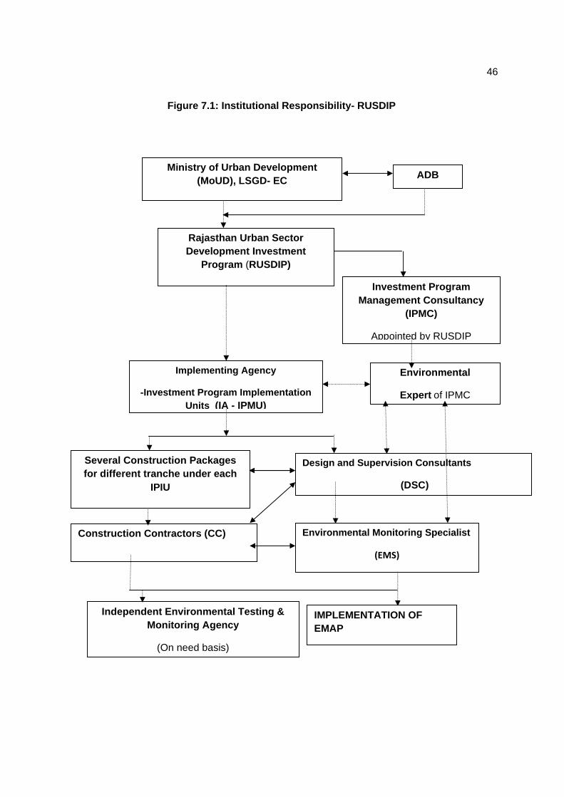
46
Figure 7.1: Institutional Responsibility- RUSDIP
Ministry of Urban Development (MoUD), LSGD- EC
Rajasthan Urban Sector Development Investment
Program (RUSDIP)
Implementing Agency
-Investment Program Implementation Units (IA - IPMU)
Several Construction Packages for different tranche under each
IPIU
Design and Supervision Consultants
(DSC)
Construction Contractors (CC) Environmental Monitoring Specialist
(EMS)
Independent Environmental Testing & Monitoring Agency
(On need basis)
IMPLEMENTATION OF EMAP
ADB
Investment Program Management Consultancy
(IPMC)
Appointed by RUSDIP
Environmental
Expert of IPMC
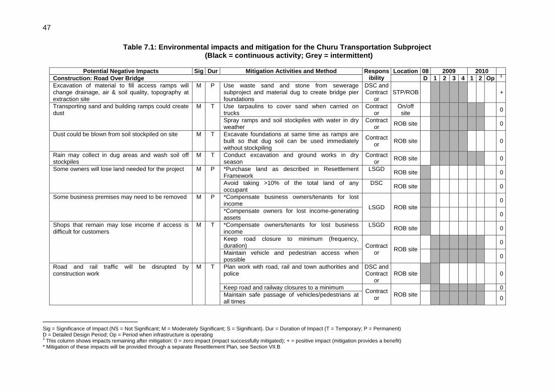
47
Table 7.1: Environmental impacts and mitigation for the Churu Transportation Subproject (Black = continuous activity; Grey = intermittent)
Potential Negative Impacts Sig Dur Mitigation Activities and Method Responsibility
Location 08 2009 2010 Construction: Road Over Bridge D 1 2 3 4 1 2 Op 3 Excavation of material to fill access ramps will change drainage, air & soil quality, topography at extraction site
M P Use waste sand and stone from sewerage subproject and material dug to create bridge pier foundations
DSC and Contract
or STP/ROB
+
Transporting sand and building ramps could create dust
M T Use tarpaulins to cover sand when carried on trucks
Contractor
On/off site
0
Spray ramps and soil stockpiles with water in dry weather
Contractor ROB site 0
Dust could be blown from soil stockpiled on site M T Excavate foundations at same time as ramps are built so that dug soil can be used immediately without stockpiling
Contractor ROB site
0
Rain may collect in dug areas and wash soil off stockpiles
M T Conduct excavation and ground works in dry season
Contractor ROB site 0
Some owners will lose land needed for the project M P *Purchase land as described in Resettlement Framework
LSGD ROB site 0
Avoid taking >10% of the total land of any occupant
DSC ROB site 0
Some business premises may need to be removed M P *Compensate business owners/tenants for lost income LSGD ROB site
0
*Compensate owners for lost income-generating assets
0
Shops that remain may lose income if access is difficult for customers
M T *Compensate owners/tenants for lost business income
LSGD ROB site 0
Keep road closure to minimum (frequency, duration) Contract
or ROB site
0
Maintain vehicle and pedestrian access when possible
0
Road and rail traffic will be disrupted by construction work
M T Plan work with road, rail and town authorities and police
DSC and Contract
or ROB site
0
Keep road and railway closures to a minimum Contractor ROB site
0 Maintain safe passage of vehicles/pedestrians at all times
0
Sig = Significance of Impact (NS = Not Significant; M = Moderately Significant; S = Significant). Dur = Duration of Impact (T = Temporary; P = Permanent) D = Detailed Design Period; Op = Period when infrastructure is operating 3 This column shows impacts remaining after mitigation: 0 = zero impact (impact successfully mitigated); + = positive impact (mitigation provides a benefit) * Mitigation of these impacts will be provided through a separate Resettlement Plan, see Section VII.B

48
Potential Negative Impacts Sig Dur Mitigation Activities and Method Responsibility
Location 08 2009 2010 Construction: Road Over Bridge D 1 2 3 4 1 2 Op 3
Provide effective diversions & alternative routes if needed
0
Conduct work that requires road and railway closure at times when traffic volume is low
0
Conduct work near railway at times when trains are fewer
0
Schedule truck sand deliveries for periods of low traffic
0
Existing infrastructure could be damaged by construction
S P Determine locations of water pipes, electricity pylons, etc and design scheme to avoid damage DSC ROB site
0
Locate different infrastructure on opposite sides of road
0
Roads/people may be disturbed by repeated excavation
M T Integrate subprojects to conduct excavation at same time
DSC/LGD ROB site 0
Ground disturbance could damage archaeological and historical remains
S P Request state and local archaeological authorities to assess archaeological potential of the site
DSC
ROB site
0
Select alternatives if site has medium-high potential
DSC 0
Include state and town historical authorities as project stakeholders to benefit from their expertise
LSGD 0
Develop and apply protocol to protect chance finds (excavation observed by archaeologist; stop work if finds are suspected; state authority to plan appropriate action)
DSC andContract
or
+
People living nearby may be disturbed by noise, dust
M T Inform community of work in advance; address concerns
Contractor ROB site
0
Plan work with community; avoid work at sensitive times
0
Avoid conducting noise-generating activities at night
0
Reduce dust by spraying soil and covering with tarpaulins
0
Use modern vehicles/machinery & maintain as specified
0
Workers and the public are at risk from accidents on site
M T Prepare and implement a site Health and Safety Plan that includes measures to: Contract
or ROB site
0
- Exclude the public from site; 0 - Ensure that workers use Personal Protective Equipment
0

49
Potential Negative Impacts Sig Dur Mitigation Activities and Method Responsibility
Location 08 2009 2010 Construction: Road Over Bridge D 1 2 3 4 1 2 Op 3
- Provide Health & Safety Training (including process of transmission of HIV/AIDS) for all personnel;
0
- Follow documented procedures for all site activities;
0
- Keep accident reports and records. 0 Existing water supply system uses AC pipes, a material that can be carcinogenic if inhaled as dust particles
S T Design all infrastructure to avoid locations of AC pipes DSC All sites 0
Train all construction personnel in dangers of AC pipes and how to recognise them in situ
Contractor All sites 0
Develop and apply protocol if AC pipes are encountered. This should include:
DSC and Contract
or ROB site
0
- immediate reporting of any occurrence to management;
Contractor ROB site
0
- removal of all persons to a safe distance; 0 - use of appropriate breathing apparatus and protective suits by workers delegated to deal with AC material;
0
- safe removal and long-term disposal of AC material
+
Economic benefits if local people are employed in Contractor’s workforce
M T Contractor should employ at least 50% of workforce from communities in vicinity of work site
Contractor ROB site +
Operation and Maintenance New bridge will be more visible than present crossing
M P Plant and maintain large growing native trees at periphery
DSC/CC ROB site 0
Worker safety at risk when conducting road repairs M T Coordinate with police - provide warning signs/diversions
OMC ROB site 0

50
139. Resettlement issues will be coordinated centrally by a Resettlement Specialist within the IPMU, who will ensure consistency of approach between towns. A local Resettlement Specialist will also be appointed to IPIUs of zones in which there are resettlement impacts and they will prepare and implement local Resettlement Plans following the framework established in Tranche 1.
140. Environmental issues will be coordinated by an Environmental Specialist within the IPMU/ IPMC, who will ensure that all subprojects comply with environmental safeguards. An Environmental Monitoring Specialist (EMS) who is part of the DSC team will implement the Environmental Monitoring Plan from each IEE (see below), to ensure that mitigation measures are provided and protect the environment as intended. Domestic Environmental Consultants (DEC) will be appointed by each IPIU to update the existing IEEs in the detailed design stage, and to prepare IEEs or EIAs for new subprojects, where required to comply with national law and/or ADB procedure.
C. Environmental Monitoring Plan
141. Table 7.1 shows that most mitigation activities are the responsibility of the Construction Contractors (CC) employed to build the infrastructure during the construction stage, or the O&M Contractors employed to conduct maintenance or repair work when the system is operating. Responsibility for the relevant measures will be assigned to the Contractors via the contracts through which they are appointed (prepared by the DSC during the detailed design stage), so they will be legally required to take the necessary action. There are also some actions that need to be taken by LSGD in their role as project proponent, and some actions related to the design that will be implemented by the DSC.
142. A program of monitoring will be conducted to ensure that all parties take the specified action to provide the required mitigation, to assess whether the action has adequately protected the environment, and to determine whether any additional measures may be necessary. This will be conducted by a qualified Environmental Monitoring Specialist (EMS) from the DSC. The EMS will be responsible for all monitoring activities and reporting the results and conclusions to the IPMU, and will recommend remedial action if measures are not being provided or are not protecting the environment effectively. The EMS may be assisted by environmental specialists in particular technical fields, and junior or medium-level engineers who can make many of the routine observations on site. Post-construction monitoring will be conducted by the relevant Government Agency (GA) to whom responsibility for the infrastructure will pass once it begins to operate4.
143. Table 7.1 shows that most of the mitigation measures are fairly standard methods of minimising disturbance from building in urban areas (maintaining access, planning work to avoid sensitive times, finding uses for waste material, etc), and experienced Contractors should be familiar with most of the requirements. Monitoring of such measures normally involves making observations in the course of site visits, although some require more formal checking of records and other aspects. There will also be some surveys of residents, as most of the measures are aimed at preventing impacts on people and the human environment.
144. Table 7.2 shows the proposed Environmental Monitoring Plan (EMP) for this subproject, which specifies the various monitoring activities to be conducted during all phases. Some of the measures shown in Table 7.1 have been consolidated to avoid repetition, and there has been 4 In the operational period some infrastructure will be the responsibility of the Municipal Boards/Councils, whilst others will be the responsibility of the appropriate branch of the State government (such as PWD, PHED, etc)
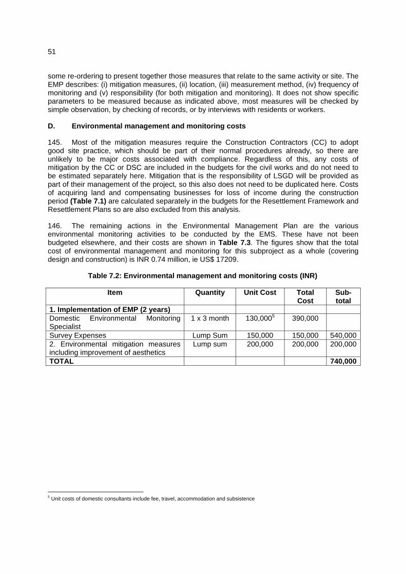
51
some re-ordering to present together those measures that relate to the same activity or site. The EMP describes: (i) mitigation measures, (ii) location, (iii) measurement method, (iv) frequency of monitoring and (v) responsibility (for both mitigation and monitoring). It does not show specific parameters to be measured because as indicated above, most measures will be checked by simple observation, by checking of records, or by interviews with residents or workers.
D. Environmental management and monitoring costs
145. Most of the mitigation measures require the Construction Contractors (CC) to adopt good site practice, which should be part of their normal procedures already, so there are unlikely to be major costs associated with compliance. Regardless of this, any costs of mitigation by the CC or DSC are included in the budgets for the civil works and do not need to be estimated separately here. Mitigation that is the responsibility of LSGD will be provided as part of their management of the project, so this also does not need to be duplicated here. Costs of acquiring land and compensating businesses for loss of income during the construction period (Table 7.1) are calculated separately in the budgets for the Resettlement Framework and Resettlement Plans so are also excluded from this analysis.
146. The remaining actions in the Environmental Management Plan are the various environmental monitoring activities to be conducted by the EMS. These have not been budgeted elsewhere, and their costs are shown in Table 7.3. The figures show that the total cost of environmental management and monitoring for this subproject as a whole (covering design and construction) is INR 0.74 million, ie US$ 17209.
Table 7.2: Environmental management and monitoring costs (INR)
Item Quantity Unit Cost Total Cost
Sub-total
1. Implementation of EMP (2 years) Domestic Environmental Monitoring Specialist
1 x 3 month 130,0005 390,000
Survey Expenses Lump Sum 150,000 150,000 540,0002. Environmental mitigation measures including improvement of aesthetics
Lump sum 200,000 200,000 200,000
TOTAL 740,000
5 Unit costs of domestic consultants include fee, travel, accommodation and subsistence
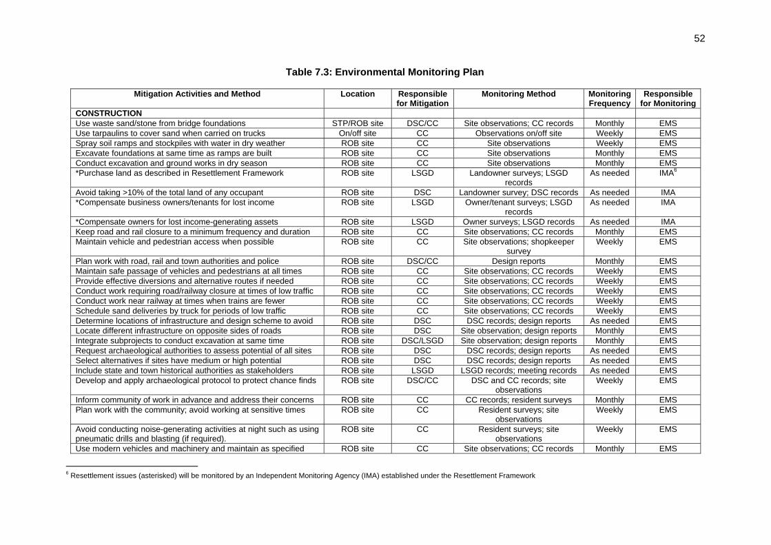
52
Table 7.3: Environmental Monitoring Plan
Mitigation Activities and Method Location Responsible for Mitigation
Monitoring Method Monitoring Frequency
Responsible for Monitoring
CONSTRUCTION Use waste sand/stone from bridge foundations STP/ROB site DSC/CC Site observations; CC records Monthly EMS Use tarpaulins to cover sand when carried on trucks On/off site CC Observations on/off site Weekly EMS Spray soil ramps and stockpiles with water in dry weather ROB site CC Site observations Weekly EMS Excavate foundations at same time as ramps are built ROB site CC Site observations Monthly EMS Conduct excavation and ground works in dry season ROB site CC Site observations Monthly EMS *Purchase land as described in Resettlement Framework ROB site LSGD Landowner surveys; LSGD
records As needed IMA6
Avoid taking >10% of the total land of any occupant ROB site DSC Landowner survey; DSC records As needed IMA *Compensate business owners/tenants for lost income ROB site LSGD Owner/tenant surveys; LSGD
records As needed IMA
*Compensate owners for lost income-generating assets ROB site LSGD Owner surveys; LSGD records As needed IMA Keep road and rail closure to a minimum frequency and duration ROB site CC Site observations; CC records Monthly EMS Maintain vehicle and pedestrian access when possible ROB site CC Site observations; shopkeeper
survey Weekly EMS
Plan work with road, rail and town authorities and police ROB site DSC/CC Design reports Monthly EMS Maintain safe passage of vehicles and pedestrians at all times ROB site CC Site observations; CC records Weekly EMS Provide effective diversions and alternative routes if needed ROB site CC Site observations; CC records Weekly EMS Conduct work requiring road/railway closure at times of low traffic ROB site CC Site observations; CC records Weekly EMS Conduct work near railway at times when trains are fewer ROB site CC Site observations; CC records Weekly EMS Schedule sand deliveries by truck for periods of low traffic ROB site CC Site observations; CC records Weekly EMS Determine locations of infrastructure and design scheme to avoid ROB site DSC DSC records; design reports As needed EMS Locate different infrastructure on opposite sides of roads ROB site DSC Site observation; design reports Monthly EMS Integrate subprojects to conduct excavation at same time ROB site DSC/LSGD Site observation; design reports Monthly EMS Request archaeological authorities to assess potential of all sites ROB site DSC DSC records; design reports As needed EMS Select alternatives if sites have medium or high potential ROB site DSC DSC records; design reports As needed EMS Include state and town historical authorities as stakeholders ROB site LSGD LSGD records; meeting records As needed EMS Develop and apply archaeological protocol to protect chance finds ROB site DSC/CC DSC and CC records; site
observations Weekly EMS
Inform community of work in advance and address their concerns ROB site CC CC records; resident surveys Monthly EMS Plan work with the community; avoid working at sensitive times ROB site CC Resident surveys; site
observations Weekly EMS
Avoid conducting noise-generating activities at night such as using pneumatic drills and blasting (if required).
ROB site CC Resident surveys; site observations
Weekly EMS
Use modern vehicles and machinery and maintain as specified ROB site CC Site observations; CC records Monthly EMS
6 Resettlement issues (asterisked) will be monitored by an Independent Monitoring Agency (IMA) established under the Resettlement Framework

53
Mitigation Activities and Method Location Responsible for Mitigation
Monitoring Method Monitoring Frequency
Responsible for Monitoring
Prepare and implement a site H&S Plan including personal protection from transmission of HIV/AIDS (safety of workers/public)
ROB site CC Site observations; CC records Monthly EMS
Exclude public from the site ROB site CC Site observations; CC records Monthly EMS Ensure that workers wear Personal Protective Equipment ROB site CC Site observations; CC records Monthly EMS Provide Health and Safety training including process of transmission of HIV/AIDS for all personnel
ROB site CC CC records; worker interviews Monthly EMS
Follow documented procedures for all site activities ROB site CC Site observations; CC records Monthly EMS Keep accident reports and records ROB site CC CC records Monthly EMS Design infrastructure to avoid known locations of AC pipes All sites DSC DSC records; design reports As needed EMS Train all personnel in dangers and recognition of AC pipes All sites CC Site observations; CC records Monthly EMS Develop and apply protocol if AC pipes are encountered All sites DSC/CC DSC & CC records; site
observations Weekly EMS
If AC pipes are encountered, report to management immediately All sites CC Site observations; CC records Weekly EMS Remove all persons to safe distance All sites CC Site observations; CC records Weekly EMS Workers handling AC: wear breathing apparatus; protective suits All sites CC Site observations; CC records Weekly EMS All AC material must be removed and disposed of safely All sites CC Observations on and off site; CC
records As needed EMS
Employ at least 50% of workforce from communities near sites ROB site CC CC records; worker interviews Monthly EMS OPERATION AND MAINTENANCE Plant and maintain large growing native trees at periphery of site ROB site DSC/CC Site observations; CC records As needed EMS Coordinate repairs with police – provide warning signs/diversions ROB site OMC Site observations As needed GA

54
VIII. PUBLIC CONSULTATION AND INFORMATION DISCLOSURE
A. Project stakeholders
147. Most of the main stakeholders have already been identified preliminary. If any other stakeholders that are identified during project implementation will be brought into the process in the future. Primary stakeholders are:
o Residents, shopkeepers and businesspeople who live and work alongside the roads in which network improvements will be provided and near sites where facilities will be built
o Owners and users of any land that is acquired along the transmission main route;
o Custodians and users of socially and culturally important buildings in affected areas;
o State and local authorities responsible for the protection and conservation of archaeological relics, historical sites and artefacts;
o State and local tourism authorities.
148. Secondary stakeholders are:
o LSGD as the Executing Agency;
o Other government institutions whose remit includes areas or issues affected by the project (state and local planning authorities, Department of Public Health Engineering, Local Government Dept, Ministry of Environment and Forests, Roads and Highways Division, etc);
o NGOs and CBOs working in the affected communities;
o Other community representatives (prominent citizens, religious leaders, elders, women’s groups);
o The beneficiary community in general; and
o The ADB and Government of India, Ministry of Finance.
B. Consultation and disclosure to date
149. Some informal discussion was held with the local people during site visit. Issues discussed are
o Awareness and extent of the project and development components
o Benefits of Project for the economic and social upliftment of community
o Labour availability in the Project area or requirement of outside labour involvement
55
o Local disturbances due to Project Construction Work
o Necessity of tree felling etc. at project sites
o Water logging and drainage problem if any
o Drinking water problem
o Forest and sensitive area nearby the project site
o Movement of wild animals near project site
150. Local populations are very much interested on the project and they will help project authorities in all aspects. Public consultation results specifically on environmental issues are shown in Appendix -3.
151. Some concerns made on the necessity of proper safety arrangements during construction. Local people pointed out that dust and noise may not be a problem during construction of ROB.
152. The public Consultation and group discussion meeting were conduct by RUIDP on Date 26 June , 2008 after advertising in Local NEWS papers. The objective of the meeting was to appraise the stakeholders about the environmental and social impacts of the proposed program and the safeguards provided in the program to mitigate the same. In the specific context of Churu, the environmental and social impacts of the proposed subprojects under Tranche 2 in Churu were discussed.
153. Meetings and individual interviews were held at potentially temporarily affected areas; and local informal interviews were conducted to determine the potential impacts of sub-project construction to prepare the sample Environmental Framework. A town-wise stakeholder consultation workshop was conducted which provided an overview of the Program and sub-projects to be undertaken in Churu; and discussed the Government and ADB’s Environment policies acts and potential environment impacts of the sub-projects in Churu. During the workshop, Hindi versions of the Environmental Framework were provided to ensure participants understood the objectives, policy principles and procedures related to Environment, English and Hindi versions of the Environmental Framework have been placed in the Urban Local Body (ULB) office and Environmental Framework will be provided later on. The NGO to be engaged to implement the Mitigation Measures will continue consultations, information dissemination, and disclosure. The Environmental Framework will be made available in the ULB office, Investment Program Project Management Unit and Implementation Unit (IPMU and IPIU) offices, and the town library. The finalized IEE containing Mitigation Measures will also be disclosed in ADB’s website, the State Government website, the local government website, and the IPMU and IPIU websites. ADB review and approval of the RP is required prior to award of civil works contracts.
C. Major Issues discussed during Public consultation are
(i) Proposed ROB sub project is to ensure proper movement of city traffic round the clock
56
(ii) Executive agency should give preference to engage internationally reputed contractor like Gammon, HCC, etc as people do not faith about the local contractors in respect of quality of works as well as timely completion of work;
(iii) Livelihood affected households should be given assistance in the mode of cash compensation;
(iv) Local people should be employed by the contractor during construction work;
(v) Adequate safety measures should be taken during construction work;
(vi) Mobile kiosks/vendors/hawkers have shown willingness to shift in nearby places without taking any compensation and assistance from the Executing Agency;
(vii) Local people have appreciated the ROB proposal of the government and they have ensured that they will cooperate with the Executing Agency during project implementation.
D. Future consultation and disclosure
154. LSGD will extend and expand the consultation and disclosure process significantly during implementation of RUSDIP. They will appoint an experienced NGO to handle this key aspect of the programme, who will conduct a wide range of activities in relation to all subprojects in each town, to ensure that the needs and concerns of stakeholders are registered, and are addressed in project design, construction or operation where appropriate. The programme of activities will be developed during the detailed design stage, and is likely to include the following:
Consultation during detailed design:
o Focus-group discussions with affected persons and other stakeholders (including women’s groups, NGOs and CBOs) to hear their views and concerns, so that these can be addressed in subproject design where necessary;
o Structured consultation meetings with the institutional stakeholders (government bodies and NGOs) to discuss and approve key aspects of the project.
Consultation during construction:
o Public meetings with affected communities to discuss and plan work programmes and allow issues to be raised and addressed once construction has started;
o Smaller-scale meetings to discuss and plan construction work with individual communities to reduce disturbance and other impacts, and provide a mechanism through which stakeholders can participate in subproject monitoring and evaluation;
57
Project disclosure:
o Public information campaigns (via newspaper, TV and radio) to explain the project to the wider city population and prepare them for disruption they may experience once the construction programme is underway;
o Public disclosure meetings at key project stages to inform the public of progress and future plans, and to provide copies of summary documents in Hindi;
o Formal disclosure of completed project reports by making copies available at convenient locations in the study towns, informing the public of their availability, and providing a mechanism through which comments can be made.
IX. FINDINGS AND RECOMMENDATIONS
A. Findings
155. The Project is designed to improve the quality of life of small town residents and enhance the small towns' roles as market, services, and manufacturing centers. . It has a strong community development focus reinforced by integrated poverty reduction, health and hygiene improvement investment projects. Moreover, urban residents including nearby the rural residents in surrounding hinterland will benefit from improved roads and bridges allowing better access to urban markets and social services provided in the Project towns. The towns' economies will benefit from enhanced productivity as a result of health improvement, time savings in collecting water, as well as from increased urban efficiency arising from improved roads, bridges, drainage, drinking water and sanitation.
156. During project design, community meetings were held with beneficiaries to discuss sanitation, poverty, resettlement, affordability issues, and environmental concerns. Socioeconomic surveys obtained information and individual views on current situations and future preferences. Potential environmental impacts of urban infrastructure improvements are mainly short-term during the construction period and can be minimized by the proposed mitigating measures and environmentally sound engineering and construction practices.
157. The process described in this document has assessed the environmental impacts of the infrastructure proposed under the Churu Urban Transport and Roads Subproject. Potential negative impacts were identified in relation to both construction and operation of the improved infrastructure, but no impacts were identified as being due to either the project design or location. Mitigation measures have been developed to reduce all negative impacts to acceptable levels. These were discussed with specialists responsible for the engineering aspects, and as a result some measures have already been included in the outline designs for the infrastructure.
158. This means that the number of impacts and their significance has already been reduced by amending the design.
159. A change has also been made to the location of elements of the project to further reduce impacts. This is to:
58
o Locate as much of the proposed road improvement within the ROW of the existing roads and rail line to reduce the need to acquire land and avoid relocating people.
160. Regardless of these and various other actions taken during the IEE process and in developing the project, there will still be impacts on the environment when the ROB is built and when it is operating. This is mainly because of the relatively large size of the structure, its location at a busy road and rail intersection, and the fact that the work involves some excavation so there could be a risk of uncovering historical remains from the rich cultural history of Rajasthan. Because of these factors, the most significant impacts are on the physical environment, the human environment, and the cultural heritage.
161. During the construction phase, impacts mainly arise from the need to import a large quantity of waste soil to fill RCC box-units built to raise the level of the approach roads, and because the work will inevitably cause some disruption to road and rail traffic. These are common impacts of construction in urban areas, and there are well developed methods for their mitigation. These include:
o Covering soil during transportation and when stored on site;
o Watering exposed soil during dry and windy weather;
o Planning work with the appropriate authorities to minimise disruption of road/rail traffic.
162. There could also be a need to acquire a small amount of land at the periphery of the site, which includes a thin strip inside the boundary of some establishments. Such impacts are also frequently encountered and are dealt with by a combination of the legal process and additional measures required by ADB policy on Involuntary Resettlement. Actions are discussed in a separate Resettlement Plan and Resettlement Framework, and include:
o Acquisition of land through the GoI Land Acquisition Act, through which the market value is paid, based on an analysis of recent transactions;
o Ensuring that no more than 10% of the land of a single owner or occupant is acquired;
o Providing additional compensation for loss of business and income-generating assets.
163. One field in which impacts are much less routine is archaeology, and here a series of specific measures have been developed to avoid damaging important remains. These include:
o Assessing the archaeological potential of the site, and selecting an alternative subproject if the site is considered to be of medium or high risk;
o Including archaeological, cultural and historical authorities and interest groups as project stakeholders to benefit from their expertise;
o Developing a protocol for use in conducting all excavation to ensure that any chance finds are recognised, protected and conserved.

59
164. Special measures were also developed to protect workers and the public from exposure to carcinogenic asbestos fibers in the event that Asbestos Cement pipes used in the existing water supply system are uncovered accidentally during excavation work. These are to:
o Avoid all known sites of AC pipes when the locations of new infrastructure are planned in the detailed design stage;
o Train all construction personnel to raise awareness of the dangers of AC and enable early recognition of such pipes if encountered;
o Develop and apply a protocol to protect workers and the public if AC pipes are encountered (including evacuation of the immediate area, use of protective equipment by workers, and safe removal and disposal of AC material).
165. There were limited opportunities to provide environmental enhancements, but certain measures were included. For example it is proposed that the project will:
o Employ in the workforce people who live in the vicinity of the construction site to provide them with a short-term economic gain;
o Plant large-growing trees at the periphery of the site to mask it from view and give it a more natural and pleasing appearance.
166. These and the other mitigation and enhancement measures are summarised in Table 7.1, which also shows the location of the impact, the body responsible for the mitigation, and the programme for its implementation.
167. Once the ROB is completed, it will operate with routine maintenance (such as occasional repairs of the road, safety barriers and signs), which will be small-scale, infrequent and short in duration and should not affect the environment. The only mitigation required in this period is to plan any maintenance work with the town authorities and police to ensure adequate precautions are taken to maintain the safety of workers and road users.
168. The main impacts of the operating ROB will be beneficial in improving the infrastructure of the town by providing a more efficient and effective transport route, which should improve the overall economy by reducing time spent idle in traffic by delivery vehicles, employees and customers. The general environment will also be improved at this location as the daily concentration of vehicular noise and pollution from exhaust gases will be removed.
169. Table 7.1 also assesses the effectiveness of each mitigation measure in reducing each impact to an acceptable level. This is shown as the level of significance of the residual impact (remaining after the mitigation is applied). This shows that all impacts will be rendered at least neutral (successfully mitigated), and that certain measures will produce a benefit (in addition to the major benefits provided by the operating schemes).
170. Mitigation will be assured by a programme of environmental monitoring conducted during both construction and operation to ensure that all measures are provided as intended, and to determine whether the environment is protected as envisaged. This will include observations on and off site, document checks, and interviews with workers and beneficiaries, and any requirements for remedial action will be reported to the IPMU.

60
B. Recommendations
171. There are two straightforward but essential recommendations that need to be followed to ensure that the environmental impacts of the project are successfully mitigated. These are that LSGD should ensure that:
All mitigation, compensation and enhancement measures proposed in this IEE report (Table 7.1) and in the Resettlement Framework for the RUSDIP are implemented in full, as described in these two documents;
The Environmental Monitoring Plan proposed in Section VII.C of this report and the internal and external monitoring proposed in the Resettlement Framework are also implemented in full.
X. CONCLUSIONS
172. The environmental status of the proposed improvements in urban transport and road (ROB) sector in Churu Town has been assessed. Issues related to Involuntary Resettlement were assessed by a parallel process of resettlement planning and will be compensated by measures set out in detail in the Resettlement Framework for the subproject.
173. The overall conclusion of both processes is that providing the mitigation, compensation and enhancement measures are implemented in full, there should be no significant negative environmental impacts as a result of location, design, construction or operation of the subproject. There should in fact be some small benefits from recommended mitigation and enhancement measures, and major improvements in quality of life and individual and public health once the scheme is in operation.
174. There are no uncertainties in the analysis, and no further studies are required to comply with ADB procedure or national law.

61
Appendix – 1 Photograph
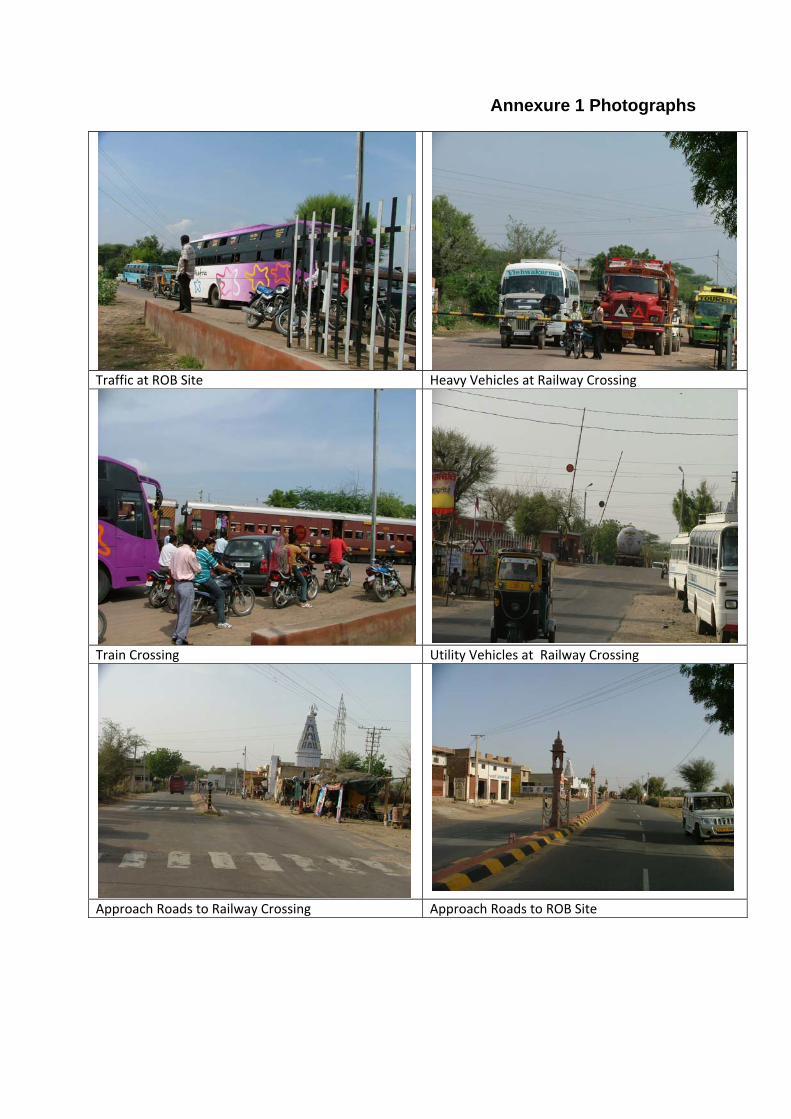
Annexure 1 Photographs
Traffic at ROB Site Heavy Vehicles at Railway Crossing
Train Crossing Utility Vehicles at Railway Crossing
Approach Roads to Railway Crossing Approach Roads to ROB Site

62
Appendix - 2
RAPID ENVIRONMENTAL ASSESSMENT (REA) CHECKLIST
Country/Project Title: India/Rajasthan (Churu) Urban Sector Development Investment Programme (Tranche-II).
Sub-Project: Construction of Rail over Bridge in Churu.
SCREENING QUESTIONS Yes No REMARKS A. Project Siting Is The Project Area…
There is no protected/environmental sensitive area along the bridge. Densely Populated?
No
Heavy with Development Activities? No
Adjacent to or Within Any Environmentally Sensitive Areas?
No
• Cultural Heritage Site
No
• Protected Area
No
• Wetland
No
• Mangrove
No
• Estuarine
No
• Buffer Zone of Protected Area
No
• Special Area for Protecting Biodiversity
No
• Bay
No
B. Potential Environmental Impacts Will The Project Cause…
No

63
SCREENING QUESTIONS Yes No REMARKS Encroachment on historical/cultural areas; disfiguration of landscape by road embankments
No There is no historical areas and landscape in the project area. One temple falling in project area and to save this temple proposed ROB has been shifted towards other side of temple.
Encroachment of precious ecology (e.g senstive or protected areas)
No There is no encroachment on precious ecology in this area, only few trees may be impacted.
Alteration of surface water hydrology of waterways crossed by roads, resulting in increased sediments in streams affected by increased soil erosion at
No There is no surface water resources exist in this area.
Deterioration of surface water quality due to silt runoff and sanitary wastes from workers based camps.
No There is no surface water resources exist in this area.
Increase local air pollution due to rock crushing cutting and filling works, and chemicals from asphalt processing.
Yes During construction phase there will be increased air pollution due to asphalt processing and rock cutting. The location of asphalt processing and rock cutting machinery will be established far from human settlements and any environmental sensitive location to avoid impacts from increased air pollution.
Noise and vibration due to blasting and other civil works.
No There is no blasting work involved in ROB construction.
Dislocation or involuntary resettlement of people.
No No resettlement is involved in this project. Two three temporary shops fall in ROW.
Other social concerns relating to inconveniences in living condition in the project areas that may trigger cases of upper respiratory problems and stress.
Yes People consulted living nearby this project area feels that some migratory tribal population living nearby in huts will shifts under ROB after construction of ROB may deteriorate that area.
Hazardous driving conditions where construction interferes with pre-existing roads.
No Contractor will provide alternate road during period of construction and maintain traffic management to avoid any hazardous driving condition.
Poor sanitation and solid waste disposal in construction camps and work sites, and possible transmission of communicable diseases from workers to local population.
No Local labor will be employed for this work if required then contractor will provide all necessary facilities in workers camp to avoid any sanitation and solid waste disposal problem.
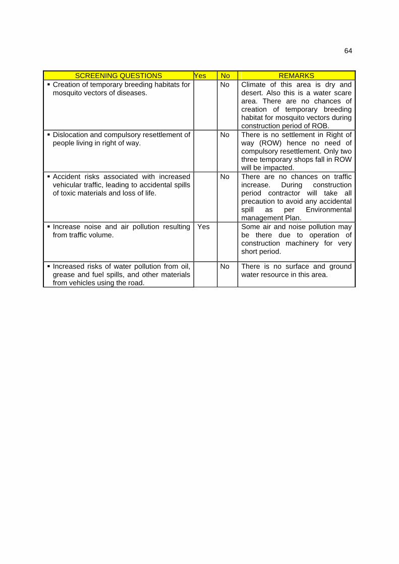
64
SCREENING QUESTIONS Yes No REMARKS Creation of temporary breeding habitats for mosquito vectors of diseases.
No Climate of this area is dry and desert. Also this is a water scare area. There are no chances of creation of temporary breeding habitat for mosquito vectors during construction period of ROB.
Dislocation and compulsory resettlement of people living in right of way.
No There is no settlement in Right of way (ROW) hence no need of compulsory resettlement. Only two three temporary shops fall in ROW will be impacted.
Accident risks associated with increased vehicular traffic, leading to accidental spills of toxic materials and loss of life.
No There are no chances on traffic increase. During construction period contractor will take all precaution to avoid any accidental spill as per Environmental management Plan.
Increase noise and air pollution resulting from traffic volume.
Yes Some air and noise pollution may be there due to operation of construction machinery for very short period.
Increased risks of water pollution from oil, grease and fuel spills, and other materials from vehicles using the road.
No There is no surface and ground water resource in this area.

65
Appendix - 3
PUBLIC CONSULTATION- ENVIRONMENT
ROB CHURU
Issues discussed
Awareness and extent of the project and development components
Benefits of Project for the economic and social Upliftment of Community
Labour availability in the Project area or requirement of outside labour involvement
Local disturbances due to Project Construction Work
Necessity of tree felling etc. at project sites
Water logging and drainage problem if any
Drinking water problem
Forest and sensitive area nearby the project site
Movement of wild animal if any
1. Date` of Consultation 25/06/08
2. Location: Fatehpur Railway Crossing
.Table: Issues of the Public Consultation- Design phase
Sr. No.
Key Issues/Demands Perception of community
1 Awareness of the project – including coverage area
People are aware about project and coverage area
2 In what way they may associate with the project
They want some job and employment during construction phase of project.
3 Presence of any forest, wild life or any sensitive / unique environmental components nearby the project area
None
4 Presence of historical/ cultural/ religious sites nearby
One temple of Rameswar Madhav near project site
5 Un favorable climatic condition No there is no problem related to sewerage and drainage.
6 Occurrence of flood Very rarely.
7 Drainage and sewerage problem facing
No there is no problem related to sewerage and drainage.
8 Present drinking water problem – quantity and quality
No problem of Quantity and Quality
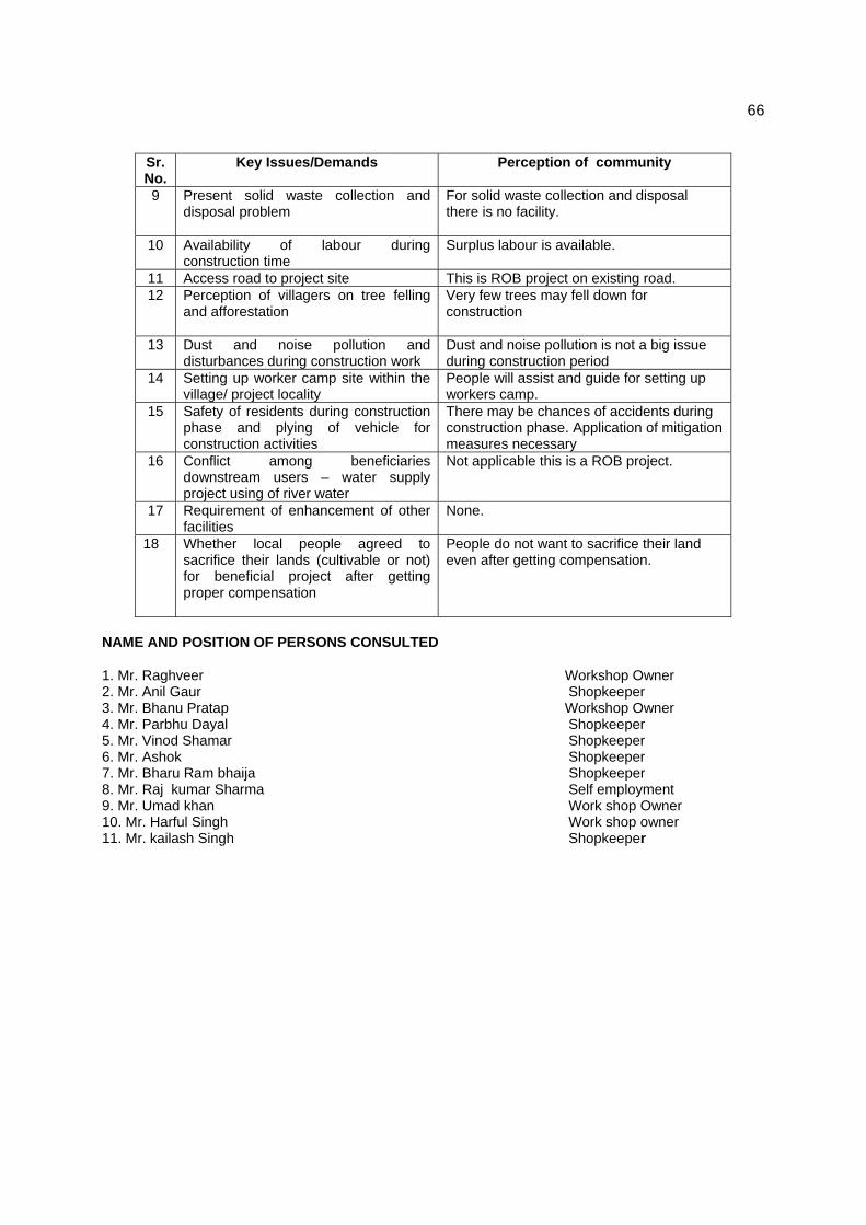
66
Sr. No.
Key Issues/Demands Perception of community
9 Present solid waste collection and disposal problem
For solid waste collection and disposal there is no facility.
10 Availability of labour during construction time
Surplus labour is available.
11 Access road to project site This is ROB project on existing road. 12 Perception of villagers on tree felling
and afforestation Very few trees may fell down for construction
13 Dust and noise pollution and disturbances during construction work
Dust and noise pollution is not a big issue during construction period
14 Setting up worker camp site within the village/ project locality
People will assist and guide for setting up workers camp.
15 Safety of residents during construction phase and plying of vehicle for construction activities
There may be chances of accidents during construction phase. Application of mitigation measures necessary
16 Conflict among beneficiaries downstream users – water supply project using of river water
Not applicable this is a ROB project.
17 Requirement of enhancement of other facilities
None.
18 Whether local people agreed to sacrifice their lands (cultivable or not) for beneficial project after getting proper compensation
People do not want to sacrifice their land even after getting compensation.
NAME AND POSITION OF PERSONS CONSULTED
1. Mr. Raghveer Workshop Owner 2. Mr. Anil Gaur Shopkeeper 3. Mr. Bhanu Pratap Workshop Owner 4. Mr. Parbhu Dayal Shopkeeper 5. Mr. Vinod Shamar Shopkeeper 6. Mr. Ashok Shopkeeper 7. Mr. Bharu Ram bhaija Shopkeeper 8. Mr. Raj kumar Sharma Self employment 9. Mr. Umad khan Work shop Owner 10. Mr. Harful Singh Work shop owner 11. Mr. kailash Singh Shopkeeper


![arXiv:1407.4256v1 [hep-ex] 16 Jul 2014research.ipmu.jp/ipmu/sysimg/ipmu/1547.pdf · Measurement of the inclusive charged current cross section on iron and hydrocarbon in the T2K on-axis](https://img.pdfslide.net/doc/110x75/606ceeada2b0b522c64013c2/arxiv14074256v1-hep-ex-16-jul-measurement-of-the-inclusive-charged-current-cross.jpg)