Embed Size (px)
Citation preview
Initial Environmental Examination
The initial environmental examination is a document of the borrower. The views expressed herein do not necessarily represent those of ADB’s Board of Directors, Management, or staff, and may be preliminary in nature.
Document Stage: Revised Project Number: 40031 ADB Loan No.: 2506 September 2008 / March 2011 / April 2013
India: Rajasthan Urban Sector Development Investment Program – Bharatpur Water Supply Subproject (Tr-2) Prepared by Local Self Government Department For the Government of Rajasthan Rajasthan Urban Infrastructure Development Project

The initial environmental examination is a document of the borrower. The views expressed herein do not necessarily represent those of ADB’s Board of Directors, Management, or staff, and may be preliminary in nature.
Initial Environmental Examination
(Enhanced Scope)
Water Supply Subproject is already in execution. Scope of works under execution includes Providing Laying Jointing of pipelines, construction of CWR/OHSRs and Pumping Stations. Enhanced work proposed in this subproject includes strengthening of Distribution System by providing pipeline and OHSRs
Document Stage: Draft IEE Project Number: 40031 ADB Loan No.:2506 Month- Year: September 2008/ March 2011/April 2013
India: Rajasthan Urban Sector Development
Investment Program - Bharatpur Water Supply Sub-
Project (Tr-02)
Prepared by Local Self Government Department
For the Government of Rajasthan
Rajasthan Urban Infrastructure Development Project
ABBREVIATION
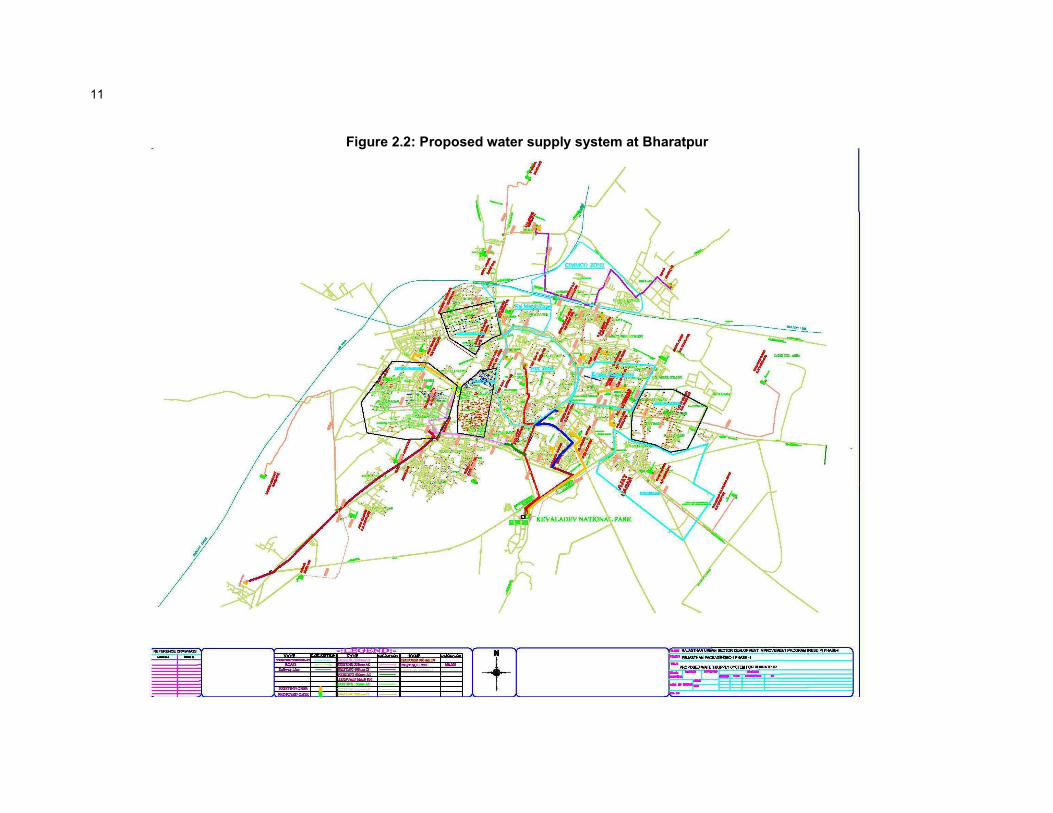
ADB - Asian Development Bank
DSC - Design and Supervision Consultancy
EA - Executing Agency
EAC - Expert Appraisal Committee
FI - Financial Intermediary
GoI - Government of India
GoR - Government of Rajasthan
GSI - Geological Survey of India
IA - Implementing Agency
IEE - Initial Environmental Examination
IPMC - Investment Programme Management Consultancy
IPMU - Investment Programme Management Unit
JNNURM - Jawaharlal Nehru National Urban Renewal Mission
lpcd - liter per capita per day
lps - liter per second
LSGD - Local Self-Government Department
MFF - Multi-tranche Financing Facility
MLD - Million liter Per day
MoEF - Ministry of Environment and Forests
NAAQS - National Ambient Air Quality Standards
OD - Outer Diameter
OM - Operations Manual
PHED - Public Health Engineering Department
PMU - Project Management Unit
RCC - Reinforced Cement Concrete
ROW - Right of Way
RPCB - Rajasthan State Pollution Control Board
RSPM - Respirable Suspended Particulate Matter
RUIDP - Rajasthan Urban Infrastructure Development Project
RUSDIP - Rajasthan Urban Sector Development Investment Program
SPM - Suspended Particulate Matter
STP - Sewerage Treatment Plant
ToR - Terms of Reference
UA - Urban Agglomeration
UIDSSMT - Urban Infrastructure Development Scheme for Small and Medium Towns
uPVC - Unplastized Poly Vinyl Chloride
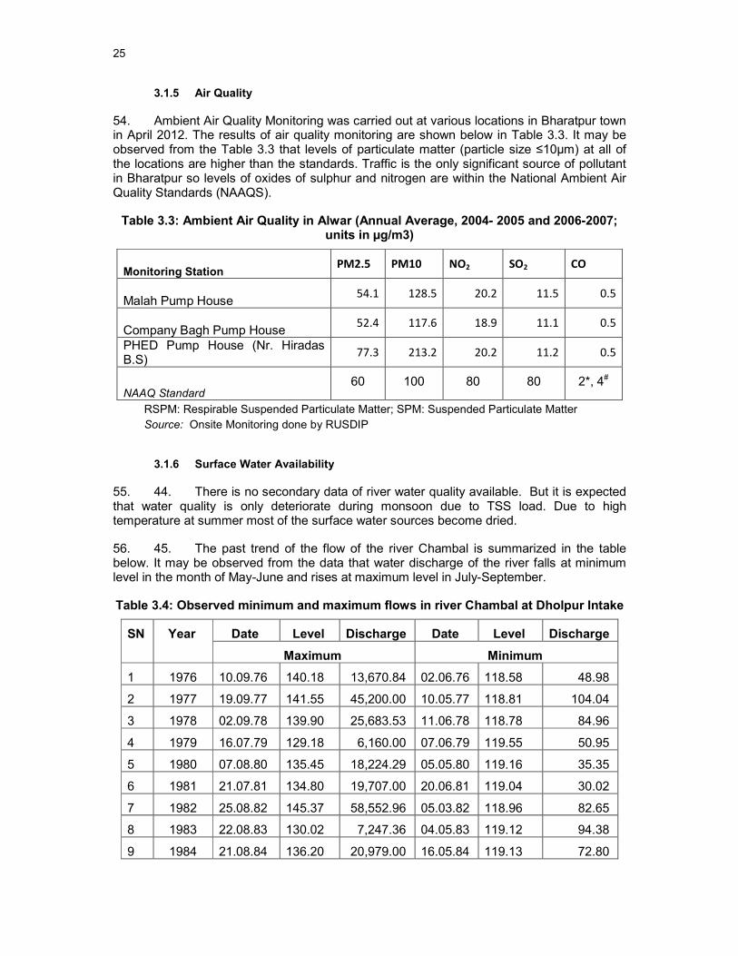
USEPA - United States Environmental Protection Agency
WC - Water Closets

WEIGHTS AND MEASURES
lakh – 100 thousand = 100,000
crore – 100 lakhs = 10,000,000
µg/m3 – micrograms per cubic meter
km – kilometer
lpd – liters per day
m – meter
m3/sec - cubic meter per second
mg/l – milligrams per liter
mm – millimeter
ppm – parts per million
NOTE{S}
(i) In this report, "$" refers to US dollars. (ii) “INR” and “Rs” refer to Indian rupees

Table of Contents
1 INTRODUCTION ................................................................................................................ 1
1.1 Purpose of the report ...................................................................................................... 1
1.2 Extent of the IEE study ................................................................................................... 1
1.2.1 ADB Policy .................................................................................................................. 1
1.2.2 National Law ............................................................................................................... 2
1.2.3 Review and Approval Procedure ................................................................................ 3
1.2.4 Scope of Study ............................................................................................................ 3
2 DESCRIPTION OF THE SUB-PROJECT ......................................................................... 4
2.1 Type, Category and Need .............................................................................................. 4
2.2 Location, Size and Implementation Schedule ................................................................ 4
2.3 Service Delivery, existing water supply arrangement .................................................... 4
2.4 Detailed scope of work ................................................................................................... 5
2.5 Associated Facilities: ...................................................................................................... 8
3 DESCRIPTION OF THE ENVIRONMENT ...................................................................... 18
3.1 Physical Resources ...................................................................................................... 18
3.1.1 Location ..................................................................................................................... 18
3.1.2 Topography, Natural hazard and Drought ................................................................ 18
3.1.3 Geology, geomorphology, mineral resources and soil ............................................. 21
3.1.4 Climate ...................................................................................................................... 23
3.1.5 Air Quality .................................................................................................................. 25
3.1.6 Surface Water Availability ......................................................................................... 25
3.1.7 Geohydrology and Groundwater .............................................................................. 26
3.2 Ecological Resources ................................................................................................... 29
3.2.1 Focus of study and introduction................................................................................ 29
3.2.2 Protected aquatic fauna in the Chambal River ........................................................ 29
3.2.3 Other flora and fauna in the National Chambal ........................................................ 32
3.3 Economic Development ............................................................................................... 36
3.3.1 Land use ................................................................................................................... 37
3.3.2 Commerce, Industry and Agriculture ........................................................................ 39
3.3.3 Infrastructure ............................................................................................................. 41
3.3.4 Transportation ........................................................................................................... 42
3.4 Social and Cultural Resources ..................................................................................... 43
3.4.1 Demography ............................................................................................................. 43
3.4.2 Health and educational facilities ............................................................................... 43
3.4.3 History, culture and tourism ...................................................................................... 44
4 ENVIRONMENTAL IMPACTS AND MITIGATION MEASURES: LOCATION AND DESIGN ................................................................................................................................... 46
5 POTENTIAL ENVIRONMENTAL IMPACTS AND MITIGATION MEASURES: INFRASTRUCTURE CONSTRUCTION ................................................................................. 47
5.1 Screening out areas of no significant impact ............................................................... 47
5.2 Distribution Network improvement & other works ........................................................ 48
5.2.1 Construction method ................................................................................................. 48

5.2.2 Physical Resources .................................................................................................. 49
5.2.3 Ecological Resources ............................................................................................... 50
5.2.4 Economic Development ............................................................................................ 50
5.2.5 Social and Cultural Resources ................................................................................. 51
6 POTENTIAL ENVIRONMENTAL IMPACTS AND MITIGATION MEASURES: OPERATION AND MAINTENANCE ....................................................................................... 55
6.1 Screening out areas of no significant impact ............................................................... 55
6.2 Operation and maintenance of the improved water supply system ............................ 55
6.3 Environmental impacts and benefits of the operating system ..................................... 55
6.3.1 Physical Resources .................................................................................................. 55
6.3.2 Ecological Resources ............................................................................................... 57
6.3.3 Economic Development ............................................................................................ 58
6.3.4 Social and Cultural Resources ................................................................................. 58
7 INSTITUTIONAL REQUIREMENTS AND ENVIRONMENTAL MONITORING PLAN ... 60
7.1 Summary of environmental impacts and mitigation measures .................................... 60
7.2 Institutional arrangements for project implementation ................................................. 60
7.3 Environmental Monitoring Plan .................................................................................... 66
7.4 Environmental management and monitoring costs ..................................................... 70
7.5 Associated Facilities ..................................................................................................... 71
8 PUBLIC CONSULTATION AND INFORMATION DISCLOSURE................................... 72
8.1 Project stakeholders ..................................................................................................... 72
8.2 Consultation and disclosure to date ............................................................................. 72
8.3 Future consultation and disclosure .............................................................................. 74
8.4 Grievance Redress Mechanism ................................................................................... 75
9 FINDINGS AND RECOMMENDATIONS ........................................................................ 76
9.1 Findings ........................................................................................................................ 76
9.2 Recommendations ........................................................................................................ 78
10 CONCLUSIONS ........................................................................................................... 80
Annexure – I ..................................................................................................................... 83
Annexure – II PHED Letter .............................................................................................. 86
Annexure –III Rapid Environmental Assessment (REA) Checklist ................................. 89
Annexure -IV Public Consultation- EnvironmenT ............................................................ 96
Annexure -V ................................................................................................................... 100

EXECUTIVE SUMMARY
1. Introduction and Regulatory Framework: Rajasthan Urban Sector Development Investment Program (RUSDIP) is intended to optimize social and economic development in 15 selected towns in the State, particularly district headquarters and towns with significant tourism potential. RUSDIP Phase II to be implemented over a seven year period beginning in 2008, and will be funded by a loan via the Multitranche Financing Facility (MFF) of the ADB. RUSDIP will improve infrastructure through the design and implementation of a series of subprojects, each providing improvements in a particular sector (water supply, sewerage, drainage, road , solid waste etc) in one town.
2. The impacts of subprojects prepared according to ADB Environment Policy (2002, 2009) and Indian National Law. Projects are screened for their expected environmental impacts and are assigned to Category A, B, C and F1. RUSDIP has been classified by ADB as environmental assessment category B (some negative impacts but less significant than category A). The only type of infrastructure provided by the RUSDIP that is specified in the EIA Notification (2006) of Govt. Of India is solid waste management, where Environmental Clearance (EC) is required for all Common Municipal Solid Waste Management Facilities. EC is thus not required for the water supply sub-project that is the subject of this Environmental Examination. This is the Initial Environmental Examination (IEE) report for the Bharatpur water supply sector. It discusses the generic environmental impacts and mitigation measures relating to the location, design, construction and operation of physical works proposed under this subproject.
3. Project Description: The sub-project is located in Bharatpur, the headquarters town of Bharatpur District, in the eastern part of Rajasthan. The main components of the sub-project are laying of distribution main, construction of Over Head Service reservoirs and laying of pumping main, replacement/ augmentation of pumping machinery and procurement and installation of household meters.
4. Description of Environment: Bharatpur lies between the East longitude 76o 53’ to 78o 17’and North latitude 26o 22’ to 27o 83’. It is situated at 100 meters above MSL. Bharatpur town lies in medium to high risk zone (III and IV). The area is prone to earthquakes as it is located on comparatively unstable geological plains based on evaluation of the available earthquake zone information. Soil of the region falls within low rainfall zone of 500- 700 mm. The soil is generally alluvial, prone to water logging. The nature of which is recent alluvial & calcareous. The climate of Bharatpur is generally dry. The maximum average temperature during summer is 44 degree Celsius to 47 degree Celsius and during winters it is -5 degree Celsius to 1 degree celsius. The average rainfall is 646 mm. 80-90 percent of the annual rains is experienced during June to September. There are no data on ambient air quality of Bharatpur Town, which is not subject to monitoring by the Rajasthan State Pollution Control Board (RPCB) as there are no major industries. The nearest station is located at Alwar (116 km from Bharatpur). Traffic is the only significant pollutant in Bharatpur, so levels of oxides of sulphur and nitrogen are likely to be well within the National Ambient Air Quality Standards (NAAQS). On an average 90 % of the district area covered with unconsolidated porous formations. As per PHED underground water in Bharatpur city and nearby area is having a high dissolve solid. The quality of ground water supply within the municipal limit and surrounding vicinity is not good and potable. Famous Bharatpur Bird Sanctuary is located in Bharatpur, but away from the proposed project site.
5. Bharatpur District is known not only for Agriculture production but for oil industries also. Bharatpur District spreads over an area of 5,066 sq.kms covering urbanization area circulation, public and semi-public, agriculture land etc. water bodies, Fort, agriculture research and mining .The Percentage of residential area is quite more in Bharatpur due to slow development of dense residential units. This is only 69% of total developed area.
6. The Present water supply of Bharatpur is partly from surface water from Bundh Baretha Irrigation Tank and the ground water sources, extracted through 19 tube wells. Bharatpur town does not have underground sewerage system. Out of the occupied residential houses only about 41.88 % population have some kind of individual facilities and about 28.78 % population with Low Cost Sanitation (LCS). The existing drainage system in Bharatpur is piecemeal construction of open nallah as per local and temporary requirements without proper whole to part designs. The town has mainly open drains. Industries exist in under RIICO, which is outside the city area and small amount of effluent disposed scattered in local nallahs. Solid Waste Management in Bharatpur is looked after by Health department of local body “Bharatpur Nagar Parishad” (BNP). Bharatpur is well connected with all the important towns of the Rajasthan State and Uttar Pradesh State. It is situated on the National Highway No.11 connecting Agra, Jaipur and Bikaner passes through Bharatpur
7. The Population of Bharatpur Municipality is 205,235 as per 2001 Census. Of the total population the males constitute 110,500 and females 94,735 with sex ratio of 857 females per 1000 males. Bharatpur saw a positive growth of population. There are good educational facilities in Bharatpur district, which serve both townspeople and inhabitants of surrounding villages and towns in the hinterland. Bharatpur is the main tourist place of Rajasthan. The historical Lohagarh fort or the ‘Iron Fort’ and other places like Keoladeo National Park , Kamra Khas Palace , Deeg Fort and Purana Mahal are full of heritage and architecture attracts Foreign Tourists .
8. Potential environmental impacts and mitigation measure: All pre-construction (design), construction, and operation activities that are likely to cause environmental impacts were identified, and evaluated to assess their magnitude, duration, and potential receptors in consultation with the stakeholders. Most of the individual elements of the subproject are relatively small and involve straightforward construction and operation, so impacts will be mainly localised and not greatly significant during design phase.
9. Implementation of the project will affect quite long tracts of land within the town where the clear water main and network extensions will be constructed, and also a series of specific locations (eg. Service reservoirs, pumping locations)
10. One National park and famous Bharatpur Bird Sanctuary is located near the proposed project area. Though the restricted area is located away from the project sites but during construction special attention particularly application of some mitigation measures are recommended in IEE report. There are no religious and historical sites nearby, hence no impact anticipated
11. During project implementation the impacts are consider on physical environment like water, air, soil, noise; on biological environment, like flora and fauna and socio-economic environment (which is positive in some extent) and sensitive receptors. All the impacts are temporary and for short duration. In all the cases mitigation measures i.e. control of air, dust pollution, checking of water and noise pollution, protection of biological environment and minimize the social impacts are taken care. Safety measures, both occupational and social are considered and those are depicted in IEE. Traffic management plan will be considered as per the requirement. During operation phases there are few positive socio-economic impacts will be anticipated.
12. During operation 43.38 MLD of water will be diverted from the protected river Chambal as the source of drinking water. The impact of this diversion on the water levels in the Chambal River, are expected to be small. The diversion amount equals around 1.50% of the lowest measured lean flow average of the last 20 years. The Chambal-Dholpur-Bharatpur water supply project is implemented and managed by PHED. Approval for construction was given from the Honourable Supreme Court and approval for forest land
conversion for the intake well and transmission pipeline construction was received from the Ministry of Environment and Forest in the year 2011.
13. Institutional responsibility and Environmental management and monitoring plan: LSGD is the Executing Agency (EA) responsible for management, coordination and execution of all activities funded under the loan. Environmental issues will be coordinated by an Environmental Specialist within the IPMU/ IPMC, who will ensure that all subprojects comply with environmental safeguards. An Environmental Monitoring Specialist (EMS) who is part of the DSC team will implement the Environmental Monitoring Plan from each IEE, to ensure that mitigation measures are provided and protect the environment as intended.
14. Implementation of Environmental management plan and monitoring frequency will be taken care during construction phase. Most the mitigation activities are the responsibility of the Construction Contractors (CC) employed to build the infrastructure during the construction stage, or the O&M Contractors employed to conduct maintenance or repair work when the system is operating. Responsibility for the relevant measures will be assigned to the Contractors via the contracts through which they are appointed (prepared by the DSC during the detailed design stage), so they will be legally required to take the necessary action. There are also some actions that need to be taken by LSGD in their role as project proponent, and some actions related to the design that will be implemented by the DSC. Mitigation measures are fairly standard methods of minimising disturbance from building in urban areas (maintaining access, planning work to avoid sensitive times, finding uses for waste material, etc), and experienced Contractors should be familiar with most of the requirements. Monitoring of such measures normally involves making observations in the course of site visits, although some require more formal checking of records and other aspects. There will also be some surveys of residents, as most of the measures are aimed at preventing impacts on people and the human environment. Environmental management and monitoring cost for the sub-project has been estimated as 2.32 million Rupees.
15. Public consultation, information disclosure and grievance redress mechanism: Public consultation with primary and secondary stakeholders has been conducted to understanding the local issues and public views regarding the possible impact. The group discussion meeting were conduct by RUIDP after advertising in Local NEWS papers. The issues like, awareness and extent of the project and development components, benefits of project for the economic and social upliftment of community, labour availability in the project area or requirement of outside labour involvement, local disturbances due to project construction work, necessity of tree felling etc. at project sites, water logging and drainage problem if any, drinking water problem, forest and sensitive area nearby the project site etc. On the basis of outcome of consultation the action plan has been developed. LSGD will extend and expand the consultation and disclosure process significantly during implementation of RUSDIP. They will appoint an experienced NGO to handle this key aspect of the programme.
16. The project authority will establish a mechanism to receive and facilitate resolution of affected persons’ concerns, complaints and grievances about the project’s environmental performance.
17. Recommendation and Conclusion: There are two straightforward but essential recommendations that need to be followed to ensure that the environmental impacts of the project are successfully mitigated. These are that LSGD should ensure that, all mitigation, compensation and enhancement measures proposed in this IEE report and in the Resettlement Framework for the RUSDIP are implemented in full, as described in these two documents and the Environmental Monitoring Plan proposed in IEE and the internal and external monitoring proposed in the Resettlement Framework are also implemented in full.

18. This initial environmental examination (IEE) ascertains that the subproject is unlikely to cause any significant environmental impacts. Few impacts were identified attributable to the proposed subproject, all of which are localized and temporary in nature and can be easily mitigated with minor to negligible residual impacts. No additional studies or need of undertaking detailed EIA is envisaged at this stage.

1
1 INTRODUCTION
1.1 Purpose of the report
1. Rajasthan Urban Sector Development Investment Program (RUSDIP) is intended to optimize social and economic development in 15 selected towns in the State, particularly district headquarters and towns with significant tourism potential. This will be achieved through investments in urban infrastructure (water supply; sewerage and sanitation; solid waste management; urban drainage; urban transport and roads), urban community upgrading (community infrastructure; livelihood promotion) and civic infrastructure (art, culture, heritage and tourism; medical services and health; fire services; and other services). RUSDIP will also provide policy reforms to strengthen urban governance, management, and support for urban infrastructure and services. The assistance will be based on the State-level framework for urban reforms, and institutional and governance reforms recommended by the Government of India (GoI) through the Jawaharlal Nehru National Urban Renewal Mission (JNNURM) and Urban Infrastructure Development Scheme for Small and Medium Towns (UIDSSMT).
2. RUSDIP Phase II to be implemented over a seven year period beginning in 2008, and will be funded by a loan via the Multitranche Financing Facility (MFF) of the ADB. The Executing Agency (EA) is the Local Self-Government Department (LSGD) of the Government of Rajasthan (GoR); and the Implementing Agency (IA) is the Project Management Unit (PMU) of the Rajasthan Urban Infrastructure Development Project (RUIDP), which is currently in the construction stage.
3. RUSDIP will improve infrastructure through the design and implementation of a series of subprojects, each providing improvements in a particular sector (water supply, sewerage, solid waste etc) in one town. RUSDIP has been classified by ADB as environmental assessment category B (some negative impacts but less significant than category A). The impacts of subprojects prepared according to ADB Environment Policy (2002, 2009) and Environmental Assessment Guidelines (2003).
1.2 Extent of the IEE study
4. Indian law and ADB policy (2009) require that the environmental impacts of development projects are identified and assessed as part of the planning and design process, and that action is taken to reduce those impacts to acceptable levels. This is done through the environmental assessment process, which has become an integral part of lending operations and project development and implementation worldwide.
1.2.1 ADB Policy
5. ADB’s Environment Policy (2009) requires the consideration of environmental issues in all aspects of the Bank’s operations, and the requirements for Environmental Assessment are described in Operations Manual (OM) 20: Section F1/BP (2006) Environmental Considerations in ADB Operations. This states that ADB requires environmental assessment of all project loans, programme loans, sector loans, sector development programme loans, financial intermediation loans and private sector investment operations.
6. The nature of the assessment required for a project depends on the significance of its environmental impacts, which are related to the type and location of the project, the sensitivity, scale, nature and magnitude of its potential impacts, and the availability of cost-effective mitigation measures. Projects are screened for their expected environmental impacts and are assigned to one of the following categories:

2
Category A: Projects that could have significant environmental impacts. An Environmental Impact Assessment (EIA) is required.
Category B: Projects that could have some adverse environmental impacts, but of less significance than those for category A. An Initial Environmental Examination (IEE) is required to determine whether significant impacts warranting an EIA are likely. If an EIA is not needed, the IEE is regarded as the final environmental assessment report.
Category C: Projects those are unlikely to have adverse environmental impacts. No EIA or IEE is required, although environmental implications are reviewed.
Category FI: Projects that involve a credit line through a financial intermediary (FI) or an equity investment in a FI. The FI must apply an environmental management system, unless all subprojects will result in insignificant impacts.
7. The Bank has categorised this program as Category B and following normal procedure for MFF loans has determined that one Environmental Examination will be conducted for each subproject, with a subproject being the infrastructure improvements in a particular sector (water supply, sewerage, etc) in one town.
1.2.2 National Law
8. The GoI EIA Notification of 2006 (replacing the EIA Notification of 1994), sets out the requirement for Environmental Assessment in India. This states that Environmental Clearance (EC) is required for specified activities/projects, and this must be obtained before any construction work or land preparation (except land acquisition) may commence. Projects are categorised as A or B depending on the scale of the project and the nature of its impacts.
9. Categories A projects require Environmental Clearance from the National Ministry of Environment and Forests (MoEF). The proponent is required to provide preliminary details of the project in the form of a Notification, after which an Expert Appraisal Committee (EAC) of the MoEF prepares comprehensive Terms of Reference (ToR) for the EIA study, which are finalized within 60 days. On completion of the study and review of the report by the EAC, MoEF considers the recommendation of the EAC and provides the EC if appropriate.
10. Category B projects require environmental clearance from the State Environment Impact Assessment Authority (SEIAA). The State level EAC categorises the project as either B1 (requiring EIA study) or B2 (no EIA study), and prepares TOR for B1 projects within 60 days. On completion of the study and review of the report by the EAC, the SEIAA issues the EC based on the EAC recommendation. The Notification also provides that any project or activity classified as category B will be treated as category A if it is located in whole or in part within 10 km from the boundary of protected areas, notified areas or inter-state or international boundaries.
11. Environment Clearance requirement is not applicable for this subproject under EIA Notification 2006/2009.

3
1.2.3 Review and Approval Procedure
12. For this ADB-classified Category B subproject, which forms part of an ongoing ADB funded multi-tranche financing facility, the March 2011 Draft Initial Environmental Examination has been reviewed by ADB’s Regional Department which is responsible for implementation and the approved report has been made available via ADB’s website. In 2012 it has been decided to revise the IEE for the Bharatpur Water Supply Subproject, as ADB observed that the assessment of the impact of using water from the protected Chambal River has not been given sufficient attention. The revised report of March 2013 will be reviewed by ADB. Based on the findings, ADB may review the categorization of the subproject. The revised document will be made available worldwide through the ADB website.
1.2.4 Scope of Study
13. This is the IEE report for the Bharatpur water supply sector. It discusses the generic environmental impacts and mitigation measures relating to the location, design, construction and operation of physical works proposed under this subproject.
14. The scope of the Bharatpur water supply sub-project of RUSDIP is strengthening the water distribution system of the town. The deficit in meeting the water demand of the town will be fulfilled by receiving water from PHED through Chambal-Dholpur-Bharatpur water supply project. The source of the water is an intake well near national Highway -3 in the section of river Chambal which is protected as National Chambal Sanctuary. The intake well is connected to the left bank of the river through a high level approach bridge and a 1950 meters long pipeline up to Sagarpada raw water reservoir. PHED had approached and got approval from the Honourable Supreme Court for construction of intake well and also got approval for forest land conversion for intake well and transmission pipeline construction from the Ministry of Environment and Forest in the year 2011.
15. The intake works for the Chambal-Dholpur-Bharatpur water supply project, which are implemented separately under PHED, are considered associated facilities to the Bharatpur Water Supply subproject. This is because 43.38 million liters per day (MLD) is used from this intake as source of drinking water in the RUSDIP project.
4
2 DESCRIPTION OF THE SUB-PROJECT
2.1 Type, Category and Need
16. This is a water supply sub-project, and as explained above it has been classified by ADB as Category B, because it is not expected to have major negative environmental impacts. Under ADB procedures such projects require an IEE to identify and mitigate the impacts, and to determine whether further study or a more detailed EIA may be required. The sub-project is needed because the present water supply infrastructure in Bharatpur is inadequate for the needs of the growing population.
17. The provision is also unequal, with un-served areas being mainly the slums and newly-developed areas. This is one of a series of subprojects designed by the RUSDIP that are intended to raise the standards of the municipal infrastructure and services of Bharatpur and the other urban centres to those expected of modern Asian towns.
2.2 Location, Size and Implementation Schedule
18. The sub-project is located in Bharatpur, the headquarters town of Bharatpur District, in the eastern part of Rajasthan (Figure 2.1). Improvements in the distribution system will affect only certain parts of the town, such as slums and developing areas where a new network will be provided, and certain other locations where 5 overhead storage reservoirs, (Figure 2.2, 2.3). Other facilities like 155 km distribution line, 3.2 km clear water main, arrangement of pumping machinery are also considered (Figure 2.3).
19. Photographs of the project area are attached as Annexure- I
2.3 Service Delivery, existing water supply arrangement
20. The Present water supply of Bharatpur is partly from surface water from Bundh Baretha Irrigation Tank and the ground water sources, extracted through 19 tube wells. 10 tube wells are located in outskirts of Bharatpur and 6.03 mld of water is abstracted. The remaining 9 tube wells are located at Mandoli, about 30 kms from Bharatpur and falls under Gambhir River basin. 7.2 mld of water is abstracted from Mandoli tube wells. In addition, there are a few local tube wells, which are proposed to be de-linked from the system, due to poor water quality.
21. The current water production from the tube wells in total is 13.23 mld. Surface water from Bundh Baretha is transmitted through a RCC gravity main of 600 mm diameter and 41 km length to a water treatment plant of 10.8 mld at Mallah Head Works. The total combined available water from the ground water and surface water is 24.03 mld. The losses are reported to be high and to the order of 40%. Considering the present estimated production level, the present per capita water supply is estimated to be about 60 lpcd. In addition to the inadequate production, the system suffers from old and leaking transmission and distribution lines, inequitable pressure distribution, inadequate storage, lack of metering, etc. There are currently 13 overhead reservoirs of total capacity of 5.75 ML. There are 22,907 connections, out of which 21,689 connections are domestic. The entire house metering work is proposed under PHED. At present water is being disinfected through application of bleaching powder, which is rudimentary and inefficient. The existing situation warrants urgent source augmentation, rehabilitation / improvement of the existing distribution system, increase in the storage capacity, provision of metering and provision of disinfection facilities.
5
2.4 Detailed scope of work
Earlier Scope
22. The Subproject will construct the downstream facilities and strengthen the existing water supply system for the town to receive and distribute the additional 43.38 MLD water supplied through the Chambal- Dholpur- Bharatpur Project implemented by PHED. The Subproject is also expected, inter alia, to reduce the unaccounted for water (UFW) by billing for the actual quantity of water supplied, since the house connections will be expanded to cover at least 90% of the town population, with either new water meters or a rehabilitated water meters. Disinfection facilities, in the form of chlorinator plants at the CWRs at Mallah head work, are also proposed with PHED and the distribution network will be expanded and strengthened to fully absorb the additional water supply from the Chambal- Dholpur -Bharatpur Project.
23. Scope and components of the works consist of the construction of OHSRs, CWRs, intermediate pump houses, rising main, procurement and installation of bulk water meters, etc., detailed as follows:
• Construction of Pump houses at Mallah Head work
• Construction of Pump houses at Company Bag head work with CWR 2.625 ML
• Provision for 3 nos. (2+1) Pumps for Saras Feeder (212 lps, 42 m head) at Mallah Head work
• Provision for 2 nos. (1+1) Pumps for Fort Feeder (163 lps, 40 m head) at Company Bag head work
• Provision for 2 nos. (1+1) Pumps for Tyonga Feeder (95 lps, 45 m head) Company Bag head work
• Transmission main/Rising main of 150 mm to 700 mm dia of approximately 17 km length
• Provision for pipe laying of approximately 3.00 km length for interconnection of 5 nos. proposed OHSR.
• Construction of 5 nos. OHSRs at new Mandi, CIMCO, Pusp Vatika of 850 KL each and at Fort and Kishna Nagar II of capacity 1350 KL each
• Procurement and installation of Bulk meter of 300 mm dia, 2 no and 600 mm dia, 1 nos.
• 2 nos. Chlorinator plant for disinfection of water one at the CWR near Company Bag and the other at Mallah Head work.
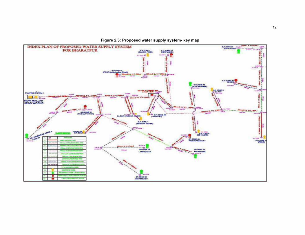
24. Treated water will be brought from the Mallah Head Work, through a transmission main (Saras Feeder) of 700/400 mm dia and a total length of about 5.75 km, and will feed the proposed CWR at the Company Bag CWR. Before connecting to this CWR, branches of the transmission mains are proposed to feed the proposed OHSR at Pushp Vatika and Krishna Nagar II and other existing OHSR at Krishnanagar and Police line. Branches will also feed the proposed PHED OHSRs of 4 nos. at Chandbai Ka Nangla, Mehndi bag, Laxminagar, Nadia farm. From the pump house at Company Bag, the water will be further pumped to various overhead reservoirs existing as well as to be constructed around town
6
through two feeders (Fort feeder and Tyonga Feeder). Fort feeder will feed water to two nos. proposed OHSRs at New Mandi and Fort-II, existing OHSRs at Gandhi Park and DD Nagar, and rising main up to the Surajmal Nagar OHSR proposed by PHED. Tyonga feeder will feed 4 nos existing of OHSRs viz. at Hospital, S.T.C, RICCO, and ITI and one no proposed OHSR under RUSDIP at CIIMCO and two nos. PHED proposed OHSRs at Ekta Vihar and Tyonga Village. The water from the OHSRs will be distributed to the households through the rehabilitated or newly constructed distribution network. The bulk meters will be provided at all supply points to measure the quantity of water supply and to enable system monitoring. Additional pumping machinery will increase the efficiency of the system and reduce the proportionate O & M cost. The existing sub-surface source will also be used in the system to meet the gap between the demand and the available surface water. Water from the tube wells yielding water with high Fluorides and TDS content will be blended with surface water to meet the potable water quality standard as per the Indian standards.
Enhanced Scope
25. Work of construction of pumping station at Mallah & Company Bag, Laying of rising main, construction of OHSRs (5 nos.) have already been considered in the approved sub-project of tranche-2 and the works under execution in Bharatpur Town. It is expected that the surface water from Mallah Treatment plant will be available to the town by 2011. However, the approved sub-project does not support any distribution system to be specifically developed in the town. At present there is some distribution system available in the town. It has become old and it seeks improvement, replacement and complete re-modelling. In some areas like Ranjeet Nagar, Krishi Upaj Mandi, Kumbher gate, there was shortage of storage capacity also and those were fed by ground water from Hiradas pump house. In this sub-project under Tranche-2 , these areas are now considered to be developed. However, it is sure that after source improvement (under execution with PHED) distribution system becomes the medium to Sharing of benefits to the consumers throughout the town. Detailed plan and commitment to guarantee the required water supply for Bharatpur is given in Annexure–II.
26. Scope and components of the works consist of the construction of OHSRs, , arrangement of machinery for pump houses, distribution mains, clear water main, procurement and installation of domestic water meters, etc., detailed as follows:
27. According to the Approved DPR the works have been taken up in Bharatpur Town. It is expected that the surface water from Mallah Treatment plant will be available to the town within the period of another three years say by 2013. The works such Rising mains pumping stations and leading mains and OHSRs have been taken up during that period. However, DPR does not support any distribution system to be specifically developed in the town. There is some distribution system available in the town. It has become old and it seeks improvement, replacement and complete remodelling. Reason for not taking the distribution system in the original DPR is mainly financial constraint. However, it is sure that after source improvement distribution system becomes the medium to contributing of benefits to the consumers.
28. To anticipate this problem a review of the more affected areas where the distribution of water has become a cognizable problem and it has become a point of worry to the maintenance staff were sorted out. More critical areas have been listed on priority. The areas which have been developed but the individual sources have not become reliable because of exploitation of underground resources have also been added in the list. The zones which are considered to enhanced the existing water supply situation have been listed as below,
• Cimco,

7
• Krishananagar,
• Pushpwatika,
• Fort,
• New Mandi
• Kumher gate,
• Krushi Upaj Mandi,
• Ranjeetnagar,
• ITI and
• Laxminagar
29. Out of the above, first five have the partial facilities available but they have been loaded unevenly so that the beneficiaries are not satisfied right from the February to July end every year. Frequency of disturbance has reached the peak. Available system would be insufficient to cater for required water rate even if the source has been replenished. Hence, it has been proposed to remodel the system and just ignore the old lines of smaller diameter. System adequacy was important for delivering the goods. These areas have been selected for complete reengineering and the OHSRs for the first five zones have been accounted for in the sub-project (Tr-2) under implementation. It has been proposed to update the distribution and the activity should run parallel to the construction of OHSRs.
30. In case of remaining five areas situation is slightly different. In this case the OHSRs are also proposed as the development in these areas is more than anticipated and present system is not able to do justice to the demands of these areas. Hence appropriate capacity OHSRs in these areas are proposed to be constructed. Initially the demands have been calculated and storage is decided relevant to about 27% of the daily demand. Distributions for four zones out of these five zones (Except ITI) are considered to be remodelled. The area of ITI zone is not so far populated and thus distribution not considered for this zone. But, PHED will look after for this work in later period.
31. Apart from the quantity of water which is found to be very inadequate there was a constant demand for the surface water. For Kumher gate, Krushi Upaj Mandi and Ranjeet Nagar, the water was supplied through Heradas Head works and the supply was mainly from the underground resources. In the summer there was a problem of inadequate and irregular water and the quality of water was not to the mark. Beneficiaries were constantly stressing for the surface water right from the time since there was talk of the surface water from the Chambal project.
32. Technically also Mallah water works and Heradas Pumping station could not remain disconnected for a long time. They are major components of the scheme old and new and their interconnection with a 600 mm diameter of the pipeline would be essential and proposed in this sub-project. Though the surface water has to come in the phases to the full requirement of the city’s demand of water advance interconnection would be helpful to use them to their full efficiency. Hence, the proposal has included the proposed 600 mm dia line from Mallah water treatment plant to Heradas pumping station. It will be used for improving further systems qualitatively and quantitatively.
33. In case of ITI there is an existing OHSR, which is very old. The structure remaining is not sound enough. Some of components have worn out and the reinforcement is open. It has no further reliability. Hence, it has been decided to replace the OHSR by a new OHSR and proposed in the project. Old Pumping machinery will also be proposed to be replaced. Existing pipe line may continue to be operative but the pumping machinery is proposed to be changed.

8
34. Fort, Pushpwatika, Krishnanagar, Kumher gate areas are much congested areas and facilities are required to be improved. Laxminagar is growing area and need to be provided with appropriate facility of water supply including the OHSR.
35. The proposed Sub-project is the balanced of the requirements of the sub-projects already approved under Tr-2 and under execution. Previously it envisaged that this sub-project will take care by the local body (PHED), but after discussion a lot with the local administration it decided to take care this sub-project under RUSDIP. This sub-project will satisfy the balance requirement to supply water @ 135 lpcd to the people. The Sub-project is also expected, inter alia, to reduce the Unaccounted For Water (UFW) by billing for the actual quantity of water supplied, since the house connections will be expanded to cover at least 90% of the town population with either new water meters or a rehabilitated water meters. Disinfections facilities in the form of chlorinator plants are already considered in the running sub-project. Ultimately the sub-project will introduce a better service level, will supply 135 lpcd treated water to the consumers.
36. Therefore, an improvement in the water supply system has been identified as a major priority by the City Level committee comprising of the major stakeholders.
37. Table 2.1 shows the nature and size of the various components of the subproject. There are two main elements: expansion/improvement of the distribution network; and reduction of non-revenue water (NRW). The descriptions shown in Table 2.1 are based on the present proposals, which are expected to be substantially correct, although certain details may change as development of the subproject progresses.
2.5 Associated Facilities:
38. Environmentally safe, continuous and reliable water sources and adequate capacity for treatment, transmission, and distribution, as well as properly functioning pumps, reservoirs, and networks are a must for RUIDP to mandate a safe water supply service to the local population. If the water is sourced through the aquifer for drinking water supply, it must be ensured that design extraction/pumping rate must be less than the documented aquifer recharge rate because excessive pumping of aquifers can lower groundwater levels in this water scarce state. In this subproject, the water is sourced from the Chambal River through the Chambal-Dholpur-Bharatpur Water Supply project of Public Health Engineering Department.
39. The source of water for this sub project is a Major Project being commissioned by Public Health Engineering Department (PHED) of Rajasthan designed to supply water to Dholpur – Bharatpur and other allied areas. They will be taking water from an intake on the river Chambal. The Chambal River and its adjacent area (1000m from the centre of the river) are protected as National Chambal Sanctuary. Figure 2.3. shows a map with the outline of the Chambal-Dholpur-Bharatpur Water Supply project.
40. The Chambal- Dholpur- Bharatpur Water Supply Project is designed to resolve the acute water crisis in the district of Dholpur and Bharatpur. The project will cover 69 villages in Dholpur district and 930 villages in Bharatpur district through 86 kilometers long pipeline. The completion of the project would provide momentum to the pace of development and also resolve the problem of salinity in underground water in the districts. The Keoladev Ghana National Park situated in Bharatpur will also started receiving the water from the PHED project which is facing the water problem. The Keoladev National Park is the habitat of migratory birds. The migration of the birds becomes limited since past few years due to drying up the water body in the national park. The water through the Chambal- Dholpur- Bharatpur Water Supply Project will revive the wildlife of the Keoladev National Park.

9
41. The stretch of the river Chambal from Keshoraipatan in Rajasthan to the Chambal-Yamuna confluence in Uttar Pradesh is protected as the National Chambal Sanctuary. The sanctuary is the habitat of two species of crocodilians – the Mugger and Gharial, and various other fauna. PHED had approached the relevant authorities and has obtained clearance from Ministry of Environment and Forest for the Chambal- Dholpur- Bharatpur Project issued vide Ministry of Environment and Forest letter Nos. 8 B/Raj./08/20/2010/FC/1208 dated 11-10-2011 (copy enclosed along with English translation in Annexure-V

10
Figure 2.1: Map showing the location of the project
11
Figure 2.2: Proposed water supply system at Bharatpur
12
Figure 2.3: Proposed water supply system- key map

13
Figure 2.4: Location of proposed water supply scheme shown in SOI toposheet

14
Table 2.1: Improvements in water supply infrastructure proposed in Bharatpur
Infrastructure Function Description Location
Earlier Scope
1. Source and Supply Augmentation
Transmission Main / Rising Main To collect pure water from WTP/CWR to the OHSR
17 km of 200 to 700 mm dia
Underground along the main roads of the Town
2. Expansion of Distribution Network
Overhead Reservoirs Increase water supply to regulate water supply
5 nos. of Over Head Reservoirs of capacity 850 KL to 1000 KL
Pockets of Government Owned land at different locations- At new Mandi, CIMCO, Pushpa vatika (all 850 KL) Krishnagar II at Fort (both 1350 KL)
Pipe laying Interconnection of 5 nos. proposed OHSR.
Provision for pipe laying of approximately 3.00 km length
At OHRSs location
Clear water reservoir Storage of Clean and treated water
1 no of capacity 2.625 ML
Government owned land available at company bagh
Pump replacement / Pumping Machinery Improve water supply and Pressure
Installation of new pumps at Chambal Bharatpur Dholpur project
Government owned land
Construction of Pump houses at Mallah Head work
Construction of Pump houses at Company Bag head work
Provision for 3 nos. (2+1) Pumps for Saras Feeder (212 lps, 42 m head) at Mallah Head work
15
Infrastructure Function Description Location
Provision for 2 nos. (1+1) Pumps for Fort Feeder (163 lps, 40 m head) at Company Bag head work
Provision for 2 nos. (1+1) Pumps for Tyonga Feeder (95 lps, 45 m head) Company Bag head work
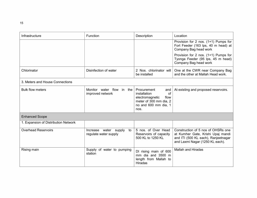
Chlorinator Disinfection of water 2 Nos. chlorinator will be installed
One at the CWR near Company Bag and the other at Mallah Head work.
3. Meters and House Connections
Bulk flow meters Monitor water flow in the improved network
Procurement and installation of electromagnetic flow meter of 300 mm dia, 2 no and 600 mm dia, 1 nos.
At existing and proposed reservoirs.
Enhanced Scope
1. Expansion of Distribution Network
Overhead Reservoirs Increase water supply to regulate water supply
5 nos. of Over Head Reservoirs of capacity 500 KL to 1250 KL
Construction of 5 nos of OHSRs one at Kumher Gate, Krishi Upaj mandi and ITI (500 KL each), Ranjeetnagar and Laxmi Nagar (1250 KL each).
Rising main Supply of water to pumping station
DI rising main of 600 mm dia and 3500 m length from Mallah to Hiradas
Mallah and Hiradas

16
Infrastructure Function Description Location
Clear water pumping main Interconnection of proposed OHSR.
DI pumping main of 250 mm to 350 mm dia and 3.2 km length is proposed from Hiradas pump house to proposed OHSRs at Kumher Gate, Krishi Upaj mandi and Ranjeetnagar
At OHRSs locations
Distribution System
Supply of water to proposed new area
Water from different pump houses will be fed to the OHSRs and then it will be distributed to different proposed zones of the town through uPVC pipe lines of 155 Km. and DI pipe of 1.3 Km
At Krishi Upaj Mandi, Kumbar gate, ITI, Ranjeetnagar and Laxmi nagar zone
Pump replacement / Pumping Machinery
Improve water supply and Pressure
Provision of Pumping machinery in Hiradas Pumping Station: Hiradas Pumping station is existing under use with PHED. Replacement of pumps in the existing pump house to feed OHSRs proposed at Kumher Gate, Krishi Upaj mandi and Ranjeetnagar. The capacities of pumps are of 48 lps at 32 m
Within the pumping station, Government owned land

17
Infrastructure Function Description Location
head.
2. Meters and House Connections
Bulk flow meters Monitor water flow in the improved network house supply
Procurement and installation of Provision of 12000 nos. of domestic meter has been taken in the sub-project.
At proposed new location

18
3 DESCRIPTION OF THE ENVIRONMENT
3.1 Physical Resources
3.1.1 Location
42. The Urban Agglomeration (UA) of Bharatpur is situated at the foothills of the Aravalli Mountain series and is strategically located between the most eastern part of the State. It forms boundaries with Gurgaon district of Haryana in the north and north–east. Mathura and Agra lies in the east. Dhaulpur district lies in its south and Sawai Madhopur, Dausa and Alwar district in the west. Bharatpur city is one of the Historical city of the Rajasthan state and it is also a Railway Junction. Historical monuments such as Keoladeo National Park, Lohagarh Fort or the “Iron Fort”, Government Museum, The Palace, Deeg ,Gopal Bhavan, Bengal Chamber, Suraj Bhavan ,Nand Bhavan ,Purana Mahal and Deeg Fort are some of the places of Tourist’s attractions. The ‘Eastern Gateway to Rajasthan’ was founded by Maharaja Surajmal in 1733 AD, it was once an impregnable well fortified city ,carved out of the region formerly known as Mewat .The trio of Bharatpur ,Deeg and Dholpur has played an important part in the history of Rajasthan. District map of Bharatpur is shown in Figure 3.1.
3.1.2 Topography, Natural hazard and Drought
43. Topography Bharatpur lies between the East longitude 76o 53’ to 78o 17’and North latitude 26o 22’ to 27o 83’. It is situated at 100 meters above MSL. The National Highway No.11 connecting Agra ,Jaipur and Bikaner passes through Bharatpur .Its total length within the District is about 71 Kms .The total Road length is about 1,985 Kms. Bharatpur lies in the north east of Rajasthan .It is gateway of Rajasthan .Typographically Bharatpur is levelled and saucer in shape .
44. Natural Hazards- Earthquake: Bharatpur town lies in medium to high risk zone (III and IV). The area is prone to earthquakes as it is located on comparatively unstable geological plains based on evaluation of the available earthquake zone information. Figure 3.2 depicts the earthquake zones of Rajasthan. Figure 3.3 shows natural hazard zones of the Bharatpur district.
45. Drought: Low rainfall coupled with erratic behavior of the monsoon in the State makes Rajasthan the most vulnerable to drought. Based upon the discussion with PHED officials the water table in the City continuously decreases by 1-2 meter on an annual basis combined with significant drawdown conditions.

19
19
Figure 3.1: District map of Bharatpur

20
Figure 3.2: Earthquake zones of Rajasthan
Figure 3.3: Natural Hazard map of Bharatpur (GSI Resource map)

21
21
3.1.3 Geology, geomorphology, mineral resources and soil
46. Bharatpur district is in eastern Rajasthan, bordering Uttar Pradesh, covers an area of 5066 km2. The district has ten tehsil, namely, Pahari, Kaman, Nagar, Dig, Kumher, Nadbai, Bharatpur, Wer, Bayana and Rupbas. The average annual rainfall is 577mm.
47. The rock types exposed are grouped under Alwar and Ajabgarh Groups belonging to the Delhi super group (Lower to Middle Proterozoic). The rocks of Alwar group comprising quartzite, basic volcanic tuffaceous sandstone, shale etc. are well exposed in the south-western part of the district around Khankhera. The Ajabagarh Group of rocks consisting of conglomerate are quartzites are exposed near Wer and around Dig and Kaman. The rocks of the Delhi Super group are succeeded by sandstone of the Bhander group which forms a part of the Vindhayan Super group (Upper Proterozoic). The rock of the Bhander Groupare well – exposed in southern and south-eastern parts of the district. The major parts of the district are occupied Quaternary alluvium and blown sand which conceal the hard rock geology. The area has been divided into two river basins, namely Barah river basin towards north and Banganga river basin towards south. Hydro-geological domains of unconsolidated and consolidated rocks formation with varying ground water potential.
48. Bayana dam site is an important irrigation project of the district. Natural hazards mainly ravenous area, water logged area, salinity prone area have also been depicted. Geomorphologically the district classified into seven geomorphic units namely hill and valley, younger flood plans, ravine, obstacle dunes and pediment / pedi-plain.
49. Mineral resources: Barytes, buildings atones quartz are the important minerals of the district. Barytes closely associated with the basic intrusive occurs in the rocks of the Delhi Super group. Barytes veins occur as fissure filling in quartzite. Occurrences are reported from Hatori (27°00’ :77°06’), Karwar (27°00’ :77°03’) etc. Small deposit of copper with an indicated reserve of 1 million tone with 1% Cu is located near Khankhera (26°55’ :77°08’). Minor occurrence of lead is reported from Jotri (27°35’ :76°58’). Quartz is available at many places in the district. Quartzite and sandstone are quarried at Bansi Paharpur (26°56 :77°03’), Dig (27°27’ :77°19’) etc. White spotted, reddish sandstone of the Bhander Group is in great demand as building Stone.
50. Geology and mineral map of the district is shown in Figure 3,4 and geomorpholigal map of the district is depicted in Figure 3.5.

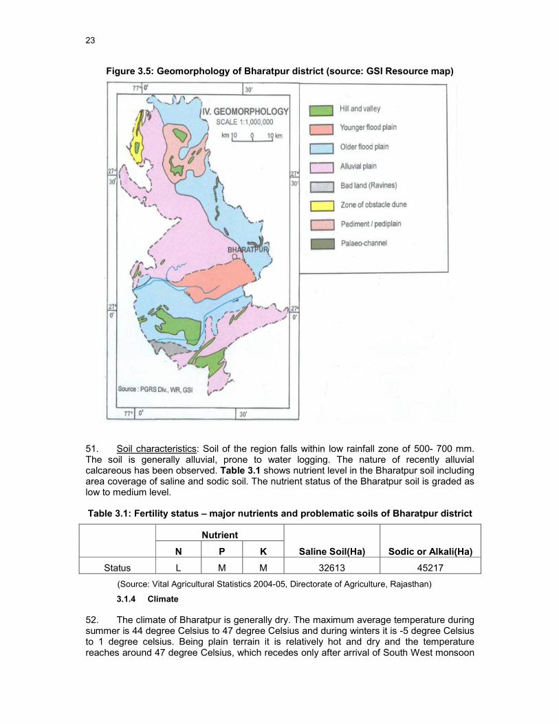
23
Figure 3.5: Geomorphology of Bharatpur district (source: GSI Resource map)
51. Soil characteristics: Soil of the region falls within low rainfall zone of 500- 700 mm. The soil is generally alluvial, prone to water logging. The nature of recently alluvial calcareous has been observed. Table 3.1 shows nutrient level in the Bharatpur soil including area coverage of saline and sodic soil. The nutrient status of the Bharatpur soil is graded as low to medium level.
Table 3.1: Fertility status – major nutrients and problematic soils of Bharatpur district
Nutrient
Saline Soil(Ha) Sodic or Alkali(Ha) N P K
Status L M M 32613 45217
(Source: Vital Agricultural Statistics 2004-05, Directorate of Agriculture, Rajasthan)
3.1.4 Climate
52. The climate of Bharatpur is generally dry. The maximum average temperature during summer is 44 degree Celsius to 47 degree Celsius and during winters it is -5 degree Celsius to 1 degree celsius. Being plain terrain it is relatively hot and dry and the temperature reaches around 47 degree Celsius, which recedes only after arrival of South West monsoon

24
towards June end. With departure of monsoon in mid September, the temperature gradually rises again and falls steeply from November .The climate is generally dry. The wind blows at low except during summer and monsoon when hard and turbulent winds are experienced .Winds blow South West to North East in summer and winter experience northern and North West winds. The average rainfall is 646 mm. 80-90 percent of the annual rains is experienced during June to September. The maximum rainfall was experienced in 1996 and 2006.
53. The rainfall over Bharatpur is scanty and is concentrated over four month i.e. from June to September. The rains are erratic and so is the distribution of the rainfall. However agriculture and the animal wealth are dependent on rains to large extent. Seasonal Rainfall data for the recent year (2007) is shown in Table 3.2. Figure 3.6 shows yearly variation (1997-2007) of rainfall at Bharatpur.
Table 3.2: Rainfall at Bharatpur in recent years (2007-2008)
S.No. Months Rainfall (mm)
1 January 0.0 2 February 36.0 3 March 37.0 4 April 0.0 5 May 36.0 6 June 155.0 7 July 88.0 8 August 81.0 9 September 106.0 10 October 0.0 11 November 0.0 12 December 0.0 13 Monsoon Rainfall 430.0
14 Non monsoon rainfall 109.00
15 Annual Rainfall 539.00
(Source: Website Govt. of Rajasthan, 2009)
Figure 3.6: Rainfall at Bharatpur during 1997 to 2007
(Source: Deputy Director hydrology water resources ID and R, Jaipur)
25
3.1.5 Air Quality
54. Ambient Air Quality Monitoring was carried out at various locations in Bharatpur town in April 2012. The results of air quality monitoring are shown below in Table 3.3. It may be observed from the Table 3.3 that levels of particulate matter (particle size ≤10µm) at all of the locations are higher than the standards. Traffic is the only significant source of pollutant in Bharatpur so levels of oxides of sulphur and nitrogen are within the National Ambient Air Quality Standards (NAAQS).
Table 3.3: Ambient Air Quality in Alwar (Annual Average, 2004- 2005 and 2006-2007; units in µg/m3)
Monitoring Station PM2.5 PM10 NO2 SO2 CO
Malah Pump House 54.1 128.5 20.2 11.5 0.5
Company Bagh Pump House 52.4 117.6 18.9 11.1 0.5
PHED Pump House (Nr. Hiradas B.S)
77.3 213.2 20.2 11.2 0.5
NAAQ Standard 60 100 80 80 2*, 4#
RSPM: Respirable Suspended Particulate Matter; SPM: Suspended Particulate Matter
Source: Onsite Monitoring done by RUSDIP
3.1.6 Surface Water Availability
55. 44. There is no secondary data of river water quality available. But it is expected that water quality is only deteriorate during monsoon due to TSS load. Due to high temperature at summer most of the surface water sources become dried.
56. 45. The past trend of the flow of the river Chambal is summarized in the table below. It may be observed from the data that water discharge of the river falls at minimum level in the month of May-June and rises at maximum level in July-September.
Table 3.4: Observed minimum and maximum flows in river Chambal at Dholpur Intake
SN Year Date Level Discharge Date Level Discharge
Maximum Minimum
1 1976 10.09.76 140.18 13,670.84 02.06.76 118.58 48.98
2 1977 19.09.77 141.55 45,200.00 10.05.77 118.81 104.04
3 1978 02.09.78 139.90 25,683.53 11.06.78 118.78 84.96
4 1979 16.07.79 129.18 6,160.00 07.06.79 119.55 50.95
5 1980 07.08.80 135.45 18,224.29 05.05.80 119.16 35.35
6 1981 21.07.81 134.80 19,707.00 20.06.81 119.04 30.02
7 1982 25.08.82 145.37 58,552.96 05.03.82 118.96 82.65
8 1983 22.08.83 130.02 7,247.36 04.05.83 119.12 94.38
9 1984 21.08.84 136.20 20,979.00 16.05.84 119.13 72.80

26
SN Year Date Level Discharge Date Level Discharge
Maximum Minimum
10 1985 11.08.85 136.15 19,950.00 29.04.85 119.09 41.23
11 1986 29.07.86 141.60 37,600.00 31.05.86 119.02 32.43
12 1987 02.09.87 133.34 16,085.34 25.05.86 119.74 68.73
13 1988 7.08.88 131.75 7,717.94 14.06.88 119.52 65.03
14 1989 29.08.89 127.27 7,882.14 17.05.89 119.33 37.70
15 1990 5.07.90 128.45 9,439.82 06.06.90 119.12 57.63
16 1991 26.08.91 139.66 20,079.63 03.06.91 119.41 58.26
17 1992 19.08.92 131.50 8,737.84 04.06.92 120.02 59.56
18 1993 07.08.93 132.15 9,056.73 08.06.93 119.85 20.92
19 1994 09.09.94 130.08 10,320.00 18.05.94 120.11 63.00
20 1995 05.09.95 134.22 17,205.00 02.06.95 119.30 32.26
21 1996 22.08.96 145.54 NA 22.04.96 120.20 32.87
22 1997 09.08.97 133.66 9,785.99 16.05.97 120.30 82.17
23 1998 16.07.98 129.60 6,817.7 15.04.98 120.30 94.00
24 1999 26.07.99 134.71 16,031.04 03.06.99 119.95 57.91
25 2000 21.07.00 132.55 12,990.77 19.05.00 119.71 48.74
26 2001 04.07.01 135.01 15,939.00 16.05.01 119.50 29.00
27 2002 04.09.02 124.56 2,394.00 05.12.02 119.6 6.6
28 2003 01.09.03 127.29 5,141.00 19.05.02 119.34 4.380
29 2004 26.08.04 137.05 22,343.00 15.06.04 119.42 6.890
30 2005 16.07.05 131.12 5,121.00 22.06.05 119.51 11.13
31 2006 03.09.06 141.5 33,748.00 29.05.06 120.52 24.4
32 2007 11.07.07 128.67 7,281.00 03.05.07 119.8 49.0
33 2008 12.07.08 125.63 5,125.00 04.06.08 119.52 8.34
34 2009 26.07.09 125.94 4,144.00 13.06.09 119.32 7.76
35 2010 24.08.10 123.28 1,647.00 09.06.10 119.34 2.0
36 2011 10.08.11 134.69 19,400.00 10.06.11 119.27 5.89
Note: Reproduced data of Central Water Commission (CWC) collected from Chambal Dholpur Bharatpur Project (CDBP) office Bharatpur. Level in meters above sea level and Discharge in m
3/second (Cumecs). The monitoring station of
CWC is near PHED intake well in Dholpur (just upstream, near the National Highway bridge).
3.1.7 Geohydrology and Groundwater
57. Geohydrological map of the Bharatpur district is shown in Figure 3.7. For broadly grouping geological formations from ground water occurrence and movement

27
considerations, the various lithological units have been classified into two groups on the basis of their degree of consolidation and related parameters. These are,
• Unconsolidated porous, quaternary formation
• Fissured formations – consolidated sedimentary rocks.
58. On an average 90 % of the district area covered with unconsolidated porous formations.
Figure 3.7: Geohydrological map of Bharatpur (Source: GSI Resource map)
59. There are number of National Hydrographic monitoring stations of Central Ground Water Board in and around Bharatpur. Fluctuation of ground water level is shown in Table 3.5. In most of the cases ground water table ranged between 5 - 10 m bgl.
Table 3.5: Number and Percentage of National Hydograph Network Station (Bharatpur) with water fluctuation range
Period No of wells
analysed
Rang 0-2 m 2-5 m 5-10m 10-20m 20-60m >60 m
Min Max No. % No. % No. % No. % No. % No. %
Jan-06 44 4 21.83 0 0 4 9.09 21 47.73 18 40.91 1 2.27 0 0

28
Period No of wells
analysed
Rang 0-2 m 2-5 m 5-10m 10-20m 20-60m >60 m
Nov05 40 2.84 20.07 0 0 10 25 16 40 13 32.5 1 2.5 0 0
Aug05 40 2.07 20.09 0 0 9 22.5 18 45 12 30 1 2.5 0 0
May05 39 4.12 21.44 0 0 7 17.95 19 48.72 12 30.77 1 2.56 0 0
Source: Ground water year book 2005-06 Rajasthan, Central Ground Water Board, Jaipur (2007-08)
60. The Central Ground Water Board carried out chemical testing of tube well water seasonally. The average concentrations of major constituents are shown in Table 3.6.
Table 3.6: Ground Water Quality in and around Bharatpur
Parameters Maximum Level
Minimum Level
Standard of Drinking water (IS: 10500: 1991)
Desirable limit (mg/l)
Maximum Permissible limit
(mg/l)
pH 9.2 7.46 EC (micro-
mhos/cm at 25 °C)
9710 235
Cl (mg/l) 2517 14 250 1000 SO4(mg/l) 2860 5 200 400 (if Mg does not
exceeds 30 ppm) NO3(mg/l) 711 0 - 100 PO4(mg/l) 1.83 0
Total Hardness(mg/l)
2150 20 300 600
Ca(mg/l) 388 8 75 200 Mg(mg/l) 445 9.7 30 100 Na(mg/l) 2162 8 - - K(mg/l) 917 0 - - F(mg/l) 8.59 0.21 1.0 1.5
Fe(mg/l) 5.7 0 0.3 1.0 SiO2(mg/l) 48 18 TDS (mg/l) 6312 153 500 2000
Note: Total – 35 nos. samples
Source: Ground water year book 2006-07 Rajasthan, Central Ground Water Board, Jaipur (2008-09)
61. As per PHED underground water in Bharatpur city and nearby area is having a high dissolve solid. Thus a major water supply project from river Chambal costing Rs. 500 Crore has prepared ,this project has plan to implement in two phases, phase I part I of this project costing Rs.166.50 Crores was sanctioned in the year 1999. Under this part 212 villages of Dholpur and Bharatpur district (enroot or having high salinity) and design population year 2016 of Bharatpur town is targeted to be benefited providing service level of 135 lpcd. Comparison of water quality from Ground water and Surface water is given in Table 3.7.
Table 3.7: Comparison of Water Quality
Source TDS Chlorides Fluorides Nitrate PH
29
Source TDS Chlorides Fluorides Nitrate PH
Ground water (Bund Baretha)
175 20 5 7 7.1
Tube well (STC) 1583 350 0.54 12 7.3 Tube well DD
Nagar 2111 630 0.12 10 7.7
Source –PHED 2009, all values in mg/l except pH.
62. The quality of ground water supply within the municipal limit and surrounding vicinity is not good and potable. At present the only treatment is done by PHED is through one Treatment Plant which is having the capacity of Treatment 10.8 MLD.
3.2 Ecological Resources
3.2.1 Focus of study and introduction
63. The works for the RUSDIP water supply subproject itself in Bharatpur town are not expected to have large impacts on the ecological resources of the region as the National Chambal Sanctuary is more than 90 km from the town. The use of water from the National Chambal Sanctuary for the subproject is the focus of study regarding the ecological impacts. Therefore, in this chapter of baseline description of the environment, the focus is on the aquatic life in the Chambal River.
64. The National Chambal Sanctuary is also known as National Chambal Gharial Wildlife Sanctuary. A 600 km stretch of the Chambal River, between Jawahar Sagar Dam (Rajasthan) and Panchhnada (Uttar Pradesh), has been declared as the National Chambal Sanctuary primarily for the conservation of gharial and associated aquatic fauna. The Sanctuary is managed by the Rajasthan, Madhya Pradesh and Uttar Pradesh Forest Departments. The width of the river and the 1000m from the centre of the river along the Chambal is protected as the sanctuary in Rajasthan and Madhya Pradesh. (Figure 2.6)
65. The sanctuary is the habitat of some important species. It has the largest remaining Gharial population (Gavialis gangeticus). This is a critically endangered species. Another critically endangered species which lives in the Chambal River is the red-crowned roofed turtle. The river is also the habitat of the Gangetic dolphin (Platanista gangetica). Apart from the gharial, the red-crowned roofed turtle and the Gangetic dolphin, the major fauna of the Chambal River includes the mugger crocodile (Crocodylus palustris), smooth coated otter (Lutra perspicillata), other species of freshwater turtles, and 78 species of wetland birds.
3.2.2 Protected aquatic fauna in the Chambal River
66. The following table summarizes the most relevant protected aquatic fauna found in the Chambal River and its protection status according to the IUCN Red List.
Table 3.8: Protected aquatic fauna in Chambal River
Sl. No.
Scientific Name Common and local names Conservation Status (IUCN)
1 Gavialis gangeticus Gharial Critically Endangered
2 Batagur kachuga Sal - Red crowned roofed turtle Critically Endangered
3 Platanista gangetica Ganges River Dolphin Endangered

30
4 Batagur dhongoka Dhond – Three striped roofed turtle Endangered
5 Chitra indica Sivtar – Narrow-headed softshell turtle Endangered
6 Hardella thurjii Bhima – Crowned river turtle Vulnerable
7 Crocodylus palustris Mugger crocodile Vulnerable
8 Lutrogale perspicillata Fresh water Otter Vulnerable
9 Nilssonia gangetica Pathal – Indian Softshell Turtle Vulnerable
10 Pangshura tentoria
Pacheda – Indian Tent Turtle Lower risk/least concern
11 Lissemys punctate Sundari – Indian Flapshell Turtle Lower risk / least concern
67. The gharial (Gavialis gangeticus gmelin, 1789) is endemic to the Indian subcontinent occurring in the Indus, Ganges, Brahmaputra and the Mahanadi River systems [ref. d, f, g]. The gharial, once widespread, is now listed as ‘Critically Endangered’ in the IUCN Red List. By 2006, the total breeding population was estimated to be around 200 individuals [ref. i]. IUCN has estimated that there were 436 breeding adults in 1997 in total; they claim that this number has declined to just 182 by 2006. This is a reduction of 58% over the last ten years [ref. c]. In the last 60 years, it is estimated that as much as to 98% of its population has declined [ref. p]. A decline of 40% between 1997 and 2007 is mentioned [ref. e].
68. IUCN justifies the listing as “critically endangered” as follows [ref. c]. IUCN’s criterion A fits the species: “A reduction in population size based on an observed, estimated, inferred or suspected population size reduction of ≥80% over the last 10 years or three generations, whichever is the longer, where the reduction or its causes may not have ceased OR may not be understood OR may not be reversible", based on an index of abundance appropriate to the taxon and a decline in area of occupancy, extent of occurrence and/or quality of habitat. Very conservative estimates of population decline over a three-generation period (from 1946 to 2006) indicate there has been a 96 to 98% population decline, and the once widespread population has been reduced to a very small number of widely spaced subpopulations. The species is also considered critically endangered on the grounds of IUCN’s criterion C: “Population size estimated to number fewer than 250 mature individuals and an estimated continuing decline of at least 25% within three years or one generation". Estimates of adult population size indicate that there has been a decline from 436 adult gharials in 1997 to 182 in 2006. This represents a 58% drop across its range over a period of nine years, well within the span of one generation. More information can be found on http://www.iucnredlist.org/details/8966/0.
69. The Chambal River holds the largest breeding subpopulation of gharial, with an estimated 48% of its total adult population [ref. p]. The river holds between 48 % and 85% of the global population [ref. i]. It is believed the gharial is now extinct from Myanmar, Bhutan and Pakistan. In Bangladesh, fewer than 20 individuals may be present [Groombridge, 1987, in ref. p].
70. The drastic decline in the last 60 years is attributed to a variety of causes, including hunting, egg collection for consumption, killing for indigenous medicine and mortality in fishing nets. New threats of loss of habitat are the construction of dams, barrages, irrigation canals, which leads to a reduction in water flow; siltation, changes in the river course, artificial embankments, sand-mining and riparian agriculture, which leads to a decrease in

31
available nesting beaches [ref. e, i, p]. This loss of riverine habitat not only leads to a decline of the gharial, but also of other riverine species such as the species described in more detail below.
71. Regarding their preferred habitat the following is known. The gharial prefers sandy parts of river banks and sand bars for basking. Rocky riverbanks and rocky outcrops are less preferred. Juvenile gharials <120 cm and 120-180 cm prefer water depths of 1-3 m and 2-3 m, respectively. Adults prefer water depths of more than 4 m. [ref. e].
72. The Chambal River is believed to be one of the last viable habitats for the Red-crowned roofed turtle (Batagur kachuga). This species are also listed as critically endangered and are rarely found. Recent annual nesting surveys indicate fewer than 400 adults females are remaining in the wild [ref. o].
73. The red-crowned roofed turtle is Critically Endangered because it is facing an extremely high risk of extinction in the wild in the immediate future. For the Red-crowned roofed turtle, IUCN has classified it as critically endangered on the ground of criteria A1cd: “A population reduction in the form of an observed, estimated, inferred or suspected reduction of at least 80% over the last 10 years or three generations, whichever is the longer, based on a decline in area of occupancy, extent of occurrence and/or quality of habitat; and actual or potential levels of exploitation [ref. a]. More details can be found at (http://www.iucnredlist.org/details/10949/0.
74. Their habitat consists of deep flowing rivers with terrestrial nest sites. Around the intake site, the river depth ranges between approximately 3.5 m in the lean season to 15 m in the monsoon. See the data in Table 3.7. No sightings of the red-crowned roofed turtle have been reported around the intake site recently by forestry officials.
75. The Gangetic dolphin (Platanista gangetica) is distributed in the northern parts of the Indian sub-continent and inhabits the Ganges, Brahmaputra and the Meghna river system and their major tributaries. Once abundant, its population is now declining all over its range due to habitat loss, commercial exploitation and mortality in passive fishery [ref. k, m]. Apart from these, construction of dams and barrages along the major tributaries has isolated its population into several pockets thereby making these isolated populations vulnerable [ref. h]. In recent years the Gangetic dolphin is receiving considerable attention as it has been declared as The National aquatic species of India. It is listed as Schedule I species under Indian Wildlife (Protection) Act, 1972 and as ‘endangered’ according to IUCN [ref. n].
76. With regard to the preferred habitat of the dolphin, the river dolphins are generally concentrated in counter-current pools below channel convergences and sharp meanders and above and below mid-channel islands. Annual monsoon-driven floods cause great variability in the dolphins’ access to large parts of their range. Isolation in seasonal lakes or deep river channels sometimes occurs, as does "escapement" from the rivers into canals and reservoirs. Deltaic (brackish) waters are a component of the total range, but Ganges dolphins are not generally known to occur in salinities greater than 10 ppt. [ref. n].
77. Considerable effort has been made to document the status of Platanista gangetica since the early 1970s, yet rigorous quantitative data on numbers, mortality, extent of occurrence, and area of occupancy are still lacking for much of the species’ range, especially in India and Bangladesh. The diversity and scale of threats – recent, ongoing, and projected – have generally outpaced effort at documentation. Moreover, it is important to bear in mind that this species is the sole living representative of its family (which represents an ancient lineage in the order Cetartiodactyla), and therefore its extinction would mean the loss of more than just a single species. [ref. n].
32
78. Applying precautionary reasoning to the evidence available, the species qualifies for listing as Endangered. IUCN’s subcriterion A2 applies because a population size reduction of more than 50% since 1944 is inferred and suspected, given that nearly all of the critical dam and barrage construction associated with the large-scale decline in the area of occupancy of both subspecies has occurred since that time. Moreover, the reduction and its causes have not ceased (more barrages are planned and under construction, habitat quality is expected to deteriorate further, and mortality from hunting and net entanglement continue), are not fully understood, and may not be reversible.
79. The Chambal River has a fluctuating population of dolphins with the density varying between 0.147 to 0.386 dolphins/river km. A recent study [ref. b] reports of a survey of 75 km of Chambal River for the presence of the river dolphin. They count only 0.09 dolphins per kilometer and these dolphins tend to cluster at locations with good river depth and meandering. According to this study, a minimum water depth of at least 5.2 m is required. Around the intake site, the river depth ranges between approximately 3.5 m in the lean season to 15 m in the monsoon. See the data in Table 3.7. Approximately 2 km upstream of the intake river dolphins are present. There is a tourist boat service available from the opposite bank of the intake site to spot dolphins at this spot 2 km upstream. See the photo in Annexure I.
3.2.3 Other flora and fauna in the National Chambal
80. Apart from the above mentioned protected aquatic fauna in the Chambal River, the following table summarizes the flora and fauna found in National Chambal Gharial wildlife Sanctuary [ref. m]
Table 3.9: other flora and fauna in the National Chambal Sanctuary
Sl. No.
Scientific Name Local Name Conservation Status
Aquatic Flora
1 Hydrilla verticillata Kureli Common
2 Chara spp. - Common
3 Vallisneria spiralis - Common
4 Tamarist Spp. - Common
5 Prosopis juliflora - Common
6 Potamogeton spp. - Common
7 Imperatatypha spp. - Common
8 Zaminchella spp. - Common
Terrestrial Flora
1 Acacia nilotica Babul Common
2 Acacia leucophloea Safed kikkar Common
3 Acacia catechu Khair Common

33
4 P. spicigera/ Prosopis cineraria
Janti Common
5 Albizia lebbeck Siris Common
6 Grewia optiva Behel Common
7 Anogeissus pendula Dhaura Common
8 Dalbergia sisoo Shisham Common
9 Ziziphus mauritiana Baer Common
10 Z. fruiticosa - Common
11 Salvadora persica Kharjal Common
12 Capparis decidua Karel Common
13 Capparis sepiaria Kanthari Common
14 Calotropis Aak Common
15 Giganteam opaca - Common
16 Carissa opaca Karounda Common
17 Tamarix dioica - Dominated
Annual Grasses
1 Aristida adscensionis Sixweeks threeawn Common
2 A . hystrix - Common
3 Dactyloctenium aegyptium Makra Common
4 Eragrostis - Common
5 Viscose - Common
6 Setariglauca mutica - Common
7 Apluda mutica Tachula Common
Perennials Grasses
1 Bothrichloa pertysa - Common
2 Census Ciliaris - Common
3 C. setigeus - Common
4 Eremopogon foveolatus - Common
5 Sporobolus marginatus - Common

34
6 Cymbopogn jwarancusa - Common
7 Cynodon dactylon Doob Common
8 Saccharum spontaneum Kaans Common
9 Saccharum munja Sarkanda Common
10 Sclinna nervosum - Common
11 Heteropogon contortus - Common
Herbs
1 Cassia occidentalis Bari Kasondi Common
2 Cassia tora Chakunda Common
3 Desmodium triflorum Motha Common
4 Xanthium stramonium - Common
Terrestrial Fauna
1 Hyaenidae Hyena Near threatened
2 Acinonyx jubatus Cheetah Vulnerable
3 Canis aureus Common Jackal Lower risk / least concern
4 Rusa unicolor Sambhar Vulnerable
5 Caracal caracal Caracal – desert lynx Lower risk / least concern
6 Gazella bennettii Chinkara – Indian Gazelle Lower risk / least concern
7 Boselaphus tragocamelus Nilgai Lower risk / least concern
8 Varanus bengalensis Common Indian Monitor lizard Lower risk / least concern
9 Herpestidae spp.(javanicus, edwardsii)
Mongoose (Small Indian or Indian Grey Mongoose)
Lower risk / least concern
Avi Fauna
1 Netta rufina Pochards Least Concern
2 Phalacrocorax [carbo or lucidus] great cormorant
Large cormorants Least Concern
3 Anser indicus Burheaded gosse Least Concern
4 Tadorna ferruginea Brahimini ducks Least Concern
5 Anas crecca Common teals Least Concern
35
6 Anas acuta
Pin tails Least Concern
7 Heron Butorides striatus
Little green bittern Not assessed in IUCN Redlist
8 Ciconia nigra Black stork Least Concern
9 Chroicocephalus ridibundus Black head gull Not assessed in IUCN Redlist
10 Motacilla cinerea Grey wagtail Least Concern
11 Grus antigone Sarus Crane Vulnerable
81. Bharatpur Bird Sanctuary- Famous Bharatpur Bird Sanctuary is located in Bharatpur. Salient features of the famous sanctuary are discussed below.
Main attraction- Sambar, Chital, Nilgai, Boar, Migratory Birds
Area covered – 29 sq. km.
Location of Bharatpur Bird Sanctuary- One of the finest bird sanctuaries in the world, Bharatpur Bird Sanctuary is a reserve that offers protection to faunal species as well. The Bharatpur Bird Sanctuary, also known as the Keoladeo Ghana National Park is a distance of 2 km from the Bhartapur town in Rajasthan India.
The recent name Keoladeo, given to the Bharatpur Sanctuary is the name derived from an ancient Hindu temple, devoted to Lord Shiva, which stands at the centre of the park. The famous Bharatput Wildlife sanctuary is also known as the Ghana Wildlife Santuary. 'Ghana' means dense, referring to the thick forest, which used to cover the area.
Bharatpur the man made world - Keoladeo Wildlife Sanctuary, popularly known as Bharatpur Wildlife Sanctuary, is perhaps the only wildlife preserve, where the wildlife habitat has been created by a man - the Maharaja of Bharatpur. In earlier times, Bharatpur town used to be flooded regularly every monsoon. In year 1760, an earthen dam (Ajan Dam) was built, to save the town, from this yearly vagary of the nature. The cavity created by removal of soil for the dam was cleared and the Bharatpur Lake was formed.
At the commencement of this century, the lake was developed, and was divided into several sections. A system of small dams, dykes, sluice gates, etc., was created to control water level in different parts. This became the hunting preserve of the Bharatpur royalty, and one of the best duck shooting wetlands in the world.
The Ecological System in the Bharatpur Bird Sanctuary
The Flora in the Bharatpur Bird Sanctuary-
The Bharatpur Bird Sanctuary has a dense forest cover, which shelters a diverse flora. The vast flora is responsible in providing natural habitat to these migratory birds and also haven of free natural perpetuation. The diverse plant species found here is a real exception to the region.
Avifauna in the Bharatpur Bird Sanctuary-
More than 300 species of birds are found in this small wildlife park of 29 sq-km of which 11 sq-km are marshes and the rest is scrubland and grassland. Migratory birds at Bharatpur bird sanctuary include, several species of Sarus Cranes, Pelicans, Geese, Grey Heron,

36
Ducks, Eagles, Brown long eared bat, Hawks, Shanks, Stints, Garganey Teal, Wagtails, Warblers, Wheatears, Flycatchers, Buntings, Larks and Pipits, etc.
The Fauna in the Bharatpur Bird Sanctuary-
The Bharatpur Bird Sanctuary is also inhabited by Sambar, Chital, Nilgai and Boar. The subproject boundary is about 300 Mtr from bird centaury/ national park of Bharatpur. None of the subproject is falling within the Buffer Zone/ Core Zone of National Park and centaury. There is no ASI or UNESCO site comes under this sub-project.
3.3 Economic Development
82. Economic base of a town reflects its prosperity. Bharatpur being district headquarter, has been functioning as administrative city with sustained growth in tertiary economic activities. The major economic activities are trade and commerce , thus it offers a number of wholesale and retail markets which acts as a distribution center for nearby towns and villages .Tourism income contributes very much towards economic generation of the town on the contrary household industries play a big role in providing employment and income generation. As per the master plan new town centers and community centers have been proposed. The town has look of business-hub indicating fast growth. Bharatpur District is known not only for Agriculture production but for oil industries also .Occupational structure of the Bharatpur town in year 2001 is given in Table 3.10.
Table 3.10: Occupational Structure of Bharatpur in 2001
Sl No. Occupation No.of Persons Engaged
% age of Total Workers
1 Agriculture & Allied Activities 2601 4.75 2 Industry 12876 23.50 3 Construction 3836 7.00 4 Trading 12328 22.50 5 Transportation &
Communication 5068 9.25
6 Other Services 18080 33.00 Total 54789 100.00
Source –Bharatpur Statistical Outline
83. The Spatial Growth of the Bharatpur town was constant for the last three decades but as per census 2001 it has increased slightly as shown in (Table 3.11).
Table 3.11: Spatial Growth in Bharatpur Town.
Year Area in Sq.Km.
1961 51.41 1971 51.41 1981 51.41 1991 51.41 2001 56.14
Source: Statistical Department, Census 2001
84. Bharatpur is highest producer of Millet, Wheat, Corn, Barley, Gram, Oil Seeds ,Cotton, Sugarcane and Rice The main sources of drinking water in Bharatpur is Irrigation Dam Bundh Baretha and deep Tube wells at village Mandoli. This place is potentially rich in mineral resources .Masonry stone deposits are in abundance, which feed several industries. The sand stone and slate stone used are of good quality and are absorbed throughout the

37
state. The silica deposits have facilitated establishment of industries in Bharatpur. Production of these minerals is giving a lot of income to the state Government of Rajasthan as shown in the Table 3.12
Table 3.12: Production and Income of Minerals
Sl No. Name of Minerals
Production (Tonnes) Income (Rupees)
1 Silica Sand 5132 564520 2 Quartz 60 6000 3 Masonry Stone 123449 4397960 4 Sand Stone 21508 4125120 5 Mill Stone 707 91910 6 Slate Stone 424 55120
Source –Statistical Department, Govt. of Rajasthan
85. This moderate growth of the town has resulted in many problems like gap between the demand and supply of basic infrastructure and amenities. The haphazard and unplanned growth of town has disturbed the circulation system, drainage system and sewerage system. Thus, today drainage and sewerage has become the most pressing problem of the town. The existing drains remain flooded and have become insufficient to carryout the drainage load today. During rainy season these drains are over flooded with water and lead to water logging in areas like Pahari ,Deeg ,Rupbas and Bayana .
86. Power status of the area: There is no power generating unit at Bharatpur. The consumption of electricity by different sectors is shown in Table below.
Table 3.13: Consumption of Electricity in Million Kwh (2003-04 and 2004-05)
District Domestic Non- Domestic (Commercial)
Industrial Public Lighting
Public Water Works Small Medium Large
Bharatpur (2003-04)
61.29 15.632 11.33 14.791 37.76 1.728 10.646
Bharatpur (2004-05)
69.64 17.52 12.64 17.14 47.68 1.966 12.495
(Source: Statistical Abstract, Rajasthan 2009)
3.3.1 Land use
87. Bharatpur District spreads over an area of 5,066 sq.kms. covering urbanization area circulation, public and semi-public, agriculture land etc. water bodies, Fort , agriculture research and mining .The Percentage of residential area is quite more in Bharatpur due to slow development of dense residential units .This is only 69% of total developed area .Being the District Headquarter Percentage land use of Government and Semi Government is 2% and for Recreation is 1% .Railway is having sufficient land under their use and the Regional major Roads are crossing through this town ,15% of total developed area is under the use of Circulation. For Commercial and Industrial purposes land use is respectively 2.50 % & 4.50% .Following table shows the Existing land use pattern of year 2001 (Table 3.14). Figure 3.9 shows the land use percentage of the Bharatpur developed area. Figure 3.8 shown land use of the Bharatpur district.
Table 3.14; Existing Land Use Bharatpur
Sl No. Land Use % age of Developed Area

38
Sl No. Land Use % age of Developed Area
1 Circulation 15 2 Public & Semi Public 6 3 Recreational 1 4 Governmental 2 5 Industrial 4.5 6 Commercial 2.5 7 Residential 69
Source – Town Planning Department
Figure 3.8: Land use proportion for Bharatpur Developed area
Land Use Bharatpur
15% 6%
1%
2%
5%
3%68%
Circulation
Public & Semi Public
Recreational
Governmental
Industrial
Commercial
Residential
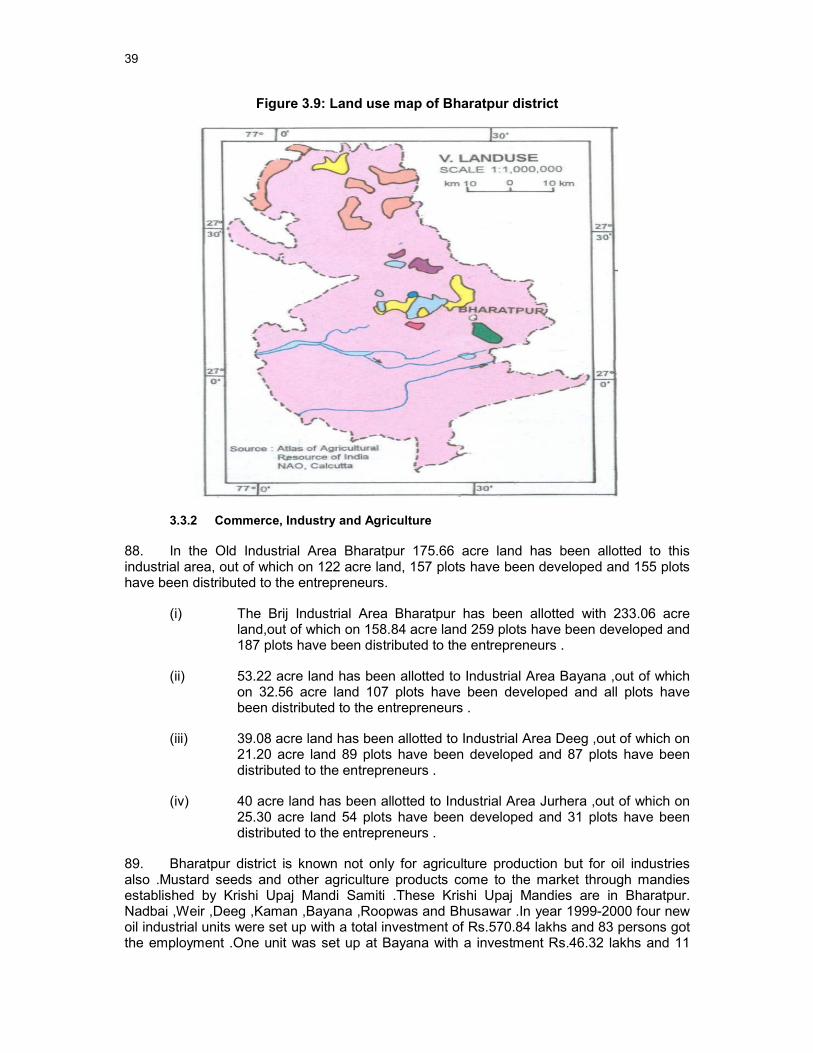
39
Figure 3.9: Land use map of Bharatpur district
3.3.2 Commerce, Industry and Agriculture
88. In the Old Industrial Area Bharatpur 175.66 acre land has been allotted to this industrial area, out of which on 122 acre land, 157 plots have been developed and 155 plots have been distributed to the entrepreneurs.
(i) The Brij Industrial Area Bharatpur has been allotted with 233.06 acre land,out of which on 158.84 acre land 259 plots have been developed and 187 plots have been distributed to the entrepreneurs .
(ii) 53.22 acre land has been allotted to Industrial Area Bayana ,out of which on 32.56 acre land 107 plots have been developed and all plots have been distributed to the entrepreneurs .
(iii) 39.08 acre land has been allotted to Industrial Area Deeg ,out of which on 21.20 acre land 89 plots have been developed and 87 plots have been distributed to the entrepreneurs .
(iv) 40 acre land has been allotted to Industrial Area Jurhera ,out of which on 25.30 acre land 54 plots have been developed and 31 plots have been distributed to the entrepreneurs .
89. Bharatpur district is known not only for agriculture production but for oil industries also .Mustard seeds and other agriculture products come to the market through mandies established by Krishi Upaj Mandi Samiti .These Krishi Upaj Mandies are in Bharatpur. Nadbai ,Weir ,Deeg ,Kaman ,Bayana ,Roopwas and Bhusawar .In year 1999-2000 four new oil industrial units were set up with a total investment of Rs.570.84 lakhs and 83 persons got the employment .One unit was set up at Bayana with a investment Rs.46.32 lakhs and 11

40
persons got the job .In terms of major oil industrial units Bharatpur has 50 units ,Nadbai has 7 units ,Deeg has 2 units and Kumher ,Jurhera ,Bayana has one each unit .Rs.1233.92 lakhs were invested in all these units .The total manpower of these units are 1600 .
90. In Bharatpur district out of total 127 factories, 126 factories were registered under factory act as given in Table 3.15.
Table 3.15: Numbers of Factories at Bharatpur
Sl No. Categories of Factories Number of Factories
1 Oil Mills 48 2 Saw Machine 33 3 Engineering Works 2 4 Surplus 3 5 Rolling Mills 2 6 Crusher 1 7 Electric Grid 6 8 Pulse Mills 1 9 Ice Factory 10 10 Ammunition Depot 1 11 Milk and Butter 1 12 Brick Factory 8 13 Petrol Depot 3 14 Alcohol Go down 1 15 Chemical 1 16 Fire Works 1 17 Cattle Feed 1 18 Tin Containers 1 19 Roadways workshop 2 20 Cigarette 1
Total 127 Source –Statistical Department
91. In and around the Bharatpur city area there are about 70-80% of lands used for agricultural purpose. Crop production statistics as depicted in Table 3.16 indicates more crop production at Rabi season in compared to Kharif season.
Table 3.16: Crop production in around Bharatpur
Type of Crops Under Rabi Crops 2006-07 (Prod in Tonnes)
Under Kharif Crops 2007-08 (Prod in Tonnes)
Cereals 503175 215396 Pulses 4251 252
Food Grains 507426 215648
Oilseeds 281294 854 Others 27724 5994 Total 816444 222496
(Source: Statistical Abstract, Rajasthan, 2009)
(Web site:http://www.rajasthankrishi.gov.in/Departments/Agriculture/main)

41
3.3.3 Infrastructure
92. Water supply: Urban Water Supply Scheme, Bharatpur come in to existence in the year 1956. 15 Nos. open wells were constructed near village Mallah, their water pumps to PS tank of capacity 2.00 lacs gallons at Atal Bundh Gate .Due to increase in salinity in water of open well this scheme was augmented in year 1968 by taking Irrigation tank Bundh Baretha as source situated at 41 Kms. away from Bharatpur city. This scheme was designed for hundred thousand souls for service level of 20 lpcd .
93. As the Dam water did not found sufficient for increasing requirement, an augmentation proposal costing Rs.4.63 Crores was sanctioned in the year 1985 .Taking 9 nos. deep tube wells as source near village Mandoli (Tehsil Roopwas) in bed of river Gambhir .This scheme has designed to meet out water demand up to the year 1998 for design population of 1.92 lacs @ 100 lpcd .
94. At present two sources of water are Irrigation Dam Bundh Baretha and deep Tube wells and only disinfection is at present given which needs to be continued if Dam and Tubewells are sources for projected stages also after recharge.
95. Sewerage System: Bharatpur town does not have underground sewerage system. Out of the occupied residential houses only about 41.88 % population have some kind of individual facilities and about 28.78 % population with Low Cost Sanitation (LCS). Most of the houses have adopted the practice of providing onsite disposal by constructing water seal / bore hole latrines or by providing septic tank with effluent discharge into soak pits or open surface drains. Economically weaker section generally defecates into the open field. No sewerage treatment facility is there in the town and the drains having combined drainage and sewage are having outfall discharge in open fields of the town on forest land. In the absence of any sewerage facility, the major mode of disposal is through individual septic tanks and low cost sanitation.
96. Sanitation: Only 50-60 % of the households reportedly has septic tanks and soaks well as the system of sewerage disposal. The remaining accounted for cases of open defecation which is an unacceptable and unhygienic practice. The raw settled sewage from septic tank is periodically flushed out by sanitary workers of the Municipal Board and discharge to open spaces, agricultural lands in an indiscriminate manner. Slum areas were also not equipped with requisite sanitation (LCS etc.) resulting in open defecation.
97. Drainage: The existing drainage system in Bharatpur is piecemeal construction of open nallah as per local and temporary requirements without proper whole to part designs. The town has mainly open drains. The waste water along with sewage is discharged into the fields towards west of the town through open drains. Storm water drainage is expressed in terms of its coverage with respect to the total road length. Ideally length of the storm water drain should be twice that of the total road length.
98. The Storm Water drains in each of the cities have been identified under three broad categories viz. Open Pucca ,Closed Pucca and Kutcha and the proportion of each of these categories to the total road length gives a picture of the existing level of Storm Water drain coverage in the city. The Storm Water Drain length as per the type of Drain is given in Table 3.17.

42
Table 3.17: Drain Length as per Drain type
Sl No. Drain Type Length in Km.
1 Open Pucca 53.56 2 Closed Pucca 44.55 3 Kutcha NA
Total 98.11 Source: Respective Agencies –UIT / MC
99. The open drain system in the town is irregular and mismanaged. The improper construction and maintenance of open drains cause spillage of rain water mixed with sewage and gets collected in local depressions at following core places of the town and requires pumping for several days
100. Industrial Effluents. Industries exist in under RIICO, which is out side the city area and small amount of effluent disposed scattered in local nallahs. As reported by the local MC, the responsibility of effluent disposal is under RIICO’s own and could not be connected to the proposed sewer network. The individual industry should treat their effluent to bring it to the required standard before final disposal.
101. Solid Waste: Bharatpur town spreads over 56.14 square km as per the census of 2001. Solid Waste Management in Bharatpur is looked after by Health department of local body “Bharatpur Nagar Parishad” (BNP). The total waste generation in the town is about 116.74 MT / day. It is important to note that no initiatives has been taken till now in terms of door to door collection of solid waste in Bharatpur. Presently most of the city wastes are simply dumped without any treatment in depressions, ditches or by the sides of the road flank in an unscientific manner. This practice may lead to air and water pollution, releases foul smell and this situation may cause major threat to the public health.
102. Presently the waste is not segregated at the household level. The residents dump the waste in the nearby collection points or on the nearest vacant land. At present there are no proper collection services in place. In Bharatpur house to house collection of solid waste is not in practice. The solid waste is dumped by the individuals either at the nearest collection point or in the low lying areas which is then picked up by the local body who collects the garbage on the trolley handcarts and dumps the waste in an unorganized manner into the roadside vats without any treatment. The waste is kept open at the collection points, which leads to subsequent foul smell, water, air pollution and unhygienic conditions. It also chokes the drains during rainy season and lead to water logging in the low lying / surrounding area.
103. Transportation of the garbage is in the loader, dumper, open tractor and donkey carts. The local body does not have suitable vehicles for the collection of waste or garbage in terms of timely lifting and transportation. There are 117 open points within the town demarcated by BNP for garbage disposal in the wards.
3.3.4 Transportation
104. Bharatpur is well connected with all the important towns of the Rajasthan State and Uttar Pradesh State. It is situated on the National Highway No.11 connecting Agra, Jaipur and Bikaner passes through Bharatpur .Its total length within the district is about 71 Kms. The total road length is 1,985 kms. This Highway is very busy due to heavy traffic because Jaipur is 174 kms. from here ,Delhi -186 kms. ,Ahmedabad -799 kms. and Mumbai is 1,350 kms.

43
3.4 Social and Cultural Resources
3.4.1 Demography
105. The Population of Bharatpur Municipality is 205,235 as per 2001 Census. Of the total population the males constitute 110,500 and females 94,735 with sex ratio of 857 females per 1000 males. Bharatpur saw a positive growth of population in 1981 and 1991 decades except all the decades the reason being migrated persons to Bharatpur town from outside. The town experienced highest decadal growth rate between1981-1991.
106. The total spread of the Urban Agglomeration is approximately 56.14 sq. km, Municipal Council. The UA supports an average density of 3644.22 persons per sq. km. high growth on account of induced industrial development, the growth rate is continuously increasing by every decade ,this remarkable growth can be ascribed to various reasons, which includes increase due to natural growth ,concentration of developmental activities like establishments of more government offices ,trade and commerce ,services and other activities , colleges and residential colonies (Table 3.18).
Table 3.18: Population Growth in Bharatpur town
Year Population Variation Growth Rate
Bharatpur town (%)
1961 49,776 -
1971 69,902 20,126 40.43
1981 105,274 35,372 50.60
1991 150,042 44,768 42.53
2001 205,235 55,193 36.79
2011 273,916 68,681 33.46
2021 366,799 92,883 33.91
2031 491,651 124,852 34.04
2041 659,519 167,868 34.14
Source: Census of India, 2001.
107. The Density growth of the city is constantly increasing as the population of the Bharatpur town is increasing in every decade as shown in the following (Table3.19).
Table 3.19 Density Growth in Bharatpur
Density in persons / Sq.Km.
1961 972.57 1971 1361.02 1981 2042.40 1991 3053.88 2001 3644.22
Source –Statistical Department 3.4.2 Health and educational facilities
108. There are good educational facilities in Bharatpur district, which serve both townspeople and inhabitants of surrounding villages and towns in the hinterland. There are

44
1482 primary schools, 538 secondary and higher secondary schools, plus 33 general degree colleges and 4 industrial training institutes (ITI) and polytechnic college. Table 3.20 shows education facility in the district.
Table 3.20: Educational facility of Bharatpur District
(No.)
Primary Schools 1482
Upper Primary (Middle) Schools 1333
Higher Secondary and Secondary Schools 538
Colleges 33
ITIs and Polytechnics 4
(Source: Official website of Rajasthan district, Statistical Abstract, Rajasthan 2009)
109. There are 430 numbers Hospitals and Dispensaries located in Bharatpur 7 are General hospitals, 59 Primary health centers,2 Maternity and Pediatric centers,1TB Hospital,2 Leprosy hospitals,36 Dispensaries and 323 sub centers as per the Census of India 2001.There are 3 Ayurvedic ,3 Homeopathic and 4 Yunani hospitals also in Bharatpur .
3.4.3 History, culture and tourism
110. Bharatpur the Eastern Gateway to Rajasthan was founded by Maharaja Suraj Mal in 1733 AD, it was once an impregnable well fortified city, carved out of the region formerly known as Mewat .The trio of Bharatpur, Deeg and Dholpur has played an important part in the history of Rajasthan.
111. The place was named as Bharatpur after the name of Bharat, the brother of Lord Rama, whose other brother Laxman was worshiped as the family deity of the Bharatpur .The legends say the rulers Laxman’s name is engraved on the state arms and the seals .The city and the fort have been believed to be founded by Rustam, a jat of Sogaria clan .Maharaja Suraj Mal took over from Khemkaran ,the son of Rustam, and established the empire .He fortified the city by building a massive wall around the city .
112. The interesting aspect of the Bharatpur history is the domination of jats in the region since 17th century .Leaders like Churaman and Badan Singh brought the jats together to mould them in to a force to reckon with .Suraj Mal has been the greatest ruler who made them a formidable force and played a very important role in the Indian history during 19th century.
113. Bharatpur is the main tourist place of Rajasthan. The historical Lohagarh fort or the ‘Iron Fort’ and other places like Keoladeo National Park ,Kamra Khas ,Palace ,Deeg Fort and Purana Mahal are full of heritage and architecture attracts Foreign Tourists .The tourist inflow in Rajasthan is constantly increasing Among other facilities the state circuit house and Dak Bungalow is available in the city. Although Bharatpur is connected with by road network with state capital and important cities, but railway connectivity is still via meter gauge line & broad gauge rail route is available. Bharatpur has only one tourist information center. At present the city lacks adequate tourist information counter at important places like Railway Station, Bus Stand etc. If tourism is to be given impetus these facilities are to be provided. Being the District Headquarter a large number of official and personal people visit the

45
Bharatpur .Some of them require to stay here due to their own work and some of them go to Agra as it is very near to this town .
Table 3.21: Famous monument/ site for tourist interest at Bharatpur
Sl. No. Name of monument/site Locality District 1. Akbar's Chhatri Bayana Bharatpur 2. Ancient fort with its monuments Bayana Bharatpur 3. Brahmabad Idgah Bayana Bharatpur 4. Islam Shah's Gate Bayana Bharatpur 5. Jahangir's Gateway Bayana Bharatpur 6. Jhajri Bayana Bharatpur 7. Saraj Sad-ullah Bayana Bharatpur 8. Usa Mandir Bayana Bharatpur 9. Lodhi's Minar Bayana Bharatpur 10. Delhi Gate outside the
Bharatpur Fort Bharatpur Bharatpur
11. Fateh Burj near Anah Gate Bharatpur Bharatpur 12. Jawahar Burj and Ashtadhatu
Gateway inside the Bharatpur Fort
Bharatpur Bharatpur
13. Moat surrounding the Fort wall Bharatpur Bharatpur 14. Fort walls including Chowburja
gate and approach bridges at the Chowburja and Ashtadhatu gates
Bharatpur Bharatpur
15. Deeg Bhawan (Palaces) Deeg Bharatpur 16. Looted gun Deeg Bharatpur 17. Marble Jhoola Deeg Bharatpur 18. Kaccha Bag Deeg Bharatpur 19. Chaurasi Khamba temple Kaman Bharatpur 20. Ancient mound Malah Bharatpur 21. Ancient mound Noh Bharatpur 22. Colossal image of Yaksha Noh Bharatpur 23. Lal Mahal Rupvaa Bharatpur
(Source: Official website of district)
114. Bharatpur is regular and frequent destination of tourists in Rajasthan. It is lagging behind as compared to other places in Rajasthan but over a period of time it is slowly increasing. The number of foreign tourists is increasing day by day .Table 3.22 shows the Nos. of Inland and Foreign tourists.
Table 3.22: Tourist Inflow of Bharatpur
Year Inland Tourist Foreign Tourist Total
2001 101,181 9,553 110,734 2002 61,361 5,181 66,542 2003 70,336 8,949 79,285 2004 73,691 33,525 107,216 2005 87,427 24,052 111,479
Source: Tourism Department Bharatpur

46
4 ENVIRONMENTAL IMPACTS AND MITIGATION MEASURES: LOCATION AND DESIGN
115. ADB Environmental Assessment Guidelines require that an IEE should evaluate impacts due to the location, design, construction and operation of the project. Construction and operation are the two activities in which the project interacts physically with the environment, so they are the two activities during which the environmental impacts occur. In assessing the effects of these processes therefore, all potential impacts of the project are identified, and mitigation is devised for any negative impacts.
116. The location of the town is such that the groundwater table is low and extra abstraction is not environmentally sustainable. In order to be able to provide enough drinking water for the inhabitants of the town, surface water has to be used. For this reason there is no other option than to use the water of the Chambal River. This surface water will be brought to the Bharatpur through a separate Chambal –Bharatpur-Dholpur water supply project of Public Health Engineering Department. This IEE discusses the impacts on environment of the Bharatpur water supply project of RUIDP as a result of location and design. With regard to the water source, no alternative location is available. The use of Chambal water is unavoidable. The design of the intake is done by the PHED project.
117. In many environmental assessments there are certain effects that, although they will occur during either the construction or operation stage, should be considered as impacts primarily of the location or design of the project, as they would not occur if an alternative location or design was chosen. For example, if a groundwater aquifer was depleted by excessive abstraction this would be an impact of both the location and design, because groundwater may not be depleted if the design had used surface water to augment the supply, and the specific aquifer would not have been depleted if the well field was located elsewhere.
118. With regard to the other aspects of the subproject, there are no impacts that can said to result from either the design or location of this subproject. This is because:
o Most of the individual elements of the subproject are relatively small and involve straightforward construction and operation, so impacts will be mainly localised and not greatly significant;
o Most of the predicted impacts are associated with the construction process, and are produced because that process is invasive, involving trenching and other excavation. However the routine nature of the impacts means that most can be easily mitigated;
o In one of the major fields in which there could be significant impacts (archaeology), those impacts are clearly a result of the construction process rather than the project design or location, as they would not occur if this did not involve trenching or other ground disturbance.

47
5 POTENTIAL ENVIRONMENTAL IMPACTS AND MITIGATION MEASURES: INFRASTRUCTURE CONSTRUCTION
5.1 Screening out areas of no significant impact
119. From the descriptions given in Section III it is clear that implementation of the project will affect quite long tracts of land within the town where the clear water main and network extensions will be constructed, and also a series of specific locations (eg. Service reservoirs, pumping locations)
120. It is not expected that the construction work will cause major negative impacts. This is mainly because:
• Pipelines will be mainly located on unused ground alongside existing roads and can be constructed without causing major disruption to road users and adjacent houses, shops and other businesses;
• New facilities within and outside the town (OHSRs, etc) will be located on government-owned land that is not occupied or used for any other purpose;
• Most pipeline construction will be conducted by small teams working on short lengths at a time so most impacts will be localised and short in duration;
• The overall construction programme will be relatively short for a project of this nature, and is expected to be completed in 2 years.
121. As a result there are several aspects of the environment that are not expected to be affected by the construction process and these can be screened out of the assessment at this stage as required by ADB procedure. These are shown in Table 5.1, with an explanation of the reasoning in each case.
Table 5.1: Fields in which construction is not expected to have significant impacts
Field Rationale
Climate Short-term production of dust is the only effect on atmosphere
Geology and seismology
Excavation will not be large enough to affect these features
Fisheries & aquatic biology
No rivers or lakes will be affected by the construction work
Wildlife and rare or endangered species
There is no wildlife or rare or endangered species are located nearby the project areas During construction phase strict mitigation measures need to be applied as per management plan for Keoladeo National Park for Plan Period 2010 – 2014 of Forest Department and the copy of the same should be provided to the contractor during execution period. The intake well of PHED is in river Chambal which is habitat of few endangered species like gharial and dolphin. The construction impacts of this separate project are dealt with by the PHED and fall outside the scope of the Bharatpur Water Supply Supproject. The impacts of the use of Chambal water will be dealt with in the chapter on operation and maintenance.
Coastal resources Bharatpur is not located in a coastal area

48
Field Rationale
Population and communities
Construction will not affect population numbers, location or composition
122. These environmental factors have thus been screened out presently but will be assessed before starting of construction.
123. Annexure - III shows Rapid Environmental Impact Assessment checklist (REA) for the said sub-project.
5.2 Distribution Network improvement & other works
5.2.1 Construction method
124. Work involve:
� Transmission/ raising main of about 17 km
� Clear water reservoir
� DI pumping main of 250 mm to 350 mm dia mm of 3.2 km length
� DI rising mains of 3.5 km
� Construction of 5 overhead reservoirs
� Distribution network uPVC pipe lines of 155 Km. and DI pipe of 1.3 Km
� Augmentation of pumping machinery
125. Reduction of non-revenue water will involve:
� New domestic meters to be installed on rising main and distribution main from SR
126. These all involve the same kinds of construction and will produce similar effects on the environment, so their impacts are considered together.
127. It is expected that the pipelines will be buried in trenches adjacent to roads, in the un-used area within the ROW, at the edge of the tarmac. However the distribution mains will be located in roads and streets in the town, where in some places this area is occupied by drains or the edges of shops and houses etc, so to avoid damage to property some trenches may be dug into the edge of the road.
128. Trenches will be dug using a backhoe digger, supplemented by manual digging where necessary. Excavated soil will be placed alongside, and the pipes (brought to site on trucks and stored on unused land nearby) will be placed in the trench by hand or using a small rig for the larger DI pipes or uPVC pipes. Pipes will be joined by hand, after which sand from local quarries will be shovelled into the trench beneath and around the pipe for support and protection. Soil will then be replaced manually on top of the pipe and compacted by a vibrating compressor. Where trenches are dug into an existing roadway, the bitumen or concrete surface will be broken by hand-held pneumatic drills, after which the trench will be excavated by backhoe, and the appropriate surface will be reapplied on completion.
49
129. Pipes are normally covered by 1.2 m of soil, and a clearance of 100 mm is left between the pipe and each side of the trench to allow backfilling. Trenches will be smaller for the distribution main (minimum of 1.4 m deep and 0.3 m wide). Old pipes will be replaced by new one after taken out old pipe by digging.
130. Clear water overhead reservoirs will be built on government land at various locations in the town. The foundations for the overhead reservoirs (OR) will be excavated by backhoe, with soil being loaded onto trucks for disposal. Aggregate and concrete will be tipped into each void to create the foundations and floor, after which metal reinforcing rods will be added to create the outline of the walls of the GR and the vertical supporting pillars of the OR. Sections of reinforcing will then be encased in wooden shuttering and concrete will be poured in, and this process will be repeated to gradually create each structure from RCC, including the tank of the OR and the above-ground portion of the GR. Surfaces will be smoothed and finished where necessary by hand.
131. Small brick rooms will be built to house the chlorination plant. The foundation will be dug and aggregate and concrete poured in to create the floors, after which the brick walls and roof materials will be added by hand. Chlorine cylinders and other equipment (including flow-meters) will be brought in on trucks and offloaded and attached by hand. A small cavity for the chlorination sump and trenches for pipe-work will also be dug, and the sump will constructed from concrete and brick.
5.2.2 Physical Resources
132. Although replacement of parts at the pump house should not have noticeable environmental effects.
133. Smaller quantities of waste will be produced by the excavation work, in particular the storage reservoirs. This is less material than produced by excavation of the WTP but it adds a further to the total waste produced by this subproject (under Tr-2), and in this case the impact of dust will be more significant because much of the work will be conducted in inhabited areas. It will thus be very important to limit physical impacts by finding beneficial uses for waste material as recommended above, and to apply additional precautions to limit the production and spread of dust. The Contractor should therefore be required to:
o Contact the town authorities to find beneficial uses for waste material, in construction projects, to raise the level of land prior to construction of roads or buildings, or to fill previously excavated areas, such as brickworks;
o Prevent the generation of dust by removing waste soil as soon as it is excavated;
o Plan the work carefully so that sand is only brought to site when it is needed;
o Cover or damp down sand and soil retained on site to reduce dust in windy weather;
o Use tarpaulins to cover loose material during transportation to and from the site.
134. The other important physical impact associated with excavation (effects on surface and groundwater drainage) should again be negated by the low rainfall and very low water table in this area, and the fact that the Contractor will almost certainly conduct the excavation work in the dry season.
135. Physical impacts will also be reduced by the method of working, whereby the network will probably be constructed by small teams working on short lengths at a time, so that impacts will be mainly localised and short in duration. Physical impacts are also mainly
50
temporary as trenches will be refilled and compacted after pipes are installed, and any disturbed road surfaces will be repaired. Because of these factors and the mitigation measures proposed above, impacts on the physical environment are not expected to be of major significance.
5.2.3 Ecological Resources
136. There is one ecological sensitive area is located in the town, i.e. Keoladeo Ghana National park. The subproject components are outside the bird centaury/ national park of Bharatpur. None of the subproject is falling within the Buffer Zone/ Core Zone of National Park and centaury. There are Roadside trees should not be removed unnecessarily to build the trenches, and to mitigate any such losses the Contractor should be required to plant and maintain three new trees (of the same species) for each one that is removed. There is also no monuments and heritage near to the subproject.
137. As discussed in Chapter 4, the source of the drinking water to be supplied to the town will be taken from the river Chambal through the Chambal-Dholpur-Bharatpur WSS project implemented by PHED. The construction impacts of the Chambal Intake are outside the scope of this IEE1 (1Rajasthan PHED has obtained the clearance from the Ministry of Environment and Forests (MoEF) for the conversion of 0.585 Ha of forest land for its project under certain conditions. It is included for reference to this document as Annexure- V.). However, the extraction and use of water from the river can potentially affect the aquatic fauna of the river as Chambal is the natural habitat of some endangered species. This aspect, which is part of the operation and maintenance phase of the Bharatpur Water Supply Subproject, will be dealt with in Chapter 6.
5.2.4 Economic Development
138. Most of this work will be conducted on government owned land in the ROW of roads, where there is no need to acquire land from private owners. It may be necessary however to acquire small amounts of land in places along the transmission main route to avoid bends in the road and allow the pipeline to follow a more direct path. If this is the case, the government will purchase land through the mechanism of the Land Acquisition Act (1894), where prices are established on the basis of recent transactions. ADB policy on Involuntary Resettlement requires that the owners and users of acquired land do not suffer economically as a result of the project, and a separate Resettlement Plan and Resettlement Framework have been prepared to examine these and related issues. This establishes that no more than 10% of the land of any owner or occupant should be acquired, and that in addition to the price of the land, farmers should be compensated for any standing crops or trees they lose.
139. Although most of the work will not require land acquisition it could still have economic impacts, if the presence of trenches, excavated material, workers and machinery discourage customers from visiting shops and businesses, which lose income as a result. These losses should be short in duration as most of the pipeline work should last for only a few days at any one site. Nevertheless the loss of income could still be significant for small traders and other businesses that exist on low profit margins. These impacts should therefore be mitigated by:
o Compensating shopkeepers and other affected businesses for lost income;
o Leaving spaces for access between mounds of excavated soil, and providing footbridges so that pedestrians can cross open trenches;

51
o Increasing the workforce in these areas to ensure that work is completed quickly;
o Consulting affected businesspeople and informing them in advance when work will occur.
140. Excavation work could damage existing infrastructure located alongside roads, such as storm drains where present, and the sewer network. It will be particularly important to avoid damaging existing water pipes as these are mainly manufactured from Asbestos Cement (AC), which can be carcinogenic if inhaled, so there are serious health risks for both workers and citizens (see below). It will be important therefore to avoid these impacts by
o Obtaining details from the Municipal Board of the nature and location of all infrastructure, and planning pipeline routes (in and outside the town) to avoid any conflict;
o Integrating construction of the various Bharatpur subprojects (in particular water supply and sewerage) so that:
i. Different infrastructure is located on opposite sides of the road where feasible;
ii. Roads and inhabitants are not subject to repeated disturbance by trenching in the same area at different times for different purposes.
141. Transport is another type of infrastructure that will be affected by some of the work, particularly construction of pipelines in the narrower streets where there is not enough space for excavated soil to be piled off the road. The road itself may also be excavated in places where there is no available land to locate pipelines alongside. Traffic will therefore be disrupted, and in some very narrow streets the whole road may need to be closed for short periods. The Contractor should therefore plan this work in conjunction with the town authorities and the police force, so that work can be carried out during periods when traffic is known to be lighter, and alternative routes and diversions can be provided where necessary. The Contractor should also increase the workforce in areas such as this, so that the work is completed in the shortest possible time.
142. It is inevitable that there will be an increase in the number of heavy vehicles in the town (particularly trucks removing waste material for disposal), and this could disrupt traffic and other activities, as well as damage fragile buildings if vibration is excessive. These impacts will therefore need to be mitigated by:
• Careful planning of transportation routes with the municipal authorities to avoid sensitive areas as far as possible, including narrow streets, congested roads, important or fragile buildings and key sites of religious, cultural or tourism importance;
• Scheduling the transportation of waste to avoid peak traffic periods, the main tourism season, and other important times.
5.2.5 Social and Cultural Resources
143. Similar to the case of source and supply augmentation works, there is a significant risk that the network improvements, which involve further extensive disturbance of the ground surface, could damage undiscovered remains, or even unknown sites. The risks are in fact very much higher in this case, as most of the work will be conducted in Bharatpur town, which has been inhabited for a long period, and where there is therefore a greater risk

52
of artefacts being discovered. The preventative measures described in Section V will thus need to be employed and strictly enforced. These are:
• Consulting national and state historical and archaeological authorities to assess the archaeological potential of all construction sites;
• Selecting alternative routes or sites to avoid any areas of medium or high risk;
• Including state and local archaeological, cultural and historical authorities and interest groups as project stakeholders to benefit from their expertise;
• Developing a protocol for use in conducting all excavation, to recognise, protect and conserve any chance finds (see Section V.B.5 for details).
144. The network improvements will also disturb some more modern-day social and cultural resources, such as schools, hospitals, temples, and also sites that are of tourism importance. Impacts could include noise, dust, and interrupted access for pedestrians and vehicles, and if pneumatic drills are used to break the surface of roads, there could be a risk of damage from vibration. Given the historical importance of Bharatpur and particularly the fort, any such damage or disruption could be highly significant, so very careful mitigation will be needed to protect these resources and to enable usage by local people and visitors to continue throughout the construction work. This will be achieved through several of the measures recommended above, including:
• Consulting the town authorities to identify any buildings at risk from vibration damage and avoiding any use of pneumatic drills or heavy vehicles in the vicinity;
• Limiting dust by removing waste soil quickly, bringing sand to site only when necessary, covering and watering stockpiles, and covering soil and sand when carried on trucks;
• Increasing the workforce in sensitive areas to complete the work quickly;
• Providing wooden bridges for pedestrians and metal sheets for vehicles to allow access across open trenches where required (including access to houses);
• Using modern vehicles and machinery with standard adaptations to reduce noise and exhaust emissions, and ensuring they are maintained to manufacturers’ specifications.
145. In addition the Executing Agency and Contractor should:
• Consult municipal authorities, custodians of important buildings, cultural and tourism authorities, and affected communities in advance of the work to identify and address key issues, and avoid working at sensitive times, such as religious and cultural festivals.
146. A different but no less significant impact is the effect on people and communities if water supplies are closed down for extended periods when work is conducted on the network. This would be inconvenient in the short term, and there could be health risks if the water supply was unavailable for several successive days or longer. It will therefore be important to take the necessary measures to avoid such a situation. This will require:
53
• Detailed planning of the construction program to keep the cessation of water supplies to the minimum possible (in both area and duration);
• Provision of alternative potable water to affected households and businesses for the duration of the shut-down;
• Liaison with affected persons to inform them of any cessation in advance, and to ensure that they are provided with an alternative supply.
147. There is invariably a safety risk when substantial construction such as this is conducted in an urban area, and precautions will thus be needed to ensure the safety of both workers and citizens. The Contractor will be required to produce and implement a site Health and Safety Plan, and this should include such measures as:
o Excluding the public from the site;
o Ensuring that all workers are provided with and use appropriate Personal Protective Equipment;
o Health and Safety Training for all site personnel;
o Documented procedures to be followed for all site activities;
o Accident reports and records; Etc.
148. An additional, particularly acute health risk presented by this work derives from the fact that, as mentioned above, the existing water supply system comprises mainly AC pipes, so there is a risk of contact with carcinogenic material if these pipes are uncovered in the course of the work. Precautions have already been introduced into the design of the project to avoid this, of which the most important are that:
• No work is proposed on those parts of the existing system that contains AC pipes (ring, carrier and distribution mains), and these will be left in situ undisturbed, so there will be no deliberate excavation of AC pipes;
• The locations of the new network will be planned to avoid all locations of existing AC pipes so AC pipes should also not be discovered accidentally.
149. Given the dangerous nature of this material for both workers and citizens, one additional measure should be taken to protect the health of all parties in the event (however unlikely) that AC pipes are encountered. This is that, during design of the water supply system, the design consultant should develop a protocol to be applied in any instance that AC pipes are found, to ensure that appropriate action is taken. This should be based on the approach recommended by the United States Environmental Protection Agency (USEPA - In the USA, standards and approaches for handling asbestos are prescribed by the Occupational Health and Safety Administration (OHSA) and the Environmental Protection Agency (EPA) and can be found at http://www.osha.gov/SLTC/asbestos), and amongst other things, should involve:
� Training of all personnel (including manual labourers) to enable them to understand the dangers of AC pipes and to be able to recognise them in situ;
� Reporting procedures to inform management immediately if AC pipes are encountered;

54
� Development and application of a detailed H&S procedure to protect both workers and citizens. This should comply with national and international standards for dealing with asbestos, and should include:
� Removal of all persons to a safe distance;
� Usage of appropriate breathing apparatus and protective equipment by persons delegated to deal with the AC material;
� Procedures for the safe removal and long-term disposal of all asbestos-containing material encountered.
150. There could again be some short-term socio-economic benefits from the construction work if local people gain employment in the workforce. To ensure that these benefits are directed to communities that are affected by the work, as suggested, the Contractor should be required to employ at least 50% of his labour force from communities in the vicinity of construction sites. Creating a workforce from mainly local people will bring additional benefits by avoiding problems that can occur if workers are imported; including social difficulties in the host community and issues of health and sanitation in poorly serviced temporary camps.

55
6 POTENTIAL ENVIRONMENTAL IMPACTS AND MITIGATION MEASURES: OPERATION AND MAINTENANCE
6.1 Screening out areas of no significant impact
151. Because a water supply system should operate without the need for major repair and maintenance (see below), there are several environmental sectors which should be unaffected once the system becomes operational. These are identified in Table 6.1 below, with an explanation of the reasoning in each case. These factors are thus screened out of the impact assessment and will not be discussed further.
Table 6.1: Fields in which operation and maintenance of the completed water supply system is not expected to have significant impacts
Field Rationale
Climate Extraction and use of water from river will not affect climate Coastal resources Bharatpur is not located in a coastal area Industries The water supplied by the new system will not be for
industrial use
6.2 Operation and maintenance of the improved water supply system
152. The main requirement for maintenance of the clear water main and distribution system will be for the detection and repair of leaks. The generally flat topography and the usage of good quality DI and uPVC pipes should mean that pipeline breaks are very rare, and that leaks are mainly limited to joints between pipes. The repair of household connections and the provision of new connections to slums and developing areas to increase the number of people supplied should reduce the incidence of illegal connections, which are often a major source of leaks.
153. The bulk meters installed at storage reservoirs and pumping stations will allow amounts of water flowing through individual parts of the network to be monitored, which will pinpoint areas where there are leaks, and/or where water is being taken from the system illegally. A small Leak Detection Team will then visit these areas with audio devices to locate individual leaks, which will then be repaired in essentially the same way that the pipes were installed. Trenches will be dug to reveal the leaking area and the faulty connection will be re-fitted, or the pipe will be removed and replaced if necessary. If illegal connections are found these will be removed and the pipe will be re-sealed, or a new connection with a meter will be provided for the household.
154. There will also be some small scale maintenance required at the new OHSRs sites, which will involve the same sort of checking of pumps and other equipment as conducted at the reservoirs, plus the regular replenishment of chlorination cylinders to maintain water treatment. Two or three men will be employed at each site for this purpose.
155. Proper disposal of solid sludge, chlorine cylinder from water treatment plan are most important
6.3 Environmental impacts and benefits of the operating system
6.3.1 Physical Resources
156. If trenches are dug to locate and repair leaks or remove and replace lengths of pipe or illegal connections, the work will follow the same procedure that was followed during

56
construction phase. In this case, soil and backfilled sand will be removed to expose the leaking junction or pipe, and if necessary a new pipe will be brought to site and replaced. The trench will then be refilled and re-compacted. This work should be very infrequent, and will affect individual small locations for short periods only (an average of a few hours for most repairs). Physical impacts will therefore be negligible. Work will not be conducted during rainfall so there will be no effect on drainage, and the removed material will be replaced in the trench so there will be no waste.
157. One of the main risks of improving a water supply system through increased abstraction is that the source will be used unsustainably, at a rate that is above the level of natural replenishment, and that the source becomes depleted as a result. That should not be an issue in this case as the water will be extracted from river. There is downstream abstraction and some water is used by local farmers, this requires only a proportion of the volume available, and the Irrigation Department has granted approval for the abstraction for the municipal supply. It should also be noted that water conservation measures included in the subproject (in particular the replacement of leaking distribution mains and faulty house connections) should significantly reduce system losses, and thus limit the volume needed.
158. The impact on water level and water flow of the use of Chambal River water, as source of drinking water, is discussed here, as this is a permanent impact on the protected river. In Chapter 3, Table 3.7, the minimum and maximum water levels and water flows in the river Chambal are provided for the years 1976 to and including 2011. The minimum water level of Chambal River water varied from 118.58 m to 120.52 m where the mean riverbed is at 115.0 m above sea level. The minimum water depth therefore varied between 3.58 and 5.52 meters. The maximum water levels measured during the monsoon varied strongly, ranging from 123.28 as lowest measured high water level to 145.54 as maximum high water level; corresponding to maximum water depths ranging from 8.28 m to 30.54 m.
159. The discharge rate varied from a maximum of 58,552.96 m3/sec (August 1982) to a minimum of 2.0 m3/sec (June 2010). The existing surface and sub-surface sources of water in Bharatpur are limited and insufficient to meet the water demand of the town. The deficit which is 43.38 MLD will be fulfilled from Chambal Dholpur Bharatpur Project in a phased manner. At present approximately 10 MLD water is being obtained from Chambal Dholpur Bharatpur Project, which is equivalent to 0.115 m3/sec. When calculating the average lowest discharge for the last 20 years from Table 3.7, we come to a discharge of 33.58 m3/sec. This is 0.34% of the total discharge of the last 20 years average minimum flow indicated in Table 3.7. It is 0.0009% of the average maximum discharge of 11,665.39 m3/sec, for the last twenty years, as derived from Table 3.7. When the system will reached at ultimate utilization (43.38 MLD i.e. 0.5 m3/sec) of Chambal water for the town it would be 1.50% and 0.004% of the average minimum and maximum flow of the river respectively. We would therefore conclude that the use of such amount of water from the river for the Bharatpur Water Supply Sub-project, has no significant impact on the reduction of water flow in Chambal River.
160. However, the overall PHED project draws more water from the river, and will therefore have measurable impacts on the water flow in the Chambal River and on the protected species in the river. The Rajasthan Public Health and Engineering Department has already obtained no objection from the Supreme Court of India for drawing the water from the river Chambal with conditions ensuring the protection of the aquatic life of the river and also has obtained clearance from Ministry of Environment and Forest (MoEF) for the conversion of 0.585 ha. of forest land for its project on certain conditions.
57
6.3.2 Ecological Resources
161. There is only one protected area (Keoladeo Ghana National park) is located within the town. It is likely that any repairing process may have some temporary ecological impacts. But that can be mitigated through strict application of mitigation measures.
162. The subproject boundary is about 300 Mtr from bird centaury/ national park of Bharatpur. None of the subproject is falling within the Buffer Zone/ Core Zone of National Park and centaury. There is also no monuments and heritage near to the subproject
163. The Wildlife Institute of India had carried out a study “Assessment of minimum water flow requirements of Chambal River in the context of Gharial and gangetic Dholphin conservation” as required by Standing Committee of National Board of Wildlife in its 18th meeting on 12th April 2010 [ref. p]. It has submitted the report to the Ministry of Environment & Forest (MoEF) in April 2011.
164. The report concludes for the entire river, that there is a positive relationship between the flow and the suitability as habitat for gharial and for the river dolphin. Therefore, a decreasing average flow means that the habitat becomes less suitable for these species. Water extraction therefore has a negative impact on the availability of suitable habitats. The impact of the ADB funded Bharatpur water supply subproject on the river flow has been calculated insignificant during the lean season, based on the lowest discharge figures per year for a period of the last 20 years. Therefore, the impact on the habitat of these species is considered minimal.
165. The impact on the large Chambal-Dholpur-Bharatpur water supply project on the habitats of these species is not insignificant. However, this is outside the scope of the present project. It should be noted that MoEF has approved the land transfer for the Chambal-Dholpur-Bharatpur Water supply project to PHED vide their Letter No. 8B/RAJ/08/17/2009/ FC/ 1208 dated 11.10.2011. They are required to follow the condition approved by the approving authority as follows for protection of biodiversity
a) The agency shall deposit sufficient amount for the plantation of 100 trees and their
maintenance for 5 years.
b) The agency shall deposit sufficient amount (as amended to integrate present wage
rate) for the adequate plantation and its maintenance for 5 years on the open land
near the proposed project site.
c) The agency shall deposit the fixed amount of the net present value (NPV) according
to the order of Government of India Letter No. 5-3/2007-FC dated 05.02.2009 and I.A
566 of Honorable High Court under RIT petition 202/1995.
d) The excavated earth from the tranches shall be refilled after laying of pipeline and
surplus material shall be disposed at suitable place.
e) The agency will cut only necessary minimum trees.
f) The water drawn under the project will be used only for drinking water purposes for
public and not be used for any other purposes especially for irrigation.
g) Government of Rajasthan shall fulfill the requirements of water for Keoladeo National
Park by this project.
h) 5% of the present total estimated cost of the Project which is Rs. 167.0 crores will be
utilised for improvement in the natural habitat of the aquatic life in river Chambal.
This amount will be used in an integrated manner for improvement in the natural
habitat of the aquatic life in river Chambal in 10 years. The states of Rajasthan,
Madhya Pradesh and Uttar Pradesh will participate in the estimated cost in a ratio of
40:40:20%.The Integrated Project will be prepared by a team of the Principal Wild
Life Conservators of the three states with the help of Indian Wild Life Institute and will

58
be approved by Ministry of Environment & Forest, Government of India. The above
funds (Rs. 8.35 crores) will be deposited in a specially created Trust Fund.
i) The extraction of water from the river Chambal will be related to the available water
in the river and minimum water level will be always be maintained for the aquatic life
j) 310 Million Cubic feet (MCFT) water shall be provided to Keoladeo National Park
during June to October every year till year2010 and subsequently 62.50 MCFT in
every year on its own cost.
6.3.3 Economic Development
166. Although network repairs could result in shops losing some business if the work means that access is difficult for customers, any losses will be small and short-lived and will probably be at the level of normal business fluctuations. It should therefore not be necessary to compensate for such losses. Nevertheless simple steps should be taken to reduce the inconvenience of the works, including:
o Informing all residents and businesses about the nature and duration of any work well in advance so that they can make preparations if necessary;
o Requiring contractors employed to conduct these works to provide wooden walkways across trenches for pedestrians and metal sheets where vehicle access is required;
o Consulting the local police regarding any such work so that it can be planned to avoid traffic disruption as far as possible, and road diversions can be organised if necessary.
167. The provision of an improved and expanded water supply system is not expected to have direct economic benefits for business or industry, as connections will only be provided to domestic users. However businesses will almost certainly benefit from the expected improvement in the health and wellbeing of their workforce (see below) as this should result in fewer days lost through illness, and overall increased productivity.
6.3.4 Social and Cultural Resources
168. Although there is a high risk of excavation in the town discovering material of historical or archaeological importance, there will be no need to take precautions to protect such material when areas are excavated to repair leaks in the network, as all work will be conducted in trenches that have already been disturbed when the infrastructure was installed.
169. Repair work could cause some temporary disruption of activities at locations of social and cultural importance such as schools, hospitals, temples, tourist sites etc, so the same precautions as employed during the construction period should be adopted. These include:
o Consulting the town authorities to identify any buildings at risk from vibration damage and avoiding any use of pneumatic drills or heavy vehicles in the vicinity;
o Completing work in these areas quickly;
o Providing wooden bridges for pedestrians and metal sheets for vehicles to allow access across open trenches where required;
o Consulting municipal authorities, custodians of important buildings, cultural and tourism authorities and local communities in advance of the work to

59
identify and address key issues, and avoid working at sensitive times, such as religious and cultural festivals.
170. The responsible authorities will employ local contractors to conduct network repairs, and contractors should be required to operate the same kinds of Health and Safety procedures as used in the construction phase (see Section V.C.5) to protect workers and the public. This should include application of the asbestos protocol if any AC pipes are encountered, and prohibition of the use of AC pipes for any repair or maintenance work.
171. The use of local contractors will provide economic benefits to the companies and the workers they employ. There is however little prospect of directing these benefits to persons affected by any maintenance or repair works as contractors will utilise their existing workforce. To provide at least some economic benefits to affected communities, persons employed to maintain the OHSRs and pipe line should be residents of the neighbouring areas.
172. The citizens of the town will be the major beneficiaries of the improved water supply, as they will be provided with a constant supply of better quality water, piped into their homes. This should improve the social capital of the city, and individual and community health and well-being. Diseases of poor sanitation, such as diarrhoea and dysentery, should be reduced, so people should spend less on healthcare and lose fewer working days due to illness, so their economic status should also improve, as well as their overall health.

60
7 INSTITUTIONAL REQUIREMENTS AND ENVIRONMENTAL MONITORING PLAN
7.1 Summary of environmental impacts and mitigation measures
173. Table 7.1 lists the potential adverse impacts of the Bharatpur water supply subproject as identified and discussed in Sections IV, V and VI, and the mitigation proposed to reduce these impacts to acceptable levels. The table also shows how the mitigation will be implemented, who will be responsible, and where and when the mitigation activities will take place. The mitigation programme is shown as the quarter of each year in which each activity will occur, which relates to the project programme described in Section II.B. The final column assesses whether the proposed action will successfully mitigate the impact (shown as 0), and indicates that some of the measures will provide an additional benefit (shown as +).
7.2 Institutional arrangements for project implementation
174. The main agencies involved in managing and implementing the subproject are:
� LSGD is the Executing Agency (EA) responsible for management, coordination and execution of all activities funded under the loan.
� The Implementing Agency (IA) is the Project Management Unit of the ongoing RUIDP, which will be expanded to include a broader range of skills and representation from the Urban Local Bodies (ULB, the local government in each town). Assigned as the RUSDIP Investment Program Management Unit (IPMU), this body will coordinate construction of subprojects across all towns, and ensure consistency of approach and performance.
� The IPMU will be assisted by Investment Program Management Consultants (IPMC) who will manage the program and assure technical quality of design and construction; and Design and Supervision Consultants (DSC), who will design the infrastructure, manage tendering of Contractors and supervise the construction process.
� Investment Program Implementation Units (IPIU) will be established in seven zones across the State to manage implementation of subprojects in their area. IPIUs will be staffed by professionals seconded from government departments (PHED, PWD), ULBs, and other agencies, and will be assisted by consultants from the IPMC and DSC as necessary.
� The IPMU will appoint Construction Contractors (CC) to build elements of the infrastructure in a particular town. The CCs will be managed by the IPIU, and construction will be supervised by the DSC.
� LSGD will be assisted by an inter-ministerial Empowered Committee (EC), to provide policy guidance and coordination across all towns and subprojects. The EC will be chaired by the Minister of Urban Development and LSG, and members will include Ministers, Directors and/or representatives of other relevant Government Ministries and Departments.
� City Level Committees (CLCs) have also been established in each town, chaired by the District Collector, with members including officials of the ULB, local representatives of state government agencies, the IPIU, and local NGOs and CBOs. The CLCs will monitor project implementation in the town and provide recommendations to the IPIU where necessary.

61
� The environment Management and Monitoring Plan and the associated budget are included in the Civil Work Contract Document. The IEE report would be made available to the Civil Work contractor for reference and guidance during implementation.
175. Figure 7.1 shows institutional responsibility for implementation of environmental safeguard at different level.
Figure 7.1: Institutional Responsibility - RUSDIP
Ministry of Urban Development (MoUD), LSGD- EA
Government of Rajasthan
Rajasthan Urban Sector Development Investment Program
(RUSDIP)
Project Implementation Authority (National Level)
Implementing Agency
-Investment Program Implementation
Units (IA - IPMU)
Several Construction Packages for different tranche under each
IPIU
Design and Supervision Consultants
(DSC)
Construction Contractors (CC) Environmental Monitoring Specialist
(EMS)
Provided by DSC
Independent Environmental Testing & Monitoring Agency
(On need basis)
IMPLEMENTATION OF EMAP
ADB
Investment Program Management Consultancy
(IPMC)
Appointed by RUSDIP
Environmental
Expert of IPMC

62
Table 7.1: Environmental impacts and mitigation for the Bharatpur Water Supply Subproject (Black = continuous activity; Grey = intermittent)
Potential Negative Impacts Sig Dur Mitigation Activities and Method Responsibility
Location 2010 2011/12
Construction: Connection Improvements
D D 3 4 1 2 3 O
p
Trenching will produce additional amounts of waste soil
M P As above: find beneficial uses in construction or infill
Contractor
All sites
+
Waste soil and imported sand may create dust M T As above: remove waste quickly, cover/spray stockpiles Contract
or Network
sites
0
Only bring sand (for backfill) to site when needed 0 Cover soil and sand when transported on trucks 0
Trees may be removed along pipeline routes M P As above: avoid removing trees, plant 3 for every 1 cut
Contractor
Network 0
Some farm land may need to be acquired where route of transmission main diverges from alongside main road
M P *Purchase land as described in Resettlement Framework
LSGD
Where necessary
0
*Avoid taking >10% of the land of any owner or tenant
DSC 0
* Compensate farmers in cash for loss of crops and trees
LSGD 0
Shops may lose income if customers’ access is impeded
M T *Compensate businesses for lost income LSGD
Network sites
0 Leave spaces for access between mounds of soil Contract
or
0
Provide bridges to allow people & vehicles to cross trench
Contractor
0
Increase workforce in these areas to finish work quickly
Contractor
0
Inform shopkeepers of work in advance LSGD 0 Trenching could damage other infrastructure S P Confirm location of infrastructure and avoid these
sites DSC
Network sites
0
Locate water and sewer pipes on opposite sides of roads
DSC
0
Roads/people may be disturbed by repeated trenching
M T Integrate subprojects to conduct trenching at same time
DSC/LGD
Network
0
Traffic will be disrupted if lack of space means that dug soil is placed on road and/or water pipes have to be located in the road itself
M T Plan work with town authorities – work when traffic is light
Contractor
Network sites
0
Ensure police provide traffic diversions when necessary
0
As above: increase workforce to finish this work quickly
0

63
Potential Negative Impacts Sig Dur Mitigation Activities and Method Respon Location 2010 2011/12
Trucks removing waste could disrupt traffic and vibration could damage fragile buildings
M T Plan routes to avoid narrow streets, congested roads, important/fragile buildings, key religious & tourism sites
Contractor
Network sites
0
Plan work to avoid peak traffic, main tourism season
Contractor
Network
0
Major risk that ground disturbance in town could damage archaeological and historical remains
S P As above: ask authorities to assess potential of all sites
DSC
All sites
0
As above: alternative sites where risk is high/medium
DSC 0
As above: include state/local authorities as stakeholders
LSGD 0
As above: apply protocol to protect chance finds DSC/CC + Sites of social/cultural importance (schools, hospitals, temples, tourism sites) may be disturbed by noise, dust, vibration and impeded access
M T Identify buildings at risk from vibration damage and avoid using pneumatic drills or heavy vehicles nearby
Contractor
Network sites
0
As above: remove waste quickly, cover/spray stockpiles, import sand only when needed, cover soil/sand on trucks
0
As above: increase workforce to finish work quickly
0
As above: use bridges to allow access (people/vehicles)
0
Use modern vehicles/machinery & maintain as specified
Contractor
All sites
0
Consult relevant authorities, custodians of buildings, local people to address issues & avoid work at sensitive times
Contractor
Network sites
0
People will be inconvenienced and their health may be at risk if water supply system is shut down for long period
M T Plan work programme to keep shutdown to minimum
DSC Network
sites
0
Provide alternative water to affected residents LSGD 0 Inform communities of any shutdown in advance LSGD 0
Workers and the public are at risk from accidents on site
M T Prepare and implement a site Health and Safety Plan that includes measures to:
Contract
or All sites
0
- Exclude the public from all construction sites; 0 - Ensure that workers use Personal Protective Equipment
0
- Provide Health & Safety Training (including process of transmission of HIV/AIDS) for all personnel;
0
- Follow documented procedures for all site activities;
0
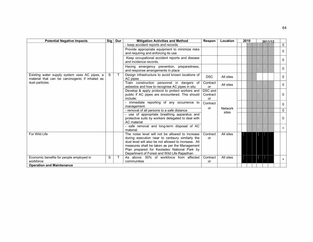
64
Potential Negative Impacts Sig Dur Mitigation Activities and Method Respon Location 2010 2011/12
- keep accident reports and records 0
Provide appropriate equipment to minimize risks and requiring and enforcing its use
0
Keep occupational accident reports and disease and incidence records.
0
Having emergency prevention, preparedness, and response arrangements in place
0
Existing water supply system uses AC pipes, a material that can be carcinogenic if inhaled as dust particles
S T Design infrastructure to avoid known locations of AC pipes
DSC All sites
0
Train construction personnel in dangers of asbestos and how to recognise AC pipes in situ
Contractor
All sites
0
Develop & apply protocol to protect workers and public if AC pipes are encountered. This should include:
DSC and Contract
or
Network sites
0
- immediate reporting of any occurrence to management
Contract
or
0
- removal of all persons to a safe distance 0 - use of appropriate breathing apparatus and protective suits by workers delegated to deal with AC material
0
- safe removal and long-term disposal of AC material
+
For Wild Life The noise level will not be allowed to increase during execution near to centaury similarly the dust level will also be not allowed to increase. All measures shall be taken as per the Management Plan prepared for Keoladeo National Park by Department of Forest and Wild Life Rajasthan
Contractor
All sites
Economic benefits for people employed in workforce
S T As above: 50% of workforce from affected communities
Contractor
All sites +
Operation and Maintenance
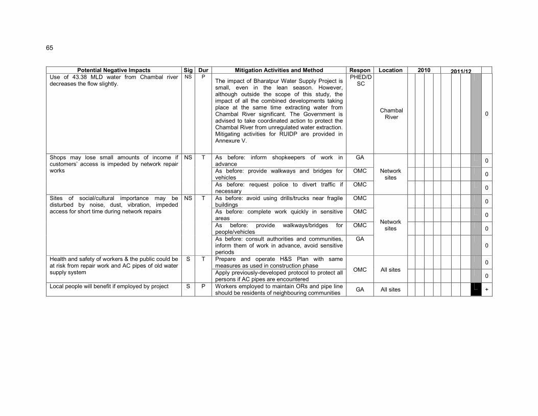
65
Potential Negative Impacts Sig Dur Mitigation Activities and Method Respon Location 2010 2011/12
Use of 43.38 MLD water from Chambal river decreases the flow slightly.
NS P The impact of Bharatpur Water Supply Project is small, even in the lean season. However, although outside the scope of this study, the impact of all the combined developments taking place at the same time extracting water from Chambal River significant. The Government is advised to take coordinated action to protect the Chambal River from unregulated water extraction. Mitigating activities for RUIDP are provided in Annexure V.
PHED/DSC
Chambal River
0
Shops may lose small amounts of income if customers’ access is impeded by network repair works
NS T As before: inform shopkeepers of work in advance
GA
Network sites
0
As before: provide walkways and bridges for vehicles
OMC 0
As before: request police to divert traffic if necessary
OMC 0
Sites of social/cultural importance may be disturbed by noise, dust, vibration, impeded access for short time during network repairs
NS T As before: avoid using drills/trucks near fragile buildings
OMC
Network sites
0
As before: complete work quickly in sensitive areas
OMC 0
As before: provide walkways/bridges for people/vehicles
OMC 0
As before: consult authorities and communities, inform them of work in advance, avoid sensitive periods
GA 0
Health and safety of workers & the public could be at risk from repair work and AC pipes of old water supply system
S T Prepare and operate H&S Plan with same measures as used in construction phase
OMC All sites
0
Apply previously-developed protocol to protect all persons if AC pipes are encountered
0
Local people will benefit if employed by project S P Workers employed to maintain ORs and pipe line should be residents of neighbouring communities
GA All sites
+

66
176. Resettlement issues will be coordinated centrally by a Resettlement Specialist within the IPMU/ IPMC, who will ensure consistency of approach between towns. A local Resettlement Specialist will also be appointed to IPIUs of zones in which there are resettlement impacts and they will prepare and implement local Resettlement Plans following the framework established in Tranche 1.
177. Environmental issues will be coordinated by an Environmental Specialist within the IPMU/ IPMC, who will ensure that all subprojects comply with environmental safeguards. An Environmental Monitoring Specialist (EMS) who is part of the DSC team will implement the Environmental Monitoring Plan from each IEE (see below), to ensure that mitigation measures are provided and protect the environment as intended. Domestic Environmental Consultants (DEC) will be appointed by each IPIU to update the existing IEEs in the detailed design stage, and to prepare IEEs or EIAs for new subprojects, where required to comply with national law and/or ADB procedure.
7.3 Environmental Monitoring Plan
178. Table 7.1 shows that most mitigation activities are the responsibility of the Construction Contractors (CC) employed to build the infrastructure during the construction stage, or the O&M Contractors employed to conduct maintenance or repair work when the system is operating. Responsibility for the relevant measures will be assigned to the Contractors via the contracts through which they are appointed (prepared by the DSC during the detailed design stage), so they will be legally required to take the necessary action.
179. There are also some actions that need to be taken by LSGD in their role as project proponent, and some actions related to the design that will be implemented by the DSC.
180. A program of monitoring will be conducted to ensure that all parties take the specified action to provide the required mitigation, to assess whether the action has adequately protected the environment, and to determine whether any additional measures may be necessary. This will be conducted by a qualified Environmental Monitoring Specialist (EMS) from the DSC. The EMS will be responsible for all monitoring activities and reporting the results and conclusions to the IPMU, and will recommend remedial action if measures are not being provided or are not protecting the environment effectively. The EMS may be assisted by environmental specialists in particular technical fields, and junior or medium-level engineers who can make many of the routine observations on site. Post-construction monitoring will be conducted by the relevant Government Agency (GA) to whom responsibility for the infrastructure will pass once it begins to operate.( In the operational period some infrastructure will be the responsibility of the Municipal Boards/Councils, whilst others will be the responsibility of the appropriate branch of the State government (such as PWD, PHED, etc)
181. Table 7.1 shows that most of the mitigation measures are fairly standard methods of minimising disturbance from building in urban areas (maintaining access, planning work to avoid sensitive times, finding uses for waste material, etc), and experienced Contractors should be familiar with most of the requirements. Monitoring of such measures normally involves making observations in the course of site visits, although some require more formal checking of records and other aspects. There will also be some surveys of residents, as most of the measures are aimed at preventing impacts on people and the human environment.
182. Table 7.1 shows the proposed Environmental Monitoring Plan (EMP) for this subproject, which specifies the various monitoring activities to be conducted during all phases. Some of the measures shown in Table 7.1 have been consolidated to avoid repetition, and there has been some re-ordering to present together those measures that

67
relate to the same activity or site. The EMP describes: (i) mitigation measures, (ii) location, (iii) measurement method, (iv) frequency of monitoring and (v) responsibility (for both mitigation and monitoring). It does not show specific parameters to be measured because as indicated above, most measures will be checked by simple observation, by checking of records, or by interviews with residents or workers.
183. Given the scale of the investment in providing the infrastructure, LSGD will also wish to conduct monitoring during the operational period to confirm the long-term benefits of the scheme. Table 7.2 shows that this will cover two elements, which will monitor:
o The chemical and bacteriological quality of water provided by the municipal system;
o The health of the population and the prevalence of diseases of poor sanitation.
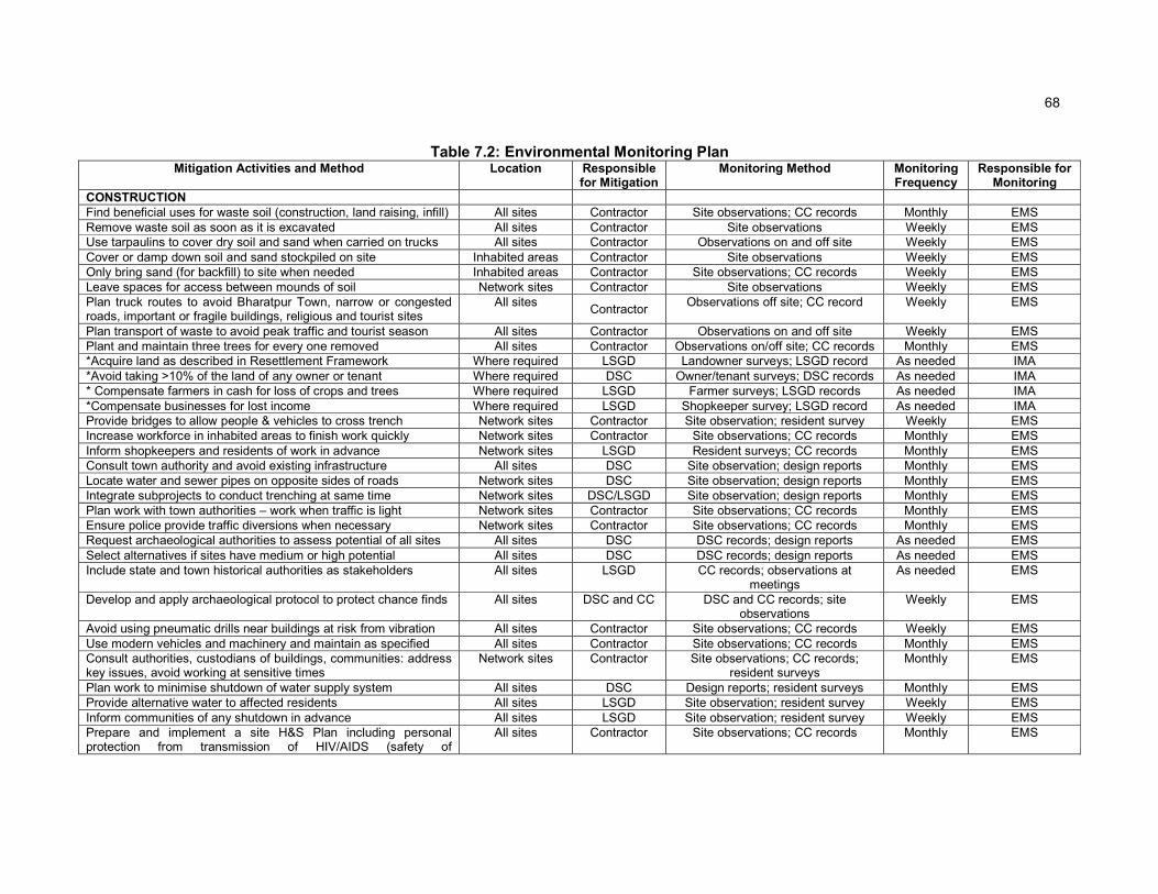
68
Table 7.2: Environmental Monitoring Plan Mitigation Activities and Method Location Responsible
for Mitigation Monitoring Method Monitoring
Frequency Responsible for
Monitoring
CONSTRUCTION Find beneficial uses for waste soil (construction, land raising, infill) All sites Contractor Site observations; CC records Monthly EMS Remove waste soil as soon as it is excavated All sites Contractor Site observations Weekly EMS Use tarpaulins to cover dry soil and sand when carried on trucks All sites Contractor Observations on and off site Weekly EMS Cover or damp down soil and sand stockpiled on site Inhabited areas Contractor Site observations Weekly EMS Only bring sand (for backfill) to site when needed Inhabited areas Contractor Site observations; CC records Weekly EMS Leave spaces for access between mounds of soil Network sites Contractor Site observations Weekly EMS Plan truck routes to avoid Bharatpur Town, narrow or congested roads, important or fragile buildings, religious and tourist sites
All sites Contractor
Observations off site; CC record Weekly EMS
Plan transport of waste to avoid peak traffic and tourist season All sites Contractor Observations on and off site Weekly EMS Plant and maintain three trees for every one removed All sites Contractor Observations on/off site; CC records Monthly EMS *Acquire land as described in Resettlement Framework Where required LSGD Landowner surveys; LSGD record As needed IMA *Avoid taking >10% of the land of any owner or tenant Where required DSC Owner/tenant surveys; DSC records As needed IMA * Compensate farmers in cash for loss of crops and trees Where required LSGD Farmer surveys; LSGD records As needed IMA *Compensate businesses for lost income Where required LSGD Shopkeeper survey; LSGD record As needed IMA Provide bridges to allow people & vehicles to cross trench Network sites Contractor Site observation; resident survey Weekly EMS Increase workforce in inhabited areas to finish work quickly Network sites Contractor Site observations; CC records Monthly EMS Inform shopkeepers and residents of work in advance Network sites LSGD Resident surveys; CC records Monthly EMS Consult town authority and avoid existing infrastructure All sites DSC Site observation; design reports Monthly EMS Locate water and sewer pipes on opposite sides of roads Network sites DSC Site observation; design reports Monthly EMS Integrate subprojects to conduct trenching at same time Network sites DSC/LSGD Site observation; design reports Monthly EMS Plan work with town authorities – work when traffic is light Network sites Contractor Site observations; CC records Monthly EMS Ensure police provide traffic diversions when necessary Network sites Contractor Site observations; CC records Monthly EMS Request archaeological authorities to assess potential of all sites All sites DSC DSC records; design reports As needed EMS Select alternatives if sites have medium or high potential All sites DSC DSC records; design reports As needed EMS Include state and town historical authorities as stakeholders All sites LSGD CC records; observations at
meetings As needed EMS
Develop and apply archaeological protocol to protect chance finds All sites DSC and CC DSC and CC records; site observations
Weekly EMS
Avoid using pneumatic drills near buildings at risk from vibration All sites Contractor Site observations; CC records Weekly EMS Use modern vehicles and machinery and maintain as specified All sites Contractor Site observations; CC records Monthly EMS Consult authorities, custodians of buildings, communities: address key issues, avoid working at sensitive times
Network sites Contractor Site observations; CC records; resident surveys
Monthly EMS
Plan work to minimise shutdown of water supply system All sites DSC Design reports; resident surveys Monthly EMS Provide alternative water to affected residents All sites LSGD Site observation; resident survey Weekly EMS Inform communities of any shutdown in advance All sites LSGD Site observation; resident survey Weekly EMS Prepare and implement a site H&S Plan including personal protection from transmission of HIV/AIDS (safety of
All sites Contractor Site observations; CC records Monthly EMS

69
Mitigation Activities and Method Location Responsible for Mitigation
Monitoring Method Monitoring Frequency
Responsible for Monitoring
workers/public) Exclude public from the site All sites Contractor Site observations; CC records Monthly EMS Ensure that workers wear Personal Protective Equipment All sites Contractor Site observations; CC records Monthly EMS Provide Health and Safety training including process of transmission of HIV/AIDS for all personnel
All sites Contractor CC records; worker interviews Monthly EMS
Follow documented procedures for all site activities All sites Contractor Site observations; CC records Monthly EMS Keep accident reports and records All sites Contractor CC records Monthly EMS Design infrastructure to avoid known locations of AC pipes Network sites DSC DSC records; design reports As needed EMS Train all personnel in dangers and recognition of AC pipes All sites Contractor Site observations; CC records Monthly EMS Develop and apply protocol if AC pipes are encountered All sites DSC/CC DSC & CC records; site
observations Weekly EMS
If AC pipes are encountered, report to management immediately All sites Contractor Site observations; CC records Weekly EMS
Remove all persons to safe distance All sites Contractor Site observations; CC records Weekly EMS Workers handling AC: wear breathing apparatus; protective suits All sites Contractor Site observations; CC records Weekly EMS All AC material must be removed and disposed of safely All sites Contractor Observations on and off site; CC
records As needed EMS
Employ at least 50% of workforce from communities near sites All sites Contractor CC records; worker interviews Monthly EMS Reduction in noise level and dust level All sites Contractor Observations on site As needed EMS OPERATION AND MAINTENANCE Inform shopkeepers and residents of work in advance Network sites GA Resident surveys Monthly Provide walkways and bridges for vehicles Network sites OM Contractor Site observation; resident survey Monthly Request police to divert traffic if necessary Network sites OM Contractor Site observations Monthly Avoid using drills or trucks near fragile buildings Network sites OM Contractor Site observations Monthly Complete work quickly in sensitive areas Network sites OM Contractor Site observations; OMC records Monthly Consult and inform authorities & people, avoid sensitive periods Network sites OM Contractor Site observation; resident survey Monthly Prepare and operate H&S plan to protect workers and citizens All sites OM Contractor Site observations; OMC records Monthly Apply AC protocol to protect all persons if AC pipes encountered All sites OM Contractor Site observations; OMC records Monthly Employ people who live nearby to maintain OHSRs and pipe line All sites GA Employer record; worker survey Monthly LONG-TERM SURVEYS Survey of chemical and bacteriological quality of municipal water Pump house /
OHSRs and Domestic sites
LSGD Water quality sampling and analysis Annual for 5 years
Consulting laboratory
Survey of public health and incidence of water borne disease Bharatpur Town LSGD Hospital records; resident surveys Annual for 5 years
Social studies consultant
Survey of water levels in Chambal River. Stop of intake by DSC when water levels in Chambal reach the minimum allowed levels
Intake site DSC/LSGD CWC records Weekly CWC
Resettlement issues (asterisked) will be monitored by an Independent Monitoring Agency (IMA) established under the Resettlement Framework

184. An accredited laboratory will be appointed to monitor the quality of water at the intake and at the point of supply to consumers (in houses and slums), and a domestic social studies consultant will be appointed to monitor public health and the incidence of disease. These surveys will be conducted annually over the first five years of operation of the system, and require the initial collection of baseline data on pre-project conditions, during the construction period.
7.4 Environmental management and monitoring costs
185. Most of the mitigation measures require the contractors to adopt good site practice, which should be part of their normal procedures already, so there are unlikely to be major costs associated with compliance. Regardless of this, any costs of mitigation by the contractors (those employed to construct the infrastructure or the local companies employed to conduct O&M when the system is operating) are included in the budgets for the civil works and do not need to be estimated separately here. Mitigation that is the responsibility of LSGD will be provided as part of their management of the project, so this also does not need to be duplicated here. Costs of acquiring land (if any) and compensating shopkeepers and farmers for loss of income (Table 7.1) are calculated separately in the budgets for the Resettlement Framework and Resettlement Plans so are also excluded from this analysis.
186. The remaining actions in the Environmental Management Plan are:
o The environmental monitoring during construction, conducted by the EMS; and
o The long-term post-construction surveys that will be commissioned by LSGD.
187. These have not been budgeted elsewhere, and their costs are shown in Table 7.3, with details of the calculations shown in footnotes beneath the table. The figures show that the total cost of environmental management and monitoring for the subproject as a whole (covering design, 2 years of construction and the first five years of operation) is INR 2.32 million.
Table 7.3: Environmental management and monitoring costs (INR)
Item Quantity Unit Cost Total Cost Sub-total
1. Implementation of EMP (2 years)
Domestic Environmental Monitoring Specialist
1 x 3 month 130,000* 390,000
Survey Expenses Lump sum 120,000 120,000
EMP required as per Management Plan for Keoladeo National Park Plan period 2010-2014
Lump sum 2,50,000 2,50,000 7,60,000
2. Survey of municipal water quality (6 years)
Domestic Consultant 6 x ½ month 130,000 390,000
Sample Analysis 6 x 20 4,000***
480,000
Other Expenses Lump sum 200,000 200,000 10,70,000.00
3. Survey of public health (6 years)
Domestic Consultant 6 x ½ month 130,000 390,000
Other Expenses Lump sum 250,000 250,000 6,40,000.00

71
Item Quantity Unit Cost Total Cost Sub-total
4. Environmental mitigation measures including buffer zone development at pumping station
Lump sum 100,000 100,000 1,00,000.00
TOTAL 25,70,000.00
*Unit costs of domestic consultants include fee, travel, accommodation and subsistence
** Cost of a standard suite of drinking water quality parameters (pH, turbidity, chlorinity, alkalinity, conductivity, TDS, DO, total and faecal coliforms, and selected metals) per sample
7.5 Associated Facilities
188. There are no upstream associated facilities in this subproject, however, the downstream users of aquifer/river can be considered associated to the facility.
189. Environmentally safe, continuous and reliable water sources and adequate capacity for treatment, transmission, and distribution, as well as properly functioning pumps, reservoirs, and networks are a must for RUIDP to mandate a safe water supply service to the local population. If the water is sourced through the aquifer for drinking water supply, it must be ensured that design extraction/pumping rate must be less than the documented aquifer recharge rate because excessive pumping of aquifers can lower groundwater levels in this water scarce state.

8 PUBLIC CONSULTATION AND INFORMATION DISCLOSURE
8.1 Project stakeholders
190. Most of the main stakeholders have already been identified preliminary. If any other stakeholders that are identified during project implementation will be brought into the process in the future. Primary stakeholders are:
o Residents, shopkeepers and businesspeople who live and work alongside the roads in which network improvements will be provided and near sites where facilities will be built
o Owners and users of any land that is acquired along the transmission main route;
o Custodians and users of socially and culturally important buildings in affected areas;
o State and local authorities responsible for the protection and conservation of archaeological relics, historical sites and artefacts;
o State and local tourism authorities.
191. Secondary stakeholders are:
o LSGD as the Executing Agency;
o Other government institutions whose remit includes areas or issues affected by the project (state and local planning authorities, Department of Public Health Engineering, Local Government Dept, Ministry of Environment and Forests, Roads and Highways Division, etc);
o NGOs and CBOs working in the affected communities;
o Other community representatives (prominent citizens, religious leaders, elders, women’s groups);
o The beneficiary community in general; and
o The ADB. and the Government of India, Ministry of Finance
8.2 Consultation and disclosure to date
192. Some informal discussion was held with the local people during site visit. Issues discussed are
� Awareness and extent of the project and development components
� Benefits of Project for the economic and social Upliftment of Community
� Labour availability in the Project area or requirement of outside labour involvement
� Local disturbances due to Project Construction Work
73
� Necessity of tree felling etc. at project sites
� Water logging and drainage problem if any
� Drinking water problem
� Forest and sensitive area nearby the project site
� Movement of wild animals nearby the project site
193. Local populations are very much interested on the project and they will help project authorities in all aspects. Public consultation results specifically on environmental issues are shown in Annexure - IV. Summary of the consultation is also shown in Annexure – IV.
194. The public Consultation and group discussion meeting were conduct by RUIDP on Date 25 June, 2009 after advertising in Local NEWS papers. The objective of the meeting was to appraise the stakeholders about the environmental and social impacts of the proposed program and the safeguards provided in the program to mitigate the same. In the specific context of Bharatpur, the environmental and social impacts of the proposed subprojects in Bharatpur were discussed.
195. Meetings and individual interviews were held at potentially temporarily affected areas; and local informal interviews were conducted to determine the potential impacts of sub-project construction to prepare the sample Environmental Framework. A town-wise stakeholder consultation workshop was conducted which provided an overview of the Program and sub-projects to be undertaken in Bharatpur; and discussed the Government and ADB’s Environment policies acts and potential environment impacts of the sub-projects in Bharatpur. During the workshop, Hindi versions of the Environmental Framework were provided to ensure participants understood the objectives, policy principles and procedures related to Environment, English and Hindi versions of the Environmental Framework have been placed in the Urban Local Body (ULB) office and Environmental Framework will be provided later on. The NGO to be engaged to implement the Mitigation Measures will continue consultations, information dissemination, and disclosure. The Environmental Framework will be made available in the ULB office, Investment Program Project Management Unit and Implementation Unit (IPMU and IPIU) offices, and the town library. The finalized IEE containing Mitigation Measures will also be disclosed in ADB’s website, the State Government website, the local government website, and the IPMU and IPIU websites. ADB review and approval of the RP is required prior to award of civil works contracts.
196. Major Issues discussed during Public consultation are
(i) Proposed water supply project should ensure enough supply of drinking water in all wards of city.
(ii) Executive agency should give preference to engage internationally reputed contractor like Gammon, HCC, etc as people do not faith about the local contractors in respect of quality of works as well as timely completion of work;
(iii) Efforts should be made by government to supply drinking water round the clock;
(iv) Livelihood affected households should be given assistance in the mode of cash compensation;

(v) Local people should be employed by the contractor during construction work;
(vi) Adequate safety measures should be taken during construction work;
(vii) Mobile kiosks/vendors/hawkers have shown willingness to shift in nearby places without taking any compensation and assistance from the Executing Agency;
(viii) Local people have appreciated the water supply proposal of the government and they have ensured that they will cooperate with the Executing Agency during project implementation.
8.3 Future consultation and disclosure
197. LSGD will extend and expand the consultation and disclosure process significantly during implementation of RUSDIP. They will appoint an experienced NGO to handle this key aspect of the programme, who will conduct a wide range of activities in relation to all subprojects in each town, to ensure that the needs and concerns of stakeholders are registered, and are addressed in project design, construction or operation where appropriate. The programme of activities will be developed during the detailed design stage, and is likely to include the following:
� Consultation during detailed design:
o Focus-group discussions with affected persons and other stakeholders (including women’s groups, NGOs and CBOs) to hear their views and concerns, so that these can be addressed in subproject design where necessary;
o Structured consultation meetings with the institutional stakeholders (government bodies and NGOs) to discuss and approve key aspects of the project.
� Consultation during construction:
o Public meetings with affected communities to discuss and plan work programmes and allow issues to be raised and addressed once construction has started;
o Smaller-scale meetings to discuss and plan construction work with individual communities to reduce disturbance and other impacts, and provide a mechanism through which stakeholders can participate in subproject monitoring and evaluation;
� Project disclosure:
o Public information campaigns (via newspaper, TV and radio) to explain the project to the wider city population and prepare them for disruption they may experience once the construction programme is underway;
o Public disclosure meetings at key project stages to inform the public of progress and future plans, and to provide copies of summary documents in Hindi;
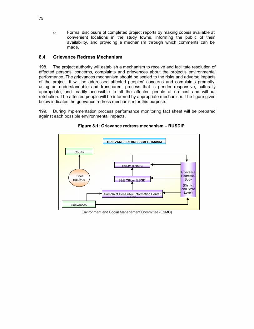
75
Complaint Cell/Public Information Center (LSGD)
Grievances
ESMC (LSGD)
S&E Officer (LSGD)
Courts
Grievance Redressal
Body
(District and State
Level)
If not resolved
GRIEVANCE REDRESS MECHANISM
o Formal disclosure of completed project reports by making copies available at convenient locations in the study towns, informing the public of their availability, and providing a mechanism through which comments can be made.
8.4 Grievance Redress Mechanism
198. The project authority will establish a mechanism to receive and facilitate resolution of affected persons’ concerns, complaints and grievances about the project’s environmental performance. The grievances mechanism should be scaled to the risks and adverse impacts of the project. It will be addressed affected peoples’ concerns and complaints promptly, using an understandable and transparent process that is gender responsive, culturally appropriate, and readily accessible to all the affected people at no cost and without retribution. The affected people will be informed by appropriate mechanism. The figure given below indicates the grievance redress mechanism for this purpose.
199. During implementation process performance monitoring fact sheet will be prepared against each possible environmental impacts.
Figure 8.1: Grievance redress mechanism – RUSDIP
Environment and Social Management Committee (ESMC)

9 FINDINGS AND RECOMMENDATIONS
9.1 Findings
200. The Project is designed to improve the quality of life of small town residents and enhance the small towns' roles as market, services, and manufacturing centers. It has a strong community development focus reinforced by integrated poverty reduction, health and hygiene improvement investment projects. The towns' economies will benefit from enhanced productivity as a result of health improvement, time savings in collecting water, as well as from increased urban efficiency arising from improved roads, bridges, drainage, drinking water and sanitation. Residents in towns will also benefit from lower water costs and from savings in health care costs.
201. During project design, community meetings were held with beneficiaries to discuss sanitation, poverty, resettlement, affordability issues, and environmental concerns. Socioeconomic surveys obtained information and individual views on current situations and future preferences. Potential environmental impacts of urban infrastructure improvements are mainly short-term during the construction period and can be minimized by the proposed mitigating measures and environmentally sound engineering and construction practices.
202. The process described in this document has assessed the environmental impacts of all elements of the infrastructure proposed under the Bharatpur Water Supply Subproject. Potential negative impacts were identified in relation to both construction and operation of the improved infrastructure, but no impacts were identified as being due to either the project design or location. Mitigation measures have been developed in generic way to reduce all negative impacts to acceptable levels. These were discussed with specialists responsible for the engineering aspects, and as a result some measures have already been included in the outline designs for the infrastructure. These include:
o Locating all pipelines within the ROW of existing roads, to avoid the need to acquire land or relocate people;
o Locating pipelines on unused land adjacent to roads wherever possible, to avoid damaging roads and disrupting traffic and other activities.
203. This means that the number of impacts and their significance has already been reduced by amending the design.
204. Changes have also been made to the location of elements of the project to further reduce impacts. These include:
o Locating all facilities (OHSRs, pipe line) on government-owned land to avoid the need for land acquisition and relocation of people;
o Locating the distribution main in the ROW alongside a main road, to reduce the acquisition of agricultural land and impacts on livelihoods of farmers and workers.
205. Regardless of these and various other actions taken during the IEE process and in developing the project, there will still be impacts on the environment when the infrastructure is built and when it is operating. This is mainly because of the invasive nature of trenching and other excavation; because the distribution network is located in an ancient town where there are densely populated areas and sites of historical and tourism interest; and because Rajasthan is an area with a rich history, so there is a high risk that ground disturbance may
77
uncover important remains. Because of these factors the most significant impacts are on the physical environment, the human environment, tourism, and the cultural heritage.
206. During the construction phase, impacts mainly arise from the need to dispose of large quantities of waste soil and import a similar amount of sand to support the pipes in the trenches; and from the disturbance of residents, businesses, traffic and important buildings by the construction work. These are common impacts of construction in urban areas, and there are well developed methods for their mitigation. These include:
o Finding beneficial uses for waste material;
o Covering soil and sand during transportation and when stored on site;
o Planning work to minimise disruption of traffic and communities;
o Providing temporary structures to maintain access across trenches where required.
207. There could also be a need to acquire small amounts of farm land along the route of the distribution main, where it is impracticable for the pipeline to follow bends in the road. Such impacts are also frequently encountered and are dealt with by a combination of the legal process and additional measures required by ADB policy on Involuntary Resettlement. Actions are discussed in a separate Resettlement Plan and Resettlement Framework, and include:
o Acquisition of land through the GOI Land Acquisition Act, through which the market value is paid, based on an analysis of recent transactions;
o Ensuring that no more than 10% of the land of a single owner or tenant is acquired;
o Providing additional compensation for loss of standing crops and productive trees.
208. One field in which impacts are much less routine is archaeology, and here a series of specific measures have been developed to avoid damaging important remains. These include:
o Assessing the archaeological potential of all proposed construction sites, and selecting alternative locations to avoid any areas of medium or high risk;
o Including archaeological, cultural and historical authorities and interest groups as project stakeholders to benefit from their expertise;
o Developing a protocol for use in conducting all excavation to ensure that any chance finds are recognised, protected and conserved.
209. The use of AC pipes in the existing water distribution network presents a particular problem, as workers and the public will need to be protected from inhalation of asbestos dust, which can be carcinogenic. This will be addressed by a number of measures, including:
o Limiting network improvements to expansion of the area covered, and leaving the existing AC system (ring, carrier and distribution mains) in situ undisturbed;

o Training staff and workers to raise awareness of the dangers of AC and enable early recognition of such pipes if encountered accidentally;
o Development of a protocol based on USEPA guidelines, to protect workers and the public if AC pipes are encountered (including evacuation of the immediate area, use of protective equipment by workers, and safe removal and disposal of AC material).
210. There were limited opportunities to provide environmental enhancements, but certain measures were included. For example it is proposed that the project will:
o Employ in the workforce people who live in the vicinity of construction sites to provide them with a short-term economic gain;
o Ensure that people employed in the longer term to maintain and operate the new facilities are residents of nearby communities.
211. These and the other mitigation and enhancement measures are summarised in Table 7.1, which also shows the location of the impact, the body responsible for the mitigation, and the program for its implementation.
212. Once the system is operating, most facilities (OHSRs. pump house) will operate with routine maintenance, which should not affect the environment. Leaks in the distribution network will need to be repaired from time to time, but environmental impacts will be much less than those of the construction period as the work will be infrequent, affecting small areas only. It will also be conducted in areas that have already been excavated, so there will be no need to protect archaeological material.
213. The main impacts of the operating water supply system will be beneficial as the citizens of Bharatpur will be provided with a constant supply of water, which will serve a greater proportion of the population, including slum-dwellers. This will improve the quality of life of people as well as benefiting both individual and public health as the improvements in hygiene should reduce the incidence of disease associated with poor sanitation. This should lead to economic gains as people will be away from work less and will spend less on healthcare, so their incomes should increase.
214. Table 7.1 also assesses the effectiveness of each mitigation measure in reducing each impact to an acceptable level. This is shown as the level of significance of the residual impact (remaining after the mitigation is applied). This shows that all impacts will be rendered at least neutral (successfully mitigated), and that certain measures will produce a benefit (in addition to the major benefits provided by the operating schemes).
215. Mitigation will be assured by a programme of environmental monitoring conducted during both construction and operation to ensure that all measures are provided as intended, and to determine whether the environment is protected as envisaged. This will include observations on and off site, document checks, and interviews with workers and beneficiaries, and any requirements for remedial action will be reported to the IPMU. There will also be longer-term surveys to monitor the expected improvements in the quality of domestic water and the health of the population.
9.2 Recommendations
216. There are two straightforward but essential recommendations that need to be followed to ensure that the environmental impacts of the project are successfully mitigated. These are that LSGD should ensure that:

79
o All mitigation, compensation and enhancement measures proposed in this Status report (Table 7.1) and in the Resettlement Framework for the RUSDIP are implemented in full, as described in these two documents;
o The Environmental Monitoring Plan proposed in Section VII of this report and the internal and external monitoring proposed in the Resettlement Framework are also implemented in full.
10 CONCLUSIONS
217. The environmental status of the proposed improvements in water supply and distribution infrastructure in Bharatpur Town has been assessed. Issues related to Involuntary Resettlement were assessed by a parallel process of resettlement planning and will be compensated by measures set out in detail in the Resettlement Framework for the subproject.
218. The overall conclusion of above process is that provided the mitigation, compensation and enhancement measures are implemented in full, there should be no significant negative environmental impacts as a result of location, design, construction or operation of the subproject. There should in fact be some small benefits from recommended mitigation and enhancement measures, and major improvements in quality of life and individual and public health once the scheme is in operation.
219. The surface water requirement of the Bharatpur Water Supply Subproject is not significantly impacting the water levels in the Chambal River. Therefore, the habitats of gharials and other protected aquatic species in the Chambal River are not expected to be impacted by this ADB supported subproject.
220. There are no uncertainties in the analysis, and no further studies are required to comply with ADB procedure or national law

81
References
a. Asian Turtle Trade Working Group 2000. Batagur kachuga. In: IUCN 2012. IUCN Red List of Threatened Species. Version 2012.2. <www.iucnredlist.org>. Downloaded on 12 February 2013. b. Sunil Choudhury, Sushant Dey et all (2012). “River Dolphin distribution in regulated river systems: implications for dry-season flow regimes in the Gangetic basin”. In: Aquatic Conservation: marine and freshwater ecosystems2009. Published online in Wiley Online Library.
c. Choudhury, B.C., Singh, L.A.K., Rao, R.J., Basu, D., Sharma, R.K., Hussain, S.A., Andrews, H.V., Whitaker, N., Whitaker, R., Lenin, J., Maskey, T., Cadi, A., Rashid, S.M.A., Choudhury, A.A., Dahal, B., Win Ko Ko, U., Thorbjarnarson, J & Ross, J.P. 2007. Gavialis gangeticus. In: IUCN 2012. IUCN Red List of Threatened Species. Version 2012.2. <www.iucnredlist.org>. Downloaded on 12 February 2013. d. Groombridge B. (1987). “The distribution and status of world crocodilians”. In Wildlife management: Crocodiles and Alligators edited by G.J.W Webb, S.C. Manolis and P.J Whitehead. Surrey Beatty R. Sons. Pvt. Ltd. in association with the Conservation Commission of the Northern Territory, Australia. pp. 9-21. e. Hussain S.A. (2009). “Basking site and water depth selection by gharial Gavialis gangeticus Gmelin 1789 (Crocodylia, Reptilia) in National Chambal Sanctuary, India and its implication for river conservation”. In: Aquatic Conservation: marine and freshwater ecosystems 22: 11-25. Published online in Wiley InterScience f. Hussain S.A (1999). “Reproductive Success, hatching survival and rate of increase of gharial (Gavialis gangeticus) in National Chambal Sanctuary, India”. The Biological Conservation 87:261-268 g. Hussain S.A. (1991). “Ecology of gharial (Gavialis gangeticus) in National Chambal Sanctuary, India”. M Phil dissertation, Centre for Wildlife and Ornithology, Aligarh Muslim University, Aligarh. h. Mohan, R.S.L (1989). “Conservation and Management of the Ganges river dolphin Plantanista gangetica in India”. In Biology and conservation of the river dolphins, Ed. W.F Perrin, R.L. Brownell, Jr. Zhou Kaiya and Liu Jainkan. Occasional paper of the IUCN Species Survival Commission. No. 3: 64-69
i. Nair, T., Thorbjarnarson J.B. et all: “Rigorous gharial population estimation in the Chambal: implications for conservation and management of a globally threatened crocodilian”. In: Journal of applied ecology, 2012-44. j. Perrin, WF and RL Brownell, Jr. (1989) “Report of the workshop on Biology and conservation of the platanistoid dolphin, Wuhan, People’s Republic of China” in Biology and conservation of the river dolphins. k. Rao, R J (1989) “Conservation and management of freshwater turtles in the National Chambal Sanctuary”. First World Congress of Herpetology. Tiger Paper 6-10 l. Rao, R J. S.A Hussain and R. K. Sharma (1989). “The status and conservation of Gangetic dolphin (Platanista gangetica) in the National Chambal Sanctuary”. Tiger Paper: 6-10

m. R. Sreenivas Murthy, IFS (2004) “Management plan of National Chambal
Sanctuary, Morena, Madhya Pradesh (2003-2004 to 2013-2014)”.
n. Smith, B.D. & Braulik, G.T. 2012. Platanista gangetica. In: IUCN 2012. IUCN Red List of Threatened Species. Version 2012.2. <www.iucnredlist.org>. Downloaded on 12 February 2013 o. Wikipedia, wiki on Red-crowned roofed turtle: retrieved on 22 January 2013. p. Wildlife Institute of India (April 2011) Study Report “Assessment of minimum water flow requirements of Chambal river in the context of Gharial (Gavialis gangeticus) and Gangetic Dolphin (Platanista gangetica) conservation”

83
Annexure – I
Photographs
Intake well Structure of Public Health & Engineering Department at Dholpur
Boating for Dolphin site seeing, approx. 2 Km upstream from intake well at Dholpur
Existing bridge (National Highway-03) on Chambal River near PHED’s Intake well
View of Future bridge (National Highway-03) from PHED’s Intake well

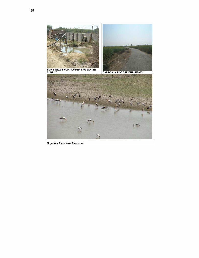
85

Annexure – II

87

89
Annexure –III
Rapid Environmental Assessment (REA) Checklist
Instructions:
10.1.1 (i) The project team completes this checklist to support the environmental classification of a project. It is to be attached to the environmental categorization form and submitted to the Environment and Safeguards Division (RSES) for endorsement by the Director, RSES and for approval by the Chief Compliance Officer.
(ii) This checklist focuses on environmental issues and concerns. To ensure that social dimensions are adequately considered, refer also to ADB's (a) checklists on involuntary resettlement and Indigenous Peoples; (b) poverty reduction handbook; (c) staff guide to consultation and participation; and (d) gender checklists.
(iii) Answer the questions assuming the “without mitigation” case. The purpose is to identify potential impacts. Use the “remarks” section to discuss any anticipated mitigation measures.
Country/Project Title:
Sector Division:
Water supply subproject is already in execution. Scope of works under execution includes providing laying jointing of pipelines, construction of CWR/OHSRS and pumping stations. Enhanced work proposed in this subproject includes strengthening of distribution system by providing pipeline and OHSRS.
Screening Questions Yes No Remarks
A. Project Siting
Is the project area_
� Densely populated? √ As per the census 2001, the urban
population of Bharatpur was 4,08,960 which is expected to rise by almost 1.5 times, hence the project is coming up at a densely populated area.
� Heavy with development activities? √ Since Bharatpur is one of the least
developed areas of Rajasthan, hence it is not loaded with developmental activities. It is infact an effort to develop the same.
� Adjacent to or within any environmentally sensitive areas?
• Cultural heritage site
√ Bharatpur city is one of the Historical city of the Rajasthan state Historical monuments such as Lohagarh Fort or the “Iron Fort”, Government Museum, The Palace, Deeg ,Gopal Bhavan,
India / RUSDIP
Bharatpur Water Supply Sub Project
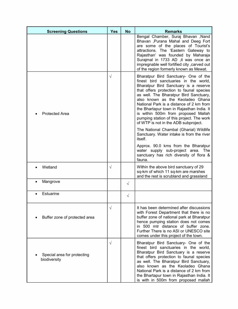
Screening Questions Yes No Remarks
Bengal Chamber, Suraj Bhavan ,Nand Bhavan ,Purana Mahal and Deeg Fort are some of the places of Tourist’s attractions. The ‘Eastern Gateway to Rajasthan’ was founded by Maharaja Surajmal in 1733 AD ,it was once an impregnable well fortified city ,carved out of the region formerly known as Mewat.
• Protected Area
√ Bharatpur Bird Sanctuary- One of the finest bird sanctuaries in the world, Bharatpur Bird Sanctuary is a reserve that offers protection to faunal species as well. The Bharatpur Bird Sanctuary, also known as the Keoladeo Ghana National Park is a distance of 2 km from the Bhartapur town in Rajasthan India. It is within 500m from proposed Mallah pumping station of this project. The work of WTP is not in the ADB subproject.
The National Chambal (Gharial) Wildlife Sanctuary. Water intake is from the river itself.
Approx. 90.0 kms from the Bharatpur water supply sub-project area. The sanctuary has rich diversity of flora & fauna.
• Wetland
√ Within the above bird sanctuary of 29 sq-km of which 11 sq-km are marshes and the rest is scrubland and grassland
• Mangrove
√
• Estuarine
√
• Buffer zone of protected area
√ It has been determined after discussions with Forest Department that there is no buffer zone of national park at Bharatpur hence pumping station does not comes in 500 mtr distance of buffer zone. Further There is no ASI or UNESCO site comes under this project of the town.
• Special area for protecting biodiversity
√ Bharatpur Bird Sanctuary- One of the finest bird sanctuaries in the world, Bharatpur Bird Sanctuary is a reserve that offers protection to faunal species as well. The Bharatpur Bird Sanctuary, also known as the Keoladeo Ghana National Park is a distance of 2 km from the Bhartapur town in Rajasthan India. It is with in 500m from proposed mallah

91
Screening Questions Yes No Remarks
pumping station of this project .Avifauna in the Bharatpur Bird Sanctuary- More than 300 species of birds are found in this small wildlife park of 29 sq-km of which 11 sq-km are marshes and the rest is scrubland and grassland. Migratory birds at Bharatpur bird sanctuary include, several species of Sarus Cranes, Pelicans, Geese, Grey Heron, Ducks, Eagles, Brown long eared bat, Hawks, Shanks, Stints, Garganey Teal, Wagtails, Warblers, Wheatears, Flycatchers, Buntings, Larks and Pipits, etc. The Fauna in the Bharatpur Bird Sanctuary- The Bharatpur Bird Sanctuary is also inhabited by Sambar, Chital, Nilgai and Boar.
IBAT for business mentions Chambal Sanctuary as Key Biodiversity Area and as an Alliance for Zero Extinction Site.
• Bay
√
B. Potential Environmental Impacts
Will the Project cause_
� pollution of raw water supply from upstream wastewater discharge from communities, industries, agriculture, and soil erosion runoff?
√ No such source of pollution at the up stream of the intake point.
� impairment of historical/cultural monuments/areas and loss/damage to these sites?
√ No impact on any such structures
� hazard of land subsidence caused by excessive ground water pumping?
√ does not arise because the source of water is river water -Chambal river
� social conflicts arising from displacement of communities ?
√ No impact on community, so no social conflict.
� conflicts in abstraction of raw water for water supply with other beneficial water uses for surface and ground waters?
√ Potential for conflicts as many projects use Chambal water as fresh water source.
� unsatisfactory raw water supply (e.g. excessive pathogens or mineral constituents)?
√ Raw water will be treated properly in WTP considering the characteristics of the water. Although provision will be made for regular water quality monitoring
� delivery of unsafe water to distribution system?
√ Proper care has been taken during design of the system. O&M manual will

Screening Questions Yes No Remarks
be prepared , training will be given to the staffs operating the plant and to collect water sample time to time and to analyze the same to ensure the quality of the supplied water
� inadequate protection of intake works or wells, leading to pollution of water supply?
√ Proper design of the intake will minimize this problems.
� over pumping of ground water, leading to salinization and ground subsidence?
√ Does not arise because the source of water is river water as the ground water is too saline for drinking water purposes.
� excessive algal growth in storage reservoir?
√ The storage reservoirs are covered from top and proper treatment like chlorination of water will not allow algal growth in the reservoirs.
� increase in production of sewage beyond capabilities of community facilities?
√ Sewage volume will slightly but will not beyond the capabilities of the community facilities.
� inadequate disposal of sludge from water treatment plants?
√ Sludge will disposed off in designated site.
� inadequate buffer zone around pumping and treatment plants to alleviate noise and other possible nuisances and protect facilities?
√ Proposed and existing pumping stations are away from settlements and provided with proper enclosures
� impairments associated with transmission lines and access roads?
√ Impairments may be with access road but it is and can be minimized taking regulatory measures. Temporary in nature.
� health hazards arising from inadequate design of facilities for receiving, storing, and handling of chlorine and other hazardous chemicals.
√ Chlorine dosing will be done through chlorinator. MSIHC rules, 1989 and its amendment in 2010 will be followed.
� health and safety hazards to workers from handling and management of chlorine used for disinfection, other contaminants, and biological and physical hazards during project construction and operation?
√ Training will be given to worker on health and safety aspects of application of chlorine for treatment of raw water
� dislocation or involuntary resettlement of people?
√ The nature of the work does not involve dislocation activities.
� disproportionate impacts on the poor, women and children, Indigenous Peoples or other vulnerable groups?
√ No such impact
� noise and dust from construction activities?
√ During civil work noise and dust will be generated but it will be localized and short-term in nature. Proper measure as suggested in EM will minimize the
93
Screening Questions Yes No Remarks
problem. � increased road traffic due to interference
of construction activities?
√ Temporary in nature. Work will be carried out in night when traffic is least. Although a traffic management plan will be prepared for the same.
� continuing soil erosion/silt runoff from construction operations?
√ The excavated soil will be stockpiled at appropriate location and will be used for refilling with better compaction.
� delivery of unsafe water due to poor O&M treatment processes (especially mud accumulations in filters) and inadequate chlorination due to lack of adequate monitoring of chlorine residuals in distribution systems?
√ Only disinfected water from the WTP will be supplied to the OHSR and to the distribution system .O&M manual will be prepared , training will be given to the staffs operating the plant and to collect water sample time to time and to analyze the same to ensure the quality of the supplied water
� delivery of water to distribution system, which is corrosive due to inadequate attention to feeding of corrective chemicals?
√ Source of water for this subproject is treated water from WTP which is not corrosive in nature. Although DI and PVC pipes has been proposed as a precautionary measures.
� accidental leakage of chlorine gas?
√ Emergency action plan for accidental
leakage of chlorine gas will be prepared
� excessive abstraction of water affecting downstream water users?
√ Not applicable to this subproject. Source of water for this subproject is treated water from WTP
� competing uses of water?
√ High water demand throughout the
Chambal river for fresh water: for irrigation and drinking water purposes. However, the PHED clearance specifies that it is forbidden to use the water of this intake for irrigation purposes.
� increased sewage flow due to increased water supply
√ Water supply will slightly increase the sewage volume which will be taken care in the upcoming sewerage design and sewage treatment plant
� increased volume of sullage (wastewater from cooking and washing) and sludge from wastewater treatment plant
√ The proposed drainage network in the city shall take care of the waste water and sullage. Waste water sullage and storm water will be carried from the residential areas via primary channels.
Proposed solid waste management system of the town will take care of the problem
� large population influx during project construction and operation that causes increased burden on social infrastructure
√ Priority will be given to local labour for job as suggested in EMP
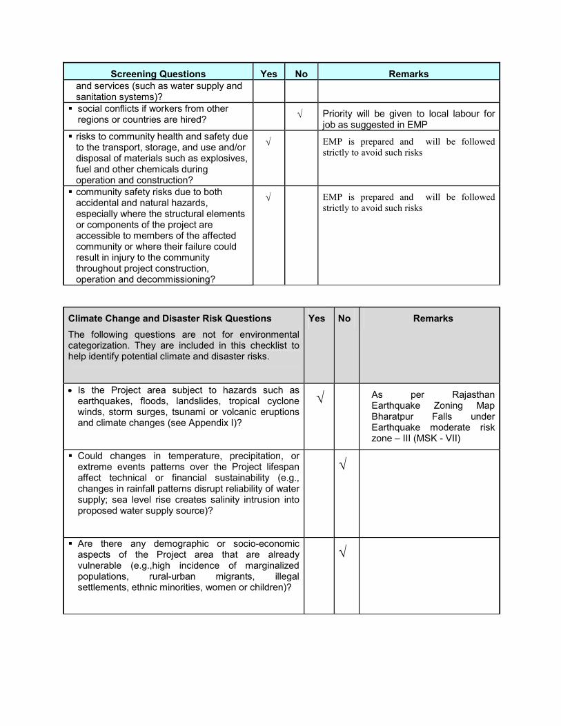
Screening Questions Yes No Remarks
and services (such as water supply and sanitation systems)?
� social conflicts if workers from other regions or countries are hired?
√ Priority will be given to local labour for job as suggested in EMP
� risks to community health and safety due to the transport, storage, and use and/or disposal of materials such as explosives, fuel and other chemicals during operation and construction?
√ EMP is prepared and will be followed
strictly to avoid such risks
� community safety risks due to both accidental and natural hazards, especially where the structural elements or components of the project are accessible to members of the affected community or where their failure could result in injury to the community throughout project construction, operation and decommissioning?
√ EMP is prepared and will be followed
strictly to avoid such risks
Climate Change and Disaster Risk Questions
The following questions are not for environmental categorization. They are included in this checklist to help identify potential climate and disaster risks.
Yes No Remarks
• Is the Project area subject to hazards such as earthquakes, floods, landslides, tropical cyclone winds, storm surges, tsunami or volcanic eruptions and climate changes (see Appendix I)?
√ As per Rajasthan
Earthquake Zoning Map Bharatpur Falls under Earthquake moderate risk zone – III (MSK - VII)
� Could changes in temperature, precipitation, or extreme events patterns over the Project lifespan affect technical or financial sustainability (e.g., changes in rainfall patterns disrupt reliability of water supply; sea level rise creates salinity intrusion into proposed water supply source)?
√
� Are there any demographic or socio-economic aspects of the Project area that are already vulnerable (e.g.,high incidence of marginalized populations, rural-urban migrants, illegal settlements, ethnic minorities, women or children)?
√

95
� Could the Project potentially increase the climate or disaster vulnerability of the surrounding area (e.g., by using water from a vulnerable source that is relied upon by many user groups, or encouraging settlement in earthquake zones)?
√
* Hazards are potentially damaging physical events.

Annexure -IV
PUBLIC CONSULTATION- ENVIRONMENT
Sub Project-: Water Supply (Bharatpur )
Issues discussed
� Awareness and extent of the project and development components
� Benefits of Project for the economic and social Upliftment of Community
� Labour availability in the Project area or requirement of outside labour involvement
� Local disturbances due to Project Construction Work
� Necessity of tree felling etc. at project sites
� Water logging and drainage problem if any
� Drinking water problem
� Forest and sensitive area nearby the project site
� Movement of wild animal if any
� Other problems, encountered, if any
1. Date & time of Consultation:- 02.07.10 at 09.30 AM , Location :- Laxmi Nagar
2. Date & time of Consultation:- 02.07.10 at 14.30 PM, Location :- Kumher gate
3. Date & time of Consultation:- 03.07.10 at 10.30 PM, Location :- Sabji Mandi
4. Date & time of Consultation:- 03.07.10 at 15.30 PM, Location :- Ranjit nagar, E- Block.
Table: Issues of the Public Consultation- Design phase
Sr. No.
Key Issues/Demands Perception of community Action to be Taken
1 Awareness of the project – including coverage area
The people in the nearby areas are aware of the upcoming project. As per the local people, the DSC consultants have informed them regarding the strengthening of the distribution system at Bharatpur town in order to improve the water supply facilities at Bharatpur
2 In what way they may associate with the
• The local people are of the view that they should be hired depending upon their
Preference will be given to the local
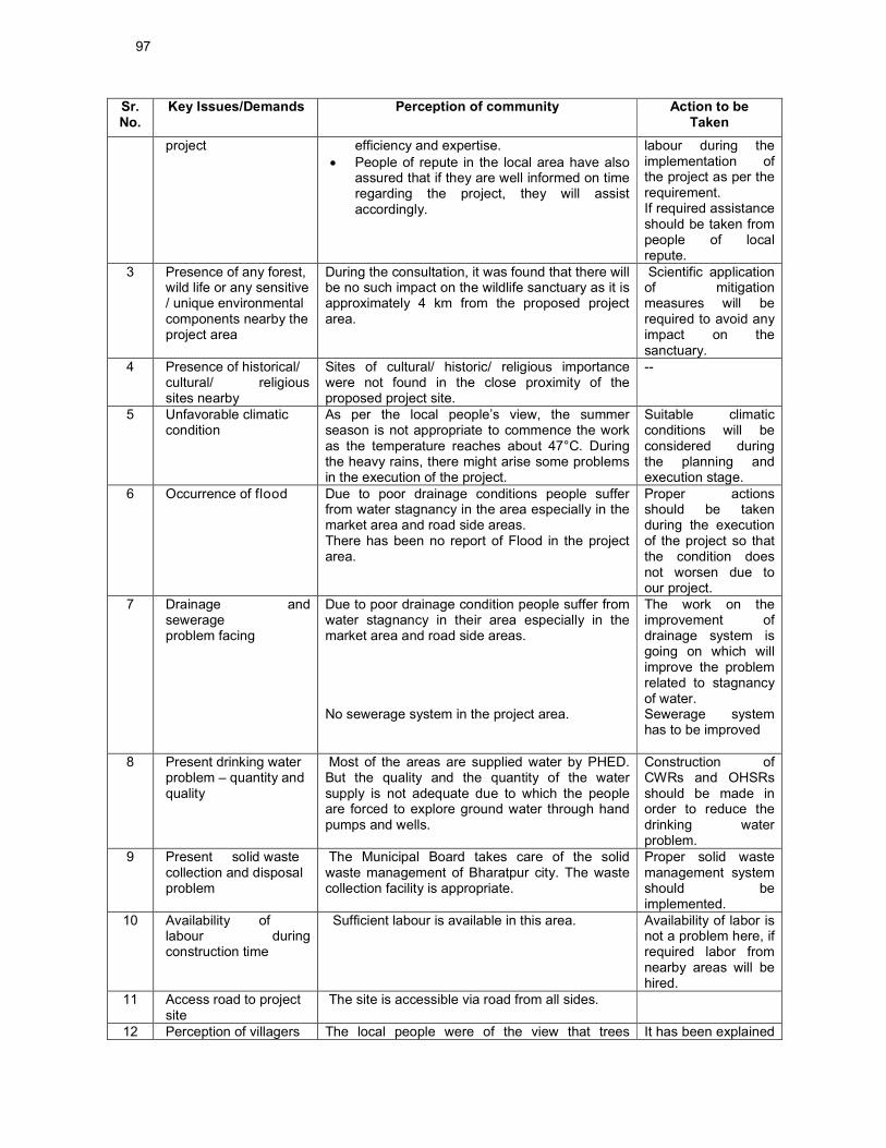
97
Sr. No.
Key Issues/Demands Perception of community Action to be Taken
project efficiency and expertise.
• People of repute in the local area have also assured that if they are well informed on time regarding the project, they will assist accordingly.
labour during the implementation of the project as per the requirement. If required assistance should be taken from people of local repute.
3 Presence of any forest, wild life or any sensitive / unique environmental components nearby the project area
During the consultation, it was found that there will be no such impact on the wildlife sanctuary as it is approximately 4 km from the proposed project area.
Scientific application of mitigation measures will be required to avoid any impact on the sanctuary.
4 Presence of historical/ cultural/ religious sites nearby
Sites of cultural/ historic/ religious importance were not found in the close proximity of the proposed project site.
--
5 Unfavorable climatic condition
As per the local people’s view, the summer season is not appropriate to commence the work as the temperature reaches about 47°C. During the heavy rains, there might arise some problems in the execution of the project.
Suitable climatic conditions will be considered during the planning and execution stage.
6 Occurrence of flood Due to poor drainage conditions people suffer from water stagnancy in the area especially in the market area and road side areas. There has been no report of Flood in the project area.
Proper actions should be taken during the execution of the project so that the condition does not worsen due to our project.
7 Drainage and sewerage problem facing
Due to poor drainage condition people suffer from water stagnancy in their area especially in the market area and road side areas. No sewerage system in the project area.
The work on the improvement of drainage system is going on which will improve the problem related to stagnancy of water. Sewerage system has to be improved
8 Present drinking water problem – quantity and quality
Most of the areas are supplied water by PHED. But the quality and the quantity of the water supply is not adequate due to which the people are forced to explore ground water through hand pumps and wells.
Construction of CWRs and OHSRs should be made in order to reduce the drinking water problem.
9 Present solid waste collection and disposal problem
The Municipal Board takes care of the solid waste management of Bharatpur city. The waste collection facility is appropriate.
Proper solid waste management system should be implemented.
10 Availability of labour during construction time
Sufficient labour is available in this area. Availability of labor is not a problem here, if required labor from nearby areas will be hired.
11 Access road to project site
The site is accessible via road from all sides.
12 Perception of villagers The local people were of the view that trees It has been explained

Sr. No.
Key Issues/Demands Perception of community Action to be Taken
on tree felling and afforestation
should not be cut; if urgent it should be minimum in number and number of trees cut should be replaced by planting trees in the nearby areas.
that during implementation of the Water supply scheme no tree is going to be affected.
13 Dust and noise Pollution and disturbances during construction work
People are aware of the fact that during construction work some amount of dust and noise will arise. But they wanted that It should be minimized as much as possible. It has been explained that as per Safeguard policy of the project for abatement of pollution, control system will be considered Vehicles movement will be controlled & appropriate measure will be taken to combat the same.
PUC certified vehicles should be used during material handling and transportation activities. Sprinkling of water should be done in order to minimize the fugitive dust emissions.
14 Setting up worker camp site within the village/ project locality
As per the people, local laborers should be hired which will minimize the requirement of setting of a temporary work shelter.
Preference will be given to the local labour during the implementation of the project as per the requirement.
15 Safety of residents During construction phase and plying of
vehicle for construction activities
People were of the view that safety measures like cautionary boards, signals, barricades should be used at the project site in order to minimize any mishap.
Safeguard policy should be Implemented in order to minimize the accidents.
16 Conflict among Beneficiaries down stream users – water supply project using of river water
• The benefits should be equally shared to others. They concern that if PHED water project is not implemented in time then RUIDP project will be of no use.
• They are also concerned on the fact that ground water table of the area is depleting
Proper actions will be taken in response to that of the local people.
17 Requirement of enhancement of other facilities
The people were of the thought that this town should be raised to the levels that of other developed cities like better road connectivity, proper solid waste management , rainwater harvesting etc should be implemented in order to raise the standard of living.
Actions should be taken in order to improve the standard of living.
18 Whether local people agreed to sacrifice their lands (cultivable or not) for beneficial project after getting proper compensation
The nature of the project does not involve any land acquisition from the local people. The Govt. Land will be used
If it will be required, proper compensation will be provided to the land owners.
Name and position of persons consulted:
Rajinder Singh : Businessman, Laxmi Nagar
Satendra Singh: Government servant, Laxmi nagar
Kedar: Shopkeeper, Laxmi Nagar
Mohan Lal Goyal: Shopkeeper, Kumher gate

99
Saudam Singh: Businessman, Kumher gate
Ummed Singh : Shopkeeper, Kumher gate
Mukesh Kumar-Fruit seller, Near Sabji Mandi
Kishan lal: Local resident, Near Sanji Mandi
Dharam Singh : Vegetable seller, Near Sabji Mandi
Uma Devi- Ward Member, Ranjit Nagar, E-Block.
Balu Ram Jain-Government Servant, Ranjit Nagar, E- Block.
Ashok Jain: Shop Keeper, Ranjit Nagar, E-Block
Summary of out come:
The various issues related to the proposed project have been discussed at various locations like Laxmi Nagar, Kumher gate etc with the local people. The local people were of the view that they are aware about the work which RUIDP and other agencies are doing. The people are in favour of strengthening of water supply distribution system at Bharatpur town. They also wished that local people should be given opportunities during the project tenure. People are suffering from various problems related to that of quality and quantity of water supplied to them and they are of the perception that with the upcoming project there problems will certainly reduce. People are aware that this RUIDP project is dependent on PHED Chambal, Bharatpur, Dholpur water project. They are concern that if the PHED project will not be successful then RUIDP project will be of no use. People are ready to extend all types of support during execution of the project. They also want that sewerage, drainage and solid waste management projects should be taken up as early as possible.

Annexure –V
Approval of the Ministry of Environment & Forest obtained by PHED for Chambal- Dholpur- Bharatpur Project
101

English Translation of Ministry of Environment & Forest (MoEF) Letter No., 1208 dated 11-10-11
Government of India
Ministry of Environment and Forest
Regional Office (Central Region)
No. 8B/RAJ/08/20/2010/FC/1208
5th Floor, Central Building
Sector-H, Aligunj
Lucknow-226024
Telefax- 0522-2326696
Date: 11.10.2011
Principal Secretary (Forest),
Secretariat
Government of Rajasthan
Subject: Conversion of Forest land of 0.585 hectare for Chambal Dholpur-Bharatpur water supply project
Reference: Principal Chief Conservator of Forest, Rajasthan letter no. 3612 dated 30.08.2011
Sir,
In reference to the above subject the Additional Principal Secretary, Government of Rajasthan requested permission vide letter no 2010 dated 11.11.2010 on above cited proposal according to the section (2) of Forest (Conservation) Act, 1980 of Government of India.
This office had requested additional information in this matter vide latter dated 10.05.2011, the compliance of the same has been provided by above referenced letter of Principal Chief Conservator of Forest, Rajasthan. After examination of the proposal of Government of Rajasthan carefully, I have been directed to inform you that the Central Government has approved the Conversion of Forest land of 0.585 hectare for Chambal Dholpur-Bharatpur water supply project and no cutting of tree on the following conditions.
1) The agency shall be deposited sufficient amount for the plantation of 100 trees and
their maintenance for 5 years.
2) The agency shall be deposited sufficient amount (as amended to integrate present
wage rate) for the adequate plantation and its maintenance for 5 years on the open
land near the proposed project site.
3) The agency shall be deposited the fixed amount of the net present value (NPV)
according to the order of Government of India Letter No. 5-3/2007-FC dated
05.02.2009 and I.A 566 of Honorable High Court under RIT petition 202/1995.
4) According to the above orders net present value and all other funds shall be
deposited in the account No. CA-1581, Corporation Bank, block-11 ground floor CGO

103
complex, phase-1 Lodi road, New Delhi-110003 of the Compensatory Afforestation
Fund Management and Planning Authority.
5) The excavated earth from the tranches shall be refilled after laying of pipeline and
surplus material shall be disposed at suitable place.
6) The agency shall provide the head wise details, photocopy of the Bank draft/cheque
(clearly mention name of the issuing bank, branch and date) and shall provide name
of the depositing bank, date etc of each amount deposited for NVP, Compensatory
plantation, penalty Compensatory Plantation, Catchment Area Treatment Plan (CAT
Plan), plantation along the alignment/proposed site, muck disposal, demarcation by
boundary pillars etc; only after which the formal approval shall be considered.
7) According to the directions of MoEF, New Delhi vide letter no. 11-9/98-FC, dated
08.07.2011, provide land reference digital data/ map in which forest limits are shown
in “.shp” files.
8) The agency will cut only necessary minimum trees.
9) The water draw under the project will be used only for drinking water purposes for
public and not be used for any other purposes especially for irrigation.
10) Government of Rajasthan shall fulfill the requirements of water for Keoladeo National
Park by this project.
11) 5% of the present total estimated cost of the Project which is Rs. 167.0 crores will be
utilised for improvement in the natural habitat of the aquatic life in river Chambal.
This amount will be used in an integrated manner for improvement in the natural
habitat of the aquatic life in river Chambal in 10 years. The states of Rajasthan,
Madhya Pradesh and Uttar Pradesh will participate in the estimated cost in a ratio of
40:40:20%.The Integrated Project will be prepared by a team of the Principal Wild
Life Conservators of the three states with the help of Indian Wild Life Institute and will
be approved by Ministry of Environment & Forest, Government of India. The above
funds (Rs. 8.35 crores) will be deposited in a specially created Trust Fund.
12) The extraction of water from the river Chambal will be related to the available water
in the river and minimum water level will be always be maintained for the aquatic life.
13) 310 MCFT water shall be provided to Keoladeo National Park during June to October
every year till year2010 and subsequently 62.50 MCFT in every year. All expenses
including principal and recurring expenditure shall be bear by the project authorities
and no payment shall be made by the Rajasthan Forest Department in this head.
Yours Faithfully
(Shailja Singh) Forest Conservator (Central)