Embed Size (px)
Citation preview
REPUBLIC OF INDONESIAMINISTRY OF PUBLIC WORKS PEOPINSI JAWA TIWJAKDIRECTORATE GENERAL CIPTA KARYA indWAHD*A>I4 ATIDIRECTORATE DINA PROGRAM KOTAMADVA SUPAMYA
E134
C,2 2 A 3teAIUIDP , j Bt '
SURABAYAPreparation of Integrated Urban InfrastructureDevelopment Project in Surabaya Municipality
ENVIRONMENTAL ASSESSMENTSUMMARY -WORLD BANK FORMAT
JIlls PT. INDULEXCO OCTOBER 1992I In assocition with
~~= MOTr MACDONALD INTERNATIONAL1111=P.T. PEiRSADA ADHI CIPTA
Pub
lic D
iscl
osur
e A
utho
rized
Pub
lic D
iscl
osur
e A
utho
rized
Pub
lic D
iscl
osur
e A
utho
rized
Pub
lic D
iscl
osur
e A
utho
rized
SURABAYA URBAN DEVELOBIENT P80JECT
UY12OV.1MENTAL ASSESSXENT SUWUARY
WORLD BANK FORAUT
October 1992
CONTENTS
Page
1. Introduction 12. Project Description 23. Baseline Data 34. Impacts 75. Analysis-of Alternatives 126. Mitigation Plans 147. Monitoring and Evaluation 158. Institutional Needs 179. Public Participation 18
enas-sun
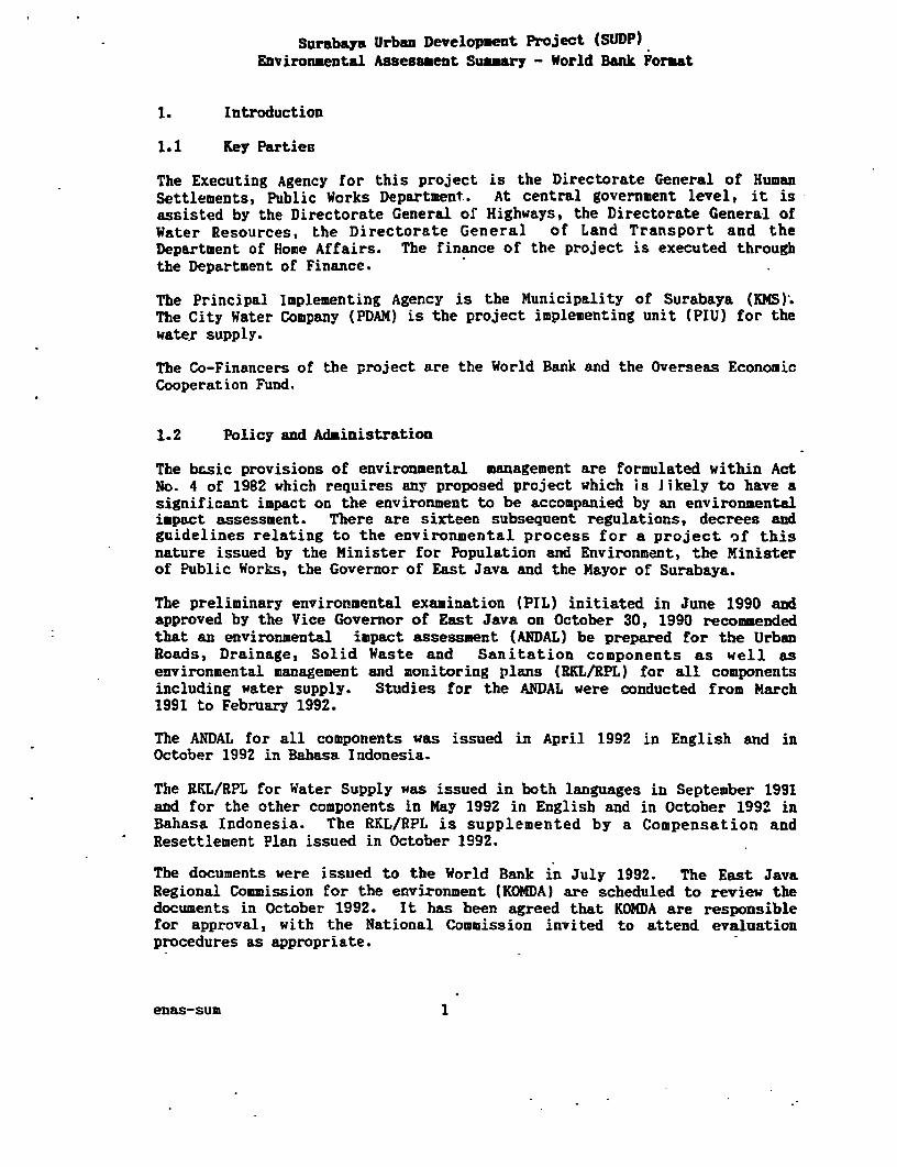
Surabaya Urban Development Project (SUDP)Eavironmental Assessment Summary - World Bank Format
1. Introduction
1.1 Key Parties
The Executing Agency for this project is the Directorate General of HumanSettlements, Public Works Department. At central government level, it isassisted by the Directorate General of Highways, the Directorate General ofWater Resources, the Directorate General of Land Transport and theDepartment of Home Affairs. The finance of the project is executed throughthe Department of Finance.
The Principal Implementing Agency is the Municipality of Surabaya (KMS).The City Water Company (PDAM) is the project implementing unit (PIU) for thewater supply.
The Co-Financers of the project are the World Bank and the Overseas EconomicCooperation Fund.
1.2 Policy and Administration
The bc.sic provisions of environmental management are formulated within ActNo. 4 of 1982 which requires any proposed project which is likely to have asignificant impact on the environment to be accompanied by an environmentalimpact assessment. There are sixteen subsequent regulations, decrees andguidelines relating to the environmental process for a project of thisnature issued by the Minister for Population and Environment, the Ministerof Public Works, the Governor of East Java and the Mayor of Surabaya.
The preliminary environmental examination (PIL) initiated in June 1990 andapproved by the Vice Governor of East Java on October 30, 1990 recommendedthat an environmental impact assessment (ANDAL) be prepared for the UrbanRoads, Drainage, Solid Waste and Sanitation components as well asenvironmental management and monitoring plans (RKL/RPL) for all componentsincluding water supply. Studies for the ANDAL were conducted from March1991 to February 1992.
The ANDAL for all components was issued in April 1992 in English and inOctober 1992 in Bahasa Indonesia.
The RKL/RPL for Water Supply was issued in both languages in September 1991and for the other components in May 1992 in English and in October 1992 inBahasa Indonesia. The RKL/RPL is supplemented by a Compensation andResettlement Plan issued in October 1992.
The documents were issued to the World Bank in July 1992. The East JavaRegional Commission for the environment (KOMDA) are scheduled to review thedocuments in October 1992. It has been agreed that KOMDA are responsiblefor approval, with the National Commission invited to attend evaluationprocedures as appropriate.
enas-sum 1
2. Project Description
The project is for integrated urban infrastructure development andenvironmental improvement in Surabaya and includes all expenditure inSurabaya for the next six years on urban roads and transport, urbandrainage, water supply, solid waste management, sanitation and kampungimprovement. It also includes improvements iu urban management by institu-tional and human resources development, in financial management, incommunity participation and in land management, as well as technicalassistance and training.
The list of components is:
- 200 km of new and improved urban roads- 5 No traffic management schemes
- 92 km rehebilitated water pipelines- 1020 km water distribution pipelines- 146000 water connections- 72 km transmission and primary water pipelines- 2 pump stations and reservoirs- Water leakage programme and computer systems upgrade
- 143 km of new and improved drains
- 197 new or rehabilitaLed solid waste depots or transfer sites- 27 container trucks + 336 containers- 14 compactor trucks + 1033 waste bins- 350 hand carts for solid waste- 11 new or overhauled-landfill equipment
- 47 km of new sewers or pump mains- 6200 house connections- 2 pump stations- 1 sewage treatment (Stabilisation pond) plant- 1 septage treatment (digestion) plant + 4 No sludge vehicles
- 1200 ha of improved kampung- 30000 septic tanks or pit latrines- 15000 kitchen and bathroom improvements- 110000 improved land certificate holdings in kampung areas- 200000 building permits in kampung areas
- Community development programmes in at least 72 kampungs toencourage community participation in development, develop therole of women and small scale business ventures and improveawareness of health and welfare issues.
- Improved operation and maintenance for roads, drainage, watersupply, solid waste and sanitation.
- Humar resource development to strengthen RMS and PDAM.
- Training for 3000 government officials and 24000 communityofficials and inhabitants.
enas-sum 2
- Technical assistance for urban. management, desPgn and super-vision, operation and maintenance, master planning, humanresource development and training, revenue improvement, landmanagement, community development and transport management.
- Environmental monitoring and management to ensure that projectmitigations are carried out especially resettlement of personsdisplaced by roads and drains, monitoring of nearby wetlands andloss of irrigated areas.
The roads and drainage improvements directly affect 7185 properties by landacquisition and 2952 of these must be relocated. The road and transportcomponents will improve access to and within the city, improve safety,pedestrian access and public transport. The drainage will provide flood freeareas.
The water supply component will provide potable water to an additional146000 properties.
The roads and drainage improvements will enable development close to coastalwet lands but not on the wetlands.
The drainage improvements will convert irrigation channels and causeirrigation to cease, a process which has been occurring rapidly as the.city develops, but until now with already developed areas subject to regularflooding whilst the remaining irrigation continues.
The solid waste manageamer.t and sanitation components will improve theenvironment in these sectors increasing solid waste collection to 90Xcoverage, introducing controlled landfill procedures and improvingsanitation for 250000 people.
The proposed implementation schedule is shown on Figure 1.
3. Baseline Date..
3.1 Location
The area is the Municipality of Surabaya which lies between latitude 70 12'and 70 21' South and between longitude 112° 36' and 1120 54' East.
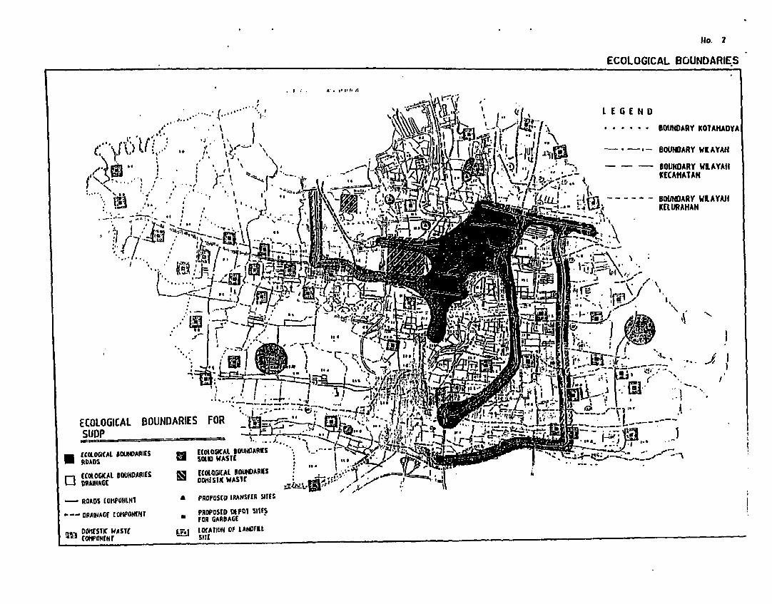
The municipality is a lowland plain, 3 to 6 * above sea level, with twogently sloping hills in the south west rising up to 50 a above sea level.The whole municipality is 290.4 square kilometres. See Figure 2 for theintensively observed ecological borders of the project.
3.2 Climate
The area enjoys a tropical climate with a wet season from November to April,Kay transitional, and a dry season from June to October. Rainfall is about1860 m- per year with about 25 mm/month in the dry season peaking to 350 -per month during January and February. Humidity is between 63 and 85Z. Airquality is generally good and there is no major noise pollution.
enas-sum 3
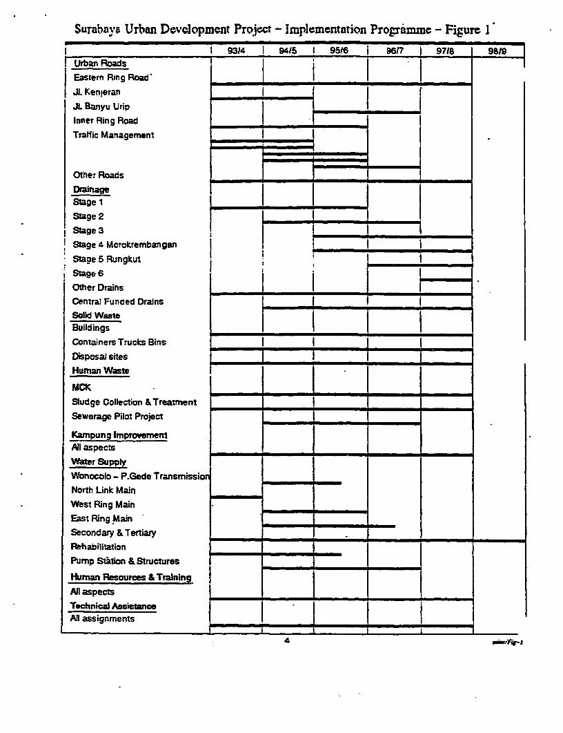
Surabava Urban De"vlopment Project - Implemen tation Programme - Figure 1
g3/ 1 94/5 1 95_ 6 j_ _6/7 9718 9819Urban Roads i j (
Eastern Ring Road'
JI. Kenjeran
Jl. Banyu Urip
Inner Ring Road m i
Traffic Management I I
Other Roads _ .
Drainage IIStage 1
Stage 2
Stage 3
! Stage 4 MorokrembanganStaoe 5 RungKut !
i Stage 6jOther Drains j [ -
Central Funded Drains
Solid WasteBuildings
Containers Trucks Bins
Disposal sites
Human Waste
Sludge Collection & Treatment
Sewerage Pilot Project -
Kampung Improvement 1All aspects - -
Water Supply
Wonocolo - P.Gede Transmission
North Link Main
West Ring Main
East Ring Main -
Secondary & Tertiary -
PRehabilitation
Pump Station &Structures
HiumanResources &Training -
All aspects|
Technical Assistance -All assignments -
4 _FI
ECOLOGICAL BOUNDARIE.S
, , ' ' (" I \X6%g 8 18 , * * * * * lD~~~~~ B O A R Y K D l A M A D Y A |
N lirG , a ; . oWNDARY WE AYAH|
*--ORAIHACf toNEHr " fPoRSGStaac>sFOl SlltS l~~~~~~~~~KELUAHA
00e1£51f WASlt E lEAIIOH Of lAHOfUl~~~~~~.3 hlPCtH 51
3.3 Geology
The low land plain is alluvial soil consisting of clay, sandy clay and sandcovered shell. The hilly areas are formed from old alluvial soil alsoconsisting of clays and sand.
3.4 Hydrology
Kali Surabaya flows to the north and divides into two, namely Kali Wonokromowhich flows to the east and Kali Mas which continues to the north. RsliSurabaya has a flow between 20 m3/s and 370 m3/s at Mirip Outfall. AtGunungsari Dan, the water surface can be kept up to 4.7 X above sea level todivert flow to Gresik and West Surabaya but as Gunungsari channel hasinsufficient fall there has been zero flow diverted for several years.There are also dams at Ngagel to divert water to the water treatment works,and at Gubeng to retain water for flushing and local irrigation.
The land east of Kali Mas and Kali Surabaya drains directly to the eastcoast via many parallel drains. The land south of the hills drains to K.Kedurus and into K. Surabaya. The land north of the hills drains directly
-to the north coast. Consequently the catchment for the K. Mas is verynarrow.
Generally soils have very low permeability, about 5 x 10⁻⁴ cu/sec and wellshave very limited capacity. Groundwater is about 3 to 8 m and 0.5 to 3 abelow ground level in the dry and wet season respectively.
Water quality of the rivers and groundwater is very poor with heavypollution from human waste.
3.5 Biology
a. Flora: lost of Surabaya is au antificial ecosystem consisting of housing,industry, warehousing, ricefields, upland fields and fish ponds. Only asmall strip (1 to 30 m wide) is natural mangrove swamp along the north andeast coast. There are 42 sq km of rice fields, 25 sq km of which is rainfed and many of the designated irrigated. areas cannot receive irrigationwater at any time. The reported crop (1989) for rice is 26000 tonnes peryear. Secondary crops sucb as maize and cassava give over 700 tonnes peryear. Vegetables and fruit are also produced. Most animals are domestic.
b. Fauna: Several types of wild birds occupy the coastal wetlands, restingin the mangrove at night. Seven species- are protected. Fishing occurs at seaand in fish ponds producing 4585 tonnes and 5132 tonnes respectively.Fishing in fresh and general waters is minimal.
3.6 Socio economic
Most people are employed in merchandising, hotels and restaurants (33X) andmany in social services (27X). Manufacturing and Industry (21X) andtransport (1lX) are the other major sectors.
enas-sum 6
Surabaya people are relatively healthy, the most common disenseS beingdiarrhoea and skin diseases.
The 1990 population was 2.6 million, 51% of which were female. The mostpopulous age range is 20 to 24 years old.
The people directly affected by the project have been identified atnd are asshown in Table 1.
The future trend without the project would lead to the economic sLagnationof Surabaya. The trend for many years has been for urban infrastructureexpenditure to increase but still it has not caught up with demand. Roadsand transport expenditure at this stage is considered vital to avoid futuremajor congestion being experienced by other cities. Flooding in a majorproblem in Surabaya and improvements are long overdue. Water supplY is alsoa major problem which is holding back development in many parts of the city.Solid waste expenditure is a continuation of major improvements made in thepast few years and the sewerage pilot project enables a start to be' made toreduce pollution from the city centre. The kampung improvement programmewill build on the successes of the past twenty years involving the communityeven more and improving sanitation and land rights.
4. Impacts
4.1 Urban Roads
The urban road and transport improvements will improve access to and withinthe city, improve public transport facilities, decrease through traffic,Improve traffic ma nagement and improve freight transport. It will improvesafety, improve the pedestrian environment and guide sound land use. Otherbenefits include improved operation and maintenance and work opportunities.
Major adverse impacts include the resettlement necessary due to landacquisition, the problems during construction in existing narrow roads fortraffic and the possibility of road construction encouraging development inadjacent or nearby wetlands. These are discussed below.
Other possible adverse impacts studied were extraction of sand and gravelfor construction, loss of green verge areas, changes in air qualitY andnoise, and the possibility of new roads causing changes to drainagepatterns. These were evaluated and found not to be major problems' for thisproject.
4.1.1 Land Acquisition for the Roads
By far the greatest adverse impact is caused by the land acquisition. Fullsurveys have been carried out to calculate the scale of the impact Acomplete (100%) enumeration of each property affected was implemented during1991. Each property has a one page survey sheet. The results were loggedand analysed and are summarised in Table 2.
enas-sum 7
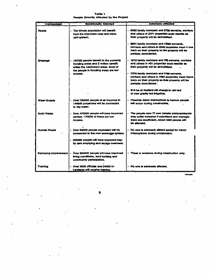
Table IPeople DIrectiy AfQted by the Project
Comfponent Boneticl.lly AlleCted Adver-ly Affected
Roads - The Whole populaUon will bensfil - 8060 famIly member. end 571 mrvt. workersfrom tho Improved road and trans- and others In 247t propernls must feost asport system. theIr property wil be demolsed.
- 4201 family member and 13300 servants.Workers and others In 2540 propertI must mback on their propeny r tho property wi bepalisdly demolished.
Dranage - 154725 peopIe befeilt In the currently - 1813 family membrs and M servants, workerstlooding areas and 2 mIlion bonefit and othemr In 4S1 propertles must rrosttb *within the catchment areas. Most of their property wv be demolihd.the people In flooding afeas are lowIncome. - 7076 lamIly members and 74M servanta.
workers end other In 168 propet must movback on their property a ther property will bepartidally demolished.
- 510 ha of ricetid wil chnmg to nan fedor non graity fed Irrgaton.
Water supply - Over 700000 people ot aft Incomes In - Possible minor lrteuptona t vaious people146000 propernes will be connected wu occur during construcOn.to CtY water.
Solid Wato - Over 470000 peopIe will have Improved - The peopl near 77 new troaner aonsldepotsserice. 170000 of these are Iow may su*er nuisance ffCoperallons and manage.Income. mrnt are InauMclent About 1000 people winl
ibe affctd.
Human Waste - Over 5S000 people equivalent will be - No one n addwerelY ated except tor minorconnecte d10 the new sewerae systm. InluptIons durlng conarucbon.
- 200000 people wol have Improv d sep-tic *nk emptying and sludge tmea-nenL
Kampung Improvement -Ovr 600000 People WI have improved - Them Is nuteance durng conretructon only.living condiions, land holding andcomnmunity parUolpaton.
Training - Over 3000 officials and 24000 In- - No one is adversely affected.habimtas wdll receive traIning. __
8
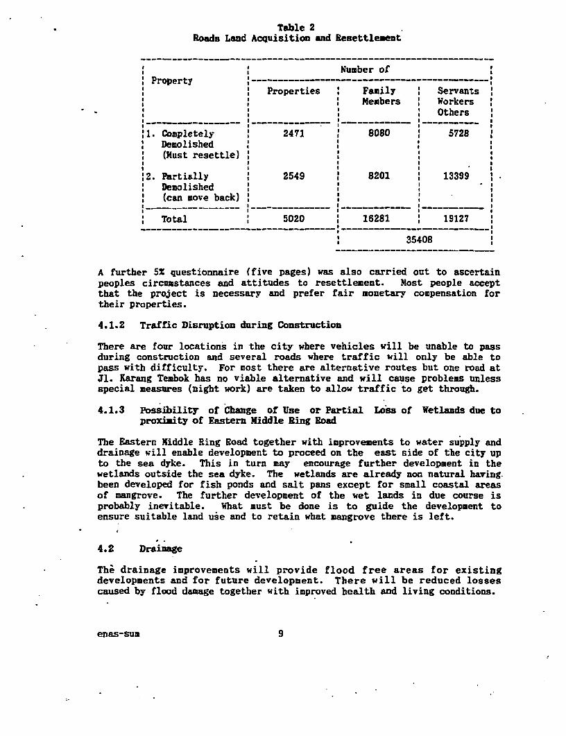
Table 2Roads Land Acquisition and Resettlement
Number ofProperty ----------------------- ---------------------
Properties Family : ServantsMembers : Workers
Others-- - - - - - - - - - -- - - - - -- - -- - -- - -- - - - -
'1. Completely 2471 8080 5728Demolished(Must resettle)
,2. Partially 2549 8201 ' 13399Demolished(can move back) '
*--- - -- - - - - - I - - - - - - - - - - - -
Total 5020 16281 19127
35408
A further 5X questionnaire (five pages) was also carried out to ascertainpeoples circumstances and attitudes to resettlement. Most people acceptthat the project is necessary and prefer fair monetary compensation fortheir properties.
4.1.2 Traffic Disruption during Construction
There are four locations in the city where vehicles will be unable to passduring construction and several roads where traffic will only be able topass with difficulty. For most there are alternative routes but one road atJl. Karang Teabok has no viable alternative and will cause problems unlessspecial measures (night work) are taken to allow traffic to get through.
4.1.3 Possibility of Change of Use or Partial Loss of Wetlands due toproximity of Eastern Middle Ring Road
The Eastern Riddle Ring Road together with improvements to water supply anddrainage will enable development to proceed on the east side of the city upto the sea dyke. This in turn may encourage further development in thewetlands outside the sea dyke. The wetlands are already non natural having.been developed for fish ponds and salt pans except for small coastal areasof mangrove. The further development of the wet lands in due course isprobably inevitable. What must be done is to guide the development toensure suitable land use and to retain what mangrove there is left.
4.2 Drainage
The drainage improvements will provide flood free areas for existingdevelopments and for future development. There will be reduced lossescaused by flood damage together with improved health and living conditions.
enas-sum 9
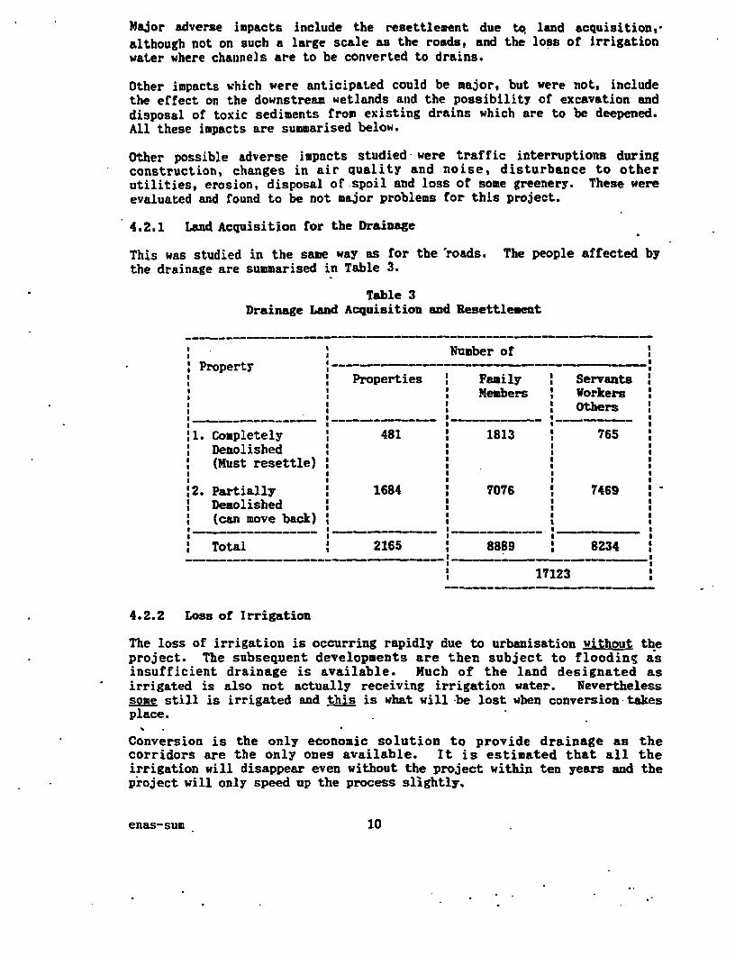
Major adverse impacts include the resettlement due to land acquisition,-although not on such a large scale as the roads, and the loss of irrigationwater where channels are to be converted to drains.
Other impacts which were anticipated could be major, but were not, includethe effect on the downstream wetlands and the possibility of excavation anddisposal of toxic sediments from existing drains which are to be deepened.All these impacts are summarised below.
Other possible adverse impacts studied were traffic interruptions duringconstruction, changes in air quality and noise, disturbance to otherutilities, erosion, disposal of spoil and loss of some greenery. These wereevaluated and found to be not major problems for this project.
4.2.1 Land Acquisition for the Drainage
This was studied in the same way as for the roads. The people affected bythe drainage are summarised in Table 3.
Table 3Drainage Land Acquisition and Resettlement
___.--_ ______ _ _Number of
* Property ------- …
Properties Family ServantsMembers ' Workers
Others -~~~ - - ---------- -
,1. Completely 481 1813 765Demolished(Must resettle)
'2. Partially 1684 7076 7469Demolished(can move back)
* _ ~~~~~~~~~~~~~~~~~~~~~~~~~________ ,I
Total 2165 8889 8234
17123
4.2.2 Loss of Irrigation
The loss of irrigation is occurring rapidly due to urbanisation without theproject. The subsequent developments are then subject to flooding asinsufficient drainage is available. Much of the land designated asirrigated is also not actually receiving irrigation water. Neverthelesssome still is irrigated and this is what will-be lost when conversion-takesplace.
Conversion is the only economic solution to provide drainage as thecorridors are the only ones available. It is estimated that all theirrigation will disappear even without the project within ten years and theproject will only speed up the process slightly.
enas-sum 10
Most of the owners of the ricefields will benefit as they will be able to.sell their land for developsent. However the rice farmers will lose theirlivelihood during the dry season only as they will be able to operate thefields as rainfed. Also downstream users may still be able to obtaingravity fed water if tide gates are kept closed during the dry season andthe water is backed up. Upstream users will only be able to continue toirrigate by using hand or mechanical pumping.
4.2.3 Downstream Wetlands
There will be no change to downstream wetlands as tidegates will be upratedbut not moved. Concerns about the wetlands have led the project to designunlined channels through the wetlands and to ensure that watergates to pondsare left undisturbed or replaced.
4.2.4 Possibility of Toxic Sediments
Testing of sediments in existing channels showed that there are no majorconcentrations of toxic substances. Only one high reading of DDT was foundbut not upstream or downstream of that reading. DDT has been banned inIndonesia for several years.
4.3 Water Supply
No major adverse impacts occur due to the water supply component. There isa major beneficial impact in that water supplies to the city will almostdouble.
Other impacts considered and evaluated were interruption to water supplies,and other utilities, access restriction, traffic disturbance, safetyhazards, destruction of vegetation, instability of structures, waterwayflows and quality, and reduction of urban amenity. The evaluation showedthat the water supply component has a very linited potential to affect theenvironment.
4.4 Solid Waste
The solid waste improvements will improve collection, transfer and transportsystems and upgrade disposal to controlled landfill through improvedoperation and management. Solid waste is under further study by JICA.
Significant impacts will be at Keputib and Kenjeran Beach landfills and atthe transfer site/depot locations. No major leachate problems have beenidentified but this -is being studied further by JICA as is long termcapacity of the landfills and the need for new sites.
Recycling is at a high level and will be encouraged to continue.
4.4.1 Keputib Landfill
Upgrading to controlled landfill as proposed by the project is urgentlyneeded to minimise smell, smoke and rodent nuisance to adjacent areas.
enas-sum l1
4.4.2 Kenjeran Beach
This landfill is causing' pollution to the sea and is too close to adesignated recreation area. It is not controlled by Kotauadya Surabaya asit is a private operation.
4.4.3 Transfer Stations and Depots
If the new transfer stations and depots are Pot well managed, nearby homes willbe affected with smells, dust and litter.
4.5 Sanitation and Sewerage.
The only significant adverse impact is disturbance to people and trafficduring construction of the' sewerage network.
Other aspects studied were all concluded to be positive except for thepossibility of smell at the treatment works and pump stations. The treatmentworks is to be located at Tandes well away from residential areas and thepump stations will be designed to minitise smells.
4.6 Kaupung Improvement (KIP)
There is disturbance during construction of KIP when bouse fronts aredemolished and moved back but otherwise-there are no adverse impacts.
5. Analysis of Alternatives
5.1 Urban Roads and Transport
Full studies of roads and transport requirements have been made. Thelocations of improved roads and new roads have been selected by checkingtraffic demands and road capacities using a computer model. Upgrading ofroads will follow an approved road grid layout of arterial, collector andlocal roads designed to achieve the objectives of the project. The projectforms part of the city transport strategy.
5.2 Drainage
The drainage proposals are part of the drainage master plan. Most of theproposed drainage channels are on existing drainage alignments or areconversions of irrigation channels and will be at suitable levels to collectstormwater from adjacent land and there are no economic alternativealignments.
New channels in Kali Simo/Tandes area have been located to enablestormwater to be drained quickiy and efficiently. The channels are locatedto coordinate with planning of adjacent land.
Benefits for each channel have been evaluated and the economic internal rateof return calculated. These are in the range 31X to 1651.
enas-sum 12
Additionally for each sub-project, the percentage of land value increase hasbeen calculated in order to achieve an internal rate of return of 10 (and15X and 20X). The land value increases required are in the range of 1.7X to125. These figures show that all the projects are economically viable asexperience shows that the ratio of the value of well drained land to floodedland is well above the maximum value required.
5.3 Solid Waste
The locations of the landfill sites are existing and will be used to theirmaximum capacity. A new site is planned at Benowo. Additional studies willbe required before this is brought on stream. These are on going funded byJICA.
The locations of the new transfer stations and depots have been agreed withthe Lurah of each Kelurahan and sited in the most suitable location but awayfrom any immediately adjacent residential land to minimize disturbance. Eachtrarsfer station must be located within 1 to 2 km of the collection areaand be sufficiently close without causing nuisance. The locations can stillbe moved if any chosen location proves unacceptable.
The city wide solid waste system uses the least cost, environmentallyacceptable alternatives and has been evaluated by financial analysis (assome of the benefits are economically difficult to place a value on) andthe financial internal rate of return is about 20.
5.4 Waste Water
The location of the pilot sewerage project has been carefully selected.Kelurahan Petemon was established as a sewerage pilot area for the followingreasons
: IUIDP integration. : the SUDP drainage sector includes Gunungsaridrainage channel which will eliminate periodic flooding in the westernparts of the Kelurahan.
* Water supply is programmed to be upgraded in the Kelurahan.* Income levels are sufficiently high to assist in cost recovery. Cross
subsidisation is possible.* Good location within reasonable distance of business/commercial
district.
Similarly, the locations for the on-site sanitation facilities have beencarefully analysed for suitability according to the following criteria
* . population density* resident income* percentage of septic tanks installed* groundwater level and soil permeability* flooding.* availability of water supply* existing facilities
The criteria set are in accordance with the National strategy for sanitation.
enas-sum 13
5.5 Kampung Improvemnet
KIP sites are selected using EMS criteria of flooding, water supply,sanitation facilities, accessibilitY, community attitude to development,population density, income, education, age of Kampung, physical condition,layout and estimated impact of KIP. These are scored and weighted and thekampungs then prioritised. It is proposed to improve 10 to 12 kampungs on azonal basis each year.
6. Mitigation Plans
These are set out clearly in the Environmental Mangement Plan (RKL) and aresumarised below.
6.1 Land Acquisition and Resettlement - Road and Drains
An improved land acquisition procedure will be followed in accordance withthe law but which in addition gives those affected early consultation,improved (NGO) representation on the land aquisition coomittee and a choiceof options on resettlement. This is fully detailed in the Compensation andResettlement Plan which has been agreed by both Kotamadya Surabaya and theWorld Bank.
The main alternative option to monetary compensation is resettlement insites and services schemes giving a total of 936 plots which will be capableof housing about 32X of those whose property is completely demolished. Thisis the proportion revealed by the questionnaire. The sites and servicesschemes will be implemented by the KIP unit of Kotamadya Surabaya and beconfinanced by World Bank.
Other alternatives to be offered include
Fringe Kampung ImprovementHousing by PerumnasHousing by YKPPrivate housing funded by BTNWalk Up Flats
Cost for the sites and services scheme (Rp. 4.1 billion) and for NGOassistance (0.2 billion) are allowed for in the medium term programme.
6.2 Traffic Disruption - Roads, Drains and Sewerage
Traffic disruption plans will be made outlining alternative routes andtraffic management arrangements with organisation agreed with the trafficauthorities to publicise the arrangements.
Traffic flows will be monitored by traffic engineers.
enas-sum 14
6.3 Possibility of Change of Use or Partial LoSB Of Wetlands due toproximity of Eastern Middle Ring Road
A land use study will be carried out and a land use plan will be prepared aspart of the Regional Master Plan. This will determine how best to use,develop and protect the wetlands for the benefit of the whole city. The cityauthorities will then enforce it.
6.4 LOBS or Irrigation due to Conversionx of Channels to Drains
Some monetary compensation and the provision of temporary PUsPiiAg may beneeded. It is necessary to identify in detail what areas still actuallvreceive irrigation water and whether there are imminent plans to develop. Noareas are designated to stay as irrigated rice fields in the laster Planwhich has been available for over ten years. A baseline survey is to becarried out just prior to construction to ascertain areas, production andincome and whether phasing of the conversions can be improved to minimiseimpacts. A further survey will be carried out after conversion takes placeto determine that necessary compensation measures were taken and that theyare fair.
6.5 Wetlands Management during Drainage construction
A fisheries expert will be made available during construction to engure thatwater flows are not unnecessarily disturbed by channel excavation.
6.6 Kenjeran Beach Landfill for Solid Waste Disposal
This site should be closed as soon as possible. A management plan should bedrawn up by KMS/JICA to enable effective management of the closedown. JICAare studying this in depth.
6.7 Transfer Stations and-Depots for Solid Waste Management
Rules for the siting, construction and operation of the stations/depots havebeen drawn up. Management of all solid waste management will be strengthenedby provision of technical assistance.
7. Monitoring and Evaluation
The environmental monitoring plan (MKL) sets out clearly what monitoring andevaluation is required and this is summarised below and is also shownclesrly in Table 4.
7.1 Land Acquisition and Resettlement - Roads and Drains
The questionnaire survey (5X) and complete enumeration survey provides avery substantial base line for monitoring the land acquisition andresettlement.
enas-sum 15

Impact Mitigations MonItoring
ROADS
1. Resettlement of afflcted Resettlament & Compensation Follow up soclo economic surveypeople. Plan with aIternalive options, based on ANDAL questionnairs
survey.
Traffic disruption. Traffic management and public Observation surveys of traffic flowsinformation. during construction.
Encouragement of Accale- Land use study and plan. Aerial survey or land survey torated wetiand development determine that zoning rogulationsdue to Influence of nearby are being enforced.ring road.
DRAINAGE
; Resettiement of affected Resettlement and Compensation Follow up socio economic surveyspeople. Plan with alternative options based on ANDAL questonnalre
survey.
Traffe Disruption. Traffic management and public Observation of traffic flows duringInformation. construction.
Changes to Brackich water No lining to channels down- Supervision by fisheries expertponds In East Surabaya. stream of tidegates. during construction.
Watergat-c to ponds leftundisturbed or replaced.
Change to agricultur, due Temporary pumping. Baseline and follow up survey byto conversation of Irrigatlon Increase In value of land. Irrigation engineer to determinechannels to drainage Possible monetary compensa- extent and value of agricultural
tion to farmes. lo".SOUD WASTE
8. Expansion of Landfll at Operational Improvements to Regular checking by solid wasteKeputih. upgrade to Controlled LandfilL expen that operanonal ndes are
being followed together with airand water quality tests.
Continued Operatlion of Temporary closure whilst JICA Water quality testing and sociaKenjoran Beach Landfill and GOUKMS study the possibi- survey to ensur nearby recreation
ity of reclamation and establish area can operate satisfactorily.operating rules and legal Issues. Surveys required are baseline. oneIf closure made permanent JICA year after and five years afterto provide guidance on rehabili- closure.taton.
10. Air pollution and health risks Good design and construction. Air and water quality testing andto residents near new depots Strict operation rules. sociological survey of 10% sampleor transfer stations. Containerisaton. based on ANDAL survey.
SANITATION
Temporary traffic disruption. Traffic management plan specifi- Regular traffiengineer.air and noise pollution due to cation and control of equipment Inspections and constructondigglng sewer piee trenches. land spoil storage/transportation, supervision.
1 6
The random sample used for the questionnaire will be used for follow upsurveys to be carried out just prior to the people being moved, six monthsafter land acquisition is completed and then two y-ars later to ascertainthat arrangements were indeed fair and satisfactory. In this way it will bepossible to monitor the social and economic situation of those displaced orpartially displaced people and to adjust arrangements if necessary.
7.2 Traffic Disruption - Roads, Drains and Sewerage
Traffic management for these components will be monitored independently bythe traffic management technical assistance and recommendations made forimprovements as necessary.
7.3 Possibility of Change of Use or Partial- Loss of Wetlands due. toproximity of Eastern Middle Ring Road
A yearly survey of the wetlands will be carried out by an ecologist and asociologist to monitor that land use zoning regulations are being followed.
7.4 Loss of Irrigation due to Conversion of Channels to Drains
.The baseline survey of irrigated areas is not yet determined as it iscontinually changing at a rapid pace. The baseline survey for each channelwill be carried out by an irrigation engineer prior to construction and thenafter conversation is completed. This will enable determination of actualchanges in agricultural practice and income.
7.5 Solid Waste Disposal Sites
All landfill sites operations will be monitored yearly, and air and waterquality tested quarterly, by the solid waste management expert.
For Kenjeran Beach, additional monitoring will be carried out by asociologist to determine that the recreation area does not suffer any healthhazards, and by a marine ecologist to determine if there is continuingcoastal pollution. This additional monitoring will be carried out prior toclosure of the landfill and one year and five years after closure.
7.6 Transfer Stations and Depots for Solid Waste Management
A baseline survey of 1OX of the stations and depots was carried out for theANDAL. This sample will be resurveyed one year after construction andmonitored for sociological reaction and for air and water quality.
8. Institutional Needs
The izplementation arrangements for SUDP will also encompass the managementand monitoring of environmental requirements. In particular eachimplementation unit will be responsible for management of its component toensure that mitigation measures are fully implemented. Specific additionalarrangements to carry out independent management advice and monitoring will
enas-sum 17
be made by Kotamadya Surabaya. In particular they will appoint AirlanggaUniversity to carry out continuing resettlement surveys as they wereinvolved in the baseline survey, appoint the NGO for resettlement,preferably the one previously used for the KIP womens involvement survey,and appoint specialists such as the ecologist, sociologists, marineecologist and irrigation engineer for monitoring. These specialists are inaddition to specialists appointed under technical assistance forimplementation who will also be monitoring in their disciplines asnecessary.
Environmental management supervision will be by the Urban Management Unit ofKotamadya Surabaya, by the Provincial Planning Board (Bappeda Tk 1) and bythe Directorate General of Human Settlements (Cipta Karya).
Environmental training courses for City staff have been included in theproject as part of the Human Resources Development and Training component.
Enforcement measures. and legal strengthening is being carried out on anational and regional basis by the new BAPEDAL agency and these will besufficient without further measures under this project.
9. Public Participation.
To date, consultation has been by survey on an individual basis. Surveyshave been carried out for :
Land acquisition for Roads and Drains Survey - 1991Household survey - 1989Pilot Project Area Household & Commercial Sewerage Survey - 1991.Solid Waste Industrial Survey - 1991Role of Woman in SUDP Survey - 1991
All these surveys have been questions to individuals to ascertain base data.An NGO carried out the Role of Women in SUDP Survey in conjunction with thepreparation consultants.
The only group basis survey has been through the focus groups for the Roleof Women in SUDP Survey.
There has been no further consultation yet and there will not be until fundsare assured in order to avoid embarassment. This is early enough as theproject is on a 5 year programme basis.
Funds are now assured from OECF and it is planned to announce the project inNovember 1992 concurrently with appraisal by World Bank. The announcementwill be to the press and public and will include release of thisenvironmental assessment summary in the Indonesian language.
After that, group consultations will commence with the first and second yearpriority projects and will continue for the whole programme.
enas-sum 18
A public information centre is to be set up as part of the project to be thefocus to disseminate information and receive complaints. NGOs willparticipate in SUDP for the land acquisition and resettlement and as part ofthe community development under the KIP sector but which has the aim ofcommunity development for the whole programme. Community participation willcontinue to have a high profile in the solid waste sector and there will bespecial community programmes drawn up and carried out for the sewerage pilotproject.
;
enaS-sum 19