Embed Size (px)
Citation preview
Information Requirements for Integrating Spatially Discrete, Feature-
Based Earth Observations
Jeffery S. HorsburghAnthony Aufdenkampe, Kerstin Lehnert, Emilio Mayorga,
Leslie Hsu, Lulin Song, Ilya Zaslavsky, David Valentine
Support: 1224638
Challenge
• Information models of current geoscience cyberinfrastructures:– Represent common information elements in
inconsistent ways (e.g., people, units, measured variables, etc.)
– Lack extensibility required for supporting additional data types
Given data sharing requirements from funding agencies:
What information must accompany observational data for them to be archivable and discoverable within a publication system as well as interpretable once retrieved from such a system for analysis and (re)use?
Overarching Goals
• Create an information model (ODM2) that is integrative and extensible– Accommodating a wide range of observational data– Aimed at achieving interoperability across multiple
disciplines and systems that support publication of earth observations
• Allow a diverse range of geoscience observations to be consistently managed, shared, discovered, accessed, and interpreted
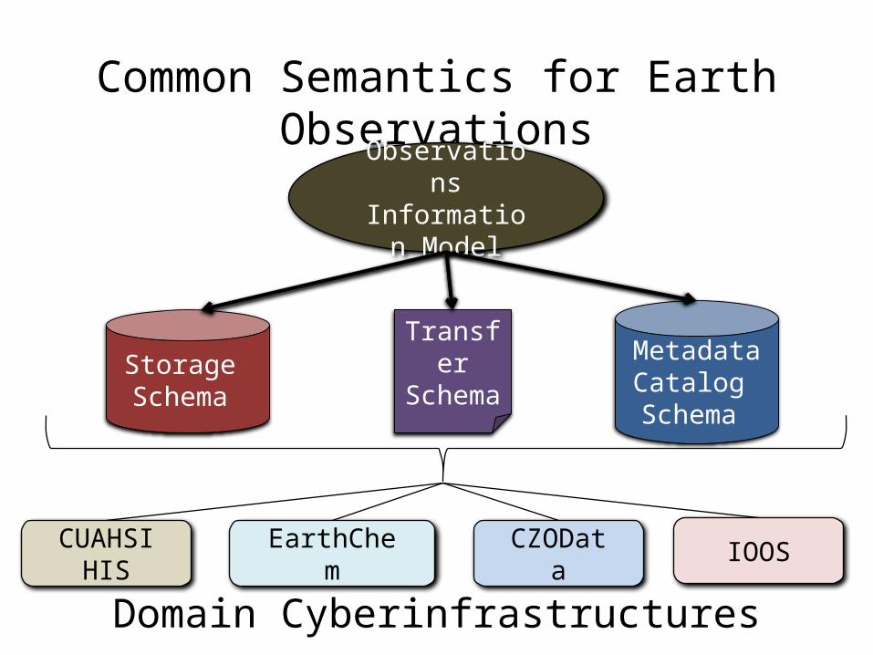
Common Semantics for Earth Observations
ObservationsInformation
Model
Domain Cyberinfrastructures
CUAHSIHIS EarthChem CZOData IOOS
Storage Schema
TransferSchema
Metadata Catalog Schema
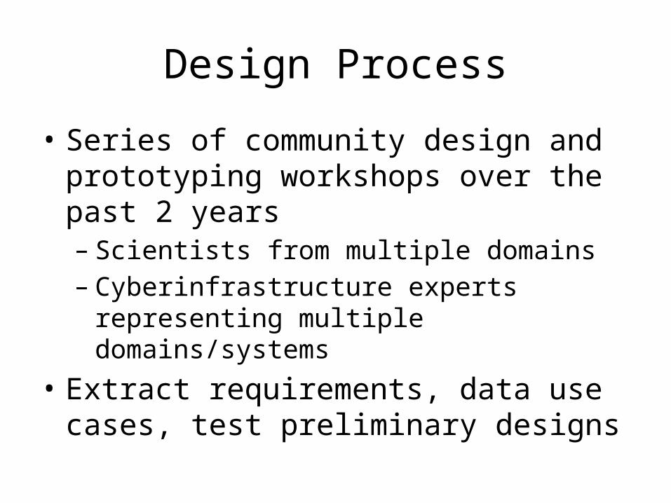
Design Process
• Series of community design and prototyping workshops over the past 2 years– Scientists from multiple domains– Cyberinfrastructure experts representing multiple
domains/systems• Extract requirements, data use cases, test
preliminary designs
Requirement: Describe Observed Feature(s)
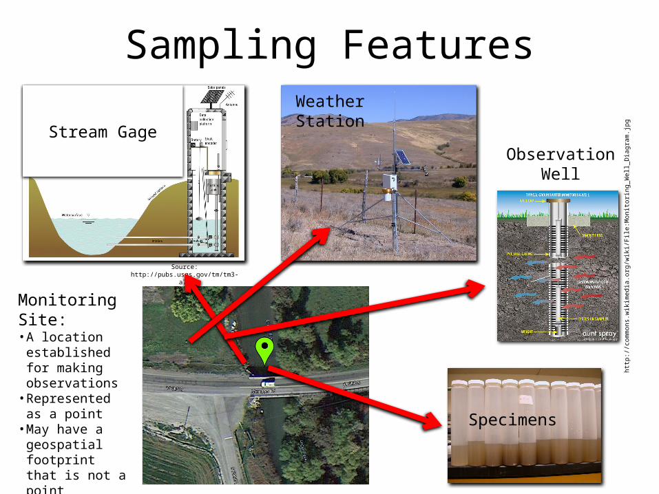
Sampling Features
Stream Gage
Source: http://pubs.usgs.gov/tm/tm3-a7/
Weather Station
Monitoring Site:• A location
established for making observations• Represented as a
point• May have a
geospatial footprint that is not a point
http:
//co
mm
ons.
wik
imed
ia.o
rg/w
iki/F
ile:M
onito
ring_
Wel
l_D
iagr
am.jp
gObservationWell
Specimens
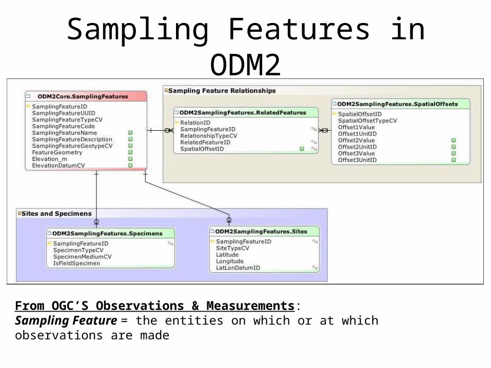
Sampling Features in ODM2
From OGC’S Observations & Measurements:Sampling Feature = the entities on which or at which observations are made
Requirement: Support Diverse Data Types
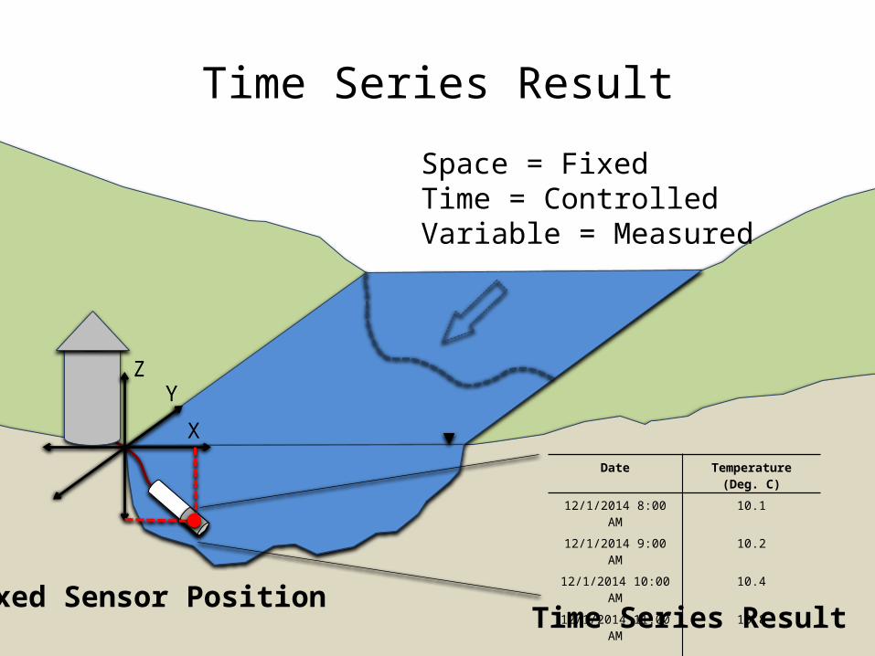
Time Series Result
Z
X
Y
Fixed Sensor Position
Date Temperature (Deg. C)
12/1/2014 8:00 AM 10.1
12/1/2014 9:00 AM 10.2
12/1/2014 10:00 AM 10.4
12/1/2014 11:00 AM 10.8
. . . . . .
Time Series Result
Space = FixedTime = ControlledVariable = Measured
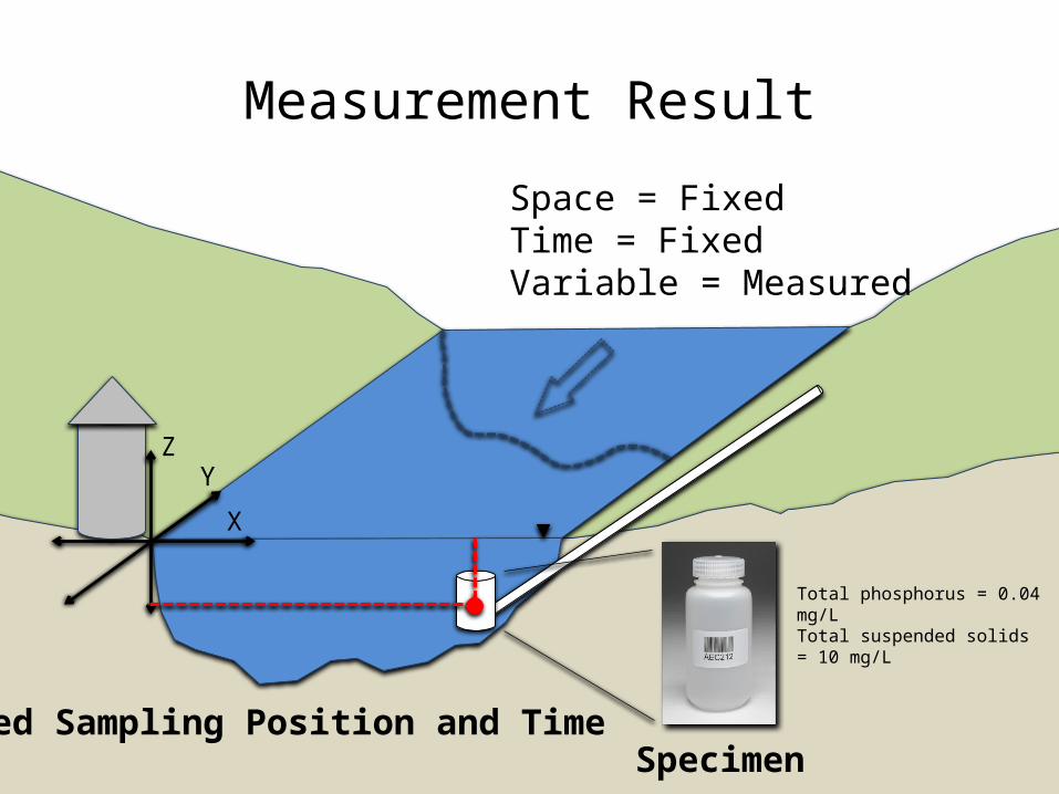
Measurement Result
Z
X
Y
Fixed Sampling Position and TimeSpecimen
Total phosphorus = 0.04 mg/LTotal suspended solids = 10 mg/L
Space = FixedTime = FixedVariable = Measured
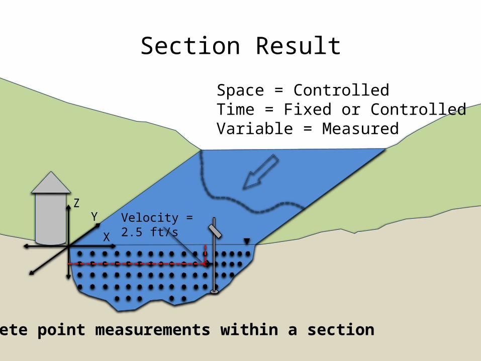
Section Result
Z
X
Y
Discrete point measurements within a section
Velocity = 2.5 ft/s
Space = ControlledTime = Fixed or ControlledVariable = Measured
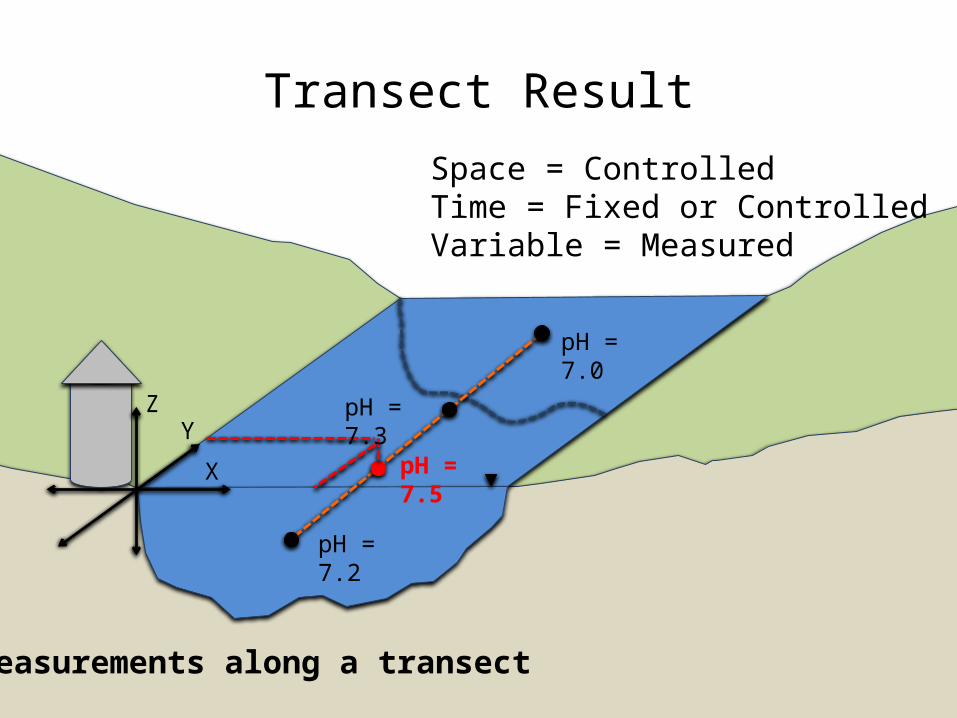
Transect Result
Z
X
Y
Measurements along a transect
pH = 7.2
pH = 7.5
pH = 7.3
pH = 7.0
Space = ControlledTime = Fixed or ControlledVariable = Measured

ODM2 Core Schema + Results
• People and organizations• Actions• Results• Measured variables• Units• Processing levels
Time Series
Measurement
Transect
. . .
• Space• Time• Measured Values
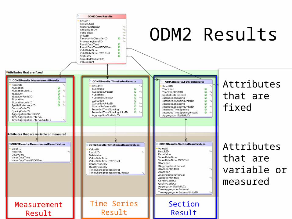
TransectResult
ODM2 Results
Attributes that are fixed
Attributes that are variable or measured
MeasurementResult
Time SeriesResult
SectionResult
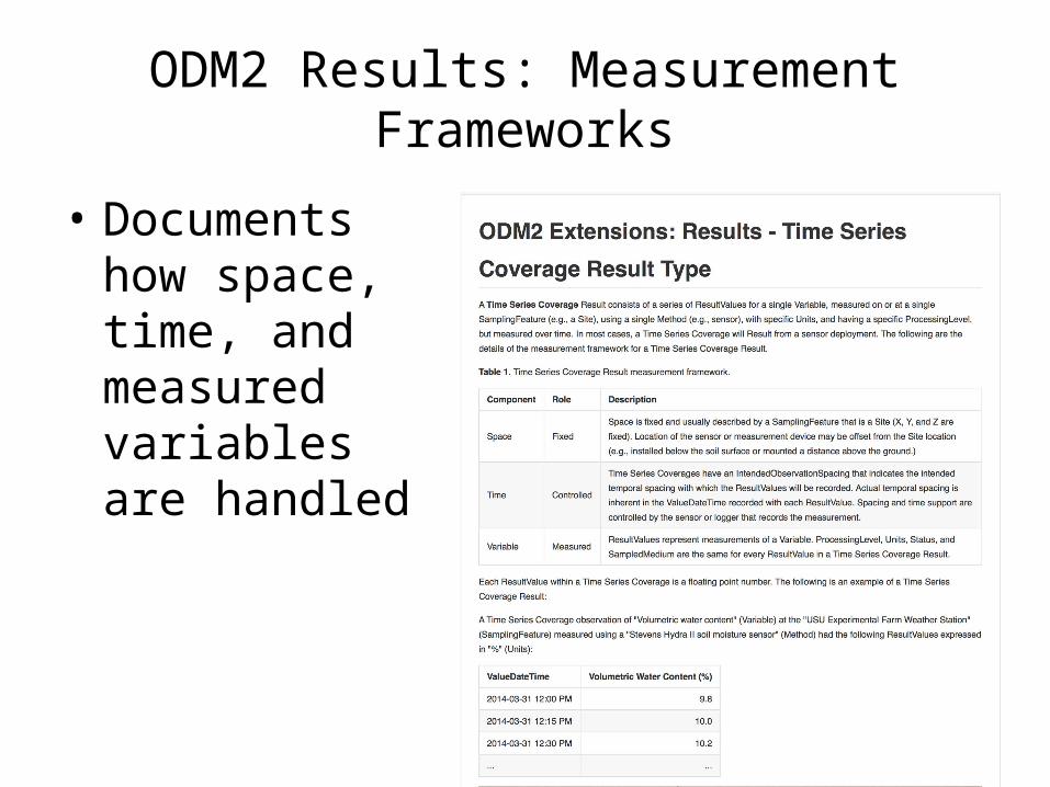
ODM2 Results: Measurement Frameworks
• Documents how space, time, and measured variables are handled
Requirement: Support Observation Provenance
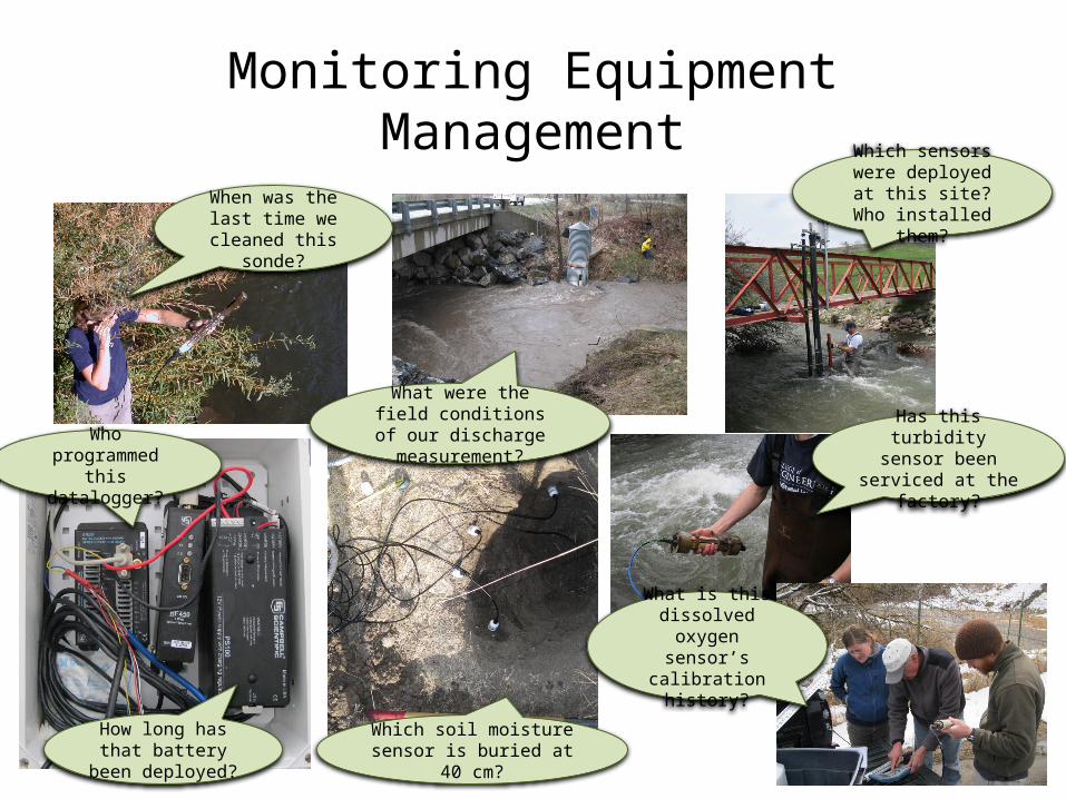
Monitoring Equipment ManagementWhich sensors were
deployed at this site? Who installed them?
Which soil moisture sensor is buried at 40 cm?
Has this turbidity sensor been serviced
at the factory?Who programmed
this datalogger?
How long has that battery been
deployed?
What is this dissolved oxygen
sensor’s calibration history?
When was the last time we cleaned this
sonde?
What were the field conditions of our
discharge measurement?
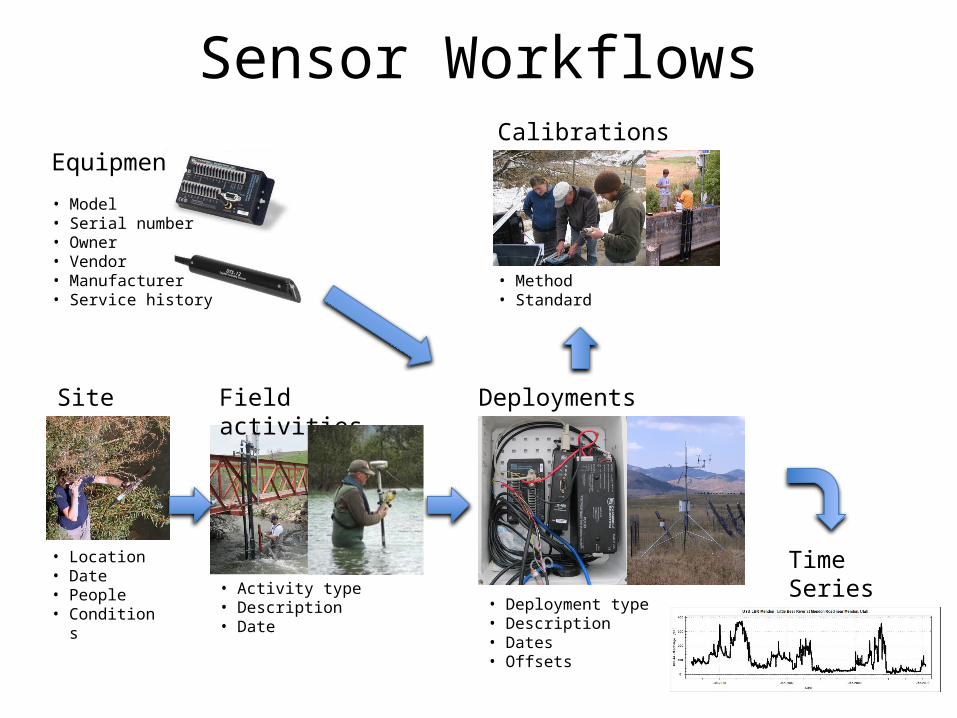
Sensor Workflows
Site visits
Equipment
Field activities
• Location• Date• People• Conditions
• Activity type• Description• Date
• Model• Serial number• Owner• Vendor• Manufacturer• Service history
Deployments
• Deployment type• Description• Dates• Offsets
Calibrations
• Method • Standard
Time Series Observations
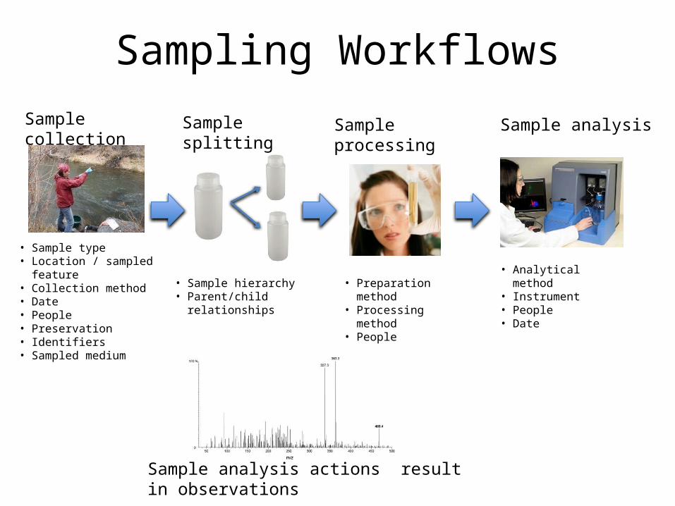
Sampling WorkflowsSample collection Sample splitting Sample processing Sample analysis
Sample analysis actions result in observations
• Sample type• Location / sampled feature• Collection method• Date• People• Preservation• Identifiers• Sampled medium
• Sample hierarchy• Parent/child relationships
• Preparation method• Processing method• People
• Analytical method• Instrument• People• Date
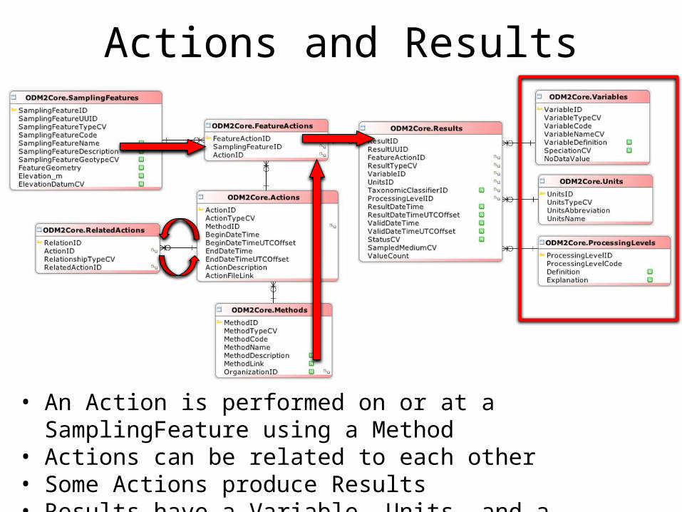
Actions and Results
• An Action is performed on or at a SamplingFeature using a Method• Actions can be related to each other• Some Actions produce Results• Results have a Variable, Units, and a ProcessingLevel
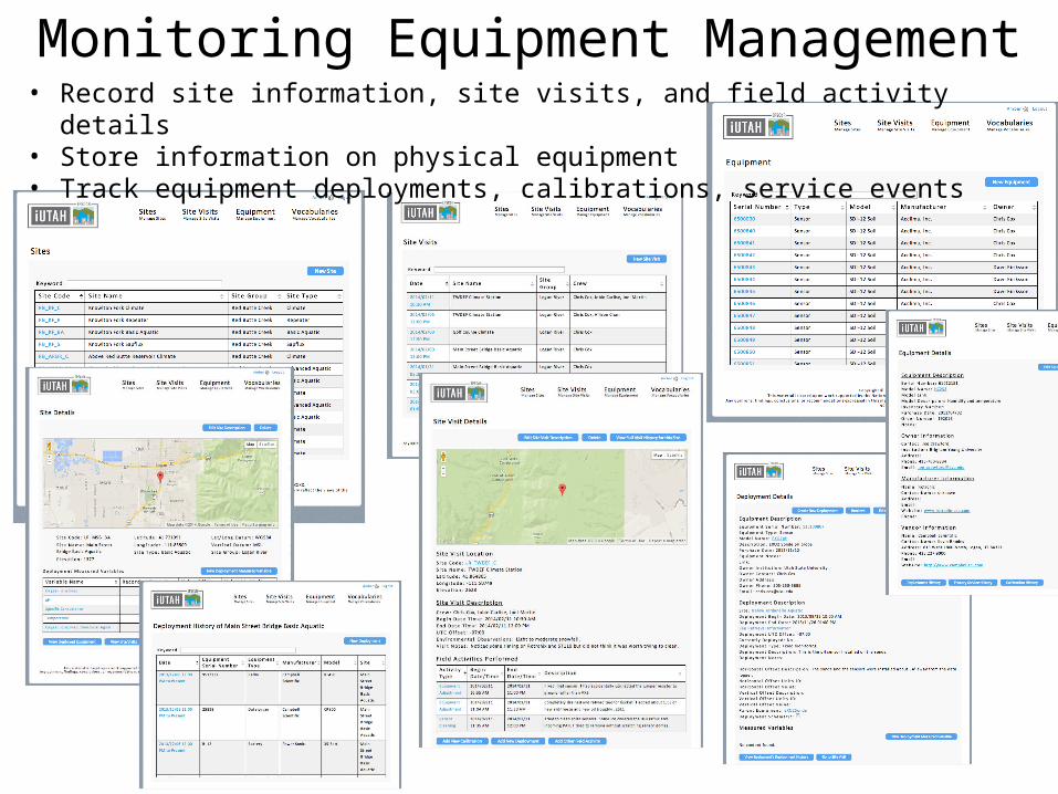
Monitoring Equipment Management• Record site information, site visits, and field activity details• Store information on physical equipment• Track equipment deployments, calibrations, service events
Requirement: Support Multiple Functional Use Cases
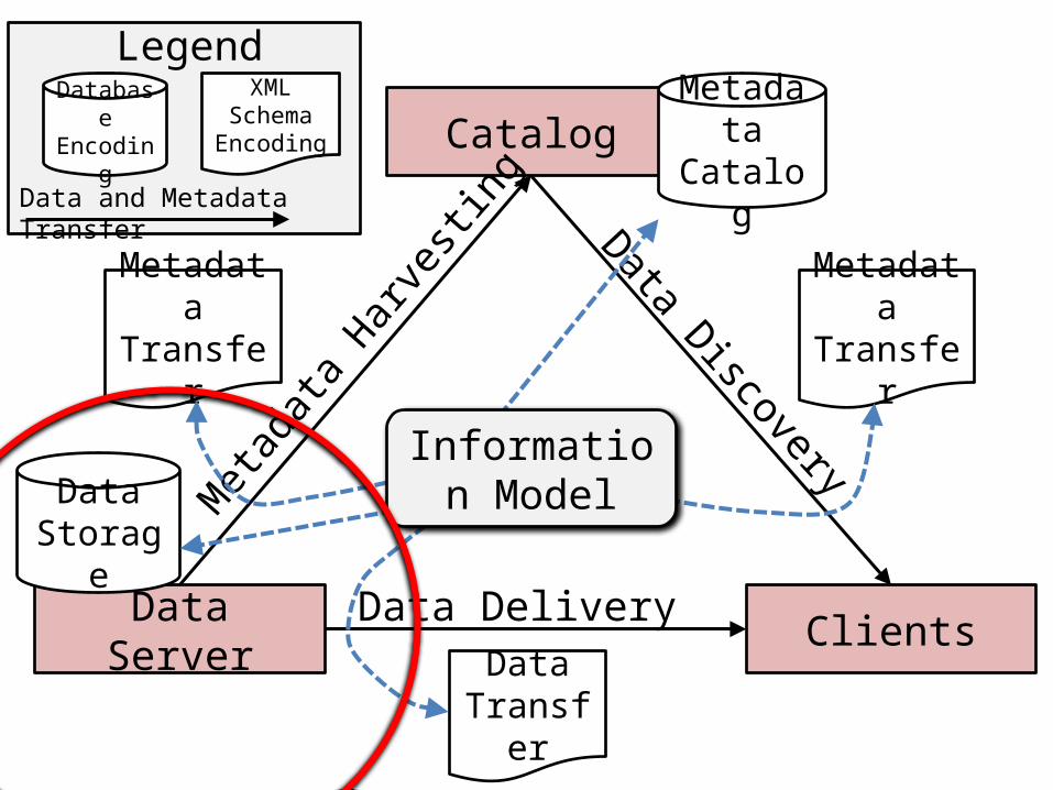
Catalog
Data Server Clients
MetadataCatalog
Data Storage
Met
adata
Har
vesti
ngData Discovery
Data Delivery
MetadataTransfer
MetadataTransfer
DataTransfer
Information Model
DatabaseEncoding
XML Schema
Encoding
Legend
Data and Metadata Transfer
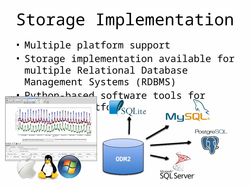
Storage Implementation • Multiple platform support• Storage implementation available for multiple
Relational Database Management Systems (RDBMS) • Python-based software tools for multiple platforms
ODM2
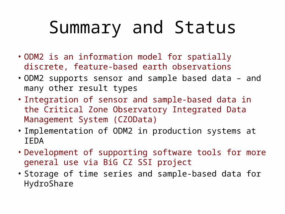
Summary and Status
• ODM2 is an information model for spatially discrete, feature-based earth observations
• ODM2 supports sensor and sample based data – and many other result types
• Integration of sensor and sample-based data in the Critical Zone Observatory Integrated Data Management System (CZOData)
• Implementation of ODM2 in production systems at IEDA• Development of supporting software tools for more general
use via BiG CZ SSI project• Storage of time series and sample-based data for HydroShare
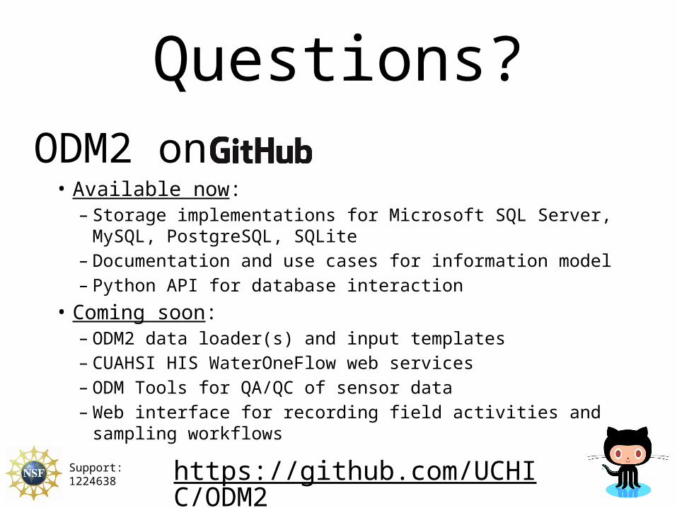
ODM2 on• Available now:
– Storage implementations for Microsoft SQL Server, MySQL, PostgreSQL, SQLite
– Documentation and use cases for information model– Python API for database interaction
• Coming soon:– ODM2 data loader(s) and input templates– CUAHSI HIS WaterOneFlow web services– ODM Tools for QA/QC of sensor data– Web interface for recording field activities and sampling workflows
Questions?
https://github.com/UCHIC/ODM2 Support: 1224638


![English | 5211 · ACD[2.1E][DR] SYLLABUS Break-Up/Scheme of Studies Textbook: New Oxford Modern English - 5 Author: Nicholas Horsburgh/ Clair Horsburgh Publisher: Oxford University](https://img.pdfslide.net/doc/110x75/5fbcdc2eb84fd343031b7da7/english-acd21edr-syllabus-break-upscheme-of-studies-textbook-new-oxford.jpg)