Embed Size (px)
Citation preview

Developing and Using Ecological Reference Sheets Based on Rangeland Health Indicators
Homer Sanchez Homer Sanchez Jeff HerrickJeff Herrick
Arlene Arlene TugelTugel

Part I: What’s the reference?
Part II: Reference sheet development

• The rangeland health reference is based on what is possible (long-term ecological potential) for a particular soil and climate combination (i.e. ecological site)
• S&T models indicate what is realistic (based on short-term potential and limited resource availability) (i.e. communities in an ecological state)

A reference sheet is developed for A reference sheet is developed for the the ““Reference StateReference State”” of each of each ecological siteecological site……
The state where the functional capabilities The state where the functional capabilities represented by soil and site stability, represented by soil and site stability, hydrologic function, and biotic integrity hydrologic function, and biotic integrity are performing at a nearare performing at a near--optimum level optimum level under the natural disturbance regime.under the natural disturbance regime.

Reminder Reminder ---- RH and S&T are used RH and S&T are used together:together:
–– To determine departure from the reference To determine departure from the reference statestate»» None to Slight None to Slight –– is expected for the ecological site is expected for the ecological site
and falls within the range of variation for the and falls within the range of variation for the indicator (no threshold crossed)indicator (no threshold crossed)
»» SM, M, ME SM, M, ME -- indicates that a threshold is being indicates that a threshold is being approached or has already been crossedapproached or has already been crossed
»» Extreme to Total Extreme to Total –– Up to and including maximum Up to and including maximum possible departure for the indicator possible departure for the indicator
–– To identify specific issues of concern To identify specific issues of concern (erosion, hydrology, biotic integrity(erosion, hydrology, biotic integrity
–– To help identify and communicate To help identify and communicate management optionsmanagement options

Generating Generating the the ecological ecological reference reference worksheetworksheet
Capture Capture temporal and temporal and disturbancedisturbancevariability!variability!

A reference sheet for each Ecological Site A reference sheet for each Ecological Site is developed for the is developed for the ““reference statereference state””
IndicatorsIndicators. . For each indicator, describe the potential for the site. Where For each indicator, describe the potential for the site. Where possible, (1) use numbers, (2) include expected range of values possible, (1) use numbers, (2) include expected range of values for abovefor above-- and and belowbelow--average years for average years for eacheach community within the reference state, when community within the reference state, when appropriate & (3) cite data. Continue descriptions on separate sappropriate & (3) cite data. Continue descriptions on separate sheet.heet.
1. Number and extent of rills:1. Number and extent of rills: Minimal on slopes less than 5% and increasing Minimal on slopes less than 5% and increasing slightly as slopes increase up to 15%. Rills spaced 15slightly as slopes increase up to 15%. Rills spaced 15--50 ft. apart when 50 ft. apart when present on slopes of 10present on slopes of 10--15% under average when present. After wildfires, high 15% under average when present. After wildfires, high human or herbivore impacts, extended drought or , or combinationhuman or herbivore impacts, extended drought or , or combinations of these s of these disturbances, rills may double in numbers on slopes from 10disturbances, rills may double in numbers on slopes from 10--15% after high 15% after high intensity summer thunderstorms. intensity summer thunderstorms. 2. Presence of water flow patterns:2. Presence of water flow patterns: Generally up to 20 feet apart and short Generally up to 20 feet apart and short (less than 10 feet long) with numerous obstructions that alter t(less than 10 feet long) with numerous obstructions that alter the water flow he water flow path. On slopes of 10path. On slopes of 10--15%, flow patterns increase in number and length (30% 15%, flow patterns increase in number and length (30% increase in both number and length. Flow pattern length and numincrease in both number and length. Flow pattern length and numbers may bers may double after wildfires, high human or herbivore impacts, extendedouble after wildfires, high human or herbivore impacts, extended drought, or d drought, or combinations of these disturbances if high intensity summer thuncombinations of these disturbances if high intensity summer thunderstorms derstorms occur.occur.

Generating the ecological Generating the ecological reference worksheetreference worksheet
Reference Worksheet defines the Reference Worksheet defines the ““None to SlightNone to Slight”” Category in Category in the Evaluation Worksheetthe Evaluation Worksheet

Generating the reference Generating the reference worksheetworksheet
What do you need to define potential for What do you need to define potential for an ecological site?an ecological site?– Ecological Site Descriptions – Soil survey information– Ecological Reference Area(s) – Expert knowledge (old timers and brilliant
ecologists)– Other data (e.g. from LTER, NRI, and other
long-term studies)

Data collection for the Data collection for the reference descriptionreference description
Become familiar with the 17 indicators Become familiar with the 17 indicators Follow the examples. Follow the examples. Use a blank reference sheet to record Use a blank reference sheet to record the qualitative observations made at an the qualitative observations made at an ESD data collection site.ESD data collection site.Use data collected from level 3 data Use data collected from level 3 data soil/plant community data collectionsoil/plant community data collection

Ecological Reference Area(s)Ecological Reference Area(s)“A landscape unit in which ecological processes are
functioning within a normal range of variability and the plant community has adequate resistance to and resiliency
from most disturbances”
Special Management Areas Well-managed rangeland
Exclosures
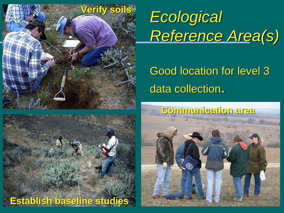
Ecological Ecological Reference Reference Area(sArea(s))
Good location for level 3 Good location for level 3 data collectiondata collection..
Verify soilsVerify soils
Establish baseline studiesEstablish baseline studies
Communication area Communication area

Reference Sheet Reference Sheet DevelopmentDevelopment
Must develop Reference State Must develop Reference State descriptions for each indicator, if descriptions for each indicator, if they are not availablethey are not availableDone with a group of experts on soils Done with a group of experts on soils and plants for the ecological siteand plants for the ecological site– Recommended to include multiple
agencies, academics, ranchers and interested NGO’s
Compile all your resourcesCompile all your resources– Ecological site descriptions, soil surveys,
maps, photos, your data, etc.

12. Functional/Structural Groups12. Functional/Structural Groups
Begin hereBegin here– Most people are familiar with dominant plants– Lays groundwork for understanding other
indicatorsWhy use F/S groups not species?Why use F/S groups not species?– Several species on an ecological site may fill a
similar functional or structural role. » One or a few species can be missing as long as the
group’s dominance order on the site is maintained

What are criteria for F/S Groups?What are criteria for F/S Groups?
Functional GroupsFunctional Groups– Life Cycle (History) & Phenology
» Annual or Perennial» Early vs. Late-season growth
– Photosynthetic Pathways» C3, C4
– Nitrogen-fixing abilityStructureStructure– Growth Form
» Tree, shrub, forb, graminoid, succulent, vine» Tall, Short» Rooting form for forbs (tap vs. fibrous)» Clonal form (rhizomatous vs. bunchgrass)

Lumping & SplittingLumping & SplittingConsider plant communities in Consider plant communities in alternative states vs. the reference alternative states vs. the reference state.state.– Be certain you have represented the
major F/S groups that can dominate the site in the reference state and any alternative states.
– Are there F/S groups that will never dominate the site?
» If so, lump them with other groups– Do not have single species F/S group
unless it will likely dominate the site in the reference or alternative states

F/S Reference DescriptionF/S Reference DescriptionDominant > 40% compositionDominant > 40% compositionSubdominant = 11 Subdominant = 11 –– 40 % composition40 % compositionMinor < 11 % compositionMinor < 11 % composition– Describe groups that will be dominant and
subdominant in the reference state and under what conditions might they change dominance and remain within the reference state» Example – Sage & grass co-dominate without
fire and grass dominates with recent fire.

GuidanceGuidanceGeneral guidance for the development of ecological General guidance for the development of ecological reference sheets for reference sheets for ESD'sESD's is available in is available in Interpreting Indicators of Rangeland Health, Interpreting Indicators of Rangeland Health, verver 4.0, 4.0, 2005. See pgs 152005. See pgs 15--16, 2116, 21--27, 7227, 72--75. 75. Follow examples when writing each description.Follow examples when writing each description.
www.blm.gov/nstc/library/techref.htmwww.blm.gov/nstc/library/techref.htmThis is a revised version. Changes are minor, This is a revised version. Changes are minor, except for the addition of the reference worksheet.except for the addition of the reference worksheet.


![Dynamic Soil-Structure Interaction, Wolf[1]](https://img.pdfslide.net/doc/110x75/55cf8cff5503462b139128df/dynamic-soil-structure-interaction-wolf1.jpg)