Embed Size (px)
Citation preview

Inside...DIRECTOR’S NOTENew Battlefield Archaeology Book––
Partisans, Guerillas, and IrregularsTwo New Book Chapters by SCIAA Staff
RESEARCHArtillery Ammunition from Star FortWateree Bug Ceramic MotifScale Weights from Santa ElenaEarly Human Life on the Southeastern
Coastal Plain BookUpdate of Southeastern Paleoamerican
SurveyField Slave Quarters at Historic
BrattonsvilleCastle Pinckney Project
APPLIED RESEARCHVietnam War-Era Training Villages at Fort
JacksonArchaeological Survey at Rose HillPlantation State Historic Site
SAVANNAH RIVER ARCHAEOLOGICAL RESEARCH PROGRAM
Cemetery Survey in Jackson, South Carolina
SEAC 2019 Patty Jo Watson Award
ARCHAEOLOGICAL RESEARCH TRUST (ART) AND SCIAA DONORS
ENDOWMENT OPPORTUNITIESStanley South Student Archaeological
Research Endowment Fund
Thank you for your generous support of the Archaeological Research Trust (ART) Endowment Fund and the printing of Legacy. Please send donations in the enclosed envelope to Nena Powell Rice USC/SCIAA, 1321 Pendleton Street, Columbia, SC 29208, indicating whether you want to continue receiving Legacy and include your email address. All contributions are appreciated. Please visit our website at: http://www.artsandsciences.sc.edu/sciaa to download past issues, and let the Editor know if you wish to receive Legacy by email.
Thank You! Nena Powell Rice, Editor, (803) 331-3431 Cell, ([email protected]).
VOL. 24, NO. 1, SEPTEMBER 2020
During the summer of 2020, we have been busy preparing the report for our two “Maymester” seasons of field work at the Star Fort, at Ninety Six National Historic Site in Greenwood County. (See Legacy July 2018, July 2019, and the article on pages 5-7 of this issue). The large collection of artifacts from that project includes some remarkably archaic weapons technology employed by both the Loyalist defenders of the Star Fort and the Americans who lay siege to the fort in 1781.
The Americans successfully employed fire arrows in the siege of Fort Motte a few weeks before the siege of Ninety Six was undertaken (see Legacy December 2015), for the fire arrow point we recovered from the American siege camp at Fort Motte). The effort was repeated with less success at Ninety Six, including the Star Fort, where we recovered another wrought iron arrow point. A British source described these “African arrows” as “fitted to the bores of musquets” from which they were
Ancient Weapons from the Siege of Ninety SixBy James Legg and Steve Smith
Figure 1: Iron weapons from the 1781 siege of the Star Fort at Ninety Six: From upper left, fire arrow point, spear heads, and pike point. (Photo by James B. Legg)
NINETY SIX, See Page 11
2Legacy, Vol. 24, No. 1, September 2020
Legacy is the magazine of the SC Institute of Archaeology and Anthropology, College of Arts and Sciences, University of South CarolinaLegacy will be published twice in 2020
Nena Powell Rice, Chief Editor, Format, Design, and Production ([email protected])James B. Legg, Co- Editor
Editorial Board Chester B. DePratter, ResearchKeith Stephenson, Savannah River Archaeological Research ProgramJonathan Leader, State ArchaeologistNena Powell Rice, Archaeological Research Trust (ART)Steven D. Smith, DirectorJames Spirek, State Underwater Archaeologist
Archaeological Research TrustBoard of TrusteesBill Bridges, Chair, Greenville, SCGeorge Bell, Vice Chair, Greenville, SCKenneth Huggins, Past Chair, Mt. Pleasant, SCNena Powell Rice, Secretary, Columbia, SCSteven D. Smith, Director, Ex-Officio, Columbia, SCJonathan Leader, State Archaeologist, Ex-Officio, Columbia, SCF. Jo Baker, Pawleys Island, SCWilliam A. Behan, Bluffton, SCHunter Bridges, Greenville, SCChester DePratter, Columbia SCErnest L. “Chip” Helms, III, MD, Society Hill, SCSam McCuen, Lexington, SCIra Miller, Columbia, SCBob Mimms, Pawleys Island, SCPatricia Moore-Pastides, Columbia, SCBill Sullivan, Callawassie Island, SCWalter Wilkinson, Pawleys Island, SCBenjamin T. Zeigler, Florence, SC
Emeritis BoardLezlie Barker, Greenville, SCRobert Benedict, Greenville, SCB. Lindsay Crawford, Columbia, SCLou Edens, Mt. Pleasant, SCCary Hall, Greenville, SCDavid G. Hodges, Columbia, SCDorothy Kendall, MD, Eastover, SCEdward Kendall, MD, Eastover, SCFrancis Neuffer, MD, Columbia, SCHeyward Robinson, Mt. Pleasant, SC
Administrative Staff to ART BoardNena Powell Rice (803) 331-3431 Cell or ([email protected])
University of South CarolinaSC Institute of Archaeology andAnthropology1321 Pendleton StreetColumbia, SC 29208(803) 777-8170 (For Staff Directory)(803) 331-3431 Cell (Nena Rice)(803) 254-1338, FAXhttp://www.artsandsciences.sc.edu/sciaa
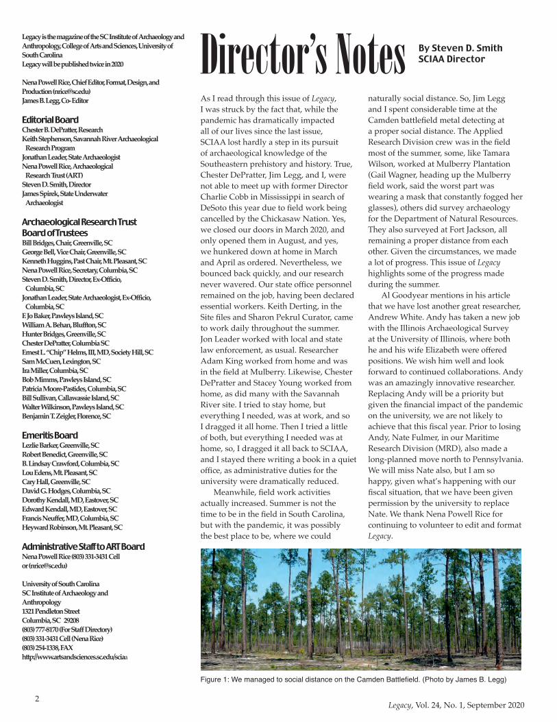
Director’s Notes By Steven D. SmithSCIAA Director
As I read through this issue of Legacy, I was struck by the fact that, while the pandemic has dramatically impacted all of our lives since the last issue, SCIAA lost hardly a step in its pursuit of archaeological knowledge of the Southeastern prehistory and history. True, Chester DePratter, Jim Legg, and I, were not able to meet up with former Director Charlie Cobb in Mississippi in search of DeSoto this year due to field work being cancelled by the Chickasaw Nation. Yes, we closed our doors in March 2020, and only opened them in August, and yes, we hunkered down at home in March and April as ordered. Nevertheless, we bounced back quickly, and our research never wavered. Our state office personnel remained on the job, having been declared essential workers. Keith Derting, in the Site files and Sharon Pekrul Curator, came to work daily throughout the summer. Jon Leader worked with local and state law enforcement, as usual. Researcher Adam King worked from home and was in the field at Mulberry. Likewise, Chester DePratter and Stacey Young worked from home, as did many with the Savannah River site. I tried to stay home, but everything I needed, was at work, and so I dragged it all home. Then I tried a little of both, but everything I needed was at home, so, I dragged it all back to SCIAA, and I stayed there writing a book in a quiet office, as administrative duties for the university were dramatically reduced.
Meanwhile, field work activities actually increased. Summer is not the time to be in the field in South Carolina, but with the pandemic, it was possibly the best place to be, where we could
naturally social distance. So, Jim Legg and I spent considerable time at the Camden battlefield metal detecting at a proper social distance. The Applied Research Division crew was in the field most of the summer, some, like Tamara Wilson, worked at Mulberry Plantation (Gail Wagner, heading up the Mulberry field work, said the worst part was wearing a mask that constantly fogged her glasses), others did survey archaeology for the Department of Natural Resources. They also surveyed at Fort Jackson, all remaining a proper distance from each other. Given the circumstances, we made a lot of progress. This issue of Legacy highlights some of the progress made during the summer.
Al Goodyear mentions in his article that we have lost another great researcher, Andrew White. Andy has taken a new job with the Illinois Archaeological Survey at the University of Illinois, where both he and his wife Elizabeth were offered positions. We wish him well and look forward to continued collaborations. Andy was an amazingly innovative researcher. Replacing Andy will be a priority but given the financial impact of the pandemic on the university, we are not likely to achieve that this fiscal year. Prior to losing Andy, Nate Fulmer, in our Maritime Research Division (MRD), also made a long-planned move north to Pennsylvania. We will miss Nate also, but I am so happy, given what’s happening with our fiscal situation, that we have been given permission by the university to replace Nate. We thank Nena Powell Rice for continuing to volunteer to edit and format Legacy.
Figure 1: We managed to social distance on the Camden Battlefield. (Photo by James B. Legg)
3Legacy, Vol. 24, No. 1, September 2020
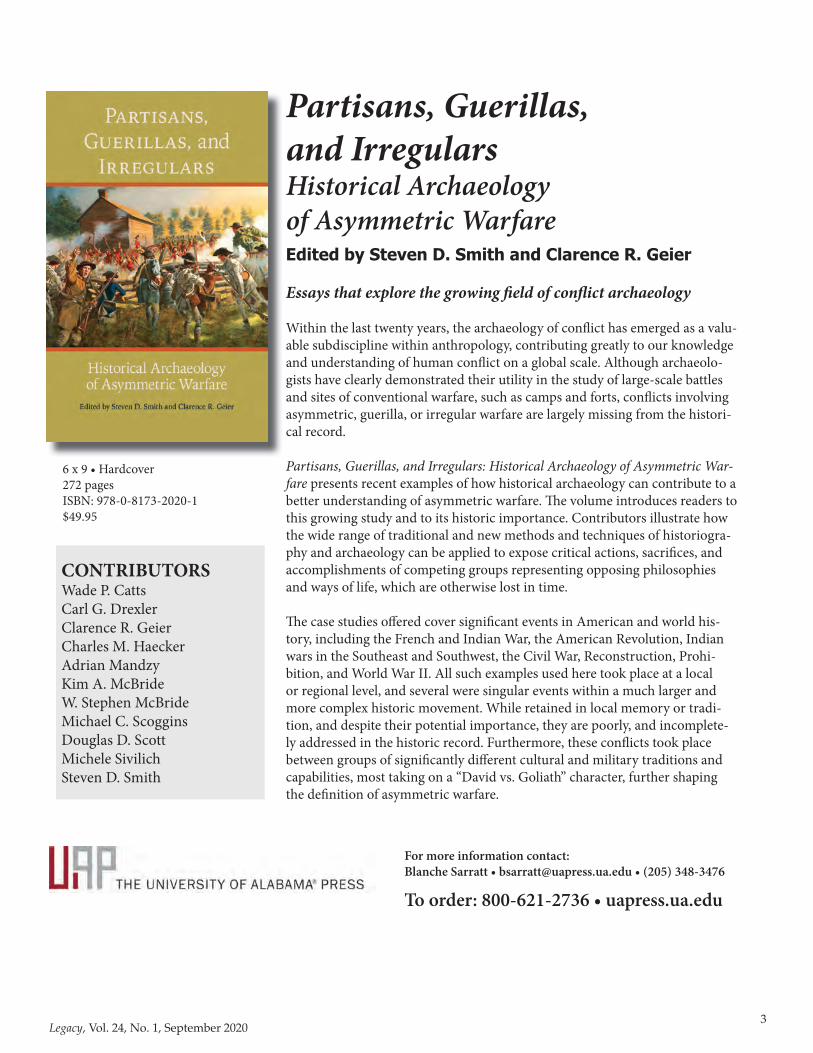
New for Spring 2019Partisans, Guerillas,and IrregularsHistorical Archaeologyof Asymmetric WarfareEdited by Steven D. Smith and Clarence R. Geier
Essays that explore the growing � eld of con� ict archaeology
Within the last twenty years, the archaeology of con� ict has emerged as a valu-able subdiscipline within anthropology, contributing greatly to our knowledge and understanding of human con� ict on a global scale. Although archaeolo-gists have clearly demonstrated their utility in the study of large-scale battles and sites of conventional warfare, such as camps and forts, con� icts involving asymmetric, guerilla, or irregular warfare are largely missing from the histori-cal record.
Partisans, Guerillas, and Irregulars: Historical Archaeology of Asymmetric War-fare presents recent examples of how historical archaeology can contribute to a better understanding of asymmetric warfare. � e volume introduces readers to this growing study and to its historic importance. Contributors illustrate how the wide range of traditional and new methods and techniques of historiogra-phy and archaeology can be applied to expose critical actions, sacri� ces, and accomplishments of competing groups representing opposing philosophies and ways of life, which are otherwise lost in time.
� e case studies o� ered cover signi� cant events in American and world his-tory, including the French and Indian War, the American Revolution, Indian wars in the Southeast and Southwest, the Civil War, Reconstruction, Prohi-bition, and World War II. All such examples used here took place at a local or regional level, and several were singular events within a much larger and more complex historic movement. While retained in local memory or tradi-tion, and despite their potential importance, they are poorly, and incomplete-ly addressed in the historic record. Furthermore, these con� icts took place between groups of signi� cantly di� erent cultural and military traditions and capabilities, most taking on a “David vs. Goliath” character, further shaping the de� nition of asymmetric warfare.
For more information contact:Blanche Sarratt • [email protected] • (205) 348-3476
To order: 800-621-2736 • uapress.ua.edu
6 x 9 • Hardcover272 pagesISBN: 978-0-8173-2020-1$49.95
CONTRIBUTORSWade P. CattsCarl G. DrexlerClarence R. GeierCharles M. HaeckerAdrian MandzyKim A. McBrideW. Stephen McBrideMichael C. ScogginsDouglas D. ScottMichele SivilichSteven D. Smith
4Legacy, Vol. 24, No. 1, September 2020
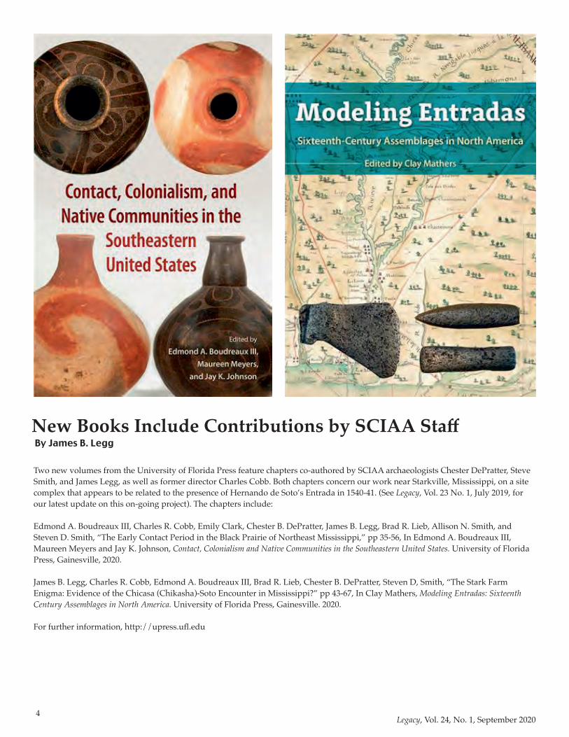
New Books Include Contributions by SCIAA StaffBy James B. Legg
Two new volumes from the University of Florida Press feature chapters co-authored by SCIAA archaeologists Chester DePratter, Steve Smith, and James Legg, as well as former director Charles Cobb. Both chapters concern our work near Starkville, Mississippi, on a site complex that appears to be related to the presence of Hernando de Soto’s Entrada in 1540-41. (See Legacy, Vol. 23 No. 1, July 2019, for our latest update on this on-going project). The chapters include:
Edmond A. Boudreaux III, Charles R. Cobb, Emily Clark, Chester B. DePratter, James B. Legg, Brad R. Lieb, Allison N. Smith, and Steven D. Smith, “The Early Contact Period in the Black Prairie of Northeast Mississippi,” pp 35-56, In Edmond A. Boudreaux III, Maureen Meyers and Jay K. Johnson, Contact, Colonialism and Native Communities in the Southeastern United States. University of Florida Press, Gainesville, 2020.
James B. Legg, Charles R. Cobb, Edmond A. Boudreaux III, Brad R. Lieb, Chester B. DePratter, Steven D, Smith, “The Stark Farm Enigma: Evidence of the Chicasa (Chikasha)-Soto Encounter in Mississippi?” pp 43-67, In Clay Mathers, Modeling Entradas: Sixteenth Century Assemblages in North America. University of Florida Press, Gainesville. 2020.
For further information, http://upress.ufl.edu
5Legacy, Vol. 24, No. 1, September 2020
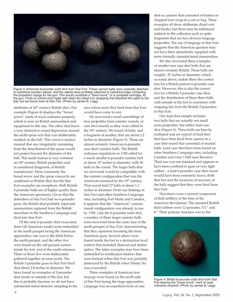
ResearchRegular readers of Legacy, will recall that in 2018 and 2019, SCIAA Director Steve Smith conducted USC “Maymester” archaeological field schools in and around Star Fort, a component of the 1781 British defenses of Ninety Six, South Carolina, at Ninety Six National Historic Site (Figures 1 and 2). The work included formal excavation units, and an array of metal detector sample areas. Among our findings was a significant assemblage related to the field artillery that was heavily employed by both the American attackers and the British (Loyalist) defenders.
In the Spring and Summer of 1781, American Southern commander Nathanael Greene and his subordinates pursued a very successful campaign to eject the British and their Loyalist American allies from their many posts in the interior of South Carolina. Nearly all of the British posts were either captured or evacuated during that campaign, including the three most important interior fortified towns of Camden, Ninety-Six, and Augusta, Georgia. On May 22, 1781, Greene’s army lay siege to the post of Ninety Six, in present Greenwood County, South Carolina. The strongest component in the defenses of Ninety Six was an eight-sided earthwork called Star Fort. The major American effort during the 29-day effort to capture Ninety Six was a formal, systematic siege approach against Star Fort from the north. Artillery fire was a
daily feature of the siege. By June 18th, the Americans were entrenched immediately north of the ditch of Star Fort, but a large relief force of British regular troops was on its way to break the siege. Greene decided to risk a direct assault on Star Fort before giving up the siege, but the attack met with a bloody repulse. Greene broke off the siege and withdrew the following day, but the British then decided that the post of Ninety Six was too exposed to be maintained, and they evacuated the site.
In 1976, the site of Ninety Six became a National Historic Site. The National Park Service soon conducted extensive excavations to trace and restore the American siege approaches to Star Fort, but the fort itself has received relatively little attention beyond limited testing by South Carolina’s first State Archaeologist William Edwards in the early 1960s, and mapping by SCIAA’s Stanley South in 1970. The fabric of the earthwork fort is almost completely original and unrestored, and our modest excavations did little to impact that condition. Nevertheless, we were able to document meaningful architectural information, and recovered an extensive sample of 1781 siege material.
The artillery-related assemblage includes a total of nine iron solid shot cannon balls for 6-pounder guns, which are cast iron spheres about 3.5 inches in diameter, weighing about six pounds.
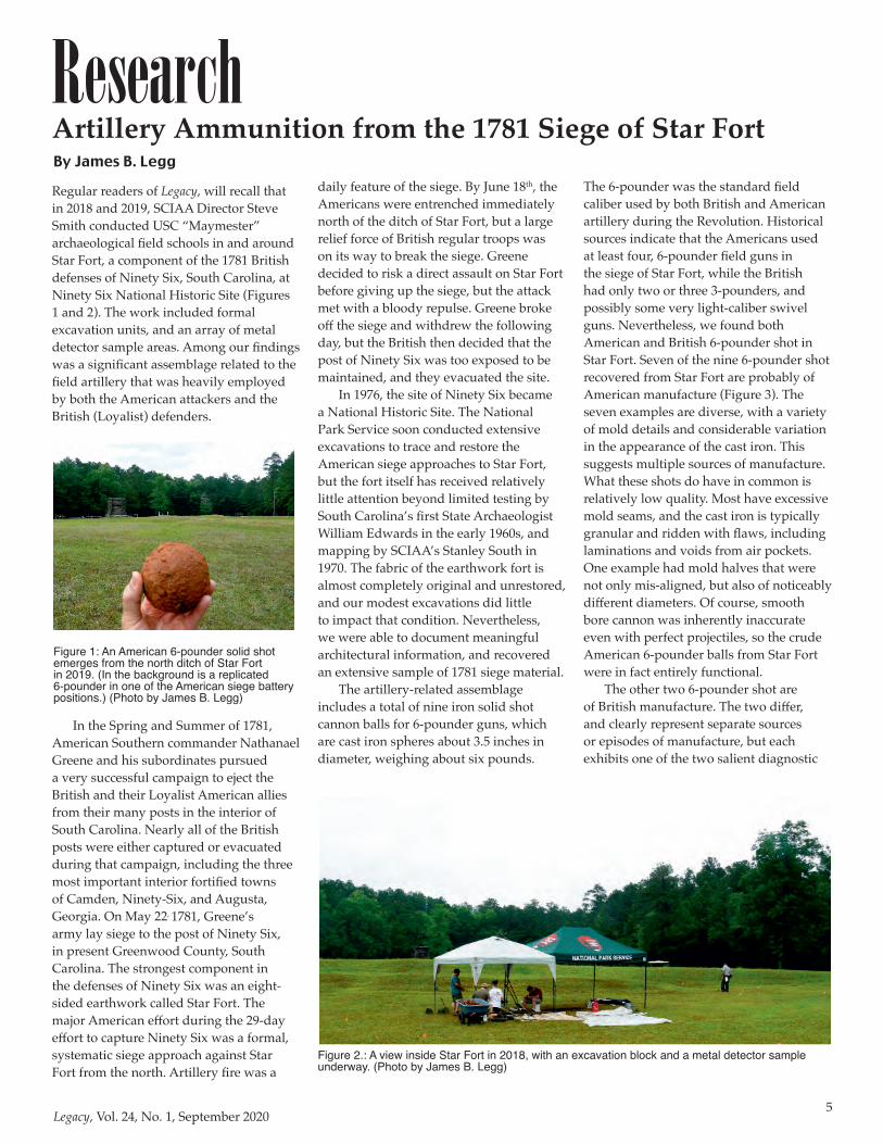
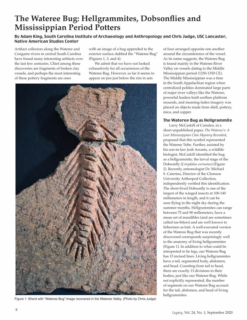
The 6-pounder was the standard field caliber used by both British and American artillery during the Revolution. Historical sources indicate that the Americans used at least four, 6-pounder field guns in the siege of Star Fort, while the British had only two or three 3-pounders, and possibly some very light-caliber swivel guns. Nevertheless, we found both American and British 6-pounder shot in Star Fort. Seven of the nine 6-pounder shot recovered from Star Fort are probably of American manufacture (Figure 3). The seven examples are diverse, with a variety of mold details and considerable variation in the appearance of the cast iron. This suggests multiple sources of manufacture. What these shots do have in common is relatively low quality. Most have excessive mold seams, and the cast iron is typically granular and ridden with flaws, including laminations and voids from air pockets. One example had mold halves that were not only mis-aligned, but also of noticeably different diameters. Of course, smooth bore cannon was inherently inaccurate even with perfect projectiles, so the crude American 6-pounder balls from Star Fort were in fact entirely functional.
The other two 6-pounder shot are of British manufacture. The two differ, and clearly represent separate sources or episodes of manufacture, but each exhibits one of the two salient diagnostic
Artillery Ammunition from the 1781 Siege of Star FortBy James B. Legg
Figure 1: An American 6-pounder solid shot emerges from the north ditch of Star Fort in 2019. (In the background is a replicated 6-pounder in one of the American siege battery positions.) (Photo by James B. Legg)
Figure 2.: A view inside Star Fort in 2018, with an excavation block and a metal detector sample underway. (Photo by James B. Legg)
6Legacy, Vol. 24, No. 1, September 2020
attributes of 18th century British shot. One example (Figure 4) displays the “broad arrow” mark of royal ordnance property, which is seen on British ammunition and equipment to this day. The other shot bears a very distinctive round depression around the mold sprue scar that was deliberately molded on the ball. This concave surface insured that any irregularity remaining from the detachment of the sprue would not project beyond the diameter of the ball. This mold feature is very common on 18th century British projectiles and is considered diagnostic of British manufacture. More commonly the broad arrow and the sprue concavity are combined on British shot, but the Star Fort examples are exceptions. Both British 6-pounder balls are of higher quality than the American specimens. Given that the defenders of Star Fort had no 6-pounder guns, the British shot probably represent ammunition captured from the British elsewhere in the Southern Campaign and fired into Star Fort.
Of the nine 6-pounder shot excavated, three (all American made) were embedded in the north parapet facing the American approaches; one was in the ditch below the north parapet, and the other five were found on the old ground surface inside the fort, and at the south entrance. Three of those five were deliberately gathered together at some point. The British 3-pounder guns in Star Fort fired shot about 2.8 inches in diameter. We have found no examples of 3-pounder shot inside or outside of the fort, but this is probably because we do not have substantial metal detector sampling in the
area where most shot fired from Star Fort would have come to rest.
We recovered a small assemblage of iron projectiles from canister rounds, or case shot rounds as they were called in the 18th century. We found 14 balls, and a fragment of another, that are about 1.2 inches in diameter (Figure 5). These are almost certainly American 6-pounder case shot/canister balls. The British ordnance regulations in 1780 called for a much smaller 6-pounder canister ball of about .87 inches in diameter, with 56 balls to the round. The larger balls that we recovered would be compatible with the canister configuration that was the American standard by the 19th century. That round held 27 balls of about 1.2 inches in diameter. From our findings at Star Fort and other Southern Campaign sites, including Fort Motte and Camden, it appears that the “American” canister round configuration was already in use by 1780. Like the 6-pounder solid shot, a number of these larger canister balls were recovered from the outer face of the north parapet of Star Fort, demonstrating that they represent incoming fire from American guns. Several others were found inside the fort in a destruction level context that included charcoal and timber spikes. The latter examples may have been embedded in fortification timbers that were burned when Star Fort was partially destroyed by the British when Ninety Six was evacuated.
Three examples of American iron langrage were found on the north side of Star Fort facing the siege approaches. Langrage was an expedient form of case
shot or canister that consisted of broken or chopped iron scrap in a can or bag. These examples all show deliberate chisel cuts and breaks, but there may be additional artifacts in the collection such as spike fragments that are less obvious langrage projectiles. The use of langrage at Star Fort suggests that the American gunners may not have been abundantly supplied with more formally manufactured ammunition.
We also recovered three examples of smaller iron case shot balls that are almost certainly British. These balls are roughly .87 inches in diameter, which, as noted above, makes them the correct size for a British pattern 6-pounder case shot. However, this is also the correct size for a British 3-pounder case shot, and the distribution of these three balls well outside of the fort is consistent with outgoing fire from the British 3-pounders in Star Fort.
Our lead shot sample includes two balls that are actually not small arms projectiles, but rather lead case shot (Figure 6). These balls are heavily scalloped and are typical of lead shot that have been fired from cannon in a case shot round that consisted of musket balls. Lead case shot have been found on other Southern Campaign sites, including Camden and Gray’s Hill near Beaufort. Their use was not standard and appears to have been confined to guns of very light caliber––a lead 6-pounder case shot round would have been extremely heavy. Both that fact and the locations of recovery of the balls suggest that they were fired from Star Fort.
Howitzers were a normal component of field artillery at the time of the American Revolution. The standard British field calibers were 12-pounder, 5.5,” and 8.” Their primary function was to fire
Figure 3: American 6-pounder solid shot from Star Fort. These cannon balls were originally attached to cylindrical wooden sabots, and the sabots were probably attached to cylindrical bags containing the propellant charge for the gun. This would constitute a “fixed round,” or a complete cartridge, for the gun. Finds of unfired shot might well retain the sheet iron strapping that attached the sabot to the ball, but we found none at Star Fort. (Photo by James B. Legg)
Figure 4: British 6-pounder solid shot from Star Fort bearing the “broad arrow” mark of royal ordnance property. (Photo by James B. Legg)

7Legacy, Vol. 24, No. 1, September 2020
explosive, time fused shells at relatively close range. There is no mention in the detailed primary sources of howitzers being involved in the siege of Ninety Six, but we found one fragment each from a 12-pounder shell and a 5.5” shell (Figure 7). The 5.5” fragment was found inside Star Fort, while the 12-pounder fragment was found outside the fort to the west. The 12-pounder fragment is perhaps small enough to have been part of a 6-pounder langrage round, but the 5.5” fragment is too large. We speculated originally that this undocumented use of howitzers had to do with the American capture of the British post at Augusta, which fell on June 5, 1781. Troops and supplies from Augusta were then dispatched to join the siege of Ninety Six, and it seemed possible that the three British artillery pieces captured at Augusta included one or more
howitzers that were used against Star Fort in the latter stages of the siege. Another possibility, for the 5.5” howitzer, at least, has to do with the American capture of Fort Granby, near present Cayce. That fort
fell to the Americans in May, as Nathanael Greene was in the area preparing to march on Ninety Six, and Greene supplied his small army from the material captured there. Two 5.5” howitzers were taken at Fort Granby, and it is possible that at least one of those guns was included in the expedition to Ninety Six. It remains unexplained why the primary sources consistently mention only 6-pounder guns in the American artillery contingent at Ninety Six.
Our sample of artillery material from Star Fort is small, but diverse and informative. There is little artillery material in public hands that derives from sites related to the Southern campaign prior to
Yorktown, so any properly documented and conserved additions are significant. On Southern Campaign sites generally, and at Ninety Six, archaeological artillery collections suggest that the artillery arms on both sides were less than ideal manifestations of the British ordnance regulations. Guns and ammunition were often non-standard, and ammunition included expedient types such as langrage and lead case shot. The quality of American-made ammunition was fair at best, and it was supplemented by captured material. As in the case of small arms and small arms ammunition, both sides in the Southern Campaign used miscellaneous arrays of weaponry, and ordnance supplies were not abundant.
The excavations and metal detecting conducted on the Star Fort battlefield in 2018 and 2019 recovered a very small sample of the siege material present on the site, certainly less than 1%. Even this very limited data, however, has added to our understanding of the events, and to our understanding of the material assemblages employed by the two belligerents in 1781. A more comprehensive sample of the site
is recommended, as it would certainly improve our understanding dramatically.
Conservation and analysis of the Star Fort artifacts from 2018 and 2019 is complete, and we are working on the final report for both seasons. In the next issue of Legacy, we will have a look at the extensive small arms evidence from the Star Fort project, including ammunition, gun parts, and accoutrement hardware from both sides.
We would like to thank the National Park Service, particularly the staff of Ninety Six National Historic Site, for the opportunity to work at Star Fort.
Figure 5: 1.2” iron balls fired in American 6-pounder case shot (canister) rounds, excavated in and around Star Fort. (Photo by James B. Legg)
Figure 6: Lead case shot (canister) ball, probably fired from a British 3-pounder gun in Star Fort at the American siege approach-es. (Photo by James B. Legg)
Figure 7: Fragment of an exploded 5.5” howitzer shell from inside Star Fort. (Photo by James B. Legg)
8Legacy, Vol. 24, No. 1, September 2020
Artifact collectors along the Wateree and Congaree rivers in central South Carolina have found many interesting artifacts over the last few centuries. Chief among these discoveries are fragments of broken clay vessels, and perhaps the most interesting of these pottery fragments are ones
with an image of a bug appended to the exterior surface dubbed the “Wateree Bug” (Figures 1, 3, and 4).
We admit that we have not looked exhaustively for all occurrences of the Wateree Bug. However, so far it seems to appear on jars just below the rim in sets
of four arranged opposite one another around the circumference of the vessel. As its name suggests, the Wateree Bug is found mainly in the Wateree River Valley on vessels dating to the Middle Mississippian period (1250-1350 CE). The Middle Mississippian was a time in the South Appalachian region when centralized polities dominated large parts of major river valleys like the Wateree, powerful leaders built earthen platform mounds, and meaning-laden imagery was placed on objects made from shell, pottery, mica, and copper.
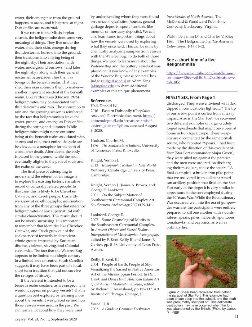
The Wateree Bug as HellgrammiteLarry McCaskill of Camden, in a
short unpublished paper, The Wateree’s: A Lost Mississippian Clan Mystery Revealed, proposed that this symbol represented the Wateree Tribe. Further, assisted by his son-in-law Josh Arrants, a wildlife biologist, McCaskill identified the bug as a hellgrammite, the larval stage of the Dobsonfly (Corydalus cornutus) (Figure 2). Recently, entomologist Dr. Michael S. Caterino, Director of the Clemson University Arthropod Collection, independently verified this identification. The short-lived Dobsonfly is one of the largest of the winged insects at 100-140 millemeters in length, and it can be seen flying in the night sky during the summer months. Hellgrammites can range between 75 and 90 millemeters, have a mean set of mandibles (and are sometimes called toe-biters) and are well known to fishermen as bait. A well-executed version of the Wateree Bug that was recently discovered corresponds surprisingly well to the anatomy of living hellgrammites (Figure 1). In addition to what could be interpreted to be legs, our Wateree Bug has 13 incised lines. Living hellgrammites have a tail, segmented body, abdomen, and head. Counting from tail to head, there are exactly 13 divisions in their bodies, just like our Wateree Bug. While not explicitly represented, the number of segments on our Wateree Bug account for the tail, abdomen, and head of living hellgrammites.
The Wateree Bug: Hellgrammites, Dobsonflies and Mississippian Period PottersBy Adam King, South Carolina Institute of Archaeology and Anthropology and Chris Judge, USC Lancaster, Native American Studies Center
Figure 1: Sherd with “Wateree Bug” image recovered in the Wateree Valley. (Photo by Chris Judge)

9Legacy, Vol. 24, No. 1, September 2020
The Wateree Bug and Mississippian Period Imagery
We agree that the Wateree Bug resembles a hellgrammite. However, there is an important lesson that people studying ancient Indigenous imagery of the Southeast have learned. Just because it looks like a hellgrammite does not mean the makers were referring to actual hellgrammites when they made the image (Knight 2013). In fact, the majority of Mississippian period imagery refers to
beings, places, and even events of other realms, not living people or the natural world (Knight et al. 2001). So, the Wateree Bug may look like a hellgrammite, but it is likely the people who made it were actually referring to some being or aspect of their larger cosmos.
Non-Indigenous scholars working with Native Americans and information collected by anthropologists have reconstructed a general model of how people of the Mississippian period
understood the cosmos (Lankford 2007; Reilly 2004). That cosmos was likely made up of three realms, each with its own spirits and important associations. People, plants, and animals lived on a flat plane floating in the primordial sea. This realm of the cosmos was the earthly realm, and it was also inhabited by important spirit beings. Above the earthly plane was the above or sky realm, often thought of as dome attached to the earthly realm by ropes or snakes or some other means. Creatures with wings lived in the sky realm, as did important spirits, like the sun and weather spirits. The sky realm was a place of order and life. Under the ground and the water was a third realm that was inhabited by creatures and spirits that live in the water and under the ground. This beneath realm was the place where the dead went, so it was a place of chaos and death. However, it was also the source of water and regenerated life. When the sun set each night, the beneath realm and the sky realm switched places, such that the beneath realm became the night sky. The Milky Way was understood to be the path that souls traveled to the realm of the dead.
Plants, animals, natural phenomena, and celestial events all were connected in some way to their place in the cosmos and took meaning from that place. Birds were beings of the sky realm, and many sky realm spirits had avian characteristics and behaviors. Conversely, bats and hawkmoths, which fly in the night sky, were associated with the evening version of the beneath realm. Creatures that live in the water, under the ground, or even under rocks and logs were connected to the beneath realm. Snakes fall into this category, and to this day, for many Indigenous groups of the Southeast, one of the most important beings of the beneath realm has snake characteristics.
Back to our hellgrammite. There is another important principle to keep in mind when trying to understand ancient imagery. It is much easier to find the referent of an image than its meaning. The referent is what the image is intended to represent, and it is possible to reconstruct that from details of actual imagery. Meaning is tricky. Particular images can have many meanings, and those can change depending on the person and time. Most people know that an orange paw print is intended to represent
Figure 2: Life Cycle of the Dobsonfly from hellgrammite (A) to Dobsonfly (C). (Walsh and Riley 1861: 61)

10Legacy, Vol. 24, No. 1, September 2020
Clemson University. However, it can mean something entirely different to a Gamecock football fan than it does to a Clemson fan. Here we think the referent of our Wateree Bug is somehow linked to the hellgrammite. Its meaning to those who saw it is much harder to discern.
Trying to find the referent of an ancient image is best done in a systematic fashion. It is easy to fall into the trap of thinking the referent of an image must be what the image looks like to you. It is important to remember that the Wateree Bug was made by Indigenous people hundreds of years ago who likely thought about the world and how to understand it much differently than we do today. The best way to avoid just looking at an image through your eyes is to follow a simple set of steps (Knight 2013).
The first step is to collect as many examples of the image (made by the same people during the same time period) as possible. Then compare all of the images to see what aspects are always there and which ones can come and go. Those that are always there can be assumed to be the most important for cluing the viewer into what the image is meant to represent. In our case, that set of features is pretty simple. First it always appears on four opposed locations just below the rim on a large ceramic jar. The image itself is composed of a raised, segmented bar with rounded ends that tapers on the end nearest the base of the vessel. This
element is completely surrounded by short line segments that also point toward the base. There are other variations (many we would like to see more of), but those elements always appear as far as we know.
Once we have that basic image, then it is useful to turn to the natural world to see if there are creatures that have those same characteristics. This is where others have suggested that the hellgrammite may be the model for our Wateree Bug. Remember,
instead of being an actual hellgrammite, it is likely an image of something that has the characteristics of a hellgrammite. Those characteristics can help situate the image in the Mississippian cosmos and also hint at some of its possible associations.
As noted earlier, hellgrammites are the larval stage of the Dobsonfly (Hall 2016). Adult Dobsonflies only live for a few days to a week, and their main goal is to reproduce. They lay their eggs at night on rocky walls just above creeks and rivers. When the eggs hatch, the larvae fall into the water where they live as hellgrammites for up to five years. You can find them under rocks in rivers and creeks. During their larval stage, hellgrammites periodically shed their skin similar to snakes.
When it is time, usually in the spring and summer, hellgrammites leave the water and create an underground chamber under a rock or log where they pupate. Often this happens en masse, so if you were watching, you might see dozens of hellgrammites crawling out of the water and burrowing into the ground. There are actual accounts of “hellgrammite crawlings,” where large numbers of hellgrammites emerge from the water at the same time during thunderstorms (Voshell 2002: 442). After pupating for about two weeks, Dobsonflies emerge from their underground chambers and take to the sky. Like their emergence from the
Figure 3: Sherd with “Wateree Bug” image, from the collection of Henry Shute. (Photo by Chris Judge)
Figure 4: Sherd with partial “Wateree Bug” image, from the collection of Henry Shute. (Photo by Chris Judge)
11Legacy, Vol. 24, No. 1, September 2020
water, their emergence from the ground happens en masse, and it happens at night. Dobsonflies are nocturnal.
If we return to the Mississippian cosmos, the hellgrammite does some very meaningful things. They live under the water, shed their skin, emerge during thunderstorms, burrow into the ground, then transform into a flying being of the night sky. Their association with water, underground burrows, (and later the night sky), along with their general nocturnal nature, identifies them as beings of the beneath realm. That they shed their skin connects them to snakes—another important resident of the beneath realm. Like rattlesnakes (Hudson 1976), hellgrammites may be associated with thunderstorms and rain. The connection to rain and the growing season is reinforced by the fact that hellgrammites leave the water, pupate, and emerge as Dobsonflies during the spring and summer. While hellgrammites might represent some being of the beneath realm associated with storms and rain, their entire life cycle can be viewed as a metaphor for the path of a soul after death. After death, the body is placed in the ground, while the soul eventually alights to the path of souls and the realm of the dead.
The final piece of attempting to understand the referent of an image is to explore the existing historic narrative record of culturally related people. In this case, this is likely to be Cherokee, Catawba, and Creek people. Currently, we know of no ethnographic information from any of the three groups that reference hellgrammites or any supernatural with similar characteristics. This result should not be overly surprising. It is important to remember that identities like Cherokee, Catawba, and Creek grew out of the coalescence of formerly independent ethnic groups impacted by European disease, violence, slaving, and Colonial economics. The fact that the Wateree Bug appears to be limited to a single century in a limited area of central South Carolina suggests it may have been part of a local, short term tradition that did not survive the ravages of history.
If the referent is intended to be a beneath realm creature, as we suspect, why would it appear on pottery vessels? That is a question best explored by learning more about the vessels it was placed on and how those vessels were used in the past. We can learn a lot about how they were used
by understanding where they were found on archaeological sites (houses, general garbage deposits, special contexts like mounds or mortuary deposits). We can also learn some important things about how the vessels were used by exploring what they once held. This can be done by chemically analyzing samples from vessels with the Wateree Bug. To do both of those things, we need to learn more about the Wateree Bug and the pottery vessels it was placed on. If you know of any examples of the Wateree Bug, please contact Chris Judge ([email protected]) or Adam King ([email protected]) to share additional examples of this unique phenomena.
ReferencesHall, Donald W.2016 Eastern Dobsonfly (Corydalus cornutus). Electronic document, http://entnemdept.ufl.edu/creatures/misc/eastern_dobsonfly.htm, accessed August 9, 2020.
Hudson, Charles M.1976 The Southeastern Indians. University of Tennessee Press, Knoxville.
Knight, Vernon J.2013 Iconographic Method in New World Prehistory. Cambridge University Press, Cambridge.
Knight, Vernon J., James A. Brown, and George E. Lankford2001 On the Subject Matter of Southeastern Ceremonial Complex Art. Southeastern Archaeology 20(2):129-141.
Lankford, George E.2007 Some Cosmological Motifs in the Southeastern Ceremonial Complex, In Ancient Objects and Sacred Realms: Interpretations of Mississippian Iconography, edited by F. Kent Reilly III and James F. Garber, pp. 8–38. University of Texas Press, Austin.
Reilly, F. Kent, III2004 People of Earth, People of Sky: Visualizing the Sacred in Native American Art of the Mississippian Period, In Hero, Hawk, and Open Hand: American Indian Art of the Ancient Midwest and South, edited by Richard F. Townshend, pp.125-137. Art Institute of Chicago, Chicago, IL.
Voshell J. R.2002 A Guide to Common Freshwater
Invertebrates of North America. The McDonald & Woodward Publishing Company. Blacksburg, Virginia.
Walsh, Benjamin D., and Charles V. Riley 1861 The Hellgramite Fly. The American Entomologist 1(4): 61-62.
discharged. They were entwined with flax, dipped in combustibles lighted…” The tip of our arrow point is curled from a heavy impact. Also in the Star Fort, we recovered two different examples of large, crudely forged spearheads that might have been at home in Iron Age Europe. These weap-ons are documented by the same British source, who reported “Spears… had been made by the direction of this excellent of-ficer [Star Fort commander Major Green]; they were piled up against the parapet, and the men were ordered, on discharg-ing their musquets, to use the spears.” A final example is a broken iron pike point that we recovered from a distant Ameri-can artillery position that fired on the Star Fort early in the siege; it is very similar in appearance to the sort employed during the 30 Years War. While the Revolutionary War occurred well into the era of gunpow-der warfare, the participants were entirely prepared to kill one another with swords, sabres, spears, pikes, halberds, spontoons, tomahawks, and bayonets, as well as ordinary fire.
NINETY SIX, From Page 1
Figure 2: Spear head recovered from behind the parapet of Star Fort. This example had been driven deep into the subsoil, and the shaft was presumably snapped off. This deliberate destruction may have occurred when the fort was abandoned by the British. (Photo by James B. Legg)
See a short film of a live Hellgrammite
https://www.youtube.com/watch?time_continue=40&v=zjLBd3oLOco&feature=emb_title
12Legacy, Vol. 24, No. 1, September 2020
As people go about their day-to-day commercial transactions, products are often bought and sold based on weights and measures. If a product is not already packaged at a standard weight or volume, then some form of measurement has to be made. The concern over accurately determining the amount of a good involved in a trade by the use of a measuring device dates back at least to the second millennium B.C. in Egypt (Kisch 1965:2-3). In our modern world, this often happens without our involvement or often our cognizance, whether a product is being weighed on a digital scale at the market or fuel volume internally gauged by a fuel pump, for example. In earlier times, though, measuring the weight or volume of something was a more involved process, a process that involved the use of containers of standardized volume, balances, scales, and weights, all of which can end up in the archaeological record.
In the Spanish colonial Americas, the concern with measurements dates back to the early days of the conquest, with decrees being made that regulated the use of weights in commerce and offices being established for inspectors and regulators
as early as 1525 in Mexico City (Carrera Stampa 1949:3-4). This was, of course, reflective of the concern with weights and measures that already existed in the Old World. Small weights have been found at the early colonial towns of La Isabela (Deagan and Cruxent 2002:219-220) and Concepción de la Vega (Deagan 2002:261-264), from the 1540-1542 Coronado expedition at El Morro (Mathers et al.
2010), the Luna site (Worth et al. 2020:491), Santa Elena, and other colonial sites.
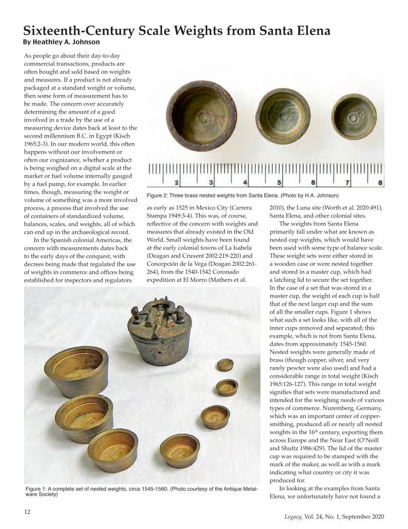
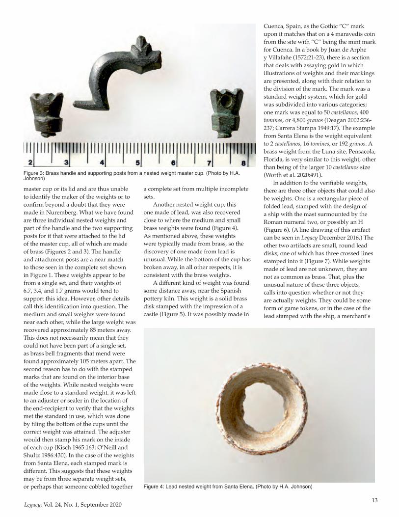
The weights from Santa Elena primarily fall under what are known as nested cup weights, which would have been used with some type of balance scale. These weight sets were either stored in a wooden case or were nested together and stored in a master cup, which had a latching lid to secure the set together. In the case of a set that was stored in a master cup, the weight of each cup is half that of the next larger cup and the sum of all the smaller cups. Figure 1 shows what such a set looks like, with all of the inner cups removed and separated; this example, which is not from Santa Elena, dates from approximately 1545-1560. Nested weights were generally made of brass (though copper, silver, and very rarely pewter were also used) and had a considerable range in total weight (Kisch 1965:126-127). This range in total weight signifies that sets were manufactured and intended for the weighing needs of various types of commerce. Nuremberg, Germany, which was an important center of copper-smithing, produced all or nearly all nested weights in the 16th century, exporting them across Europe and the Near East (O’Neill and Shultz 1986:429). The lid of the master cup was required to be stamped with the mark of the maker, as well as with a mark indicating what country or city it was produced for.
In looking at the examples from Santa Elena, we unfortunately have not found a
Sixteenth-Century Scale Weights from Santa ElenaBy Heathley A. Johnson
Figure 1: A complete set of nested weights, circa 1545-1560. (Photo courtesy of the Antique Metal-ware Society)
Figure 2: Three brass nested weights from Santa Elena. (Photo by H.A. Johnson)
13Legacy, Vol. 24, No. 1, September 2020
master cup or its lid and are thus unable to identify the maker of the weights or to confirm beyond a doubt that they were made in Nuremberg. What we have found are three individual nested weights and part of the handle and the two supporting posts for it that were attached to the lid of the master cup, all of which are made of brass (Figures 2 and 3). The handle and attachment posts are a near match to those seen in the complete set shown in Figure 1. These weights appear to be from a single set, and their weights of 6.7, 3.4, and 1.7 grams would tend to support this idea. However, other details call this identification into question. The medium and small weights were found near each other, while the large weight was recovered approximately 85 meters away. This does not necessarily mean that they could not have been part of a single set, as brass bell fragments that mend were found approximately 105 meters apart. The second reason has to do with the stamped marks that are found on the interior base of the weights. While nested weights were made close to a standard weight, it was left to an adjuster or sealer in the location of the end-recipient to verify that the weights met the standard in use, which was done by filing the bottom of the cups until the correct weight was attained. The adjuster would then stamp his mark on the inside of each cup (Kisch 1965:163; O’Neill and Shultz 1986:430). In the case of the weights from Santa Elena, each stamped mark is different. This suggests that these weights may be from three separate weight sets, or perhaps that someone cobbled together
a complete set from multiple incomplete sets.
Another nested weight cup, this one made of lead, was also recovered close to where the medium and small brass weights were found (Figure 4). As mentioned above, these weights were typically made from brass, so the discovery of one made from lead is unusual. While the bottom of the cup has broken away, in all other respects, it is consistent with the brass weights.
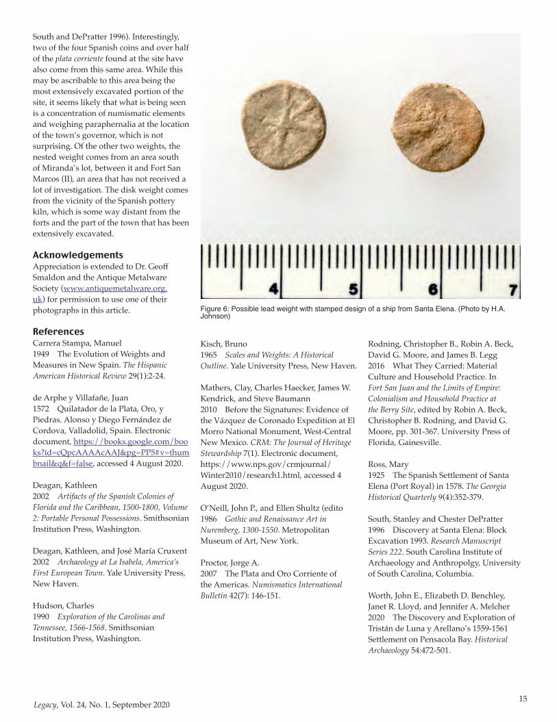
A different kind of weight was found some distance away, near the Spanish pottery kiln. This weight is a solid brass disk stamped with the impression of a castle (Figure 5). It was possibly made in
Cuenca, Spain, as the Gothic “C” mark upon it matches that on a 4 maravedis coin from the site with “C” being the mint mark for Cuenca. In a book by Juan de Arphe y Villafañe (1572:21-23), there is a section that deals with assaying gold in which illustrations of weights and their markings are presented, along with their relation to the division of the mark. The mark was a standard weight system, which for gold was subdivided into various categories; one mark was equal to 50 castellanos, 400 tomines, or 4,800 granos (Deagan 2002:236-237; Carrera Stampa 1949:17). The example from Santa Elena is the weight equivalent to 2 castellanos, 16 tomines, or 192 granos. A brass weight from the Luna site, Pensacola, Florida, is very similar to this weight, other than being of the larger 10 castellanos size (Worth et al. 2020:491).
In addition to the verifiable weights, there are three other objects that could also be weights. One is a rectangular piece of folded lead, stamped with the design of a ship with the mast surmounted by the Roman numeral two, or possibly an H (Figure 6). (A line drawing of this artifact can be seen in Legacy December 2016.) The other two artifacts are small, round lead disks, one of which has three crossed lines stamped into it (Figure 7). While weights made of lead are not unknown, they are not as common as brass. That, plus the unusual nature of these three objects, calls into question whether or not they are actually weights. They could be some form of game tokens, or in the case of the lead stamped with the ship, a merchant’s
Figure 3: Brass handle and supporting posts from a nested weight master cup. (Photo by H.A. Johnson)
Figure 4: Lead nested weight from Santa Elena. (Photo by H.A. Johnson)

14Legacy, Vol. 24, No. 1, September 2020
seal. Their proximity to the locations of the brass weights, however, does lend credence to their being some type of weight.
Having looked at all of the weights and associated artifacts, what can they tell us about weighing activities at Santa Elena? From historical documentation, we know that the Spanish were concerned with weights, given the need to be accountable for goods placed under their control. The accounts of the Juan Pardo expeditions out of Santa Elena (1566-1568), are a good example of this, with the weights of various goods (usually gun powder, matchcord, and lead shot) left at each of the forts Pardo established being enumerated (Hudson 1990:148-152). At one of these outposts, Fort San Juan, the remnants of an iron steelyard scale have been found (Rodning et al. 2016:328-329). Though such scales for weighing heavy amounts have not been found at Santa Elena, they were known to be in use there. In 1578, Captain Alvaro Flores de Quiñones inspected the fort of Santa Elena, and the “steelyards, scales, weights, and measures, by which they give out, weigh, and measure the food and rations that are given to the soldiers” were inspected (Ross 1925:365-366).
The weights that have been found at Santa Elena, measurable in grams instead of pounds, were clearly for weighing at a much finer scale. The presence of a weight for gold is likely indicative of the hopes of
the Spaniards for what they would find in the New World. As Santa Elena was not a center for the mass production of goods, the nested weights are probably not tied to commerce. A more likely need for them, or
the use that they were put to, would have been for weighing silver. There is some historical documentation that suggests the soldiers at Santa Elena may have been paid in pieces of silver instead of minted coins. The recovery of 21 pieces of silver, called plata corriente, from the site offers supporting evidence. These plata corriente, which never had a standard size or value when complete, were broken in smaller fragments as needed and used in the place of minted coinage (Proctor 2007:146-151). Weighing these fragments of silver would have been necessary in order to figure out what their value equated to in terms of minted coinage.
Finally, it is interesting and informative to note where all of the weights at Santa Elena have been recovered. With the exception of the large nested weight and the disk weight, all of the weights, the master cup handle and posts, and the possible weights come from the residential lots thought to be associated with Governor Miranda, occupied between 1580 and 1587. Most of the items were found around Structure 7, with the handle and posts being found near Structure 5 (see
Figure 5: Brass disk weight from Santa Elena. (Photo by H.A. Johnson)
Figure 6: Possible lead weight with stamped design of a ship from Santa Elena. (Photo by H.A. Johnson)
15Legacy, Vol. 24, No. 1, September 2020
South and DePratter 1996). Interestingly, two of the four Spanish coins and over half of the plata corriente found at the site have also come from this same area. While this may be ascribable to this area being the most extensively excavated portion of the site, it seems likely that what is being seen is a concentration of numismatic elements and weighing paraphernalia at the location of the town’s governor, which is not surprising. Of the other two weights, the nested weight comes from an area south of Miranda’s lot, between it and Fort San Marcos (II), an area that has not received a lot of investigation. The disk weight comes from the vicinity of the Spanish pottery kiln, which is some way distant from the forts and the part of the town that has been extensively excavated.
AcknowledgementsAppreciation is extended to Dr. Geoff Smaldon and the Antique Metalware Society (www.antiquemetalware.org.uk) for permission to use one of their photographs in this article.
ReferencesCarrera Stampa, Manuel1949 The Evolution of Weights and Measures in New Spain. The Hispanic American Historical Review 29(1):2-24.
de Arphe y Villafañe, Juan1572 Quilatador de la Plata, Oro, y Piedras. Alonso y Diego Fernández de Cordova, Valladolid, Spain. Electronic document, https://books.google.com/books?id=cQpcAAAAcAAJ&pg=PP5#v=thumbnail&q&f=false, accessed 4 August 2020.
Deagan, Kathleen2002 Artifacts of the Spanish Colonies of Florida and the Caribbean, 1500-1800, Volume 2: Portable Personal Possessions. Smithsonian Institution Press, Washington.
Deagan, Kathleen, and José María Cruxent2002 Archaeology at La Isabela, America’s First European Town. Yale University Press, New Haven.
Hudson, Charles1990 Exploration of the Carolinas and Tennessee, 1566-1568. Smithsonian Institution Press, Washington.
Kisch, Bruno1965 Scales and Weights: A Historical Outline. Yale University Press, New Haven.
Mathers, Clay, Charles Haecker, James W. Kendrick, and Steve Baumann2010 Before the Signatures: Evidence of the Vázquez de Coronado Expedition at El Morro National Monument, West-Central New Mexico. CRM: The Journal of Heritage Stewardship 7(1). Electronic document, https://www.nps.gov/crmjournal/Winter2010/research1.html, accessed 4 August 2020.
O’Neill, John P., and Ellen Shultz (edito1986 Gothic and Renaissance Art in Nuremberg, 1300-1550. Metropolitan Museum of Art, New York.
Proctor, Jorge A.2007 The Plata and Oro Corriente of the Americas. Numismatics International Bulletin 42(7): 146-151.
Rodning, Christopher B., Robin A. Beck, David G. Moore, and James B. Legg2016 What They Carried: Material Culture and Household Practice. In Fort San Juan and the Limits of Empire: Colonialism and Household Practice at the Berry Site, edited by Robin A. Beck, Christopher B. Rodning, and David G. Moore, pp. 301-367. University Press of Florida, Gainesville.
Ross, Mary1925 The Spanish Settlement of Santa Elena (Port Royal) in 1578. The Georgia Historical Quarterly 9(4):352-379.
South, Stanley and Chester DePratter1996 Discovery at Santa Elena: Block Excavation 1993. Research Manuscript Series 222. South Carolina Institute of Archaeology and Anthropolgy, University of South Carolina, Columbia.
Worth, John E., Elizabeth D. Benchley, Janet R. Lloyd, and Jennifer A. Melcher2020 The Discovery and Exploration of Tristán de Luna y Arellano’s 1559-1561 Settlement on Pensacola Bay. Historical Archaeology 54:472-501.
Figure 6: Possible lead weight with stamped design of a ship from Santa Elena. (Photo by H.A. Johnson)
16Legacy, Vol. 24, No. 1, September 2020
Early Human Life on the Southeastern Coastal PlainE D I T E D B Y A L B E R T C . G O O D Y E A R A N D C H R I S T O P H E R R . M O O R E
“Explores the current diversity of academic thought on the early human occupation of the American Southeast.”—e r v a n g a r r i s o n , author of Techniques in Archaeological Geology
“The early occupation of the Southeast for too long has been treated as essentially invariable, and contributors to this volume address this with new methods and data.”—p h i l i p j . c a r r , coeditor of Contemporary Lithic Analysis in the Southeast: Problems, Solutions, and Interpretations
Bringing together major archaeological research projects from Virginia to Alabama, this volume explores the rich prehistory of the Southeastern Coastal Plain. Contributors consider how the region’s warm weather, abundant water, and geography have long been optimal for the habitation of people beginning 50,000 years ago. They highlight demographic changes and cultural connections across this wide span of time and space. New data are provided here for many sites, including evidence for human settlement before the Clovis period at the famous Topper site in South Carolina. Contributors track the progression of sea level rise that gradually submerged shorelines and landscapes, and they discuss the possibility of a comet collision that triggered the Younger Dryas cold reversion and contributed to the extinction of Pleistocene megafauna like mastodons and mammoths. Essays also examine the various stone materials used by prehistoric foragers, the location of chert quarries, and the details stone tools reveal about social interaction and mobility. This volume synthesizes more than fifty years of research and addresses many of today’s controversial questions in the archaeology of the early Southeast, such as the sudden demise of the Clovis technoculture and the recognition of the mysterious
“Middle Paleoindian” period.
a l b e r t c . g o o d y e a r is a retired research affiliate at the South Carolina Institute of Archaeology and Anthropology and director of the Southeastern Paleoamerican Survey. c h r i s t o p h e r r . m o o r e is a geoarchaeologist with the Savannah River Archaeological Research Program.
434 pp. | 6 1/8 x 9 1/4 95 b/w illus., 33 maps, 22 tables
ISBN 978-1-68340-034-9
TO ORDER:
CALL 800-226-3822 and have VISA, MasterCard, American Express, or Discover number handy.
MAIL completed order form with check payable to University Press of Florida to:
University Press of Florida15 NW 15th StreetGainesville, FL 32603-1933
ONLINE at http://upress.ufl.edu Enter discount code AU718 at checkout *Postage and handling fee:
USA: $6.00 for the first book, $1.00 for each additional book. Int’l: $15.00 for the first book, $10.00 for each additional book.
Discount Code: AU718
____ Check enclosed
EARLY HUMAN LIFE ON THE SOUTHEASTERN COASTAL PLAIN
SPECIAL PRICE $75.00
No. Copies X____________
Book Total $____________
7% Sales Tax (FL Residents) $____________
Postage and Handling* $____________
TOTAL ____________
Daytime Phone_______________________________
Printed Name
____________________________________________
Signature
____________________________________________
Address
____________________________________________
____________________________________________
____________________________________________
Card #
____________________________________________
Exp Date _________Security code /CVV #__________
U N I V E R S I T Y P R E S S O F F LO R I D A 800.226.3822 · U P R E S S . U F L . E D U
Special discount available through July 31, 2018
NOTE: THIS DISCOUNT INTENDED FOR INDIVIDUALS ONLY. IT IS NOT APPLICABLE TO BOOKSTORES OR LIBRARIES.
17Legacy, Vol. 24, No. 1, September 2020
The Southeastern Paleoamerican Survey (SEPAS) was founded in 2005 and renamed from the former Allendale Paleoamerican Expedition (Goodyear 2006). Its purpose is to search for and discover archaeological evidence for the earliest human occupation of the Southeastern United States. The history of professional and avocational interests in what has been traditionally referred to as Paleoindian studies in South Carolina archaeology has been summarized in a book chapter (Goodyear 2016) published in Archaeology in South Carolina: the Hidden Heritage in the Palmetto State (King, ed., 2016).
To date, the focus of surveys and excavations has been on sites 12,000 years and older, including the well-known preClovis and Clovis occupations at the Topper site. Thus far, the emphasis has been on the Southeastern Coastal Plain ranging from Virginia to Florida. An edited book concerning the archaeology of this area was published in 2018 (Goodyear and Moore, eds. 2018) (see Page 16), that included a chapter providing more evidence of the artifacts and antiquity of the preClovis occupation of the Topper site, not previously published (Goodyear and Sain 2018).
Program DevelopmentsI retired from the South Carolina
Institute of South Carolina (SCIAA) at the University of South Carolina (USC) in 2014, after 40 years. I was appointed the next day as a Research Affiliate with SCIAA-USC. In 2015, Dr. Andrew A. White was hired by (SCIAA) as a research faculty member at the rank of Assistant Professor. He was made a member of the SCIAA Research Division with the expectation of developing a field project within South Carolina. His specialties are Paleoindian and Early Archaic societies, and he used collections from sites in the Midcontinent for his dissertation at the University of Michigan (White 2012). He has a continuing interest in the Kirk phase of the Early Archaic and how it spread across the eastern U.S. (White 2015a). In 2015, he began a multi-year excavation program at the Dorn site (38FA608), an alluvially buried multicomponent prehistoric site on the bank of the Broad River in Fairfield County, South Carolina (White 2015b, 2020)). In the summer of 2020, Andy left SCIAA when he and his wife Dr. Elizabeth Bridges both took positions with the Illinois Archaeology Survey. Andy will be sorely missed for his considerable abilities as an archaeologist and his keen analytical insights.
In 2016, USC provided SCIAA with new facilities across campus in the first floor of Barnwell College. Andy White and I were both given space there, which has provided excellent room for office, lab, and storage for our collections. Using an Archaeological Research Trust (ART) grant, Andy began a project cataloging and analyzing artifacts of the Dr. Larry Strong collection, a gift from Strong in 1999, of well over 16,000 artifacts found in Allendale County, South Carolina (White 2016a). Much of the Topper site collections were moved there as well, allowing easy access for analysis by future researchers. Joe Wilkinson provided assistance in organizing Topper artifact collections and records resulting from several years of field research. He was given an office there to continue artifact photography and to pursue his work with private collections, which resulted in his
master’s degree thesis (Wilkinson 2017) on the Early Archaic of South Carolina, and subsequently a book chapter on the Early Archaic occupation of the Coastal Plain (Wilkinson 2018).
The important work with private artifact collections initiated by Tommy Charles in the 1980’s, and forward, collections drawn from throughout the state, has resulted in a great deal of data regarding types of stone tools and their raw materials. A compilation of his work resulted in a volume by Tommy Charles and Christopher Moore entitled Prehistoric Chipped Stone Tools of South Carolina (Charles and Moore 2018). This volume provides information on the typical stone tool artifacts found throughout the state along with types and sources of lithic raw material. As such, it is an invaluable source for both professional archaeologists and members of the public who often find artifacts. Some collections were eventually donated to SCIAA as a result of Tommy’s work with collectors. Among these are the Wiles collection from Abbeville County, the Wilma Croft collection from Aiken County, the Larry Strong collection from Allendale County, and Tommy’s collection from the Manning site (38LX50). Other important collections not donated that have been inventoried include the Johnny Causey collection from Hampton County, the William F. Barnes collection from Fairfax, South Carolina, and the Dennis Hendrix collection from Barnwell, Bamberg and Orangeburg Counties. Other collections donated to SEPAS include the Lee Thomas collection (Goodyear and Wilkinson 2018), parts of the Island site (38CL102) collection of Steve Williams, and the Gene Porter collection of Barnwell County. Artifact data were also recorded from 16 private collections down the Congaree and Santee River basin (COWASEE), most of which had not been previously recorded (Goodyear 2014).
In summary, numerous private artifact collections have been donated or inventoried for the southern part of the state by SEPAS that can allow detailed geographic studies of prehistoric cultures using time sensitive artifacts such as projectile points. Advances in lithic
Update on the Activities of the Southeastern Paleoamerican Survey (2014-2020)By Albert C. Goodyear, Director
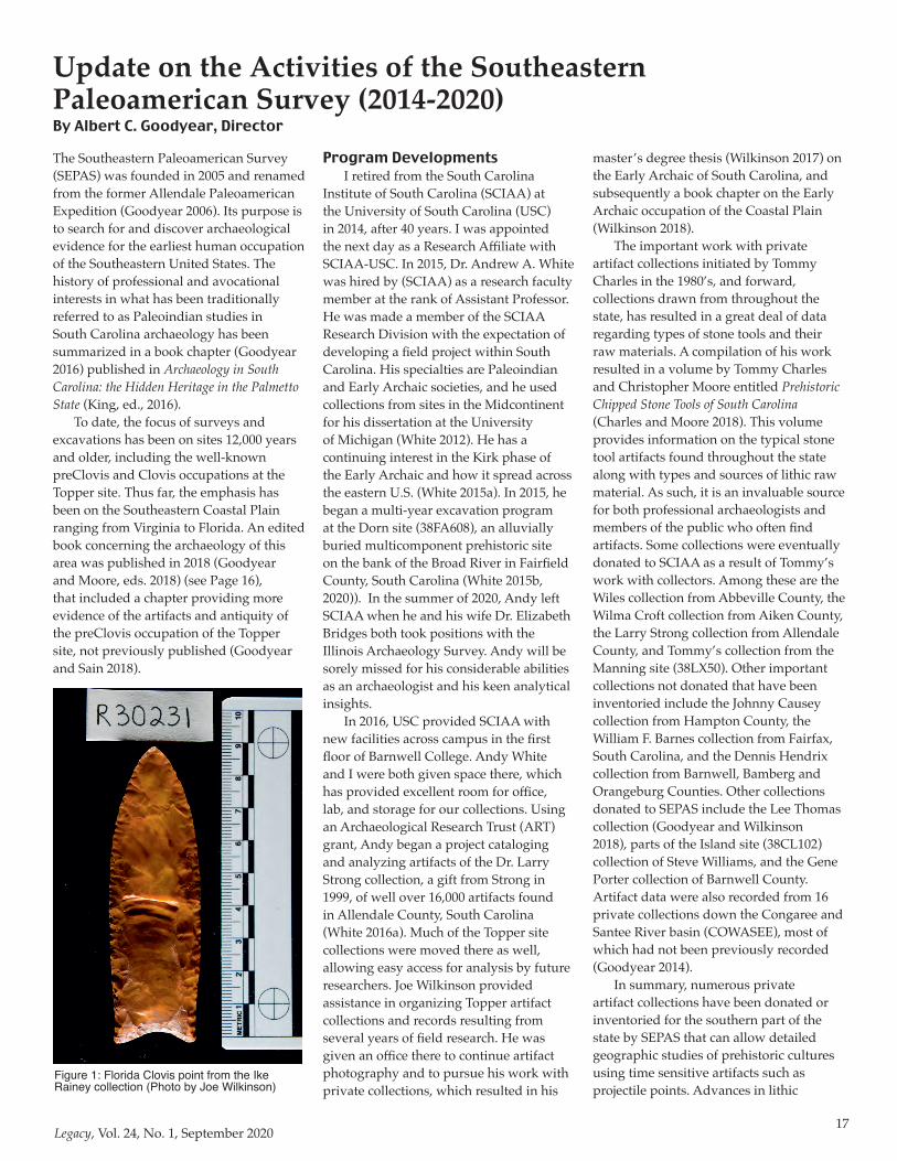
Figure 1: Florida Clovis point from the Ike Rainey collection (Photo by Joe Wilkinson)

18Legacy, Vol. 24, No. 1, September 2020
raw material identification and their geological sources allow the mapping of dispersion zones and probable foraging territories of prehistoric hunter-gathers (e.g., Moore and Charles 2018). SCIAA has had a long history of working with the public and their artifact collections and sites, a powerful means of obtaining data that is commensurate with the often geographically extensive distributions of prehistoric cultural groups. For Paleoamerican studies, this has been critical for reconstructing possible macrobands for Clovis groups such as the proposed Uwharrie Mountain group of North Carolina (Daniel and Goodyear 2018) and a similar band in the southern Coastal Plain of South Carolina and southeast Georgia known as the Allendale-Brier Creek Clovis Complex (Goodyear 2018).
SEPAS Research ActivitiesPaleoindian points have continued
to be recorded for South Carolina, a data base begun by Jim Michie in the late 1960’s and substantially added to by Tommy Charles, as part of his state-wide private collections survey. The history of this survey including additions to it since Tommy retired, has been traced out in my article on the search for earliest people in South Carolina (Goodyear 2016). As of this writing, we are up to 791 points that are presumed to be non and pre-Dalton in age. More attention is now being paid to recording Dalton points throughout the stat,e as Daltons are being seen as the end of the classic Paleoindian point technologies. Dalton may also be the first groups to be affected by sea level rise causing the loss of prime Coastal Plain
wetlands, which may have necessitated intensification of hunting and gathering in the Piedmont. This has been referred to as the Dalton Piedmont Transhumance Hypothesis based on Dalton representing the first large Paleoindian sites occurring on the Fall Line and lower Piedmont (Smallwood et al. 2018).
The major use of traditional fluted points such as Clovis and Redstone has been synthesized using the Uwharrie Mountain and Allendale-Brier Creek Clovis complexes as developed by Randy Daniel and myself. Using the diagnostic lithic raw materials native to sources in both states, it is clear that two probably contemporary Clovis macrobands existed over the Carolinas. It has been shown that the northern portion of South Carolina was likely the southern portion of the Uwharrie
group, based on the morphologically identical Clovis point attributes, except length. Length would naturally decrease moving geographically away from the Uwharrie Mountain sources (Daniel and Goodyear 2015). The southern macroband is identified as the Allendale-Brier Creek Clovis Complex in recognition of the high densities of Clovis points in both areas likely due to the abundant high quality Coastal Plain chert sources (Daniel and Goodyear 2018; Goodyear and Charles 1984; Goodyear 2018).
In keeping with the concept of the focus on the wider Southeastern area, a fluted point survey has been created for the state of Florida. As of this writing, the total number recorded is 451, which includes classic Clovis points, Redstones, and fluted Simpsons. Also being recorded, are Clovis point preforms that are common in the major rivers of Florida, which is also the source of the bulk of fluted points. Nearly all of these points were originally found by members of the public, especially by scuba diving in the springs and rivers. Many of these were found starting in the 1960’s and continuing up to the early 2000’s. Several of the larger well documented private collections eventually ended up in the Ike Rainey collection in Ocala, Florida (Figure 1), along with many other good examples of prehistoric Florida artifacts. While recording of fluted points is still ongoing, including the current update of our original Tampa Bay study (Goodyear et al. 1983). The plan is to eventually create a well-documented data
Figure 2: Clovis point from the Mark Corbitt cache from the Withlacoochee River, South Georgia. (Photos by Joe Wilkinson and drawings by Darby Erd)
Figure 3: Two Clovis polyhedral blade cores from the Mark Corbitt cache from the Withlacoochee River, South Georgia. (Photo by Joe Wilkinson)
19Legacy, Vol. 24, No. 1, September 2020
base of fluted points covering an area from Tampa Bay to Raleigh, North Carolina. This would cover an area some 1,000 kilometers from north to south, which would allow detection of any technological attributes and raw material patterns potentially related to demographic and cultural elements.
One project in the southern Georgia area on the Withlacoochee River near Valdosta, Georgia, concerns the Mark Corbitt quarry cache of Clovis artifacts. An evident cluster of chert artifacts, including one Clovis point (Figure 2), two polyhedral blade cores (Figure 3), and several tools were found by Mark Corbitt as a youth eroding out of the river bank. Some of these were stacked on top of each other. Analysis of the artifacts has been done led by Ashley Smallwood and Tom Jennings supplemented by me and Joe Wilkinson, who also did the photography. The petrography of the cherts has been done by Sam Upchurch from Florida, expert on Coastal Plain cherts. Silicified limestone cherts and silicified coral, both outcrops locally in the river bed and can be easily procured. Silicified coral in Florida is notoriously hard to flake without thermal alteration. The silicified coral from this quarry seems unusually good, not necessarily requiring heat treatment. On one visit, a backhoe was used to expose the profile in the river bank, revealing at least two different floodplains regimes. In the lower floodplain with a darker colored and finer sediments resting on bedrock, some culturally flaked artifacts were found. This lower floodplain is likely Pleistocene and early Holocene in age and provides
an intriguing geological context to test for Paleoamerican occupation. A paper by this group of investigators was presented at the Southeastern Archaeological Conference (SEAC) meeting in Augusta, Georgia in 2018 (Goodyear et al. 2018).
In 2019-2020, Andy White, Joe Wilkinson, and I began to research the evidence in South Carolina of what can be called buried closed Early Archaic lithic assemblages. Both Andy White and Joe Wilkinson have done considerable research on the Early Archaic with their interests with side-notched Taylor points and Kirk corner-notched points (White 2016b; Wilkinson 2018). Throughout the eastern U.S., there is widespread recognition of temporally separate horizons of side-notched points followed by corner-notched points (Tuck 1974; White 2019). We examined evidence in South Carolina for these two temporally discrete horizons by studying the best examples of what can be called “closed” assemblages where only one type of notched point was present. These would be Early Archaic sites that were sufficiently buried to eliminate as much as possible, the reoccupation and thus, mixing of these sites by later occupations. Two sites, G.S. Lewis East (Kirk) and the Topper site (Taylor), each seem to meet those expectations (Goodyear, White, and Wilkinson 2019). In addition, two caches of Kirk corner-notched points were added to check for the homogeneity in the types. The Nipper Creek site in Richland County, South Carolina had a Kirk corner-notched cache of six points that may have been a cache for later use
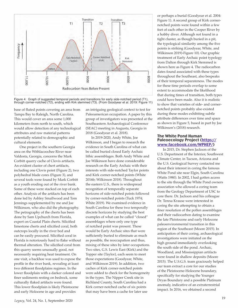
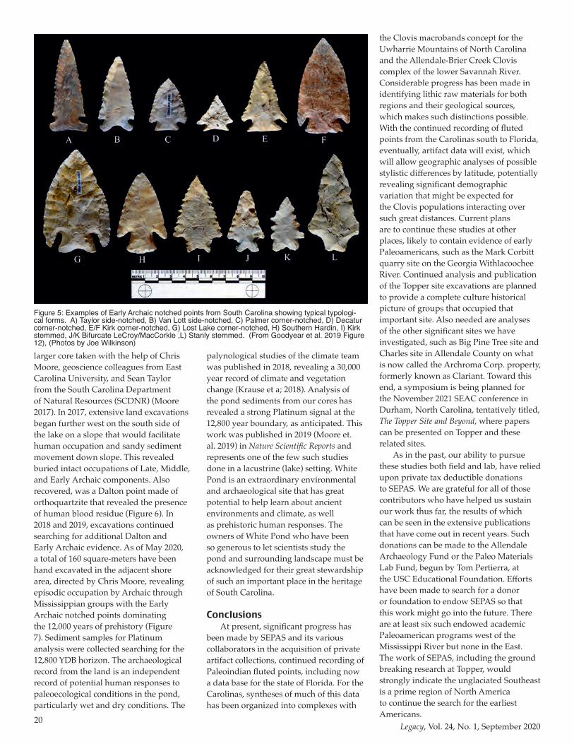
or perhaps a burial (Goodyear et al. 2004: Figure 1). A second group of Kirk corner-notched points were found within a few feet of each other in the Cooper River by a hobby diver. Although not found in a tight cluster, as though buried in a pit, the typological similarity among the five points is striking (Goodyear, White, and Wilkinson 2019)-Figure 10). Our graphic treatment of Early Archaic point typology from Dalton through Kirk Stemmed is shown here as Figure 4. The radiocarbon dates found associated with these types throughout the Southeast, also bespeaks of their temporal separateness. The modes for these time periods overlap to some extent to accommodate the likelihood that during times of transition, both types could have been made. Also it is realistic to show that varieties of side- and corner-notched points probably also existed during these modes exhibiting subtle attribute differences over time and space as shown in Figure 5, based in part by Joe Wilkinson’s (2018) research.
The White Pond Human Paleoecology Project (https://www.facebook.com/WPHEP/)
In 2015, Dr. Stephen Jackson of the U.S. Department of the Interior, Southwest Climate Center, in Tucson, Arizona and the U.S. Geological Survey contacted me about their interest in coring the famous White Pond site near Elgin, South Carolina (Watts 1980). In 2002, I had gotten access to the site through the White Pond owners association who allowed a coring team from the Geology Department of USC to core there. Dr. Jackson and his colleague Dr. Teresa Krause were interested in coring the site attempting to obtain a finer resolution of the pollen assemblages and their radiocarbon dating to examine the late Pleistocene and early Holocene paleoenvironmental transition in this region of the Southeast (Moore 2015). In anticipation of their coring, archaeological investigations were initiated on the high ground immediately overlooking the south side of the pond. Archaic, Woodland, and Mississippian artifacts were found in shallow deposits (Moore 2015). The U.S.G.S. team graciously helped our team extract a core for our studies of the Pleistocene-Holocene boundary, specifically for studying the Younger Dryas Boundary and a possible Platinum anomaly, indicative of an extraterrestrial impact. In 2016, we obtained a second
Figure 4: Graph of suggested temporal periods and transitions for early side-notched period (T1), through corner-notched (T2), ending with Kirk stemmed (T3). (From Goodyear et al. 2019: Figure 11)
20Legacy, Vol. 24, No. 1, September 2020
larger core taken with the help of Chris Moore, geoscience colleagues from East Carolina University, and Sean Taylor from the South Carolina Department of Natural Resources (SCDNR) (Moore 2017). In 2017, extensive land excavations began further west on the south side of the lake on a slope that would facilitate human occupation and sandy sediment movement down slope. This revealed buried intact occupations of Late, Middle, and Early Archaic components. Also recovered, was a Dalton point made of orthoquartzite that revealed the presence of human blood residue (Figure 6). In 2018 and 2019, excavations continued searching for additional Dalton and Early Archaic evidence. As of May 2020, a total of 160 square-meters have been hand excavated in the adjacent shore area, directed by Chris Moore, revealing episodic occupation by Archaic through Mississippian groups with the Early Archaic notched points dominating the 12,000 years of prehistory (Figure 7). Sediment samples for Platinum analysis were collected searching for the 12,800 YDB horizon. The archaeological record from the land is an independent record of potential human responses to paleoecological conditions in the pond, particularly wet and dry conditions. The
palynological studies of the climate team was published in 2018, revealing a 30,000 year record of climate and vegetation change (Krause et a; 2018). Analysis of the pond sediments from our cores has revealed a strong Platinum signal at the 12,800 year boundary, as anticipated. This work was published in 2019 (Moore et. al. 2019) in Nature Scientific Reports and represents one of the few such studies done in a lacustrine (lake) setting. White Pond is an extraordinary environmental and archaeological site that has great potential to help learn about ancient environments and climate, as well as prehistoric human responses. The owners of White Pond who have been so generous to let scientists study the pond and surrounding landscape must be acknowledged for their great stewardship of such an important place in the heritage of South Carolina.
ConclusionsAt present, significant progress has
been made by SEPAS and its various collaborators in the acquisition of private artifact collections, continued recording of Paleoindian fluted points, including now a data base for the state of Florida. For the Carolinas, syntheses of much of this data has been organized into complexes with
the Clovis macrobands concept for the Uwharrie Mountains of North Carolina and the Allendale-Brier Creek Clovis complex of the lower Savannah River. Considerable progress has been made in identifying lithic raw materials for both regions and their geological sources, which makes such distinctions possible. With the continued recording of fluted points from the Carolinas south to Florida, eventually, artifact data will exist, which will allow geographic analyses of possible stylistic differences by latitude, potentially revealing significant demographic variation that might be expected for the Clovis populations interacting over such great distances. Current plans are to continue these studies at other places, likely to contain evidence of early Paleoamericans, such as the Mark Corbitt quarry site on the Georgia Withlacoochee River. Continued analysis and publication of the Topper site excavations are planned to provide a complete culture historical picture of groups that occupied that important site. Also needed are analyses of the other significant sites we have investigated, such as Big Pine Tree site and Charles site in Allendale County on what is now called the Archroma Corp. property, formerly known as Clariant. Toward this end, a symposium is being planned for the November 2021 SEAC conference in Durham, North Carolina, tentatively titled, The Topper Site and Beyond, where papers can be presented on Topper and these related sites.
As in the past, our ability to pursue these studies both field and lab, have relied upon private tax deductible donations to SEPAS. We are grateful for all of those contributors who have helped us sustain our work thus far, the results of which can be seen in the extensive publications that have come out in recent years. Such donations can be made to the Allendale Archaeology Fund or the Paleo Materials Lab Fund, begun by Tom Pertierra, at the USC Educational Foundation. Efforts have been made to search for a donor or foundation to endow SEPAS so that this work might go into the future. There are at least six such endowed academic Paleoamerican programs west of the Mississippi River but none in the East. The work of SEPAS, including the ground breaking research at Topper, would strongly indicate the unglaciated Southeast is a prime region of North America to continue the search for the earliest Americans.
Figure 5: Examples of Early Archaic notched points from South Carolina showing typical typologi-cal forms. A) Taylor side-notched, B) Van Lott side-notched, C) Palmer corner-notched, D) Decatur corner-notched, E/F Kirk corner-notched, G) Lost Lake corner-notched, H) Southern Hardin, I) Kirk stemmed, J/K Bifurcate LeCroy/MacCorkle ,L) Stanly stemmed. (From Goodyear et al. 2019 Figure 12), (Photos by Joe Wilkinson)
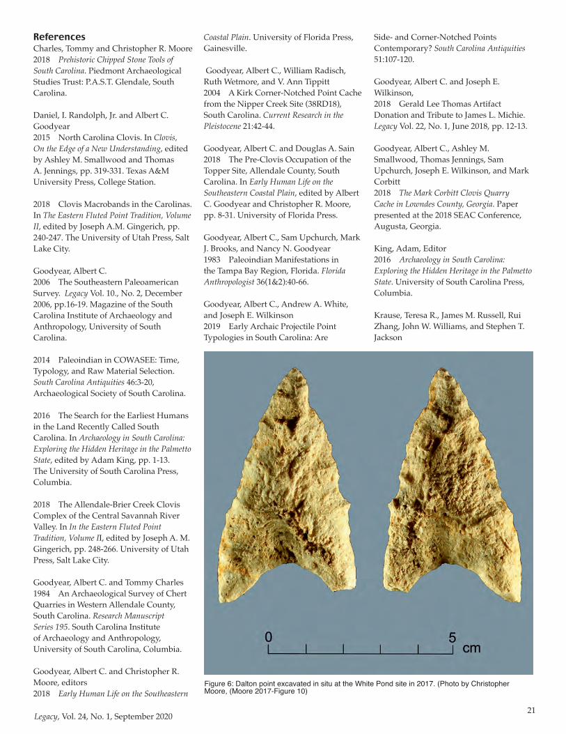
21Legacy, Vol. 24, No. 1, September 2020
ReferencesCharles, Tommy and Christopher R. Moore2018 Prehistoric Chipped Stone Tools of South Carolina. Piedmont Archaeological Studies Trust: P.A.S.T. Glendale, South Carolina.
Daniel, I. Randolph, Jr. and Albert C. Goodyear 2015 North Carolina Clovis. In Clovis, On the Edge of a New Understanding, edited by Ashley M. Smallwood and Thomas A. Jennings, pp. 319-331. Texas A&M University Press, College Station.
2018 Clovis Macrobands in the Carolinas. In The Eastern Fluted Point Tradition, Volume II, edited by Joseph A.M. Gingerich, pp. 240-247. The University of Utah Press, Salt Lake City.
Goodyear, Albert C.2006 The Southeastern Paleoamerican Survey. Legacy Vol. 10., No. 2, December 2006, pp.16-19. Magazine of the South Carolina Institute of Archaeology and Anthropology, University of South Carolina.
2014 Paleoindian in COWASEE: Time, Typology, and Raw Material Selection. South Carolina Antiquities 46:3-20, Archaeological Society of South Carolina.
2016 The Search for the Earliest Humans in the Land Recently Called South Carolina. In Archaeology in South Carolina: Exploring the Hidden Heritage in the Palmetto State, edited by Adam King, pp. 1-13. The University of South Carolina Press, Columbia.
2018 The Allendale-Brier Creek Clovis Complex of the Central Savannah River Valley. In In the Eastern Fluted Point Tradition, Volume II, edited by Joseph A. M. Gingerich, pp. 248-266. University of Utah Press, Salt Lake City.
Goodyear, Albert C. and Tommy Charles1984 An Archaeological Survey of Chert Quarries in Western Allendale County, South Carolina. Research Manuscript Series 195. South Carolina Institute of Archaeology and Anthropology, University of South Carolina, Columbia.
Goodyear, Albert C. and Christopher R. Moore, editors2018 Early Human Life on the Southeastern
Coastal Plain. University of Florida Press, Gainesville.
Goodyear, Albert C., William Radisch, Ruth Wetmore, and V. Ann Tippitt2004 A Kirk Corner-Notched Point Cache from the Nipper Creek Site (38RD18), South Carolina. Current Research in the Pleistocene 21:42-44.
Goodyear, Albert C. and Douglas A. Sain2018 The Pre-Clovis Occupation of the Topper Site, Allendale County, South Carolina. In Early Human Life on the Southeastern Coastal Plain, edited by Albert C. Goodyear and Christopher R. Moore, pp. 8-31. University of Florida Press.
Goodyear, Albert C., Sam Upchurch, Mark J. Brooks, and Nancy N. Goodyear1983 Paleoindian Manifestations in the Tampa Bay Region, Florida. Florida Anthropologist 36(1&2):40-66.
Goodyear, Albert C., Andrew A. White, and Joseph E. Wilkinson2019 Early Archaic Projectile Point Typologies in South Carolina: Are
Side- and Corner-Notched Points Contemporary? South Carolina Antiquities 51:107-120.
Goodyear, Albert C. and Joseph E. Wilkinson,2018 Gerald Lee Thomas Artifact Donation and Tribute to James L. Michie. Legacy Vol. 22, No. 1, June 2018, pp. 12-13.
Goodyear, Albert C., Ashley M. Smallwood, Thomas Jennings, Sam Upchurch, Joseph E. Wilkinson, and Mark Corbitt2018 The Mark Corbitt Clovis Quarry Cache in Lowndes County, Georgia. Paper presented at the 2018 SEAC Conference, Augusta, Georgia.
King, Adam, Editor2016 Archaeology in South Carolina: Exploring the Hidden Heritage in the Palmetto State. University of South Carolina Press, Columbia.
Krause, Teresa R., James M. Russell, Rui Zhang, John W. Williams, and Stephen T. Jackson
Figure 6: Dalton point excavated in situ at the White Pond site in 2017. (Photo by Christopher Moore, (Moore 2017-Figure 10)
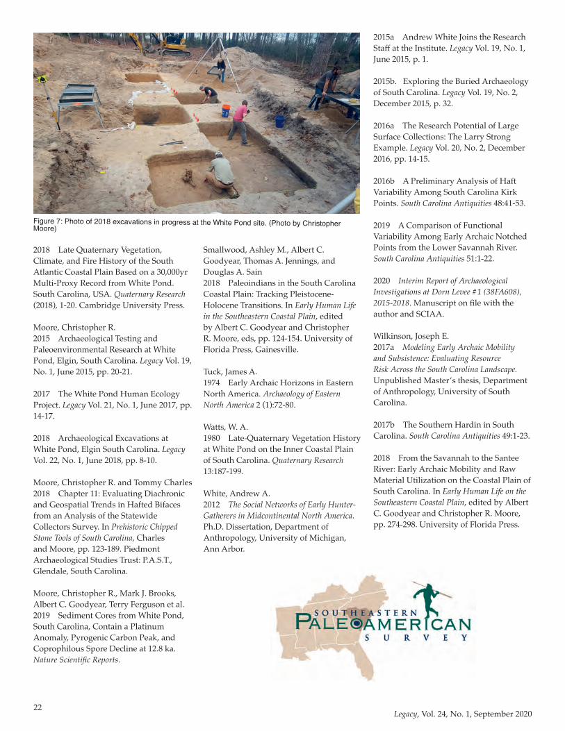
22Legacy, Vol. 24, No. 1, September 2020
2018 Late Quaternary Vegetation, Climate, and Fire History of the South Atlantic Coastal Plain Based on a 30,000yr Multi-Proxy Record from White Pond. South Carolina, USA. Quaternary Research (2018), 1-20. Cambridge University Press.
Moore, Christopher R.2015 Archaeological Testing and Paleoenvironmental Research at White Pond, Elgin, South Carolina. Legacy Vol. 19, No. 1, June 2015, pp. 20-21.
2017 The White Pond Human Ecology Project. Legacy Vol. 21, No. 1, June 2017, pp. 14-17.
2018 Archaeological Excavations at White Pond, Elgin South Carolina. Legacy Vol. 22, No. 1, June 2018, pp. 8-10.
Moore, Christopher R. and Tommy Charles2018 Chapter 11: Evaluating Diachronic and Geospatial Trends in Hafted Bifaces from an Analysis of the Statewide Collectors Survey. In Prehistoric Chipped Stone Tools of South Carolina, Charles and Moore, pp. 123-189. Piedmont Archaeological Studies Trust: P.A.S.T., Glendale, South Carolina.
Moore, Christopher R., Mark J. Brooks, Albert C. Goodyear, Terry Ferguson et al.2019 Sediment Cores from White Pond, South Carolina, Contain a Platinum Anomaly, Pyrogenic Carbon Peak, and Coprophilous Spore Decline at 12.8 ka. Nature Scientific Reports.
Smallwood, Ashley M., Albert C. Goodyear, Thomas A. Jennings, and Douglas A. Sain2018 Paleoindians in the South Carolina Coastal Plain: Tracking Pleistocene-Holocene Transitions. In Early Human Life in the Southeastern Coastal Plain, edited by Albert C. Goodyear and Christopher R. Moore, eds, pp. 124-154. University of Florida Press, Gainesville.
Tuck, James A.1974 Early Archaic Horizons in Eastern North America. Archaeology of Eastern North America 2 (1):72-80.
Watts, W. A.1980 Late-Quaternary Vegetation History at White Pond on the Inner Coastal Plain of South Carolina. Quaternary Research 13:187-199.
White, Andrew A.2012 The Social Networks of Early Hunter-Gatherers in Midcontinental North America. Ph.D. Dissertation, Department of Anthropology, University of Michigan, Ann Arbor.
2015a Andrew White Joins the Research Staff at the Institute. Legacy Vol. 19, No. 1, June 2015, p. 1.
2015b. Exploring the Buried Archaeology of South Carolina. Legacy Vol. 19, No. 2, December 2015, p. 32.
2016a The Research Potential of Large Surface Collections: The Larry Strong Example. Legacy Vol. 20, No. 2, December 2016, pp. 14-15.
2016b A Preliminary Analysis of Haft Variability Among South Carolina Kirk Points. South Carolina Antiquities 48:41-53.
2019 A Comparison of Functional Variability Among Early Archaic Notched Points from the Lower Savannah River. South Carolina Antiquities 51:1-22.
2020 Interim Report of Archaeological Investigations at Dorn Levee #1 (38FA608), 2015-2018. Manuscript on file with the author and SCIAA.
Wilkinson, Joseph E.2017a Modeling Early Archaic Mobility and Subsistence: Evaluating Resource Risk Across the South Carolina Landscape. Unpublished Master’s thesis, Department of Anthropology, University of South Carolina.
2017b The Southern Hardin in South Carolina. South Carolina Antiquities 49:1-23.
2018 From the Savannah to the Santee River: Early Archaic Mobility and Raw Material Utilization on the Coastal Plain of South Carolina. In Early Human Life on the Southeastern Coastal Plain, edited by Albert C. Goodyear and Christopher R. Moore, pp. 274-298. University of Florida Press.
Figure 7: Photo of 2018 excavations in progress at the White Pond site. (Photo by Christopher Moore)

23Legacy, Vol. 24, No. 1, September 2020
Historic Brattonsville (38YK21) is a significant Piedmont “Frontier” Antebellum Plantation, Revolutionary War site, Postbellum Scots-Irish and African-American Piedmont community that has been on the National Register of Historic Places since 1971, and today functions as a popular living history destination near the city of Rock Hill in York County, South Carolina. Plans to return to Historic Brattonsville this fall 2020 and to continue fieldwork with Winthrop University students have unfortunately been thwarted by the current COVID-19 health crisis. However, in the fall of 2017, SCIAA Research Affiliate/Winthrop University faculty (Gillam) and students (Lamb and others; first identified the location of previously unknown quarters of enslaved field workers at Historic Brattonsville (Figure 1).
The significance of Historic Brattonsville cannot be overstated at the national, state, and local levels. The initial purchase of 200-acres in the Rainey-Bratton deed transaction and subsequent records indicate that Col. William Bratton was living on the property after 1766 and that between 1774 and 1780, Col. Bratton and his family were living in what is now known as the Colonel Bratton House (Beck 1995; Wilkins et al. 1975). Located on a major crossroad, the intersecting roads were a primary north-south road, known historically as the Armour’s Ford,
Armstrong Ford, or Lincoln Road (today, Brattonsville Road), and another road, Rocky Mount or Rocky Marsh Road that branched to the southeast (near Percival Road today). Historic Brattonsville also contains the significant Revolutionary War site of the Williamson’s Plantation/Battle of Huck’s Defeat (Smith 2010).
The location of the original house and greater plantation was strategically placed at the intersection of these two significant colonial roads to enable trade and economic growth for the Bratton family, and grow it did at the cost of the ever-increasing slave population. In 1790, Col. Bratton owned 12 enslaved people and 200 acres of land. By 1815, he increased his slave ownership to 23 slaves. In 1827, his
son, Dr. John S. Bratton, owned 40 slaves and 3,540 acres of land. By the 1830 census, Dr. Bratton held 49 slaves, with that number expanding rapidly to 112 slaves in the 1840 census. In 1843, Dr. Bratton had increased his slave count to 140 slaves. In 1861, Dr. Bratton’s son, John Simpson Bratton Jr., along with his widow, Harriet Bratton, owned 152 slaves and 8,000 acres of land until the end of the Civil War. Where the recently discovered field slave quarters fit into this timeline is revealed by the ceramics recovered and highlighted below.
The fieldwork was originally designed to test a peripheral wooded area of the plantation for possible antebellum brick production activities, one of many industries at Bratton Plantation. The area of interest was identified by Brattonsville staff due to the presence of a glazed brick scatter associated with possible footing stones (Figure 2) and a nearby brick pile along the adjacent woods edge (Figure 3). However, the recovery of household wares in shovel test pits soon revealed the actual function of the site as domestic quarters for field slaves.
Along the forested edge of the ridge top, the surface of the landform appeared irregular and partially disturbed. However, a few footing stones of at least one structure appear to be in or very near their original positions. Elsewhere, footing stones and brick scatter appeared more disturbed and randomly distributed, likely
Field Slave Quarters Discovered at Historic BrattonsvilleBy J. Christopher Gillam1, Gregory M. Lamb2,, and January Withers Costa3
1Winthrop University/SCIAA Research Affiliate, Rock Hill/Columbia, SC.2Independant Archaeological Field Technician, Rock Hill, SC.3Kings Mountain Historical Museum, Kings Mountain, NC
Figure 1: Winthrop University student field crew with Gillam (3rd from right) and Lamb (5th from right). (Photo by Chris Gillam)
Figure 2: Footing stones and brick scatter in the wooded area of the site. (Photo by Chris Gillam)
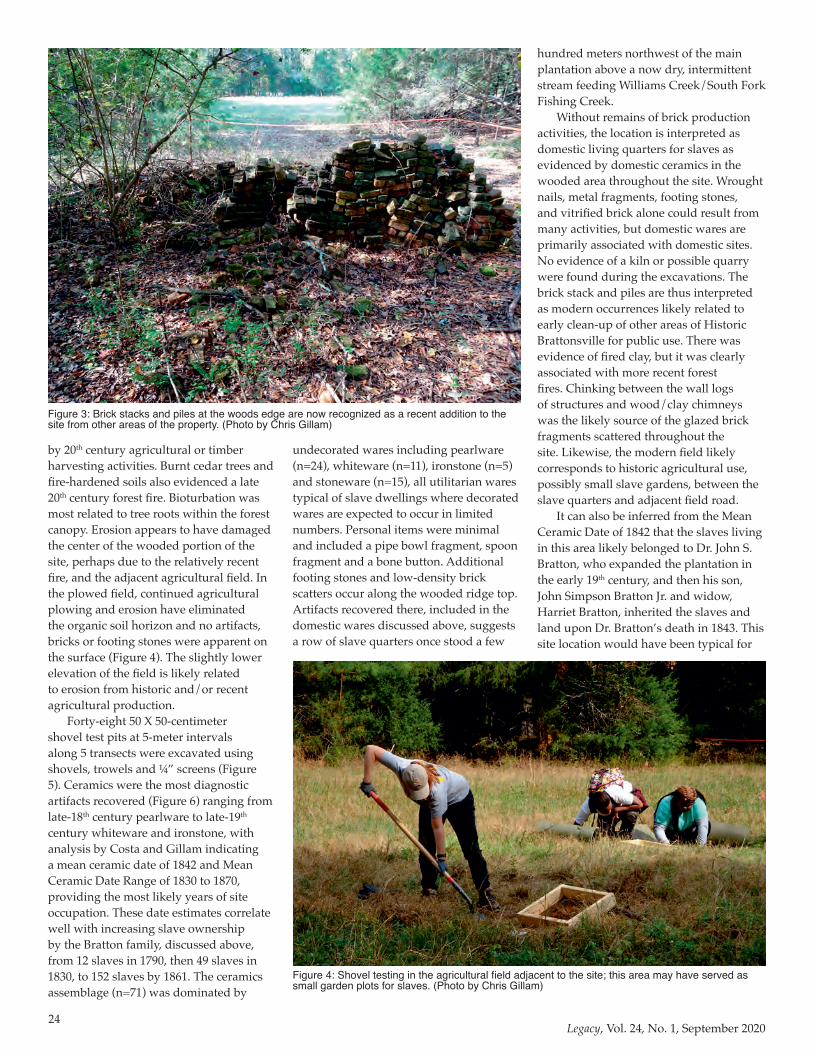
24Legacy, Vol. 24, No. 1, September 2020
by 20th century agricultural or timber harvesting activities. Burnt cedar trees and fire-hardened soils also evidenced a late 20th century forest fire. Bioturbation was most related to tree roots within the forest canopy. Erosion appears to have damaged the center of the wooded portion of the site, perhaps due to the relatively recent fire, and the adjacent agricultural field. In the plowed field, continued agricultural plowing and erosion have eliminated the organic soil horizon and no artifacts, bricks or footing stones were apparent on the surface (Figure 4). The slightly lower elevation of the field is likely related to erosion from historic and/or recent agricultural production.
Forty-eight 50 X 50-centimeter shovel test pits at 5-meter intervals along 5 transects were excavated using shovels, trowels and ¼” screens (Figure 5). Ceramics were the most diagnostic artifacts recovered (Figure 6) ranging from late-18th century pearlware to late-19th century whiteware and ironstone, with analysis by Costa and Gillam indicating a mean ceramic date of 1842 and Mean Ceramic Date Range of 1830 to 1870, providing the most likely years of site occupation. These date estimates correlate well with increasing slave ownership by the Bratton family, discussed above, from 12 slaves in 1790, then 49 slaves in 1830, to 152 slaves by 1861. The ceramics assemblage (n=71) was dominated by
undecorated wares including pearlware (n=24), whiteware (n=11), ironstone (n=5) and stoneware (n=15), all utilitarian wares typical of slave dwellings where decorated wares are expected to occur in limited numbers. Personal items were minimal and included a pipe bowl fragment, spoon fragment and a bone button. Additional footing stones and low-density brick scatters occur along the wooded ridge top. Artifacts recovered there, included in the domestic wares discussed above, suggests a row of slave quarters once stood a few
hundred meters northwest of the main plantation above a now dry, intermittent stream feeding Williams Creek/South Fork Fishing Creek.
Without remains of brick production activities, the location is interpreted as domestic living quarters for slaves as evidenced by domestic ceramics in the wooded area throughout the site. Wrought nails, metal fragments, footing stones, and vitrified brick alone could result from many activities, but domestic wares are primarily associated with domestic sites. No evidence of a kiln or possible quarry were found during the excavations. The brick stack and piles are thus interpreted as modern occurrences likely related to early clean-up of other areas of Historic Brattonsville for public use. There was evidence of fired clay, but it was clearly associated with more recent forest fires. Chinking between the wall logs of structures and wood/clay chimneys was the likely source of the glazed brick fragments scattered throughout the site. Likewise, the modern field likely corresponds to historic agricultural use, possibly small slave gardens, between the slave quarters and adjacent field road.
It can also be inferred from the Mean Ceramic Date of 1842 that the slaves living in this area likely belonged to Dr. John S. Bratton, who expanded the plantation in the early 19th century, and then his son, John Simpson Bratton Jr. and widow, Harriet Bratton, inherited the slaves and land upon Dr. Bratton’s death in 1843. This site location would have been typical for
Figure 3: Brick stacks and piles at the woods edge are now recognized as a recent addition to the site from other areas of the property. (Photo by Chris Gillam)
Figure 4: Shovel testing in the agricultural field adjacent to the site; this area may have served as small garden plots for slaves. (Photo by Chris Gillam)
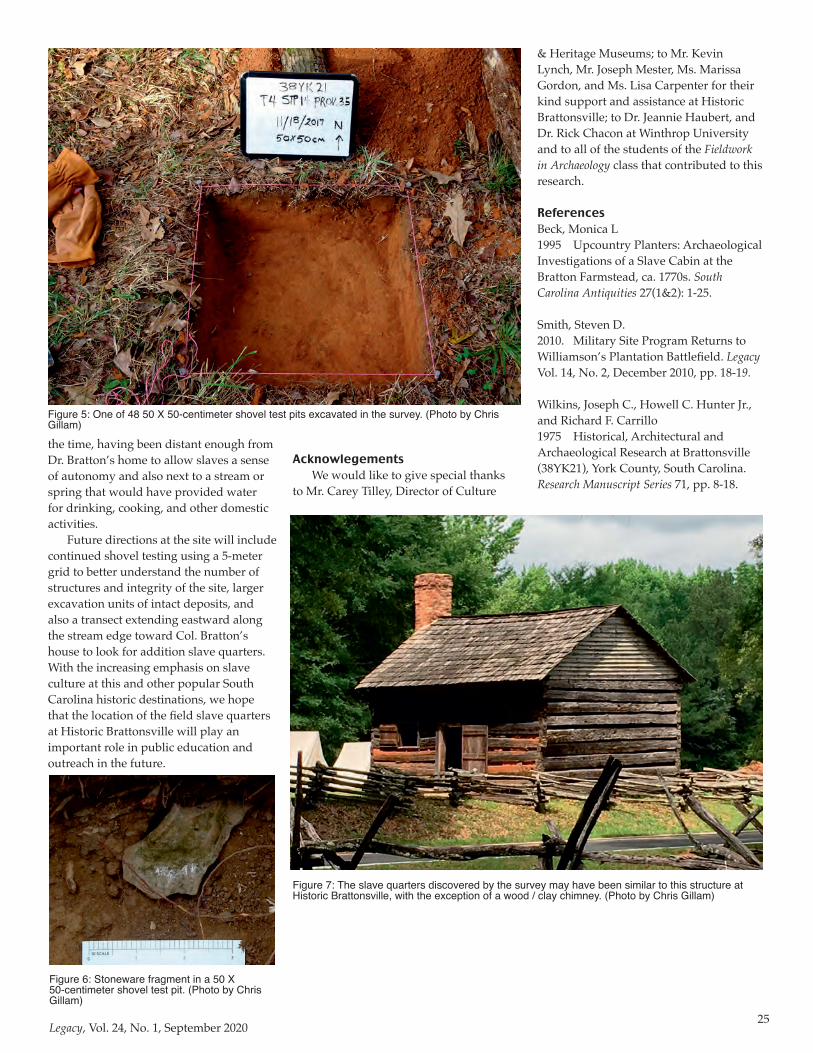
25Legacy, Vol. 24, No. 1, September 2020
the time, having been distant enough from Dr. Bratton’s home to allow slaves a sense of autonomy and also next to a stream or spring that would have provided water for drinking, cooking, and other domestic activities.
Future directions at the site will include continued shovel testing using a 5-meter grid to better understand the number of structures and integrity of the site, larger excavation units of intact deposits, and also a transect extending eastward along the stream edge toward Col. Bratton’s house to look for addition slave quarters. With the increasing emphasis on slave culture at this and other popular South Carolina historic destinations, we hope that the location of the field slave quarters at Historic Brattonsville will play an important role in public education and outreach in the future.
Figure 5: One of 48 50 X 50-centimeter shovel test pits excavated in the survey. (Photo by Chris Gillam)
AcknowlegementsWe would like to give special thanks
to Mr. Carey Tilley, Director of Culture
& Heritage Museums; to Mr. Kevin Lynch, Mr. Joseph Mester, Ms. Marissa Gordon, and Ms. Lisa Carpenter for their kind support and assistance at Historic Brattonsville; to Dr. Jeannie Haubert, and Dr. Rick Chacon at Winthrop University and to all of the students of the Fieldwork in Archaeology class that contributed to this research.
ReferencesBeck, Monica L1995 Upcountry Planters: Archaeological Investigations of a Slave Cabin at the Bratton Farmstead, ca. 1770s. South Carolina Antiquities 27(1&2): 1-25.
Smith, Steven D.2010. Military Site Program Returns to Williamson’s Plantation Battlefield. Legacy Vol. 14, No. 2, December 2010, pp. 18-19.
Wilkins, Joseph C., Howell C. Hunter Jr., and Richard F. Carrillo1975 Historical, Architectural and Archaeological Research at Brattonsville (38YK21), York County, South Carolina. Research Manuscript Series 71, pp. 8-18.
Figure 6: Stoneware fragment in a 50 X 50-centimeter shovel test pit. (Photo by Chris Gillam)
Figure 7: The slave quarters discovered by the survey may have been similar to this structure at Historic Brattonsville, with the exception of a wood / clay chimney. (Photo by Chris Gillam)
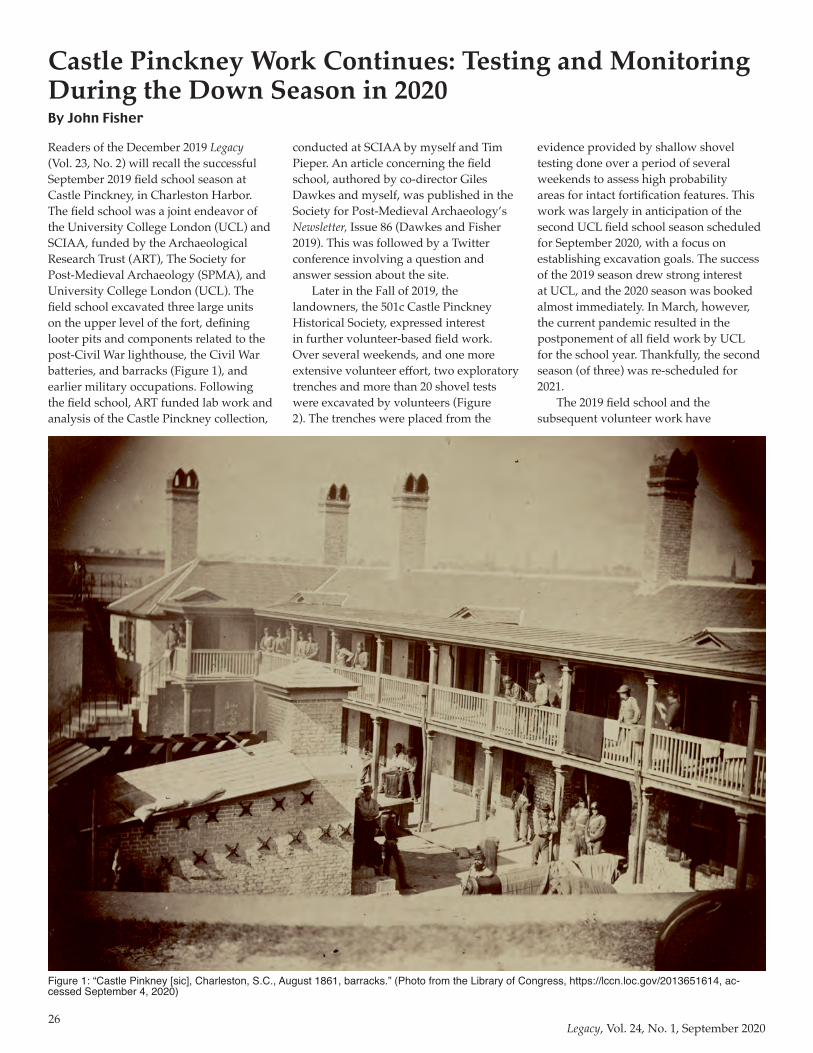
26Legacy, Vol. 24, No. 1, September 2020
Readers of the December 2019 Legacy (Vol. 23, No. 2) will recall the successful September 2019 field school season at Castle Pinckney, in Charleston Harbor. The field school was a joint endeavor of the University College London (UCL) and SCIAA, funded by the Archaeological Research Trust (ART), The Society for Post-Medieval Archaeology (SPMA), and University College London (UCL). The field school excavated three large units on the upper level of the fort, defining looter pits and components related to the post-Civil War lighthouse, the Civil War batteries, and barracks (Figure 1), and earlier military occupations. Following the field school, ART funded lab work and analysis of the Castle Pinckney collection,
conducted at SCIAA by myself and Tim Pieper. An article concerning the field school, authored by co-director Giles Dawkes and myself, was published in the Society for Post-Medieval Archaeology’s Newsletter, Issue 86 (Dawkes and Fisher 2019). This was followed by a Twitter conference involving a question and answer session about the site.
Later in the Fall of 2019, the landowners, the 501c Castle Pinckney Historical Society, expressed interest in further volunteer-based field work. Over several weekends, and one more extensive volunteer effort, two exploratory trenches and more than 20 shovel tests were excavated by volunteers (Figure 2). The trenches were placed from the
evidence provided by shallow shovel testing done over a period of several weekends to assess high probability areas for intact fortification features. This work was largely in anticipation of the second UCL field school season scheduled for September 2020, with a focus on establishing excavation goals. The success of the 2019 season drew strong interest at UCL, and the 2020 season was booked almost immediately. In March, however, the current pandemic resulted in the postponement of all field work by UCL for the school year. Thankfully, the second season (of three) was re-scheduled for 2021.
The 2019 field school and the subsequent volunteer work have
Castle Pinckney Work Continues: Testing and Monitoring During the Down Season in 2020By John Fisher
Figure 1: “Castle Pinkney [sic], Charleston, S.C., August 1861, barracks.” (Photo from the Library of Congress, https://lccn.loc.gov/2013651614, ac-cessed September 4, 2020)
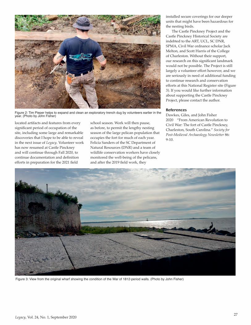
27Legacy, Vol. 24, No. 1, September 2020
located artifacts and features from every significant period of occupation of the site, including some large and remarkable discoveries that I hope to be able to reveal in the next issue of Legacy. Volunteer work has now resumed at Castle Pinckney and will continue through Fall 2020, to continue documentation and definition efforts in preparation for the 2021 field
school season. Work will then pause, as before, to permit the lengthy nesting season of the large pelican population that occupies the fort for much of each year. Felicia Sanders of the SC Department of Natural Resources (DNR) and a team of wildlife conservation workers have closely monitored the well-being of the pelicans, and after the 2019 field work, they
Figure 2: Tim Pieper helps to expand and clean an exploratory trench dug by volunteers earlier in the year. (Photo by John Fisher)
installed secure coverings for our deeper units that might have been hazardous for the nesting birds.
The Castle Pinckney Project and the Castle Pinckney Historical Society are indebted to the ART, UCL, SC DNR, SPMA, Civil War ordnance scholar Jack Melton, and Scott Harris of the College of Charleston. Without their support, our research on this significant landmark would not be possible. The Project is still largely a volunteer effort however, and we are seriously in need of additional funding to continue research and conservation efforts at this National Register site (Figure 3). If you would like further information about supporting the Castle Pinckney Project, please contact the author. ReferencesDawkes, Giles, and John Fisher2020 “From American Revolution to Civil War: The fort of Castle Pinckney, Charleston, South Carolina.” Society for Post-Medieval Archaeology Newsletter 86: 9-10.
Figure 3: View from the original wharf showing the condition of the War of 1812-period walls. (Photo by John Fisher)
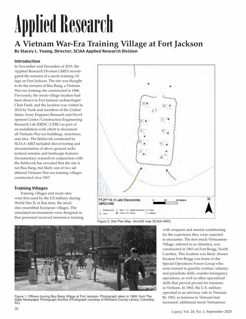
28Legacy, Vol. 24, No. 1, September 2020
Applied ResearchIntroductionIn November and December of 2019, the Applied Research Division (ARD) investi-gated the remains of a mock-training vil-lage on Fort Jackson. The site was thought to be the remains of Bau Bang, a Vietnam War-era training site constructed in 1966. Previously, the mock-village location had been shown to Fort Jackson archaeologist Chan Funk, and the location was visited in 2014 by Funk and members of the United States Army Engineer Research and Devel-opment Center/Construction Engineering Research Lab (ERDC/CERL) as part of an installation-wide effort to document all Vietnam War-era buildings, structures, and sites. The fieldwork conducted by SCIAA-ARD included shovel testing and documentation of above ground archi-tectural remains and landscape features. Documentary research in conjunction with the fieldwork has revealed that the site is not Bau Bang, but likely one of two ad-ditional Vietnam War-era training villages constructed circa 1967.
.Training Villages
Training villages and mock sites were first used by the US military during World War II; at that time, the mock sites resembled European villages. The simulated environments were designed so that personnel received immersive training
with weapons and mental conditioning for the experience they were expected to encounter. The first mock-Vietnamese Village, referred to as Atlantica, was constructed in 1963 on Fort Bragg, North Carolina. This location was likely chosen because Fort Bragg was home to the Special Operations Forces Group who were trained in guerilla warfare, infantry and parachute skills, counter-insurgency operations, as well as other specialized skills that proved pivotal for missions in Vietnam. In 1963, the U.S. military operated in an advisory role in Vietnam. By 1965, as tensions in Vietnam had increased, additional mock-Vietnamese
A Vietnam War-Era Training Village at Fort JacksonBy Stacey L. Young, Director, SCIAA Applied Research Division
Figure 1: Officers touring Bau Bang Village at Fort Jackson. Photograph taken in 1969, from The State Newspaper Photograph Archive (Photograph courtesy of Richland County Library, Columbia, SC)
Figure 2: Site Plan Map. (ArcGIS map SCIAA-ARD)
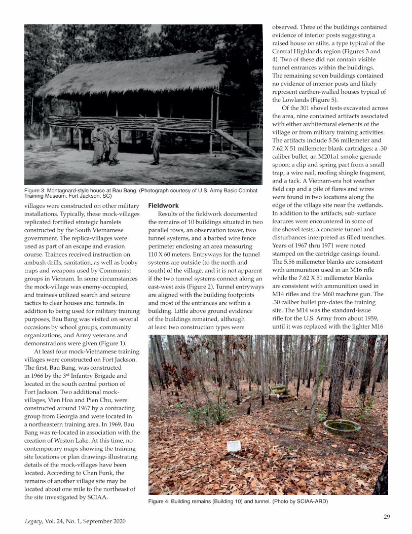
29Legacy, Vol. 24, No. 1, September 2020
villages were constructed on other military installations. Typically, these mock-villages replicated fortified strategic hamlets constructed by the South Vietnamese government. The replica-villages were used as part of an escape and evasion course. Trainees received instruction on ambush drills, sanitation, as well as booby traps and weapons used by Communist groups in Vietnam. In some circumstances the mock-village was enemy-occupied, and trainees utilized search and seizure tactics to clear houses and tunnels. In addition to being used for military training purposes, Bau Bang was visited on several occasions by school groups, community organizations, and Army veterans and demonstrations were given (Figure 1).
At least four mock-Vietnamese training villages were constructed on Fort Jackson. The first, Bau Bang, was constructed in 1966 by the 3rd Infantry Brigade and located in the south central portion of Fort Jackson. Two additional mock-villages, Vien Hoa and Pien Chu, were constructed around 1967 by a contracting group from Georgia and were located in a northeastern training area. In 1969, Bau Bang was re-located in association with the creation of Weston Lake. At this time, no contemporary maps showing the training site locations or plan drawings illustrating details of the mock-villages have been located. According to Chan Funk, the remains of another village site may be located about one mile to the northeast of the site investigated by SCIAA.
FieldworkResults of the fieldwork documented
the remains of 10 buildings situated in two parallel rows, an observation tower, two tunnel systems, and a barbed wire fence perimeter enclosing an area measuring 110 X 60 meters. Entryways for the tunnel systems are outside (to the north and south) of the village, and it is not apparent if the two tunnel systems connect along an east-west axis (Figure 2). Tunnel entryways are aligned with the building footprints and most of the entrances are within a building. Little above ground evidence of the buildings remained, although at least two construction types were
observed. Three of the buildings contained evidence of interior posts suggesting a raised house on stilts, a type typical of the Central Highlands region (Figures 3 and 4). Two of these did not contain visible tunnel entrances within the buildings. The remaining seven buildings contained no evidence of interior posts and likely represent earthen-walled houses typical of the Lowlands (Figure 5).
Of the 301 shovel tests excavated across the area, nine contained artifacts associated with either architectural elements of the village or from military training activities. The artifacts include 5.56 millemeter and 7.62 X 51 millemeter blank cartridges; a .30 caliber bullet, an M201a1 smoke grenade spoon; a clip and spring part from a small trap, a wire nail, roofing shingle fragment, and a tack. A Vietnam-era hot weather field cap and a pile of flares and wires were found in two locations along the edge of the village site near the wetlands. In addition to the artifacts, sub-surface features were encountered in some of the shovel tests; a concrete tunnel and disturbances interpreted as filled trenches. Years of 1967 thru 1971 were noted stamped on the cartridge casings found. The 5.56 millemeter blanks are consistent with ammunition used in an M16 rifle while the 7.62 X 51 millemeter blanks are consistent with ammunition used in M14 rifles and the M60 machine gun. The .30 caliber bullet pre-dates the training site. The M14 was the standard-issue rifle for the U.S. Army from about 1959, until it was replaced with the lighter M16
Figure 3: Montagnard-style house at Bau Bang. (Photograph courtesy of U.S. Army Basic Combat Training Museum, Fort Jackson, SC)
Figure 4: Building remains (Building 10) and tunnel. (Photo by SCIAA-ARD)
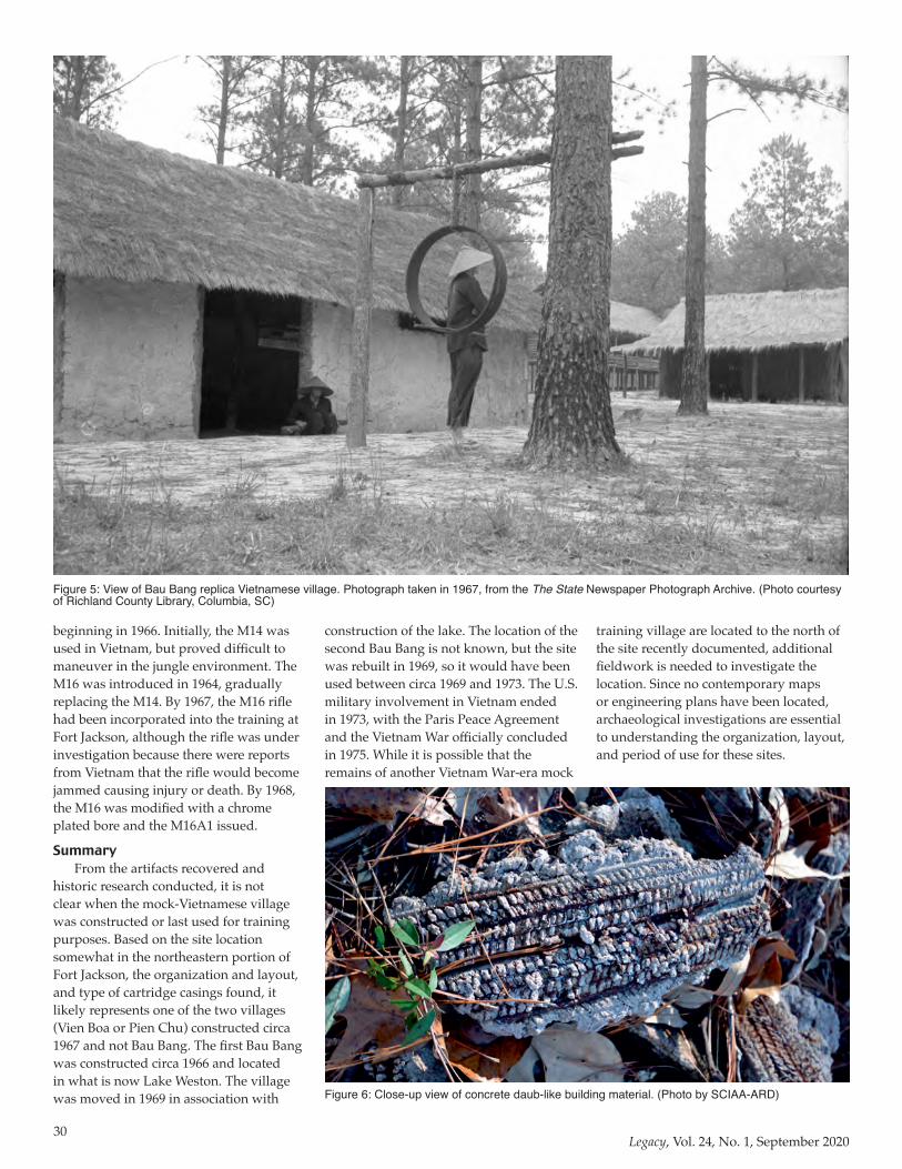
30Legacy, Vol. 24, No. 1, September 2020
beginning in 1966. Initially, the M14 was used in Vietnam, but proved difficult to maneuver in the jungle environment. The M16 was introduced in 1964, gradually replacing the M14. By 1967, the M16 rifle had been incorporated into the training at Fort Jackson, although the rifle was under investigation because there were reports from Vietnam that the rifle would become jammed causing injury or death. By 1968, the M16 was modified with a chrome plated bore and the M16A1 issued.
SummaryFrom the artifacts recovered and
historic research conducted, it is not clear when the mock-Vietnamese village was constructed or last used for training purposes. Based on the site location somewhat in the northeastern portion of Fort Jackson, the organization and layout, and type of cartridge casings found, it likely represents one of the two villages (Vien Boa or Pien Chu) constructed circa 1967 and not Bau Bang. The first Bau Bang was constructed circa 1966 and located in what is now Lake Weston. The village was moved in 1969 in association with
Figure 5: View of Bau Bang replica Vietnamese village. Photograph taken in 1967, from the The State Newspaper Photograph Archive. (Photo courtesy of Richland County Library, Columbia, SC)
construction of the lake. The location of the second Bau Bang is not known, but the site was rebuilt in 1969, so it would have been used between circa 1969 and 1973. The U.S. military involvement in Vietnam ended in 1973, with the Paris Peace Agreement and the Vietnam War officially concluded in 1975. While it is possible that the remains of another Vietnam War-era mock
training village are located to the north of the site recently documented, additional fieldwork is needed to investigate the location. Since no contemporary maps or engineering plans have been located, archaeological investigations are essential to understanding the organization, layout, and period of use for these sites.
Figure 6: Close-up view of concrete daub-like building material. (Photo by SCIAA-ARD)
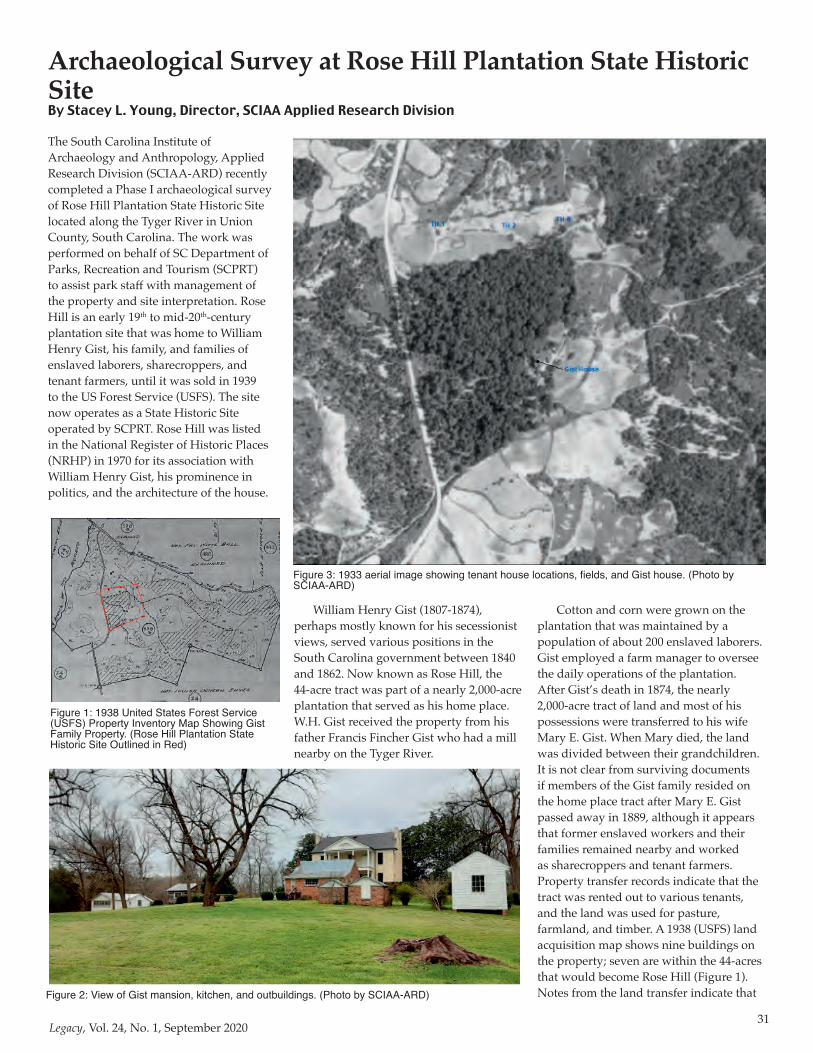
31Legacy, Vol. 24, No. 1, September 2020
The South Carolina Institute of Archaeology and Anthropology, Applied Research Division (SCIAA-ARD) recently completed a Phase I archaeological survey of Rose Hill Plantation State Historic Site located along the Tyger River in Union County, South Carolina. The work was performed on behalf of SC Department of Parks, Recreation and Tourism (SCPRT) to assist park staff with management of the property and site interpretation. Rose Hill is an early 19th to mid-20th-century plantation site that was home to William Henry Gist, his family, and families of enslaved laborers, sharecroppers, and tenant farmers, until it was sold in 1939 to the US Forest Service (USFS). The site now operates as a State Historic Site operated by SCPRT. Rose Hill was listed in the National Register of Historic Places (NRHP) in 1970 for its association with William Henry Gist, his prominence in politics, and the architecture of the house.
William Henry Gist (1807-1874), perhaps mostly known for his secessionist views, served various positions in the South Carolina government between 1840 and 1862. Now known as Rose Hill, the 44-acre tract was part of a nearly 2,000-acre plantation that served as his home place. W.H. Gist received the property from his father Francis Fincher Gist who had a mill nearby on the Tyger River.
Cotton and corn were grown on the plantation that was maintained by a population of about 200 enslaved laborers. Gist employed a farm manager to oversee the daily operations of the plantation. After Gist’s death in 1874, the nearly 2,000-acre tract of land and most of his possessions were transferred to his wife Mary E. Gist. When Mary died, the land was divided between their grandchildren. It is not clear from surviving documents if members of the Gist family resided on the home place tract after Mary E. Gist passed away in 1889, although it appears that former enslaved workers and their families remained nearby and worked as sharecroppers and tenant farmers. Property transfer records indicate that the tract was rented out to various tenants, and the land was used for pasture, farmland, and timber. A 1938 (USFS) land acquisition map shows nine buildings on the property; seven are within the 44-acres that would become Rose Hill (Figure 1). Notes from the land transfer indicate that
Archaeological Survey at Rose Hill Plantation State Historic SiteBy Stacey L. Young, Director, SCIAA Applied Research Division
Figure 1: 1938 United States Forest Service (USFS) Property Inventory Map Showing Gist Family Property. (Rose Hill Plantation State Historic Site Outlined in Red)
Figure 2: View of Gist mansion, kitchen, and outbuildings. (Photo by SCIAA-ARD)
Figure 3: 1933 aerial image showing tenant house locations, fields, and Gist house. (Photo by SCIAA-ARD)
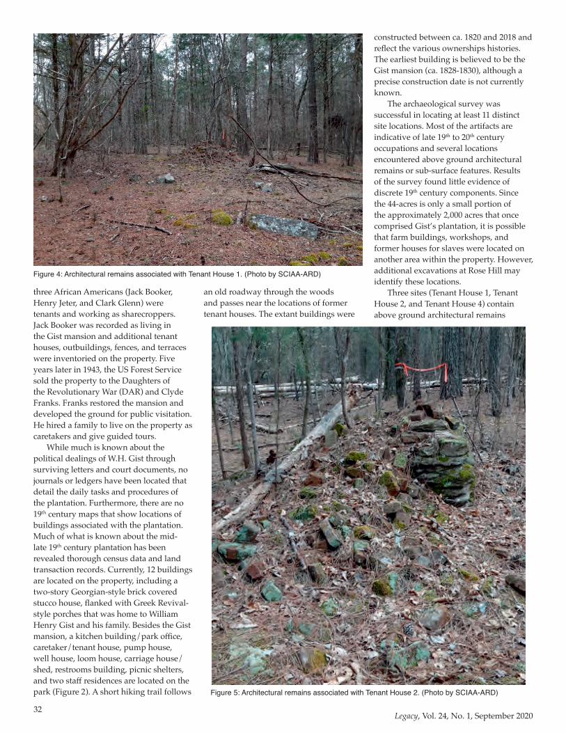
32Legacy, Vol. 24, No. 1, September 2020
three African Americans (Jack Booker, Henry Jeter, and Clark Glenn) were tenants and working as sharecroppers. Jack Booker was recorded as living in the Gist mansion and additional tenant houses, outbuildings, fences, and terraces were inventoried on the property. Five years later in 1943, the US Forest Service sold the property to the Daughters of the Revolutionary War (DAR) and Clyde Franks. Franks restored the mansion and developed the ground for public visitation. He hired a family to live on the property as caretakers and give guided tours.
While much is known about the political dealings of W.H. Gist through surviving letters and court documents, no journals or ledgers have been located that detail the daily tasks and procedures of the plantation. Furthermore, there are no 19th century maps that show locations of buildings associated with the plantation. Much of what is known about the mid-late 19th century plantation has been revealed thorough census data and land transaction records. Currently, 12 buildings are located on the property, including a two-story Georgian-style brick covered stucco house, flanked with Greek Revival-style porches that was home to William Henry Gist and his family. Besides the Gist mansion, a kitchen building/park office, caretaker/tenant house, pump house, well house, loom house, carriage house/shed, restrooms building, picnic shelters, and two staff residences are located on the park (Figure 2). A short hiking trail follows
an old roadway through the woods and passes near the locations of former tenant houses. The extant buildings were
constructed between ca. 1820 and 2018 and reflect the various ownerships histories. The earliest building is believed to be the Gist mansion (ca. 1828-1830), although a precise construction date is not currently known.
The archaeological survey was successful in locating at least 11 distinct site locations. Most of the artifacts are indicative of late 19th to 20th century occupations and several locations encountered above ground architectural remains or sub-surface features. Results of the survey found little evidence of discrete 19th century components. Since the 44-acres is only a small portion of the approximately 2,000 acres that once comprised Gist’s plantation, it is possible that farm buildings, workshops, and former houses for slaves were located on another area within the property. However, additional excavations at Rose Hill may identify these locations.
Three sites (Tenant House 1, Tenant House 2, and Tenant House 4) contain above ground architectural remains
Figure 4: Architectural remains associated with Tenant House 1. (Photo by SCIAA-ARD)
Figure 5: Architectural remains associated with Tenant House 2. (Photo by SCIAA-ARD)
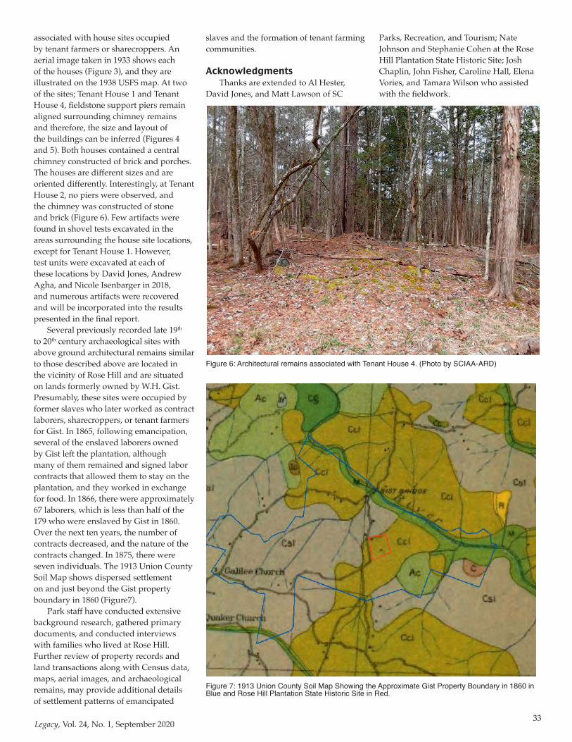
33Legacy, Vol. 24, No. 1, September 2020
associated with house sites occupied by tenant farmers or sharecroppers. An aerial image taken in 1933 shows each of the houses (Figure 3), and they are illustrated on the 1938 USFS map. At two of the sites; Tenant House 1 and Tenant House 4, fieldstone support piers remain aligned surrounding chimney remains and therefore, the size and layout of the buildings can be inferred (Figures 4 and 5). Both houses contained a central chimney constructed of brick and porches. The houses are different sizes and are oriented differently. Interestingly, at Tenant House 2, no piers were observed, and the chimney was constructed of stone and brick (Figure 6). Few artifacts were found in shovel tests excavated in the areas surrounding the house site locations, except for Tenant House 1. However, test units were excavated at each of these locations by David Jones, Andrew Agha, and Nicole Isenbarger in 2018, and numerous artifacts were recovered and will be incorporated into the results presented in the final report.
Several previously recorded late 19th to 20th century archaeological sites with above ground architectural remains similar to those described above are located in the vicinity of Rose Hill and are situated on lands formerly owned by W.H. Gist. Presumably, these sites were occupied by former slaves who later worked as contract laborers, sharecroppers, or tenant farmers for Gist. In 1865, following emancipation, several of the enslaved laborers owned by Gist left the plantation, although many of them remained and signed labor contracts that allowed them to stay on the plantation, and they worked in exchange for food. In 1866, there were approximately 67 laborers, which is less than half of the 179 who were enslaved by Gist in 1860. Over the next ten years, the number of contracts decreased, and the nature of the contracts changed. In 1875, there were seven individuals. The 1913 Union County Soil Map shows dispersed settlement on and just beyond the Gist property boundary in 1860 (Figure7).
Park staff have conducted extensive background research, gathered primary documents, and conducted interviews with families who lived at Rose Hill. Further review of property records and land transactions along with Census data, maps, aerial images, and archaeological remains, may provide additional details of settlement patterns of emancipated
Figure 6: Architectural remains associated with Tenant House 4. (Photo by SCIAA-ARD)
Figure 7: 1913 Union County Soil Map Showing the Approximate Gist Property Boundary in 1860 in Blue and Rose Hill Plantation State Historic Site in Red.
slaves and the formation of tenant farming communities.
AcknowledgmentsThanks are extended to Al Hester,
David Jones, and Matt Lawson of SC
Parks, Recreation, and Tourism; Nate Johnson and Stephanie Cohen at the Rose Hill Plantation State Historic Site; Josh Chaplin, John Fisher, Caroline Hall, Elena Vories, and Tamara Wilson who assisted with the fieldwork.
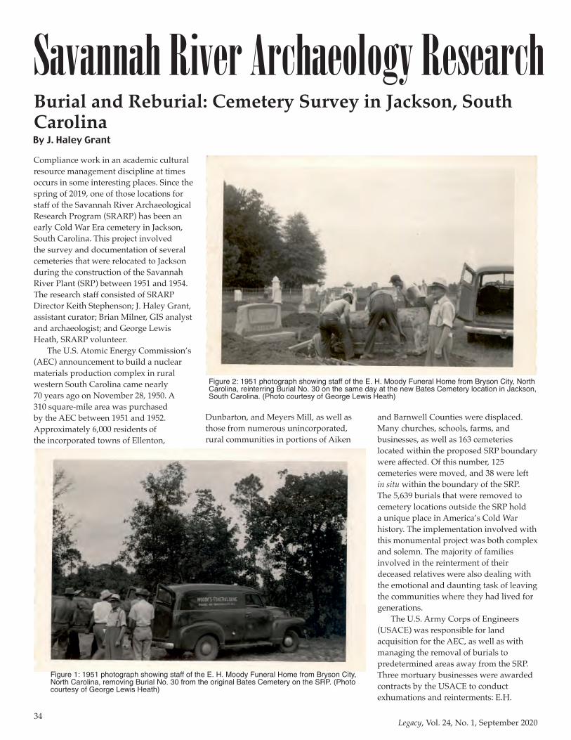
34Legacy, Vol. 24, No. 1, September 2020
Savannah River Archaeology Research
Compliance work in an academic cultural resource management discipline at times occurs in some interesting places. Since the spring of 2019, one of those locations for staff of the Savannah River Archaeological Research Program (SRARP) has been an early Cold War Era cemetery in Jackson, South Carolina. This project involved the survey and documentation of several cemeteries that were relocated to Jackson during the construction of the Savannah River Plant (SRP) between 1951 and 1954. The research staff consisted of SRARP Director Keith Stephenson; J. Haley Grant, assistant curator; Brian Milner, GIS analyst and archaeologist; and George Lewis Heath, SRARP volunteer.
The U.S. Atomic Energy Commission’s (AEC) announcement to build a nuclear materials production complex in rural western South Carolina came nearly 70 years ago on November 28, 1950. A 310 square-mile area was purchased by the AEC between 1951 and 1952. Approximately 6,000 residents of the incorporated towns of Ellenton,
Dunbarton, and Meyers Mill, as well as those from numerous unincorporated, rural communities in portions of Aiken
and Barnwell Counties were displaced. Many churches, schools, farms, and businesses, as well as 163 cemeteries located within the proposed SRP boundary were affected. Of this number, 125 cemeteries were moved, and 38 were left in situ within the boundary of the SRP. The 5,639 burials that were removed to cemetery locations outside the SRP hold a unique place in America’s Cold War history. The implementation involved with this monumental project was both complex and solemn. The majority of families involved in the reinterment of their deceased relatives were also dealing with the emotional and daunting task of leaving the communities where they had lived for generations.
The U.S. Army Corps of Engineers (USACE) was responsible for land acquisition for the AEC, as well as with managing the removal of burials to predetermined areas away from the SRP. Three mortuary businesses were awarded contracts by the USACE to conduct exhumations and reinterments: E.H.
Burial and Reburial: Cemetery Survey in Jackson, South CarolinaBy J. Haley Grant
Figure 1: 1951 photograph showing staff of the E. H. Moody Funeral Home from Bryson City, North Carolina, removing Burial No. 30 from the original Bates Cemetery on the SRP. (Photo courtesy of George Lewis Heath)
Figure 2: 1951 photograph showing staff of the E. H. Moody Funeral Home from Bryson City, North Carolina, reinterring Burial No. 30 on the same day at the new Bates Cemetery location in Jackson, South Carolina. (Photo courtesy of George Lewis Heath)
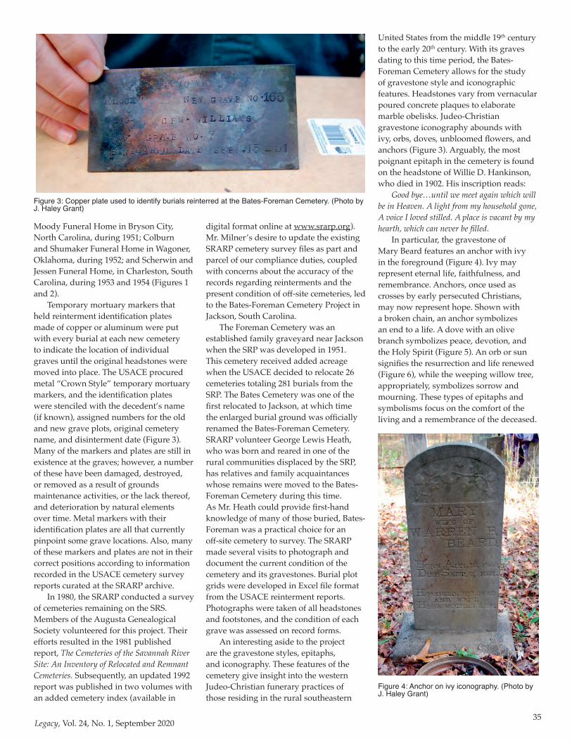
35Legacy, Vol. 24, No. 1, September 2020
Moody Funeral Home in Bryson City, North Carolina, during 1951; Colburn and Shumaker Funeral Home in Wagoner, Oklahoma, during 1952; and Scherwin and Jessen Funeral Home, in Charleston, South Carolina, during 1953 and 1954 (Figures 1 and 2).
Temporary mortuary markers that held reinterment identification plates made of copper or aluminum were put with every burial at each new cemetery to indicate the location of individual graves until the original headstones were moved into place. The USACE procured metal “Crown Style” temporary mortuary markers, and the identification plates were stenciled with the decedent’s name (if known), assigned numbers for the old and new grave plots, original cemetery name, and disinterment date (Figure 3). Many of the markers and plates are still in existence at the graves; however, a number of these have been damaged, destroyed, or removed as a result of grounds maintenance activities, or the lack thereof, and deterioration by natural elements over time. Metal markers with their identification plates are all that currently pinpoint some grave locations. Also, many of these markers and plates are not in their correct positions according to information recorded in the USACE cemetery survey reports curated at the SRARP archive.
In 1980, the SRARP conducted a survey of cemeteries remaining on the SRS. Members of the Augusta Genealogical Society volunteered for this project. Their efforts resulted in the 1981 published report, The Cemeteries of the Savannah River Site: An Inventory of Relocated and Remnant Cemeteries. Subsequently, an updated 1992 report was published in two volumes with an added cemetery index (available in
digital format online at www.srarp.org). Mr. Milner’s desire to update the existing SRARP cemetery survey files as part and parcel of our compliance duties, coupled with concerns about the accuracy of the records regarding reinterments and the present condition of off-site cemeteries, led to the Bates-Foreman Cemetery Project in Jackson, South Carolina.
The Foreman Cemetery was an established family graveyard near Jackson when the SRP was developed in 1951. This cemetery received added acreage when the USACE decided to relocate 26 cemeteries totaling 281 burials from the SRP. The Bates Cemetery was one of the first relocated to Jackson, at which time the enlarged burial ground was officially renamed the Bates-Foreman Cemetery. SRARP volunteer George Lewis Heath, who was born and reared in one of the rural communities displaced by the SRP, has relatives and family acquaintances whose remains were moved to the Bates-Foreman Cemetery during this time. As Mr. Heath could provide first-hand knowledge of many of those buried, Bates-Foreman was a practical choice for an off-site cemetery to survey. The SRARP made several visits to photograph and document the current condition of the cemetery and its gravestones. Burial plot grids were developed in Excel file format from the USACE reinterment reports. Photographs were taken of all headstones and footstones, and the condition of each grave was assessed on record forms.
An interesting aside to the project are the gravestone styles, epitaphs, and iconography. These features of the cemetery give insight into the western Judeo-Christian funerary practices of those residing in the rural southeastern
United States from the middle 19th century to the early 20th century. With its graves dating to this time period, the Bates-Foreman Cemetery allows for the study of gravestone style and iconographic features. Headstones vary from vernacular poured concrete plaques to elaborate marble obelisks. Judeo-Christian gravestone iconography abounds with ivy, orbs, doves, unbloomed flowers, and anchors (Figure 3). Arguably, the most poignant epitaph in the cemetery is found on the headstone of Willie D. Hankinson, who died in 1902. His inscription reads:
Good bye…until we meet again which will be in Heaven. A light from my household gone, A voice I loved stilled. A place is vacant by my hearth, which can never be filled.
In particular, the gravestone of Mary Beard features an anchor with ivy in the foreground (Figure 4). Ivy may represent eternal life, faithfulness, and remembrance. Anchors, once used as crosses by early persecuted Christians, may now represent hope. Shown with a broken chain, an anchor symbolizes an end to a life. A dove with an olive branch symbolizes peace, devotion, and the Holy Spirit (Figure 5). An orb or sun signifies the resurrection and life renewed (Figure 6), while the weeping willow tree, appropriately, symbolizes sorrow and mourning. These types of epitaphs and symbolisms focus on the comfort of the living and a remembrance of the deceased.
Figure 3: Copper plate used to identify burials reinterred at the Bates-Foreman Cemetery. (Photo by J. Haley Grant)
Figure 4: Anchor on ivy iconography. (Photo by J. Haley Grant)
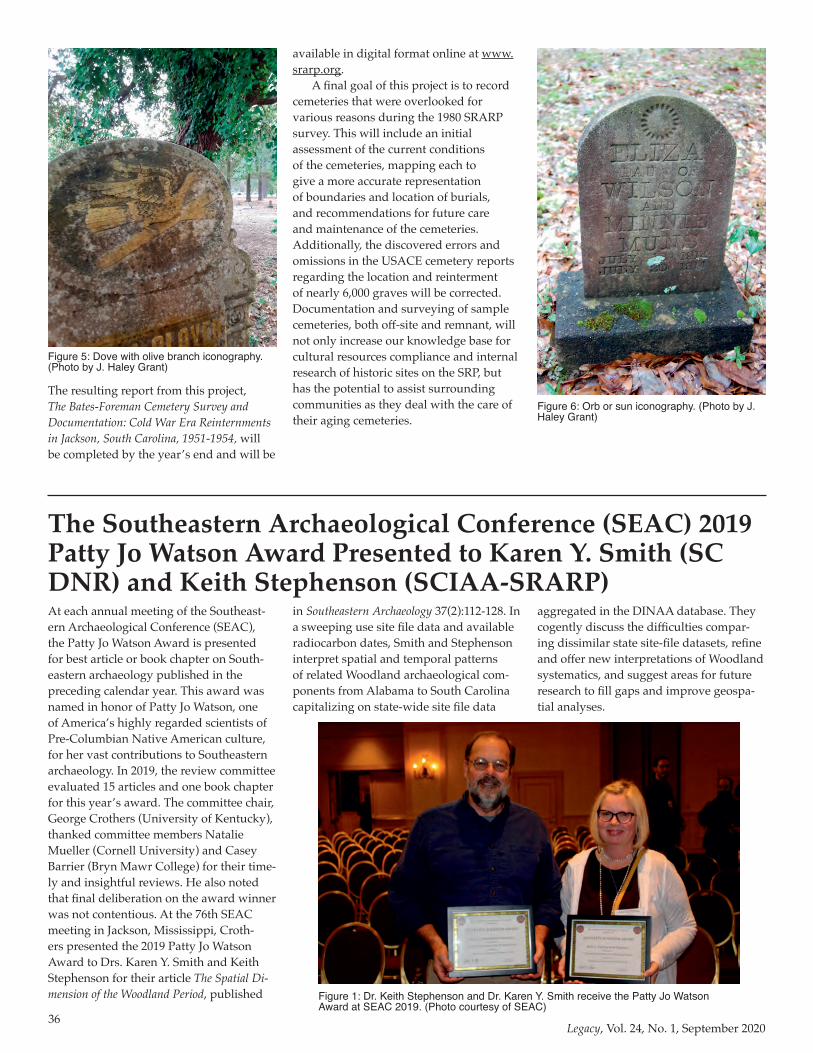
36Legacy, Vol. 24, No. 1, September 2020
The resulting report from this project, The Bates-Foreman Cemetery Survey and Documentation: Cold War Era Reinternments in Jackson, South Carolina, 1951-1954, will be completed by the year’s end and will be
Figure 5: Dove with olive branch iconography. (Photo by J. Haley Grant)
available in digital format online at www.srarp.org.
A final goal of this project is to record cemeteries that were overlooked for various reasons during the 1980 SRARP survey. This will include an initial assessment of the current conditions of the cemeteries, mapping each to give a more accurate representation of boundaries and location of burials, and recommendations for future care and maintenance of the cemeteries. Additionally, the discovered errors and omissions in the USACE cemetery reports regarding the location and reinterment of nearly 6,000 graves will be corrected. Documentation and surveying of sample cemeteries, both off-site and remnant, will not only increase our knowledge base for cultural resources compliance and internal research of historic sites on the SRP, but has the potential to assist surrounding communities as they deal with the care of their aging cemeteries.
Figure 6: Orb or sun iconography. (Photo by J. Haley Grant)
At each annual meeting of the Southeast-ern Archaeological Conference (SEAC), the Patty Jo Watson Award is presented for best article or book chapter on South-eastern archaeology published in the preceding calendar year. This award was named in honor of Patty Jo Watson, one of America’s highly regarded scientists of Pre-Columbian Native American culture, for her vast contributions to Southeastern archaeology. In 2019, the review committee evaluated 15 articles and one book chapter for this year’s award. The committee chair, George Crothers (University of Kentucky), thanked committee members Natalie Mueller (Cornell University) and Casey Barrier (Bryn Mawr College) for their time-ly and insightful reviews. He also noted that final deliberation on the award winner was not contentious. At the 76th SEAC meeting in Jackson, Mississippi, Croth-ers presented the 2019 Patty Jo Watson Award to Drs. Karen Y. Smith and Keith Stephenson for their article The Spatial Di-mension of the Woodland Period, published
in Southeastern Archaeology 37(2):112-128. In a sweeping use site file data and available radiocarbon dates, Smith and Stephenson interpret spatial and temporal patterns of related Woodland archaeological com-ponents from Alabama to South Carolina capitalizing on state-wide site file data
aggregated in the DINAA database. They cogently discuss the difficulties compar-ing dissimilar state site-file datasets, refine and offer new interpretations of Woodland systematics, and suggest areas for future research to fill gaps and improve geospa-tial analyses.
The Southeastern Archaeological Conference (SEAC) 2019 Patty Jo Watson Award Presented to Karen Y. Smith (SC DNR) and Keith Stephenson (SCIAA-SRARP)
Figure 1: Dr. Keith Stephenson and Dr. Karen Y. Smith receive the Patty Jo Watson Award at SEAC 2019. (Photo courtesy of SEAC)
37Legacy, Vol. 24, No. 1, September 2020
South Carolina Archaeology Book
Method of payment:_____ Check or money order (payable to USC Press in United States dollars)
Credit Card: ____ American Express ____ Discover ____ Mastercard ____ VisaAccount number: _____________________________________ Exp. date: ________Signature: ____________________________________________________________ Name (please print): ________________________________ Phone: ____________Shipping address: ________________________________________________________________________________________________________________________________________________________________________________________________
Send me ______ copy/copies
(hc, 978-1-61117-608-7, $39.99 each) ______
SC residents add 8% sales tax ______
Shipping* ______
TOTAL ______
*add $7.50 for first book, $2.00 for each additional book
718 Devine Street, Columbia, South Carolina 29208 800-768-2500 • Fax 800-868-0740 • www.uscpress.com
Adam King is a research associate profes-sor in the South Carolina Institute of Ar-chaeology and Anthropology and special projects archaeologist for the Savannah River Archaeological Research Program at the University of South Carolina. King has conducted research in the Southeast since 1987 and specializes in the Mississip-pian period and the political economies of chiefdoms. He is the author of Etowah: The Political History of a Chiefdom Capital.
ARCHAEOLOGY IN SOUTH CAROLINAExploring the Hidden Heritage of the Palmetto StateEdited by Adam King
Adam King’s Archaeology in South Carolina contains an overview of the fascinating archaeological research currently ongoing in the Palmetto State and features essays by twenty scholars studying South Carolina’s past through archaeological research. The scholarly contributions are enhanced by more than one hundred black-and-white and thirty-eight color images of some of the most important and interesting sites and artifacts found in the state.
South Carolina has an extraordinarily rich history encompassing some of the first human habitations of North America as well as the lives of people at the dawn of the modern era. King begins the anthology with the basic hows and whys of archaeology and introduces readers to the current issues influencing the field of research. The contributors are all recognized experts from universities, state agen-cies, and private consulting firms, reflecting the diversity of people and institutions that engage in archaeology.
The volume begins with investigations of some of the earliest Paleo-Indian and Native American cultures that thrived in South Carolina, including work at the Topper Site along the Savannah River. Other essays explore the creation of early communities at the Stallings Island site, the emergence of large and complex Native American polities before the coming of Europeans, the impact of the com-ing of European settlers on Native American groups along the Savannah River, and the archaeology of the Yamasee, a people whose history is tightly bound to the emerging European society.
The focus then shifts to Euro-Americans with an examination of a long-term project seeking to understand George Galphin’s trading post established on the Savannah River in the eighteenth century.
March 2015, 304 pages, 38 color and 103 b&w illus.
CODE AUFR
Method of payment:_____ Check or money order (payable to USC Press in United States dollars)
Credit Card: ____ American Express ____ Discover ____ Mastercard ____ VisaAccount number: _____________________________________ Exp. date: ________Signature: ____________________________________________________________ Name (please print): ________________________________ Phone: ____________Shipping address: ________________________________________________________________________________________________________________________________________________________________________________________________
Send me ______ copy/copies
(hc, 978-1-61117-608-7, $39.99 each) ______
SC residents add 8% sales tax ______
Shipping* ______
TOTAL ______
*add $7.50 for first book, $2.00 for each additional book
718 Devine Street, Columbia, South Carolina 29208 800-768-2500 • Fax 800-868-0740 • www.uscpress.com
Adam King is a research associate profes-sor in the South Carolina Institute of Ar-chaeology and Anthropology and special projects archaeologist for the Savannah River Archaeological Research Program at the University of South Carolina. King has conducted research in the Southeast since 1987 and specializes in the Mississip-pian period and the political economies of chiefdoms. He is the author of Etowah: The Political History of a Chiefdom Capital.
ARCHAEOLOGY IN SOUTH CAROLINAExploring the Hidden Heritage of the Palmetto StateEdited by Adam King
Adam King’s Archaeology in South Carolina contains an overview of the fascinating archaeological research currently ongoing in the Palmetto State and features essays by twenty scholars studying South Carolina’s past through archaeological research. The scholarly contributions are enhanced by more than one hundred black-and-white and thirty-eight color images of some of the most important and interesting sites and artifacts found in the state.
South Carolina has an extraordinarily rich history encompassing some of the first human habitations of North America as well as the lives of people at the dawn of the modern era. King begins the anthology with the basic hows and whys of archaeology and introduces readers to the current issues influencing the field of research. The contributors are all recognized experts from universities, state agen-cies, and private consulting firms, reflecting the diversity of people and institutions that engage in archaeology.
The volume begins with investigations of some of the earliest Paleo-Indian and Native American cultures that thrived in South Carolina, including work at the Topper Site along the Savannah River. Other essays explore the creation of early communities at the Stallings Island site, the emergence of large and complex Native American polities before the coming of Europeans, the impact of the com-ing of European settlers on Native American groups along the Savannah River, and the archaeology of the Yamasee, a people whose history is tightly bound to the emerging European society.
The focus then shifts to Euro-Americans with an examination of a long-term project seeking to understand George Galphin’s trading post established on the Savannah River in the eighteenth century.
March 2015, 304 pages, 38 color and 103 b&w illus.
CODE AUFR The volume concludes with recollections and observations on a lifetime in the
field by the preeminent historical archaeologist Stanley South, who passed away
in 2016. Stan spent the last 51 years of his career at the South Carolina Institute of
Archaeology and Anthropology.

38Legacy, Vol. 24, No. 1, September 2020
ART / SCIAA Donors Update January 2019-August 2020The staff of the Institute wishes to thank our donors who have graciously supported the research and programs listed below.
Archaeological Research Trust (ART)Patron ($10,000+)William A. BehanJudy BurnsLou EdensAntony C. Harper Family FoundationDrs. Edward and Dorothy Kendall FoundationJames and Shirley KirbyDrs. Francis and Mary NeufferEstate of Elizabeth H. StringfellowWilliam and Shanna SullivanWalter Wilkinson
Benefactor ($1,000-$9,999)F. Jo BakerGeorge and Betti BellBOB-BQ Inc.Central Carolina Community FoundationKimberly ElliottKimbrell and Jane KirbyErnest L. Helms, III MDSam and Gina McCuenRobert E. and Page Mimms, Jr.Ruth Ann OttNena Powell RiceRobert N. Strickland
Partner ($500-999)Jerry DacusJay and Jennifer MillsSteven D. SmithUniversity of South Carolina PressRebecca F. Zinko
Advocate ($250-499)John Edward and Sandra B. AllisonBill BridgesWilliam Patrick, Jr. and Jane DornITW FoundationJoyce HallenbeckDavid and Sue HodgesRandy C. and Julie A. IveyRichard W. LangElliott E. and Betsy C. PowellDon Rosick and Pat MasonTim and Alice Barron Pearce StewartRichard E. Watkins
Contributor ($249-100)AF ConsultantsJudy AnnstadScott and Lezlie BarkerHoward and Mary Ann BridgmanLindsey Dale BoozerJames BortonRichard and Ann ChristieHarold D. and Cynthia CurrySarah C. GillespieCary HallGeorge and Geraldine KingLarry Roberts and Lyn B. KirklandHenry S. and Katherine Leftwich KnightJohn and Carol KososkiJerrell D. MelearJay and Jennifer MillsHoang NguyenConrad and Betty D. PearsonBarbara Key PowellMary Julia RoyallSusan B. Smith
Paul and Kathy Stewart (In Memory of John Key Powell and Ann Penniman Powell)Gerral Lee ThomasThad and Judy TimmonsRobert E. and Carol Ann TylerRobert Wayne Whiteside
Supporter ($99-50)William H. Baab, Jr.David Henry BarronCharles Burke BaxleyJoanna Burbank CraigBenard and Lillian DaleyGlenn J. DuttonEddie and Anita FeemsterAlma Harriett ForeJane Hammond JerveyMary Hardy (In Memory of Joseph Hardy)Michael HarmonPeter LittlefieldJoan G. LoweryJean Elliott ManningJeffrey and Dale MilneWilliam D. Moxley, Jr.Lawrence and Hepsy ParhamMike N. PetersMyrtle QuattlebaumBradfort L. RauschenbergArthur L. and Frances J. RickenbakerByron C. and Bernona RodgersGwen Anne SheriffJohn and Pamela StuartGordon and Ann C. ThrustonTheodore M. TsolovosRobert E. TylerAndy and Elizabeth WhiteJames A. and Christine B. WilliamsMartha Zierden
Regular ($49 or less)Michael and Aileen Ellen AhearnRandy and Mary Alice AkersRichard B. and Mollie BakerFred and Angela BroomeWesley and Karen BurnettFrederick and Sandra BurnhamJanet CieglerHugh CoxThomas CoxMary CrocketEdward S. Cummings, IIIJerry DacusDavid DonmoyerGus K. DunlapThomas Craig and Krys ElmoreJames Russell FennellKenneth FreyGavin Banks HalloranCarolyn HudsonRaymond and Paula JacobsHubert W. and Constance LaquementBetty MandellFordyce Harwood and Martha D. MasonJack A. and Martha Robinson MeyerJames and Betty MontgomeryJack W. and Vee NistendirkJohn OllerVernon M. and Lillian K. ParkerThomas and Carol PinckneyDeborah PriceAna Nazario Raguseo
Harry E. and Margaret G. ShealySandra SheridanLecreda B. SmithC. Diane SmockJohn J. and Pamela B. StuartGeorge R. StubbsHenry S. and Leslie Ann SullyGerral Lee ThomasMargaret B. UlrichsenJan Steensen UrbanRobert L. and Janice Van BurenAlexandra VainasGeorge and Catherine WalkerRichard G. and Mildred WallWillaim B. and Suzanne B. WallFrank P. and Meta W. WhitlockNeill WilkinsonJames A. and Christine B. WilliamsChristopher WorleyBradford W. WycheX Ray Compliance SolutionsRita Zollinger
LegacyAF ConsultantsMichael J. and Aileen Ellen AhearnRandy and Mary Alice AkersJohn Edward and Sandra B. AllisonRichard B. and Mollie BakerLezlie Mills BarkerDavid Henry BarronWilliam R. BauerCharles Burke BaxleyPaul H. and Judith Davis BensonLindsey Dale BoozerG. G. Boyd, Jr.Howard and Mary ann BridgmanJeff and Angela BroomeBobby E. ButlerLouie C. and Kathleen L. ChavisAnn and Richard ChristieWilliam C. and Roberta B. ColemanRobert C. CostelloWilliam E. Covington, IIIJoanna Burbank CraigEdward S. Cummings, IIIHarold and Cynthia CurryJerry DacusWalter Patrick, Jr. and Jane Ballenger DornGlenn J. DuttonLou EdensThomas Craig and Krys ElmoreEddie and Anita FeemsterHelen W. FelthamLorene Fisher (In Memory of Joel Fisher)Alma Harriett ForeSarah C. GillespieAlbert C. Goodyear, IIIJoyce A. HallenbeckMary Hardy (In Memory of Joseph Hardy)Michael HarmonHarper Family Foundation (In Memory of Antony C. Harper)David and Sue HodgesJohn Elbert and Kay G. HollisLouie Glen and Joan Anderson InabinetRandy C. and Julie A. IveyRaymond L. and Paula W. JacobsJane Hammond JerveyWilliam C. JohnsonJudy S. Kendall
39Legacy, Vol. 24, No. 1, September 2020
Doris D. Krell KahnRichard W. LangHubert W. and Constance B. LaquementStephen G. LoringJoan G. LowerySam and Gina McCuenJerrell D. MelearDorothy L. MooreJohn M. NewmanHoang NguyenLeon E. PerryMike N. PetersThomas and Carol PinckneyErnie and Joan PlummerBarbara Key PowellDeborah PriceMyrtle L. QuattlebaumWilliam Leland, Jr. and Kathryn R. RaleyNena Powell RiceArthur L. and Frances J. RickenbakerByron C. and Bernona L. Rodgers, Jr.Chris and Dawn RosendallDon Rosick and Pat MasonMary Julia RoyallPeter C. and Tanner T. SaxonGerald F. SchoedlWilliam Charles Schmidt, Jr.Schwab Charitable FundDavid and Carolyn SegarsMichael Jon SeptonHarry E. and Margaret G. ShealyGwen Anne SheriffFred Henry and Carol B. ShuteLeroy Hampton Simkins, Jr.James R. SmithLecreda B. SmithC. Diane SmockSouth Carolina State MuseumRoger Alan (Sr.) and Karen Bedenbaugh SteelePaul and Kathy Stewart (In Memory of John Key Powell and Ann Penniman Powell)Tim and Alice Barron Pearce StewartJulie H. StrahlRobert N. StricklandJohn J. and Pamela B. StuartGeorge R. StubbsHenry S. and Leslie Ann SullyWesley TauchinayThad and Judy TimmonsGerral Lee ThomasGordon and Ann Thruston
John Ronald and Marolyn M. FloydAlbert C. Goodyear IIISoutheastern Archaeological ConferenceWhite Pond, Inc.
SCIAA Family Fund (ART/Outreach)Sam McCuenJay and Jennifer MillsGerald F. Schroedl
Snows Island/Fort Motte FundLawrence and Nancy BabitsDr. Ernest L. Helms, IIIRichard E. Watkins
Stanley South Student Archaeological Research FundRandy and Mary Alice AkersNathan FosterMary Hardy (In Memory of Joseph Hardy)Michael A. HarmonCatherin S. LongJ. Jefferson ReidKevin RooneyJames L. and Ramona Y. SkinnerDale R. Thompson
Robert L. Stephenson Library FundArchaeological Research Trust BoardGeorge and Betti BellEdward and Dorothy KendallJay and Jennifer MillsUSC Thomas Cooper Library
Wateree Mound Erosion Monitoring & Catawba River FundDuke Energy Carolinas LLC
John Winthrop Archaeological Research Endowment FundArchroma, Inc.John Winthrop
Underwater Archaeology Research FundLowcountry Civil War Round TableOldfield Fishing Outdoor Club
Theodore Minas TsolovosRobert and Carol TylerJan Steensen UrbanRobert L. and Janice Van BurenGeorge and Catherine WalkerWilliam B. and Suzanne B. WallJames S. WelchGeorge WesterfieldConstance WhiteNeill WilkinsonRobert Wayne WhitesideBradford W. WycheRita Zollinger
Allendale Archaeology Research FundEdward Owen and Linda M. ClaryAlbert C. Goodyear, IIIHarper Family FoundationNeal and Catherine W. Konstantin FoundationSchwab Charitable FundRoger Alan, Sr.and Karen Bedenbaugh SteeleGerral Lee Thomas
Paleoamerican Materials Analysis Fund.William E. Covington, IIILorene Fisher (In Memory of Joel Fisher)Albert C. Goodyear, IIIDonald and April GordonHarper Family Foundation (In Memory of Antony C. Harper)Betsy Pertierra (In Memory of Thomas Pertierra)John and Alison SimpsonLee Thomas
Contact Period / St. Augustine FundMichael and Danayse CassellJames HouserJames N. and Shirley T. KirbyRichard B. and Mary Jean MorawetzSanta Elena FoundationDr. Robert and Joan SnydorWilliam and Shanna SullivanJaques TheriotMr. and Mrs. Pascal ToneVanguard Charitable
Savannah River Archaeological Research ProgramMark J. Brooks and Barbara E. TaylorWilliam and Patricia Covington
ART Board meeting at White Pond. (Photo by Dale Bales)

Special Endowment OpportunityPlease Support the Stanley South Student Archaeological Research Endowment Fund
Stan South was a larger-than-life figure that played a prominent role in the field of historical archaeology in the United States and beyond, mainly focusing on investigating the most important historical and archaeological sites in South and North Carolina for nearly 60 years. His passing on March 20, 2016, brought to an end a life and career filled with scholarship and accomplishment.
To honor Stan’s many years of work, SCIAA has established The Stanley South Student Archaeological Research Fund to support undergraduate and graduate student research in archaeology by the University of South Carolina students. To endow the Stanley South Student Scholarship Fund, we need to raise $25,000. Contributions can be made online by visiting: https://giving.sc.edu/givenow.aspx, or by check made payable to the USC Educational Foundation and mailed to: SCIAA—Stan South Fund, 1321 Pendleton Street, University of South Carolina, Columbia SC 29208. You may also use the insert envelop in this issue of Legacy. Thank you so much for your support!
Non-ProfitOrganizationU.S. POSTAGEPAIDPermit #766Columbia, SC
LegacyMagazine of the South Carolina Institute of Archaeology and AnthropologyUniversity of South CarolinaSC Institute of Archaeology and Antrhopology1321 Pendleton StreetColumbia, SC 29208 USA