Embed Size (px)
Citation preview

Journal of Alpine Research | Revue degéographie alpine
100-1 | 2012Montagne, marginalité et catastrophe
Integrated development, risk management andcommunity-based climate change adaptation in amountain-plains system in Northern Tanzania
Elisabeth Edna Wangui, Thomas A. Smucker, Ben Wisner, Eric Lovell,Adolfo Mascarenhas, Maingi Solomon, Daniel Weiner, Abubakari Munna,Gaurav Sinha, Charles Bwenge, Hubert Meena et Pantaleo Munishi
Édition électroniqueURL : http://journals.openedition.org/rga/1701DOI : 10.4000/rga.1701ISSN : 1760-7426
ÉditeurAssociation pour la diffusion de la recherche alpine
Référence électroniqueElisabeth Edna Wangui, Thomas A. Smucker, Ben Wisner, Eric Lovell, Adolfo Mascarenhas, Maingi Solomon, Daniel Weiner, Abubakari Munna, Gaurav Sinha, Charles Bwenge, Hubert Meena et Pantaleo Munishi, « Integrated development, risk management and community-based climate changeadaptation in a mountain-plains system in Northern Tanzania », Revue de Géographie Alpine | Journal ofAlpine Research [En ligne], 100-1 | 2012, mis en ligne le 13 avril 2012, consulté le 30 avril 2019. URL :http://journals.openedition.org/rga/1701 ; DOI : 10.4000/rga.1701
Ce document a été généré automatiquement le 30 avril 2019.
La Revue de Géographie Alpine est mise à disposition selon les termes de la licence Creative CommonsAttribution - Pas d'Utilisation Commerciale - Pas de Modification 4.0 International.

Integrated development, riskmanagement and community-basedclimate change adaptation in amountain-plains system inNorthern Tanzania
Elisabeth Edna Wangui, Thomas A. Smucker, Ben Wisner, Eric Lovell,Adolfo Mascarenhas, Maingi Solomon, Daniel Weiner, Abubakari Munna,Gaurav Sinha, Charles Bwenge, Hubert Meena et Pantaleo Munishi
NOTE DE L'AUTEUR
This material is based upon work supported by the U.S. National Science Foundation
under Grant No.0921952: LKCCAP – (Local Knowledge and Climate Change Adaptation
Project). Any opinions, findings and conclusions or recommendations expressed in this
material are those of the author(s) and do not necessarily reflect the views of the National
Science Foundation.
1 There is considerable interest in the synergism among sustainable livelihood
development (DEV), disaster risk reduction (DRR) and community based climate
adaptation (CBA) (e.g. Orr et al., 2009; Duryog Nivaran et Practical Action, 2010). Such
tightly coupled linkages are apparent at high, medium and low altitude in the North of
Tanzania, where a team of researchers from Tanzanian and American institutions has
been investigating the interplay of local and outside specialist knowledge in the process
of spontaneous adaptation to many changes, including climate change. The relations
among these processes are schematised in Figure 1.
Integrated development, risk management and community-based climate change ad...
Journal of Alpine Research | Revue de géographie alpine, 100-1 | 2012
1
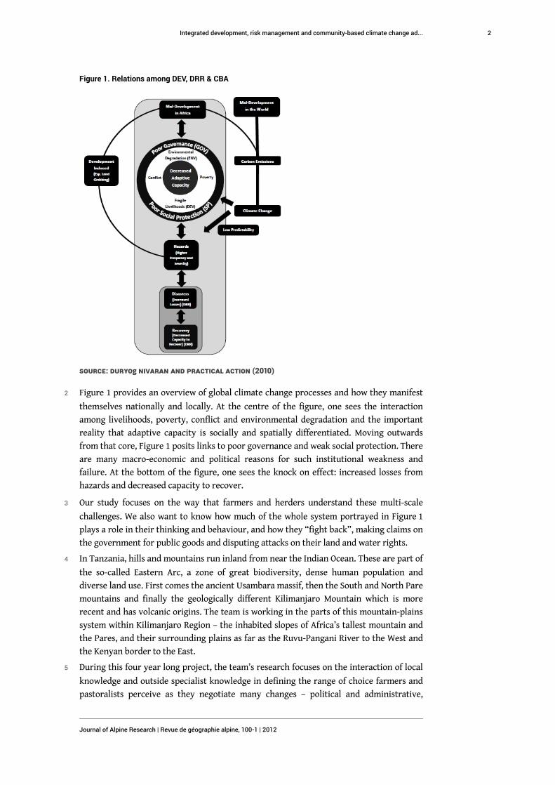
Figure 1. Relations among DEV, DRR & CBA
Source: Duryog Nivaran and Practical Action (2010)
2 Figure 1 provides an overview of global climate change processes and how they manifest
themselves nationally and locally. At the centre of the figure, one sees the interaction
among livelihoods, poverty, conflict and environmental degradation and the important
reality that adaptive capacity is socially and spatially differentiated. Moving outwards
from that core, Figure 1 posits links to poor governance and weak social protection. There
are many macro-economic and political reasons for such institutional weakness and
failure. At the bottom of the figure, one sees the knock on effect: increased losses from
hazards and decreased capacity to recover.
3 Our study focuses on the way that farmers and herders understand these multi-scale
challenges. We also want to know how much of the whole system portrayed in Figure 1
plays a role in their thinking and behaviour, and how they “fight back”, making claims on
the government for public goods and disputing attacks on their land and water rights.
4 In Tanzania, hills and mountains run inland from near the Indian Ocean. These are part of
the so-called Eastern Arc, a zone of great biodiversity, dense human population and
diverse land use. First comes the ancient Usambara massif, then the South and North Pare
mountains and finally the geologically different Kilimanjaro Mountain which is more
recent and has volcanic origins. The team is working in the parts of this mountain-plains
system within Kilimanjaro Region – the inhabited slopes of Africa’s tallest mountain and
the Pares, and their surrounding plains as far as the Ruvu-Pangani River to the West and
the Kenyan border to the East.
5 During this four year long project, the team’s research focuses on the interaction of local
knowledge and outside specialist knowledge in defining the range of choice farmers and
pastoralists perceive as they negotiate many changes – political and administrative,
Integrated development, risk management and community-based climate change ad...
Journal of Alpine Research | Revue de géographie alpine, 100-1 | 2012
2

economic, infrastructural and environmental – in the course of minimising risks and
maximising opportunities. The study’s overall aims are set out in Figure 2.
Figure 2. Overall project theoretical framework
6 In order to capture a wide sample of agro-ecological and pastoral conditions, micro-
climates, topographical settings and cultural-linguistic situations, we conducted scoping
throughout much of Kilimanjaro Region, consulting with regional and district leaders and
professionals and holding local focus groups with ward and village level leaders and
elders. We chose Kilimanjaro Region since it contains an enormous range of variability in
these respects and also because it is adjacent to Simanjiro District, Manyara Region across
the Ruvu river and Kadjiado District in Kenya, where some of the study team had been
active in other, related research projects.
Context and methods
7 The team eventually chose four gradients, each composed of villages at the top, mid-slope
and in plains. Two of these gradients ran from the highest inhabited zone on Mt.
Kilimanjaro and down slope in two directions (Figure 3). In Rombo District, one gradient
descends toward the Kenyan border. In Moshi Rural District, a second descends toward
the rice irrigation schemes in the western plains beyond Moshi Town. One gradient each
was also defined in Mwanga and Same Districts. Again, these involved highland villages at
the highest inhabited altitudes and descended toward the plains. In the lowland villages
one finds a rich diversity of livelihood activities: Maasai in five sampled villages carry out
pastoral activities with varying degrees of diversification into agriculture and trade.
There is river fishing, dryland farming, irrigation farming and horticulture (mangoes).
The highest sites feature banana and taro roots, coffee, ginger and cardamom (these last
two recent introductions of high value), fruit (e.g. avocado) and vegetable cultivation, and
small scale dairying. The middle zone on these gradients is a transition zone that had
been farmed seasonally and only permanently settled within the last generation. Staple
Integrated development, risk management and community-based climate change ad...
Journal of Alpine Research | Revue de géographie alpine, 100-1 | 2012
3

bananas give way gradually to maize and cassava and sunflower. These villages are nearer
to the main tarmac road that joins Tanga and Dar es Salaam on the Indian Ocean coast to
Same Town, Mwanga Town and onwards to Moshi and Arusha as well as to border
crossings into Kenya. Commerce is therefore more highly developed as a non-farm
livelihood option (see Box 1).
Figure 3. Map of full study area
8 A structured questionnaire was administered to 600 randomly chosen adults in 14 villages
along these four gradients. Tanzania’s highly organised, decentralised system of
governance made it possible to obtain lists of village residents and choose respondents at
random (with randomly chosen replacements if those chosen were not available).
9 Analysis of wealth indicators suggests less socio-economic inequality between altitudinal
zones than might be suggested by income-based indictors of poverty. A wealth index was
developed by assigning equal weights to four household survey variables reflecting land-
based forms of livelihood, rural diversification and local social resources. The index
consists of the following four variables: land access, livestock wealth, extent of
remittances and involvement in community-based organizations. Percentiles were
calculated from grouped data and cross-tabulated to indicate the distribution of
households within each wealth percentile group by altitudinal zone. We ran the χ2 test for
independence in contingency tables and found that altitudinal zone and wealth index are
statistically independent (α = 0.05, 18 df). Thus wealth variation by altitudinal zone – as
measured by this index – is not statistically significant. This assessment of the wealth
classes by zone suggests less socio-economic stratification by agro-climatic conditions
than suggested by previous efforts to map income poverty (URT, 2005) and provides
important background to our investigation of capacity and spatial interdependence
related to DEV, DDR, and CBA among the study sites (Table 1).
Integrated development, risk management and community-based climate change ad...
Journal of Alpine Research | Revue de géographie alpine, 100-1 | 2012
4
Table 1. Wealth distribution of households by zone
Wealth index
percentile
Altitudinal zones
Total
- Number (%
)
Lower
(500-700m)
- Number (%)
Middle
(700-1200m)
- Number (%)
Upper (>
1200m)
- Number (%)
10 29 (12.6) 17 (8.4) 9 (5.4) 55 (9.2)
20 22 (9.6) 37 (18.2) 29 (17.5) 88 (14.7)
30 13 (5.7) 12 (5.9) 10 (6.0) 35 (5.8)
40 26 (11.3) 15 (7.4) 7 (4.2) 48 (8.0)
50 31 (13.5) 21 (10.3) 25 (15.1) 77 (12.9)
60 18 (7.8) 16 (7.9) 20 (12.0) 54 (9.0)
70 27 (11.7) 23 (11.3) 19 (11.4) 69 (11.5)
80 25 (10.9) 20 (9.9) 12 (7.4) 57 (9.5)
90 22 (9.6) 19 (9.4) 20 (12.0) 61 (10.2)
100 17 (7.4) 23 (11.3) 15 (9.0) 55 (9.2)
Total 230 (100) 203 (100) 166 (100) 599 (100)
10 The people of Kilimanjaro Region have generally been adept at maximizing traditional
practices and absorbing new ones. This is best exemplified by the intense garden-like
family homestead with banana as a staple, stall fed cattle and coffee as a cash crop
introduced over a 100 years ago. By the 1970s improved breeds of dairy cattle brought
increased production and surpluses that provided extra income. From this stable base the
people invested heavily in education so that there has been diversification away from the
core livelihood based on fishing, pastoralism and agriculture. The impact of this can
clearly be seen in Table 2. The core livelihoods activities depicted in the first four
columns account for only about 40% of the households. If we look at Mwanga District, in
2003, there were more than 10,300 households employed in the government, private
sector or NGOs (URT, 2007). The figure is now higher. This means more people buying
food, productivity increasing or going into crops that give greater returns. Where equity
issues were considered right from the start and an integrated approach taken, as in Lower
Moshi, and the rights of people over resources has been assured, paddy yields have more
than doubled (Likwelile et al., 2008).
Integrated development, risk management and community-based climate change ad...
Journal of Alpine Research | Revue de géographie alpine, 100-1 | 2012
5

Table 2. Principal activity of the households from the region of Kilimandjaro
District
Crops /
Farming
Livestock
keeping /
Herding
Livestock
pastoralismFishing
Total %
4
columns
Total %
10
unlisted
columns
Numbers % Numbers % Numbers % Numbers % % %
Rombo 99,057 38 1,278 0.5 354 0.1 118 0.0 38.6 61,4
Mwanga 29,060 37 684 0.9 115 0,1 117 0.1 38.1 61,9
Same 58,823 45 3,467 2.7 148 0.1 0 0.0 47.8 52.2
Moshi
Rural119,230 34 4,653 1.3 261 0.1 0 0.0 35.4 64,6
Hai 87,085 43 6,616 3.2 227 0.1 111 0.1 48.4 51.6
Total 393,255 38 18,698 1.8 1,105 0.1 346 0.0 39.9 60.1
Source: URT (2007)
Hypothesis
11 Our hypothesis is based on the following general observations found in previous studies
in Africa (e.g. Richards, 1986; Wangari et al., 1996; Mascarenhas, 2000, 2010; Sarris and
Karfakis, 2006; Mwaura, 2008; Smucker and Wisner, 2008; Wangui, 2008). Rural people on
these gradients do not perceive climate change as a unique challenge, but understand it
as one of many changes. They seek to minimise risks and maximise opportunities that
accompany not only climate change but other changes in the physical and natural
environment and economy, politico-administrative and legal changes and changes in
infrastructure (transport, markets, communication) and services available. While the
residents of these gradients have been living with climate variability for generations,
changes over the past 10-20 years present difficulties for the application of traditional
decision making criteria such as signs that one should plant.
12 Our hypothesis, therefore, is that people will be found to be using a wide range of social
contacts and diverse ecosystems across spatially distinct zones to buffer the effects of
natural hazard risks, including those that are climate related, as well as a means of
adapting to other changes in economic risks and opportunities. We refer to this as socio-
geographic adaptation.
13 This is only one of the three hypotheses in this on-going research project. Another deals
with the nature of the relationship between local/traditional knowledge and outside/
specialist knowledge; while a third is focused on possible conflict and conflict resolution
arising from growing socio-geographical adaptive capacity. Since this paper is an interim
report on the first phase of our work, we only address the first hypothesis.
Integrated development, risk management and community-based climate change ad...
Journal of Alpine Research | Revue de géographie alpine, 100-1 | 2012
6

Preliminary findings
14 Hazards vary by altitude. In the highlands, mid-slopes and internal valleys they include
drought, flooding, minor landslides that block roads and occasional deadly ones, as in
highland Same District in 2009 when 28 people died, wind damage to crops, insect and
animal attack on crops and livestock (the latter including baboons, wild pigs and
crocodiles). In the lowlands drought, floods and tick-borne animal disease are also the
main hazards. Wind damage to crops is less common and landslides are absent.
15 The household survey on all gradients showed a perception that drought, flooding,
damaging winds and landslide had increased over the past ten years. In addition,
respondents from all agro-climatic zones believed that animal and plant diseases and pest
attacks had increased (Table 3)
Table 3. Perception of natural hazard trends
Hazard
Zone
-
% ‘yes’
Drought
increasing
Flood
increasing
Wind
increasing
Landslide
increasing
Animal and
plant disease
increasing
Pest attack
increasing
High 51 0 37 16 63 67
Medium 83 10 36 18 67 77
Low 93 24 52 12 81 81
16 Whilst increasing drought was reported by half of highland dwellers, it was in the mid-
slope zones and lowlands that nearly everyone perceived greater incidence of drought.
Since the lowland sites are recipients of seasonal flow from the mountains, often in the
form of flash flooding, it is not surprising that increased floods were a concern of farmers
and pastoralists in these low altitude sites.
17 A specific change in climate identified was variability in the starting time of rains, and, in
this bi-modal rainfall regime, the length of the so-called short rains and long rains.
Changes in the distribution of rain more than its absolute quantity were said to produce
the greatest hardship (Table 4). Such results concerning the perception and
understanding of climate characteristics need to be set against current climate science
models. According to Agrawala et al. (2003), mean annual temperatures in Tanzania are
projected to increase by 2.2 °C by 2100. Their work shows seasonal variations in this
increase with June, July and August averaging a higher increase of 2.6 °C and December,
January, February averaging a 1.9 °C increase. They also report that country level
averages show a projected annual precipitation increase of 10% by 2100. Results from the
National Science Foundation funded, “East Africa Climate People and Savannah
Ecosystems Project” (ECLIPSE) confirm this trend (Moore et al., 2011). There are however
seasonal variations in this trend. June, July and August are projected to have a decline of
6% while December, January and February show increases of 16.7%.
Integrated development, risk management and community-based climate change ad...
Journal of Alpine Research | Revue de géographie alpine, 100-1 | 2012
7

Table 4. Perception of changes in rainy seasons
Comments by whole survey across all
zones (percentage mentioning short and
long rains)
Cooler Warmer Shorter HeavierMore
droughts
Short rains xx 18 26 xx 21
Long rains 26 xx 21 15 xx
18 Fifty-eight per cent of all respondents had witnessed a decrease in vegetation over the
past ten years, rising to 65% in the lowland sites, where there has been considerable in-
migration. Decreasing soil fertility was noted by 63% of the household survey. In the high
mountain sites where permaculture still prevails, fertility decline was reported by only
51% (while 40% of their neighbours thought fertility had increased). In the middle zone,
where slopes can still be steep, but annual cropping, not the traditional polyculture, is
practiced, some 70% said fertility had decreased in the last ten years.
19 In addition to changes in pests and plant and animal diseases, hazards that may well be
climate related, roughly a third of all households across the agroclimatic zones believed
invasive weeds had increased; however, opinion differed as about the same percentage
thought weeds had decreased and a slight majority overall though they were about the
same.
20 Other changes widely acknowledged by respondents were improvements in
transportation (road density and available public transport) and communications (mobile
phones) and increased awareness of the need to diversity livelihoods. As we shall see
below, these changes to some extent facilitate an adaptive strategy in the face of climate
risks that has so far been reasonably successful.
21 All of these changes and hazards were discussed in a holistic way as aspects of life,
together with a variety of economic and social risks and opportunities. This was
strikingly obvious in the focus groups with elderly women and men that produced time
lines of disaster experience. The Swahili word for disaster is maafa, and was generally
understood to be the outcome of a wide variety of risks. In one time line – the result of
several hours of discussion and debate – elders arrayed a series of disastrous events
including named droughts, floods, gale force winds, locust plagues to colonial period
quarantine of the village due to cholera (Figure 4). The last mentioned did as much harm
to livelihoods as some of the extreme natural events because trade and socio-spatial
interdependence – already existing then – was cut off. Men were forced to travel secretly
at night to seek a few days wage labour in order to purchase and bring home food – all
under the threat of capture and imprisonment.
Integrated development, risk management and community-based climate change ad...
Journal of Alpine Research | Revue de géographie alpine, 100-1 | 2012
8

Figure 4. Emangulai “A” time line
Box 1. One elder spoke as follows during a time line focus group:
“Comparing 1974 and 1984, 1984 was much worse because many places did not even
have transportation. So even the means to take food to people was difficult… ‘84 had
very intense hunger, and then there was also cholera. There was quarantine and all
the roads were closed. People were not able to communicate… There was intense
hunger because nobody could do anything to help themselves… People had to wait
for the government to bring them food here… [I]t was a very bad cholera outbreak. I
remember it very well… And the drought made everything worse.”
22 Compared to the 1940s when severe drought killed people, the elders said that more
recent droughts have much lower fatalities. In the past, drought meant that people had to
walk down to the plains and trek for several days and then walk back up hill with a head
load of about 35 kg of grain. Improved infrastructure has reduced the risk from disastrous
food shortages.
Preliminary test of hypothesis
23 The research team chose four sites in the North Pare mountains and associated plains for
intensive qualitative study. The gradient descends from 1476 m to 500 m in Mwanga
District and takes in a very wide range of topography, climate, soil, water resources as
well as livelihood systems (Figure 5).
Integrated development, risk management and community-based climate change ad...
Journal of Alpine Research | Revue de géographie alpine, 100-1 | 2012
9

Figure 5. Map of Mwanga gradient
24 Livelihood systems include zero-grazing milk production, banana, maize, taro root,
cardamom and coffee production in the highlands and semi-arid, dryland extensive
herding and irrigation of rice and vegetables in the lowlands as one approaches the Ruvu-
Pangani River. In the mid-slopes and internal valleys one finds a mixture of rainfed
agriculture that combines some lowland cultivars such as cassava with highland crops
such as bananas and also includes maize and sunflower as well as some small-scale
irrigation. Ethnic-linguistic groups include the Pare in the highlands, Pare mixed with
Chagga in the mid-slope zone, Maasai herders (and a wide variety of immigrant farmers
of diverse backgrounds) in the irrigation zones. Immigrant farmers include Pare whose
parents or grandparents originally came from the mountain area.
25 The large household survey along all four gradients included 118 randomly chosen
households in four village sites along this Mwanga gradient (one highland, one mid-slope
and two in the lowlands – one of which was exclusively Maasai). We held follow up focus
group discussions with men, women and elders in each of the four sites which suggested
that mobility and social interdependence are the key to simultaneous and synergistic
livelihood improvement, risk reduction and adaptation to climate change. Many highland
and mid-slope dwellers have family members working in the lowlands or in urban areas.
26 Ten per cent of all respondents list a spouse or head of household living outside of the
homestead; while this combines both those who are farming, herding, fishing or trading
elsewhere on the gradient, it also includes those in paid employment and able to remit
income, as nine per cent of the sample reports they do. In addition, sons and daughters
also migrate and remit income. Forty-two per cent of households interviewed claimed
one or more dependents living outside the homestead. In total, 30% of all households
received remittances – a considerable component of the livelihood system during
Integrated development, risk management and community-based climate change ad...
Journal of Alpine Research | Revue de géographie alpine, 100-1 | 2012
10

“normal” times, and one that is likely to be more important during an emergency. Sixty-
one per cent of the remittance locations (from which children or a spouse sent money)
were one of these larger Tanzania cities: Dar es Salaam (30%), Arusha (17%), Moshi (12%)
and Tanga (3%).
27 Many also have livestock or secondary farms in the lowlands. Lowland farmers have
secondary farms in the highland. Thirty-nine per cent of lowland plots were, in fact,
cultivated by people whose home is in the middle zone and another 14% cultivated by
people whose home is in the upper zone. Of highland plots, 37% are farmed by middle
zoners and 9% by lowlander dwellers. The pivotal position of the recently settled middle
slopes is apparent. Dispersion of livestock, at least during “normal” rainfall conditions is
less than the spread of farms. It is mostly the lowland farmer-herders and pastoralists
who have livestock, especially goats and sheep in pasture in a neighbouring village or in a
more distant place in the lowland and even a few in the highlands.
Box 2. A focus group elder spoke about migration along the gradient:
“1954 is important because before there was a flood, there was a drought. And that is
when people moved from the highlands and came down to the lowlands to farm over
here. I remember my parents moved here to farm during that time.”
28 Most of the Maasai also engage in irrigation farming and trading. Animal fodder, rice and
dried river fish are traded up the slope; while bananas and milk products are marketed
downhill. From mid-slope farms maize and sunflower oil go in both directions, and fodder
goes to highland stall-feeding. Diversity of livelihood activities and income sources,
including trade, is definitely an aspect of the combined DEV-CBA-DRR strategy that the
team’s early research has revealed. Also from key informants we learned that many new
credit sources are available such as informal village banks and loans from religious and
social groups. This provides another source of income for livelihood diversification.
Box 3. Cross border migration as socio-geographic adaptation
Maingi Solomon
Njukini – an informal settlement wedged between the Kenya-Tanzania border and
Tsavo West National Park - presents a microcosm of East African dryland
communities. The settlement demonstrates two important interrelated aspects: (1)
the arid and semi arid areas have both social, economic and ecological diversity; (2)
various communities have had different perspectives and responded differently to
hazards.
Njukini marks a transitional zone between the pastoral areas of Loitoktok and
Kajiado and the crop oriented Taita-Taveta areas to the East in Kenya and Southwest
up the slopes of Mt. Kilimanjaro, through the low, medium and upper sites of the
Rombo gradient. It is characterised by dryland farming, pastoralism and trade. The
presence of water has allowed four irrigation schemes, and this has attracted casual
labour.
Before the early 1970s, there were very few people in Njukini because it was a
government protected water catchment area. After Kenya’s independence several
Integrated development, risk management and community-based climate change ad...
Journal of Alpine Research | Revue de géographie alpine, 100-1 | 2012
11

people moved from Mkuu on present-day Tanzania’s Kilimanjaro slopes to settle in
Njukini. They lived outside the protected area next to the border. However, highly
politically connected individuals owned land within the protected area and utilised
the water for large-scale farming and depended on migrant family labour. In time
employers did not allow mature members of the families to live with their parents in
the estate. The older children curved out temporary farms outside the estate.
Tensions between the members of the East Africa Community (EAC) in the early to
mid-1970s contributed to settlement in the area by Kenyans moving back from
Tanzania Njukini thus became a host of many Kenyans crossing the border from
different parts of Tanzania.
Several factors influence perspectives on resource use and migration. Migration
histories demonstrate social networks which facilitate resource access across the
border. The proximity to the Kenya/Tanzania border offers a unique opportunity for
the residents to diversify livelihoods through trade, social networks, labour and
migration.
29 Governance is important in this strategy. Roads must be maintained especially during the
rainy seasons, since mobility and trade is at the core of the strategy. Small non-lethal but
obstructive landslides are common during intensive rain storms in the mountains. Land
tenure issues, water rights and other issues of access and regulation of land use and
resource access are also crucial in the face of growing population density and the
constant threat of deforestation. In Tanzania a complex nested system of governance
exists at the scale of the sub-village, village, ward, district, region and nation. Each of
these play roles in what is often a struggle for access to resources and services, access to
and maintenance of infrastructure and the adjudication and allocation of property rights.
30 Ways of coping with drought also reveal the importance of socio-geographic strategies,
diversity of livelihood activities and governance. The household survey covering all four
of the gradients included a section that asked about coping activities during the 2008
drought – a serious event in all of the gradient’s zones. Twenty-eight per cent of the
lowland site dwellers undertook wage labour in order to purchase food, higher than the
17% choosing this option in the upper zone and 15% in the middle zone. Nine per cent in
the lower zone sold handicrafts and manure – rare coping measures in the middle and
upper zones. Also in the lower zone some 15% reported selling wood as a coping
mechanism during the 2008 drought. Others made and sold charcoal – something we
observed and spoke about – but since this activity is illegal, it did not emerge clearly in
the household survey. Livestock were moved to another place by 45% of the lowland
households, 14% of people in the middle zone and 12% at the upper end of the gradient.
31 Seventy-four per cent of the sampled households in the lowlands sold livestock during
the drought (55% reported doing so in the middle zone and 56% in the upper zone). Such
a high level of distress sale of livestock in the lowlands, especially prominent among the
Maasai, may have been effective in providing money to feed the family during the 2008
drought, but reducing herd size in this manner also reduces their capacity to respond
soon to a subsequent crisis.
32 Agronomic adjustment (or coping) was also evident. Half of the whole sample said they
planted before the first rains; while 60% planted immediately after them. A third engaged
in one kind of irrigation or another – right across the agroclimatic zones. Seventeen per
Integrated development, risk management and community-based climate change ad...
Journal of Alpine Research | Revue de géographie alpine, 100-1 | 2012
12

cent used soil and water conservation measures, and 18% said they cultivated wetlands.
Notably, 58% signalled that they had weeded more frequently, and 44% had planted
drought-resistant crops. Since drought may affect high, middle as well as lowland sites,
one would expect adoption of drought-resistant crops all along the study gradient.
However, millet and sorghum are not staple foods for most people in the middle and
highland sites, and key informants mentioned that these crops are perceived as “birds’
food” or only for commercial purposes. Thus, peoples’ perception, lack of market for
these crops as well as presence of pests like the bird, quelea quelea, limit the adoption of
this adaptation strategy.
33 Concerning agronomic measures, both old and new techniques were apparent in field
visits and intensive key informant interviews. While everyone claimed to pray as a
drought coping measure, only 31% of the sample consulted a rainmaker. Indeed, in a
separate question about the sources of seasonal climate forecasts, radio and the
government agricultural extension officer were the two top ranking sources – followed by
more traditional natural signs: the moon, first rains and clouds. Lightning and thunder
topped the list of “second most reliable” indicators. No more than 7% ever listed the
traditional weather forecaster among the three most reliable sources.
34 Cultural change and demographic pressure seem also to have affected the ability to
source wild plant and animal foods as a coping measure, except in the lowland sites
(where there is more undisturbed wild land), and even there no more than 5-6% claim to
have hunted or gathered wild plants, respectively. Also, it is notable that a greater
proportion says they relied on government food relief (69%) than on their relatives (39%).
This is a function of more efficient government relief activities and better transport and
is not necessarily a function of a more fragmented and isolated life style, since other
coping measures point toward social interdependence. One example is moving livestock
to available pasture and water, mentioned earlier. Another is moving in with a relative,
something practiced during the 2008 drought by 14% of lowland households. In addition,
across the whole sample along the four gradients we found that 20% belonged to faith
based groups, 12% to community groups, 8% to some other informal group and 7% to a
savings society. All of these provide possible conduits for knowledge to flow as well as a
nexus around which cooperative coping and livelihood activities may be organised.
Discussion and provisional conclusions
35 Historically the residents of these gradients have shown considerable flexibility,
resilience and adaptability. One suggestion of this is changes that have taken place in the
staple food. Among the waPare people in Same District, as among the waSambaa in the
Usambara Mountains, dramatic shifts over the last half century have taken place, with
bananas giving way to cassava and this, in turn, being displaced by maize and rice. Our
household survey data also shows staple food shifts of this kind.
36 A number of studies have suggested that farming, herding and fishing as the basis of
livelihoods cannot be expected to be guided in a future of climate change exclusively by
knowledge developed in the past (Wisner, 2010; Onyongo, 2011; ENDA, n.d.). However, this
caution assumes a static, “traditional” body of knowledge. Local knowledge is not a single
epistemology and technology but is a bundle of practical knowledge, modified by
communities. There are compelling reasons to regard local knowledge as a valuable
Integrated development, risk management and community-based climate change ad...
Journal of Alpine Research | Revue de géographie alpine, 100-1 | 2012
13

national resource (Warren and Rajasekaran, 1993). For example, recent work on rain
water harvesting shows the versatility of local knowledge in different parts of Tanzania
including in the Pare Mountains (where our Mwanga gradient is located) (Mbilinyi et al.,
2005).
37 Our study suggests that local knowledge draws from diverse sources – a process
accelerated by more interaction up and down the altitude gradients – and that livelihoods
are in constant flux. This process of socio-geographic adaptation is at the core of
livelihood diversification and differential vulnerability to climate change and
environmental change more broadly. The earlier discussion of how people coped during
the 2008 drought shows that strategies are flexible and change, even when it comes to
something as vital as coping under stress. However, the results also have a dark side. One
also notes a shrinking of the available range of coping measures due to constraints on
access to common property resources (compare Smucker and Wisner, 2008, writing about
Kenya).
38 Given such a history of opportunistic strategies in the face of variability and changes of
many kinds, what are the chances that socio-geographic adaptation will continue to allow
stability or even increased well being in this part of Tanzania?
39 There are many imponderables. Climate models simply do not yet provide projections at a
spatial resolution appropriate to informing district and community-level adaptation
planning. Whatever further climate changes occur, a deciding factor will be access to
resources and locations. Even now there is considerable competition over water rights
and access to irrigation water. Herder-farmer conflicts exist. More and more people from
outside the region, among them, some wealthy and influential individuals, are acquiring
land in the lowlands and in the middle zone of the gradient. While neither government
nor the people can control the climate, both can do a good deal to anticipate and resolve
emerging conflicts of interest surrounding land, water and prime locations along the
main roads. The recent Land Act and Villages Act provided a framework of decentralised,
popular control of access. Time will tell whether this democratic process will be trumped,
not by climate alone, but by economic and political power.
BIBLIOGRAPHIE
AGRAWALA S., MOEHNER A., HEMP A., VAN AALST M., HITZ S., SMITH J., MEENA H., MWAKIFWAMBA S.M.,
HYERA T., MWAIPOPO O.U., 2003. – Development and climate change in Tanzania : focus on Mount
Kilimanjaro, Organization for Economic Co-operation and Development (OECD), Paris.
DURYOG NIVARAN, PRACTICAL ACTION, 2010. – South Asian disasater report 2010 : changing climates,
impeding risks, emergent perspectives, Duryog Nivaran / Practical Action, Colombo.
ENDA, n.d. – Climate and development : indigenous knowledge bank, Environments and Development
Africa (ENDA), Dakar.
Integrated development, risk management and community-based climate change ad...
Journal of Alpine Research | Revue de géographie alpine, 100-1 | 2012
14

LiKWELILE S., RUTASITARA L., HAULE J., 2008. – Broad aid effectiveness to infrastructure : a comparative
study of East Asia and Sub-Saharan Africa – Tanzania case study, Report n° 36-3, Japan Bank of
International Cooperation Institute, Tokyo.
MASCARHENAS A., 2000. – Poverty, environment and livelihood along the gradients of the Usambaras in
Tanzania, Research report n°2, Research on Poverty Elimination (REPOA), Dar es Salaam.
MASCARHENAS A., 2010. – « How significant is climate change in the understanding of the
vulnerability and resilience among pastoralist and farmers in Kilimanjaro Region – Tanzania ? »,
Integrated Disaster Reduction Conference, Global Risk Forum, 29 mai – 5 juin 2010, Davos, Suisse.
MBILINYI B., TUMBO S., MAHOO H., SENKONDO E., HATIBU N., 2005. – « Indigenous knowledge as
decision support tool in rainwater harvesting ». Physics and Chemistry of the Earth, n°30,
pp 11-16/792-798.
MOORE N., ALAGARSWAMY G., PIJANOWSKI B., THORNTON P., LOFGREN B., OLSON J., ANDRESEN J., YANDA P., QI
J., 2012. – « East African food security as influenced by future climate change and land use change
at local to regional scales », Climatic Change, sous presse.
MWAURA P., 2008. – Indigenous knowledge in disaster management in Africa, United Nations
Environment Programme, Nairobi.
O’BRIEN G., O’KEEFE P., ROSE J., WISNER B., 2006. – « Climate change and disaster management ».
Disasters, Vol. 30, n°1, pp 64-80.
ONYONGO M., 2011. – « Community-based adaptation for local empowerment and global
influence : methods and practice from the Adaptation Learning Programme for Africa »,
AfricaAdapt Symposium, March 2011, Dakar, Senegal.
ORR S., CARTWRIGHT A., TICKNER D., 2009. – Understanding water risks, WWF Water Security Series n°
4, WWF, Godalming.
RICHARDS P., 1986. – Coping with hunger : hazard and experiment in a West African rice farming system,
University College London Press, Londres.
SARRIS A., KARFAKIS P., 2006. – Household vulnerability in rural Tanzania, FAO commodity and trade
policy research working paper n°17, Food and Agriculture Organisation, Rome.
SMUCKER T., WISNER B., 2008. – « Changing household responses to drought in Tharaka, Kenya :
persistence, change, and challenge ». Disasters, Vol. 32, n°2, pp 190-215.
SUDMEIER-RIEUX K., MASUNDIRE H., RIZVI A., RIETBERGEN S., 2006. – Ecosystems, livelihoods and disasters
, International Union for Conservation of Nature, Gland.
URT, 2005. – Poverty and human development report 2005, United Republic of Tanzania (URT) /
Mkuki na Nyota Publisher, Dar es Salaam.
URT, 2007. – National sample census of agriculture 2002-2003 – Volume Vc : regional report - Kilimanjaro
Region, National Bureau of Statistics with Ministries, Dar es Salaam.
WANGARI E., THOMAS-SLAYTER B., ROCHELEAU E., 1996. – Gendered visions for survival in Kenya :
Semi-arid regions in Kenya. In D. Rocheleau, B. Thomas-Slayter, E. Wangari, (eds.) Feminist
political ecology : global perspectives and local experiences, Routledge. Londres, pp 127-154.
WANGUI E., 2008. – « Development interventions, changing livelihoods, and the making of female
Maasai pastoralists ». Agriculture and Human Values, Vol. 25, n°3, pp 365-378.
WARREN M., RAJASEKARAN B., 1993. – « Putting local knowledge to good use ». International
Agricultural Development, Vol. 13, n°4, pp 8-10.
Integrated development, risk management and community-based climate change ad...
Journal of Alpine Research | Revue de géographie alpine, 100-1 | 2012
15

WISNER B., 2010. – « Cultural diversity and climate change ». International Social Science Journal,
Vol. 61, n°199, pp 131-140.
WISNER B., BLAIKIE P., CANNON T., DAVIS I., 2004. – At risk : natural hazards, people’s vulnerability and
disasers, 2e édition, Routledge, Londres.
RÉSUMÉS
This paper presents a preliminary analysis of work conducted along altitudinal gradients in the
mountains and plains of northern Tanzania. We find evidence of a high degree of
interdependence among groups of people of different language/cultural groups and socio-
economic status interacting along environmental gradients from high to low altitude. We call
this “socio-geographical adaptation” to climate change. However, our analysis and discussion
adds complexity to any simple notion of “adaptation to climate change” since changes are
multiple and adaptation is complex.
INDEX
Keywords : climate change, complexity, governance, interdependence, livelihood
AUTEURS
ELISABETH EDNA WANGUI
Ohio University, US
THOMAS A. SMUCKER
Ohio University, US
BEN WISNER
Aon-Benfield UCL Hazard Research Centre, UK
ERIC LOVELL
Ohio University, US
ADOLFO MASCARENHAS
Institute for Resource Assesment, University of Dar Es Salaam, Tanzania
MAINGI SOLOMON
Ohio University, US
DANIEL WEINER
Ohio University, US
ABUBAKARI MUNNA
Sokoini University of Agriculture, Tanzania
Integrated development, risk management and community-based climate change ad...
Journal of Alpine Research | Revue de géographie alpine, 100-1 | 2012
16

GAURAV SINHA
Ohio University, US
CHARLES BWENGE
University of Florida, US
HUBERT MEENA
Centre for Energy, Environment, Science and Technology (CEEST), Tanzania
PANTALEO MUNISHI
Sokoini University of Agriculture, Tanzania
Integrated development, risk management and community-based climate change ad...
Journal of Alpine Research | Revue de géographie alpine, 100-1 | 2012
17