Embed Size (px)
Citation preview

www.elsevier.com/locate/geomorph
Geomorphology 55 (2003) 329–344
Integrating soils and geomorphology in mountains—an
example from the Front Range of Colorado
P.W. Birkelanda,*, R.R. Shrobab, S.F. Burnsc, A.B. Priced, P.J. Tonkine
aDepartment of Geological Sciences, University of Colorado, Boulder, CO 80309-0399, USAbUS Geological Survey, MS 980, Box 25046, Denver Federal Center, Denver, CO 80225, USA
cDepartment of Geology, Portland State University, Portland, OR, 97207, USAdUS Department of Agriculture, Natural Resources Conservation Service, 655 Parfet Street, Lakewood, CO 80215, USA
eSoil, Plant, and Ecological Science Division, Lincoln University, Canterbury, New Zealand
Received 25 April 2002; received in revised form 24 June 2002; accepted 10 March 2003
Abstract
Soil distribution in high mountains reflects the impact of several soil-forming factors. Soil geomorphologists use key
pedological properties to estimate ages of Quaternary deposits of various depositional environments, estimate long-term
stability and instability of landscapes, and make inferences on past climatic change. Once the influence of the soil-forming
factors is known, soils can be used to help interpret some aspects of landscape evolution that otherwise might go
undetected.
The Front Range of Colorado rises from the plains of the Colorado Piedmont at about 1700 m past a widespread, dissected
Tertiary erosion surface between 2300 and 2800 m up to an alpine Continental Divide at 3600 to over 4000 m. Pleistocene
valley glaciers reached the western edge of the erosion surface. Parent rocks are broadly uniform (granitic and gneissic).
Climate varies from 46 cm mean annual precipitation (MAP) and 11 jC mean annual temperature (MAT) in the plains to 102
cm and � 4 jC, respectively, near the range crest. Vegetation follows climate with grassland in the plains, forest in the
mountains, and tundra above 3450 m. Soils reflect the bioclimatic transect from plains to divide: A/Bw or Bt/Bk or K
(grassland) to A/E/Bw or Bt/C (forest) to A/Bw/C (tundra). Corresponding soil pH values decrease from 8 to less than 5 with
increasing elevation. The pedogenic clay minerals dominant in each major vegetation zone are: smectite (grassland),
vermiculite (forest), and 1.0–1.8 nm mixed-layer clays (tundra). Within the lower forested zone, the topographic factor
(aspect) results in more leached, colder soils, with relatively thin O horizons, well-expressed E horizons and Bt horizons
(Alfisols) on N-facing slopes, whereas soils with thicker A horizons, less developed or no E horizons, and Bw or Bt horizons
(Mollisols) are more common on S-facing slopes. The topographic factor in the tundra results in soil patterns as a consequence
of wind-redistributed snow and the amount of time it lingers on the landscape. An important parent material factor is airborne
dust, which results in fine-grained surface horizons and, if infiltrated, contributes to clay accumulation in some Bt horizons.
The time factor is evaluated by soil chronosequence studies of Quaternary deposits in tundra, upper forest, and plains
grassland. Few soils in the study area are >10,000 years old in the tundra, >100,000 years old in the forest, and >2 million
years old in the grassland. Stages of granite weathering vary with distance from the Continental Divide and the best developed
is grus near the sedimentary/granitic rock contact just west of the mountain front. Grus takes a minimum of 100,000 years to
form.
0169-555X/03/$ - see front matter D 2003 Elsevier B.V. All rights reserved.
doi:10.1016/S0169-555X(03)00148-X
* Corresponding author.

P.W. Birkeland et al. / Geomorphology 55 (2003) 329–344330
Some of the relations indicated by the soil map patterns are: (1) parts of the erosion surface have been stable for 100,000
years or more; (2) development of grus near the mountain front could be due in part to pre-Pennsylvanian weathering; (3) a
few soil properties reflect Quaternary paleoclimate; and (4) a correlation between soil development in the canyons and stream
incision rates.
D 2003 Elsevier B.V. All rights reserved.
Keywords: Geomorphology; Soils; Mountains; Front Range of Colorado
1. Introduction increase from east to west, and relate well to the soil
Soils can provide information useful to the geo-
morphological interpretation of mountainous terrain.
Their distribution, laterally and vertically, results from
the impact of the soil-forming factors—climate, veg-
etation, topographic setting, parent material, and time
(Jenny, l980; Birkeland, 1999). The altitudinal distri-
bution of soils shows the impact of the climate and
vegetation factors. One of the more important roles of
soils is in helping put surficial deposits of diverse
origins (glacial, fluvial, colluvial, periglacial, etc.—
the parent material factor) into age groups (time
factor). Richmond (1962) did this in his classic work
in the La Sal Mountains of Utah. The topographic
factor needs more study, because if there are marked
differences in soils with topographic setting, one has
to determine if it is due to the time factor or to the
rates of pedological processes.
This paper analyses the relation between soils and
geomorphology in the Front Range of Colorado and
adjacent plains. Birkeland studied the area in a recon-
naissance fashion while taking students on field trips
for the past 35 years. Former students and colleagues
have contributed by their detailed published and
unpublished work on parts of the range and plains.
However, this study—a first approximation of a
coherent soil-geomorphic history of the range—was
facilitated by soil maps and profile descriptions for the
Front Range west of Boulder by the U.S. Department
Agriculture, U.S. Forest Service (2001, and written
communications, 1999, respectively).
There are not many examples of integrating soils
and geomorphology at the scale of a mountain range.
One exception is the work of Tonkin and Basher
(1990) in the Southern Alps of New Zealand. Soil
distribution was well known from extensive mapping,
and they did detailed studies in key basins across the
range. Uplift, precipitation, and erosion rates all
patterns. In the eastern part of the range, mean annual
precipitation (MAP) is relatively low ( < 100 cm),
uplift and erosion slight, and A/Bw/C soil profiles
on transport-limited slopes denote geomorphic stabil-
ity during most of the Holocene. In areas with MAP
between 140 and 200 cm, the soil pattern is complex
and consists of both eroded soils in the upper parts of
the basins and one or more buried soils in the lower
parts. In contrast, in the western part of the range, a
high uplift rate combined with >1000 cm MAP results
in high erosion rates, A/R soil profiles on steep
weathering-limited slopes, and soil residence times
of 100–200 years.
A few of the lessons learned in Southern Alps
apply to the Front Range of Colorado. One is that the
precipitation in the latter area is similar to that of the
drier part of the Southern Alps study area, and the
landscape and soils in the Front Range of Colorado
seem similarly relatively stable. A second is that
basin-wide patterns of soil development seem to
correspond with stream incision rates.
2. Regional setting
The Front Range of Colorado rises abruptly above
the Colorado Piedmont section of the Great Plains
(Fig. 1). This paper focuses on a Colorado Piedmont-
to-Front Range of Colorado transect near the town of
Boulder. The base of the mountain front is between
1700 and 1830 m, and the area west of the front rises
to about 2500 m over a distance of about 6 km.
Farther west are remnants of a dissected Tertiary
erosion surface (Scott and Taylor, 1986; Bradley,
1987). This surface is expressed by accordant ridges
and extensive areas of low-relief terrain that slope
gently upward to the west to about 2750 m over
distances of about 10–20 km. West of the erosion

Fig. 1. Location map showing the Front Range of Colorado, mountain front, and Colorado Piedmont near Boulder, Colorado. Heavy solid lines
near Ward and Nederland indicate the approximate lower limit of Pleistocene glaciation; dotted pattern indicates till and related glacial deposits
(modified from Madole et al., 1998). Gray pattern shows the approximate extent of a Tertiary erosion surface (modified from Scott and Taylor,
1986).
P.W. Birkeland et al. / Geomorphology 55 (2003) 329–344 331
surface, the mountains rise to the Continental Divide
(3600–4100 m) over distances of about 10–15 km.
Several rivers drain the area. To the south is Coal
Creek, which heads about 28-km east of the Con-
tinental Divide; its headwaters were never glaciated.
To the north, both Boulder and Left Hand Creeks head
just east of the Continental Divide and their upper
reaches were glaciated during the Pleistocene.
Boulder Creek was more extensively glaciated. The
glaciers in both of these drainages terminated at about
2500–2700 m, close to the western edge of the
erosion surface. All of the above creeks flow in
steep-sided canyons; canyon relief is high in the
glaciated mountains, minor near the western edge of
the erosion surface, and increases to a maximum just
west of the mountain front. Maximum relief in the
canyons is Coal Creek, 660 m; Boulder Creek, 840 m;
and Left Hand Creek, 350 m.
There is disagreement regarding the elevation at
which the erosion surface formed—did it form close
to its present elevation, or did it form at a lower
elevation and subsequently been uplifted (Steven et
al., 1997 and references cited therein). Whatever the
case, canyon cutting commenced about 5 my (million
years) ago (Trimble, 1980; Steven et al., 1997).
3. Soil profiles
Soil profiles are composed of various horizons, and
the kind of soil profile varies with the soil-forming
factors (Birkeland, 1999). The surface O and A
horizons are commonly high in organic matter and
have characteristically dark colors. Beneath the O and
(or) A, mostly in acidic forested conditions, is a light
colored E horizon. The color of the latter horizon
indicates that much of the iron released in it has been
translocated to the underlying B horizon. Beneath the
A and (or) E horizons in most environments, given
sufficient time for them to develop, is a B horizon.

P.W. Birkeland et al. / Geomorphology 55 (2003) 329–344332
There are several types of B horizons. A Bw horizon
in this area is generally oxidized. An example would
be a parent material of 2.5Y hue alters to a Bw with a
10YR hue. The alteration is due to Fe release during
weathering. Given sufficient time, clay accumulation
is recognizable, and the horizon is designated Bt. The
clay has either infiltrated from overlying horizon(s) or
formed in place. In drier moisture regimes (grasslands
in the plains of this study), soil moisture is insufficient
to leach carbonate from the soil, and it accumulates to
form Bk or K horizons; these horizons form beneath
the Bw or Bt, or can occur as an overprint on the Bt
horizon (e.g., Btk). Six morphological stages in the
development of carbonate horizons are recognized in
the western USA, and the time to attain each stage
varies with climate and the rate of influx of Ca-
enriched dust (Machette, 1985). The first two stages
(I and II) are Bk horizons in which the color of the
non-carbonate material is clearly visible. If carbonate
accumulation is extensive and the carbonate and its
white color dominate the horizon, the horizon is
designated K (stages III through VI). At depth is the
little altered surficial parent material referred to as the
C horizon (Cox if slightly altered and Cu if unaltered).
Rock parent material is designated R, Cr if the rock is
weathered, and Crt if clay has accumulated. Horizons
with evidence of gleying are designated by the letter g
(e.g., Bg). In Canada (Soil Classification Working
Group, 1998), if a particular type of horizon is so
Fig. 2. Vegetation zones and climatic data for a transect from the Contine
Veblen and Lorenz, 1991, Fig. 2, and Barry, 1973, Table 4 and p. 92). E
adjacent elevation ranges represent ecotones between the zones.
weakly developed that it barely meets the criteria for
its recognition, it is followed by the letter j (e.g., Ej or
Btj), a practice we have adopted.
4. Factors of soil formation, Front Range of
Colorado
Jenny (1980) formulated the general soil-forming
equation
Soil ¼ f ðcl; o; r; p; t; . . . ; Þ
where cl is climate, o organisms, primarily vegetation,
r slope or topographic setting, p parent material, t time
over which the soil has formed, and . . . unknown
factors, a common one important to this study is
airborne dust. Each factor has a strong influence on
the resulting soil, and knowledge of these factors can
be used to predict the soil properties at a particular site.
Climate and vegetation vary with altitude in the
study area transect (Fig. 2). The Colorado Piedmont is
warm and dry with grassland vegetation. Westward
into the mountains, the mean annual temperature
progressively decreases, MAP increases, and the veg-
etation varies accordingly. Most of the range is in
forest, except for tundra above about 3450 m.
Bedrock parent material in much of the mountains
consists of a Precambrian core of igneous and high-
ntal Divide to the Colorado Piedmont near Boulder (modified from
levation ranges are typical for the vegetation zones. Gaps between

P.W. Birkeland et al. / Geomorphology 55 (2003) 329–344 333
grade metamorphic rocks (Lovering and Goddard,
1950; Tweto, 1979; Braddock and Cole, 1990). The
oldest rocks (>1.7 by [billion years] old) are biotite
and hornblende gneiss and schist; these were intruded
by granodiorite (1.7 by) and granite (1.4 by). Small
intrusive bodies of Tertiary age (mainly monzonite
and quartz monzonite) comprise a minor amount of
the igneous rocks. The Colorado Mineral Belt of
Tertiary mineralization trends NE–SW through the
area and intersects the range front north of Boulder;
hydrothermal alteration of the bedrock within this belt
is common. A narrow outcrop of E-dipping sedimen-
tary rocks veneers the front of the range, and shale
commonly underlies the Quaternary fluvial and other
surficial deposits in the plains.
The parent material for most soils discussed here
formed from rocks and surficial deposits high in
feldspar, quartz, biotite, and hornblende. Most of the
deposits are gravelly with a sandy matrix, except for
loess caps that are high in silt.
The ages of the soils throughout the study area can
be estimated from stratigraphic and geochronologic
studies in both the plains and mountains. A well-
expressed suite of river terrace deposits in the plains
(Fig. 3) is dated and correlated by the radiocarbon and
uranium-series methods, association with volcanic ash
of known age, soils, and relative height above streams.
The lower terrace deposits are generally accepted as
having been deposited during the Holocene and the
Pinedale and Bull Lake glaciations (Madole, 1991).
Fig. 3. Diagrammatic cross-section of alluvial units in the Colorado Piedmo
post-Piney Creek, Piney Creek, and pre-Piney Creek alluvial units, Holo
Louviers Alluvium, Late Pleistocene, or late Middle Pleistocene (Bull Lake
age of intercalated Lava Creek B ash, 640 ky; Rocky Flats Alluvium, abo
There is less agreement on the climatic control and the
timing of the older surficial deposits. The oldest
widespread deposit, the Rocky Flats Alluvium, is
about 2 Ma (million years old) (Birkeland et al.,
1996). The older mountain chronosequence is formed
in two widespread deposits—till of the Pinedale gla-
ciation (younger, and associated with marine isotope
stages 2 and 4) and till of the Bull Lake glaciation
(mainly marine isotope stage 6). They are dated and
correlated by the radiocarbon method, cosmogenic
isotope exposure age estimates, soils, and rock-weath-
ering features (Madole,1986; Madole and Shroba,
1979; Madole et al., 1998; Nelson and Shroba, 1998;
Schildgen, 2000). Pertinent local ages are a radio-
carbon age of 23.5 ky (thousand years old) for the
maximum extent of Pinedale ice, and a minimum
cosmogenic isotope exposure age of 122 ky for the
maximum extent of Bull Lake ice. A younger moun-
tain chronosequence is formed in rock-glacier deposits
and in tills deposited by glaciers that re-occupied
cirques after the disappearance of Pinedale ice. The
oldest post-Pinedale till is about 12 ky (possible
Younger Dryas equivalent), and there are at least three
younger Holocene advances. Dating and correlating of
these deposits are by the radiocarbon method, lichen-
ometry, soils, and rock-weathering features (Benedict,
1985; Birkeland et al., 1987; Davis et al., 1992).
There are few data on the influence of topographic
setting on soil development in the study area, as all the
soil chronosequence study sites were on relatively flat
nt near Denver (from Madole, 1991, Fig. 14). Approximate ages are:
cene; Broadway Alluvium, Late Pleistocene (Pinedale glaciation);
glaciation); Slocum Alluvium, 240 ky; Verdos Alluvium, similar to
ut 2 Ma.

P.W. Birkeland et al. / Geomorp334
surfaces. However, catena studies on Holocene and
Pleistocene moraines in other parts of the Rocky
Mountains serve as a model of soil development on
slopes with time (Birkeland, 1999, p. 247). Aspect
influences soil development in the canyons because
they trend E–W, and the bioclimatic zones in the
canyons are strongly influenced by aspect. At any
given elevation, the S-facing slopes are relatively
warm, and the N-facing cool, and these differences
are reflected in the vegetation (Veblen and Lorenz,
1991).
5. General soil distribution, Front Range of
Colorado
The general soil pattern of the study area reflects
the impact of the above soil-forming factors (U.S.
Department Agriculture, Soil Conservation Service,
1975, with changes that correspond with the most
recent Soil Taxonomy, Soil Survey Staff, 1999).
Argiustolls and Paleustolls (A/Bw or Bt/Bk or K/C
profiles) dominate in the plains. The forested moun-
tains are mainly Cryalfs (cold soils with A/E/Bt/C
profiles) at higher elevations and Ustalfs at lower
elevations. Cryepts (cold soils with A/Bw/C profiles)
are above tree line. Soil pH decreases with elevation
from about 8 in the grasslands to 5 and less in the
tundra (Netoff, 1977, written communication 1970;
Birkeland et al., 1987). There are a wide variety of
clay minerals in the soils of the study area. Clays that
are best associated with the overall bioclimate and
geochemical conditions are smectite in the plains,
vermiculite in the forest, and mixed layer 1.0–1.8-
nm clays above tree line (Netoff, 1977; Shroba and
Birkeland, 1983; Birkeland et al., 1987).
6. Soil chronosequences
We have studied soil chronosequences in three
major vegetation zones—the grasslands using mainly
fluvial deposits about 2 Ma and younger, the upper
montane using tills of the Pinedale and Bull Lake
glaciations (about 14–47 and 120–160 ky, respec-
tively; Nelson and Shroba, 1998), and in the alpine
tundra using tills and rock-glacier deposits 12 ky and
younger.
6.1. Grassland soil chronosequence
Birkeland et al. (1996) provide the latest review of
soils in the plains, much of which is based on the
quantitative studies by Machette (1975, 1977, 1985)
and Machette et al. (1976).
A characteristic soil sequence is present through-
out the plains of the study area (Fig. 4); carbonate
has accumulated in many of the soils and the
morphological stages of development of these soils
are from Machette (1985, Table 2). Soils formed in
Holocene deposits (Piney Creek Alluvium and
younger) are A/Cu profiles in the youngest deposit,
and A/Bw/C with or without a Bk in the older
deposits. Overthickened (cumulic) A horizons, due
to pedogenesis keeping pace with floodplain sedi-
mentation, are common. Some of these latter A
horizons are several times thicker than the typical
(noncumulic) A horizons. Soils in Broadway Allu-
vium (Pinedale age) have A/Bw/C profiles on coarse-
grained alluvium, but A/Bt/Bk profiles on fine-
grained (silty) alluvium. Carbonate morphology is
stage I in post-Broadway and younger soils. Mor-
phological differences with grain size are a good
example of the effect of the parent material factor, as
soils formed from the finer-grained (silty) materials
have sufficient primary clay for soil water to redis-
tribute it downward to form a Bt horizon, and the
slight decrease in permeability is sufficient to cause
carbonate to precipitate rather than be carried in
solution through the soil. Soils formed in loess
considered to be the same age as the Broadway
Alluvium also have an A/Bt/Bk profile (Reheis,
1980). Soils formed in Louviers Alluvium (Bull Lake
age) have an A/Bt/Bk profile with stage II– III
carbonate morphology. Soils in older alluvial depos-
its are progressively thicker, redder, more clay rich
(Fig. 5), and display higher stages of carbonate
morphology. The soil in the Rocky Flats Alluvium
(about 2 Ma) is about as clay rich, red (10R in the Bt
horizon), and carbonate rich in the K horizon (94%)
as any soil on Earth (Birkeland, 1999). Machette
(1985) ranks the plains near Boulder as one of
relatively low carbonate influx when compared to
other areas in the western USA. Pre-Broadway
loesses are not present in the study area either
because they were deposited only in areas farther
east (Muhs et al., 1999) or, if deposited, they were
hology 55 (2003) 329–344

Fig. 4. Diagram showing maximum development of soils formed in alluvial units and loess (from Madole, 1991, Fig. 15). Although developed
for the Lafayette area, Colorado (Machette, 1977), these soils are typical of those of the Colorado Piedmont in the Denver–Boulder area. Letters
denote soil horizons.
P.W. Birkeland et al. / Geomorphology 55 (2003) 329–344 335
locally incorporated into soils on pre-Broadway
deposits (Shroba and Carrara, 1996), or were sub-
sequently eroded.
The Rocky Flats Alluvium has an estimated age of
about 2 Ma, based in large part on landscape position,
minimum-limiting age of younger deposits, and
buried soils (Machette et al., 1976; Birkeland et al.,
1996). The nearby Verdos Alluvium is dated by its
association with the Lava Creek B Ash (0.64 Ma;
redated by Lanphere et al., 2002), and has an A/5YR
Bt/stage III–IV K profile. The period of time between
the deposition of the Verdos Alluvium and the Rocky
Flats Alluvium is locally represented by at least seven
buried soils. Using the morphology of the latter, their
clay and carbonate contents, and the fact that both
normal and reversed magnetic components are present
in these soils, the age of the Rocky Flats is likely to be
about 2 Ma.
6.2. Forest soil chronosequence
The forest chronosequence consists of soils formed
in tills of the Pinedale and Bull Lake glaciations in the
subalpine and upper montane forests, and therefore
spans the last 120–160 ky (thousand years). Rich-
mond (1960) did the early work on soils. In this study,
we draw on the work by Madole (1969), Netoff
(1977), Madole and Shroba (1979), Shroba and Birke-
land (1983), and Madole et al. (1998).
The characteristic soil on till of the Pinedale glaci-
ation has an O and (or) A/Ej or E/Bw or Btj/Cox
profile. Hue of the B horizon is usually 10YR, and
most of the clasts within the soil are unweathered. Clay
content has a maximum content near 10% ( < 2 mm-
size faction) and commonly decreases progressively
with increasing depth. This distribution is thought to
reflect the downward infiltration of airborne dust.

Fig. 5. Plot of clay content ( < 2 mm-size fraction) with depth in
soils of the Colorado Piedmont in the Denver–Boulder area (from
Machette, 1975, and Machette et al., 1976).
P.W. Birkeland et al. / Geomorphology 55 (2003) 329–344336
The characteristic soil on till of the Bull Lake
glaciation is an O and (or) A/E/Bt/Cox profile. The
Bt commonly has a 7.5YR hue, clay content reaches a
maximum of 16%, and about 20% of biotite-rich
granitic and gneissic clasts within the soil is weath-
ered to grus. At one locality near Nederland, where
there appears to be superimposed tills of the Pinedale
and Bull Lake glaciations, the buried post-Bull Lake
soil has a morphology similar to the above soil. We
interpret this to mean that the major morphological
features of the post-Bull Lake soil formed prior to the
time when the Pinedale ice was close to its maximum
extent. It is possible that much of this soil develop-
ment occurred during the last interglacial period when
climate over much of North America was warmer than
the present (Muhs et al., 2002).
When one compares the soils younger than about
160 ky in the mountains with those of similar age in
the plains, one sees many similarities in the relative
development of B-horizon properties (e.g., clay con-
tent and color).
6.3. Alpine tundra soil chronosequence
The alpine chronosequence spans the time between
about 0.3 and 12 ky (Mahaney, 1974; Benedict, 1985;
Birkeland et al., 1987). Deposits that are 0.3 ky have a
thin A/Cu profile. Pedogenesis in increasingly older
deposits results in an A/Cox/Cu profile in 2 ky, and an
A/Bw/Cox profile in 3.5 ky with a maximum hue of
10YR. Soil color (chroma and value) is used to
differentiate the Cox horizon from the Bw. The 12-
ky soil has an A/Bw or Bt/Cox profile. The Bt
horizons have a maximum clay content of 14%,
double that of the underlying horizon, and most have
a 7.5YR hue (versus 10YR for the Bw horizons).
Fine-grained material (fine sand and finer) is
prominent in the A horizons of soils 2 ky and older.
It is considered to be an eolian material mixed with
the uppermost part of the underlying till or rock-
glacier deposit. Geochemical data indicate that part
of the fine-grained material is derived from semiarid
basins upwind of the alpine soils (Muhs et al., 1992).
Locally, it has been translocated and produces silt
caps on clasts at depth (Burns, 1980) and contributes
to the clay content in the Bt horizon.
Comparing the alpine and adjacent forest chrono-
sequences, one sees that some 12-ky alpine tundra
soils can be as well, or better, developed than 20-ky
soils at lower elevations in the forest. Several factors
that might help explain this are (1) greater eolian
influx in the alpine, promoting greater availability of
fines, (2) greater soil moisture in parts of the alpine
due to wind redistribution of snow and the potential
for melt-season flushing by large amounts of water
through the soil and possibly (3) greater local dis-
turbance of soils by tree throw in forested areas.
6.4. Soil catena chronosequences
Soil catena (toposequence) studies have not been
undertaken on moraines in the Rocky Mountains of
Colorado, but some have been done in other parts of
the Rocky Mountains and western USA (reviewed by
Birkeland, 1999, chapter 9). A soil catena consists of a
number of soils aligned downslope on one landform
to depict soil morphologies and properties at key
slope positions. If these soils are on moraines of
different ages, they constitute a soil catena chronose-
quence. These studies can provide age estimates for
slopes and slope deposits throughout the Front Range
of Colorado.
Although many of our catena studies were under-
taken in sagebrush terrain in the western USA, Berry
(1987) undertook one in the forested terrain in Idaho.

P.W. Birkeland et al. / Geomorphology 55 (2003) 329–344 337
In general, the downslope soils have the same overall
profile morphology as those upslope on the nearly flat
moraine crest. In other words, the post-Pinedale soils
have mainly Bw horizons at all slope positions, and
most of the post-Bull Lake soils have Bt horizons at
all slope positions. Downslope changes are least in the
post-Pinedale soils, but in the post-Bull Lake soils,
both the Bt clay content and clay maximum are more
pronounced downslope and pedogenic Fe content
parallels the clay content with depth.
In some catena studies in the western USA, the
summit soil is the least developed of that catena. This
is expected as soil moisture is least in the summit
position. The relative development of some of the
summit soils is so weak that we wondered if their
weak development could be due in part to erosion.
One possible answer came from a post-fire study of a
forested catena in Wild Basin (McMillan, 1990),
about 35 km northwest of Boulder. The summit soil
in burned areas has an A/Cox/Cu profile, whereas the
downslope soils have A/E/Bw/Cox profiles. Erosion,
even on nearly flat surfaces, was widespread in
burned areas and over time could help explain these
contrasting soils with catena positions.
6.5. Application of chronosequence and catena
studies to soils of the Front Range of Colorado
The above soil development relations can be used
to provide a time framework for the development of
soils in the Front Range of Colorado. For example, a
soil with a mainly cumulic A horizon denotes for-
mation during the Holocene. Soils with a well-devel-
oped Bw horizon or a weak Bt horizon suggest
formation over a period of between 10 ky and greater
than 20 ky. Soils with A/brown and sandy loam Bt/
Cox profiles suggest soil development of at least 50
ky and perhaps as long as 150 ky. Finally, soils with
Bt horizons that are red (2.5YR) and have sandy clay
loam texture, or a texture class with even more clay,
denote formation over several 100 ky. Interestingly,
these relations are generally true throughout the
range regardless of elevation. It could be that other
factors locally influence soil development, such as
aspect, but consistently greater degree of soil devel-
opment with stratigraphically older deposits under-
scores the importance of time in pedogenesis in this
area.
7. Soil distribution in the Front Range of Colorado
The U.S. Department Agriculture, U.S. Forest
Service (2001) has prepared soil maps of the study
area at a scale of 1:24,000, following a 3rd-order soil
survey (Soil Survey Division Staff, 1993). These
maps show a general relation between the major soils
and various elements of the landscape (Fig. 6).
Most of the mountainous terrain west of Nederland
and Ward has soils with A/Bw/C and (or) R profiles in
the tundra and O and (or) A/E/Bw/C and (or) R
profiles in the forest. Such profiles are due either to
young deposits (Pinedale age and Holocene tills and
periglacial deposits) or to erosion under the present or
glacial-age climate and vegetation. Rolling bedrock
topography characterizes the unglaciated windswept
tundra between glaciated valleys. Burns and Tonkin
(1982) noted that soils on this undulating topography
form a catena. The key to understanding these soils is
wind redistribution of snow and dust (referred to as
mixed loess when it is incorporated into the under-
lying soil). Both of them are minimal on the topo-
graphic highs and increase in thickness in the lee of
the highs. Hence, soils on the highs are mainly thin
and either lack or have a surface layer of mixed loess.
Greater soil moisture downslope in the lee positions
results in progressively better developed and thicker
soils, as well as a mixed loess surface layer. At the
base of the slope, the soils show signs of poor drain-
age (O/Bg profiles) and the thickest mixed loess,
transported from upslope chiefly during snowmelt.
Fir-spruce tree islands are a common feature in the
tundra, just above tree line. They migrate downwind
at a rate about 1–2 m/0.1 ky (Benedict, 1984).
Holtmeier and Broll (1992) noted that the islands trap
both windblown snow and fine-grained eolian mate-
rial, resulting in underlying soils that are relatively
leached A/Bw/C profiles and have a fine-grained
surface layer. Burns has noted that the B-horizon
hue under these tree islands is 7.5YR versus 10YR
in the surrounding tundra. Only where the tree islands
move slow enough is there sufficient time for E
horizons to form (Benedict, 2000).
Many of the soils on the erosion surface are O and
(or) A/Bt/C and (or) R profiles. These soils are
extensive on wide tracts of the erosion surface. East-
ward, the erosion surface consists of accordant ridges,
and where the ridges are narrow the soils are A/Bw/C

Fig. 6. Schematic perspective diagram showing relations between soils and landscape in the Front Range of Colorado and adjacent Colorado
Piedmont between Boulder and the Continental Divide. Cryolls and Ustolls shown are on S-facing slopes, but Cryalfs and Ustalfs on adjacent
N-facing slopes cannot be shown because of the orientation of the diagram. Cryepts commonly form in the steep terrain west of the erosion
surface; they have A/Bw/C and (or) R profiles (tundra) as well as O and (or) A/E/Bw/C and (or) R (forest) profiles. Cryalfs and Ustalfs
commonly form on the erosion surface east of Ward and Nederland. They have O and (or) A/E/Bt/C and (or) R profiles. Dotted patterns in two
small areas near Ward and Boulder are Cryalfs that have clayey, red (2.5YR hue) Bt horizons. Cryolls and Ustolls commonly form on S-facing
slopes in the canyons incised into the erosion surface; they have A/Ej/Bw/C and (or) R as well as A/Bw/C and (or) R profiles. Ustolls commonly
form in the plains; they have A/Bw/Bk and A/Bt/K profiles. Gray pattern along the mountain front indicates a large area of bedrock that is
locally mantled by surficial deposits and their associated soils. Soil distribution, classification, and horizon designations are modified from maps
(1:24,000 scale) and profile descriptions by the U.S. Department Agriculture, U.S. Forest Service (2001, and written communication, 1999,
respectively).
P.W. Birkeland et al. / Geomorphology 55 (2003) 329–344338
and (or) R profiles. Interestingly, these well-developed
soils with Bt horizons remain well expressed adjacent
to areas formerly covered by Pinedale ice. We inter-
pret this to mean that periglacial processes were not of
sufficient intensity or duration to erode these soils. If
this is correct, then these parts of the erosion surface
have been stable for at least 100 ky. On the erosion
surface near Ward (Fig. 6), there is a small area of soil
with a morphology similar to the above, except that
the Bt has a 2.5YR hue and a sandy clay texture.
Comparing this soil with those in the plains suggests
several 100 ky of landscape stability to form such a
soil.
Soils on the N-facing versus S-facing valley sides
(U.S. Department Agriculture, U.S. Forest Service,
2001) provide an opportunity to compare the influ-
ence of aspect on soil development (Fig. 7). In the
tundra, as well as in the subalpine forest, soil maps
show little difference in soil morphology between N-
and S-facing slopes. Most of the above soils are
Cryepts with a similar horizon sequence. Apparently,
the combination of relatively high precipitation and
low temperature negates the effect of aspect. From the
western edge of the erosion surface to the mountain
front, however, N-facing soils are mainly O and (or)
A/E/Bt/Bw/C and (or) R profiles. In contrast, S-facing
soils have A/Ej/Bw/C and (or) R profiles and the A
horizons of these soils are thicker than the O and (or)
A horizons of the N-facing soils. These profile con-
trasts result in Cryalfs on the N-facing slopes and
Cryolls on the S-facing slopes; if temperatures are
frigid at lower elevations, however, the soils are
classified as Ustalfs and Ustolls, respectively. This
contrast in soil-profile development could either be a
function of age (N-facing slope deposits are more
stable and older) or of process (Bt horizons form
faster on N-facing slopes due chiefly to greater
effective soil moisture).
Reconnaissance work by bicycle in many road cuts
along main and mining roads in the mountains indi-
cates that grus development shows a strong relation
with topographic setting and geological history. Clay-
ton et al. (1979) have developed a seven-class classi-
fication of granite weathering. Class 1 is unweathered
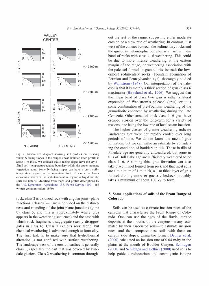
Fig. 7. Generalized diagram showing soil profiles on N-facing
versus S-facing slopes in the canyons near Boulder. Each profile is
about 1 m thick. We estimate that S-facing slopes have the cryic–
frigid soil– temperature-regime boundary within the upper montane
vegetation zone. Some N-facing slopes can have a cryic soil –
temperature regime to the mountain front; if warmer at lower
elevations, however, the soil – temperature regime is frigid and the
soils are Ustalfs. Modified from maps and profile descriptions by
the U.S. Department Agriculture, U.S. Forest Service (2001, and
written communication, 1999).
P.W. Birkeland et al. / Geomorphology 55 (2003) 329–344 339
rock; class 2 is oxidized rock with angular joint–plane
junctions. Classes 3–6 are subdivided on the distinct-
ness and rounding of the joint plane junctions (gone
by class 5, and this is approximately where grus
appears in the weathering sequence) and the ease with
which rock fragments disaggregate (easily disaggre-
gates in class 6). Class 7 exhibits rock fabric, but
chemical weathering is advanced enough to form clay.
The first task is to make sure that hydrothermal
alteration is not confused with surface weathering.
The landscape west of the erosion surface is generally
class 1, especially the part that was covered by Pine-
dale glaciers. Class 2 weathering is common through-
out the rest of the range, suggesting either moderate
erosion or a slow rate of weathering. In contrast, just
west of the contact between the sedimentary rocks and
the igneous–metamorphic complex is a narrow linear
band of rocks with class 4–6 weathering. This could
be due to more intense weathering at the eastern
margin of the range, or weathering association with
the paleosol formed in granodiorite beneath the low-
ermost sedimentary rocks (Fountain Formation of
Permian and Pennsylvanian age), thoroughly studied
by Wahlstrom (1948). Our interpretation of the pale-
osol is that it is mainly a thick section of grus (class 6
maximum) (Birkeland et al., 1996). We suggest that
the linear band of class 4–6 grus is either a lateral
expression of Wahlstrom’s paleosol (grus), or it is
some combination of pre-Fountain weathering of the
granodiorite enhanced by weathering during the Late
Cenozoic. Other areas of thick class 4–6 grus have
escaped erosion over the long-term for a variety of
reasons, one being the low rate of local steam incision.
The higher classes of granite weathering indicate
landscapes that were not rapidly eroded over long
periods of time. We do not know the rate of grus
formation, but we can make an estimate by consider-
ing the condition of boulders in tills. Those in tills of
Pinedale age are generally unweathered, but some in
tills of Bull Lake age are sufficiently weathered to be
class 4–6. Assuming this, grus formation can also
take place in soil formed from rock and that most soils
are a minimum of 1 m thick, a 1-m thick layer of grus
formed from granitic or gneissic bedrock probably
takes a minimum of about 100 ky to form.
8. Some applications of soils of the Front Range of
Colorado
Soils can be used to estimate incision rates of the
canyons that characterize the Front Range of Colo-
rado. One can use the ages of the fluvial terrace
deposits at the mouths of the canyons—many esti-
mated by their associated soils—to estimate incision
rates, and then compare these soils with those on
canyon side slopes. Using the former, Dethier et al.
(2000) calculated an incision rate of 0.04 m/ky in the
plains at the mouth of Boulder Canyon. Schildgen
(2000) and Schildgen and Dethier (2000) used soils to
help guide a radiocarbon and cosmogenic isotope

P.W. Birkeland et al. / Geomorphology 55 (2003) 329–344340
dating study within Boulder Canyon; they identified
deposits of Holocene, Pinedale, Bull Lake, and pre-
Bull Lake ages. At a major knickpoint within the
canyon, they calculate an incision rate of 0.15 m/ky.
The contrast between this higher rate and the much
lower rate determined in the plains might be due in
part to the upstream migration of the knickpoint or to
the durability of the bedrock at or near the knickpoint.
Most soils on side slopes in Boulder Canyon seem to
be fairly young, less than 20 ky. This seems fitting as
the side slopes are steep, cliffs are common, and of the
three streams here compared, Boulder Creek has the
highest discharge and was the most extensively gla-
ciated in its headwaters. The next major canyon to the
north, Left Hand, has an incision rate in the plains
near the mountain front of 0.05–0.1 m/ky (range in
values is due to which fluvial deposit is used as a
datum). In Left Hand Canyon, the headwaters were
not extensively glaciated, the canyon side slopes are
more gentle than those in Boulder Canyon, and soils
with Bt horizons on side slopes are more common. A
major canyon south of Boulder Canyon is the ungla-
ciated Coal Creek Canyon, where incision in the
plains at the mountain front is 0.006 m/ky. Soils on
the valley sides near the canyon mouth commonly
have red, clay-rich Bt horizons that suggest they
formed over several 100 ky (Birkeland et al., 1996).
Thus, soils on side slopes of the canyons correspond
with incision rates. Coal Creek has the lowest incision
rate and the oldest soils on side slopes. Boulder Creek
has a high incision rate and the youngest soils on side
slopes. The differences in the development of soils on
side slopes in Boulder Canyon and Left Hand Canyon
could be related to the higher discharge, more exten-
sive glacier activity, and knickpoint migration in the
former.
Veblen and Lorenz (1991) have documented the
great change in vegetation in the Front Range of
Colorado during the last century. Many of the changes
are associated with mining, and the logging and
burning that accompanied the mining. Many slopes
were extensively devegetated. Reconnaissance study
of road cuts along many mining roads in the moun-
tains via bicycle reveals neither widespread extensive
erosion (enough to remove the steady-state A horizons
that take several thousand years to form) nor deposi-
tion (buried soils) in these disturbed areas. These
observations suggest that the mountain slopes outside
of the heavily mined sites did not respond drastically
to perturbations caused by human activities.
Quaternary climate change can be deciphered in
some soils. Shroba and Birkeland (1983) note the
presence of vermiculite and a high degree of illite
(mica) weathering in soils now 100 m above tree line.
Because vermiculite is a forest indicator (Netoff,
1977; Shroba and Birkeland, 1983), these data suggest
a tree line higher than present sometime during the
Holocene. Organo-cutans are dark brown organic
stains that form on the undersides of stones in the
lower part of the B horizon and in the C horizon of
alpine soils that lack excessive snow cover (Burns,
1980; Benedict, 2000, Appendix B). Burns and
Davenport (1988) observe these stains in forested
soils at elevations as low as 2735 m, suggesting that
they formed in alpine soils during glacial-age low-
ering of upper tree line of greater than 700 m. This
interpretation is consistent with pollen data that sug-
gest 500–800 m of tree line lowering during the
Pinedale glaciation (Legg and Baker, 1980; Madole,
1986). Strongly developed E horizons that persist to
the mountain front might partly be a legacy of glacial
climates, and the intact profiles suggest little tree
throw. Finally, Btk horizons are common in the plains;
this mix of carbonate depletion and accumulation in
the same horizon might reflect leaching during glacial
climate and accumulation during interglacial climate,
respectively.
The rate of carbon accumulation and its storage in
soils are important issues in current biogeochemical
cycling studies. These trends are best studied by soil
chronosequence studies. Bockheim et al. (1998) have
taken data from our studies in the Front Range of
Colorado, the Wind River Range of Wyoming, and
the Southern Alps of New Zealand to make compa-
rative accumulation curves for alpine environments.
The New Zealand soils accumulate carbon faster and
reach higher levels of carbon content, and those of the
Front Range of Colorado rank higher on both
accounts than those of the Wind River Range. We
need more of these kinds of data for many other
environments, such as those for the forests of the
Front Range of Colorado.
Soil-profile development can be used to estimate
long-term (20–100 ky) rates of lowering of the
landscape (denudation). A/Bt/C profiles, such as
those associated with the erosion surface, are best

P.W. Birkeland et al. / Geomorphology 55 (2003) 329–344 341
for placing broad limits on rates of denudation. These
soils take about 100 ky to form and typically the base
of the Bt horizon is close to 1-m depth. Therefore, to
preserve such a profile, denudation had to be much
less than 1 m/100 ky (0.01 m/ky), and perhaps no
more than 0.1 m/100 ky (0.001 m/ky). Those small
areas of soils with red, clay-rich Bt horizons would
have an even lower rate of denudation. Comparing
the latter denudation rate for the erosion surface
(0.001 m/ky) with the incision rate of Boulder
Canyon mentioned earlier (0.04 m/ky) suggests that
relief in Boulder Canyon is increasing. The moun-
tains west of the erosion surface, outside of the areas
covered by Pinedale glaciers, are characterized by O
and (or) A/Bw/C and (or) R soil profiles. One
possible denudation scenario is that these soils
formed in the last 10–20 ky following sufficiently
rapid denudation during the Pinedale glaciation to
have removed the pre-existing soils. Assuming 1-m-
deep profiles, their preservation requires a denudation
rate much less than 0.05–0.1 m/ky, perhaps as low as
0.005–0.01 m/ky. This latter denudation rate is
greater that that estimated for areas characterized by
soils with A/Bt/C profiles because Bw horizons form
more rapidly than Bt horizons. The latter range
agrees with that calculated by Caine (1984; personal
communication in Thorne and Loewenherz, 1987) for
the tundra-covered Green Lakes Valley, just south of
Niwot Ridge.
Niwot Ridge is a broad, gently rolling ridge above
tree line, with a maximum elevation of about 3700 m.
It is characterized by A/Bw/C soil profiles (Burns and
Tonkin, 1982). Solifluction and frost creep have been
active in moving surficial materials downslope during
the Holocene (Benedict,1970). Bovis and Thorn
(1981) measured contemporary erosion on Niwot
Ridge and calculated denudation rates. If we extrap-
olate their rates over a longer time frame, the rate for
the tundra meadow would be 0.01 m/ky (1 m/100 ky),
and that for the dry meadow would be 0.1 m/ky (10
m/100 ky). These high values make us suspect that
these measured rates should not be extrapolated so far
back in time. The previous authors as well as Caine
(1974) used Benedict’s (1970) surface-material trans-
portation rates, most taken at sites that were quite
active, to calculate a denudation rate of 0.01m/ky (1
m/100 ky). All of these rates have problems associ-
ated with them, and one important thing is the
accumulation of wind-blown fines, which produce a
result opposite to that of denudation. In any case, over
long periods of time, the lower of the two rates above
would be compatible with the A/Bw/C soil profiles on
Niwot Ridge, but the higher rate could not have been
sustained for even 10 ky and allow preservation of the
soils.
The above rates of denudation for the mountains
west of the erosion surface (0.005–0.01 m/ky) and for
Niwot Ridge (0.01 m/ky) seem reasonable when
compared with other cosmogenic radionuclide erosion
rates in the nearby Front Range of Colorado. Small et
al. (1997) calculate rates for tors and a large boulder
of 0.007–0.008 m/ky. These dated features are on
summit surfaces above treeline, at 3,575–3,734 m.
The erosion rates for tors should be considered
minimal because they are an low, isolated features
on low-relief terrain. The above rates are lower that
those of Dethier et al. (2002) who determined 0.018–
0.030 m/ky for sediment removed from small (<50
km2), non-glaciated catchment basins on granitic and
gneissic bedrock in the northern Front Range of
Colorado and the Laramie and Medicine Bow Ranges
of southern Wyoming.
9. Summary
Soils reflect the geomorphic setting of the Front
Range of Colorado. The Front Range is an old range,
with canyons cut during the last 5 my. Glaciation
affected the western quarter or third of the range east
of the Continental Divide. MAP doubles from the
plains to the divide and MAT decreases 14 jC over
the same distance; these environmental differences
result in contrasts in soil profiles. Soil chronosequence
studies help identify surfaces and deposits that have
been stable during the Holocene, for about 20, 100,
and several 100 ky in the mountains, and for as long
as about 2 my in the plains. Compared to a tectoni-
cally active range, such as the Southern Alps of New
Zealand, soils in the Front Range of Colorado on
predominately transport-limited slopes indicate that
the latter is geomorphically quite stable, and most
similar to the drier parts of the Southern Alps. Future
work could concentrate on how soil-development
patterns relate to geomorphic activity with elevation
in the Front Range of Colorado (Caine, 1984). Appli-

P.W. Birkeland et al. / Geomorphology 55 (2003) 329–344342
cations of soils include (1) helping to estimate stream
incision rates in the canyons; (2) linking the latter to
soil patterns on canyon side slopes following the
model that Tonkin and Basher (1990) developed in
the Southern Alps of New Zealand; (3) assessing
landscape stability following disruption accompany-
ing mining; (4) assessing the effects of Quaternary
paleoclimate on the landscape as well as on soil
development; and (5) estimating long-term denuda-
tion rates.
Acknowledgements
Our understanding of various aspects of the soils
and geomorphology of the Front Range and Colorado
Piedmont was enhanced by conversations with many
individuals during the past decades. They include
W.W. Atkinson, J.B. Benedict, W.C. Bradley, Nel
Caine, D.P. Dethier, M.N. Machette, R.F. Madole,
Gergely Markos, D.I. Netoff, P.E. Patterson, and John
Pitlick. D.R. Muhs, A.R. Nelson, and John Pitlick
provided helpful reviews of previous versions of this
manuscript. M.A. Berger of the US Geological Survey
prepared digital copies of the figures. P.W. Birkeland’s
attendance at the 2001 Binghamton Symposium was
funded by a Bill Hiss Creativity Award granted by the
University of Colorado.
References
Barry, R.G., 1973. A climatological transect on the east slope of the
Front Range, Colorado. Arct. Alp. Res. 5, 89–110.
Benedict, J.B., 1970. Downslope soil movement in a Colorado
alpine region: rates, processes, and climatic significance. Arct.
Alp. Res. 2, 165–226.
Benedict, J.B., 1984. Rates of tree-island migration, Colorado
Rocky Mountains, USA. Ecology 27, 820–823.
Benedict, J.B., 1985. Arapaho Pass. Glacial geology and archeol-
ogy at the crest of the Colorado Front Range. Center for Moun-
tain Archeology, Research Report, 3. 197 pp.
Benedict, J.B., 2000. Game drives of the Devil’s Thumb Pass Area.
In: Cassells, E.S. (Ed.), This Land of Shining Mountains. Center
for Mountain Archeology, Research Report, 8, 18–94.
Berry, M.B., 1987. Morphological and chemical characteristics of
soil catenas on Pinedale and Bull Lake moraine slopes in the
Salmon River Mountains, Idaho. Quat. Res. 28, 210–225.
Birkeland, P.W., 1999. Soils and Geomorphology. Oxford Univ.
Press, New York. 430 pp.
Birkeland, P.W., Burke, R.M., Shroba, R.R., 1987. Holocene alpine
soils in gneissic deposits, Colorado Front Range. U.S. Geol.
Surv. Bull. 1590. 21 pp.
Birkeland, P.W., Miller, D.C., Patterson, P.E., Price, A.B., Shroba,
R.R., 1996. Soil-geomorphic relationships near Rocky Flats,
Boulder and Golden, with a stop at the pre-Fountain Formation
paleosol of Wahlstrom (1948). Colo. Geol. Surv., Spec. Publ.
(CD-ROM) 44. 13 pp.
Bockheim, J.G., Birkeland, P.W., Bland, W.L., 1998. Carbon stor-
age and accumulation rates in alpine soils: evidence from Hol-
ocene chronosequences. In: Lal, R., Kimble, J.M., Stewart, B.A.
(Eds.), Global Climate Change and Cold Regions Ecosystems.
Lewis Publishers, Boca Raton, pp. 185–196.
Bovis, M.J., Thorn, C.E., 1981. Soil loss variation within a Colo-
rado alpine area. Earth Surf. Processes Landf. 6, 151–163.
Braddock, W.A., Cole, J.C., 1990. Geologic map of Rocky Moun-
tain National Park and vicinity, Colorado. U.S. Geol. Surv.
Misc. Investigations Series Map I—1973.
Bradley, W.C., 1987. Erosion surfaces of the Colorado Front
Range: a review. In: Graf, W.L. (Ed.), Geomorphic Systems
of North America. Geol. Soc. Amer., Centennial Spec., vol. 2,
pp. 215–220.
Burns, S.F. 1980. Alpine soil distribution and development, Colo-
rado Front Range. PhD Dissertation, Univ. Colorado, Boulder.
360 pp.
Burns, S.F., Davenport, R.E., 1988. Using organo-cutans in subal-
pine soils as indicators of a past lower treeline. Amer. Quaternary
Assoc., 10th Biennial Meeting, Program and Abstracts, p. 57.
Burns, S.F., Tonkin, P.J., 1982. Soil geomorphic models and spatial
distribution and development of alpine soils. In: Thorn, C.E.
(Ed.), Space and Time in Geomorphology. Allen and Unwin,
London, pp. 25–43.
Caine, N., 1974. The geomorphic processes of the alpine environ-
ment. In: Ives, J.D., Barry, R.G. (Eds.), Arctic and Alpine En-
vironments. Methuen, London, pp. 721–748.
Caine, N., 1984. Elevational contrasts in contemporary geomorphic
activity in the Colorado Front Range. Stud. Geomorphol. Car-
patho-Balc. 18, 5–31.
Clayton, J.L., Megahan, W.F., Hampton, D., 1979. Soil and bedrock
properties: weathering and alteration products and processes in
the Idaho batholith. USDA For. Serv. Res. Pap. INT-237. 35 pp.
Davis, P.T., Birkeland, P.W., Caine, N., Rodbell, D.T., 1992. New
radiocarbon ages from cirques in Colorado Front Range. Geol.
Soc. Amer., Abstr. Programs 24 (7), A347.
Dethier, D.P., Schildgen, T.F., Bierman, P., Caffee, M., 2000. The
cosmogenic isotope record of late Pleistocene incision, Boulder
Canyon, Colorado. Geol. Soc. Amer., Abstr. Programs 32 (7),
A473.
Dethier, D.P., Ouimet, W., Bierman, P., Finkel, R.C., 2002. Long-
term erosion rates derived from 10Be in sediment from small
catchments, Northern Front Range and Southern Wyoming.
Geol. Soc. Amer., Abstr. Programs 34 (6).
Holtmeier, F., Broll, G., 1992. The influence of tree islands and
microtopography on pedoecological conditions in the forest –
alpine tundra ecotone on Niwot Ridge, Colorado Front Range,
USA. Arct. Alp. Res. 24, 216–228.
Jenny, H., 1980. The Soil Resource—Origin and Behavior. Springer,
New York. 377 pp.

P.W. Birkeland et al. / Geomorphology 55 (2003) 329–344 343
Lanphere, M.A., Champion, D.E., Christiansen, R.L., Izett, G.A.,
Obradovich, J.D., 2002. Revised ages for tuffs of the Yellow-
stone Plateau volcanic field: assignment of the Huckleberry
Ridge Tuff to a new geomagnetic polarity event. Geol. Soc.
Amer. Bull. 114, 559–568.
Legg, T.E., Baker, R.G., 1980. Palynology of Pinedale sediments,
Devlins Park, Boulder County, Colorado. Arct. Alp. Res. 12,
319–333.
Lovering, T.S., Goddard, E.N., 1950. Geology and ore deposits of
the Front Range, Colorado. U.S. Geol. Surv. Prof. Pap. 223.
319 pp.
Machette, M.N., 1975. The Quaternary geology of the Lafayette
Quadrangle, Colorado. Master’s thesis, Univ. Colorado, Boulder.
105 pp.
Machette, M.N., 1977. Geologic map of the Lafayette Quadrangle,
Adams, Boulder, and Jefferson Counties, Colorado. U.S. Geol.
Surv. Geologic Quadrangle Map GQ-1392.
Machette, M.N., 1985. Calcic soils of the southwestern United
States. Geol. Soc. Amer. Spec. Pap. 203, 1–21.
Machette, M.N., Birkeland, P.W., Markos, G., Guccione, M.J., 1976.
Soil development in Quaternary deposits in the Golden-Boulder
portion of the Colorado Piedmont. Prof. Contrib. Colo. Sch.
Mines (8), 217–259.
Madole, R.F., 1969. Pinedale and Bull Lake glaciations in upper St.
Vrain drainage basin, Boulder County, Colorado. Arct. Alp. Res.
1, 279–287.
Madole, R.F., 1986. Lake Devlin and Pinedale glacial history, Front
Range, Colorado. Quat. Res. 25, 43–54.
Madole, R.F., 1991. Colorado Piedmont section. In: Morrison, R.B.
(Ed.), Quaternary Nonglacial Geology: Conterminous United
States. Geol. Soc. Amer., The Geology of North America,
vol. K-2, pp. 456–462.
Madole, R.F., Shroba, R.R., 1979. Till sequence and soil develop-
ment in the North St. Vrain drainage basin, east slope, Front
Range, Colorado. In: Ethridge, F.G. (Ed.), Field Guide, North-
ern Front Range and Northwestern Denver Basin, Colorado.
Dept. Earth Resources, Colorado State University, Ft. Collins,
pp. 123–178.
Madole, R.F., VanSistine, D.P., Michael, J.A., 1998. Pleistocene
glaciation in the upper Platte River drainage basin, Colorado.
U.S. Geol. Surv. Geol. Investigations Series Map I—2644.
Mahaney, W.C., 1974. Soil stratigraphy and genesis of neoglacial
deposits in the Arapaho and Henderson cirques, central Colo-
rado Front Range. In: Mahaney, W.C. (Ed.), Quaternary Envi-
ronments. Atkinson College/York University Monograph No. 5,
Toronto, Canada, 197–240.
McMillan, M.E., 1990. Soil development on a subalpine Pinedale
moraine and erosion ten years after a burn, Rocky Mountain
National Park, Colorado. Master’s thesis, Univ. of Colorado,
Boulder. 91 pp.
Muhs, D.R., Benedict, J.B., Evans, J., 1992. Sources of probable
eolian sediments on late Quaternary alpine moraines, Colorado
Front Range—evidence from trace element geochemistry. Amer.
Quaternary Assoc., 12th Biennial Meeting, Program and Ab-
stracts, p. 73.
Muhs, D.R., Aleinikoff, J.N., Stafford Jr., T.W., Kihl, R., Been, J.,
Mahan, S.A., Cowherd, S., 1999. Late Quaternary loess in
northeastern Colorado: part I—age and paleoclimatic signifi-
cance. Geol. Soc. Amer. Bull. 111, 1861–1875.
Muhs, D.R., Simmons, K.R., Steinke, B., 2002. Timing and warmth
of the last interglacial period: new U-series evidence from Ha-
waii and Bermuda and a new fossil compilation for North Amer-
ica. Quat. Sci. Rev. 21, 1355–1383.
Nelson, A.R., Shroba, R.R., 1998. Soil relative dating of moraine
and outwash– terrace sequences in the northern part of the upper
Arkansas Valley, central Colorado, U.S.A. Arct. Alp. Res. 30,
349–361.
Netoff, D.I., 1997. Soil clay mineralogy of Quaternary deposits in
two Front Range–Piedmont transects, Colorado. PhD disserta-
tion, Univ. Colorado, Boulder. 169 pp.
Reheis, M.C., 1980. Loess sources and loessial soil changes in a
downwind transect, Boulder –Lafayette, Colorado. Mt. Geol.
17, 7–12.
Richmond, G.M., 1960. Glaciation of the east slope of Rocky
Mountain National Park, Colorado. Geol. Soc. Amer. Bull. 71,
1371–1382.
Richmond, G.M., 1962. Quaternary Stratigraphy of the La Sal
Mountains, Utah. U.S. Geol. Surv. Prof. Pap. 324. 135 pp.
Schildgen, T.F., 2000. Fire and Ice: The Geomorphic History of
Middle Boulder Creek as Determined by Isotopic Dating Tech-
niques, Colorado Front Range. Honors thesis, Williams College,
Williamstown, MA. 103 pp.
Schildgen, T.F., Dethier, D.P., 2000. Fire and ice: using isotopic
dating techniques to interpret the geomorphic history of Middle
Boulder Creek, Colorado. Geol. Soc. Amer., Abstr. Programs 32
(7), A-18.
Scott, G.R., Taylor, R.B., 1986. Map showing late Eocene erosion
surface, Oligocene–Miocene paleovalleys, and Tertiary depos-
its in the Pueblo, Denver, and Greeley 1� 2 quadrangles,
Colorado. U.S. Geol. Surv. Misc. Investigation Series Map
I—1626.
Shroba, R.R., Birkeland, P.W., 1983. Trends in late-Quaternary soil
development in the Rocky Mountains and Sierra Nevada of the
western United States. In: Porter, S.C. (Ed.), Late Quaternary
Environments of the United States. The Late Pleistocene, vol. 1.
Univ. Minnesota Press, Minneapolis, pp. 145–156.
Shroba, R.R., Carrara, P.E., 1996. Surficial geologic map of the
Rocky Flats Environmental Technology Site and vicinity, Jef-
ferson and Boulder Counties, Colorado. U.S. Geol. Surv. Misc.
Investigations Series Map I—2526.
Small, E.E., Anderson, R.S., Repka, J.L., Finkel, R., 1997. Erosion
rates of alpine bedrock summit surfaces deduced from in situ
10Be and 26Al. Earth and Planet. Sci. Lett. 150, 413–425.
Soil Classification Working Group, 1998. The Canadian System of
Soil Classification, 3rd ed. National Research Council Research
Press, Ottawa Publ. 1646. 187 pp.
Soil Survey Division Staff, 1993. Soil Survey Manual. U.S. Dept.
Agriculture Handbook, no. 18. 437 pp.
Soil Survey Staff, 1999. Soil Taxonomy, 2nd ed. U.S. Dept. Agri-
culture Handbook, no. 436. 869 pp.
Steven, T.A., Evanoff, E., Yuhas, R.H., 1997. Middle and late
Cenozoic tectonic and geomorphic development of the Front
Range of Colorado. In: Bolyard, D.W., Sonnenberg, S.A.
(Eds.), Geologic History of the Colorado Front Range. Rocky

P.W. Birkeland et al. / Geomorphology 55 (2003) 329–344344
Mountain Assoc. Geologists Guidebook, Field Trip no. 7,
115–124.
Thorne, C.E., Loewenherz, D.S., 1987. Alpine mass wasting in the
Indian Peaks area, Front Range, Colorado. In: Graf, W.L. (Ed.),
Geomorphic Systems of North America. Geol. Soc. Amer., Cen-
tennial Spec., vol. 2, pp. 238–247.
Tonkin, P.J., Basher, L.R., 1990. Soil-stratigraphic techniques in the
study of soil and landform evolution across the Southern Alps,
New Zealand. Geomorphology 3, 547–575.
Trimble, D.E., 1980. Cenozoic tectonic history of the Great Plains
contrasted with that of the Southern Rocky Mountains: a syn-
thesis. Mt. Geol. 17, 59–69.
Tweto, O., 1979. Geologic map of Colorado. U.S. Geol. Surv.
U.S. Department Agriculture, Soil Conservation Service, 1975.
General Soil Map—Colorado, Portland, Oregon.
U.S. Department Agriculture, U.S. Forest Service, 2001. Soil Sur-
vey of Roosevelt–Arapahoe National Forest, Colorado, Interim
Version [unpublished]. Forest Supervisor’s Office, U.S. Forest
Service, Ft. Collins, CO.
Veblen, T.T., Lorenz, D.C., 1991. The Colorado Front Range, A
Century of Ecological Change. Univ. Utah Press, Salt Lake City.
186 pp.
Wahlstrom, E.E., 1948. Pre-Fountain and recent weathering on
Flagstaff Mountain near Boulder, Colorado. Geol. Soc. Amer.
Bull. 59, 1173–1189.