Embed Size (px)
Citation preview
FLD016-02 1st pgs page 31
31
The Geological Society of AmericaField Guide 16
2010
Soils, geomorphology, landscape evolution, and land use in the Virginia Piedmont and Blue Ridge
W. Cullen SherwoodTony HartshornL. Scott Eaton
Department of Geology and Environmental Science, James Madison University, 800 S. Main Street, Harrisonburg, Virginia 22807, USA
ABSTRACT
The object of this fi eld trip is to examine the geology, landforms, soils, and land use in the eastern Blue Ridge and western Piedmont geologic provinces in Orange County in central Virginia. A complex mix of igneous, sedimentary, and metamorphic bedrocks, ranging in age from Mesoproterozoic to Triassic (possibly some Jurassic) underlie the area. Soils are equally varied with a total of 62 series mapped in Orange County alone. The area being relatively stable tectonically, landforms generally refl ect the resistance to weathering of the bedrock. Area landforms range from a low ridge over Catoctin greenstone to a gently rolling Triassic basin. Soils examined on the trip represent three orders: Ultisols, Alfi sols, and Inceptisols. Residual soils clearly refl ect the compositions of the parent rocks and saprolites are common. Map patterns of forested versus nonforested lands bear a striking resemblance to the distribution patterns of the different soil and bedrock types. Our work has shown that the vast majority of the land in central Virginia, even that forested today, shows evidence of past clearing and cultivation. However, the harsh demands of growing tobacco wore out the less fertile and more erodible soils by the mid-nineteenth century resulting in their abandonment and the subsequent regeneration of the vast tracts of hardwood forests we see today. Only the most productive soils remain in agriculture.
Sherwood, W.C., Hartshorn, T., and Eaton, L.S., 2010, Soils, geomorphology, landscape evolution, and land use in the Virginia Piedmont and Blue Ridge, in Fleeger, G.M., and Whitmeyer, S.J., eds., The Mid-Atlantic Shore to the Appalachian Highlands: Field Trip Guidebook for the 2010 Joint Meeting of the North-eastern and Southeastern GSA Sections: Geological Society of America Field Guide 16, p. 31–50, doi: 10.1130/2010.0016(02). For permission to copy, contact [email protected]. ©2010 The Geological Society of America. All rights reserved.
REGIONAL GEOLOGY
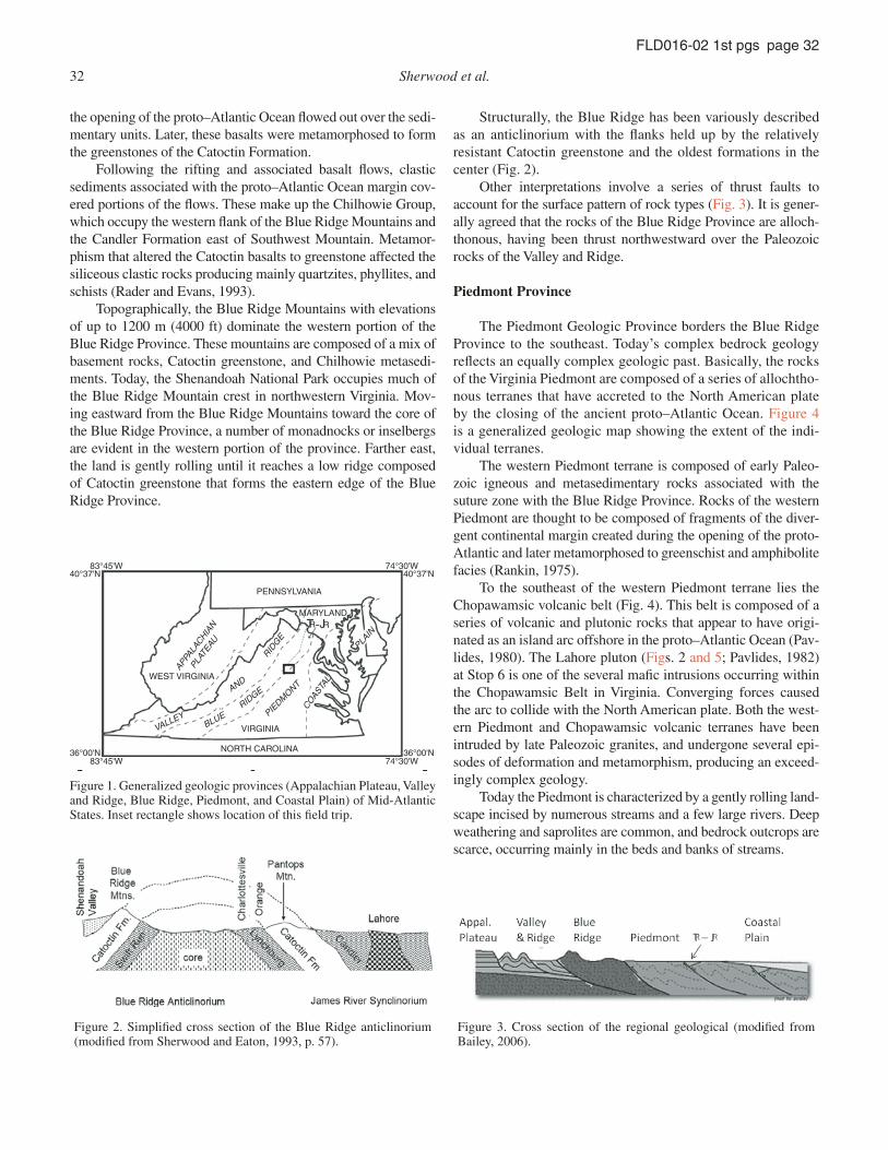
Virginia can be divided into fi ve geologic provinces (Fig. 1). Our trip will include portions of the Blue Ridge and Piedmont provinces in central Virginia.
Blue Ridge Province
The oldest rocks in Virginia are found in the Blue Ridge Province, a complex basement massif. The core of the massif
is composed of Mesoproterozoic crystalline rocks, some >1 Gy (Southworth et al., 2009). During the Grenvillian orogeny, gra-nitic intrusions and associated metamorphism affected the core. Moving outward from the core, rocks of Neoproterozoic age form the fl anks of the massif. Here a series of sedimentary rocks derived from the weathering of the core—ranging from alluvial conglomerates to marine shales—were deposited along with volcanic ash. These rocks make up the Swift Run Formation on the west side and the Lynchburg Group on the east side of the eroded core (Fig. 2). Subsequently, basalt fl ows associated with
32 Sherwood et al.
FLD016-02 1st pgs page 32
the opening of the proto–Atlantic Ocean fl owed out over the sedi-mentary units. Later, these basalts were metamorphosed to form the greenstones of the Catoctin Formation.
Following the rifting and associated basalt fl ows, clastic sediments associated with the proto–Atlantic Ocean margin cov-ered portions of the fl ows. These make up the Chilhowie Group, which occupy the western fl ank of the Blue Ridge Mountains and the Candler Formation east of Southwest Mountain. Metamor-phism that altered the Catoctin basalts to greenstone affected the siliceous clastic rocks producing mainly quartzites, phyllites, and schists (Rader and Evans, 1993).
Topographically, the Blue Ridge Mountains with elevations of up to 1200 m (4000 ft) dominate the western portion of the Blue Ridge Province. These mountains are composed of a mix of basement rocks, Catoctin greenstone, and Chilhowie metasedi-ments. Today, the Shenandoah National Park occupies much of the Blue Ridge Mountain crest in northwestern Virginia. Mov-ing eastward from the Blue Ridge Mountains toward the core of the Blue Ridge Province, a number of monadnocks or inselbergs are evident in the western portion of the province. Farther east, the land is gently rolling until it reaches a low ridge composed of Catoctin greenstone that forms the eastern edge of the Blue Ridge Province.
83°45'W
83°45'W
74°30'W
74°30'W
40°37'N 40°37'N
36°00'N36°00'N
PENNSYLVANIA
WEST VIRGINIA
VIRGINIA
APPA
LACHIA
N
PLAT
EAU
NORTH CAROLINA
MARYLAND
VALLEY
AND
RIDG
E
RIDGE
BLUE PIEDM
ONT
COAS
TAL
PLAIN
TR RJ-
Figure 1. Generalized geologic provinces (Appalachian Plateau, Valley and Ridge, Blue Ridge, Piedmont, and Coastal Plain) of Mid-Atlantic States. Inset rectangle shows location of this fi eld trip.
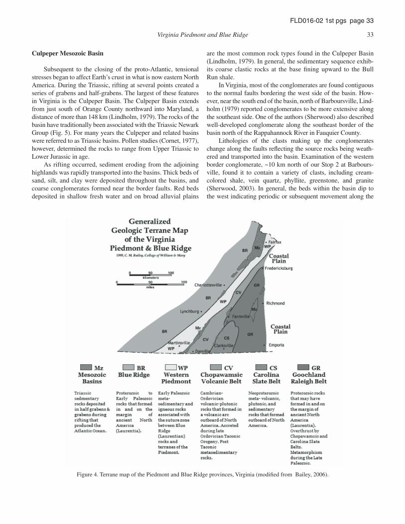
Figure 2. Simplifi ed cross section of the Blue Ridge anticlinorium (modifi ed from Sherwood and Eaton, 1993, p. 57).
Structurally, the Blue Ridge has been variously described as an anticlinorium with the fl anks held up by the relatively resistant Catoctin greenstone and the oldest formations in the center (Fig. 2).
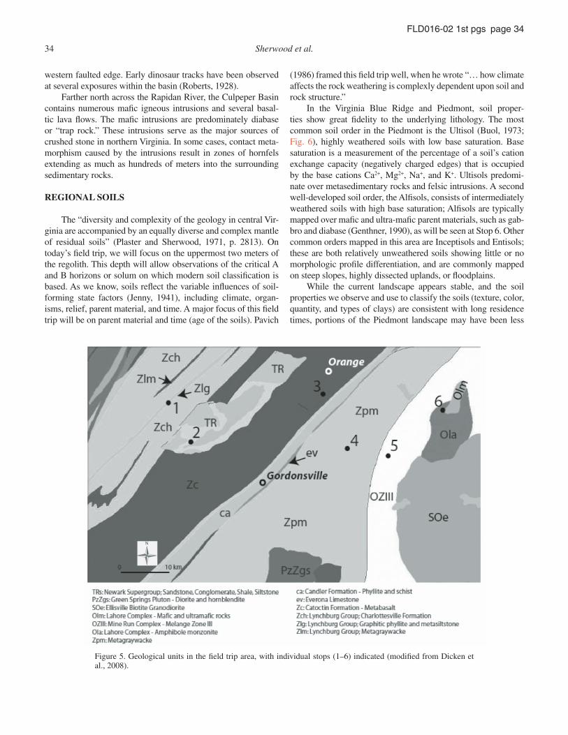
Other interpretations involve a series of thrust faults to account for the surface pattern of rock types (Fig. 3). It is gener-ally agreed that the rocks of the Blue Ridge Province are alloch-thonous, having been thrust northwestward over the Paleozoic rocks of the Valley and Ridge.
Piedmont Province
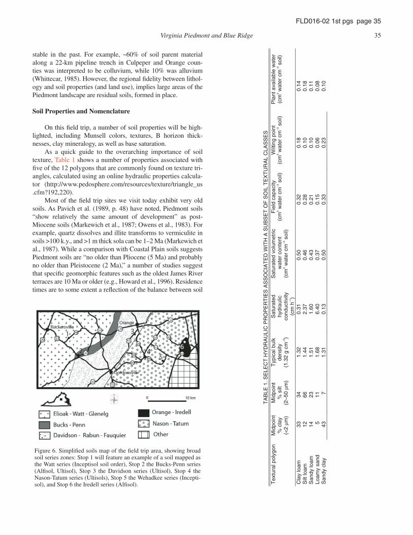
The Piedmont Geologic Province borders the Blue Ridge Province to the southeast. Today’s complex bedrock geology refl ects an equally complex geologic past. Basically, the rocks of the Virginia Piedmont are composed of a series of allochtho-nous terranes that have accreted to the North American plate by the closing of the ancient proto–Atlantic Ocean. Figure 4 is a generalized geologic map showing the extent of the indi-vidual terranes.
The western Piedmont terrane is composed of early Paleo-zoic igneous and metasedimentary rocks associated with the suture zone with the Blue Ridge Province. Rocks of the western Piedmont are thought to be composed of fragments of the diver-gent continental margin created during the opening of the proto-Atlantic and later metamorphosed to greenschist and amphibolite facies (Rankin, 1975).
To the southeast of the western Piedmont terrane lies the Chopawamsic volcanic belt (Fig. 4). This belt is composed of a series of volcanic and plutonic rocks that appear to have origi-nated as an island arc offshore in the proto–Atlantic Ocean (Pav-lides, 1980). The Lahore pluton (Figs. 2 and 5; Pavlides, 1982) at Stop 6 is one of the several mafi c intrusions occurring within the Chopawamsic Belt in Virginia. Converging forces caused the arc to collide with the North American plate. Both the west-ern Piedmont and Chopawamsic volcanic terranes have been intruded by late Paleozoic granites, and undergone several epi-sodes of deformation and metamorphism, producing an exceed-ingly complex geology.
Today the Piedmont is characterized by a gently rolling land-scape incised by numerous streams and a few large rivers. Deep weathering and saprolites are common, and bedrock outcrops are scarce, occurring mainly in the beds and banks of streams.
Figure 3. Cross section of the regional geological (modifi ed from Bailey, 2006).
Virginia Piedmont and Blue Ridge 33
FLD016-02 1st pgs page 33
Culpeper Mesozoic Basin
Subsequent to the closing of the proto-Atlantic, tensional stresses began to affect Earth’s crust in what is now eastern North America. During the Triassic, rifting at several points created a series of grabens and half-grabens. The largest of these features in Virginia is the Culpeper Basin. The Culpeper Basin extends from just south of Orange County northward into Maryland, a distance of more than 148 km (Lindholm, 1979). The rocks of the basin have traditionally been associated with the Triassic Newark Group (Fig. 5). For many years the Culpeper and related basins were referred to as Triassic basins. Pollen studies (Cornet, 1977), however, determined the rocks to range from Upper Triassic to Lower Jurassic in age.
As rifting occurred, sediment eroding from the adjoining highlands was rapidly transported into the basins. Thick beds of sand, silt, and clay were deposited throughout the basins, and coarse conglomerates formed near the border faults. Red beds deposited in shallow fresh water and on broad alluvial plains
are the most common rock types found in the Culpeper Basin (Lindholm, 1979). In general, the sedimentary sequence exhib-its coarse clastic rocks at the base fi ning upward to the Bull Run shale.
In Virginia, most of the conglomerates are found contiguous to the normal faults bordering the west side of the basin. How-ever, near the south end of the basin, north of Barboursville, Lind-holm (1979) reported conglomerates to be more extensive along the southeast side. One of the authors (Sherwood) also described well-developed conglomerate along the southeast border of the basin north of the Rappahannock River in Fauquier County.
Lithologies of the clasts making up the conglomerates change along the faults refl ecting the source rocks being weath-ered and transported into the basin. Examination of the western border conglomerate, ~10 km north of our Stop 2 at Barbours-ville, found it to contain a variety of clasts, including cream- colored shale, vein quartz, phyllite, greenstone, and granite (Sherwood, 2003). In general, the beds within the basin dip to the west indicating periodic or subsequent movement along the
Figure 4. Terrane map of the Piedmont and Blue Ridge provinces, Virginia (modifi ed from Bailey, 2006).
34 Sherwood et al.
FLD016-02 1st pgs page 34
western faulted edge. Early dinosaur tracks have been observed at several exposures within the basin (Roberts, 1928).
Farther north across the Rapidan River, the Culpeper Basin contains numerous mafi c igneous intrusions and several basal-tic lava fl ows. The mafi c intrusions are predominately diabase or “trap rock.” These intrusions serve as the major sources of crushed stone in northern Virginia. In some cases, contact meta-morphism caused by the intrusions result in zones of hornfels extending as much as hundreds of meters into the surrounding sedimentary rocks.
REGIONAL SOILS
The “diversity and complexity of the geology in central Vir-ginia are accompanied by an equally diverse and complex mantle of residual soils” (Plaster and Sherwood, 1971, p. 2813). On today’s fi eld trip, we will focus on the uppermost two meters of the regolith. This depth will allow observations of the critical A and B horizons or solum on which modern soil classifi cation is based. As we know, soils refl ect the variable infl uences of soil-forming state factors (Jenny, 1941), including climate, organ-isms, relief, parent material, and time. A major focus of this fi eld trip will be on parent material and time (age of the soils). Pavich
(1986) framed this fi eld trip well, when he wrote “… how climate affects the rock weathering is complexly dependent upon soil and rock structure.”
In the Virginia Blue Ridge and Piedmont, soil proper-ties show great fi delity to the underlying lithology. The most common soil order in the Piedmont is the Ultisol (Buol, 1973; Fig. 6), highly weathered soils with low base saturation. Base saturation is a measurement of the percentage of a soil’s cation exchange capacity (negatively charged edges) that is occupied by the base cations Ca2+, Mg2+, Na+, and K+. Ultisols predomi-nate over metasedimentary rocks and felsic intrusions. A second well-developed soil order, the Alfi sols, consists of intermediately weathered soils with high base saturation; Alfi sols are typically mapped over mafi c and ultra-mafi c parent materials, such as gab-bro and diabase (Genthner, 1990), as will be seen at Stop 6. Other common orders mapped in this area are Inceptisols and Entisols; these are both relatively unweathered soils showing little or no morphologic profi le differentiation, and are commonly mapped on steep slopes, highly dissected uplands, or fl oodplains.
While the current landscape appears stable, and the soil properties we observe and use to classify the soils (texture, color, quantity, and types of clays) are consistent with long residence times, portions of the Piedmont landscape may have been less
Figure 5. Geological units in the fi eld trip area, with individual stops (1–6) indicated (modifi ed from Dicken et al., 2008).
Virginia Piedmont and Blue Ridge 35
FLD016-02 1st pgs page 35
stable in the past. For example, ~60% of soil parent material along a 22-km pipeline trench in Culpeper and Orange coun-ties was interpreted to be colluvium, while 10% was alluvium (Whittecar, 1985). However, the regional fi delity between lithol-ogy and soil properties (and land use), implies large areas of the Piedmont landscape are residual soils, formed in place.
Soil Properties and Nomenclature
On this fi eld trip, a number of soil properties will be high-lighted, including Munsell colors, textures, B horizon thick-nesses, clay mineralogy, as well as base saturation.
As a quick guide to the overarching importance of soil texture, Table 1 shows a number of properties associated with fi ve of the 12 polygons that are commonly found on texture tri-angles, calculated using an online hydraulic properties calcula-tor (http://www.pedosphere.com/resources/texture/triangle_us.cfm?192,220).
Most of the fi eld trip sites we visit today exhibit very old soils. As Pavich et al. (1989, p. 48) have noted, Piedmont soils “show relatively the same amount of development” as post-Miocene soils (Markewich et al., 1987; Owens et al., 1983). For example, quartz dissolves and illite transforms to vermiculite in soils >100 k.y., and >1 m thick sola can be 1–2 Ma (Markewich et al., 1987). While a comparison with Coastal Plain soils suggests Piedmont soils are “no older than Pliocene (5 Ma) and probably no older than Pleistocene (2 Ma),” a number of studies suggest that specifi c geomorphic features such as the oldest James River terraces are 10 Ma or older (e.g., Howard et al., 1996). Residence times are to some extent a refl ection of the balance between soil
Figure 6. Simplifi ed soils map of the fi eld trip area, showing broad soil series zones: Stop 1 will feature an example of a soil mapped as the Watt series (Inceptisol soil order), Stop 2 the Bucks-Penn series (Alfi sol, Ultisol), Stop 3 the Davidson series (Ultisol), Stop 4 the Nason-Tatum series (Ultisols), Stop 5 the Wehadkee series (Incepti-sol), and Stop 6 the Iredell series (Alfi sol).
TA
BLE
1. S
ELE
CT
HY
DR
AU
LIC
PR
OP
ER
TIE
S A
SS
OC
IAT
ED
WIT
H A
SU
BS
ET
OF
SO
IL T
EX
TU
RA
L C
LAS
SE
S
Tex
tura
l pol
ygon
M
idpo
int
% c
lay
(<2
μm)
Mid
poin
t %
silt
(2
–50
μm)
Typ
ical
bul
k de
nsity
(1
.32
g cm
–3)
Sat
urat
ed
hydr
aulic
co
nduc
tivity
(c
m h
–1)
Sat
urat
ed v
olum
etric
wat
er c
onte
nt
(cm
3 wat
er c
m–3
soi
l)
Fie
ld c
apac
ity
(cm
3 wat
er c
m–3
soi
l) W
iltin
g po
int
(cm
3 wat
er c
m–3
soi
l) P
lant
ava
ilabl
e w
ater
(c
m3 w
ater
cm
–3 s
oil)
Cla
y lo
am
33
34
1.32
0.
31
0.50
0.
32
0.18
0.
14
Silt
loam
12
66
1.
44
2.37
0.
46
0.28
0.
10
0.18
S
andy
loam
14
23
1.
51
1.60
0.
43
0.21
0.
10
0.11
Lo
amy
sand
5
11
1.68
6.
40
0.37
0.
15
0.06
0.
08
San
dy c
lay
43
7 1.
31
0.13
0.
50
0.33
0.
23
0.10
36 Sherwood et al.
FLD016-02 1st pgs page 36
production rates and total denudation (physical erosion + chemi-cal weathering) rates. However, the quantifi cation of these rates is not by any means straightforward.
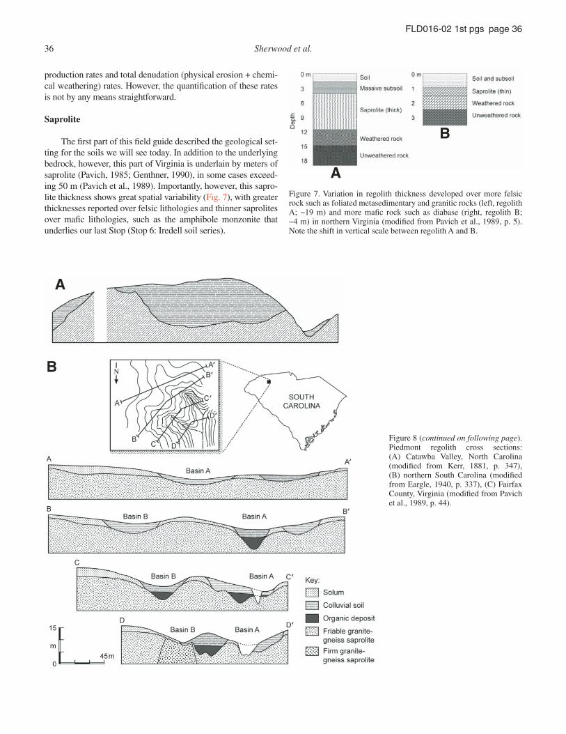
Saprolite
The fi rst part of this fi eld guide described the geological set-ting for the soils we will see today. In addition to the underlying bedrock, however, this part of Virginia is underlain by meters of saprolite (Pavich, 1985; Genthner, 1990), in some cases exceed-ing 50 m (Pavich et al., 1989). Importantly, however, this sapro-lite thickness shows great spatial variability (Fig. 7), with greater thicknesses reported over felsic lithologies and thinner saprolites over mafi c lithologies, such as the amphibole monzonite that underlies our last Stop (Stop 6: Iredell soil series).
A
B
Figure 7. Variation in regolith thickness developed over more felsic rock such as foliated metasedimentary and granitic rocks (left, regolith A; ~19 m) and more mafi c rock such as diabase (right, regolith B; ~4 m) in northern Virginia (modifi ed from Pavich et al., 1989, p. 5). Note the shift in vertical scale between regolith A and B.
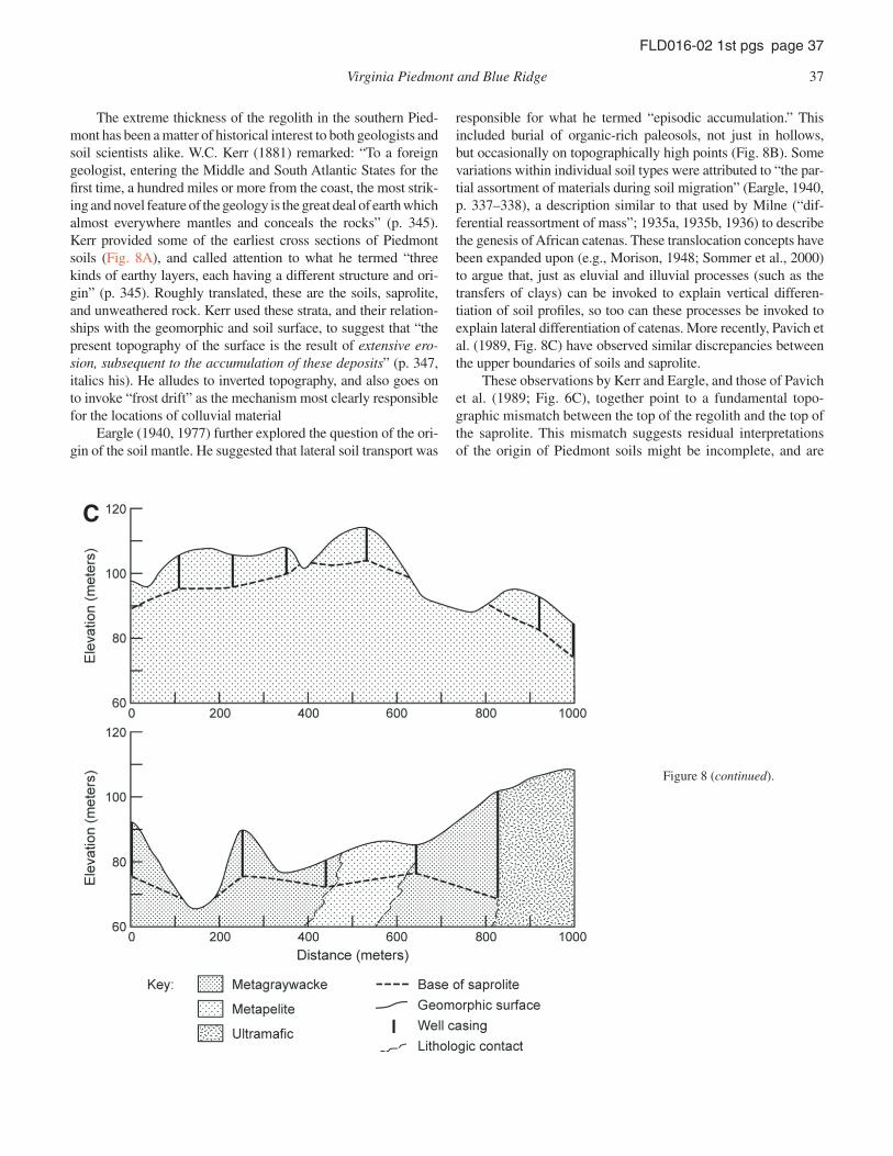
A
B
Figure 8 (continued on following page). Piedmont regolith cross sections: (A) Catawba Valley, North Carolina (modifi ed from Kerr, 1881, p. 347), (B) northern South Carolina (modifi ed from Eargle, 1940, p. 337), (C) Fairfax County, Virginia (modifi ed from Pavich et al., 1989, p. 44).
Virginia Piedmont and Blue Ridge 37
FLD016-02 1st pgs page 37
The extreme thickness of the regolith in the southern Pied-mont has been a matter of historical interest to both geologists and soil scientists alike. W.C. Kerr (1881) remarked: “To a foreign geologist, entering the Middle and South Atlantic States for the fi rst time, a hundred miles or more from the coast, the most strik-ing and novel feature of the geology is the great deal of earth which almost everywhere mantles and conceals the rocks” (p. 345). Kerr provided some of the earliest cross sections of Piedmont soils (Fig. 8A), and called attention to what he termed “three kinds of earthy layers, each having a different structure and ori-gin” (p. 345). Roughly translated, these are the soils, saprolite, and unweathered rock. Kerr used these strata, and their relation-ships with the geomorphic and soil surface, to suggest that “the present topography of the surface is the result of extensive ero-sion, subsequent to the accumulation of these deposits” (p. 347, italics his). He alludes to inverted topography, and also goes on to invoke “frost drift” as the mechanism most clearly responsible for the locations of colluvial material
Eargle (1940, 1977) further explored the question of the ori-gin of the soil mantle. He suggested that lateral soil transport was
responsible for what he termed “episodic accumulation.” This included burial of organic-rich paleosols, not just in hollows, but occasionally on topographically high points (Fig. 8B). Some variations within individual soil types were attributed to “the par-tial assortment of materials during soil migration” (Eargle, 1940, p. 337–338), a description similar to that used by Milne (“dif-ferential reassortment of mass”; 1935a, 1935b, 1936) to describe the genesis of African catenas. These translocation concepts have been expanded upon (e.g., Morison, 1948; Sommer et al., 2000) to argue that, just as eluvial and illuvial processes (such as the transfers of clays) can be invoked to explain vertical differen-tiation of soil profi les, so too can these processes be invoked to explain lateral differentiation of catenas. More recently, Pavich et al. (1989, Fig. 8C) have observed similar discrepancies between the upper boundaries of soils and saprolite.
These observations by Kerr and Eargle, and those of Pavich et al. (1989; Fig. 6C), together point to a fundamental topo-graphic mismatch between the top of the regolith and the top of the saprolite. This mismatch suggests residual interpretations of the origin of Piedmont soils might be incomplete, and are
C
Figure 8 (continued).
38 Sherwood et al.
FLD016-02 1st pgs page 38
consistent with the ideas that parent material has been translo-cated and that topographic inversion has occurred in many areas of the Piedmont.
Systematic differences in saprolite thickness across the Piedmont can be traced to the underlying lithologies, because “despite the mass loss due to dissolution of less resistant miner-als (such as plagioclase and biotite), the quartz and muscovite remain relatively unaltered, and grain-to-grain contacts of mus-covite retain structural integrity” (Pavich et al., 1989). Thus, the prolonged and intense chemical weathering of felsic materials leads to the formation of a quartz- and/or muscovite-rich skel-eton that allows for continued solutional (“plasma” sensu Pédro, 1983) losses, leading to great saprolite thicknesses. Weathering of mafi c materials, by contrast, produces collapse of the profi le, yielding much thinner saprolites.
In a study of the Maryland Piedmont, Costa and Cleaves (1984) suggested saprolite thickness refl ected parent material mineralogy and degree of metamorphism. They also suggested the mineralogy of the saprolite refl ected landscape setting: kaolinite and quartz dominated drier, upland portions of catenas, whereas kaolinite, quartz, and smectites dominated wetter, lower portions of catenas.
The Piedmont, while upstream of a passive margin, is not tectonically quiescent. Tertiary marine formations such as the Miocene Calvert Formation now lie as much as 150 m above sea level, implying uplift of 20 m/m.y. (Darton, 1951). Further-more, fall line compressional faults have thrust crystalline rocks over younger sedimentary rocks, and these faults have been active during the Cenozoic (Mixon and Newell, 1977; Prowell, 1976). Long-term lowering of the Potomac Valley (~15 m/ m.y.) through the Piedmont has been suggested to refl ect a combina-tion of “slow fl exural uplift of the Atlantic margin from offshore sediment unloading, isostatic response to denudation, and pro-tracted late Cenozoic sea-level fall” (Reusser et al., 2004, p. 499). Genthner (1990) has suggested that the eastern Blue Ridge and Piedmont’s rolling hillslopes led Hack (1960) and Pavich (1986) to believe they represent an equilibrium landscape: erosion rates appear to be matching long, slow uplift rates.
FIELD TRIP ITINERARY
This fi eld guide will emphasize U.S. soil taxonomic clas-sifi cations instead of, for example, World Reference Base clas-sifi cations (the WRB is successor to the Food and Agriculture Organization’s classifi cation system), because the U.S. system names have, in our opinion, a higher information density. And it is worth remembering Lewis Carroll’s (1871) thinly veiled expla-nation for why we classify soils:
“What’s the use of their having names,” the Gnat said, “if they won’t answer to them?”
“No use to them,” said Alice, “but it’s useful to the people that name them, I suppose. If not, why do things have names at all?”
Introduction
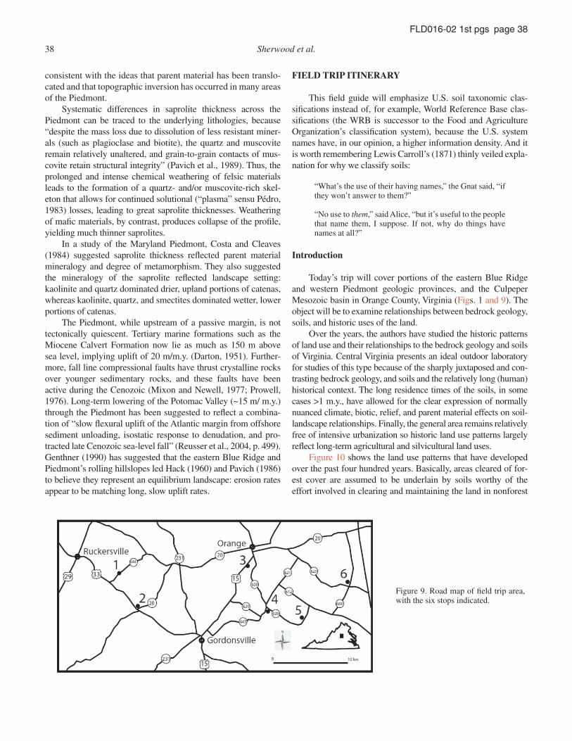
Today’s trip will cover portions of the eastern Blue Ridge and western Piedmont geologic provinces, and the Culpeper Mesozoic basin in Orange County, Virginia (Figs. 1 and 9). The object will be to examine relationships between bedrock geology, soils, and historic uses of the land.
Over the years, the authors have studied the historic patterns of land use and their relationships to the bedrock geology and soils of Virginia. Central Virginia presents an ideal outdoor laboratory for studies of this type because of the sharply juxtaposed and con-trasting bedrock geology, and soils and the relatively long (human) historical context. The long residence times of the soils, in some cases >1 m.y., have allowed for the clear expression of normally nuanced climate, biotic, relief, and parent material effects on soil-landscape relationships. Finally, the general area remains relatively free of intensive urbanization so historic land use patterns largely refl ect long-term agricultural and silvicultural land uses.
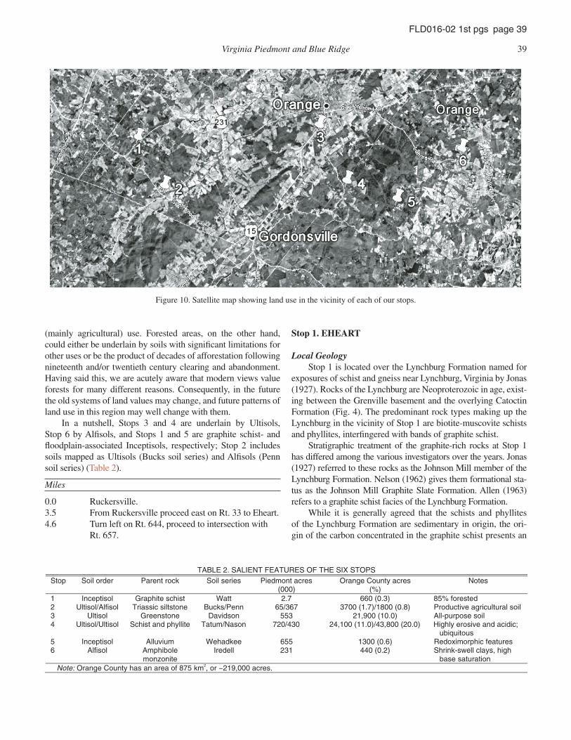
Figure 10 shows the land use patterns that have developed over the past four hundred years. Basically, areas cleared of for-est cover are assumed to be underlain by soils worthy of the effort involved in clearing and maintaining the land in nonforest
Figure 9. Road map of fi eld trip area, with the six stops indicated.
Virginia Piedmont and Blue Ridge 39
FLD016-02 1st pgs page 39
(mainly agricultural) use. Forested areas, on the other hand, could either be underlain by soils with signifi cant limitations for other uses or be the product of decades of afforestation following nineteenth and/or twentieth century clearing and abandonment. Having said this, we are acutely aware that modern views value forests for many different reasons. Consequently, in the future the old systems of land values may change, and future patterns of land use in this region may well change with them.
In a nutshell, Stops 3 and 4 are underlain by Ultisols, Stop 6 by Alfi sols, and Stops 1 and 5 are graphite schist- and fl oodplain-associated Inceptisols, respectively; Stop 2 includes soils mapped as Ultisols (Bucks soil series) and Alfi sols (Penn soil series) (Table 2).
Miles
0.0 Ruckersville.3.5 From Ruckersville proceed east on Rt. 33 to Eheart.4.6 Turn left on Rt. 644, proceed to intersection with
Rt. 657.
Stop 1. EHEART
Local GeologyStop 1 is located over the Lynchburg Formation named for
exposures of schist and gneiss near Lynchburg, Virginia by Jonas (1927). Rocks of the Lynchburg are Neoproterozoic in age, exist-ing between the Grenville basement and the overlying Catoctin Formation (Fig. 4). The predominant rock types making up the Lynchburg in the vicinity of Stop 1 are biotite-muscovite schists and phyllites, interfi ngered with bands of graphite schist.
Stratigraphic treatment of the graphite-rich rocks at Stop 1 has differed among the various investigators over the years. Jonas (1927) referred to these rocks as the Johnson Mill member of the Lynchburg Formation. Nelson (1962) gives them formational sta-tus as the Johnson Mill Graphite Slate Formation. Allen (1963) refers to a graphite schist facies of the Lynchburg Formation.
While it is generally agreed that the schists and phyllites of the Lynchburg Formation are sedimentary in origin, the ori-gin of the carbon concentrated in the graphite schist presents an
Figure 10. Satellite map showing land use in the vicinity of each of our stops.
TABLE 2. SALIENT FEATURES OF THE SIX STOPS
Stop Soil order Parent rock Soil series Piedmont acres (000)
Orange County acres (%)
Notes
1 Inceptisol Graphite schist Watt 2.7 660 (0.3) 85% forested 2 Ultisol/Alfisol Triassic siltstone Bucks/Penn 65/367 3700 (1.7)/1800 (0.8) Productive agricultural soil 3 Ultisol Greenstone Davidson 553 21,900 (10.0) All-purpose soil 4 Ultisol/Ultisol Schist and phyllite Tatum/Nason 720/430 24,100 (11.0)/43,800 (20.0) Highly erosive and acidic;
ubiquitous 5 Inceptisol Alluvium Wehadkee 655 1300 (0.6) Redoximorphic features 6 Alfisol Amphibole
monzonite Iredell 231 440 (0.2) Shrink-swell clays, high
base saturation Note: Orange County has an area of 875 km2, or ~219,000 acres.
40 Sherwood et al.
FLD016-02 1st pgs page 40
intriguing question. A search of the existing literature resulted in no evidence that this topic has been addressed in a systematic way. Rumors have circulated for many years to the effect that the rocks contained ~8% graphite and mining had been considered at one time.
SoilsHere we will observe a soil mapped as part of the Watt soil
series, also formally known as (“afka”) a loamy-skeletal, mixed, semiactive, mesic Typic Dystrudept, meaning (U.S. soil taxo-nomic classifi cations are read from right to left, and the formative elements of the subgroup are in italics).Order→Inceptisol (weakly developed, “infantile” soil) Suborder→Udept (udic soil moisture regime: wetter than ustic [semiarid grasslands or savannas], drier than peru dic [precipitation exceeds evapotranspiration in every month of the year]) Great group→Dystrudept (low base saturation) Subgroup→Typic Dystrupdept (insuffi ciently dis tinguished [morphologically or chemically] to merit classifi cation as another subgroup).
Watt (A) horizons are typically dark-gray (5Y 2/1), chan-nery silt loams, dominated by graphitic schist fragments, and can be extremely acid with very low base saturation. Watt soils are commonly mapped over rocks with traces of sulfi des, which results in very low pH values. Watt B horizons are thin, show an increase in rock fragments with depth, and bedrock is typically within 0.5–1 m of the surface. Because of the dark parent material, “in most places, the C horizon is darker colored than the solum” (Offi cial Series Description, Natural Resources Conservation Ser-vice [NRCS]). The areal extent of Watt soils was derived with an online Soil Extent Mapping Tool (link [e.g., http://www.cei.psu.edu/soiltool/semtool.html?seriesname = WATT] at the offi cial series description web site): Watt soils cover 2700 acres across the Piedmont, and 745 acres (0.3%) across Orange County.
The Watt soil we will examine is interfi ngered at a very fi ne spatial scale with the Glenelg soil series, afka fi ne-loamy,
mixed, semiactive, mesic Typic Hapludults (Table 3). From the offi cial Glenelg series description: “Depth to bedrock is 2–3 m or more. Rock fragments range from 0 to 35% throughout the solum and 5–55% in the C horizon. Fragments are mostly hard white quartz or schist and range from gravel or channers to stones in size. Stone content ranges from 0 to 5%. Mica content increases sharply in the lower part of the solum and substratum. Unlimited reaction ranges from very strongly acid to slightly acid.”
Land UseDue to its shallow depth to bedrock, high acidity (pH <5),
and low organic matter content, the Watt series exhibits severe limitations for most land uses. In Orange County, over 80% of the Watt remains in forest cover (see Fig. 10). Even the quality of the forests is generally poor. Acid-tolerant tree species such as chestnut oak, hickory, and maple predominate, but growth rates are slow. The understory contains dogwood and wild blueberries. The Orange County Soil Survey notes the best trees to plant on Watt soils for pulp wood or timber production are loblolly and short leaf pines.
Use of the Watt soil for agriculture in Virginia is almost nonexistent and is generally not recommended. All of the char-acteristics noted above plus excessive drainage create poor con-ditions for crops and even hay or pasture. U.S. Department of Agriculture (USDA) tables (Carter et al., 1971) for the Watt do not even list expected yields for the principal grains and hay, and rate its use for pasture as lowest of the 63 soils mapped in Orange County (U.S. Department of Agriculture, 1971).
Potential for development also has the Watt series receiving low ratings. The principal limitation is the shallow depth which makes it unsuitable for common on-site sewage disposal systems that use septic tanks and drain fi elds. Alternative systems can be used but are expensive and require a high level of maintenance. Watt soils can also present signifi cant engineering problems, such as the necessity for blasting during excavations for founda-tions, deep ditches, or road cuts. They also provide inadequate fi ll material and exhibit poor compactibility.
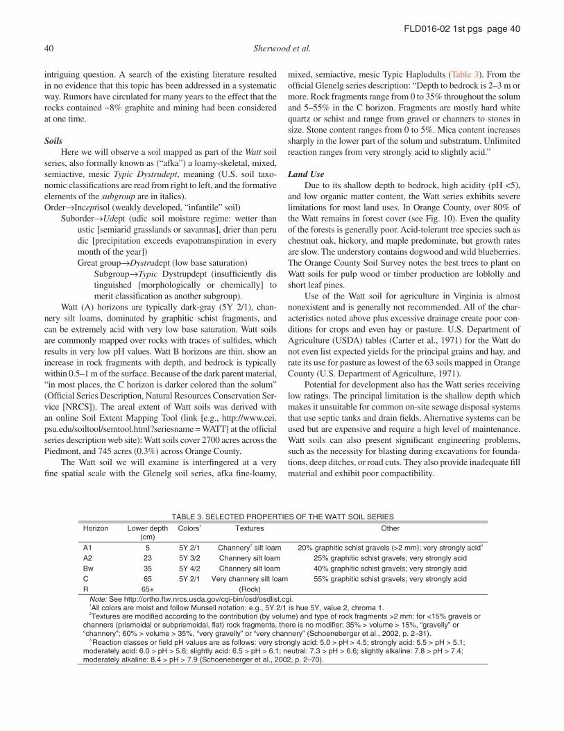
TABLE 3. SELECTED PROPERTIES OF THE WATT SOIL SERIES
Horizon Lower depth (cm)
Colors1 rehtO serutxeT
A1 5 5Y 2/1 Channery2 silt loam 20% graphitic schist gravels (>2 mm); very strongly acid3 A2 23 5Y 3/2 Channery silt loam 25% graphitic schist gravels; very strongly acid Bw 35 5Y 4/2 Channery silt loam 40% graphitic schist gravels; very strongly acid C 65 5Y 2/1 Very channery silt loam 55% graphitic schist gravels; very strongly acid
)kcoR( +56 R Note: See http://ortho.ftw.nrcs.usda.gov/cgi-bin/osd/osdlist.cgi. 1All colors are moist and follow Munsell notation: e.g., 5Y 2/1 is hue 5Y, value 2, chroma 1. 2Textures are modified according to the contribution (by volume) and type of rock fragments >2 mm: for <15% gravels or channers (prismoidal or subprismoidal, flat) rock fragments, there is no modifier; 35% > volume > 15%, “gravelly” or “channery”; 60% > volume > 35%, “very gravelly” or “very channery” (Schoeneberger et al., 2002, p. 2–31). 3 Reaction classes or field pH values are as follows: very strongly acid: 5.0 > pH > 4.5; strongly acid: 5.5 > pH > 5.1; moderately acid: 6.0 > pH > 5.6; slightly acid: 6.5 > pH > 6.1; neutral: 7.3 > pH > 6.6; slightly alkaline: 7.8 > pH > 7.4; moderately alkaline: 8.4 > pH > 7.9 (Schoeneberger et al., 2002, p. 2–70).
Virginia Piedmont and Blue Ridge 41
FLD016-02 1st pgs page 41
Miles
6.2 From Stop 1, proceed east on Rt. 657 to left on Rt. 33.
8.0 Barboursville intersection of Rt. 33 and Rt. 20.
Stop 2. BARBOURSVILLE
Local GeologyStop 2 places us at the far south end of the Culpeper Meso-
zoic basin described earlier under Regional Geology. For many years the basin was thought to be continuous to a point just south of Barboursville, where it ends at a transverse fault. More recent investigations, however, have uncovered a distinct break in the basin ~13 km north of Stop 2, just west of Orange Court House. Whether this relatively small area, separate from the main basin, will continue to be considered as a part of the Culpeper Basin or will assume a new name in the future has not been determined at this writing.
The rocks underlying Stop 2 are known as the Bull Run shale (Roberts, 1928) or Bull Run Formation (Lindholm, 1979). They exhibit the characteristic color of most sedimentary rocks found in the Mesozoic basins throughout the eastern states. It has been variously described as red, pinkish-red, or pinkish purple and, once seen, the color can be recognized instantly. Lithologically, the rocks at Stop 2 are predominately shales and siltstones. Fresh and even slightly weathered exposures exhibit white specks of plagioclase feldspar, and desiccation cracks are common. Early dinosaur tracks have been found at a number of exposures farther north within the basin.
SoilsJust north of the intersection of Rt. 20 and Rt. 33, we will
meet soils that have been mapped as part of the Penn and Bucks soil series (Table 4). Penn soils are afka fi ne-loamy, mixed, super-active, mesic Ultic Hapludalfs.
Order→Alfisol (clay-rich, high base saturation) Suborder→Udalf (udic soil moisture regime) Great group→Hapludalf (insuffi ciently distinguished [morphologically or chemically] to merit classifi cation as another great group) Subgroup→Ultic Hapludalf (suffi ciently leached that base saturation is lower than for a Typic Hapludalf).
Penn surface horizons are dark reddish brown (5YR 3/3), silt loams, and have relatively low base saturation. Subsurface hori-zons show increases in gravels (>2 mm) or channers, as well as a pronounced color shift to redder hues (2.5YR 4/4) that refl ect the underlying parent material, often reddish shale, siltstone, or fi ne-grained sandstone of Triassic–Jurassic age (145–250 m.y. B.P.). Penn soils are closely related to the Bucks soil series, differing primarily in terms of depth to bedrock (Penn <1 m) and base saturation (Penn > Bucks). (Bucks soils are afka as fi ne-loamy, mixed, active, mesic Typic Hapludults.)
Across the Piedmont, Penn soils cover 367,000 acres, while the Bucks soils cover 65,000 acres; across Orange County, Penn soils comprise 1800 acres (0.8%), while Bucks soils comprise 3700 acres (1.7%) (U.S. Department of Agriculture, 1971).
Land UseSoils of the Bucks and Penn series are the most commonly
mapped units within the Mesozoic basins of Virginia. They are also among the most productive soils and often occur together in close proximity on the landscape. Although the Orange County Soil Survey maps Stop 2 as Bucks, our experience has shown that we may well encounter Penn.
Both Bucks and Penn soils are intensively farmed through-out the rural portions of the Culpeper Basin. The land use pattern in Figure 9 clearly shows the preponderance of clear land in a band extending to the northeast from Stop 2. Several soil attri-butes account for this intensive utilization.
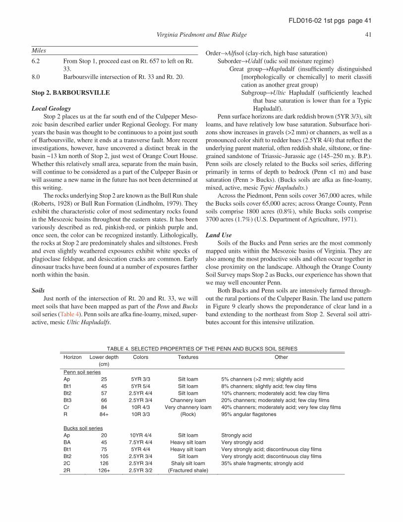
TABLE 4. SELECTED PROPERTIES OF THE PENN AND BUCKS SOIL SERIES
Horizon Lower depth (cm)
rehtO serutxeT sroloC
Penn soil series Ap 25 5YR 3/3 Silt loam 5% channers (>2 mm); slightly acid Bt1 45 5YR 5/4 Silt loam 8% channers; slightly acid; few clay films Bt2 57 2.5YR 4/4 Silt loam 10% channers; moderately acid; few clay films Bt3 66 2.5YR 3/4 Channery loam 20% channers; moderately acid; few clay films Cr 84 10R 4/3 Very channery loam 40% channers; moderately acid; very few clay films R 84+ 10R 3/3 (Rock) 95% angular flagstones Bucks soil series Ap 20 10YR 4/4 Silt loam Strongly acid BA 45 7.5YR 4/4 Heavy silt loam Very strongly acid Bt1 75 5YR 4/4 Heavy silt loam Very strongly acid; discontinuous clay films Bt2 105 2.5YR 3/4 Silt loam Very strongly acid; discontinuous clay films 2C 126 2.5YR 3/4 Shaly silt loam 35% shale fragments; strongly acid 2R 126+ 2.5YR 3/2 (Fractured shale)
42 Sherwood et al.
FLD016-02 1st pgs page 42
Topographically both series occupy nearly level to gen-tly sloping landscapes where erosion is limited. They are well drained and suffi ciently deep to bedrock to allow good root development. The Penn series, being an Alfi sol, has, by defi ni-tion, a relatively high base saturation. Although the Bucks series is classifi ed as an Ultisol, the presence of fresh or only partially weathered plagioclase feldspar in the bedrock and subsoil pro-vide nutrients and acid neutralization. The Orange County Soil Survey states: “These (Bucks Series) are among the best soils for farming in Orange County.” Although timber trees thrive on Bucks and Penn soils, forest acreage tends to be limited because the land is usually cleared for other uses.
As often is the case with good agricultural soils, the Bucks and Penn soils are also well suited for engineering and urban development. Consequently, pressures to build on these soils are high, and many highly productive farms throughout the Culpeper Basin are disappearing under concrete and asphalt.
Miles
15.6 Proceed north on Rt. 20 to right on Rt. 639.19.2 Proceed east on Rt. 639 to Rt. 15 (by Montpelier,
home of James Madison).21.2 Turn left on Rt. 15 and proceed to Agriculture
Experiment Station.
Stop 3. Northern Piedmont Agricultural Research and Extension Center (NPAREC)
Local GeologyStop 3 is located on the eastern limb of the Blue Ridge
Anticlinorium near the eastern edge of the Blue Ridge Province (Fig. 2).
Here the bedrock is the Catoctin Formation, comprised of a thick series of basaltic lava fl ows subsequently metamorphosed to greenstone. Thickness of the formation is reported by Nelson (1962) to exceed 7 km at the Orange County line 12 km to the southwest of Stop 3, while thickness values reported by others working farther south are somewhat less.
Greenstone is the dominate rock type within the Catoctin Formation and in the vicinity of Stop 3. Fresh bedrock is mainly a grayish-green to dark-yellowish green, fi ne grained, somewhat schistose, chlorite and actinolite-bearing lithology with common epidosite segregations. Rocks displaying amygdaloidal features
usually occur at the tops of the individual fl ows where vesicles are fi lled with an assortment of minerals. White quartz, jasper, epidote, and pink orthoclase feldspar fi llings are common. These rocks are much sought after by rock and mineral collectors who saw and polish them producing striking display specimens. Unfortunately, for any collectors along on this trip, amygdaloidal zones have not been described at this specifi c locality.
Associated and interbedded with the metabasalt are con-formable beds of metasedimentary rocks. Impure quartzites and arkosic sandstones appear to be the most common of these. However, metasiltstone and phyllite are also reported (Rader and Evans, 1993). These units range from a few cm to 100 m in thick-ness but are usually less than 20 m. Most occur as lenses with limited horizontal extent.
A conglomerate unit up to 400 m thick and containing greenstone clasts was described by Nelson (1962) as occurring within the Catoctin in Albemarle County, 12 km to the south-west of Stop 3. A number of other geologists (Furcron, 1939; Espenshade, 1986; Kline et al., 1990) have described greenstone breccia within the Catoctin. Finally Lambeth (1901) described “alaskite” dikes intruding the Catoctin in the vicinity of Thomas Jefferson’s Monticello some 40 km to the southeast. These dikes composed of nearly pure microcline have a striking pink color that weathers to orange. One of the authors (Sherwood) deter-mined the foundation and basement walls at Thomas Jefferson’s Monticello to be constructed of this stone.
SoilsJust south of the town of Orange along Rt. 15 lies the
NPAREC. Here, we will meet a soil that has been mapped as part of the Davidson soil series, afka a fi ne, kaolinitic, thermic Rhodic Kandiudult (Table 5).Order→Ultisol (clay-rich, low base saturation) Suborder→Udult (udic soil moisture regimes) Great group→Kandiudult (distinguishable chemically by low-activity clays, meaning the clay cation exchange capacity is <16 cmol
+ kg clay-1)
Subgroup→Rhodic Kandiudult (very red).Davidson surface horizons are typically dark red (2.5YR,
5YR), clay loams, dominated by kaolinite, and very acid, and thus, have very low base saturation (<13%). Subsurface hori-zons are dark red (10R 3/6), and occasionally contain stone lines. Davidson soils form from rocks high in ferromagnesian minerals
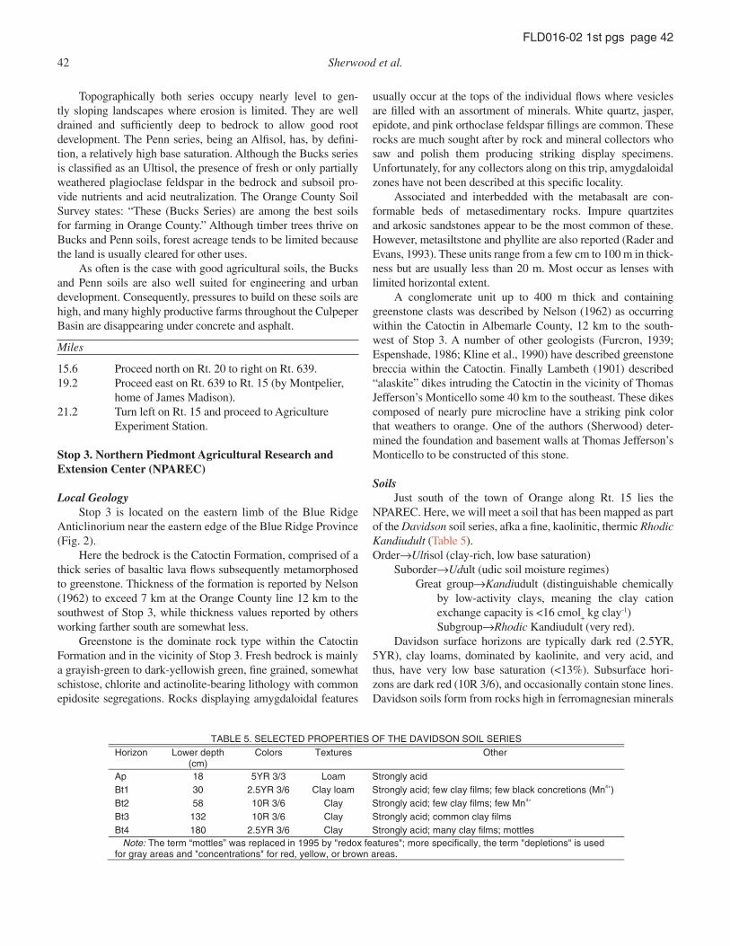
TABLE 5. SELECTED PROPERTIES OF THE DAVIDSON SOIL SERIES
Horizon Lower depth (cm)
rehtO serutxeT sroloC
Ap 18 5YR 3/3 Loam Strongly acid Bt1 30 2.5YR 3/6 Clay loam Strongly acid; few clay films; few black concretions (Mn4+) Bt2 58 10R 3/6 Clay Strongly acid; few clay films; few Mn4+ Bt3 132 10R 3/6 Clay Strongly acid; common clay films Bt4 180 2.5YR 3/6 Clay Strongly acid; many clay films; mottles Note: The term “mottles” was replaced in 1995 by "redox features"; more specifically, the term "depletions" is used for gray areas and "concentrations" for red, yellow, or brown areas.
Virginia Piedmont and Blue Ridge 43
FLD016-02 1st pgs page 43
(e.g., greenstone); bedrock is typically >1.8 m (Genthner, 1990). Davidson soils comprise ~553,000 acres across the Piedmont, and 23,000 acres (10%) in Orange County (U.S. Department of Agriculture, 1971).
Land UseThe soils formed from the Catoctin greenstone have long
been considered to be among the most desirable in the Blue Ridge and Piedmont of Virginia. Many of the earliest land pat-ents from the King of England were underlain by the Catoc-tin Formation. Figure 9 shows intense use of the land on either side of Southwest Mountain where the Davidson and related greenstone soils are free of forest cover. This is strong evidence that the early settlers recognized the greenstone-derived soils. A list of the antebellum families living over the Catoctin contains many FFVs (First Families of Virginia). Even today some of the most beautiful estates in Virginia are located here. The homes of four United States Presidents—Jefferson, Madison, Monroe, and Taylor—are all located over greenstone soils within 45 km of this stop.
Although many of these homes have commanding views of the surrounding countryside, doubtless the principal draw was the productivity of the greenstone-derived soils that underlie the fl anks of Southwest Mountain. Only the steepest slopes were unsuitable for crop production. The Davidson, Rabun, and Fau-quier series that form from weathered greenstone are all deep, well drained, and productive. A state soil scientist recently mea-sured over 6 m of B horizon at a site underlain by Davidson soil only 6 km south of Stop 3. During the colonial period and even after, much of this acreage was devoted to crops, particu-larly tobacco, corn, and wheat. The Orange County Soil Survey estimates corn, wheat, alfalfa, and pasture yields from Davidson soils as among the highest in the County. Today pastures and hay production predominate.
The same properties that make the Davidson, Rabun, and Fauquier soils excellent for agriculture apply to tree growth. Hardwoods, particularly poplars and oak species grow rapidly in these soils. The Landmark Forest at Montpelier just over the ridge to the west of this stop has been essentially undisturbed for ~100 yr. It contains impressive specimens of the forenamed trees. Tulip poplars with 1.5-m diameters at breast height and oaks with 1.2-m diameters are common there.
Greenstone-derived soils also have few limitations for a range of nonagricultural uses. Their deep profi les and well-drained properties are ideal for conventional on-site waste-water systems such as those involving septic tanks and drain fi elds. Consequently, development pressures for single homes, subdivisions, and commercial enterprises are great. The fact that most of the land over the greenstone is in “strong hands” (i.e., families with a tradition of far-sighted management of the land) may be a factor that limits runaway development over these soils.
Davidson soils also exhibit more than adequate engineering properties (Parker et al., 1983). Despite high silt and clay con-
tent that classifi es them as A-7–5 in the American Association of State Hightway and Transportation Offi cials (AASHTO) system, and as MH in the Unifi ed system, the clay fractions are high in kaolinite. Kaolinite-rich soils are the most stable for engineering uses of the clay-rich soils. They exhibit low shrink-swell poten-tial and moderate optimum moisture, shear strength, liquid lim-its, plasticity indices, and California bearing ratio (CBR) values. Consequently these soils are commonly used for fi ll material and other engineering purposes.
Miles
23.2 Proceed south on Rt. 15 to left (east) on Rt. 639.26.3 Turn left on Rt. 643.27.2 Proceed to the intersection of Rt. 643 and 638.
Stop 4. The Flat Woods
Local GeologyStop 4 is located in the western Piedmont (see Fig. 4). After
leaving Stop 3 we proceeded southward parallel to the strike of the Catoctin Formation, then turned eastward at Madison Run. At that point we left the Catoctin and crossed the Mountain Run fault and the Candler Formation. The Candler Formation, of Cambrian age, lies stratigraphically above the Catoctin. Major rock types within the Candler are phyllite, metasiltstone, metatuff, and dolo-mitic marble. At the top of the formation at this point is the Eve-rona Limestone. Mack (1965) describes the Everona as ~55 m of dark-blue, thin-bedded, slatey limestone containing thin string-ers of calcite. Weathering of the limestone has created a distinct, narrow valley that can be traced for several kilometers along the strike of the formation. Note we cross through the valley just east of the railroad. As is usually the case with limestone, the narrow valley has been cleared and farmed since the colonial period (see Fig. 10). The limestone was also mined at several sites during the mid 1800s for the production of hydrated lime.
The bedrock at Stop 4 overlies the Candler Formation. The Virginia State Geologic Map (Rader and Evens, 1993) refers to these rocks as “Stratifi ed rocks of the western Piedmont.” Lithologically they are a complex of metagraywacke, quartzose schist, phyllite, and mélange. The metagraywackes have been highly sheared and altered to quartzose chlorite and biotite schist with some blue quartz. According to Pavlides (1980) these rocks grade upward into a sequence of metavolcanic and metasedi-mentary rocks correlated with the Chopawamsic Formation of northern Virginia.
SoilsHere we will meet a soil that has been mapped as part of the
Tatum soil series, afka a fi ne, mixed, semiactive, thermic Typic Hapludult (Table 6). Tatum surface horizons are typically brown (7.5YR 4/4), silt loams, contain 25% quartz and sericite schist channers, and have low base saturation. Subsurface horizons are much redder (2.5YR 5/6) clay loams. Tatum soils typically over-lie sericite, schist, phyllite, or other fi ne-grained metamorphic
44 Sherwood et al.
FLD016-02 1st pgs page 44
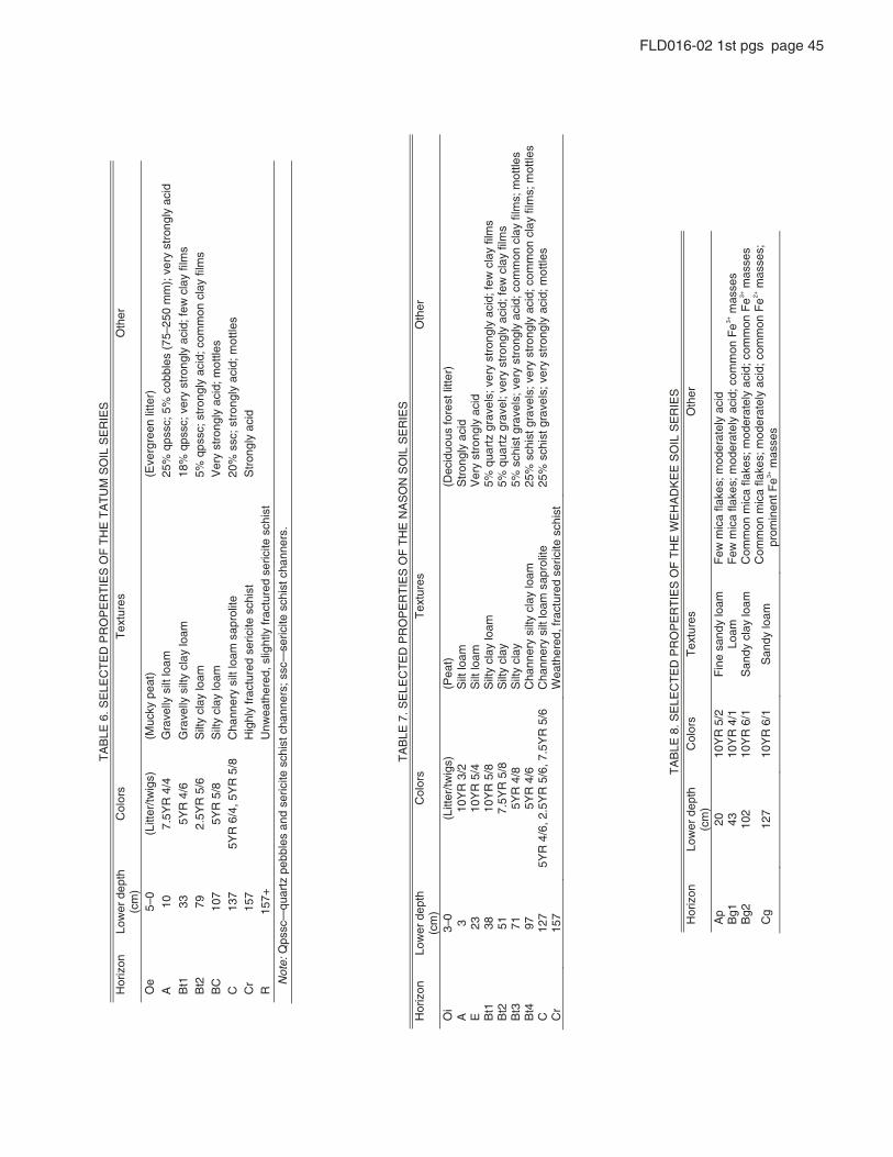
rock. Nason soils are very closely related to Tatum soils, with an identical classifi cation, but with the principal difference being subsoil horizons are less red (5YR to 10YR; Table 7). Tatum and Nason soils together cover 1.15 million acres (0.72M and 0.43M acres, respectively) of the Piedmont, and 24,000 (11%) and 45,000 (20%) acres, respectively, of Orange County (U.S. Department of Agriculture, 1971).
Land UseTatum and Nason soils cover vast areas of the western and
central Piedmont of Virginia. In Orange County alone, the two series comprise >30% of the total land area with about three quarters of the land area in forests (Fig. 9). Acid tolerant vegeta-tion predominates, with chestnut oaks, Virginia pine, black gum, and blueberries common. During the colonial period and even up to the Civil War most of these soils were cleared and farmed, principally for tobacco. However, due to their acidity, low natu-ral fertility, and highly erodible nature, most of the land quickly became exhausted and was abandoned.
The Piedmont, in fact, has been the locus of considerable research on past soil erosion rates (e.g., Ireland et al., 1939; Trimble, 1985). In 1995, it was suggested that current soil ero-sion rates were unsustainable relative to soil production rates and expensive to remedy (Pimentel et al., 1995). Follow-on let-ters and studies from economists (e.g., Crosson, 1995) led to an exchange of letters, which triggered yet another response from Trimble and Crosson (2000), titled “U.S. soil erosion rates—Myth and reality.” In this article, Trimble and Crosson (p. 250) wrote “We do not seem to have a truly informed idea of how much soil erosion is occurring in this country, let alone of the processes of sediment movement and deposition.” Recent studies have estimated that farmland denudation is occurring at rates of between ~600 and ~4000 m/m.y. (Wilkinson and McElroy, 2007; Montgomery, 2007), and that these rates are approximately two orders of magnitude larger than soil production rates. It will be important on this fi eld trip to relate current land uses, including abandonment following attempts at agriculture, to soil properties.
During the nineteenth century, as the soils were exhausted large numbers of the settlers moved westward in their quest for “new land.” The worn-out and heavily eroded fi elds were left to nature, where the old fi eld succession of Virginia pine, black locust, blackberries, and broom sedge followed. Within a few years the Virginia pines came to dominate. Even today, fi elds abandoned during the twentieth century contain thick stands of this species. However, Virginia pines are shade intolerant and relatively short-lived trees. After about seventy years the pines begin to die off and young shade-tolerant hardwoods such as oaks, hickory, poplar, maple, and ash take over. Today, hardwood forests predominate over Tatum and Nason soils in the Virginia Piedmont.
In the twenty-fi rst century, with readily available lime and fertilizers, some Tatum and Nason soils can be successfully farmed, and this is the case on a modest scale in Orange County. However, stringent management practices, particularly to control erosion, are required.
Tatum and Nason soils are normally deep and well drained so they usually pass the “perc” test required for conventional septic-tank and drain-fi eld waste water systems. These properties together with lax local zoning regulations and low land prices have resulted in an explosion of strip development along the sec-ondary roads in the “fl at woods” area. This condition will be evi-dent as we proceed to our next stop. Thirty years ago these roads traversed virtually unbroken forests.
Miles
31.3 Proceed east on Rt. 638 to bridge over Cooks Creek.
Stop 5. Floodplain of Cooks Creek
Local GeologyThe bedrock at Stop 5 lies within the Copowamsic volca-
nic belt. As noted earlier, this belt is one of the allochthonous terranes making up the western and central portions of the Vir-ginia Piedmont. Pavlides (1990) mapped the rocks here as part of the Malange Zone III of the Mine Run Complex, probably of Ordovician age. Pavlides recognized three distinct malange zones within the Mine Run Complex. While the matrix rocks are predominately schists and phyllites, the zones are differentiated on the basis of the degree of deformation and the compositions of the included blocks of other lithologies. In Zone III many of the matrix rocks are highly deformed and contain abundant euhedral magnetite. Exotic blocks of mafi c composition include amphibo-lite, ultramafi cs, serpentinite, and talc. Some blocks contain more than one rock type. Nonmafi c blocks composed of biotite gneiss are also present.
Despite the interesting bedrock in this area, the principal purpose of Stop 5 is to examine the geomorphology (Fig. 9). At this point, Cooks Creek, a tributary to the North Anna River, has abandoned its former channel and moved ~100 m to the south. In so doing, the stream has left a well-defi ned abandoned channel and a nearly level wetland fl oodplain that sustains standing water in wet sessions. It also left a stretch of cut bank that resembles a large amphitheater.
SoilWhere Rt. 638 crosses Cooks Creek, we will visit a fl ood-
plain soil that is framed by an amphitheater with ~20 m of relief, refl ecting millennia of incision. This Wehadkee soil series, afka a fi ne-loamy, mixed, active, nonacid, thermic Fluvaquentic Endo-aquept, has grayish-brown (10YR 5/2) surface horizons, with some mica fl akes, and moderate base saturation (Table 8). Some redoximorphic features are evident in subsurface horizons, and the irregular decrease in organic carbon with depth leads to the “Fluvaquentic” subgroup classifi cation. Wehadkee soils develop from sediments derived from schist, gneiss, granite, phyllite, and other metamorphic and igneous rocks. For this particular soil at this stop, the parent material represents material transported by Cooks Creek to this location. The Wehadkee series comprises
Virginia Piedmont and Blue Ridge 45
FLD016-02 1st pgs page 45
TA
BLE
6. S
ELE
CT
ED
PR
OP
ER
TIE
S O
F T
HE
TA
TU
M S
OIL
SE
RIE
S
Hor
izon
Lo
wer
dep
th
(cm
) reht
O se ru tx e
T srol o
C
)rettil neergrevE(
) tae p yk cuM(
) sgiwt/rettiL(
0–5 e
O A
10
7.5Y
R 4
/4
Gra
velly
silt
loam
25
% q
pssc
; 5%
cob
bles
(75
–250
mm
); v
ery
stro
ngly
aci
d
%81
maol yal c ytl is yllevar
G 6 /4
RY5
33 1 t
Bqp
ssc;
ver
y st
rong
ly a
cid;
few
cla
y fil
ms
pq %5
maol y alc ytl i
S 6/5
RY 5. 2
9 7 2t
Bss
c; s
tron
gly
acid
; com
mon
cla
y fil
ms
BC
10
7 5Y
R 5
/8
Silt
y cl
ay lo
am seltto
m ;dica ylgnorts yreV
C
13
7 5Y
R 6
/4, 5
YR
5/8
C
hann
ery
silt
loam
sap
rolit
e 20
% s
sc; s
tron
gly
acid
; mot
tles
Cr
157
H
ighl
y fr
actu
red
seric
ite s
chis
t S
tron
gly
acid
R
15
7+
U
nwea
ther
ed, s
light
ly fr
actu
red
seric
ite s
chis
t
N
ote:
Qps
sc—
quar
tz p
ebbl
es a
nd s
eric
ite s
chis
t cha
nner
s; s
sc—
seric
ite s
chis
t cha
nner
s.
TA
BLE
7. S
ELE
CT
ED
PR
OP
ER
TIE
S O
F T
HE
NA
SO
N S
OIL
SE
RIE
S
Hor
izon
Lo
wer
dep
th
(cm
) reht
O s erutxe
T srolo
C
Oi
3–0
)rettil tserof suoudiceD(
)t aeP(
)sgiwt/ret tiL (
dica ylgnortS
maol t li
S 2/3
RY01
3
A dica ylgnorts yre
V
maol tliS
4/5 R
Y01 32
E
rg ztrauq %5
mao l yalc ytli
S 8/5
RY01
83 1t
Bav
els;
ver
y st
rong
ly a
cid;
few
cla
y fil
ms
varg ztrauq %5
yalc yt liS
8 /5 R
Y5 .7 15
2 tB
el; v
ery
stro
ngly
aci
d; fe
w c
lay
film
s ;slevarg tsihcs
%5 ya lc ytli
S 8/4
RY 5
17 3t
Bve
ry s
tron
gly
acid
; com
mon
cla
y fil
ms;
mot
tles
Bt4
97
5Y
R 4
/6
Cha
nner
y si
lty c
lay
loam
25
% s
chis
t gra
vel s
; ver
y st
rong
ly a
cid;
com
mon
cla
y fil
ms;
mot
tles
C
127
5YR
4/6
, 2.5
YR
5/6
, 7.5
YR
5/6
C
hann
ery
silt
loam
sap
rolit
e 25
% s
chis
t gra
vels
; ver
y st
rong
ly a
cid;
mot
tles
utcarf ,dereh taeW
751
rC
red
seric
ite s
chis
t
TA
BLE
8. S
ELE
CT
ED
PR
OP
ER
TIE
S O
F T
HE
WE
HA
DK
EE
SO
IL S
ER
IES
H
oriz
on
Low
er d
epth
(c
m)
rehtO
serutxeT
sroloC
Ap
20
10Y
R 5
/2
Fin
e sa
ndy
loam
F
ew m
ica
flake
s; m
oder
atel
y ac
id
Bg1
43
10
YR
4/1
Lo
am
Few
mic
a fla
kes;
mod
erat
ely
acid
; com
mon
Fe
3+ m
asse
s B
g2
102
10Y
R 6
/1
San
dy c
lay
loam
C
omm
on m
ica
flake
s; m
oder
atel
y ac
id; c
omm
on F
e3+ m
asse
s
Cg
127
10Y
R 6
/1
San
dy lo
am
Com
mon
mic
a fla
kes;
mod
erat
ely
acid
; com
mon
Fe2+
mas
ses;
pr
omin
ent F
e3+ m
asse
s
46 Sherwood et al.
FLD016-02 1st pgs page 46
~655,000 acres of the Piedmont, 62,000 of those in Virginia (1%), and 1300 (0.6%) of those in Orange County (U.S. Depart-ment of Agriculture, 1971).
Land UseLike most of the land over Wehadkee soils in Orange County,
Stop 5 is forested. Wetland tolerant tree species common here are river birch, sycamore, alder, maple, iron wood, and willow oak. In addition, fi ne specimens of tulip poplar are present. Poplar, a desirable timber species, can grow rapidly and attain immense size under the conditions found here. Noncanopy vegetation includes spice bush, button bush, and ferns. While tree growth can be rapid in Wehadkee soils, harvesting can present problems during wet seasons. Many forms of wildlife such as deer, musk-rat, raccoon, wild turkey, and a variety of other birds fl ourish in areas with Wehadkee soils.
Surprisingly, some 40% of the Wehadkee soils in Orange County have been cleared and used for pasture. The carrying capacity of these soils, at 80 cow-acre-days per year ranks about midway when compared to other soils within the County. How-ever, during very dry years, pastures on Wehadkee soils are desir-able, providing good forage when the grasses on the upland soils do not. A very small acreage over the Wehadkee soils in Orange County is devoted to growing crops, mainly corn. Again these fi elds can aid farmers during dry years, but generally cropping on Wehadkee soils is not recommended.
Because of the seasonally high water table and suscep-tibility to flooding, Wehadkee soils are not recommended for development.
Miles
32.6 Proceed east on Rt. 638 to intersection with Rt. 612, turn right on Rt. 612.
34.7 Proceed east on Rt. 612 to intersection with Rt. 669, turn left on Rt. 669.
38.8 Proceed north on Rt. 669 to Stop 6, 0.2 miles north of Lahore.
Stop 6. Lahore
Local GeologyStop 6 is over the Lahore pluton (see Fig. 2). The pluton
was named by Pavlides (1990) for the small village of Lahore located immediately to the south of our stop. It was intruded into malange zone III during the Ordovician. It is one of a number of mafi c intrusions emplaced within the Central Virginia volcanic-plutonic belt. Pavlides (1990) recognized three distinct litholo-gies within the pluton. These are:
(1) amphibole monzonite, mesocratic, medium-grained amphibole monzonite, and amphibole-quartz monzo-nite. A foliation is defi ned by the alignment of tabular feldspar crystals;
(2) pyroxene monzonite with color ranging from dark gray to black. The rock is massive to weakly foliated and con-
sists of large augite and plagioclase grains (some zoned) and opaque oxides; and
(3) mafi c and ultramafi c rocks consisting of partially serpen-tinized pyroxenite and diopside.
Stop 6 is located over lithology type 1—amphibole monzo-nite. The landscape over the Lahore pluton is very gently rolling to nearly level. This topography is in subtle contrast to that in the surrounding countryside, where hill slopes are somewhat steeper and stream valleys are narrower and more pronounced. The aver-age land elevation over the pluton is slightly lower than that sur-rounding the intrusion. This difference is even more pronounced over the famous Green Springs intrusion, located ~18 km south-west of Lahore. Because of its slightly lower elevation, the Green Springs area is often referred to as the Green Springs basin.
SoilsJust north of Lahore Road off Rt. 669, we will meet a
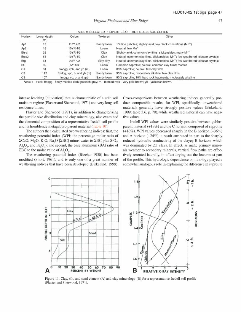
soil mapped as the series, afka a fi ne, mixed, active, thermic, Oxyaquic Vertic Hapludalf (Table 9). Iredell surface horizons are typically dark grayish-brown (2.5Y 4/2), sandy loam, with few gravels, and with moderate base saturation. Subsurface horizons show strong increases in shrink-swell–prone clays (presence of slickensides) as well as base saturation. In the Virginia Piedmont, Iredell soils are most closely associated with mafi c plutons, such as diabase, monzonite, diorite, and gabbro. Iredell soils cover ~231,000 acres across the Piedmont, and 427 acres (0.2%) of Orange County (U.S. Department of Agriculture, 1971). Unlike any of the other soils on this fi eld trip, some of the soil pH values are >7.9, an unusual feature for soils in humid climates with long residence times.
The taxonomic classifi cation of Iredell soils provided above is specifi c to a location, per the offi cial series description, 71 m “north of a fi re hydrant, across the road from the Southside School, [1.6 km] south of Chester, South Carolina, along U.S. Highway 72.” This classifi cation indicates the mineralogy is mixed, a characterization that is also likely to apply to our spe-cifi c Iredell soil (Plaster and Sherwood, 1971), since several clay minerals were found in the B horizon (Fig. 11). Note that while montmorillonite increases sharply in the C horizon, this increase is only relative to other clay minerals. In fact, total clay shows a precipitous decline below the argillic B horizon, so it is possible that there could have been more montmorillonite present in the B horizon than in the C horizon, because of the >5-fold difference in total clay content (Fig. 11).
Not too surprisingly for an Alfi sol, there is a pronounced increase in clay with depth, followed by a sharp decrease with depth (Fig. 11A). From the A
2 horizon (sample I-1, 25–37 cm)
to the B horizon (samples I-2 and I-3, 37–91 cm) to the C hori-zon (samples I-4 through I-6, 91–183 cm), clay-sized material (<2 μm) changed from 18% to 66% to 12%. Just as striking as this clay bulge is the shift in clay mineralogy (Fig. 11B), from clays dominated by quartz and vermiculite, to illite in the B horizon, to montmorillonite in the C horizon. The dominance of clay-sized quartz at the surface of the profi le was attributed to
Virginia Piedmont and Blue Ridge 47
FLD016-02 1st pgs page 47
intense leaching (eluviation) that is characteristic of a udic soil moisture regime (Plaster and Sherwood, 1971) and very long soil residence times.
Plaster and Sherwood (1971), in addition to characterizing the particle size distribution and clay mineralogy, also examined the elemental composition of a representative Iredell soil profi le and its hornblende metagabbro parent material (Table 10).
The authors then calculated two weathering indices: fi rst, the weathering potential index (WPI; the percentage molar ratio of ΣCaO, MgO, K
2O, Na
2O [ΣBC] minus water to ΣBC plus SiO
2,
Al2O
3, and Fe
2O
3); and second, the base:aluminum (BA) ratio of
ΣBC to the molar value of Al2O
3.
The weathering potential index (Rieche, 1950) has been modifi ed (Short, 1961), and is only one of a great number of weathering indices that have been developed (Birkeland, 1999).
Cross-comparisons between weathering indices generally pro-duce comparable results; for WPI, specifi cally, unweathered materials generally have strongly positive values (Birkeland, 1999: table 3.6, p. 70), while weathered material can have nega-tive values.
Iredell WPI values were similarly positive between gabbro parent material (+19%) and the C horizon composed of saprolite (+16%). WPI values decreased sharply in the B horizon (−36%) and A horizon (−24%), a result attributed in part to the sharply reduced hydraulic conductivity of the clayey B-horizon, which was dominated by 2:1 clays. In effect, as mafi c primary miner-als weather to secondary minerals, vertical fl ow paths are effec-tively rerouted laterally, in effect drying out the lowermost part of the profi le. This hydrologic dependence on lithology played a somewhat analogous role in explaining the difference in saprolite
TABLE 9. SELECTED PROPERTIES OF THE IREDELL SOIL SERIES
Horizon Lower depth (cm)
rehtO serutxeT sroloC
Ap1 13 2.5Y 4/2 Sandy loam 1% fine pebbles; slightly acid; few black concretions (Mn4+) Ap2 18 10YR 4/2 Loam Neutral; few Mn4+ Btss1 28 10YR 4/3 Clay Slightly acid; common clay films, slickensides; many Mn4+ Btss2 51 10YR 4/3 Clay Neutral; common clay films, slickensides, Mn4+; few weathered feldspar crystals Btg 61 2.5Y 4/2 Silty clay Neutral; common clay films, slickensides, Mn4+; few weathered feldspar crystals BC 69 5Y 4/3 Loam Common saprolite; neutral; common clay films; mottles C1 81 fmdgg, vpb, and yb (m) Loam 80% saprolite; neutral; few clay films C2 112 fmdgg, vpb, b, and yb (m) Sandy loam 90% saprolite; moderately alkaline; few clay films C3 157 fmdgg, yb, b, and vpb Sandy loam 90% saprolite, 10% hard rock fragments; moderately alkaline
Note: b—black; fmdgg—finely mottled dark greenish gray; m—mottled; vpb—very pale brown; yb—yellowish brown.
A BFigure 11. Clay, silt, and sand content (A) and clay mineralogy (B) for a representative Iredell soil profi le (Plaster and Sherwood, 1971).
48 Sherwood et al.
FLD016-02 1st pgs page 48
thickness over felsic versus mafi c lithologies. BA ratios showed a comparable pattern.
Plaster and Sherwood (1971) raised two questions that we copy here for the purposes of stimulating discussion: (1) Why is there such a dramatic shift in montmorillonite from the B to C horizons? And, (2) Where has the talc identifi ed in the parent material gone? With regards to the depth profi le of montmoril-lonite, Eades (1953) suggested that fi ne-grained montmorillon-ite could be eluviated from the B horizon and illuviated into the C horizon.
These elemental depth profi les produced at least two unex-pected results. First, it was noted that CaO and MgO might typically be expected, as biologically cycled bases, to show a decrease, not increase, with depth. One possible explanation is that the A2, versus the A1, horizon may not have captured the tree-pumping signal. Second, K
2O:Na
2O ratios decreased sharply
with depth, whereas the authors expected to see no increase in Na
2O with depth. This result is consistent with a hydrologic
rerouting following in situ formation of low- conductivity clays (see Table 1, which does not account for differences in clay min-eralogy). For example, illite, a clay that displays a strong affi nity for K, decreases with depth. Another factor may be the addition of K-rich fertilizers at the surface over many decades to increase crop yields.
The WPI values for the Iredell soil show that the saprolite (sample I-5) has experienced little chemical weathering, which Plaster and Sherwood (1971) attributed to the “high concentra-tion of hydrophyllic clays in the B horizon”; the “impermeable nature of this clay-rich zone has hindered the downward migra-tion of water and stands as the major reason for the lack of chemi-cal weathering” of the saprolite (p. 2824).
Land UseToday, most types of land development in areas underlain
by Iredell and related “blackjack” soil series—a catch-all term for Jackland, Whitestore, Orange, Zion, and other high shrink-swell clayey soils—is generally discouraged. Several character-istics of these soils contribute to this policy. First, most of the land will not “perc” due to poor drainage and a seasonally high water table. Second, soils over mafi c intrusions usually contain signifi cant amounts of high shrink-swell smectitic clays such as montmorillonite. The taxonomy of the closely related Orange series (fi ne, smectitic, mesic Albaquic Hapludalfs) indicates a 2:1 shrink-swell clay like montmorillonite makes up over 50% of the
clays present. Shrink-swell soils are highly unstable for engineer-ing uses such as foundations, fi lls and other types of construction.
The question then arises, are these soils suitable for agricul-ture? Tables in the Orange County Soil Survey listing crop yields for the various soil series rate the Orange-Iredell complex in the lowest echelons for corn, wheat, and hay, and low to medium for pasture. Interestingly, the tables give higher yield fi gures for these same soils on 2%–7% slopes than on 0%–2% slopes. Nor-mally, for most soils the more level slopes are more productive because they are less susceptible to erosion.
The reason for these seemingly illogical values can be summed in a single term—drainage! Level landscapes underlain by Iredell and Orange soils exhibit such poor drainage that crops suffer from too much water. Moderate slopes improve drainage and runoff and provide better conditions for crop production. An ancillary problem caused by smectite-rich soils can be harvest-ing during wet years. When these soils are disturbed while wet, structure is destroyed and they turn to a viscous liquid. It is not unusual for tractors to become mired up to their axles when these conditions occur. Finally, drainage affects chemical weathering processes. As Pavich (1986, p. 587) has noted, “the functional relationships of regolith production and erosion must begin with consideration of the hydrologic processes operating within the soil. The soil acts to partition rainfall into evapotranspiration, runoff, and recharge to the saprolite…. Since water movement is dependent on rock structure, rock weathering rate may be more dependent on soil water balance and rock structure than mineral dissolution kinetics if the rock contains at least one mineral phase that reacts rapidly with dilute, acidic solutions.”
Examining the land use patterns in Figure 10, it is evident that despite the latent problems associated with the Iredell soil, the trends are clear. Land underlain by mafi c igneous rocks and Iredell or similar soils has been preferentially cleared and farmed over the years. Areas underlain by Tatum and Nason soils are largely forested.
The reason can be traced back to the colonial period of Vir-ginia history. As discussed at Stop 4, settlers whose land was over highly acid and erodible soils such as the Tatum and Nason, liter-ally wore out the land in a few short years. A combination of the demands of tobacco production and poor farming methods were largely responsible. A settler to this area, John Craven, wrote in 1833 “… the whole face of the country presented a scene of deso-lation that baffl es description, farm after farm had been worn out, and washed and gullied, so scarcely an acre could be found in
TABLE 10. CHEMICAL COMPOSITION (ALL VALUES %) OF A REPRESENTATIVE IREDELL SOIL, WITH TWO WEATHERING INDICES: WEATHERING POTENTIAL INDEX (WPI) AND THE BASE:ALUMINUM (BA) RATIO
Lower (cm)
SiO2 Al3O3 Fe2O3 CaO MgO Na2O K2O LOI Total WPI BA
A2 37 54.40 10.40 23.89 1.43 0.00 2.60 0.67 6.65 100 –23.8 0.80 B 91 49.92 21.33 14.93 1.88 1.34 2.06 0.68 9.31 101 –35.8 0.48 C 183 45.89 17.07 10.67 7.90 10.09 1.61 1.55 3.64 98 16.1 2.75 Rock 46.37 16.67 13.70 9.45 7.47 2.05 1.60 2.41 100 19.3 2.56 Note: From Plaster and Sherwood (1971); Plaster (1968). LOI—loss on ignition.
Virginia Piedmont and Blue Ridge 49
FLD016-02 1st pgs page 49
place fi t for cultivation.…” Even George Washington described the existing farming methods as “ruinous” and visiting English farmer William Strickland noted “...Virginia farms of the area were much worn out … nearly exhausted … and tobacco and maize … a curse” Strickland (1801).
As noted earlier, these conditions led to a massive out- migration of settlers from the Virginia Piedmont and throughout the southern states and the abandonment of hundreds of thou-sands of acres of degraded land. Over time, these lands slowly returned to forest. Even today most of these lands remain for-ested. On the other hand, many of the early settlers over the Ire-dell, Orange, and related soils formed over the mafi c intrusions remained on the land. While the heavy clay soils are diffi cult to work, they are considerably less erosive and are characterized by naturally high pH and nutrient retention. These properties allowed the land to be successfully farmed for generations, and many families to become relatively prosperous. A number of these families remain on the land today. These areas lack for-est cover and appear as light gray in Figure 10. The relationship between the cleared (nonforested) areas and the areal extent of the mafi c intrusions is striking. More than one fi eld geologist has noted the contact between the mafi c intrusions and the surround-ing metasedimentary rocks can be located by following the tree line on the topographic mark of the area.
ACKNOWLEDGMENTS
We thank the following colleagues for their reviews of early editions of this manuscript: Lee Daniels, Greg Hancock, Louis Heidel, Dan Richter, Dave Starner, Aaron Thompson, and Rich Whittecar. Dot McLaren kindly provided assistance with sev-eral of the illustrations. Landowners in this area have been par-ticularly generous over the years with granting us access to their properties. We are appreciative of over thirty years of students’ and colleagues’ critiques of portions of this fi eld trip.
REFERENCES CITED
Allen, R.M., 1963, Geology and mineral resources of Greene and Madison Counties: Virginia Division of Mineral Resources Bulletin 78, 102 p.
Bailey, C.M., 2006, The geology of Virginia: A resource for information, photo-graphs, maps and diagrams of the geology of the Commonwealth, http://web.wm.edu/geology/virginia/ (accessed December 2009).
Birkeland, P.W., 1999, Soils and geomorphology: New York, Oxford University Press, Third edition, 174 p.
Buol, S.W., ed., 1973, Soils of the southern states and Puerto Rico: Southern Cooperative Series Bulletin 174, 105 p.
Carroll, L., 1871, Through the Looking-Glass, and What Alice Found There: London, Macmillan.
Carter, J.B., et al., 1971, Soil survey of Orange County, Virginia: Washington D.C., U.S. Department of Agriculture, Soil Conservation Service.
Cornet, B., 1977, The palynostratigraphy and age of the Newark Supergroup [Ph.D. thesis]: University Park, Pennsylvania, Pennsylvania State University, 505 p.
Costa, J.E. and Cleaves, E. T.,1984, The Piedmont landscape of Maryland: a new look at an old problem: Earth surface processes and landforms; v. 9, p. 59–74.
Craven, J.H., 1833, Letter by J.H. Craven, in Craven, A.O., 1925, Soil exhaus-tion as a factor in the agricultural history of Virginia and Maryland, 1606–1860: Urbana, Illinois, University of Illinois, 184 p.
Crosson, P., 1995, Soil erosion and its on-farm productivity consequences: What do we know?: Science, v. 269, p. 461, doi: 10.1126/science.269.5223.461.
Darton, N.H., 1951, Structural relations of Cretaceous and Tertiary formations in parts of Maryland and Virginia: Geological Society of America Bulletin, v. 62, p. 745–780, doi:10.1130/0016-7606(1951)62[745:SROCAT]2.0.CO;2.
Dicken, C.L., Nicholson, S.W., Horton, J.D., Kinney, S.A., Gunther, G., Foose, M.P., and Mueller, J.A.L., 2008, Preliminary integrated geologic map databases for the United States: Delaware, Maryland, New York, Penn-sylvania, and Virginia: Washington, D.C., U.S. Geological Survey Open-File Report 2005-1325, version 1.1 (August 2008) (http://pubs.usgs.gov/of/2005/1325/).
Eades, J.L., 1953, A study of the mineralogy of clays in soils as a product of the parent material [M.S. thesis]: Charlottesville, Virginia, University of Virginia, 99 p.
Eargle, D.H., 1940, The relations of soils and surface in the South Carolina Piedmont: Science, v. 91, p. 337–338, doi: 10.1126/science.91.2362.337.
Eargle, D.H., 1977, Piedmont Pleistocene soils of the Spartanburg area, South Carolina: South Carolina Division of Geology, State Development Board, Geologic Notes, v. 21, p. 57–74.
Espenshade, G.H., 1986, Geology of the Marshall Quadrangle, Fauquier County, Virginia: U.S. Geological Survey Bulletin 1560, 60 p.
Furcron, A.S., 1939, Geology and mineral resources of the Warrenton quad-rangle, Virginia: Virginia Geological Survey Bulletin 54, 94 p.
Genthner, M.H., 1990, The variability and geomorphology of Appling, Cecil, and Davidson soils on sideslopes in the Virginia Piedmont [M.S. thesis]: Blacksburg, Virginia, Department of Crop and Soil Environmental Sci-ences, Virginia Polytechnic Institute and State University, 217 p.
Hack, J.T., 1960, Interpretation of erosional topography in humid temperature regions: American Journal of Science 258-A, p. 80–97.
Howard, J.L., Amos, D.F., and Daniels, W.L., 1996, Micromorphology and dis-solution of quartz sand in some exceptionally ancient soils: Sedimentary Geology, v. 105, no. 1–2, p. 51–62, doi: 10.1016/0037-0738(95)00133-6.
Ireland, H.A., Sharpe, C.F.S., and Eargle, D.H., 1939, Principles of gully ero-sion in the Piedmont of South Carolina: Washington, D.C., U.S. Depart-ment of Agriculture, Technical Bulletin 633, 142 p.
Jenny, H., 1941, Factors of soil formation: a system of quantitative pedology: New York, McGraw-Hill Book Company, 174 p.
Jonas, A.I., 1927, Geologic reconnaissance in the Piedmont of Virginia: Geo-logical Society of America Bulletin, v. 38, no. 5, p. 837–846.
Kerr, W.C., 1881, On the action of frost in the arrangement of superfi cial earth material: American Journal of Science, Third series, v. 21, no. 125, May, article 44, p. 345–358.
Kline, S.W., Conley, J.F., and Evens, N.H., 1990, Hyaloclastic pillow breccia in the Catoctin metabasalt of the eastern limb of the Blue Ridge anticlino-rium in Virginia: Southeastern Geology, v. 30, no. 9, p. 241–257.
Lambeth, W.A., 1901, Notes on the geology of the Monticello area, Virginia [Ph.D. thesis]: Charlottesville, Virginia, University of Virginia, 174 p.
Lindholm, R.C., 1979, Geologic history and stratigraphy of the Triassic– Jurassic Culpeper Basin, Virginia: Geological Society of America Bulletin, v. 90, part 2, p. 1702–1736, doi: 10.1130/0016-7606(1979)90<995:GHASOT>2.0.CO;2.
Mack, T., 1965, Characteristics of the Everona Formation in Virginia: Virginia Division of Mineral Resources Information Circular 10, 16 p.
Markewich, H.W., Pavich, M.J., Hall, R.L., Johnson, R.G., and Hern, P.P., 1987, Age relations between soils and geology in the Coastal Plain of Maryland and Virginia: U.S. Geological Survey Professional Paper 1589-A, 34 p.
Mixon, R.B., and Newell, W.L., 1977, Stafford fault system: Structures docu-menting Cretaceous and Tertiary deformation along the Fall Line in north-eastern Virginia: Geology, v. 5, p. 437-440.
Montgomery, D.R., 2007, Soil erosion and agricultural sustainability: Proceed-ings of the National Academy of Sciences of the United States of Amer-ica, v. 104, p. 13,268–13,272, doi: 10.1073/pnas.0611508104.
Morison, C.G.T., 1948, The catena and its application to tropical soils: Com-monwealth Bureau of Soil Science Technical Bulletin 46, p. 124–130.
Nelson, W.A., 1962, Geology and mineral Resources of Albemarle County, Vir-ginia: Division of Mineral Resources Bulletin 77.
Owens, J.P., Hess, M.M., Denny, C.S., and Dwornik, E.J., 1983, Postdepo-sitional alteration and near-surface minerals in selected Coastal Plain formations of the Middle Atlantic states: U.S. Geological Survey Profes-sional Paper 1067-F, p. F1–F45.
Parker, J.C., Amos, D.F., and Baker, J.C., 1983, Engineering properties of selected soils of the Virginia Piedmont: Blacksburg, Virginia, Department
50 Sherwood et al.
FLD016-02 1st pgs page 50
of Agronomy, Virginia Polytechnic Institute and State University, Bulletin 83-6, 174 p.
Pavich, M.J., 1985, Appalachian Piedmont morphogenesis: Weathering, erosion and Cenozoic uplift, in Morisawa, M., and Hack, J.T., eds., Tectonic Geo-morphology: Binghamton, New York, Proceedings 15th Annual Geomor-phology Symposium Series, State University of New York, p. 299–319.
Pavich, M.J., 1986, Processes and rates of saprolite production and erosion on a foliated granitic rock of the Virginia Piedmont, in Colman, S.M., and Dethier, D.P., eds., Rates of Chemical Weathering of Rocks and Minerals: Orlando, Florida, Academic Press, p. 551–590.
Pavich, M.J., Leo, G.W., Obermeier, S.F., and Estabrook, J.R., 1989, Inves-tigations of the characteristics, origin, and residence time of the upland residual mantle of the Piedmont of Fairfax County, Virginia: Washington, D.C., U.S. Geological Survey Professional Paper 1352, 174 p.
Pavlides, L., 1980, Revised nomenclature and stratigraphy relationship of the Fredericksburg Complex and Quantico Formation of the Virginia Pied-mont: Washington, D.C., U.S. Geological Survey Professional Paper 1146, 29 p.
Pavlides, L., 1982, Petrology of the “Lahore” complex and Ellisville pluton, composite granitoid bodies in the Piedmont of Virginia: Washington, D.C., U.S. Geological Survey Professional Paper 1275, 60 p.
Pavlides, L., 1990, Geology of part of the Northern Virginia Piedmont: Washing-ton, D.C., U.S. Geological Survey Open-File Report 90-548, map and text.
Pédro, G., 1983, Structuring of some basic pedological processes: Geoderma, v. 31, p. 289–299, doi: 10.1016/0016-7061(83)90042-3.
Pimentel, D., Harvey, C., Resosudarmo, P., Sinclair, K., Kurz, D., McNair, M., Crist, S., Shpritz, L., Fritton, L., Saffouri, R., and Blair, R., 1995, Envi-ronmental and economic costs of soil erosion and conservation benefi ts: Science, v. 267, p. 1117–1123, doi: 10.1126/science.267.5201.1117.
Plaster, R.W., 1968, Geologic, mineralogic, and engineering studies of three Virginia soil profi les [masters thesis]: Charlottesville, Virginia, University of Virginia, 109 p.
Plaster, R.W., and Sherwood, W.C., 1971, Bedrock weathering and residual soil formation in Central Virginia: Geological Society of America Bulletin, v. 82, p. 2813–2826, doi: 10.1130/0016-7606(1971)82[2813:BWARSF]2.0.CO;2.
Prowell, D.C., 1976, Implications of Cretaceous and post-Cretaceous faults in the Eastern United States: Geological Society of America Abstracts with Programs, v. 8, no. 2, p. 249–250.
Rader, E.K., and Evans, N.H., 1993, editors, Geologic map of Virginia-Expanded explanation: Charlottesville, Virginia Division of Mineral Resources, 80 p.
Rankin, D.W., 1975, The continental margin of eastern North America in the southern Appalachians: The opening and closing of the proto–Atlantic Ocean: American Journal of Science, v. 278-A, p. 1–40.
Reusser, L.J., Bierman, P.R., Pavich, M.J., Zen, E., Larsen, J., and Finkel, R., 2004, Rapid late-Pleistocene incision of Atlantic passive-margin river gorges: Science, v. 305, p. 499–502, doi: 10.1126/science.1097780.
Rieche, P., 1950, A survey of weathering processes and products: New Mexico University Publications, Geology, 95 p.
Roberts, J.K., 1928, The geology of the Virginia Triassic: Charlottesville, Vir-ginia, Virginia Geological Survey Bulletin 39, 174 p.
Schoeneberger, P.J., Wysocki, D.A., Benham, E.C., and Broderson, W.D., eds., 2002, Field Book for Describing and Sampling Soils, Version 2.0: Lin-coln, Nebraska, Natural Resources Conservation Service, National Soil Survey Center, 174 p.
Sherwood, W.C., 2003, Examination of boulders from several anthropogenic features at Montpelier: Unpublished technical report on fi le with the Head of Archeology, James Madison, Montpelier, 11 p.
Sherwood, W.C., and Eaton, L.S., 1993, Soils, geology, and land use in the Virginia Piedmont, p. 51–69, in Field Trip Guidebook: Harrisonburg, Virginia, National Association of Geology Teachers, Southeast Section Meeting, 14–16 May 1993, James Madison University.
Short, N.M., 1961, Geochemical variations in four residual soils: The Journal of Geology, v. 69, p. 534–574, doi: 10.1086/626770.
Sommer, M., Halm, D., Weller, U., Zarei, M., and Stahr, K., 2000, Lateral pod-zolization in a granite landscape: Soil Science Society of America Jour-nal, v. 64, p. 1434–1442.
Southworth, S., Bailey, C.M., Eaton, L.S., Hancock, G., Lamoreaux, M.H., Lit-win, R.J., Burton, W.C., and Whitten, J., 2009, Geology of the Shenan-doah National Park Region: Guidebook for 39th Annual Virginia Geologi-cal Field Conference (October 2–3, 2009), 174 p.
Strickland, W., 1801, Observations on the agriculture of the United States of America: London, Bulmar and Company, 174 p.
Trimble, S.W., 1985, Perspectives on the history of soil erosion control in the eastern United States: Agricultural History, v. 59, no. 2, p. 162–180.
Trimble, S.W., and Crosson, P., 2000, U.S. soil erosion rates—Myth or reality?: Science, v. 289, p. 248–250, doi: 10.1126/science.289.5477.248.
U.S. Department of Agriculture, 1971, Soil Survey of Orange County, Virginia: Washington, D.C., U.S. Department of Agriculture, Soil Conservation Ser-vice in cooperation with the Virginia Agricultural Experiment Station, 174 p.
Whittecar, G.R., 1985, Stratigraphy and soil development in upland alluvium and colluvium, north-central Virginia Piedmont: Southeastern Geology, v. 26, no. 2, p. 117–129.
Wilkinson, B.H., and McElroy, B.J., 2007, The impact of humans on continen-tal erosion and sedimentation: Geological Society of America Bulletin, v. 119, p. 140–156, doi: 10.1130/B25899.1.
MANUSCRIPT ACCEPTED BY THE SOCIETY 2 DECEMBER 2009
Printed in the USA