Embed Size (px)
Citation preview
CNS SG/8-WP/10 17/1/2018
International Civil Aviation Organization
MIDANPIRG Communication, Navigation and Surveillance Sub-Group
Eighth Meeting (CNS SG/8)
(Cairo, Egypt, 26 - 28 February 2018)
Agenda Item 4: CNS Planning and Implementation in the MID Region
GNSS PLANNING AND IMPLEMENTATION
(Presented by Secretariat)
SUMMARY
The aim of this paper is to present the outcome of the ACAC/ICAO
CNSS Workshop. The paper presents also a Draft Guidance on GNSS
Implementation in the MID Region, for review and inputs by the
meeting.
Action by the meeting is at paragraph 3
REFERENCES
- MIDANPIRG/16 Report
1. INTRODUCTION
1.1 GNSS is defined by ICAO SARPs as a worldwide position and time determination
system that includes one or more satellite constellations, aircraft receivers and system integrity
monitoring, augmented as necessary to support the required navigation performance for the intended
operation.
1.2 The 12th Air Navigation Conference agreed that “Multi-constellation, Multi-frequency
GNSS has clear technical advantages that will support the provision of operational benefits. To realize
these benefits, ICAO, States, ANSPs, standards bodies, manufacturers and aircraft operators need to
coordinate activities to address and resolve related issues.”
CNS SG/8-WP/10 -2-
2. DISCUSSION
ACAC/ICAO GNSS Workshop
2.1 The ACAC/ICAO GNSS Workshop was held in Rabat, Morocco, 6-7 November 2017.
The Workshop was supported by European Commission and attended by a total of forty-nine (49)
participants, from nine (9) States (Algeria, Egypt, France, India, Lebanon, Libya, Morocco, Tunisia and
Yemen), six (6) Organizations (ACAC, ICAO, IFALPA, EC, JPO and IATA) and six (6) Industries
(Telespazio, Thales Alenia Space, DLC Consultant ESSP, RESYS Consultants and Abdus Salam
International Center for Theoretical Physics). Only four (4) MID States attended the Workshop (Egypt,
Lebanon, Libya and Yemen).
2.2 The Workshop discussed mainly the following topics:
a) Global and Regional Developments related to GNSS
b) Regional SBAS: EGNOS and SBAS initiative for GCC States, Iraq and Yemen
c) SBAS Initiative in East Africa and GAGAN
d) Panel Discussion on GNSS/SBAS implementation
e) GBAS implementation
f) GNSS vulnerabilities and mitigation measures.
2.3 The objective of the Workshop was to provide a forum for sharing the current and future
developments related to GNSS with a focus on SBAS and GBAS implementation and GNSS
vulnerability and mitigation measures. The Summary of Discussion is at Appendix A.
Guidance material on GNSS Implementation in the MID Region
2.4 GNSS is a key enabler of the PBN Implementation in the MID Region. Guidance
material on GNSS Implementation has been developed to complement the information in the PBN Plan
and provide guidance on the implementation aspects of GNSS in order to assist States in the introduction
of GNSS operations. The Draft Guidance on GNSS Implementation in the MID Region is at
Appendix B.
2.5 The Global Air Navigation Plan, Aviation System Block Upgrades (ASBU)
methodology, MID Region Air Navigation Plan and the MID Region Air Navigation Strategy, in
addition to the Assembly Resolutions and the twelfth Air Navigation Conference (AN-Conf/12)
Recommendations related to GNSS have been considered in the development of the guidance material
on GNSS Implementation in the MID Region.

CNS SG/8-WP/10 -3-
3. ACTION BY THE MEETING
3.1 The meeting is invited to:
a) consider the outcome of ACAC/ICAO GNSS Workshop;
b) review and update, as deem necessary, the Guidance on GNSS Implementation in
the MID Region at Appendix B; and
c) endorse the following Draft Conclusion:
DRAFT CONCLUSION 8/X: GUIDANCE ON GNSS IMPLMENTATION
That, States review the Draft Guidance on GNSS Implementation in the MID
Region at Appendix 8X, and provide the ICAO MID Office with their
comments/inputs by 15 May 2018 in order to present the consolidated version
to the ANSIG/3 meeting for further review and improvement.
--------------------
CNS SG/8 -WP/10 APPENDIX A
International Civil Aviation Organization
ACAC/ICAO MID WORKSHOP ON GNSS
(Rabat-Morocco, 7 - 8 November 2017)
SUMMARY OF DISCUSSIONS
1. GENERAL
1.1. PlaceandDuration
1.1.1 The ACAC/ICAO GNSS Workshop was successfully held at the Golden Tulip Farah Hotel, Rabat, Morocco, 7 and 8 November 2017. The Workshop was supported by the European Commission (EC).
1.2. Opening 1.2.1 Mr. Mohamed REJEB, ACAC Air Navigation and Aviation Safety Expert opened the Workshop on behalf of His Excellency Eng. Mohamed Ibrahim Sherif, Director General of ACAC.Mr. Mohamed Smaoui, Deputy Regional Director, ICAO Middle East Regional Office provided also an opening speech on behalf of ICAO.
1.3. Attendance 1.3.1 The Workshop was attended by a total of forty-nine (49) participants, from nine (9) States (Algeria, Egypt, France, India, Lebanon, Libya, Morocco, Tunisia and Yemen), six (6) Organizations (ACAC, ICAO, IFALPA, EC, JPO and IATA) and six (6) Industries (Telespazio, Thales Alenia Space, DLC Consultant ESSP, RESYS Consultants and Abdus Salem International Center for Theoretical Physics). The List of Participants is at Attachment A.
1.4. Agenda 1.4.1 The Agenda was developed around the main following topics:
a) Session 1: Global and Regional Developments related to GNSS b) Session 2: Regional SBAS: EGNOS and SBAS initiative for GCC States,
Iraq and Yemen c) Session 3: SBAS Initiative in East Africa and GAGAN d) Session 4: Panel Discussion on GNSS/SBAS implementation e) Session 5: GBAS implementation f) Session 6: GNSS vulnerabilities and mitigation measures g) Session 7: Conclusions and Closing Session
-2-
ACAC/ICAO MID GNSS WS 2
1.4.2 The Work Programme is at Attachment B.
2. WORKSHOPOBJECTIVES 2.1 The main objectives of the Workshop were to provide a forum for sharing the current and future developments related to GNSS with a focus on SBAS and GBAS implementation and GNSS vulnerability and mitigation measures.
3. SessionsoftheSeminar 3.1 Thirteen (13) presentations were delivered during the six (6) Sessions of the Workshop. Sufficient time was allocated for discussion to identify the priority areas and examine possible partnerships that could be established. 3.2 The presentations are available on the ACAC and ICAO MID websites: www.acac.org.ma and www.icao.int/mid
4. CONCLUSIONS/RECOMMENDATIONS
4.1 The Workshop developed the following Conclusions/Recommendations:
• The Workshop was apprised of the Global and Regional Developments related to GNSS implementation, including the MID Region Air Navigation Strategy, the MID Region PBN Implementation Plan and the ACAC GNSS Strategy.
• The Workshop was apprised of EGNOS Status, roadmap and extension to EUROMED.
• It was noted that five (5) ACAC/EUROMED States have already officially notified their interest in EGNOS implementation (Algeria, Jordan, Lebanon, Libya, and Tunisia). The extension of the EGNOS coverage to the EUROMED States requires the deployment of three (3) additional RIMS.
• Interested States to use EGNOS Safety of Life (SoL) service need to initiate negotiation with the EC for the signature of an EGNOS International Agreement in parallel with the RIMS installation, and provision of technical assistance.
• EGNOS provision of SoL Service includes NPA, APV-I and LPV-200 service levels.
• The Workshop was apprised of the results of the study case carried out by Thales related to the implementation of an Autonomous SBAS system for the GCC States, Iraq and Yemen. The Workshop noted the outcomes of the CBA and the methodology used, as well as the recommendations from CBA related to the ANSPs and States.
• The Workshop noted the availability on the European side of a pool of industries, which can provide a complete range of support needed for the development of and operation of a turn-key SBAS system up-to service provision.

-3-
• The Workshop was apprised of the Programme management Office (JPO) activities related to GNSS, including the benefits analysis for SBAS implementation in East Africa. The Cost Benefit Analysis is foreseen as the next step to support the choice of the technical scenario.
• The Workshop noted the challenges faced by JPO related to the data collection from some States for the development of the CBA.
• The Workshop was apprised of the GAGAN developments and the possibility to extend services to the MID States. Interested states need to approach CAA INDIA for further coordination.
• The workshop noted that SARPs are available for GBAS CAT I. For CAT II/III the SARPs are under development.
• The Workshop was apprised of France experience related to GBAS implementation, including the outcomes of the Paris CDG GBAS Study, which was not very positive in terms of replacement of the current ILSs by GBAS, due mainly to low level of fleet equipage, lack of standards (for CAT II/III) and need to modify the ATC tools.
• GBAS implementation is currently not economical for small airports (1 RWY). The cost of 1 GBAS is around 1.5 to 2 M Euros per Station (# cost of 3 ILSs).
• The need for business case before any GBAS implementation, considering inter-alia, fleet equipage was underlined.
• It was noted that GBAS CAT I is being implemented in few parts of the world, however, overall GBAS CAT I deployment remains limited.
• The Workshop was apprised of the effects of solar radio bursts on GNSS operations by Prof. Sandro RADICELLA, Abdus Salam International Center for Theoretical Physics.
• As part of the GNSS vulnerability issues, Dr. Adlen LOUKIL, from Tunisia University made a presentation on Cybersecurity, safety and resilience, and the need of developing national Security policy against cyber threats including awareness and training programmes.
• States are encouraged to implement best practices related to GNSS Vulnerabilities mitigation measures, as per ICAO guidance material, including the coordination between CAA and Military Authorities related to GNSS interferences.
• The Workshop was apprised of and supported the MIDANPIRG outcome related to the reporting of GNSS Vulnerability incidents/ occurrences, including the development of a RASG-MID Safety Advisory (RSA) related to GNSS vulnerabilities and mitigations measures.
• The Workshop noted the IATA position with regard to SBAS implementation.
• The Workshop reiterated the ANC/12 Recommendations related to GNSS Vulnerabilities: Recommendation 6/6 – Use of multiple constellations. Recommendation 6/7 – Assistance to States in mitigating global
navigation satellite system vulnerabilities. Recommendation 6/8 – Planning for mitigation of global navigation
satellite system (GNSS) vulnerabilities. Recommendation 6/9 – Ionosphere and space weather information for
future global navigation satellite system implementation.

-4-
ACAC/ICAO MID GNSS WS 4
• States are encouraged to embrace early benefits from Basic GNSS (ABAS) implementation (PBN RNP APCH operations).
• States to keep pace with GNSS global and regional developments, and explore all possible solutions to achieve the required performance objectives, in accordance with the GANP and regional priorities and plans.
• The regional and national GNSS implementation plans/strategies should be linked to the regional ASBU implementation Plans approved by the relevant PIRG.
• Airspace users should be involved in the planning of any GNSS implementation, in order to take into consideration operational needs and fleet capabilities.
5. CLOSING 5.1 In closing, Mr. Mohamed Rejeb, Air Navigation and Safety ACAC Expert and Mr. Mohamed Smaoui, Deputy Regional Director, ICAO Middle East Regional Office thanked the participants for their presence and expressed ACAC/ICAO MID gratitude to the States, EC and all the stakeholders from International Organizations/Industry for their valuable contributions and excellent support to the Workshop.
5.2 The participants recognized the usefulness of the event and expressed their thanks to ACAC/ICAO MID for organizing such a fruitful Workshop and underlined the importance of necessary follow-up actions on the Recommendations & Conclusions mentioned above, and the conduct of additional Joint ACAC/ICAO MID Workshops.
--------------------

CNS SG/8 -WP/10 APPENDIX B
AMENDMENTS
The MID Region GNSS Roadmap should be reviewed and updated by the CNS Sub‐
Group. States shall submit their proposal for amendment to the Plan to the ICAO
MID Regional Office, the changes can be coordinated by correspondence with main
CNS focal points/ or issuing state letters.
The table below provides a means to record all amendments. An up to date
electronic version of the Plan will be available on the ICAO MID Regional Office
website.
Edition Date Comment Section affected
V0.1
11/2/2018 All
Guidance on GNSS Implementation in the MID Region Page 3
TABLE OF CONTENTS
Acronyms………………………………………………………………………………………….. 5 The objective and scope of the document…………………………………………. 6 Part I: General Navigation Infrastructure………………………………….......... 7 1. Terrestrial Navigations…………………………………………………………………. 7 2. Global Navigation Satellite System (GNSS)………………………………….... 8 2.1 GPS…………………………………………………………………………………………….. 8 2.2 GLONASS……………………………………………………………………………………… 8 2.3 Galileo…………………………………………………………………………………………. 8 2.4 BeiDou………………………………………………………………………………………… 9 2.5 RNSS………………………………………………………………………………………….. 9 3. Augmentation………………………………………………………………………………… 9 3.1 Satellite based Augmentation System (SBAS)…………………………….... 9 3‐1‐1 WAAS………………………………………………………………………………………. 103‐1‐2 EGNOS……………………………………………………………………………………… 10 3‐1‐3 GAGAN…………………………………………………………………………………….. 11 3‐1‐4 SDCM………………………………………………………………………………………. 12 3‐1‐5 MSAS……………………………………………………………………………………….. 12 3‐2 Ground Based Augmentation System (GBAS)………………………………. 13 3‐3 Aircraft Based Augmentation System (ABAS)………………………………. 133‐3‐1 Receiver Autonomous Integrity System (RAIM)……………………….. 13 3‐3‐2 Aircraft Autonomous Integrity System (AAIM)…………………………. 14 4. Global Air Navigation Plan (GANP)…………………………………………………. 14 Part II: GNSS in ICAO MID Region………………………………………………………. 16 1. The Conventional Ground Based Navigation Systems in the MID……………………………………………………………………………………………….
16
2. SBAS……………………………………………………………………………………………… 17 2‐1 EGNOS……………………………………………………………………………………….. 17 2‐2 GAGAN………………………………………………………………………………………. 21 3. GNSS Application in the MID Region…….……………………………………….. 22 4. GBAS……………………………………………………………………………………………... 22 5. Cost Benefits Analysis…………………….……………………………………………… 226. Current use of SBAS/GBAS in the MID Region…………………………….…. 23 Part III: GNSS Vulnerabilities……………………………………………………………… 24 1‐ Introduction………………………………………….………………………………………. 24 2‐ Unintentional Interference Source………………………………………………… 24 2‐1 Solar Effect…………………………………………………………………………………. 24
Guidance on GNSS Implementation in the MID Region Page 4
2‐2 Radio Frequency Interference……………………………………………………. 24 2‐3 Onboard Systems……………………………………………………………………….. 25 3. Intentional Interference Sources…………………………………………………… 253‐1 Jamming……………………………………………………………………………………. 25 3‐2 Spoofing…………………………………………………………………………………….. 25 4‐Reducing the likelihood of Interference…………………………………………. 25 5‐Mitigation Strategies…………………………………………………………………….. 26 References………………………………………………………………………………………… Appendix A: List of NDBs in the MID Region……………………………………….
27 28
List of Figures
1‐1 Current and Planned SBAS Systems…………………………………………..10 1‐2 GANP Navigation Roadmap……………………………………………………….15 2‐2 APV‐I Availability Map……………………………………………………………….18
2‐3 APV‐I Continuity Map………………………………………………………………..18
2‐4 LPV200 Availability Map…………………………………………………………….19
2‐4 LPV200 Continuity Map……………………………………………………………..19
2‐5 GAGAN GEO Footprint……………………………………………………………….21
List of Tables
2‐1 Current Conventional Infrastructure………………………………………….16
2‐2 Minimum signal‐in‐space performance…………………………..20

Guidance on GNSS Implementation in the MID Region Page 5
ACRONYMS
AO Aircraft Operators
AAIM Aircraft Autonomous Integrity Monitoring
ABAS Aircraft Based Augmentation System
APCH Approach
CAPEX Capital Expenditure
DME Distance Measuring Equipment
DOP Dilution of Precision
EGNOSS European Geostationary Navigation Overlay Service
FD Fault Detection
FDE Fault Detection and Exclusion
GAGAN GPS Aided GEO Augmented Navigation
GBAS Ground Based Augmentation System
GLONASS Global Navigation Satellite System
GLS GBAS Landing System
GNSS Global Navigation Satellite System
GPS Global Positioning System
ILS Instrument Landing System
INS Inertial Navigation System
IRS Inertial Reference System
LNAV Lateral Navigation
MLS Microwave Landing System
MSAS MTSAT Satellite based Augmentation System
NDB Non‐Directional Beacon
NPA Non‐precision Approach
NSE Navigation Sensor Error
OPEX Operating Expense
PA Precision Approach
PBN Performance Based Navigation
RAIM Receiver Autonomous Integrity Monitoring
RNAV Area Navigation
RNP Required Navigation Performance
SBAS Satellite Based Augmentation
SDCM System of Differential Correction and Monitoring
VOR Very High Frequency Omni Directional Radio Range

Guidance on GNSS Implementation in the MID Region Page 6
THE OBJECTIVE AND SCOPE OF THE DOCUMENT
The objective of this document is to provide States in the Middle East Region with
guidance for GNSS implementation based on the Global Air Navigation Plan and
Regional Requirements.
The document outlines the status of all satellite constellations and Augmentation
systems worldwide, with focus on the available Augmentation systems that can be
used in the MID Region; the services provided, and requirements to exploit these
Navigation services.
Moreover, this document provides practical information on GBAS deployment, with
reference to other Regions experience and factors to be considered in the process of
cost estimation for the cost benefit analysis.
Furthermore, the guidance document explains the GNSS vulnerabilities due to intentional and unintentional sources of interference and to certain ionospheric effects. Also, it describes ways to reduce the likelihood of interference and the mitigation strategies to reduce the impact of the signal outage.
The GNSS application is out of scope of this document and addressed in the MID PBN
implementation plan. The GNSS is the key enabler for PBN implementation. The
guidance on GNSS implementation is developed to complement the information in
the MID PBN implementation Plan; ICAO MID DOC 007.
This document is divided into three parts; Part one includes information about the
GNSS and Augmentation systems worldwide, and ICAO Navigation Roadmap from
the GANP.
Part II identifies the current conventional Navigation aids infrastructure in the MID
Region. And focuses on the SBAS Systems that may extends their services to the MID
states.
Part III addresses the GNSS vulnerabilities and the mitigation strategies as defined by
ICAO.
Guidance on GNSS Implementation in the MID Region Page 7
Part I: General Navigational Infrastructure
Navigation Aids Infrastructure refers to the ground and space‐based NAVAIDs and
provides positioning capability.
1‐ TERRESTRIAL NAVIGATIONS
Terrestrial Navigation Aids “conventional” refers to ground‐based navigations such as
NDB, ILS, VOR, TACAN, DME, …, etc.
The basic principle of all of these navigation facilities is the fact that aircraft in
general navigate towards and away from the navigation aid itself, “point to point”.
This means that the location of the navigation aid must be in an optimized location.
This optimized position is, in many cases, not achievable (due to being situated in
high terrain, open seas, politically unacceptable areas, etc). Therefore the route
structure must be aligned with the position of the navigation aid and not aligned in
the ideal position for its purpose. This results in additional distances being flown by
aircraft which has a number of disadvantages including economic, environmental
and efficiency drawbacks.
In addition to the additional distance flown a number of other problem areas arise;
High terrain. At airports located in high terrain with difficult accessibility arrival
procedures, based upon conventional ground based navigation aids, may result in
aircraft being unable to land at the airport safely during periods of low visibility.
Lateral containment of tracks. With conventional ground based navigation aids
the accuracy of the track to be flown is a factor of how close to the aid the aircraft is.
The closer the aircraft is to the aid the more accurate the track keeping capability. As
the aircraft gets further away from the aid the accuracy reduces. This requires that a
maximum distance for the aid to be used must be published and that the route
spacing requires to be established on the worst case scenario.
In the global context, GNSS based PBN procedures have been implemented. And
several GLS (CAT I) procedures in place.
Guidance on GNSS Implementation in the MID Region Page 8
2‐ GLOBAL NAVIGATION SATELLITE SYSTEM (GNSS)
GNSS is a satellite‐based navigation system utilizing satellite signals, for providing
accurate and reliable position, navigation, and time services to airspace users. It
provides location and time information anywhere on, or near, the earth in all
weather conditions.
In 1996, the International Civil Aviation Organization (ICAO) endorsed the
development and use of GNSS as a primary source of future navigation for civil
aviation. ICAO noted the increased flight safety, route flexibility and operational
efficiencies that could be realized from the move to space‐based navigation. Today
several GNSS systems are available in the world, the first system in operation was the
Global Positioning System (GPS).
2‐1 GPS
The Global Positioning System (GPS) is a space‐based radio‐navigation system
consisting of a constellation of satellites and a network of ground stations used for
monitoring and control. Currently 32 GPS satellites orbit the Earth at an altitude of
approximately 11,000 miles providing users with accurate information on position,
velocity, and time anywhere in the world and in all weather conditions.
GPS is operated and maintained by the Department of Defense (DoD).
2‐2 GLONASS
The Russian Global Navigation Satellite System, which began operation in 1993.
GLONASS network provides real‐time positioning and speed data for surface, sea and
airborne objects with an accuracy of one meter (three feet).
A group of 28 GLONASS satellites was in orbit as of April 2014, with 24 in operation,
three spares, and one in the test‐flight phase.
2‐3 Galileo Galileo is Europe’s Global Satellite Navigation System (GNSS), providing improved positioning and timing information with significant positive implications for many European services and users. The system is still under deployment.
Guidance on GNSS Implementation in the MID Region Page 9
2‐4 BeiDou
The BeiDou Navigation Satellite System (BDS), also known as BeiDou‐2, is China’s second‐generation satellite navigation system that will be capable of providing positioning, navigation, and timing services to users on a continuous worldwide basis. It is a constellation of 35 satellites that will offer complete coverage of the globe.
2‐5 RNSS
Regional Navigation Satellite System (RNSS) like NAVIC and QZSS. The Indian Regional
Navigation Satellite System (IRNSS) with an operational name of NAVIC. QZSS is a
system especially for usage in the Asia‐Oceania regions, with a focus on Japan.
3‐ AUGMENTATION
Augmentation System provides additional data to users of GNSS equipment to improve accuracy, integrity, availability, or any other improvement to positioning, navigation, and timing. A wide range of different augmentation systems have been developed.
3‐1 Space Based Augmentation System (SBAS)
SBAS systems are designed to augment the navigation system constellations by
broadcasting additional signals from geostationary (GEO) satellites. The basic scheme
is to use a set of monitoring stations (at very well‐known position) to receive GNSS
signals that will be processed in order to obtain some estimations of these errors
that are also applicable to the users (i.e. ionospheric errors, satellite position/clock
errors, etc.). Once these estimations have been computed, they are transmitted in
the form of “differential corrections” by means of a GEO satellite.
Wide range of SBAS systems, designed according to the same standard have already
been commissioned by the US (Wide Area Augmentation System WAAS) and Japan
(MTSAT Satellite based Augmentation System MSAS).
Other systems are under commissioning or deployment in other regions of the world
(e.g. GPS Aided GEO Augmented Navigation GAGAN in India and System of
Differential Correction and Monitoring SDCM in Russia).
Guidance on GNSS Implementation in the MID Region Page 10
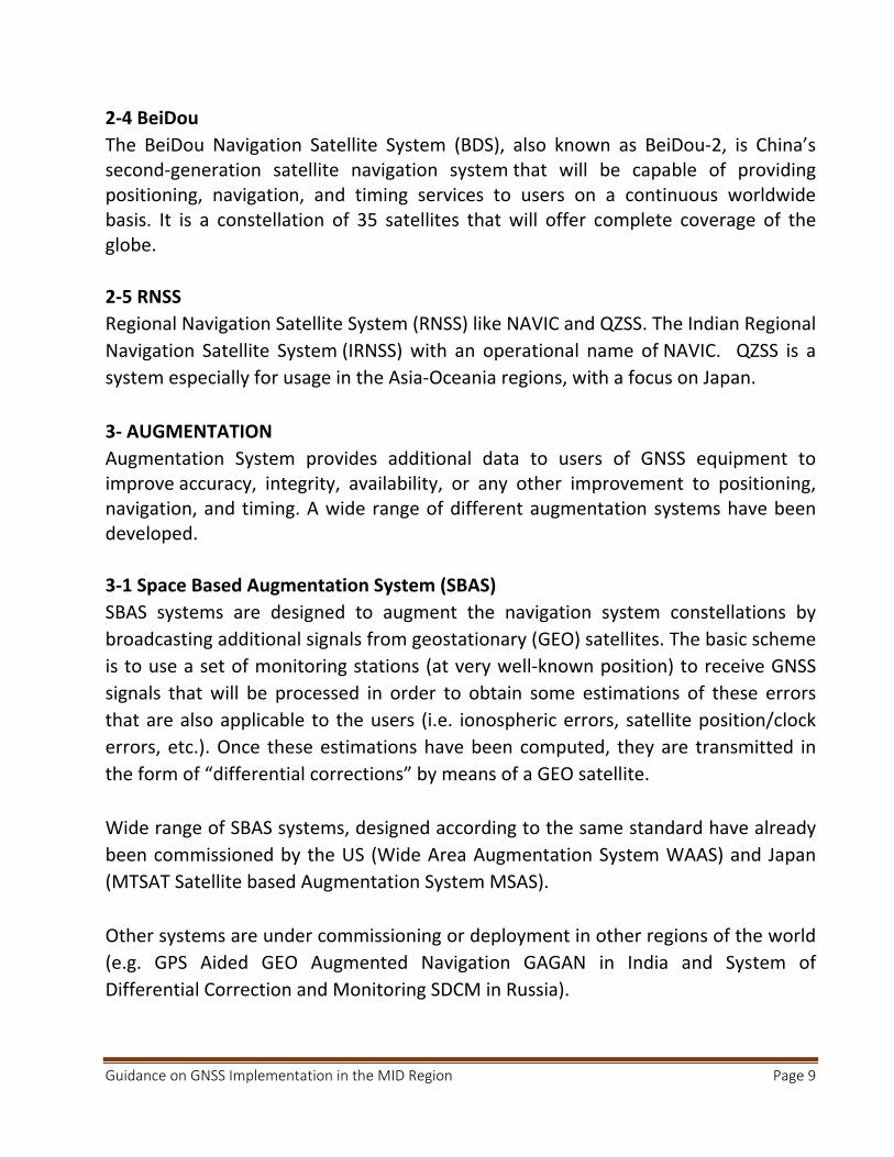
The current and planned SBAS systems coverage depicted in the figure (1‐1)
Figure (1‐1)
3‐1‐1 WAAS
The Wide Area Augmentation System (WAAS) is an Air navigation aid developed by
the Federal Aviation Administration to augment the Global Positioning System (GPS),
with the goal of improving its accuracy, integrity, and availability.
3‐1‐2 EGNOS
The European Geostationary Navigation Overlay Service Navigation (EGNOS) is the
European implementation of SBAS. Originally it was planned to augment GPS and
GLONASS. Today, EGNOS augments GPS signals. EGNOS provides corrections and
integrity information to GPS signals over a broad area centered over Europe and it is
fully interoperable with other existing SBAS systems.
EGNOS provides three services: • Open Service (OS), freely available to any user; • Safety of Life (SoL) Service, that provides the most stringent level of signal‐in‐space performance to all Safety of Life user communities; • EGNOS Data Access Service (EDAS) for users who require enhanced performance for commercial and professional use.
Guidance on GNSS Implementation in the MID Region Page 11
The main objective of the EGNOS SoL service is to support civil aviation operations down to Localizer Performance with Vertical Guidance (LPV) minima. In order to provide the SoL Service, the EGNOS system has been designed so that the EGNOS Signal‐In‐Space (SIS) is compliant to the ICAO SARPs for SBAS. The Services provided by EGNOS:
Non‐Precision Approach operations and other flight operations supporting PBN navigation specifications other than RNP APCH, not only for approaches but also for other phases of flight.
Approach operations with Vertical Guidance supporting RNP APCH PBN navigation specification down to LPV minima as low as 250 ft.
Category I precision approach with a Vertical Alert Limit (VAL) equal to 35m and supporting RNP APCH PBN navigation specification down to LPV minima as low as 200 ft.
A NOTAM (Notice to Airmen) is a notice issued to alert pilots of potential hazards along a flight route that could affect the safety of the flight. The objective of the EGNOS NOTAM proposal generation is to: • Predict APV‐I and LPV‐200 services outages at given airports. • Create and format the corresponding NOTAM proposals into an ICAO format and according to the European Concept for GNSS NOTAM to ease the validation process to be performed by the NOF (NOTAM Offices). • Distribute the NOTAM proposals to the concerned NOFs through the AFTN network. 3‐1‐3 GAGAN GAGAN is the acronym for GPS Aided GEO Augmented Navigation. The GAGAN uses a system of ground stations to provide necessary augmentations to the GPS standard positioning service (SPS) navigation signal. A network of precisely surveyed ground reference stations (INdian Reference Stations INRES) is strategically positioned across the country to collect GPS satellite data. Using this information, the master control center (Indian Master Control Centre INMCC) generates messages to correct any signal errors. These correction messages are then uplinked through (Indian Land Uplink Station INLUS) and broadcast through communication satellites (Geostationary) to receivers onboard aircraft using the same frequency as GPS.
Guidance on GNSS Implementation in the MID Region Page 12
The Indian Space Research Organization (ISRO) and Airports Authority of India (AAI) have implemented the GPS Aided Geo Augmented Navigation‐GAGAN project as a Satellite Based Augmentation System (SBAS) for the Indian Airspace. The objective of GAGAN to establish, deploy and certify satellite based augmentation system for safety‐of‐life civil aviation applications in India has been successfully completed. The system is inter‐operable with other international SBAS systems like US‐WAAS, European EGNOS, and Japanese MSAS etc. GAGAN GEO footprint extends from Africa to Australia and has expansion capability for seamless navigation services across the region. GAGAN provides the additional accuracy, availability, and integrity necessary for all phases of flight, from enroute through approach for all qualified airports within the GAGAN service volume. The services provided by GAGAN are the following:
RNP 0.1 within India FIR APV‐1 in the landmass of Indian FIR.
Due to impact of ionosphere behavior over the equatorial regions, availability of
GAGAN APV ‐1 service is better than 76% of landmass on nominal iono days.
3‐1‐4 SDCM The System for Differential Corrections and Monitoring (SDCM) is the SBAS currently being developed in the Russian Federation as a component of GLONASS. 3‐1‐5 MSAS MTSAT Satellite Based Augmentation System (MSAS) is the Japanese SBAS, the system in operation since September 27, 2007. MSAS provide GPS Augmentation Information for RNAV, from En‐route through NPA (RNP 0.3) within Fukuoka FIR. Due to ionosphere horizontal navigation information only provided. MSAS provide users with NOTAM when required, including alert for Service Interruption or Predicted Service Outage.

Guidance on GNSS Implementation in the MID Region Page 13
3‐2 GROUND BASED AUGMENTATION SYSTEM (GBAS)
GBAS is an augmentation system in which the user receives augmentation
information directly from a ground‐based transmitter. GBAS support precision
approach, landing, departure and surface movement.
GBAS cat I is now operational at many Airports (any from the MID???), GBAS
classified based on approach service type as following:
GAST‐A : APV I Performance
GAST‐B : APV II Performance
GAST‐C : CAT I Performance
GAST‐D : CAT III Performance
GAST‐F : CAT III Performance (multiconstellation,
multifrequency)
GAST‐D standard is still under development. The cost of a single certified GBAS ground station is from SESAR studies and deployment in Europe 1,5 to 2 M€ per airport, which is equal roughly to the cost of three ILSs. 3‐3 AIRCRAFT BASED AUGMENTATION SYSTEM (ABAS)
ABAS is achieved by features of the onboard equipment designed to overcome the
performance limitations of the GNSS constellations. The two systems currently in use
are Receiver Autonomous Integrity Monitoring (RAIM) and the Aircraft Autonomous
Integrity Monitor (AAIM). ABAS considered low cost integrity supervision.
3‐3‐1 Receiver autonomous integrity monitoring (RAIM)
RAIM is a technology developed to assess the integrity of the GPS in a GPS receiver
system and can predict areas in which the GPS signal may be compromised. RAIM
requires no data from outside the satellite receiver, only from GPS.
Fault detection and Exclusion (FDE) mechanism is used in RAIM, minimum five (5)
satellite is needed for ‘fault detection’ and six (6) for ‘fault exclusion’.
Guidance on GNSS Implementation in the MID Region Page 14
3‐3‐2 Aircraft Autonomous Integrity monitoring (AAIM)
AAIM uses the redundancy of position estimates from multiple sensors, including
GNSS, to provide integrity performance that is at least equivalent to RAIM. An
example is the use of an inertial navigation system or other navigation sensors as an
integrity check on GPS data when RAIM is unavailable but GPS positioning
information continues to be valid. AAIM requires data from GPS and other sensor
(INS).
AAIM uses GNSS signal plus onboard Inertial (INS) to achieve primary means for
enroute though non‐precision approach.
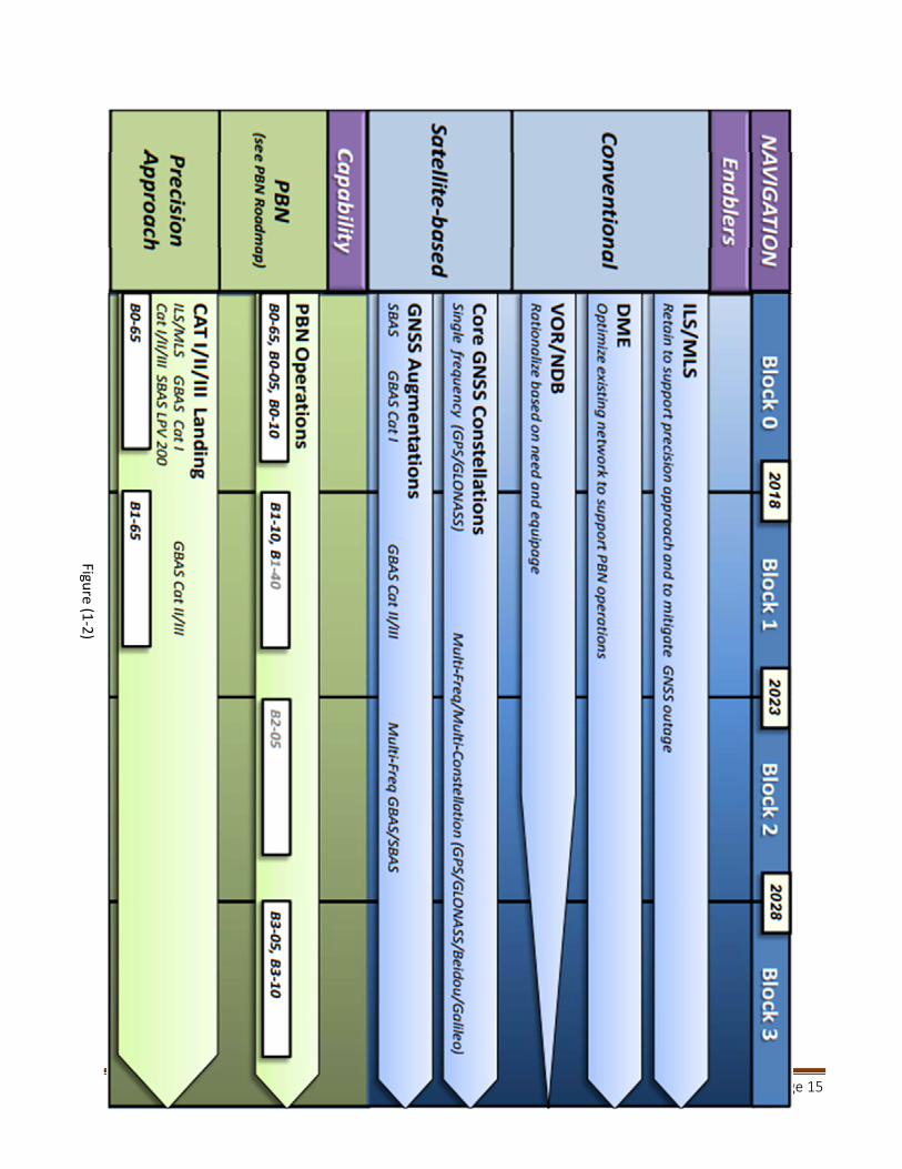
4‐ Global Air Navigation Plan
The GANP and ASBUs recognize the Global Navigation Satellite System (GNSS) as a technical enabler supporting improved services. Roadmaps in the GANP outline timeframes for the availability of GNSS elements, the implementation of related services and the rationalization of conventional infrastructure. The ICAO Navigation roadmap depicted in figure (1‐2)
Guidance on GNSS Implementation in the MID Region Page 15
Figure (1
‐2)
Guidance on GNSS Implementation in the MID Region Page 16
Part II: GNSS in ICAO Middle East Region
1‐ The conventional Ground Based Navigation systems in the MID
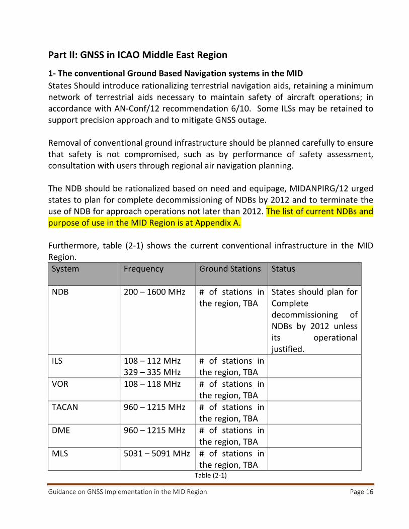
States Should introduce rationalizing terrestrial navigation aids, retaining a minimum network of terrestrial aids necessary to maintain safety of aircraft operations; in accordance with AN‐Conf/12 recommendation 6/10. Some ILSs may be retained to support precision approach and to mitigate GNSS outage. Removal of conventional ground infrastructure should be planned carefully to ensure that safety is not compromised, such as by performance of safety assessment, consultation with users through regional air navigation planning. The NDB should be rationalized based on need and equipage, MIDANPIRG/12 urged states to plan for complete decommissioning of NDBs by 2012 and to terminate the use of NDB for approach operations not later than 2012. The list of current NDBs and purpose of use in the MID Region is at Appendix A. Furthermore, table (2‐1) shows the current conventional infrastructure in the MID Region.
System Frequency Ground Stations Status
NDB 200 – 1600 MHz # of stations in the region, TBA
States should plan for Complete decommissioning of NDBs by 2012 unless its operational justified.
ILS
108 – 112 MHz 329 – 335 MHz
# of stations in the region, TBA
VOR 108 – 118 MHz # of stations in the region, TBA
TACAN 960 – 1215 MHz # of stations in the region, TBA
DME 960 – 1215 MHz # of stations in the region, TBA
MLS 5031 – 5091 MHz # of stations in the region, TBA
Table (2‐1)
Guidance on GNSS Implementation in the MID Region Page 17
2) SBAS
The implementation of GNSS and augmentations systems in the MID Region should
be in full compliance with ICAO Standards and Recommended Practices and PANS;
due to geographic location of some MID States, taking advantages of adjacent SBAS
services (EGNOS and GAGAN) is possible.
SBAS‐based procedure do not require any infrastructure at the Airport served, but
SBAS elements (e.g. reference stations, master station, satellites) must be in place to
support required service level*
2‐1 EGNOS
Some of MID Region States who are member in the EUROMED* can exploit the use of EGNOS in various applications, mainly in the transport sectors. As of the time of developing this document; five (5) States have officially notified their interest in EGNOS implementation (Algeria, Jordan, Lebanon, Libya, and Tunisia).
The requirements to use EGNOS services are as follow:
a) Installation of additionnel RIMS, three RIMS are sufficient to extend the service to EURCOMED States.
b) Air Navigation Service Providers have to sign an EGNOS Working Agreement (EWA) with the ESSP (Certified provider of Safety of Life service in aviation in EU ) to be able to activate use of EGNOS SoL.
c) International bilateral agreements should be signed between EU and each State to define liability in case of EGNOS failure which results in death/injury/loss/damage to equipment.
EGNOS Service Maps
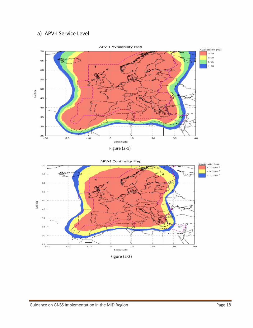
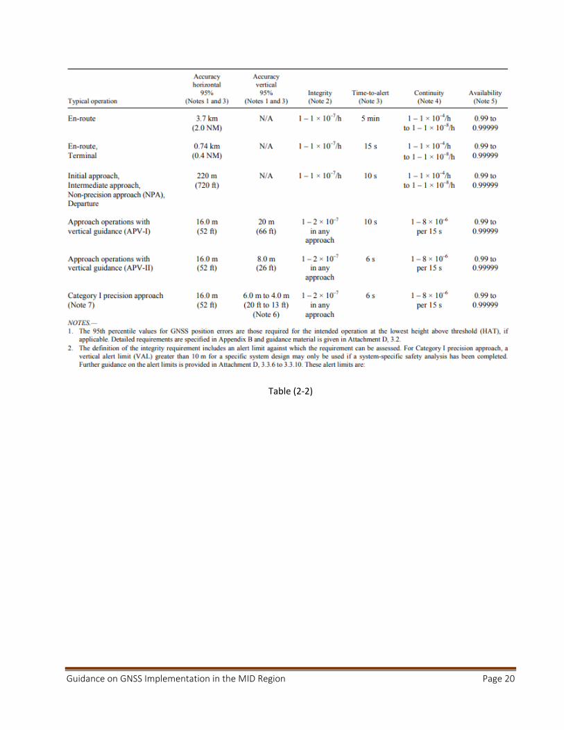
The current service maps shown in the figures (2‐1, 2‐2, 2‐3 and 2‐4), the current availability and continuity for APV‐I and LPV service level in the MID Region are less than the minimum required signal‐in‐space performance specified in Annex 10 Vol. I., the requirements are shown in table (2‐2)
*Euromed countries (Algeria, Egypt, Jordan, Lebanon, Libya, Morocco, Palestine, Syria and Tunisia).
Guidance on GNSS Implementation in the MID Region Page 18
a) APV‐I Service Level
Figure (2‐1)
Figure (2‐2)

Guidance on GNSS Implementation in the MID Region Page 19
b) LPV200 Service Level
Figure (2‐3)
Figure (2‐4)
Guidance on GNSS Implementation in the MID Region Page 20
Table (2‐2)
Guidance on GNSS Implementation in the MID Region Page 21
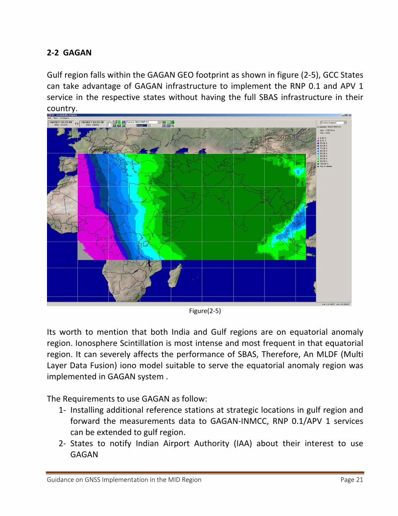
2‐2 GAGAN Gulf region falls within the GAGAN GEO footprint as shown in figure (2‐5), GCC States can take advantage of GAGAN infrastructure to implement the RNP 0.1 and APV 1 service in the respective states without having the full SBAS infrastructure in their country.
Figure(2‐5)
Its worth to mention that both India and Gulf regions are on equatorial anomaly region. Ionosphere Scintillation is most intense and most frequent in that equatorial region. It can severely affects the performance of SBAS, Therefore, An MLDF (Multi Layer Data Fusion) iono model suitable to serve the equatorial anomaly region was implemented in GAGAN system . The Requirements to use GAGAN as follow:
1‐ Installing additional reference stations at strategic locations in gulf region and forward the measurements data to GAGAN‐INMCC, RNP 0.1/APV 1 services can be extended to gulf region.
2‐ States to notify Indian Airport Authority (IAA) about their interest to use GAGAN
Guidance on GNSS Implementation in the MID Region Page 22
3‐GNSS Application in the MID Region The PBN Implementation plan (ICAO MID Doc 007) documents the applications of GNSS in ICAO Middle East Region. Reference to MID Surveillance plan will be added later 4‐GBAS Transition from ILS to GBAS should be based on an economic assessment, an
operational assessment and from a safety and security perspective. Cost benefits
analysis should be conducted taking on consideration that one GBAS can be used for
several runways ends and even in some cases more than one Airports. The standard
for GBAS CAT II/III is under development.
5‐ Cost Benefits Analysis:
The use of GNSS in PBN applications reduces the overall running cost of Navigation infrastructure. Also deploying GBAS reduces the cost for ground infrastructure since a single GBAS ground station can provide approach guidance to all runways at an airport. GBAS can increase the Airport capacity, because it does not have sensitive areas that must be protected. However, the CBA is very dependent on specific operational and airport infrastructure aspects.
States may consider the following factors during the process of estimating the cost
associated with competing alternative in CBA:
a) CAPEX a.1 Installation Cost;
‐ One GBAS costs around 1.5 ‐2 M euro (equal to the cost of 3 ILSs).
‐ ILS(s) must be retained to ensure the service continuity during the
GNSS/GBAS outage.
a.2 Training for operational and technical staff.
b) OPEX: c.1 Cost of Flight Check (Calibration).

Guidance on GNSS Implementation in the MID Region Page 23
c.2 Maintenance costs (Preventive, Reactive, maintenance Contract, less Spare
parts).
It has been reported by several CBA studies, that GBAS initial investment is higher
than for ILS, and lower OPEX. However, Net Present Cost need to be calculated based
on Airport infrastructure and operational requirements.
6‐ Current Use of GBAS/SBAS in the MID Region
TBA

Guidance on GNSS Implementation in the MID Region Page 24
PART III: GNSS VULNERABILITIES
1‐ Introduction
GNSS signals are very weak at the receiver antenna therefore the signal is vulnerable, and also susceptible to ionosphere effects. Current GNSS use a single frequency band common to GPS, GLONASS and SBAS. This makes it easier to intentionally jam GNSS signals. 2‐ Unintentional Interference Sources
There are a number of sources of potential interference to GNSS, including mobile
and fixed VHF communications, Solar effect and other sources. The likelihood and
operational effect of interference vary with the environment.
Unintentional interference is not considered a significant threat provided that States
exercise proper control and protection over the electromagnetic spectrum for both
existing and new frequency allocations. Furthermore,
2‐1 Solar Effect
GNSS signals are delayed by varying amounts of time depending on the density of
ionized particles (ionosphere) which itself depends on the intensity of solar radiation
and other solar energy bursts. The solar activity can cause GNSS service to be
degraded or temporarily lost.
The type and severity of ionospheric effects vary with the level of solar activity, the
region of the world and other factors such as time of year and time of day. Rare solar
storms can affect GNSS service over a wide area. The Solar activity peaks happens
every eleven years.
The availability of a second frequency will allow avionics to calculate ionospheric delay in real time, effectively eliminating a major error source.
2‐2 Radio Frequency Interference
Harmonics of television stations, certain radars, mobile satellite communications and military systems can cause interference with GNSS signals.
Guidance on GNSS Implementation in the MID Region Page 25
2‐3 On‐board systems
Many reported instances of GNSS interference have been traced to on‐board
systems; such interference can be prevented by installing advanced avionics.
3‐Intentional Interference Sources
3‐1 Jamming
Personal privacy devices (PPDs) have been recognized as being responsible for
causing interference to GPS receivers in many occurrences. The intention of PPDs is
to protect the privacy of the user so that the user’s location is not revealed,
therefore the user will not be tracked or monitored. PPDs are low‐cost jammers to
mask GPS signal.
3‐2 Spoofing
Spoofing is the broadcast of GNSS‐like signals that cause avionics to calculate erroneous positions and provide false guidance. It is considered that the spoofing of GNSS is less likely than the spoofing of traditional aids because it is technically much more complex. Spoofing of the GBAS data broadcast is virtually impossible, because of an authentication scheme that has been developed. 4‐Reducing the Likelihood of Interferences
The likelihood of interference depends on such factors as population density and the motivation of individuals or groups in an area to disrupt aviation and non‐aviation services
a) Effective spectrum management, this comprises creating and enforcing
regulations/laws that control the use of spectrum and carefully assessing
applications for new spectrum allocations.
b) The introduction of GNSS signals on new frequencies will ensure that unintentional interference does not cause the complete loss of GNSS
service (outage) although enhanced services depending upon the
availability of both frequencies might be degraded by such interference
Guidance on GNSS Implementation in the MID Region Page 26
c) State should develop and enforce a strong regulatory framework governing the use of intentional radiators, including GNSS repeaters, pseudolites, spoofers and jammers, should forbid the use of jamming and spoofing devices and regulate their importation, exportation, manufacture, sale, purchase, ownership and use.
d) Multi‐constellation GNSS would allow the receiver to track more satellites, reducing the likelihood of service disruption.
5‐ Mitigation Strategies
The disruption of GNSS signals will require the application of realistic and effective mitigation strategies to both ensure the safety and regularity of air services and discourage those who would consider disrupting aircraft operations. There are three principal methods which can be applied in combination:
a) taking advantage of on‐board equipment, such as IRS; b) taking advantage of conventional navigation aids and radar; and c) employing procedural (aircrew and/or ATC) methods.
Mitigation of GNSS vulnerabilities needs to be balanced in the context of the overall threats to communications, navigation, and surveillance/air traffic management (CNS/ATM) operations to ensure that the applied effort is neither too small (leading to potentially unacceptable risks and/or preventing realization of GNSS enabled benefits) nor too large (in comparison with the effort expended on mitigating other risks).
Guidance on GNSS Implementation in the MID Region Page 27
References
1‐ ICAO ANNEX 10, VOL I, Aeronautical Telecommunications.
2‐ ICAO DOC 9849, Global Navigation Satellite System Manual. First edition, 2003.
3‐ ICAO DOC 8071, Manual on Testing Radio Navigation Aids, , VOL I,
4‐ ICAO DOC 8071, Manual on Testing Radio Navigation Aids, Volume II Testing of
Satellite‐based Radio Navigation Systems, first edition, 2007.
5‐ ICAO DOC 9750, Global Air Navigation Plan. 6‐ GNSS Strategy endorsed by MIDANPIRG 15
7‐ PBN Implementation Plan in ICAO MID Region, First Edition.
8‐ EGNOS Safety of Life (SoL) Service Definition Document, Version 3.1,
26/9/2016
9‐ McGill University, Paper on the impact of satellite based navigation upon the
aviation industry.
10‐ FAA, AC 20‐138C, AC90 105A, AC90 101A. 11‐ Feasibility Studies on Ground Based Augmentation System (GBAS) , ASECNA,
2013
12‐ http://www.eurocontrol.int/press‐releases/egnos‐operational‐aviation

Guidance on GNSS Implementation in the MID Region Page 28
APPENDIX A
LIST OF NDBs IN THE MID REGION AND PURPOSE OF RETAIN
State NDB ID Purpose of retain Plan to remove
- END -