Embed Size (px)
Citation preview
CNS SG/8-REPORT
INTERNATIONAL CIVIL AVIATION ORGANIZATION
THE MIDDLE EAST AIR NAVIGATION PLANNING AND IMPLEMENTATION REGIONAL GROUP
(MIDANPIRG)
REPORT OF THE EIGHTH MEETING OF CNS SUB-GROUP (Cairo, Egypt, 26 - 28 February 2018)
The views expressed in this Report should be taken as those of the MIDANPIRG CNS Sub-Group and not of the Organization. This Report will, however, be submitted to the MIDANPIRG and any formal action taken will be published in due course as a Supplement to the Report.
Approved by the Meeting
and published by authority of the Secretary General

The designations employed and the presentation of material in this publication do not imply the expression of any opinion whatsoever on the part of ICAO concerning the legal status of any country, territory, city or area or of its authorities, or concerning the delimitation of its frontier or boundaries.

TABLE OF CONTENTS Page
PART I - HISTORY OF THE MEETING 1. Place and Duration ......................................................................................................... 1 2. Opening .......................................................................................................................... 1 3. Attendance ..................................................................................................................... 1 4. Officers and Secretariat .................................................................................................. 1 5. Language ........................................................................................................................ 1 6. Agenda ........................................................................................................................... 2 7. Conclusions and Decisions - Definition ........................................................................ 2 8. List of Draft Conclusions and Draft Decisions .............................................................. 2 PART II - REPORT ON AGENDA ITEMS
Report on Agenda Item 1 ............................................................................................ 1-1
Report on Agenda Item 2 ............................................................................................ 2-1 Report on Agenda Item 3 ............................................................................................ 3-3 Report on Agenda Item 4 ..................................................................................... 4-1/4-7 Report on Agenda Item 5 ............................................................................................ 5-1 Report on Agenda Item 6 ............................................................................................ 6-1 Report on Agenda Item 6 ............................................................................................ 7-1
APPENDICES
Appendix 2A Appendix 3A Appendix 4A-4H Appendix 5A Appendix 6A Appendix 7A
ATTACHMENT List of Participants ................................................................................... Attachment A
----------------

CNS SG/8-REPORT -1-
PART I – HISTORY OF THE MEETING 1. PLACE AND DURATION 1.1 The Eighth meeting of the MIDANPIRG Communication, Navigation and Surveillance Sub-Group (CNS SG/8) was held at the ICAO MID Regional Office, Cairo, Egypt, 26-28 February 2018. 2. OPENING 2.1 The meeting was opened by Mr. Mohamed Smaoui, Deputy Regional Director, ICAO Middle East Office, who welcomed the participants to Cairo. Mr. Smaoui highlighted few subjects that will be addressed by the meeting, inter-alia, the CRV project, MID Surveillance plan, GNSS Guidance material and IWXXM/ROC Communication requirements. 2.2 Mr. Smaoui underlined that the implementation level of AIDC/OLDI in the Region is still very low and the CNS SG needs to identify the technical challenges, if any, and propose actions/solutions to foster the implementation of the ASBU module B0-FICE.
2.3 In closing, Mr. Smaoui thanked the participants for their presence and wished the meeting every success in its deliberations. 3. ATTENDANCE 3.1 The meeting was attended by a total of forty (40) participants, from eleven (11) States (Egypt, Iran, Iraq, Jordan, Kuwait, Lebanon, Oman, Saudi Arabia, Sudan, United Arab Emirates and Yemen) and four (4) International Organizations/Industry (ACAC, IATA, IFATCA and SITA). The list of participants is at the Attachment A. 4. OFFICERS AND SECRETARIAT 4.1 The meeting was chaired by Mr. Saleh Abdullah Al-Harthy, Director of CNS, Public Authority for Civil Aviation (PACA), Oman. 4.2 Mrs. Muna Alnadaf, RO/CNS was the Secretary of the meeting supported by Mr. Mohamed Smaoui, Deputy Regional Director (DRD).
5. LANGUAGE 5.1 The discussions were conducted in English. Documentation was issued in English.

CNS SG/8-REPORT -2-
6. AGENDA 6.1 The following Agenda was adopted:
Agenda Item 1: Adoption of the Provisional Agenda and election of Chairpersons Agenda Item 2: Follow-up on MIDANPIRG/16 Conclusions and Decisions relevant
to CNS Agenda Item 3: Global Developments related to CNS Agenda Item 4: CNS planning and implementation in the MID Region
Agenda Item 5: Review of Air Navigation Deficiencies in the CNS Field Agenda Item 6: Future Work Programme Agenda Item 7: Any other business
7. CONCLUSIONS AND DECISIONS - DEFINITIONS 7.1 All MIDANPIRG Sub-Groups and Task Forces record their actions in the form of Conclusions and Decisions with the following significance:
a) Conclusions deal with the matters which, in accordance with the Group’s terms of reference, merit directly the attention of States on which further action will be initiated by ICAO in accordance with established procedures; and
b) Decisions deal with matters of concern only to the MIDANPIRG and its contributory bodies.
8. LIST OF DRAFT CONCLUSIONS AND DRAFT DECISIONS DRAFT CONCLUSION 8/1: SUPPORT ICAO POSITION TO WRC-19
DRAFT CONCLUSION 8/2: FREQUENCY MANAGEMENT WORKSHOP DRAFT CONCLUSION 8/3: IMPLEMENTATION OF FTBP DRAFT CONCLUSION 8/4: THE COMMUNICATION NETWORK FOR IWXXM
DATA EXCHANGE DRAFT CONCLUSION 8/5: KHARTOUM COM CENTRE DRAFT CONCLUSION 8/6: GUIDANCE ON GNSS IMPLMENTATION

CNS SG/8-REPORT
-3-
DRAFT CONCLUSION 8/7: MID REGION PBN IMPLEMENTATION PLAN DRAFT CONCLUSION 8/8: FREQUENCY MANAGEMENT FOCAL POINTS DRAFT CONCLUSION 8/9: MID REGION SURVEILLANCE PLAN DRAFT DECISION 8/10: REVISED CNS SG TERMS OF REFERENCE
----------------

CNS SG/8-REPORT 1-1
PART II: REPORT ON AGENDA ITEMS REPORT ON AGENDA ITEM 1: ADOPTION OF THE PROVISIONAL AGENDA AND ELECTION OF
CHAIRPERSONS 1.1 The subject was addressed in WP/1 presented by the Secretariat. The meeting reviewed and adopted the Agenda as at paragraph 6 of the History of the Meeting. 1.2 The meeting noted that Mr. Ali Humaid Al-Adawi, the Chairman of the CNS Sub Group, retired from the Public Authority for Civil Aviation (PACA), Oman; and Dr. Suleiman Deeb, the Vice-Chairman of the CNS Sub Group retired from the Civil Aviation Regulatory Commission (CARC), Jordan. The meeting thanked Mr. Al-Adawi and Dr. Deeb for their good work and excellent contributions to the CNS SG and MIDANPIRG during their careers. 1.3 In accordance with the MIDANPIRG Procedural Handbook, Edition July 2015 (MID Doc 001), Part IV, paragraph 6.2, the meeting unanimously elected Mr. Saleh Abdullah Al-Harthy, Director of CNS, Public Authority for Civil Aviation (PACA), Oman, as the new Chairperson and Mr. Khaled Mohamed Reda Ahmed Eltanany, CNS Inspector, Egyptian Civil Aviation Authority (ECAA), Egypt, as the Vice-Chairperson of the CNS SG, respectively.
-------------------

CNS SG/8-REPORT
2-1
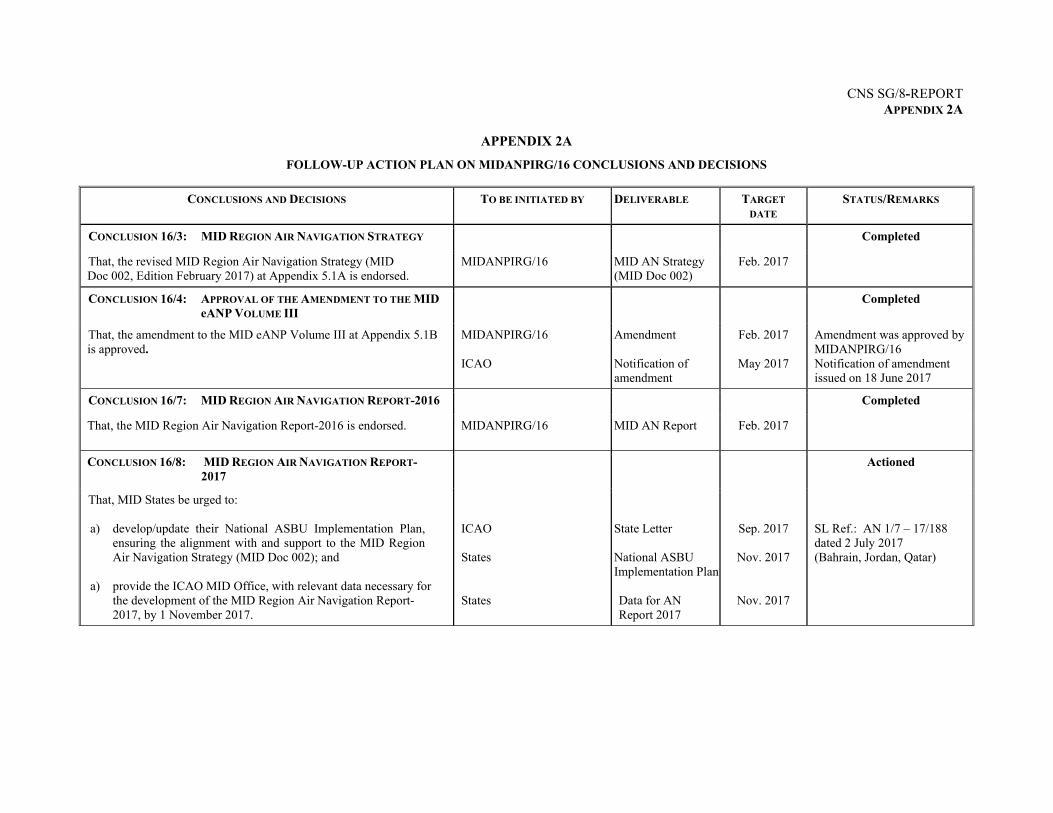
REPORT ON AGENDA ITEM 2: FOLLOW-UP ON MIDANPIRG/16 CONCLUSIONS AND DECISIONS
RELEVANT TO CNS 2.1 The subject was addressed in WP/2 presented by the Secretariat. The meeting noted the status of the MIDANPIRG/16 Conclusions and Decisions relevant to CNS and the follow-up actions taken by concerned parties as at Appendix 2A.
---------------------
CNS SG/8-REPORT 3-1
REPORT ON AGENDA ITEM 3: GLOBAL DEVELOPMENTS RELATED TO CNS Outcome of the WRC-19 Preparatory Workshop 3.1 The subject was addressed in WP/3 presented by the Secretariat. The meeting was apprised of the outcome of the WRC-19 Preparatory Workshop held in Paris, France, 11-12 September 2017. The Report of the Workshop is at Appendix 3A. The meeting recognized that may issues related to Frequency Management need to be addressed at Regional level; and agreed that the coming CNS SG meetings should include items related to Frequency Management in their Agendas. 3.2 The meeting recalled MIDANPIRG/15 Conclusion 15/27 regarding States’ support to the ICAO Position to WRC-15:
CONCLUSION 15/27: SUPPORT ICAO POSITION TO WRC-15
That, States be urged to: a) support the ICAO Position to the WRC-15;
b) make necessary arrangements for the designated Civil Aviation Personnel to
participate actively in the preparatory work for WRC-15 at the national level; and
c) attend the preparatory regional spectrum management groups meetings and WRC-15 to support and protect aviation interests.
3.3 The meeting recalled that DGCA-MID/2 meeting urged States to ensure continuous coordination with their Radio Frequency Spectrum Regulatory Authorities (Telecommunications Authorities) and the Arab Spectrum Management Group (ASMG) for the support of the ICAO position at WRC and its preparatory meetings. The meeting urged States to work closely with their States Telecommunication Authorities to ensure that ICAO Position is suitably reflected in the national position of the State and in the regional position; and to support ICAO Position during WRC-19 meeting. Accordingly, the meeting agreed to the following Draft Conclusion:
DRAFT CONCLUSION 8/1: SUPPORT ICAO POSITION TO WRC-19
That, States be urged to: a) work closely with their States Telecommunication Authorities to support the ICAO
Position to the WRC-19;
b) make necessary arrangements for the designated Civil Aviation Personnel to participate actively in the preparatory work for WRC-19 at the national level; and
c) attend the preparatory regional spectrum management groups meetings and WRC-19 to support and protect aviation interests.
CNS SG/8–REPORT 3-2
3.4 The meeting recalled MIDANPIRG Conclusion 13/44 related to the removal of States’ names from footnotes 5.362B and/or 5.362C, in coordination with States’ spectrum regulatory authorities, according to the ITU procedures of the GNSS signal. In this respect, the meeting was informed that this was valid until January 2015 and now the footnotes are removed from the ITU Radio Regulations Edition of 2016. 3.5 In connection with the above, the meeting underlined the importance of the ITU attendance to the CNS SG meetings; and requested the ICAO MID Office to take necessary measures to encourage ITU attendance. Frequency Finder Tool
3.6 The meeting recalled that MIDANPIRG/16 urged States to use the Frequency Finder tool for requesting the allocation and deletion of frequencies from the COM list. In this regard, the meeting noted that new version of Frequency Finder tool has been developed. The tool and the complete documentation are available at: https://www.icao.int/safety/FSMP/Pages/Documents.aspx
3.7 The meeting agreed that a Workshop on frequency management, including the use of the Frequency Finder tool would be beneficial to address frequency management issues and keep States abreast of the use of the tool. Accordingly, the meeting agreed to the following Draft Conclusion:
DRAFT CONCLUSION 8/2: FREQUENCY MANAGEMENT WORKSHOP That, ICAO consider the organization of a Workshop on Frequency finder tool for States in the MID Region in 2019-2020.
PBCS Implementation Issues 3.8 The subject was addressed in WP/4 presented by IATA. The meeting noted that effective 29 March 2018, Performance Based Communication Standards (PBCS) will be implemented over portions of the NAT and APAC oceanic flight information regions in order to reduce separation standards; and airlines intending to fly into portions of the NAT/APAC oceanic airspaces will require PBCS operational approvals.
3.9 The meeting noted that following pending tasks are associated with PBCS implementation in the MID Region:
– establishing States’ policies for PBCS implementation and operational approval; – operators’ readiness and eligibility to file PBCS capability; and – ANSP readiness to process flight plan PBCS designators.
3.10 The meeting recalled that Amendment 1 to ICAO Doc 4444 reserved codes for PBCS in the ICAO FPL format, and that States’ Flight Data Processing Systems can process the codes. Nevertheless, the meeting urged States, as a matter of high priority, to conduct tests before 29 March 2018, to ensure the readiness of their flight processing systems. Furthermore, the meeting agreed that ICAO MID Office to follow-up with States and provide assistance, as required.
CNS SG/8-REPORT 3-3
3.11 The meeting urged States to expedite their development and implementation of PBCS operational approval regulations and processes, and invited States to use the ICAO PBCS Authorization Guide. The PBCS Authorization Guide and other related documents are available on ICAO website at: https://www.icao.int/airnavigation/pbcs/Pages/Operatinal-authorization.aspx
3.12 The meeting agreed that the subject needs to be coordinated with the RASG-MID, in order to follow-up with the Regulators and Airworthiness Authorities, their readiness for granting PBCS operational approvals. Accordingly, the meeting requested IATA to present a working paper on PBCS implementation to the upcoming RSC/6 meeting (Cairo, 25-27 June 2018), for further coordination and monitoring.
Outcome of the Interregional SWIM Workshop 3.13 The subject was addressed in PPT/1 presented by the Secretariat. The meeting was apprised of the outcome of the Interregional APAC/EUR/MID Workshop held in Brussels, 2-4 October 2017. In particular, the meeting noted that the implementation of the Exchange models (FIXM, AIXM, IWXXM) is a key enabler for SWIM. It was highlighted that States should foster the implementation of B0-FICE and implement FIXM. The meeting noted also that Data security/cyber security is a challenge in SWIM and needs to be considered.
3.14 The meeting was informed that the AIM Sub Group would develop a Regional SWIM Roadmap in coordination with the ATM and CNS Sub-Groups. Consequently, the meeting agreed that new task related to SWIM infrastructure requirements should be added to the Terms of Reference (TORs) of the CNS SG.
--------------------
CNS SG/8-REPORT 4-1
REPORT ON AGENDA ITEM 4: CNS PLANNING AND IMPLEMENTATION IN THE MID REGION Status of SITA AMHS Gateway Interconnections and Transition to AMHS within the MID Region 4.1 The subject was addressed in WP/8 presented by SITA and PPT/4 presented by Jordan. The meeting was apprised of the progress made in SITA AMHS Gateway inter-connections and transition to AMHS in the different ICAO Regions. 4.2 The meeting noted that the AMHS Interoperability and Preoperational tests with Jordan and Lebanon are completed and coordination with the ANSPs within MID Region has started to plan for transition to AMHS within ICAO MID Region. It was highlighted that the progress is pending completion of address validation and appropriate configuration update with some AMHS COM Centres to complete transition within MID Region. Accordingly, the meeting developed SITA Type X Transition Action Plan at Appendix 4A.
ROC and IWXXM Implementation 4.3 The subject was addressed in WP/6 and PPT/2 presented by the Secretariat. The meeting was apprised of the Communication requirements to establish ROC and enable OPMET data exchange in IWXXM format. Accordingly, the meeting agreed to the following Draft Conclusion:
DRAFT CONCLUSION 8/3: IMPLEMENTATION OF FTBP That, States are urged to:
a) implement FTBP capability at National COM Centres (AMHS is a pre-requisite);
b) implement P3/P7 with FTBP capability at the National OPMET Centre (NOC);
and
c) set the maximum overall AMHS Message size to 4 MB. 4.4 The meeting updated the ROC Connectivity plan as at Appendix 4B. 4.5 The meeting noted that exchanging the IWXXM format in the current mixed environment (AFTN, Basic and Extended AMHS Connections) need a lot of preparation and monitoring, to ensure messages flow through consistent routes; main and backup routes to eliminate the generation of non-delivery reports (NDRs). Furthermore, the requirement that each State in the MID Region has direct connection with the Main and Backup ROCs, will impose additional cost on the ROCs and MID States. Accordingly, the meeting agreed to the following Draft Conclusion:
DRAFT CONCLUSION 8/4: THE COMMUNICATION NETWORK FOR IWXXM DATA
EXCHANGE That, the Main and Backup Regional OPMET Centres (Bahrain and Saudi Arabia) and the Main COM Centres in the MID Region be urged to join the CRV Project in order to enable the exchange of OPMET information in IWXXM format.
CNS SG/8-REPORT 4-2
4.6 Egypt and Jordan were invited to support the Secretariat to update the FTBP Testing Document based on the new IWXXM update and AMHS Profile defined by Appendix H to EUR DOC 020. In this regard, the meeting encouraged States to test FTBP capability using the second version of the MID FTBP Test Document. CRV Project 4.7 The subject was addressed in WP/7 presented by the Secretariat. The meeting recalled that the aim of establishing MID IP Network (CRV) is to help States achieve a safe, secure, reliable and economical backbone network to handle current and anticipated network traffic demand and enable the implementation of many ASBU Modules. 4.8 The meeting recalled that MIDANPIRG/16 agreed that the procurement framework of the APAC CRV be used for the implementation of the MID IP Network Project and that the CRV procurement includes all ICAO MID States as potential users. Furthermore, Six (6) States (Bahrain, Iran, Jordan, Kuwait, Lebanon and Sudan) confirmed their commitment and three (3) States (Oman, Saudi Arabia and UAE) confirmed provisional commitment to the project.
4.9 The meeting was provided with progress report on the CRV project in the APAC Region. Moreover, the meeting noted that States should complete the High Level Questionnaire with their requirements and selected Service Package(s) as a first step. Based on States inputs, the CRV’s Service Provider (PCCW) will produce the System Design Document (SDD) for each State.
4.10 The meeting urged States that have not yet completed the high level Questionnaire, to do so and touch-base with PCCW during the CRV Workshop, which will be held back-to-back with the CNS SG/8 meeting on 1 March 2018.
4.11 The meeting invited States to attend the CRV OG/4 meeting in Nadi, Fiji to discuss and approve their SDD.
Khartoum COM Centre
4.12 The subject was addressed in PPT/7 presented by Sudan. The meeting recalled that during the MIDANPIRG/15 meeting, IATA raised an issue about messages flow and loss between the MID and AFI Regions. Thus, the MIDAMC STG/3 agreed to the necessity of having additional entry/exit point between the two Regions. 4.13 The meeting received a request from Sudan to consider Khartoum COM Centre as a Main COM Centre and gateway with AFI. Furthermore, the meeting noted that the advanced technology in Khartoum COM Centre and geographical location of Sudan at the interface area, support Sudan request. Accordingly, the meeting requested Sudan to send an official letter to the ICAO MID Office with necessary justifications and agreed to the following Draft Conclusion:
DRAFT CONCLUSION 8/5: KHARTOUM COM CENTRE That, in order to establish a third Gateway to the AFI Region, Khartoum COM Centre be changed to a main Centre.
CNS SG/8-REPORT 4-3
MID Region Backup Consideration for Ground-To-Ground Voice/Data Communication
4.14 The subject was addressed in WP/16 presented by IRAN. The meeting noted the need for backup solution for each ground-to-ground voice data communication and the variety of available network infrastructures in Iran that could be used as a backup to the data and voice communications. 4.15 The meeting noted that the public internet could be used as a backup means for data communication or for point-to-point connection with low traffic, according to the guidance in ICAO Doc 9855.
4.16 The meeting agreed that ground-to-ground backup arrangement involve many parties and aspects: States, Telecommunication service providers, contingency arrangement procedures, etc.; therefore, the meeting agreed that the subject be further considered and addressed by the CNS SG/9 meeting.
AIDC/OLDI Implementation
4.17 The subject was addressed in WP/9 presented by the Secretariat. The meeting noted that the status of implementation of AIDC/OLDI in the MID Region is still far below the acceptable level. Furthermore, the meeting was apprised of the replies to the Questionnaire sent to the States’ AIDC/OLDI focal points in order to identify challenges impeding the implementation. 4.18 The meeting agreed to the following actions/recommendations based on the challenges identified related to AIDC/OLDI implementation in the MID Region:
ICAO MID Office to coordinate with Paris Office regarding Beirut – Nicosia and Cairo
– Nicosia OLDI connections; States that do not have AIDC/OLDI capability are urged to plan for an upgrade of
their systems as soon as possible; States that need assistance (Jordan, Lebanon and Yemen) are invited to visit Muscat
Centre (including Simulator), as Oman offered to share their AIDC/OLDI experience with other States; and
States that have not replied to the Questionnaire, are urged to do so by 1 April 2018.
4.19 The meeting reviewed and updated the status of AIDC/OLDI Implementation and the list of AIDC/OLDI Focal Points at Appendices 4C and 4D, respectively. Outcome of ACAC/ICAO GNSS Workshop 4.20 The subject was addressed in PPT/5 presented by ACAC and WP/10 presented by the Secretariat. The meeting was apprised of the outcome of ACAC/ICAO GNSS Workshop held in Rabat, 6-7 November 2017, and the follow-up actions taken by ACAC. The presentations and Summary of Discussions of the Workshop are available at https://www.icao.int/MID/Pages/2017/GNSS-Wksp.aspx.
CNS SG/8-REPORT 4-4
Guidance Material on GNSS Implementation in the MID Region 4.21 The subject was addressed in WP/10 presented by the Secretariat. The meeting noted that Draft Guidance on GNSS Implementation in the MID Region has been developed by the Secretariat, to complement the information in the MID PBN Implementation Plan (MID Doc 007) and assist States in their GNSS planning and implementation process. The meeting reviewed the Draft Guidance on GNSS Implementation in the MID Region at Appendix 4E and agreed to the following Draft Conclusion:
DRAFT CONCLUSION 8/6: GUIDANCE ON GNSS IMPLEMENTATION That, States review the Draft Guidance on GNSS Implementation in the MID Region at Appendix 4E, and provide the ICAO MID Office with their comments/inputs by 15 May 2018 in order to present the consolidated version to the ANSIG/3 meeting for further review and improvement.
MID Region PBN Implementation Plan 4.22 The subject was addressed in WP/17 presented by the Secretariat. The meeting noted that the PBN SG/3 updated the MID Region PBN Implementation Plan (MID Doc 007), and agreed that Chapter 2 of the plan (CNS Infrastructure) be reviewed and updated by the CNS SG/8 meeting, as appropriate. 4.23 The meeting reviewed the MID Region PBN Implementation Plan at Appendix 4F and agreed to the following Draft Conclusion:
DRAFT CONCLUSION 8/7: MID REGION PBN IMPLEMENTATION PLAN That, States review Chapter 2 of the MID Region PBN Implementation plan (CNS Infrastructure) at Appendix 4F, and provide the ICAO MID Office with their comments/inputs by 1 April 2018 in order to present the updated version to the ATM SG/4 meeting for further review and improvement.
Harmful Interference
4.24 The subject was addressed in WP/15 presented by Iran. It was highlighted that the removal of harmful interference requires coordination among States in close coordination with the ICAO MID Office.
4.25 In order to improve the coordination and respond to the interference occurrences in timely manner, the meeting agreed that States should assign focal point for the frequency management issues. Accordingly, the meeting agreed to the following Draft Conclusion:
DRAFT CONCLUSION 8/8: FREQUENCY MANAGEMENT FOCAL POINTS That, States be invited to assign Frequency Management Focal Points by 1 April 2018, for a better coordination of frequency management issues, including harmful interference.
CNS SG/8-REPORT 4-5
User Requirements for ATS Communication-Surveillance (URATS)
4.26 The subject was addressed in PPT/3 presented by IATA. The meeting was apprised of the users’/IATA’s requirements for ground-ground and air-ground Communication.
ATS Data Security in the MID Region 4.27 The subject was addressed in WP/12 presented by UAE. The meeting recalled MIDANPIRG 16/26 Decision related to the establishment of the ATM DATA Security Action Group (ADSAG):
DECISION 16/ 26: ATM DATA SECURITY ACTION GROUP That, the ATM Data Security Action Group (ADSAG) be: a) established to develop the MID Region ATM Data Security Plan, to be presented
to the CNS SG/8; and
b) composed of members from Bahrain, Iran, Kuwait, Oman, Saudi Arabia, UAE (Rapporteur), ICAO and IFAIMA
4.28 The meeting reviewed the proposed Minimum Security Baseline documents (MSBs) developed by UAE, which form part of the ATM Data Security Action Group’s deliverables. The meeting noted that UAE developed a portal to facilitate the sharing of knowledge and reporting of cyber events. The meeting invited States to register on the ATM data and cyber security portal and provide feedback for further enhancement, once the portal becomes available. 4.29 The meeting agreed that the MSBs be circulated to MID States for feedback before the end of April 2018.
Challenges and Mitigation of Security Issues associated with the use of ADS-B 4.30 The subject was addressed in WP/5 presented by Egypt, which highlighted the security threats and challenges associated with the use of ADS-B, as well as the various techniques used to mitigate these security threats.
ADS-B/Out Implementation in UAE
4.31 The subject was addressed in PPT/8 presented by UAE. The meeting was apprised of UAE’s experience related to ADS-B/Out implementation. 4.32 The meeting noted that based on a study carried out by GCAA-UAE in 2015, around 60% of the fleet (civil carriers) using the Emirates FIR were equipped with ADS-B/Out. The current percentage is around 95% .
4.33 It was highlighted that UAE mandated the use of ADS-B/Out in Emirates FIR as of 1 January 2020.
CNS SG/8-REPORT 4-6
Use of MLAT for A-SMGCS System at Cairo Airport
4.34 The subject was addressed in WP/18 and PPT/6 presented by Egypt. The meeting was apprised of Egypt’s experience related to A-SMGCS Implementation in Cairo Airport based on MLAT, including the benefits and advantages and lessons learned.
MID Region Surveillance Plan
4.35 The subject was addressed in WP/11 presented by the Secretariat. The meeting recalled that MIDANPIRG/16 through Decision 16/23 tasked the CNS SG to develop the MID Region Surveillance Plan, in coordination with ATM SG, taking into consideration the Users’ and States’ operational needs and requirements.
DECISION 16/ 23: MID REGION SURVEILLANCE PLAN
That, the MID Region Surveillance Plan be developed by the CNS SG, based on the operational needs identified by the ATM SG.
4.36 The meeting reviewed the MID Region Surveillance plan at Appendix 4G developed by the Secretariat and agreed that the plan needs further improvements. Accordingly, the meeting developed the following Draft Conclusion:
DRAFT CONCLUSION 8/9: MID REGION SURVEILLANCE PLAN That, States review the Draft MID Region Surveillance Plan at Appendix 4G, and provide the ICAO MID Office with their comments/inputs by 15 April 2018 in order to present the consolidated version to the ATM SG/4 and ANSIG/3 meetings for further review and improvement.
4.37 The meeting reiterated MIDANPIRG Conclusion 16/22 regarding the Process for Mode S Interrogator Codes Allocation in the MID Region:
CONCLUSION 16/ 22: MODE S INTERROGATOR CODE (IC) ALLOCATION That, States, that have not yet done so, be urged to: a) provide the ICAO MID Office with their Mode S Interrogator Code (IC) Focal
Points; and b) register to the MICA application for the allocation of the Mode S Interrogator
Code (IC) at: https://ext.eurocontrol.int/mica/Index.action 4.38 The meeting noted that as a follow-up action to the above Conclusion, the ICAO MID Office issued State Letter Ref.: AN 7/27– 17/329 on 26 November 2017. Replies were received from three (3) States (Jordan, Kuwait and Sudan).
CNS SG/8-REPORT 4-7
4.39 It was underlined that MICA focal Points shall revalidate the IC allocations under their responsibility every 5 years, and confirm to the MICA Cell whether the issued IC allocations are still in use. This revalidation is to occur every 5 years following the effective date of the issued IC allocation to avoid Code withdrawal according to the MID Doc 005 (SSR Code Management Plan).
MID Air Navigation Strategy and eANP 4.40 The subject was addressed in WP/13 and WP/14 presented by the Secretariat. The meeting recalled that MIDANPIRG/16 endorsed an updated version of the MID Air Navigation Strategy. 4.41 Considering the progress related to ADS-B and MLAT implementation in the MID Region, the meeting agreed to propose to ANSIG/3 to change the B0-ASUR from priority 2 to priority 1.
4.42 The meeting agreed that, for better monitoring, the effective date of the ACAS carriage regulations should be added to the Table B0-ACAS in the eANP Vol III as at Appendix 4H.
-------------------
CNS SG/8-REPORT 5-1
REPORT ON AGENDA ITEM 5: REVIEW OF AIR NAVIGATION DEFICIENCIES IN THE CNS FIELD 5.1 The subject was addressed in WP/19 presented by the Secretariat. The meeting recalled that, the MIDANPIRG/15, through Conclusion 15/35, urged States to use the MID Air Navigation Deficiency Database (MANDD) for the submission of requests for addition, update, and elimination of Air Navigation Deficiencies, including the submission of a specific Corrective Action Plan (CAP) for each deficiency; and submit a Formal Letter to the ICAO MID Regional Office containing the evidence(s) that mitigation measures have been implemented for the elimination of deficiency(ies) when requesting the elimination of deficiency(ies) from the MANDD. 5.2 The meeting recalled that the MIDANPIRG/16 meeting noted with concern that the majority of deficiencies listed in the MANDD have no specific Corrective Action Plan (CAP). The meeting urged States to implement the provisions of MIDANPIRG Conclusion 15/35 related to elimination of Air Navigation Deficiencies, in particular, the submission of a specific Corrective Action Plan (CAP) for each deficiency. 5.3 The meeting reviewed and updated the list of deficiencies in the CNS field as at Appendix 5A.
---------------------
CNS SG/8-REPORT 6-1
REPORT ON AGENDA ITEM 6: FUTURE WORK PROGRAMME 6.1 The subject was addressed in WP/20 presented by the Secretariat. The meeting reviewed and updated the CNS SG Terms of References (TORs) as at Appendix 6A. Accordingly, the meeting agreed to the following Draft Decision:
DRAFT DECISION 8/10: REVISED CNS SG TERMS OF REFERENCE That, the CNS SG Terms of Reference be updated as at Appendix 6A.
6.2 Taking into consideration, the planned ICAO MID Regional events which are of relevance to the activity of the CNS Sub-group, in particular the ANSIG/3 and MIDANPIRG/17 meetings, it was agreed that the CNS SG/9 meeting along with the MID AMC STG/4 meeting be held during the Second Quarter of 2019. The duration will be 4 days and the venue will be Cairo, unless a State is willing to host the meeting.
--------------------

CNS SG/8-REPORT 7-1
REPORT ON AGENDA ITEM 7: ANY OTHER BUSINESS 7.1 The meeting reviewed and updated the list of Designated CNS Focal Points as at Appendix 7A. 7.2 The meeting noted that the ICAO Competency Based Training (CBT) Workshop for Air Traffic Controllers (ATCO) and Air Traffic Safety Electronics Personnel (ATSEP) will be held at the ICAO MID Regional Office, Cairo, Egypt, 5 - 7 March 2018. The objective of the Workshop is to provide guidance for the implementation of competency-based training and assessment for ATCOs and ATSEP as outlined in the fourth amendment to the Procedures for Air Navigation Services Training (ICAO Doc 9868) and the associated ICAO Training Manuals. The meeting encouraged States to participate in this Workshop.
-------------------

APPENDICES
CNS SG/8-REPORT APPENDIX 2A
APPENDIX 2A
FOLLOW-UP ACTION PLAN ON MIDANPIRG/16 CONCLUSIONS AND DECISIONS
CONCLUSIONS AND DECISIONS TO BE INITIATED BY DELIVERABLE TARGET
DATE STATUS/REMARKS
CONCLUSION 16/3: MID REGION AIR NAVIGATION STRATEGY Completed
That, the revised MID Region Air Navigation Strategy (MID Doc 002, Edition February 2017) at Appendix 5.1A is endorsed.
MIDANPIRG/16 MID AN Strategy (MID Doc 002)
Feb. 2017
CONCLUSION 16/4: APPROVAL OF THE AMENDMENT TO THE MID
eANP VOLUME III Completed
That, the amendment to the MID eANP Volume III at Appendix 5.1B is approved.
MIDANPIRG/16 ICAO
Amendment Notification of amendment
Feb. 2017
May 2017
Amendment was approved by MIDANPIRG/16 Notification of amendment issued on 18 June 2017
CONCLUSION 16/7: MID REGION AIR NAVIGATION REPORT-2016 Completed
That, the MID Region Air Navigation Report-2016 is endorsed. MIDANPIRG/16 MID AN Report Feb. 2017
CONCLUSION 16/8: MID REGION AIR NAVIGATION REPORT-2017
Actioned
That, MID States be urged to:
a) develop/update their National ASBU Implementation Plan, ensuring the alignment with and support to the MID Region Air Navigation Strategy (MID Doc 002); and
a) provide the ICAO MID Office, with relevant data necessary for the development of the MID Region Air Navigation Report-2017, by 1 November 2017.
ICAO States States
State Letter National ASBU Implementation Plan Data for AN Report 2017
Sep. 2017
Nov. 2017
Nov. 2017
SL Ref.: AN 1/7 – 17/188 dated 2 July 2017 (Bahrain, Jordan, Qatar)
CNS SG/8-REPORT APPENDIX 2A
2A-2
CONCLUSIONS AND DECISIONS TO BE INITIATED BY DELIVERABLE TARGET
DATE STATUS/REMARKS
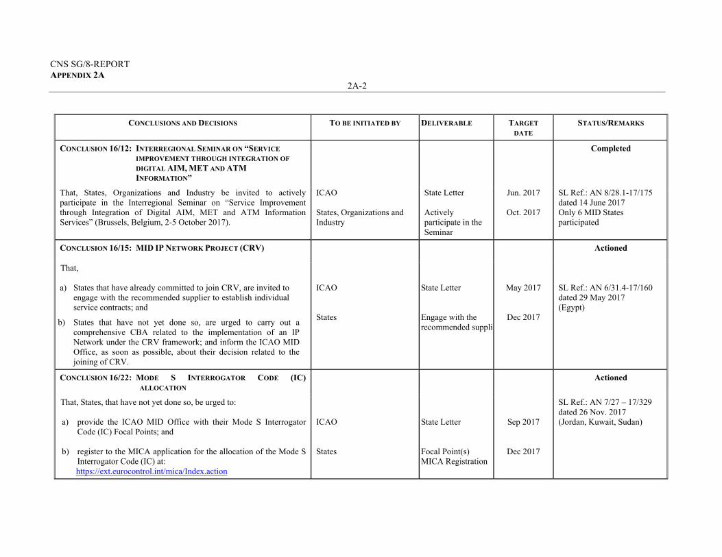
CONCLUSION 16/12: INTERREGIONAL SEMINAR ON “SERVICE
IMPROVEMENT THROUGH INTEGRATION OF
DIGITAL AIM, MET AND ATM
INFORMATION”
Completed
That, States, Organizations and Industry be invited to actively participate in the Interregional Seminar on “Service Improvement through Integration of Digital AIM, MET and ATM Information Services” (Brussels, Belgium, 2-5 October 2017).
ICAO States, Organizations and Industry
State Letter Actively participate in the Seminar
Jun. 2017
Oct. 2017
SL Ref.: AN 8/28.1-17/175 dated 14 June 2017 Only 6 MID States participated
CONCLUSION 16/15: MID IP NETWORK PROJECT (CRV) Actioned
That, a) States that have already committed to join CRV, are invited to
engage with the recommended supplier to establish individual service contracts; and
b) States that have not yet done so, are urged to carry out a comprehensive CBA related to the implementation of an IP Network under the CRV framework; and inform the ICAO MID Office, as soon as possible, about their decision related to the joining of CRV.
ICAO States
State Letter Engage with the recommended supplie
May 2017
Dec 2017
SL Ref.: AN 6/31.4-17/160 dated 29 May 2017 (Egypt)
CONCLUSION 16/22: MODE S INTERROGATOR CODE (IC)
ALLOCATION Actioned
That, States, that have not yet done so, be urged to: a) provide the ICAO MID Office with their Mode S Interrogator
Code (IC) Focal Points; and
b) register to the MICA application for the allocation of the Mode S Interrogator Code (IC) at: https://ext.eurocontrol.int/mica/Index.action
ICAO States
State Letter Focal Point(s) MICA Registration
Sep 2017
Dec 2017
SL Ref.: AN 7/27 – 17/329 dated 26 Nov. 2017 (Jordan, Kuwait, Sudan)
CNS SG/8-REPORT APPENDIX 2A
2A-3
CONCLUSIONS AND DECISIONS TO BE INITIATED BY DELIVERABLE TARGET
DATE STATUS/REMARKS
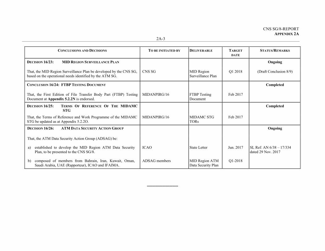
DECISION 16/23: MID REGION SURVEILLANCE PLAN Ongoing
That, the MID Region Surveillance Plan be developed by the CNS SG, based on the operational needs identified by the ATM SG.
CNS SG MID Region Surveillance Plan
Q1 2018 (Draft Conclusion 8/9)
CONCLUSION 16/24: FTBP TESTING DOCUMENT Completed
That, the First Edition of File Transfer Body Part (FTBP) Testing Document at Appendix 5.2.2N is endorsed.
MIDANPIRG/16 FTBP Testing Document
Feb 2017
DECISION 16/25: TERMS OF REFERENCE OF THE MIDAMC
STG Completed
That, the Terms of Reference and Work Programme of the MIDAMC STG be updated as at Appendix 5.2.2O.
MIDANPIRG/16 MIDAMC STG TORs
Feb 2017
DECISION 16/26: ATM DATA SECURITY ACTION GROUP Ongoing
That, the ATM Data Security Action Group (ADSAG) be: a) established to develop the MID Region ATM Data Security
Plan, to be presented to the CNS SG/8.
b) composed of members from Bahrain, Iran, Kuwait, Oman, Saudi Arabia, UAE (Rapporteur), ICAO and IFAIMA.
ICAO ADSAG members
State Letter MID Region ATM Data Security Plan
Jun. 2017
Q1-2018
SL Ref: AN 6/38 – 17/334 dated 29 Nov. 2017
----------------------

REPORT OF THE WRC-19 PREPARATORY WORKSHOP FOR THE EUR/NAT AND MID REGIONS
11 – 12 SEPTEMBER 2017 - ICAO EUR/NAT OFFICE, PARIS, FRANCE,
INTERNATIONAL CIVIL AVIATION ORGANIZATION
European and North Atlantic Office
CNS SG/8-REPORT Appendix 3A

2
1. Introduction 1.1 A Regional Preparatory Workshop for the EUR/NAT and MID Regions was held in the ICAO EUR/NAT Regional Office, Paris, France on 11 and 12 September 2017. 1.2 The Workshop was organized in conjunction with the Fifth Meeting of the Working Group of the Frequency Spectrum Management Panel (FSMP-WG/5), 4 – 8 September and the 23
rd meeting of the
EANPG Frequency Management Group (FMG/23), 13 – 15 September 2017. The objective of the Workshop was to raise awareness of aviation relevant frequency spectrum issues being deliberated within the ITU and Regional frequency spectrum preparatory process and to educate participants in how they can contribute effectively to this process. 2. Attendance 2.1 The Workshop was attended by 49 participants from 24 States, and 9 International Organizations and industry partners. The list of participants is at Attachment 1. 3. Opening of the Workshop 3.1 On behalf of ICAO, Mr. Loftur Jonasson, the Secretary of the Frequency Spectrum Management Panel, welcomed all participants. He highlighted the importance of continued access to interference free spectrum as a critical enabler for the aviation safety critical communications, navigation and surveillance (CNS) functions and that this continued access could only be ensured through active coordination with national radio regulators and the participation of aviation CNS professionals, from States and Industry, in the ITU World Radiocommunication Conference process. 3.2 After initial introductions of all participants, Mr. Mike Biggs, Chairman of the Frequency Spectrum Management Panel, was elected as the chair for the Workshop. Mr. Biggs emphasized the purpose of the Workshop and further emphasized that participants need to create relationships with their radio regulators and give them regular updates on the items of interest to aviation. 4. Workshop Agenda 4.1 The Workshop Agenda, as attached to the letter of invitation was adopted without change.
1. Introduction, including the outcome of WRC-15 and discussion of preparations for future WRCs
2. WRC-19 preparations: Aviation related topics and action plans to be implemented at the national and regional levels
3. Spectrum issues and challenges, not on the specific agenda for WRC-19 4. The reality of frequency management, current practices and new challenges 5. Any other business
5. Organization, Working arrangement, Language and Documentation
5.1 The Workshop was conducted as a single body. The working language was English inclusive of all documentation and this report. Attachment 2 contains a hyperlinked list of presentations. Agenda Item 1: Introduction to Aviation Spectrum and ITU/WRC Process 1.1 Under this agenda item, the Workshop reviewed the requirement of aeronautical spectrum management and the role of aviation within the ITU WRC process (WRC19Wrkshp11). States/Administrations were invited to take note of Assembly Resolution A38-6, which provides detailed
3
guidance on how to support and promote the ICAO Position for WRC-19, as required to ensure continued sufficient and interference free access to frequency spectrum required for aeronautical communications, navigation and surveillance safety services. The importance of close cooperation with the State Spectrum Regulators to ensure that aeronautical concerns are sufficiently addressed in any action taken by WRC-19 was highlighted. Agenda Item 2 – WRC-19 preparations; Aviation related topics and action plans to be implemented at the national and regional levels. Review of relevant agenda items 2.1 The Chair of the Workshop, Mr. Michael Biggs, FAA USA, presented an overview of all aviation relevant agenda items of significance for civil aviation to be addressed by the next WRC (WRC-19) (WRC19Wrkshp12).
2.2 A detailed overview of the ITU preparatory process towards WRC-19 was presented by Mr. Nikolai Vassiliev, ITU (WRC19Wrkshp13).
2.3 The Workshop also reviewed a number of presentations on the WRC-19 agenda items relevant to aviation:
WRC-19 Agenda Item 1.10 – GADSS (Mr. Claude Pichavant, Airbus, WRC19Wrkshp23, and Mr. John Mettrop, UK CAA, WRC19Wrkshp24);
WRC-19 Agenda Item 9.1.4 – Stations on –board sub-orbital vehicles (Mr. John Mettrop, UK CAA, WRC19Wrkshp21)
WRC-19 agenda items which may negatively affect spectrum access for aeronautical systems (1.7, 1.8, 1.9, 1.11, 1.12, 1.13, 1.14, 1.16, 9.1.3, 9.1.6) (Mr. Andrew Roy, ASRI, WRC19Wrkshp22)
2.4 The Workshop also reviewed the current status of WRC-19 preparations within the ICAO EUR/NAT, MID and APAC Regions and how those match up with the ICAO Position:
Status of CEPT preparations for WRC-19 (Mr. Stephen Parry, UK NATS, WRC19Wrkshp41);
Arab Spectrum Management Group (ASMG) and Agenda Items of WRC-19 (Mr. Alaa Mohammad Alturki, SANS, Saudi Arabia, WRC19Wrkshp42)
APT preliminary views for WRC-19 (Mr. Eddy D’Amico, Airservices Australia, WRC19Wrkshp43)
Agenda Item 3: Spectrum issues and challenges, not on the specific agenda for WRC-19 3.1 A number of spectrum relevant issues not on the specific agenda for WRC-19 were reviewed under this agenda item. While some of these items will be reflected on the agenda of future WRCs, such as WRC-23 (2023), there are other items which are currently being pursued on a Regional basis, outside of the WRC process, this includes for instance the potential issue of the 960 - 1 164 MHz frequency band (DME, SSR, ADS-B…) being shared by wireless audio equipment (microphones, in-ear monitors) used for Programme Making and Special Events (PMSE). 3.1.1 Challenges in protecting the aeronautical radio altimeter band (4 200 – 4 400 MHz) were discussed, highlighting the importance of the radio altimeter as an essential enabler for precision approach, landing and ground proximity and collision avoidance. Sharing of the radio altimeter band with systems providing Wireless-Avionics Intra-Communications, a wireless point-to-point intra-aircraft system providing safety
4
critical functions, was also explored. Potential harmful interference to the radio altimeters due to future WRC decisions was highlighted (Joseph Cramer, Boeing USA, WRC19Wrkshp25). 3.1.2 The development of wireless link applications for Small Unmanned Aircraft Systems for disaster relief and related functions was explored (Dr. Fumie Ono, NICT Japan, WRC19Wrkshp51). 3.1.3 Current SARPs and radioregulatory issues around using the fixed satellite service (FSS) for the RPAS C2 link were discussed (Mr. Michael Neale, Aces Inc, USA, WRC19Wrkshp31), and a potential solution co-using the existing AMS(R)S allocation in the 5 GHz band (5 030 – 5 091 MHz) for both line-of-sight (terrestrial) and beyond-line-of-sight (satellite) was introduced (Mr. Christian Peyrotte, Thales Alenia Space, France, WRC19Wrkshp53) 3.1.4 CEPT deliberations on the potential accommodation of wireless microphones and in-ear monitors, Programme Making and Special Events (PMSE), targeting to share the 960 – 1164 MHz band were discussed (Mr. Raffi Khatcherian, EUROCONTROL, WRC19Wrkshp52). Workshop participants agreed that this is of great concern to aviation due to the potential safety risks if this band is shared without sufficient technical testing and regulatory regime to ensure the protection of the Secondary Surveillance Radar, Traffic Collision Avoidance System, Distance Measuring Equipment and other safety critical aeronautical systems operating in this frequency band. Participants were encouraged to engage with their radio regulatory authorities to ensure that the issue is understood and addressed appropriately.
3.1.5 GNSS Radio Frequency Source Localization was discussed (Gerhard Berz, EUROCONTROL, WRC19Wrkshp54) and the new ICAO GNSS RFI mitigation plan contained in the latest version of ICAO Doc 9849 was introduced. In addition to being reactive, GNSS interference threat monitoring needs also to be proactive through risk assessment and the deployment of mitigation measures. Agenda Item 4: The reality of frequency management, current practices and new challenges 4.1 Under this agenda item the work programme of the European Air Navigation Planning Group (EANPG) Frequency Management Group (FMG) was introduced (Torsten Jacob, DFS Germany, WRC19Wrkshp62). Implementation issues experienced with VHF Digital Link Mode 2 in Europe were discussed and the European frequency planning database (SAFIRE) was introduced as well as the future modernization of the European Regional planning and guidance material (EUR Doc 011). Other current and relevant issues in the Region, including DME and GNSS compatibility in the 1164 – 1215 MHz band (Gerhard Berz, EUROCONTROL, WRC19Wrkshp61) were discussed and an update was provided on the status of 8.33 kHz channel DSB-AM implementation in Europe (Jacky Pouzet, EUROCONTROL, WRC19Wrkshp63). Agenda Item: 5: Any other business 5.1 The Workshop took note of the planned alignment of the ICAO and ITU databases for VHF com frequencies (117.975 – 137 MHz), leveraging the data contained in the ICAO global frequency database (Com List 3), which is an integral component of the new ICAO frequency assignment planning software “Frequency Finder” (Nikolai Vassiliev, ITU, WRC19Wrkshp64).
_ _ _ _ _ _ _ _ _ _

Attachment 1, List of Participants
_ _ _ _ _ _ _ _ _ _
ALGERIA
Adel BENAZZOUZ
Benseddik YAHIA
AUSTRALIA
Eddy D’AMICO
BELARUS
Vadzim SIHAI
CANADA
John TAYLOR
CZECH REPUBLIC
Martin LEHKY
EGYPT
Mohammed Ahmed Mahmmoud FARID
Ahmed Mahmoud ISMAIL
FRANCE
Christian FLEURY
Alexandre GUIGNOT
Moustaph SOUMARE
GERMANY
Torsten JACOB
Dominik MEYER
HUNGARY
Janos BUKI
ISRAEL
Ron HOVAV
JAPAN
Fumie ONO
Takeshi TOMODA
LATVIA
Edgars DREIJERS
LEBANON
Wissam EID
Mohamad SAAD
MOROCCO
Sara TOUIL
PHILIPPINES
Charlemagne GILO
POLAND
Karol KAZMIERCZAK
SAUDI ARABIA
Alaa ALTURKI
SUDAN
Ahmed Abdelgabier Mohamed KARRAR
SLOVAKIA
Miron MISANIC
SWEDEN
Morgan SUNDELL
SWITZERLAND
Jésus MARTIN
TURKEY
Firat GULERSES
Göhkan HUZMELI
Haluk OZER
UNITED KINGDOM
Alistair GIBSON
John METTROP
Stephen PARRY
USA
Louis BELL
Michael BIGGS
AIRBUS
Claude PICHAVANT
ASECNA
Eric Armand DAMIBA
Bissa SOUGUE
ASRI
Andrew ROY
BOEING
Joseph CRAMER
EMBRAER
Luis Fernando DE SOUZA
EUROCONTROL
Gerhard BERZ
Raffi KHATCHERIAN
Jacky POUZET
ITU
Nikolai VASSILIEV
THALES
Christian PEYROTTE
ICAO
Robert WITZEN
Loftur JONASSON

Attachment 2, List of Presentations
WRC19Wrkshp11 – Aviation Frequency Spectrum and the ITU World
Radiocommunication Conferences (WRC), Loftur JONASSON, ICAO WRC19Wrkshp12 – ICAO Position for ITU WRC-19
Mike BIGGS, FAA USA WRC19Wrkshp13 – ITU Preparatory Process towards WRC-19
Nikolai Vassiliev, ITU WRC19Wrkshp21 – Stations on-board sub-orbital vehicles (space planes)
John METTROP, UK CAA WRC19Wrkshp22 – WRC-19 Agenda Items for other issues
Andrew ROY, ASRI USA
WRC19Wrkshp23 – GADSS in depth – Airbus views on the Global Aeronautical Distress and Safety System Claude PICHAVANT, Airbus France
WRC19Wrkshp24 – Global Aeronautical Distress & Safety System (GADSS)
Radio Regulatory provisions John METTROP, CAA UK
WRC19Wrkshp25 – Protection of Radio Altimeter and Wireless Avionics Intra-
Communications systems Joseph Cramer, Boeing USA
WRC19Wrkshp31 – Use of the Fixed Satellite Service for RPAS C2 link (ITU
Resolution 155 (WRC-15)) Michael Neale, Aces Inc USA
WRC19Wrkshp41 – Regional preparations for WRC-19, CEPT
Stephen Parry, NATS UK
WRC19Wrkshp42 – Regional preparations for WRC-19, ASMG Alaa Mohammad Alturki, SANS Saudi Arabia
WRC19Wrkshp43 – Regional preparations for WRC-19, APT Eddy D’Amico, Airservices Australia
WRC19Wrkshp51 – Development of Wireless Applications for small UAS in Japan Fumie Ono, NICT Japan
WRC19Wrkshp52 – CEPT deliberations on the Potential accommodation of
wireless Microphones and In-Ear Monitors (Programme Making and Special Events (PMSE)), in the 960 – 1164 MHz band Raffi Khatcherian, EUROCONTROL
WRC19Wrkshp53 – A potential new aeronautical mobile satellite route service system in the 5 GHz band for the RPAS C2 link Christian Peyrotte, Thales Alenia Space, France
WRC19Wrkshp54 – GNSS RFI Source Localization
Gerhard Berz, EUROCONTROL

2
WRC19Wrkshp55 – RF Interference Detection and MitigationMike BIGGS, FAA USA
WRC19Wrkshp62 – EANPG Frequency Management Group (FMG)and VHF Datalink implementation issues Torsten Jacob, DFS Germany
WRC19Wrkshp61 – DME and GNSS compatibility in the 1164 – 1215 MHzband Gerhard Berz, EUROCONTROL
WRC19Wrkshp63 – 8.33 kHz Implementation Progress ReportJacky Pouzet, EUROCONTROL
WRC19Wrkshp64 – Alignment of ITU and ICAO DatabasesNikolai Vassiliev, ITU
--------------------

CNS SG/8-REPORT APPENDIX 4A
APPENDIX 4A
TRANSITION TO SITA TYPE X IN THE MID REGION
ACTION PLAN
No. Action Champion Timeline Ramarks
1. Agree on AIRAC date (21 June 2018) for the SITA Type X transition in the Region
CNS SG 28/2/2018
2 Revalidate the exceptional SITA AMHS User Addresses published by the AMC Application
States 15 March 2018
3. Upload the validated SITA AMHS User Address into the EUR and MID AMC
MIDAMC 29 March 2018
4. Discuss “SITA Proposed Routings” of MID States through OLBA or OJAM AMHS Centers
States MIDAMC
SITA
15 March 2018
5. Route the PRMD SITA to either the MTCU or to the Regional SITA Gateway
States 15 March 2018
6. Notify the intention of integrating a new SITA Gateway into ICAO MID Region and providing the planned transition AIRAC date.
MIDAMC 25 March 2018
7. Complete the Planning Acknowledgement Table
States MIDAMC
25 March 2018
8. Submit Planning Acknowledgement Table & Routing Arrangements to the AMC Operator confirming Regional acknowledgement
MIDAMC 1 April 2019
9. Publish the agreed transition date will be on the AMC Bulletin Board
EUR AMC MIDAMC
1 April 2019
CNS SG/8-REPORT APPENDIX 4A
4A-2
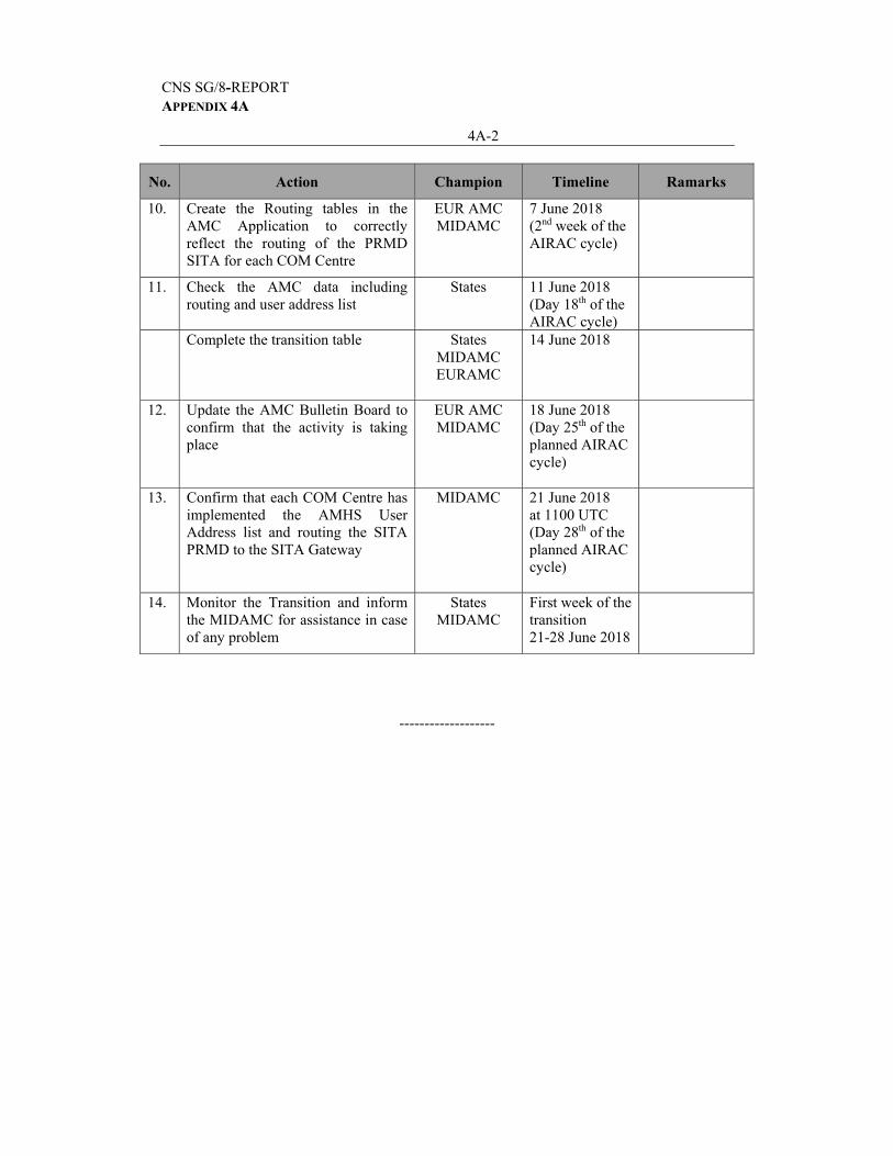
No. Action Champion Timeline Ramarks
10. Create the Routing tables in the AMC Application to correctly reflect the routing of the PRMD SITA for each COM Centre
EUR AMC MIDAMC
7 June 2018 (2nd week of the AIRAC cycle)
11. Check the AMC data including routing and user address list
States 11 June 2018 (Day 18th of the AIRAC cycle)
Complete the transition table States MIDAMC EURAMC
14 June 2018
12. Update the AMC Bulletin Board to confirm that the activity is taking place
EUR AMC MIDAMC
18 June 2018 (Day 25th of the planned AIRAC cycle)
13. Confirm that each COM Centre has implemented the AMHS User Address list and routing the SITA PRMD to the SITA Gateway
MIDAMC 21 June 2018 at 1100 UTC (Day 28th of the planned AIRAC cycle)
14. Monitor the Transition and inform the MIDAMC for assistance in case of any problem
States MIDAMC
First week of the transition 21-28 June 2018
-------------------
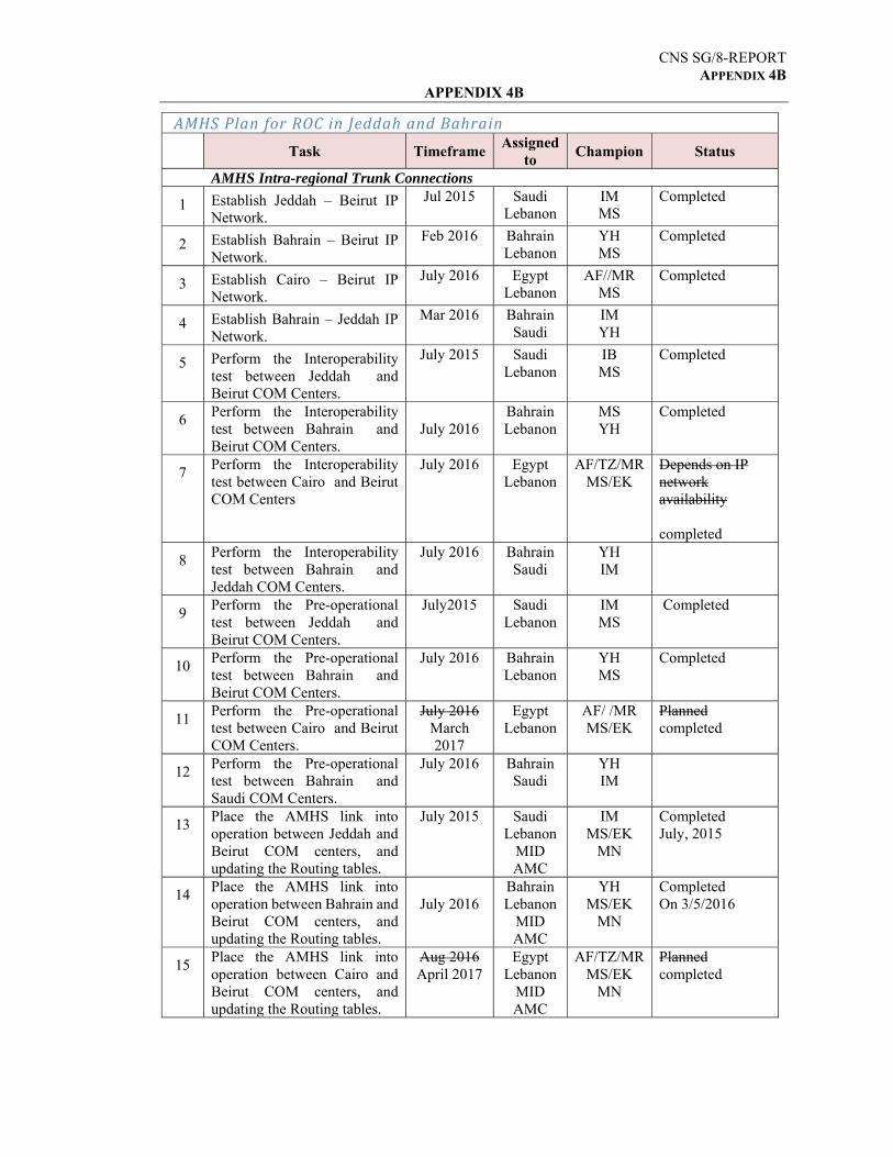
CNS SG/8-REPORT APPENDIX 4B
APPENDIX 4B
AMHS PlanforROCinJeddahandBahrain
Status Champion Assigned
toTimeframeTask
AMHS Intra-regional Trunk Connections Completed IM
MS Saudi
Lebanon Jul 2015 Establish Jeddah – Beirut IP
Network. 1
Completed YH MS
Bahrain Lebanon
Feb 2016 Establish Bahrain – Beirut IP Network.
2
Completed AF//MR MS
Egypt Lebanon
July 2016 Establish Cairo – Beirut IP Network.
3
IM YH
Bahrain Saudi
Mar 2016 Establish Bahrain – Jeddah IP Network.
4
Completed IB MS
Saudi Lebanon
July 2015 Perform the Interoperability test between Jeddah and Beirut COM Centers.
5
Completed MS YH
Bahrain Lebanon
July 2016
Perform the Interoperability test between Bahrain and Beirut COM Centers.
6
Depends on IP network availability completed
AF/TZ/MR MS/EK
Egypt Lebanon
July 2016 Perform the Interoperability test between Cairo and Beirut COM Centers
7
YH IM
Bahrain Saudi
July 2016 Perform the Interoperability test between Bahrain and Jeddah COM Centers.
8
Completed IM MS
Saudi Lebanon
July2015 Perform the Pre-operational test between Jeddah and Beirut COM Centers.
9
Completed YH MS
Bahrain Lebanon
July 2016 Perform the Pre-operational test between Bahrain and Beirut COM Centers.
10
Planned completed
AF/ /MR MS/EK
Egypt Lebanon
July 2016 March 2017
Perform the Pre-operational test between Cairo and Beirut COM Centers.
11
YH IM
Bahrain Saudi
July 2016 Perform the Pre-operational test between Bahrain and Saudi COM Centers.
12
Completed July, 2015
IM MS/EK
MN
Saudi Lebanon
MID AMC
July 2015 Place the AMHS link into operation between Jeddah and Beirut COM centers, and updating the Routing tables.
13
Completed On 3/5/2016
YH MS/EK
MN
Bahrain Lebanon
MID AMC
July 2016
Place the AMHS link into operation between Bahrain and Beirut COM centers, and updating the Routing tables.
14
Planned completed
AF/TZ/MR MS/EK
MN
Egypt Lebanon
MID AMC
Aug 2016 April 2017
Place the AMHS link into operation between Cairo and Beirut COM centers, and updating the Routing tables.
15
CNS SG/8-REPORT APPENDIX 4B
4B-2
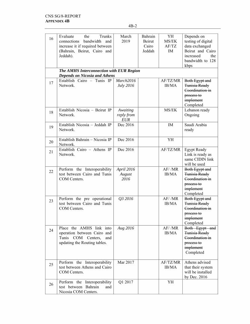
Depends on testing of digital data exchanged Beirut and Cairo increased the bandwidth to 128 kbps
YH MS/EK AF/TZ
IM
Bahrain Beirut Cairo
Jeddah
March 2019
Evaluate the Trunks connections bandwidth and increase it if required between (Bahrain, Beirut, Cairo and Jeddah).
16
The AMHS Interconnection with EUR Region Depends on Nicosia and Athens
Both Egypt and Tunisia Ready Coordination in process to implement Completed
AF/TZ/MR IB/MA
March2016 July 2016
Establish Cairo – Tunis IP Network.
17
Lebanon ready Ongoing
MS/EK Awaiting reply from
EUR
Establish Nicosia – Beirut IP Network.
18
Saudi Arabia ready
IM Dec 2016 Establish Nicosia – Jeddah IP Network.
19
YH Dec 2016 Establish Bahrain – Nicosia IP Network.
20
Egypt Ready Link is ready as same CIDIN link will be used
AF/TZ/MR Dec 2016 Establish Cairo – Athens IP Network.
21
Both Egypt and Tunisia Ready Coordination in process to implement Completed
AF/ /MR IB/MA
April 2016 August 2016
Perform the Interoperability test between Cairo and Tunis COM Centers.
22
Both Egypt and Tunisia Ready Coordination in process to implement Completed
AF/ /MR IB/MA
Q3 2016
Perform the pre operational test between Cairo and Tunis COM Centers.
23
Both Egypt and Tunisia Ready Coordination in process to implement Completed
AF/ /MR IB/MA
Aug 2016 Place the AMHS link into operation between Cairo and Tunis COM Centers, and updating the Routing tables.
24
Athens advised that their system will be installed by Dec. 2016
AF/TZ/MR IB/MA
Mar 2017 Perform the Interoperability test between Athens and Cairo COM Centers.
25
YH Q1 2017 Perform the Interoperability test between Bahrain and Nicosia COM Centers.
26
CNS SG/8-REPORT APPENDIX 4B
4B-3
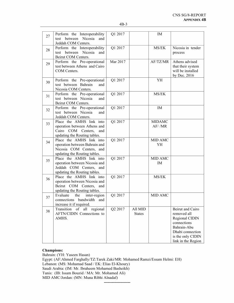
IM Q1 2017 Perform the Interoperability test between Nicosia and Jeddah COM Centers.
27
Nicosia in tender process
MS/EK Q1 2017 Perform the Interoperability test between Nicosia and Beirut COM Centers.
28
Athens advised that their system will be installed by Dec. 2016
AF/TZ/MR
Mar 2017 Perform the Pre-operational test between Athens and Cairo COM Centers.
29
YH Q1 2017 Perform the Pre-operational test between Bahrain and Nicosia COM Centers.
30
MS/EK Q1 2017 Perform the Pre-operational test between Nicosia and Beirut COM Centers.
31
IM Q1 2017 Perform the Pre-operational test between Nicosia and Jeddah COM Centers.
32
MIDAMC AF/ /MR
Q1 2017 Place the AMHS link into operation between Athens and Cairo COM Centers, and updating the Routing tables.
33
MID AMC YH
Q1 2017 Place the AMHS link into operation between Bahrain and Nicosia COM Centers, and updating the Routing tables.
34
MID AMC IM
Q1 2017 Place the AMHS link into operation between Nicosia and Jeddah COM Centers, and updating the Routing tables.
35
MS/EK Q1 2017 Place the AMHS link into operation between Nicosia and Beirut COM Centers, and updating the Routing tables.
36
MID AMC Q1 2017 Evaluate the inter-region connections bandwidth and increase it if required.
37
Beirut and Cairo removed all Regional CIDIN connections Bahrain-Abu Dhabi connection is the only CIDIN link in the Region
All MID States
Q2 2017 Transition of all regional AFTN/CIDIN Connections to AMHS.
38
Champions: Bahrain: (YH: Yaseen Hasan) Egypt: (AF:Ahmed Farghally/TZ:Tarek Zaki/MR: Mohamed Ramzi/Essam Helmi: EH) Lebanon: (MS: Mohamad Saad / EK: Elias El-Khoury) Saudi Arabia: (IM: Mr. Ibraheem Mohamed Basheikh) Tunis: (IB: Issam Bouzid / MA: Mr. Mohamed Ali) MID AMC/Jordan: (MN: Muna Ribhi Alnadaf)
--------------------
CNS SG/8-REPORT APPENDIX 4C
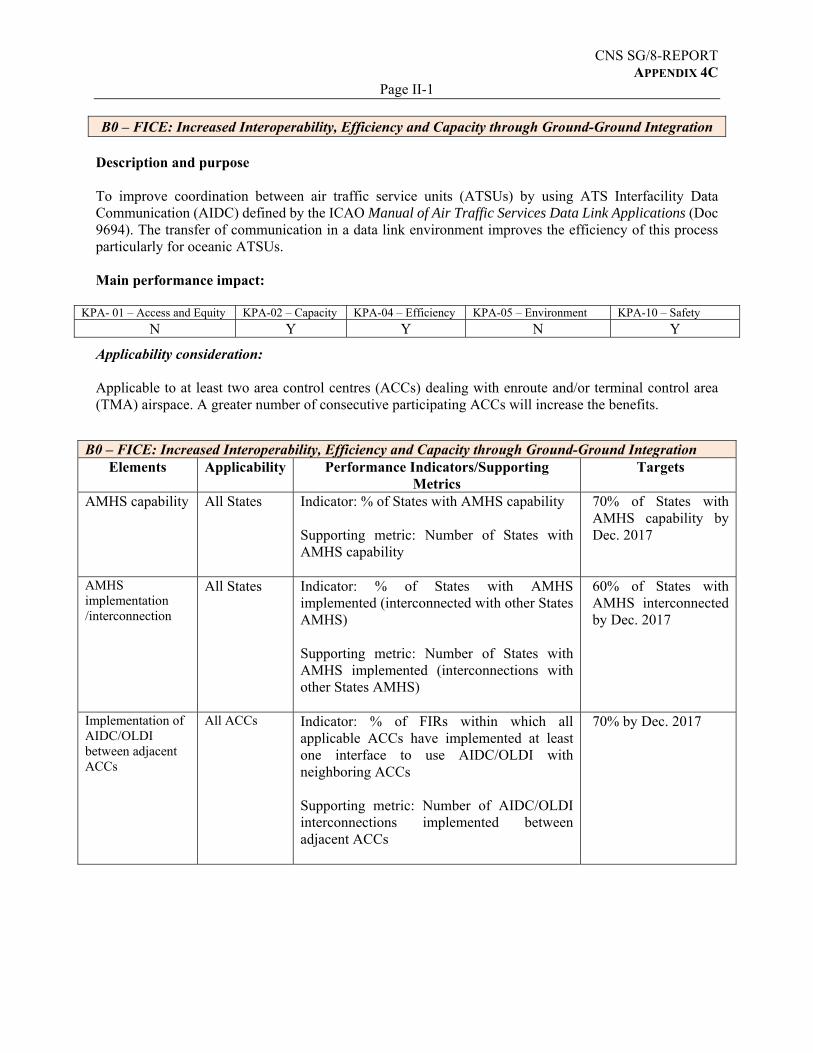
Page II-1 B0 – FICE: Increased Interoperability, Efficiency and Capacity through Ground‐Ground Integration
Description and purpose To improve coordination between air traffic service units (ATSUs) by using ATS Interfacility Data Communication (AIDC) defined by the ICAO Manual of Air Traffic Services Data Link Applications (Doc 9694). The transfer of communication in a data link environment improves the efficiency of this process particularly for oceanic ATSUs. Main performance impact:
KPA- 01 – Access and Equity KPA-02 – Capacity KPA-04 – Efficiency KPA-05 – Environment KPA-10 – Safety
N Y Y N Y
Applicability consideration: Applicable to at least two area control centres (ACCs) dealing with enroute and/or terminal control area (TMA) airspace. A greater number of consecutive participating ACCs will increase the benefits.
B0 – FICE: Increased Interoperability, Efficiency and Capacity through Ground‐Ground Integration
Elements Applicability Performance Indicators/Supporting Metrics
Targets
AMHS capability All States Indicator: % of States with AMHS capability Supporting metric: Number of States with AMHS capability
70% of States with AMHS capability by Dec. 2017
AMHS implementation /interconnection
All States Indicator: % of States with AMHS implemented (interconnected with other States AMHS) Supporting metric: Number of States with AMHS implemented (interconnections with other States AMHS)
60% of States with AMHS interconnected by Dec. 2017
Implementation of AIDC/OLDI between adjacent ACCs
All ACCs Indicator: % of FIRs within which all applicable ACCs have implemented at least one interface to use AIDC/OLDI with neighboring ACCs Supporting metric: Number of AIDC/OLDI interconnections implemented between adjacent ACCs
70% by Dec. 2017
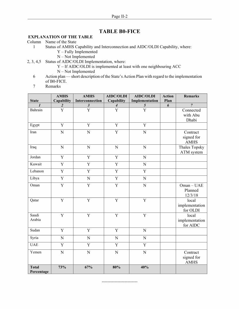
Page II-2
TABLE B0-FICE EXPLANATION OF THE TABLE Column Name of the State
1 Status of AMHS Capability and Interconnection and AIDC/OLDI Capability, where: Y – Fully Implemented N – Not Implemented
2, 3, 4,5 Status of AIDC/OLDI Implementation, where: Y – If AIDC/OLDI is implemented at least with one neighbouring ACC N – Not Implemented
6 Action plan — short description of the State’s Action Plan with regard to the implementation of B0-FICE.
7 Remarks
State
AMHS Capability
AMHS Interconnection
AIDC/OLDI Capability
AIDC/OLDI Implementation
Action Plan
Remarks
1 2 3 4 5 6 7 Bahrain Y Y Y Y Connected
with Abu Dhabi
Egypt Y Y Y Y
Iran N N Y N Contract signed for
AMHS Iraq N N N N Thales Topsky
ATM system Jordan Y Y Y N
Kuwait Y Y Y N
Lebanon Y Y Y Y
Libya Y N Y N
Oman Y Y Y N Oman – UAE Planned 12/3/18
Qatar Y Y Y Y local implementation
for OLDI Saudi Arabia
Y Y Y Y local implementation
for AIDC Sudan Y Y Y N
Syria N N N N
UAE Y Y Y Y
Yemen N N N N Contract signed for
AMHS Total Percentage
73% 67% 80% 40%
-------------------------
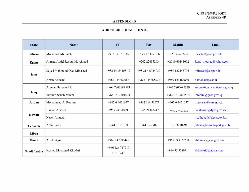
CNS SG/8-REPORT APPENDIX 4D
APPENDIX 4D
AIDC/OLDI FOCAL POINTS
State Name Tel. Fax Mobile Email
Bahrain Mohamed Ali Saleh +973 17 321 187 +973 17 329 966 +973 3962 2202 [email protected]
Egypt Ahmed Abdel Rasoul M. Ahmed +202 22685293 +2010 60241692 [email protected]
Iran Seyed Mahmood Qazi Mirsaeed +982 144544031-2 +98 21 445 44030 +989 122443706 [email protected]
Arash Khodaei +982 144662066 +98 21 44665576 +989 121483840 [email protected]
Iraq
Ammar Hussein Ali +964 7803697529 +964 7803697529 [email protected]
Ibrahim Sabah Naiem +964 7812801524 +964 7812801524 [email protected]
Jordan Mohammad Al Rousan +962 6 4451677 +962 6 4451677 +962 6 4451677 [email protected]
Kuwait
Hamad Alnaser +965 24760421 +965 24343417 +965 97652527 [email protected] ,
Naser Alhubail [email protected]
Lebanon Amin Jaber +961 1 628199 + 961 1 629021 +961 3210291 [email protected]
Libya
Oman Ali Al Ajmi +968 24 518 448 +968 99 416 280 [email protected]
Saudi Arabia Khaled Mohamed Khodari +966 126 717717
Ext. 1247 +966 55 5580714 [email protected]
CNS SG/8-REPORT APPENDIX 4D
4D-2
Sudan ELtahir Abdelatif Hassan +249 183784925 +249 183784925 +249 123499352 [email protected]
Syria
UAE Hamad Al Belushi +971 2 599 6633 +971 2 599 6836 +971 50 616 4350 [email protected]
Yemen
Abdullah Abdulwareth AlEryani +967 2 343686 +967 777190602 [email protected]
Yunes Saeed Ahmed +967 2298600 +967 777523776 [email protected]
---------------------
CNS SG/8-REPORT APPENDIX 4E
International Civil Aviation Organization
Guidance on GNSS Implementation in the MID Region
Version 0.1
28/2/2018
Guidance on GNSS Implementation in the MID Region Page 2
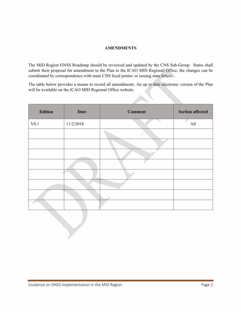
AMENDMENTS
The MID Region GNSS Roadmap should be reviewed and updated by the CNS Sub-Group. States shall submit their proposal for amendment to the Plan to the ICAO MID Regional Office, the changes can be coordinated by correspondence with main CNS focal points/ or issuing state letters.
The table below provides a means to record all amendments. An up to date electronic version of the Plan will be available on the ICAO MID Regional Office website.
Edition Date Comment Section affected
V0.1 11/2/2018 All
Guidance on GNSS Implementation in the MID Region Page 3
TABLE OF CONTENTS
Acronyms………………………………………………………………………………………………... 5The objective and scope of the document……………………………………………………………….. 6Part I: General Navigation Infrastructure…………………………………............................................... 71. Terrestrial Navigations……………………………………………………………………………… 72. Global Navigation Satellite System (GNSS)…………………………………...................................... 72.1 GPS………………………………………………………………………………………………….. 72.2 GLONASS…………………………………………………………………………………………... 82.3 Galileo……………………………………………………………………………………………….. 82.4 BeiDou………………………………………………………………………………………………. 82.5 RNSS………………………………………………………………………………………………. 83. Augmentation………………………………………………………………………………………… 83.1 Space based Augmentation System (SBAS)………….……………………....................................... 93.1.1 WAAS……………………………………………………………………………………………. 93.1.2 EGNOS…………………………………………………………………………………………… 103.1.3 GAGAN…………………………………………………………………………………………... 10 3.1.4 SDCM…………………………………………………………………………………………….. 113.1.5 MSAS…………………………………………………………………………………………….. 113.2 Ground Based Augmentation System (GBAS)…………………………………………………….. 113.3 Aircraft Based Augmentation System (ABAS)…………………………………………………….. 123.3.1 Receiver Autonomous Integrity System (RAIM)………………………………………………… 123.3.2 Aircraft Autonomous Integrity System (AAIM)………………………………………………….. 124. Global Air Navigation Plan (GANP)…………………………………………………………………. 12Part II: GNSS in ICAO MID Region…………………………………………………………………….. 141. The Conventional Ground Based Navigation Systems in the MID………………………………….. 142. SBAS…………………………………………………………………………………………………. 142.1 EGNOS……………………………………………………………………………………………… 152.2 GAGAN……………………………………………………………………………………………... 193. GNSS Application in the MID Region…….………………………………………………………… 194. GBAS……………………………………………………………………………………………........ 205. Cost Benefits Analysis…………………….…………………………………………………………. 206. Current use of SBAS/GBAS in the MID Region…………………………….………………………. 20Part III: GNSS Vulnerabilities…………………………………………………………………………… 211. Introduction………………………………………….……………………………………………….. 212. Unintentional Interference Source……………………………………………………………………. 212.1 Solar Effect………………………………………………………………………………………….. 212.2 Radio Frequency Interference………………………………………………………………………. 212.3 Onboard Systems……………………………………………………………………………………. 213. Intentional Interference Sources……………………………………………………………………… 213.1 Jamming……………………………………………………………………………………………... 213.2 Spoofing……………………………………………………………………………………………... 224.Reducing the likelihood of Interferences……………………………………………………………. 225.Mitigation Strategies………………………………………………………………………………….. 22References……………………………………………………………………………………………….. Appendix A: List of NDBs in the MID Region…………………………………………………………..
23 24
Guidance on GNSS Implementation in the MID Region Page 4
List of Figures
1-1 Current and Planned SBAS Systems…………………………………………………...…… 9 1-2 GANP Navigation Roadmap………………………………………………………………. 13 2-2 APV-I Availability Map……………………………………………………………………. 16 2-3 APV-I Continuity Map……………………………………………………………………... 16 2-4 LPV200 Availability Map…………………………………………………………………... 17 2-4 LPV200 Continuity Map……………………………………………………………………. 17 2-5 GAGAN GEO Footprint……………………………………………………………………. 19
List of Tables
2-1 Current Conventional Infrastructure………………………………………………….……. 14 2-2 Minimum signal-in-space performance……………………………………………………. 18

Guidance on GNSS Implementation in the MID Region Page 5
ACRONYMS
AO Aircraft Operators AAIM Aircraft Autonomous Integrity Monitoring ABAS Aircraft Based Augmentation System APCH Approach CAPEX Capital Expenditure DME Distance Measuring Equipment DOP Dilution of Precision EGNOSS European Geostationary Navigation Overlay Service FD Fault Detection FDE Fault Detection and Exclusion GAGAN GPS Aided GEO Augmented Navigation GBAS Ground Based Augmentation System GLONASS Global Navigation Satellite System GLS GBAS Landing System GNSS Global Navigation Satellite System GPS Global Positioning System ILS Instrument Landing System INS Inertial Navigation System IRS Inertial Reference System LNAV Lateral Navigation MLS Microwave Landing System MSAS MTSAT Satellite based Augmentation System NDB Non-Directional Beacon NPA Non-precision Approach NSE Navigation Sensor Error OPEX Operating Expense PA Precision Approach PBN Performance Based Navigation RAIM Receiver Autonomous Integrity Monitoring RNAV Area Navigation RNP Required Navigation Performance SBAS Satellite Based Augmentation SDCM System of Differential Correction and Monitoring VOR Very High Frequency Omni Directional Radio Range
Guidance on GNSS Implementation in the MID Region Page 6
THE OBJECTIVE AND SCOPE OF THE DOCUMENT
The objective of this document is to provide States in the Middle East Region with guidance for GNSS implementation based on the Global Air Navigation Plan and Regional Requirements.
The document outlines the status of all satellite constellations and Augmentation systems worldwide, with focus on the available Augmentation systems that can be used in the MID Region; the services provided, and requirements to exploit these Navigation services.
Moreover, this document provides practical information on GBAS deployment, with reference to other Regions experience and factors to be considered in the process of cost estimation for the cost benefit analysis.
Furthermore, the guidance document explains the GNSS vulnerabilities due to intentional and unintentional sources of interference and to certain ionospheric effects. Also, it describes ways to reduce the likelihood of interference and the mitigation strategies to reduce the impact of the signal outage.
The GNSS application is out of scope of this document and addressed in the MID PBN implementation plan. The GNSS is the key enabler for PBN implementation. The guidance on GNSS implementation is developed to complement the information in the MID PBN implementation Plan; ICAO MID DOC 007.
This document is divided into three parts; Part one includes information about the GNSS and Augmentation systems worldwide, and ICAO Navigation Roadmap from the GANP.
Part II identifies the current conventional Navigation aids infrastructure in the MID Region. And focuses on the SBAS Systems that may extends their services to the MID states.
Part III addresses the GNSS vulnerabilities and the mitigation strategies as defined by ICAO.
Guidance on GNSS Implementation in the MID Region Page 7
PART I: GENERAL NAVIGATIONAL INFRASTRUCTURE Navigation Aids Infrastructure refers to the ground and space-based NAVAIDs and provides positioning capability. 1. Terrestrial Navigations Terrestrial Navigation Aids “conventional” refers to ground-based navigations such as NDB, ILS, VOR, TACAN, DME, …, etc. The basic principle of all of these navigation facilities is the fact that aircraft in general navigate towards and away from the navigation aid itself, “point to point”. This means that the location of the navigation aid must be in an optimized location. This optimized position is, in many cases, not achievable (due to being situated in high terrain, open seas, politically unacceptable areas, etc). Therefore the route structure must be aligned with the position of the navigation aid and not aligned in the ideal position for its purpose. This results in additional distances being flown by aircraft which has a number of disadvantages including economic, environmental and efficiency drawbacks. In addition to the additional distance flown a number of other problem areas arise:
High terrain. At airports located in high terrain with difficult accessibility arrival procedures, based upon conventional ground based navigation aids, may result in aircraft being unable to land at the airport safely during periods of low visibility.
Lateral containment of tracks. With conventional ground based navigation aids the accuracy of
the track to be flown is a factor of how close to the aid the aircraft is. The closer the aircraft is to the aid the more accurate the track keeping capability. As the aircraft gets further away from the aid the accuracy reduces. This requires that a maximum distance for the aid to be used must be published and that the route spacing requires to be established on the worst case scenario.
In the global context, GNSS based PBN procedures have been implemented. And several GLS (CAT I) procedures in place. 2. Global Navigation Satellite System (GNSS) GNSS is a satellite-based navigation system utilizing satellite signals, for providing accurate and reliable position, navigation, and time services to airspace users. It provides location and time information anywhere on, or near, the earth in all weather conditions. In 1996, the International Civil Aviation Organization (ICAO) endorsed the development and use of GNSS as a primary source of future navigation for civil aviation. ICAO noted the increased flight safety, route flexibility and operational efficiencies that could be realized from the move to space-based navigation. Today several GNSS systems are available in the world, the first system in operation was the Global Positioning System (GPS). 2.1 GPS The Global Positioning System (GPS) is a space-based radio-navigation system consisting of a constellation of satellites and a network of ground stations used for monitoring and control. Currently 32 GPS satellites orbit the Earth at an altitude of approximately 11,000 miles providing users with accurate information on position, velocity, and time anywhere in the world and in all weather conditions.
Guidance on GNSS Implementation in the MID Region Page 8
GPS is operated and maintained by the Department of Defense (DoD). 2.2 GLONASS
The Russian Global Navigation Satellite System, which began operation in 1993. GLONASS network provides real-time positioning and speed data for surface, sea and airborne objects with an accuracy of one meter (three feet). A group of 28 GLONASS satellites was in orbit as of April 2014, with 24 in operation, three spares, and one in the test-flight phase. 2.3 Galileo
Galileo is Europe’s Global Satellite Navigation System (GNSS), providing improved positioning and timing information with significant positive implications for many European services and users. The system is still under deployment. 2.4 BeiDou The BeiDou Navigation Satellite System (BDS), also known as BeiDou-2, is China’s second-generation satellite navigation system that will be capable of providing positioning, navigation, and timing services to users on a continuous worldwide basis. It is a constellation of 35 satellites that will offer complete coverage of the globe. 2.5 RNSS Regional Navigation Satellite System (RNSS) like NAVIC and QZSS. The Indian Regional Navigation Satellite System (IRNSS) with an operational name of NAVIC. QZSS is a system especially for usage in the Asia-Oceania regions, with a focus on Japan. 3. Augmentation Augmentation System provides additional data to users of GNSS equipment to improve accuracy, integrity, availability, or any other improvement to positioning, navigation, and timing. A wide range of different augmentation systems have been developed.
Guidance on GNSS Implementation in the MID Region Page 9
3.1 Space Based Augmentation System (SBAS)
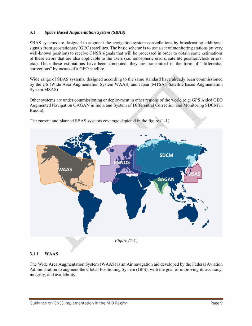
SBAS systems are designed to augment the navigation system constellations by broadcasting additional signals from geostationary (GEO) satellites. The basic scheme is to use a set of monitoring stations (at very well-known position) to receive GNSS signals that will be processed in order to obtain some estimations of these errors that are also applicable to the users (i.e. ionospheric errors, satellite position/clock errors, etc.). Once these estimations have been computed, they are transmitted in the form of “differential corrections” by means of a GEO satellite. Wide range of SBAS systems, designed according to the same standard have already been commissioned by the US (Wide Area Augmentation System WAAS) and Japan (MTSAT Satellite based Augmentation System MSAS). Other systems are under commissioning or deployment in other regions of the world (e.g. GPS Aided GEO Augmented Navigation GAGAN in India and System of Differential Correction and Monitoring SDCM in Russia). The current and planned SBAS systems coverage depicted in the figure (1-1)
Figure (1-1)
3.1.1 WAAS The Wide Area Augmentation System (WAAS) is an Air navigation aid developed by the Federal Aviation Administration to augment the Global Positioning System (GPS), with the goal of improving its accuracy, integrity, and availability.
Guidance on GNSS Implementation in the MID Region Page 10
3.1.2 EGNOS
The European Geostationary Navigation Overlay Service Navigation (EGNOS) is the European implementation of SBAS. Originally it was planned to augment GPS and GLONASS. Today, EGNOS augments GPS signals. EGNOS provides corrections and integrity information to GPS signals over a broad area centered over Europe and it is fully interoperable with other existing SBAS systems. EGNOS provides three services:
• Open Service (OS), freely available to any user; • Safety of Life (SoL) Service, that provides the most stringent level of signal-in-space
performance to all Safety of Life user communities; • EGNOS Data Access Service (EDAS) for users who require enhanced performance for
commercial and professional use. The main objective of the EGNOS SoL service is to support civil aviation operations down to Localizer Performance with Vertical Guidance (LPV) minima. In order to provide the SoL Service, the EGNOS system has been designed so that the EGNOS Signal-In-Space (SIS) is compliant to the ICAO SARPs for SBAS. The Services provided by EGNOS:
Non-Precision Approach operations and other flight operations supporting PBN navigation specifications other than RNP APCH, not only for approaches but also for other phases of flight.
Approach operations with Vertical Guidance supporting RNP APCH PBN navigation specification down to LPV minima as low as 250 ft.
Category I precision approach with a Vertical Alert Limit (VAL) equal to 35m and supporting RNP APCH PBN navigation specification down to LPV minima as low as 200 ft.
A NOTAM (Notice to Airmen) is a notice issued to alert pilots of potential hazards along a flight route that could affect the safety of the flight. The objective of the EGNOS NOTAM proposal generation is to:
• Predict APV-I and LPV-200 services outages at given airports. • Create and format the corresponding NOTAM proposals into an ICAO format and according
to the European Concept for GNSS NOTAM to ease the validation process to be performed by the NOF (NOTAM Offices).
• Distribute the NOTAM proposals to the concerned NOFs through the AFTN network.
3.1.3 GAGAN
GAGAN is the acronym for GPS Aided GEO Augmented Navigation. The GAGAN uses a system of ground stations to provide necessary augmentations to the GPS standard positioning service (SPS) navigation signal. A network of precisely surveyed ground reference stations (INdian Reference Stations INRES) is strategically positioned across the country to collect GPS satellite data. Using this information, the master control center (Indian Master Control Centre INMCC) generates messages to correct any signal errors. These correction messages are then uplinked through (Indian Land Uplink Station INLUS) and broadcast through communication satellites (Geostationary) to receivers onboard aircraft using the same frequency as GPS. The Indian Space Research Organization (ISRO) and Airports Authority of India (AAI) have implemented the GPS Aided Geo Augmented Navigation-GAGAN project as a Satellite Based Augmentation System
Guidance on GNSS Implementation in the MID Region Page 11
(SBAS) for the Indian Airspace. The objective of GAGAN to establish, deploy and certify satellite based augmentation system for safety-of-life civil aviation applications in India has been successfully completed. The system is inter-operable with other international SBAS systems like US-WAAS, European EGNOS, and Japanese MSAS etc. GAGAN GEO footprint extends from Africa to Australia and has expansion capability for seamless navigation services across the region. GAGAN provides the additional accuracy, availability, and integrity necessary for all phases of flight, from enroute through approach for all qualified airports within the GAGAN service volume. The services provided by GAGAN are the following: RNP 0.1 within India FIR APV-1 in the landmass of Indian FIR.
Due to impact of ionosphere behavior over the equatorial regions, availability of GAGAN APV -1 service is better than 76% of landmass on nominal iono days.
3.1.4 SDCM
The System for Differential Corrections and Monitoring (SDCM) is the SBAS currently being developed in the Russian Federation as a component of GLONASS.
3.1.5 MSAS
MTSAT Satellite Based Augmentation System (MSAS) is the Japanese SBAS, the system in operation since September 27, 2007. MSAS provide GPS Augmentation Information for RNAV, from En-route through NPA (RNP 0.3) within Fukuoka FIR. Due to ionosphere horizontal navigation information only provided. MSAS provide users with NOTAM when required, including alert for Service Interruption or Predicted Service Outage. 3.2 Ground Based Augmentation System (GBAS)
GBAS is an augmentation system in which the user receives augmentation information directly from a ground-based transmitter. GBAS support precision approach, landing, departure and surface movement. GBAS cat I is now operational at many Airports (any from the MID???), GBAS classified based on approach service type as following:
GAST-A : APV I Performance GAST-B : APV II Performance GAST-C : CAT I Performance GAST-D : CAT III Performance GAST-F : CAT III Performance (multiconstellation, multifrequency)
GAST-D standard is still under development. The cost of a single certified GBAS ground station is from SESAR studies and deployment in Europe 1,5 to 2 M€ per airport, which is equal roughly to the cost of three ILSs.
Guidance on GNSS Implementation in the MID Region Page 12
3.3 Aircraft Based Augmentation System (ABAS)
ABAS is achieved by features of the onboard equipment designed to overcome the performance limitations of the GNSS constellations. The two systems currently in use are Receiver Autonomous Integrity Monitoring (RAIM) and the Aircraft Autonomous Integrity Monitor (AAIM). ABAS considered low cost integrity supervision. 3.3.1 Receiver Autonomous Integrity Monitoring (RAIM)
RAIM is a technology developed to assess the integrity of the GPS in a GPS receiver system and can predict areas in which the GPS signal may be compromised. RAIM requires no data from outside the satellite receiver, only from GPS. Fault detection and Exclusion (FDE) mechanism is used in RAIM, minimum five (5) satellite is needed for ‘fault detection’ and six (6) for ‘fault exclusion’. 3.3.2 Aircraft Autonomous Integrity monitoring (AAIM)
AAIM uses the redundancy of position estimates from multiple sensors, including GNSS, to provide integrity performance that is at least equivalent to RAIM. An example is the use of an inertial navigation system or other navigation sensors as an integrity check on GPS data when RAIM is unavailable but GPS positioning information continues to be valid. AAIM requires data from GPS and other sensor (INS). AAIM uses GNSS signal plus onboard Inertial (INS) to achieve primary means for enroute though non-precision approach. 4. Global Air Navigation Plan
The GANP and ASBUs recognize the Global Navigation Satellite System (GNSS) as a technical enabler supporting improved services. Roadmaps in the GANP outline timeframes for the availability of GNSS elements, the implementation of related services and the rationalization of conventional infrastructure. The ICAO Navigation roadmap depicted in figure (1-2)
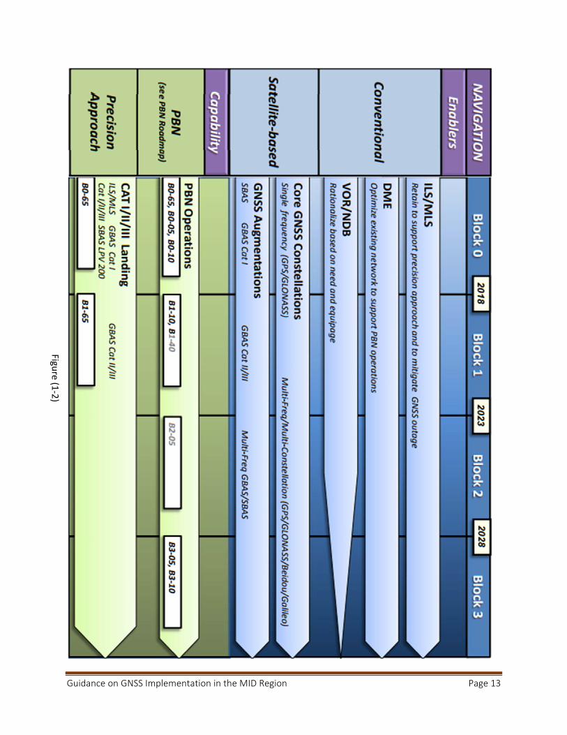
Guidance on GNSS Implementation in the MID Region Page 13
Figure (1
‐2)
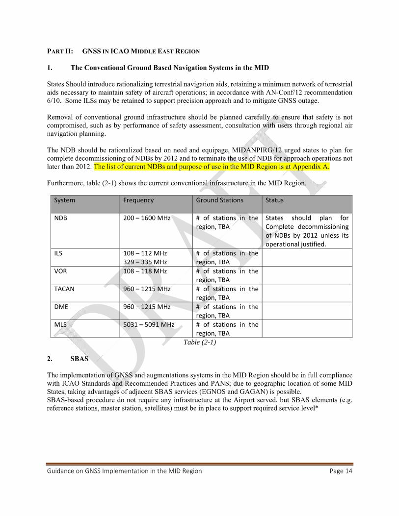
Guidance on GNSS Implementation in the MID Region Page 14
PART II: GNSS IN ICAO MIDDLE EAST REGION 1. The Conventional Ground Based Navigation Systems in the MID
States Should introduce rationalizing terrestrial navigation aids, retaining a minimum network of terrestrial aids necessary to maintain safety of aircraft operations; in accordance with AN-Conf/12 recommendation 6/10. Some ILSs may be retained to support precision approach and to mitigate GNSS outage. Removal of conventional ground infrastructure should be planned carefully to ensure that safety is not compromised, such as by performance of safety assessment, consultation with users through regional air navigation planning. The NDB should be rationalized based on need and equipage, MIDANPIRG/12 urged states to plan for complete decommissioning of NDBs by 2012 and to terminate the use of NDB for approach operations not later than 2012. The list of current NDBs and purpose of use in the MID Region is at Appendix A. Furthermore, table (2-1) shows the current conventional infrastructure in the MID Region.
System Frequency Ground Stations Status
NDB 200 – 1600 MHz # of stations in the region, TBA
States should plan for Complete decommissioning of NDBs by 2012 unless its operational justified.
ILS
108 – 112 MHz 329 – 335 MHz
# of stations in the region, TBA
VOR 108 – 118 MHz # of stations in the region, TBA
TACAN 960 – 1215 MHz # of stations in the region, TBA
DME 960 – 1215 MHz # of stations in the region, TBA
MLS 5031 – 5091 MHz # of stations in the region, TBA
Table (2-1) 2. SBAS
The implementation of GNSS and augmentations systems in the MID Region should be in full compliance with ICAO Standards and Recommended Practices and PANS; due to geographic location of some MID States, taking advantages of adjacent SBAS services (EGNOS and GAGAN) is possible. SBAS-based procedure do not require any infrastructure at the Airport served, but SBAS elements (e.g. reference stations, master station, satellites) must be in place to support required service level*
Guidance on GNSS Implementation in the MID Region Page 15
2.1 EGNOS
Some of MID Region States who are member in the EUROMED* can exploit the use of EGNOS in various applications, mainly in the transport sectors. As of the time of developing this document; five (5) States have officially notified their interest in EGNOS implementation (Algeria, Jordan, Lebanon, Libya, and Tunisia).
The requirements to use EGNOS services are as follow:
a) Installation of additionnel RIMS, three RIMS are sufficient to extend the service to EURCOMED States.
b) Air Navigation Service Providers have to sign an EGNOS Working Agreement (EWA) with the ESSP (Certified provider of Safety of Life service in aviation in EU ) to be able to activate use of EGNOS SoL.
c) International bilateral agreements should be signed between EU and each State to define liability in case of EGNOS failure which results in death/injury/loss/damage to equipment.
EGNOS Service Maps The current service maps shown in the figures (2-1, 2-2, 2-3 and 2-4), the current availability and continuity for APV-I and LPV service level in the MID Region are less than the minimum required signal-in-space performance specified in Annex 10 Vol. I., the requirements are shown in table (2-2)
*Euromed countries (Algeria, Egypt, Jordan, Lebanon, Libya, Morocco, Palestine, Syria and Tunisia).
a) APV-I Service Level
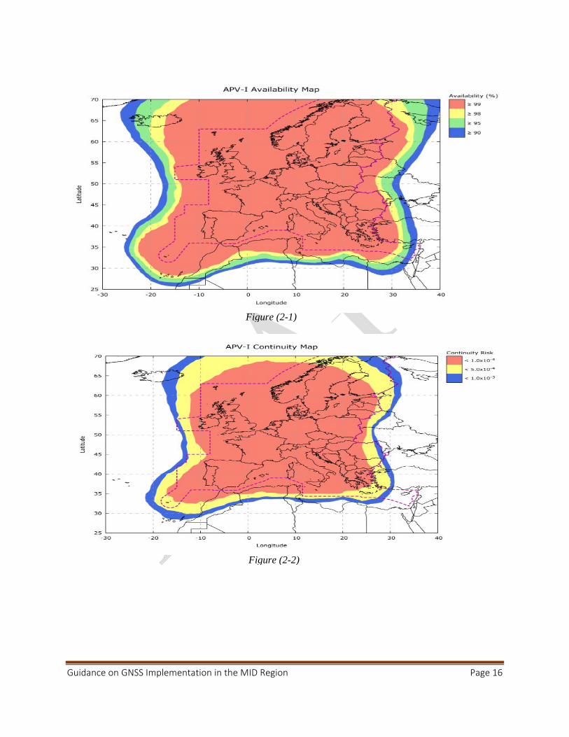
Guidance on GNSS Implementation in the MID Region Page 16
Figure (2-1)
Figure (2-2)
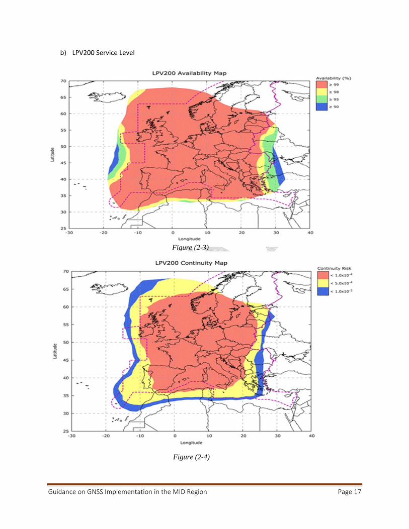
Guidance on GNSS Implementation in the MID Region Page 17
b) LPV200 Service Level
Figure (2-3)
Figure (2-4)
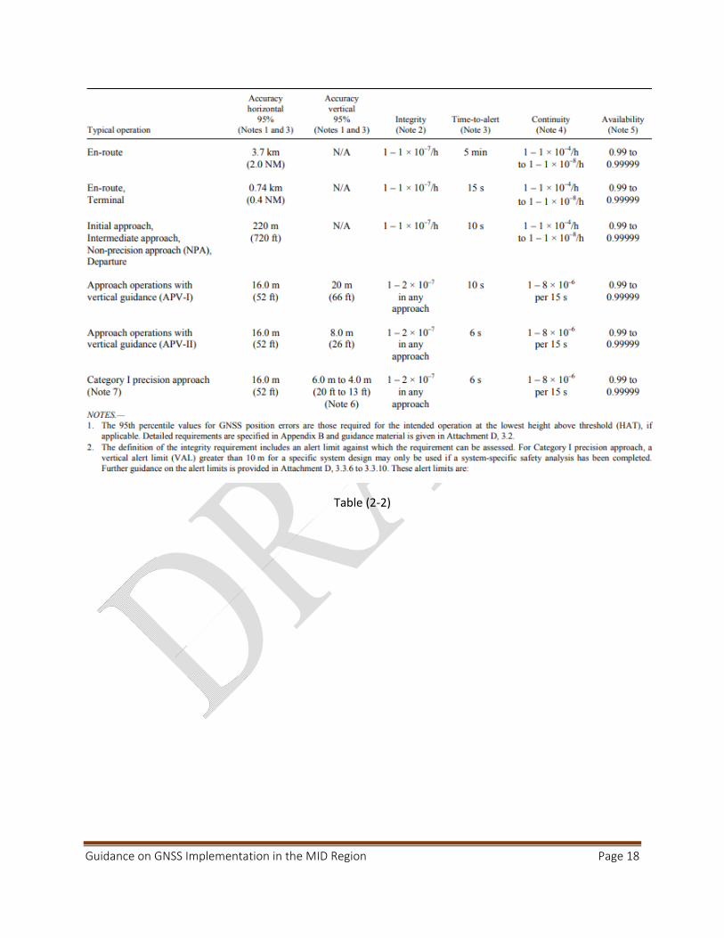
Guidance on GNSS Implementation in the MID Region Page 18
Table (2‐2)
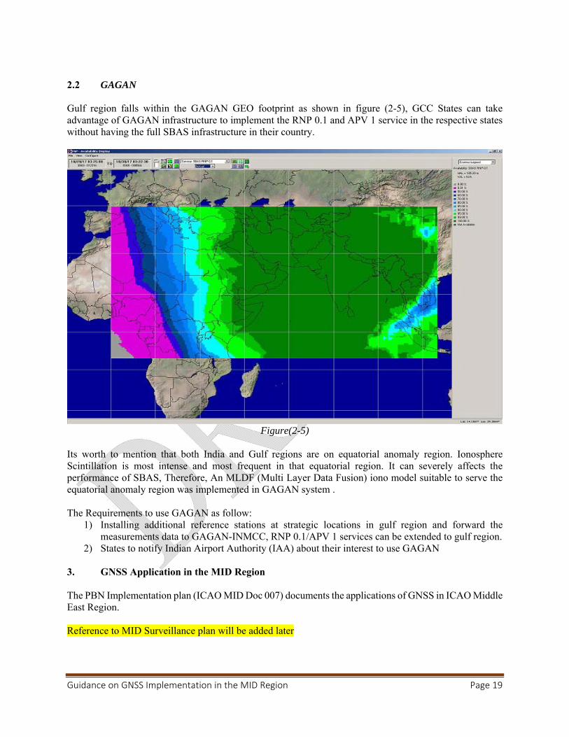
Guidance on GNSS Implementation in the MID Region Page 19
2.2 GAGAN Gulf region falls within the GAGAN GEO footprint as shown in figure (2-5), GCC States can take advantage of GAGAN infrastructure to implement the RNP 0.1 and APV 1 service in the respective states without having the full SBAS infrastructure in their country.
Figure(2-5)
Its worth to mention that both India and Gulf regions are on equatorial anomaly region. Ionosphere Scintillation is most intense and most frequent in that equatorial region. It can severely affects the performance of SBAS, Therefore, An MLDF (Multi Layer Data Fusion) iono model suitable to serve the equatorial anomaly region was implemented in GAGAN system . The Requirements to use GAGAN as follow:
1) Installing additional reference stations at strategic locations in gulf region and forward the measurements data to GAGAN-INMCC, RNP 0.1/APV 1 services can be extended to gulf region.
2) States to notify Indian Airport Authority (IAA) about their interest to use GAGAN 3. GNSS Application in the MID Region The PBN Implementation plan (ICAO MID Doc 007) documents the applications of GNSS in ICAO Middle East Region. Reference to MID Surveillance plan will be added later
Guidance on GNSS Implementation in the MID Region Page 20
4. GBAS Transition from ILS to GBAS should be based on an economic assessment, an operational assessment and from a safety and security perspective. Cost benefits analysis should be conducted taking on consideration that one GBAS can be used for several runways ends and even in some cases more than one Airports. The standard for GBAS CAT II/III is under development. 5. Cost Benefits Analysis
The use of GNSS in PBN applications reduces the overall running cost of Navigation infrastructure. Also deploying GBAS reduces the cost for ground infrastructure since a single GBAS ground station can provide approach guidance to all runways at an airport. GBAS can increase the Airport capacity, because it does not have sensitive areas that must be protected. However, the CBA is very dependent on specific operational and airport infrastructure aspects. States may consider the following factors during the process of estimating the cost associated with competing alternative in CBA:
a) CAPEX a.1 Installation Cost; ‐ One GBAS costs around 1.5 -2 M euro (equal to the cost of 3 ILSs). ‐ ILS(s) must be retained to ensure the service continuity during the GNSS/GBAS outage. a.2 Training for operational and technical staff.
b) OPEX: c.1 Cost of Flight Check (Calibration). c.2 Maintenance costs (Preventive, Reactive, maintenance Contract, less Spare parts).
It has been reported by several CBA studies, that GBAS initial investment is higher than for ILS, and lower OPEX. However, Net Present Cost need to be calculated based on Airport infrastructure and operational requirements. 6. Current Use of GBAS/SBAS in the MID Region
TBA
Guidance on GNSS Implementation in the MID Region Page 21
PART III: GNSS VULNERABILITIES 1. Introduction
GNSS signals are very weak at the receiver antenna therefore the signal is vulnerable, and also susceptible to ionosphere effects. Current GNSS use a single frequency band common to GPS, GLONASS and SBAS. This makes it easier to intentionally jam GNSS signals. 2. Unintentional Interference Sources There are a number of sources of potential interference to GNSS, including mobile and fixed VHF communications, Solar effect and other sources. The likelihood and operational effect of interference vary with the environment. Unintentional interference is not considered a significant threat provided that States exercise proper control and protection over the electromagnetic spectrum for both existing and new frequency allocations. Furthermore, 2.1 Solar Effect
GNSS signals are delayed by varying amounts of time depending on the density of ionized particles (ionosphere) which itself depends on the intensity of solar radiation and other solar energy bursts. The solar activity can cause GNSS service to be degraded or temporarily lost. The type and severity of ionospheric effects vary with the level of solar activity, the region of the world and other factors such as time of year and time of day. Rare solar storms can affect GNSS service over a wide area. The Solar activity peaks happens every eleven years. The availability of a second frequency will allow avionics to calculate ionospheric delay in real time, effectively eliminating a major error source. 2.2 Radio Frequency Interference
Harmonics of television stations, certain radars, mobile satellite communications and military systems can cause interference with GNSS signals. 2.3 On-board systems
Many reported instances of GNSS interference have been traced to on-board systems; such interference can be prevented by installing advanced avionics. 3. Intentional Interference Sources
3.1 Jamming
Personal privacy devices (PPDs) have been recognized as being responsible for causing interference to GPS receivers in many occurrences. The intention of PPDs is to protect the privacy of the user so that the user’s location is not revealed, therefore the user will not be tracked or monitored. PPDs are low-cost jammers to mask GPS signal. 3.2 Spoofing

Guidance on GNSS Implementation in the MID Region Page 22
Spoofing is the broadcast of GNSS-like signals that cause avionics to calculate erroneous positions and provide false guidance. It is considered that the spoofing of GNSS is less likely than the spoofing of traditional aids because it is technically much more complex. Spoofing of the GBAS data broadcast is virtually impossible, because of an authentication scheme that has been developed. 4. Reducing the Likelihood of Interferences
The likelihood of interference depends on such factors as population density and the motivation of individuals or groups in an area to disrupt aviation and non-aviation services
a) Effective spectrum management, this comprises creating and enforcing regulations/laws that
control the use of spectrum and carefully assessing applications for new spectrum allocations.
b) The introduction of GNSS signals on new frequencies will ensure that unintentional interference does not cause the complete loss of GNSS service (outage) although enhanced services depending upon the availability of both frequencies might be degraded by such interference
c) State should develop and enforce a strong regulatory framework governing the use of intentional radiators, including GNSS repeaters, pseudolites, spoofers and jammers, should forbid the use of jamming and spoofing devices and regulate their importation, exportation, manufacture, sale, purchase, ownership and use.
d) Multi-constellation GNSS would allow the receiver to track more satellites, reducing the
likelihood of service disruption. 5. Mitigation Strategies
The disruption of GNSS signals will require the application of realistic and effective mitigation strategies to both ensure the safety and regularity of air services and discourage those who would consider disrupting aircraft operations. There are three principal methods which can be applied in combination:
a) taking advantage of on-board equipment, such as IRS; b) taking advantage of conventional navigation aids and radar; and c) employing procedural (aircrew and/or ATC) methods.
Mitigation of GNSS vulnerabilities needs to be balanced in the context of the overall threats to communications, navigation, and surveillance/air traffic management (CNS/ATM) operations to ensure that the applied effort is neither too small (leading to potentially unacceptable risks and/or preventing realization of GNSS enabled benefits) nor too large (in comparison with the effort expended on mitigating other risks).
Guidance on GNSS Implementation in the MID Region Page 23
References: 1- ICAO ANNEX 10, VOL I, Aeronautical Telecommunications. 2- ICAO DOC 9849, Global Navigation Satellite System Manual. First edition, 2003. 3- ICAO DOC 8071, Manual on Testing Radio Navigation Aids, , VOL I, 4- ICAO DOC 8071, Manual on Testing Radio Navigation Aids, Volume II Testing of Satellite-based
Radio Navigation Systems, first edition, 2007. 5- ICAO DOC 9750, Global Air Navigation Plan. 6- GNSS Strategy endorsed by MIDANPIRG 15 7- PBN Implementation Plan in ICAO MID Region, First Edition. 8- EGNOS Safety of Life (SoL) Service Definition Document, Version 3.1, 26/9/2016 9- McGill University, Paper on the impact of satellite based navigation upon the aviation industry.
10- FAA, AC 20-138C, AC90 105A, AC90 101A. 11- Feasibility Studies on Ground Based Augmentation System (GBAS) , ASECNA, 2013 12- http://www.eurocontrol.int/press-releases/egnos-operational-aviation

Guidance on GNSS Implementation in the MID Region Page 24
APPENDIX A
LIST OF NDBs IN THE MID REGION AND PURPOSE OF RETAIN
State NDB ID Purpose of Retain Plan to Remove
----------------

CNS SC/8-REPORT APPENDIX 4F
APPENDIX 4F
MID Doc 007
INTERNATIONAL CIVIL AVIATION ORGANIZATION
MIDDLE EAST AIR NAVIGATION PLANNING AND IMPLEMENTATION REGIONAL GROUP
(MIDANPIRG)
MID REGION PERFORMANCE BASED NAVIGATION
IMPLEMENTATION PLAN
EDITION FEBRUARYAPRIL, 20168

-2-
The designations employed and the presentation of material in this publication do not imply the expression of any opinion whatsoever on the part of ICAO concerning the legal status of any country, territory, city or area or of its authorities, or concerning the delimitation of its frontier or boundaries.

-3-
AMENDMENTS The MID Region PBN Implementation Plan should be reviewed and updated by the PBN and/or the ATM Sub-Groups and presented to MIDANPIRG for endorsement. Stakeholders shall submit their proposal for amendment to the Plan to the ICAO MID Regional Office at least three months prior the PBN or the ATM Sub-Groups meetings in order to ensure adequate time for appropriate coordination. The table below provides a means to record all amendments. An up to date electronic version of the Plan will be available on the ICAO MID Regional Office website.
Amendment Number
Effective Date
Initiated by
Impacted pages Remarks
1 April 2016 MSG/5 Based on PBN SG/2 outcome
2 February 2018 PBN SG/2
Formatted: Font: 10 pt, Not Bold, Complex Script Font: 11pt, Not Bold

-4-
EXECUTIVE SUMMARY
The MID Region Performance Based Navigation (PBN) Implementation Plan has been developed to harmonize PBN implementation in the MID Region and to addresses the strategic objectives of PBN based on clearly established operational requirements, avoiding equipage of multiple on-board or ground based equipment, avoidance of multiple airworthiness and operational approvals and explains in detail contents relating to potential navigation applications. The Plan was prepared in accordance with ICAO provisions related to PBN, the Global Air Navigation Plan, Aviation System Block Upgrades (ASBU) methodology, MID Region Air Navigation Plan and the MID Region Air Navigation Strategy. In addition to the Assembly Resolutions and the twelfth Air Navigation Conference (AN-Conf/12) Recommendations related to PBN. The plan envisages pre- and post-implementation safety assessments and continued availability of conventional air navigation procedures during transition. The plan discusses issues related to implementation which include traffic forecasts, aircraft fleet readiness, adequacy of ground-based CNS infrastructure etc. Implementation targets for various categories of airspace for the short term (2013 – 20172018) and for the medium term (2018 2019 – 20222025) have been projected in tabular forms to facilitate easy reference. For the long term (2023 2026 and beyond) it has been envisaged that GNSS and its augmentation system would become the primary navigation infrastructure This Document consolidates, updates and supersedes all previous MID Region PBN and GNSS Strategies/Plans.
The parts related to PBN implementation for En-route will be reviewed and updated by the ATM Sub-Group and those related to terminal and approach will be reviewed and updated by the PBN Sub-Group.
Explanation of Terms
The drafting and explanation of this document is based on the understanding of some
particular terms and expressions that are described below: MID Region PBN Implementation Plan - A document offering appropriate
guidance for air navigation service providers, airspace operators and users, regulating agencies, and international organizations, on the evolution of navigation, as one of the key systems supporting air traffic management, and which describes the RNAV and RNP navigation applications that should be implemented in the short, medium and long term in the MID Region.
Performance Based Navigation - Performance based navigation specifies RNAV
and RNP system performance requirements for aircraft operating along an ATS route, on an instrument approach procedure or in an airspace.
Performance requirements - Performance requirements are defined in terms of
accuracy, integrity, continuity, availability and functionality needed for the proposed operation in the context of a particular airspace concept. Performance requirements are identified in navigation specifications which also identify which navigation sensors and equipment may be used to meet the performance requirement.

-5-
REFERENCE DOCUMENTS The below ICAO Documents provide Guidance related to the PBN implementation:
• PANS-ATM (Doc 4444) • PANS-Ops (Doc 8168) • PBN Manual (Doc 9613) • GNSS Manual (Doc 9849) • RNP AR Procedure Design Manual (Doc 9905) • CDO Manual (Doc 9931) • Manual on Use of PBN in Airspace Design (Doc 9992) • CCO Manual (Doc 9993) • Procedure QA Manual (Doc 9906) • PBN Ops Approval Manual (Doc 9997)
-6-
TABLE OF CONTENTS
Executive Summary 4
Acronyms 7
Chapter 1 8
PERFORMANCE BASED NAVIGATION 8
1. Introduction 8
2. Benefits of Performance Based Navigation 8
3. Goals and Objectives of PBN Implementation 9
4. Planning Principles 9
5. PBN Operational Requirements and Implementation Strategy 10
Chapter 2 12
CNS Infrastructure 12
1. Navigation infrastructure 12
2. Other Navigation Infrastructure supporting PBN 12
3. Surveillance Infrastructure 13
4. Communication Infrastructure 13
Chapter 3 14
Implementation of PBN 14
1. ATM Operational Requirements 14
2. Implementation Phases: 15
CHAPTER 4 19
Safety Assessment and Monitoring 19
1. Need for Safety Assessment 19
2. Roles and Responsibilities 19
CHAPTER 5 20
1. Operational approval requirements 20
2. DOCUMENTATION OF OPERATIONAL APPROVAL 22
3. STATE REGULATORY MATERIAL 23
4. APPROVAL PROCESS 23
5. FOREIGN OPERATIONS 24
CHAPTER 6 PBN Charting 1. INTRODUCTION 2. TRANSITION PLAN FOR RNAV TO RNP INSTRUMENT APPROACH CHART DEPICTION
Formatted: Font: (Default) +Body (Calibri), 11 pt, ComplexScript Font: +Body CS (Arial), 11 pt, Do not check spelling orgrammar
Formatted: Left
Formatted: Font: Not Bold, Complex Script Font: Not Bold
Formatted: Indent: Before: 0", Add space betweenparagraphs of the same style
Formatted: List Paragraph, Left, Indent: Before: 0",Numbered + Level: 1 + Numbering Style: 1, 2, 3, … + Startat: 1 + Alignment: Left + Aligned at: 0.25" + Indent at: 0.5"
Formatted: Font: (Default) +Headings CS (Times NewRoman), 11 pt, Complex Script Font: +Headings CS (TimesNew Roman), 11 pt, All caps
-7-
ACRONYMS The acronyms used in this document along with their expansions are given in the following List: AACO Arab Air Carrier Association ABAS Aircraft-Based Augmentation System ACAC Arab Civil Aviation Commission AIS Aeronautical Information System APAC Asia and Pacific Regions APCH Approach APV Approach Procedures with Vertical Guidance AOC Air operator certificate ATC Air Traffic Control ASBU Aviation System Block Upgrades Baro VNAV Barometric Vertical Navigation CCO Continuous Climb Operations CDO Continuous Decent Operations CNS/ATM Communication Navigation Surveillance/Air Traffic Management CPDLC Controller Pilot Data Link Communications DME Distance Measuring Equipment FIR Flight Information Region FMS Flight Management System GBAS Ground-Based Augmentation System GNSS Global Navigation Satellite System GLS GBAS Landing System IATA International Air Transport Association IFALPA International Federation of Air Line Pilots’ Associations IFATCA International Federation of Air Traffic Controllers’ Associations IFF Identification Friend or Foe INS Inertial Navigation System IRU Inertial Reference Unit MEL Minimum equipment list MID eANP MID Region Air Navigation Plan MIDANPIRG Middle East Air Navigation Planning and Implementation Regional Group MIDRMA Middle East Regional Monitoring Agency MLAT Multilateration PANS Procedures for Air Navigation Services PBN Performance Based Navigation PIRG Planning and Implementation Regional Group RCP Required Communication Performance RNAV Area Navigation RNP Required Navigation Performance SARP Standards and Recommended Practices SBAS Satellite-Based Augmentation System SID Standard Instrument Departure SOP Standard operating procedure STAR Standard Instrument Arrival TAWS Terrain awareness warning system TMA Terminal Control Area VOR VHF Omni-directional Radio-range WGS World Geodetic System
-8-
CHAPTER 1
PERFORMANCE BASED NAVIGATION
1. INTRODUCTION
1.1 The Performance Based Navigation (PBN) concept specifies aircraft RNAV system performance requirements in terms of accuracy, integrity, availability, continuity and functionality needed for the proposed operations in the context of a particular airspace concept, when supported by the appropriate navigation infrastructure. In this context, the PBN concept represents a shift from sensor-based to performance based navigation. 1.2 The main tool for optimizing the airspace structure is the implementation of PBN, which will foster the necessary conditions for the utilization of RNAV and RNP capabilities by a significant portion of airspace users in the MID Region. 1.3 The MID Regional PBN Implementation Plan will serve as guidance for regional projects for the implementation of air navigation infrastructure, as well as for the development of national implementation plans. 1.4 The PBN Manual (Doc 9613) provides guidance on PBN navigation specifications and encompasses two types of approvals: airworthiness, exclusively relating to the approval of aircraft, and operational, dealing with the operational aspects of the operator. PBN approval will be granted to operators that comply with these two types of approval. 1.5 After the implementation of PBN as part of the airspace concept, the total system needs to be monitored to ensure that safety of the system is maintained. A system safety assessment shall be conducted during and after implementation and evidence collected to ensure that the safety of the system is assured.
2. BENEFITS OF PERFORMANCE BASED NAVIGATION
a) Access and Equity: Increased aerodrome accessibility.
b) Capacity: In contrast with ILS, the GNSS based approaches do not require the definition and management of sensitive and critical areas resulting in potentially increased runway capacity.
c) Efficiency: Cost savings related to the benefits of lower approach minima: fewer diversions, overflights, cancellations and delays. Cost savings related to higher airport capacity in certain circumstances (e.g. closely spaced parallels) by taking advantage of the flexibility to offset approaches and define displaced thresholds.
d) Environment: Environmental benefits through reduced fuel burn.
e) Safety: Stabilized approach paths.
f) Cost Benefit Analysis: Aircraft operators and air navigation service providers (ANSPs) can quantify the benefits of lower minima by using historical aerodrome weather observations and modeling airport accessibility with existing and new minima. Each aircraft operator can then assess benefits against the cost of any required avionics upgrade. Until there are GBAS (CAT II/III) Standards, GLS cannot be considered as a candidate to globally replace ILS. The GLS business case needs to consider the cost of retaining ILS or MLS to allow continued operations during an interference event

-9-
3. GOALS AND OBJECTIVES OF PBN IMPLEMENTATION
3.1. The MID Region PBN Implementation Plan has the following strategic objectives:
a) ensure that implementation of the navigation element of the MID CNS/ATM system is based on clearly established operational requirements;
b) avoid unnecessarily imposing the mandate for multiple equipment on board or
multiple systems on ground; c) avoid the need for multiple airworthiness and operational approvals for intra and
inter-regional operations; and d) avoid an eclipsing of ATM operational requirements by commercial interests,
generating unnecessary costs to States, organizations, and airspace users. 3.2. Furthermore, the Plan will provide a high-level strategy for the evolution of the navigation applications to be implemented in the MID Region in the short term (2013-2018), medium term (2019-2025). 3.3. The plan is intended to assist the main stakeholders of the aviation community to plan the future transition and their investment strategies. For example, Operators can use this Regional Plan to plan future equipage and additional navigation capability investment; Air Navigation Service Providers can plan a gradual transition for the evolving ground infrastructure, Regulating Agencies will be able to anticipate and plan for the criteria that will be needed in the future.
4. PLANNING PRINCIPLES
4.1. The implementation of PBN in the MID Region shall be based on the following principles:
a) implementation of PBN specification and granting PBN operational approvals should be in compliance with ICAO provisions;
b) States conduct pre- and post–implementation safety assessments to ensure the application and maintenance of the established target level of safety;
c) continued application of conventional air navigation procedures during the transition period, to guarantee the operation by users that are not PBN capable;
d) Users/operational requirements should be taken into consideration while planning for PBN implementation;
e) States should provide the ICAO MID Regional Office with their updated PBN implementation Plan on annual basis (before December);
f) the implementation of Advanced-RNP should start by January 2015;
g) implementation of approach procedures with vertical guidance (APV) (Baro-VNAV and/or augmented GNSS), including LNAV only minima, for all runway ends at international Aerodromes, either as the primary approach or as a back-up for precision approaches by 2017 with intermediate milestones as follows: 50 percent by 2015 and 70 per cent by 2016;
h) implementation of straight-in LNAV only procedures, as an exception to g) above, for instrument runways at aerodromes where there is no local altimeter setting available and where there are no aircraft suitably equipped for APV operations with a maximum certificated take-off mass of 5 700 kg or more; and
-10-
i)f) States should assess the benefit accrued from the implementation of PBN procedures and ATS Routes, and to report the environmental benefits to the ICAO MID Regional Office.
5. PBN OPERATIONAL REQUIREMENTS AND IMPLEMENTATION STRATEGY
5.1. Introduction of PBN should be consistent with the Global Air Navigation Plan. Moreover, PBN Implementation shall be in full compliance with ICAO SARPs and PANS. 5.2. Continuous Climb and Descent Operations (CCO and CDO) are two of several tools available to aircraft operators and ANSPs, through collaboration between stakeholders, would enhance efficiency, flight predictability, while reducing fuel burn, emissions and controller-pilot communications, thereby enhancing safety. En-route 5.3. Considering the traffic characteristic and CNS/ATM capability of the Region, the en-route operations can be classified as oceanic, remote continental, continental, and local/domestic. In principle, each classification of the en-route operations should adopt, but not be limited to single PBN navigation specification. This implementation strategy will be applied by the States and international organizations themselves, as coordinated at regional level to ensure harmonization. 5.4. In areas where operational benefits can be achieved and appropriate CNS/ATM capability exists or can be provided for a more accurate navigation specification, States are encouraged to introduce more accurate navigation specification on the basis of coordination with stakeholders and affected neighbouring States. Terminal 5.5. Terminal operations have their own characteristics, taking into account the applicable separation minima between aircraft and between aircraft and obstacles. It also involves the diversity of aircraft, including low-performance aircraft flying in the lower airspace and conducting arrival and departure procedures on the same path or close to the paths of high-performance aircraft. 5.6. In this context, the States should develop their own national plans for the implementation of PBN in Terminal Control Areas (TMAs), based on the MID Region PBN Implementation Plan, seeking the harmonization of the application of PBN and avoiding the need for multiple operational approvals for intra- and inter-regional operations, and the applicable aircraft separation criteria. Approach 5.7. ATC workload should be taken into account while developing PBN Approach Procedures. One possible way to accomplish this would be by co-locating the Initial Approach Waypoint (IAW) for PBN with the Initial Approach Fix (IAF) of the conventional approaches. States should phase-out conventional non-precision approach procedures at a certain point when deemed operationally suitable and taking in consideration GNSS integrity requirements. 5.8. MID States are encouraged to include implementation of CCO and CDO, where appropriate, as part of their PBN implementation plans, in compliance with the provisions of ICAO Documents 9931 and 9993, and in accordance with the MID Region Air Navigation Strategy. 5.9. Sates are encouraged to plan for the implementation of RNP AR procedures, which can provide significant operational and safety advantages over other area navigation (RNAV) procedures by incorporating additional navigational accuracy, integrity and functional capabilities to permit operations using reduced obstacle clearance tolerances that enable approach and departure procedures to be implemented in circumstances where other types of approach and departure procedures are not
Formatted: Indent: First line: 0"
Formatted: Highlight

-11-
operationally possible or satisfactory. Procedures implemented in accordance with RNP AR Procedure Design Manual (Doc 9905) allow the exploitation of high-quality, managed lateral and vertical navigation (VNAV) capabilities that provide improvements in operational safety and reduced un-stabilized approaches and Controlled Flight Into Terrain (CFIT) risks.
-12-
CHAPTER 2
CNS INFRASTRUCTURE
1. NAVIGATION INFRASTRUCTURE Global Navigation Satellite System (GNSS) 1.1. Global Navigation Satellite System (GNSS) is a satellite-based navigation system utilizing satellite signals, such as Global Positioning System (GPS), and GLONASS for providing accurate and reliable position, navigation, and time services to airspace users. In 1996, the International Civil Aviation Organization (ICAO) endorsed the development and use of GNSS as a primary source of future navigation for civil aviation. ICAO noted the increased flight safety, route flexibility and operational efficiencies that could be realized from the move to space-based navigation. 1.2. GNSS supports both RNAV and RNP operations. Through the use of appropriate GNSS augmentations. GNSS navigation provides sufficient accuracy, integrity, availability and continuity to support en-route, terminal area, and approach operations. Approval of RNP operations with appropriate certified avionics provides on-board performance monitoring and alerting capability enhancing the integrity of aircraft navigation. 1.3. GNSS augmentations include Aircraft-Based Augmentation System (ABAS), Satellite-Based Augmentation System (SBAS) and Ground-Based Augmentation System (GBAS). 1.4. For GNSS implementation States need to provide effective spectrum management and protection of GNSS frequencies by enforcing strong regulatory framework governing the use of GNSS repeaters, and jammers. States need to assess the likelihood and effects of GNSS vulnerabilities in their airspace and apply, as necessary, recognized and available mitigation methods. 1.5. During transition to GNSS, sufficient ground infrastructure for current navigation systems must remain available. Before existing ground infrastructure is considered for removal, users should be consulted and given reasonable transition time to allow them to equip accordingly. 1.6. GNSS implementation should take advantage of the improved robustness and availability made possible by the existence of multiple global navigation satellite system constellations and associated augmentation systems. 1.7. Operators consider equipage with GNSS receivers able to process more than one constellation in order to gain the benefits associated with the support of more demanding operations. States allow for realization of the full advantages of on-board mitigation techniques.
2. OTHER NAVIGATION INFRASTRUCTURE SUPPORTING PBN 2.1. Other navigation infrastructure that supports PBN applications includes INS, VOR/DME, DME/DME, and DME/DME/IRU. These navigation infrastructures may satisfy the requirements of RNAV navigation specifications, but not those of RNP. 2.2. INS may be used to support PBN en-route operations with RNAV- 10 and RNAV 5 navigation specifications. 2.3. VOR/DME may be used to support PBN en-route operations based on RNAV 5 navigation specification. 2.4. DME/DME and DME/DME/IRU may support PBN en-route and terminal area operations based on RNAV 5, and RNAV 1 navigation specifications. Validation of DME/DME coverage area and appropriate DME/DME geometry should be conducted to identify possible DME/DME gaps, including identification of critical DMEs, and to ensure proper DME/DME service
Formatted: Indent: First line: 0"
-13-
coverage.
Note.- The conventional Navaid infrastructure should be maintained to support non-equipped aircraft during a transition period.
3. SURVEILLANCE INFRASTRUCTURE 3.1. For RNAV operations, States should ensure that sufficient surveillance coverage is provided to assure the safety of the operations. Because of the on-board performance monitoring and alerting requirements for RNP operations, surveillance coverage may not be required. Details on the surveillance requirements for PBN implementation can be found in the ICAO PBN Manual (Doc 9613) and ICAO PANS-ATM (Doc 4444), and information on the current surveillance infrastructure in the MID can be found in the MID eANP. 3.2. Multilateration (MLAT) employs a number of ground stations, which are placed in strategic locations around an airport, its local terminal area or a wider area that covers the larger surrounding airspace. Multilateration requires no additional avionics equipment, as it uses replies from Mode A, C and S transponders, as well as military IFF and ADS-B transponders.
4. COMMUNICATION INFRASTRUCTURE 4.1. Implementation of RNAV and RNP routes includes communication requirements. Details on the communication requirements for PBN implementation can be found in ICAO PANS-ATM (Doc 4444), ICAO RCP Manual (Doc 9869), and ICAO Annex 10. Information on the current communication infrastructure in the MID can also be found in MID eANP. .
Formatted: Indent: First line: 0"
-14-
CHAPTER 3
IMPLEMENTATION OF PBN
1. ATM OPERATIONAL REQUIREMENTS 1.1. The Global ATM Operational Concept (Doc 9854) makes it necessary to adopt an airspace concept able to provide an operational scenario that includes route networks, minimum separation standards, assessment of obstacle clearance, and a CNS infrastructure that satisfies specific strategic objectives, including safety, access, capacity, efficiency, and environment. 1.2. During the planning phase of any implementation of PBN, States should gather inputs from all aviation stakeholders to obtain operational needs and requirements. These needs and requirements should then be used to derive airspace concepts and to select appropriate PBN navigation specification 1.3. In this regard, the following should be taken into consideration:
a) Traffic and cost benefit analyses b) Necessary updates on automation c) Operational simulations in different scenarios d) ATC personnel training e) Flight plan processing f) Flight procedure design training to include PBN concepts and ARINC-424 coding
standard g) Enhanced electronic data and processes to ensure appropriate level of AIS data
accuracy, integrity and timeliness h) WGS-84 implementation in accordance with ICAO Annex 15 provisions i) Uniform classification of adjacent and regional airspaces, where practicable j) RNAV/RNP applications for SIDs and STARs k) Coordinated RNAV/RNP routes implementation l) RNP approach with vertical guidance m) Establish PBN approval database
1.4. Table 23-1 shows the navigation specifications published in PBN Manual (Doc 9613), Volume II. It demonstrates, for example, that navigation specifications extend over various phases of flight. It also contains the Navaids/Sensor associated with each PBN specification. 1.5. The implementation of PBN additional functionalities/path terminator should be considered while planning/designing new procedures such as:
the Radius to Fix (RF) for approach;
Fixed Radius Transition (FRT) for En-route; and
Time of Arrival Control (TOAC).
Formatted: Indent: Before: 0.88", Hanging: 0.31"
Formatted: Indent: First line: 0"
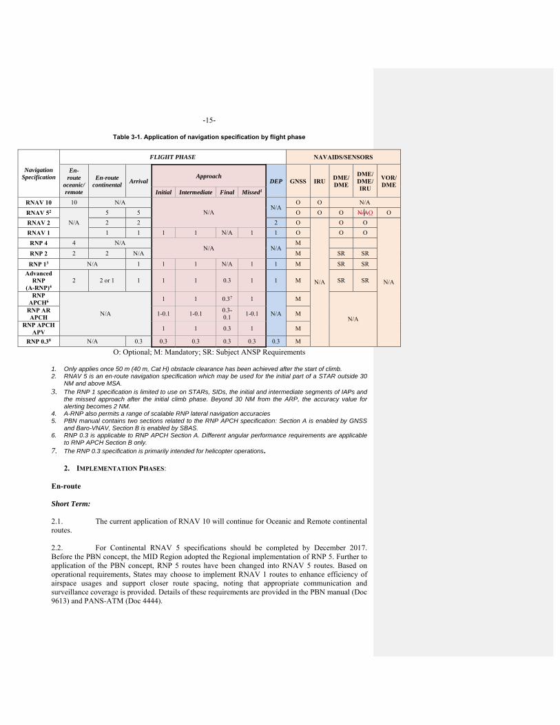
-15-
Table 3-1. Application of navigation specification by flight phase
Navigation Specification
FLIGHT PHASE NAVAIDS/SENSORS
En-route
oceanic/ remote
En-route continental
Arrival Approach
DEP GNSS IRU DME/ DME
DME/ DME/ IRU
VOR/ DME
Initial Intermediate Final Missed1
RNAV 10 10 N/A
N/A N/A
O O N/A
RNAV 52
N/A
5 5 O O O N/AO O
RNAV 2 2 2 2 O
N/A
O O
N/A
RNAV 1 1 1 1 1 N/A 1 1 O O O
RNP 4 4 N/A N/A N/A
M
RNP 2 2 2 N/A M SR SR
RNP 13 N/A 1 1 1 N/A 1 1 M SR SR
Advanced RNP
(A-RNP)4 2 2 or 1 1 1 1 0.3 1 1 M SR SR
RNP APCH6
N/A
1 1 0.37 1
N/A
M
N/A
RNP AR APCH
1-0.1 1-0.1 0.3-0.1
1-0.1 M
RNP APCH APV
1 1 0.3 1 M
RNP 0.38 N/A 0.3 0.3 0.3 0.3 0.3 0.3 M
O: Optional; M: Mandatory; SR: Subject ANSP Requirements
1. Only applies once 50 m (40 m, Cat H) obstacle clearance has been achieved after the start of climb. 2. RNAV 5 is an en-route navigation specification which may be used for the initial part of a STAR outside 30
NM and above MSA. 3. The RNP 1 specification is limited to use on STARs, SIDs, the initial and intermediate segments of IAPs and
the missed approach after the initial climb phase. Beyond 30 NM from the ARP, the accuracy value for alerting becomes 2 NM.
4. A-RNP also permits a range of scalable RNP lateral navigation accuracies 5. PBN manual contains two sections related to the RNP APCH specification: Section A is enabled by GNSS
and Baro-VNAV, Section B is enabled by SBAS. 6. RNP 0.3 is applicable to RNP APCH Section A. Different angular performance requirements are applicable
to RNP APCH Section B only. 7. The RNP 0.3 specification is primarily intended for helicopter operations.
2. IMPLEMENTATION PHASES:
En-route
Short Term: 2.1. The current application of RNAV 10 will continue for Oceanic and Remote continental routes. 2.2. For Continental RNAV 5 specifications should be completed by December 2017. Before the PBN concept, the MID Region adopted the Regional implementation of RNP 5. Further to application of the PBN concept, RNP 5 routes have been changed into RNAV 5 routes. Based on operational requirements, States may choose to implement RNAV 1 routes to enhance efficiency of airspace usages and support closer route spacing, noting that appropriate communication and surveillance coverage is provided. Details of these requirements are provided in the PBN manual (Doc 9613) and PANS-ATM (Doc 4444).
-16-
Medium Term: 2.3. RNP 4 and/or RNP 2 routes would be considered for implementation for the en-route oceanic/remote operations. 2.4. RNP 2 or RNAV 1 would be considered for implementation for en-route continental/local domestic operations. Terminal Short Term: 2.5. In a non-surveillance environment and/or in an environment without adequate ground navigation infrastructure, the SID/STAR application of RNP 1 is expected in selected TMAs with exclusive application of GNSS. 2.6. CCO and CDO should be implemented at the defined TMAs, in accordance with the State PBN implementation Plans, the MID Region Air Navigation Strategy and the MID ANP. Medium Term: 2.7. RNAV 1, A-RNP 1 will be implemented in all TMAs, expected target will be 70 % by the end of this term. Approach Short Term: 2.8. Implementation of PBN approaches with vertical guidance (LNAV/VNAV minima) (APV) for runway ends at the international aerodromes listed in the MID ANP should be completed by December 2017, including LNAV only minima. 2.9. The application of RNP AR APCH procedures would be limited to selected airports, where obvious operational benefits can be obtained due to the existence of significant obstacles. Medium Term: 2.10. The extended application of RNP AR APCH should continue for airports where there are operational benefits. 2.11. To progress further with the universal implementation of PBN approaches. GLS procedures should be implemented for the defined runway ends to enhance the reliability and predictability of approaches to runways increasing safety, accessibility, and efficiency. 2.12. Table 3-2 summarizes the implementation targets of each PBN navigation specification in the MID Region:
Formatted: Indent: First line: 0"
Formatted: Indent: First line: 0"
Formatted: Indent: First line: 0"
Formatted: Indent: First line: 0"
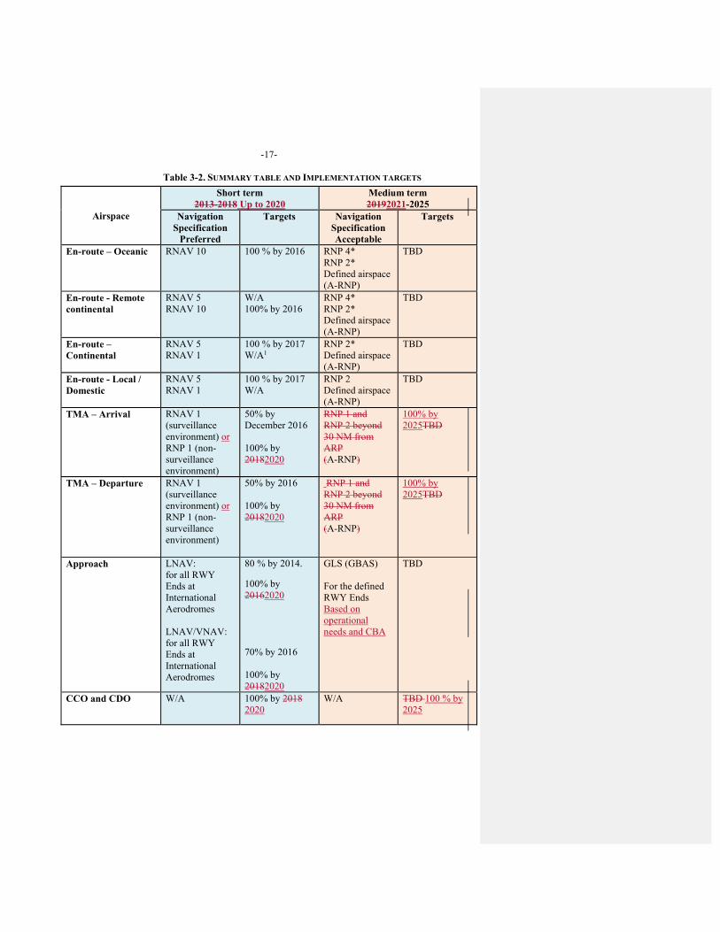
-17-
Table 3-2. SUMMARY TABLE AND IMPLEMENTATION TARGETS
Airspace
Short term 2013-2018 Up to 2020
Medium term 20192021-2025
Navigation Specification
Preferred
Targets Navigation Specification Acceptable
Targets
En-route – Oceanic RNAV 10 100 % by 2016 RNP 4* RNP 2* Defined airspace (A-RNP)
TBD
En-route - Remote continental
RNAV 5 RNAV 10
W/A 100% by 2016
RNP 4* RNP 2* Defined airspace (A-RNP)
TBD
En-route – Continental
RNAV 5 RNAV 1
100 % by 2017 W/A1
RNP 2* Defined airspace (A-RNP)
TBD
En-route - Local / Domestic
RNAV 5 RNAV 1
100 % by 2017 W/A
RNP 2 Defined airspace (A-RNP)
TBD
TMA – Arrival RNAV 1 (surveillance environment) or RNP 1 (non-surveillance environment)
50% by December 2016 100% by 20182020
RNP 1 and RNP 2 beyond 30 NM from ARP (A-RNP)
100% by 2025TBD
TMA – Departure RNAV 1 (surveillance environment) or RNP 1 (non-surveillance environment)
50% by 2016 100% by 20182020
RNP 1 and RNP 2 beyond 30 NM from ARP (A-RNP)
100% by 2025TBD
Approach LNAV: for all RWY Ends at International Aerodromes LNAV/VNAV: for all RWY Ends at International Aerodromes
80 % by 2014.
100% by 20162020 70% by 2016 100% by 20182020
GLS (GBAS) For the defined RWY Ends Based on operational needs and CBA
TBD
CCO and CDO W/A 100% by 2018 2020
W/A TBD 100 % by 2025
-18-
‒ W/A: where applicable/defined Airspace, in accordance with State PBN implementation Plans, the MID Region Air navigationNavigation Strategy and the MID ANP.
‒ * would be considered for implementation at the identified Airspace/TMAs ‒ When no month is specified (e.g. by 2017) means by the end of the year (December 2017). Long Term (20256 and Beyond) 2.13. In this phase, GNSS augmentation is expected to be a primary navigation infrastructure for PBN implementation. States should work co-operatively on a multinational basis to implement GNSS in order to facilitate seamless and inter-operable systems and undertake coordinated Research and Development (R&D) programs on GNSS implementation and operation. 2.14. Moreover, during this phase, States are encouraged to consider segregating traffic according to navigation capability and granting preferred routes to aircraft with better navigation performance. 2.15. The required PBN navigation specifications and their associated targets to be implemented for the Long term will be defined in due course.
Formatted: Indent: Before: 0"

-19-
CHAPTER 4
SAFETY ASSESSMENT AND MONITORING
1. NEED FOR SAFETY ASSESSMENT 1.1. To ensure that the introduction of PBN en-route applications within the MID Region is undertaken in a safe manner and in accordance with relevant ICAO provisions, implementation shall only take place following conduct of a safety assessment that has demonstrated that an acceptable level of safety will be met. This assessment may also need to demonstrate levels of risk associated with specific PBN en-route implementation. Additionally, ongoing periodic safety reviews shall be undertaken where required in order to establish that operations continue to meet the target levels of safety
2. ROLES AND RESPONSIBILITIES 2.1. To demonstrate that the system is safe, it will be necessary that the implementing agency – a State or group of States - ensures that a safety assessment and, where required, ongoing monitoring of the PBN en-route implementation are undertaken. 2.2. In undertaking a safety assessment to enable en-route implementation of PBN, a State or the implementing agency shall:
a) establish and maintain a database registry of PBN approvals; b) monitor aircraft horizontal-plane navigation performance and the occurrence of
large navigation errors and report results; c) conduct safety and readiness assessments; d) monitor operator compliance with State approval requirements after PBN
implementation; and e) initiate necessary remedial actions if PBN requirements are not met.
Formatted: Indent: First line: 0"
-20-
CHAPTER 5 OPERATIONAL APPROVAL
1. OPERATIONAL APPROVAL REQUIREMENTS
1.2. Operational approval is usually the responsibility of the regulatory authority of the State of the Operator for commercial air transport operations and the State of Registry for general Aviation (GA) operations. For certain operations, GA operators may not be required to follow the same authorization model as commercial operators. 1.3. The operational approval assessment must take account of the following:
a) aircraft eligibility and airworthiness compliance;
b) operating procedures for the navigation systems used;
c) control of operating procedures (documented in the OM);
d) flight crew initial training and competency requirements and continuing competency requirements;
e) dispatch training requirements; and
f) control of navigation database procedures. Where a navigation database is required, operators need to have documented procedures for the management of such databases. These procedures will define the sourcing of navigation data from approved suppliers, data validation procedures for navigation databases and the installation of updates to databases into aircraft so that the databases remain current with the AIRAC cycle. (For RNP AR applications, the control of the terrain database used by TAWS must also be addressed.)
Aircraft eligibility 1.4. An aircraft is eligible for a particular PBN application provided there is clear statement in:
a) the Type Certificate (TC); or b) the Supplement Type Certificate (STC); or c) the associated documentation — Aircraft Flight manual (AFM) or equivalent
document; or d) a compliance statement from the manufacturer that has been approved by the State
of Design and accepted by the State of Registry or the State of the Operator, if different.
1.5. The operator must have a configuration list detailing the pertinent hardware and software components and equipment used for the PBN operation. 1.6. The TC is the approved standard for the production of a specified type/series of aircraft. The aircraft specification for that type/series, as part of the TC, will generally include a navigation standard. The aircraft documentation for that type/series will define the system use, operational limitations, equipment fitted and the maintenance practices and procedures. No changes (modifications) are permitted to an aircraft unless the CAA of the State of Registry either approves such changes through a modification approval process, STC or accepts technical data defining a design change that has been approved by another State. 1.7. For recently manufactured aircraft, where the PBN capability is approved under the TC, there may be a statement in the AFM limitations section identifying the operations for which the aircraft is approved. There is also usually a statement that the stated approval does not itself constitute an approval for an operator to conduct those operations. Alternate methods of achieving the
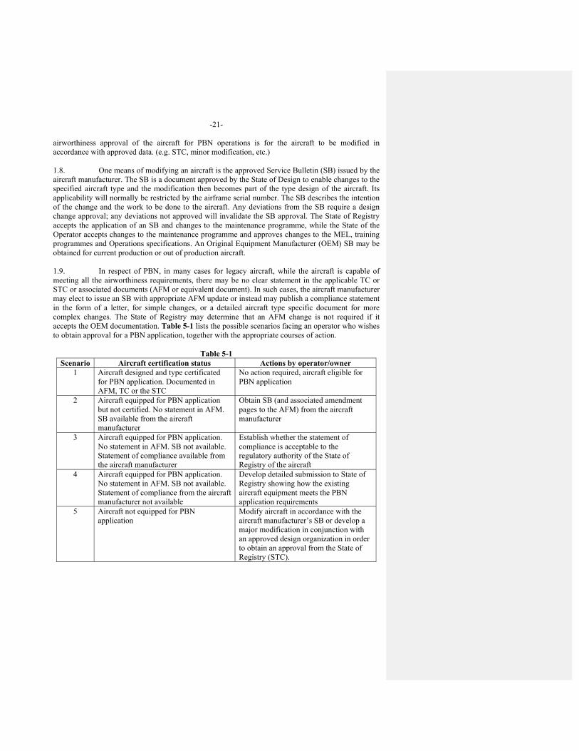
-21-
airworthiness approval of the aircraft for PBN operations is for the aircraft to be modified in accordance with approved data. (e.g. STC, minor modification, etc.) 1.8. One means of modifying an aircraft is the approved Service Bulletin (SB) issued by the aircraft manufacturer. The SB is a document approved by the State of Design to enable changes to the specified aircraft type and the modification then becomes part of the type design of the aircraft. Its applicability will normally be restricted by the airframe serial number. The SB describes the intention of the change and the work to be done to the aircraft. Any deviations from the SB require a design change approval; any deviations not approved will invalidate the SB approval. The State of Registry accepts the application of an SB and changes to the maintenance programme, while the State of the Operator accepts changes to the maintenance programme and approves changes to the MEL, training programmes and Operations specifications. An Original Equipment Manufacturer (OEM) SB may be obtained for current production or out of production aircraft. 1.9. In respect of PBN, in many cases for legacy aircraft, while the aircraft is capable of meeting all the airworthiness requirements, there may be no clear statement in the applicable TC or STC or associated documents (AFM or equivalent document). In such cases, the aircraft manufacturer may elect to issue an SB with appropriate AFM update or instead may publish a compliance statement in the form of a letter, for simple changes, or a detailed aircraft type specific document for more complex changes. The State of Registry may determine that an AFM change is not required if it accepts the OEM documentation. Table 5-1 lists the possible scenarios facing an operator who wishes to obtain approval for a PBN application, together with the appropriate courses of action.
Table 5-1 Scenario Aircraft certification status Actions by operator/owner
1 Aircraft designed and type certificated for PBN application. Documented in AFM, TC or the STC
No action required, aircraft eligible for PBN application
2 Aircraft equipped for PBN application but not certified. No statement in AFM. SB available from the aircraft manufacturer
Obtain SB (and associated amendment pages to the AFM) from the aircraft manufacturer
3 Aircraft equipped for PBN application. No statement in AFM. SB not available. Statement of compliance available from the aircraft manufacturer
Establish whether the statement of compliance is acceptable to the regulatory authority of the State of Registry of the aircraft
4 Aircraft equipped for PBN application. No statement in AFM. SB not available. Statement of compliance from the aircraft manufacturer not available
Develop detailed submission to State of Registry showing how the existing aircraft equipment meets the PBN application requirements
5 Aircraft not equipped for PBN application
Modify aircraft in accordance with the aircraft manufacturer’s SB or develop a major modification in conjunction with an approved design organization in order to obtain an approval from the State of Registry (STC).
-22-
Operating procedures 1.10. The Standard operating procedure (SOP) must be developed to cover both normal and non-normal (contingency) procedures for the systems used in the PBN operation. The SOP must address:
a) preflight planning requirements including the MEL and, where appropriate, RNP/RAIM prediction;
b) actions to be taken prior to commencing the PBN operation; c) actions to be taken during the PBN operation; and d) actions to be taken in the event of a contingency, including the reporting of
significant incidents GA pilots must ensure that they have suitable procedures/checklists covering all these areas Control of operating procedures 1.11. The SOP must be adequately documented in the OM and checklists Flight crew and dispatch training 1.12. A flight crew and dispatch training programme for the PBN operation must cover all the tasks associated with the operation and provide sufficient background to ensure a comprehensive understanding of all aspects of the operation. The operator must have adequate records of course completion for flight crew, flight dispatchers and maintenance personnel. Control of navigation database procedures 1.13. If a navigation database is required, the procedures for maintaining currency, checking for errors and reporting errors to the navigation database supplier must be documented in the maintenance manual by commercial operators
2. DOCUMENTATION OF OPERATIONAL APPROVAL 2.1. Operational approval may be documented as an endorsement of the Air operator certificate (AOC) through:
a) Operations specification, associated with the AOC; or b) amendment to the OM; or c) LOA.
2.2. During the validity of the operational approval, the CAA should consider any anomaly reports received from the operator or other interested party. Repeated navigation error occurrences attributed to a specific piece of navigation equipment may result in restrictions on use or cancelation of the approval for use of that equipment. Information that indicates the potential for repeated errors may require modification of an operator’s training programme. Information that attributes multiple errors to a particular pilot or crew may necessitate remedial training and checking or a review of the operational approval. 2.3. The State may determine that a GA aircraft may operate on a PBN route/procedure provided that the operator has ensured that the aircraft has suitably approved equipment (is eligible), the navigation database is valid, the pilot is suitably qualified and current with respect to the equipment, and adequate procedures (checklists) are in place.
-23-
3. STATE REGULATORY MATERIAL 3.1. Individual States must develop national regulatory material which addresses the PBN applications relevant to their airspace or relevant to operations conducted in another State by the State’s operators or by aircraft registered in that State. The regulations may be categorized by operation, flight phase, area of operation and/or navigation specification. Approvals for commercial operations should require specific authorization.
4. APPROVAL PROCESS General 4.2. Since each operation may differ significantly in complexity and scope, the project manager and the operational approval team need considerable latitude in taking decisions and making recommendations during the approval process. The ultimate recommendation by the project manager and decision by the DGCA regarding operational approval should be based on the determination of whether or not the applicant:
a) meets the requirements established by the State in its air navigation regulations; b) is adequately equipped; and c) is capable of conducting the proposed operation in a safe and efficient manner.
4.3. The complexity of the approval process is based on the inspector’s assessment of the applicant’s proposed operation. For simple approvals, some steps can be condensed or eliminated. Some applicants may lack a basic understanding of what is required for approval. Other applicants may propose a complex operation, but may be well prepared and knowledgeable. Because of the variety in proposed operations and differences in an applicant’s knowledge, the process must be thorough enough and flexible enough to apply to all possibilities. Phases of the approval process Step 1 — Pre-application phase 4.4. The operator initiates the approval process by reviewing the requirements; establishing that the aircraft, the operating procedures, the maintenance procedures and the training meet the requirements; and developing a written proposal to the regulator. A number of regulators have published “job aids” to assist the operator in gathering the necessary evidence to support the approval application. At this stage a pre-application meeting with the regulator can also be very beneficial. If the proposed application is complex, the operator may need to obtain advice and assistance from OEMs or other design organizations, training establishments, data providers, etc. Step 2 — Formal application phase 4.5. The operator submits a formal, written application for approval to the CAA, which appoints a project manager either for the specific approval or generally for PBN approvals. Step 3 — Document evaluation phase 4.6. The CAA project manager evaluates the formal, written application for approval to determine whether all the requirements are being met. If the proposed application is complex, the project manager may need to obtain advice and assistance from other organizations such as regional agencies or experts in other States.
-24-
Step 4 — Demonstration and inspection phase 4.7. During a formal inspection by the project manager (assisted as necessary by a CAA team), the operator demonstrates how the requirements are being met. Step 5 — Approval phase 4.8. Following a successful formal inspection by the CAA, approval is given through:
a) Operations specification, associated with the AOC; or b) amendment to the OM; or c) LOA.
Some PBN applications may not require formal approval for GA operations — this will be determined by the State of Registry. Note.— The approval procedure described above consists of a simplified process of the certification
guidance contained in Part III of the Manual of Procedures for Operations Inspection, Certification and Continued Surveillance (Doc 8335).
5. FOREIGN OPERATIONS
5.1. A State undertakes, in accordance with Article 12 to the Convention, to ensure that every aircraft flying over or maneuvering within its territory shall comply with the rules and regulations relating to the flight and maneuver of aircraft there in force. Article 33 to the Convention provides that certificates of airworthiness and certificates of competency and licenses issued, or rendered valid, by the State in which an aircraft is registered, shall be recognized by other States, provided that the requirements under which such certificates or licenses were issued or rendered valid are equal to or above the minimum standards which may be established by ICAO. This requirement for recognition is now extended by Annex 6, Part I and Part III, Section II, such that Contracting States shall recognize as valid an AOC issued by another Contracting State, provided that the requirements under which the certificate was issued are at least equal to the applicable Standards specified in Annex 6, Part I and Part III. 5.2. States should establish procedures to facilitate the application by foreign operators for approval to operate into their territory. States should be careful in their requirements for applications, to request only details relevant to the evaluation of the safety of the operations under consideration and their future surveillance. When evaluating an application by an operator from another State to operate within its territory a State will examine both the safety oversight capabilities and record of the State of the Operator and, if different, the State of Registry, as well as the operational procedures and practices of the operator. This is necessary in order for the State, in the terms of Article 33 to the Convention, to have confidence in the validity of the certificates and licenses associated with the operator, its personnel and aircraft, in the operational capabilities of the operator and in the level of certification and oversight applied to the activities of the operator by the State of the Operator. 5.3. The operator will need to make applications to each State into or over which it is intended to operate. The operator will also need to keep its own CAA, as the authority of the State of the Operator, informed of all applications to operate in other States. Applications should be made direct to the CAAs of the States into which it is intended to operate. In some cases it will be possible to download information and instructions for making an application and the necessary forms from a website maintained by the CAA in question. 5.4. States should promote the implementation and operational approval of Advanced RNP (A-RNP) navigation specifications, which serves all the flight phases as follows:
Formatted: Indent: First line: 0"
-25-
En-Route Oceanic, Remote: RNP 2; En-Route Continental: RNP 2 or RNP 1; Arrival and Departures: RNP 1; Initial, intermediate and missed approach phases: RNP 1; and Final Approach Phase: RNP 0.3.
5.5. Because functional and performance requirements are defined for each navigation specification, an aircraft approved for an RNP specification is not automatically approved for all RNAV specifications. Similarly, an aircraft approved for an RNP or RNAV specification having a stringent accuracy requirement (e.g. RNP 0.3 specification) is not automatically approved for a navigation specification having a less stringent accuracy requirement (e.g. RNP 4).

-26-
CHAPTER 6
PBN CHARTING
1. INTRODUCTION 6.1 Charting of PBN Instrument Approach Procedures in the MID Region should follow the criteria included in Annex 4 and the PANS OPS (DOC 8168).
2. TRANSITION PLAN FOR RNAV TO RNP INSTRUMENT APPROACH CHART DEPICTION
6.2 For a harmonized implementation of the Amendment 6 to the PANS OPS related to RNAV to RNP Approach Chart Depiction, the following transition plan should apply in the MID Region:
MID States, that have not yet done so, should implement RNAV to RNP Chart naming convention for their current PBN Approach Procedures published in their AIPs, starting from 29 March 2019 up to 8 September 2022. New PBN Approach Procedures, planned to be published before 29 March 2019, should be published using the new naming convention, if practicable. If a PBN Approach Procedure published in the National AIP is amended and re-published before 29 March 2019 (for any reason), the new naming convention should be used, if practicable.
6.3 States are required to provide the ICAO MID Office with their action plan for the implementation of RNAV to RNP Chart naming convention, and keep the MID Office apprised of the status of implementation.
---------------------
CNS SG/8-REPORT APPENDIX 4G
2/24/2018
MID Surveillance Plan Version 1.0
CNS SGICAO MID OFFICE
MID Surveillance Plan Page 1 of 13
Table of contents
1. Background…………………………………………………………………2
2. Introduction……………………………………………………………….2
3. Surveillance in Ganp……………………………………………………3
4. Surveillance Technologies…………………………………………..4
4.1 Primary Radar……………………………………………………..4 4.2 Secondary Radar (SSR/MSSR)…………………………........5
4.3 Mode S Radar……………………………………………………....6
4.4 ADS-B……………………………………………………….....................6
4.5 ADS-C…………………………………………………………………….6
4.6 MLAT…………………………………………………………………….7
5. Comparison between Surveillance technologies………..8
6. Operational Requirements……………………..……………............11
7. Baseline in the mid region…………………………………………...11
8. mID Region surveillance plan……………………………………...11 References………………………………………………………………………..13
MID Surveillance Plan Page 2 of 13
1- Background
The purpose of this document is to review the available surveillance technologies and highlight their strengths and weaknesses, in order to develop a MID Region Surveillance Plan based on Regional operational requirements, Users’ capabilities and specificities of the Region.
The global Air Navigation Plan (GANP) through B0-ASUR, defined the possibility of using lower cost ground surveillance supported by new technologies such as ADS-B OUT and wide area multilateration (MLAT) systems.
MIDANPIRG/16 through Decision 16/24 tasked the CNS SG to develop MID Surveillance Plan based on the Regional operational requirements identified by the ATM SG: DECISION 16/ 23: MID REGION SURVEILLANCE PLAN
That, the MID Region Surveillance Plan be developed by the CNS SG, based on the operational needs identified by the ATM SG.
This document provides summary of the available surveillance technologies for Civil aviation use, strengths and weaknesses, comparison between them and implementation timelines in the MD Region. The plan timelines are divided into three stages; short-term until 2020, mid-term from 2021 to 2025, and long-term beyond 2025.
2- Introduction The surveillance service delivered to users may be based on a mix of three main types of surveillance:
a) independent non-cooperative surveillance: the aircraft position is derived from measurement not using the cooperation of the remote aircraft; like Primary Surveillance Radar (PSR); b) independent cooperative surveillance: the position is derived from measurements performed by a local surveillance subsystem using aircraft transmissions. Aircraft derived information (e.g., pressure altitude, aircraft identity) can be provided from those transmissions, like Secondary Surveillance Radar (SSR) and Multilateration; and c) dependent cooperative surveillance: the position is derived on board the aircraft and is provided to the local surveillance subsystem along with possible additional data (e.g., aircraft identity, pressure altitude). Like Automatic Dependent Surveillance-Broadcast (ADS-B) and Automatic Dependent Surveillance-Contract (ADS-C).
The main applications of ATC Surveillance in civil aviation are:
MID Surveillance Plan Page 3 of 13
1- Aerodrome Control Service; 2- Approach Control Service; and 3- Area Control Service.
3- Surveillance in GANP The GANP addressed the emerging Surveillance technologies through the thread Alternative Surveillance in block 0 (B0-ASUR), the technologies laid down in that module are ADS-B out and MLAT. The lower costs of dependent surveillance infrastructure (ADS-B and MLAT) in comparison to conventional radars support business decisions to expand radar-equivalent service volumes and the use of radar-like separation procedures into remote or non-radar areas. The eleventh Air Navigation Conference recommended ADS-B on 1090MHz for international use and this is happening. Equipage rate is growing together with Mode S, airborne collision avoidance system (ACAS) and ADS-B OUT mandates. ADS-B OUT, Version 2 also provides for ACAS RA DOWNLINK information. The GANP Surveillance roadmap is depicted in figure (1).
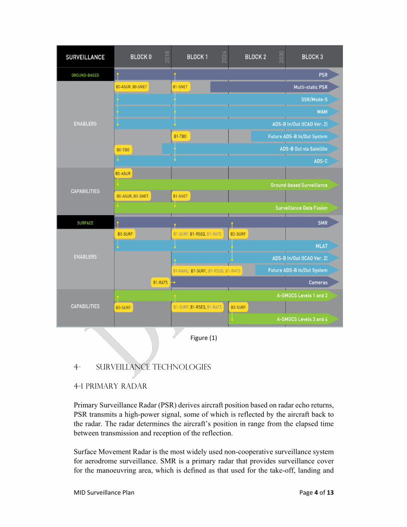
MID Surveillance Plan Page 4 of 13
Figure (1)
4- Surveillance Technologies
4-1 primary Radar
Primary Surveillance Radar (PSR) derives aircraft position based on radar echo returns, PSR transmits a high-power signal, some of which is reflected by the aircraft back to the radar. The radar determines the aircraft’s position in range from the elapsed time between transmission and reception of the reflection. Surface Movement Radar is the most widely used non-cooperative surveillance system for aerodrome surveillance. SMR is a primary radar that provides surveillance cover for the manoeuvring area, which is defined as that used for the take-off, landing and
MID Surveillance Plan Page 5 of 13
taxiing of aircraft. In A-SMGCS, the non-cooperative surveillance service is typically provided by one or several SMRs. Millimetre radar is an emerging technology used for aerodrome surveillance which provides higher resolution than traditional SMR. Millimetre Radar and SMR can be used for FOD Detection. The strengths and weaknesses below are related to the PSR. 4-1-1 Strengths
Independent Radar, does not require any specific equipment of the aircraft (Transponder).
4-1-2 Weaknesses
Does not provide the identity or the altitude of the Aircraft cannot be easily sited in oceanic locations, or rough terrain such as in
mountainous regions PSR has a heavy reliance on mechanical components with large maintenance
requirements High CAPEX Can report false target
4-2 Secondary Surveillance Radar (SSR/MSSR) A surveillance radar system which uses transmitters/receivers (interrogators) and transponders.
4-2-1 Strengths
receive aircraft data for barometric altitude, identification code 4-2-2 Weaknesses
High CAPEX cannot be easily sited in oceanic locations, or rough terrain such as in
mountainous regions has a heavy reliance on mechanical components with large maintenance
requirements, 4-3 Mode s Radar An enhanced mode of SSR that permits selective interrogation and reply capability.
4-3-1 Strengths
improve shortage and constraints in Mode a codes (Aircraft ID) backward compatible with transponder mode A/C ability to download enhance surveillance information
MID Surveillance Plan Page 6 of 13
4-3-2 Weaknesses
has a heavy reliance on mechanical components with large maintenance requirements
cannot be easily sited in oceanic locations, or rough terrain such as in mountainous regions
High CAPEX
4-4 ADS-B Dependent surveillance is an advanced surveillance technology that allows avionics to broadcast an aircraft’s identification, position, altitude, velocity, and other information.
4-4-1 Strengths
improve shortage and constraints in Mode a codes (Aircraft ID) Low cost Easy to maintain The non-mechanical nature of the ADS-B ground infrastructure make it easy to
relocate and maintain. it to be sited in locations that are difficult for radar installations, like hilly areas,
filling the surveillance gap between radar coverage provide radar-like separation procedures into remote or non-radar areas Use of dependent surveillance also improves the search and rescue support
provided by the surveillance network, ADS-B’s positional accuracy and update rate allows for improved flown trajectory tracking allowing for early determination of loss of contact and enhances the ability for search and rescue teams to pinpoint the related location
4-4-2 Weaknesses
aircraft must be equipped with ADS-B OUT dependent on GNSS, outage of GNSS affect ADS-B
4-5 ADS-C
The aircraft uses on-board navigation systems to determine its position, velocity and other data. A ground ATM system establishes a “contract” with the aircraft to report this information at regular intervals or when defined events occur. This information is transmitted on point-to-point data links. 4-5-1 Strengths
can be easily sited in oceanic locations, or rough terrain such as in mountainous regions
does not need ground infrastructure minimal cost at ANSP
MID Surveillance Plan Page 7 of 13
use of dependent surveillance also improves the search and rescue support provided by the surveillance network
4-5-2 Weaknesses high cost per report, as the airline use third party network. long latency when satellite used.
The ADS-C used in Oceanic and remote areas (non-Radar area), therefore, it will be excluded in the next section as it’s not applicable in the MID Region. 4-6 MLAT
MLAT is a system that uses currently existing aircraft transponder signals to calculate, usually as a minimum, a three-dimensional position. it requires a minimum of four receiving stations to calculate an aircraft’s position. If the aircraft’s pressure altitude is known then the position may be resolved using three receiving stations. MLAT can act in two modes; Passive mode where it uses the existing transmissions made by the aircraft, or active mode, to trigger replies in the manner of Mode S SSR interrogations. The technique is used to provide surveillance over wide area (wide area MLAT system - WAM). 4-6-1 Strengths
can make use of currently existing aircraft transmissions, does not requires specific avionic.
improve shortage and constraints in Mode A codes (Aircraft ID) provides a transition to an environment where the majority of aircraft will be
equipped with ADS-B. 4-6-2 Weaknesses
requires multiple sensors to calculate aircraft’s positions high running cost; including maintenance; telecommunication; multiple secured
sites needs a common time reference to determine the relative TOA of the signal at
the receiving stations (time‐stamped by a common clock or synchronism by a common reference such as GNSS)
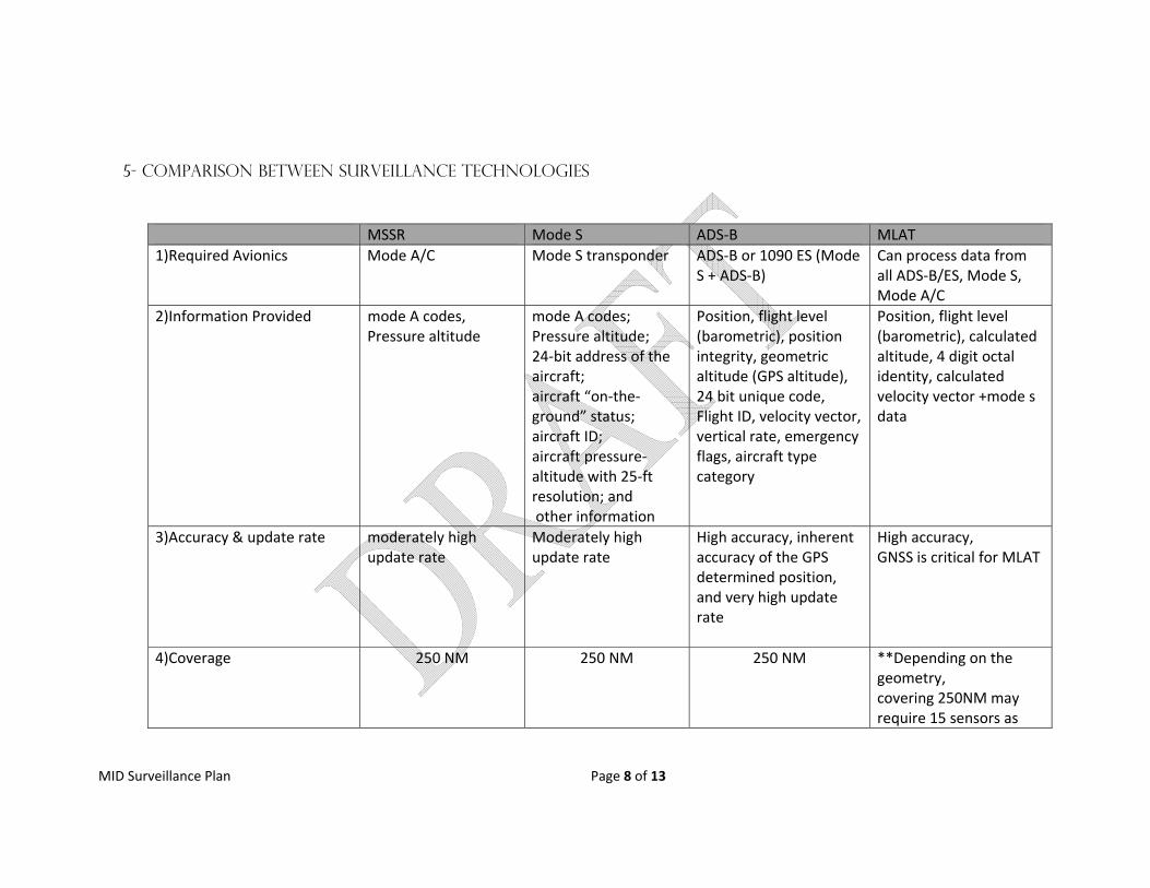
MID Surveillance Plan Page 8 of 13
5- Comparison between Surveillance Technologies
MSSR Mode S ADS‐B MLAT
1)Required Avionics Mode A/C Mode S transponder ADS‐B or 1090 ES (Mode S + ADS‐B)
Can process data from all ADS‐B/ES, Mode S, Mode A/C
2)Information Provided mode A codes, Pressure altitude
mode A codes; Pressure altitude; 24‐bit address of the aircraft; aircraft “on‐the‐ground” status; aircraft ID; aircraft pressure‐altitude with 25‐ft resolution; and other information
Position, flight level (barometric), position integrity, geometric altitude (GPS altitude), 24 bit unique code, Flight ID, velocity vector, vertical rate, emergency flags, aircraft type category
Position, flight level (barometric), calculated altitude, 4 digit octal identity, calculated velocity vector +mode s data
3)Accuracy & update rate moderately high update rate
Moderately high update rate
High accuracy, inherent accuracy of the GPS determined position, and very high update rate
High accuracy, GNSS is critical for MLAT
4)Coverage 250 NM 250 NM 250 NM **Depending on the geometry, covering 250NM may require 15 sensors as
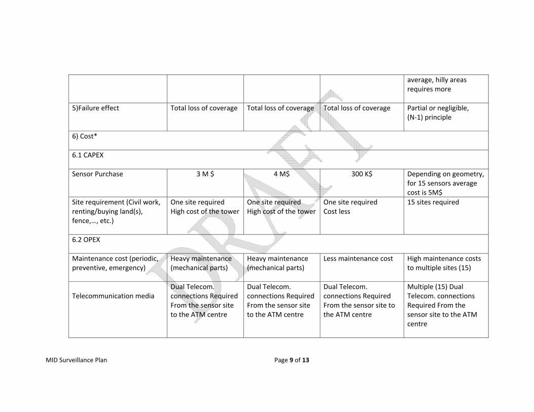
MID Surveillance Plan Page 9 of 13
average, hilly areas requires more
5)Failure effect
Total loss of coverage Total loss of coverage Total loss of coverage Partial or negligible, (N‐1) principle
6) Cost*
6.1 CAPEX
Sensor Purchase 3 M $ 4 M$ 300 K$ Depending on geometry, for 15 sensors average cost is 5M$
Site requirement (Civil work, renting/buying land(s), fence,…, etc.)
One site requiredHigh cost of the tower
One site requiredHigh cost of the tower
One site requiredCost less
15 sites required
6.2 OPEX
Maintenance cost (periodic, preventive, emergency)
Heavy maintenance (mechanical parts)
Heavy maintenance (mechanical parts)
Less maintenance cost High maintenance costs to multiple sites (15)
Telecommunication media
Dual Telecom. connections Required From the sensor site to the ATM centre
Dual Telecom. connections Required From the sensor site to the ATM centre
Dual Telecom. connections Required From the sensor site to the ATM centre
Multiple (15) Dual Telecom. connections Required From the sensor site to the ATM centre
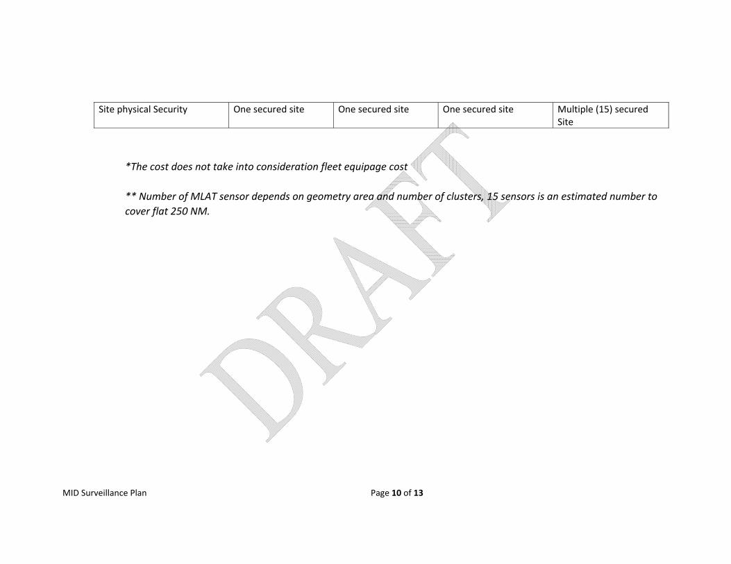
MID Surveillance Plan Page 10 of 13
Site physical Security One secured site One secured site One secured site Multiple (15) secured Site
*The cost does not take into consideration fleet equipage cost ** Number of MLAT sensor depends on geometry area and number of clusters, 15 sensors is an estimated number to cover flat 250 NM.
MID Surveillance Plan Page 11 of 13
6. Operational Requirements
To be added by ATM SG
7. Baseline in the MID Region
All MID State have been using SSR/MSSR
Few MID States implemented MLAT at International Aerodromes
ADS‐B has been installed at some States as backup and complementary means
to the MSSR
Several States have installed Radar Mode S
States have installed MLAT as WAM and to be used as ADS‐B in later stage ,
???
Many Surveillance Gap areas are existing in the Region State issued ADS‐B Mandate to commence in 2020
Adjacent Regions mandated carriage of ADS‐B. Europe and FAA in 2020.
Several ADS‐B mandate worldwide will accelerate the ADS‐B equipage.
However, Regional Airline, General flights and Military aircraft impeding the
ADS‐B implementation in the MID Region.
8- MID Region Surveillance PLAN
8.1 Short Term (2018 – 2020)
Make full use of SSR Mode ‘S’ capabilities, reduce reliance on 4 digit octal
code.
States to consider emerging dependent Surveillance technologies (ADS‐
B and MLAT) in their national Surveillance Plans.
State should conduct safety assessment for ADS‐B/ MLAT
implementation as per [5].
The proportions of equipped aircraft are critical for the ADS‐B deployment, therefore, States should early involve Users, communicate
the change, the rationale and the impact.
States are encouraged to use INCENTIVE strategy with stakeholders to accelerate ADS‐B equipage; incentive approach might be financial or
operational incentive or combined (e.g. Most Capable Best Served
principle, waive fees).
Prioritize ADS‐B implementation in areas where there is no radar
coverage surveillance.
MLAT/SMR to be implemented at Aerodrome to enable A‐SGMC and
approach
MID Surveillance Plan Page 12 of 13
8.2 Mid Term (2021‐2024)
ADS‐B to be implemented for Area and approach Control Services, where
implementation would bring capacity and operational efficiencies;
Relocate, as appropriate, WAM Sensors to work as ADS‐B receivers
States to share Radar/ADS‐B data to improve boundary coverage and
enhance the surveillance availability.
Retain Mode S Radar as backup to ADS‐B
8.3 Long Term (2025 Onward)
ADS‐B is foreseen to be main Surveillance technology. The existence of
Multi‐constellation GNSS (GPS, Galileo, Glonass, …, etc.) reduces the
likelihood of ADS‐B outage.
Implementation of Airborne Collision Avoidance System (ACAS) adapted
to trajectory‐based operations with improved surveillance function
supported by ADS‐B aimed at reducing nuisance alerts and deviations.
Airlines to upgrade ADS‐B Avionic to ADS‐B in/out.

MID Surveillance Plan Page 13 of 13
References
[1] ICAO Annex 10, Vol V
[2] ICAO Doc 9924, Aeronautical Surveillance Manual
[3] The Aviation System Block Upgrade Doc, July, 2016.
[4] ICAO Doc 9871, Technical Provisions for Mode S Services and Extended Squitter.
[5] ICAO circular 326, Assessment of ADS‐B and Multilateration Surveillance to
Support Air Traffic Services and Guidelines for Implementation
[6] EUROCONTROL Standard Document for RADAR Surveillance in EN‐Route Airspace
and Major Terminal Areas.
[7] Guidance Material on Comparison of Surveillance Technologies (GMST), APAC
Region.
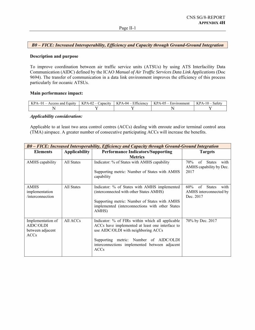
CNS SG/8-REPORT APPENDIX 4H
Page II-1 B0 – FICE: Increased Interoperability, Efficiency and Capacity through Ground‐Ground Integration
Description and purpose To improve coordination between air traffic service units (ATSUs) by using ATS Interfacility Data Communication (AIDC) defined by the ICAO Manual of Air Traffic Services Data Link Applications (Doc 9694). The transfer of communication in a data link environment improves the efficiency of this process particularly for oceanic ATSUs. Main performance impact: KPA- 01 – Access and Equity KPA-02 – Capacity KPA-04 – Efficiency KPA-05 – Environment KPA-10 – Safety
N Y Y N Y
Applicability consideration: Applicable to at least two area control centres (ACCs) dealing with enroute and/or terminal control area (TMA) airspace. A greater number of consecutive participating ACCs will increase the benefits.
B0 – FICE: Increased Interoperability, Efficiency and Capacity through Ground‐Ground Integration
Elements Applicability Performance Indicators/Supporting Metrics
Targets
AMHS capability All States Indicator: % of States with AMHS capability Supporting metric: Number of States with AMHS capability
70% of States with AMHS capability by Dec. 2017
AMHS implementation /interconnection
All States Indicator: % of States with AMHS implemented (interconnected with other States AMHS) Supporting metric: Number of States with AMHS implemented (interconnections with other States AMHS)
60% of States with AMHS interconnected by Dec. 2017
Implementation of AIDC/OLDI between adjacent ACCs
All ACCs Indicator: % of FIRs within which all applicable ACCs have implemented at least one interface to use AIDC/OLDI with neighboring ACCs Supporting metric: Number of AIDC/OLDI interconnections implemented between adjacent ACCs
70% by Dec. 2017

Page II-2
TABLE B0-FICE EXPLANATION OF THE TABLE
Column 1 Name of the State
2,3,4 Status of AMHS Capability and Interconnection and AIDC/OLDI Capability, where:
Y – Fully Implemented N – Not Implemented
5 Status of AIDC/OLDI Implementation, where: Y – If AIDC/OLDI is implemented at least with one neighbouring ACC
N – Not Implemented 6 Action plan — short description of the State’s Action Plan with regard to the
implementation of B0-FICE.
7 Remarks
State
AMHS Capabilit
y
AMHS Interconnectio
n
AIDC/OLDI Capability
AIDC/OLDI Implementatio
n
Action Plan
Remarks
1 2 3 4 5 6 7 Bahrain Y Y Y Y OLDI
connection with ABU
Dhabi Egypt Y Y Y Y
Iran N N Y N
Iraq N N N N
Jordan Y Y Y N Planned with
Cyprus
Kuwait Y Y Y N
Lebanon Y Y Y Y Oman – UAE
Planned 12/3/18
Libya Y N Y N Contract signed for
AMHS
Oman Y Y Y N
Qatar Y Y Y Y local implementation for OLDI
Saudi Arabia
Y Y Y Y local implementation for AIDC
Sudan Y Y Y N
Syria N N N N
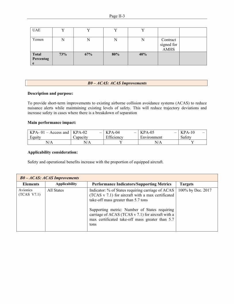
Page II-3
B0 – ACAS: ACAS Improvements
Description and purpose: To provide short-term improvements to existing airborne collision avoidance systems (ACAS) to reduce nuisance alerts while maintaining existing levels of safety. This will reduce trajectory deviations and increase safety in cases where there is a breakdown of separation Main performance impact:
KPA- 01 – Access and Equity
KPA-02 – Capacity
KPA-04 – Efficiency
KPA-05 – Environment
KPA-10 – Safety
N/A N/A Y N/A Y Applicability consideration: Safety and operational benefits increase with the proportion of equipped aircraft.
B0 – ACAS: ACAS Improvements
Elements Applicability Performance Indicators/Supporting Metrics Targets Avionics (TCAS V7.1)
All States Indicator: % of States requiring carriage of ACAS (TCAS v 7.1) for aircraft with a max certificated take-off mass greater than 5.7 tons Supporting metric: Number of States requiring carriage of ACAS (TCAS v 7.1) for aircraft with a max certificated take-off mass greater than 5.7 tons
100% by Dec. 2017
UAE Y Y Y Y
Yemen N N N N Contract signed for
AMHS
Total Percentage
73% 67% 80% 40%
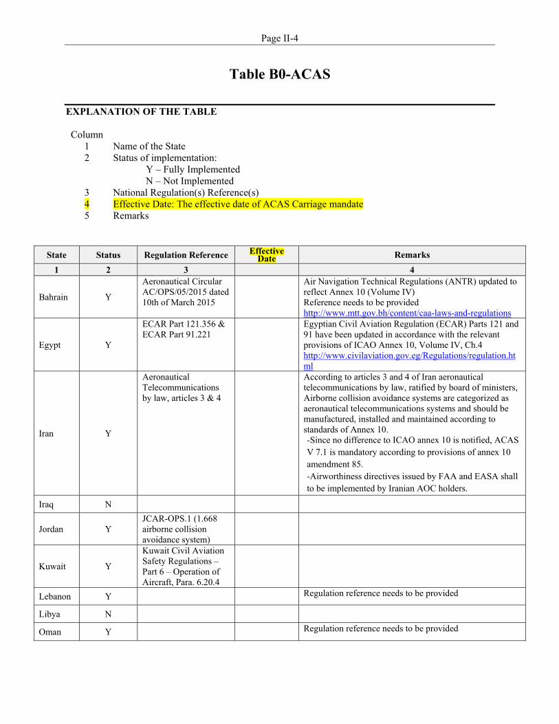
Page II-4
Table B0-ACAS
EXPLANATION OF THE TABLE
Column 1 Name of the State 2
Status of implementation: Y – Fully Implemented
N – Not Implemented 3 National Regulation(s) Reference(s) 4 Effective Date: The effective date of ACAS Carriage mandate 5 Remarks
State Status Regulation Reference EffectiveDate Remarks
1 2 3 4
Bahrain Y
Aeronautical Circular AC/OPS/05/2015 dated 10th of March 2015
Air Navigation Technical Regulations (ANTR) updated to reflect Annex 10 (Volume IV) Reference needs to be provided http://www.mtt.gov.bh/content/caa-laws-and-regulations
Egypt Y
ECAR Part 121.356 & ECAR Part 91.221
Egyptian Civil Aviation Regulation (ECAR) Parts 121 and 91 have been updated in accordance with the relevant provisions of ICAO Annex 10, Volume IV, Ch.4 http://www.civilaviation.gov.eg/Regulations/regulation.html
Iran Y
Aeronautical Telecommunications by law, articles 3 & 4
According to articles 3 and 4 of Iran aeronautical telecommunications by law, ratified by board of ministers, Airborne collision avoidance systems are categorized as aeronautical telecommunications systems and should be manufactured, installed and maintained according to standards of Annex 10. -Since no difference to ICAO annex 10 is notified, ACAS V 7.1 is mandatory according to provisions of annex 10 amendment 85. -Airworthiness directives issued by FAA and EASA shall to be implemented by Iranian AOC holders.
Iraq N
Jordan Y JCAR-OPS.1 (1.668 airborne collision avoidance system)
Kuwait Y
Kuwait Civil Aviation Safety Regulations – Part 6 – Operation of Aircraft, Para. 6.20.4
Lebanon Y Regulation reference needs to be provided
Libya N
Oman Y Regulation reference needs to be provided
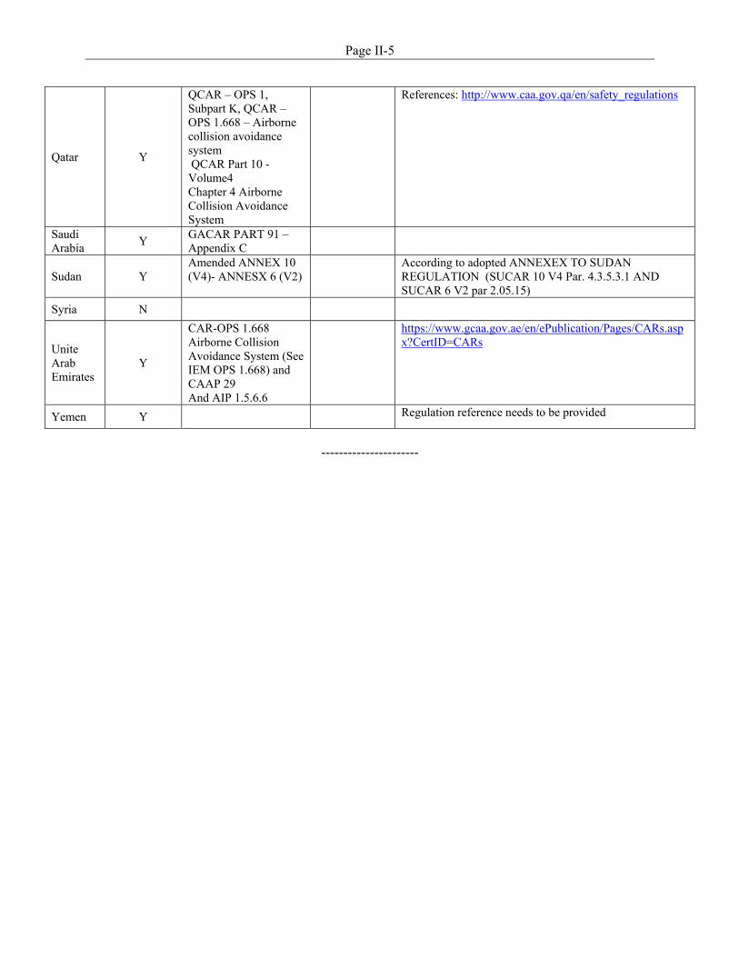
Page II-5
----------------------
Qatar Y
QCAR – OPS 1, Subpart K, QCAR – OPS 1.668 – Airborne collision avoidance system QCAR Part 10 - Volume4 Chapter 4 Airborne Collision Avoidance System
References: http://www.caa.gov.qa/en/safety_regulations
Saudi Arabia
Y GACAR PART 91 – Appendix C
Sudan Y Amended ANNEX 10 (V4)- ANNESX 6 (V2)
According to adopted ANNEXEX TO SUDAN REGULATION (SUCAR 10 V4 Par. 4.3.5.3.1 AND SUCAR 6 V2 par 2.05.15)
Syria N
Unite Arab Emirates
Y
CAR-OPS 1.668 Airborne Collision Avoidance System (See IEM OPS 1.668) and CAAP 29 And AIP 1.5.6.6
https://www.gcaa.gov.ae/en/ePublication/Pages/CARs.aspx?CertID=CARs
Yemen Y Regulation reference needs to be provided
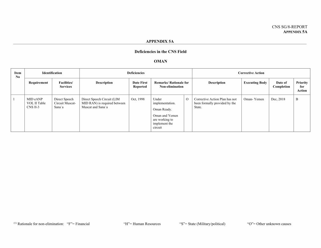
CNS SG/8-REPORT APPENDIX 5A
APPENDIX 5A
(1) Rationale for non-elimination: “F”= Financial “H”= Human Resources “S”= State (Military/political) “O”= Other unknown causes
Deficiencies in the CNS Field
OMAN
Item No
Identification Deficiencies Corrective Action
Requirement Facilities/ Services
Description Date First Reported
Remarks/ Rationale for Non-elimination
Description Executing Body Date of Completion
Priority for
Action
1 MID eANP VOL II Table CNS II-3
Direct Speech Circuit Muscat-Sana`a
Direct Speech Circuit (LIM MID RAN) is required between Muscat and Sana`a
Oct, 1998
Under implementation.
Oman Ready.
Oman and Yemen are working to implement the circuit
O Corrective Action Plan has not been formally provided by the State.
Oman- Yemen Dec, 2018
B
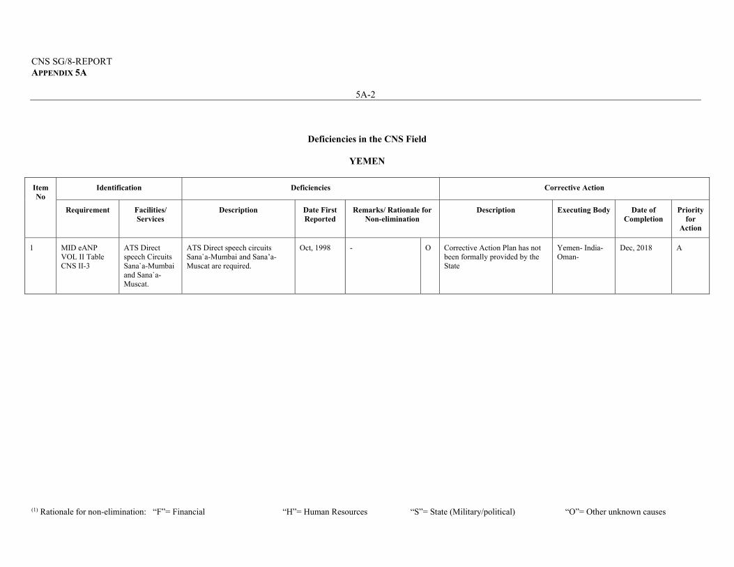
CNS SG/8-REPORT APPENDIX 5A
5A-2
(1) Rationale for non-elimination: “F”= Financial “H”= Human Resources “S”= State (Military/political) “O”= Other unknown causes
Deficiencies in the CNS Field
YEMEN
Item No
Identification Deficiencies Corrective Action
Requirement Facilities/ Services
Description Date First Reported
Remarks/ Rationale for Non-elimination
Description Executing Body Date of Completion
Priority for
Action
1 MID eANP VOL II Table CNS II-3
ATS Direct speech Circuits Sana`a-Mumbai and Sana`a-Muscat.
ATS Direct speech circuits Sana`a-Mumbai and Sana’a-Muscat are required.
Oct, 1998
- O Corrective Action Plan has not been formally provided by the State
Yemen- India- Oman-
Dec, 2018
A

CNS SG/8-REPORT APPENDIX 5A
5A-3
(1) Rationale for non-elimination: “F”= Financial “H”= Human Resources “S”= State (Military/political) “O”= Other unknown causes
Note:* Priority for action to remedy a deficiency is based on the following safety assessments: 'U' priority = Urgent requirements having a direct impact on safety and requiring immediate corrective actions. Urgent requirement consisting of any physical, configuration, material, performance, personnel or procedures specification, the application of which is urgently required for air navigation safety. 'A' priority = Top priority requirements necessary for air navigation safety. Top priority requirement consisting of any physical, configuration, material, performance, personnel or procedures specification, the application of which is considered necessary for air navigation safety. 'B' priority = Intermediate requirements necessary for air navigation regularity and efficiency. Intermediate priority requirement consisting of any physical, configuration, material, performance, personnel or procedures specification, the application of which is considered necessary for air navigation regularity and efficiency. Definition: A deficiency is a situation where a facility, service or procedure does not comply with a regional air navigation plan approved by the Council, or with related ICAO Standards and Recommended Practices, and which situation has a negative impact on the safety, regularity and/or efficiency of international civil aviation.
-----------------

CNS SG/8-REPORT APPENDIX 6A
APPENDIX 6A
COMMUNICATION, NAVIGATION AND SURVEILLANCE SUB-GROUP
(CNS SG)
1. TERMS OF REFERENCE 1.1 The Terms of Reference of the CNS Sub-Group are:
a) ensure that the implementation of CNS in the MID Region is coherent and compatible with developments in adjacent Regions, and is in line with the Global Air Navigation Plan (GANP), the Aviation System Block Upgrades (ASBU) methodology and the MID Region Air Navigation Strategy;
b) monitor the status of implementation of the MID Region CNS-related ASBU Modules included in the MID Region Air Navigation Strategy as well as other required CNS supporting infrastructure, identify the associated difficulties and deficiencies and provide progress reports, as required;
c) keep under review the MID Region CNS performance objectives/priorities, develop action plans to achieve the agreed performance targets and propose changes to the MID Region CNS plans/priorities, modernization programmes through the ANSIG, as appropriate;
d) seek to achieve common understanding and support from all stakeholders and involved in or affected by the CNS developments/activities in the MID Region;
e) provide a platform for harmonization of developments and deployments of CNS facilities and procedures at regional and inter-regional levels;
f) monitor and review the latest developments in the area of CNS, provide expert inputs
for CNS-related issues; and propose solutions for meeting ATM operational requirements;
g) address Frequency Management issues ;
h) oversee the MID ATS Message Management Center (MIDAMC) work programme;
i) monitor the global development related to SWIM infrastructure and Data exchange models;
j) assist States in protecting ATM System against security threats, and ensuring
continuity of service;
k) provide regular progress reports to the ANSIG and MIDANPIRG concerning its work programme; and
l) review periodically its Terms of Reference and propose amendments, as necessary.
CNS SG/8-REPORT APPENDIX 6A
6A-2 1.2 In order to meet the Terms of Reference, the CNS Sub-Group shall:
a) provide necessary assistance and guidance to States to ensure harmonization and interoperability in line with the GANP, the MID ANP and ASBU methodology;
b) provide necessary inputs to the MID Air Navigation Strategy through the monitoring of the agreed Key Performance Indicators related to CNS facilities and procedures;
c) identify and review those specific deficiencies and problems that constitute major
obstacles to the provision of efficient CNS implementation, and recommend necessary remedial actions;
d) follow-up the MID AMC operations e) assist, coordinate, harmonize and support in the implementation of CNS facilities and
procedures;
f) support the ICAO Position at WRCs, and encourage States for the proper utilization of the Frequency Spectrum;
g) address harmful interference issues and propose solutions;
h) support the development and implementation of the MID Region SWIM Roadmap parts related to Infrastructure
i) update ATN Plan as necessary MID Region and assist in its implementation conduct; and
j) follow-up surveillance technologies implementation to be in line with the surveillance strategy and MID operational improvements in coordination with other Sub-Groups and coordinate Interrogation Code Allocations.
2. COMPOSITION
2.1 The Sub-Group is composed of:
a) MIDANPIRG Member States;
b) concerned International and Regional Organizations as observers; and
c) other representatives from provider States and Industry may be invited on ad-hoc
basis, as observers, when required.
--------------------
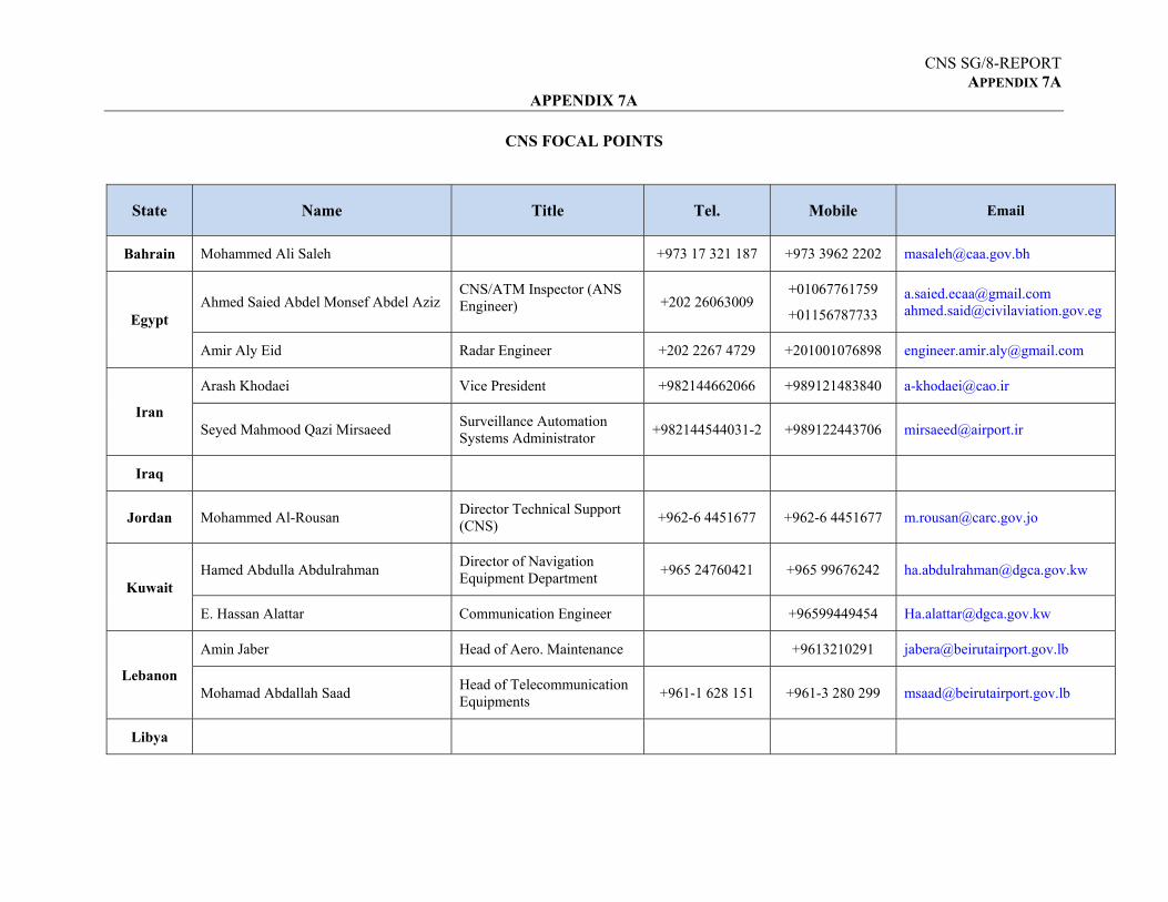
CNS SG/8-REPORT APPENDIX 7A
APPENDIX 7A
CNS FOCAL POINTS
State Name Title Tel. Mobile Email
Bahrain Mohammed Ali Saleh +973 17 321 187 +973 3962 2202 [email protected]
Egypt Ahmed Saied Abdel Monsef Abdel Aziz
CNS/ATM Inspector (ANS Engineer) +202 26063009
+01067761759
+01156787733
[email protected] [email protected]
Amir Aly Eid Radar Engineer +202 2267 4729 +201001076898 [email protected]
Iran
Arash Khodaei Vice President +982144662066 +989121483840 [email protected]
Seyed Mahmood Qazi Mirsaeed Surveillance Automation Systems Administrator
+982144544031-2 +989122443706 [email protected]
Iraq
Jordan Mohammed Al-Rousan Director Technical Support (CNS)
+962-6 4451677 +962-6 4451677 [email protected]
Kuwait Hamed Abdulla Abdulrahman
Director of Navigation Equipment Department
+965 24760421 +965 99676242 [email protected]
E. Hassan Alattar Communication Engineer +96599449454 [email protected]
Lebanon
Amin Jaber Head of Aero. Maintenance +9613210291 [email protected]
Mohamad Abdallah Saad Head of Telecommunication Equipments
+961-1 628 151 +961-3 280 299 [email protected]
Libya
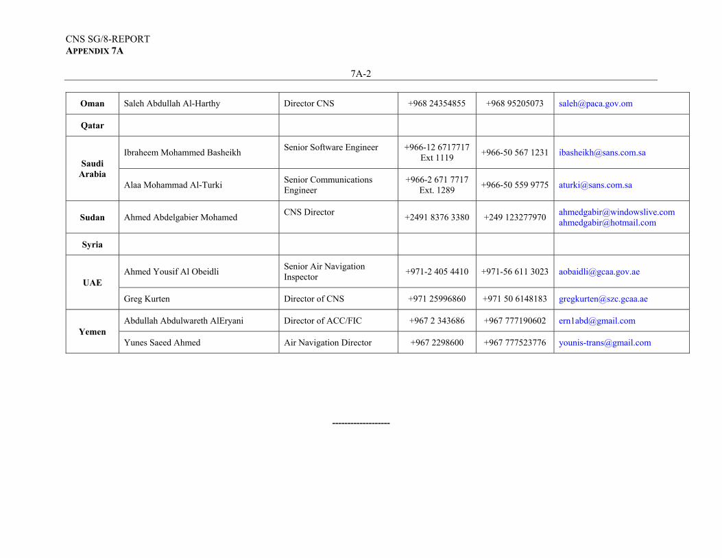
CNS SG/8-REPORT APPENDIX 7A
7A-2
Oman Saleh Abdullah Al-Harthy Director CNS +968 24354855 +968 95205073 [email protected]
Qatar
Saudi Arabia
Ibraheem Mohammed Basheikh Senior Software Engineer +966-12 6717717
Ext 1119 +966-50 567 1231 [email protected]
Alaa Mohammad Al-Turki Senior Communications Engineer
+966-2 671 7717 Ext. 1289
+966-50 559 9775 [email protected]
Sudan Ahmed Abdelgabier Mohamed CNS Director
+2491 8376 3380 +249 123277970 [email protected] [email protected]
Syria
UAE Ahmed Yousif Al Obeidli
Senior Air Navigation Inspector
+971-2 405 4410 +971-56 611 3023 [email protected]
Greg Kurten Director of CNS +971 25996860 +971 50 6148183 [email protected]
Yemen Abdullah Abdulwareth AlEryani Director of ACC/FIC +967 2 343686 +967 777190602 [email protected]
Yunes Saeed Ahmed Air Navigation Director +967 2298600 +967 777523776 [email protected]
-------------------

ATTACHMENT A
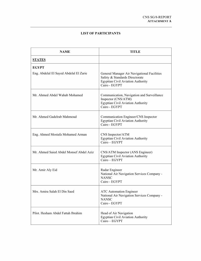
CNS SG/8-REPORT
ATTACHMENT A
LIST OF PARTICIPANTS
NAME TITLE
STATES
EGYPT
Eng. Abdelal El Sayed Abdelal El Zarie
General Manager Air Navigational Facilities Safety & Standards Directorate Egyptian Civil Aviation Authority Cairo - EGYPT
Mr. Ahmed Abdel Wahab Mohamed
Communication, Navigation and Surveillance Inspector (CNS/ATM) Egyptian Civil Aviation Authority Cairo - EGYPT
Mr. Ahmed Gadelrab Mahmoud
Communication Engineer/CNS Inspector Egyptian Civil Aviation Authority Cairo - EGYPT
Eng. Ahmed Mostafa Mohamed Arman
CNS Inspector/ATM Egyptian Civil Aviation Authority Cairo – EGYPT
Mr. Ahmed Saied Abdel Monsef Abdel Aziz
CNS/ATM Inspector (ANS Engineer) Egyptian Civil Aviation Authority Cairo – EGYPT
Mr. Amir Aly Eid
Radar Engineer National Air Navigation Services Company - NANSC Cairo - EGYPT
Mrs. Amira Salah El Din Saed
ATC Automation Engineer National Air Navigation Services Company - NANSC Cairo - EGYPT
Pilot. Hesham Abdel Fattah Ibrahim
Head of Air Navigation Egyptian Civil Aviation Authority Cairo – EGYPT
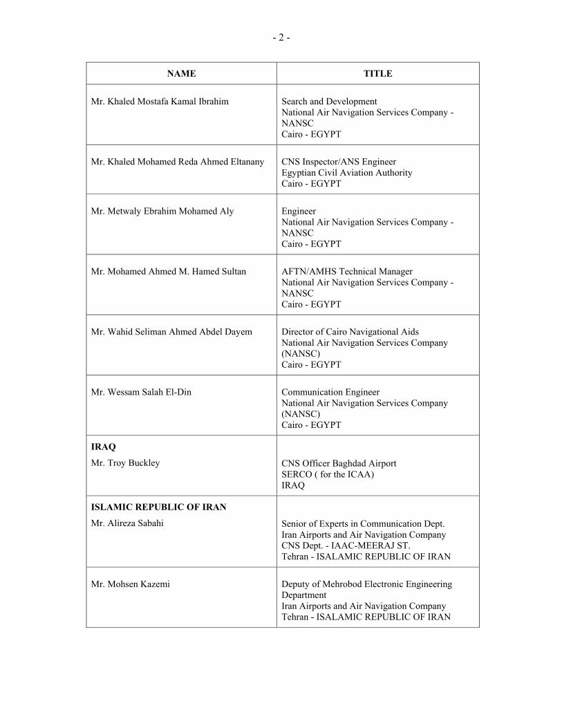
- 2 -
NAME TITLE
Mr. Khaled Mostafa Kamal Ibrahim
Search and Development National Air Navigation Services Company - NANSC Cairo - EGYPT
Mr. Khaled Mohamed Reda Ahmed Eltanany
CNS Inspector/ANS Engineer Egyptian Civil Aviation Authority Cairo - EGYPT
Mr. Metwaly Ebrahim Mohamed Aly
Engineer National Air Navigation Services Company - NANSC Cairo - EGYPT
Mr. Mohamed Ahmed M. Hamed Sultan
AFTN/AMHS Technical Manager National Air Navigation Services Company - NANSC Cairo - EGYPT
Mr. Wahid Seliman Ahmed Abdel Dayem
Director of Cairo Navigational Aids National Air Navigation Services Company (NANSC) Cairo - EGYPT
Mr. Wessam Salah El-Din
Communication Engineer National Air Navigation Services Company (NANSC) Cairo - EGYPT
IRAQ
Mr. Troy Buckley
CNS Officer Baghdad Airport SERCO ( for the ICAA) IRAQ
ISLAMIC REPUBLIC OF IRAN
Mr. Alireza Sabahi
Senior of Experts in Communication Dept. Iran Airports and Air Navigation Company CNS Dept. - IAAC-MEERAJ ST. Tehran - ISALAMIC REPUBLIC OF IRAN
Mr. Mohsen Kazemi
Deputy of Mehrobod Electronic Engineering Department Iran Airports and Air Navigation Company Tehran - ISALAMIC REPUBLIC OF IRAN
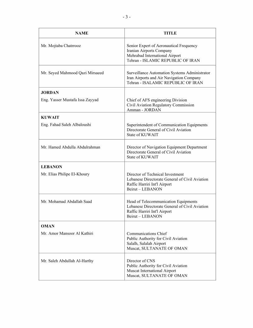
- 3 -
NAME TITLE
Mr. Mojtaba Chatrrooz
Senior Expert of Aeronautical Frequency Iranian Airports Company Mehrabad International Airport Tehran - ISLAMIC REPUBLIC OF IRAN
Mr. Seyed Mahmood Qazi Mirsaeed
Surveillance Automation Systems Administrator Iran Airports and Air Navigation Company Tehran - ISALAMIC REPUBLIC OF IRAN
JORDAN
Eng. Yasser Mustafa Issa Zayyad
Chief of AFS engineering Division Civil Aviation Regulatory Commission Amman - JORDAN
KUWAIT
Eng. Fahad Saleh Albaloushi
Superintendent of Communication Equipments Directorate General of Civil Aviation State of KUWAIT
Mr. Hamed Abdulla Abdulrahman
Director of Navigation Equipment Department Directorate General of Civil Aviation State of KUWAIT
LEBANON
Mr. Elias Philipe El-Khoury
Director of Technical Investment Lebanese Directorate General of Civil Aviation Raffic Harriri Int'l Airport Beirut – LEBANON
Mr. Mohamad Abdallah Saad
Head of Telecommunication Equipments Lebanese Directorate General of Civil Aviation Raffic Harriri Int'l Airport Beirut – LEBANON
OMAN
Mr. Amor Mansoor Al Kathiri
Communications Chief Public Authority for Civil Aviation Salalh, Salalah Airport Muscat, SULTANATE OF OMAN
Mr. Saleh Abdullah Al-Harthy
Director of CNS Public Authority for Civil Aviation Muscat International Airport Muscat, SULTANATE OF OMAN
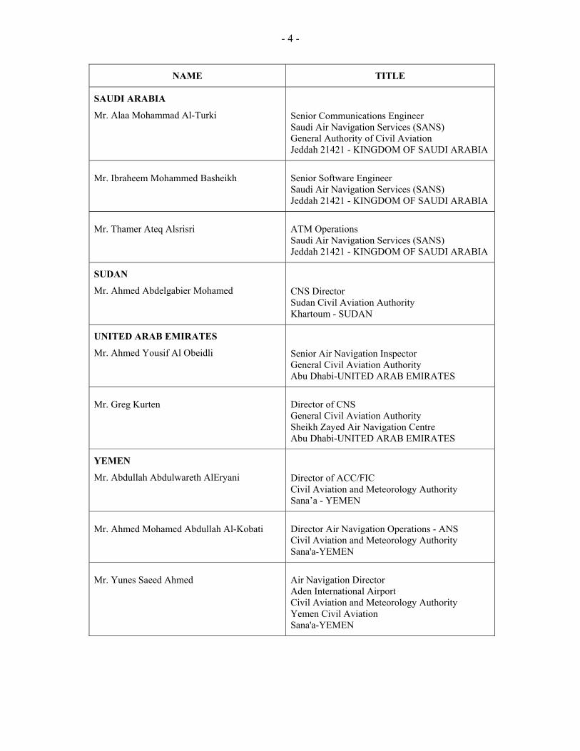
- 4 -
NAME TITLE
SAUDI ARABIA
Mr. Alaa Mohammad Al-Turki
Senior Communications Engineer Saudi Air Navigation Services (SANS) General Authority of Civil Aviation Jeddah 21421 - KINGDOM OF SAUDI ARABIA
Mr. Ibraheem Mohammed Basheikh
Senior Software Engineer Saudi Air Navigation Services (SANS) Jeddah 21421 - KINGDOM OF SAUDI ARABIA
Mr. Thamer Ateq Alsrisri
ATM Operations Saudi Air Navigation Services (SANS) Jeddah 21421 - KINGDOM OF SAUDI ARABIA
SUDAN
Mr. Ahmed Abdelgabier Mohamed
CNS Director Sudan Civil Aviation Authority Khartoum - SUDAN
UNITED ARAB EMIRATES
Mr. Ahmed Yousif Al Obeidli
Senior Air Navigation Inspector General Civil Aviation Authority Abu Dhabi-UNITED ARAB EMIRATES
Mr. Greg Kurten
Director of CNS General Civil Aviation Authority Sheikh Zayed Air Navigation Centre Abu Dhabi-UNITED ARAB EMIRATES
YEMEN
Mr. Abdullah Abdulwareth AlEryani
Director of ACC/FIC Civil Aviation and Meteorology Authority Sana’a - YEMEN
Mr. Ahmed Mohamed Abdullah Al-Kobati
Director Air Navigation Operations - ANS Civil Aviation and Meteorology Authority Sana'a-YEMEN
Mr. Yunes Saeed Ahmed
Air Navigation Director Aden International Airport Civil Aviation and Meteorology Authority Yemen Civil Aviation Sana'a-YEMEN
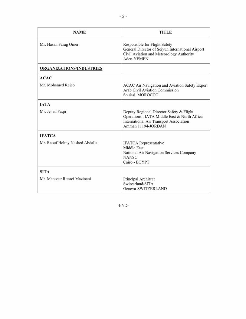
- 5 -
NAME TITLE
Mr. Hasan Farag Omer
Responsible for Flight Safety General Director of Seiyun International Airport Civil Aviation and Meteorology Authority Aden-YEMEN
ORGANIZATIONS/INDUSTRIES
ACAC
Mr. Mohamed Rejeb
ACAC Air Navigation and Aviation Safety Expert Arab Civil Aviation Commission Souissi, MOROCCO
IATA
Mr. Jehad Faqir
Deputy Regional Director Safety & Flight Operations , IATA Middle East & North Africa International Air Transport Association Amman 11194-JORDAN
IFATCA
Mr. Raouf Helmy Nashed Abdalla
IFATCA Representative Middle East National Air Navigation Services Company - NANSC Cairo - EGYPT
SITA
Mr. Mansour Rezaei Mazinani
Principal Architect Switzerland/SITA Geneva-SWITZERLAND
-END-