Embed Size (px)
Citation preview

Introduction of spatial enabled data warehouse
technology across the enterprise
Geospatial World Forum
23. – 27. April, Amsterdam
Joachim Figura, CISS TDI GmbH

Company Profile
The 3 Use Cases – Herten,Siegen, Duesseldorf
GeoETL-Tool CITRA®
Challenging CITRA Projects in brief
Closing Remarks
Agenda

Foundation: 1982
Location:
CISS TDI
Gesellschaft für Technische
DV Informationssysteme mbH
Barbarossastraße 36
D - 53489 Sinzig
www.ciss.de
Phone: +49(0)2642-9780-0
Fax: +49(0)2642-9780-10
Branch:
Sales Office, Mc Coy, Texas, USA
Company Profile

Software product for
analysis, modeling and
exchange of complex
spatial information
between GIS and
data bases.
Market entry in 1987
Currently > 5000 licenses in the market
Company Profile
CITRA®

• Integration of data of different source
systems and their administration in
data bases
• Data supply with CITRA-ExportCenter
or purchase via the web according
to user needs
Company Profile
(Geo) Data Warehouse

Service for the complete and high quality transfer
of data sets from a system A into another system B
CITRA‘s modeling
capabilities make
it happen!
Company Profile
Data migration

Company Profile
The 3 Use Cases – Herten,Siegen, Duesseldorf
GeoETL-Tool CITRA®
Challenging CITRA Projects in brief
Closing Remarks
Agenda

3 use-cases
Project GDW Herten – Parties Involved
Illustration based on http://de.wikipedia.org/wiki/Ruhrgebiet
City of Herten,
multiple departments
Herten Public Works
Herten Utilities,
gas, electricity, district heating

3 use-cases
Available Geodata
General
Plannin
g
Electricit
y
Gas
Distric
t
heatin
g
Urban
Topograph
y
...
Environ-
ment
Municipal
specific data Traffi
c
Public
Transportatio
n
Urban
Planning
Land
Registe
r
Civil
Sewag
e Municipal
specific data
...
...
...

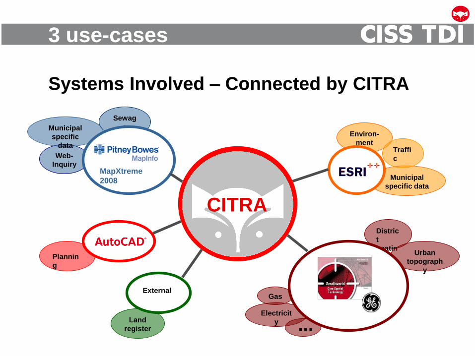
3 use-cases
Systems Involved
Plannin
g
Environ-
ment
Municipal
specific data
Traffi
c
Land
register
External
Web-
Inquiry
Sewag
e Municipal
specific
data
MapXtreme
2008
Electricit
y
Gas
Distric
t
heatin
g Urban
topograph
y
...
3 use-cases
Systems Involved – Connected by CITRA
Web-
Inquiry
Sewag
e Municipal
specific
data
MapXtreme
2008
CITRA
Electricit
y
Gas
Distric
t
heatin
g Urban
topograph
y
...
Plannin
g
Environ-
ment
Municipal
specific data
Traffi
c
Land
register
External

• Constant growth of geodata sets
• Increasing demand for use of geodata
• Data exchange between different
GIS-Applications and GIS-Technologies
• Internal exchange & with external partners
• Concepts for keeping data from the various systems
and applications up-to-date
The Challenge
3 use-cases

• Improving the availability and usability
of geodata within the company group
• Improving efficiency in decision processes
• Reducing costs due to consolidated and
standardized processes
• Rapid benefits by implementing the most urgent
components short term...
• ...and being able to complete the project without
having to change technology
Goal (User Perspective)
3 use-cases

• Contemporary IT-structures (focus on IT not on GIS!):
(geo-)data warehouse
• Separation of production and useage of data
• Standards, e.g. OGC
• Incremental implementation with low project risk
Moderate financial efforts
Benefits right from the start with the first data sets
Ready for future extension by adding new data sets
or GIS technology.
Goal (IT Perspective)
3 use-cases

• Contemporary IT-structures (focus on IT not on GIS!):
(geo-)data warehouse
• Separation of production and useage of data
• Standards, e.g. OGC
• Incremental implementation with low project risk
Moderate financial efforts
Benefits right from the start with the first data sets
Ready for future extension by adding new data sets
or GIS technology.
Oracle Locator/Spatial as geodata warehouse platform
Goal (IT Perspective)
3 use-cases

3 use-cases
Systems Involved – Connected by CITRA
Web-
Inquiry
Sewag
e Municipal
specific
data
MapXtreme
2008
CITRA
Electricit
y
Gas
Distric
t
heatin
g Urban
topograph
y
...
Plannin
g
Environ-
ment
Municipal
specific data
Traffi
c
Land
register
External

3 use-cases
Systems Involved – Connected by CITRA
Web-
Inquiry
Sewag
e Municipal
specific
data
Plannin
g
Environ-
ment
Municipal
specific data
Traffi
c
Land
register
MapXtreme
2008
Electricit
y
Gas
Distric
t
heatin
g Urban
topograph
y
...
External

3 use-cases
Data Warehouse at Herten Group
Processing Data Management Users Production
utility
data
- Smallworld -
Herten Municipal Utilities
environmental
data
- Shape -
City of Herten
cadastral
data
- MI TAB -
Dep. of traffic,
transport,..
…
(Geo) Data
Warehouse
ArcGIS Server
& ArcView

3 use-cases
Achieved Results: Cadastre daily up-to-date

3 use-cases
Achieved Results: Gas Distribution Network

• All Goals and Requirements met or exceeded!
• Common and regulated use of data substantially improved
• Data is up-to-date
• Effort for provision of data is significantly reduced
• Synergies due to common usage of the ETL Tool CITRA,
e.g. for the integration of data and for information retrieval
• Improved basis for taking decisions
• Process flow optimized due to direct access to the data
• Incremental implementation of GDW project stages
Benefits Realized Using CITRA for GDW
projects
3 use-cases

3 use-cases
Data Warehouse at Herten Group
Processing Data Management Users Production
utility
data
- Smallworld -
Herten Municipal Utilities
environmental
data
- Shape -
City of Herten
cadastral
data
- MI TAB -
Dep. of traffic,
transport,..
…
(Geo) Data
Warehouse

3 use-cases
Data Warehouse at Herten Group
Processing Data Management Users Production
utility
data
- Smallworld -
Herten Municipal Utilities
environmental
data
- Shape -
City of Herten
cadastral
data
- MI TAB -
Dep. of traffic,
transport,..
…
(Geo) Data
Warehouse
ArcGIS Server
& ArcView

ArcGIS Server
& ArcView
ETL
Warehouse Utilization
Operation
(Geo) Data
Warehouse
Geodaten-Online-Shop
DXF
MapInfo
Shape
GC OSIRIS
APEX
Cadenza
ALKIS
Data Warehouse at Herten Group
3 use-cases
utility
data
- Smallworld -
environmental
data
- Shape -
cadastral
data
- MI TAB -
Herten Municipal Utilities
City of Herten

HOST
os390
landfill, sewage
plant, etc.
ALK-
IDB
Oracle
OPR-
GIAP
ASCII data
(e.g. town
planning map)
S&K-
Tiffany
Win-
Kauf
small
sewage
works
MS-Access
canal, natural
monument, etc.
Win-
Fried
Centura-DB
e.g. cemetery
ProBauG/G
Oracle
ALB/
relational
IBM-DB2
CAD
DXF/DWG
3 use-cases
Initial Situation: KDZ-Westfalen Sued Siegen

3 use-cases
Geodata Warehouse at KDZ-Westfalen Sued
Siegen
ETL Data management Users Operation
Cadastral
data
Shape
DXF
Sewer data
(Geo) Data
Warehouse
ISYBAU
AutoCAD Map
StadtCAD Hippodamos
GRAPPA / OnLine
Planning Office
Geodata
Environmental data
Planning data
3 use-cases
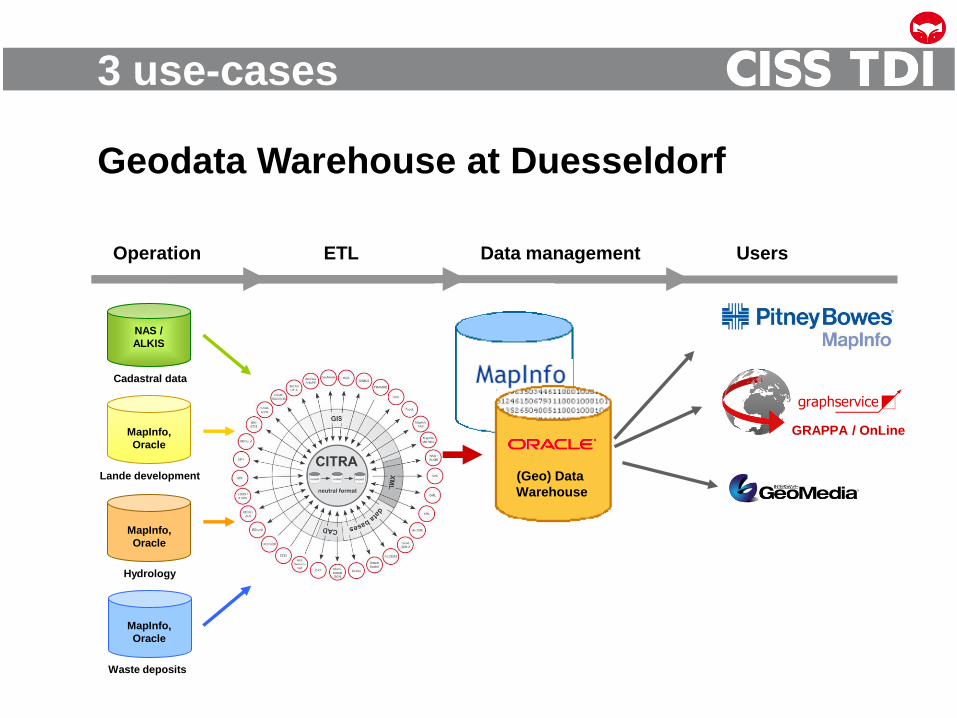
Geodata Warehouse at Duesseldorf
ETL Data management Users Operation
NAS /
ALKIS
MapInfo,
Oracle
Waste deposits
(Geo) Data
Warehouse
Lande development
Hydrology
Cadastral data
MapInfo,
Oracle
MapInfo,
Oracle
GRAPPA / OnLine
3 use-cases
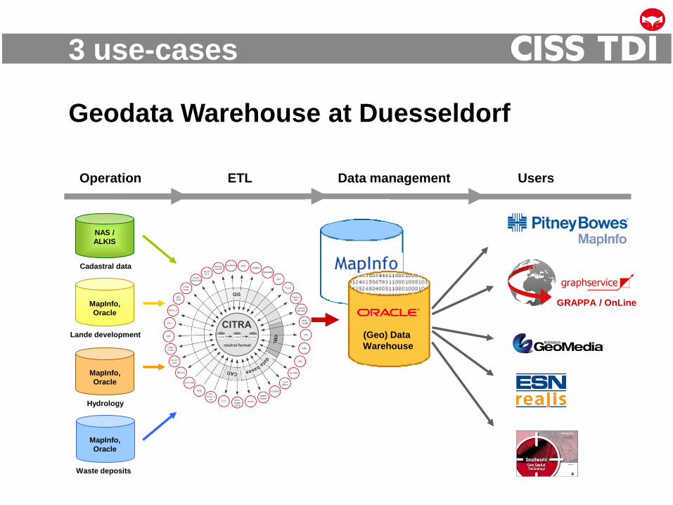
Geodata Warehouse at Duesseldorf
ETL Data management Users Operation
NAS /
ALKIS
MapInfo,
Oracle
Waste deposits
(Geo) Data
Warehouse
GRAPPA / OnLine
Lande development
Hydrology
Cadastral data
MapInfo,
Oracle
MapInfo,
Oracle

Company Profile
The 3 Use Cases – Herten,Siegen, Duesseldorf
GeoETL-Tool CITRA®
Challenging CITRA Projects in brief
Closing Remarks
Agenda

The Task
GeoETL-Tool CITRA

The Concept
GeoETL-Tool CITRA

The Translation in 3 Steps
GeoETL-Tool CITRA
Modeling tools
Syntactic conversion and
classification of data
Syntactic conversion and
checking consistency
Working on CITRA format

The Implementation
GeoETL-Tool CITRA
Source
Test
Analysis
Report Report
Target
Report Report
...

Company Profile
The 3 Use Cases – Herten,Siegen, Duesseldorf
GeoETL-Tool CITRA®
Challenging CITRA Projects in brief
Closing Remarks
Agenda

• Modelling of cadastre data
• CITRA Open Street Map Converter e.g. to Oracle & others
• CITRA in Smallworld Context
Challenging CITRA use cases in brief
Use cases in brief

What does modelling mean?
Use cases in brief

• Modelling of cadastre data
• CITRA Open Street Map Converter e.g. to Oracle & others
• CITRA in Smallworld Context
Challenging CITRA use cases in brief
Use cases in brief

• Derivation of an intelligent data model
• Handling of the large variety of combinations of OSM
features and available tags.
• Management of exclaves and enclaves
• Suitable for a quick visualization
• Storage without loss of any information from the original
source data
• Mapping on the Oracle Network Data Model
Open street Map CITRA
Use cases in brief

Map in MapInfo (data from Oracle Spatial)
Use cases in brief

OpenStreetMap in MapInfo from TAB-Format
Use cases in brief

Shortest Path
Use cases in brief

• Modelling of cadstre data
• CITRA Open Street Map Converter e.g. to Oracle & others
• CITRA in Smallworld Context
Challenging CITRA use cases in brief
Use cases in brief

• Mapping Smallworld -> Oracle Network Data Model
- Topology on Smallworld is Geometry orientated
- The Network Model on Oracle is Node Egde orientated
• Extraction of the entire data
• Dimensions
• Differential update
• Internal worlds
• Ready to use configurations
from Smallworld NRM‘s to
Oracle, DXF SHP
• Raster data
Example Smallworld (e.g. LINZ AG)
Use cases in brief
Replacement of FME

Netzinformation
GE-Smallworld
Dokumentation/
As-built plans
Updating
of the NIS-plans
from SWS to Oracle
Daily update
Objects excavation projects
in „GIS-Oracle“
„Live-Access“
Excavation coordination
(incl. data collection)
Geodata Warehouse
NIS-Inquiry
+ NIS-Analysis
NIS-Inquiry-“Power“
+ NIS-Analysis
comprehensive
NIS-Analysis
Bentley
Microstation
CAD (GIS)
(dgn/dwg/dxf)
Thematic
Mapping
Additional modul
to NRM‘s
GeoMedia
(shape)
comprehensive
NIS-Analysis
- Hydroconsult -
CAD
(dxf)
Microstation, Autocad
- sporadically -
GIS for public transport
(Linz Lines)
Applications
(Inquiry, Analysis, partially data collecting)
In development
Internet plan inquiry
GIS
ORACLE
Inte
rgra
ph
Use cases in brief
Linz AG (Austria)

Intergraph Smart Client Workflow-application excavation plan
Planprintout: Excavation coordination
(actual excavation plan Intergraph +
as-built information from Smallworld)
Use cases in brief
Linz AG (Austria)

Company Profile
The 3 Use Cases – Herten,Siegen, Duesseldorf
GeoETL-Tool CITRA®
Challenging CITRA Projects in brief
Closing Remarks
Agenda

• merge data from different sources
• create a common data model for different requirements
in usage and technology, as a rule - simplify data model,
create metadata, create presentation – but regardless
• usage as comprehensive background information having
sufficient space for future growth
• good visual presentation
Challenge Warehouse
Closing Remarks

• get all required data from source to goal
• map data best possible on the target
• quality assurance
• improve data quality e.g. correct data errors,
create topology according to the possibilities of the
goal system
Challenge Migration
Closing Remarks

References (excerpt)
Closing Remarks

CISS TDI GmbH
Barbarossastraße 36 53489 Sinzig
Germany
Tel.: +49 2642 97 80 0
[email protected] www.ciss.de
Questions

Intergraph Smart Client
Inquiry und Analysis via Intergraphs
Smart Client in the Intranet
• From the Oracle-Geodata Warehouse
• Geobasis data (basemap, orthophotos,
…)
• All network data from Smallworld-NRMs
(electric power, gas, district heating,
water, sewer)
• GIS-Data Linz public transport lines
(INGR-Geotrams for public transport e.g.
bus, street car)
Use cases in brief Austrian Linz AG

Intergraph Smart Client Workflow-application excavation plan
Excavation coordination within LINZ AG = Workflow-contolled Coordination of excavation projects
across all divisions using Intergraph Smart Client-Workflow with network data from GE-Smallworld
Use cases in brief Austrian Linz AG

Gas billing
– Query on Geografic Data without GIS
Task:
Legal Provision:
The gas bill has to be based among others on the elevation
of the delivery point.
The delivery points have to be assigned to approriate
elevation zones
Geodata Warehouse & Co

Query on Geografic Data without GIS
Gas billing
Problem:
• Addresses don‘t have any coordinates, nor information
about the elevation, nor an assignment to approriate
elevation zones, e.g. urban districts
• Elevation is only available in form of the DTM (raster)
Geodata Warehouse & Co

Query on Geografic Data without GIS
Gas billing
Solution:
• Geocoding of the addresses, projection of the elevation
from the adjacent raster points to the addresses,
searching appropriate elevation zones and mapping of
the addresses to the zones, and if required use a
background map, e.g. OSM, Navteq, Tomtom
Geodata Warehouse & Co


![Wal-Mart’s Data Warehouse - derbaum.comderbaum.com/tu/WalMarts DWH.pdf · Wal-Mart’s data warehouse, the biggest in the world, enabled it to ... [West01] Data Warehousing: Using](https://img.pdfslide.net/doc/110x75/5a71ba317f8b9a93538d2e99/wal-marts-data-warehouse-derbaumcomderbaumcomtuwalmarts-dwhpdfpdf.jpg)