Embed Size (px)
Citation preview

1/12/2015
1
Russ Aicher [email protected]
Russ Aicher [email protected]
INTRODUCTION TO GIS
New York Association of Professional Land Surveyors
January 22, 2015
Russ Aicher [email protected]
Introduction
• GIS -
• GIS –
• GIS –

1/12/2015
3
Russ Aicher [email protected]
What is a GIS
• Geographic– of or relating to geography
• the study of the physical features of the earth, its atmosphere, and of human activity as it affects and is affected by these
• Information– knowledge gained through study, communication, research,
instruction, etc.
• System– a set of connected things or parts forming a complex whole
– a set of principles or procedures according to which something is done; an organized scheme or method.
wikipedia
Russ Aicher [email protected]
What is a GIS
• Anything that uses spatial and nonspatial data to extract information greater than the sum of its components
– Cartography
– Photogrammetry
– Remote Sensing
– Surveying
– GIS

1/12/2015
4
Russ Aicher [email protected]
What is a GIS
• Spatial Data
– Data that has inherent geographic or locationalcomponent to it
• Coordinates of a corner
• Zip codes
• Boundaries
• Area codes
Russ Aicher [email protected]
What is a GIS
• Non Spatial Data
– Data without a geographic or locationalcomponent to it
– Many times we can associate this data with Spatial Data
• Iron Pipe located at a corner
• +4 of a zip code
• County
• Line number for a phone

1/12/2015
5
Russ Aicher [email protected]
Some GIS Terminology
• Map
– An all encompassing term
• Features
– Items that make up the map
• Layers
– Like Features are organized into individual layers
• Attributes
– The non spatial data describing the features
Russ Aicher [email protected]
Geospatial Data
• How data is organized in GIS software packages
– Information in a map is usually divided into like themes or layers
– Each layer is saved as an individual File
• (ignoring geodatabases)
– Example layers
• Roads, Rivers, Lakes, Land use
• All layers fall within 1 of two types of Spatial Data models

1/12/2015
6
Russ Aicher [email protected]
Spatial Data Models
• Two general types of Spatial Data utilized by GIS packages
– Vector
• Points, lines, polygons
• 0,1,2 dimensions respectively
– Raster
• A grid of cells or pixels
• 2 dimensional
• Represents an area
Russ Aicher [email protected]
Spatial Data Models
• Vector Spatial Data Model Types– Points
– Lines• Made up of at least 2 connected points
– Polygons• Note, polygons must close
– No single data layer can contain more than 1 of the above vector types
– Point is the primitive unit• Can not be broken down further and still be vector

1/12/2015
8
Russ Aicher [email protected]
Russ Aicher [email protected]
Spatial Data Models
• Vector Spatial Data Model
– Topology
• Spatial relationship between features and how they connect to one another
• Important for any networks– Utilities
– Roads
• Separates a line from a polygon
– Different file types have different levels of Topology (more on this later)

1/12/2015
9
Russ Aicher [email protected]
Spatial Data Models
• Vector Spatial Data Model
– Attributes
• An unlimited number of attributes allowed for each feature
• Like attributes are organized into columns in the Attribute table
– Simple to add new columns (fields)
– Type of column defines what you can do with it
• Each layer has its own Attribute Table
Russ Aicher [email protected]
Spatial Data Models
• Vector Spatial Data Model– Attribute Table
• Each feature’s attributes arranged into a single row in the table
– 1 Feature = 1 Row in the attribute table
• Columns types (like attributes) are defined when created
– String
– Float
– Integer
– Blob

1/12/2015
10
Russ Aicher [email protected]
Russ Aicher [email protected]
Spatial Data Models
• Raster
– A grid of pixels or cells representing an area
• Each cell in the raster represents an area
– Every pixel contains a single numerical value
– Raster can have only 1 type of attribute
• Elevation
• Concentration
• Land cover
• -etc

1/12/2015
11
Russ Aicher [email protected]
Spatial Data Models
• Raster
– Never any gaps in the raster
– May be referred to as a surface
– Simple, innate topology
– Very useful for modeling
Russ Aicher [email protected]
Spatial Data Models
• Raster
591 590 593 594 595 597
594 596 597 598 599 600
596 598 599 600 601 602
600 601 602 603 605 605
604 605 608 609 610 612
604 606 609 611 612 614
22 21 22 23 23 21
23 23 23 21 21 21
23 23 23 21 21 21
23 21 21 21 21 21
21 21 21 21 90 90
21 41 41 21 21 90

1/12/2015
12
Russ Aicher [email protected]
Spatial Data Models
• Raster– Values in raster cells are always numbers
– Values may function as codes depending on the data the raster represents• Example landcover:
– 21: Developed, Open Space
– 22: Developed, Low Intensity
– 23: Developed, Medium Intensity
– 41: Hardwood forest
– 90: Wetlands
– Codes should be defined in the metadata
Russ Aicher [email protected]
Spatial Data Models
• Raster
– Imagery is usually comprised of multiple rasters
• True color –– 1 raster storing brightness values for Red
– 1 raster storing brightness values for Blue
– 1 raster storing brightness values for Green
• False color –– 1 raster storing brightness values for Near Infrared
– 1 raster storing brightness values for Red
– 1 raster storing brightness values for Green

1/12/2015
14
Russ Aicher [email protected]
Spatial Data Models
• Raster
– Landsat has 8 bands (1 raster for each band)
– Hyperspectral imagery comprised of 200+ rasters
Russ Aicher [email protected]
Spatial Data Models
• While Vector and Raster Data can be used in a map, they can not interact with each other
– There’s always exceptions
• To combine data from one type with another one must convert
– Vector -> Raster = Rasterization
– Raster -> Vector = Vectorization

1/12/2015
15
Russ Aicher [email protected]
Common File Types
• Raster File Types– Tiff
– IMG
– Jpeg - JP2000
– GRID
• Vector File Types– Shapefiles
– Coverages
– Geodatabases
Russ Aicher [email protected]
Common File Types
• Raster File Types– Tiff *.tif
• Fairly common
• Uncompressed file - can be large files
• A safe format
• Same format used in graphics industry
– Img *.img• Not as common
• Somewhat compressed
• Not the format used in graphics industry

1/12/2015
16
Russ Aicher [email protected]
Common File Types
• Raster File Types– Jpeg - JP2000 *.jpg, *.jp2
• Not as common– JP2000 becoming more common for imagery
• Highly compressed– May affect image quality
– GRID – ESRI raster format• Complicated file structure
• Fairly common
• Somewhat compressed
• Usually imports without issues
Russ Aicher [email protected]
Common File Types
• Raster File Types
– Many - many more
• BIL
• MrSID
• DRG
• BMP
• RST
• …
• ASCII

1/12/2015
17
Russ Aicher [email protected]
Common File Types
• Raster File Types
– World File
• OK, not really a raster
• Used to georeference some rasters– *.tif and *.jpg most common
• Simple text file accompanying the raster– *.tfw or *.jpw
Russ Aicher [email protected]
Common File Types
• Vector File Types– Shapefile
• Open format
• Very Common
• Poor Topology
• Made up of multiple files– Not all are necessary
• Must have these three– *.shp
– *.dbf
– *.shx

1/12/2015
18
Russ Aicher [email protected]
Shapefiles File Types
• .sbn and .sbx—The files that store the spatial index of the features.
• .fbn and .fbx—The files that store the spatial index of the features for shapefiles that are read-only.
• .ain and .aih—The files that store the attribute index of the active fields in a table or a theme's attribute table.
• .atx—An .atx file is created for each shapefile or dBASE attribute index created in ArcCatalog. ArcView 3.x attribute indexes for shapefiles and
• .ixs and .mxs—Geocoding index for read/write shapefiles..prj—The file that stores the coordinate system information (used by ArcGIS).
• .xml—Metadata for ArcGIS—Stores information about the shapefile.
Russ Aicher [email protected]
Common File Types
• Vector File Types
– Coverages
• ESRI proprietary format
• Fairly uncommon anymore
• Excellent Topology
• Complicated file structure
• Difficult to use in most software
• Strict rules for naming

1/12/2015
19
Russ Aicher [email protected]
Common File Types
• Vector File Types
– ESRI export format *.e00
• A safe way to move a coverage layer
• More likely to find this than coverage itself
• Has to be converted back to a coverage to be used
• Essentially a giant text file
Russ Aicher [email protected]
Common File Types
• Vector File Types
– Geodatabase
• Introduced by ESRI
• Importing to other software can be a problem
• Can store multiple layers
• Topology is dependent on the user
• Personal Geodatabase– Microsoft Access format *.mdb

1/12/2015
20
Russ Aicher [email protected]
Database Applications
• In order for a piece of software be termed a GIS package it requires a database management system
– Connection must be made between spatial features and associated non spatial data
• An example: Shapefiles
– *.shp – Feature geometry and Identifier
– *.dbf – non spatial data – the attribute table
Russ Aicher [email protected]
Database Applications
• Making the connections between shapes and data
– ID field
• Key field
• Not editable in Software
• Never use for a Join*
• Types– PID
– FID
– OID

1/12/2015
21
Russ Aicher [email protected]
Database Applications
• Some Terminology
– Fields – Columns
– Tables – Relations
– Joins – Relationships
– Query – Subsetting attributes
– SQL – Structured Query Language
Russ Aicher [email protected]
Database Applications
• Joins
– Connecting multiple tables through like attributes
– Reduces redundancies
– Types
• 1 : 1
• 1 : many
• Many : 1
• Many : many

1/12/2015
22
Russ Aicher [email protected]
Database Applications
• Joins
Russ Aicher [email protected]
Database Applications
• Joins

1/12/2015
23
Russ Aicher [email protected]
Database Applications
• Joins
Russ Aicher [email protected]
Applications
• Spatial Query
– Locating features from one layer based upon their spatial relationship to features in another layer
• Distance
• Intersection
• Contains

1/12/2015
24
Russ Aicher [email protected]
Applications
• Topography to Raster
– Converting individual elevation points or contours to a raster
Russ Aicher [email protected]
Applications
• Networks
– Topology is very important
• What is connected to what?
• Direction
• Timing

1/12/2015
25
Russ Aicher [email protected]
Applications
• Networks
Russ Aicher [email protected]
Applications
• Record Keeping
1/12/2015
26
Russ Aicher [email protected]
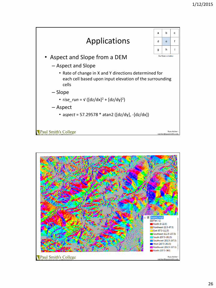
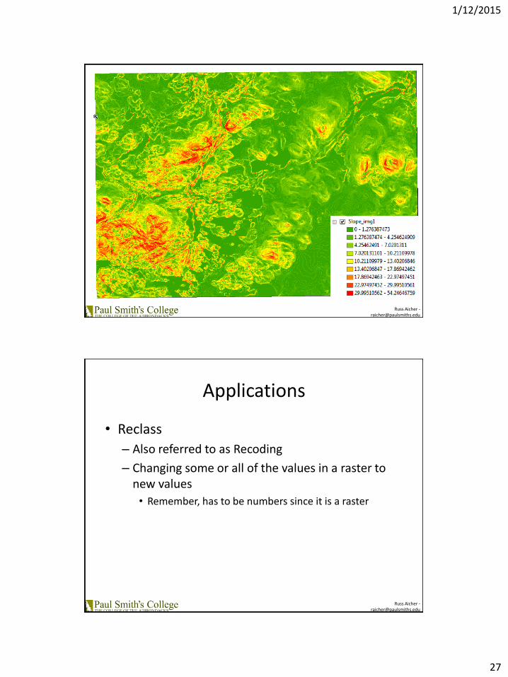
Applications
• Aspect and Slope from a DEM
– Aspect and Slope
• Rate of change in X and Y directions determined for each cell based upon input elevation of the surrounding cells
– Slope
• rise_run = √ ([dz/dx]2 + [dz/dy]2)
– Aspect
• aspect = 57.29578 * atan2 ([dz/dy], -[dz/dx])
Russ Aicher [email protected]
1/12/2015
27
Russ Aicher [email protected]
Russ Aicher [email protected]
Applications
• Reclass
– Also referred to as Recoding
– Changing some or all of the values in a raster to new values
• Remember, has to be numbers since it is a raster

1/12/2015
29
Russ Aicher [email protected]
Applications
• Simple Hydrologic Analysis
– Flow Accumulation
– Flow Direction
– Watershed Delineation
Russ Aicher [email protected]

1/12/2015
32
Russ Aicher [email protected]
Applications
• GIS 335
Class Project
Russ Aicher [email protected]
Applications
• GIS 335
Class Project
1/12/2015
33
Russ Aicher [email protected]
Applications
• Georeferencing– Estabishing the location of a 2d or 3d object in
real space• Giving real world coordinates to something that
doesn’t have it
– 1855 Map of Erie County• Medium 1 map ; 125 x 93 cm
• Call Number G3803.E6 1855 .G4
• Library of Congress Geography and Map Division
• Digital Id g3803e la000494 http://hdl.loc.gov/loc.gmd/g3803e.la000494 Library of Congress Catalog Number 2012593658
Russ Aicher [email protected]
Metadata
• Data about data
– Incredibly Important
– Should be included with all data
– Often overlooked by GISers
– Something surveying community has all over GISers
– Who, What, Where, When, Why

1/12/2015
34
Russ Aicher [email protected]
Metadata
• Data about data– Attributes
– Coordinate systems
– How data was collected/created
– Accuracies• Positional
• Attributes
– Point of contact
– …
Russ Aicher [email protected]
Metadata
• Standards
– FGDC
• Content Standards for Digital Geospatial Metadata– CSDGM
• International Organization for Standardization– ISO 19115-1:2014

1/12/2015
35
Russ Aicher [email protected]
Metadata
• Examples
– CUGIR – Tompkins Building Outlines
– Maine GIS – Conserved Lands (10/28/2014)
– Click USGS – NJ Lidar
Russ Aicher [email protected]
Questions?
• Russ Aicher
- Assistant Professor
- Survey Technology Program Coordinator
- Paul Smith’s College
- 518-327-6950