Embed Size (px)
Citation preview
1
Chapter 1Introduction to GIS
1. Introduction to GIS
1.1 Introduction
Q: What is GIS?
A: GIS is the abbreviation of Geographic(al) Information Systems. In general, GIS refers to computer software that treat digital spatial database.
GIS differs from other computer software in that it can treat spatial database. Microsoft EXCEL, ACCESS, dBASE IV are not GIS.
1. Introduction to GIS
A more strict definition of GIS claims that GIS at least has to be able to
1) create2) manage3) store4) analyze5) visualize
spatial data.
1. Introduction to GIS
Strictly speaking, simple map viewers including web map browsers are not GIS. However, this strict definition is rather outdated.
There are some cases the term GIS includes not only computer software but also hardware such as map digitizers, graphic monitors, XY-plotters, etc.. This implies that to use functions of GIS we have to prepare not only a personal computer but also other special hardware, which is not the case today.
1. Introduction to GIS
GIS websites (general)
http://gis.about.com/http://www.gislounge.com/http://www.gis.com/http://www.spatialnews.com/http://www.geoplace.com/http://www.geocomm.com/
1. Introduction to GIS
1.2 GIS software
The list of commercial GIS software:
http://www.hdm.com/gis3l.htmhttp://www.gis.com/software/find_software.htmlhttp://www.geoplan.ufl.edu/software.htmlhttp://www.geo.uni-bonn.de/members/haack/gis-software.html
2
1. Introduction to GIS
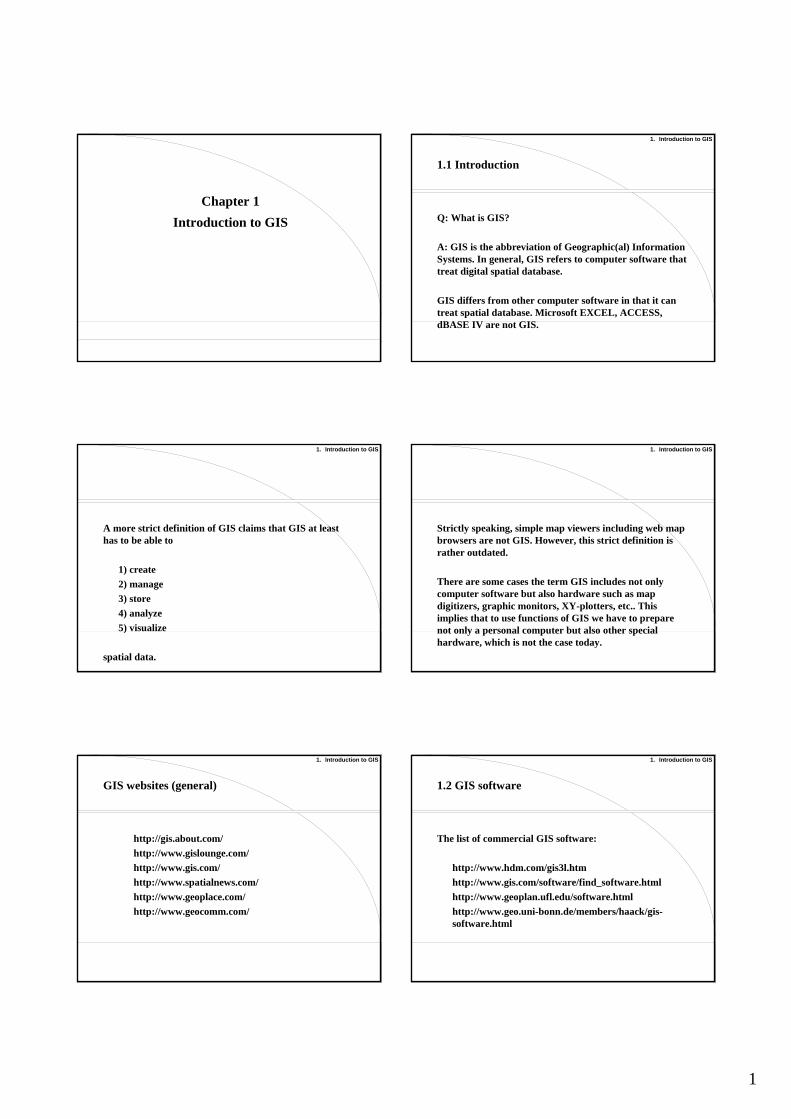
Market share of GIS companies in the world (Dataquest, 1997)
1. Intergraph (GeoMedia) 22.1%2. ESRI (Arc/INFO, ArcView) 21.3%3. Landmark Graphics (GeoGraphics) 9.3%4. Siemens Nixdorf (SICAD) 8.0%5. Autodesk (Autodesk Map) 6.0%6. Smallworld (Smallworld GIS) 3.6%7. Bentley (MicroStation GeoGraphics) 3.5%8. Mapinfo (Mapinfo) 3.2%
1. Introduction to GIS
Market share of GIS companies in Japan (IDC, 1997)
1. Alps (Mapinfo) 24%2. Giken Shoji International (Tactician) 17%3. Pasco (Arcview) 12%4. Dawn (GeoBase) 11%5. Intergraph Japan (GeoMedia) 10%6. Informatix (SIS) 5%7. Bentley Japan (MicroStation GeoGraphics) 3%
Figure: Mapinfo (http://www.mapinfo.com) Figure: Tactician (http://www.tactician.com/)
Figure: Arcview (www.esri.com) Figure: GeoBasic (http://www.ge-net.co.jp/)
3
1. Introduction to GIS
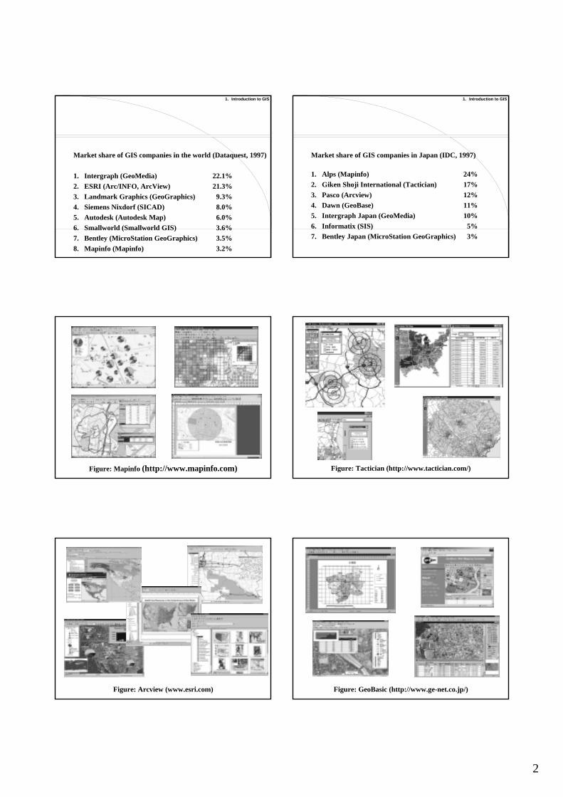
Free GIS software is also available on the Internet.
Lists are available from the following websites:http://www.freegis.org/http://www.gis.com/software/free_software.html
1. Introduction to GIS
• GRASS http://www3.baylor.edu/grass/• GMT http://gmt.soest.hawaii.edu/
• TNTlite http://www.microimages.com/tntlite/(free version of the commercial product TNTmips)
• ArcExplorer http://www.esri.com/software/arcexplorer/(free version of the commercial product Arcview)
1. Introduction to GIS
1.3 GIS-based computer systems
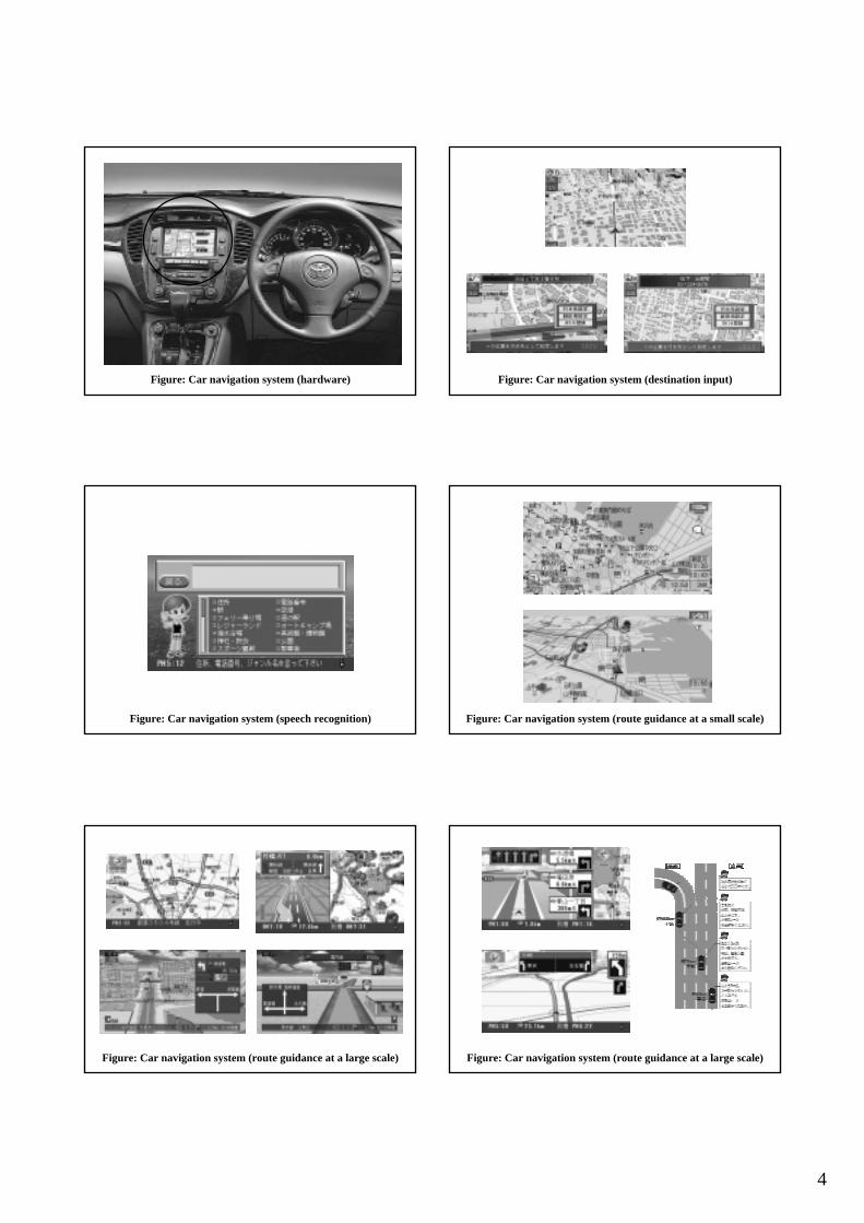
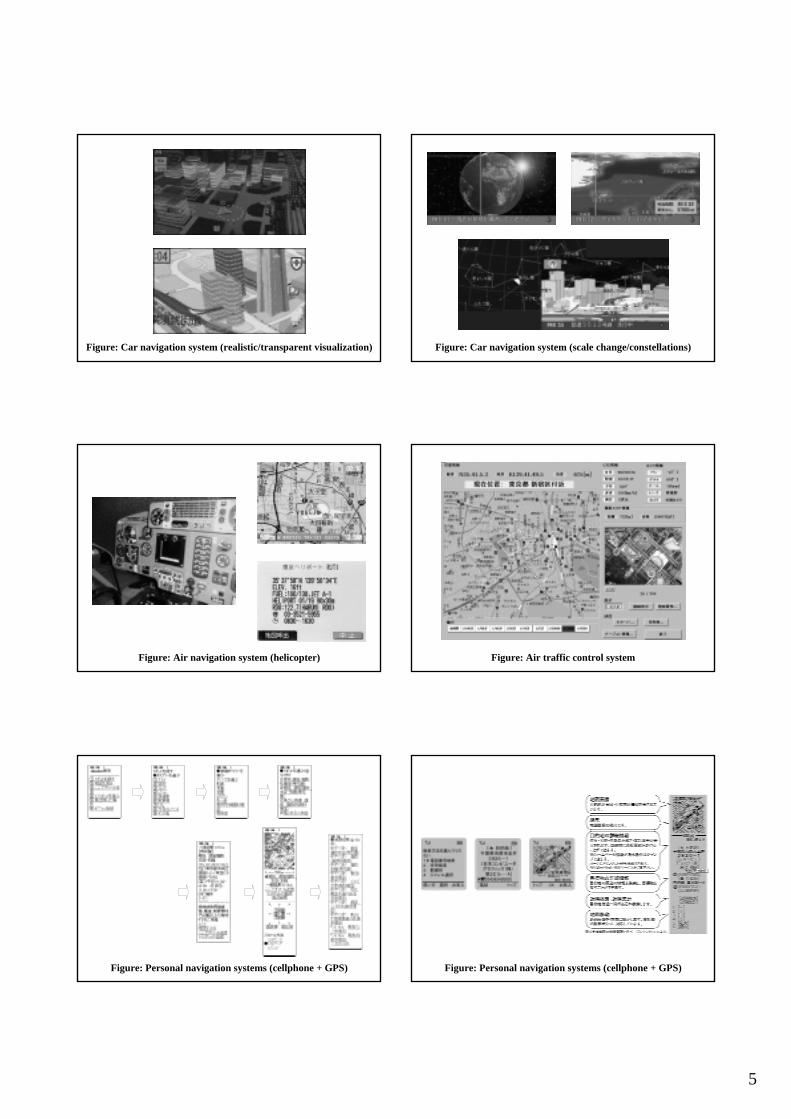
GIS is now used in a wide variety of computer systems.
• Web map browsers• Shortest path search systems• Navigation systems
Figure: US census data (http://www.census.gov/)
Figure: MAPION, a map browser (http://www.mapion.co.jp) Figure: Shortest path search systems (http://www.jhnet.go.jp/route/, http://ekimae.toshiba.co.jp/rmap/area/tokyo.html)
4
Figure: Car navigation system (hardware) Figure: Car navigation system (destination input)
Figure: Car navigation system (speech recognition) Figure: Car navigation system (route guidance at a small scale)
Figure: Car navigation system (route guidance at a large scale) Figure: Car navigation system (route guidance at a large scale)
5
Figure: Car navigation system (realistic/transparent visualization) Figure: Car navigation system (scale change/constellations)
Figure: Air navigation system (helicopter) Figure: Air traffic control system
Figure: Personal navigation systems (cellphone + GPS) Figure: Personal navigation systems (cellphone + GPS)
6
1. Introduction to GIS
Note
The objective of this course is NOT to teach you how to use GIS software. Unfortunately, we cannot use GIS software in this lecture, because of the limited availability of personal computers and GIS software.
If you want to use GIS software, you can1) find freeware on the Internet,2) buy a commercial package by yourself, or,3) ask your supervisor to buy a GIS package.
1. Introduction to GIS
1.4 Functions of GIS
1. Creation of spatial data2. Visualization of spatial data3. Spatial search4. Data overlay5. Buffer operation6. Network analysis7. 3-dimensional analysis8. Geocoding
1. Introduction to GIS
1.4.1 Creation of spatial data
A paper map A digital map
1. Introduction to GIS
1.4.2 Visualization of spatial data
1. Cholopleth map2. Map (visual) overlay3. Flexible scale change
1. Introduction to GIS
1.4.3 Spatial search
Find the nearest spatial object (point, line, or polygon) from a point, or a set of points.
1. Introduction to GIS
1.4.4 Data overlay
+

7
1. Introduction to GIS
1.4.5 Buffer operation
1. Introduction to GIS
1.4.6 Network analysis
1. Introduction to GIS 1. Introduction to GIS
1.4.7 3-dimensional analysis
1. Introduction to GIS
1.4.8 Geocoding
Conversion of an address into the longitude and latitude
Yukio Sadahiro, 139 31 54.3 E, 35 45 54.1 NUniversity of Tokyo, 135 45 45.7 E, 35 42 49.6 N
Yukio Sadahiro, 2-5-23-203, Shinbori, Niiza-shi, SaitamaUniversity of Tokyo, 7-3-1, Hongo, Bunkyo-ku, Tokyo
Figure: ‘TOWNPAGE’, telephone directory of commercial facilities

8
Figure: ‘HELLOPAGE’, telephone directory of individuals
1. Introduction to GIS
1.5 Why do we use GIS in spatial analysis?
In the beginning, GIS was developed for military use.
• Spy satellites take high-resolution pictures of the earth’s surface.
• Long-range missiles are equipped with a camera and a digital map to navigate themselves.
Fundamentals of GIS, especially the data acquisition theory is greatly based on the military technology developed during the Cold War period.
1. Introduction to GIS
GIS technology was a top military secret, but it had been gradually opened to the public, which was accelerated after the end of the Cold War. GIS was first used for agriculture planning and landuse control in the mid 60’. They used GIS mainly because
they could easily overlay maps by using GIS.
This is still a basic motivation of GIS use.
1. Introduction to GIS
Probably the most important motivation of GIS use was, and still is, that we can easily visualize digital maps. If we have only paper maps, it is time-consuming to integrate several maps into one map by manual tracing.
In spatial analysis, we have to visualize spatial data repeatedly in various ways and at various scales. Consequently, visualization of spatial data has to be done easily and rapidly; otherwise, there is no time left for spatial analysis.
1. Introduction to GIS
The second reason why GIS is necessary for spatial analysis is that we have to do calculations in spatial analysis. We may
count the total number of points,calculate the average population,or measure the length of line segments.
We can easily do these calculations by using GIS.
1. Introduction to GIS
The third reason is that spatial data we want to analyze are often provided in a digital format that is suitable for GIS use. This assures that sophisticated spatial analysis can be done immediately in a computerized environment if we obtain spatial data; we can save our time to convert the data in an analogue format including paper maps and hardcopies of figures, tables, and manuscrpipts, into a digital format.
9
1. Introduction to GIS
The fourth reason is that we may easily obtain spatial data if we use GIS and its related tools such as GPS, cellphones, and mobile-GIS modules. Without GIS, it is really difficult to obtain the spatial data that exactly meet our needs.
1. Introduction to GIS
1.6 Applications of GIS - typical examples
Today there are many applications of GIS in various academic fields. This is mainly because of three reasons:
1) decreasing cost of GIS use2) increasing availaility of spatial data3) improvement of user interface
1. Introduction to GIS
The cost of GIS use has been drastically decreasing.
1990 ARC/INFO: $100,000
1996 ArcView: $10,000
2002 GeoBasic: $100
1. Introduction to GIS
Data availability has also been greatly improved: basic spatial data are now provided by both public organizations and private companies.
User interface of recent GIS is now even better: from text-based interface to graphical interface.
1. Introduction to GIS
Ten years ago, GIS was a tool for experts.
Today it is a tool for everyone.
Low cost, user-friendly interface, wide availability of spatial data have been promoting the widespread of GIS.
1. Introduction to GIS
• Urban planning• Real estate• Facility management• Marketing analysis• Environmental management• Hydrology• Archaeology and history• Health management
.
.
GIS applications
10
1. Introduction to GIS
Urban planning
1. Hanna, K. C. and Culpepper, R. B. (1998): GIS and Site Design: New Tools for Design Professionals, John Wiley.
2. Timmermans, H. (1998): Decision Support Systems in Urban Planning, E & F N Spon.
3. Easa, S. and Chan, Y. (1999): Urban Planning and Development Applications of GIS, American Society of Civil Engineers.
1. Introduction to GIS
Real estate
1. Castle, G. H. (1998): GIS in Real Estate: Integrating, Analyzing, and Presenting Locational Information, Appraisal Institute.
2. Orford, S. (1999): Valuing the Built Environment: GIS and House Price Analysis, Ashgate Publishing Company.
3. Thrall, G. I. (2002): Business Geography and New Real Estate Market Analysis, Oxford University Press.
1. Introduction to GIS
Facility management
1. Douglas, W. J. (1995): Environmental GIS: Applications to Industrial Facilities, Lewis Publishers.
1. Introduction to GIS
Marketing analysis
1. Birkin, M., Clarke, G., Clarke, M., and Wilson, A. (1996): Intelligent GIS: Location Decisions and Strategic Planning, John Wiley.
2. Longley, P. and Clarke, G. (1996): GIS for Business and Service Planning, John Wiley.
3. Malczewski, J. (1999): GIS and Multicriteria Decision Analysis, John Wiley.
4. Jankowski, P. and Nyerges, T. L. (2001): GIS for Group Decision Making, Taylor & Francis.
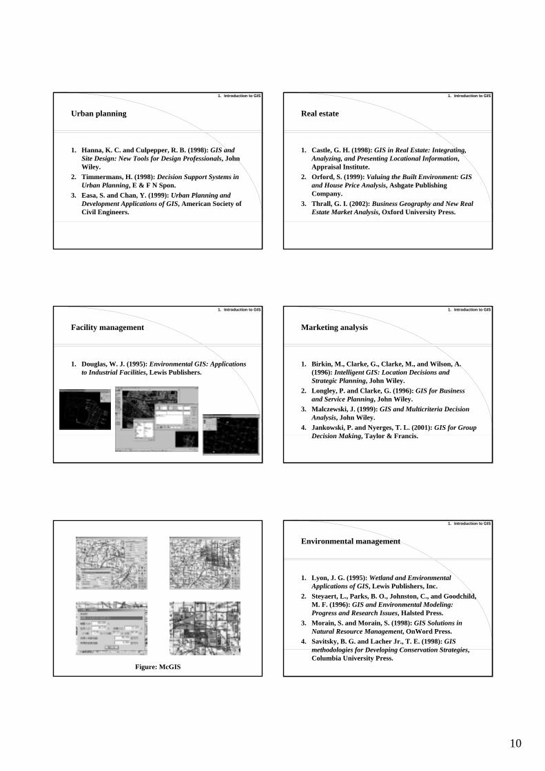
Figure: McGIS
1. Introduction to GIS
Environmental management
1. Lyon, J. G. (1995): Wetland and Environmental Applications of GIS, Lewis Publishers, Inc.
2. Steyaert, L., Parks, B. O., Johnston, C., and Goodchild, M. F. (1996): GIS and Environmental Modeling: Progress and Research Issues, Halsted Press.
3. Morain, S. and Morain, S. (1998): GIS Solutions in Natural Resource Management, OnWord Press.
4. Savitsky, B. G. and Lacher Jr., T. E. (1998): GIS methodologies for Developing Conservation Strategies, Columbia University Press.
11
1. Introduction to GIS
Environmental management (cntd.)
1. Wadsworth, R., Treweek, J., and Treweek, C. (1999): GIS for Ecology: An Introduction, Addison-Wesley Publishing.
2. Halls, P. (2001): Spatial Information and the Environment, Taylor & Francis.
3. Millington, A. C., Walsh, S. J., and Osborne, P. (2001): GIS and Remote Sensing Applications in Biogeography and Ecology, Kluwer Academic Publishers.
1. Introduction to GIS
Hydrology
1. Montgomery, D. R. and Gurnell, A. M. (2000): Hydrological Applications of GIS, John Wiley.
2. Lyon, J. G. (2001): Wetland Landscape Characterization: Techniques and Applications for GIS, Mapping, Remote Sensing, and Image Analysis, Ann Arbor Press Inc.
3. Vieux., B. E (2001): Distributed Hydrologic Modeling Using GIS, Kluwer Academic Publishers.
4. Lyon, J. G. (2002): GIS for Water Resources and Watershed Management, Ann Arbor Press Inc.
1. Introduction to GIS
Archaeology and history
1. Allen, K. M. S., Green, S. W., and Zubrow, E. B. W. (1991): Interpreting Space: GIS and Archaeology, Taylor & Francis.
2. Aldenderfer, M. S. and Maschner, H. D. G. (1996): Anthropology, Space, and Geographic Information Systems, Oxford University Press.
3. Wescott, K. and Brandon, R. J. (2000): Practical Applications of GIS for Archaeologists: A Predictive Modeling Toolkit, Taylor & Francis.
4. Wheatley, D. and Gillings, M. (2002): Spatial Technology and Archaeology, Taylor & Francis.
1. Introduction to GIS
Health management
1. Albert, D. P., Gesler, W. M., and Levergood, B. (2000): Spatial Analysis, GIS, and Remote Sensing Applications in the Health Sciences, Ann Arbor Press.
2. Elliott, P., Wakefield, J., and Best, N. (2001): Spatial Epidemiology: Methods and Applications, Oxford University Press.
3. Lawson, A. (2001): Statistical Methods in Spatial Epidemiology, John Wiley.
4. Cromley, E. K. and McLafferty, S. L. (2002): GIS and Public Health, Guilford Press.
1. Introduction to GIS
GIS applications - other academic fields
GIS is now used in a wide variety of academic fields:
• geography, geology, geostatistics,• topography, hydrology,• ecology, biology, biometrics, forestry, epidemiology, • urban planning, transportation science,• regional science, operations research,• archaeology, history, political science,• criminology, sociology, …
1. Introduction to GIS
Because of this, some people say GIS refers to Geographical Information Science. At present, GIS expands across a wide variety of scientific research fields, but GIS should be a field of science that integrates spatial concepts and methodology of spatial analysis used in those fields.
GIS is no longer only a computer system; it has become a scientific research field.