Embed Size (px)
Citation preview

BioOne sees sustainable scholarly publishing as an inherently collaborative enterprise connecting authors, nonprofit publishers, academic institutions, researchlibraries, and research funders in the common goal of maximizing access to critical research.
Comparison of Transect-Based Standard and Adaptive Sampling Methods forInvasive Plant SpeciesAuthor(s): Bruce D. Maxwell, Vickie Backus, Matthew G. Hohmann, Kathryn M. Irvine, PatrickLawrence, Erik A. Lehnhoff, and Lisa J. RewSource: Invasive Plant Science and Management, 5(2):178-193. 2012.Published By: Weed Science Society of AmericaDOI: http://dx.doi.org/10.1614/IPSM-D-11-00022.1URL: http://www.bioone.org/doi/full/10.1614/IPSM-D-11-00022.1
BioOne (www.bioone.org) is a nonprofit, online aggregation of core research in the biological, ecological, andenvironmental sciences. BioOne provides a sustainable online platform for over 170 journals and books publishedby nonprofit societies, associations, museums, institutions, and presses.
Your use of this PDF, the BioOne Web site, and all posted and associated content indicates your acceptance ofBioOne’s Terms of Use, available at www.bioone.org/page/terms_of_use.
Usage of BioOne content is strictly limited to personal, educational, and non-commercial use. Commercial inquiriesor rights and permissions requests should be directed to the individual publisher as copyright holder.

Comparison of Transect-Based Standardand Adaptive Sampling Methods for
Invasive Plant SpeciesBruce D. Maxwell, Vickie Backus, Matthew G. Hohmann, Kathryn M. Irvine, Patrick Lawrence, Erik A. Lehnhoff,
and Lisa J. Rew*
Early detection of an invading nonindigenous plant species (NIS) may be critical for efficient and effective
management. Adaptive survey sampling methods may provide unbiased sampling for best estimates of distribution
of rare and spatially clustered populations of plants in the early stages of invasion. However, there are few examples
of these methods being used for nonnative plant surveys in which travelling distances away from an initial or source
patch, or away from a road or trail, can be time consuming due to the topography and vegetation. Nor is there
guidance as to which of the many adaptive methods would be most appropriate as a basis for invasive plant mapping
and subsequent management. Here we used an empirical complete census of four invader species in early to middle
stages of invasion in a management area to assess the effectiveness and efficiency of three nonadaptive methods, four
adaptive cluster methods, and four adaptive web sampling methods that all originated from transects. The adaptive
methods generally sampled more NIS-occupied cells and patches than standard transect approaches. Sampling along
roads only was time-efficient and effective, but only for species with restricted distribution along the roads. When
populations were more patchy and dispersed over the landscape the adaptive cluster starting at the road generally
proved to be the most time-efficient and effective NIS detection method.
Key words: Canada thistle, Cirsium arvense (L.) Scop., Dalmatian toadflax, Linaria dalmatica (L.) P. Mill., smooth
brome, Bromus inermis Leyss., common St. Johnswort, Hypericum perforatum L., early detection rapid response,
EDRR, nonnative plants, survey, weed mapping, exotic species, inventory, census.
Land managers often have three main objectivesassociated with NIS management. The first is to maximizepatch detection at the earliest stages of invasion to increasethe success of management directed at eradication. Thesecond objective is to estimate the area infested by a NIS toaid with management planning. A third objective, nottypically identified by managers but important forprioritization of NIS populations for management, is tounderstand the distribution of the NIS populations on thelandscape (Rew et al. 2007) in order to create predictive
maps (habitat suitability maps) of the entire area of interest,not just the area sampled (Rew et al. 2005). It is rarelyfeasible to perform an inventory of an entire managementarea. Therefore, to achieve the above objectives, some formof sampling is required. We created a study that simulateda range of sampling methods on a real-world fully censusedNIS management area, to determine which samplingmethods best fulfill the above objectives.
The popular early detection rapid response (EDRR)management approach is dependent on effective detectionwhen metapopulations are scattered small patches (Max-well et al. 2008; Moody and Mack 1988; Stanaway et al.2010). The large spatial extent of some managed areascoupled with limited resources and competing prioritiesusually makes it impossible to conduct a complete ground-based NIS inventory and mapping effort. In thesecircumstances, information must be obtained throughsubsampling the area (survey). During initial stages ofinvasion, NIS can be sparsely distributed as individuals orsmall clusters of individuals making their detection difficultfor human observers and for remote sensed imagery. Whenthe lands under management are extensive, even during
DOI: 10.1614/IPSM-D-11-00022.1
* First, second, fifth, sixth and seventh authors: Professor,
Postdoctoral Assistant, Graduate Student, Assistant ResearchProfessor, and Assistant Professor, respectively, Department of Land
Resources and Environmental Sciences, Montana State University,
Bozeman, MT 59717; third author: U.S. Army Corps of Engineers,
Engineer Research and Development Center, Construction Engi-
neering Research Laboratory, Champaign, IL 61826; fourth author:
Assistant Professor, Department of Mathematical Sciences, Montana
State University, Bozeman, MT 59717. Corresponding author’s
E-mail: [email protected]
Invasive Plant Science and Management 2012 5:178–193
178 N Invasive Plant Science and Management 5, April–June 2012

later stages of infestation when NIS local abundance hasincreased, detection can be difficult because the plants aredistributed in infrequent patches across the landscape. Inthese situations, improving patch detection with conven-tional (roadside or nonadaptive transect) sampling methodsrequires increasing the sample size, which results in moretime to detect patches, i.e., less efficiency (Morrison et al.2008).
Adaptive sampling, in which the selection of additionalsampling units is initiated if a NIS is observed (Thompson2002), is an alternative to conventional sampling. Adaptivesampling methods are reported to be an improvement indetection and mapping distribution effectiveness andefficiency over conventional methods for sampling rare,spatially clustered populations (Christman 2000; Smithet al. 2004). Adaptive cluster sampling methods include afixed initial sample set, and for each sample unit within theinitial sample set, if the value of the variable of interestsatisfies a specified condition, neighboring units are addedto the sample set (Thompson 1990, 1991a, 1991b, 2002,2004; Thompson and Seber 1996; Salehi and Seber 1997;
Smith et al. 2004). Spatial adjacency or other criteria canbe used to define ‘‘neighboring’’ units. Adaptive websampling and link-based sampling are flexible classes ofadaptive designs for sampling distributions that formspatial networks (Thompson 2006; Vincent 2008). In thesemethods, additional sampling units can be based on thespatial structure of the population (Thompson 2006).
Researchers have investigated the effectiveness and costand time efficiency of adaptive cluster sampling designs forrare herbaceous plants (Philippi 2005; Prather 2006;Morrison et al. 2008; Rew et al. 2006) and trees (Acharyaet al. 2004). Prather (2006) provided one example of theapplication of adaptive sampling to surveying NIS, but didnot explore the many possible permutations to the adaptivemethods. The use of adaptive cluster sampling methods, ingeneral, and adaptive web methods, specifically, forsurveying NIS has not to our knowledge been thoroughlytested. We used a comprehensive census of four NIS tocompare a range of adaptive sampling methods fordetection, distribution estimation, and time efficiency thatcould be recommended for use by managers.
A complete census of four NIS (Lehnhoff and Lawrence2010), representing a range of different reproductive anddispersal mechanisms and subsequent different spatialdistributions in a real management area, was used as aconstant landscape to conduct a comparison of thesimulated sampling methods. Thus we set out to providea sampling recommendation associated with a species’biological characteristics along a continuum represented bythe species we selected for this study. NIS presence andabsence were recorded along the path of a virtual surveyor.We compared standard methods used to survey NIS(random targeted transect adapted from Rew et al. [2006],and roadside census, which is commonly used bymanagers), as well as adaptive cluster sampling andadaptive web sampling methods (Thompson 2006).
Materials and Methods
Study Area. The management area considered for oursampling simulations occurred within the Little BighornBattlefield National Monument, administered by the U.S.National Park Service. The monument is located insoutheastern Montana and its native vegetation consistsprimarily of northern shortgrass prairie dominated bynative perennial grasses in the genera Agropyron, Poa, Stipa,and Bouteloua, with occasional swales consisting of westernsnowberry (Symphoricarpos occidentalis Hook.), prairie rose(Rosa arkansana Porter), chokecherry (Prunus virginiana L.)and silver sagebrush (Artemisia cana Pursh) shrub species(Bock and Bock 2006). In 2010, a complete NIS inventory(census) was performed within the monument boundary(Lehnhoff and Lawrence 2010), creating a base map for thesimulation study. Virtual surveys were conducted within an
Management ImplicationsIt is often not possible or cost-effective to conduct a complete
inventory of potentially invasive plant species in large managementareas, particularly at the early stages of invasion when populationsmay be infrequent and dispersed on the landscape. Detection atthe early stages of invasion may be crucial for effective and cost-effective management. Thus managers must have survey methodsthat are effective and efficient for estimating the distribution ofinvading species. To accomplish different survey goals, which mayinclude finding early invading populations, locating manydifferent invasive plant species, finding the most populations ofa single species, or collecting information to characterize speciesdistributions, knowing which survey technique to use is critical.We tested three standard and eight adaptive survey methods on avirtual landscape populated with four empirically censused invasiveplant species: Canada thistle, Dalmatian toadflax, smooth brome,and common St. Johnswort. The species exhibited somewhatdifferent growth forms, reproductive patterns, and seed dispersaldistances and were in different stages of invasion. Randomtransects with adaptive cluster sampling generally performed bestwhen the survey goal was to find the largest number of populationsin the shortest amount of time for species that were wellestablished and occupied areas away from the road. If the specieswas in the early stages of invasion and only occupied roadsidehabitat, surveying along roads performed best. When the surveygoal was to accurately assess the proportion of the landscapeinfested by each species, stratified random targeted transectswithout adaptive sampling performed best for all species.However, managers should be aware that adaptive samplingmethods overestimate infested area. This study indicates thatadaptive sampling methods can improve nonindigenous speciespatch detection for management, but regardless of the samplingmethod, detection remains relative low (maximum of 33% ofpatches) with typical management constraints and thereforeseriously challenges the concept of early detection and rapidresponse.
Maxwell et al.: Adaptive sampling N 179

inventoried (full census) study area of 195 ha (482 ac), notincluding an adjacent riparian area (Figure 1). There wasone main road traversing the study site, as well as smallerroads and interpretative trails. Roads and trails werecollectively referred to as rights-of-way (RoWs).
Target NIS Populations. Four of the inventoried (fullycensused) NIS in the management area were used in thisstudy: smooth brome (Bromus inermis Leyss.), Canadathistle [Cirsium arvense (L.) Scop.], common St. Johnswort(Hypericum perforatum L.), and Dalmatian toadflax[Linaria dalmatica (L.) P. Mill.]. These species werechosen because they represent a range of distributions(initial to later stages of invasion), primary dispersalmechanisms (short or long), and primary reproductivestrategies (sexual or vegetative) resulting in different visualpatterns of individual plants across the study site. Smoothbrome is a rhizomatous grass in a late stage of invasion,Canada thistle is a rhizomatous and wind-dispersed forbin an early to middle stage of invasion, common St.Johnswort is a nonrhizomatous and non–wind-dispersedforb in middle to late stage of invasion, and Dalmatiantoadflax is a rhizomatous and non–wind-dispersed forb inan early stage of invasion (Figure 2). Smooth brome wasdistributed widely in dispersed patches throughout thestudy site; common St. Johnswort was similarly prevalentin abundance, but existed, on average, in smaller patches ina more clustered pattern; Canada thistle was not asabundant, occurring in large clustered patches; andDalmatian toadflax, a more recently introduced species,occurred in small, highly clustered patches that were not
widely distributed. Common St. Johnswort and Dalmatiantoadflax were actively managed in the past, whereas smoothbrome and Canada thistle were not.
Simulation Design. Our simulation study consisted ofplacing transects on the mapped portion of the manage-ment area and virtually sampling 15 contiguous 10 by10–m (32.8 by 32.8–ft) cells along each transect. Samplingsimulations were conducted in ArcGIS (ArcGIS 9 Desktop.version 9.3.1, ESRI, Redlands, CA) and Python (version2.5, Python Software Foundation, http://www.python.org. ).All transects started at randomly selected points along theRoW to simulate maximized efficiency at the onset ofsampling. In each simulated sampling session the samesample set of transects was recorded and used to ensureany difference between methods could be attributed to thesampling methods themselves and not differences in theplacement of transects. One hundred simulations were runfor each sampling design. The transect number for eachsimulation was set at 13 or 26, approximately 1 and 2% ofthe study area prior to adaptive sampling. Sampling 1% ofa management area would be considered the upper limitfor most government agencies responsible for large tractsof land (Roy Rankin, National Park Service, personalcommunication).
Survey Methods
Three nonadaptive and eight adaptive (four adaptiveweb and four adaptive cluster) methods were simulated. Allbut one sampling strategy had transects point away fromthe RoW and because preferential roadside sampling is acommon practice among land managers (Sharma andRaghubanshi 2009), we included a design to mimicroadside sampling (RdTr). Road transects includedsampling 15 consecutive cells along both sides of theRoW and consequently had twice as many cells as all othermethods. Therefore, 15 of the 30 10 by 10–m cells wererandomly selected for each road transect to make themconsistent in area sampled with other nonadaptivemethods. The other two nonadaptive methods includedstratified random transects (SRT) where presence andabsence of a NIS was recorded in a 10-m-wide, 150-m-longstraight transect, again with 10 by 10–m cells. Thesetransects extended away from RoWs on a random compassdirection, were constrained to lie entirely within the studyarea, and ended at least 40 m from any RoW (Figure 3a).The third nonadaptive method, SRT with patch dimension(RTPD), recorded patch size in addition to recording thepresence or absence of NIS along the transect, but wasotherwise identical to SRT. Rew et al. (2006) foundestimating the average patch area and using the estimationin conjunction with number of patches detected provideda more accurate estimate of the percentage of landscape
Figure 1. Arial photo of the management area with the 195-hastudy area (hatched) at Little Bighorn Battlefield NationalMonument, Crow Agency, Montana (45u 349 120N, 107u279 00W).
180 N Invasive Plant Science and Management 5, April–June 2012

infested. The three nonadaptive methods were chosen forcomparison with adaptive sampling designs because theyare commonly used for sampling NIS (Huebner 2007; Rewet al. 2006; Sharma and Raghubanshi 2009).
The adaptive methods built on the SRT and followed atwo-stage sequential design, similar to those of Thompson(1991a) and Salehi and Smith (2005), where a secondarysampling set of units was selected once a NIS was foundpresent within a 10-m by 10–m transect cell. Seven ofthe adaptive designs included a species-specific dispersaldistance (20, 30, or 50 m or two, three, or five cells)selection to constrain distance travelled to the next sampleaway from the original transect. Adding the dispersaldistance variable increased the adaptive sampling methodsto 25.
All adaptive sampling methods, except the adaptive king(described below), required a dispersal distance thatdetermined a maximum survey distance (MSD) todetermine or constrain the location of samples to alogistically reasonable distance beyond the transect. Thedispersal distance represented one-half of the maximum
primary wind dispersal distance of seed for each speciesbased on terminal velocity and horizontal wind speed of400 m s21 (Cousens and Mortimer 1995). The MSD wasthe maximum length, both parallel and perpendicular to atransect, that a surveyor had to walk to include additionalsample cells beyond the transect.
Two types of adaptive sampling were tested: adaptivecluster and adaptive web. Adaptive cluster samplingmethods capitalize on the clustered spatial pattern ofindividuals in a population that may be caused by adiversity of abiotic and biotic processes such as dispersalpatterns (Cousens and Mortimer 1995) or exogenousprocesses such as soil moisture gradients. The designrequires an inclusion criterion that, when met, triggers theinclusion of additional sampling units. The inclusioncriterion we used for all the simulated adaptive samplingdesigns was the presence of NIS. Limited application ofadaptive cluster sampling may be due to the fact that finalsample size is not known a priori and can end up beinglarge and thus potentially inefficient (Brown 2003; Smithet al. 2004; Su and Quinn 2003). To prevent excessive
Figure 2. Distribution and number (lower right corner) of patches (grey pixels) and number of 10 by 10–m cells occupied (inparentheses) of (a) smooth brome, (b) Dalmatian toadflax, (c) Canada thistle, and (d) and common St. Johnswort, relative to rights ofway (black lines) in the study area.
Maxwell et al.: Adaptive sampling N 181

sampling, we used MSD to place pragmatic limits on thenumber of cells sampled (Gattone and Battista 2011). Thedistances were used to define the survey limit from anoccupied NIS cell located within a transect. If the NISpatch boundary fell outside the MSD, the patch wasdeemed too large and cluster sampling was not performed.If cluster sampling was performed, no cells located outsidethe MSD were sampled (Figures 3b and 3c). Thus, themaximum search distance (MsD), not to be confused withMSD (maximum survey distance), was reset each time thata NIS was identified in a new cell outside the originaltransect (Figure 3b). Cluster sampling was not performedalong the entire length of a transect; instead, sessions ofcluster and transect (returning to the original transect)sampling were performed in an alternating fashion toincrease efficiency. Each cluster sampling session wasestablished for a distance equal to the MSD along theoriginal transect.
Eight adaptive sampling designs were simulated: fouradaptive cluster methods and four adaptive web methods.
Adaptive Cluster Methods. Stratified random transect withadaptive cluster sampling (RTAC) required a dispersaldistance (20, 30, or 50 m) to define the MSD (Figures 3band 3c). All cells within an original transect were surveyedone at a time, starting with the cell next to a RoW(Figure 3a). If one or more NIS patches were detectedwithin a cell along the transect, cluster sampling began.Cluster sampling was carried out by first delineating theNIS patch perimeter. If the patch was contained within theMsD, a set of concentric ‘‘rings’’ around the outside of thepatch were added to the survey as described by Prather(2006) and Rew et al. (2006). The process began withsampling the ring immediately adjacent to the NIS patchand continued with increasing size of concentric circlesto the MSD defined by the preselected species-specificdispersal distance. The virtual surveyor sampled the cellscontained in the first ring one at a time, starting with thecell directly to the north, and circling in either a clockwiseor counter-clockwise direction. The initial direction wasrandomly chosen and rings in the set were surveyed inalternating directions. If more NIS were detected within aring cell, the remaining cells in the current ring and anyremaining rings were not surveyed, and the ring procedurebegan anew at the next NIS patch encountered in the ring.
Figure 3. (a) Diagram of portion of simulated stratified randomtransect method with unsampled cells (10 by 10 m) in white,sampled cells shaded, detected nonindigenous species (NIS)patches (P), and nondetected NIS patches (P) along the originaltransect; (b) NIS patch boundaries (dotted lines) and arrows
r
showing maximum survey distance (MSD) and maximum searchdistance (MsD) used with random transect with adaptive clustersampling method (sampling starts at road); (c) stratified randomtransect with adaptive cluster sampling alternate method wheresampling was constrained to not begin along the original transectuntil a distance equal to the MSD was reached.
182 N Invasive Plant Science and Management 5, April–June 2012

The maximum area to be surveyed was determined by theMSD for the first patch detected. Adaptive samplingcontinued until (1) all rings within the search area weresurveyed and no NIS patches were detected, (2) all cellswithin the maximum search area were surveyed, or (3) theboundary of the MSD was reached. When any of theseconditions were met, the surveyor moved back to theoriginal transect cell that triggered the adaptive samplingand continued sampling along the original transect.
Stratified random transect with adaptive cluster samplingalternate (RTACT) was exactly the same as RTAC exceptthat cluster sampling was not initiated along the transectuntil a NIS patch was reached that was greater than theMSD along the original transect (Figure 3c). This approachwas added to avoid oversampling roadside populations.
Adaptive king sampling (AK) proceeded along atransect in the same way as SRT until a NIS wasencountered and then would additionally survey neigh-boring cells (Figure 4a). The neighborhood was defined asthe eight adjacent cells surrounding an occupied cell (aking’s move in the game of chess). The virtual surveyorsampled the cells in the neighborhood one at a timestarting with the cell directly to the north and moving in aclockwise direction. If no additional NIS were detected inany of the neighborhood cells, the surveyor moved back tothe original transect and continued sampling along it(Figure 4a). If additional NIS were detected in any of theneighborhood cells, a new ‘‘king’s move’’ neighborhoodwas added to the survey. Only cells not previouslysurveyed or added to the sample were included in thenew neighborhood. The surveyor always finished survey-ing the cells in the current neighborhood before moving tothe next neighborhood regardless of NIS occupation.Neighborhoods were surveyed in the order they weredetected and added to the survey, and surveying alwaystook place in a clockwise direction within each neighbor-hood. Surveying recursively in this manner continueduntil (1) no neighboring cells contained NIS, (2) thenumber of neighborhood cells surveyed reached 50, or (3)the MSD was reached.
Adaptive modified king 360 (AK360) was an adaptivesampling approach included as a modified version of the AKdesign in which, upon observing a NIS presence in theoriginal transect, instead of adding the immediate neigh-boring cells to the sample, the surveyor randomly selected acell that was within a circle centered at the currentlyoccupied transect cell and at a radius equal to the MsD(Figure 4b). If one or more NIS individuals were detected inthe MsD random cell, additional neighbor cells were addedto the survey and sampled as described for the AK design.
Adaptive Web Methods. Adaptive web methods use spatialrelationships with other variables as part of the inclusioncriterion for adding additional sampling units to a survey
around a NIS-occupied cell on the original transect. Weused adjacency and limited distance as the spatialrelationships. Inclusion in the sample beyond the originaltransect was determined with a probability test where arandom value below a predetermined probability (p) wouldsignal inclusion of an adjacent cell or a random value . pwould result in choosing a random cell (hereafter referred
Figure 4. Diagram of portion of simulated sampling usingadaptive cluster designs (a) adaptive king and (b) adaptive king360 (AK360), where white cells represent nonsampled, shadedcells represent sampled, P represents detected nonindigenousspecies (NIS) patches, P represents nondetected NIS patches, andthe dashed line indicates a road. In (b) the AK360 design, arrowsindicate the cell selected randomly within a circle of radius equalto the maximum search distance (in this case 30 m) and centeredon the transect cell where NIS were detected.
Maxwell et al.: Adaptive sampling N 183

to as a restricted- random cell) within a predefined beltsuperimposed on the original transect. The adaptive webbelt extended the species-specific dispersal distance per-pendicular to and on both sides of the original transect. Ifthe restricted-random cell was occupied by the target NISthen the process of selecting further samples continuedwith the same rules, selecting all ‘‘king’s-move’’ adjacentcells or more restricted-random cells based on the p-test.
Basic adaptive web with random belt selection (BRB)used 0.90 for the probability of adding a neighboring cellto the sample once a NIS was detected in the originaltransect. The BRB method imposed a maximum limit of50 cells that could be sampled adaptively following a NISoccurrence (occupied cell) in the original transect(Figure 5a). In this design, all cells within a transect weresurveyed one at a time, starting with the cell next to aRoW. If one or more NIS patch was found within atransect cell, a uniform random number (p) was chosen foreach nonsampled cell in the ‘‘king’s-move’’ neighborhoodof the transect cell. If the random number was less than p,the neighboring cell was added to the sampled cells;otherwise, a random cell was selected and added to thesurvey from within the belt created at the predeterminedMsD on either side and parallel to the transect .
All NIS-occupied cells added to the survey because of theiradjacency to NIS-occupied cells were sampled first in order tominimize surveyor walking distance. The virtual surveyorthen sampled cells not previously sampled based on the p testand the most efficient travel route to the next restricted-random cell. Once a new restricted-random cell wasidentified, if a NIS presence was recorded the ‘‘kings-move’’neighborhood for it was sampled just as the neighborhoodadjacent to the original transect occupied cell was sampled(described above). Surveying recursively in this mannercontinued until (1) no more cells were found to be NIS-occupied, (2) the number of neighborhood cells surveyedreached 50, or (3) the boundary of the survey area was reached.
If after all the neighborhood cells were surveyed and themaximum number of cells to survey adaptively had notbeen reached, the surveyor would select random previouslyunsampled cells from within the transect belt (sampledcells without arrows to them; Figure 5a). The randomlyselected cells added to the sample were arranged andsurveyed in an order that minimized walking distance. IfNIS were detected while surveying these random cells, theselection process described above was repeated, and asbefore, the cells selected from the neighborhoods weresampled first, before continuing with the cells selectedrandomly (e.g., Figure 5a, upper left randomly selectedoccupied cell with no arrow to it). Surveying adaptively inthis manner continued until (1) all cells added adaptivelywere surveyed, (2) the number of cells surveyed adaptivelyreached 50, or (3) the boundary of the survey area wasreached. When any of these conditions were met, the
Figure 5. Diagram of portion of simulated sampling associated withthe first patch detected then triggering further adaptive websampling designs: (a) basic adaptive web with random belt selectionand (b) basic adaptive web with circle selection (B360) where whitecells represent nonsampled, shaded cells represent sampled, Prepresents detected nonindigenous species (NIS) patches, Prepresents non-detected NIS patches, bold lines parallel to originaltransect at maximum survey distance represent the belt boundary (inthis case equal to 50 m), and the dashed line indicates a road (RoW).Values (p) in selected cells were used to decide if cell would beincluded in sample survey (p # 0.90 included) otherwise arrowindicates next random cell within belt or maximum search distance(MsD) (for B360) to be tested for inclusion in sample. Cells sampledaway from original transect not adjacent to occupied cells andwithout an arrow were randomly selected within the belt or MsD.
184 N Invasive Plant Science and Management 5, April–June 2012
virtual surveyor moved back to the transect cell thattriggered the adaptive sampling and continued along theoriginal transect.
Basic adaptive web with circle selection (B360) wasimplemented in the same way as BRB, with one difference.During the selection process, when a random cell needed tobe selected and added to the sample, the selection was notmade from the cells located in a fixed belt surrounding thetransect; instead, it was made from the cells locatedwithin a circle centered at the current occupied cell beingsurveyed. The radius of the circle was set at thepredetermined MsD (Figure 5b).
Local habitat variability adaptive web with randombelt selection (LHVRB) was an adaptive web samplingdesign that incorporated a measure of local environmen-tal heterogeneity into the selection process for determin-ing additional cells to sample. The assumption was thatthe more homogeneous the habitat was in the neighbor-hood where an initial NIS was found, the greater thechance that an additional NIS would be detected in thatneighborhood. We assigned a local habitat value (LHV)to each cell in the survey area based on aspect derivedfrom the digital elevation map under the assumption thatterrain aspect was a major explanatory variable deter-mining the distribution of the selected species. Forexample, if the aspect was the same in the nine-cellneighborhood centered on the occupied cell, the LHVwould be 1; if there were two aspects in the neighbor-hood, the LHV would be 2; and if all of the cells haddifferent aspects, the LHV would be 9. We chose to basethe LHV on terrain aspect because it exhibited the
greatest variability across the management area and isoften an explanatory value related to NIS occurrence.LHV could logically be substituted with probability ofoccurrence or habitat suitability values derived frommultiple variables known to drive distribution of NIS(Rew et al. 2006).
Instead of using a fixed value for p for this method, theprobability of adding a neighboring cell to the sample oncea NIS was found varied as a function of LHV: p 5 1.0 2(LHV/9.0) + 0.1. All other design factors and rules wereexactly the same as for BRB, described above.
Local habitat variability adaptive web with circleselection (LHV360) was implemented in the same manneras the B360 design, except varied as a function of LHV, asdescribed under LHVRB.
Sampling Methods Performance Assessment. Methodperformance was based on how effectively a methoddetected NIS patches for a given species (objective 1), howaccurately each method estimated the total area infested byeach species (objective 2), and the time efficiency of thedifferent methods (objective 3). The assessment methodswere chosen because they tend to be most directly relevantto current management considerations. The samplingmethods presented in this paper were not assessed for theiradequacy to estimate spatial distribution of NIS species orfor use in accurate occupancy maps. Each method’spotential to maximize detection of patches was assessedby calculating the proportion of patches detected (pD) foreach species (patches intersected/total patches in themanagement area for a given species). The management
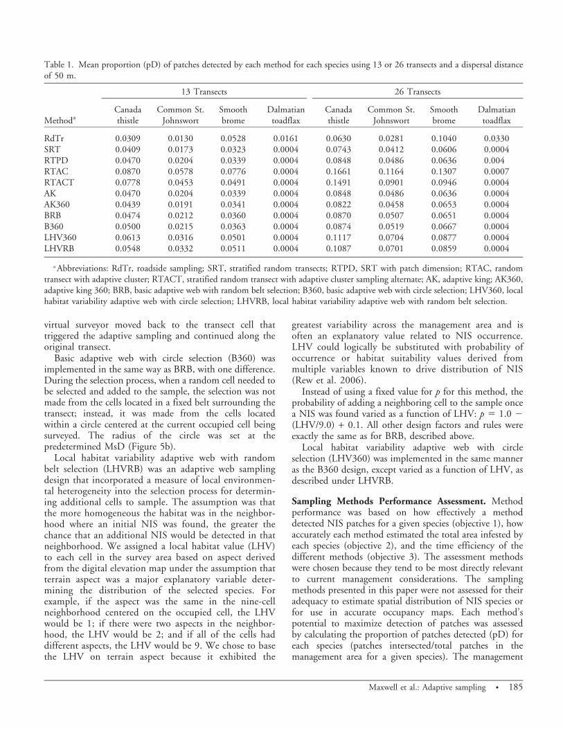
Table 1. Mean proportion (pD) of patches detected by each method for each species using 13 or 26 transects and a dispersal distanceof 50 m.
Methoda
13 Transects 26 Transects
Canadathistle
Common St.Johnswort
Smoothbrome
Dalmatiantoadflax
Canadathistle
Common St.Johnswort
Smoothbrome
Dalmatiantoadflax
RdTr 0.0309 0.0130 0.0528 0.0161 0.0630 0.0281 0.1040 0.0330SRT 0.0409 0.0173 0.0323 0.0004 0.0743 0.0412 0.0606 0.0004RTPD 0.0470 0.0204 0.0339 0.0004 0.0848 0.0486 0.0636 0.004RTAC 0.0870 0.0578 0.0776 0.0004 0.1661 0.1164 0.1307 0.0007RTACT 0.0778 0.0453 0.0491 0.0004 0.1491 0.0901 0.0946 0.0004AK 0.0470 0.0204 0.0339 0.0004 0.0848 0.0486 0.0636 0.0004AK360 0.0439 0.0191 0.0341 0.0004 0.0822 0.0458 0.0653 0.0004BRB 0.0474 0.0212 0.0360 0.0004 0.0870 0.0507 0.0651 0.0004B360 0.0500 0.0215 0.0363 0.0004 0.0874 0.0519 0.0667 0.0004LHV360 0.0613 0.0316 0.0501 0.0004 0.1117 0.0704 0.0877 0.0004LHVRB 0.0548 0.0332 0.0511 0.0004 0.1087 0.0701 0.0859 0.0004
a Abbreviations: RdTr, roadside sampling; SRT, stratified random transects; RTPD, SRT with patch dimension; RTAC, randomtransect with adaptive cluster; RTACT, stratified random transect with adaptive cluster sampling alternate; AK, adaptive king; AK360,adaptive king 360; BRB, basic adaptive web with random belt selection; B360, basic adaptive web with circle selection; LHV360, localhabitat variability adaptive web with circle selection; LHVRB, local habitat variability adaptive web with random belt selection.
Maxwell et al.: Adaptive sampling N 185

implication is directly tied to EDRR, so once any part of apatch is detected the manager can eradicate the entirepatch. The closer pD was to 1.0 the more likely EDRRcould be successful.
The proportion of occupied cells detected in the samplerelative to the proportion of occupied cells on the wholelandscape (management area) (pCD/pCO) was used todetermine accuracy of estimating the proportion of areainfested (occupied cells visited/total cells visited divided bythe number of total cells occupied/the total cells in themanagement area for a given species). A ratio of 1.0indicates a completely accurate estimate of the proportionalarea infested by a NIS. Values below 1.0 indicate anunderestimate of area infested and values above 1.0 indicateoverestimates. One would expect adaptive samplingmethods, by their very nature, to produce overestimatesof proportional area infested. Managers are often requiredto present estimates of NIS area infested in theirmanagement area for budgeting and other planningactivities, so we provide these results to illustrate thedegree of bias when using these methods for estimating theproportion of area infested. The time required to performeach method was used to compare time efficiency because
some methods may be effective at detecting patches, butrequire covering far more ground and thus take longer toachieve. The time required to conduct a survey wascalculated postsimulation using the virtual surveyor’s travellogs and assuming a travel speed of 1 km h21 (0.6 mi h21)while surveying and 3 km h21 walking between transectsand sample cells. Method efficiency was assessed bydetermining the proportion of patches detected/hoursspent sampling (pD h21) for each species and theproportion of occupied cells detected per hour (pC h21)for each species.
Sampling methods were compared qualitatively usingbox and whisker plots. Since the goal of the research wasto provide an assessment of the relative advantages of thedifferent methods for the stated objectives, the box plotsprovided best unbiased comparisons. Multiple meanscomparisons based on ANOVA were not used due toviolation of assumptions. Nonparametric procedures wererejected because they require choosing a control methodto compare with and there was no method to logically useas a control. All of the analyses were conducted in R(version 2.11.1, R Development Core Team. Vienna,Austria).
Figure 6. Simulation results comparing patches detected among general categories of methods using 26 transects and a dispersaldistance of 50 m replicated 100 times for (a) smooth brome, (b) Dalmatian toadflax, (c) Canada thistle, and (d) and common St.Johnswort. The bold line in the box was the median, the box was 50% of data, whisker included 95% of data, and open circles wereoutliers for each simulated sampling approach.
186 N Invasive Plant Science and Management 5, April–June 2012

Results and Discussion
The NIS distributions used in our simulations wereconsistent with previously observed sites and studies where anassociation between NIS and anthropogenic disturbance suchas RoWs was apparent (Gelbard and Belnap 2003; Parendesand Jones 2000; Pauchard and Alaback 2004; Sharma andRaghubanshi 2009; Spellerberg 1998; Watkins et al. 2003;).
Effectiveness of Patch Detection. The first objective wasto determine the effectiveness and efficiency of the samplingmethods to maximize patch detection for maximizing thesuccess of EDRR. The maximum number of patchesdetected with any of the sampling methods was 34 forsmooth brome and common St. Johnswort, 15 for Canadathistle, and 2 for Dalmatian toadflax. This represented 24,25, 33, and 29% of the total patches for these species,respectively (calculated from values in Figure 2). Most NISare likely to be introduced to an area along roads and manyspecies show some degree of aggregation. Therefore, themethods described here should optimize NIS populationdetection. However, it would take considerably moresampling effort, regardless of the method, to detect allpatches and effectively implement EDRR for these species inthis typical management area. So if the detection probabilityis high, intensive monitoring for new patches along roads
may allow EDRR to succeed with the caveat that the expenseof detection is likely to increase linearly as a function ofdeclining occurrence.
The mean proportion of patches detected increased,approximately doubling, with a doubling of the number oftransects (13 to 26) in the study area for all species exceptDalmatian toadflax (Table 1). The best methods wereonly detecting a mean of about 9, 6, 8, and 2% of theCanada thistle, common St. Johnswort, smooth brome, andDalmatian toadflax patches, respectively. Increasing theassigned dispersal distance from 20 to 50 m expanded thesearch area and increased the proportion of patches detectedfor some methods (data not shown). Additional comparisonsof methods were limited to the results from the simulationswith 26 transects and a dispersal distance of 50 m becausepatterns in method performance were consistent regardlessof transect number and dispersal distance. Differencesamong methods were amplified and in some cases madesignificantly different (P , 0.05 in multiple meanscomparisons) by using more transects (26) and larger searcharea (50 m). Dalmatian toadflax was highly clustered andthere were only seven patches in total and these wererestricted to a small portion of the study area (Figure 2).Therefore, only general statements about method perfor-mance were included for Dalmatian toadflax.
Figure 7. The proportion of (a) smooth brome, (b) Dalmatian toadflax, (c) Canada thistle, and (d) common St. Johnswort patchesdetected for each method, where the bold line in the box was the median, the box was 50% of data, whisker included 95% of data, andopen circles were outliers. These were simulation results for the 26 transects and the 50-m dispersal distance case.
Maxwell et al.: Adaptive sampling N 187

Comparison of the general categories of samplingmethods for proportion of patches detected indicated thatsampling along roads may be the best sampling method forthe very patchy and aggregated metapopulation species (e.g.,smooth brome and Dalmatian toadflax; Figure 6a and 6b,respectively). These species were aggregated near the roadsprobably because they were likely introduced along the road,were relatively new to the area, or both. This characteristicdistribution should aid in the success of EDRR as it iscurrently implemented. However, the proportion of patchesdetected was so low that none of the methods could bejudged as performing adequately to accomplish effectiveEDRR management. This is important as the basic transectssampled 1% (13) or 2% (26) of total area—more than many
land managers can achieve under current budgets. ForCanada thistle and common St. Johnswort, which were lessassociated with RoWs, there was no apparent benefit forpatch detection of the adaptive sampling methods when theywere grouped (Figures 6c and 6d, respectively).
Specific methods were compared for their potential todetect a high proportion of patches of each species. Theadaptive cluster method (RTAC) outperformed all methodsfor all species (Figures 7a, 7c, and 7d ) except for Dalmatiantoadflax (Figure 7b) where RdTr sampling a distance equalto the transects detected more than a single patch. TheRTACT method was consistently the second best methodfor detecting patches for all species except Dalmatiantoadflax. RTACT differed from RTAC by delaying the
Figure 8. The number of (a) smooth brome and (b) Canada thistle patches detected per hour of sampling for each method, where thebold line in the box was the median, the box was 50% of data, whisker included 95% of data, and open circles were outliers. Thesewere simulation results for the 26 transects and the 50-m dispersal distance case.
188 N Invasive Plant Science and Management 5, April–June 2012

onset of adaptive sampling until the MsD was traversed awayfrom the road before invoking cluster sampling. Theadaptive web sampling methods that utilized previoushabitat knowledge about the species and sampled 360uaround a NIS occurrence (LHV360 and LHVRB) consis-tently showed promise for patch detection (Figures 7a, 7c,and 7d). With greater information on habitat requirementsas well as a greater variation in habitat quality across themanagement area, the adaptive web approaches may becomesuperior to the adaptive cluster approaches.
Time Efficiency for Patch Detection. Specific samplingmethods were compared for their time efficiency for
detecting patches using the number of patches detectedper hour of sampling. Smooth brome, because of itsdistribution near the roads, was most efficiently sampledalong the roads (Figure 8a). Canada thistle (Figure 8b) andcommon St. Johnswort (not shown because it was similarto Canada thistle) were very similar among methods withRTAC (an adaptive cluster method) again outperformingthe other methods for these highly dispersed species in alater stage of invasion.
Sampling for Infested Area Estimates. Managers may beinterested in using the designs we explored for estimatingthe total area infested by NIS. Adaptive methods, ideal for
Figure 9. The sample estimated (a) smooth brome and (b) Canada thistle area infested per total area infested in the management areafor each method, where the bold line in the box was the median, the box was 50% of data, whisker included 95% of data, and opencircles are outliers. The line at 1.0 on y-axis was where the estimate from sample was equivalent to the actual area infested. These weresimulation results for the 26 transects and the 50-m dispersal distance case.
Maxwell et al.: Adaptive sampling N 189

maximizing patch detection or occupied cell detection,preferentially sample adjacent cells, which are more likelyto also have a NIS present. If the sampling design was asimple random sample of cells throughout the studyregion, an unbiased estimate for the proportion of totalarea infected is simply the number of cells infested dividedby the total number of cells surveyed. We know a prioriusing this estimate as a summary measure for our designsshould produce overestimates of the total area infested;however, we do so to demonstrate the bias if thesemethods are used for the objective of making infested areaestimates.
Specific methods were compared qualitatively with boxplots to determine how much each deviated from 1.0 for the
ratio of the estimated proportion of area infested from thesample to the known proportion of area infested. Allsampling methods consistently overestimated area infestedfor smooth brome (Figure 9a). Again, this result was due tothe aggregation of smooth brome around roads and all of themethods used roads as a starting point. The nonadaptivesampling approach of SRTs perpendicular to the roadproduced fewer overestimates of area infested for Canadathistle (Figure 9b), although on average the method was stilla slight overestimate. The overestimation of area infested islikely because the transects were short and did not maximizedistance from all RoWs, unlike SRT in Rew et al. (2006).Results for common St. Johnswort (data not shown) werealmost identical to those for Canada thistle.
Figure 10. The number of (a) smooth brome– and (b) Canada thistle–occupied map cells detected per hour of sampling for eachmethod, where the bold line in the box was the median, the box was 50% of data, whisker included 95% of data, and open circles wereoutliers. These were simulation results for the 26 transects and the 50-m dispersal distance case.
190 N Invasive Plant Science and Management 5, April–June 2012

As expected, the adaptive sampling approaches generallyoverestimated the total area infested for all species. We useda naı̈ve estimator for the proportion of area infested, butour goal was to demonstrate, for a manager, the potentialoverestimation of total area infested if these adaptivemethods are used with a simple random sample estimator.
Time Efficiency for Area Estimates. Specific samplingmethods were compared for their time efficiency fordetecting NIS-occupied cells on the map, as opposed topatches, using the number of cells detected per hour ofsampling. This was a measure of efficiency of discoveringall of the areas occupied by NIS leading to an estimate ofarea infested and to a more complete understanding of thediversity of habitats occupied by the species. We wereseeking the method that most efficiently identifiedoccupied cells in the widest range of habitats so thatpopulations could be identified for monitoring. Habitatassociations can be used to prioritize NIS populations for
management, since populations can be expected to showvariation in invasive potential across a range of habitats(Lehnhoff et al. 2008; Maxwell et al. 2009; Rew et al.2007). Although there was not a high degree of variation invegetative communities (habitat) across the selectedmanagement area, several of the adaptive web methodsincorporated a cell inclusion criterion based on habitat (inthis case, aspect variability). Therefore, we could determineif these particular methods had a better ability to detectoccupied cells compared to those methods that did notincorporate the habitat factor. Smooth brome was mostefficiently sampled along the roads because of itsdistribution concentrated near the roads (Figure 10a).For Canada thistle (Figure 10b) and common St. Johns-wort (not shown as it was similar to Canada thistle) theadaptive web methods incorporating the habitat inclusioncriterion performed well, but not as well as the nonadaptivemethod (RTPD), which efficiently documents occupiedcells by following patch outlines.
Table 2. Matrix to help identify best sampling methods for nonindigenous species patch detection and infested area estimates based onspecies typology. Shading indicates strength of factor (i.e., darker is stronger).
a Abbreviations: RdTr, road transect or roadside sampling; SRT, stratified random transects; RTAC, random transect with adaptivecluster; RTACT, stratified random transect with adaptive cluster sampling alternate; AK360, adaptive king 360.
Maxwell et al.: Adaptive sampling N 191

Study Site Implications. We used a real-world study areawhere a full census of all NIS was available on which toconduct our simulated sampling. There are very few siteswith a full NIS census so the potential to find replicateswith the same or even similar species to achieve the beststudy conditions was not possible. Alternatively, wecould have created distributions of NIS, but any modelwe may use to distribute the populations wouldinherently bias toward sampling methods that mayrespond to drivers used in the model. Therefore,although a single site was not ideal, we are satisfied thatit represented a typical NIS-infested management areawith no known biasing variable influencing the distri-bution of the chosen species.
The species used for our survey sampling methodscomparison represent a typology range for herbaceous NISthat have historically invaded and spread in the westernUnited States. These species vary in their reproductivemechanisms (i.e., an emphasis on sexual or asexualreproduction), dispersal mechanisms (i.e., long-distancewind-dispersed to short-distance rhizome/lateral-root de-pendent), and probable time since introduction. Therewere no records available to allow us to determine theprecise time of introduction, but the different distribu-tions coupled with knowledge of dispersal potential anddistribution patterns for these species observed in otherareas where time since introduction was known allowed usto rank species for each of the characteristics. In addition,we used the typology to associate best sampling methodsfor patch detection and estimates of area infested(Table 2).
In summary, adaptive cluster survey and sampling designthat began sampling nearest the road (RTAC) performedbest for detecting NIS patches for species that efficientlydisperse or have had time to disperse and establishthroughout the management area. Sampling along theroad (RdTr method) was effective for both patch detectionand estimates of area infested for species that were morerecently introduced or those that are patchy and have lowdispersal potential and thus remain near the roads. Thisstudy provides further evidence that roads representcorridors for introduction of NIS and any managementthat can be imposed to prevent dispersal along thesecorridors may be the best way to prevent invasions of NIS.This study also demonstrates that typical budget con-straints that limit sampling to less than 2% of amanagement area, regardless of the sampling methodology,are unlikely to provide high enough detection to makeEDRR successful. The adaptive cluster and web samplingmethods can improve detection and time efficiency forspecies that are not restricted to RoWs. Adaptive clusterand web sampling methods provide inflated estimates ofNIS-infested areas.
Acknowledgments
Funding was from the U.S. Army Corps of Engineers –Engineering Research and Development Center, ConstructionEngineering Research Laboratory grant W9132T-09-2-0012.Thanks to Little Bighorn Battlefield National Monument forsupply of research site and plant distribution data.
Literature Cited
Acharya, B., G. Bhattarai, A. de Gier, and A. Stein. 2000. Systematicadaptive cluster sampling for the assessment of rare tree species inNepal. Forest Ecol. Manag. 137:65–73.
Bock, J. H. and C. E. Bock. 2006. A survey of the vascular plants andbirds of Little Bighorn National Battlefield. Final Report on CESUtask agreement CA-1200-99-007. http://www.friendslittlebighorn.com/LIBIFinalReportplantsbirds.pdf.
Brown, J. A. 2003. Designing an efficient adaptive cluster sample.Environ. Ecol. Stat. 10:95–105.
Christman, M. C. 2000. A review of quadrat-based sampling of rare,geographically clustered populations. J. Agric. Biol. Environ. Stat. 5:201–234.
Cousens, R. and G. Mortimer. 1995. Dynamics of Weed Populations.Cambridge, UK: Cambridge University Press. 332 p.
Gattone, S. A. and T. Di Battista. 2011. Adaptive cluster sampling witha data driven stopping rule. Stat. Methods Appl. 20:1–21.
Gelbard, J. L. and J. Belnap. 2003. Roads as conduits for exotic plantinvasions in a semiarid landscape. Conserv. Biol. 17:420–432.
Huebner, C. 2007. Detection and monitoring of invasive exotic plants: acomparison of four sampling methods. Northeast. Nat. 14:183–206.
Lehnhoff, E. and P. Lawrence. 2010. Revised Inventory of Non-Indigenous Plants at Little Bighorn Battlefield National Monument.Final Report on CESU task agreement J1380099006. http://www.cfc.umt.edu/CESU/NEWCESU/Assets/Individual%20Project%20Reports/NPS%20Projects/MSU/2009/09Lehnhoff_LIBI_weed%20inventory_Fnl_rpt.pdf.
Lehnhoff, E. A., L. J. Rew, B. D. Maxwell, and M. L. Taper. 2008.Quantifying invasiveness: a case study of Linaria vulgaris. InvasivePlant Sci. Manag. 1:319–325.
Maxwell, B. D., E. A. Lehnhoff, and L. J. Rew. 2009. The rationalefor monitoring invasive plant populations as a crucial step formanagement. Invasive Plant Sci. Manag. 2:1–9.
Moody, M. E. and R. N. Mack. 1988. Controlling the spread of plantinvasions: the importance of nascent foci. J. Appl. Ecol. 25:1009–1021.
Morrison, L. W., D. R. Smith, C. C. Young, and D. W. Nichols. 2008.Evaluating sampling designs by computer simulation: a case studywith the Missouri bladderpod. Popul. Ecol. 50:417–425.
Parendes, L. A. and J. A. Jones. 2000. Role of light availability anddispersal in exotic plant invasion along roads and streams in the H. J.Andrews Experimental Forest, Oregon. Conserv. Biol. 14:64–75.
Pauchard, A. and P. B. Alaback. 2004. Influence of elevation, land use, andlandscape context on patterns of alien plant invasions along roadsides inprotected areas of south-central Chile. Conserv. Biol. 18:238–251.
Philippi, T. 2005. Adaptive cluster sampling for estimation ofabundances within local populations of low-abundance plants.Ecology 86:1091–1100.
Prather, T. S. 2006. Adaptive sampling design. Inventory and surveymethods for nonindigenous plant species. Pages 56–59 in L. J. Rewand M. L. Pokorny, eds. Inventory and Survey Methods forNonindigenous Plant Species. Bozeman, MT: Montana StateUniversity Extension.
Rew, L. J., E. A. Lehnhoff, and B. D. Maxwell. 2007. Non-indigenousspecies management using a population prioritization framework.Can. J. Plant Sci. 87:1029–1036.
192 N Invasive Plant Science and Management 5, April–June 2012

Rew, L. J., B. D. Maxwell, and R. Aspinall. 2005. Predicting theoccurrence of nonindigenous species using environmental andremotely sensed data. Weed Sci. 53:236–241.
Rew, L. J., B. D. Maxwell, F. L. Dougher, and R. Aspinall. 2006.Searching for a needle in a haystack: evaluating survey methods fornon-indigenous plant species. Biol. Invasions 8:523–539.
Salehi, M. M. and G.A.F. Seber. 1997. Two stage adaptive clustersampling. Biometrics 53:959–970.
Salehi, M. M. and D. R. Smith. 2005. Two stage sequential sampling:a neighborhood free adaptive sampling procedure. J. Agr. Biol.Environ. Stud. 10:84–102.
Sharma, G. P. and A. S. Raghubanshi. 2009. Plant invasions alongroads: a case study from central highlands, India. Environ. Monit.Assess. 157:191–198.
Smith, D. R., J. A. Brown, and N. Lo. 2004. Applications of adaptivesampling to biological populations. Pages 77–122 in W. L.Thompson, ed. Sampling Rare or Elusive Species: Concepts, Designs,and Techniques for Estimating Population Parameters. Washington,D.C.: Island Press.
Spellerberg, I. F. 1998. Ecological effects of roads and traffic: a literaturereview. Global Ecol. Biogeogr. 7:317–333.
Su, Z. and T. J. Quinn II. 2003. Estimator bias and efficiency foradaptive cluster sampling with order statistics and a stopping rule.Environ. Ecol. Stat. 10:17–41.
Thompson, S. K. 1990. Adaptive cluster sampling. J. Am. Stat. Assoc.85:1050–1059.
Thompson, S. K. 1991a. Adaptive cluster sampling: designs withprimary and secondary units. Biometrics 47:1103–1115.
Thompson, S. K. 1991b. Stratified adaptive cluster sampling.Biometrika 78:389–397.
Thompson, S. K. 2002. Sampling. 2nd ed. New York: Wiley. 400 p.Thompson, S. K. 2006. Adaptive web sampling. Biometrics 62:
1224–1234.Thompson, S. K. and G.A.F. Seber. 1996. Adaptive Sampling. New
York: Wiley. 288 p.Thompson, W. L. 2004. Future directions in estimating abundance of
rare or elusive species. Pages 389–399 in W. L. Thompson, ed.Sampling Rare or Elusive Species: Concepts, Designs, and Tech-niques for Estimating Population Parameters. Washington, DC:Island.
Vincent, K. S. 2008. Design Variations in Adaptive Web Sampling.M.Sc. Thesis. Burnaby, BC, Canada: Simon Fraser University.54 p.
Watkins, R. Z., J. Chen, J. Pickens, and K. D. Brosofske. 2003. Effectsof forest roads on understory plants in a managed hardwoodlandscape. Conserv. Biol. 17:411–419.
Received March 28, 2011, and approved January 5, 2012.
Maxwell et al.: Adaptive sampling N 193