Embed Size (px)
Citation preview

Investigations in the areas around Okhimath in
Rudraprayag district on the aftermath of
landslide incidences of September, 2012
A report
Disaster Mitigation and Management Centre
Department of Disaster Management
Uttarakhand Secretariat
Dehradun 0 248 001
October, 2012
Foreword
Abnormally high precipitation in the area around Okhimath, in the
catchment of Mandakini river that has its confluence with Alaknanda at
Rudraprayag, on 13th and 14th September, 2012 induced landslides and
debris flows around many villages. These inflicted heavy loss of human
lives, property and infrastructure in Jua, Kimara, Bamankholi,
Premnagar, Dangwari, Mangoli, Chunni, Salami and Giriagaon villages of
Okhimath tehsil of Rudraprayag district. It was followed by landslides in
Kirora Malla and Timli villages in Jakholi tehsil in the morning hours of
16th September, 2012. As many as 69 human lives were lost in these
incidences. In terms of human lives lost this is thus the biggest tragedy
since the creation of the state.
This report is the outcome of the field investigations carried out in the
disaster hit areas between 17th and 23rd September, 2012 by Disaster
Mitigation and Management Centre (DMMC) team comprising of Shri
Bhupendra Bhaisora, Shri Sushil Khanduri and Shri Saklani. Site
inspection and other investigations were carried out in the presence of the
concerned Patwari, Gram Pradhan and local people.
Assistance provided by the officials of Rudraprayag district
administration and other departments during the field work is duly
acknowledged. Dr. P.K. Champatiray, Head, Geosciences Division of
Indian Institute of Remote Sensing (IIRS), Dehradun is thanked for
sharing pre and post – disaster satellite imageries of the area. GIS analysis
and study of the satellite imageries was done at GIS Laboratory of DMMC
by Ms Chanderkala, Ms Suman Ghildiyal, and Shri Ashish Rawat. All are
thanked for their contribution and assistance.
8th October, 2012
Dehradun
(Piyoosh Rautela)
ED, DMMC

Index
Page no.
1. The area 1
2. Major disaster incidences in the district 4
3. Present disaster event 8
4. Administrative response 10
5. Landuse / land cover 13
6. General geology of the area 16
7. Observations made around the affected
villages
19
7.1 Giriyagaon (Pangran tok) 19
7.2 Salami village 21
7.3 Chunni, Mangoli, Brahmankholi,
Premnagar, Dangwari, Jua and Sansari
villages
23
7.4 Kimana village 27
7.5 Pathali and Semla villages 29
7.6 Kirora Malla village 31
8. Discussion and future strategy 34

1
Disaster Mitigation and Management Centre
Department of Disaster Management, Government of Uttarakhand
The area
The area devastated by disasters during monsoons of 2012 is located in
Okhimath and Jakholi tehsils of Rudraprayag district and falls in the
catchment of Mandakini river that has its confluence with Alaknanda
river at Rudraprayag.
Fig. 1. Location map of the disaster affected area around Okhimath in
Rudraprayag district. The affected habitations are shown in red.

2
Disaster Mitigation and Management Centre
Department of Disaster Management, Government of Uttarakhand
The area can be approached by the link roads bifurcating from the
Kedarnath National Highway and most areas are in close proximity of
the road head. Okhimath (Fig. 2) is located at a distance of 37 km from
Rudraprayag. For reaching Okhimath National Highway has to be left at
Kund that is at a distance of 30 km from Rudraprayag. For reaching
Kirora the National Highway has to be left at Agastyamuni, that is at a
distance of 18 km from Rudraprayag, and one has to travel further on
the link road to Jakholi for 22 km.
Fig. 2. Panoramic view of Okhimath town showing scars made by the debris
descending down the steep slope.
The area is observed to be dissected by several ridges and the ground
elevations generally vary from 1200 to 2600 meters above mean sea
level. Hundreds of meter high steep cliffs are common feature of the
topography of the area. Geomorphic features of fluvial / fluvio-glacial
and colluvial origin are generally observed in the area.

3
Disaster Mitigation and Management Centre
Department of Disaster Management, Government of Uttarakhand
The area is drained by Madhyamaheshwar and Kali Ganga rivers that
are the main tributaries of Mandakini river. The streams and rivers in the
area are generally observed to flow with great force through steep and
narrow channels; often resulting in excessive bank erosion and ultimate
collapse of the banks.
Subtropical and temperate montane type of vegetation is generally
observed in the area. The area is generally observed to have moderate to
thick forest cover.
The area has tropical climate and experiences high monsoonal rainfall.
The summers are pleasant while the winters are cold. Average summer
temperature remains around 25° C while the winter temperature may
even drop to 0° C. The rainfall pattern in the area shows high spatial
variability that is largely controlled by slope aspect.
4
Disaster Mitigation and Management Centre
Department of Disaster Management, Government of Uttarakhand
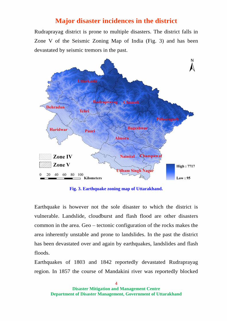
Major disaster incidences in the district
Rudraprayag district is prone to multiple disasters. The district falls in
Zone V of the Seismic Zoning Map of India (Fig. 3) and has been
devastated by seismic tremors in the past.
Fig. 3. Earthquake zoning map of Uttarakhand.
Earthquake is however not the sole disaster to which the district is
vulnerable. Landslide, cloudburst and flash flood are other disasters
common in the area. Geo – tectonic configuration of the rocks makes the
area inherently unstable and prone to landslides. In the past the district
has been devastated over and again by earthquakes, landslides and flash
floods.
Earthquakes of 1803 and 1842 reportedly devastated Rudraprayag
region. In 1857 the course of Mandakini river was reportedly blocked

5
Disaster Mitigation and Management Centre
Department of Disaster Management, Government of Uttarakhand
for three days due to landslides. The course of Mandakini was again
blocked by landslides in 1976.
Flash floods in Kunjya Gad (tributary of Mandakini) in 1979 inflicted
heavy losses in Kontha, Chandranagar and Ajaypur. 29 persons were
killed in this incidence and the course of Mandakini was blocked near
Chandrapuri.
32 persons were killed in Sirwari landslide in Jakholi tehsil in 1986 and
the Uttarkashi Earthquake of 1991 inflicted heavy losses to the
residential and other structures in Jakholi, Okhimath and Rudraprayag.
During the monsoons of 1998 major landslides occurred at many places
in Madhyamaheshwar and Kali Ganga valleys between 11th and 19
th
August. Massive landslide at Bheti – Paundar (in the vicinity of
Mansuna) blocked the course of Madhyamaheshwar river for more than
24 hours causing serious concern in the downstream areas (Fig. 4).
Summary of losses in this event is given in Table 1.
Table 1. Losses incurred by landslides in Madhyamaheshwar and Kali Ganga
valleys in August 1998.
Sl. No. Head Number
1. Human lives lost 103
2. Affected villages 34
3. Affected families 1,767
4. Affected population 9,792
5. Cattle loss 423
6. Houses damaged 1,276
7. Agriculture land loss (in ha) 411

6
Disaster Mitigation and Management Centre
Department of Disaster Management, Government of Uttarakhand
Fig. 4. View of Bheti – Paundar landslide of August 1998.
Chamoli Earthquake of 1991 caused significant loss of human lives and
property in Rudraprayag district (Figs. 5 and 6). Population of 11,500 in
34 villages was affected by the quake that caused loss of 36 human
lives. 176 persons were injured in this incidence that took toll of 140
cattle.
Figs. 5 and 6. View of the devastation at Akhori (left) and Oring (right) villages of
Rudraprayag district due to 1999 Chamoli Earthquake.

7
Disaster Mitigation and Management Centre
Department of Disaster Management, Government of Uttarakhand
Landslides amid abnormally heavy precipitation on 15th
and 16th
July,
2001 in Phata area of Okhimath tehsil caused death of 28 persons (Figs.
7 and 8). Population of 3,924 in 15 villages of the area was affected by
this incidence. 52 houses were damaged / destroyed in the incidence that
took toll of 62 cattle and 43 hectare agricultural land.
Figs. 7 and 8. View of the Phata landslide of July, 2001.
04 persons were killed in the landslide around Vijaynagar in
Agastyamuni on 21st July, 2005. 14 houses were damaged / destroyed in
this incidence.
On 26th July, 2006 landslides and flash floods caused massive losses in
Ladoli, Devali, Gholtir and Gursyal villages and in 2010 losses were
reported from Jaili village of Jakholi tehsil.
The above description makes it amply clear that the areas devastated by
the mass movement at present have been inherently vulnerable and have
been repeatedly affected by various disasters in the past.

8
Disaster Mitigation and Management Centre
Department of Disaster Management, Government of Uttarakhand
Present disaster event
In the Uttarakhand Himalaya, mass movement is often triggered by high
precipitation during monsoon months, destabilization of the toe of the
slope material by road construction and other developmental initiatives
and undercutting of the banks by streams.
Very heavy rainfall was recorded in the area around Okhimath in
Rudraprayag district in the night of 13th September as also in the morning
hours of 14th
September 2012 (Fig. 9). This triggered landslide and debris
flow at many places in the vicinity of Okhimath. It is reported that
landslides started around midnight and the dislodged mass continued to
move down even till the morning.
Fig. 9. Daily precipitation received at Okhimath in the month of September, 2012.
These landslides and debris flows devastated Jua, Kimara, Bamankholi,
Premnagar, Dangwari, Mangoli, Chunni, Salami and Giriagaon villages.
Many houses in these villages were overrun by debris and road connecting
Kund to Okhimath was washed away at Kund and Chunni. The other road
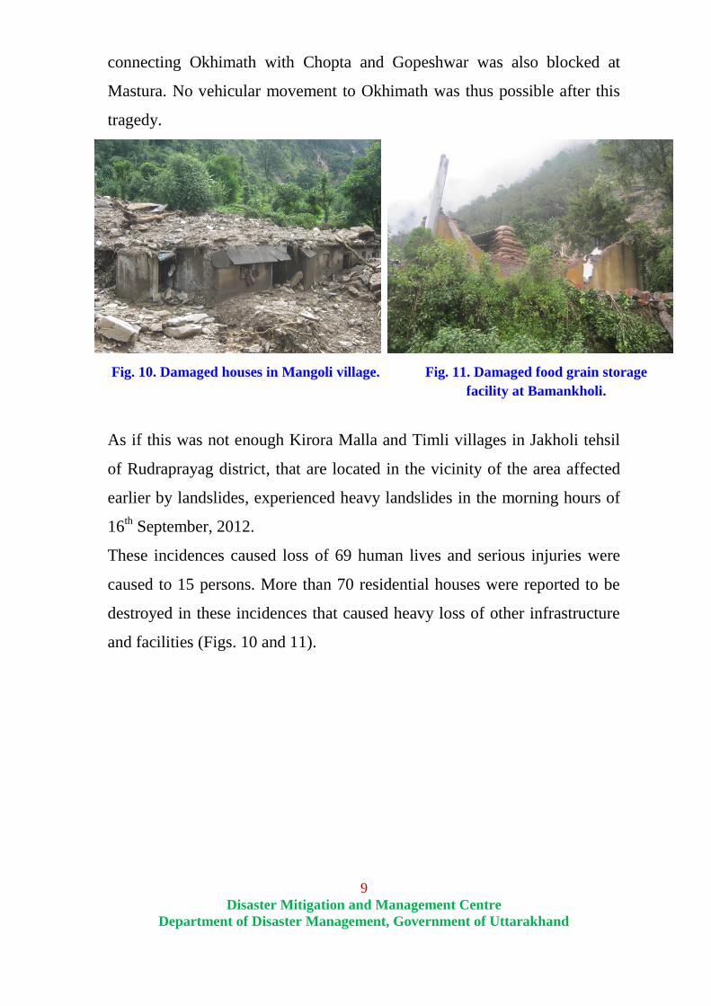
9
Disaster Mitigation and Management Centre
Department of Disaster Management, Government of Uttarakhand
connecting Okhimath with Chopta and Gopeshwar was also blocked at
Mastura. No vehicular movement to Okhimath was thus possible after this
tragedy.
Fig. 10. Damaged houses in Mangoli village. Fig. 11. Damaged food grain storage
facility at Bamankholi.
As if this was not enough Kirora Malla and Timli villages in Jakholi tehsil
of Rudraprayag district, that are located in the vicinity of the area affected
earlier by landslides, experienced heavy landslides in the morning hours of
16th September, 2012.
These incidences caused loss of 69 human lives and serious injuries were
caused to 15 persons. More than 70 residential houses were reported to be
destroyed in these incidences that caused heavy loss of other infrastructure
and facilities (Figs. 10 and 11).

10
Disaster Mitigation and Management Centre
Department of Disaster Management, Government of Uttarakhand
Administrative response
Even though assess to Okhimath was disrupted and it was raining heavily
search and rescue teams of the Department of Disaster Management
managed to reach the disaster affected area in the wee hours of 14th
September and started search and rescue operations. Officials of the district
administration including the District Magistrate and police force also
reached the site of the incidence in the morning. By the evening Army and
ITBP personnel also reached the site of the disaster and started rescue
operations (Figs. 12 and 13).
Figs. 12 and 13. Army and ITBP personnel engaged in search and rescue
operations.
Foot paths connecting the villages having been washed off extra effort had
to be put in to evacuate the survivors to safer locations (Fig. 14). Injured
persons were also quickly evacuated to Base Hospital, Srinagar for advance
medical care by helicopter (Fig. 15).
Fig. 14. Survivors being evacuated. Fig. 15. Air evacuation of the injured.

11
Disaster Mitigation and Management Centre
Department of Disaster Management, Government of Uttarakhand
As the incidence has rendered large number of people without shelter,
clothing and other essential items and food relief camp was set up at
Government Inter College (GIC), Okhimath and Bharat Sewa Ashram,
Okhimath where around 550 persons were accommodated. These persons
were provided clothes and bedding together with other necessities.
Community kitchen was set up in the relief camp with the help of Shanti
Kunj, Haridwar (Figs. 16 and 17).
Fig. 16. Community Kitchen at
GIC Okhimath.
Fig. 17. People being provided food at the
relief camp.
A temporary medical post was also set up in the relief camps to attend to
medical exigencies of any sort (Fig. 18). Apart from this a central store was
established at GIC Okhimath for storing the relief material (Fig. 19).
Fig. 18. Medical post at GIC Okhimath. Fig. 19. Relief material storage
facility at GIC Okhimath.

12
Disaster Mitigation and Management Centre
Department of Disaster Management, Government of Uttarakhand
Together with this various logistics related arrangements were also made for
the search and rescue personnel, organizations bringing in relief material,
media personnel and the VIPs visiting the disaster affected area.
Figs. 20 and 21. Rescue operation in Okhimath by NDRF and rescue team of
disaster management, Uttarakhand
In view of fresh incidences in Jakholi tehsil one platoon of PAC was
mobilized from Srinagar. One company of NDRF also reached the site of
the incidence on 16th
September.
Search and rescue teams of the Department of Disaster Management and
NDRF were present at the incidence site till the search operations were not
called off in the evening of 21st September. Despite best efforts from all
quarters only 53 dead bodies could be recovered (Figs. 20 and 21).

13
Disaster Mitigation and Management Centre
Department of Disaster Management, Government of Uttarakhand
Landuse / land cover
Characterization of the landuse was undertaken using satellite imageries
of the area (Fig. 22). It shows that 57 percent of the area falls under
forest cover and half of this is actually under dense forest cover. 38
percent of the area is observed to be under agricultural operations.
Fig. 22. Landuse map of the area around Okhimath in Rudraprayag district
(Satellite imagery of 30th
March, 2012).

14
Disaster Mitigation and Management Centre
Department of Disaster Management, Government of Uttarakhand
Comparison of the pre and post disaster satellite imageries clearly shows
that more than 0.5 sq km area has been directly affected by landslides
(Fig. 23, Table 2).
Fig. 23. Post – disaster landuse map of the area around Okhimath in
Rudraprayag district (Satellite imagery of 19th
September, 2012).

15
Disaster Mitigation and Management Centre
Department of Disaster Management, Government of Uttarakhand
Post – disaster satellite imagery clearly shows that most of the
devastating landslides initiated in the higher reaches of the N – S
trending steep ridge to the east – northeast of Okhimath. Initiating
mostly in forest area these gathered mass and momentum while
descending down. This is responsible for the devastating power of these
slides.
Most of the habitations were observed to be situated amid agricultural
lands with thick cover of overburden material. This added to the
devastation and a number of houses were completely swept away by the
landslide debris.
Table 2. Statistical details of the landuse / land cover changes brought forth in
the area due to the mass movement of September 2012 (Data based
upon the satellite imageries of 30th
March, 2012 and 19th
September,
2012).
Landuse / landcover
class
Area (in sq km) Percent
change 30th
March,
2012
19th
September,
2012
Change in
area
Dense Forest 4.44 4.56 0.12 2.8
Open Forest 4.49 4.61 0.12 2.7
Agriculture 6.03 5.28 -0.75 -12.4
Open Area 0.30 0.21 -0.08 -27.9
Landslide 0.04 0.55 0.51 1342.1
Water Body 0.22 0.27 0.05 24.1
Habitation 0.28 0.26 -0.02 -7.4
The analysis clearly shows that overwhelming proportion of the area (59
percent) affected by landslides and debris flows was erstwhile under
agricultural operations. Of the total area ravazed by landslides 27
percent is accounted for by open forest, 10 percent by dense forest and 4
percent by habitations. This amply highlights the impact the landslides
on human interests as 64 percent of the area ravazed by landslides falls
under agriculture and habitation.

16
Disaster Mitigation and Management Centre
Department of Disaster Management, Government of Uttarakhand
General geology of the area
The rocks exposed in the Uttarakhand Himalaya range from Archaean to
Holocene in age and are grouped into 15 super-sequences whose spatial
distribution is often controlled by NW-SE trending tectonic
discontinuities that as disposed from south to north are i) Main Frontal
Thrust (MFT), ii) Main Boundary Thrust (MBT), iii) south Almora
Thrust (SAT), iv) North Almora Thrust (NAT) and vi) Main Central
Thrust (MCT).
Super-sequence (litho-package) I (Archaean Central Crystalline) to XI
(Late Paleocene to Middle Eocene Subathu Group) are exposed in part
of Lesser, Great and Tethyan Himalayan zones. The super-sequence XII
(Upper Eocene to Early Miocene Murrees - Dagshai) and XIII (Early
Miocene to Lower Pleistocene Siwalik Group) are restricted to the Sub
Himalayas. The Super-sequence XIV (Middle to Late Pleistocene older
terrace alluvium and lateral moraines) and XV (Holocene newer
alluvium and terminal moraines) occur as valley fill deposits.
The Garhwal Group is extensively developed in the Inner Lesser
Himalaya from Kali valley in the east to Tons valley and beyond in the
west. In the Ganga valley, it is limited by the MCT in the north and
North Almora Thrust (NAT) in the south. It represents super-sequence II
that comprises of low to medium grade meta-sediments. These include
quartzite with penecontemporaneous mafic metavolcanics and
carbonates intruded by epidiorite and granite - gneiss. The Garhwal
Group is intruded by two types of granites viz. biotite granite and
tourmaline granite. The Garhwal Group has been folded into a series of
NW-SE trending doubly plunging anticlines and synclines which have
been refolded into NE-SW trending cross folds.

17
Disaster Mitigation and Management Centre
Department of Disaster Management, Government of Uttarakhand
Central Crystalline (Super-sequence I) forms a part of a linear belt that
can be traced from the Yamuna Valley in the west to the Kali Valley in
the east and beyond in the Nepal Himalaya. Main Central Thrust (MCT)
forms its southern contact with the Garhwal Group while it forms
basement for the deposition for various sequences ranging in age from
Meso - Proterozoic to Quaternary. It possibly forms the oldest
crystalline basement of the Himalaya. Although, it has witnessed
different Precambrian orogenies prior to the strong Himalayan Orogeny,
much of the original composition is preserved. The gneisses,
migmatites, crystalline schist, thick quartzite with conspicuous horizons
of calc-silicates and para-amphibolite with psammite gneisses in the
upper part form bulk of the metasediments. Details of lithostratigraphy
are given in Table 3.
Table 3: Lithostratigraphy of the Central Crystalline and Garhwal Group
(After Agrwal and Kumar 1980, Kumar, 2005).
FORMATIONS LITHOLOGY METAMORPHIC
GRADE
Central Crystalline Group (Supersequence- I)
Rilkot Kyanite, sillimanite-staurolite, biotite schist;
banded calcsilicates.
----------------------------------- Unconformity ---------------------------------
Badrinath Garnet, sillimanite, muscovite and kyanite
bearing gneiss, mica schist, migmatite, calc-
silicate, leucogranite, pegmatite and garnet
mphibolites.
Sillimanite zone
Pandukeshwar Banded quartzitic gneiss and interbedded
quartz mica schist, para-amphibolite.
Kyanite zone
Munsiari
(Joshimath)
Garnet mica gneiss, garnet, staurolite and
kyanite gneisses, tourmaline-mica gneiss,
garnet mphibolites.
Kyanite and
Staurolite zone
Bhimgora
Quartzite
White quartzite with gneiss and schist.

18
Disaster Mitigation and Management Centre
Department of Disaster Management, Government of Uttarakhand
Ragsi Mica schist, gneiss, para-amphibolite. Kyanite zone
-------------------------- Main Central Thrust (MCT) --------------------------
Garhwal Group (Supersequence- II)
Berinag Quartzite with/without penecontemporeneous
mafic metavolcanic intruded by epidiorite.
Deoban Limestone, dolomite and phyllite
Rautgara Quartzite with Penecontemporaneous mafic
metavolcanic intruded by epidiorite.
Uttarkashi
(= Agastmuni)
Grayish black to grayish blue limestone and
dolomite with thinly bedded grey slate. Banded
grey, green and slates interbedded with
quartzite. White to buff, fine-grained, current
bedded quartzite and interbedded slate with
minor lenses of limestone.
-------------------------------- Alaknanda Fault ----------------------------------
The exposed rocks in the Mandakini valley mainly belong to Central
Crystalline and Garhwal Group that are separated by MCT and the
township of Okhimath lies to the north of this tectonic plane.
Most areas affected presently by landslides are observed to show
exposures of Central Crystallines.

19
Disaster Mitigation and Management Centre
Department of Disaster Management, Government of Uttarakhand
Observations made around the affected villages
1. Giriyagaon (Pangran tok)
Giriyagaon is located on the left flank of southwesterly flowing
Madhyamaheshwar river and can be approached by Okhimath -
Mansuna motor road. After travelling for 07 km one however has to
leave the vehicle and walk for 2 km from the road head in the upslope
direction to reach the village.
The investigations were carried out in the area on 19th
September, 2012
and traverses were taken around the site, nala bed, footpath section and
upslope to examine the geological setup as also to investigate the causes
of instability.
The area was observed to be located amid agricultural fields that are
intervened by both rock outcrops and overburden. The rock exposures in
area were observed to comprise of gneisses belonging to the Central
Crystallines. General trend of the rocks was observed to be NW - SE
with moderate dips towards NE. The rocks in the area were observed to
be traversed by numerous joints that constitute important structural
discontinuities affecting the strength of rock mass and stability of
slopes. The foliation planes were observed to dip towards NE at angles
varying from 30º to 35º. Other two prominent structural weaknesses
(joints) were observed to dip towards WSW at steep angles (75º / 245º)
and towards NW at moderately steep angles (45º / 310º).
Reconnaissance geological - geotechnical assessment: Overburden
thickness in the area including weathered rock zone was generally
observed to be as much as 2.0 meters. The overburden material was
observed to comprise of hill wash and debris consisting of grey to
grayish brown, fine grained silty matrix with fragments of gneiss.
20
Disaster Mitigation and Management Centre
Department of Disaster Management, Government of Uttarakhand
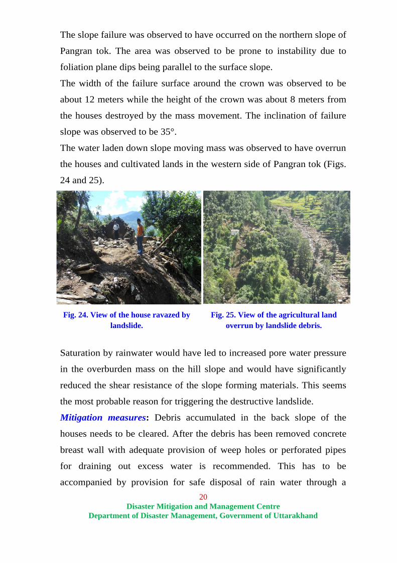
The slope failure was observed to have occurred on the northern slope of
Pangran tok. The area was observed to be prone to instability due to
foliation plane dips being parallel to the surface slope.
The width of the failure surface around the crown was observed to be
about 12 meters while the height of the crown was about 8 meters from
the houses destroyed by the mass movement. The inclination of failure
slope was observed to be 35°.
The water laden down slope moving mass was observed to have overrun
the houses and cultivated lands in the western side of Pangran tok (Figs.
24 and 25).
Fig. 24. View of the house ravazed by
landslide.
Fig. 25. View of the agricultural land
overrun by landslide debris.
Saturation by rainwater would have led to increased pore water pressure
in the overburden mass on the hill slope and would have significantly
reduced the shear resistance of the slope forming materials. This seems
the most probable reason for triggering the destructive landslide.
Mitigation measures: Debris accumulated in the back slope of the
houses needs to be cleared. After the debris has been removed concrete
breast wall with adequate provision of weep holes or perforated pipes
for draining out excess water is recommended. This has to be
accompanied by provision for safe disposal of rain water through a

21
Disaster Mitigation and Management Centre
Department of Disaster Management, Government of Uttarakhand
network of interconnected drains into the main stream. This would help
in stabilizing this site.
2. Salami
Salami village is located on the left flank of southwesterly flowing
Madhyamaheshwar river and can be approached by Okhimath -
Mansuna link road. After travelling for 3 km one has however to trek for
1.5 km in the upslope direction to reach the village. The area was
observed to be drained by three local streams.
The area was investigated on 19th
September, 2012 and traverses were
taken around the site, nala bed, road section and upslope to examine the
geological setup of the area as also to investigate the causes of
instability.
The area was observed to be located amid agricultural fields that were
interrupted by both outcrops and overburden material. Rock exposures
of Central Crystalline gneisses were observed along the road section and
as also upslope of the village. The general trend of the rocks was
observed to be NW-SE with moderate dips towards NE. The rocks in the
area were observed to be traversed by numerous joints that constitute
important structural discontinuities affecting the strength of rock mass
and stability of the slopes. The foliations were observed to dip towards
NE at angles varying from 28º to 33º. The other two weak planes (joints)
were observed to dip towards W and NNE (60º / 270º and 75º / 010º).
Reconnaissance geological-geotechnical assessment: General
overburden thickness including weathered rock zone in the area was
observed to be up to 2.0 meters. The overburden material was observed
to comprise of hill wash and debris consisting of grey to grayish brown,
fine grained silty matrix with fragments of gneiss.

22
Disaster Mitigation and Management Centre
Department of Disaster Management, Government of Uttarakhand
A number of agricultural fields around the village were observed to be
damaged due to shallow water saturated debris flows (Figs. 26 and 27).
Water is deduced to be the main driving force of these debris flows.
Fig. 26. Photograph showing slope failure
and ensuing damage to a number of
agricultureal fields around Salami village.
Fig. 27. View of the houses damaged by
water saturated debris in Salami village.
The debris flows were observed to have overrun five residential houses
of the village. Amongst these, one house was severely damaged while
the others were partially damaged.
Mitigation measures: In this area there exist a number of severely
damaged structures that are located on highly vulnerable area falling in
close proximity of the course of seasonal drainage channel. These are
therefore endangered by bank erosion during coming monsoons. These
are required to be removed immediately.
Debris accumulated around the houses needs to be cleared. After this
oblique concrete retaining structures of appropriate height would have to
be constructed upslope of affected site. Particular caution is required to
ensure that these structures are founded on compact rocks and compact
soil materials. This would help in protecting the remaining houses.
New constructions and other anthropogenic interventions are required to
be avoided in the proximity of seasonal streams.

23
Disaster Mitigation and Management Centre
Department of Disaster Management, Government of Uttarakhand
It is required that anthropogenic intervention of all kinds be strictly
regulated in the proximity of both seasonal and perennial streams.
Appropriate legislative intervention in this regard is a must and this
recommendation applies equally for all the areas under the present focus
as also for rest of the state.
3. Chunni, Mangoli, Brahmankholi, Premnagar,
Dangwari, Jua and Sansari villages
These villages are located on the Kund – Okhimath - Mansuna motor
road and are all located in close proximity of each other. These villages
are situated at distances varying between 0.5 to 2.5 km from the bus
stand at Okhimath. All these villages are situated on the left flank of
south flowing Mandakini river. A number of other local seasonal /
perennial streams also drain the area.
The areas were investigated on 18th
and 20th September, 2012 and
traverses were taken around the site, nala bed, footpath section and
upslope to examine the geological setup of the area together with the
causes of slope instability.
The areas under present focus were observed to be located in close
proximity of the motor road amid agricultural fields that are occupied by
outcrops as well as overburden. The upslope area was observed to have
very steep rock cut slope with N-S trending ridge.
Exposures of Central Crystalline gneisses were observed along the road
section. The general trend of the rocks was observed to be NW-SE with
gently to moderately steep dips towards NE. The rocks in the area were
observed to be traversed by numerous joints that constitute major
structural discontinuities affecting the strength of rock mass and stability
of slopes. The foliation planes were observed to dip in northeasterly
24
Disaster Mitigation and Management Centre
Department of Disaster Management, Government of Uttarakhand
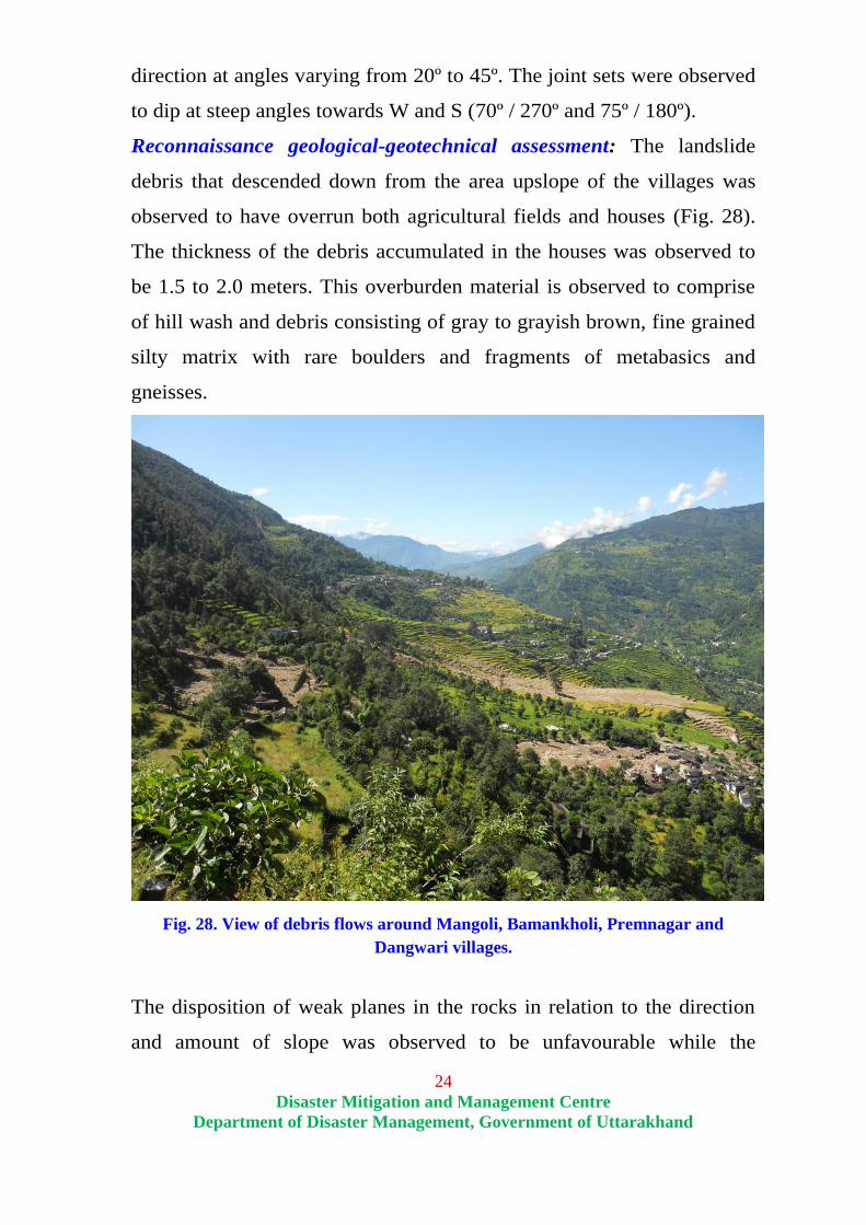
direction at angles varying from 20º to 45º. The joint sets were observed
to dip at steep angles towards W and S (70º / 270º and 75º / 180º).
Reconnaissance geological-geotechnical assessment: The landslide
debris that descended down from the area upslope of the villages was
observed to have overrun both agricultural fields and houses (Fig. 28).
The thickness of the debris accumulated in the houses was observed to
be 1.5 to 2.0 meters. This overburden material is observed to comprise
of hill wash and debris consisting of gray to grayish brown, fine grained
silty matrix with rare boulders and fragments of metabasics and
gneisses.
Fig. 28. View of debris flows around Mangoli, Bamankholi, Premnagar and
Dangwari villages.
The disposition of weak planes in the rocks in relation to the direction
and amount of slope was observed to be unfavourable while the

25
Disaster Mitigation and Management Centre
Department of Disaster Management, Government of Uttarakhand
crumbled nature of the rocks attributed to jointing and local folding was
responsible for low rock mass strength.
The landslide that devastated this area was a huge mass of water
saturated debris. While moving down along the steep slope from the
uphill area it generated enough momentum to ravage everything that
came in its way. High flash-flood discharge of the local streams
contributed to the instability of the hill slopes of the area.
Fig. 29. Photograph dipicting
debris flow in Jua Kimana village. Fig. 30. Photograph showing debris flow around
Chunni village.
Number of agricultural fields and houses were damaged due to shallow
debris flows in the area (Fig. 29, 30 and 31). Rapidly running water and
gravity driven movement induced by lubricating action of ground water
were largely responsible for driving the debris down slope at fast pace.
A seasonal stream was observed to flows through Sansari village. The
agricultural fields in the vicinity of this stream were observed to show
signs of ground subsidence on its left flank. Ground fissures as wide as
1.5 m were also observed around this location (Fig. 32).

26
Disaster Mitigation and Management Centre
Department of Disaster Management, Government of Uttarakhand
Fig. 31. Photograph showing
devastation caused by debris flow
around Mangoli.
Fig. 32. Photograph depicting subsidence in
agricultural lands due to bank eroion by seasonal
nala around Sansari.
Mitigation measures: Removal the transported material which is come
from the upslope through local streams/gulley’s into agricultural lands.
After removing the materials local community will be further utilize the
agricultural lands.
There should be thorough geotechnical assessment of affected sites of
important exists houses whereas infrastructures in the verge of damage
and/or partially damaged by destructive debris flows.
Eastern side as well as upslope of villages, all nalas need to be
channelizing with cascade form downhill into the main stream. This will
help to protect rest of exists houses from excessive rise of water level
during the monsoon.
It is suggested that all exists houses near and on specific affected sites
along newly developed nalas bed area be immediately removed.
Good lining/gradient/cleaning of road-side drains to prevent further
water percolation/stagnation and erosion. These measures focus at
preventing development of the harmful saturation, pore pressures and

27
Disaster Mitigation and Management Centre
Department of Disaster Management, Government of Uttarakhand
erosion, and flooding in the weak slopes/zones due to heavy
precipitation.
Presently the village Sansari area questioned site is highly susceptible to
landslide so the local population is advised not to stay in this highly
vulnerable site.
4. Kimana
Kimana vilalge is located above the Okhimath - Chaupta motor road at a
distance of 1.0 km from the junction of Mansuna – Okhimath and
Chaupta - Okimath motor roads. It is located on the right flank of
southwest flowing Kakra Gad, a tributary of Mandakini river.
The affected area was investigated on 20th September, 2012 and
traverses were taken around the site, footpath section and upslope to
examine the geological setup.
Geology of the area: The village was observed to be located amid
agricultural fields and occupied by outcrops as well as overburden
material. Upslope side was observed to have very steep rock cut slope
with N-S trending ridge. Exposures of Central Crystalline gneisses were
observed on the upslope side of the village as also along the road
section. The general trend of the rocks was observed to be NW - SE
with moderate dips towards NE. The rocks were observed to be
traversed by numerous joints that constitute important structural
discontinuities affecting the strength of rock mass and stability of
slopes. The foliation plane was generally observed to be well developed
and dips at angles varying between 30º to 35º towards northeast. The
joint sets were observed to have steep dips towards SW and SSE
respectively (65º / 240º and 70º / 165º).

28
Disaster Mitigation and Management Centre
Department of Disaster Management, Government of Uttarakhand
Reconnaissance geological-geotechnical assessments: The overburden
thickness including weathered rock in the area was observed to be up to
3.0 meters. The overburden material comprised of hill wash and debris
consisting of grey to brown, fine grained silty matrix with fragments of
gneisses.
The spatial disposition of joint sets was observed to result in the
formation of wedges that facilitated detachment of the rock mass (Fig.
33). The same was observed to slide down and overrun the agricultural
fields near the Panchayat Ghar (Fig. 34).
Fig. 33. Photograph depicting rocks
detached due to wedging.
Fig. 34. View of rock fall zone near
Panchyat Ghar in Kimana village.
Mitigation measures: Devastation caused by the down slope moving
mass is a direct function of the rock mass and fragmentation of large
detached blocks is sure to reduce the impact. It is therefore
recommended that the large detached rock mass be broken into small
pieces so that the area situated on the down slope direction is safe.

29
Disaster Mitigation and Management Centre
Department of Disaster Management, Government of Uttarakhand
5. Pathali and Semla
These villages are located on the right flank of southwest flowing Kakra
Gad, a tributary of Mandakini river and can be approached by Okhimath
- Semla link motor road. Pathali and Semla are at a distance of 2.0 and
5.0 km respectively from Okimath.
These areas were investigated on dated 20th
September, 2012 and
traverses were taken around the site, road section and upslope to
examine the geological setup.
Geology of the area: A rock cum debris slide reportedly occurred in
Semla village on 15th
September, 2012. This affected the agricultural
fields located below the road. The agricultural fields were observed to
be occupied by both outcrops and overburden material. In the upslope
direction the area was observed to have very steep rock cut slope with
E-W trending ridge. Exposures of Central Crystalline schists were
observed along the road section. The rocks in the area were traversed by
numerous joints. The foliation plane is generally observed to be well
developed and observed to dip angles varying between 35º to 40º
towards northeast. The joint sets were observed to have steep dips
towards SW and SSE respectively (65º / 250º and 70º / 170º).
Reconnaissance geological-geotechnical assessment: The overburden
thicknesses in the area around the villages was observed to be 2.0 m.
This overburden material comprised of hill wash and debris that
consisted of gray to grayish brown, fine grained silty matrix with rare
boulders and fragments of schist.
Intense rain facilitated the slide by providing lubricating effect between
the competent rocks that reduced the shear resistance of the slope
forming materials together with the overburden material. This triggered
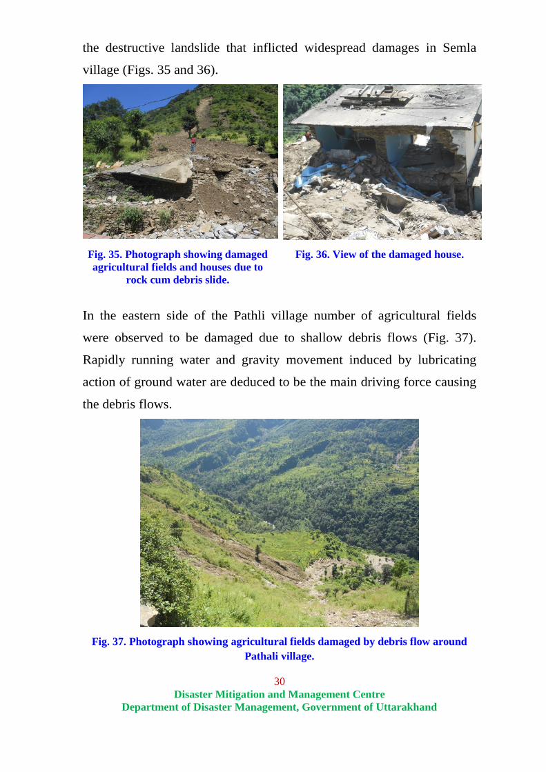
30
Disaster Mitigation and Management Centre
Department of Disaster Management, Government of Uttarakhand
the destructive landslide that inflicted widespread damages in Semla
village (Figs. 35 and 36).
Fig. 35. Photograph showing damaged
agricultural fields and houses due to
rock cum debris slide.
Fig. 36. View of the damaged house.
In the eastern side of the Pathli village number of agricultural fields
were observed to be damaged due to shallow debris flows (Fig. 37).
Rapidly running water and gravity movement induced by lubricating
action of ground water are deduced to be the main driving force causing
the debris flows.
Fig. 37. Photograph showing agricultural fields damaged by debris flow around
Pathali village.
31
Disaster Mitigation and Management Centre
Department of Disaster Management, Government of Uttarakhand
Mitigation measures: The slope is required to be modified at different
level in the area affected by debris slide at Semla village by benching
and erection of appropriately designed buttress / retaining walls with
suitable provision of weep hole.
Well anchored concrete wall has to be constructed at the toe of the
landslide where maximum damage has been inflicted to the houses. It
would help in protecting the rest of the houses in case of future instances
of slope instability.
Burst wall with appropriate height is required to be constructed on the
uphill side of Semla village around the road.
It is recommended that the debris and rock mass accumulated by the
slide in the agricultural lands of Pathali village be cleared so as to enable
masses to continue with routine agricultural chores.
6. Kirora Malla
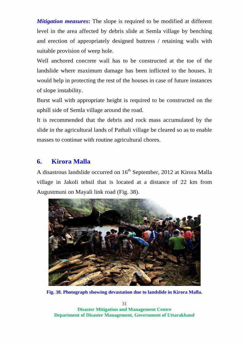
A disastrous landslide occurred on 16th September, 2012 at Kirora Malla
village in Jakoli tehsil that is located at a distance of 22 km from
Augustmuni on Mayali link road (Fig. 38).
Fig. 38. Photograph showing devastation due to landslide in Kirora Malla.

32
Disaster Mitigation and Management Centre
Department of Disaster Management, Government of Uttarakhand
The area was observed to be located just below the road amid
agricultural land and occupied by outcrops as well as overburden. The
overburden thickness including weathered rock mass around the village
was observed to be 3.0 meters. This overburden material comprised of
hill wash and debris consisting of gray to grayish brown, fine grained
silty matrix with fragments of quartz schist phyllite.
Rock exposures of quartz schist and phyllites belonging to Lesser
Himalaya were observed along the road section as also upslope of the
village. The rocks in the area were observed to be traversed by
numerous joints that constitute important structural discontinuities
affecting the strength of rock mass and stability of slopes. The foliation
planes were generally observed to be well developed and dipping at
angles varying between 35º to 40º towards northeast. The joint sets were
observed to have steep dips towards NNW and W respectively (80º /
350º and 55º / 270º).
Fig. 39. Photograph showing debris flow
at kirora Malla. Fig. 40. View of completely damaged
house at Kirora Malla.
Reconnaissance geological-geotechnical assessments: A family of five
persons was reportedly buried under the debris of the destructive
landslides caused by excessive precipitation. Intense rainfall in the area
resulted in high stream discharge and soil saturation with reduction of

33
Disaster Mitigation and Management Centre
Department of Disaster Management, Government of Uttarakhand
the coefficient of internal friction of the slope forming materials. This
induced massive mass movement that completely destroyed a house that
came in its way (Fig. 39 and 40).
Another landslide was observed to be mass of water saturated debris that
descended down the steep slope through the nala and ravaged a house
that came in its way at Bengar tok (Figs. 41 and 42). Fortunately the
flow of water was diverted upslope of the house towards western side
and this limited the magnitude of damage.
Fig. 41. Photograph showing slight
debris flow at backslope of the house. Fig. 42. View of debris overrunning a
toilet at Bengar tok.
Mitigation measures: In the Bengar tok the affected site falls in the
course of perennial nala and therefore the population residing in the
surrounding area needs to be shifted to alternate safe locations.
34
Disaster Mitigation and Management Centre
Department of Disaster Management, Government of Uttarakhand
Discussion and future strategy
Though often dubbed as being a menace for the mountain areas landslide is
a powerful landscape building process. It helps in soil development and
often provides good aquifers. Large number of habitations in the hills are
therefore located in close proximity of stabilised old landslides.
Our ancestors however very well understood the basic fact that howsoever
stabilized the old slide material be it is likely to be reactivated by excessive
precipitation and other factors like seismic shaking. They therefore choose
not to settle over the stabilized slides. Review of the habitation pattern of
the hills brings forth the fact that despite practicing agriculture over
stabilised old landslides they deliberately settled down over stable rocks at
locations that were in the middle and upper hill slopes. This clearly implied
that they had to negotiate long distances daily for both mending fields and
fetching water. They thus preferred safety over comfort and this is the
simple underlying fact that saved them from the fury of both landslides and
flash floods.
Our ancestors could also appreciate the interrelationship between landslides
and saturation of soil and other slope forming materials. They therefore
devised ways of disposing off excess precipitation in the main stream by a
network of drains in the upper reaches of vulnerable slopes. Remnants of
these can still be observed in Madhyamaheshwar valley. They at the same
time kept the far flung fields outward sloping and unbunded.
Unplanned construction of roads on the vulnerable slopes in the recent times
and unscientific disposal of the excavated debris have induced instability in
the hill slopes and many areas in the proximity of the roads have became
chronically prone to landslides. Detorioration of hill agriculture and
concentration of economic opportunities and other facilities in close
proximity of the roads encouraged people to settle down by the road side.
35
Disaster Mitigation and Management Centre
Department of Disaster Management, Government of Uttarakhand
Increased inflow of tourist and pilgrim traffic in the area only encouraged
this trend.
With the passage of time traditional practices of landslide management were
forgotten and more and more people started to settle in areas vulnerable to
landslides. This reflects increasing trend of giving priority to comfort over
safety in all the spheres of life. This resulted in enhanced landslide risk in
the hills.
It needs to be understood very well that landslide is a natural process in the
hills and it is not possible to rule out their occurrence. Their impact can
however be reduced to a great extent by proper planning and timely
implementation of appropriate mitigation schemes.
It is suggested that the following measures be discussed, debated and acted
upon, with amendments where required, for making the hills safer from the
threat of landslides:
Revival of traditional practices of landslide management: Traditional
landslide management practices of the region are required to be studied and
documented in detail. These can be suitably amalgamated with the modern
technical inputs and put to practice in landslide prone areas.
Ban on the use of explosives: Use of explosives in the fragile Himalayan
terrain for infrastructure developmental works introduces instability in the
rocks and therefore use of explosives should necessarily be banned.
Limiting construction of roads in the hills: Construction of roads is often
highlighted as one of the prime reasons for landslides to occur. Construction
of roads is therefore required to be checked and limited. Alternative
connectivity options, such as rope-ways would be better suited for the hills.
Discontinuing target driven schemes: Target driven schemes for
connecting all the habitations with particular characteristics by road are
required to be given a second thought in the hills. These roads, as

36
Disaster Mitigation and Management Centre
Department of Disaster Management, Government of Uttarakhand
constructed under PMGSY, have in no way added to the prosperity of the
region but have certainly disturbed its ecological balance. It is required to be
clearly understood that attempts to connect every village, tok and house in
the mountainous areas are not going to be beneficial in the long run.
Geological studies: It is highly required that detailed geological
investigations be carried out before finalizing the alignment of the roads in
the hills. This would help in judiciously avoiding the stretches that are
likely to become landslide prone.
Debris disposal policy: Unplanned and unscientific disposal of the
excavated material along the hill slopes often initiates landslides besides
causing loss of forest resources, agricultural land and water sources. A clear
cut policy for the disposal of excavated material is immediately required for
the hills. The cost of planned disposal of the excavated material would then
have to be made part of the routine budget of the developmental initiative. It
might sound like additional financial burden but for larger good of the
society provision for this would have to be made.
Hazard zonation: At present there exists to mechanism of checking
developmental initiatives on the pretext that the area is prone to certain
hazard. So long as there is no dispute with regard to the title of the land one
is free to use it in the manner he deems appropriate. Areas that have become
chronically prone to mass movement and other hazards are therefore
required to be identified and officially notified and all anthropogenic
interventions in these areas have to be banned by law. This provision would
automatically ban habitation in the close proximity of seasonal streams and
rivers. In case people are already residing in such areas provision has to be
made for their timely relocation. This provision in the long run would
encourage people to settle down at safer places due to enhanced awareness

37
Disaster Mitigation and Management Centre
Department of Disaster Management, Government of Uttarakhand
in this regard and differential land pricing and insurance premium
depending on its hazard proneness.
Landslide treatment: Landslides have to be scientifically treated in their
initial stages. This would ensure that the problem does not become chronic.
Landslide prediction: With establishment of rainfall thresholds for mass
movement on different lithologies and slopes it is possible to develop a
predictive model for landslides. For this close network of automatic rain
gauges would have be established in the region and data would have to be
collected on various rock parameters and slope characteristics. To begin
with this exercise can be initiated in some of the vulnerable areas and the
same can be gradually extended to other areas.
Though put forth plain and simple it all is not going to be easy. Strong
lobbying would be required for legislative action and bringing forth policy
changes, formation of rules and regulations. Firm executive action in
accordance with letter and spirit of the legislative decisions would then be
required to ensure compliance of the same.