Embed Size (px)
Citation preview
Please fill out information in all gray boxes
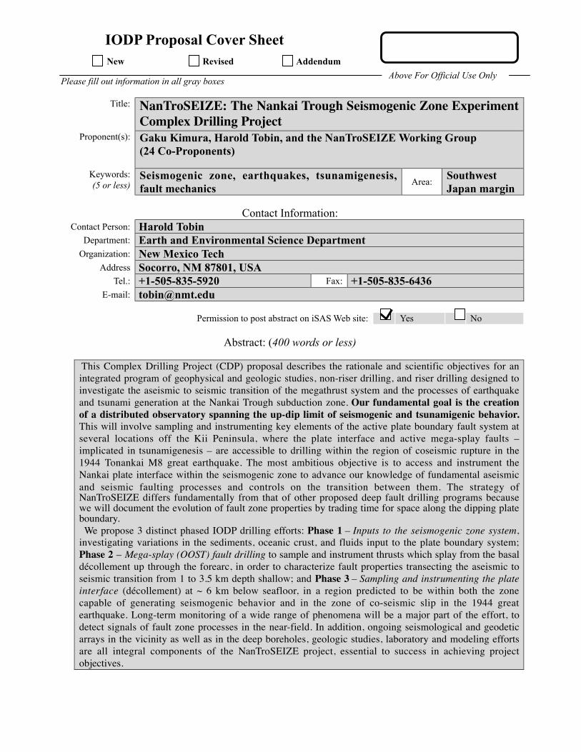
Title: NanTroSEIZE: The Nankai Trough Seismogenic Zone ExperimentComplex Drilling Project
Proponent(s): Gaku Kimura, Harold Tobin, and the NanTroSEIZE Working Group(24 Co-Proponents)
Keywords:(5 or less)
Seismogenic zone, earthquakes, tsunamigenesis,fault mechanics
Area:SouthwestJapan margin
Contact Information:Contact Person: Harold Tobin
Department: Earth and Environmental Science DepartmentOrganization: New Mexico Tech
Address Socorro, NM 87801, USATel.: +1-505-835-5920 Fax: +1-505-835-6436
E-mail: [email protected]
Permission to post abstract on iSAS Web site: Yes No
Abstract: (400 words or less)
This Complex Drilling Project (CDP) proposal describes the rationale and scientific objectives for anintegrated program of geophysical and geologic studies, non-riser drilling, and riser drilling designed toinvestigate the aseismic to seismic transition of the megathrust system and the processes of earthquakeand tsunami generation at the Nankai Trough subduction zone. Our fundamental goal is the creationof a distributed observatory spanning the up-dip limit of seismogenic and tsunamigenic behavior.This will involve sampling and instrumenting key elements of the active plate boundary fault system atseveral locations off the Kii Peninsula, where the plate interface and active mega-splay faults –implicated in tsunamigenesis – are accessible to drilling within the region of coseismic rupture in the1944 Tonankai M8 great earthquake. The most ambitious objective is to access and instrument theNankai plate interface within the seismogenic zone to advance our knowledge of fundamental aseismicand seismic faulting processes and controls on the transition between them. The strategy ofNanTroSEIZE differs fundamentally from that of other proposed deep fault drilling programs becausewe will document the evolution of fault zone properties by trading time for space along the dipping plateboundary. We propose 3 distinct phased IODP drilling efforts: Phase 1 – Inputs to the seismogenic zone system,investigating variations in the sediments, oceanic crust, and fluids input to the plate boundary system;Phase 2 – Mega-splay (OOST) fault drilling to sample and instrument thrusts which splay from the basaldécollement up through the forearc, in order to characterize fault properties transecting the aseismic toseismic transition from 1 to 3.5 km depth shallow; and Phase 3 – Sampling and instrumenting the plateinterface (décollement) at ~ 6 km below seafloor, in a region predicted to be within both the zonecapable of generating seismogenic behavior and in the zone of co-seismic slip in the 1944 greatearthquake. Long-term monitoring of a wide range of phenomena will be a major part of the effort, todetect signals of fault zone processes in the near-field. In addition, ongoing seismological and geodeticarrays in the vicinity as well as in the deep boreholes, geologic studies, laboratory and modeling effortsare all integral components of the NanTroSEIZE project, essential to success in achieving projectobjectives.
IODP Proposal Cover SheetNew Revised Addendum
Above For Official Use Only

Scientific Objectives: (250 words or less)
The principal scientific objective of the proposed drilling is to acquire data bearing on and testing the followingkey hypotheses:
1. Systematic, progressive material and state changes control the onset of seismogenic behavior onsubduction thrusts.
2. Subduction zone megathrusts are weak faults.
3. Within the seismogenic zone, relative plate motion is primarily accommodated by coseismicfrictional slip in a concentrated zone.
4. Physical properties, chemistry, and state of the fault zone change with time during the earthquakecycle.
5. The mega-splay (OOST) thrust fault system slips in discrete events which may includetsunamigenic slip during great earthquakes.
Proposed NanTroSEIZE efforts will test models for the frictional behavior of fault rocks across theaseismic – seismogenic transition, the composition of faults and fluids and associated pore pressure andstate of stress, partitioning of strain spatially between basal interface and splays, temporally betweencoseismic and interseismic periods, and between infraseismic and aseismic events vs. seismic events.Long-term borehole observations potentially ultimately will test whether interseismic variations ordetectable precursory phenomena exist prior to great subduction earthquakes.
Please describe below any non-standard measurements technology needed to achieve the proposed scientific objectives.
In various combinations, the following non-standard measurements are desired for sites covered by this CDP:
During Drilling and Casing Installation: Logging/measurement while drilling, drill stem & wirelinepressure/permeability tests, cross-hole hydrologic tests, offset/walkaway vertical seismic profiling, cross-holeseismic.
Long-Term Borehole Observatory Monitoring: Array temperature measurement, pressure measurement in packer-isolated intervals, array measurement for short-period, three-component seismometry, bottom-hole broadband andstrong motion seismometry, bottom hole strain, multi-level tilt, and long-term fluid collection for biological andgeochemical measurements. Many of these measurements will need to be made at temperatures of ~ 80 – 150+ C.
Proposed Sites:
SEE INDIVIDUAL PROPOSALS FOR EACH PHASE FOR SITE DESCRIPTIONS
1
Please fill out information in all gray boxes
Title: 603-Add2, NanTroSEIZE Proposal 603 Addendum. Mechanical and Hydrologic State
of Mega-Splay Faults: Implications for Seismogenic Faulting and Tsunami Generation
Proponent(s): Lisa McNeill (Southampton), Greg Moore (IFREE-JAMSTEC), Harold Tobin (U.
Wisconsin), Masataka Kinoshita (IFREE-JAMSTEC), Casey Moore (UC Santa Cruz), Mike
Underwood U. (Missouri), Gaku Kimura (Tokyo Univ.)
Keywords:
(5 or less)
Seismogenic zone, earthquakes, tsunamigenesis, megasplay
fault activity, fault mechanics Area:
Nankai Trough,
Japan
Contact Information: Contact Person: Lisa McNeill
Department: National Oceanography Centre, Southampton
Organization: University of Southampton
Address European Way, Southampton, UK
Tel.: 44-23-8059 3640 Fax: 44-23-8059 3059
E-mail: [email protected]
Permission to post abstract on IODP-MI Web site: Yes No
Abstract: (400 words or less)
We are requesting to add two additional sites to our list of contingency sites for NanTroSEIZE drilling
during Stage 1. These two sites could be cored with APC/XCB (or HPCS/ESCS) during any of the 3
scheduled expeditions on either Chikyu or JR. The cores are designed to provide detailed age control on
slope sediment that overlies the tips of the mega-splay fault system offshore Kii Peninsula. The new 3D
seismic data volume images these sediments in greater detail than was previously available and we are able
to choose key sites to date the most recent movement along the splay faults. The near-surface displacement
history of these faults is key to understanding the timing and development of the splay system.
IODP Proposal Cover Sheet
New Revised Addendum
Above For Official Use Only
2
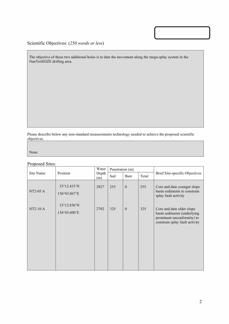
Scientific Objectives: (250 words or less)
The objective of these two additional holes is to date the movement along the mega-splay system in the
NanTroSEIZE drilling area.
Please describe below any non-standard measurements technology needed to achieve the proposed scientific
objectives.
None
Proposed Sites:
Penetration (m) Site Name Position
Water
Depth
(m) Sed Bsm Total Brief Site-specific Objectives
NT2-05 A
NT2-10 A
33°12.433’N
136°43.867’E
33°12.830’N
136°43.600’E
2827
2702
255
325
0
0
255
325
Core and date younger slope
basin sediments to constrain
splay fault activity
Core and date older slope
basin sediments (underlying
prominent unconformity) to
constrain splay fault activity

Please fill out information in all gray boxes
Title: NanTroSEIZE Reference Sites:Sampling and Measuring Inputs to the Seismogenic Zone
Proponent(s): Michael Underwood, Juichiro Ashi, Wonn Soh, Julia Morgan, Saneatsu Saito, Demian Saffer, Elizabeth Screaton, Masataka Kinoshita, Gregory Moore, Miriam Kastner, Susan Bilek, Kohtaro Ujiie
Keywords:(5 or less)
Subduction inputs; physical and chemical hydrology;lithostratigraphy; structural geology; heat flow and diagenesis
Area:Nankai Trough,Shikoku Basin
Contact Information:Contact Person: Michael Underwood
Department: Department of Geological SciencesOrganization: University of Missouri
Address 101 Geology BuildingTel.: 573-882-4685 Fax: 573-882-5458
E-mail: [email protected]
Permission to post abstract on iSAS Web site: X Yes No
Abstract: (400 words or less)
A foremost goal of IODP is to drill into the seismogenic zone of a plate-boundary fault. The CDPproposal for NanTroSEIZE (Nankai Trough Seismogenic Zone Experiment) identifies several phases ormilestones in pursuit of that goal. Phase 1, the shallow reference sites, will test five fundamentalhypotheses: (1) Systematic and progressive changes in material properties and state control the onset ofseismogenic behavior and locking of subduction thrusts. (2) Subduction zone megathrusts are weak faults;that is, they slip under conditions of low resolved shear stress. (3) Within the seismogenic zone, relativeplate motion is accommodated primarily by coseismic frictional slip in a concentrated zone. (4) Out-of-sequence (or splay) faults develop where the plate-boundary fault is strong relative to adjacent zoneswithout splay faults. (5) The plate-boundary fault, near its up-dip limit of seismicity, follows the interfacebetween underthrust metasedimentary rocks and igneous basement. Reference sites serve three vital roles in testing these hypotheses. First, they establish, prior tosubduction, how lithology, deformation features, hydrologic properties (porosity, permeability), variablesof state (stress, pore pressure, temperature) and in situ properties (mineral and fluid composition,alteration, grain fabric, strain rate, microseismicity) change from a basement high (potential asperity) to abasement plain. Second, after showing how basement topography affects stratigraphy and hydrology (and,therefore, mechanical properties), we will separate those inherited variables from changes superimposedby diagenesis, deformation, and fluid flow along the P-T path of subduction. Third, to track fault-zoneevolution toward stick-slip behavior, we need to begin characterizing the plate-boundary fault where it isshallow and aseismic, then move down dip (with deep drilling) into the seismogenic zone. Data from previous DSDP-ODP legs cannot be imported to the Kii-Kumano region becausestratigraphic, thermal, and hydrologic inputs to Nankai Trough change so much along strike. Drilling tworeference sites within the Shikoku Basin will quantify initial conditions and show how basement reliefinfluences the pre-subduction geometry of sedimentary facies, temperature, permeability, sediment andbasement alteration, and fluid flow. A third reference site at the toe of the accretionary prism will showearly-phase deformation and verify how strata get partitioned above and below the frontal decollement.The prism-toe site, moreover, will add a third dimension to constraints on facies architecture,hydrogeology, thermal structure, and reaction progress where rocks first enter the subduction zone.
iSAS/IODP Proposal Cover SheetNew Revised Addendum
Above For Official Use Only
Scientific Objectives: (250 words or less)
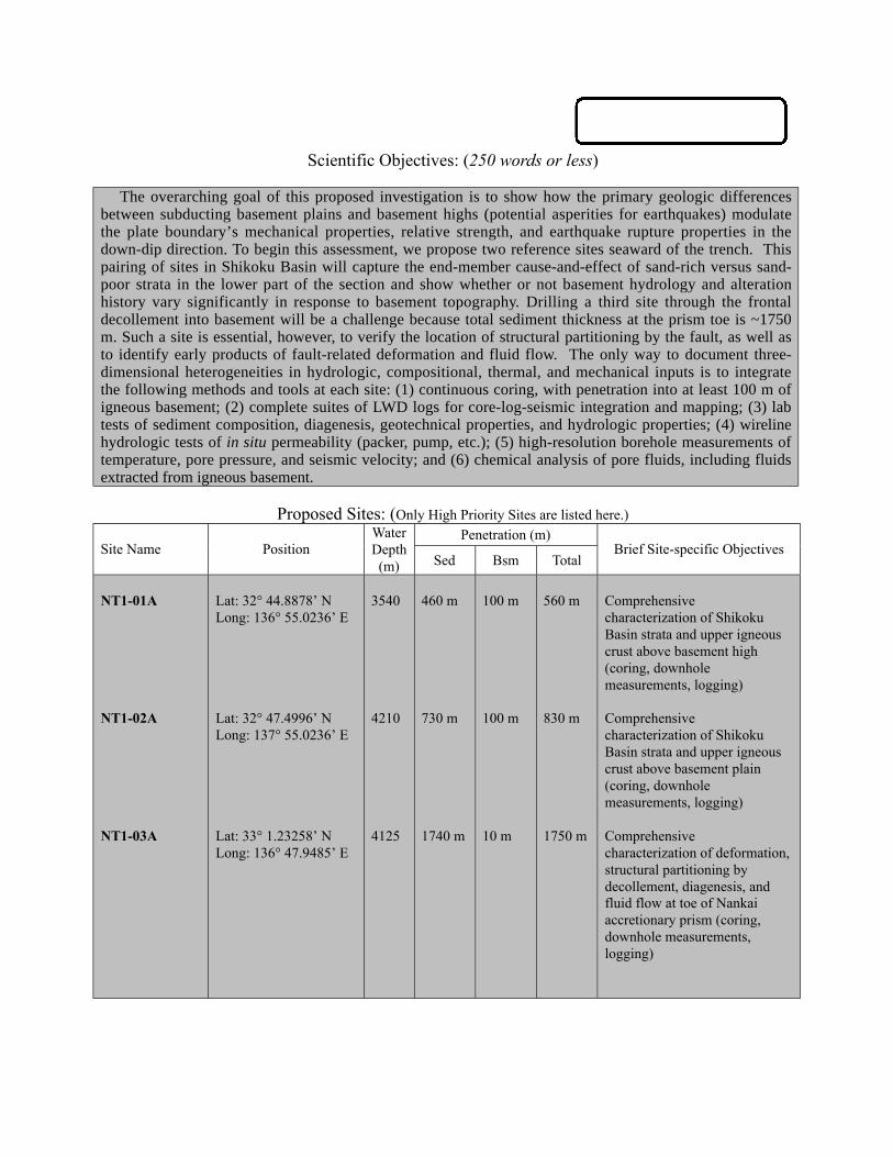
The overarching goal of this proposed investigation is to show how the primary geologic differencesbetween subducting basement plains and basement highs (potential asperities for earthquakes) modulatethe plate boundary’s mechanical properties, relative strength, and earthquake rupture properties in thedown-dip direction. To begin this assessment, we propose two reference sites seaward of the trench. Thispairing of sites in Shikoku Basin will capture the end-member cause-and-effect of sand-rich versus sand-poor strata in the lower part of the section and show whether or not basement hydrology and alterationhistory vary significantly in response to basement topography. Drilling a third site through the frontaldecollement into basement will be a challenge because total sediment thickness at the prism toe is ~1750m. Such a site is essential, however, to verify the location of structural partitioning by the fault, as well asto identify early products of fault-related deformation and fluid flow. The only way to document three-dimensional heterogeneities in hydrologic, compositional, thermal, and mechanical inputs is to integratethe following methods and tools at each site: (1) continuous coring, with penetration into at least 100 m ofigneous basement; (2) complete suites of LWD logs for core-log-seismic integration and mapping; (3) labtests of sediment composition, diagenesis, geotechnical properties, and hydrologic properties; (4) wirelinehydrologic tests of in situ permeability (packer, pump, etc.); (5) high-resolution borehole measurements oftemperature, pore pressure, and seismic velocity; and (6) chemical analysis of pore fluids, including fluidsextracted from igneous basement.
Proposed Sites: (Only High Priority Sites are listed here.)Penetration (m)
Site Name PositionWaterDepth(m) Sed Bsm Total
Brief Site-specific Objectives
NT1-01A
NT1-02A
NT1-03A
Lat: 32° 44.8878’ NLong: 136° 55.0236’ E
Lat: 32° 47.4996’ NLong: 137° 55.0236’ E
Lat: 33° 1.23258’ NLong: 136° 47.9485’ E
3540
4210
4125
460 m
730 m
1740 m
100 m
100 m
10 m
560 m
830 m
1750 m
Comprehensivecharacterization of ShikokuBasin strata and upper igneouscrust above basement high(coring, downholemeasurements, logging)
Comprehensivecharacterization of ShikokuBasin strata and upper igneouscrust above basement plain(coring, downholemeasurements, logging)
Comprehensivecharacterization of deformation,structural partitioning bydecollement, diagenesis, andfluid flow at toe of Nankaiaccretionary prism (coring,downhole measurements,logging)

Please fill out information in all gray boxes
Title: NanTroSEIZE Drilling and Observatory Phase 2Mechanical and Hydrologic State of Mega-Splay Faults:
Implications for Seismogenic Faulting and Tsunami GenerationProponent(s): Masataka Kinoshita, Kevin Brown, Demian Saffer, Pierre Henry, Fred Chester, Tadanori Goto,
Sean P. S. Gulick, Tetsuro Hirono, Hisao Ito, Aitaro Kato, Gaku Kimura, Achim Kopf, GregoryMoore, J. Casey Moore, Yasuyuki Nakamura, Jin-Oh Park, Saneatsu Saito, Susan Schwartz,Masanao Shinohara, Ralph Stephen, Harold Tobin, Kohtaro Ujiie, Urumu Tsunogai, and MakotoYamano
Keywords:(5 or less)
Seismogenic zone, splay fault, tsunamigenesis, fault mechanics,fluid flow
Area:SouthwesternJapan margin
Contact Information:Contact Person: Masataka Kinoshita
Department: Deep-sea Research DepartmentOrganization: Japan Marine Science and Technology Center
Address 2-15 Natsushima, Yokosuka 237-0061 JAPANTel.: +81-46-867-9323 Fax: +81-46-867-9315
E-mail: [email protected]
Permission to post abstract on iSAS Web site: Yes No
Abstract: (400 words or less)
The principal goal of NanTroSEIZE is to understand the mechanics of seismogenesis and rupturepropagation along subduction plate boundary faults as stated in the accompanying CDP. At Nankai, large out-of-sequence-thrust faults (“mega-splays") that branch from the décollement are common, first order structuralelements of the margin and appear continuous for several 10's of km along strike. These faults offset recent slopebasin sediments, are characterized by seafloor scarps, and are commonly associated with active fluid venting. Offthe Kii peninsula, such a mega-splay lies within the 1944 Tonankai coseismic rupture area estimated from tsunamiand seismic waveform inversions; inversions cannot distinguish splay fault slip from décollement slip.Accordingly, both the décollement zone and the splay fault system represent necessary primary fault targets toaddress seismogenic zone processes.
The goal of this proposal is to (1) characterize the magnitude and nature of strain accumulation and slipalong mega-splays off the Kii peninsula, and (2) sample and instrument the mega-splay fault system at a range ofP-T conditions from ~1-3.5 km bsf. Specifically, this proposal is aimed at testing 5 key hypotheses: (1) The mega-splay is a significant locus of plate boundary slip, slips in seismogenic events, and is currently locked; (2) Themega-splay is part of a weak plate boundary fault system and slips at low resolved shear stress; (3) Changes inphysical and chemical properties of the fault zone with increasing temperature and pressure cause slip along themega-splay to undergo a transition from aseismic to seismic slip; (4) The mega-splay is hydrologically connectedto the seismogenic décollement zone at great depths impacting its mechanical and chemical state, and (5) Physicalproperties, chemistry, and state of the fault zone change systematically during the interseismic period.
Proposed drilling includes (1) coring of 1 site in the Kumano Basin, focused on characterizing the tectonichistory of the plate above the mega-splay faults, and (2) intersection of the active mega-splay fault system at threedepths from ~1 to ~3.5 km bsf (down dip evolutionary studies). We propose installation of long-term boreholemonitoring instruments at several of the sites. These borehole observatories, along with surface arrays ofmeasurements, regional geodetic and seismic monitoring both on land and via offshore cabled observatories, willprovide critical data toward understanding the slip distribution, temporal nature, and controlling mechanisms ofseismogenic faulting along the plate boundary system.
IODP Proposal Cover SheetNew Revised Addendum
Above For Official Use Only

Scientific Objectives: (250 words or less)
To test the five principal hypotheses (above), 5 holes will be drilled utilizing a dense net work of 2D and 3Dseismic reflection data. Comprehensive programs of coring, logging and downhole measurements will target the in-situ mega-splay and wall-rock structural architecture, fault properties, stress state, fluid pressure, and temperature.Post-drilling laboratory studies will include the fluid chemistry, veining/diagenesis, mechanical properties, and faultmicro-fabric relationships. NT2 sites 1 through 3 will target the mega-splay fault at depths between ~ 1 and 3.5 km.They will assess evolutionary changes in all the various parameters over a temperature range of 20°C through~100+ °C (Hypotheses 2 and 3). In addition, at NT2-01A and B sites (1km sites), closely-spaced, paired holes willallow extensive cross hole hydrologic and geophysical studies of the shallow fault-zone. Ultimately the 3.5 km site.NT2-3, will also be used for similar cross hole studies during the Phase 3 program. These cross hole tests, togetherwith the fluid chemistry and vein studies, will constrain the down dip hydrologic connectivity of the fault system(Hypothesis 4). The NT2-04 site in the Kumano Basin, together with additional geological investigations along thesplays fault traces, will allow us to constrain the mega-splays faulting activity (Hypothesis 1). At a minimum, SitesNT2-01A and NT2-03A will be instrumented for studies of the fault locking patterns (geodetic measurements), andlong-term interactions of pore pressure, temperature, tilt and strain, seism city, fluid chemistry, and electricalproperties during this interseismic period.
Please describe below any non-standard measurements technology needed to achieve the proposed scientific objectives.LWD (RAB), DVTP-P, hydrofracturing test (wireline packer test), VSP.Geodetic (strain/tilt), seismic and hydrologic (P,T) sensors and osmotic sampler are installed for a long-termborehole observatory at NT2-03A. Cross-well hydrologic (pumping / fluid injection test) and electrical propertiersexperimentsare planned at NT2-01A and B.
Proposed Sites:Penetration (m)
Site Name PositionWaterDepth(m) Sed Bsm Total
Brief Site-specific Objectives
NT2-01ANT2-01B
NT2-02A
NT2-03A
NT2-04A
NT2-06A,BNT2-07ANT2-08A
33°13.0’N, 136°41.4’E
33°14.0’N, 136°40.8’E
33°15.9’N, 136°39.5’E
33°23.4’N, 136°34.6’E
33°06.6’N, 136°31.3’E33°08.6’N, 136°30.0’E33°10.8’N, 136°28.6’E
2470
2080
2240
1990
299022602170
1000
2000
3500
1400
100020003500
0
0
0
300
000
1000
2000
3500
1700
100020003500
Characterization of active splayfault and fluid flow regime bycore sampling, logging, cross-hole experiments and long-term monitoring
Study the progressive change inthe fault properties byintersecting the splay fault atintermediate depth of 2km
Study the progressive change inthe fault properties byintersecting the splay fault atintermediate depth of 3.5km
Total history of the splay faultthrough continuous coring theKumano basin sediments andpilot drilling for riser platform
Alternate site for NT2-01A,BAlternate site for NT2-02AAlternate site for NT2-03A
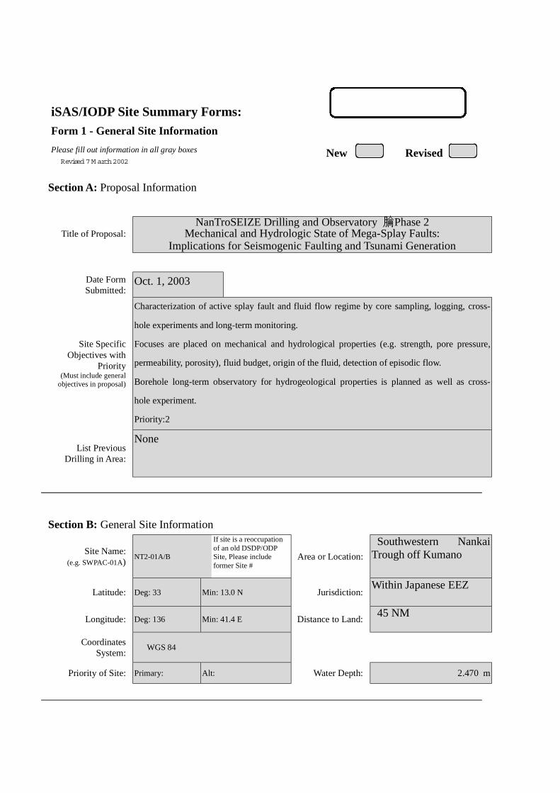
iSAS/IODP Site Summary Forms:Form 1 - General Site Information
Please fill out information in all gray boxes
Section A: Proposal Information
Title of Proposal:NanTroSEIZE Drilling and Observatory Phase 2
Mechanical and Hydrologic State of Mega-Splay Faults:Implications for Seismogenic Faulting and Tsunami Generation
Date FormSubmitted:
Oct. 1, 2003
Site SpecificObjectives with
Priority(Must include general
objectives in proposal)
Characterization of active splay fault and fluid flow regime by core sampling, logging, cross-
hole experiments and long-term monitoring.
Focuses are placed on mechanical and hydrological properties (e.g. strength, pore pressure,
permeability, porosity), fluid budget, origin of the fluid, detection of episodic flow.
Borehole long-term observatory for hydrogeological properties is planned as well as cross-
hole experiment.
Priority:2
List PreviousDrilling in Area:
None
Section B: General Site Information
Site Name:(e.g. SWPAC-01A)
NT2-01A/B
If site is a reoccupationof an old DSDP/ODPSite, Please includeformer Site #
Area or Location:
Southwestern NankaiTrough off Kumano
Latitude: Deg: 33 Min: 13.0 N Jurisdiction:Within Japanese EEZ
Longitude: Deg: 136 Min: 41.4 E Distance to Land: 45 NM
CoordinatesSystem:
WGS 84
Priority of Site: Primary: Alt: Water Depth: 2.470 m
New RevisedRevised 7 M arch 2002

Section C: Operational Information
Sediments Basement1000Proposed
Penetration:(m) What is the total sed. thickness? >3,000 m
0
Total Penetration: 700 m
General Lithologies: Upper section of splay faults, consisting of deformed, compacted turbidite
Coring Plan:(Specify or Circle)
1-2-3-APC VPC* XCB MDCB* PCS RCB Re-entry HRGB* Systems Currently Under Development
Standard Tools Special Tools LWDNeutron-Porosity Borehole Televiewer Formation Fluid Sampling Density-NeutronLitho-Density Nuclear Magnetic
ResonanceBorehole Temperature
& PressureResistivity-Gamma Ray
Gamma Ray Geochemical Borehole Seismic Acoustic
Resistivity Side-Wall Core Sampling
Acoustic
Wireline LoggingPlan:
Formation Image Others ( ) Others ( FMI )
Max.BoreholeTemp. :
Expected value (For Riser Drilling)
20
Cuttings Sampling Intervals
from 200 m to 300 m, 5 m intervals
from 700 m to 900 m, 5 m intervals
Mud Logging:(Riser Holes Only)
Basic Sampling Intervals: 5mEstimated days: Drilling/Coring: 15 Logging: 5 Total On-Site: 40
Future Plan: Longterm Borehole Observation Plan/Re-entry Plan
Geodetic (strain/tilt), seismic and hydrologic (P,T) sensors with casing (20 days) Cross-hole experiments (5 days)Please check following List of Potential Hazards
Shallow Gas Complicated SeabedCondition
Hydrothermal Activity
What is your Weatherwindow? (Preferable period
with the reasons)
Hydrocarbon Soft Seabed Landslide and Turbidity Current
Shallow Water FlowCurrents Methane Hydrate
Abnormal Pressure Fractured Zone Diapir and Mud Volcano
Man-made Objects FaultHigh Temperature
H2S High Dip Angle Ice Conditions
Hazards/Weather:
CO2
May – August(typhoon risk in late
August to September,then low pressure inNovember throughMarch)
°C

New RevisedPlease fill out information in all gray boxes
roposal #: Site #: NT2-01A/B Date Form Submitted: Oct. 1, 2003
Data Type
SSPRequir-ements
ExistsIn DB Details of available data and data that are still to be collected
1High resolutionseismic reflection
YESPrimary Line(s) :Location of Site on line (SP or Time only) JAMSTEC Line-I (Feb. 2003)
Crossing Lines(s): JAMSTEC Line-9 (Feb. 2003)
2Deep Penetrationseismic reflection
YESPrimary Line(s): Location of Site on line (SP or Time only) KR0108-4
Crossing Lines(s):
3 Seismic Velocity† YES Stacking velocity and migration velocity from MCS lines.OBS data also available.
4 Seismic Grid YES Acquired by JAMSTEC in Feb. 2003
5a Refraction(surface)
YES Two-ship COP (max. offset 20km) was obtained by JAMSTEC in Sep.2002
5b Refraction(near bottom)
YES OBS data by Nakanishi et al. (1997)
6 3.5 kHz NO Location of Site on line (Time)
7 Swathbathymetry
YES Multi-narrow beam data by JAMSTEC R/V Yokosuka
8a Side-lookingsonar (surface)
YES Some data collected using IZANAGI side scan sonar
8b Side-lookingsonar (bottom)
NO
9 Photographyor Video
YES Taken by submersibles of JASMTEC
10 Heat Flow YES Obtained from surface ship, submersibles, long-erm monitoring and BSR
11a Magnetics YES Compiled map published from AIST, Japan
11b Gravity YES Compiled map published from AIST, Japan
12 Sediment cores YES Gravity and piston cores13 Rock sampling YES Taken by submersible and ROV
14a Water current data YES Available on JODC web page (http://www.jodc.go.jp/)14b Ice Conditions
15 OBSmicroseismicity
Being processed now
16 Navigation YES
17 Other
SSP Classification of Site: SSP Watchdog: Date of Last Review:SSP Comments:
X=required; X*=may be required for specific sites; Y=recommended; Y*=may be recommended for specific sites;R=required for re-entry sites; T=required for high temperature environments; † Accurate velocity information is requiredfor holes deeper than 400m.
iSAS/IODP Site Summary Forms:Form 2 - Site Survey Detail

New Revised
Proposal #: Site #: NT2-01A/B Date Form Submitted: Oct. 1, 2003Water Depth (m): 2470 Sed. Penetration (m): 1000 Basement Penetration (m): 0
Do you need to use the conical side-entry sub (CSES) at this site? Yes No
Are high temperatures expected at this site? Yes No
Are there any other special requirements for logging at this site? Yes No
If “Yes” Please describe requirements:
What do you estimate the total logging time for this site to be:
Measurement Type Scientific ObjectiveRelevance
(1=high, 3=Low)
Neutron-Porosity Estimation of water content in sedimentary sequences and basement. 1
Litho-Density Estimation of water content,bulk density,and mineral composition in
sedimentary sequences and basement.
1
Natural Gamma Ray Estimation clay contents and mineral composition in sedimentary
sequences and basement.
1
Resistivity-Induction Estimation of water content and electro-magnetic properties in
sedimentary sequences and basement.
1
Acoustic
FMS Imaging of sedimentary structures and fractures.Core-log correlation of
structural features.
1
BHTV
Resistivity-Laterolog
Magnetic/Susceptibility
Density-Neutron (LWD) Estimation of water contents,bulk density,and lithology in unstable
borehole environments.
1
Resitivity-Gamma Ray
(LWD)
Estimation of water contents,bulk density,and lithology in unstable
borehole environments.
1
Other: Special tools (CORK,
PACKER, VSP, PCS, FWS,
WSP
Cross-hole hydrologic and electrical experiment. RAB
Hydrofracturing, Packer injection test
CORK and Geodetic borehole observatory
1
For help in determining logging times, please contact the ODP-LDEO Wireline Logging Services groupat:
[email protected]://www.ldeo.columbia.edu/BRG/brg_home.htmlPhone/Fax: (914) 365-8674 / (914) 365-3182
Note: Sites with greater than 400 m ofpenetration or significant basementpenetration require deployment ofstandard toolstrings.
iSAS/IODP Site Summary Forms:Form 3 - Detailed Logging Plan

New RevisedPlease fill out information in all gray boxes
Proposal #: Site #: NT2-01A/B Date Form Submitted: Oct. 1, 2003
1 Summary of Operations at site:(Example: Triple-APC to refusal, XCB10 m into basement, log as shown onpage 3.)
APC to refusal,then XCB to refusal.RCB to 1000 m
2 Based on Previous DSDP/ODPdrilling, list all hydrocarbonoccurrences of greater thanbackground levels. Give natureof show, age and depth of rock:
JNOC will conduct drilling in eastern Nankai in 2004. This datawill be used for urprogram.
3 From Available information, listall commercial drilling in thisarea that produced or yieldedsignificant hydrocarbon shows.Give depths and ages ofhydrocarbon-bearing deposits.
None
4 Are there any indications of gashydrates at this location? Yes, MCS profile shows BSRs
5 Are there reasons to expecthydrocarbon accumulations atthis site? Please give details.
6 What “special” precautions willbe taken during drilling? Yes, During drilling into the fault zone, hole may collapse.
7 What abandonment proceduresdo you plan to follow: None
8 Please list other natural ormanmade hazards which mayeffect ship’s operations:(e.g. ice, currents, cables)
Strong Kuroshio current, typhoon (June – October)
9 Summary: What do youconsider the major risks indrilling at this site?
Current
iSAS/IODP Site Summary Forms:Form 4 – Pollution & Safety Hazard Summary

New Revised
Proposal #: Site #: NT2-01A/B Date Form Submitted: Oct. 1, 2003
Sub-bottom
depth (m)
Key reflectors,Unconformities,
faults, etcAge
Assumedvelocity(km/sec)
Lithology Paleo-environment
Avg. rateof sed.accum.(m/My)
Comments
300
800
Unconformity
fault
Holocene toMioce
ne
1.6-2.5km/s
Slopesediments
to
oldaccretionary
rocks
Accretionaryprism
iSAS/IODP Site Summary Forms:Form 5 – Lithologic Summary

iSAS/IODP Site Summary Forms:Form 1 - General Site Information
Please fill out information in all gray boxes
Section A: Proposal Information
Title of Proposal:NanTroSEIZE Drilling and Observatory Phase 2
Mechanical and Hydrologic State of Mega-Splay Faults:Implications for Seismogenic Faulting and Tsunami Generation
Date FormSubmitted:
Oct. 1, 2003
Site SpecificObjectives with
Priority(Must include general
objectives in proposal)
Study the progressive change in the fault properties by intersecting the splay fault at
intermediate depth of 2km. Integration with NT2-01A and NT2-03A are essential.
Priority:2
List PreviousDrilling in Area:
None
Section B: General Site Information
Site Name:(e.g. SWPAC-01A)
NT2-02A
If site is a reoccupationof an old DSDP/ODPSite, Please includeformer Site #
Area or Location:
Southwestern NankaiTrough off Kumano
Latitude: Deg: 33 Min: 14.0 N Jurisdiction:Within Japanese EEZ
Longitude: Deg: 136 Min: 40.8 E Distance to Land: 45 NM
CoordinatesSystem:
WGS 84
Priority of Site: Primary: Alt: Water Depth: 2,080 m
New RevisedRevised 7 M arch 2002

Section C: Operational Information
Sediments Basement2000Proposed
Penetration:(m) What is the total sed. thickness? >3,000 m
0
Total Penetration: 1,700 m
General Lithologies: Slope basin sediment on top, fracturedsection across the splay fault, and underlyingdeformed, compacted turbidite
Coring Plan:(Specify or Circle)
1-2-3-APC VPC* XCB MDCB* PCS RCB Re-entry HRGB* Systems Currently Under Development
Standard Tools Special Tools LWDNeutron-Porosity Borehole Televiewer Formation Fluid Sampling Density-NeutronLitho-Density Nuclear Magnetic
ResonanceBorehole Temperature
& PressureResistivity-Gamma Ray
Gamma Ray Geochemical Borehole Seismic Acoustic
Resistivity Side-Wall Core Sampling
Acoustic
Wireline LoggingPlan:
Formation Image Others ( ) Others ( FMI )
Max.BoreholeTemp. :
Expected value (For Riser Drilling)
40-60
Cuttings Sampling Intervals
from 300 m to 500 m, 5 m intervals
from 1700 m to 1900 m, 5 m intervals
Mud Logging:(Riser Holes Only)
Basic Sampling Intervals: 5mEstimated days: Drilling/Coring: 25 Logging: 10 Total On-Site: 35
Future Plan: Longterm Borehole Observation Plan/Re-entry Plan
Please check following List of Potential Hazards
Shallow Gas Complicated SeabedCondition
Hydrothermal Activity
What is your Weatherwindow? (Preferable period
with the reasons)
Hydrocarbon Soft Seabed Landslide and Turbidity Current
Shallow Water FlowCurrents Methane Hydrate
Abnormal Pressure Fractured Zone Diapir and Mud Volcano
Man-made Objects FaultHigh Temperature
H2S High Dip Angle Ice Conditions
Hazards/Weather:
CO2
May – August(typhoon risk in late
August to September,then low pressure inNovember throughMarch)
°C

New RevisedPlease fill out information in all gray boxes
roposal #: Site #: NT2-02A Date Form Submitted: Oct. 1, 2003
Data Type
SSPRequir-ements
ExistsIn DB Details of available data and data that are still to be collected
1High resolutionseismic reflection
YESPrimary Line(s) :Location of Site on line (SP or Time only) JAMSTEC Line-I (Feb. 2003)
Crossing Lines(s): JAMSTEC Line-9 (Feb. 2003)
2Deep Penetrationseismic reflection
YESPrimary Line(s): Location of Site on line (SP or Time only) KR0108-4
Crossing Lines(s):
3 Seismic Velocity† YES Stacking velocity and migration velocity from MCS lines.OBS data also available.
4 Seismic Grid YES Acquired by JAMSTEC in Feb. 2003
5a Refraction(surface)
YES Two-ship COP (max. offset 20km) was obtained by JAMSTEC in Sep.2002
5b Refraction(near bottom)
YES OBS data by Nakanishi et al. (1997)
6 3.5 kHz NO Location of Site on line (Time)
7 Swathbathymetry
YES Multi-narrow beam data by JAMSTEC R/V Yokosuka
8a Side-lookingsonar (surface)
YES Some data collected using IZANAGI side scan sonar
8b Side-lookingsonar (bottom)
NO
9 Photographyor Video
YES Taken by submersibles of JASMTEC
10 Heat Flow YES Obtained from surface ship, submersibles, long-erm monitoring and BSR
11a Magnetics YES Compiled map published from AIST, Japan
11b Gravity YES Compiled map published from AIST, Japan
12 Sediment cores YES Gravity and piston cores13 Rock sampling YES Taken by submersible and ROV
14a Water current data YES Available on JODC web page (http://www.jodc.go.jp/)14b Ice Conditions
15 OBSmicroseismicity
Being processed now
16 Navigation YES
17 Other
SSP Classification of Site: SSP Watchdog: Date of Last Review:SSP Comments:
X=required; X*=may be required for specific sites; Y=recommended; Y*=may be recommended for specific sites;R=required for re-entry sites; T=required for high temperature environments; † Accurate velocity information is requiredfor holes deeper than 400m.
iSAS/IODP Site Summary Forms:Form 2 - Site Survey Detail

New Revised
Proposal #: Site #: NT2-02A Date Form Submitted: Oct. 1, 2003Water Depth (m): 2080 Sed. Penetration (m): 2000 Basement Penetration (m): 0
Do you need to use the conical side-entry sub (CSES) at this site? Yes No
Are high temperatures expected at this site? Yes No
Are there any other special requirements for logging at this site? Yes No
If “Yes” Please describe requirements:
What do you estimate the total logging time for this site to be:
Measurement Type Scientific ObjectiveRelevance
(1=high, 3=Low)
Neutron-Porosity Estimation of water content in sedimentary sequences and basement. 1
Litho-Density Estimation of water content,bulk density,and mineral composition in
sedimentary sequences and basement.
1
Natural Gamma Ray Estimation clay contents and mineral composition in sedimentary
sequences and basement.
1
Resistivity-Induction Estimation of water content and electro-magnetic properties in
sedimentary sequences and basement.
1
Acoustic
FMS Imaging of sedimentary structures and fractures.Core-log correlation of
structural features.
1
BHTV
Resistivity-Laterolog
Magnetic/Susceptibility
Density-Neutron (LWD) Estimation of water contents,bulk density,and lithology in unstable
borehole environments.
1
Resitivity-Gamma Ray
(LWD)
Estimation of water contents,bulk density,and lithology in unstable
borehole environments.
1
Other: Special tools (CORK,
PACKER, VSP, PCS, FWS,
WSP
RAB preferred
2
For help in determining logging times, please contact the ODP-LDEO Wireline Logging Services groupat:
[email protected]://www.ldeo.columbia.edu/BRG/brg_home.htmlPhone/Fax: (914) 365-8674 / (914) 365-3182
Note: Sites with greater than 400 m ofpenetration or significant basementpenetration require deployment ofstandard toolstrings.
iSAS/IODP Site Summary Forms:Form 3 - Detailed Logging Plan

New RevisedPlease fill out information in all gray boxes
Proposal #: Site #: NT2-02A Date Form Submitted: Oct. 1, 2003
1 Summary of Operations at site:(Example: Triple-APC to refusal, XCB10 m into basement, log as shown onpage 3.)
APC to refusal,then XCB to refusal.RCB to 2000 m
2 Based on Previous DSDP/ODPdrilling, list all hydrocarbonoccurrences of greater thanbackground levels. Give natureof show, age and depth of rock:
JNOC will conduct drilling in eastern Nankai in 2004. This datawill be used for urprogram.
3 From Available information, listall commercial drilling in thisarea that produced or yieldedsignificant hydrocarbon shows.Give depths and ages ofhydrocarbon-bearing deposits.
None
4 Are there any indications of gashydrates at this location? Yes, MCS profile shows BSRs
5 Are there reasons to expecthydrocarbon accumulations atthis site? Please give details.
6 What “special” precautions willbe taken during drilling? Yes, During drilling into the fault zone, hole may collapse.
7 What abandonment proceduresdo you plan to follow: None
8 Please list other natural ormanmade hazards which mayeffect ship’s operations:(e.g. ice, currents, cables)
Strong Kuroshio current, typhoon (June – October)
9 Summary: What do youconsider the major risks indrilling at this site?
Current
iSAS/IODP Site Summary Forms:Form 4 – Pollution & Safety Hazard Summary

New Revised
Proposal #: Site #: NT2-02A Date Form Submitted: Oct. 1, 2003
Sub-bottom
depth (m)
Key reflectors,Unconformities,
faults, etcAge
Assumedvelocity(km/sec)
Lithology Paleo-environment
Avg. rateof sed.accum.(m/My)
Comments
400
1800
Unconformity
fault
Holocene toMioce
ne
1.6-2.5km/s
Slopesediments
to
oldaccretionary
rocks
Accretionaryprism
iSAS/IODP Site Summary Forms:Form 5 – Lithologic Summary

iSAS/IODP Site Summary Forms:Form 1 - General Site Information
Please fill out information in all gray boxes
Section A: Proposal Information
Title of Proposal:NanTroSEIZE Drilling and Observatory Phase 2
Mechanical and Hydrologic State of Mega-Splay Faults:Implications for Seismogenic Faulting and Tsunami Generation
Date FormSubmitted:
Oct. 1, 2003
Site SpecificObjectives with
Priority(Must include general
objectives in proposal)
Study the progressive change in the fault properties by intersecting the splay fault at
intermediate depth of 3.5km. Integration with NT2-01A and NT2-02A are essential.
Priority:1
List PreviousDrilling in Area:
None
Section B: General Site Information
Site Name:(e.g. SWPAC-01A)
NT2-03A
If site is a reoccupationof an old DSDP/ODPSite, Please includeformer Site #
Area or Location:
Southwestern NankaiTrough off Kumano
Latitude: Deg: 33 Min: 15.9 N Jurisdiction:Within Japanese EEZ
Longitude: Deg: 136 Min: 39.5 E Distance to Land: 45 NM
CoordinatesSystem:
WGS 84
Priority of Site: Primary: Alt: Water Depth: 2,240 m
New RevisedRevised 7 M arch 2002

Section C: Operational Information
Sediments Basement3500Proposed
Penetration:(m) What is the total sed. thickness? >3,000 m
0
Total Penetration: 2,200 m
General Lithologies: Slope basin sediment on top, fracturedsection across the splay fault, and underlyingdeformed, compacted turbiditeContinuous coring may be replaced with ordinary/LWD logging.Coring Plan:
(Specify or Circle) 1-2-3-APC VPC* XCB MDCB* PCS RCB Re-entry HRGB
* Systems Currently Under Development
Standard Tools Special Tools LWDNeutron-Porosity Borehole Televiewer Formation Fluid Sampling Density-NeutronLitho-Density Nuclear Magnetic
ResonanceBorehole Temperature
& PressureResistivity-Gamma Ray
Gamma Ray Geochemical Borehole Seismic Acoustic
Resistivity Side-Wall Core Sampling
Acoustic
Wireline LoggingPlan:
Formation Image Others ( ) Others ( FMI )
Max.BoreholeTemp. :
Expected value (For Riser Drilling)
80-100
Cuttings Sampling Intervals
from 1700 m to 1900 m, 5 m intervals
from 3300 m to 3500 m, 5 m intervals
Mud Logging:(Riser Holes Only)
Basic Sampling Intervals: 5mEstimated days: Drilling/Coring: 130 Logging: 20 Total On-Site: 250
Future Plan: Longterm Borehole Observation Plan/Re-entry Plan
Geodetic (strain/tilt), seismic and hydrologic (P,T) sensors (100 days?)
Please check following List of Potential Hazards
Shallow Gas Complicated SeabedCondition
Hydrothermal Activity
What is your Weatherwindow? (Preferable period
with the reasons)
Hydrocarbon Soft Seabed Landslide and Turbidity Current
Shallow Water FlowCurrents Methane Hydrate
Abnormal Pressure Fractured Zone Diapir and Mud Volcano
Man-made Objects FaultHigh Temperature
H2S High Dip Angle Ice Conditions
Hazards/Weather:
CO2
May – August(typhoon risk in late
August to September,then low pressure inNovember throughMarch)
°C

New RevisedPlease fill out information in all gray boxes
roposal #: Site #: NT2-03A Date Form Submitted: Oct. 1, 2003
Data Type
SSPRequir-ements
ExistsIn DB Details of available data and data that are still to be collected
1High resolutionseismic reflection
YESPrimary Line(s) :Location of Site on line (SP or Time only) JAMSTEC Line-I (Feb. 2003)
Crossing Lines(s): JAMSTEC Line-9 (Feb. 2003)
2Deep Penetrationseismic reflection
YESPrimary Line(s): Location of Site on line (SP or Time only) KR0108-4
Crossing Lines(s):
3 Seismic Velocity† YES Stacking velocity and migration velocity from MCS lines.OBS data also available.
4 Seismic Grid YES Acquired by JAMSTEC in Feb. 2003
5a Refraction(surface)
YES Two-ship COP (max. offset 20km) was obtained by JAMSTEC in Sep.2002
5b Refraction(near bottom)
YES OBS data by Nakanishi et al. (1997)
6 3.5 kHz NO Location of Site on line (Time)
7 Swathbathymetry
YES Multi-narrow beam data by JAMSTEC R/V Yokosuka
8a Side-lookingsonar (surface)
YES Some data collected using IZANAGI side scan sonar
8b Side-lookingsonar (bottom)
NO
9 Photographyor Video
YES Taken by submersibles of JASMTEC
10 Heat Flow YES Obtained from surface ship, submersibles, long-erm monitoring and BSR
11a Magnetics YES Compiled map published from AIST, Japan
11b Gravity YES Compiled map published from AIST, Japan
12 Sediment cores YES Gravity and piston cores13 Rock sampling YES Taken by submersible and ROV
14a Water current data YES Available on JODC web page (http://www.jodc.go.jp/)14b Ice Conditions
15 OBSmicroseismicity
Being processed now
16 Navigation YES
17 Other
SSP Classification of Site: SSP Watchdog: Date of Last Review:SSP Comments:
X=required; X*=may be required for specific sites; Y=recommended; Y*=may be recommended for specific sites;R=required for re-entry sites; T=required for high temperature environments; † Accurate velocity information is requiredfor holes deeper than 400m.
iSAS/IODP Site Summary Forms:Form 2 - Site Survey Detail

New Revised
Proposal #: Site #: NT2-03A Date Form Submitted: Oct. 1, 2003Water Depth (m): 2240 Sed. Penetration (m): 3500 Basement Penetration (m): 0
Do you need to use the conical side-entry sub (CSES) at this site? Yes No
Are high temperatures expected at this site? Yes No
Are there any other special requirements for logging at this site? Yes No
If “Yes” Please describe requirements:
What do you estimate the total logging time for this site to be:
Measurement Type Scientific ObjectiveRelevance
(1=high, 3=Low)
Neutron-Porosity Estimation of water content in sedimentary sequences and basement. 1
Litho-Density Estimation of water content,bulk density,and mineral composition in
sedimentary sequences and basement.
1
Natural Gamma Ray Estimation clay contents and mineral composition in sedimentary
sequences and basement.
1
Resistivity-Induction Estimation of water content and electro-magnetic properties in
sedimentary sequences and basement.
1
Acoustic
FMS Imaging of sedimentary structures and fractures.Core-log correlation of
structural features.
1
BHTV
Resistivity-Laterolog
Magnetic/Susceptibility
Density-Neutron (LWD) Estimation of water contents,bulk density,and lithology in unstable
borehole environments.
1
Resitivity-Gamma Ray
(LWD)
Estimation of water contents,bulk density,and lithology in unstable
borehole environments.
1
Other: Special tools (CORK,
PACKER, VSP, PCS, FWS,
WSP
RAB, VSP
Hydrofracturing, Packer injection test
CORK and Geodetic/Seismic borehole observatory
1
For help in determining logging times, please contact the ODP-LDEO Wireline Logging Services groupat:
[email protected]://www.ldeo.columbia.edu/BRG/brg_home.htmlPhone/Fax: (914) 365-8674 / (914) 365-3182
Note: Sites with greater than 400 m ofpenetration or significant basementpenetration require deployment ofstandard toolstrings.
iSAS/IODP Site Summary Forms:Form 3 - Detailed Logging Plan

New RevisedPlease fill out information in all gray boxes
Proposal #: Site #: NT2-03A Date Form Submitted: Oct. 1, 2003
1 Summary of Operations at site:(Example: Triple-APC to refusal, XCB10 m into basement, log as shown onpage 3.)
APC to refusal,then XCB to refusal.RCB to 3500 m
2 Based on Previous DSDP/ODPdrilling, list all hydrocarbonoccurrences of greater thanbackground levels. Give natureof show, age and depth of rock:
JNOC will conduct drilling in eastern Nankai in 2004. This datawill be used for urprogram.
3 From Available information, listall commercial drilling in thisarea that produced or yieldedsignificant hydrocarbon shows.Give depths and ages ofhydrocarbon-bearing deposits.
None
4 Are there any indications of gashydrates at this location? Yes, MCS profile shows BSRs
5 Are there reasons to expecthydrocarbon accumulations atthis site? Please give details.
6 What “special” precautions willbe taken during drilling? Yes, During drilling into the fault zone, hole may collapse.
7 What abandonment proceduresdo you plan to follow: None
8 Please list other natural ormanmade hazards which mayeffect ship’s operations:(e.g. ice, currents, cables)
Strong Kuroshio current, typhoon (June – October)
9 Summary: What do youconsider the major risks indrilling at this site?
Current
iSAS/IODP Site Summary Forms:Form 4 – Pollution & Safety Hazard Summary

New Revised
Proposal #: Site #: NT2-03A Date Form Submitted: Oct. 1, 2003
Sub-bottom
depth (m)
Key reflectors,Unconformities,
faults, etcAge
Assumedvelocity(km/sec)
Lithology Paleo-environment
Avg. rateof sed.accum.(m/My)
Comments
300
1800
3400
Unconformity
Fault
fault
Holocene toMioce
ne
1.6-2.5km/s
Slopesediments
to
oldaccretionary
rocks
Accretionaryprism
iSAS/IODP Site Summary Forms:Form 5 – Lithologic Summary

iSAS/IODP Site Summary Forms:Form 1 - General Site Information
Please fill out information in all gray boxes
Section A: Proposal Information
Title of Proposal:NanTroSEIZE Drilling and Observatory Phase 2
Mechanical and Hydrologic State of Mega-Splay Faults:Implications for Seismogenic Faulting and Tsunami Generation
Date FormSubmitted:
Oct. 1, 2003
Site SpecificObjectives with
Priority(Must include general
objectives in proposal)
Total history of the splay fault system through continuous coring the Kumano foreac basin
sediments: Objective 1 is the primary target of this site. Total history of the splay fault system
is depicted by integrating the results from NT1b-05A as a reference for this site.
Drilling the underlying acoustic basement is planned to clarify the structure of pst
accretionary complex, but is also used as a pilot drilling for the future riser-based proposal.
Priority:4
List PreviousDrilling in Area:
None
Section B: General Site Information
Site Name:(e.g. SWPAC-01A)
NT2-04A
If site is a reoccupationof an old DSDP/ODPSite, Please includeformer Site #
Area or Location:
Southwestern NankaiTrough off Kumano
Latitude: Deg: 33 Min: 23.4 N Jurisdiction:Within Japanese EEZ
Longitude: Deg: 136 Min: 34.6 E Distance to Land: 37 NM
CoordinatesSystem:
WGS 84
Priority of Site: Primary: Alt: Water Depth: 1,990 m
New RevisedRevised 7 M arch 2002

Section C: Operational Information
Sediments Basement1,400Proposed
Penetration:(m) What is the total sed. thickness? 1,400 m
300
Total Penetration: 1,700 m
General Lithologies: Forearc basin sediment with unconformitylaying on acoustic basement of Tertiallyaccretionary complex
Coring Plan:(Specify or Circle)
1-2-3-APC VPC* XCB MDCB* PCS RCB Re-entry HRGB* Systems Currently Under Development
Standard Tools Special Tools LWDNeutron-Porosity Borehole Televiewer Formation Fluid Sampling Density-NeutronLitho-Density Nuclear Magnetic
ResonanceBorehole Temperature
& PressureResistivity-Gamma Ray
Gamma Ray Geochemical Borehole Seismic Acoustic
Resistivity Side-Wall Core Sampling
Acoustic
Wireline LoggingPlan:
Formation Image Others ( ) Others ( FMI )
Max.BoreholeTemp. :
Expected value (For Riser Drilling)
70
Cuttings Sampling Intervals
from m to m, m intervals
from m to m, m intervals
Mud Logging:(Riser Holes Only)
Basic Sampling Intervals: 5mEstimated days: Drilling/Coring: 15 Logging: 3 Total On-Site: 18
Future Plan: Longterm Borehole Observation Plan/Re-entry Plan
Please check following List of Potential Hazards
Shallow Gas Complicated SeabedCondition
Hydrothermal Activity
What is your Weatherwindow? (Preferable period
with the reasons)
Hydrocarbon Soft Seabed Landslide and Turbidity Current
Shallow Water FlowCurrents Methane Hydrate
Abnormal Pressure Fractured Zone Diapir and Mud Volcano
Man-made Objects FaultHigh Temperature
H2S High Dip Angle Ice Conditions
Hazards/Weather:
CO2
May – August(typhoon risk in late
August to September,then low pressure inNovember throughMarch)
°C

New RevisedPlease fill out information in all gray boxes
roposal #: Site #: NT2-04A Date Form Submitted: Oct. 1, 2003
Data Type
SSPRequir-ements
ExistsIn DB Details of available data and data that are still to be collected
1High resolutionseismic reflection
YESPrimary Line(s) :Location of Site on line (SP or Time only) JAMSTEC Line-I (Feb. 2003)
Crossing Lines(s): JAMSTEC Line (Feb. 2003)
2Deep Penetrationseismic reflection
YESPrimary Line(s): Location of Site on line (SP or Time only) KR0108-4
Crossing Lines(s):
3 Seismic Velocity† YES Stacking velocity and migration velocity from MCS lines.OBS data also available.
4 Seismic Grid YES Acquired by JAMSTEC in Feb. 2003
5a Refraction(surface)
YES Two-ship COP (max. offset 20km) was obtained by JAMSTEC in Sep.2002
5b Refraction(near bottom)
YES OBS data by Nakanishi et al. (1997)
6 3.5 kHz NO Location of Site on line (Time)
7 Swathbathymetry
YES Multi-narrow beam data by JAMSTEC R/V Yokosuka
8a Side-lookingsonar (surface)
YES Some data collected using IZANAGI side scan sonar
8b Side-lookingsonar (bottom)
NO
9 Photographyor Video
YES Taken by submersibles of JASMTEC
10 Heat Flow YES Obtained from surface ship, submersibles, long-erm monitoring and BSR
11a Magnetics YES Compiled map published from AIST, Japan
11b Gravity YES Compiled map published from AIST, Japan
12 Sediment cores YES Gravity and piston cores13 Rock sampling YES Taken by submersible and ROV
14a Water current data YES Available on JODC web page (http://www.jodc.go.jp/)14b Ice Conditions
15 OBSmicroseismicity
Being processed now
16 Navigation YES
17 Other
SSP Classification of Site: SSP Watchdog: Date of Last Review:SSP Comments:
X=required; X*=may be required for specific sites; Y=recommended; Y*=may be recommended for specific sites;R=required for re-entry sites; T=required for high temperature environments; † Accurate velocity information is requiredfor holes deeper than 400m.
iSAS/IODP Site Summary Forms:Form 2 - Site Survey Detail

New Revised
Proposal #: Site #: NT2-04A Date Form Submitted: Oct. 1, 2003Water Depth (m): 1990 Sed. Penetration (m): 1400 Basement Penetration (m): 300
Do you need to use the conical side-entry sub (CSES) at this site? Yes No
Are high temperatures expected at this site? Yes No
Are there any other special requirements for logging at this site? Yes No
If “Yes” Please describe requirements:
What do you estimate the total logging time for this site to be:
Measurement Type Scientific ObjectiveRelevance
(1=high, 3=Low)
Neutron-Porosity Estimation of water content in sedimentary sequences and basement. 1
Litho-Density Estimation of water content,bulk density,and mineral composition in
sedimentary sequences and basement.
1
Natural Gamma Ray Estimation clay contents and mineral composition in sedimentary
sequences and basement.
1
Resistivity-Induction Estimation of water content and electro-magnetic properties in
sedimentary sequences and basement.
1
Acoustic
FMS Imaging of sedimentary structures and fractures.Core-log correlation of
structural features.
1
BHTV
Resistivity-Laterolog
Magnetic/Susceptibility
Density-Neutron (LWD)
.
Resitivity-Gamma Ray
(LWD)
Other: Special tools (CORK,
PACKER, VSP, PCS, FWS,
WSP
For help in determining logging times, please contact the ODP-LDEO Wireline Logging Services groupat:
[email protected]://www.ldeo.columbia.edu/BRG/brg_home.htmlPhone/Fax: (914) 365-8674 / (914) 365-3182
Note: Sites with greater than 400 m ofpenetration or significant basementpenetration require deployment ofstandard toolstrings.
iSAS/IODP Site Summary Forms:Form 3 - Detailed Logging Plan

New RevisedPlease fill out information in all gray boxes
Proposal #: Site #: NT2-04A Date Form Submitted: Oct. 1, 2003
1 Summary of Operations at site:(Example: Triple-APC to refusal, XCB10 m into basement, log as shown onpage 3.)
APC to refusal,then XCB to refusal.RCB to 1700 m
2 Based on Previous DSDP/ODPdrilling, list all hydrocarbonoccurrences of greater thanbackground levels. Give natureof show, age and depth of rock:
JNOC will conduct drilling in eastern Nankai in 2004. This datawill be used for urprogram.
3 From Available information, listall commercial drilling in thisarea that produced or yieldedsignificant hydrocarbon shows.Give depths and ages ofhydrocarbon-bearing deposits.
None
4 Are there any indications of gashydrates at this location? Yes, MCS profile shows BSRs
5 Are there reasons to expecthydrocarbon accumulations atthis site? Please give details.
6 What “special” precautions willbe taken during drilling? Yes, During drilling into the fault zone, hole may collapse.
7 What abandonment proceduresdo you plan to follow: None
8 Please list other natural ormanmade hazards which mayeffect ship’s operations:(e.g. ice, currents, cables)
Strong Kuroshio current, typhoon (June – October)
9 Summary: What do youconsider the major risks indrilling at this site?
Current
iSAS/IODP Site Summary Forms:Form 4 – Pollution & Safety Hazard Summary

New Revised
Proposal #: Site #: NT2-04A Date Form Submitted: Oct. 1, 2003
Sub-bottom
depth (m)
Key reflectors,Unconformities,
faults, etcAge
Assumedvelocity(km/sec)
Lithology Paleo-environment
Avg. rateof sed.accum.(m/My)
Comments
1400 Unconformity Holocene tolate
Tertialy
1.5-2.0km/s
Turbidite &hemipelagicsediments
Forearc basin Fan deposits?
iSAS/IODP Site Summary Forms:Form 5 – Lithologic Summary
1
iSAS/IODP Site Summary Forms:Form 1 - General Site Information
Please fill out information in all gray boxes
Section A: Proposal Information
Title of Proposal:NanTroSEIZE Drilling and Observatory Phase 2
Mechanical and Hydrologic State of Mega-Splay Faults:Implications for Seismogenic Faulting and Tsunami Generation
Date FormSubmitted:
Oct. 1, 2003
Site SpecificObjectives with
Priority(Must include general
objectives in proposal)
Characterization of active splay fault and fluid flow regime by core sampling, logging, cross-
hole experiments and long-term monitoring.
Focuses are placed on mechanical and hydrological properties (e.g. strength, pore pressure,
permeability, porosity), fluid budget, origin of the fluid, detection of episodic flow.
Borehole long-term observatory for hydrogeological properties is planned as well as cross-
hole experiment.
Priority:3 (Alternate site for NT2-01A/B)
List PreviousDrilling in Area:
None
Section B: General Site Information
Site Name:(e.g. SWPAC-01A)
NT2-06A/B
If site is a reoccupationof an old DSDP/ODPSite, Please includeformer Site #
Area or Location:
Southwestern NankaiTrough off Kumano
Latitude: Deg: 33 Min: 06.6 N Jurisdiction:Within Japanese EEZ
Longitude: Deg: 136 Min: 31.3 E Distance to Land: 45 NM
CoordinatesSystem:
WGS 84
Priority of Site: Primary: Alt: Water Depth: 2.990 m
New RevisedRevised 7 M arch 2002

2
Section C: Operational Information
Sediments Basement1000Proposed
Penetration:(m) What is the total sed. thickness? >3,000 m
0
Total Penetration: 700 m
General Lithologies: Upper section of splay faults, consisting of deformed, compacted turbidite
Coring Plan:(Specify or Circle)
1-2-3-APC VPC* XCB MDCB* PCS RCB Re-entry HRGB* Systems Currently Under Development
Standard Tools Special Tools LWDNeutron-Porosity Borehole Televiewer Formation Fluid Sampling Density-NeutronLitho-Density Nuclear Magnetic
ResonanceBorehole Temperature
& PressureResistivity-Gamma Ray
Gamma Ray Geochemical Borehole Seismic Acoustic
Resistivity Side-Wall Core Sampling
Acoustic
Wireline LoggingPlan:
Formation Image Others ( ) Others ( FMI )
Max.BoreholeTemp. :
Expected value (For Riser Drilling)
20
Cuttings Sampling Intervals
from 200 m to 300 m, 5 m intervals
from 700 m to 900 m, 5 m intervals
Mud Logging:(Riser Holes Only)
Basic Sampling Intervals: 5mEstimated days: Drilling/Coring: 15 Logging: 5 Total On-Site: 40
Future Plan: Longterm Borehole Observation Plan/Re-entry Plan
Geodetic (strain/tilt), seismic and hydrologic (P,T) sensors with casing (20 days) Cross-hole experiments (5 days)Please check following List of Potential Hazards
Shallow Gas Complicated SeabedCondition
Hydrothermal Activity
What is your Weatherwindow? (Preferable period
with the reasons)
Hydrocarbon Soft Seabed Landslide and Turbidity Current
Shallow Water FlowCurrents Methane Hydrate
Abnormal Pressure Fractured Zone Diapir and Mud Volcano
Man-made Objects FaultHigh Temperature
H2S High Dip Angle Ice Conditions
Hazards/Weather:
CO2
May – August(typhoon risk in late
August to September,then low pressure inNovember throughMarch)
°C

New RevisedPlease fill out information in all gray boxes
roposal #: Site #: NT2-06A/B Date Form Submitted: Oct. 1, 2003
Data Type
SSPRequir-ements
ExistsIn DB Details of available data and data that are still to be collected
1High resolutionseismic reflection
YESPrimary Line(s) :Location of Site on line (SP or Time only) JAMSTEC Line-I (Feb. 2003)
Crossing Lines(s): JAMSTEC Line-9 (Feb. 2003)
2Deep Penetrationseismic reflection
YESPrimary Line(s): Location of Site on line (SP or Time only) KR0108-4
Crossing Lines(s):
3 Seismic Velocity† YES Stacking velocity and migration velocity from MCS lines.OBS data also available.
4 Seismic Grid YES Acquired by JAMSTEC in Feb. 2003
5a Refraction(surface)
YES Two-ship COP (max. offset 20km) was obtained by JAMSTEC in Sep.2002
5b Refraction(near bottom)
YES OBS data by Nakanishi et al. (1997)
6 3.5 kHz NO Location of Site on line (Time)
7 Swathbathymetry
YES Multi-narrow beam data by JAMSTEC R/V Yokosuka
8a Side-lookingsonar (surface)
YES Some data collected using IZANAGI side scan sonar
8b Side-lookingsonar (bottom)
NO
9 Photographyor Video
YES Taken by submersibles of JASMTEC
10 Heat Flow YES Obtained from surface ship, submersibles, long-erm monitoring and BSR
11a Magnetics YES Compiled map published from AIST, Japan
11b Gravity YES Compiled map published from AIST, Japan
12 Sediment cores YES Gravity and piston cores13 Rock sampling YES Taken by submersible and ROV
14a Water current data YES Available on JODC web page (http://www.jodc.go.jp/)14b Ice Conditions
15 OBSmicroseismicity
Being processed now
16 Navigation YES
17 Other
SSP Classification of Site: SSP Watchdog: Date of Last Review:SSP Comments:
X=required; X*=may be required for specific sites; Y=recommended; Y*=may be recommended for specific sites;R=required for re-entry sites; T=required for high temperature environments; † Accurate velocity information is requiredfor holes deeper than 400m.
iSAS/IODP Site Summary Forms:Form 2 - Site Survey Detail

New Revised
Proposal #: Site #: NT2-06A/B Date Form Submitted: Oct. 1, 2003Water Depth (m): 2990 Sed. Penetration (m): 1000 Basement Penetration (m): 0
Do you need to use the conical side-entry sub (CSES) at this site? Yes No
Are high temperatures expected at this site? Yes No
Are there any other special requirements for logging at this site? Yes No
If “Yes” Please describe requirements:
What do you estimate the total logging time for this site to be:
Measurement Type Scientific ObjectiveRelevance
(1=high, 3=Low)
Neutron-Porosity Estimation of water content in sedimentary sequences and basement. 1
Litho-Density Estimation of water content,bulk density,and mineral composition in
sedimentary sequences and basement.
1
Natural Gamma Ray Estimation clay contents and mineral composition in sedimentary
sequences and basement.
1
Resistivity-Induction Estimation of water content and electro-magnetic properties in
sedimentary sequences and basement.
1
Acoustic
FMS Imaging of sedimentary structures and fractures.Core-log correlation of
structural features.
1
BHTV
Resistivity-Laterolog
Magnetic/Susceptibility
Density-Neutron (LWD) Estimation of water contents,bulk density,and lithology in unstable
borehole environments.
1
Resitivity-Gamma Ray
(LWD)
Estimation of water contents,bulk density,and lithology in unstable
borehole environments.
1
Other: Special tools (CORK,
PACKER, VSP, PCS, FWS,
WSP
Cross-hole hydrologic and electrical experiment. RAB
Hydrofracturing, Packer injection test
CORK and Geodetic borehole observatory
1
For help in determining logging times, please contact the ODP-LDEO Wireline Logging Services groupat:
[email protected]://www.ldeo.columbia.edu/BRG/brg_home.htmlPhone/Fax: (914) 365-8674 / (914) 365-3182
Note: Sites with greater than 400 m ofpenetration or significant basementpenetration require deployment ofstandard toolstrings.
iSAS/IODP Site Summary Forms:Form 3 - Detailed Logging Plan

New RevisedPlease fill out information in all gray boxes
Proposal #: Site #: NT2-06A/B Date Form Submitted: Oct. 1, 2003
1 Summary of Operations at site:(Example: Triple-APC to refusal, XCB10 m into basement, log as shown onpage 3.)
APC to refusal,then XCB to refusal.RCB to 1000 m
2 Based on Previous DSDP/ODPdrilling, list all hydrocarbonoccurrences of greater thanbackground levels. Give natureof show, age and depth of rock:
JNOC will conduct drilling in eastern Nankai in 2004. This datawill be used for urprogram.
3 From Available information, listall commercial drilling in thisarea that produced or yieldedsignificant hydrocarbon shows.Give depths and ages ofhydrocarbon-bearing deposits.
None
4 Are there any indications of gashydrates at this location? Yes, MCS profile shows BSRs
5 Are there reasons to expecthydrocarbon accumulations atthis site? Please give details.
6 What “special” precautions willbe taken during drilling? Yes, During drilling into the fault zone, hole may collapse.
7 What abandonment proceduresdo you plan to follow: None
8 Please list other natural ormanmade hazards which mayeffect ship’s operations:(e.g. ice, currents, cables)
Strong Kuroshio current, typhoon (June – October)
9 Summary: What do youconsider the major risks indrilling at this site?
Current
iSAS/IODP Site Summary Forms:Form 4 – Pollution & Safety Hazard Summary
New Revised
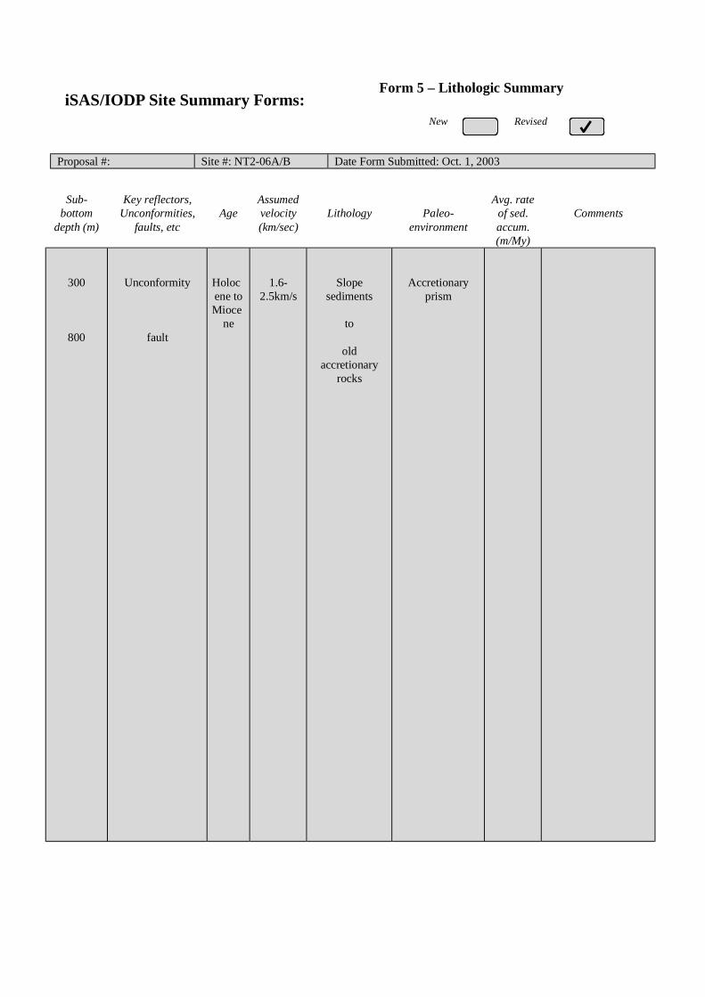
Proposal #: Site #: NT2-06A/B Date Form Submitted: Oct. 1, 2003
Sub-bottom
depth (m)
Key reflectors,Unconformities,
faults, etcAge
Assumedvelocity(km/sec)
Lithology Paleo-environment
Avg. rateof sed.accum.(m/My)
Comments
300
800
Unconformity
fault
Holocene toMioce
ne
1.6-2.5km/s
Slopesediments
to
oldaccretionary
rocks
Accretionaryprism
iSAS/IODP Site Summary Forms:Form 5 – Lithologic Summary

iSAS/IODP Site Summary Forms:Form 1 - General Site Information
Please fill out information in all gray boxes
Section A: Proposal Information
Title of Proposal:NanTroSEIZE Drilling and Observatory Phase 2
Mechanical and Hydrologic State of Mega-Splay Faults:Implications for Seismogenic Faulting and Tsunami Generation
Date FormSubmitted:
Oct. 1, 2003
Site SpecificObjectives with
Priority(Must include general
objectives in proposal)
Study the progressive change in the fault properties by intersecting the splay fault at
intermediate depth of 2km. Integration with NT2-01A and NT2-03A are essential.
Priority:2 (Alternate site for NT2-02A)
List PreviousDrilling in Area:
None
Section B: General Site Information
Site Name:(e.g. SWPAC-01A)
NT2-07A
If site is a reoccupationof an old DSDP/ODPSite, Please includeformer Site #
Area or Location:
Southwestern NankaiTrough off Kumano
Latitude: Deg: 33 Min: 08.6 N Jurisdiction:Within Japanese EEZ
Longitude: Deg: 136 Min: 30.0 E Distance to Land: 45 NM
CoordinatesSystem:
WGS 84
Priority of Site: Primary: Alt: Water Depth: 2,260 m
New RevisedRevised 7 M arch 2002

Section C: Operational Information
Sediments Basement2000Proposed
Penetration:(m) What is the total sed. thickness? >3,000 m
0
Total Penetration: 1,700 m
General Lithologies: Slope basin sediment on top, fracturedsection across the splay fault, and underlyingdeformed, compacted turbidite
Coring Plan:(Specify or Circle)
1-2-3-APC VPC* XCB MDCB* PCS RCB Re-entry HRGB* Systems Currently Under Development
Standard Tools Special Tools LWDNeutron-Porosity Borehole Televiewer Formation Fluid Sampling Density-NeutronLitho-Density Nuclear Magnetic
ResonanceBorehole Temperature
& PressureResistivity-Gamma Ray
Gamma Ray Geochemical Borehole Seismic Acoustic
Resistivity Side-Wall Core Sampling
Acoustic
Wireline LoggingPlan:
Formation Image Others ( ) Others ( FMI )
Max.BoreholeTemp. :
Expected value (For Riser Drilling)
40-60
Cuttings Sampling Intervals
from 300 m to 500 m, 5 m intervals
from 1700 m to 1900 m, 5 m intervals
Mud Logging:(Riser Holes Only)
Basic Sampling Intervals: 5mEstimated days: Drilling/Coring: 25 Logging: 10 Total On-Site: 35
Future Plan: Longterm Borehole Observation Plan/Re-entry Plan
Please check following List of Potential Hazards
Shallow Gas Complicated SeabedCondition
Hydrothermal Activity
What is your Weatherwindow? (Preferable period
with the reasons)
Hydrocarbon Soft Seabed Landslide and Turbidity Current
Shallow Water FlowCurrents Methane Hydrate
Abnormal Pressure Fractured Zone Diapir and Mud Volcano
Man-made Objects FaultHigh Temperature
H2S High Dip Angle Ice Conditions
Hazards/Weather:
CO2
May – August(typhoon risk in late
August to September,then low pressure inNovember throughMarch)
°C

New RevisedPlease fill out information in all gray boxes
roposal #: Site #: NT2-07A Date Form Submitted: Oct. 1, 2003
Data Type
SSPRequir-ements
ExistsIn DB Details of available data and data that are still to be collected
1High resolutionseismic reflection
YESPrimary Line(s) :Location of Site on line (SP or Time only) JAMSTEC Line-I (Feb. 2003)
Crossing Lines(s): JAMSTEC Line-9 (Feb. 2003)
2Deep Penetrationseismic reflection
YESPrimary Line(s): Location of Site on line (SP or Time only) KR0108-4
Crossing Lines(s):
3 Seismic Velocity† YES Stacking velocity and migration velocity from MCS lines.OBS data also available.
4 Seismic Grid YES Acquired by JAMSTEC in Feb. 2003
5a Refraction(surface)
YES Two-ship COP (max. offset 20km) was obtained by JAMSTEC in Sep.2002
5b Refraction(near bottom)
YES OBS data by Nakanishi et al. (1997)
6 3.5 kHz NO Location of Site on line (Time)
7 Swathbathymetry
YES Multi-narrow beam data by JAMSTEC R/V Yokosuka
8a Side-lookingsonar (surface)
YES Some data collected using IZANAGI side scan sonar
8b Side-lookingsonar (bottom)
NO
9 Photographyor Video
YES Taken by submersibles of JASMTEC
10 Heat Flow YES Obtained from surface ship, submersibles, long-erm monitoring and BSR
11a Magnetics YES Compiled map published from AIST, Japan
11b Gravity YES Compiled map published from AIST, Japan
12 Sediment cores YES Gravity and piston cores13 Rock sampling YES Taken by submersible and ROV
14a Water current data YES Available on JODC web page (http://www.jodc.go.jp/)14b Ice Conditions
15 OBSmicroseismicity
Being processed now
16 Navigation YES
17 Other
SSP Classification of Site: SSP Watchdog: Date of Last Review:SSP Comments:
X=required; X*=may be required for specific sites; Y=recommended; Y*=may be recommended for specific sites;R=required for re-entry sites; T=required for high temperature environments; † Accurate velocity information is requiredfor holes deeper than 400m.
iSAS/IODP Site Summary Forms:Form 2 - Site Survey Detail

New Revised
Proposal #: Site #: NT2-07A Date Form Submitted: Oct. 1, 2003Water Depth (m): 2260 Sed. Penetration (m): 2000 Basement Penetration (m): 0
Do you need to use the conical side-entry sub (CSES) at this site? Yes No
Are high temperatures expected at this site? Yes No
Are there any other special requirements for logging at this site? Yes No
If “Yes” Please describe requirements:
What do you estimate the total logging time for this site to be:
Measurement Type Scientific ObjectiveRelevance
(1=high, 3=Low)
Neutron-Porosity Estimation of water content in sedimentary sequences and basement. 1
Litho-Density Estimation of water content,bulk density,and mineral composition in
sedimentary sequences and basement.
1
Natural Gamma Ray Estimation clay contents and mineral composition in sedimentary
sequences and basement.
1
Resistivity-Induction Estimation of water content and electro-magnetic properties in
sedimentary sequences and basement.
1
Acoustic
FMS Imaging of sedimentary structures and fractures.Core-log correlation of
structural features.
1
BHTV
Resistivity-Laterolog
Magnetic/Susceptibility
Density-Neutron (LWD) Estimation of water contents,bulk density,and lithology in unstable
borehole environments.
1
Resitivity-Gamma Ray
(LWD)
Estimation of water contents,bulk density,and lithology in unstable
borehole environments.
1
Other: Special tools (CORK,
PACKER, VSP, PCS, FWS,
WSP
RAB preferred
2
For help in determining logging times, please contact the ODP-LDEO Wireline Logging Services groupat:
[email protected]://www.ldeo.columbia.edu/BRG/brg_home.htmlPhone/Fax: (914) 365-8674 / (914) 365-3182
Note: Sites with greater than 400 m ofpenetration or significant basementpenetration require deployment ofstandard toolstrings.
iSAS/IODP Site Summary Forms:Form 3 - Detailed Logging Plan
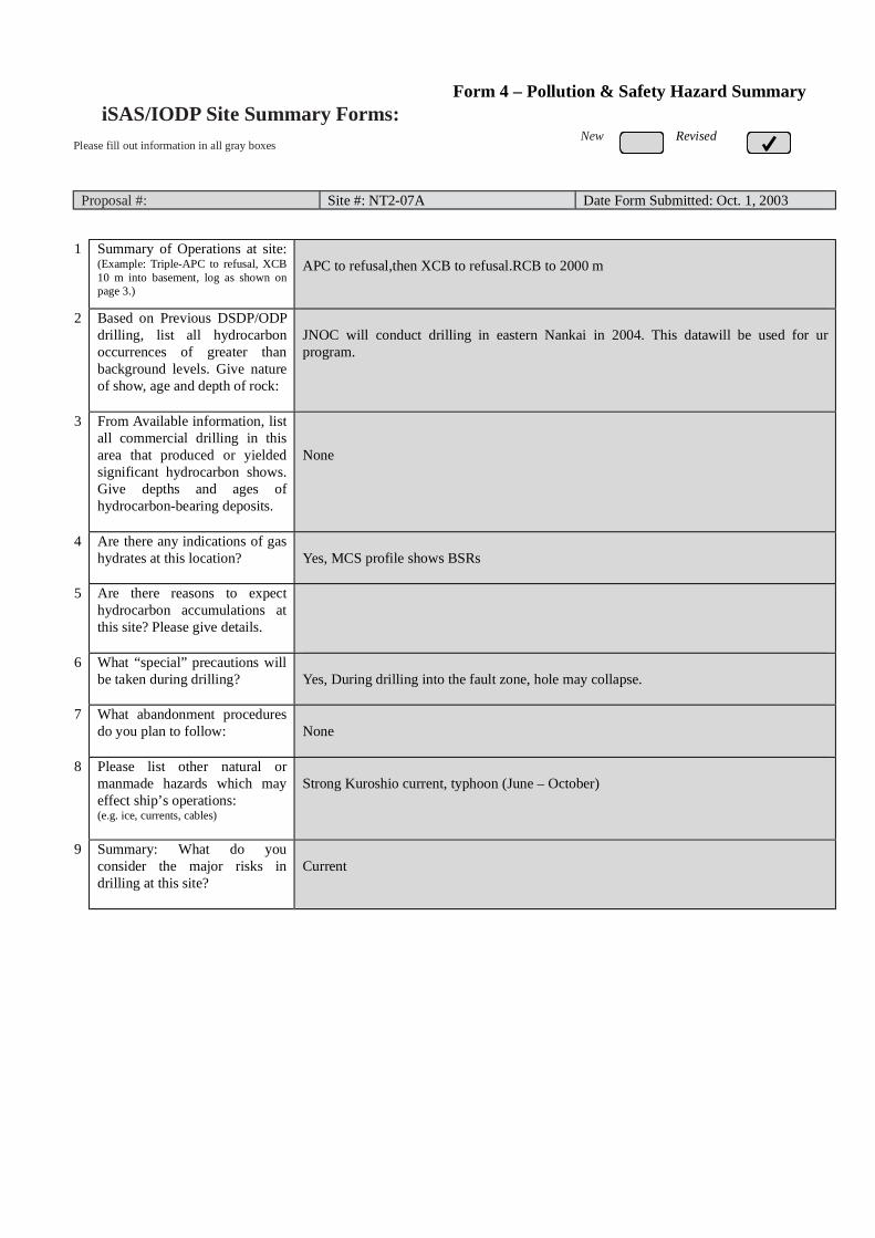
New RevisedPlease fill out information in all gray boxes
Proposal #: Site #: NT2-07A Date Form Submitted: Oct. 1, 2003
1 Summary of Operations at site:(Example: Triple-APC to refusal, XCB10 m into basement, log as shown onpage 3.)
APC to refusal,then XCB to refusal.RCB to 2000 m
2 Based on Previous DSDP/ODPdrilling, list all hydrocarbonoccurrences of greater thanbackground levels. Give natureof show, age and depth of rock:
JNOC will conduct drilling in eastern Nankai in 2004. This datawill be used for urprogram.
3 From Available information, listall commercial drilling in thisarea that produced or yieldedsignificant hydrocarbon shows.Give depths and ages ofhydrocarbon-bearing deposits.
None
4 Are there any indications of gashydrates at this location? Yes, MCS profile shows BSRs
5 Are there reasons to expecthydrocarbon accumulations atthis site? Please give details.
6 What “special” precautions willbe taken during drilling? Yes, During drilling into the fault zone, hole may collapse.
7 What abandonment proceduresdo you plan to follow: None
8 Please list other natural ormanmade hazards which mayeffect ship’s operations:(e.g. ice, currents, cables)
Strong Kuroshio current, typhoon (June – October)
9 Summary: What do youconsider the major risks indrilling at this site?
Current
iSAS/IODP Site Summary Forms:Form 4 – Pollution & Safety Hazard Summary

New Revised
Proposal #: Site #: NT2-07A Date Form Submitted: Oct. 1, 2003
Sub-bottom
depth (m)
Key reflectors,Unconformities,
faults, etcAge
Assumedvelocity(km/sec)
Lithology Paleo-environment
Avg. rateof sed.accum.(m/My)
Comments
400
1800
Unconformity
fault
Holocene toMioce
ne
1.6-2.5km/s
Slopesediments
to
oldaccretionary
rocks
Accretionaryprism
iSAS/IODP Site Summary Forms:Form 5 – Lithologic Summary

iSAS/IODP Site Summary Forms:Form 1 - General Site Information
Please fill out information in all gray boxes
Section A: Proposal Information
Title of Proposal:NanTroSEIZE Drilling and Observatory Phase 2
Mechanical and Hydrologic State of Mega-Splay Faults:Implications for Seismogenic Faulting and Tsunami Generation
Date FormSubmitted:
Oct. 1, 2003
Site SpecificObjectives with
Priority(Must include general
objectives in proposal)
Study the progressive change in the fault properties by intersecting the splay fault at
intermediate depth of 3.5km. Integration with NT2-01A and NT2-02A are essential.
Priority:1 (Alternate site for NT2-03A)
List PreviousDrilling in Area:
None
Section B: General Site Information
Site Name:(e.g. SWPAC-01A)
NT2-08A
If site is a reoccupationof an old DSDP/ODPSite, Please includeformer Site #
Area or Location:
Southwestern NankaiTrough off Kumano
Latitude: Deg: 33 Min: 10.8 N Jurisdiction:Within Japanese EEZ
Longitude: Deg: 136 Min: 28.6 E Distance to Land: 45 NM
CoordinatesSystem:
WGS 84
Priority of Site: Primary: Alt: Water Depth: 2,170 m
New RevisedRevised 7 M arch 2002

Section C: Operational Information
Sediments Basement3500Proposed
Penetration:(m) What is the total sed. thickness? >3,000 m
0
Total Penetration: 2,200 m
General Lithologies: Slope basin sediment on top, fracturedsection across the splay fault, and underlyingdeformed, compacted turbiditeContinuous coring may be replaced with ordinary/LWD logging.Coring Plan:
(Specify or Circle) 1-2-3-APC VPC* XCB MDCB* PCS RCB Re-entry HRGB
* Systems Currently Under Development
Standard Tools Special Tools LWDNeutron-Porosity Borehole Televiewer Formation Fluid Sampling Density-NeutronLitho-Density Nuclear Magnetic
ResonanceBorehole Temperature
& PressureResistivity-Gamma Ray
Gamma Ray Geochemical Borehole Seismic Acoustic
Resistivity Side-Wall Core Sampling
Acoustic
Wireline LoggingPlan:
Formation Image Others ( ) Others ( FMI )
Max.BoreholeTemp. :
Expected value (For Riser Drilling)
80-100
Cuttings Sampling Intervals
from 1700 m to 1900 m, 5 m intervals
from 3300 m to 3500 m, 5 m intervals
Mud Logging:(Riser Holes Only)
Basic Sampling Intervals: 5mEstimated days: Drilling/Coring: 130 Logging: 20 Total On-Site: 250
Future Plan: Longterm Borehole Observation Plan/Re-entry Plan
Geodetic (strain/tilt), seismic and hydrologic (P,T) sensors (100 days?)
Please check following List of Potential Hazards
Shallow Gas Complicated SeabedCondition
Hydrothermal Activity
What is your Weatherwindow? (Preferable period
with the reasons)
Hydrocarbon Soft Seabed Landslide and Turbidity Current
Shallow Water FlowCurrents Methane Hydrate
Abnormal Pressure Fractured Zone Diapir and Mud Volcano
Man-made Objects FaultHigh Temperature
H2S High Dip Angle Ice Conditions
Hazards/Weather:
CO2
May – August(typhoon risk in late
August to September,then low pressure inNovember throughMarch)
°C

New RevisedPlease fill out information in all gray boxes
roposal #: Site #: NT2-08A Date Form Submitted: Oct. 1, 2003
Data Type
SSPRequir-ements
ExistsIn DB Details of available data and data that are still to be collected
1High resolutionseismic reflection
YESPrimary Line(s) :Location of Site on line (SP or Time only) JAMSTEC Line-I (Feb. 2003)
Crossing Lines(s): JAMSTEC Line-9 (Feb. 2003)
2Deep Penetrationseismic reflection
YESPrimary Line(s): Location of Site on line (SP or Time only) KR0108-4
Crossing Lines(s):
3 Seismic Velocity† YES Stacking velocity and migration velocity from MCS lines.OBS data also available.
4 Seismic Grid YES Acquired by JAMSTEC in Feb. 2003
5a Refraction(surface)
YES Two-ship COP (max. offset 20km) was obtained by JAMSTEC in Sep.2002
5b Refraction(near bottom)
YES OBS data by Nakanishi et al. (1997)
6 3.5 kHz NO Location of Site on line (Time)
7 Swathbathymetry
YES Multi-narrow beam data by JAMSTEC R/V Yokosuka
8a Side-lookingsonar (surface)
YES Some data collected using IZANAGI side scan sonar
8b Side-lookingsonar (bottom)
NO
9 Photographyor Video
YES Taken by submersibles of JASMTEC
10 Heat Flow YES Obtained from surface ship, submersibles, long-erm monitoring and BSR
11a Magnetics YES Compiled map published from AIST, Japan
11b Gravity YES Compiled map published from AIST, Japan
12 Sediment cores YES Gravity and piston cores13 Rock sampling YES Taken by submersible and ROV
14a Water current data YES Available on JODC web page (http://www.jodc.go.jp/)14b Ice Conditions
15 OBSmicroseismicity
Being processed now
16 Navigation YES
17 Other
SSP Classification of Site: SSP Watchdog: Date of Last Review:SSP Comments:
X=required; X*=may be required for specific sites; Y=recommended; Y*=may be recommended for specific sites;R=required for re-entry sites; T=required for high temperature environments; † Accurate velocity information is requiredfor holes deeper than 400m.
iSAS/IODP Site Summary Forms:Form 2 - Site Survey Detail

New Revised
Proposal #: Site #: NT2-08A Date Form Submitted: Oct. 1, 2003Water Depth (m): 2170 Sed. Penetration (m): 3500 Basement Penetration (m): 0
Do you need to use the conical side-entry sub (CSES) at this site? Yes No
Are high temperatures expected at this site? Yes No
Are there any other special requirements for logging at this site? Yes No
If “Yes” Please describe requirements:
What do you estimate the total logging time for this site to be:
Measurement Type Scientific ObjectiveRelevance
(1=high, 3=Low)
Neutron-Porosity Estimation of water content in sedimentary sequences and basement. 1
Litho-Density Estimation of water content,bulk density,and mineral composition in
sedimentary sequences and basement.
1
Natural Gamma Ray Estimation clay contents and mineral composition in sedimentary
sequences and basement.
1
Resistivity-Induction Estimation of water content and electro-magnetic properties in
sedimentary sequences and basement.
1
Acoustic
FMS Imaging of sedimentary structures and fractures.Core-log correlation of
structural features.
1
BHTV
Resistivity-Laterolog
Magnetic/Susceptibility
Density-Neutron (LWD) Estimation of water contents,bulk density,and lithology in unstable
borehole environments.
1
Resitivity-Gamma Ray
(LWD)
Estimation of water contents,bulk density,and lithology in unstable
borehole environments.
1
Other: Special tools (CORK,
PACKER, VSP, PCS, FWS,
WSP
RAB, VSP
Hydrofracturing, Packer injection test
CORK and Geodetic/Seismic borehole observatory
1
For help in determining logging times, please contact the ODP-LDEO Wireline Logging Services groupat:
[email protected]://www.ldeo.columbia.edu/BRG/brg_home.htmlPhone/Fax: (914) 365-8674 / (914) 365-3182
Note: Sites with greater than 400 m ofpenetration or significant basementpenetration require deployment ofstandard toolstrings.
iSAS/IODP Site Summary Forms:Form 3 - Detailed Logging Plan
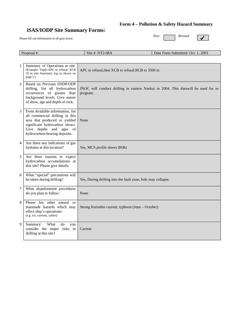
New RevisedPlease fill out information in all gray boxes
Proposal #: Site #: NT2-08A Date Form Submitted: Oct. 1, 2003
1 Summary of Operations at site:(Example: Triple-APC to refusal, XCB10 m into basement, log as shown onpage 3.)
APC to refusal,then XCB to refusal.RCB to 3500 m
2 Based on Previous DSDP/ODPdrilling, list all hydrocarbonoccurrences of greater thanbackground levels. Give natureof show, age and depth of rock:
JNOC will conduct drilling in eastern Nankai in 2004. This datawill be used for urprogram.
3 From Available information, listall commercial drilling in thisarea that produced or yieldedsignificant hydrocarbon shows.Give depths and ages ofhydrocarbon-bearing deposits.
None
4 Are there any indications of gashydrates at this location? Yes, MCS profile shows BSRs
5 Are there reasons to expecthydrocarbon accumulations atthis site? Please give details.
6 What “special” precautions willbe taken during drilling? Yes, During drilling into the fault zone, hole may collapse.
7 What abandonment proceduresdo you plan to follow: None
8 Please list other natural ormanmade hazards which mayeffect ship’s operations:(e.g. ice, currents, cables)
Strong Kuroshio current, typhoon (June – October)
9 Summary: What do youconsider the major risks indrilling at this site?
Current
iSAS/IODP Site Summary Forms:Form 4 – Pollution & Safety Hazard Summary

New Revised
Proposal #: Site #: NT2-08A Date Form Submitted: Oct. 1, 2003
Sub-bottom
depth (m)
Key reflectors,Unconformities,
faults, etcAge
Assumedvelocity(km/sec)
Lithology Paleo-environment
Avg. rateof sed.accum.(m/My)
Comments
300
1800
3400
Unconformity
Fault
fault
Holocene toMioce
ne
1.6-2.5km/s
Slopesediments
to
oldaccretionary
rocks
Accretionaryprism
iSAS/IODP Site Summary Forms:Form 5 – Lithologic Summary

Please fill out information in all gray boxes
Title: NanTroSEIZE Drilling and Observatory Phase 3: A Window into theSeismogenic Zone
Proponent(s): Kiyoshi Suyehiro, Harold Tobin, Eiichiro Araki, Susan Bilek, Tadanori Goto, Pierre Henry,Gaku Kimura, Aitaro Kato, Masa Kinoshita, Chris Marone, Greg Moore, J. Casey Moore,Demian Saffer, Arito Sakaguchi, Masanao Shinohara, Ralph Stephen, Akito Tsutsumi,Kohtaro Ujiie, Kelin Wang
Keywords:(5 or less)
Seismogenic zone, fault mechanics, borehole observatory,tsunamigenesis Area: Southwestern
Japan margin
Contact Information:Contact Person: Harold Tobin
Department: Earth and Environmental Science DepartmentOrganization: New Mexico Tech
Address Socorro, NM 87801 USATel.: 505-835-5920 Fax: 505-835-6436
E-mail: [email protected]
Permission to post abstract on iSAS Web site: Yes No
Abstract: (400 words or less)
The principal goal of NanTroSEIZE is to understand seismogenesis and rupture propagation along subductionplate boundary faults by direct testing of key hypotheses related to the mechanics of subduction megathrusts.NanTroSEIZE Phase 3 represents the culmination of the Seismogenic Zone Initiative: drilling into,sampling, and monitoring of the subduction zone plate interface at depths of coseismic slip. This proposalcenters on the deepest drilling effort in the NanTroSEIZE project: sampling a single site across the entire plateinterface into the top of the subducting Philippine Sea plate. The proposed borehole will penetrate a major splayfault (~4 km bsf) potentially implicated in coseismic slip, as well as the master decollement (~6 km bsf), at alocation of shallow large slip during the 1944 Tonankai Mw 8.2 earthquake.
The goal of this proposal is to address two key questions by a combination of logging, coring, down-holeexperiments, and long-term monitoring:
(1) What controls the nature of fault slip and its spatial variability (i.e. the updip transition from aseismic toseismogenic slip)?
(2) What processes control temporal changes in slip behavior on a given fault?Specifically, this proposal is aimed at testing hypotheses explaining controls on unstable slip, and documenting theroles of fault zone state (stress, fluid pressure, fabric) and composition in controlling frictional rheology. Down-hole and monitoring observations, core analyses, and post-cruise laboratory studies will provide direct tests ofexisting hypothesis for fault zone frictional behavior. One focus of Phase 3 will be on documenting the materialproperties and ambient conditions at each of the two faults, and comparing results with findings from shallowerportions of the plate boundary system sampled during Phases 1 and 2 to rigorously characterize controls on faultslip behavior in an active megathrust system.
Proposed activities include (1) drilling, LWD, and casing of a main hole - with drillstem tests performed atcasing set points, (2) creation of a sidetrack coring hole with continuous coring from 4000-6200 mbsf, and (3) welltests in perforated casing and installation of an observatory system for continuous monitoring of pore fluidpressure, temperature, strain, tilt, and seismicity. The borehole observatories, along with surface arrays ofmeasurements, and regional geodetic and seismic monitoring, will provide critical data toward understanding theslip distribution, temporal variability, and controlling mechanisms of seismogenic faulting along the plate boundarysystem.
IODP Proposal Cover SheetNew Revised Addendum
Above For Official Use Only
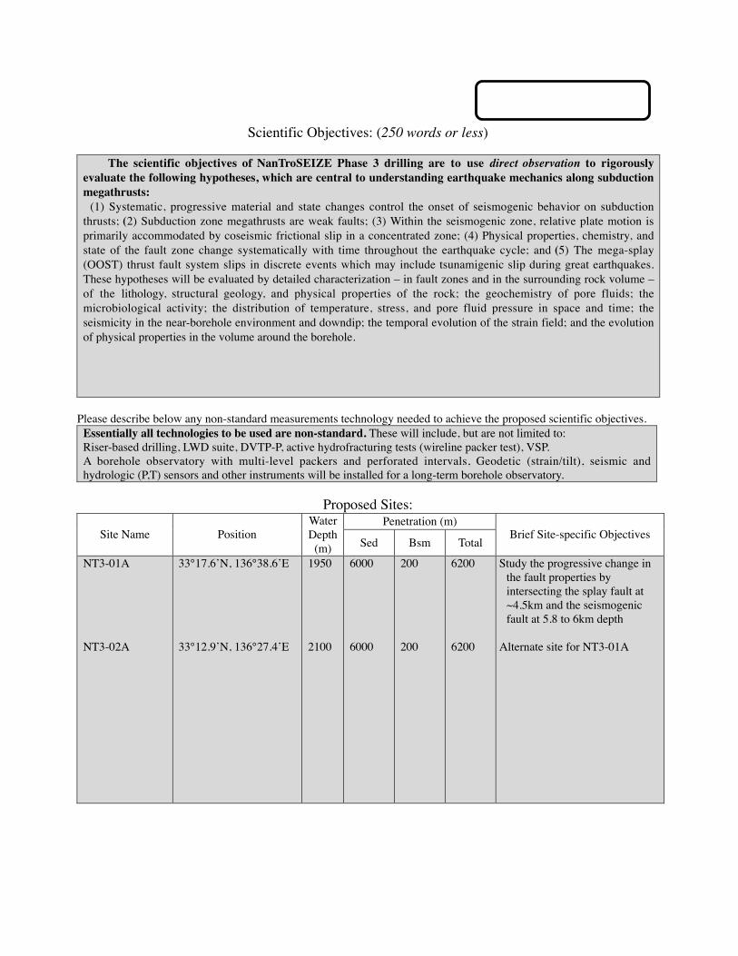
Scientific Objectives: (250 words or less)
The scientific objectives of NanTroSEIZE Phase 3 drilling are to use direct observation to rigorouslyevaluate the following hypotheses, which are central to understanding earthquake mechanics along subductionmegathrusts:
(1) Systematic, progressive material and state changes control the onset of seismogenic behavior on subductionthrusts; (2) Subduction zone megathrusts are weak faults; (3) Within the seismogenic zone, relative plate motion isprimarily accommodated by coseismic frictional slip in a concentrated zone; (4) Physical properties, chemistry, andstate of the fault zone change systematically with time throughout the earthquake cycle; and (5) The mega-splay(OOST) thrust fault system slips in discrete events which may include tsunamigenic slip during great earthquakes.These hypotheses will be evaluated by detailed characterization – in fault zones and in the surrounding rock volume –of the lithology, structural geology, and physical properties of the rock; the geochemistry of pore fluids; themicrobiological activity; the distribution of temperature, stress, and pore fluid pressure in space and time; theseismicity in the near-borehole environment and downdip; the temporal evolution of the strain field; and the evolutionof physical properties in the volume around the borehole.
Please describe below any non-standard measurements technology needed to achieve the proposed scientific objectives.Essentially all technologies to be used are non-standard. These will include, but are not limited to:Riser-based drilling, LWD suite, DVTP-P, active hydrofracturing tests (wireline packer test), VSP.A borehole observatory with multi-level packers and perforated intervals, Geodetic (strain/tilt), seismic andhydrologic (P,T) sensors and other instruments will be installed for a long-term borehole observatory.
Proposed Sites:Penetration (m)
Site Name PositionWaterDepth
(m) Sed Bsm TotalBrief Site-specific Objectives
NT3-01A
NT3-02A
33°17.6’N, 136°38.6’E
33°12.9’N, 136°27.4’E
1950
2100
6000
6000
200
200
6200
6200
Study the progressive change inthe fault properties byintersecting the splay fault at~4.5km and the seismogenicfault at 5.8 to 6km depth
Alternate site for NT3-01A

iSAS/IODP Site Summary Forms:Form 1 - General Site InformationPlease fill out information in all gray boxes
Section A: Proposal Information
Title of Proposal: NanTroSEIZE Drilling and Observatory Phase 3: A Window into theSeismogenic Zone
Date FormSubmitted:
Apr. 1, 2003
Site SpecificObjectives with
Priority(Must include general
objectives in proposal)
Sample and instrument decollement, mega-splay, and wall rock of lower prism to addressfault rheology, slip history, and temporal change objectives.
Priority:1
List PreviousDrilling in Area:
None
Section B: General Site Information
Site Name:(e.g. SWPAC-01A) NT3-01A
If site is a reoccupationof an old DSDP/ODPSite, Please includeformer Site #
Area or Location: Southwestern NankaiTrough off Kumano
Latitude: Deg: 33 Min: 17.6 N Jurisdiction:Within Japanese EEZ
Longitude: Deg: 136 Min: 38.6 E Distance to Land: 45 NM
CoordinatesSystem: WGS 84
Priority of Site: Primary: X Alt: Water Depth: 1,950 m
New RevisedRevised 7 March 2002

Section C: Operational Information
Sediments Basement5800 - 6000Proposed
Penetration:(m) What is the total sed. thickness? >5,500 m
200
Total Penetration: 6,200 mGeneral Lithologies: Slope basin clastic sediments, accreted and
deformed trench turbidites, hemipelagic andpelagic mudstones, pillow basalt.Continuous coring may be replaced with LWD logging in intervalsCoring Plan:
(Specify or Circle) 1-2-3-APC VPC* XCB MDCB* PCS RCB Re-entry HRGB
* Systems Currently Under Development
Standard Tools Special Tools LWDNeutron-Porosity Borehole Televiewer Formation Fluid Sampling Density-NeutronLitho-Density Nuclear Magnetic
ResonanceBorehole Temperature& Pressure
Resistivity-Gamma Ray
Gamma Ray Geochemical Borehole Seismic AcousticResistivity Side-Wall Core
SamplingAcoustic
Wireline LoggingPlan:
Formation Image Others ( ) Others ( FMI )
Max.BoreholeTemp. :
Expected value (For Riser Drilling) 150-170 degCCuttings Sampling Intervals
from 1500 m to 3600 m, 5 m intervalsfrom 4300 m to 6200 m, 5 m intervals
Mud Logging:(Riser Holes Only)
Basic Sampling Intervals: 5mEstimated days: Drilling/Coring: ??? Logging: ?? Total On-Site: ???
Future Plan: Longterm Borehole Observation Plan/Re-entry Plan Long-term observatory installation and data telemetry/recording
Please check following List of Potential HazardsShallow Gas Complicated Seabed
ConditionHydrothermal Activity
What is your Weatherwindow? (Preferable period
with the reasons)
Hydrocarbon Soft Seabed Landslide and Turbidity Current
Shallow Water FlowCurrents Methane Hydrate
Abnormal Pressure Fractured Zone Diapir and Mud Volcano
Man-made Objects FaultHigh Temperature
H2S High Dip Angle Ice Conditions
Hazards/Weather:
CO2
May – August optimal
(typhoon risk in lateAugust to September)
°C
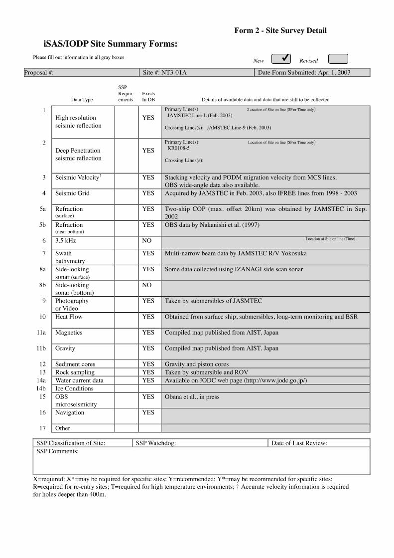
New RevisedPlease fill out information in all gray boxes
Proposal #: Site #: NT3-01A Date Form Submitted: Apr. 1, 2003
Data Type
SSPRequir-ements
ExistsIn DB Details of available data and data that are still to be collected
1High resolutionseismic reflection
YESPrimary Line(s) :Location of Site on line (SP or Time only) JAMSTEC Line-L (Feb. 2003)
Crossing Lines(s): JAMSTEC Line-9 (Feb. 2003)
2Deep Penetrationseismic reflection
YESPrimary Line(s): Location of Site on line (SP or Time only) KR0108-5
Crossing Lines(s):
3 Seismic Velocity† YES Stacking velocity and PODM migration velocity from MCS lines.OBS wide-angle data also available.
4 Seismic Grid YES Acquired by JAMSTEC in Feb. 2003, also IFREE lines from 1998 - 2003
5a Refraction(surface)
YES Two-ship COP (max. offset 20km) was obtained by JAMSTEC in Sep.2002
5b Refraction(near bottom)
YES OBS data by Nakanishi et al. (1997)
6 3.5 kHz NO Location of Site on line (Time)
7 Swathbathymetry
YES Multi-narrow beam data by JAMSTEC R/V Yokosuka
8a Side-lookingsonar (surface)
YES Some data collected using IZANAGI side scan sonar
8b Side-lookingsonar (bottom)
NO
9 Photographyor Video
YES Taken by submersibles of JASMTEC
10 Heat Flow YES Obtained from surface ship, submersibles, long-term monitoring and BSR
11a Magnetics YES Compiled map published from AIST, Japan
11b Gravity YES Compiled map published from AIST, Japan
12 Sediment cores YES Gravity and piston cores13 Rock sampling YES Taken by submersible and ROV
14a Water current data YES Available on JODC web page (http://www.jodc.go.jp/)14b Ice Conditions
15 OBSmicroseismicity
YES Obana et al., in press
16 Navigation YES
17 Other
SSP Classification of Site: SSP Watchdog: Date of Last Review:SSP Comments:
X=required; X*=may be required for specific sites; Y=recommended; Y*=may be recommended for specific sites;R=required for re-entry sites; T=required for high temperature environments; † Accurate velocity information is requiredfor holes deeper than 400m.
iSAS/IODP Site Summary Forms:Form 2 - Site Survey Detail

New Revised
Proposal #: Site #: NT3-01A Date Form Submitted: Apr. 1, 2003Water Depth (m): 1950 Sed. Penetration (m): 6000 Basement Penetration (m): 200
Do you need to use the conical side-entry sub (CSES) at this site? Yes NoAre high temperatures expected at this site? Yes NoAre there any other special requirements for logging at this site? Yes No
If “Yes” Please describe requirements:
What do you estimate the total logging time for this site to be:
Measurement Type Scientific ObjectiveRelevance
(1=high, 3=Low)
Neutron-Porosity Estimation of water content in sedimentary sequences and basement. 1
Litho-Density Estimation of water content,bulk density,and mineral composition in
sedimentary sequences and basement.
1
Natural Gamma Ray Estimation clay contents and mineral composition in sedimentary
sequences and basement.
1
Resistivity-Induction Estimation of water content and electro-magnetic properties in
sedimentary sequences and basement.
1
Acoustic Yes, dipole sonic, LWD sonic for physical properties
FMS Preferably FMI & RAB. Imaging of sedimentary structures and
fractures.Core-log correlation of structural features.
1
BHTV Perhaps?
Resistivity-Laterolog LWD resistivity
Magnetic/Susceptibility
Density-Neutron (LWD) Estimation of water contents,bulk density,and lithology in unstable
borehole environments.
1
Resitivity-Gamma Ray
(LWD)
Estimation of water contents,bulk density,and lithology in unstable
borehole environments.
1
Other: Special tools (CORK,
PACKER, VSP, PCS, FWS,
WSP
RAB, VSP
Hydrofracturing, Packer injection test
Geodetic/Seismic and multi-level packer borehole observatory
1
For help in determining logging times, please contact the ODP-LDEO Wireline Logging Services groupat:
[email protected]://www.ldeo.columbia.edu/BRG/brg_home.htmlPhone/Fax: (914) 365-8674 / (914) 365-3182
Note: Sites with greater than 400 m ofpenetration or significant basementpenetration require deployment ofstandard toolstrings.
iSAS/IODP Site Summary Forms:Form 3 - Detailed Logging Plan

New RevisedPlease fill out information in all gray boxes
Proposal #: Site #: NT3-01A Date Form Submitted: Apr. 1, 2003
1 Summary of Operations at site:(Example: Triple-APC to refusal, XCB10 m into basement, log as shown onpage 3.)
APC to refusal,then XCB to refusal.RCB to 6200 m or 200 m into basement.
2 Based on Previous DSDP/ODPdrilling, list all hydrocarbonoccurrences of greater thanbackground levels. Give natureof show, age and depth of rock:
JNOC will conduct BSR drilling in eastern Nankai in 2004. This data will be used forour program.
3 From Available information,list all commercial drilling inthis area that produced oryielded significant hydrocarbonshows. Give depths and ages ofhydrocarbon-bearing deposits.
None
4 Are there any indications of gashydrates at this location? Yes, MCS profile shows BSRs
5 Are there reasons to expecthydrocarbon accumulations atthis site? Please give details.
Except for normal gas hydrate occurrence, none.
6 What “special” precautions willbe taken during drilling? Fault zones are likely unstable and overpressured, prone to collapse, possible pressure
kicks.
7 What abandonment proceduresdo you plan to follow: Unknown at this time for riser operations
8 Please list other natural ormanmade hazards which mayeffect ship’s operations:(e.g. ice, currents, cables)
Strong Kuroshio current, typhoon (June – October)
9 Summary: What do youconsider the major risks indrilling at this site?
Current, shallow overpressure (but latter is probably not major
iSAS/IODP Site Summary Forms: Form 4 – Pollution & Safety Hazard Summary

New RevisedNew Revised
Proposal #: Site #: NT3-01A Date Form Submitted: Apr. 1, 2003
Sub-bottom
depth (m)
Key reflectors,Unconformities,
faults, etcAge
Assumedvelocity(km/sec)
Lithology Paleo-environment
Avg. rateof sed.accum.(m/My)
Comments
2001000
4500
6000
UnconformityUnconformity
Fault
fault
Holocene toMioce
ne
1.6-2.5km/s
Slopesediments
to
oldaccretionary
rocks
Accretionaryprism
iSAS/IODP Site Summary Forms:Form 5 – Lithologic Summary

iSAS/IODP Site Summary Forms:Form 1 - General Site InformationPlease fill out information in all gray boxes
Section A: Proposal Information
Title of Proposal: NanTroSEIZE Drilling and Observatory Phase 3: A Window into theSeismogenic Zone
Date FormSubmitted:
Apr. 1, 2003
Site SpecificObjectives with
Priority(Must include general
objectives in proposal)
Sample and instrument decollement, mega-splay, and wall rock of lower prism to addressfault rheology, slip history, and temporal change objectives.
Priority:2
List PreviousDrilling in Area:
None
Section B: General Site Information
Site Name:(e.g. SWPAC-01A) NT3-02A
If site is a reoccupationof an old DSDP/ODPSite, Please includeformer Site #
Area or Location: Southwestern NankaiTrough off Kumano
Latitude: Deg: 33 Min: 12.9 N Jurisdiction:Within Japanese EEZ
Longitude: Deg: 136 Min: 27.4 E Distance to Land: 45 NM
CoordinatesSystem: WGS 84
Priority of Site: Primary: X Alt: X Water Depth: 1,950 m
New RevisedRevised 7 March 2002
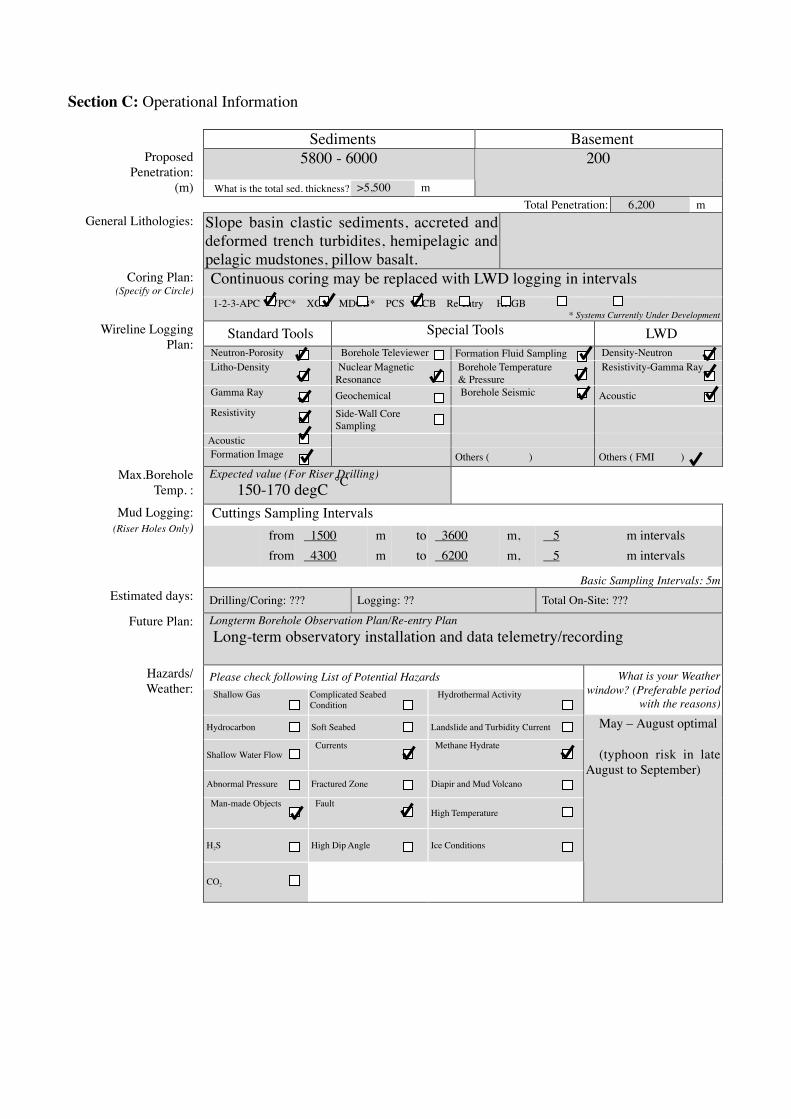
Section C: Operational Information
Sediments Basement5800 - 6000Proposed
Penetration:(m) What is the total sed. thickness? >5,500 m
200
Total Penetration: 6,200 mGeneral Lithologies: Slope basin clastic sediments, accreted and
deformed trench turbidites, hemipelagic andpelagic mudstones, pillow basalt.Continuous coring may be replaced with LWD logging in intervalsCoring Plan:
(Specify or Circle) 1-2-3-APC VPC* XCB MDCB* PCS RCB Re-entry HRGB
* Systems Currently Under Development
Standard Tools Special Tools LWDNeutron-Porosity Borehole Televiewer Formation Fluid Sampling Density-NeutronLitho-Density Nuclear Magnetic
ResonanceBorehole Temperature& Pressure
Resistivity-Gamma Ray
Gamma Ray Geochemical Borehole Seismic AcousticResistivity Side-Wall Core
SamplingAcoustic
Wireline LoggingPlan:
Formation Image Others ( ) Others ( FMI )
Max.BoreholeTemp. :
Expected value (For Riser Drilling) 150-170 degCCuttings Sampling Intervals
from 1500 m to 3600 m, 5 m intervalsfrom 4300 m to 6200 m, 5 m intervals
Mud Logging:(Riser Holes Only)
Basic Sampling Intervals: 5mEstimated days: Drilling/Coring: ??? Logging: ?? Total On-Site: ???
Future Plan: Longterm Borehole Observation Plan/Re-entry Plan Long-term observatory installation and data telemetry/recording
Please check following List of Potential HazardsShallow Gas Complicated Seabed
ConditionHydrothermal Activity
What is your Weatherwindow? (Preferable period
with the reasons)
Hydrocarbon Soft Seabed Landslide and Turbidity Current
Shallow Water FlowCurrents Methane Hydrate
Abnormal Pressure Fractured Zone Diapir and Mud Volcano
Man-made Objects FaultHigh Temperature
H2S High Dip Angle Ice Conditions
Hazards/Weather:
CO2
May – August optimal
(typhoon risk in lateAugust to September)
°C

New RevisedPlease fill out information in all gray boxes
Proposal #: Site #: NT3-02A Date Form Submitted: Apr. 1, 2003
Data Type
SSPRequir-ements
ExistsIn DB Details of available data and data that are still to be collected
1High resolutionseismic reflection
YESPrimary Line(s) :Location of Site on line (SP or Time only) JAMSTEC Line-B (Feb. 2003)
Crossing Lines(s): JAMSTEC Line-9 (Feb. 2003)
2Deep Penetrationseismic reflection
YESPrimary Line(s): Location of Site on line (SP or Time only) KR0108-5, 3
Crossing Lines(s):
3 Seismic Velocity† YES Stacking velocity and PODM migration velocity from MCS lines.OBS wide-angle data also available.
4 Seismic Grid YES Acquired by JAMSTEC in Feb. 2003, also IFREE lines from 1998 - 2003
5a Refraction(surface)
YES Two-ship COP (max. offset 20km) was obtained by JAMSTEC in Sep.2002
5b Refraction(near bottom)
YES OBS data by Nakanishi et al. (1997)
6 3.5 kHz NO Location of Site on line (Time)
7 Swathbathymetry
YES Multi-narrow beam data by JAMSTEC R/V Yokosuka
8a Side-lookingsonar (surface)
YES Some data collected using IZANAGI side scan sonar
8b Side-lookingsonar (bottom)
NO
9 Photographyor Video
YES Taken by submersibles of JASMTEC
10 Heat Flow YES Obtained from surface ship, submersibles, long-term monitoring and BSR
11a Magnetics YES Compiled map published from AIST, Japan
11b Gravity YES Compiled map published from AIST, Japan
12 Sediment cores YES Gravity and piston cores13 Rock sampling YES Taken by submersible and ROV
14a Water current data YES Available on JODC web page (http://www.jodc.go.jp/)14b Ice Conditions
15 OBSmicroseismicity
YES Obana et al., in press
16 Navigation YES
17 Other
SSP Classification of Site: SSP Watchdog: Date of Last Review:SSP Comments:
X=required; X*=may be required for specific sites; Y=recommended; Y*=may be recommended for specific sites;R=required for re-entry sites; T=required for high temperature environments; † Accurate velocity information is requiredfor holes deeper than 400m.
iSAS/IODP Site Summary Forms:Form 2 - Site Survey Detail

New Revised
Proposal #: Site #: NT3-01A Date Form Submitted: Apr. 1, 2003Water Depth (m): 1950 Sed. Penetration (m): 6000 Basement Penetration (m): 200
Do you need to use the conical side-entry sub (CSES) at this site? Yes NoAre high temperatures expected at this site? Yes NoAre there any other special requirements for logging at this site? Yes No
If “Yes” Please describe requirements:
What do you estimate the total logging time for this site to be:
Measurement Type Scientific ObjectiveRelevance
(1=high, 3=Low)
Neutron-Porosity Estimation of water content in sedimentary sequences and basement. 1
Litho-Density Estimation of water content,bulk density,and mineral composition in
sedimentary sequences and basement.
1
Natural Gamma Ray Estimation clay contents and mineral composition in sedimentary
sequences and basement.
1
Resistivity-Induction Estimation of water content and electro-magnetic properties in
sedimentary sequences and basement.
1
Acoustic Yes, dipole sonic, LWD sonic for physical properties
FMS Preferably FMI & RAB. Imaging of sedimentary structures and
fractures.Core-log correlation of structural features.
1
BHTV Perhaps?
Resistivity-Laterolog LWD resistivity
Magnetic/Susceptibility
Density-Neutron (LWD) Estimation of water contents,bulk density,and lithology in unstable
borehole environments.
1
Resitivity-Gamma Ray
(LWD)
Estimation of water contents,bulk density,and lithology in unstable
borehole environments.
1
Other: Special tools (CORK,
PACKER, VSP, PCS, FWS,
WSP
RAB, VSP
Hydrofracturing, Packer injection test
Geodetic/Seismic and multi-level packer borehole observatory
1
For help in determining logging times, please contact the ODP-LDEO Wireline Logging Services groupat:
[email protected]://www.ldeo.columbia.edu/BRG/brg_home.htmlPhone/Fax: (914) 365-8674 / (914) 365-3182
Note: Sites with greater than 400 m ofpenetration or significant basementpenetration require deployment ofstandard toolstrings.
iSAS/IODP Site Summary Forms:Form 3 - Detailed Logging Plan

New RevisedPlease fill out information in all gray boxes
Proposal #: Site #: NT3-01A Date Form Submitted: Apr. 1, 2003
1 Summary of Operations at site:(Example: Triple-APC to refusal, XCB10 m into basement, log as shown onpage 3.)
APC to refusal,then XCB to refusal.RCB to 6200 m or 200 m into basement.
2 Based on Previous DSDP/ODPdrilling, list all hydrocarbonoccurrences of greater thanbackground levels. Give natureof show, age and depth of rock:
JNOC will conduct BSR drilling in eastern Nankai in 2004. This data will be used forour program.
3 From Available information,list all commercial drilling inthis area that produced oryielded significant hydrocarbonshows. Give depths and ages ofhydrocarbon-bearing deposits.
None
4 Are there any indications of gashydrates at this location? Yes, MCS profile shows BSRs
5 Are there reasons to expecthydrocarbon accumulations atthis site? Please give details.
Except for normal gas hydrate occurrence, none.
6 What “special” precautions willbe taken during drilling? Fault zones are likely unstable and overpressured, prone to collapse, possible pressure
kicks.
7 What abandonment proceduresdo you plan to follow: Unknown at this time for riser operations
8 Please list other natural ormanmade hazards which mayeffect ship’s operations:(e.g. ice, currents, cables)
Strong Kuroshio current, typhoon (June – October)
9 Summary: What do youconsider the major risks indrilling at this site?
Current, shallow overpressure (but latter is probably not major
iSAS/IODP Site Summary Forms: Form 4 – Pollution & Safety Hazard Summary

New RevisedNew Revised
Proposal #: Site #: NT3-01A Date Form Submitted: Apr. 1, 2003
Sub-bottom
depth (m)
Key reflectors,Unconformities,
faults, etcAge
Assumedvelocity(km/sec)
Lithology Paleo-environment
Avg. rateof sed.accum.(m/My)
Comments
2001000
4500
6000
UnconformityUnconformity
Fault
fault
Holocene toMioce
ne
1.6-2.5km/s
Slopesediments
to
oldaccretionary
rocks
Accretionaryprism
iSAS/IODP Site Summary Forms:Form 5 – Lithologic Summary

Please fill out information in all gray boxes
Title: NanTroSEIZE Drilling and Observatory Phase 3: A Window into theSeismogenic Zone
Proponent(s): Kiyoshi Suyehiro, Harold Tobin, Eiichiro Araki, Susan Bilek, Tadanori Goto, Pierre Henry,Gaku Kimura, Aitaro Kato, Masa Kinoshita, Chris Marone, Greg Moore, J. Casey Moore,Demian Saffer, Arito Sakaguchi, Masanao Shinohara, Ralph Stephen, Akito Tsutsumi,Kohtaro Ujiie, Kelin Wang
Keywords:(5 or less)
Seismogenic zone, fault mechanics, borehole observatory,tsunamigenesis Area: Southwestern
Japan margin
Contact Information:Contact Person: Harold Tobin
Department: Earth and Environmental Science DepartmentOrganization: New Mexico Tech
Address Socorro, NM 87801 USATel.: 505-835-5920 Fax: 505-835-6436
E-mail: [email protected]
Permission to post abstract on iSAS Web site: Yes No
Abstract: (400 words or less)
The principal goal of NanTroSEIZE is to understand seismogenesis and rupture propagation along subductionplate boundary faults by direct testing of key hypotheses related to the mechanics of subduction megathrusts.NanTroSEIZE Phase 3 represents the culmination of the Seismogenic Zone Initiative: drilling into,sampling, and monitoring of the subduction zone plate interface at depths of coseismic slip. This proposalcenters on the deepest drilling effort in the NanTroSEIZE project: sampling a single site across the entire plateinterface into the top of the subducting Philippine Sea plate. The proposed borehole will penetrate a major splayfault (~4 km bsf) potentially implicated in coseismic slip, as well as the master decollement (~6 km bsf), at alocation of shallow large slip during the 1944 Tonankai Mw 8.2 earthquake.
The goal of this proposal is to address two key questions by a combination of logging, coring, down-holeexperiments, and long-term monitoring:
(1) What controls the nature of fault slip and its spatial variability (i.e. the updip transition from aseismic toseismogenic slip)?
(2) What processes control temporal changes in slip behavior on a given fault?Specifically, this proposal is aimed at testing hypotheses explaining controls on unstable slip, and documenting theroles of fault zone state (stress, fluid pressure, fabric) and composition in controlling frictional rheology. Down-hole and monitoring observations, core analyses, and post-cruise laboratory studies will provide direct tests ofexisting hypothesis for fault zone frictional behavior. One focus of Phase 3 will be on documenting the materialproperties and ambient conditions at each of the two faults, and comparing results with findings from shallowerportions of the plate boundary system sampled during Phases 1 and 2 to rigorously characterize controls on faultslip behavior in an active megathrust system.
Proposed activities include (1) drilling, LWD, and casing of a main hole - with drillstem tests performed atcasing set points, (2) creation of a sidetrack coring hole with continuous coring from 4000-6200 mbsf, and (3) welltests in perforated casing and installation of an observatory system for continuous monitoring of pore fluidpressure, temperature, strain, tilt, and seismicity. The borehole observatories, along with surface arrays ofmeasurements, and regional geodetic and seismic monitoring, will provide critical data toward understanding theslip distribution, temporal variability, and controlling mechanisms of seismogenic faulting along the plate boundarysystem.
IODP Proposal Cover SheetNew Revised Addendum
Above For Official Use Only

Scientific Objectives: (250 words or less)
The scientific objectives of NanTroSEIZE Phase 3 drilling are to use direct observation to rigorouslyevaluate the following hypotheses, which are central to understanding earthquake mechanics along subductionmegathrusts:
(1) Systematic, progressive material and state changes control the onset of seismogenic behavior on subductionthrusts; (2) Subduction zone megathrusts are weak faults; (3) Within the seismogenic zone, relative plate motion isprimarily accommodated by coseismic frictional slip in a concentrated zone; (4) Physical properties, chemistry, andstate of the fault zone change systematically with time throughout the earthquake cycle; and (5) The mega-splay(OOST) thrust fault system slips in discrete events which may include tsunamigenic slip during great earthquakes.These hypotheses will be evaluated by detailed characterization – in fault zones and in the surrounding rock volume –of the lithology, structural geology, and physical properties of the rock; the geochemistry of pore fluids; themicrobiological activity; the distribution of temperature, stress, and pore fluid pressure in space and time; theseismicity in the near-borehole environment and downdip; the temporal evolution of the strain field; and the evolutionof physical properties in the volume around the borehole.
Please describe below any non-standard measurements technology needed to achieve the proposed scientific objectives.Essentially all technologies to be used are non-standard. These will include, but are not limited to:Riser-based drilling, LWD suite, DVTP-P, active hydrofracturing tests (wireline packer test), VSP.A borehole observatory with multi-level packers and perforated intervals, Geodetic (strain/tilt), seismic andhydrologic (P,T) sensors and other instruments will be installed for a long-term borehole observatory.
Proposed Sites:Penetration (m)
Site Name PositionWaterDepth
(m) Sed Bsm TotalBrief Site-specific Objectives
NT3-01A
NT3-02A
33°17.6’N, 136°38.6’E
33°12.9’N, 136°27.4’E
1950
2100
6000
6000
200
200
6200
6200
Study the progressive change inthe fault properties byintersecting the splay fault at~4.5km and the seismogenicfault at 5.8 to 6km depth
Alternate site for NT3-01A

Please fill out information in all gray boxes
Title: The Nankai Trough Seismogenic Zone Experiment: Observatory Science at the Reference Sites
Proponent(s): Elizabeth Screaton, Michael Underwood, Demian Saffer, Kelin Wang, Geoff Wheat, Koichiro Obana, Greg Moore, Kevin Brown, Juichiro Ashi
Keywords: (5 or less)
Subduction inputs; hydrogeology; long-term observatories Area: Nankai Trough Shikoku Basin
Contact Information:
Contact Person: Elizabeth Screaton Department: Department of Geology
Organization: University of Florida Address PO Box 112120, 241 Williamson, Gainesville FL 32611 USA
Tel.: (352) 392-4612 Fax: (352) 392-9294 E-mail: screaton@ ufl.edu
Permission to post abstract on IODP-MI Sapporo Web site: Yes No
Abstract: (400 words or less)
The NanTroSEIZE Complex Drilling Plan describes a multi-phase strategy to get at the root cause of the transition from stable sliding to stick-slip fault behavior -- by intersecting the “seismogenic conveyor belt” of Nankai Trough on either side of its up-dip limit of seismicity. With a campaign of coring, logging, downhole measurements, and long-term observatory science, NanTroSEIZE will test hypotheses concerning the onset of seismogenic behavior and locking of subduction thrusts. Characterizing the inputs to the seismogenic zone through examination of reference sites is a vital component of NanTroSEIZE. This revised full proposal outlines scientific rationale and plans for installation of long-term borehole observatories at NantroSEIZE reference sites. Monitoring at these observatories serves two distinct purposes. First, the observatories will provide information on material properties and background geophysical and geochemical conditions. The state of stress and strength of coupling on the plate-boundary fault are acutely sensitive to 3-D variations in pore pressure, and these pore pressures will be greatly affected by the distribution and permeability of turbidites and the permeability of the ocean crust. Second, observatories allow us to detect temporal changes in the geophysical or geochemical conditions and even the material properties. Temporal changes include the gradual stress build-up during the interseismic period. Associated variations in the thermal and hydrological regimes, and episodic seismic and aseismic strain events, could show how the seismogenic zone adjusts to new conditions caused by the stress build-up, which elevates predictive understanding of the seismogenic zone. Two reference sites in Shikoku Basin, on a basement high and basement plain, will show how stratigraphy, basement topography, and thermal structure affect the physical and hydrologic properties of subduction inputs. Each will require a pair of screened intervals: one targeting open basement and one targeting the overlying sediment. A site located 7 km seaward of the deformation front will indicate how far pressure and chemistry anomalies are transmitted seaward of the deformation front. CORK monitoring at the toe of the accretionary prism will isolate temperature and pressure signals in the frontal décollement from signals in the subducting turbidites. A second shallow observatory at the prism toe will monitor micro-seismicity and strain. An observatory in Kumano Basin provides an important complement to background and transient data obtained within and seaward of the mega-splay system. This monitoring network will provide a vital context for observations within the plate boundary fault system.
IODP Proposal Cover Sheet New Revised Addendum
Above For Official Use Only
X
X
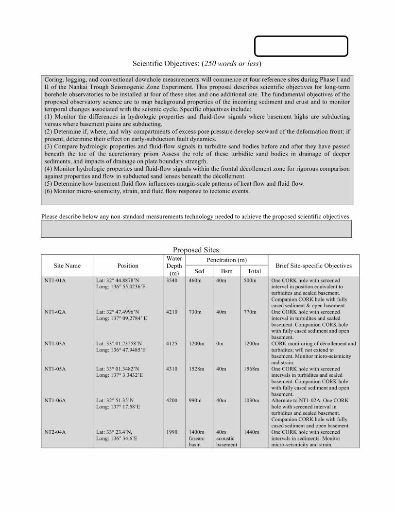
Scientific Objectives: (250 words or less)
Coring, logging, and conventional downhole measurements will commence at four reference sites during Phase I and II of the Nankai Trough Seismogenic Zone Experiment. This proposal describes scientific objectives for long-term borehole observatories to be installed at four of these sites and one additional site. The fundamental objectives of the proposed observatory science are to map background properties of the incoming sediment and crust and to monitor temporal changes associated with the seismic cycle. Specific objectives include: (1) Monitor the differences in hydrologic properties and fluid-flow signals where basement highs are subducting versus where basement plains are subducting. (2) Determine if, where, and why compartments of excess pore pressure develop seaward of the deformation front; if present, determine their effect on early-subduction fault dynamics. (3) Compare hydrologic properties and fluid-flow signals in turbidite sand bodies before and after they have passed beneath the toe of the accretionary prism Assess the role of these turbidite sand bodies in drainage of deeper sediments, and impacts of drainage on plate boundary strength. (4) Monitor hydrologic properties and fluid-flow signals within the frontal décollement zone for rigorous comparison against properties and flow in subducted sand lenses beneath the décollement. (5) Determine how basement fluid flow influences margin-scale patterns of heat flow and fluid flow. (6) Monitor micro-seismicity, strain, and fluid flow response to tectonic events.
Please describe below any non-standard measurements technology needed to achieve the proposed scientific objectives.
Proposed Sites:
Penetration (m) Site Name Position
Water Depth
(m) Sed Bsm Total Brief Site-specific Objectives
NT1-01A NT1-02A NT1-03A NT1-05A NT1-06A NT2-04A
Lat: 32° 44.8878’N Long: 136° 55.0236’E Lat: 32° 47.4996’N Long: 137° 09.2784’ E Lat: 33° 01.23258’N Long: 136° 47.9485’E Lat: 33° 01.3482’N Long: 137° 3.3432’E Lat: 32° 51.35’N Long: 137° 17.58’E Lat: 33° 23.4’N, Long: 136° 34.6’E
3540 4210 4125 4310 4200 1990
460m 730m 1200m 1528m 990m 1400m forearc basin
40m 40m 0m 40m 40m 40m acoustic basement
500m 770m 1200m 1568m 1030m 1440m
One CORK hole with screened interval in position equivalent to turbidites and sealed basement. Companion CORK hole with fully cased sediment & open basement. One CORK hole with screened interval in turbidites and sealed basement. Companion CORK hole with fully cased sediment and open basement. CORK monitoring of décollement and turbidites; will not extend to basement. Monitor micro-seismicity and strain. One CORK hole with screened intervals in turbidites and sealed basement. Companion CORK hole with fully cased sediment and open basement. Alternate to NT1-02A. One CORK hole with screened interval in turbidites and sealed basement. Companion CORK hole with fully cased sediment and open basement. One CORK hole with screened intervals in sediments. Monitor micro-seismicity and strain.

IODP Site Summary Forms: Form 1 - General Site Information
Please fill out information in all gray boxes
Section A: Proposal Information
Title of Proposal: The Nankai Trough Seismogenic Zone Experiment: Observatory Science at the Reference Sites
Date Form Submitted: Sept. 30, 2004
Site Specific Objectives with
Priority (Must include general
objectives in proposal)
One CORK hole with screened interval in turbidites and sealed basement. Companion CORK hole with fully cased sediment and open basement. Reference site to characterize hydrology of Shikoku Basin strata and upper igneous crust where a bathymetric mound is underlain by a basement high. Objectives are to show how stratigraphy, basement topography, and thermal structure affect the physical and hydrologic properties of subduction inputs.
List Previous Drilling in Area:
This site would be a return to NT1-01A, which is proposed to be drilled in 603A-Full2 (NantroSEIZE Reference Sites).
Section B: General Site Information
Site Name: (e.g. SWPAC-01A)
NT1-01A If site is a reoccupation
of an old DSDP/ODP Site, Please include former Site #
Area or Location:
Nankai Trough off Kii
Latitude:
Deg: 32 N Min: :44.8878 Jurisdiction:Japan
Longitude:
Deg: 136 E Min: 55.0236 Distance to Land:130 km to Cape Shiono-Misaki
Coordinates System:
WGS 84, Other ( )
Priority of Site: Primary:x Alt: Water Depth: 3540 m
New Revised Revised 7 March 2002
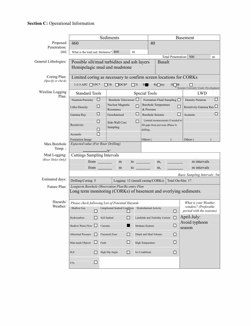
Section C: Operational Information
Sediments Basement
460 Proposed Penetration:
(m) What is the total sed. thickness? 460 m
40
Total Penetration: 500 m General Lithologies: Possible silt/mud turbidites and ash layers
Hemipelagic mud and mudstone Basalt
Limited coring as necessary to confirm screen locations for CORKs Coring Plan: (Specify or check)
1-2-3-APC VPC* XCB MDCB* PCS RCB Re-entry HRGB * Systems Currently Under Development
Standard Tools Special Tools LWD Neutron-Porosity Borehole Televiewer Formation Fluid Sampling Density-Neutron
Litho-Density Nuclear Magnetic Resonance
Borehole Temperature & Pressure
Resistivity-Gamma Ray
Gamma Ray Geochemical Borehole Seismic Acoustic
Resistivity Side-Wall Core Sampling
Limited measurements if needed to
fill gaps from previous (Phase I)
drilling.
Acoustic
Wireline Logging Plan:
Formation Image Others ( ) Others ( ) Max.Borehole
Temp. : Expected value (For Riser Drilling)
Cuttings Sampling Intervals from m to m, m intervals from m to m, m intervals
Mud Logging: (Riser Holes Only)
Basic Sampling Intervals: 5m Estimated days: Drilling/Coring: 5 Logging: 12 (install casing/CORKs) Total On-Site: 17
Future Plan: Longterm Borehole Observation Plan/Re-entry Plan Long term monitoring (CORKs) of basement and overlying sediments.
Please check following List of Potential Hazards Shallow Gas Complicated Seabed Condition Hydrothermal Activity
What is your Weather window? (Preferable
period with the reasons)
Hydrocarbon Soft Seabed Landslide and Turbidity Current
Shallow Water Flow Currents Methane Hydrate
Abnormal Pressure Fractured Zone Diapir and Mud Volcano
Man-made Objects Fault High Temperature
H2S High Dip Angle Ice Conditions
Hazards/ Weather:
CO2
April-July: Avoid typhoon season
°C
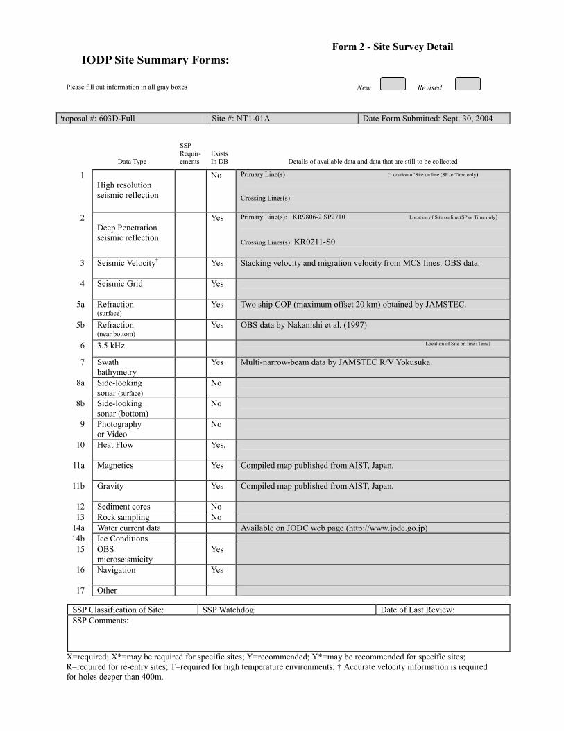
New Revised
Please fill out information in all gray boxes
Proposal #: 603D-Full Site #: NT1-01A Date Form Submitted: Sept. 30, 2004
Data Type
SSP Requir-ements
Exists In DB
Details of available data and data that are still to be collected 1
High resolution seismic reflection
No Primary Line(s) :Location of Site on line (SP or Time only) Crossing Lines(s):
2 Deep Penetration seismic reflection
Yes Primary Line(s): KR9806-2 SP2710 Location of Site on line (SP or Time only) Crossing Lines(s): KR0211-S0
3 Seismic Velocity† Yes Stacking velocity and migration velocity from MCS lines. OBS data.
4 Seismic Grid Yes
5a Refraction (surface)
Yes Two ship COP (maximum offset 20 km) obtained by JAMSTEC.
5b Refraction (near bottom)
Yes OBS data by Nakanishi et al. (1997)
6 3.5 kHz Location of Site on line (Time)
7 Swath bathymetry
Yes Multi-narrow-beam data by JAMSTEC R/V Yokusuka.
8a Side-looking sonar (surface)
No
8b Side-looking sonar (bottom)
No
9 Photography or Video
No
10 Heat Flow Yes.
11a Magnetics Yes Compiled map published from AIST, Japan.
11b Gravity Yes Compiled map published from AIST, Japan.
12 Sediment cores No 13 Rock sampling No
14a Water current data Available on JODC web page (http://www.jodc.go.jp) 14b Ice Conditions
15 OBS microseismicity
Yes
16 Navigation Yes
17 Other
SSP Classification of Site: SSP Watchdog: Date of Last Review: SSP Comments:
X=required; X*=may be required for specific sites; Y=recommended; Y*=may be recommended for specific sites; R=required for re-entry sites; T=required for high temperature environments; † Accurate velocity information is required for holes deeper than 400m.
IODP Site Summary Forms:Form 2 - Site Survey Detail

New Revised
Proposal #: 603D-Full Site #: NT1-01A Date Form Submitted: Sept. 30, 2004 Water Depth (m): 3540 Sed. Penetration (m): 460 Basement Penetration (m): 40
Do you need to use the conical side-entry sub (CSES) at this site? Yes No
Are high temperatures expected at this site? Yes No
Are there any other special requirements for logging at this site? Yes No If “Yes” Please describe requirements:No logging planned. Site will have been logged in previous phase.
CORK installation only
What do you estimate the total logging time for this site to be: 12 days install casing/CORKS
Measurement Type
Scientific Objective Relevance
(1=high, 3=Low) Neutron-Porosity
Litho-Density
Natural Gamma Ray
Resistivity-Induction
Acoustic
FMS
BHTV
Resistivity-Laterolog
Magnetic/Susceptibility
Density-Neutron (LWD)
Resitivity-Gamma Ray
(LWD)
Other: Special tools (CORK,
PACKER, VSP, PCS, FWS,
WSP
CORK
For help in determining logging times, please contact the ODP-LDEO Wireline Logging Services group at: [email protected] http://www.ldeo.columbia.edu/BRG/brg_home.html Phone/Fax: (914) 365-8674 / (914) 365-3182
Note: Sites with greater than 400 m of
penetration or significant basement penetration require deployment of standard toolstrings.
IODP Site Summary Forms: Form 3 - Detailed Logging Plan

New Revised
Please fill out information in all gray boxes
Proposal #: 603D-Full Site #: NT1-01A Date Form Submitted: Sept. 30, 2004
1 Summary of Operations at site:
(Example: Triple-APC to refusal, XCB 10 m into basement, log as shown on page 3.)
RCB with limited coring to confirm monitoring intervals for CORK. CORK installation
2 Based on Previous DSDP/ODP drilling, list all hydrocarbon occurrences of greater than background levels. Give nature of show, age and depth of rock:
None
3 From Available information, list all commercial drilling in this area that produced or yielded significant hydrocarbon shows. Give depths and ages of hydrocarbon-bearing deposits.
None
4 Are there any indications of gas hydrates at this location?
No
5 Are there reasons to expect hydrocarbon accumulations at this site? Please give details.
No
6 What “special” precautions will be taken during drilling?
None
7 What abandonment procedures do you plan to follow:
None. Holes will be CORKed.
8 Please list other natural or manmade hazards which may effect ship’s operations: (e.g. ice, currents, cables)
Strong Kuroshio current. Typhoon season (June to Oct)
9 Summary: What do you consider the major risks in drilling at this site?
Current
IODP Site Summary Forms:Form 4 – Pollution & Safety Hazard Summary

New New Revised
Proposal #: 603D-Full Site #: NT1-01A Date Form Submitted: Sept. 30, 2004
Sub-
bottom depth (m)
Key reflectors, Unconformities,
faults, etc
Age
Assumed velocity (km/sec)
Lithology
Paleo-environme
nt
Avg. rate of sed. accum. (m/My)
Comments
seafloor
460
560
Unconformity
Total depth
20 Ma
1.6-1.9
2.0
Hemipelagite
Volcanic sediment and
basement basalt
Backarc basin Floor
Backarc basin
spreading ridge
23 m/my
IODP Site Summary Forms: Form 5 – Lithologic Summary

IODP Site Summary Forms: Form 1 - General Site Information
Please fill out information in all gray boxes
Section A: Proposal Information
Title of Proposal: The Nankai Trough Seismogenic Zone Experiment: Observatory Science at the Reference Sites
Date Form Submitted: Sept. 30, 2004
Site Specific Objectives with
Priority (Must include general
objectives in proposal)
One CORK hole with screened interval in turbidites and sealed basement. Companion CORK hole with fully cased sediment and open basement. Reference site to characterize hydrology of Shikoku Basin strata and upper igneous crust where basement topography is relatively flat. Objectives are to document how stratigraphy, basement topography, and thermal structure affect the physical and hydrologic properties of subduction inputs.
List Previous Drilling in Area:
This site would be a return to NT1-02A, which is proposed to be drilled in 603A-Full2 (NantroSEIZE Reference Sites).
Section B: General Site Information
Site Name: (e.g. SWPAC-01A)
NT1-02A If site is a reoccupation
of an old DSDP/ODP Site, Please include former Site #
Area or Location:
Nankai Trough off Kii
Latitude:
Deg: 32 N Min: :47.4996 Jurisdiction:Japan
Longitude:
Deg: 137 E Min: 9.2784 Distance to Land:145 km to Cape Shiono-Misaki
Coordinates System:
WGS 84, Other ( )
Priority of Site: Primary:x Alt: Water Depth: 4210 m
New Revised Revised 7 March 2002

Section C: Operational Information
Sediments Basement
730 Proposed Penetration:
(m) What is the total sed. thickness? 730 m
40
Total Penetration: 770 m General Lithologies: Possible silt/mud turbidites and ash layers
Hemipelagic mud and mudstone Basalt
Limited coring as necessary to confirm screen locations for CORKs Coring Plan: (Specify or check)
1-2-3-APC VPC* XCB MDCB* PCS RCB Re-entry HRGB * Systems Currently Under Development
Standard Tools Special Tools LWD Neutron-Porosity Borehole Televiewer Formation Fluid Sampling Density-Neutron
Litho-Density Nuclear Magnetic Resonance
Borehole Temperature & Pressure
Resistivity-Gamma Ray
Gamma Ray Geochemical Borehole Seismic Acoustic
Resistivity Side-Wall Core Sampling
Limited measurements if needed to
fill gaps from previous (Phase I)
drilling.
Acoustic
Wireline Logging Plan:
Formation Image Others ( ) Others ( ) Max.Borehole
Temp. : Expected value (For Riser Drilling)
Cuttings Sampling Intervals from m to m, m intervals from m to m, m intervals
Mud Logging: (Riser Holes Only)
Basic Sampling Intervals: 5m Estimated days: Drilling/Coring: 6 days Logging: 12 (install casing/CORKs) Total On-Site: 18 days
Future Plan: Longterm Borehole Observation Plan/Re-entry Plan Long term monitoring (CORKs) of basement and overlying sediments.
Please check following List of Potential Hazards Shallow Gas Complicated Seabed Condition Hydrothermal Activity
What is your Weather window? (Preferable
period with the reasons)
Hydrocarbon Soft Seabed Landslide and Turbidity Current
Shallow Water Flow Currents Methane Hydrate
Abnormal Pressure Fractured Zone Diapir and Mud Volcano
Man-made Objects Fault High Temperature
H2S High Dip Angle Ice Conditions
Hazards/ Weather:
CO2
April-July: Avoid typhoon season
°C

New Revised
Please fill out information in all gray boxes
Proposal #: 603D-Full Site #: NT1-02A Date Form Submitted: Sept. 30, 2004
Data Type
SSP Requir-ements
Exists In DB
Details of available data and data that are still to be collected 1
High resolution seismic reflection
No Primary Line(s) :Location of Site on line (SP or Time only) Crossing Lines(s):
2 Deep Penetration seismic reflection
Yes Primary Line(s): KR9806-1 SP1740 Location of Site on line (SP or Time only) Crossing Lines(s): KR0211-S0 nearby
3 Seismic Velocity† Yes Stacking velocity and migration velocity from MCS lines. OBS data.
4 Seismic Grid Yes
5a Refraction (surface)
Yes Two ship COP (maximum offset 20 km) obtained by JAMSTEC.
5b Refraction (near bottom)
Yes OBS data by Nakanishi et al. (1997)
6 3.5 kHz Location of Site on line (Time)
7 Swath bathymetry
Yes Multi-narrow-beam data by JAMSTEC R/V Yokusuka.
8a Side-looking sonar (surface)
No
8b Side-looking sonar (bottom)
No
9 Photography or Video
No
10 Heat Flow Yes.
11a Magnetics Yes Compiled map published from AIST, Japan.
11b Gravity Yes Compiled map published from AIST, Japan.
12 Sediment cores No 13 Rock sampling No
14a Water current data Available on JODC web page (http://www.jodc.go.jp) 14b Ice Conditions
15 OBS microseismicity
Yes
16 Navigation Yes
17 Other
SSP Classification of Site: SSP Watchdog: Date of Last Review: SSP Comments:
X=required; X*=may be required for specific sites; Y=recommended; Y*=may be recommended for specific sites; R=required for re-entry sites; T=required for high temperature environments; † Accurate velocity information is required for holes deeper than 400m.
IODP Site Summary Forms:Form 2 - Site Survey Detail
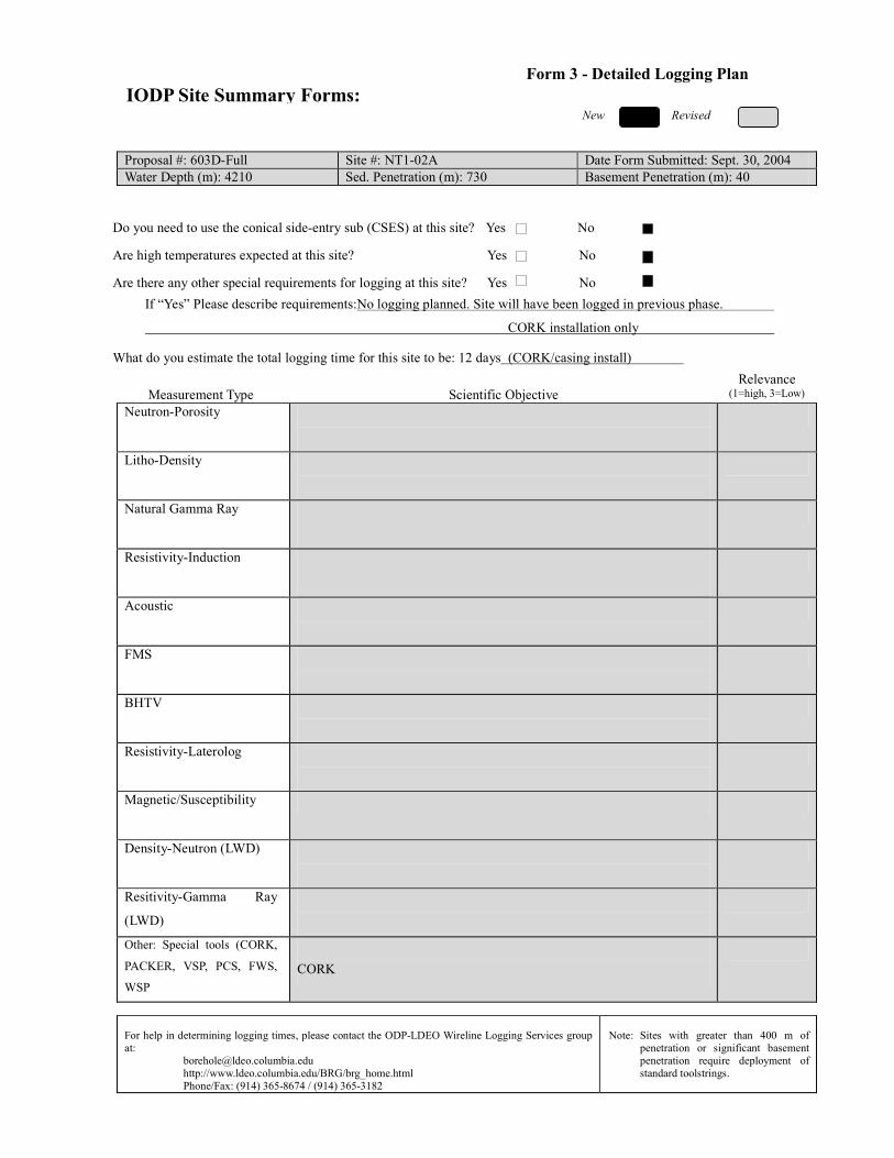
New Revised
Proposal #: 603D-Full Site #: NT1-02A Date Form Submitted: Sept. 30, 2004 Water Depth (m): 4210 Sed. Penetration (m): 730 Basement Penetration (m): 40
Do you need to use the conical side-entry sub (CSES) at this site? Yes No
Are high temperatures expected at this site? Yes No
Are there any other special requirements for logging at this site? Yes No If “Yes” Please describe requirements:No logging planned. Site will have been logged in previous phase.
CORK installation only
What do you estimate the total logging time for this site to be: 12 days (CORK/casing install)
Measurement Type
Scientific Objective Relevance
(1=high, 3=Low) Neutron-Porosity
Litho-Density
Natural Gamma Ray
Resistivity-Induction
Acoustic
FMS
BHTV
Resistivity-Laterolog
Magnetic/Susceptibility
Density-Neutron (LWD)
Resitivity-Gamma Ray
(LWD)
Other: Special tools (CORK,
PACKER, VSP, PCS, FWS,
WSP
CORK
For help in determining logging times, please contact the ODP-LDEO Wireline Logging Services group at: [email protected] http://www.ldeo.columbia.edu/BRG/brg_home.html Phone/Fax: (914) 365-8674 / (914) 365-3182
Note: Sites with greater than 400 m of
penetration or significant basement penetration require deployment of standard toolstrings.
IODP Site Summary Forms: Form 3 - Detailed Logging Plan

New Revised
Please fill out information in all gray boxes
Proposal #: 603D-Full Site #: NT1-01A Date Form Submitted: Sept. 30, 2004
1 Summary of Operations at site:
(Example: Triple-APC to refusal, XCB 10 m into basement, log as shown on page 3.)
RCB with limited coring to confirm monitoring intervals for CORK. CORK installation
2 Based on Previous DSDP/ODP drilling, list all hydrocarbon occurrences of greater than background levels. Give nature of show, age and depth of rock:
None
3 From Available information, list all commercial drilling in this area that produced or yielded significant hydrocarbon shows. Give depths and ages of hydrocarbon-bearing deposits.
None
4 Are there any indications of gas hydrates at this location?
No
5 Are there reasons to expect hydrocarbon accumulations at this site? Please give details.
No
6 What “special” precautions will be taken during drilling?
May need casing of sandy turbidites prior to basement drilling/basement CORK installation.
7 What abandonment procedures do you plan to follow:
None. Holes will be CORKed.
8 Please list other natural or manmade hazards which may effect ship’s operations: (e.g. ice, currents, cables)
Strong Kuroshio current. Typhoon season (June to Oct)
9 Summary: What do you consider the major risks in drilling at this site?
Current
IODP Site Summary Forms:Form 4 – Pollution & Safety Hazard Summary
NT1-02A

New New Revised
Proposal #: 603D-Full Site #: NT1-02A Date Form Submitted: Sept. 30, 2004
Sub-
bottom depth (m)
Key reflectors, Unconformities,
faults, etc
Age
Assumed velocity (km/sec)
Lithology
Paleo-environme
nt
Avg. rate of sed. accum. (m/My)
Comments
seafloor
730
830
Unconformity
Total depth
20 Ma
1.6-1.9
2.0
Hemipelagite and turbidites
Volcanic
sediment and basement basalt
Backarc basin Floor
Backarc basin
spreading ridge
36 m/my Heterogeneous stratigraphy with
irregular packets of turbidite sand.
IODP Site Summary Forms: Form 5 – Lithologic Summary
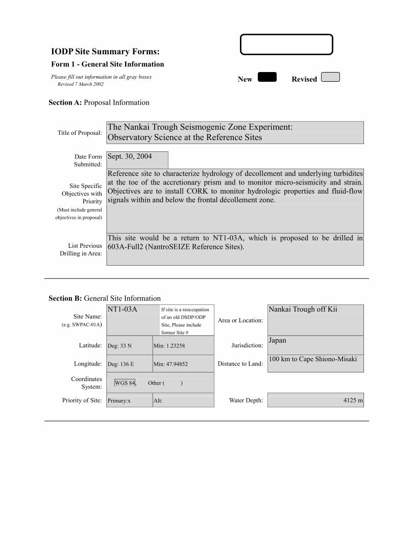
IODP Site Summary Forms: Form 1 - General Site Information
Please fill out information in all gray boxes
Section A: Proposal Information
Title of Proposal: The Nankai Trough Seismogenic Zone Experiment: Observatory Science at the Reference Sites
Date Form Submitted: Sept. 30, 2004
Site Specific Objectives with
Priority (Must include general
objectives in proposal)
Reference site to characterize hydrology of decollement and underlying turbidites at the toe of the accretionary prism and to monitor micro-seismicity and strain. Objectives are to install CORK to monitor hydrologic properties and fluid-flow signals within and below the frontal décollement zone.
List Previous Drilling in Area:
This site would be a return to NT1-03A, which is proposed to be drilled in 603A-Full2 (NantroSEIZE Reference Sites).
Section B: General Site Information
Site Name: (e.g. SWPAC-01A)
NT1-03A If site is a reoccupation
of an old DSDP/ODP Site, Please include former Site #
Area or Location:
Nankai Trough off Kii
Latitude:
Deg: 33 N Min: 1.23258 Jurisdiction:Japan
Longitude:
Deg: 136 E Min: 47.94852 Distance to Land:100 km to Cape Shiono-Misaki
Coordinates System:
WGS 84, Other ( )
Priority of Site: Primary:x Alt: Water Depth: 4125 m
New Revised Revised 7 March 2002

Section C: Operational Information
Sediments Basement
1200 Proposed Penetration:
(m) What is the total sed. thickness? 1740 m
Total Penetration: 1200 m General Lithologies: Silt and sand turbidites, ash layers,
hemipelagic mud and mudstone
Limited coring as necessary to confirm screen locations for CORKs Coring Plan: (Specify or check)
1-2-3-APC VPC* XCB MDCB* PCS RCB Re-entry HRGB * Systems Currently Under Development
Standard Tools Special Tools LWD Neutron-Porosity Borehole Televiewer Formation Fluid Sampling Density-Neutron
Litho-Density Nuclear Magnetic Resonance
Borehole Temperature & Pressure
Resistivity-Gamma Ray
Gamma Ray Geochemical Borehole Seismic Acoustic
Resistivity Side-Wall Core Sampling
Limited measurements if needed to
fill gaps from previous (Phase I)
drilling.
Acoustic
Wireline Logging Plan:
Formation Image Others ( ) Others ( ) Max.Borehole
Temp. : Expected value (For Riser Drilling)
Cuttings Sampling Intervals from m to m, m intervals from m to m, m intervals
Mud Logging: (Riser Holes Only)
Basic Sampling Intervals: 5m Estimated days: Drilling/Coring: 6 days Logging:12 (install casing/CORKs) Total On-Site: 18 days
Future Plan: Longterm Borehole Observation Plan/Re-entry Plan Long term monitoring (CORKs) of turbidites and decollement.
Please check following List of Potential Hazards Shallow Gas Complicated Seabed Condition Hydrothermal Activity
What is your Weather window? (Preferable
period with the reasons)
Hydrocarbon Soft Seabed Landslide and Turbidity Current
Shallow Water Flow Currents Methane Hydrate
Abnormal Pressure Fractured Zone Diapir and Mud Volcano
Man-made Objects Fault High Temperature
H2S High Dip Angle Ice Conditions
Hazards/ Weather:
CO2
April-July: Avoid typhoon season
°C
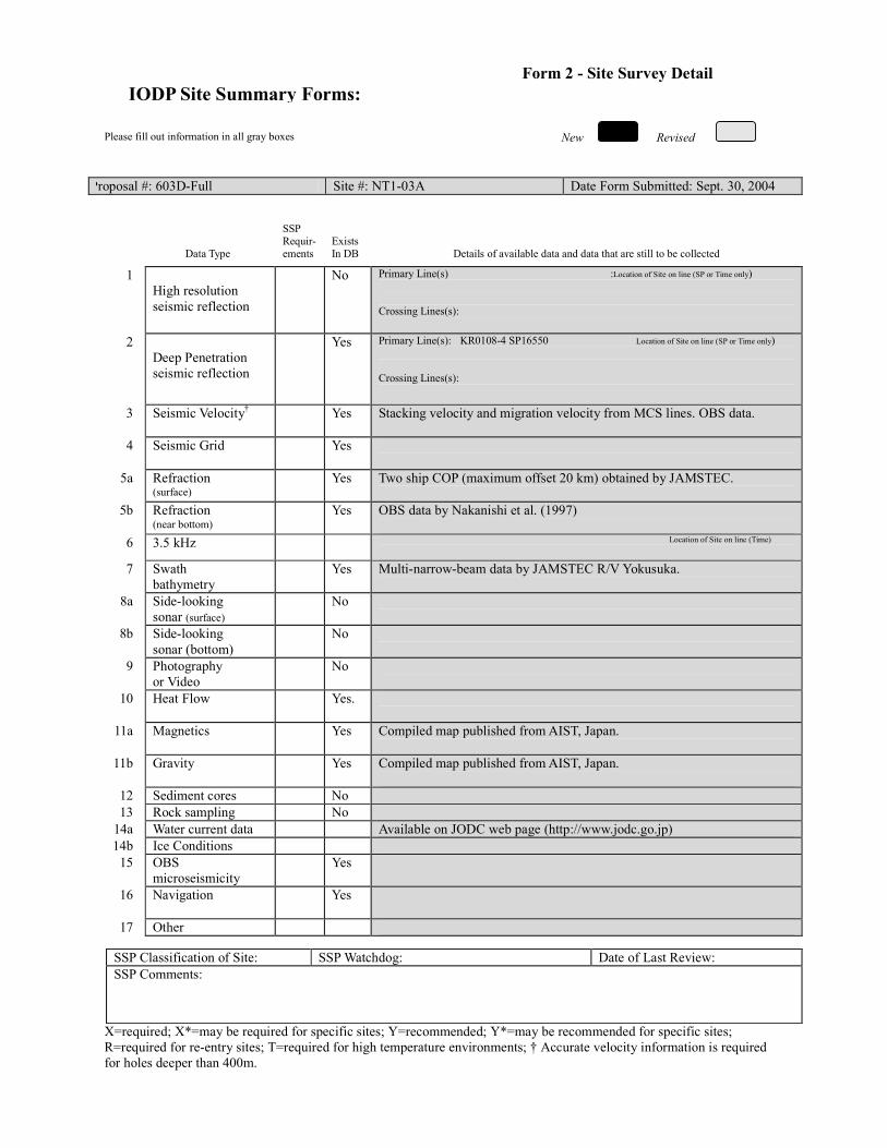
New Revised
Please fill out information in all gray boxes
Proposal #: 603D-Full Site #: NT1-03A Date Form Submitted: Sept. 30, 2004
Data Type
SSP Requir-ements
Exists In DB
Details of available data and data that are still to be collected 1
High resolution seismic reflection
No Primary Line(s) :Location of Site on line (SP or Time only) Crossing Lines(s):
2 Deep Penetration seismic reflection
Yes Primary Line(s): KR0108-4 SP16550 Location of Site on line (SP or Time only) Crossing Lines(s):
3 Seismic Velocity† Yes Stacking velocity and migration velocity from MCS lines. OBS data.
4 Seismic Grid Yes
5a Refraction (surface)
Yes Two ship COP (maximum offset 20 km) obtained by JAMSTEC.
5b Refraction (near bottom)
Yes OBS data by Nakanishi et al. (1997)
6 3.5 kHz Location of Site on line (Time)
7 Swath bathymetry
Yes Multi-narrow-beam data by JAMSTEC R/V Yokusuka.
8a Side-looking sonar (surface)
No
8b Side-looking sonar (bottom)
No
9 Photography or Video
No
10 Heat Flow Yes.
11a Magnetics Yes Compiled map published from AIST, Japan.
11b Gravity Yes Compiled map published from AIST, Japan.
12 Sediment cores No 13 Rock sampling No
14a Water current data Available on JODC web page (http://www.jodc.go.jp) 14b Ice Conditions
15 OBS microseismicity
Yes
16 Navigation Yes
17 Other
SSP Classification of Site: SSP Watchdog: Date of Last Review: SSP Comments:
X=required; X*=may be required for specific sites; Y=recommended; Y*=may be recommended for specific sites; R=required for re-entry sites; T=required for high temperature environments; † Accurate velocity information is required for holes deeper than 400m.
IODP Site Summary Forms:Form 2 - Site Survey Detail

New Revised
Proposal #: 603D-Full Site #: NT1-03A Date Form Submitted: Sept. 30, 2004 Water Depth (m): 4125 Sed. Penetration (m): 1200 Basement Penetration (m): 0
Do you need to use the conical side-entry sub (CSES) at this site? Yes No
Are high temperatures expected at this site? Yes No
Are there any other special requirements for logging at this site? Yes No If “Yes” Please describe requirements:No logging planned. Site will have been logged in previous phase.
CORK installation only
What do you estimate the total logging time for this site to be: 12 days (CORK/casing install)
Measurement Type
Scientific Objective Relevance
(1=high, 3=Low) Neutron-Porosity
Litho-Density
Natural Gamma Ray
Resistivity-Induction
Acoustic
FMS
BHTV
Resistivity-Laterolog
Magnetic/Susceptibility
Density-Neutron (LWD)
Resitivity-Gamma Ray
(LWD)
Other: Special tools (CORK,
PACKER, VSP, PCS, FWS,
WSP
CORK
For help in determining logging times, please contact the ODP-LDEO Wireline Logging Services group at: [email protected] http://www.ldeo.columbia.edu/BRG/brg_home.html Phone/Fax: (914) 365-8674 / (914) 365-3182
Note: Sites with greater than 400 m of
penetration or significant basement penetration require deployment of standard toolstrings.
IODP Site Summary Forms: Form 3 - Detailed Logging Plan

New Revised
Please fill out information in all gray boxes
Proposal #: 603D-Full Site #: NT1-03A Date Form Submitted: Sept. 30, 2004
1 Summary of Operations at site:
(Example: Triple-APC to refusal, XCB 10 m into basement, log as shown on page 3.)
RCB with limited coring to confirm monitoring intervals for CORK. CORK installation
2 Based on Previous DSDP/ODP drilling, list all hydrocarbon occurrences of greater than background levels. Give nature of show, age and depth of rock:
None
3 From Available information, list all commercial drilling in this area that produced or yielded significant hydrocarbon shows. Give depths and ages of hydrocarbon-bearing deposits.
None
4 Are there any indications of gas hydrates at this location?
No
5 Are there reasons to expect hydrocarbon accumulations at this site? Please give details.
No
6 What “special” precautions will be taken during drilling?
May need shallow casing to to stabilize sandy turbidites.
7 What abandonment procedures do you plan to follow:
None. Holes will be CORKed.
8 Please list other natural or manmade hazards which may effect ship’s operations: (e.g. ice, currents, cables)
Strong Kuroshio current. Typhoon season (June to Oct)
9 Summary: What do you consider the major risks in drilling at this site?
Current, instability of accreted trench turbidites.
IODP Site Summary Forms:Form 4 – Pollution & Safety Hazard Summary

New New Revised
Proposal #: 603D-Full Site #: NT1-03A Date Form Submitted: Sept. 30, 2004
Sub-
bottom depth (m)
Key reflectors, Unconformities,
faults, etc
Age
Assumed velocity (km/sec)
Lithology
Paleo-environme
nt
Avg. rate of sed. accum. (m/My)
Comments
seafloor
230
790
1000
1200
Fault
Reflector
Reflector
Total depth
Quaternary
Pleistocene Plio-Miocene
1.5
1.6-1.8
1.9
2.4
Hemipelagite + volcanic ash
turbidites
hemipelagite and volcanic
ash
hemipelagite + turbidite
Upper Shikoku Basin
Trench wedge Upper Shikoku Basin Lowe Shikoku Basin
Probably contains thick layers of
unconsolidated sands.
Heterogeneous stratigraphy with
irregular packets of sand or sandstone
IODP Site Summary Forms: Form 5 – Lithologic Summary

IODP Site Summary Forms: Form 1 - General Site Information
Please fill out information in all gray boxes
Section A: Proposal Information
Title of Proposal: The Nankai Trough Seismogenic Zone Experiment: Observatory Science at the Reference Sites
Date Form Submitted: Sept. 30, 2004
Site Specific Objectives with
Priority (Must include general
objectives in proposal)
One CORK hole with screened interval in turbidites and sealed basement. Companion CORK hole with fully cased sediment and open basement. Objectives are to document variations in turbidite and basement fluid flow between NT1-02A and deformation front.
List Previous Drilling in Area:
No scientific drilling in immediate vicinity. DSDP 87, ODP 131, 190, and 196 were conducted about 200 km SW of this proposal’s sites.
Section B: General Site Information
Site Name: (e.g. SWPAC-01A)
NT1-04B If site is a reoccupation
of an old DSDP/ODP Site, Please include former Site #
Area or Location:
Nankai Trough off Kii
Latitude:
Deg: 33 N Min: 01.3482 Jurisdiction:Japan
Longitude:
Deg: 137 E Min: 3.3432 Distance to Land:120 km to Cape Shiono-Misaki
Coordinates System:
WGS 84, Other ( )
Priority of Site: Primary: Alt:x Water Depth: 4310 m
New Revised Revised 7 March 2002
NT1-05A

Section C: Operational Information
Sediments Basement
1528 Proposed Penetration:
(m) What is the total sed. thickness? 1528 m
40
Total Penetration: 1568 m General Lithologies: Possible silt/mud turbidites and ash layers
Hemipelagic mud and mudstone Basalt
APC/XCB to refusal, RCB to TD. Coring Plan: (Specify or check)
1-2-3-APC VPC* XCB MDCB* PCS RCB Re-entry HRGB * Systems Currently Under Development
Standard Tools Special Tools LWD Neutron-Porosity Borehole Televiewer Formation Fluid Sampling Density-Neutron
Litho-Density Nuclear Magnetic Resonance
Borehole Temperature & Pressure
Resistivity-Gamma Ray
Gamma Ray Geochemical Borehole Seismic Acoustic
Resistivity Side-Wall Core Sampling
Acoustic
Wireline Logging Plan:
Formation Image Others ( ) Others ( ) Max.Borehole
Temp. : Expected value (For Riser Drilling)
Cuttings Sampling Intervals from m to m, m intervals from m to m, m intervals
Mud Logging: (Riser Holes Only)
Basic Sampling Intervals: 5m Estimated days: Drilling/Coring: 18 days Logging: 7 logging,
12 CORK/casing Total On-Site: 37 days
Future Plan: Longterm Borehole Observation Plan/Re-entry Plan Long term monitoring (CORKs) of basement and overlying sediments.
Please check following List of Potential Hazards Shallow Gas Complicated Seabed Condition Hydrothermal Activity
What is your Weather window? (Preferable
period with the reasons)
Hydrocarbon Soft Seabed Landslide and Turbidity Current
Shallow Water Flow Currents Methane Hydrate
Abnormal Pressure Fractured Zone Diapir and Mud Volcano
Man-made Objects Fault High Temperature
H2S High Dip Angle Ice Conditions
Hazards/ Weather:
CO2
April-July: Avoid typhoon season
°C

New Revised
Please fill out information in all gray boxes
Proposal #: 603D-Full Site #: NT1-04A Date Form Submitted: Sept. 30, 2004
Data Type
SSP Requir-ements
Exists In DB
Details of available data and data that are still to be collected 1
High resolution seismic reflection
No Primary Line(s) :Location of Site on line (SP or Time only) Crossing Lines(s):
2 Deep Penetration seismic reflection
Yes Primary Line(s): KR9806-1 SP2922 Location of Site on line (SP or Time only) Crossing Lines(s): KY0314-100 SP 3558
3 Seismic Velocity† Yes Stacking velocity and migration velocity from MCS lines. OBS data.
4 Seismic Grid Yes
5a Refraction (surface)
Yes Two ship COP (maximum offset 20 km) obtained by JAMSTEC.
5b Refraction (near bottom)
Yes OBS data by Nakanishi et al. (1997)
6 3.5 kHz Location of Site on line (Time)
7 Swath bathymetry
Yes Multi-narrow-beam data by JAMSTEC R/V Yokusuka.
8a Side-looking sonar (surface)
No
8b Side-looking sonar (bottom)
No
9 Photography or Video
No
10 Heat Flow Yes.
11a Magnetics Yes Compiled map published from AIST, Japan.
11b Gravity Yes Compiled map published from AIST, Japan.
12 Sediment cores No 13 Rock sampling No
14a Water current data Available on JODC web page (http://www.jodc.go.jp) 14b Ice Conditions
15 OBS microseismicity
Yes
16 Navigation Yes
17 Other
SSP Classification of Site: SSP Watchdog: Date of Last Review: SSP Comments:
X=required; X*=may be required for specific sites; Y=recommended; Y*=may be recommended for specific sites; R=required for re-entry sites; T=required for high temperature environments; † Accurate velocity information is required for holes deeper than 400m.
IODP Site Summary Forms:Form 2 - Site Survey Detail
NT1-05A

New Revised
Proposal #: 603D-Full Site #: NT1-04B Date Form Submitted: Sept. 30, 2004 Water Depth (m): 4310 Sed. Penetration (m): 1528 Basement Penetration (m): 40
Do you need to use the conical side-entry sub (CSES) at this site? Yes No
Are high temperatures expected at this site? Yes No
Are there any other special requirements for logging at this site? Yes No If “Yes” Please describe requirements:
What do you estimate the total logging time for this site to be: 7 days logging, 12 days CORK/casing install
Measurement Type
Scientific Objective Relevance
(1=high, 3=Low) Neutron-Porosity Estimation of water content in sedimentary sequences and basement.
1
Litho-Density Estimation of water content, bulk density, and mineral composition in sedimentary sequences and basement.
1
Natural Gamma Ray Estimation of clay contents and mineral composition in sedimentary sequences and basement.
1
Resistivity-Induction Estimation of water content and electromagnetic properties in sedimentary sequence and basement.
1
Acoustic Determination of in situ velocity and estimation of physical properties. Comparsion with seismic velocity and create synthetic seismograms.
1
FMS Imaging of sedimentary structures and fractures. Core-log correlation of structural features.
2
BHTV
Resistivity-Laterolog
Magnetic/Susceptibility
Density-Neutron (LWD) Estimation of water contents, bulk density and lithology in unstable borehole environments.
1
Resitivity-Gamma Ray (LWD)
Estimation of water contents, electro-magnetic properties, and lithology in unstable borehole environment.
1
Other: Special tools (CORK, PACKER, VSP, PCS, FWS, WSP
Packer: hydrologic tests of sediment + basement VSP: core-log-seismic integration CORK: monitoring of sediment P, T, chem
1
For help in determining logging times, please contact the ODP-LDEO Wireline Logging Services group at: [email protected] http://www.ldeo.columbia.edu/BRG/brg_home.html Phone/Fax: (914) 365-8674 / (914) 365-3182
Note: Sites with greater than 400 m of
penetration or significant basement penetration require deployment of standard toolstrings.
IODP Site Summary Forms: Form 3 - Detailed Logging Plan
NT1-05A

New Revised
Please fill out information in all gray boxes
Proposal #: 603D-Full Site #: NT1-04B Date Form Submitted: Sept. 30, 2004
1 Summary of Operations at site:
(Example: Triple-APC to refusal, XCB 10 m into basement, log as shown on page 3.)
APC to refusal, XCB to refusal. RCB to TD, log. CORK installation.
2 Based on Previous DSDP/ODP drilling, list all hydrocarbon occurrences of greater than background levels. Give nature of show, age and depth of rock:
None
3 From Available information, list all commercial drilling in this area that produced or yielded significant hydrocarbon shows. Give depths and ages of hydrocarbon-bearing deposits.
None
4 Are there any indications of gas hydrates at this location?
No
5 Are there reasons to expect hydrocarbon accumulations at this site? Please give details.
No
6 What “special” precautions will be taken during drilling?
May need casing of sandy turbidites prior to basement drilling/basement CORK installation.
7 What abandonment procedures do you plan to follow:
None. Holes will be CORKed.
8 Please list other natural or manmade hazards which may effect ship’s operations: (e.g. ice, currents, cables)
Strong Kuroshio current. Typhoon season (June to Oct)
9 Summary: What do you consider the major risks in drilling at this site?
Current
IODP Site Summary Forms:Form 4 – Pollution & Safety Hazard Summary
NT1-05A

New New Revised
Proposal #: 603D-Full Site #: NT1-04A Date Form Submitted: Sept. 30, 2004
Sub-
bottom depth (m)
Key reflectors, Unconformities,
faults, etc
Age
Assumed velocity (km/sec)
Lithology
Paleo-environme
nt
Avg. rate of sed. accum. (m/My)
Comments
seafloor
1528
1568
Unconformity
Total depth
~20 Ma
1.55-2.37
Hemipelagite and turbidites
Volcanic
sediment and basement basalt
Backarc basin Floor
Backarc basin spreading ridge
Heterogeneous stratigraphy with
irregular packets of turbidite sand.
IODP Site Summary Forms: Form 5 – Lithologic Summary
NT1-05A
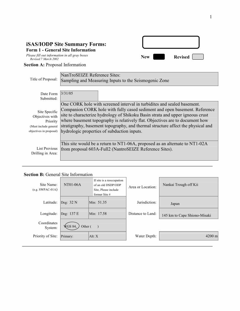
1
iSAS/IODP Site Summary Forms: Form 1 - General Site Information Please fill out information in all gray boxes
Section A: Proposal Information
Title of Proposal: NanTroSEIZE Reference Sites: Sampling and Measuring Inputs to the Seismogenic Zone
Date Form Submitted:
3/31/05
Site Specific Objectives with
Priority (Must include general
objectives in proposal)
One CORK hole with screened interval in turbidites and sealed basement. Companion CORK hole with fully cased sediment and open basement. Reference site to characterize hydrology of Shikoku Basin strata and upper igneous crust where basement topography is relatively flat. Objectives are to document how stratigraphy, basement topography, and thermal structure affect the physical and hydrologic properties of subduction inputs.
List Previous Drilling in Area:
This site would be a return to NT1-06A, proposed as an alternate to NT1-02A from proposal 603A-Full2 (NantroSEIZE Reference Sites).
Section B: General Site Information
Site Name: (e.g. SWPAC-01A)
NT01-06A
If site is a reoccupation of an old DSDP/ODP Site, Please include former Site #
Area or Location:
Nankai Trough off Kii
Latitude:
Deg: 32 N Min: 51.35 Jurisdiction: Japan
Longitude:
Deg: 137 E Min: 17.58 Distance to Land: 145 km to Cape Shiono-Misaki
Coordinates System:
WGS 84, Other ( )
Priority of Site: Primary: Alt: X Water Depth: 4200 m
New Revised Revised 7 March 2002

2
Section C: Operational Information
Sediments Basement 990 m Proposed
Penetration: (m) What is the total sed. thickness? 990 m
40 m
Total Penetration: 1030 m General Lithologies: Silt and sand turbidites, ash layers,
hemipelagic mud and mudstone Basalt
Limited coring as necessary to confirm screen locations for CORKs Coring Plan: (Specify or check)
1-2-3-APC VPC* XCB MDCB* PCS RCB Re-entry HRGB * Systems Currently Under Development
Standard Tools Special Tools LWD Neutron-Porosity Borehole Televiewer Formation Fluid Sampling Density-Neutron Litho-Density Nuclear Magnetic
Resonance Borehole Temperature
& Pressure Resistivity-Gamma Ray
Gamma Ray Geochemical Borehole Seismic Acoustic
Resistivity Side-Wall Core Sampling
Limited measurements if needed to
fill gaps from previous (Phase I)
drilling.
Acoustic
Wireline Logging Plan:
Formation Image Others ( ) Others ( ) Max.Borehole
Temp. : Expected value (For Riser Drilling)
Cuttings Sampling Intervals from m to m, m intervals from m to m, m intervals
Mud Logging: (Riser Holes Only)
Basic Sampling Intervals: 5m Estimated days: Drilling/Coring: 7 days Logging: 12 days (casing/CORK) Total On-Site: 19 days
Future Plan: Longterm Borehole Observation Plan/Re-entry Plan CORK observatory
Please check following List of Potential Hazards Shallow Gas Complicated Seabed Condition Hydrothermal Activity
What is your Weather window? (Preferable
period with the reasons)
Hydrocarbon Soft Seabed Landslide and Turbidity Current
Shallow Water Flow Currents
Methane Hydrate
Abnormal Pressure Fractured Zone Diapir and Mud Volcano
Man-made Objects Fault High Temperature
H2S High Dip Angle Ice Conditions
Hazards/ Weather:
CO2
April-July : avoid typhoon season
°C

3
New Revised
9.27849.2784
Please fill out information in all gray boxes
Proposal #: 603A-Full Site #: NT01-06A Date Form Submitted: 11/05/04
Data Type
SSP Requir-ements
Exists In DB
Details of available data and data that are still to be collected 1
High resolution seismic reflection
Yes
Primary Line(s) :Location of Site on line (SP or Time only) odkm03-103-1 SP2860 Crossing Lines(s): odkm03-ACA SP2175
2 Deep Penetration seismic reflection
Yes
Primary Line(s): Location of Site on line (SP or Time only) KR9806-1 nearby Crossing Lines(s): KR0211-S0 nearby
3 Seismic Velocity† Yes Stacking velocity and migration velocity from MCS lines. OBS data
4 Seismic Grid Yes 5a Refraction
(surface) Yes Two ship COP (maximum offset 20 km) obtained by JAMSTEC at the end
of September, 2002. 5b Refraction
(near bottom) Yes OBS data by Nakanishi et al. (1997)
6 3.5 kHz No Location of Site on line (Time)
7 Swath
bathymetry Yes Multi-narrow-beam data by JAMSTEC R/V Yokosuka
8a Side-looking
sonar (surface) No
8b Side-looking
sonar (bottom) No
9 Photography
or Video No
10 Heat Flow Yes
11a Magnetics Yes Compiled map published from AIST, Japan
11b Gravity Yes Compiled map published from AIST, Japan
12 Sediment cores No 13 Rock sampling No
14a Water current data Available on JODC web page (http://www.jodc.go.jp) 14b Ice Conditions
15 OBS microseismicity
Yes
16 Navigation Yes
17 Other
iSAS/IODP Site Summary Forms: Form 2 - Site Survey Detail
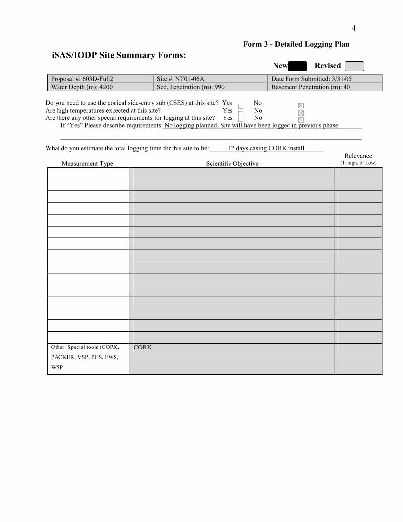
4
New Revised
Proposal #: 603D-Full2 Site #: NT01-06A Date Form Submitted: 3/31/05 Water Depth (m): 4200 Sed. Penetration (m): 990 Basement Penetration (m): 40
Do you need to use the conical side-entry sub (CSES) at this site? Yes No Are high temperatures expected at this site? Yes No Are there any other special requirements for logging at this site? Yes No
If “Yes” Please describe requirements: No logging planned. Site will have been logged in previous phase.
What do you estimate the total logging time for this site to be: 12 days casing CORK install
Measurement Type
Scientific Objective Relevance
(1=high, 3=Low)
Other: Special tools (CORK,
PACKER, VSP, PCS, FWS,
WSP
CORK
iSAS/IODP Site Summary Forms: Form 3 - Detailed Logging Plan

5
New Revised
Please fill out information in all gray boxes
Proposal #: 603D-Full2 Site #: NT01-06A Date Form Submitted: 3/31/05
1 Summary of Operations at site: (Example: Triple-APC to refusal, XCB 10 m into basement, log as shown on page 3.)
RCB with limited coring to confirm monitoring intervals for CORK. CORK installation
2 Based on Previous DSDP/ODP drilling, list all hydrocarbon occurrences of greater than background levels. Give nature of show, age and depth of rock:
None
3 From Available information, list all commercial drilling in this area that produced or yielded significant hydrocarbon shows. Give depths and ages of hydrocarbon-bearing deposits.
None
4 Are there any indications of gas hydrates at this location?
No
5 Are there reasons to expect hydrocarbon accumulations at this site? Please give details.
No
6 What “special” precautions will be taken during drilling?
Standard monitoring of C 1 to Cn; shallow casing may be needed to stabilize shallow sandy turbidite layers.
7 What abandonment procedures do you plan to follow:
None. Will be CORKed.
8 Please list other natural or manmade hazards which may effect ship’s operations: (e.g. ice, currents, cables)
Strong Kuroshio current, typhoon (June to Oct.)
9 Summary: What do you consider the major risks in drilling at this site?
Kuroshio Current
iSAS/IODP Site Summary Forms: Form 4 – Pollution & Safety Hazard Summary
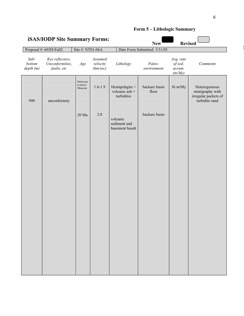
6
NNew Revised
Proposal #: 603D-Full2 Site #: NT01-06A Date Form Submitted: 3/31/05
Sub- bottom
depth (m)
Key reflectors, Unconformities,
faults, etc
Age
Assumed velocity (km/sec)
Lithology
Paleo-
environment
Avg. rate of sed. accum. (m/My)
Comments
990
unconformity
Holocene to lower Miocene 20 Ma
1.6-1.9
2.0
Hemipelagite + volcanic ash +
turbidites
volcanic sediment and basement basalt
backarc basin floor
backarc basin
36 m/My
Heterogeneous stratigraphy with
irregular packets of turbidite sand
iSAS/IODP Site Summary Forms:
Form 5 – Lithologic Summary
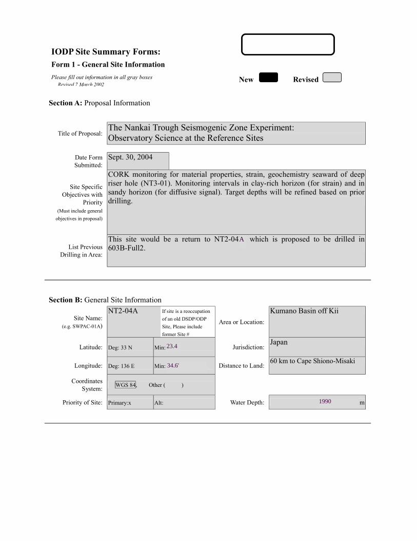
IODP Site Summary Forms: Form 1 - General Site Information
Please fill out information in all gray boxes
Section A: Proposal Information
Title of Proposal: The Nankai Trough Seismogenic Zone Experiment: Observatory Science at the Reference Sites
Date Form Submitted: Sept. 30, 2004
Site Specific Objectives with
Priority (Must include general
objectives in proposal)
CORK monitoring for material properties, strain, geochemistry seaward of deep riser hole (NT3-01). Monitoring intervals in clay-rich horizon (for strain) and in sandy horizon (for diffusive signal). Target depths will be refined based on prior drilling.
List Previous Drilling in Area:
This site would be a return to NT2-04B, which is proposed to be drilled in 603B-Full2.
Section B: General Site Information
Site Name: (e.g. SWPAC-01A)
NT2-04A If site is a reoccupation
of an old DSDP/ODP Site, Please include former Site #
Area or Location:
Kumano Basin off Kii
Latitude:
Deg: 33 N Min: 25.1 Jurisdiction:Japan
Longitude:
Deg: 136 E Min: 37.5 Distance to Land:60 km to Cape Shiono-Misaki
Coordinates System:
WGS 84, Other ( )
Priority of Site: Primary:x Alt: Water Depth: 4125 m
New Revised Revised 7 March 2002
23.4
34.6'
1990
A
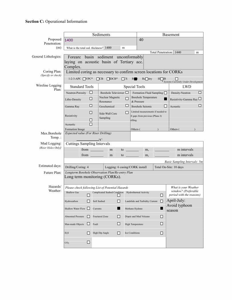
Section C: Operational Information
Sediments Basement
1450 Proposed Penetration:
(m) What is the total sed. thickness? 1400 m
40
Total Penetration: 1440 m General Lithologies: Forearc basin sediment unconformably
laying on acoustic basin of Tertiary acc. Complex.
Limited coring as necessary to confirm screen locations for CORKs Coring Plan: (Specify or check)
1-2-3-APC VPC* XCB MDCB* PCS RCB Re-entry HRGB * Systems Currently Under Development
Standard Tools Special Tools LWD Neutron-Porosity Borehole Televiewer Formation Fluid Sampling Density-Neutron
Litho-Density Nuclear Magnetic Resonance
Borehole Temperature & Pressure
Resistivity-Gamma Ray
Gamma Ray Geochemical Borehole Seismic Acoustic
Resistivity Side-Wall Core Sampling
Limited measurements if needed to
ill gaps from previous (Phase I)
rilling.
Acoustic
Wireline Logging Plan:
Formation Image Others ( ) Others ( ) Max.Borehole
Temp. : Expected value (For Riser Drilling)
Cuttings Sampling Intervals from m to m, m intervals from m to m, m intervals
Mud Logging: (Riser Holes Only)
Basic Sampling Intervals: 5m Estimated days: Drilling/Coring: 4 Logging: 6 casing/CORK install Total On-Site: 10 days
Future Plan: Longterm Borehole Observation Plan/Re-entry Plan Long term monitoring (CORKs).
Please check following List of Potential Hazards Shallow Gas Complicated Seabed Condition Hydrothermal Activity
What is your Weather window? (Preferable
period with the reasons)
Hydrocarbon Soft Seabed Landslide and Turbidity Current
Shallow Water Flow Currents Methane Hydrate
Abnormal Pressure Fractured Zone Diapir and Mud Volcano
Man-made Objects Fault High Temperature
H2S High Dip Angle Ice Conditions
Hazards/ Weather:
CO2
April-July: Avoid typhoon season
°C
1400

New Revised
Please fill out information in all gray boxes
Proposal #: 603D-Full Site #: NT2-04A Date Form Submitted: Sept. 30, 2004
Data Type
SSP Requir-ements
Exists In DB
Details of available data and data that are still to be collected 1
High resolution seismic reflection
Yes Primary Line(s) :Location of Site on line (SP or Time only) JAMSTEC Line 1 (Feb. 2003) Crossing Lines(s): JAMSTEC Lin (Feb. 2003)
2 Deep Penetration seismic reflection
Yes Primary Line(s): KR0108-4 Location of Site on line (SP or Time only) Crossing Lines(s):
3 Seismic Velocity† Yes Stacking velocity and migration velocity from MCS lines. OBS data.
4 Seismic Grid Yes
5a Refraction (surface)
Yes Two ship COP (maximum offset 20 km) obtained by JAMSTEC.
5b Refraction (near bottom)
Yes OBS data by Nakanishi et al. (1997)
6 3.5 kHz Location of Site on line (Time)
7 Swath bathymetry
Yes Multi-narrow-beam data by JAMSTEC R/V Yokusuka.
8a Side-looking sonar (surface)
Yes Some data collected using IZANAGI side scan sonar.
8b Side-looking sonar (bottom)
No
9 Photography or Video
Yes Taken by JAMSTEC submersibles.
10 Heat Flow Yes.
11a Magnetics Yes Compiled map published from AIST, Japan.
11b Gravity Yes Compiled map published from AIST, Japan.
12 Sediment cores Yes Gravity and piston cores. 13 Rock sampling No
14a Water current data Available on JODC web page (http://www.jodc.go.jp) 14b Ice Conditions
15 OBS microseismicity
Yes
16 Navigation Yes
17 Other
SSP Classification of Site: SSP Watchdog: Date of Last Review: SSP Comments:
X=required; X*=may be required for specific sites; Y=recommended; Y*=may be recommended for specific sites; R=required for re-entry sites; T=required for high temperature environments; † Accurate velocity information is required for holes deeper than 400m.
IODP Site Summary Forms:Form 2 - Site Survey Detail
I
Line (Feb. 2003)
l

New Revised
Proposal #: 603D-Full Site #: NT2-04A Date Form Submitted: Sept. 30, 2004 Water Depth (m): 1990 Sed. Penetration (m): 1400 Basement Penetration (m): 40
Do you need to use the conical side-entry sub (CSES) at this site? Yes No
Are high temperatures expected at this site? Yes No
Are there any other special requirements for logging at this site? Yes No If “Yes” Please describe requirements:No logging planned. Site will have been logged in previous phase.
CORK installation only
What do you estimate the total logging time for this site to be: 6 days (install casing/CORK)
Measurement Type
Scientific Objective Relevance
(1=high, 3=Low) Neutron-Porosity
Litho-Density
Natural Gamma Ray
Resistivity-Induction
Acoustic
FMS
BHTV
Resistivity-Laterolog
Magnetic/Susceptibility
Density-Neutron (LWD)
Resitivity-Gamma Ray
(LWD)
Other: Special tools (CORK,
PACKER, VSP, PCS, FWS,
WSP
CORK
For help in determining logging times, please contact the ODP-LDEO Wireline Logging Services group at: [email protected] http://www.ldeo.columbia.edu/BRG/brg_home.html Phone/Fax: (914) 365-8674 / (914) 365-3182
Note: Sites with greater than 400 m of
penetration or significant basement penetration require deployment of standard toolstrings.
IODP Site Summary Forms: Form 3 - Detailed Logging Plan

New Revised
Please fill out information in all gray boxes
Proposal #: 603D-Full Site #: NT2-04A Date Form Submitted: Sept. 30, 2004
1 Summary of Operations at site:
(Example: Triple-APC to refusal, XCB 10 m into basement, log as shown on page 3.)
RCB with limited coring to confirm monitoring intervals for CORK to 1450 m. CORK installation
2 Based on Previous DSDP/ODP drilling, list all hydrocarbon occurrences of greater than background levels. Give nature of show, age and depth of rock:
None
3 From Available information, list all commercial drilling in this area that produced or yielded significant hydrocarbon shows. Give depths and ages of hydrocarbon-bearing deposits.
None
4 Are there any indications of gas hydrates at this location?
Yes, MCS profile shows BSR.
5 Are there reasons to expect hydrocarbon accumulations at this site? Please give details.
No
6 What “special” precautions will be taken during drilling?
May need casing to to stabilize shallow sediments.
7 What abandonment procedures do you plan to follow:
None. Holes will be CORKed.
8 Please list other natural or manmade hazards which may effect ship’s operations: (e.g. ice, currents, cables)
Strong Kuroshio current. Typhoon season (June to Oct)
9 Summary: What do you consider the major risks in drilling at this site?
Current, instability of shallow sediments.
IODP Site Summary Forms:Form 4 – Pollution & Safety Hazard Summary

New New Revised
Proposal #: 603D-Full Site #: NT2-04A Date Form Submitted: Sept. 30, 2004
Sub-
bottom depth (m)
Key reflectors, Unconformities,
faults, etc
Age
Assumed velocity (km/sec)
Lithology
Paleo-environme
nt
Avg. rate of sed. accum. (m/My)
Comments
seafloor
1400
1450
Unconformity
Total depth
Holocene to Late tertiary
1.5-2
Turbidites and hemipelagic sediments
Forearc basin sediments
IODP Site Summary Forms: Form 5 – Lithologic Summary

Please fill out information in all gray boxes
Title: NanTroSEIZE Drilling and Observatory Phase 2Mechanical and Hydrologic State of Mega-Splay Faults:
Implications for Seismogenic Faulting and Tsunami GenerationProponent(s): Masataka Kinoshita, Kevin Brown, Demian Saffer, Pierre Henry, Fred Chester, Tadanori Goto,
Sean P. S. Gulick, Tetsuro Hirono, Hisao Ito, Aitaro Kato, Gaku Kimura, Achim Kopf, GregoryMoore, J. Casey Moore, Yasuyuki Nakamura, Jin-Oh Park, Saneatsu Saito, Susan Schwartz,Masanao Shinohara, Ralph Stephen, Harold Tobin, Kohtaro Ujiie, Urumu Tsunogai, and MakotoYamano
Keywords:(5 or less)
Seismogenic zone, splay fault, tsunamigenesis, fault mechanics,fluid flow
Area:SouthwesternJapan margin
Contact Information:Contact Person: Masataka Kinoshita
Department: Deep-sea Research DepartmentOrganization: Japan Marine Science and Technology Center
Address 2-15 Natsushima, Yokosuka 237-0061 JAPANTel.: +81-46-867-9323 Fax: +81-46-867-9315
E-mail: [email protected]
Permission to post abstract on iSAS Web site: Yes No
Abstract: (400 words or less)
The principal goal of NanTroSEIZE is to understand the mechanics of seismogenesis and rupturepropagation along subduction plate boundary faults as stated in the accompanying CDP. At Nankai, large out-of-sequence-thrust faults (“mega-splays") that branch from the décollement are common, first order structuralelements of the margin and appear continuous for several 10's of km along strike. These faults offset recent slopebasin sediments, are characterized by seafloor scarps, and are commonly associated with active fluid venting. Offthe Kii peninsula, such a mega-splay lies within the 1944 Tonankai coseismic rupture area estimated from tsunamiand seismic waveform inversions; inversions cannot distinguish splay fault slip from décollement slip.Accordingly, both the décollement zone and the splay fault system represent necessary primary fault targets toaddress seismogenic zone processes.
The goal of this proposal is to (1) characterize the magnitude and nature of strain accumulation and slipalong mega-splays off the Kii peninsula, and (2) sample and instrument the mega-splay fault system at a range ofP-T conditions from ~1-3.5 km bsf. Specifically, this proposal is aimed at testing 5 key hypotheses: (1) The mega-splay is a significant locus of plate boundary slip, slips in seismogenic events, and is currently locked; (2) Themega-splay is part of a weak plate boundary fault system and slips at low resolved shear stress; (3) Changes inphysical and chemical properties of the fault zone with increasing temperature and pressure cause slip along themega-splay to undergo a transition from aseismic to seismic slip; (4) The mega-splay is hydrologically connectedto the seismogenic décollement zone at great depths impacting its mechanical and chemical state, and (5) Physicalproperties, chemistry, and state of the fault zone change systematically during the interseismic period.
Proposed drilling includes (1) coring of 1 site in the Kumano Basin, focused on characterizing the tectonichistory of the plate above the mega-splay faults, and (2) intersection of the active mega-splay fault system at threedepths from ~1 to ~3.5 km bsf (down dip evolutionary studies). We propose installation of long-term boreholemonitoring instruments at several of the sites. These borehole observatories, along with surface arrays ofmeasurements, regional geodetic and seismic monitoring both on land and via offshore cabled observatories, willprovide critical data toward understanding the slip distribution, temporal nature, and controlling mechanisms ofseismogenic faulting along the plate boundary system.
IODP Proposal Cover SheetNew Revised Addendum
Above For Official Use Only
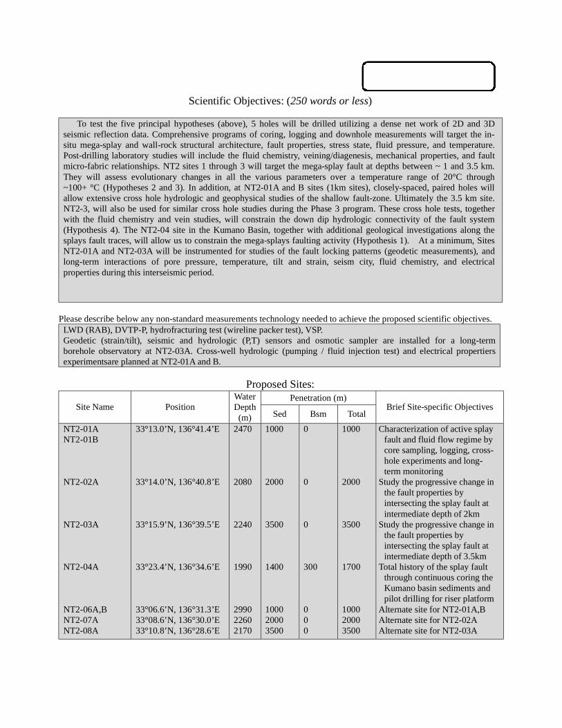
Scientific Objectives: (250 words or less)
To test the five principal hypotheses (above), 5 holes will be drilled utilizing a dense net work of 2D and 3Dseismic reflection data. Comprehensive programs of coring, logging and downhole measurements will target the in-situ mega-splay and wall-rock structural architecture, fault properties, stress state, fluid pressure, and temperature.Post-drilling laboratory studies will include the fluid chemistry, veining/diagenesis, mechanical properties, and faultmicro-fabric relationships. NT2 sites 1 through 3 will target the mega-splay fault at depths between ~ 1 and 3.5 km.They will assess evolutionary changes in all the various parameters over a temperature range of 20°C through~100+ °C (Hypotheses 2 and 3). In addition, at NT2-01A and B sites (1km sites), closely-spaced, paired holes willallow extensive cross hole hydrologic and geophysical studies of the shallow fault-zone. Ultimately the 3.5 km site.NT2-3, will also be used for similar cross hole studies during the Phase 3 program. These cross hole tests, togetherwith the fluid chemistry and vein studies, will constrain the down dip hydrologic connectivity of the fault system(Hypothesis 4). The NT2-04 site in the Kumano Basin, together with additional geological investigations along thesplays fault traces, will allow us to constrain the mega-splays faulting activity (Hypothesis 1). At a minimum, SitesNT2-01A and NT2-03A will be instrumented for studies of the fault locking patterns (geodetic measurements), andlong-term interactions of pore pressure, temperature, tilt and strain, seism city, fluid chemistry, and electricalproperties during this interseismic period.
Please describe below any non-standard measurements technology needed to achieve the proposed scientific objectives.LWD (RAB), DVTP-P, hydrofracturing test (wireline packer test), VSP.Geodetic (strain/tilt), seismic and hydrologic (P,T) sensors and osmotic sampler are installed for a long-termborehole observatory at NT2-03A. Cross-well hydrologic (pumping / fluid injection test) and electrical propertiersexperimentsare planned at NT2-01A and B.
Proposed Sites:Penetration (m)
Site Name PositionWaterDepth(m) Sed Bsm Total
Brief Site-specific Objectives
NT2-01ANT2-01B
NT2-02A
NT2-03A
NT2-04A
NT2-06A,BNT2-07ANT2-08A
33°13.0’N, 136°41.4’E
33°14.0’N, 136°40.8’E
33°15.9’N, 136°39.5’E
33°23.4’N, 136°34.6’E
33°06.6’N, 136°31.3’E33°08.6’N, 136°30.0’E33°10.8’N, 136°28.6’E
2470
2080
2240
1990
299022602170
1000
2000
3500
1400
100020003500
0
0
0
300
000
1000
2000
3500
1700
100020003500
Characterization of active splayfault and fluid flow regime bycore sampling, logging, cross-hole experiments and long-term monitoring
Study the progressive change inthe fault properties byintersecting the splay fault atintermediate depth of 2km
Study the progressive change inthe fault properties byintersecting the splay fault atintermediate depth of 3.5km
Total history of the splay faultthrough continuous coring theKumano basin sediments andpilot drilling for riser platform
Alternate site for NT2-01A,BAlternate site for NT2-02AAlternate site for NT2-03A

iSAS/IODP Site Summary Forms:Form 1 - General Site Information
Please fill out information in all gray boxes
Section A: Proposal Information
Title of Proposal:NanTroSEIZE Drilling and Observatory Phase 2
Mechanical and Hydrologic State of Mega-Splay Faults:Implications for Seismogenic Faulting and Tsunami Generation
Date FormSubmitted:
Oct. 1, 2003
Site SpecificObjectives with
Priority(Must include general
objectives in proposal)
Characterization of active splay fault and fluid flow regime by core sampling, logging, cross-
hole experiments and long-term monitoring.
Focuses are placed on mechanical and hydrological properties (e.g. strength, pore pressure,
permeability, porosity), fluid budget, origin of the fluid, detection of episodic flow.
Borehole long-term observatory for hydrogeological properties is planned as well as cross-
hole experiment.
Priority:2
List PreviousDrilling in Area:
None
Section B: General Site Information
Site Name:(e.g. SWPAC-01A)
NT2-01A/B
If site is a reoccupationof an old DSDP/ODPSite, Please includeformer Site #
Area or Location:
Southwestern NankaiTrough off Kumano
Latitude: Deg: 33 Min: 13.0 N Jurisdiction:Within Japanese EEZ
Longitude: Deg: 136 Min: 41.4 E Distance to Land: 45 NM
CoordinatesSystem:
WGS 84
Priority of Site: Primary: Alt: Water Depth: 2.470 m
New RevisedRevised 7 M arch 2002
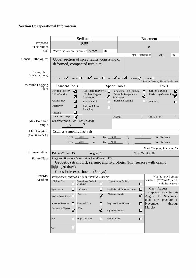
Section C: Operational Information
Sediments Basement1000Proposed
Penetration:(m) What is the total sed. thickness? >3,000 m
0
Total Penetration: 700 m
General Lithologies: Upper section of splay faults, consisting of deformed, compacted turbidite
Coring Plan:(Specify or Circle)
1-2-3-APC VPC* XCB MDCB* PCS RCB Re-entry HRGB* Systems Currently Under Development
Standard Tools Special Tools LWDNeutron-Porosity Borehole Televiewer Formation Fluid Sampling Density-NeutronLitho-Density Nuclear Magnetic
ResonanceBorehole Temperature
& PressureResistivity-Gamma Ray
Gamma Ray Geochemical Borehole Seismic Acoustic
Resistivity Side-Wall Core Sampling
Acoustic
Wireline LoggingPlan:
Formation Image Others ( ) Others ( FMI )
Max.BoreholeTemp. :
Expected value (For Riser Drilling)
20
Cuttings Sampling Intervals
from 200 m to 300 m, 5 m intervals
from 700 m to 900 m, 5 m intervals
Mud Logging:(Riser Holes Only)
Basic Sampling Intervals: 5mEstimated days: Drilling/Coring: 15 Logging: 5 Total On-Site: 40
Future Plan: Longterm Borehole Observation Plan/Re-entry Plan
Geodetic (strain/tilt), seismic and hydrologic (P,T) sensors with casing (20 days) Cross-hole experiments (5 days)Please check following List of Potential Hazards
Shallow Gas Complicated SeabedCondition
Hydrothermal Activity
What is your Weatherwindow? (Preferable period
with the reasons)
Hydrocarbon Soft Seabed Landslide and Turbidity Current
Shallow Water FlowCurrents Methane Hydrate
Abnormal Pressure Fractured Zone Diapir and Mud Volcano
Man-made Objects FaultHigh Temperature
H2S High Dip Angle Ice Conditions
Hazards/Weather:
CO2
May – August(typhoon risk in late
August to September,then low pressure inNovember throughMarch)
°C

New RevisedPlease fill out information in all gray boxes
roposal #: Site #: NT2-01A/B Date Form Submitted: Oct. 1, 2003
Data Type
SSPRequir-ements
ExistsIn DB Details of available data and data that are still to be collected
1High resolutionseismic reflection
YESPrimary Line(s) :Location of Site on line (SP or Time only) JAMSTEC Line-I (Feb. 2003)
Crossing Lines(s): JAMSTEC Line-9 (Feb. 2003)
2Deep Penetrationseismic reflection
YESPrimary Line(s): Location of Site on line (SP or Time only) KR0108-4
Crossing Lines(s):
3 Seismic Velocity† YES Stacking velocity and migration velocity from MCS lines.OBS data also available.
4 Seismic Grid YES Acquired by JAMSTEC in Feb. 2003
5a Refraction(surface)
YES Two-ship COP (max. offset 20km) was obtained by JAMSTEC in Sep.2002
5b Refraction(near bottom)
YES OBS data by Nakanishi et al. (1997)
6 3.5 kHz NO Location of Site on line (Time)
7 Swathbathymetry
YES Multi-narrow beam data by JAMSTEC R/V Yokosuka
8a Side-lookingsonar (surface)
YES Some data collected using IZANAGI side scan sonar
8b Side-lookingsonar (bottom)
NO
9 Photographyor Video
YES Taken by submersibles of JASMTEC
10 Heat Flow YES Obtained from surface ship, submersibles, long-erm monitoring and BSR
11a Magnetics YES Compiled map published from AIST, Japan
11b Gravity YES Compiled map published from AIST, Japan
12 Sediment cores YES Gravity and piston cores13 Rock sampling YES Taken by submersible and ROV
14a Water current data YES Available on JODC web page (http://www.jodc.go.jp/)14b Ice Conditions
15 OBSmicroseismicity
Being processed now
16 Navigation YES
17 Other
SSP Classification of Site: SSP Watchdog: Date of Last Review:SSP Comments:
X=required; X*=may be required for specific sites; Y=recommended; Y*=may be recommended for specific sites;R=required for re-entry sites; T=required for high temperature environments; † Accurate velocity information is requiredfor holes deeper than 400m.
iSAS/IODP Site Summary Forms:Form 2 - Site Survey Detail

New Revised
Proposal #: Site #: NT2-01A/B Date Form Submitted: Oct. 1, 2003Water Depth (m): 2470 Sed. Penetration (m): 1000 Basement Penetration (m): 0
Do you need to use the conical side-entry sub (CSES) at this site? Yes No
Are high temperatures expected at this site? Yes No
Are there any other special requirements for logging at this site? Yes No
If “Yes” Please describe requirements:
What do you estimate the total logging time for this site to be:
Measurement Type Scientific ObjectiveRelevance
(1=high, 3=Low)
Neutron-Porosity Estimation of water content in sedimentary sequences and basement. 1
Litho-Density Estimation of water content,bulk density,and mineral composition in
sedimentary sequences and basement.
1
Natural Gamma Ray Estimation clay contents and mineral composition in sedimentary
sequences and basement.
1
Resistivity-Induction Estimation of water content and electro-magnetic properties in
sedimentary sequences and basement.
1
Acoustic
FMS Imaging of sedimentary structures and fractures.Core-log correlation of
structural features.
1
BHTV
Resistivity-Laterolog
Magnetic/Susceptibility
Density-Neutron (LWD) Estimation of water contents,bulk density,and lithology in unstable
borehole environments.
1
Resitivity-Gamma Ray
(LWD)
Estimation of water contents,bulk density,and lithology in unstable
borehole environments.
1
Other: Special tools (CORK,
PACKER, VSP, PCS, FWS,
WSP
Cross-hole hydrologic and electrical experiment. RAB
Hydrofracturing, Packer injection test
CORK and Geodetic borehole observatory
1
For help in determining logging times, please contact the ODP-LDEO Wireline Logging Services groupat:
[email protected]://www.ldeo.columbia.edu/BRG/brg_home.htmlPhone/Fax: (914) 365-8674 / (914) 365-3182
Note: Sites with greater than 400 m ofpenetration or significant basementpenetration require deployment ofstandard toolstrings.
iSAS/IODP Site Summary Forms:Form 3 - Detailed Logging Plan

New RevisedPlease fill out information in all gray boxes
Proposal #: Site #: NT2-01A/B Date Form Submitted: Oct. 1, 2003
1 Summary of Operations at site:(Example: Triple-APC to refusal, XCB10 m into basement, log as shown onpage 3.)
APC to refusal,then XCB to refusal.RCB to 1000 m
2 Based on Previous DSDP/ODPdrilling, list all hydrocarbonoccurrences of greater thanbackground levels. Give natureof show, age and depth of rock:
JNOC will conduct drilling in eastern Nankai in 2004. This datawill be used for urprogram.
3 From Available information, listall commercial drilling in thisarea that produced or yieldedsignificant hydrocarbon shows.Give depths and ages ofhydrocarbon-bearing deposits.
None
4 Are there any indications of gashydrates at this location? Yes, MCS profile shows BSRs
5 Are there reasons to expecthydrocarbon accumulations atthis site? Please give details.
6 What “special” precautions willbe taken during drilling? Yes, During drilling into the fault zone, hole may collapse.
7 What abandonment proceduresdo you plan to follow: None
8 Please list other natural ormanmade hazards which mayeffect ship’s operations:(e.g. ice, currents, cables)
Strong Kuroshio current, typhoon (June – October)
9 Summary: What do youconsider the major risks indrilling at this site?
Current
iSAS/IODP Site Summary Forms:Form 4 – Pollution & Safety Hazard Summary

New Revised
Proposal #: Site #: NT2-01A/B Date Form Submitted: Oct. 1, 2003
Sub-bottom
depth (m)
Key reflectors,Unconformities,
faults, etcAge
Assumedvelocity(km/sec)
Lithology Paleo-environment
Avg. rateof sed.accum.(m/My)
Comments
300
800
Unconformity
fault
Holocene toMioce
ne
1.6-2.5km/s
Slopesediments
to
oldaccretionary
rocks
Accretionaryprism
iSAS/IODP Site Summary Forms:Form 5 – Lithologic Summary

iSAS/IODP Site Summary Forms:Form 1 - General Site Information
Please fill out information in all gray boxes
Section A: Proposal Information
Title of Proposal:NanTroSEIZE Drilling and Observatory Phase 2
Mechanical and Hydrologic State of Mega-Splay Faults:Implications for Seismogenic Faulting and Tsunami Generation
Date FormSubmitted:
Oct. 1, 2003
Site SpecificObjectives with
Priority(Must include general
objectives in proposal)
Study the progressive change in the fault properties by intersecting the splay fault at
intermediate depth of 2km. Integration with NT2-01A and NT2-03A are essential.
Priority:2
List PreviousDrilling in Area:
None
Section B: General Site Information
Site Name:(e.g. SWPAC-01A)
NT2-02A
If site is a reoccupationof an old DSDP/ODPSite, Please includeformer Site #
Area or Location:
Southwestern NankaiTrough off Kumano
Latitude: Deg: 33 Min: 14.0 N Jurisdiction:Within Japanese EEZ
Longitude: Deg: 136 Min: 40.8 E Distance to Land: 45 NM
CoordinatesSystem:
WGS 84
Priority of Site: Primary: Alt: Water Depth: 2,080 m
New RevisedRevised 7 M arch 2002

Section C: Operational Information
Sediments Basement2000Proposed
Penetration:(m) What is the total sed. thickness? >3,000 m
0
Total Penetration: 1,700 m
General Lithologies: Slope basin sediment on top, fracturedsection across the splay fault, and underlyingdeformed, compacted turbidite
Coring Plan:(Specify or Circle)
1-2-3-APC VPC* XCB MDCB* PCS RCB Re-entry HRGB* Systems Currently Under Development
Standard Tools Special Tools LWDNeutron-Porosity Borehole Televiewer Formation Fluid Sampling Density-NeutronLitho-Density Nuclear Magnetic
ResonanceBorehole Temperature
& PressureResistivity-Gamma Ray
Gamma Ray Geochemical Borehole Seismic Acoustic
Resistivity Side-Wall Core Sampling
Acoustic
Wireline LoggingPlan:
Formation Image Others ( ) Others ( FMI )
Max.BoreholeTemp. :
Expected value (For Riser Drilling)
40-60
Cuttings Sampling Intervals
from 300 m to 500 m, 5 m intervals
from 1700 m to 1900 m, 5 m intervals
Mud Logging:(Riser Holes Only)
Basic Sampling Intervals: 5mEstimated days: Drilling/Coring: 25 Logging: 10 Total On-Site: 35
Future Plan: Longterm Borehole Observation Plan/Re-entry Plan
Please check following List of Potential Hazards
Shallow Gas Complicated SeabedCondition
Hydrothermal Activity
What is your Weatherwindow? (Preferable period
with the reasons)
Hydrocarbon Soft Seabed Landslide and Turbidity Current
Shallow Water FlowCurrents Methane Hydrate
Abnormal Pressure Fractured Zone Diapir and Mud Volcano
Man-made Objects FaultHigh Temperature
H2S High Dip Angle Ice Conditions
Hazards/Weather:
CO2
May – August(typhoon risk in late
August to September,then low pressure inNovember throughMarch)
°C
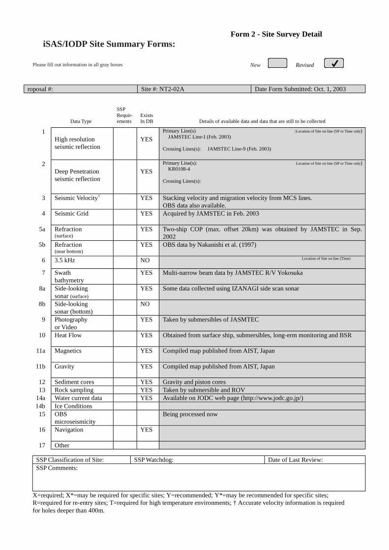
New RevisedPlease fill out information in all gray boxes
roposal #: Site #: NT2-02A Date Form Submitted: Oct. 1, 2003
Data Type
SSPRequir-ements
ExistsIn DB Details of available data and data that are still to be collected
1High resolutionseismic reflection
YESPrimary Line(s) :Location of Site on line (SP or Time only) JAMSTEC Line-I (Feb. 2003)
Crossing Lines(s): JAMSTEC Line-9 (Feb. 2003)
2Deep Penetrationseismic reflection
YESPrimary Line(s): Location of Site on line (SP or Time only) KR0108-4
Crossing Lines(s):
3 Seismic Velocity† YES Stacking velocity and migration velocity from MCS lines.OBS data also available.
4 Seismic Grid YES Acquired by JAMSTEC in Feb. 2003
5a Refraction(surface)
YES Two-ship COP (max. offset 20km) was obtained by JAMSTEC in Sep.2002
5b Refraction(near bottom)
YES OBS data by Nakanishi et al. (1997)
6 3.5 kHz NO Location of Site on line (Time)
7 Swathbathymetry
YES Multi-narrow beam data by JAMSTEC R/V Yokosuka
8a Side-lookingsonar (surface)
YES Some data collected using IZANAGI side scan sonar
8b Side-lookingsonar (bottom)
NO
9 Photographyor Video
YES Taken by submersibles of JASMTEC
10 Heat Flow YES Obtained from surface ship, submersibles, long-erm monitoring and BSR
11a Magnetics YES Compiled map published from AIST, Japan
11b Gravity YES Compiled map published from AIST, Japan
12 Sediment cores YES Gravity and piston cores13 Rock sampling YES Taken by submersible and ROV
14a Water current data YES Available on JODC web page (http://www.jodc.go.jp/)14b Ice Conditions
15 OBSmicroseismicity
Being processed now
16 Navigation YES
17 Other
SSP Classification of Site: SSP Watchdog: Date of Last Review:SSP Comments:
X=required; X*=may be required for specific sites; Y=recommended; Y*=may be recommended for specific sites;R=required for re-entry sites; T=required for high temperature environments; † Accurate velocity information is requiredfor holes deeper than 400m.
iSAS/IODP Site Summary Forms:Form 2 - Site Survey Detail

New Revised
Proposal #: Site #: NT2-02A Date Form Submitted: Oct. 1, 2003Water Depth (m): 2080 Sed. Penetration (m): 2000 Basement Penetration (m): 0
Do you need to use the conical side-entry sub (CSES) at this site? Yes No
Are high temperatures expected at this site? Yes No
Are there any other special requirements for logging at this site? Yes No
If “Yes” Please describe requirements:
What do you estimate the total logging time for this site to be:
Measurement Type Scientific ObjectiveRelevance
(1=high, 3=Low)
Neutron-Porosity Estimation of water content in sedimentary sequences and basement. 1
Litho-Density Estimation of water content,bulk density,and mineral composition in
sedimentary sequences and basement.
1
Natural Gamma Ray Estimation clay contents and mineral composition in sedimentary
sequences and basement.
1
Resistivity-Induction Estimation of water content and electro-magnetic properties in
sedimentary sequences and basement.
1
Acoustic
FMS Imaging of sedimentary structures and fractures.Core-log correlation of
structural features.
1
BHTV
Resistivity-Laterolog
Magnetic/Susceptibility
Density-Neutron (LWD) Estimation of water contents,bulk density,and lithology in unstable
borehole environments.
1
Resitivity-Gamma Ray
(LWD)
Estimation of water contents,bulk density,and lithology in unstable
borehole environments.
1
Other: Special tools (CORK,
PACKER, VSP, PCS, FWS,
WSP
RAB preferred
2
For help in determining logging times, please contact the ODP-LDEO Wireline Logging Services groupat:
[email protected]://www.ldeo.columbia.edu/BRG/brg_home.htmlPhone/Fax: (914) 365-8674 / (914) 365-3182
Note: Sites with greater than 400 m ofpenetration or significant basementpenetration require deployment ofstandard toolstrings.
iSAS/IODP Site Summary Forms:Form 3 - Detailed Logging Plan

New RevisedPlease fill out information in all gray boxes
Proposal #: Site #: NT2-02A Date Form Submitted: Oct. 1, 2003
1 Summary of Operations at site:(Example: Triple-APC to refusal, XCB10 m into basement, log as shown onpage 3.)
APC to refusal,then XCB to refusal.RCB to 2000 m
2 Based on Previous DSDP/ODPdrilling, list all hydrocarbonoccurrences of greater thanbackground levels. Give natureof show, age and depth of rock:
JNOC will conduct drilling in eastern Nankai in 2004. This datawill be used for urprogram.
3 From Available information, listall commercial drilling in thisarea that produced or yieldedsignificant hydrocarbon shows.Give depths and ages ofhydrocarbon-bearing deposits.
None
4 Are there any indications of gashydrates at this location? Yes, MCS profile shows BSRs
5 Are there reasons to expecthydrocarbon accumulations atthis site? Please give details.
6 What “special” precautions willbe taken during drilling? Yes, During drilling into the fault zone, hole may collapse.
7 What abandonment proceduresdo you plan to follow: None
8 Please list other natural ormanmade hazards which mayeffect ship’s operations:(e.g. ice, currents, cables)
Strong Kuroshio current, typhoon (June – October)
9 Summary: What do youconsider the major risks indrilling at this site?
Current
iSAS/IODP Site Summary Forms:Form 4 – Pollution & Safety Hazard Summary
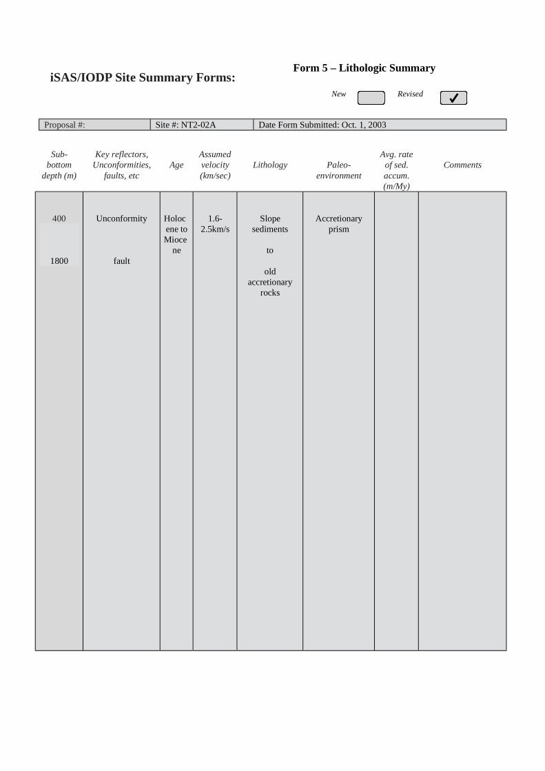
New Revised
Proposal #: Site #: NT2-02A Date Form Submitted: Oct. 1, 2003
Sub-bottom
depth (m)
Key reflectors,Unconformities,
faults, etcAge
Assumedvelocity(km/sec)
Lithology Paleo-environment
Avg. rateof sed.accum.(m/My)
Comments
400
1800
Unconformity
fault
Holocene toMioce
ne
1.6-2.5km/s
Slopesediments
to
oldaccretionary
rocks
Accretionaryprism
iSAS/IODP Site Summary Forms:Form 5 – Lithologic Summary
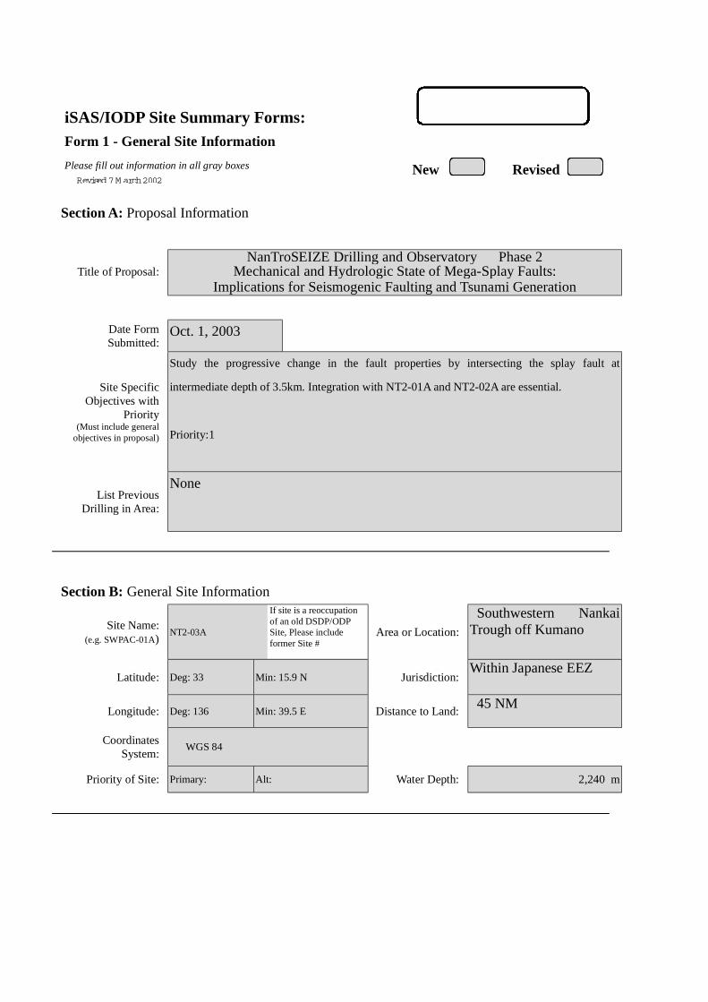
iSAS/IODP Site Summary Forms:Form 1 - General Site Information
Please fill out information in all gray boxes
Section A: Proposal Information
Title of Proposal:NanTroSEIZE Drilling and Observatory Phase 2
Mechanical and Hydrologic State of Mega-Splay Faults:Implications for Seismogenic Faulting and Tsunami Generation
Date FormSubmitted:
Oct. 1, 2003
Site SpecificObjectives with
Priority(Must include general
objectives in proposal)
Study the progressive change in the fault properties by intersecting the splay fault at
intermediate depth of 3.5km. Integration with NT2-01A and NT2-02A are essential.
Priority:1
List PreviousDrilling in Area:
None
Section B: General Site Information
Site Name:(e.g. SWPAC-01A)
NT2-03A
If site is a reoccupationof an old DSDP/ODPSite, Please includeformer Site #
Area or Location:
Southwestern NankaiTrough off Kumano
Latitude: Deg: 33 Min: 15.9 N Jurisdiction:Within Japanese EEZ
Longitude: Deg: 136 Min: 39.5 E Distance to Land: 45 NM
CoordinatesSystem:
WGS 84
Priority of Site: Primary: Alt: Water Depth: 2,240 m
New RevisedRevised 7 M arch 2002

Section C: Operational Information
Sediments Basement3500Proposed
Penetration:(m) What is the total sed. thickness? >3,000 m
0
Total Penetration: 2,200 m
General Lithologies: Slope basin sediment on top, fracturedsection across the splay fault, and underlyingdeformed, compacted turbiditeContinuous coring may be replaced with ordinary/LWD logging.Coring Plan:
(Specify or Circle) 1-2-3-APC VPC* XCB MDCB* PCS RCB Re-entry HRGB
* Systems Currently Under Development
Standard Tools Special Tools LWDNeutron-Porosity Borehole Televiewer Formation Fluid Sampling Density-NeutronLitho-Density Nuclear Magnetic
ResonanceBorehole Temperature
& PressureResistivity-Gamma Ray
Gamma Ray Geochemical Borehole Seismic Acoustic
Resistivity Side-Wall Core Sampling
Acoustic
Wireline LoggingPlan:
Formation Image Others ( ) Others ( FMI )
Max.BoreholeTemp. :
Expected value (For Riser Drilling)
80-100
Cuttings Sampling Intervals
from 1700 m to 1900 m, 5 m intervals
from 3300 m to 3500 m, 5 m intervals
Mud Logging:(Riser Holes Only)
Basic Sampling Intervals: 5mEstimated days: Drilling/Coring: 130 Logging: 20 Total On-Site: 250
Future Plan: Longterm Borehole Observation Plan/Re-entry Plan
Geodetic (strain/tilt), seismic and hydrologic (P,T) sensors (100 days?)
Please check following List of Potential Hazards
Shallow Gas Complicated SeabedCondition
Hydrothermal Activity
What is your Weatherwindow? (Preferable period
with the reasons)
Hydrocarbon Soft Seabed Landslide and Turbidity Current
Shallow Water FlowCurrents Methane Hydrate
Abnormal Pressure Fractured Zone Diapir and Mud Volcano
Man-made Objects FaultHigh Temperature
H2S High Dip Angle Ice Conditions
Hazards/Weather:
CO2
May – August(typhoon risk in late
August to September,then low pressure inNovember throughMarch)
°C

New RevisedPlease fill out information in all gray boxes
roposal #: Site #: NT2-03A Date Form Submitted: Oct. 1, 2003
Data Type
SSPRequir-ements
ExistsIn DB Details of available data and data that are still to be collected
1High resolutionseismic reflection
YESPrimary Line(s) :Location of Site on line (SP or Time only) JAMSTEC Line-I (Feb. 2003)
Crossing Lines(s): JAMSTEC Line-9 (Feb. 2003)
2Deep Penetrationseismic reflection
YESPrimary Line(s): Location of Site on line (SP or Time only) KR0108-4
Crossing Lines(s):
3 Seismic Velocity† YES Stacking velocity and migration velocity from MCS lines.OBS data also available.
4 Seismic Grid YES Acquired by JAMSTEC in Feb. 2003
5a Refraction(surface)
YES Two-ship COP (max. offset 20km) was obtained by JAMSTEC in Sep.2002
5b Refraction(near bottom)
YES OBS data by Nakanishi et al. (1997)
6 3.5 kHz NO Location of Site on line (Time)
7 Swathbathymetry
YES Multi-narrow beam data by JAMSTEC R/V Yokosuka
8a Side-lookingsonar (surface)
YES Some data collected using IZANAGI side scan sonar
8b Side-lookingsonar (bottom)
NO
9 Photographyor Video
YES Taken by submersibles of JASMTEC
10 Heat Flow YES Obtained from surface ship, submersibles, long-erm monitoring and BSR
11a Magnetics YES Compiled map published from AIST, Japan
11b Gravity YES Compiled map published from AIST, Japan
12 Sediment cores YES Gravity and piston cores13 Rock sampling YES Taken by submersible and ROV
14a Water current data YES Available on JODC web page (http://www.jodc.go.jp/)14b Ice Conditions
15 OBSmicroseismicity
Being processed now
16 Navigation YES
17 Other
SSP Classification of Site: SSP Watchdog: Date of Last Review:SSP Comments:
X=required; X*=may be required for specific sites; Y=recommended; Y*=may be recommended for specific sites;R=required for re-entry sites; T=required for high temperature environments; † Accurate velocity information is requiredfor holes deeper than 400m.
iSAS/IODP Site Summary Forms:Form 2 - Site Survey Detail

New Revised
Proposal #: Site #: NT2-03A Date Form Submitted: Oct. 1, 2003Water Depth (m): 2240 Sed. Penetration (m): 3500 Basement Penetration (m): 0
Do you need to use the conical side-entry sub (CSES) at this site? Yes No
Are high temperatures expected at this site? Yes No
Are there any other special requirements for logging at this site? Yes No
If “Yes” Please describe requirements:
What do you estimate the total logging time for this site to be:
Measurement Type Scientific ObjectiveRelevance
(1=high, 3=Low)
Neutron-Porosity Estimation of water content in sedimentary sequences and basement. 1
Litho-Density Estimation of water content,bulk density,and mineral composition in
sedimentary sequences and basement.
1
Natural Gamma Ray Estimation clay contents and mineral composition in sedimentary
sequences and basement.
1
Resistivity-Induction Estimation of water content and electro-magnetic properties in
sedimentary sequences and basement.
1
Acoustic
FMS Imaging of sedimentary structures and fractures.Core-log correlation of
structural features.
1
BHTV
Resistivity-Laterolog
Magnetic/Susceptibility
Density-Neutron (LWD) Estimation of water contents,bulk density,and lithology in unstable
borehole environments.
1
Resitivity-Gamma Ray
(LWD)
Estimation of water contents,bulk density,and lithology in unstable
borehole environments.
1
Other: Special tools (CORK,
PACKER, VSP, PCS, FWS,
WSP
RAB, VSP
Hydrofracturing, Packer injection test
CORK and Geodetic/Seismic borehole observatory
1
For help in determining logging times, please contact the ODP-LDEO Wireline Logging Services groupat:
[email protected]://www.ldeo.columbia.edu/BRG/brg_home.htmlPhone/Fax: (914) 365-8674 / (914) 365-3182
Note: Sites with greater than 400 m ofpenetration or significant basementpenetration require deployment ofstandard toolstrings.
iSAS/IODP Site Summary Forms:Form 3 - Detailed Logging Plan

New RevisedPlease fill out information in all gray boxes
Proposal #: Site #: NT2-03A Date Form Submitted: Oct. 1, 2003
1 Summary of Operations at site:(Example: Triple-APC to refusal, XCB10 m into basement, log as shown onpage 3.)
APC to refusal,then XCB to refusal.RCB to 3500 m
2 Based on Previous DSDP/ODPdrilling, list all hydrocarbonoccurrences of greater thanbackground levels. Give natureof show, age and depth of rock:
JNOC will conduct drilling in eastern Nankai in 2004. This datawill be used for urprogram.
3 From Available information, listall commercial drilling in thisarea that produced or yieldedsignificant hydrocarbon shows.Give depths and ages ofhydrocarbon-bearing deposits.
None
4 Are there any indications of gashydrates at this location? Yes, MCS profile shows BSRs
5 Are there reasons to expecthydrocarbon accumulations atthis site? Please give details.
6 What “special” precautions willbe taken during drilling? Yes, During drilling into the fault zone, hole may collapse.
7 What abandonment proceduresdo you plan to follow: None
8 Please list other natural ormanmade hazards which mayeffect ship’s operations:(e.g. ice, currents, cables)
Strong Kuroshio current, typhoon (June – October)
9 Summary: What do youconsider the major risks indrilling at this site?
Current
iSAS/IODP Site Summary Forms:Form 4 – Pollution & Safety Hazard Summary
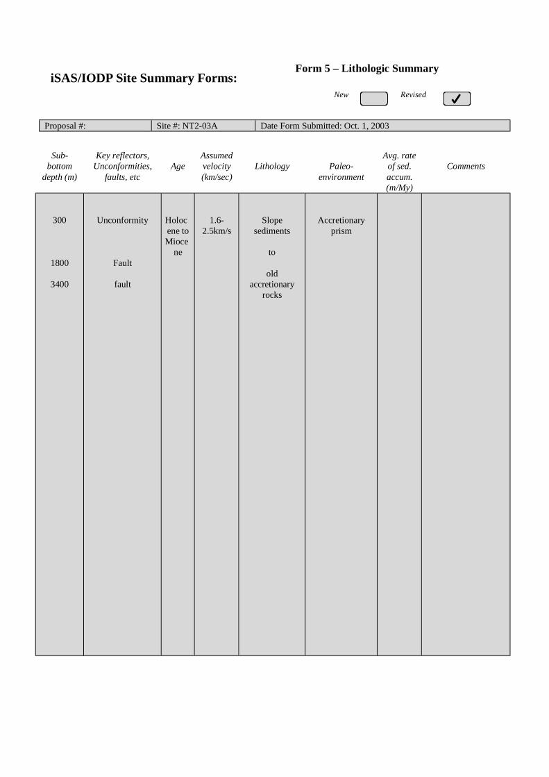
New Revised
Proposal #: Site #: NT2-03A Date Form Submitted: Oct. 1, 2003
Sub-bottom
depth (m)
Key reflectors,Unconformities,
faults, etcAge
Assumedvelocity(km/sec)
Lithology Paleo-environment
Avg. rateof sed.accum.(m/My)
Comments
300
1800
3400
Unconformity
Fault
fault
Holocene toMioce
ne
1.6-2.5km/s
Slopesediments
to
oldaccretionary
rocks
Accretionaryprism
iSAS/IODP Site Summary Forms:Form 5 – Lithologic Summary
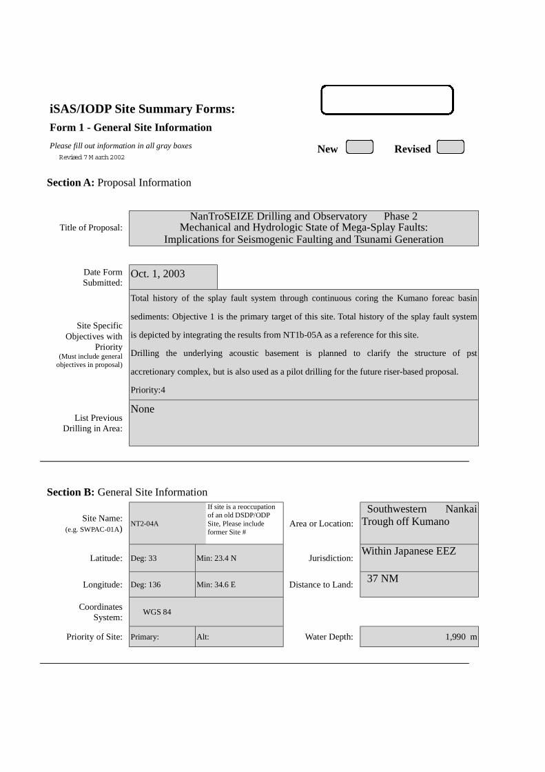
iSAS/IODP Site Summary Forms:Form 1 - General Site Information
Please fill out information in all gray boxes
Section A: Proposal Information
Title of Proposal:NanTroSEIZE Drilling and Observatory Phase 2
Mechanical and Hydrologic State of Mega-Splay Faults:Implications for Seismogenic Faulting and Tsunami Generation
Date FormSubmitted:
Oct. 1, 2003
Site SpecificObjectives with
Priority(Must include general
objectives in proposal)
Total history of the splay fault system through continuous coring the Kumano foreac basin
sediments: Objective 1 is the primary target of this site. Total history of the splay fault system
is depicted by integrating the results from NT1b-05A as a reference for this site.
Drilling the underlying acoustic basement is planned to clarify the structure of pst
accretionary complex, but is also used as a pilot drilling for the future riser-based proposal.
Priority:4
List PreviousDrilling in Area:
None
Section B: General Site Information
Site Name:(e.g. SWPAC-01A)
NT2-04A
If site is a reoccupationof an old DSDP/ODPSite, Please includeformer Site #
Area or Location:
Southwestern NankaiTrough off Kumano
Latitude: Deg: 33 Min: 23.4 N Jurisdiction:Within Japanese EEZ
Longitude: Deg: 136 Min: 34.6 E Distance to Land: 37 NM
CoordinatesSystem:
WGS 84
Priority of Site: Primary: Alt: Water Depth: 1,990 m
New RevisedRevised 7 M arch 2002

Section C: Operational Information
Sediments Basement1,400Proposed
Penetration:(m) What is the total sed. thickness? 1,400 m
300
Total Penetration: 1,700 m
General Lithologies: Forearc basin sediment with unconformitylaying on acoustic basement of Tertiallyaccretionary complex
Coring Plan:(Specify or Circle)
1-2-3-APC VPC* XCB MDCB* PCS RCB Re-entry HRGB* Systems Currently Under Development
Standard Tools Special Tools LWDNeutron-Porosity Borehole Televiewer Formation Fluid Sampling Density-NeutronLitho-Density Nuclear Magnetic
ResonanceBorehole Temperature
& PressureResistivity-Gamma Ray
Gamma Ray Geochemical Borehole Seismic Acoustic
Resistivity Side-Wall Core Sampling
Acoustic
Wireline LoggingPlan:
Formation Image Others ( ) Others ( FMI )
Max.BoreholeTemp. :
Expected value (For Riser Drilling)
70
Cuttings Sampling Intervals
from m to m, m intervals
from m to m, m intervals
Mud Logging:(Riser Holes Only)
Basic Sampling Intervals: 5mEstimated days: Drilling/Coring: 15 Logging: 3 Total On-Site: 18
Future Plan: Longterm Borehole Observation Plan/Re-entry Plan
Please check following List of Potential Hazards
Shallow Gas Complicated SeabedCondition
Hydrothermal Activity
What is your Weatherwindow? (Preferable period
with the reasons)
Hydrocarbon Soft Seabed Landslide and Turbidity Current
Shallow Water FlowCurrents Methane Hydrate
Abnormal Pressure Fractured Zone Diapir and Mud Volcano
Man-made Objects FaultHigh Temperature
H2S High Dip Angle Ice Conditions
Hazards/Weather:
CO2
May – August(typhoon risk in late
August to September,then low pressure inNovember throughMarch)
°C

New RevisedPlease fill out information in all gray boxes
roposal #: Site #: NT2-04A Date Form Submitted: Oct. 1, 2003
Data Type
SSPRequir-ements
ExistsIn DB Details of available data and data that are still to be collected
1High resolutionseismic reflection
YESPrimary Line(s) :Location of Site on line (SP or Time only) JAMSTEC Line-I (Feb. 2003)
Crossing Lines(s): JAMSTEC Line (Feb. 2003)
2Deep Penetrationseismic reflection
YESPrimary Line(s): Location of Site on line (SP or Time only) KR0108-4
Crossing Lines(s):
3 Seismic Velocity† YES Stacking velocity and migration velocity from MCS lines.OBS data also available.
4 Seismic Grid YES Acquired by JAMSTEC in Feb. 2003
5a Refraction(surface)
YES Two-ship COP (max. offset 20km) was obtained by JAMSTEC in Sep.2002
5b Refraction(near bottom)
YES OBS data by Nakanishi et al. (1997)
6 3.5 kHz NO Location of Site on line (Time)
7 Swathbathymetry
YES Multi-narrow beam data by JAMSTEC R/V Yokosuka
8a Side-lookingsonar (surface)
YES Some data collected using IZANAGI side scan sonar
8b Side-lookingsonar (bottom)
NO
9 Photographyor Video
YES Taken by submersibles of JASMTEC
10 Heat Flow YES Obtained from surface ship, submersibles, long-erm monitoring and BSR
11a Magnetics YES Compiled map published from AIST, Japan
11b Gravity YES Compiled map published from AIST, Japan
12 Sediment cores YES Gravity and piston cores13 Rock sampling YES Taken by submersible and ROV
14a Water current data YES Available on JODC web page (http://www.jodc.go.jp/)14b Ice Conditions
15 OBSmicroseismicity
Being processed now
16 Navigation YES
17 Other
SSP Classification of Site: SSP Watchdog: Date of Last Review:SSP Comments:
X=required; X*=may be required for specific sites; Y=recommended; Y*=may be recommended for specific sites;R=required for re-entry sites; T=required for high temperature environments; † Accurate velocity information is requiredfor holes deeper than 400m.
iSAS/IODP Site Summary Forms:Form 2 - Site Survey Detail

New Revised
Proposal #: Site #: NT2-04A Date Form Submitted: Oct. 1, 2003Water Depth (m): 1990 Sed. Penetration (m): 1400 Basement Penetration (m): 300
Do you need to use the conical side-entry sub (CSES) at this site? Yes No
Are high temperatures expected at this site? Yes No
Are there any other special requirements for logging at this site? Yes No
If “Yes” Please describe requirements:
What do you estimate the total logging time for this site to be:
Measurement Type Scientific ObjectiveRelevance
(1=high, 3=Low)
Neutron-Porosity Estimation of water content in sedimentary sequences and basement. 1
Litho-Density Estimation of water content,bulk density,and mineral composition in
sedimentary sequences and basement.
1
Natural Gamma Ray Estimation clay contents and mineral composition in sedimentary
sequences and basement.
1
Resistivity-Induction Estimation of water content and electro-magnetic properties in
sedimentary sequences and basement.
1
Acoustic
FMS Imaging of sedimentary structures and fractures.Core-log correlation of
structural features.
1
BHTV
Resistivity-Laterolog
Magnetic/Susceptibility
Density-Neutron (LWD)
.
Resitivity-Gamma Ray
(LWD)
Other: Special tools (CORK,
PACKER, VSP, PCS, FWS,
WSP
For help in determining logging times, please contact the ODP-LDEO Wireline Logging Services groupat:
[email protected]://www.ldeo.columbia.edu/BRG/brg_home.htmlPhone/Fax: (914) 365-8674 / (914) 365-3182
Note: Sites with greater than 400 m ofpenetration or significant basementpenetration require deployment ofstandard toolstrings.
iSAS/IODP Site Summary Forms:Form 3 - Detailed Logging Plan

New RevisedPlease fill out information in all gray boxes
Proposal #: Site #: NT2-04A Date Form Submitted: Oct. 1, 2003
1 Summary of Operations at site:(Example: Triple-APC to refusal, XCB10 m into basement, log as shown onpage 3.)
APC to refusal,then XCB to refusal.RCB to 1700 m
2 Based on Previous DSDP/ODPdrilling, list all hydrocarbonoccurrences of greater thanbackground levels. Give natureof show, age and depth of rock:
JNOC will conduct drilling in eastern Nankai in 2004. This datawill be used for urprogram.
3 From Available information, listall commercial drilling in thisarea that produced or yieldedsignificant hydrocarbon shows.Give depths and ages ofhydrocarbon-bearing deposits.
None
4 Are there any indications of gashydrates at this location? Yes, MCS profile shows BSRs
5 Are there reasons to expecthydrocarbon accumulations atthis site? Please give details.
6 What “special” precautions willbe taken during drilling? Yes, During drilling into the fault zone, hole may collapse.
7 What abandonment proceduresdo you plan to follow: None
8 Please list other natural ormanmade hazards which mayeffect ship’s operations:(e.g. ice, currents, cables)
Strong Kuroshio current, typhoon (June – October)
9 Summary: What do youconsider the major risks indrilling at this site?
Current
iSAS/IODP Site Summary Forms:Form 4 – Pollution & Safety Hazard Summary
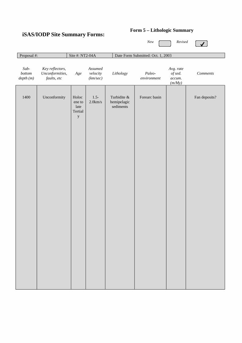
New Revised
Proposal #: Site #: NT2-04A Date Form Submitted: Oct. 1, 2003
Sub-bottom
depth (m)
Key reflectors,Unconformities,
faults, etcAge
Assumedvelocity(km/sec)
Lithology Paleo-environment
Avg. rateof sed.accum.(m/My)
Comments
1400 Unconformity Holocene tolate
Tertialy
1.5-2.0km/s
Turbidite &hemipelagicsediments
Forearc basin Fan deposits?
iSAS/IODP Site Summary Forms:Form 5 – Lithologic Summary

1
iSAS/IODP Site Summary Forms:Form 1 - General Site Information
Please fill out information in all gray boxes
Section A: Proposal Information
Title of Proposal:NanTroSEIZE Drilling and Observatory Phase 2
Mechanical and Hydrologic State of Mega-Splay Faults:Implications for Seismogenic Faulting and Tsunami Generation
Date FormSubmitted:
Oct. 1, 2003
Site SpecificObjectives with
Priority(Must include general
objectives in proposal)
Characterization of active splay fault and fluid flow regime by core sampling, logging, cross-
hole experiments and long-term monitoring.
Focuses are placed on mechanical and hydrological properties (e.g. strength, pore pressure,
permeability, porosity), fluid budget, origin of the fluid, detection of episodic flow.
Borehole long-term observatory for hydrogeological properties is planned as well as cross-
hole experiment.
Priority:3 (Alternate site for NT2-01A/B)
List PreviousDrilling in Area:
None
Section B: General Site Information
Site Name:(e.g. SWPAC-01A)
NT2-06A/B
If site is a reoccupationof an old DSDP/ODPSite, Please includeformer Site #
Area or Location:
Southwestern NankaiTrough off Kumano
Latitude: Deg: 33 Min: 06.6 N Jurisdiction:Within Japanese EEZ
Longitude: Deg: 136 Min: 31.3 E Distance to Land: 45 NM
CoordinatesSystem:
WGS 84
Priority of Site: Primary: Alt: Water Depth: 2.990 m
New RevisedRevised 7 M arch 2002
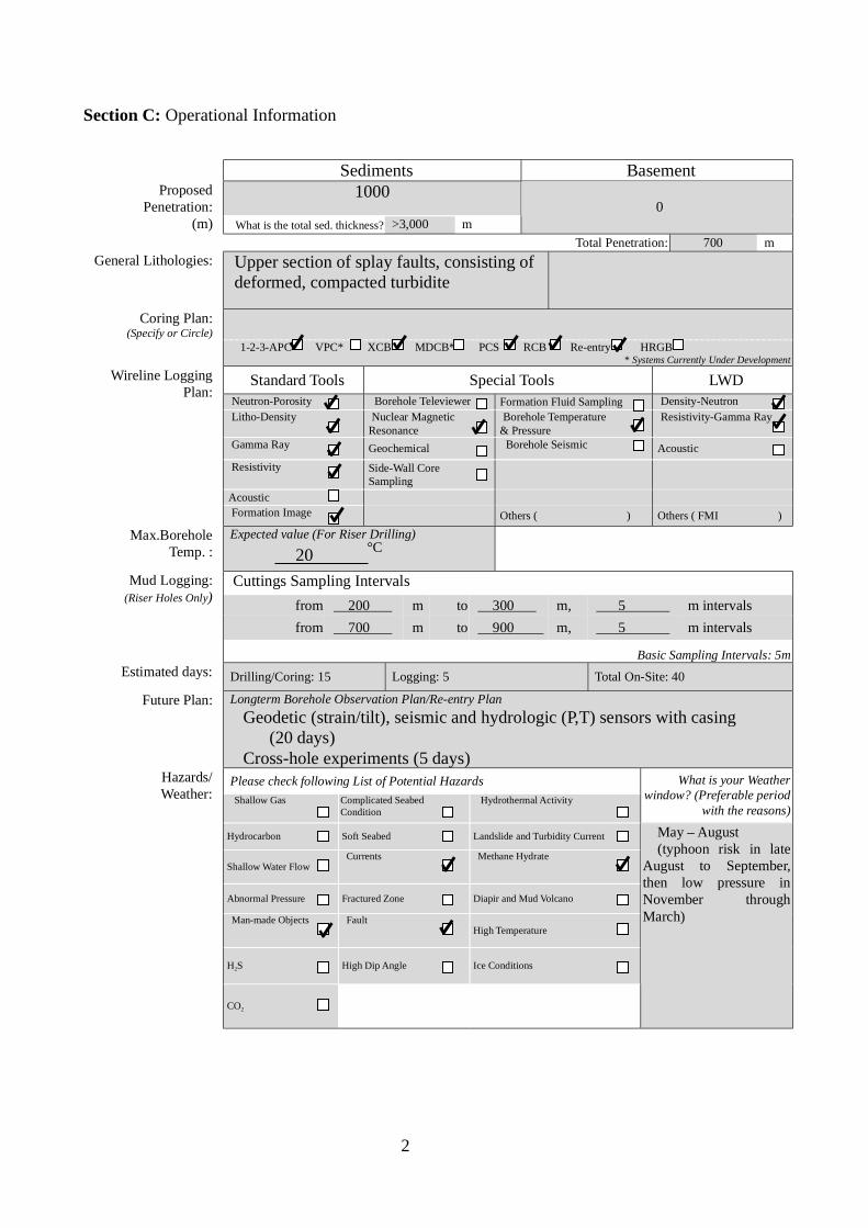
2
Section C: Operational Information
Sediments Basement1000Proposed
Penetration:(m) What is the total sed. thickness? >3,000 m
0
Total Penetration: 700 m
General Lithologies: Upper section of splay faults, consisting of deformed, compacted turbidite
Coring Plan:(Specify or Circle)
1-2-3-APC VPC* XCB MDCB* PCS RCB Re-entry HRGB* Systems Currently Under Development
Standard Tools Special Tools LWDNeutron-Porosity Borehole Televiewer Formation Fluid Sampling Density-NeutronLitho-Density Nuclear Magnetic
ResonanceBorehole Temperature
& PressureResistivity-Gamma Ray
Gamma Ray Geochemical Borehole Seismic Acoustic
Resistivity Side-Wall Core Sampling
Acoustic
Wireline LoggingPlan:
Formation Image Others ( ) Others ( FMI )
Max.BoreholeTemp. :
Expected value (For Riser Drilling)
20
Cuttings Sampling Intervals
from 200 m to 300 m, 5 m intervals
from 700 m to 900 m, 5 m intervals
Mud Logging:(Riser Holes Only)
Basic Sampling Intervals: 5mEstimated days: Drilling/Coring: 15 Logging: 5 Total On-Site: 40
Future Plan: Longterm Borehole Observation Plan/Re-entry Plan
Geodetic (strain/tilt), seismic and hydrologic (P,T) sensors with casing (20 days) Cross-hole experiments (5 days)Please check following List of Potential Hazards
Shallow Gas Complicated SeabedCondition
Hydrothermal Activity
What is your Weatherwindow? (Preferable period
with the reasons)
Hydrocarbon Soft Seabed Landslide and Turbidity Current
Shallow Water FlowCurrents Methane Hydrate
Abnormal Pressure Fractured Zone Diapir and Mud Volcano
Man-made Objects FaultHigh Temperature
H2S High Dip Angle Ice Conditions
Hazards/Weather:
CO2
May – August(typhoon risk in late
August to September,then low pressure inNovember throughMarch)
°C

New RevisedPlease fill out information in all gray boxes
roposal #: Site #: NT2-06A/B Date Form Submitted: Oct. 1, 2003
Data Type
SSPRequir-ements
ExistsIn DB Details of available data and data that are still to be collected
1High resolutionseismic reflection
YESPrimary Line(s) :Location of Site on line (SP or Time only) JAMSTEC Line-I (Feb. 2003)
Crossing Lines(s): JAMSTEC Line-9 (Feb. 2003)
2Deep Penetrationseismic reflection
YESPrimary Line(s): Location of Site on line (SP or Time only) KR0108-4
Crossing Lines(s):
3 Seismic Velocity† YES Stacking velocity and migration velocity from MCS lines.OBS data also available.
4 Seismic Grid YES Acquired by JAMSTEC in Feb. 2003
5a Refraction(surface)
YES Two-ship COP (max. offset 20km) was obtained by JAMSTEC in Sep.2002
5b Refraction(near bottom)
YES OBS data by Nakanishi et al. (1997)
6 3.5 kHz NO Location of Site on line (Time)
7 Swathbathymetry
YES Multi-narrow beam data by JAMSTEC R/V Yokosuka
8a Side-lookingsonar (surface)
YES Some data collected using IZANAGI side scan sonar
8b Side-lookingsonar (bottom)
NO
9 Photographyor Video
YES Taken by submersibles of JASMTEC
10 Heat Flow YES Obtained from surface ship, submersibles, long-erm monitoring and BSR
11a Magnetics YES Compiled map published from AIST, Japan
11b Gravity YES Compiled map published from AIST, Japan
12 Sediment cores YES Gravity and piston cores13 Rock sampling YES Taken by submersible and ROV
14a Water current data YES Available on JODC web page (http://www.jodc.go.jp/)14b Ice Conditions
15 OBSmicroseismicity
Being processed now
16 Navigation YES
17 Other
SSP Classification of Site: SSP Watchdog: Date of Last Review:SSP Comments:
X=required; X*=may be required for specific sites; Y=recommended; Y*=may be recommended for specific sites;R=required for re-entry sites; T=required for high temperature environments; † Accurate velocity information is requiredfor holes deeper than 400m.
iSAS/IODP Site Summary Forms:Form 2 - Site Survey Detail

New Revised
Proposal #: Site #: NT2-06A/B Date Form Submitted: Oct. 1, 2003Water Depth (m): 2990 Sed. Penetration (m): 1000 Basement Penetration (m): 0
Do you need to use the conical side-entry sub (CSES) at this site? Yes No
Are high temperatures expected at this site? Yes No
Are there any other special requirements for logging at this site? Yes No
If “Yes” Please describe requirements:
What do you estimate the total logging time for this site to be:
Measurement Type Scientific ObjectiveRelevance
(1=high, 3=Low)
Neutron-Porosity Estimation of water content in sedimentary sequences and basement. 1
Litho-Density Estimation of water content,bulk density,and mineral composition in
sedimentary sequences and basement.
1
Natural Gamma Ray Estimation clay contents and mineral composition in sedimentary
sequences and basement.
1
Resistivity-Induction Estimation of water content and electro-magnetic properties in
sedimentary sequences and basement.
1
Acoustic
FMS Imaging of sedimentary structures and fractures.Core-log correlation of
structural features.
1
BHTV
Resistivity-Laterolog
Magnetic/Susceptibility
Density-Neutron (LWD) Estimation of water contents,bulk density,and lithology in unstable
borehole environments.
1
Resitivity-Gamma Ray
(LWD)
Estimation of water contents,bulk density,and lithology in unstable
borehole environments.
1
Other: Special tools (CORK,
PACKER, VSP, PCS, FWS,
WSP
Cross-hole hydrologic and electrical experiment. RAB
Hydrofracturing, Packer injection test
CORK and Geodetic borehole observatory
1
For help in determining logging times, please contact the ODP-LDEO Wireline Logging Services groupat:
[email protected]://www.ldeo.columbia.edu/BRG/brg_home.htmlPhone/Fax: (914) 365-8674 / (914) 365-3182
Note: Sites with greater than 400 m ofpenetration or significant basementpenetration require deployment ofstandard toolstrings.
iSAS/IODP Site Summary Forms:Form 3 - Detailed Logging Plan

New RevisedPlease fill out information in all gray boxes
Proposal #: Site #: NT2-06A/B Date Form Submitted: Oct. 1, 2003
1 Summary of Operations at site:(Example: Triple-APC to refusal, XCB10 m into basement, log as shown onpage 3.)
APC to refusal,then XCB to refusal.RCB to 1000 m
2 Based on Previous DSDP/ODPdrilling, list all hydrocarbonoccurrences of greater thanbackground levels. Give natureof show, age and depth of rock:
JNOC will conduct drilling in eastern Nankai in 2004. This datawill be used for urprogram.
3 From Available information, listall commercial drilling in thisarea that produced or yieldedsignificant hydrocarbon shows.Give depths and ages ofhydrocarbon-bearing deposits.
None
4 Are there any indications of gashydrates at this location? Yes, MCS profile shows BSRs
5 Are there reasons to expecthydrocarbon accumulations atthis site? Please give details.
6 What “special” precautions willbe taken during drilling? Yes, During drilling into the fault zone, hole may collapse.
7 What abandonment proceduresdo you plan to follow: None
8 Please list other natural ormanmade hazards which mayeffect ship’s operations:(e.g. ice, currents, cables)
Strong Kuroshio current, typhoon (June – October)
9 Summary: What do youconsider the major risks indrilling at this site?
Current
iSAS/IODP Site Summary Forms:Form 4 – Pollution & Safety Hazard Summary

New Revised
Proposal #: Site #: NT2-06A/B Date Form Submitted: Oct. 1, 2003
Sub-bottom
depth (m)
Key reflectors,Unconformities,
faults, etcAge
Assumedvelocity(km/sec)
Lithology Paleo-environment
Avg. rateof sed.accum.(m/My)
Comments
300
800
Unconformity
fault
Holocene toMioce
ne
1.6-2.5km/s
Slopesediments
to
oldaccretionary
rocks
Accretionaryprism
iSAS/IODP Site Summary Forms:Form 5 – Lithologic Summary

iSAS/IODP Site Summary Forms:Form 1 - General Site Information
Please fill out information in all gray boxes
Section A: Proposal Information
Title of Proposal:NanTroSEIZE Drilling and Observatory Phase 2
Mechanical and Hydrologic State of Mega-Splay Faults:Implications for Seismogenic Faulting and Tsunami Generation
Date FormSubmitted:
Oct. 1, 2003
Site SpecificObjectives with
Priority(Must include general
objectives in proposal)
Study the progressive change in the fault properties by intersecting the splay fault at
intermediate depth of 2km. Integration with NT2-01A and NT2-03A are essential.
Priority:2 (Alternate site for NT2-02A)
List PreviousDrilling in Area:
None
Section B: General Site Information
Site Name:(e.g. SWPAC-01A)
NT2-07A
If site is a reoccupationof an old DSDP/ODPSite, Please includeformer Site #
Area or Location:
Southwestern NankaiTrough off Kumano
Latitude: Deg: 33 Min: 08.6 N Jurisdiction:Within Japanese EEZ
Longitude: Deg: 136 Min: 30.0 E Distance to Land: 45 NM
CoordinatesSystem:
WGS 84
Priority of Site: Primary: Alt: Water Depth: 2,260 m
New RevisedRevised 7 M arch 2002
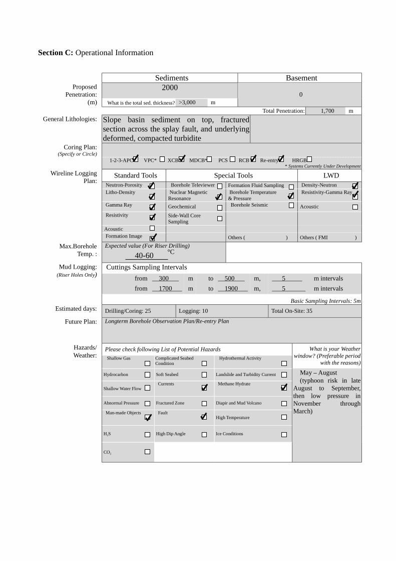
Section C: Operational Information
Sediments Basement2000Proposed
Penetration:(m) What is the total sed. thickness? >3,000 m
0
Total Penetration: 1,700 m
General Lithologies: Slope basin sediment on top, fracturedsection across the splay fault, and underlyingdeformed, compacted turbidite
Coring Plan:(Specify or Circle)
1-2-3-APC VPC* XCB MDCB* PCS RCB Re-entry HRGB* Systems Currently Under Development
Standard Tools Special Tools LWDNeutron-Porosity Borehole Televiewer Formation Fluid Sampling Density-NeutronLitho-Density Nuclear Magnetic
ResonanceBorehole Temperature
& PressureResistivity-Gamma Ray
Gamma Ray Geochemical Borehole Seismic Acoustic
Resistivity Side-Wall Core Sampling
Acoustic
Wireline LoggingPlan:
Formation Image Others ( ) Others ( FMI )
Max.BoreholeTemp. :
Expected value (For Riser Drilling)
40-60
Cuttings Sampling Intervals
from 300 m to 500 m, 5 m intervals
from 1700 m to 1900 m, 5 m intervals
Mud Logging:(Riser Holes Only)
Basic Sampling Intervals: 5mEstimated days: Drilling/Coring: 25 Logging: 10 Total On-Site: 35
Future Plan: Longterm Borehole Observation Plan/Re-entry Plan
Please check following List of Potential Hazards
Shallow Gas Complicated SeabedCondition
Hydrothermal Activity
What is your Weatherwindow? (Preferable period
with the reasons)
Hydrocarbon Soft Seabed Landslide and Turbidity Current
Shallow Water FlowCurrents Methane Hydrate
Abnormal Pressure Fractured Zone Diapir and Mud Volcano
Man-made Objects FaultHigh Temperature
H2S High Dip Angle Ice Conditions
Hazards/Weather:
CO2
May – August(typhoon risk in late
August to September,then low pressure inNovember throughMarch)
°C

New RevisedPlease fill out information in all gray boxes
roposal #: Site #: NT2-07A Date Form Submitted: Oct. 1, 2003
Data Type
SSPRequir-ements
ExistsIn DB Details of available data and data that are still to be collected
1High resolutionseismic reflection
YESPrimary Line(s) :Location of Site on line (SP or Time only) JAMSTEC Line-I (Feb. 2003)
Crossing Lines(s): JAMSTEC Line-9 (Feb. 2003)
2Deep Penetrationseismic reflection
YESPrimary Line(s): Location of Site on line (SP or Time only) KR0108-4
Crossing Lines(s):
3 Seismic Velocity† YES Stacking velocity and migration velocity from MCS lines.OBS data also available.
4 Seismic Grid YES Acquired by JAMSTEC in Feb. 2003
5a Refraction(surface)
YES Two-ship COP (max. offset 20km) was obtained by JAMSTEC in Sep.2002
5b Refraction(near bottom)
YES OBS data by Nakanishi et al. (1997)
6 3.5 kHz NO Location of Site on line (Time)
7 Swathbathymetry
YES Multi-narrow beam data by JAMSTEC R/V Yokosuka
8a Side-lookingsonar (surface)
YES Some data collected using IZANAGI side scan sonar
8b Side-lookingsonar (bottom)
NO
9 Photographyor Video
YES Taken by submersibles of JASMTEC
10 Heat Flow YES Obtained from surface ship, submersibles, long-erm monitoring and BSR
11a Magnetics YES Compiled map published from AIST, Japan
11b Gravity YES Compiled map published from AIST, Japan
12 Sediment cores YES Gravity and piston cores13 Rock sampling YES Taken by submersible and ROV
14a Water current data YES Available on JODC web page (http://www.jodc.go.jp/)14b Ice Conditions
15 OBSmicroseismicity
Being processed now
16 Navigation YES
17 Other
SSP Classification of Site: SSP Watchdog: Date of Last Review:SSP Comments:
X=required; X*=may be required for specific sites; Y=recommended; Y*=may be recommended for specific sites;R=required for re-entry sites; T=required for high temperature environments; † Accurate velocity information is requiredfor holes deeper than 400m.
iSAS/IODP Site Summary Forms:Form 2 - Site Survey Detail
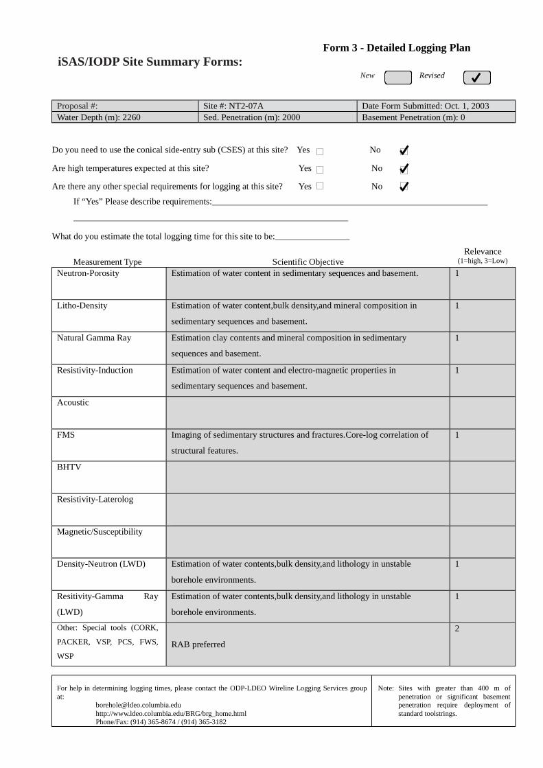
New Revised
Proposal #: Site #: NT2-07A Date Form Submitted: Oct. 1, 2003Water Depth (m): 2260 Sed. Penetration (m): 2000 Basement Penetration (m): 0
Do you need to use the conical side-entry sub (CSES) at this site? Yes No
Are high temperatures expected at this site? Yes No
Are there any other special requirements for logging at this site? Yes No
If “Yes” Please describe requirements:
What do you estimate the total logging time for this site to be:
Measurement Type Scientific ObjectiveRelevance
(1=high, 3=Low)
Neutron-Porosity Estimation of water content in sedimentary sequences and basement. 1
Litho-Density Estimation of water content,bulk density,and mineral composition in
sedimentary sequences and basement.
1
Natural Gamma Ray Estimation clay contents and mineral composition in sedimentary
sequences and basement.
1
Resistivity-Induction Estimation of water content and electro-magnetic properties in
sedimentary sequences and basement.
1
Acoustic
FMS Imaging of sedimentary structures and fractures.Core-log correlation of
structural features.
1
BHTV
Resistivity-Laterolog
Magnetic/Susceptibility
Density-Neutron (LWD) Estimation of water contents,bulk density,and lithology in unstable
borehole environments.
1
Resitivity-Gamma Ray
(LWD)
Estimation of water contents,bulk density,and lithology in unstable
borehole environments.
1
Other: Special tools (CORK,
PACKER, VSP, PCS, FWS,
WSP
RAB preferred
2
For help in determining logging times, please contact the ODP-LDEO Wireline Logging Services groupat:
[email protected]://www.ldeo.columbia.edu/BRG/brg_home.htmlPhone/Fax: (914) 365-8674 / (914) 365-3182
Note: Sites with greater than 400 m ofpenetration or significant basementpenetration require deployment ofstandard toolstrings.
iSAS/IODP Site Summary Forms:Form 3 - Detailed Logging Plan

New RevisedPlease fill out information in all gray boxes
Proposal #: Site #: NT2-07A Date Form Submitted: Oct. 1, 2003
1 Summary of Operations at site:(Example: Triple-APC to refusal, XCB10 m into basement, log as shown onpage 3.)
APC to refusal,then XCB to refusal.RCB to 2000 m
2 Based on Previous DSDP/ODPdrilling, list all hydrocarbonoccurrences of greater thanbackground levels. Give natureof show, age and depth of rock:
JNOC will conduct drilling in eastern Nankai in 2004. This datawill be used for urprogram.
3 From Available information, listall commercial drilling in thisarea that produced or yieldedsignificant hydrocarbon shows.Give depths and ages ofhydrocarbon-bearing deposits.
None
4 Are there any indications of gashydrates at this location? Yes, MCS profile shows BSRs
5 Are there reasons to expecthydrocarbon accumulations atthis site? Please give details.
6 What “special” precautions willbe taken during drilling? Yes, During drilling into the fault zone, hole may collapse.
7 What abandonment proceduresdo you plan to follow: None
8 Please list other natural ormanmade hazards which mayeffect ship’s operations:(e.g. ice, currents, cables)
Strong Kuroshio current, typhoon (June – October)
9 Summary: What do youconsider the major risks indrilling at this site?
Current
iSAS/IODP Site Summary Forms:Form 4 – Pollution & Safety Hazard Summary

New Revised
Proposal #: Site #: NT2-07A Date Form Submitted: Oct. 1, 2003
Sub-bottom
depth (m)
Key reflectors,Unconformities,
faults, etcAge
Assumedvelocity(km/sec)
Lithology Paleo-environment
Avg. rateof sed.accum.(m/My)
Comments
400
1800
Unconformity
fault
Holocene toMioce
ne
1.6-2.5km/s
Slopesediments
to
oldaccretionary
rocks
Accretionaryprism
iSAS/IODP Site Summary Forms:Form 5 – Lithologic Summary
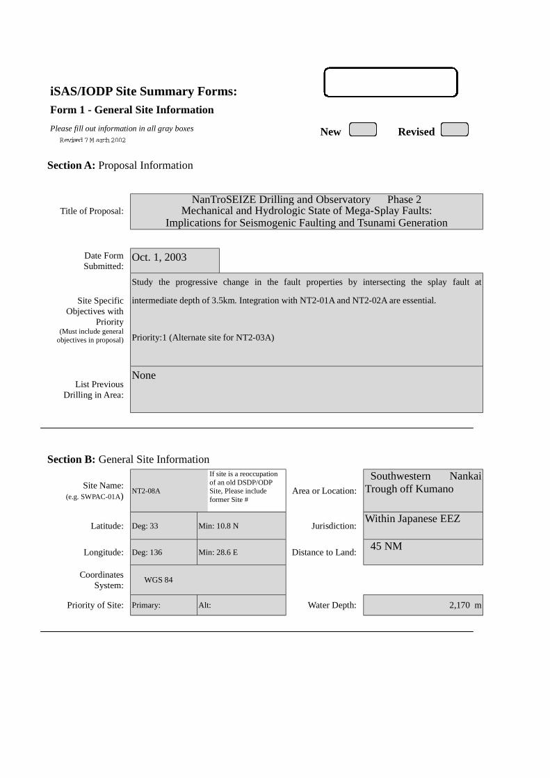
iSAS/IODP Site Summary Forms:Form 1 - General Site Information
Please fill out information in all gray boxes
Section A: Proposal Information
Title of Proposal:NanTroSEIZE Drilling and Observatory Phase 2
Mechanical and Hydrologic State of Mega-Splay Faults:Implications for Seismogenic Faulting and Tsunami Generation
Date FormSubmitted:
Oct. 1, 2003
Site SpecificObjectives with
Priority(Must include general
objectives in proposal)
Study the progressive change in the fault properties by intersecting the splay fault at
intermediate depth of 3.5km. Integration with NT2-01A and NT2-02A are essential.
Priority:1 (Alternate site for NT2-03A)
List PreviousDrilling in Area:
None
Section B: General Site Information
Site Name:(e.g. SWPAC-01A)
NT2-08A
If site is a reoccupationof an old DSDP/ODPSite, Please includeformer Site #
Area or Location:
Southwestern NankaiTrough off Kumano
Latitude: Deg: 33 Min: 10.8 N Jurisdiction:Within Japanese EEZ
Longitude: Deg: 136 Min: 28.6 E Distance to Land: 45 NM
CoordinatesSystem:
WGS 84
Priority of Site: Primary: Alt: Water Depth: 2,170 m
New RevisedRevised 7 M arch 2002
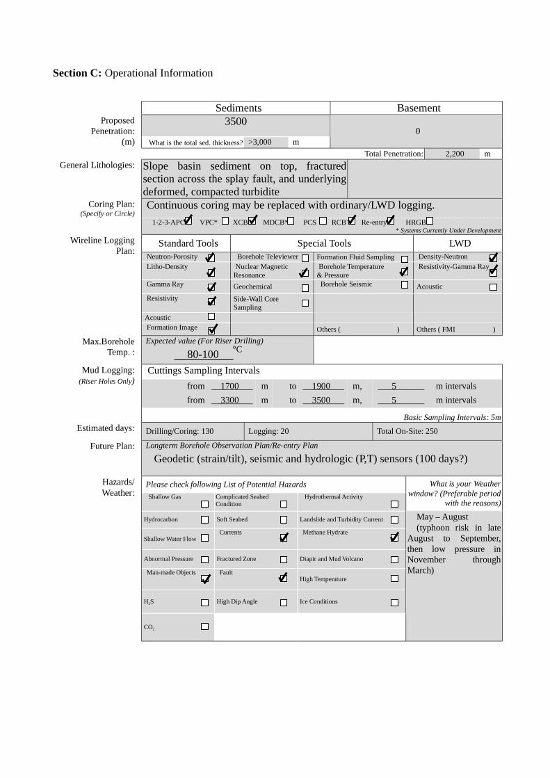
Section C: Operational Information
Sediments Basement3500Proposed
Penetration:(m) What is the total sed. thickness? >3,000 m
0
Total Penetration: 2,200 m
General Lithologies: Slope basin sediment on top, fracturedsection across the splay fault, and underlyingdeformed, compacted turbiditeContinuous coring may be replaced with ordinary/LWD logging.Coring Plan:
(Specify or Circle) 1-2-3-APC VPC* XCB MDCB* PCS RCB Re-entry HRGB
* Systems Currently Under Development
Standard Tools Special Tools LWDNeutron-Porosity Borehole Televiewer Formation Fluid Sampling Density-NeutronLitho-Density Nuclear Magnetic
ResonanceBorehole Temperature
& PressureResistivity-Gamma Ray
Gamma Ray Geochemical Borehole Seismic Acoustic
Resistivity Side-Wall Core Sampling
Acoustic
Wireline LoggingPlan:
Formation Image Others ( ) Others ( FMI )
Max.BoreholeTemp. :
Expected value (For Riser Drilling)
80-100
Cuttings Sampling Intervals
from 1700 m to 1900 m, 5 m intervals
from 3300 m to 3500 m, 5 m intervals
Mud Logging:(Riser Holes Only)
Basic Sampling Intervals: 5mEstimated days: Drilling/Coring: 130 Logging: 20 Total On-Site: 250
Future Plan: Longterm Borehole Observation Plan/Re-entry Plan
Geodetic (strain/tilt), seismic and hydrologic (P,T) sensors (100 days?)
Please check following List of Potential Hazards
Shallow Gas Complicated SeabedCondition
Hydrothermal Activity
What is your Weatherwindow? (Preferable period
with the reasons)
Hydrocarbon Soft Seabed Landslide and Turbidity Current
Shallow Water FlowCurrents Methane Hydrate
Abnormal Pressure Fractured Zone Diapir and Mud Volcano
Man-made Objects FaultHigh Temperature
H2S High Dip Angle Ice Conditions
Hazards/Weather:
CO2
May – August(typhoon risk in late
August to September,then low pressure inNovember throughMarch)
°C
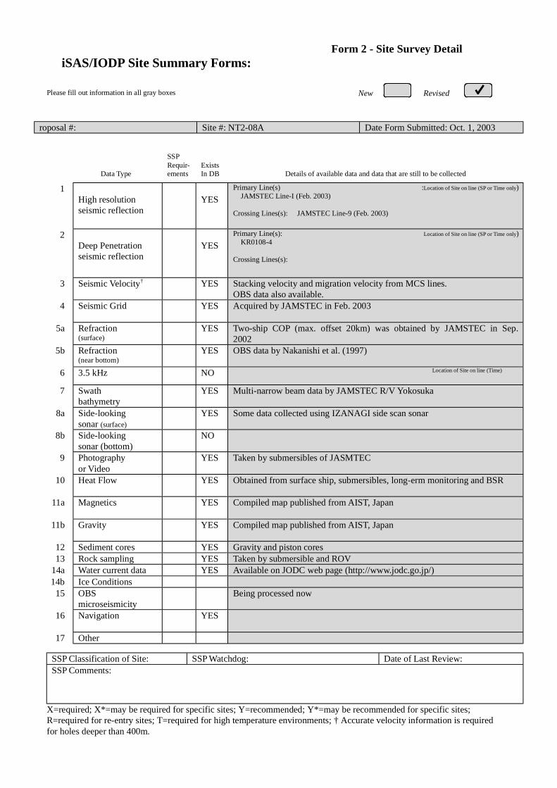
New RevisedPlease fill out information in all gray boxes
roposal #: Site #: NT2-08A Date Form Submitted: Oct. 1, 2003
Data Type
SSPRequir-ements
ExistsIn DB Details of available data and data that are still to be collected
1High resolutionseismic reflection
YESPrimary Line(s) :Location of Site on line (SP or Time only) JAMSTEC Line-I (Feb. 2003)
Crossing Lines(s): JAMSTEC Line-9 (Feb. 2003)
2Deep Penetrationseismic reflection
YESPrimary Line(s): Location of Site on line (SP or Time only) KR0108-4
Crossing Lines(s):
3 Seismic Velocity† YES Stacking velocity and migration velocity from MCS lines.OBS data also available.
4 Seismic Grid YES Acquired by JAMSTEC in Feb. 2003
5a Refraction(surface)
YES Two-ship COP (max. offset 20km) was obtained by JAMSTEC in Sep.2002
5b Refraction(near bottom)
YES OBS data by Nakanishi et al. (1997)
6 3.5 kHz NO Location of Site on line (Time)
7 Swathbathymetry
YES Multi-narrow beam data by JAMSTEC R/V Yokosuka
8a Side-lookingsonar (surface)
YES Some data collected using IZANAGI side scan sonar
8b Side-lookingsonar (bottom)
NO
9 Photographyor Video
YES Taken by submersibles of JASMTEC
10 Heat Flow YES Obtained from surface ship, submersibles, long-erm monitoring and BSR
11a Magnetics YES Compiled map published from AIST, Japan
11b Gravity YES Compiled map published from AIST, Japan
12 Sediment cores YES Gravity and piston cores13 Rock sampling YES Taken by submersible and ROV
14a Water current data YES Available on JODC web page (http://www.jodc.go.jp/)14b Ice Conditions
15 OBSmicroseismicity
Being processed now
16 Navigation YES
17 Other
SSP Classification of Site: SSP Watchdog: Date of Last Review:SSP Comments:
X=required; X*=may be required for specific sites; Y=recommended; Y*=may be recommended for specific sites;R=required for re-entry sites; T=required for high temperature environments; † Accurate velocity information is requiredfor holes deeper than 400m.
iSAS/IODP Site Summary Forms:Form 2 - Site Survey Detail

New Revised
Proposal #: Site #: NT2-08A Date Form Submitted: Oct. 1, 2003Water Depth (m): 2170 Sed. Penetration (m): 3500 Basement Penetration (m): 0
Do you need to use the conical side-entry sub (CSES) at this site? Yes No
Are high temperatures expected at this site? Yes No
Are there any other special requirements for logging at this site? Yes No
If “Yes” Please describe requirements:
What do you estimate the total logging time for this site to be:
Measurement Type Scientific ObjectiveRelevance
(1=high, 3=Low)
Neutron-Porosity Estimation of water content in sedimentary sequences and basement. 1
Litho-Density Estimation of water content,bulk density,and mineral composition in
sedimentary sequences and basement.
1
Natural Gamma Ray Estimation clay contents and mineral composition in sedimentary
sequences and basement.
1
Resistivity-Induction Estimation of water content and electro-magnetic properties in
sedimentary sequences and basement.
1
Acoustic
FMS Imaging of sedimentary structures and fractures.Core-log correlation of
structural features.
1
BHTV
Resistivity-Laterolog
Magnetic/Susceptibility
Density-Neutron (LWD) Estimation of water contents,bulk density,and lithology in unstable
borehole environments.
1
Resitivity-Gamma Ray
(LWD)
Estimation of water contents,bulk density,and lithology in unstable
borehole environments.
1
Other: Special tools (CORK,
PACKER, VSP, PCS, FWS,
WSP
RAB, VSP
Hydrofracturing, Packer injection test
CORK and Geodetic/Seismic borehole observatory
1
For help in determining logging times, please contact the ODP-LDEO Wireline Logging Services groupat:
[email protected]://www.ldeo.columbia.edu/BRG/brg_home.htmlPhone/Fax: (914) 365-8674 / (914) 365-3182
Note: Sites with greater than 400 m ofpenetration or significant basementpenetration require deployment ofstandard toolstrings.
iSAS/IODP Site Summary Forms:Form 3 - Detailed Logging Plan

New RevisedPlease fill out information in all gray boxes
Proposal #: Site #: NT2-08A Date Form Submitted: Oct. 1, 2003
1 Summary of Operations at site:(Example: Triple-APC to refusal, XCB10 m into basement, log as shown onpage 3.)
APC to refusal,then XCB to refusal.RCB to 3500 m
2 Based on Previous DSDP/ODPdrilling, list all hydrocarbonoccurrences of greater thanbackground levels. Give natureof show, age and depth of rock:
JNOC will conduct drilling in eastern Nankai in 2004. This datawill be used for urprogram.
3 From Available information, listall commercial drilling in thisarea that produced or yieldedsignificant hydrocarbon shows.Give depths and ages ofhydrocarbon-bearing deposits.
None
4 Are there any indications of gashydrates at this location? Yes, MCS profile shows BSRs
5 Are there reasons to expecthydrocarbon accumulations atthis site? Please give details.
6 What “special” precautions willbe taken during drilling? Yes, During drilling into the fault zone, hole may collapse.
7 What abandonment proceduresdo you plan to follow: None
8 Please list other natural ormanmade hazards which mayeffect ship’s operations:(e.g. ice, currents, cables)
Strong Kuroshio current, typhoon (June – October)
9 Summary: What do youconsider the major risks indrilling at this site?
Current
iSAS/IODP Site Summary Forms:Form 4 – Pollution & Safety Hazard Summary
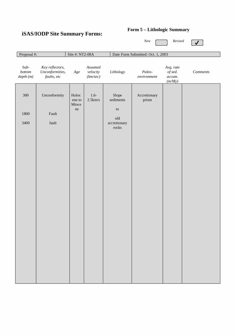
New Revised
Proposal #: Site #: NT2-08A Date Form Submitted: Oct. 1, 2003
Sub-bottom
depth (m)
Key reflectors,Unconformities,
faults, etcAge
Assumedvelocity(km/sec)
Lithology Paleo-environment
Avg. rateof sed.accum.(m/My)
Comments
300
1800
3400
Unconformity
Fault
fault
Holocene toMioce
ne
1.6-2.5km/s
Slopesediments
to
oldaccretionary
rocks
Accretionaryprism
iSAS/IODP Site Summary Forms:Form 5 – Lithologic Summary

Please fill out information in all gray boxes
Title: NanTroSEIZE Drilling and Observatory Phase 3: A Window into theSeismogenic Zone
Proponent(s): Kiyoshi Suyehiro, Harold Tobin, Eiichiro Araki, Susan Bilek, Tadanori Goto, Pierre Henry,Gaku Kimura, Aitaro Kato, Masa Kinoshita, Chris Marone, Greg Moore, J. Casey Moore,Demian Saffer, Arito Sakaguchi, Masanao Shinohara, Ralph Stephen, Akito Tsutsumi,Kohtaro Ujiie, Kelin Wang
Keywords:(5 or less)
Seismogenic zone, fault mechanics, borehole observatory,tsunamigenesis Area: Southwestern
Japan margin
Contact Information:Contact Person: Harold Tobin
Department: Earth and Environmental Science DepartmentOrganization: New Mexico Tech
Address Socorro, NM 87801 USATel.: 505-835-5920 Fax: 505-835-6436
E-mail: [email protected]
Permission to post abstract on iSAS Web site: Yes No
Abstract: (400 words or less)
The principal goal of NanTroSEIZE is to understand seismogenesis and rupture propagation along subductionplate boundary faults by direct testing of key hypotheses related to the mechanics of subduction megathrusts.NanTroSEIZE Phase 3 represents the culmination of the Seismogenic Zone Initiative: drilling into,sampling, and monitoring of the subduction zone plate interface at depths of coseismic slip. This proposalcenters on the deepest drilling effort in the NanTroSEIZE project: sampling a single site across the entire plateinterface into the top of the subducting Philippine Sea plate. The proposed borehole will penetrate a major splayfault (~4 km bsf) potentially implicated in coseismic slip, as well as the master decollement (~6 km bsf), at alocation of shallow large slip during the 1944 Tonankai Mw 8.2 earthquake.
The goal of this proposal is to address two key questions by a combination of logging, coring, down-holeexperiments, and long-term monitoring:
(1) What controls the nature of fault slip and its spatial variability (i.e. the updip transition from aseismic toseismogenic slip)?
(2) What processes control temporal changes in slip behavior on a given fault?Specifically, this proposal is aimed at testing hypotheses explaining controls on unstable slip, and documenting theroles of fault zone state (stress, fluid pressure, fabric) and composition in controlling frictional rheology. Down-hole and monitoring observations, core analyses, and post-cruise laboratory studies will provide direct tests ofexisting hypothesis for fault zone frictional behavior. One focus of Phase 3 will be on documenting the materialproperties and ambient conditions at each of the two faults, and comparing results with findings from shallowerportions of the plate boundary system sampled during Phases 1 and 2 to rigorously characterize controls on faultslip behavior in an active megathrust system.
Proposed activities include (1) drilling, LWD, and casing of a main hole - with drillstem tests performed atcasing set points, (2) creation of a sidetrack coring hole with continuous coring from 4000-6200 mbsf, and (3) welltests in perforated casing and installation of an observatory system for continuous monitoring of pore fluidpressure, temperature, strain, tilt, and seismicity. The borehole observatories, along with surface arrays ofmeasurements, and regional geodetic and seismic monitoring, will provide critical data toward understanding theslip distribution, temporal variability, and controlling mechanisms of seismogenic faulting along the plate boundarysystem.
IODP Proposal Cover SheetNew Revised Addendum
Above For Official Use Only

Scientific Objectives: (250 words or less)
The scientific objectives of NanTroSEIZE Phase 3 drilling are to use direct observation to rigorouslyevaluate the following hypotheses, which are central to understanding earthquake mechanics along subductionmegathrusts:
(1) Systematic, progressive material and state changes control the onset of seismogenic behavior on subductionthrusts; (2) Subduction zone megathrusts are weak faults; (3) Within the seismogenic zone, relative plate motion isprimarily accommodated by coseismic frictional slip in a concentrated zone; (4) Physical properties, chemistry, andstate of the fault zone change systematically with time throughout the earthquake cycle; and (5) The mega-splay(OOST) thrust fault system slips in discrete events which may include tsunamigenic slip during great earthquakes.These hypotheses will be evaluated by detailed characterization – in fault zones and in the surrounding rock volume –of the lithology, structural geology, and physical properties of the rock; the geochemistry of pore fluids; themicrobiological activity; the distribution of temperature, stress, and pore fluid pressure in space and time; theseismicity in the near-borehole environment and downdip; the temporal evolution of the strain field; and the evolutionof physical properties in the volume around the borehole.
Please describe below any non-standard measurements technology needed to achieve the proposed scientific objectives.Essentially all technologies to be used are non-standard. These will include, but are not limited to:Riser-based drilling, LWD suite, DVTP-P, active hydrofracturing tests (wireline packer test), VSP.A borehole observatory with multi-level packers and perforated intervals, Geodetic (strain/tilt), seismic andhydrologic (P,T) sensors and other instruments will be installed for a long-term borehole observatory.
Proposed Sites:Penetration (m)
Site Name PositionWaterDepth
(m) Sed Bsm TotalBrief Site-specific Objectives
NT3-01A
NT3-02A
33°17.6’N, 136°38.6’E
33°12.9’N, 136°27.4’E
1950
2100
6000
6000
200
200
6200
6200
Study the progressive change inthe fault properties byintersecting the splay fault at~4.5km and the seismogenicfault at 5.8 to 6km depth
Alternate site for NT3-01A

iSAS/IODP Site Summary Forms:Form 1 - General Site InformationPlease fill out information in all gray boxes
Section A: Proposal Information
Title of Proposal: NanTroSEIZE Drilling and Observatory Phase 3: A Window into theSeismogenic Zone
Date FormSubmitted:
Apr. 1, 2003
Site SpecificObjectives with
Priority(Must include general
objectives in proposal)
Sample and instrument decollement, mega-splay, and wall rock of lower prism to addressfault rheology, slip history, and temporal change objectives.
Priority:1
List PreviousDrilling in Area:
None
Section B: General Site Information
Site Name:(e.g. SWPAC-01A) NT3-01A
If site is a reoccupationof an old DSDP/ODPSite, Please includeformer Site #
Area or Location: Southwestern NankaiTrough off Kumano
Latitude: Deg: 33 Min: 17.6 N Jurisdiction:Within Japanese EEZ
Longitude: Deg: 136 Min: 38.6 E Distance to Land: 45 NM
CoordinatesSystem: WGS 84
Priority of Site: Primary: X Alt: Water Depth: 1,950 m
New RevisedRevised 7 March 2002

Section C: Operational Information
Sediments Basement5800 - 6000Proposed
Penetration:(m) What is the total sed. thickness? >5,500 m
200
Total Penetration: 6,200 mGeneral Lithologies: Slope basin clastic sediments, accreted and
deformed trench turbidites, hemipelagic andpelagic mudstones, pillow basalt.Continuous coring may be replaced with LWD logging in intervalsCoring Plan:
(Specify or Circle) 1-2-3-APC VPC* XCB MDCB* PCS RCB Re-entry HRGB
* Systems Currently Under Development
Standard Tools Special Tools LWDNeutron-Porosity Borehole Televiewer Formation Fluid Sampling Density-NeutronLitho-Density Nuclear Magnetic
ResonanceBorehole Temperature& Pressure
Resistivity-Gamma Ray
Gamma Ray Geochemical Borehole Seismic AcousticResistivity Side-Wall Core
SamplingAcoustic
Wireline LoggingPlan:
Formation Image Others ( ) Others ( FMI )
Max.BoreholeTemp. :
Expected value (For Riser Drilling) 150-170 degCCuttings Sampling Intervals
from 1500 m to 3600 m, 5 m intervalsfrom 4300 m to 6200 m, 5 m intervals
Mud Logging:(Riser Holes Only)
Basic Sampling Intervals: 5mEstimated days: Drilling/Coring: ??? Logging: ?? Total On-Site: ???
Future Plan: Longterm Borehole Observation Plan/Re-entry Plan Long-term observatory installation and data telemetry/recording
Please check following List of Potential HazardsShallow Gas Complicated Seabed
ConditionHydrothermal Activity
What is your Weatherwindow? (Preferable period
with the reasons)
Hydrocarbon Soft Seabed Landslide and Turbidity Current
Shallow Water FlowCurrents Methane Hydrate
Abnormal Pressure Fractured Zone Diapir and Mud Volcano
Man-made Objects FaultHigh Temperature
H2S High Dip Angle Ice Conditions
Hazards/Weather:
CO2
May – August optimal
(typhoon risk in lateAugust to September)
°C

New RevisedPlease fill out information in all gray boxes
Proposal #: Site #: NT3-01A Date Form Submitted: Apr. 1, 2003
Data Type
SSPRequir-ements
ExistsIn DB Details of available data and data that are still to be collected
1High resolutionseismic reflection
YESPrimary Line(s) :Location of Site on line (SP or Time only) JAMSTEC Line-L (Feb. 2003)
Crossing Lines(s): JAMSTEC Line-9 (Feb. 2003)
2Deep Penetrationseismic reflection
YESPrimary Line(s): Location of Site on line (SP or Time only) KR0108-5
Crossing Lines(s):
3 Seismic Velocity† YES Stacking velocity and PODM migration velocity from MCS lines.OBS wide-angle data also available.
4 Seismic Grid YES Acquired by JAMSTEC in Feb. 2003, also IFREE lines from 1998 - 2003
5a Refraction(surface)
YES Two-ship COP (max. offset 20km) was obtained by JAMSTEC in Sep.2002
5b Refraction(near bottom)
YES OBS data by Nakanishi et al. (1997)
6 3.5 kHz NO Location of Site on line (Time)
7 Swathbathymetry
YES Multi-narrow beam data by JAMSTEC R/V Yokosuka
8a Side-lookingsonar (surface)
YES Some data collected using IZANAGI side scan sonar
8b Side-lookingsonar (bottom)
NO
9 Photographyor Video
YES Taken by submersibles of JASMTEC
10 Heat Flow YES Obtained from surface ship, submersibles, long-term monitoring and BSR
11a Magnetics YES Compiled map published from AIST, Japan
11b Gravity YES Compiled map published from AIST, Japan
12 Sediment cores YES Gravity and piston cores13 Rock sampling YES Taken by submersible and ROV
14a Water current data YES Available on JODC web page (http://www.jodc.go.jp/)14b Ice Conditions
15 OBSmicroseismicity
YES Obana et al., in press
16 Navigation YES
17 Other
SSP Classification of Site: SSP Watchdog: Date of Last Review:SSP Comments:
X=required; X*=may be required for specific sites; Y=recommended; Y*=may be recommended for specific sites;R=required for re-entry sites; T=required for high temperature environments; † Accurate velocity information is requiredfor holes deeper than 400m.
iSAS/IODP Site Summary Forms:Form 2 - Site Survey Detail

New Revised
Proposal #: Site #: NT3-01A Date Form Submitted: Apr. 1, 2003Water Depth (m): 1950 Sed. Penetration (m): 6000 Basement Penetration (m): 200
Do you need to use the conical side-entry sub (CSES) at this site? Yes NoAre high temperatures expected at this site? Yes NoAre there any other special requirements for logging at this site? Yes No
If “Yes” Please describe requirements:
What do you estimate the total logging time for this site to be:
Measurement Type Scientific ObjectiveRelevance
(1=high, 3=Low)
Neutron-Porosity Estimation of water content in sedimentary sequences and basement. 1
Litho-Density Estimation of water content,bulk density,and mineral composition in
sedimentary sequences and basement.
1
Natural Gamma Ray Estimation clay contents and mineral composition in sedimentary
sequences and basement.
1
Resistivity-Induction Estimation of water content and electro-magnetic properties in
sedimentary sequences and basement.
1
Acoustic Yes, dipole sonic, LWD sonic for physical properties
FMS Preferably FMI & RAB. Imaging of sedimentary structures and
fractures.Core-log correlation of structural features.
1
BHTV Perhaps?
Resistivity-Laterolog LWD resistivity
Magnetic/Susceptibility
Density-Neutron (LWD) Estimation of water contents,bulk density,and lithology in unstable
borehole environments.
1
Resitivity-Gamma Ray
(LWD)
Estimation of water contents,bulk density,and lithology in unstable
borehole environments.
1
Other: Special tools (CORK,
PACKER, VSP, PCS, FWS,
WSP
RAB, VSP
Hydrofracturing, Packer injection test
Geodetic/Seismic and multi-level packer borehole observatory
1
For help in determining logging times, please contact the ODP-LDEO Wireline Logging Services groupat:
[email protected]://www.ldeo.columbia.edu/BRG/brg_home.htmlPhone/Fax: (914) 365-8674 / (914) 365-3182
Note: Sites with greater than 400 m ofpenetration or significant basementpenetration require deployment ofstandard toolstrings.
iSAS/IODP Site Summary Forms:Form 3 - Detailed Logging Plan
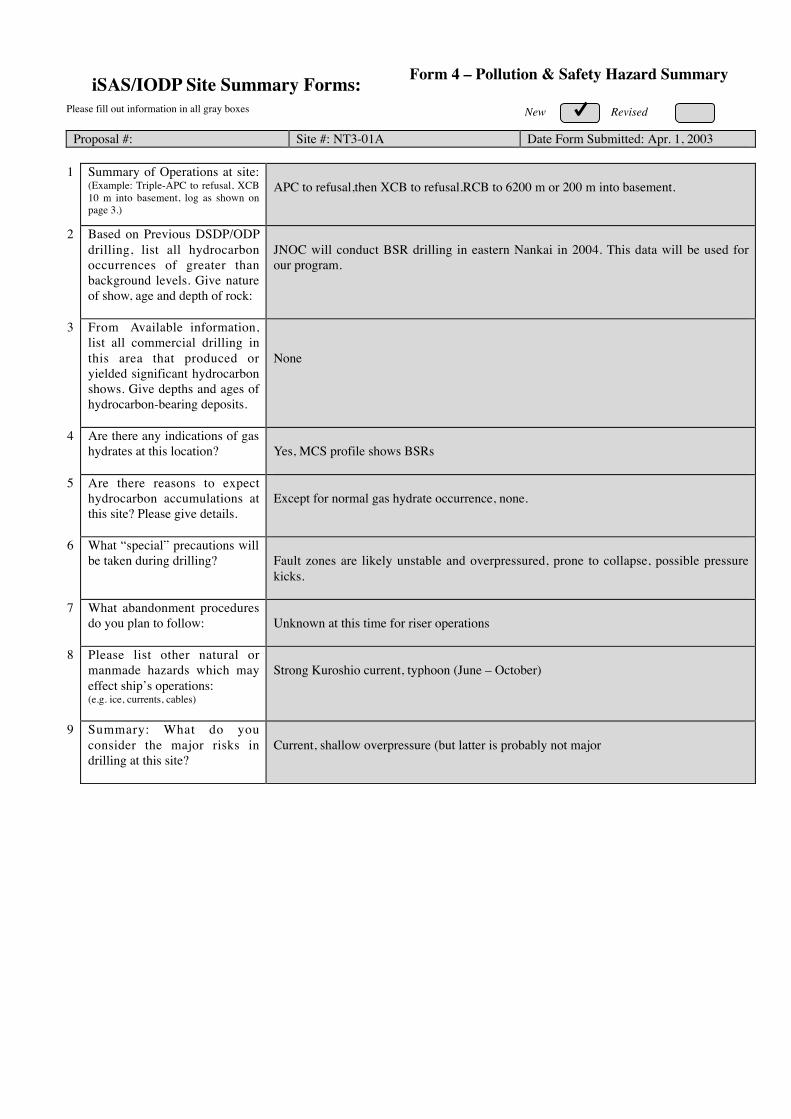
New RevisedPlease fill out information in all gray boxes
Proposal #: Site #: NT3-01A Date Form Submitted: Apr. 1, 2003
1 Summary of Operations at site:(Example: Triple-APC to refusal, XCB10 m into basement, log as shown onpage 3.)
APC to refusal,then XCB to refusal.RCB to 6200 m or 200 m into basement.
2 Based on Previous DSDP/ODPdrilling, list all hydrocarbonoccurrences of greater thanbackground levels. Give natureof show, age and depth of rock:
JNOC will conduct BSR drilling in eastern Nankai in 2004. This data will be used forour program.
3 From Available information,list all commercial drilling inthis area that produced oryielded significant hydrocarbonshows. Give depths and ages ofhydrocarbon-bearing deposits.
None
4 Are there any indications of gashydrates at this location? Yes, MCS profile shows BSRs
5 Are there reasons to expecthydrocarbon accumulations atthis site? Please give details.
Except for normal gas hydrate occurrence, none.
6 What “special” precautions willbe taken during drilling? Fault zones are likely unstable and overpressured, prone to collapse, possible pressure
kicks.
7 What abandonment proceduresdo you plan to follow: Unknown at this time for riser operations
8 Please list other natural ormanmade hazards which mayeffect ship’s operations:(e.g. ice, currents, cables)
Strong Kuroshio current, typhoon (June – October)
9 Summary: What do youconsider the major risks indrilling at this site?
Current, shallow overpressure (but latter is probably not major
iSAS/IODP Site Summary Forms: Form 4 – Pollution & Safety Hazard Summary

New RevisedNew Revised
Proposal #: Site #: NT3-01A Date Form Submitted: Apr. 1, 2003
Sub-bottom
depth (m)
Key reflectors,Unconformities,
faults, etcAge
Assumedvelocity(km/sec)
Lithology Paleo-environment
Avg. rateof sed.accum.(m/My)
Comments
2001000
4500
6000
UnconformityUnconformity
Fault
fault
Holocene toMioce
ne
1.6-2.5km/s
Slopesediments
to
oldaccretionary
rocks
Accretionaryprism
iSAS/IODP Site Summary Forms:Form 5 – Lithologic Summary
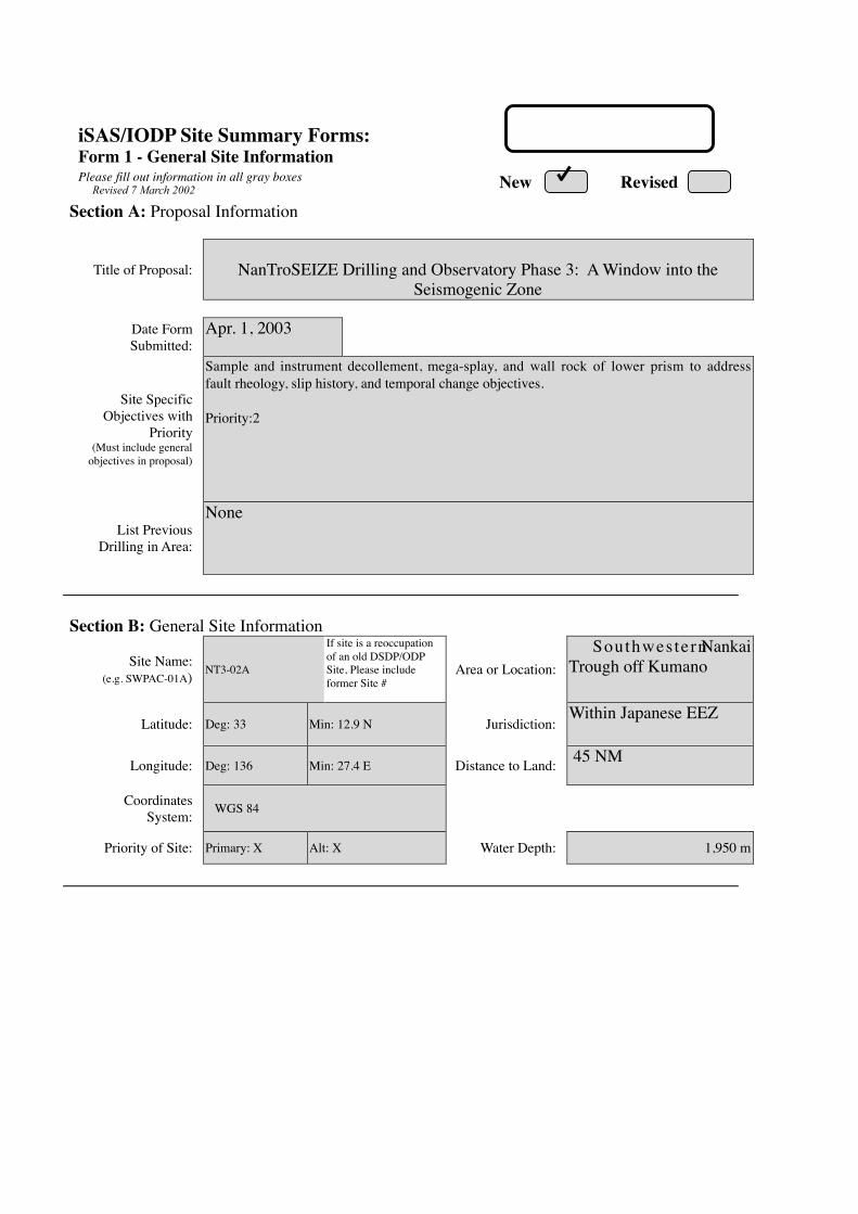
iSAS/IODP Site Summary Forms:Form 1 - General Site InformationPlease fill out information in all gray boxes
Section A: Proposal Information
Title of Proposal: NanTroSEIZE Drilling and Observatory Phase 3: A Window into theSeismogenic Zone
Date FormSubmitted:
Apr. 1, 2003
Site SpecificObjectives with
Priority(Must include general
objectives in proposal)
Sample and instrument decollement, mega-splay, and wall rock of lower prism to addressfault rheology, slip history, and temporal change objectives.
Priority:2
List PreviousDrilling in Area:
None
Section B: General Site Information
Site Name:(e.g. SWPAC-01A) NT3-02A
If site is a reoccupationof an old DSDP/ODPSite, Please includeformer Site #
Area or Location: Southwestern NankaiTrough off Kumano
Latitude: Deg: 33 Min: 12.9 N Jurisdiction:Within Japanese EEZ
Longitude: Deg: 136 Min: 27.4 E Distance to Land: 45 NM
CoordinatesSystem: WGS 84
Priority of Site: Primary: X Alt: X Water Depth: 1,950 m
New RevisedRevised 7 March 2002

Section C: Operational Information
Sediments Basement5800 - 6000Proposed
Penetration:(m) What is the total sed. thickness? >5,500 m
200
Total Penetration: 6,200 mGeneral Lithologies: Slope basin clastic sediments, accreted and
deformed trench turbidites, hemipelagic andpelagic mudstones, pillow basalt.Continuous coring may be replaced with LWD logging in intervalsCoring Plan:
(Specify or Circle) 1-2-3-APC VPC* XCB MDCB* PCS RCB Re-entry HRGB
* Systems Currently Under Development
Standard Tools Special Tools LWDNeutron-Porosity Borehole Televiewer Formation Fluid Sampling Density-NeutronLitho-Density Nuclear Magnetic
ResonanceBorehole Temperature& Pressure
Resistivity-Gamma Ray
Gamma Ray Geochemical Borehole Seismic AcousticResistivity Side-Wall Core
SamplingAcoustic
Wireline LoggingPlan:
Formation Image Others ( ) Others ( FMI )
Max.BoreholeTemp. :
Expected value (For Riser Drilling) 150-170 degCCuttings Sampling Intervals
from 1500 m to 3600 m, 5 m intervalsfrom 4300 m to 6200 m, 5 m intervals
Mud Logging:(Riser Holes Only)
Basic Sampling Intervals: 5mEstimated days: Drilling/Coring: ??? Logging: ?? Total On-Site: ???
Future Plan: Longterm Borehole Observation Plan/Re-entry Plan Long-term observatory installation and data telemetry/recording
Please check following List of Potential HazardsShallow Gas Complicated Seabed
ConditionHydrothermal Activity
What is your Weatherwindow? (Preferable period
with the reasons)
Hydrocarbon Soft Seabed Landslide and Turbidity Current
Shallow Water FlowCurrents Methane Hydrate
Abnormal Pressure Fractured Zone Diapir and Mud Volcano
Man-made Objects FaultHigh Temperature
H2S High Dip Angle Ice Conditions
Hazards/Weather:
CO2
May – August optimal
(typhoon risk in lateAugust to September)
°C

New RevisedPlease fill out information in all gray boxes
Proposal #: Site #: NT3-02A Date Form Submitted: Apr. 1, 2003
Data Type
SSPRequir-ements
ExistsIn DB Details of available data and data that are still to be collected
1High resolutionseismic reflection
YESPrimary Line(s) :Location of Site on line (SP or Time only) JAMSTEC Line-B (Feb. 2003)
Crossing Lines(s): JAMSTEC Line-9 (Feb. 2003)
2Deep Penetrationseismic reflection
YESPrimary Line(s): Location of Site on line (SP or Time only) KR0108-5, 3
Crossing Lines(s):
3 Seismic Velocity† YES Stacking velocity and PODM migration velocity from MCS lines.OBS wide-angle data also available.
4 Seismic Grid YES Acquired by JAMSTEC in Feb. 2003, also IFREE lines from 1998 - 2003
5a Refraction(surface)
YES Two-ship COP (max. offset 20km) was obtained by JAMSTEC in Sep.2002
5b Refraction(near bottom)
YES OBS data by Nakanishi et al. (1997)
6 3.5 kHz NO Location of Site on line (Time)
7 Swathbathymetry
YES Multi-narrow beam data by JAMSTEC R/V Yokosuka
8a Side-lookingsonar (surface)
YES Some data collected using IZANAGI side scan sonar
8b Side-lookingsonar (bottom)
NO
9 Photographyor Video
YES Taken by submersibles of JASMTEC
10 Heat Flow YES Obtained from surface ship, submersibles, long-term monitoring and BSR
11a Magnetics YES Compiled map published from AIST, Japan
11b Gravity YES Compiled map published from AIST, Japan
12 Sediment cores YES Gravity and piston cores13 Rock sampling YES Taken by submersible and ROV
14a Water current data YES Available on JODC web page (http://www.jodc.go.jp/)14b Ice Conditions
15 OBSmicroseismicity
YES Obana et al., in press
16 Navigation YES
17 Other
SSP Classification of Site: SSP Watchdog: Date of Last Review:SSP Comments:
X=required; X*=may be required for specific sites; Y=recommended; Y*=may be recommended for specific sites;R=required for re-entry sites; T=required for high temperature environments; † Accurate velocity information is requiredfor holes deeper than 400m.
iSAS/IODP Site Summary Forms:Form 2 - Site Survey Detail
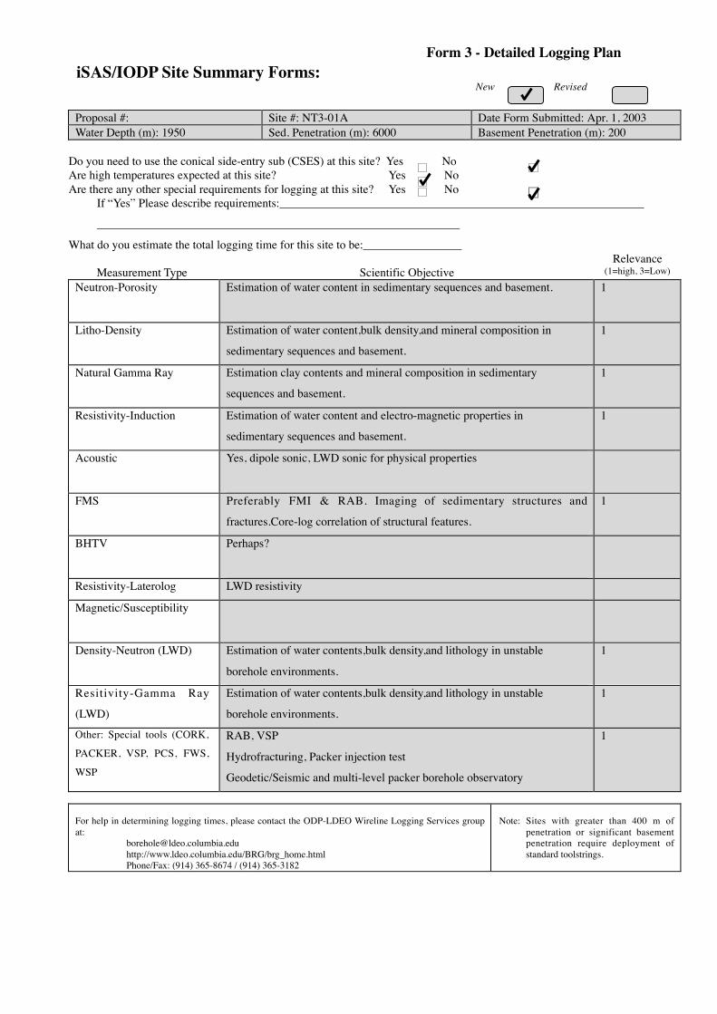
New Revised
Proposal #: Site #: NT3-01A Date Form Submitted: Apr. 1, 2003Water Depth (m): 1950 Sed. Penetration (m): 6000 Basement Penetration (m): 200
Do you need to use the conical side-entry sub (CSES) at this site? Yes NoAre high temperatures expected at this site? Yes NoAre there any other special requirements for logging at this site? Yes No
If “Yes” Please describe requirements:
What do you estimate the total logging time for this site to be:
Measurement Type Scientific ObjectiveRelevance
(1=high, 3=Low)
Neutron-Porosity Estimation of water content in sedimentary sequences and basement. 1
Litho-Density Estimation of water content,bulk density,and mineral composition in
sedimentary sequences and basement.
1
Natural Gamma Ray Estimation clay contents and mineral composition in sedimentary
sequences and basement.
1
Resistivity-Induction Estimation of water content and electro-magnetic properties in
sedimentary sequences and basement.
1
Acoustic Yes, dipole sonic, LWD sonic for physical properties
FMS Preferably FMI & RAB. Imaging of sedimentary structures and
fractures.Core-log correlation of structural features.
1
BHTV Perhaps?
Resistivity-Laterolog LWD resistivity
Magnetic/Susceptibility
Density-Neutron (LWD) Estimation of water contents,bulk density,and lithology in unstable
borehole environments.
1
Resitivity-Gamma Ray
(LWD)
Estimation of water contents,bulk density,and lithology in unstable
borehole environments.
1
Other: Special tools (CORK,
PACKER, VSP, PCS, FWS,
WSP
RAB, VSP
Hydrofracturing, Packer injection test
Geodetic/Seismic and multi-level packer borehole observatory
1
For help in determining logging times, please contact the ODP-LDEO Wireline Logging Services groupat:
[email protected]://www.ldeo.columbia.edu/BRG/brg_home.htmlPhone/Fax: (914) 365-8674 / (914) 365-3182
Note: Sites with greater than 400 m ofpenetration or significant basementpenetration require deployment ofstandard toolstrings.
iSAS/IODP Site Summary Forms:Form 3 - Detailed Logging Plan

New RevisedPlease fill out information in all gray boxes
Proposal #: Site #: NT3-01A Date Form Submitted: Apr. 1, 2003
1 Summary of Operations at site:(Example: Triple-APC to refusal, XCB10 m into basement, log as shown onpage 3.)
APC to refusal,then XCB to refusal.RCB to 6200 m or 200 m into basement.
2 Based on Previous DSDP/ODPdrilling, list all hydrocarbonoccurrences of greater thanbackground levels. Give natureof show, age and depth of rock:
JNOC will conduct BSR drilling in eastern Nankai in 2004. This data will be used forour program.
3 From Available information,list all commercial drilling inthis area that produced oryielded significant hydrocarbonshows. Give depths and ages ofhydrocarbon-bearing deposits.
None
4 Are there any indications of gashydrates at this location? Yes, MCS profile shows BSRs
5 Are there reasons to expecthydrocarbon accumulations atthis site? Please give details.
Except for normal gas hydrate occurrence, none.
6 What “special” precautions willbe taken during drilling? Fault zones are likely unstable and overpressured, prone to collapse, possible pressure
kicks.
7 What abandonment proceduresdo you plan to follow: Unknown at this time for riser operations
8 Please list other natural ormanmade hazards which mayeffect ship’s operations:(e.g. ice, currents, cables)
Strong Kuroshio current, typhoon (June – October)
9 Summary: What do youconsider the major risks indrilling at this site?
Current, shallow overpressure (but latter is probably not major
iSAS/IODP Site Summary Forms: Form 4 – Pollution & Safety Hazard Summary
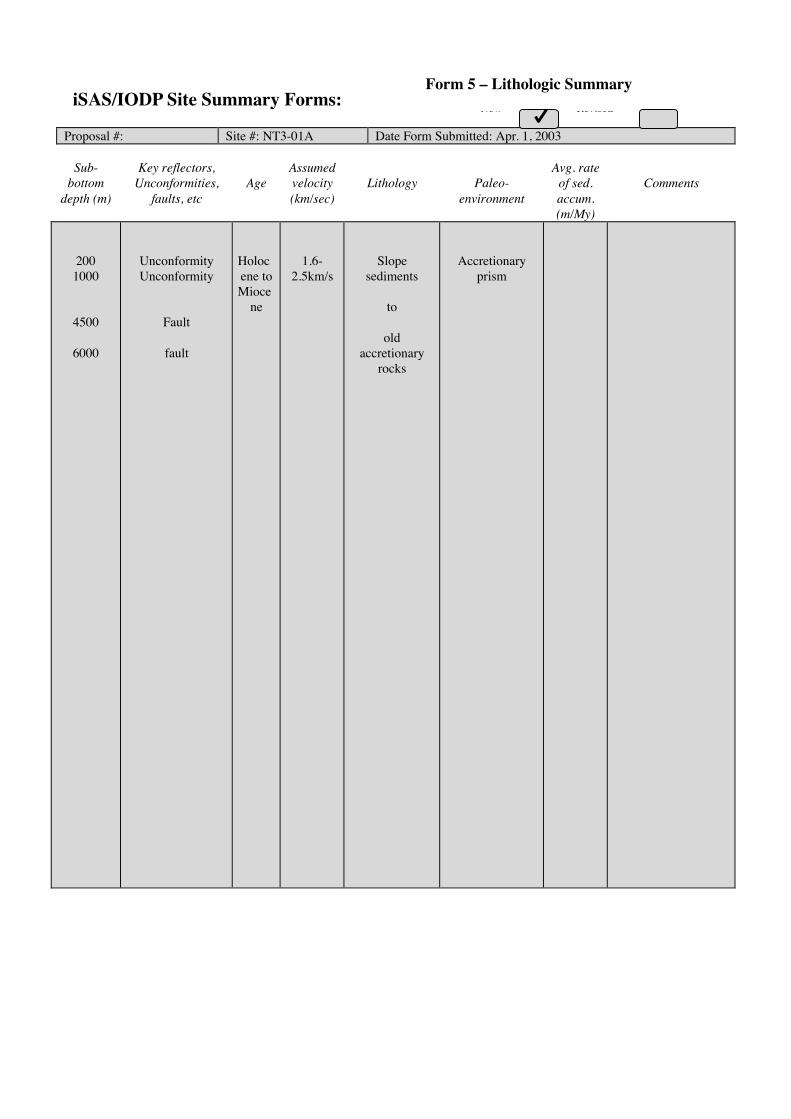
New RevisedNew Revised
Proposal #: Site #: NT3-01A Date Form Submitted: Apr. 1, 2003
Sub-bottom
depth (m)
Key reflectors,Unconformities,
faults, etcAge
Assumedvelocity(km/sec)
Lithology Paleo-environment
Avg. rateof sed.accum.(m/My)
Comments
2001000
4500
6000
UnconformityUnconformity
Fault
fault
Holocene toMioce
ne
1.6-2.5km/s
Slopesediments
to
oldaccretionary
rocks
Accretionaryprism
iSAS/IODP Site Summary Forms:Form 5 – Lithologic Summary

Please fill out information in all gray boxes
Title: The Nankai Trough Seismogenic Zone Experiment: Observatory Science at the Reference Sites
Proponent(s): Elizabeth Screaton, Michael Underwood, Demian Saffer, Kelin Wang, Geoff Wheat, Koichiro Obana, Greg Moore, Kevin Brown, Juichiro Ashi
Keywords: (5 or less)
Subduction inputs; hydrogeology; long-term observatories Area: Nankai Trough Shikoku Basin
Contact Information:
Contact Person: Elizabeth Screaton Department: Department of Geology
Organization: University of Florida Address PO Box 112120, 241 Williamson, Gainesville FL 32611 USA
Tel.: (352) 392-4612 Fax: (352) 392-9294 E-mail: screaton@ ufl.edu
Permission to post abstract on IODP-MI Sapporo Web site: Yes No
Abstract: (400 words or less)
The NanTroSEIZE Complex Drilling Plan describes a multi-phase strategy to get at the root cause of the transition from stable sliding to stick-slip fault behavior -- by intersecting the “seismogenic conveyor belt” of Nankai Trough on either side of its up-dip limit of seismicity. With a campaign of coring, logging, downhole measurements, and long-term observatory science, NanTroSEIZE will test hypotheses concerning the onset of seismogenic behavior and locking of subduction thrusts. Characterizing the inputs to the seismogenic zone through examination of reference sites is a vital component of NanTroSEIZE. This revised full proposal outlines scientific rationale and plans for installation of long-term borehole observatories at NantroSEIZE reference sites. Monitoring at these observatories serves two distinct purposes. First, the observatories will provide information on material properties and background geophysical and geochemical conditions. The state of stress and strength of coupling on the plate-boundary fault are acutely sensitive to 3-D variations in pore pressure, and these pore pressures will be greatly affected by the distribution and permeability of turbidites and the permeability of the ocean crust. Second, observatories allow us to detect temporal changes in the geophysical or geochemical conditions and even the material properties. Temporal changes include the gradual stress build-up during the interseismic period. Associated variations in the thermal and hydrological regimes, and episodic seismic and aseismic strain events, could show how the seismogenic zone adjusts to new conditions caused by the stress build-up, which elevates predictive understanding of the seismogenic zone. Two reference sites in Shikoku Basin, on a basement high and basement plain, will show how stratigraphy, basement topography, and thermal structure affect the physical and hydrologic properties of subduction inputs. Each will require a pair of screened intervals: one targeting open basement and one targeting the overlying sediment. A site located 7 km seaward of the deformation front will indicate how far pressure and chemistry anomalies are transmitted seaward of the deformation front. CORK monitoring at the toe of the accretionary prism will isolate temperature and pressure signals in the frontal décollement from signals in the subducting turbidites. A second shallow observatory at the prism toe will monitor micro-seismicity and strain. An observatory in Kumano Basin provides an important complement to background and transient data obtained within and seaward of the mega-splay system. This monitoring network will provide a vital context for observations within the plate boundary fault system.
IODP Proposal Cover Sheet New Revised Addendum
Above For Official Use Only
X
X

Scientific Objectives: (250 words or less)
Coring, logging, and conventional downhole measurements will commence at four reference sites during Phase I and II of the Nankai Trough Seismogenic Zone Experiment. This proposal describes scientific objectives for long-term borehole observatories to be installed at four of these sites and one additional site. The fundamental objectives of the proposed observatory science are to map background properties of the incoming sediment and crust and to monitor temporal changes associated with the seismic cycle. Specific objectives include: (1) Monitor the differences in hydrologic properties and fluid-flow signals where basement highs are subducting versus where basement plains are subducting. (2) Determine if, where, and why compartments of excess pore pressure develop seaward of the deformation front; if present, determine their effect on early-subduction fault dynamics. (3) Compare hydrologic properties and fluid-flow signals in turbidite sand bodies before and after they have passed beneath the toe of the accretionary prism Assess the role of these turbidite sand bodies in drainage of deeper sediments, and impacts of drainage on plate boundary strength. (4) Monitor hydrologic properties and fluid-flow signals within the frontal décollement zone for rigorous comparison against properties and flow in subducted sand lenses beneath the décollement. (5) Determine how basement fluid flow influences margin-scale patterns of heat flow and fluid flow. (6) Monitor micro-seismicity, strain, and fluid flow response to tectonic events.
Please describe below any non-standard measurements technology needed to achieve the proposed scientific objectives.
Proposed Sites:
Penetration (m) Site Name Position
Water Depth
(m) Sed Bsm Total Brief Site-specific Objectives
NT1-01A NT1-02A NT1-03A NT1-05A NT1-06A NT2-04A
Lat: 32° 44.8878’N Long: 136° 55.0236’E Lat: 32° 47.4996’N Long: 137° 09.2784’ E Lat: 33° 01.23258’N Long: 136° 47.9485’E Lat: 33° 01.3482’N Long: 137° 3.3432’E Lat: 32° 51.35’N Long: 137° 17.58’E Lat: 33° 23.4’N, Long: 136° 34.6’E
3540 4210 4125 4310 4200 1990
460m 730m 1200m 1528m 990m 1400m forearc basin
40m 40m 0m 40m 40m 40m acoustic basement
500m 770m 1200m 1568m 1030m 1440m
One CORK hole with screened interval in position equivalent to turbidites and sealed basement. Companion CORK hole with fully cased sediment & open basement. One CORK hole with screened interval in turbidites and sealed basement. Companion CORK hole with fully cased sediment and open basement. CORK monitoring of décollement and turbidites; will not extend to basement. Monitor micro-seismicity and strain. One CORK hole with screened intervals in turbidites and sealed basement. Companion CORK hole with fully cased sediment and open basement. Alternate to NT1-02A. One CORK hole with screened interval in turbidites and sealed basement. Companion CORK hole with fully cased sediment and open basement. One CORK hole with screened intervals in sediments. Monitor micro-seismicity and strain.
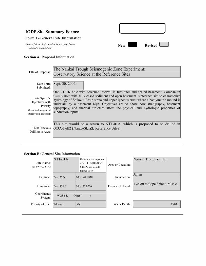
IODP Site Summary Forms: Form 1 - General Site Information
Please fill out information in all gray boxes
Section A: Proposal Information
Title of Proposal: The Nankai Trough Seismogenic Zone Experiment: Observatory Science at the Reference Sites
Date Form Submitted: Sept. 30, 2004
Site Specific Objectives with
Priority (Must include general
objectives in proposal)
One CORK hole with screened interval in turbidites and sealed basement. Companion CORK hole with fully cased sediment and open basement. Reference site to characterize hydrology of Shikoku Basin strata and upper igneous crust where a bathymetric mound is underlain by a basement high. Objectives are to show how stratigraphy, basement topography, and thermal structure affect the physical and hydrologic properties of subduction inputs.
List Previous Drilling in Area:
This site would be a return to NT1-01A, which is proposed to be drilled in 603A-Full2 (NantroSEIZE Reference Sites).
Section B: General Site Information
Site Name: (e.g. SWPAC-01A)
NT1-01A If site is a reoccupation
of an old DSDP/ODP Site, Please include former Site #
Area or Location:
Nankai Trough off Kii
Latitude:
Deg: 32 N Min: :44.8878 Jurisdiction:Japan
Longitude:
Deg: 136 E Min: 55.0236 Distance to Land:130 km to Cape Shiono-Misaki
Coordinates System:
WGS 84, Other ( )
Priority of Site: Primary:x Alt: Water Depth: 3540 m
New Revised Revised 7 March 2002

Section C: Operational Information
Sediments Basement
460 Proposed Penetration:
(m) What is the total sed. thickness? 460 m
40
Total Penetration: 500 m General Lithologies: Possible silt/mud turbidites and ash layers
Hemipelagic mud and mudstone Basalt
Limited coring as necessary to confirm screen locations for CORKs Coring Plan: (Specify or check)
1-2-3-APC VPC* XCB MDCB* PCS RCB Re-entry HRGB * Systems Currently Under Development
Standard Tools Special Tools LWD Neutron-Porosity Borehole Televiewer Formation Fluid Sampling Density-Neutron
Litho-Density Nuclear Magnetic Resonance
Borehole Temperature & Pressure
Resistivity-Gamma Ray
Gamma Ray Geochemical Borehole Seismic Acoustic
Resistivity Side-Wall Core Sampling
Limited measurements if needed to
fill gaps from previous (Phase I)
drilling.
Acoustic
Wireline Logging Plan:
Formation Image Others ( ) Others ( ) Max.Borehole
Temp. : Expected value (For Riser Drilling)
Cuttings Sampling Intervals from m to m, m intervals from m to m, m intervals
Mud Logging: (Riser Holes Only)
Basic Sampling Intervals: 5m Estimated days: Drilling/Coring: 5 Logging: 12 (install casing/CORKs) Total On-Site: 17
Future Plan: Longterm Borehole Observation Plan/Re-entry Plan Long term monitoring (CORKs) of basement and overlying sediments.
Please check following List of Potential Hazards Shallow Gas Complicated Seabed Condition Hydrothermal Activity
What is your Weather window? (Preferable
period with the reasons)
Hydrocarbon Soft Seabed Landslide and Turbidity Current
Shallow Water Flow Currents Methane Hydrate
Abnormal Pressure Fractured Zone Diapir and Mud Volcano
Man-made Objects Fault High Temperature
H2S High Dip Angle Ice Conditions
Hazards/ Weather:
CO2
April-July: Avoid typhoon season
°C

New Revised
Please fill out information in all gray boxes
Proposal #: 603D-Full Site #: NT1-01A Date Form Submitted: Sept. 30, 2004
Data Type
SSP Requir-ements
Exists In DB
Details of available data and data that are still to be collected 1
High resolution seismic reflection
No Primary Line(s) :Location of Site on line (SP or Time only) Crossing Lines(s):
2 Deep Penetration seismic reflection
Yes Primary Line(s): KR9806-2 SP2710 Location of Site on line (SP or Time only) Crossing Lines(s): KR0211-S0
3 Seismic Velocity† Yes Stacking velocity and migration velocity from MCS lines. OBS data.
4 Seismic Grid Yes
5a Refraction (surface)
Yes Two ship COP (maximum offset 20 km) obtained by JAMSTEC.
5b Refraction (near bottom)
Yes OBS data by Nakanishi et al. (1997)
6 3.5 kHz Location of Site on line (Time)
7 Swath bathymetry
Yes Multi-narrow-beam data by JAMSTEC R/V Yokusuka.
8a Side-looking sonar (surface)
No
8b Side-looking sonar (bottom)
No
9 Photography or Video
No
10 Heat Flow Yes.
11a Magnetics Yes Compiled map published from AIST, Japan.
11b Gravity Yes Compiled map published from AIST, Japan.
12 Sediment cores No 13 Rock sampling No
14a Water current data Available on JODC web page (http://www.jodc.go.jp) 14b Ice Conditions
15 OBS microseismicity
Yes
16 Navigation Yes
17 Other
SSP Classification of Site: SSP Watchdog: Date of Last Review: SSP Comments:
X=required; X*=may be required for specific sites; Y=recommended; Y*=may be recommended for specific sites; R=required for re-entry sites; T=required for high temperature environments; † Accurate velocity information is required for holes deeper than 400m.
IODP Site Summary Forms:Form 2 - Site Survey Detail

New Revised
Proposal #: 603D-Full Site #: NT1-01A Date Form Submitted: Sept. 30, 2004 Water Depth (m): 3540 Sed. Penetration (m): 460 Basement Penetration (m): 40
Do you need to use the conical side-entry sub (CSES) at this site? Yes No
Are high temperatures expected at this site? Yes No
Are there any other special requirements for logging at this site? Yes No If “Yes” Please describe requirements:No logging planned. Site will have been logged in previous phase.
CORK installation only
What do you estimate the total logging time for this site to be: 12 days install casing/CORKS
Measurement Type
Scientific Objective Relevance
(1=high, 3=Low) Neutron-Porosity
Litho-Density
Natural Gamma Ray
Resistivity-Induction
Acoustic
FMS
BHTV
Resistivity-Laterolog
Magnetic/Susceptibility
Density-Neutron (LWD)
Resitivity-Gamma Ray
(LWD)
Other: Special tools (CORK,
PACKER, VSP, PCS, FWS,
WSP
CORK
For help in determining logging times, please contact the ODP-LDEO Wireline Logging Services group at: [email protected] http://www.ldeo.columbia.edu/BRG/brg_home.html Phone/Fax: (914) 365-8674 / (914) 365-3182
Note: Sites with greater than 400 m of
penetration or significant basement penetration require deployment of standard toolstrings.
IODP Site Summary Forms: Form 3 - Detailed Logging Plan
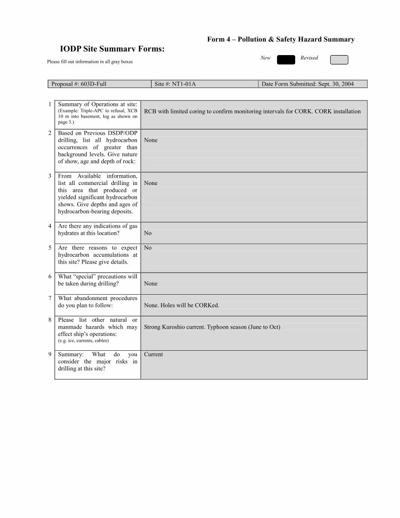
New Revised
Please fill out information in all gray boxes
Proposal #: 603D-Full Site #: NT1-01A Date Form Submitted: Sept. 30, 2004
1 Summary of Operations at site:
(Example: Triple-APC to refusal, XCB 10 m into basement, log as shown on page 3.)
RCB with limited coring to confirm monitoring intervals for CORK. CORK installation
2 Based on Previous DSDP/ODP drilling, list all hydrocarbon occurrences of greater than background levels. Give nature of show, age and depth of rock:
None
3 From Available information, list all commercial drilling in this area that produced or yielded significant hydrocarbon shows. Give depths and ages of hydrocarbon-bearing deposits.
None
4 Are there any indications of gas hydrates at this location?
No
5 Are there reasons to expect hydrocarbon accumulations at this site? Please give details.
No
6 What “special” precautions will be taken during drilling?
None
7 What abandonment procedures do you plan to follow:
None. Holes will be CORKed.
8 Please list other natural or manmade hazards which may effect ship’s operations: (e.g. ice, currents, cables)
Strong Kuroshio current. Typhoon season (June to Oct)
9 Summary: What do you consider the major risks in drilling at this site?
Current
IODP Site Summary Forms:Form 4 – Pollution & Safety Hazard Summary

New New Revised
Proposal #: 603D-Full Site #: NT1-01A Date Form Submitted: Sept. 30, 2004
Sub-
bottom depth (m)
Key reflectors, Unconformities,
faults, etc
Age
Assumed velocity (km/sec)
Lithology
Paleo-environme
nt
Avg. rate of sed. accum. (m/My)
Comments
seafloor
460
560
Unconformity
Total depth
20 Ma
1.6-1.9
2.0
Hemipelagite
Volcanic sediment and
basement basalt
Backarc basin Floor
Backarc basin
spreading ridge
23 m/my
IODP Site Summary Forms: Form 5 – Lithologic Summary

IODP Site Summary Forms: Form 1 - General Site Information
Please fill out information in all gray boxes
Section A: Proposal Information
Title of Proposal: The Nankai Trough Seismogenic Zone Experiment: Observatory Science at the Reference Sites
Date Form Submitted: Sept. 30, 2004
Site Specific Objectives with
Priority (Must include general
objectives in proposal)
One CORK hole with screened interval in turbidites and sealed basement. Companion CORK hole with fully cased sediment and open basement. Reference site to characterize hydrology of Shikoku Basin strata and upper igneous crust where basement topography is relatively flat. Objectives are to document how stratigraphy, basement topography, and thermal structure affect the physical and hydrologic properties of subduction inputs.
List Previous Drilling in Area:
This site would be a return to NT1-02A, which is proposed to be drilled in 603A-Full2 (NantroSEIZE Reference Sites).
Section B: General Site Information
Site Name: (e.g. SWPAC-01A)
NT1-02A If site is a reoccupation
of an old DSDP/ODP Site, Please include former Site #
Area or Location:
Nankai Trough off Kii
Latitude:
Deg: 32 N Min: :47.4996 Jurisdiction:Japan
Longitude:
Deg: 137 E Min: 9.2784 Distance to Land:145 km to Cape Shiono-Misaki
Coordinates System:
WGS 84, Other ( )
Priority of Site: Primary:x Alt: Water Depth: 4210 m
New Revised Revised 7 March 2002
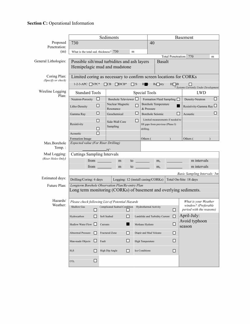
Section C: Operational Information
Sediments Basement
730 Proposed Penetration:
(m) What is the total sed. thickness? 730 m
40
Total Penetration: 770 m General Lithologies: Possible silt/mud turbidites and ash layers
Hemipelagic mud and mudstone Basalt
Limited coring as necessary to confirm screen locations for CORKs Coring Plan: (Specify or check)
1-2-3-APC VPC* XCB MDCB* PCS RCB Re-entry HRGB * Systems Currently Under Development
Standard Tools Special Tools LWD Neutron-Porosity Borehole Televiewer Formation Fluid Sampling Density-Neutron
Litho-Density Nuclear Magnetic Resonance
Borehole Temperature & Pressure
Resistivity-Gamma Ray
Gamma Ray Geochemical Borehole Seismic Acoustic
Resistivity Side-Wall Core Sampling
Limited measurements if needed to
fill gaps from previous (Phase I)
drilling.
Acoustic
Wireline Logging Plan:
Formation Image Others ( ) Others ( ) Max.Borehole
Temp. : Expected value (For Riser Drilling)
Cuttings Sampling Intervals from m to m, m intervals from m to m, m intervals
Mud Logging: (Riser Holes Only)
Basic Sampling Intervals: 5m Estimated days: Drilling/Coring: 6 days Logging: 12 (install casing/CORKs) Total On-Site: 18 days
Future Plan: Longterm Borehole Observation Plan/Re-entry Plan Long term monitoring (CORKs) of basement and overlying sediments.
Please check following List of Potential Hazards Shallow Gas Complicated Seabed Condition Hydrothermal Activity
What is your Weather window? (Preferable
period with the reasons)
Hydrocarbon Soft Seabed Landslide and Turbidity Current
Shallow Water Flow Currents Methane Hydrate
Abnormal Pressure Fractured Zone Diapir and Mud Volcano
Man-made Objects Fault High Temperature
H2S High Dip Angle Ice Conditions
Hazards/ Weather:
CO2
April-July: Avoid typhoon season
°C

New Revised
Please fill out information in all gray boxes
Proposal #: 603D-Full Site #: NT1-02A Date Form Submitted: Sept. 30, 2004
Data Type
SSP Requir-ements
Exists In DB
Details of available data and data that are still to be collected 1
High resolution seismic reflection
No Primary Line(s) :Location of Site on line (SP or Time only) Crossing Lines(s):
2 Deep Penetration seismic reflection
Yes Primary Line(s): KR9806-1 SP1740 Location of Site on line (SP or Time only) Crossing Lines(s): KR0211-S0 nearby
3 Seismic Velocity† Yes Stacking velocity and migration velocity from MCS lines. OBS data.
4 Seismic Grid Yes
5a Refraction (surface)
Yes Two ship COP (maximum offset 20 km) obtained by JAMSTEC.
5b Refraction (near bottom)
Yes OBS data by Nakanishi et al. (1997)
6 3.5 kHz Location of Site on line (Time)
7 Swath bathymetry
Yes Multi-narrow-beam data by JAMSTEC R/V Yokusuka.
8a Side-looking sonar (surface)
No
8b Side-looking sonar (bottom)
No
9 Photography or Video
No
10 Heat Flow Yes.
11a Magnetics Yes Compiled map published from AIST, Japan.
11b Gravity Yes Compiled map published from AIST, Japan.
12 Sediment cores No 13 Rock sampling No
14a Water current data Available on JODC web page (http://www.jodc.go.jp) 14b Ice Conditions
15 OBS microseismicity
Yes
16 Navigation Yes
17 Other
SSP Classification of Site: SSP Watchdog: Date of Last Review: SSP Comments:
X=required; X*=may be required for specific sites; Y=recommended; Y*=may be recommended for specific sites; R=required for re-entry sites; T=required for high temperature environments; † Accurate velocity information is required for holes deeper than 400m.
IODP Site Summary Forms:Form 2 - Site Survey Detail

New Revised
Proposal #: 603D-Full Site #: NT1-02A Date Form Submitted: Sept. 30, 2004 Water Depth (m): 4210 Sed. Penetration (m): 730 Basement Penetration (m): 40
Do you need to use the conical side-entry sub (CSES) at this site? Yes No
Are high temperatures expected at this site? Yes No
Are there any other special requirements for logging at this site? Yes No If “Yes” Please describe requirements:No logging planned. Site will have been logged in previous phase.
CORK installation only
What do you estimate the total logging time for this site to be: 12 days (CORK/casing install)
Measurement Type
Scientific Objective Relevance
(1=high, 3=Low) Neutron-Porosity
Litho-Density
Natural Gamma Ray
Resistivity-Induction
Acoustic
FMS
BHTV
Resistivity-Laterolog
Magnetic/Susceptibility
Density-Neutron (LWD)
Resitivity-Gamma Ray
(LWD)
Other: Special tools (CORK,
PACKER, VSP, PCS, FWS,
WSP
CORK
For help in determining logging times, please contact the ODP-LDEO Wireline Logging Services group at: [email protected] http://www.ldeo.columbia.edu/BRG/brg_home.html Phone/Fax: (914) 365-8674 / (914) 365-3182
Note: Sites with greater than 400 m of
penetration or significant basement penetration require deployment of standard toolstrings.
IODP Site Summary Forms: Form 3 - Detailed Logging Plan
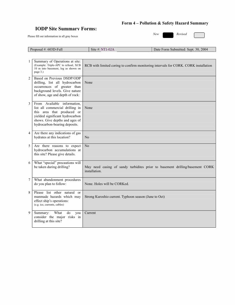
New Revised
Please fill out information in all gray boxes
Proposal #: 603D-Full Site #: NT1-01A Date Form Submitted: Sept. 30, 2004
1 Summary of Operations at site:
(Example: Triple-APC to refusal, XCB 10 m into basement, log as shown on page 3.)
RCB with limited coring to confirm monitoring intervals for CORK. CORK installation
2 Based on Previous DSDP/ODP drilling, list all hydrocarbon occurrences of greater than background levels. Give nature of show, age and depth of rock:
None
3 From Available information, list all commercial drilling in this area that produced or yielded significant hydrocarbon shows. Give depths and ages of hydrocarbon-bearing deposits.
None
4 Are there any indications of gas hydrates at this location?
No
5 Are there reasons to expect hydrocarbon accumulations at this site? Please give details.
No
6 What “special” precautions will be taken during drilling?
May need casing of sandy turbidites prior to basement drilling/basement CORK installation.
7 What abandonment procedures do you plan to follow:
None. Holes will be CORKed.
8 Please list other natural or manmade hazards which may effect ship’s operations: (e.g. ice, currents, cables)
Strong Kuroshio current. Typhoon season (June to Oct)
9 Summary: What do you consider the major risks in drilling at this site?
Current
IODP Site Summary Forms:Form 4 – Pollution & Safety Hazard Summary
NT1-02A

New New Revised
Proposal #: 603D-Full Site #: NT1-02A Date Form Submitted: Sept. 30, 2004
Sub-
bottom depth (m)
Key reflectors, Unconformities,
faults, etc
Age
Assumed velocity (km/sec)
Lithology
Paleo-environme
nt
Avg. rate of sed. accum. (m/My)
Comments
seafloor
730
830
Unconformity
Total depth
20 Ma
1.6-1.9
2.0
Hemipelagite and turbidites
Volcanic
sediment and basement basalt
Backarc basin Floor
Backarc basin
spreading ridge
36 m/my Heterogeneous stratigraphy with
irregular packets of turbidite sand.
IODP Site Summary Forms: Form 5 – Lithologic Summary

IODP Site Summary Forms: Form 1 - General Site Information
Please fill out information in all gray boxes
Section A: Proposal Information
Title of Proposal: The Nankai Trough Seismogenic Zone Experiment: Observatory Science at the Reference Sites
Date Form Submitted: Sept. 30, 2004
Site Specific Objectives with
Priority (Must include general
objectives in proposal)
Reference site to characterize hydrology of decollement and underlying turbidites at the toe of the accretionary prism and to monitor micro-seismicity and strain. Objectives are to install CORK to monitor hydrologic properties and fluid-flow signals within and below the frontal décollement zone.
List Previous Drilling in Area:
This site would be a return to NT1-03A, which is proposed to be drilled in 603A-Full2 (NantroSEIZE Reference Sites).
Section B: General Site Information
Site Name: (e.g. SWPAC-01A)
NT1-03A If site is a reoccupation
of an old DSDP/ODP Site, Please include former Site #
Area or Location:
Nankai Trough off Kii
Latitude:
Deg: 33 N Min: 1.23258 Jurisdiction:Japan
Longitude:
Deg: 136 E Min: 47.94852 Distance to Land:100 km to Cape Shiono-Misaki
Coordinates System:
WGS 84, Other ( )
Priority of Site: Primary:x Alt: Water Depth: 4125 m
New Revised Revised 7 March 2002

Section C: Operational Information
Sediments Basement
1200 Proposed Penetration:
(m) What is the total sed. thickness? 1740 m
Total Penetration: 1200 m General Lithologies: Silt and sand turbidites, ash layers,
hemipelagic mud and mudstone
Limited coring as necessary to confirm screen locations for CORKs Coring Plan: (Specify or check)
1-2-3-APC VPC* XCB MDCB* PCS RCB Re-entry HRGB * Systems Currently Under Development
Standard Tools Special Tools LWD Neutron-Porosity Borehole Televiewer Formation Fluid Sampling Density-Neutron
Litho-Density Nuclear Magnetic Resonance
Borehole Temperature & Pressure
Resistivity-Gamma Ray
Gamma Ray Geochemical Borehole Seismic Acoustic
Resistivity Side-Wall Core Sampling
Limited measurements if needed to
fill gaps from previous (Phase I)
drilling.
Acoustic
Wireline Logging Plan:
Formation Image Others ( ) Others ( ) Max.Borehole
Temp. : Expected value (For Riser Drilling)
Cuttings Sampling Intervals from m to m, m intervals from m to m, m intervals
Mud Logging: (Riser Holes Only)
Basic Sampling Intervals: 5m Estimated days: Drilling/Coring: 6 days Logging:12 (install casing/CORKs) Total On-Site: 18 days
Future Plan: Longterm Borehole Observation Plan/Re-entry Plan Long term monitoring (CORKs) of turbidites and decollement.
Please check following List of Potential Hazards Shallow Gas Complicated Seabed Condition Hydrothermal Activity
What is your Weather window? (Preferable
period with the reasons)
Hydrocarbon Soft Seabed Landslide and Turbidity Current
Shallow Water Flow Currents Methane Hydrate
Abnormal Pressure Fractured Zone Diapir and Mud Volcano
Man-made Objects Fault High Temperature
H2S High Dip Angle Ice Conditions
Hazards/ Weather:
CO2
April-July: Avoid typhoon season
°C

New Revised
Please fill out information in all gray boxes
Proposal #: 603D-Full Site #: NT1-03A Date Form Submitted: Sept. 30, 2004
Data Type
SSP Requir-ements
Exists In DB
Details of available data and data that are still to be collected 1
High resolution seismic reflection
No Primary Line(s) :Location of Site on line (SP or Time only) Crossing Lines(s):
2 Deep Penetration seismic reflection
Yes Primary Line(s): KR0108-4 SP16550 Location of Site on line (SP or Time only) Crossing Lines(s):
3 Seismic Velocity† Yes Stacking velocity and migration velocity from MCS lines. OBS data.
4 Seismic Grid Yes
5a Refraction (surface)
Yes Two ship COP (maximum offset 20 km) obtained by JAMSTEC.
5b Refraction (near bottom)
Yes OBS data by Nakanishi et al. (1997)
6 3.5 kHz Location of Site on line (Time)
7 Swath bathymetry
Yes Multi-narrow-beam data by JAMSTEC R/V Yokusuka.
8a Side-looking sonar (surface)
No
8b Side-looking sonar (bottom)
No
9 Photography or Video
No
10 Heat Flow Yes.
11a Magnetics Yes Compiled map published from AIST, Japan.
11b Gravity Yes Compiled map published from AIST, Japan.
12 Sediment cores No 13 Rock sampling No
14a Water current data Available on JODC web page (http://www.jodc.go.jp) 14b Ice Conditions
15 OBS microseismicity
Yes
16 Navigation Yes
17 Other
SSP Classification of Site: SSP Watchdog: Date of Last Review: SSP Comments:
X=required; X*=may be required for specific sites; Y=recommended; Y*=may be recommended for specific sites; R=required for re-entry sites; T=required for high temperature environments; † Accurate velocity information is required for holes deeper than 400m.
IODP Site Summary Forms:Form 2 - Site Survey Detail

New Revised
Proposal #: 603D-Full Site #: NT1-03A Date Form Submitted: Sept. 30, 2004 Water Depth (m): 4125 Sed. Penetration (m): 1200 Basement Penetration (m): 0
Do you need to use the conical side-entry sub (CSES) at this site? Yes No
Are high temperatures expected at this site? Yes No
Are there any other special requirements for logging at this site? Yes No If “Yes” Please describe requirements:No logging planned. Site will have been logged in previous phase.
CORK installation only
What do you estimate the total logging time for this site to be: 12 days (CORK/casing install)
Measurement Type
Scientific Objective Relevance
(1=high, 3=Low) Neutron-Porosity
Litho-Density
Natural Gamma Ray
Resistivity-Induction
Acoustic
FMS
BHTV
Resistivity-Laterolog
Magnetic/Susceptibility
Density-Neutron (LWD)
Resitivity-Gamma Ray
(LWD)
Other: Special tools (CORK,
PACKER, VSP, PCS, FWS,
WSP
CORK
For help in determining logging times, please contact the ODP-LDEO Wireline Logging Services group at: [email protected] http://www.ldeo.columbia.edu/BRG/brg_home.html Phone/Fax: (914) 365-8674 / (914) 365-3182
Note: Sites with greater than 400 m of
penetration or significant basement penetration require deployment of standard toolstrings.
IODP Site Summary Forms: Form 3 - Detailed Logging Plan

New Revised
Please fill out information in all gray boxes
Proposal #: 603D-Full Site #: NT1-03A Date Form Submitted: Sept. 30, 2004
1 Summary of Operations at site:
(Example: Triple-APC to refusal, XCB 10 m into basement, log as shown on page 3.)
RCB with limited coring to confirm monitoring intervals for CORK. CORK installation
2 Based on Previous DSDP/ODP drilling, list all hydrocarbon occurrences of greater than background levels. Give nature of show, age and depth of rock:
None
3 From Available information, list all commercial drilling in this area that produced or yielded significant hydrocarbon shows. Give depths and ages of hydrocarbon-bearing deposits.
None
4 Are there any indications of gas hydrates at this location?
No
5 Are there reasons to expect hydrocarbon accumulations at this site? Please give details.
No
6 What “special” precautions will be taken during drilling?
May need shallow casing to to stabilize sandy turbidites.
7 What abandonment procedures do you plan to follow:
None. Holes will be CORKed.
8 Please list other natural or manmade hazards which may effect ship’s operations: (e.g. ice, currents, cables)
Strong Kuroshio current. Typhoon season (June to Oct)
9 Summary: What do you consider the major risks in drilling at this site?
Current, instability of accreted trench turbidites.
IODP Site Summary Forms:Form 4 – Pollution & Safety Hazard Summary
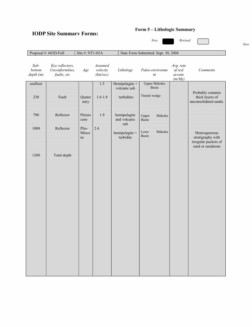
New New Revised
Proposal #: 603D-Full Site #: NT1-03A Date Form Submitted: Sept. 30, 2004
Sub-
bottom depth (m)
Key reflectors, Unconformities,
faults, etc
Age
Assumed velocity (km/sec)
Lithology
Paleo-environme
nt
Avg. rate of sed. accum. (m/My)
Comments
seafloor
230
790
1000
1200
Fault
Reflector
Reflector
Total depth
Quaternary
Pleistocene Plio-Miocene
1.5
1.6-1.8
1.9
2.4
Hemipelagite + volcanic ash
turbidites
hemipelagite and volcanic
ash
hemipelagite + turbidite
Upper Shikoku Basin
Trench wedge Upper Shikoku Basin Lowe Shikoku Basin
Probably contains thick layers of
unconsolidated sands.
Heterogeneous stratigraphy with
irregular packets of sand or sandstone
IODP Site Summary Forms: Form 5 – Lithologic Summary
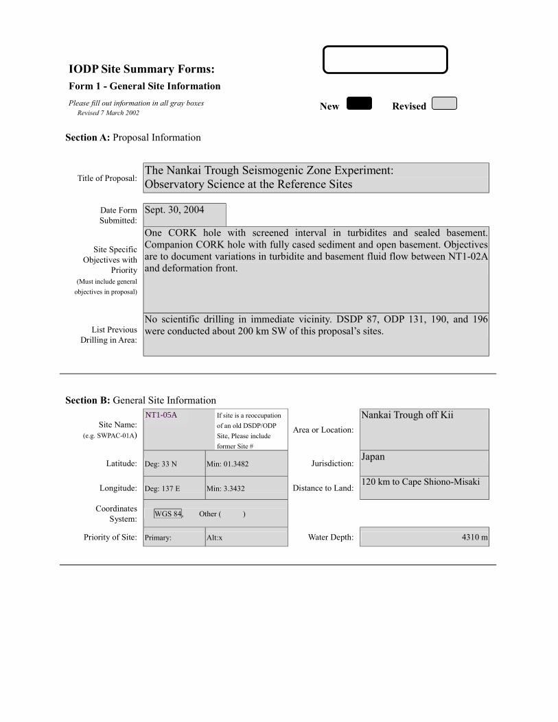
IODP Site Summary Forms: Form 1 - General Site Information
Please fill out information in all gray boxes
Section A: Proposal Information
Title of Proposal: The Nankai Trough Seismogenic Zone Experiment: Observatory Science at the Reference Sites
Date Form Submitted: Sept. 30, 2004
Site Specific Objectives with
Priority (Must include general
objectives in proposal)
One CORK hole with screened interval in turbidites and sealed basement. Companion CORK hole with fully cased sediment and open basement. Objectives are to document variations in turbidite and basement fluid flow between NT1-02A and deformation front.
List Previous Drilling in Area:
No scientific drilling in immediate vicinity. DSDP 87, ODP 131, 190, and 196 were conducted about 200 km SW of this proposal’s sites.
Section B: General Site Information
Site Name: (e.g. SWPAC-01A)
NT1-04B If site is a reoccupation
of an old DSDP/ODP Site, Please include former Site #
Area or Location:
Nankai Trough off Kii
Latitude:
Deg: 33 N Min: 01.3482 Jurisdiction:Japan
Longitude:
Deg: 137 E Min: 3.3432 Distance to Land:120 km to Cape Shiono-Misaki
Coordinates System:
WGS 84, Other ( )
Priority of Site: Primary: Alt:x Water Depth: 4310 m
New Revised Revised 7 March 2002
NT1-05A

Section C: Operational Information
Sediments Basement
1528 Proposed Penetration:
(m) What is the total sed. thickness? 1528 m
40
Total Penetration: 1568 m General Lithologies: Possible silt/mud turbidites and ash layers
Hemipelagic mud and mudstone Basalt
APC/XCB to refusal, RCB to TD. Coring Plan: (Specify or check)
1-2-3-APC VPC* XCB MDCB* PCS RCB Re-entry HRGB * Systems Currently Under Development
Standard Tools Special Tools LWD Neutron-Porosity Borehole Televiewer Formation Fluid Sampling Density-Neutron
Litho-Density Nuclear Magnetic Resonance
Borehole Temperature & Pressure
Resistivity-Gamma Ray
Gamma Ray Geochemical Borehole Seismic Acoustic
Resistivity Side-Wall Core Sampling
Acoustic
Wireline Logging Plan:
Formation Image Others ( ) Others ( ) Max.Borehole
Temp. : Expected value (For Riser Drilling)
Cuttings Sampling Intervals from m to m, m intervals from m to m, m intervals
Mud Logging: (Riser Holes Only)
Basic Sampling Intervals: 5m Estimated days: Drilling/Coring: 18 days Logging: 7 logging,
12 CORK/casing Total On-Site: 37 days
Future Plan: Longterm Borehole Observation Plan/Re-entry Plan Long term monitoring (CORKs) of basement and overlying sediments.
Please check following List of Potential Hazards Shallow Gas Complicated Seabed Condition Hydrothermal Activity
What is your Weather window? (Preferable
period with the reasons)
Hydrocarbon Soft Seabed Landslide and Turbidity Current
Shallow Water Flow Currents Methane Hydrate
Abnormal Pressure Fractured Zone Diapir and Mud Volcano
Man-made Objects Fault High Temperature
H2S High Dip Angle Ice Conditions
Hazards/ Weather:
CO2
April-July: Avoid typhoon season
°C
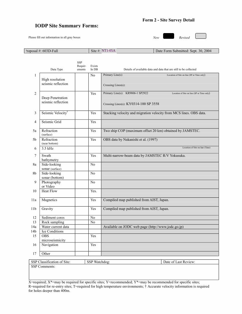
New Revised
Please fill out information in all gray boxes
Proposal #: 603D-Full Site #: NT1-04A Date Form Submitted: Sept. 30, 2004
Data Type
SSP Requir-ements
Exists In DB
Details of available data and data that are still to be collected 1
High resolution seismic reflection
No Primary Line(s) :Location of Site on line (SP or Time only) Crossing Lines(s):
2 Deep Penetration seismic reflection
Yes Primary Line(s): KR9806-1 SP2922 Location of Site on line (SP or Time only) Crossing Lines(s): KY0314-100 SP 3558
3 Seismic Velocity† Yes Stacking velocity and migration velocity from MCS lines. OBS data.
4 Seismic Grid Yes
5a Refraction (surface)
Yes Two ship COP (maximum offset 20 km) obtained by JAMSTEC.
5b Refraction (near bottom)
Yes OBS data by Nakanishi et al. (1997)
6 3.5 kHz Location of Site on line (Time)
7 Swath bathymetry
Yes Multi-narrow-beam data by JAMSTEC R/V Yokusuka.
8a Side-looking sonar (surface)
No
8b Side-looking sonar (bottom)
No
9 Photography or Video
No
10 Heat Flow Yes.
11a Magnetics Yes Compiled map published from AIST, Japan.
11b Gravity Yes Compiled map published from AIST, Japan.
12 Sediment cores No 13 Rock sampling No
14a Water current data Available on JODC web page (http://www.jodc.go.jp) 14b Ice Conditions
15 OBS microseismicity
Yes
16 Navigation Yes
17 Other
SSP Classification of Site: SSP Watchdog: Date of Last Review: SSP Comments:
X=required; X*=may be required for specific sites; Y=recommended; Y*=may be recommended for specific sites; R=required for re-entry sites; T=required for high temperature environments; † Accurate velocity information is required for holes deeper than 400m.
IODP Site Summary Forms:Form 2 - Site Survey Detail
NT1-05A
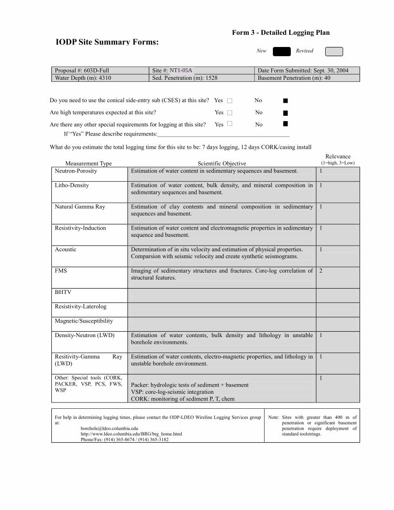
New Revised
Proposal #: 603D-Full Site #: NT1-04B Date Form Submitted: Sept. 30, 2004 Water Depth (m): 4310 Sed. Penetration (m): 1528 Basement Penetration (m): 40
Do you need to use the conical side-entry sub (CSES) at this site? Yes No
Are high temperatures expected at this site? Yes No
Are there any other special requirements for logging at this site? Yes No If “Yes” Please describe requirements:
What do you estimate the total logging time for this site to be: 7 days logging, 12 days CORK/casing install
Measurement Type
Scientific Objective Relevance
(1=high, 3=Low) Neutron-Porosity Estimation of water content in sedimentary sequences and basement.
1
Litho-Density Estimation of water content, bulk density, and mineral composition in sedimentary sequences and basement.
1
Natural Gamma Ray Estimation of clay contents and mineral composition in sedimentary sequences and basement.
1
Resistivity-Induction Estimation of water content and electromagnetic properties in sedimentary sequence and basement.
1
Acoustic Determination of in situ velocity and estimation of physical properties. Comparsion with seismic velocity and create synthetic seismograms.
1
FMS Imaging of sedimentary structures and fractures. Core-log correlation of structural features.
2
BHTV
Resistivity-Laterolog
Magnetic/Susceptibility
Density-Neutron (LWD) Estimation of water contents, bulk density and lithology in unstable borehole environments.
1
Resitivity-Gamma Ray (LWD)
Estimation of water contents, electro-magnetic properties, and lithology in unstable borehole environment.
1
Other: Special tools (CORK, PACKER, VSP, PCS, FWS, WSP
Packer: hydrologic tests of sediment + basement VSP: core-log-seismic integration CORK: monitoring of sediment P, T, chem
1
For help in determining logging times, please contact the ODP-LDEO Wireline Logging Services group at: [email protected] http://www.ldeo.columbia.edu/BRG/brg_home.html Phone/Fax: (914) 365-8674 / (914) 365-3182
Note: Sites with greater than 400 m of
penetration or significant basement penetration require deployment of standard toolstrings.
IODP Site Summary Forms: Form 3 - Detailed Logging Plan
NT1-05A
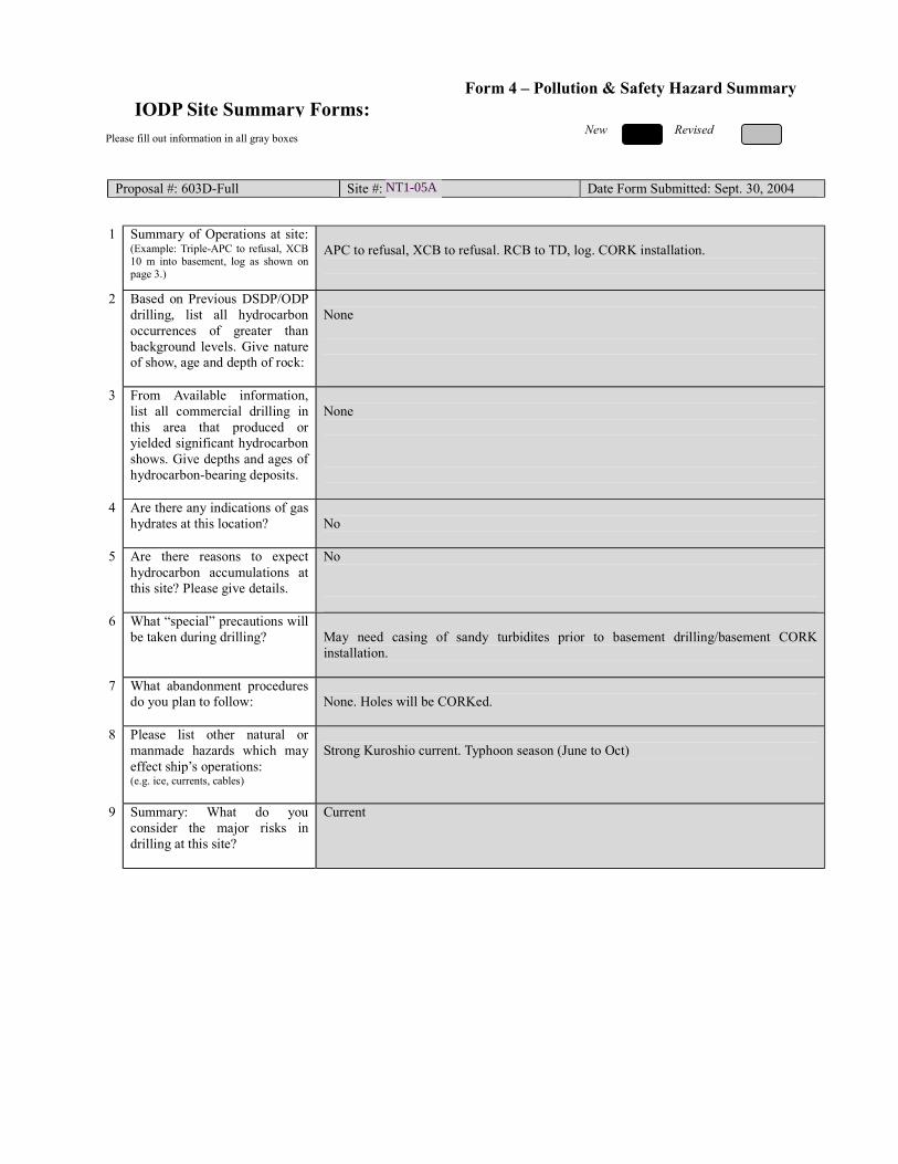
New Revised
Please fill out information in all gray boxes
Proposal #: 603D-Full Site #: NT1-04B Date Form Submitted: Sept. 30, 2004
1 Summary of Operations at site:
(Example: Triple-APC to refusal, XCB 10 m into basement, log as shown on page 3.)
APC to refusal, XCB to refusal. RCB to TD, log. CORK installation.
2 Based on Previous DSDP/ODP drilling, list all hydrocarbon occurrences of greater than background levels. Give nature of show, age and depth of rock:
None
3 From Available information, list all commercial drilling in this area that produced or yielded significant hydrocarbon shows. Give depths and ages of hydrocarbon-bearing deposits.
None
4 Are there any indications of gas hydrates at this location?
No
5 Are there reasons to expect hydrocarbon accumulations at this site? Please give details.
No
6 What “special” precautions will be taken during drilling?
May need casing of sandy turbidites prior to basement drilling/basement CORK installation.
7 What abandonment procedures do you plan to follow:
None. Holes will be CORKed.
8 Please list other natural or manmade hazards which may effect ship’s operations: (e.g. ice, currents, cables)
Strong Kuroshio current. Typhoon season (June to Oct)
9 Summary: What do you consider the major risks in drilling at this site?
Current
IODP Site Summary Forms:Form 4 – Pollution & Safety Hazard Summary
NT1-05A

New New Revised
Proposal #: 603D-Full Site #: NT1-04A Date Form Submitted: Sept. 30, 2004
Sub-
bottom depth (m)
Key reflectors, Unconformities,
faults, etc
Age
Assumed velocity (km/sec)
Lithology
Paleo-environme
nt
Avg. rate of sed. accum. (m/My)
Comments
seafloor
1528
1568
Unconformity
Total depth
~20 Ma
1.55-2.37
Hemipelagite and turbidites
Volcanic
sediment and basement basalt
Backarc basin Floor
Backarc basin spreading ridge
Heterogeneous stratigraphy with
irregular packets of turbidite sand.
IODP Site Summary Forms: Form 5 – Lithologic Summary
NT1-05A

1
iSAS/IODP Site Summary Forms: Form 1 - General Site Information Please fill out information in all gray boxes
Section A: Proposal Information
Title of Proposal: NanTroSEIZE Reference Sites: Sampling and Measuring Inputs to the Seismogenic Zone
Date Form Submitted:
3/31/05
Site Specific Objectives with
Priority (Must include general
objectives in proposal)
One CORK hole with screened interval in turbidites and sealed basement. Companion CORK hole with fully cased sediment and open basement. Reference site to characterize hydrology of Shikoku Basin strata and upper igneous crust where basement topography is relatively flat. Objectives are to document how stratigraphy, basement topography, and thermal structure affect the physical and hydrologic properties of subduction inputs.
List Previous Drilling in Area:
This site would be a return to NT1-06A, proposed as an alternate to NT1-02A from proposal 603A-Full2 (NantroSEIZE Reference Sites).
Section B: General Site Information
Site Name: (e.g. SWPAC-01A)
NT01-06A
If site is a reoccupation of an old DSDP/ODP Site, Please include former Site #
Area or Location:
Nankai Trough off Kii
Latitude:
Deg: 32 N Min: 51.35 Jurisdiction: Japan
Longitude:
Deg: 137 E Min: 17.58 Distance to Land: 145 km to Cape Shiono-Misaki
Coordinates System:
WGS 84, Other ( )
Priority of Site: Primary: Alt: X Water Depth: 4200 m
New Revised Revised 7 March 2002

2
Section C: Operational Information
Sediments Basement 990 m Proposed
Penetration: (m) What is the total sed. thickness? 990 m
40 m
Total Penetration: 1030 m General Lithologies: Silt and sand turbidites, ash layers,
hemipelagic mud and mudstone Basalt
Limited coring as necessary to confirm screen locations for CORKs Coring Plan: (Specify or check)
1-2-3-APC VPC* XCB MDCB* PCS RCB Re-entry HRGB * Systems Currently Under Development
Standard Tools Special Tools LWD Neutron-Porosity Borehole Televiewer Formation Fluid Sampling Density-Neutron Litho-Density Nuclear Magnetic
Resonance Borehole Temperature
& Pressure Resistivity-Gamma Ray
Gamma Ray Geochemical Borehole Seismic Acoustic
Resistivity Side-Wall Core Sampling
Limited measurements if needed to
fill gaps from previous (Phase I)
drilling.
Acoustic
Wireline Logging Plan:
Formation Image Others ( ) Others ( ) Max.Borehole
Temp. : Expected value (For Riser Drilling)
Cuttings Sampling Intervals from m to m, m intervals from m to m, m intervals
Mud Logging: (Riser Holes Only)
Basic Sampling Intervals: 5m Estimated days: Drilling/Coring: 7 days Logging: 12 days (casing/CORK) Total On-Site: 19 days
Future Plan: Longterm Borehole Observation Plan/Re-entry Plan CORK observatory
Please check following List of Potential Hazards Shallow Gas Complicated Seabed Condition Hydrothermal Activity
What is your Weather window? (Preferable
period with the reasons)
Hydrocarbon Soft Seabed Landslide and Turbidity Current
Shallow Water Flow Currents
Methane Hydrate
Abnormal Pressure Fractured Zone Diapir and Mud Volcano
Man-made Objects Fault High Temperature
H2S High Dip Angle Ice Conditions
Hazards/ Weather:
CO2
April-July : avoid typhoon season
°C

3
New Revised
9.27849.2784
Please fill out information in all gray boxes
Proposal #: 603A-Full Site #: NT01-06A Date Form Submitted: 11/05/04
Data Type
SSP Requir-ements
Exists In DB
Details of available data and data that are still to be collected 1
High resolution seismic reflection
Yes
Primary Line(s) :Location of Site on line (SP or Time only) odkm03-103-1 SP2860 Crossing Lines(s): odkm03-ACA SP2175
2 Deep Penetration seismic reflection
Yes
Primary Line(s): Location of Site on line (SP or Time only) KR9806-1 nearby Crossing Lines(s): KR0211-S0 nearby
3 Seismic Velocity† Yes Stacking velocity and migration velocity from MCS lines. OBS data
4 Seismic Grid Yes 5a Refraction
(surface) Yes Two ship COP (maximum offset 20 km) obtained by JAMSTEC at the end
of September, 2002. 5b Refraction
(near bottom) Yes OBS data by Nakanishi et al. (1997)
6 3.5 kHz No Location of Site on line (Time)
7 Swath
bathymetry Yes Multi-narrow-beam data by JAMSTEC R/V Yokosuka
8a Side-looking
sonar (surface) No
8b Side-looking
sonar (bottom) No
9 Photography
or Video No
10 Heat Flow Yes
11a Magnetics Yes Compiled map published from AIST, Japan
11b Gravity Yes Compiled map published from AIST, Japan
12 Sediment cores No 13 Rock sampling No
14a Water current data Available on JODC web page (http://www.jodc.go.jp) 14b Ice Conditions
15 OBS microseismicity
Yes
16 Navigation Yes
17 Other
iSAS/IODP Site Summary Forms: Form 2 - Site Survey Detail

4
New Revised
Proposal #: 603D-Full2 Site #: NT01-06A Date Form Submitted: 3/31/05 Water Depth (m): 4200 Sed. Penetration (m): 990 Basement Penetration (m): 40
Do you need to use the conical side-entry sub (CSES) at this site? Yes No Are high temperatures expected at this site? Yes No Are there any other special requirements for logging at this site? Yes No
If “Yes” Please describe requirements: No logging planned. Site will have been logged in previous phase.
What do you estimate the total logging time for this site to be: 12 days casing CORK install
Measurement Type
Scientific Objective Relevance
(1=high, 3=Low)
Other: Special tools (CORK,
PACKER, VSP, PCS, FWS,
WSP
CORK
iSAS/IODP Site Summary Forms: Form 3 - Detailed Logging Plan

5
New Revised
Please fill out information in all gray boxes
Proposal #: 603D-Full2 Site #: NT01-06A Date Form Submitted: 3/31/05
1 Summary of Operations at site: (Example: Triple-APC to refusal, XCB 10 m into basement, log as shown on page 3.)
RCB with limited coring to confirm monitoring intervals for CORK. CORK installation
2 Based on Previous DSDP/ODP drilling, list all hydrocarbon occurrences of greater than background levels. Give nature of show, age and depth of rock:
None
3 From Available information, list all commercial drilling in this area that produced or yielded significant hydrocarbon shows. Give depths and ages of hydrocarbon-bearing deposits.
None
4 Are there any indications of gas hydrates at this location?
No
5 Are there reasons to expect hydrocarbon accumulations at this site? Please give details.
No
6 What “special” precautions will be taken during drilling?
Standard monitoring of C 1 to Cn; shallow casing may be needed to stabilize shallow sandy turbidite layers.
7 What abandonment procedures do you plan to follow:
None. Will be CORKed.
8 Please list other natural or manmade hazards which may effect ship’s operations: (e.g. ice, currents, cables)
Strong Kuroshio current, typhoon (June to Oct.)
9 Summary: What do you consider the major risks in drilling at this site?
Kuroshio Current
iSAS/IODP Site Summary Forms: Form 4 – Pollution & Safety Hazard Summary

6
NNew Revised
Proposal #: 603D-Full2 Site #: NT01-06A Date Form Submitted: 3/31/05
Sub- bottom
depth (m)
Key reflectors, Unconformities,
faults, etc
Age
Assumed velocity (km/sec)
Lithology
Paleo-
environment
Avg. rate of sed. accum. (m/My)
Comments
990
unconformity
Holocene to lower Miocene 20 Ma
1.6-1.9
2.0
Hemipelagite + volcanic ash +
turbidites
volcanic sediment and basement basalt
backarc basin floor
backarc basin
36 m/My
Heterogeneous stratigraphy with
irregular packets of turbidite sand
iSAS/IODP Site Summary Forms:
Form 5 – Lithologic Summary

IODP Site Summary Forms: Form 1 - General Site Information
Please fill out information in all gray boxes
Section A: Proposal Information
Title of Proposal: The Nankai Trough Seismogenic Zone Experiment: Observatory Science at the Reference Sites
Date Form Submitted: Sept. 30, 2004
Site Specific Objectives with
Priority (Must include general
objectives in proposal)
CORK monitoring for material properties, strain, geochemistry seaward of deep riser hole (NT3-01). Monitoring intervals in clay-rich horizon (for strain) and in sandy horizon (for diffusive signal). Target depths will be refined based on prior drilling.
List Previous Drilling in Area:
This site would be a return to NT2-04B, which is proposed to be drilled in 603B-Full2.
Section B: General Site Information
Site Name: (e.g. SWPAC-01A)
NT2-04A If site is a reoccupation
of an old DSDP/ODP Site, Please include former Site #
Area or Location:
Kumano Basin off Kii
Latitude:
Deg: 33 N Min: 25.1 Jurisdiction:Japan
Longitude:
Deg: 136 E Min: 37.5 Distance to Land:60 km to Cape Shiono-Misaki
Coordinates System:
WGS 84, Other ( )
Priority of Site: Primary:x Alt: Water Depth: 4125 m
New Revised Revised 7 March 2002
23.4
34.6'
1990
A

Section C: Operational Information
Sediments Basement
1450 Proposed Penetration:
(m) What is the total sed. thickness? 1400 m
40
Total Penetration: 1440 m General Lithologies: Forearc basin sediment unconformably
laying on acoustic basin of Tertiary acc. Complex.
Limited coring as necessary to confirm screen locations for CORKs Coring Plan: (Specify or check)
1-2-3-APC VPC* XCB MDCB* PCS RCB Re-entry HRGB * Systems Currently Under Development
Standard Tools Special Tools LWD Neutron-Porosity Borehole Televiewer Formation Fluid Sampling Density-Neutron
Litho-Density Nuclear Magnetic Resonance
Borehole Temperature & Pressure
Resistivity-Gamma Ray
Gamma Ray Geochemical Borehole Seismic Acoustic
Resistivity Side-Wall Core Sampling
Limited measurements if needed to
ill gaps from previous (Phase I)
rilling.
Acoustic
Wireline Logging Plan:
Formation Image Others ( ) Others ( ) Max.Borehole
Temp. : Expected value (For Riser Drilling)
Cuttings Sampling Intervals from m to m, m intervals from m to m, m intervals
Mud Logging: (Riser Holes Only)
Basic Sampling Intervals: 5m Estimated days: Drilling/Coring: 4 Logging: 6 casing/CORK install Total On-Site: 10 days
Future Plan: Longterm Borehole Observation Plan/Re-entry Plan Long term monitoring (CORKs).
Please check following List of Potential Hazards Shallow Gas Complicated Seabed Condition Hydrothermal Activity
What is your Weather window? (Preferable
period with the reasons)
Hydrocarbon Soft Seabed Landslide and Turbidity Current
Shallow Water Flow Currents Methane Hydrate
Abnormal Pressure Fractured Zone Diapir and Mud Volcano
Man-made Objects Fault High Temperature
H2S High Dip Angle Ice Conditions
Hazards/ Weather:
CO2
April-July: Avoid typhoon season
°C
1400
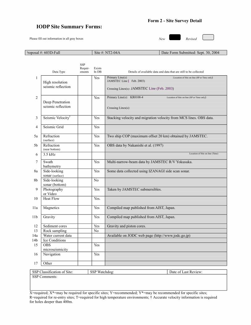
New Revised
Please fill out information in all gray boxes
Proposal #: 603D-Full Site #: NT2-04A Date Form Submitted: Sept. 30, 2004
Data Type
SSP Requir-ements
Exists In DB
Details of available data and data that are still to be collected 1
High resolution seismic reflection
Yes Primary Line(s) :Location of Site on line (SP or Time only) JAMSTEC Line 1 (Feb. 2003) Crossing Lines(s): JAMSTEC Lin (Feb. 2003)
2 Deep Penetration seismic reflection
Yes Primary Line(s): KR0108-4 Location of Site on line (SP or Time only) Crossing Lines(s):
3 Seismic Velocity† Yes Stacking velocity and migration velocity from MCS lines. OBS data.
4 Seismic Grid Yes
5a Refraction (surface)
Yes Two ship COP (maximum offset 20 km) obtained by JAMSTEC.
5b Refraction (near bottom)
Yes OBS data by Nakanishi et al. (1997)
6 3.5 kHz Location of Site on line (Time)
7 Swath bathymetry
Yes Multi-narrow-beam data by JAMSTEC R/V Yokusuka.
8a Side-looking sonar (surface)
Yes Some data collected using IZANAGI side scan sonar.
8b Side-looking sonar (bottom)
No
9 Photography or Video
Yes Taken by JAMSTEC submersibles.
10 Heat Flow Yes.
11a Magnetics Yes Compiled map published from AIST, Japan.
11b Gravity Yes Compiled map published from AIST, Japan.
12 Sediment cores Yes Gravity and piston cores. 13 Rock sampling No
14a Water current data Available on JODC web page (http://www.jodc.go.jp) 14b Ice Conditions
15 OBS microseismicity
Yes
16 Navigation Yes
17 Other
SSP Classification of Site: SSP Watchdog: Date of Last Review: SSP Comments:
X=required; X*=may be required for specific sites; Y=recommended; Y*=may be recommended for specific sites; R=required for re-entry sites; T=required for high temperature environments; † Accurate velocity information is required for holes deeper than 400m.
IODP Site Summary Forms:Form 2 - Site Survey Detail
I
Line (Feb. 2003)
l

New Revised
Proposal #: 603D-Full Site #: NT2-04A Date Form Submitted: Sept. 30, 2004 Water Depth (m): 1990 Sed. Penetration (m): 1400 Basement Penetration (m): 40
Do you need to use the conical side-entry sub (CSES) at this site? Yes No
Are high temperatures expected at this site? Yes No
Are there any other special requirements for logging at this site? Yes No If “Yes” Please describe requirements:No logging planned. Site will have been logged in previous phase.
CORK installation only
What do you estimate the total logging time for this site to be: 6 days (install casing/CORK)
Measurement Type
Scientific Objective Relevance
(1=high, 3=Low) Neutron-Porosity
Litho-Density
Natural Gamma Ray
Resistivity-Induction
Acoustic
FMS
BHTV
Resistivity-Laterolog
Magnetic/Susceptibility
Density-Neutron (LWD)
Resitivity-Gamma Ray
(LWD)
Other: Special tools (CORK,
PACKER, VSP, PCS, FWS,
WSP
CORK
For help in determining logging times, please contact the ODP-LDEO Wireline Logging Services group at: [email protected] http://www.ldeo.columbia.edu/BRG/brg_home.html Phone/Fax: (914) 365-8674 / (914) 365-3182
Note: Sites with greater than 400 m of
penetration or significant basement penetration require deployment of standard toolstrings.
IODP Site Summary Forms: Form 3 - Detailed Logging Plan
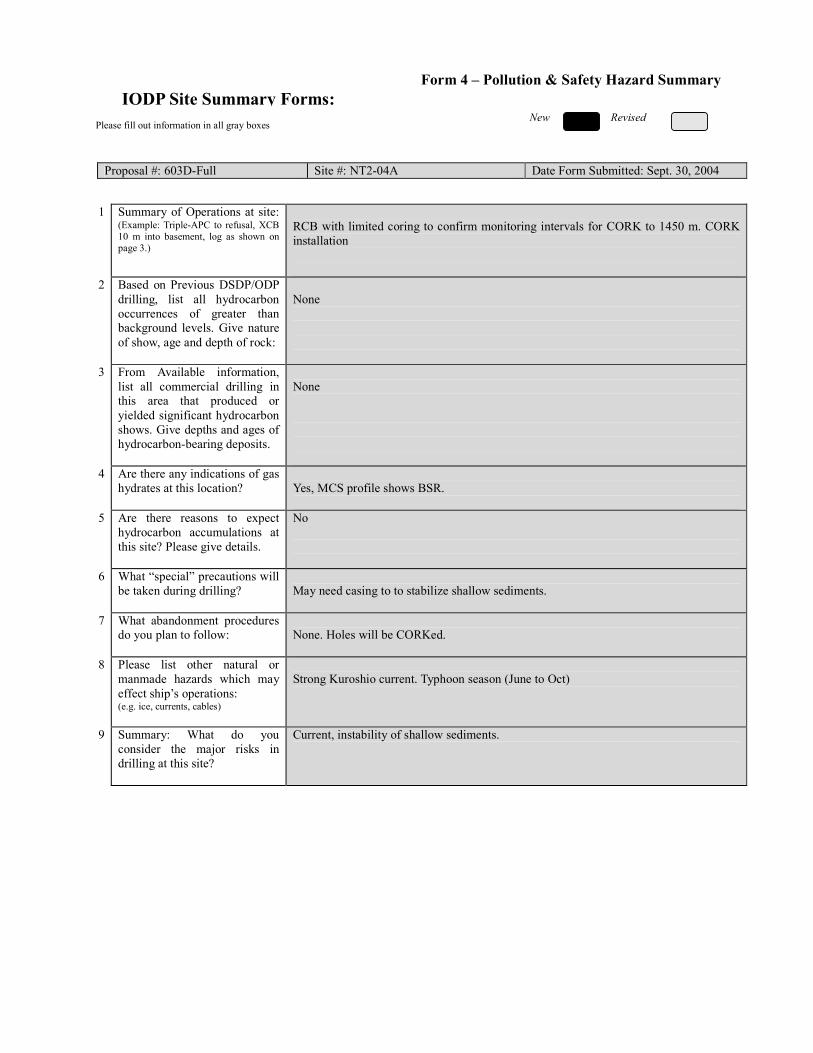
New Revised
Please fill out information in all gray boxes
Proposal #: 603D-Full Site #: NT2-04A Date Form Submitted: Sept. 30, 2004
1 Summary of Operations at site:
(Example: Triple-APC to refusal, XCB 10 m into basement, log as shown on page 3.)
RCB with limited coring to confirm monitoring intervals for CORK to 1450 m. CORK installation
2 Based on Previous DSDP/ODP drilling, list all hydrocarbon occurrences of greater than background levels. Give nature of show, age and depth of rock:
None
3 From Available information, list all commercial drilling in this area that produced or yielded significant hydrocarbon shows. Give depths and ages of hydrocarbon-bearing deposits.
None
4 Are there any indications of gas hydrates at this location?
Yes, MCS profile shows BSR.
5 Are there reasons to expect hydrocarbon accumulations at this site? Please give details.
No
6 What “special” precautions will be taken during drilling?
May need casing to to stabilize shallow sediments.
7 What abandonment procedures do you plan to follow:
None. Holes will be CORKed.
8 Please list other natural or manmade hazards which may effect ship’s operations: (e.g. ice, currents, cables)
Strong Kuroshio current. Typhoon season (June to Oct)
9 Summary: What do you consider the major risks in drilling at this site?
Current, instability of shallow sediments.
IODP Site Summary Forms:Form 4 – Pollution & Safety Hazard Summary
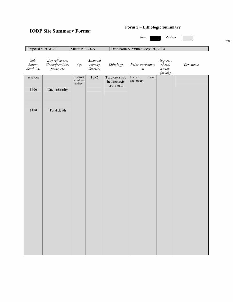
New New Revised
Proposal #: 603D-Full Site #: NT2-04A Date Form Submitted: Sept. 30, 2004
Sub-
bottom depth (m)
Key reflectors, Unconformities,
faults, etc
Age
Assumed velocity (km/sec)
Lithology
Paleo-environme
nt
Avg. rate of sed. accum. (m/My)
Comments
seafloor
1400
1450
Unconformity
Total depth
Holocene to Late tertiary
1.5-2
Turbidites and hemipelagic sediments
Forearc basin sediments
IODP Site Summary Forms: Form 5 – Lithologic Summary