Embed Size (px)
Citation preview
ISTITUTO AGRONOMICO
PER L 'OLTREMARE
UNIVERSITÀ DEGLI STUDI DI FIRENZE
FIRST LEVEL MASTER DEGREE IN
IRRIGATION PROBLEMS IN DEVELOPING COUNTRIES
Design Optimization Of Dr ip And Spr inkler System Using VEPROLGS And EPANET Softwares
Supervisor I Dr . Ivan Solinas Student Name Inocêncio Oliveira Mulaveia Supervisor I I Dr . Graziano Ghinassi
A.A. 2012/2013

i
DEDICATION
To My Parents, My Brothers And My Girlfriend For Supporting Me

ii
ACKNOWLEDGEMENT
I Want To Express My Gratitude To The Staff of Institute Agronomico Per
Lol’ tramare (IAO), Who Made Possible The Master Especially To:
The General Director Of Istituto Agronomico Per Lol’ tramare (IAO), Dr.
Giovanni Totino
Technical and Scientific Tutor, Dra. Elisa Masi
Ex-Master Tutor, Dr. Paolo Enrico Sertoli
Administrative And Logistic Coordinator, Dr. Andrea Merlin
For The Reception, Welcoming And Patience Always Showed
The Master Coordinator at University Deli Study Di Firenze Drab Elena Brescia
The Master Coordinator at Institute Agronomic Per Lol’ tramare Dr. Tiberio
Chiari
For Orientation And Support Throughout The Master
To My Supervisors Dr. Ivan Solinas And Dr. Graziano Ghinassi
For Technical And Scientific Monitoring Support Given During The Thesis
Elaboration
And Finally To Universita Degli Studi Di Firenze
For Allowing Me, To Make Part Of Unique Academic Family
My Academics Salutes
Warm Thanks
iii
TABLE OF CONTENTS
1. Introduction...………………………………………………………………1
2. State Of Art.………………………………………………………………..2
2.1 Drip Irrigation……….……………………………………………………2
2.2 Sprinkler Irrigation……………………………………………………….5
3. Study Area And Methodology……………………………………………..6
3.1 Presentation Of The StudyArea…………………………………….…….6
3.1.1 Geographic Location…………………………………………….....…..6
3.1.2 Physical-Geographic Aspects……………………………...…….….….7
3.1.2.1 Geology and Geomorphology…………………………………….…..7
3.1.2.2 Soils………………………………………………………….………..8
3.1.3 Climate characteristics……………………………………….….….…..9
3.1.3.1 Temperature………………………………………………………….10
3.1.3.2 Precipitation Characteristics………………………………………....11
3.1.4 Agriculture………………………………………………….………….13
3.1.5 Infrastructure Regulating Floods…………………………..…………..13
3.2 Methodology…………………………………………………..…..……..13
3.2.1 Data Collection……………………………………………..…………..13
3.2.2 Choice Of Plot……………………………………………..…………..16
4. Results And Discussion………………………………………...………….16
4.1 Results and Discussion for Drip Irrigation…………………...………....16
4.1.2 Crop Water Requirement………………….……………………...…….16
4.1.2.1 Results………………………………………………………………...16
4.1.2.2 Discussion………………………………………….…………………16
4.1.3 Dripline Design....………………………………………..………...…..17
4.1.3.1 Results……………………………………………….………………..17
4.1.3.2 Discussion…………………………………………….……………….18
4.1.4 EPANET Design On Dripline………………………….……………….19
4.1.4.1 Results…………………………………………………..…………….19
4.1.4.2 Discussion……………………………………………………………..21
4.2 Results And Discussion on Sprinkler System….…………………….…..22
iv
4.2.1 Crop Water Requirement……………………………………...……….22
4.2.1.1 Results………………………………………….……………………..22
4.2.1.2 Discussion………………………………………...…………………..22
4.2.2 EPANET Design On Sprinkler…………………….…………...………22
4.2.2.1 Results…………………………………………….…………………..23
4.2.2.2 Discussion………………………………………….…………………24
5. Conclusion……………………………………………….….……….…….27
References……………………………………………...…….…..…….….…28
Appendix……………………………………………...……….………….….30
v
ABSTRACT
Agriculture in Mozambique essentially is constituted by the family sector that
practice subsistence farming, which depends mainly on rainfall and so far the
results achieved have proved to be not satisfactory at all due to many factors.
However in recent years, the country had a significant improvement of
production, and this improvement has been attributed mainly to the expansion
of cultivated areas. However this improvement must be followed by an
investment of new irrigation techniques, which will allow to make a change
from subsistence agriculture (where the most producers use surface irrigation)
to commercial agriculture (with sprinkler and drip irrigation) turned to profit,
that has the major urban centers and agro-processing industry as market.
Therefore the study proposes to perform a design regarding to the sprinkler and
drip irrigation performance, providing therefore a broad vision to the producers
on the management and factors to take into consideration in choosing of these
of irrigation methods.
Then using tools like GOOGLE EARTH, to locate the area of study,
determining the latitude and longitude, the elevation of the field, CLIMWAT
2.0, to generate data through Meteorological Station that comes close of the
study area, Harmonized World Soil Database (HWSD) and SPAW Hydrology
to determine Soil Water Characteristics in the field, and Crop Water
Requirement for determination of Water Requirement Of Crop, it was possible
to design a drip irrigation system using VEPROLGS to modeling water
distribution along the drip lines and Plot and EPANET for dimensioning the
system, from the water intake to the plot head and Sprinkler irrigation system
using EPANET for dimensioning the system, from the water intake to the plot,
namely main pipes, secondary, laterals until the sprinklers.
vi

vii
viii
ABBREVIATIONS
TIA - Trabalho de Inquérito Agrícola
SADC - Southern African Developing Community
FAO - Food And Agriculture Program For United Nations
HWSD - Harmonized Water Soil Database
SPAW HIDROLOGY - Soil Plant Atmosphere Water Pond&Higrology
CHO - Control Head Orifice
H - Head
Q - Flow Rate
MW - Mega Watts
O C - Celsius Degrees
o - degrees
m.w.c - meter water column
m - meter
mm - millimetres
hr - hours
Design Optimization Of Drip And Sprinkler System Using VEPROLGS And
EPANET Softwares
2013
1
1. Introduction
Agriculture in Mozambique essentially is constituted by the family sector that
practice subsistence farming, which depends mainly on rainfall. To give an
idea of the importance of this sector for the country, data from surveys
conducted by TIA (2000), indicate that in rural areas, family farming consists
mainly small farms (those who cultivate less than 5 ha) and this sector accounts
for about 99% of agricultural production (3.090.197 family units) and occupies
over 95% of the cultivated area of the country.
According to Bart van den Boom (2011), despite the importance of this sector
it faces various problems, and the main is low productivity with decreasing
trend due to factors such as the uneven distribution of rainfall, low use of
technologies improved, poor state of road infrastructure, especially the weak
link between the south and north of the country, and relatively few investments
made in agriculture.
To the factors above it is associated, the weak agricultural extension services
due to lack of technicians with a proper formation that can guarantee
acceptable levels of adoption in agricultural programs ongoing in the country.
In recent years, the country had a significant improvement of production, and
this improvement has been attributed mainly to the expansion of cultivated
areas. However this increase in agricultural production as a reflex of a more
openness areas of cultivation must be followed by an investment of more and
more agricultural inputs, infrastructure and new irrigation techniques, which
will allow to make a change from subsistence agriculture (where the most
producers use surface irrigation) to commercial agriculture (with sprinkler and
drip irrigation) turned to profit, that has the major urban centers and agro-
processing industry as market. Hence the need to perform a study regarding to
the sprinkler and drip irrigation performance, providing therefore a broad
vision to the producers on the management and factors to take into
consideration in choosing of these of irrigation methods. The study here
presented is a thesis for Master Degree in “ Irrigation Problems in Developing
Countries” and it consists in 5 Chapters:
Design Optimization Of Drip And Sprinkler System Using VEPROLGS And
EPANET Softwares
2013
2
2. State Of The Art
Irrigated agriculture in most parts of Sub-Saharan Africa has not been
encouraging even with the threat of severe adverse effects of global food and
financial crises and a scourge of the consequences of climate change (Saa
Dittoh et al, 2010), and in the specific case of Mozambique due to its
geographical location, the country is systematically affected by natural
disasters (especially drought, floods and cyclones), and is therefore important
to invest in technologies that target the use of water for irrigation, as part of an
overall strategy of developing the agricultural sector, and Some of the
technologies in which it could invest are drip and sprinkler irrigation.
2.1 Drip Irrigation
Drip irrigation sometimes called trickle irrigation and involves dripping water
onto the soil at very low rates over a long period of time, usually lasting several
hours. The water flows under low pressure through system of small diameter
plastic pipes fitted with outlets called emitters or drippers laid along each row
of plants allowing water to be applied close to plants so that only part of the
soil in which the roots grow is wetted. With drip irrigation water, applications
are more frequent (usually every 1-3 days) than with other methods and this
provides a very favorable high moisture level in the soil in which plants can
flourish, reducing water loss by up to 60 percent.
A drip system presents basic components in which it described just after:
Valve, turns on or off the water flow through a pipe;
Backflow preventer, is a device that prevents dirt from being sucked back into
irrigation water;
Pressure regulator, reduces the water pressure and keeps it at a constant level;
Filter, cleans the water. drip emitters have very small openings that are easily
Clogged;
Design Optimization Of Drip And Sprinkler System Using VEPROLGS And
EPANET Softwares
2013
3
Emitters, controls how fast the water drips out onto the soil. most emitters are
small plastic devices that either screw or snap onto a drip tube.
Drip irrigation is compatible with vegetable crops that are grown as annuals, in
rows, and which do not require flooding.
It has long been proven as beneficial and economical on fruit, nut and
vegetable crops throughout the world, but recently growers of field crops such
as alfalfa, corn, cotton, onions, potatoes and processing tomatoes are realizing
the benefits as well in other words it is justified for crops of high market value.
Designing drip systems for operation on hilly ground can be challenging and
the options for attaining good uniformity are highly dependent on the terrain.
Fortunately there are components available that can be used to improve
uniformity, therefore it is adaptable to any farmable slope.
Drip irrigation is suitable for most soils even thus it necessary to considerer
some measures by management of the system in each soil type. It can
determine the soil wetting patterns influencing the depth of the drip tape and
the distance between emitters. The duration and frequency of irrigation are also
determined by the soil type. Over-watering can move nutrients or fertilizer (if
applied) away from the root zone. On sandy soils, water goes primarily
downward rather than horizontally so emitters should be at relatively close
spacing. Spacing between emitters can be greater in heavier soils where there is
considerable movement laterally.
In sandy soils, irrigate more frequently, but run the water for a lesser amount of
time. In heavier soils, irrigate less often, but run the water for a longer duration.
In both cases, this should lessen the chance of leaching nutrients or fertilizers
away from the root zone.
According to C. Wilson and M.Bauer (April 2013), the advantages and
disadvantages of drip irrigation are:
Design Optimization Of Drip And Sprinkler System Using VEPROLGS And
EPANET Softwares
2013
4
Advantages
It can delivers water slowly immediately above, on or below the surface of the
soil. This minimizes water loss due to runoff, wind and evaporation. Drip
irrigation can be operated during the windy periods.
The mold spots on house siding and the staining and deterioration of wood
privacy fences experienced with overspray from sprinkler irrigation is
eliminated with the use of drip; because water doesn’ t leave the landscape with
drip irrigation, pavement deterioration associated with sprinkler irrigation
runoff is eliminated.
Properties with old, galvanized steel water service lines where corrosion has
resulted in a narrowed diameter may benefit from a retrofit to drip irrigation;
the low volume requirements of drip irrigation are a good match with restricted
supply lines.
Drip systems can be managed with an AC or battery powered controller;
automated landscape irrigation is an advantage to many people with busy
lifestyles.
Adaptable and changeable over time, drip systems can be easily expanded to
irrigate additional plants if water is available. Emitters can be simply
exchanged or removed and emitter lines eliminated or repositioned; when
plants are removed or die, drip lines should be plugged.
Disadvantages
If emitters are poorly placed, too far apart or too few in number, root
development may be restricted by the limited soil area wetted.
Water seeping at ground level is hard to see and makes it difficult to know if
the system is working properly; an indicator device that raises and lowers a flag
to show when water is flowing is available to overcome this issue.
Design Optimization Of Drip And Sprinkler System Using VEPROLGS And
EPANET Softwares
2013
5
Regular maintenance inspections are needed to maintain system effectiveness.
Clogs are much less likely with filtered water and proper pressure regulation
used in combination with self-cleaning emitters.
Drip tubing can be a trip hazard especially for dogs and children but is less
problematic if covered with mulch and fastened with wire anchor pins every 2
to 3 feet; drip lines can also be easily cut while undertaking other landscape
maintenance activities.
2.2 Sprinkler Irrigation
Sprinkler Irrigation is a method in which water is sprayed into the air and
allowed to fall on the ground surface somewhat resembling rainfall. Water is
distributed through a system of pipes usually by pumping. The spray is
developed by the flow of water under pressure through small orifices or
nozzles and it is then sprayed into the air and irrigated entire soil surface
through spray heads so that it breaks up into small water drops which fall to the
ground.
The Basic components of the sprinkler irrigation system are:
Pumping Unit, is required to carry water from the source through the main line
and laterals up to the sprinkler or nozzle from where it is sprayed and applied
to the crops.
Main Lines, carries water from the pumping unit to the various parts of the
field. Main line may be permanent or portable.
Permanent Main Line, is advantageous where field boundaries are fixed and
crops require full season irrigation. Portable main lines are more economical
when a sprinkler system is used for different fields or let out on hire to other
farmers.
It is often buried so that they do not come in way of other agricultural
operations.
Lateral Lines, carry water from the main line to sprinklers or nozzles. Lateral
pipes are normally available in 5 m, 6 m, and 12 m lengths.
Design Optimization Of Drip And Sprinkler System Using VEPROLGS And
EPANET Softwares
2013
6
Each length has quick couplings. All couplings are provided rubber gaskets in
female portion, which tightens the coupling and makes it, leak proof.
Nozzle/Sprinkler Head, are the most important component of the sprinkler
system. Their operating characteristics under optimum water pressure and
climatic conditions, mainly wind velocity, will determine their suitability and
the efficiency of the system. Most agricultural sprinklers are the slow rotation
type.
Riser, the riser pipe connects the rotating sprinkler head to the lateral. Usually
the pipe diameter varies from 12 mm to 75 mm with standard pipe threads;
Almost all crops are suitable for sprinkler irrigation, but it is needed to take
into account that it can foster the development of foliar diseases and therefore
is necessary to take some measures to manage the crop when face this type of
constraint.
Sprinkler irrigation is adaptable to different terrain conditions with slope. The
lateral pipes that provide water to the field should always be placed out along
the ground contour lines whenever possible in order to minimize pressure
changes at the nozzles and ensuring uniform irrigation.
3. Study Area and Methodology
3.1 Presentation Of The Study Area
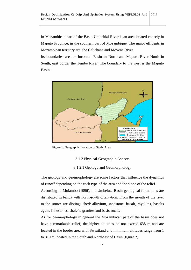
3.1.1 Geographic Location
The Hydrographic Basin of Umbelúzi is International, born in Swaziland and
has major effluents, the rivers Black M'buluzi and White M'buluzi, enters in
Mozambique from a point close to Goba border and is shared by three
countries, namely Swaziland, Mozambique and a small portion by South Africa
(figure 1).
It covers an area of 5600 km2. Of this portion Mozambique occupies about
40% and it is located downstream.
Design Optimization Of Drip And Sprinkler System Using VEPROLGS And
EPANET Softwares
2013
7
In Mozambican part of the Basin Umbelúzi River is an area located entirely in
Maputo Province, in the southern part of Mozambique. The major effluents in
Mozambican territory are: the Calichane and Movene River.
Its boundaries are the Incomati Basin in North and Maputo River North in
South, east border the Tembe River. The boundary to the west is the Maputo
Basin.
Figure 1: Geographic Location of Study Area
3.1.2 Physical-Geographic Aspects
3.1.2.1 Geology and Geomorphology
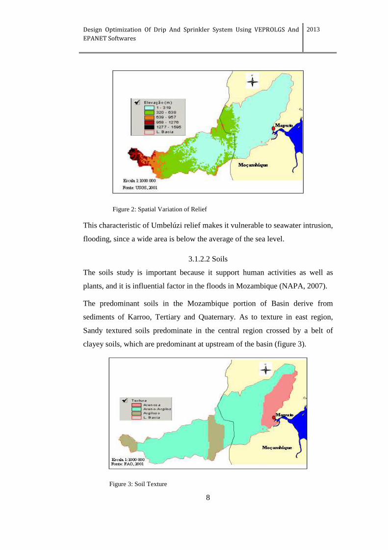
The geology and geomorphology are some factors that influence the dynamics
of runoff depending on the rock type of the area and the slope of the relief.
According to Muiambo (1996), the Umbelúzi Basin geological formations are
distributed in bands with north-south orientation. From the mouth of the river
to the source are distinguished: alluvium, sandstone, basalt, rhyolites, basalts
again, limestones, shale’s, granites and basic rocks.
As for geomorphology in general the Mozambican part of the basin does not
have a remarkable relief, the higher altitudes do not exceed 638 m and are
located in the border area with Swaziland and minimum altitudes range from 1
to 319 m located in the South and Northeast of Basin (figure 2).
Design Optimization Of Drip And Sprinkler System Using VEPROLGS And
EPANET Softwares
2013
8
Figure 2: Spatial Variation of Relief
This characteristic of Umbelúzi relief makes it vulnerable to seawater intrusion,
flooding, since a wide area is below the average of the sea level.
3.1.2.2 Soils
The soils study is important because it support human activities as well as
plants, and it is influential factor in the floods in Mozambique (NAPA, 2007).
The predominant soils in the Mozambique portion of Basin derive from
sediments of Karroo, Tertiary and Quaternary. As to texture in east region,
Sandy textured soils predominate in the central region crossed by a belt of
clayey soils, which are predominant at upstream of the basin (figure 3).
Figure 3: Soil Texture
Design Optimization Of Drip And Sprinkler System Using VEPROLGS And
EPANET Softwares
2013
9
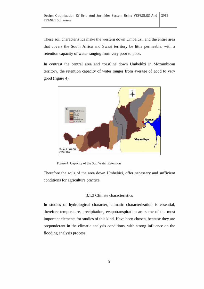
These soil characteristics make the western down Umbelúzi, and the entire area
that covers the South Africa and Swazi territory be little permeable, with a
retention capacity of water ranging from very poor to poor.
In contrast the central area and coastline down Umbelúzi in Mozambican
territory, the retention capacity of water ranges from average of good to very
good (figure 4).
Figure 4: Capacity of the Soil Water Retention
Therefore the soils of the area down Umbelúzi, offer necessary and sufficient
conditions for agriculture practice.
3.1.3 Climate characteristics
In studies of hydrological character, climatic characterization is essential,
therefore temperature, precipitation, evapotranspiration are some of the most
important elements for studies of this kind. Have been chosen, because they are
preponderant in the climatic analysis conditions, with strong influence on the
flooding analysis process.
Design Optimization Of Drip And Sprinkler System Using VEPROLGS And
EPANET Softwares
2013
10
3.1.3.1 Temperature
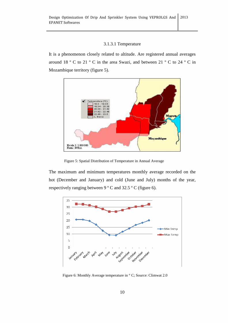
It is a phenomenon closely related to altitude. Are registered annual averages
around 18 º C to 21 º C in the area Swazi, and between 21 º C to 24 º C in
Mozambique territory (figure 5).
Figure 5: Spatial Distribution of Temperature in Annual Average
The maximum and minimum temperatures monthly average recorded on the
hot (December and January) and cold (June and July) months of the year,
respectively ranging between 9 º C and 32.5 º C (figure 6).
Figure 6: Monthly Average temperature in ° C; Source: Climwat 2.0
Design Optimization Of Drip And Sprinkler System Using VEPROLGS And
EPANET Softwares
2013
11
3.1.3.2 Precipitation Characteristics
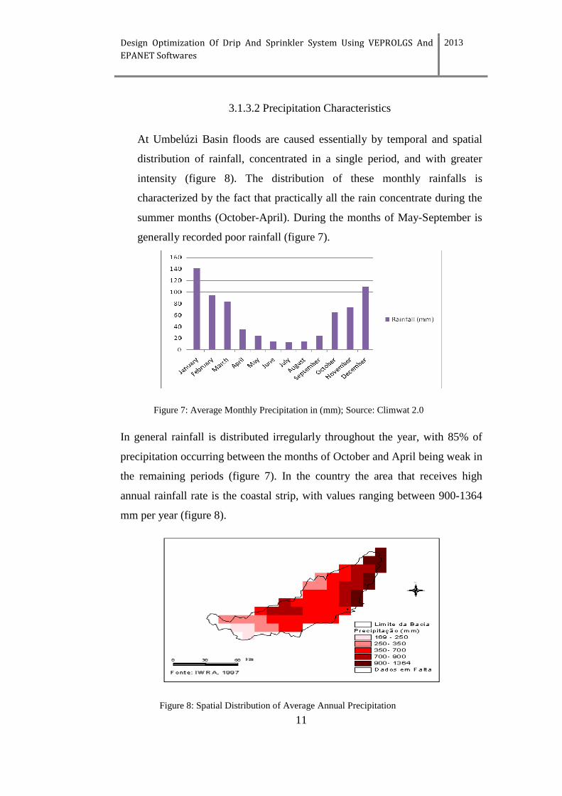
At Umbelúzi Basin floods are caused essentially by temporal and spatial
distribution of rainfall, concentrated in a single period, and with greater
intensity (figure 8). The distribution of these monthly rainfalls is
characterized by the fact that practically all the rain concentrate during the
summer months (October-April). During the months of May-September is
generally recorded poor rainfall (figure 7).
Figure 7: Average Monthly Precipitation in (mm); Source: Climwat 2.0
In general rainfall is distributed irregularly throughout the year, with 85% of
precipitation occurring between the months of October and April being weak in
the remaining periods (figure 7). In the country the area that receives high
annual rainfall rate is the coastal strip, with values ranging between 900-1364
mm per year (figure 8).
Figure 8: Spatial Distribution of Average Annual Precipitation
Design Optimization Of Drip And Sprinkler System Using VEPROLGS And
EPANET Softwares
2013
12
The potential evapotranspiration is a factor of great importance in the
hydrological cycle, so is need to get precise information of their value for
planning water resources in region. Its importance is clear due to the role it
plays in the process of water underground storing.
An example: checks in hot weather and dry when evaporation has a maximum
higher than precipitation, causes the minimum flows in the river.
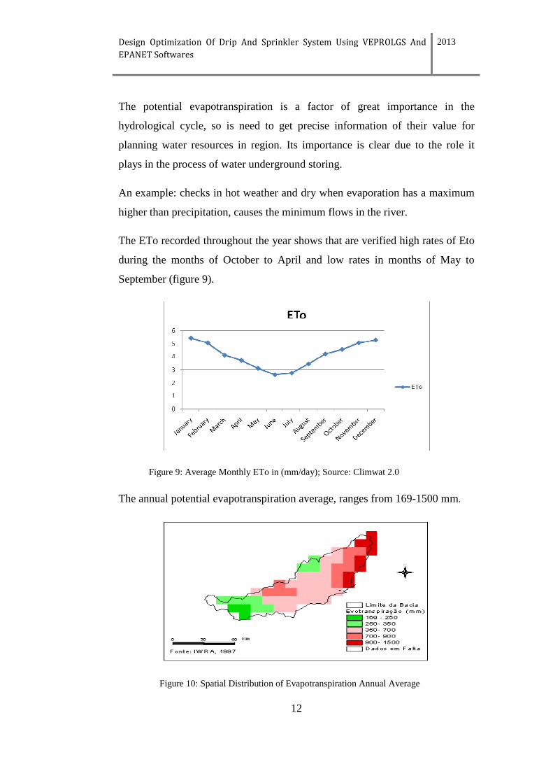
The ETo recorded throughout the year shows that are verified high rates of Eto
during the months of October to April and low rates in months of May to
September (figure 9).
Figure 9: Average Monthly ETo in (mm/day); Source: Climwat 2.0
The annual potential evapotranspiration average, ranges from 169-1500 mm.
Figure 10: Spatial Distribution of Evapotranspiration Annual Average
Design Optimization Of Drip And Sprinkler System Using VEPROLGS And
EPANET Softwares
2013
13
The lower evapotranspiration is verified in South Africa and Swazi territory,
with annual averages ranging from 169 to 350 mm and the highest (1500 mm)
in Mozambique coastal strip (figure 10).
Setting out relationship between precipitation and potential evapotranspiration
in space and within the basin scale, may be noted that the basin has high
potential evapotranspiration and low rainfall, consequently large water deficit.
Theoretically, the use of a cover in large areas would be an effective process of
soil moisture conservation, thereby reducing the penetration of solar radiation
on the ground.
3.1.4 Agriculture
Along the basin is practiced rain fed agriculture in the open prairie, and grazing
in the savanna.
3.1.5 Infrastructure Regulating Floods
The main hydraulic infrastructures are Mnjoli Dam built on the Black M'buluzi
in Swaziland and the Pequenos Libombos Dam built in Mozambique territory.
The Pequenos Libombos Dam was constructed with the following objectives:
Water supply to Maputo City (Mozambique Capital) through an annual
throughput of 76.5* 106 m3 in event more predictably, and 104*106 m3 in
extreme hypothesis, for the irrigation of 13.000 ha, floods deadness and
production of electricity with a maximum power of 1.7 MW (SADC, 2008).
3.2 Methodology
3.2.1 Data Collection
To carry out this study it was necessary to make a data collection, and were
generated software that are described below:
Design Optimization Of Drip And Sprinkler System Using VEPROLGS And
EPANET Softwares
2013
14
GOOGLE EARTH, this software was used essentially to locate the area of
study (determining the latitude and longitude, the elevation of the field and the
distances involved).
Then made up using the software CLIMWAT 2.0, to generate climate data
through Meteorological Station that comes closest, specifically the Umbeluzi
Weather Station, located at a distance of approximately 13 km of the study
area.
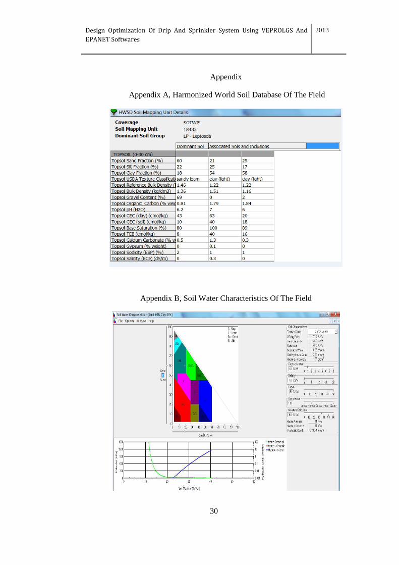
For the collection of data regarding the soil of the field were used software
such as Harmonized World Soil Database (HWSD) and SPAW Hydrology to
determine Soil Water Characteristics in the field.
For the determination of water requirement in Maize Crop, it was used
CROPWAT 8.0 Software, soil data generated by Harmonized World Soil
Database (HWSD) software and Soil Water Characteristics (SPAW
HIDROLOGY).
Design of Irrigation System
To perform the study two softwares were used VEPROLGS and EPANET 2.0.
The first was used for design and modeling water distribution along the drip
lines and Plot and the second was used for the design and dimensioning of
pipes (pipeline system), from the water intake to the plot head, or to the main
and secondary pipes.
VEPROLGS
Verification and design of drip line and plant areas for saving water and energy
(VEPROLGS) is an application software released in 2003 (first version), that
performs the operation checks dimensioning and design of systems of drip
irrigation, with the aim to increase the uniformity of distribution of irrigation,
to save water and reduce energy consumption. Through this software it is
possible to assess the functioning of entire sectors of irrigated field crops, even
if grown on slopes and strongly with changes in elevation along the row.
Design Optimization Of Drip And Sprinkler System Using VEPROLGS And
EPANET Softwares
2013
15
It is already equipped with the operating characteristics of a large number of
drip lines full tested by the National Laboratory of Irrigation within a
Convention between ARSIA and University of Pisa.
Essentially the program allows verification of the operation on the systems
already installed, and identify any changes to improve performance, guide the
design choices in the process of building new plants according to the criteria of
high efficiency, provide useful parameters for plant management.
And finally associated with the evaluation of the functional performance of the
plants to the charges for the amortization of the purchase of drip lines and
energy costs for the distribution of irrigation water.
EPANET 2.0
It was developed by the Water Supply and Water Resources Division of the
U.S. Environmental Protection Agency's National Risk Management Research
Laboratory, and it is software that models water distribution piping systems
and performs extended period simulation of the water movement and quality
behavior within pressurized pipe networks.
EPANET tracks the flow of water in each pipe, the pressure at each node, the
height of the water in each tank, and the type of chemical concentration
throughout the network during a simulation period, water age, source, and
tracing and provides a fully equipped, extended-period hydraulic analysis
package that can:
simulate systems of any size; compute friction head loss using the Hazen-
Williams, the Darcy Weisbach, or the Chezy-Manning formula; include minor
head losses for bends, fittings, etc.; model constant or variable speed pumps;
compute pumping energy and cost; model various types of valves, including
shutoff, check, pressure regulating, and flow control; account for any shape
storage tanks (i.e., surface area can vary with height); consider multiple
demand categories at nodes, each with its own pattern of time variation;
Design Optimization Of Drip And Sprinkler System Using VEPROLGS And
EPANET Softwares
2013
16
model pressure-dependent flow issuing from sprinkler heads; base system
operation on simple tank level, timer controls or complex rule-based controls.
3.2.2 Choice Of Plot
The area of 9128 m2, was defined to be a potentially agricultural area, due to
the proximity of Pequenos Libombos Dam, in which the producers practice
agriculture mostly based on surface irrigation.
4. Results And Discussion
4.1 Results and Discussion for Drip Irrigation
4.1.2 Crop Water Requirement
4.1.2.1 Results
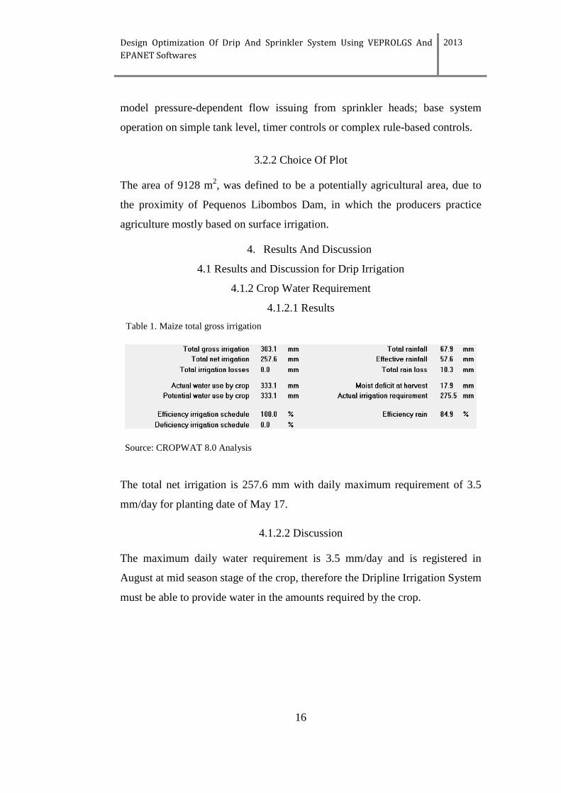
Table 1. Maize total gross irrigation
Source: CROPWAT 8.0 Analysis
The total net irrigation is 257.6 mm with daily maximum requirement of 3.5
mm/day for planting date of May 17.
4.1.2.2 Discussion
The maximum daily water requirement is 3.5 mm/day and is registered in
August at mid season stage of the crop, therefore the Dripline Irrigation System
must be able to provide water in the amounts required by the crop.
Design Optimization Of Drip And Sprinkler System Using VEPROLGS And
EPANET Softwares
2013
17
4.1.3 Dripline Design
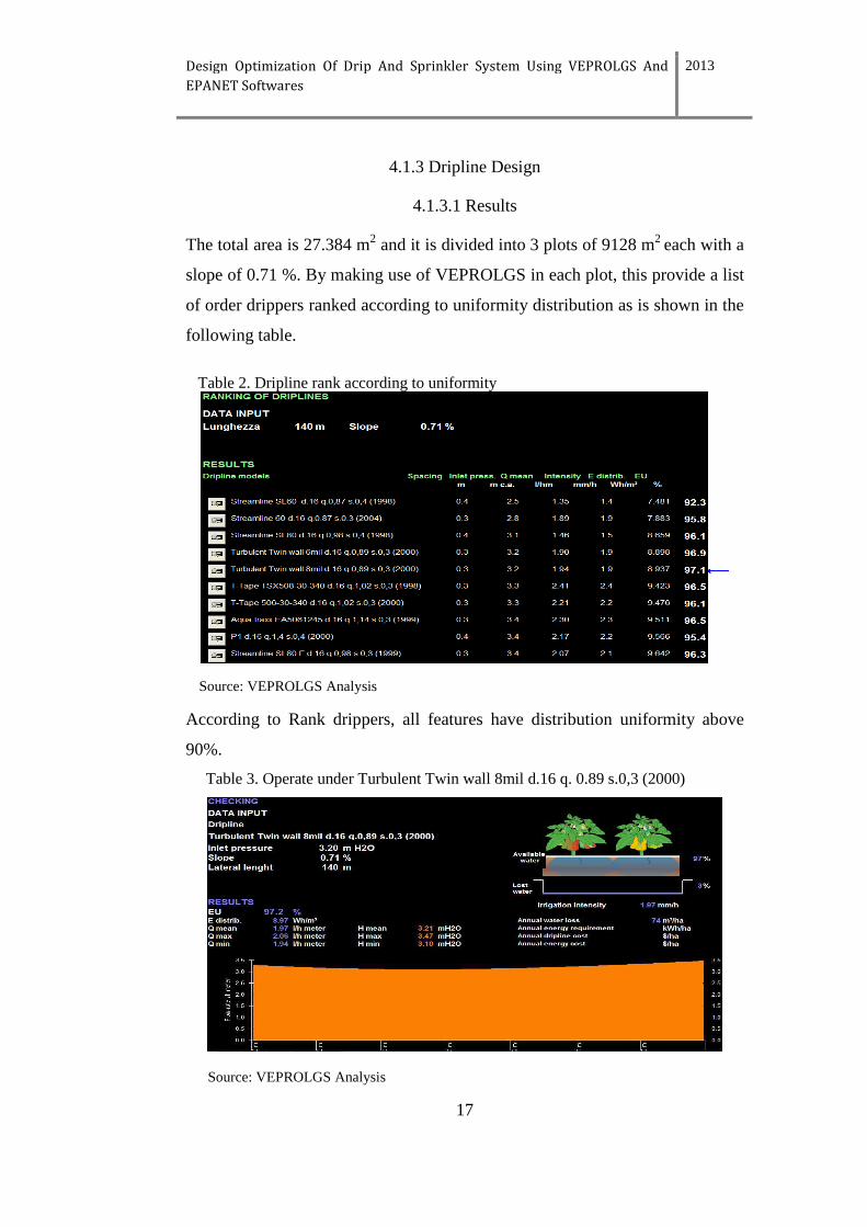
4.1.3.1 Results
The total area is 27.384 m2 and it is divided into 3 plots of 9128 m2 each with a
slope of 0.71 %. By making use of VEPROLGS in each plot, this provide a list
of order drippers ranked according to uniformity distribution as is shown in the
following table.
Table 2. Dripline rank according to uniformity
Source: VEPROLGS Analysis
According to Rank drippers, all features have distribution uniformity above
90%.
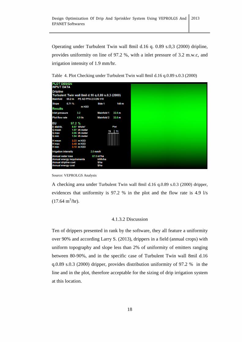
Table 3. Operate under Turbulent Twin wall 8mil d.16 q. 0.89 s.0,3 (2000)
Source: VEPROLGS Analysis
Design Optimization Of Drip And Sprinkler System Using VEPROLGS And
EPANET Softwares
2013
18
Operating under Turbulent Twin wall 8mil d.16 q. 0.89 s.0,3 (2000) dripline,
provides uniformity on line of 97.2 %, with a inlet pressure of 3.2 m.w.c, and
irrigation intensity of 1.9 mm/hr.
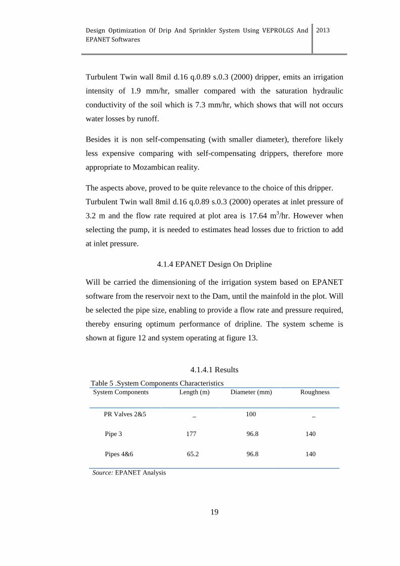
Table 4. Plot Checking under Turbulent Twin wall 8mil d.16 q.0.89 s.0.3 (2000)
Source: VEPROLGS Analysis
A checking area under Turbulent Twin wall 8mil d.16 q.0.89 s.0.3 (2000) dripper,
evidences that uniformity is 97.2 % in the plot and the flow rate is 4.9 l/s
(17.64 m3/hr).
4.1.3.2 Discussion
Ten of drippers presented in rank by the software, they all feature a uniformity
over 90% and according Larry S. (2013), drippers in a field (annual crops) with
uniform topography and slope less than 2% of uniformity of emitters ranging
between 80-90%, and in the specific case of Turbulent Twin wall 8mil d.16
q.0.89 s.0.3 (2000) dripper, provides distribution uniformity of 97.2 % in the
line and in the plot, therefore acceptable for the sizing of drip irrigation system
at this location.
Design Optimization Of Drip And Sprinkler System Using VEPROLGS And
EPANET Softwares
2013
19
Turbulent Twin wall 8mil d.16 q.0.89 s.0.3 (2000) dripper, emits an irrigation
intensity of 1.9 mm/hr, smaller compared with the saturation hydraulic
conductivity of the soil which is 7.3 mm/hr, which shows that will not occurs
water losses by runoff.
Besides it is non self-compensating (with smaller diameter), therefore likely
less expensive comparing with self-compensating drippers, therefore more
appropriate to Mozambican reality.
The aspects above, proved to be quite relevance to the choice of this dripper.
Turbulent Twin wall 8mil d.16 q.0.89 s.0.3 (2000) operates at inlet pressure of
3.2 m and the flow rate required at plot area is 17.64 m3/hr. However when
selecting the pump, it is needed to estimates head losses due to friction to add
at inlet pressure.
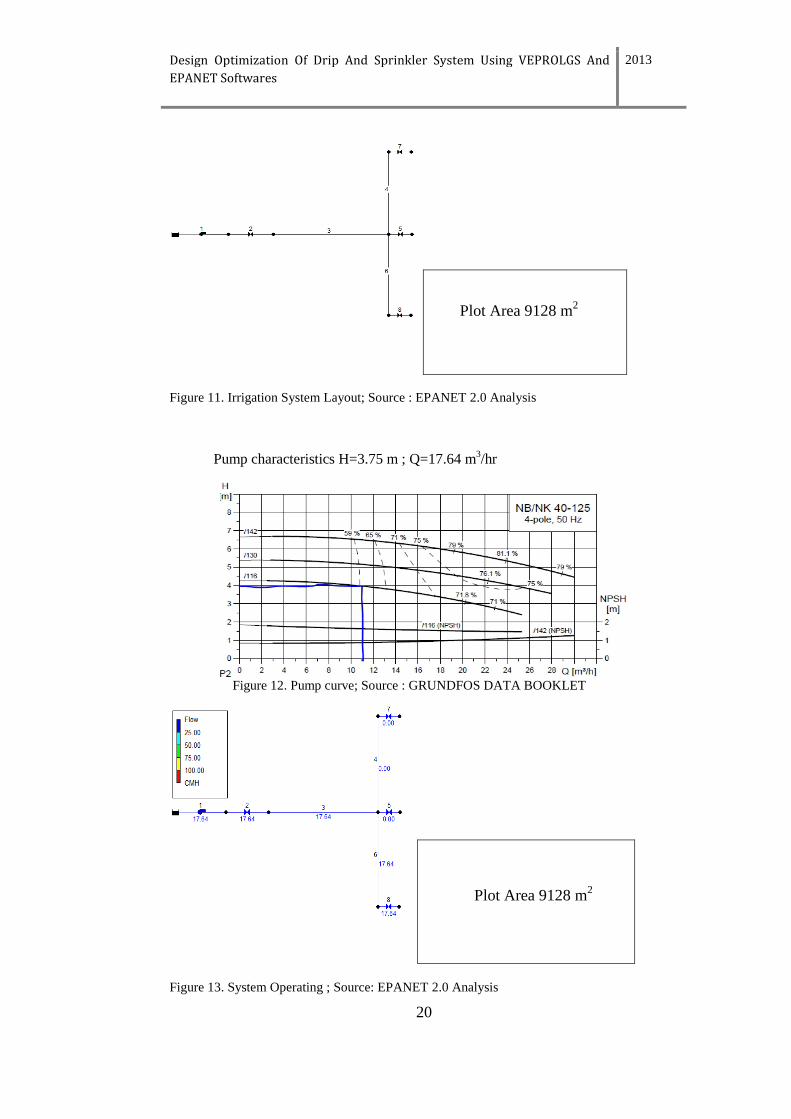
4.1.4 EPANET Design On Dripline
Will be carried the dimensioning of the irrigation system based on EPANET
software from the reservoir next to the Dam, until the mainfold in the plot. Will
be selected the pipe size, enabling to provide a flow rate and pressure required,
thereby ensuring optimum performance of dripline. The system scheme is
shown at figure 12 and system operating at figure 13.
4.1.4.1 Results
Table 5 .System Components Characteristics System Components Length (m) Diameter (mm) Roughness
PR Valves 2&5 _ 100 _
Pipe 3 177 96.8 140
Pipes 4&6 65.2 96.8 140
Source: EPANET Analysis
Design Optimization Of Drip And Sprinkler System Using VEPROLGS And
EPANET Softwares
2013
20
Figure 11. Irrigation System Layout; Source : EPANET 2.0 Analysis
Pump characteristics H=3.75 m ; Q=17.64 m3/hr
Figure 12. Pump curve; Source : GRUNDFOS DATA BOOKLET
Figure 13. System Operating ; Source: EPANET 2.0 Analysis
Plot Area 9128 m2
Plot Area 9128 m2
Design Optimization Of Drip And Sprinkler System Using VEPROLGS And
EPANET Softwares
2013
21
4.1.4.2 Discussion
Through the software is possible to verify that a is delivered at plot a flow rate
of 17.64 m3/hr, with a velocity of 0.62 m/s (figure 13) at a pressure of 3.75
m.c.w, slightly higher than had been predicted by VEPROLGS on the plot
which was 3.2 m.c.w, meaning that the pump can compensate the head losses
due to friction in the system which is 0.55 m and also can face the slope
displayed by the field (0.7 %).
The diameters applied to the pipes (96.8 mm) was with the aim to result in a
lower velocity of water and securing the pressure demanded by dripper, besides
the plots have the same area (9128m2), then the pump will provide water for all
area, each plot at time therefore it was necessary to have the same diameter.
The distances applied between driplines in VEPROLGS Software was 1 m, in
order to cover two crop lines (distance between crop lines is 0.5m), allowing
save money in cost related to buy driplines. Since the soil is sandy loam the
distances between drippers in the driplines and thus it could provide water
distribution uniformity, however the plot will be irrigate more often, but
running water for short periods of time in order to reduce the possibility of it
leaching of nutrients from the root zone.
The height of water at the Dam is 47 m and field has an elevation of 29 m, in
other words the difference between water height at the Dam and the elevation
of the field is 18 m. Since the total head required at plot by the pump is 3.75
m.c.w, it allows to say with certainty that it is possible to provide water to the
field by gravity (without use a pump). Therefore it will allow saving money on
purchasing costs, fuel/energy, and maintenance of a pump.
For such it is considered that the Dam has Constant Head Orifice (CHO)
Turnout installed at bottom. This device will allow to control and regulate the
pressure until the desired levels providing to the plot the required flow.
Design Optimization Of Drip And Sprinkler System Using VEPROLGS And
EPANET Softwares
2013
22
According Crop Water Requirement, the daily maximum net irrigation is 3.5
mm and the precipitation intensity of dripper is 1.9 mm/hr, meaning that to
irrigate one plot it will take 1.8 hrs and to irrigate all field will take 5.4 mm/hr.
4.2 Results And Discussion on Sprinkler System
4.2.1 Crop Water Requirement
4.2.1.1 Results
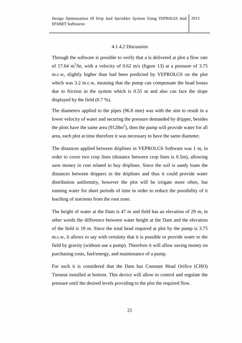
Table 6. Maize Total Gross Irrigation
Source: CROPWAT 8.0 Analysis
The total gross irrigation is 286.2 mm with daily maximum requirement of 3.7
mm/day for planting date May 17.
4.2.1.2 Discussion
The maximum daily water requirement is 3.7 mm/day and is registered in
August at mid season stage of the crop, therefore the Sprinkler System must be
able to provide water in the amounts required by the crop.
4.2.2 EPANET Design On Sprinkler
Through a pump water can be conveyed from the reservoir up to the field, and
it has to be directed to the distribution pipes and from here to sprinklers which
are distributed throughout the field. This irrigation system scheme can be
shown through EPANET Software as illustrated below in figure.14 and the
system components characteristic at table 7.
Design Optimization Of Drip And Sprinkler System Using VEPROLGS And
EPANET Softwares
2013
23
4.2.2.1 Results
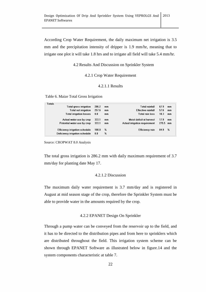
Table 7.System Components Characteristics
System Components Length (m) Diameter (mm) Roughness
Valve 2, 4-14&122 _ 75 _
Pipe 3
Pipes 15& 104-113
177
17
79.2
96.8
100
100
Pipes 16-121 17 66 100
Source: EPANET Analysis
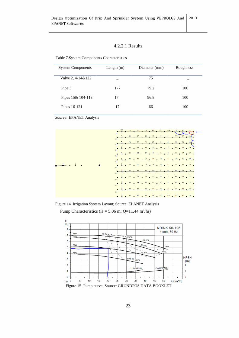
Figure 14. Irrigation System Layout; Source: EPANET Analysis
Pump Characteristics (H = 5.06 m; Q=11.44 m3/hr)
Figure 15. Pump curve; Source: GRUNDFOS DATA BOOKLET
Design Optimization Of Drip And Sprinkler System Using VEPROLGS And
EPANET Softwares
2013
24
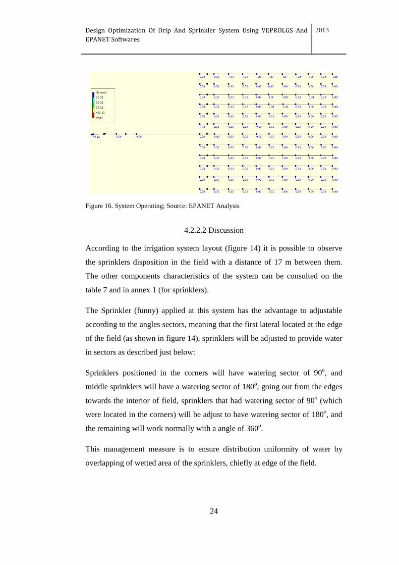
Figure 16. System Operating; Source: EPANET Analysis
4.2.2.2 Discussion
According to the irrigation system layout (figure 14) it is possible to observe
the sprinklers disposition in the field with a distance of 17 m between them.
The other components characteristics of the system can be consulted on the
table 7 and in annex 1 (for sprinklers).
The Sprinkler (funny) applied at this system has the advantage to adjustable
according to the angles sectors, meaning that the first lateral located at the edge
of the field (as shown in figure 14), sprinklers will be adjusted to provide water
in sectors as described just below:
Sprinklers positioned in the corners will have watering sector of 90o, and
middle sprinklers will have a watering sector of 180o; going out from the edges
towards the interior of field, sprinklers that had watering sector of 90o (which
were located in the corners) will be adjust to have watering sector of 180o, and
the remaining will work normally with a angle of 360o.
This management measure is to ensure distribution uniformity of water by
overlapping of wetted area of the sprinklers, chiefly at edge of the field.
Design Optimization Of Drip And Sprinkler System Using VEPROLGS And
EPANET Softwares
2013
25
In practice the system will work with one lateral with 9 sprinklers, so each
lateral has a valve at the entrance in ways that when a lateral is working the
others will be closed.
Therefore it will be assembled valve, pipe and sprinklers corresponding to a
single lateral. Meaning that to perform irrigation operation these components
(valve, laterals fitted with sprinkler) will be installed and after irrigate the plot,
it will be removed and installed on the next line so on until the all field is
irrigated.
Such management action will allow save on purchasing of other components,
but it will be needed to ensure manpower for mounting and dismounting the
components along the field, and in the specific case of Mozambique it is
possibly find manpower available.
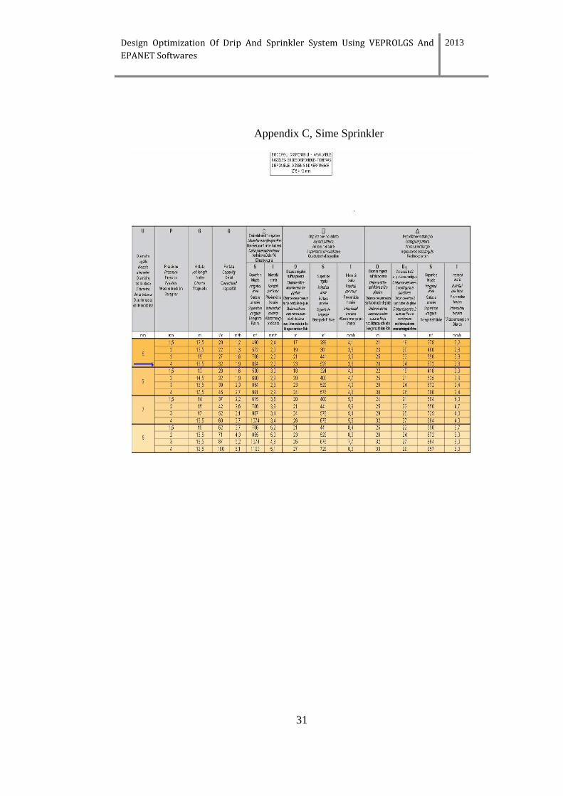
Using EPANET simulation with a Funny sprinkler from Sime, it is show that
the system operating can provide to each sprinkler a flow that ranges between
1.26 to 1.30 m3/hr, values considered to be acceptable given that in the field
sprinklers demand a flow of 1.2 m3/hr (Appendix C).
Therefore the Groundfos NB/NK 40-125 4-pole, 50 Hz /129 is the curve pump
(figure15).
Therefore since from selected diameters either in the main pipe (96.8 mm)
either in laterals with sprinklers (66 mm), the system is able to feed the last
point in the field delivering the demanded flow and also because from this
pump it is possible have a head that can cope the head losses due to friction and
the slope displayed in the field, therefore the total head was H=5.06 m to a total
flow of Q=11.44 m3/hr. However the difference between the water heights
contained in the Dam and altitude of the field and 18 m.
Design Optimization Of Drip And Sprinkler System Using VEPROLGS And
EPANET Softwares
2013
26
Although the field is at distance of 177 m from the Dam, it is possible to state
with certainty that will not be needed a pump, since with 18 m.c.w (greater
than the pump head, H=5.06) it is possible guarantee the flow demanded in the
field, simply by mounting Constant Head Orifice (CHO) Turnout on the
bottom of Dam to control and regulate the pressure until desired levels.
It will allow irrigate by gravity and save money on purchasing of a pump,
energy/fuel and maintenance.
According to Crop Water output, the daily crop water requirement is 3.7 mm,
therefore to irrigate all the field (12 laterals/lines) will be needed 44.4 mm,
meaning that it will take 12 hrs to irrigate a plot correspondent one laterals/line.
Design Optimization Of Drip And Sprinkler System Using VEPROLGS And
EPANET Softwares
2013
27
5. Conclusion
Through the softwares Google Earth, Climwat, Cropwat was possible to
generate data and support mechanism that led to design of drip and sprinkler
irrigation system that was suitable to the study area. However is worth to let
lessons learned from the performance of the system and how to improve it, in
way that could contribute to a judgment during of adoption of these two types
of irrigation systems in accordance with Umbelúzi Basin reality.
Despite cost of drip irrigation components, it operates with small capacity
pump (H=3.75 m.c.w) with small water need (Q=17.64 m3/hr), allowing water
to be provided to irrigate others fields or others purpose.
For sprinkler system is necessary considerable amounts of water to irrigate a
field, but with some management measures it is possible to get high
performances. By making the system work with one lateral line and moving it
to the next line after finishing, although requires manpower for mounting and
dismounting the lateral, this measure has proved to be extremely important,
because the system can works with a smaller capacity pump (H=5.06) which
demand a small amount of water (Q=11.44m3/hr) resulting in system
optimization.
The both systems can work in regions or seasons with water scarcity (therefore
suitable to cash crop).
Due to proximity of the field and difference of water height at the Dam and
field elevation (18 m), the two systems can work without a pump to deliver
water to the field, it is guaranteed by the height of water in the Dam.
This design of the two systems was made next to Pequenos Libombos Dam at
Umbeluzi Dam, however this approach can be applied to other crops in
different region of the country.
Design Optimization Of Drip And Sprinkler System Using VEPROLGS And
EPANET Softwares
2013
28
References
MADER. 2000. Relatório Geral Do TIA. Maputo, Mozambique: Ministry of
Agriculture and Rural Development. Available at:
http://fsg.afre.msu.edu/mozambique/iiam/rr_3p.pdf. Accessed 15 May 2013
Boom, B., 2011
Análise da pobreza em Moçambique. Available at:
http://www.sow.vu.nl/pdf/Mozambique/Analysis%20of%20Poverty%20in%20
Moz%20March%202011%20Port.pdf. Accessed 20 May 2013
Sime, SIME IDROMECCANICA.
Available at: www.sime-sprinklers.com/pdf/CG/10%20Funny.pdf. Accessed
15 June 2013
Muiambo, A.A., 1996
Impacto da Barragem dos Pequenos Libombos nos Recursos Naturais do
Distrito de Boane. Universidade Eduardo Mondlane. Available at:
http://www.saber.ac.mz/bitstream/10857/2511/1/Gt-032.pdf. Accessed 5 June
2013
Programa para Acção Nacional para Adaptação as Mudanças Climáticas, 2007.
Ministério para a Coordenação para Acção Ambiental, Moçambique. Available
at:
http://www.legisambiente.gov.mz/index.php?option=com_docman&task=doc_
view&gid=141. Accessed 3 June 2013.
Schwankl, L.: 2013
Maintenance of Micro irrigation Systems. University of California.
Available at: http://micromaintain.ucanr.edu/. Accessed 7 June 2013.
Design Optimization Of Drip And Sprinkler System Using VEPROLGS And
EPANET Softwares
2013
29
Crescimento Económico Necessário Mas Deve Ser Sustentável, 2008.
A comunidade para o Desenvolvimento da África Austral Hoje (SADC Hoje).
Available at:
http://www.sardc.net/Editorial/sadctoday/documents/portv10n6.pdf
Accessed 29 May 2013.
Dittoh, S., Akuriba, M. A., Issaka, B. Y.; and Bhattarai, M. 2010.
Sustainable Micro-Irrigation Systems for Poverty Alleviation in The Sahel: A
Case for “Micro” Public-Private Partnerships? Joint 3rd African Association of
Agricultural Economists (AAAE) and 48th Agricultural Economists.
Association of South Africa (AEASA) Conference. Available at:
http://ageconsearch.umn.edu/bitstream/97045/2/122.%20Sustainable%20Micro
%20Irrigation%20in%20the%20Sahel.pdf. Accessed 3 June 2013.
Wilson, C., Bauer, M. 2013.
Drip Irrigation for Home Gardens. Colorado State University Extension.
Available at: http://www.ext.colostate.edu/pubs/garden/04702.html.
Accessed 30 May 2013
Design Optimization Of Drip And Sprinkler System Using VEPROLGS And
EPANET Softwares
2013
30
Appendix
Appendix A, Harmonized World Soil Database Of The Field
Appendix B, Soil Water Characteristics Of The Field
Design Optimization Of Drip And Sprinkler System Using VEPROLGS And
EPANET Softwares
2013
31
Appendix C, Sime Sprinkler
Design Optimization Of Drip And Sprinkler System Using VEPROLGS And
EPANET Softwares
2013
32
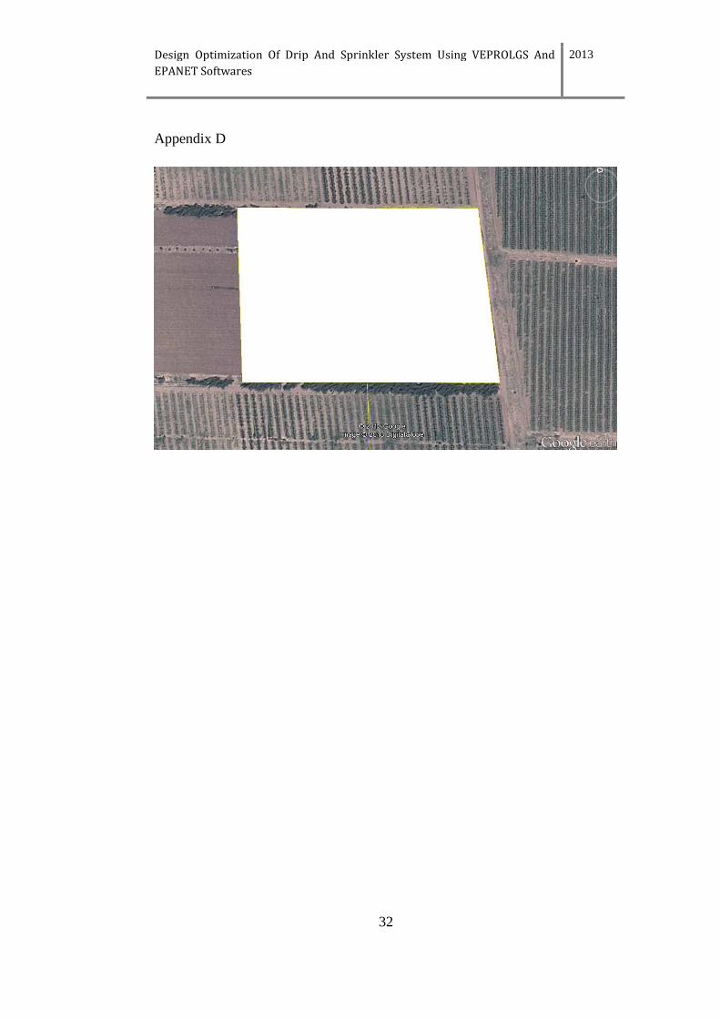
Appendix D