Embed Size (px)
Citation preview
ISPRS Journal of Photogrammetry and Remote Sensing 73 (2012) 30–38
Contents lists available at SciVerse ScienceDirect
ISPRS Journal of Photogrammetry and Remote Sensing
journal homepage: www.elsevier .com/ locate/ isprs jprs
Relative height error analysis of TanDEM-X elevation data
Paola Rizzoli ⇑, Benjamin Bräutigam, Thomas Kraus, Michele Martone, Gerhard KriegerMicrowaves and Radar Institute, German Aerospace Center (DLR), Oberpfaffenhofen, Germany
a r t i c l e i n f o
Article history:Available online 9 July 2012
Keywords:SAR interferometryDigital elevation modelRelative height errorTanDEM-X
0924-2716/$ - see front matter � 2012 Internationalhttp://dx.doi.org/10.1016/j.isprsjprs.2012.06.004
⇑ Corresponding author.E-mail address: [email protected] (P. Rizzoli).
a b s t r a c t
The primary objective of the TanDEM-X mission is the generation of a global high resolution digital ele-vation model (DEM) with single-pass SAR interferometry. Within the mission, the Earth’s land masseswill be mapped at least twice to achieve relative vertical accuracies in the order of two meters. This paperpresents an analysis of the mission performance in terms of the relative height error showing first resultsobtained from TanDEM-X interferometric data. For critical areas characterized by strong volume decor-relation phenomena or mountainous terrain, different approaches to improve the final height error areinvestigated as well.� 2012 International Society for Photogrammetry and Remote Sensing, Inc. (ISPRS) Published by Elsevier
B.V. All rights reserved.
1. Introduction
TerraSAR-X (launched in June 2007) and TanDEM-X (launchedin June 2010) are two German SAR satellites, developed within apublic/private partnership between the German Aerospace Center(DLR) and EADS Astrium. Both satellites serve for two differentSAR missions: the TerraSAR-X mission (Werninghaus and Buckre-uss, 2010), where both satellites provide high-quality SAR productsfor the science community and commercial purposes, and the Tan-DEM-X mission (Krieger et al., 2007) (started in June 2010) whichhas the primary goal of generating a global, high precision digitalelevation model (DEM). Since October 2010, both satellites havebeen flying in close orbit configuration, enabling the acquisitionof highly accurate cross- and along-track interferograms, whichwill be used as starting point for the generation of DEMs using sin-gle-pass SAR interferometry techniques (Krieger et al., 2007; Fritzet al., 2011). Digital elevation models are required for many pur-poses, such as navigation, cartography and the orthorectificationof other remote sensing image products. Up to now, DEMs havebeen derived using several SAR sensors, both airborne and space-borne. Available global DEMs are the GTOPO30 (USGS GTOPO,2001), provided by the United States Geological Survey (USGS)and characterized by a horizontal grid spacing of 3000 (approxi-mately 1 km), and the one provided by the Shuttle Radar Topogra-phy Mission (SRTM) (Werner, 2001), whose coverage is limited to alatitude range between 56�S and 60�N and which is delivered witha grid spacing of 100 for regions within the US territory and less than300 for the rest of the mapped areas. An overview of the SRTM mis-sion performance can be found in (Rodrı́guez et al., 2006), where
Society for Photogrammetry and R
different sources of errors, such as baseline determination, thermalnoise, timing and position errors and beam overlapping mis-matches are taken into account. Three different types of errorscharacterize the final DEM: an absolute height error, which canbe properly calibrated using ground reference targets, a randomerror, which is caused by thermal noise and residual geometricdecorrelation effects, and geolocation errors due to instrumenttime and phase offsets, which can be properly calibrated by usingground control points like corner reflectors. These three errorsources are taken into account to define the TanDEM-X DEM prod-uct specification, as presented in (Wessel, 2011), leading to the def-inition of the following three quantities: absolute vertical accuracy,relative vertical accuracy and absolute horizontal accuracy. Thespecified values are presented in Table 1. In this paper, only the rel-ative vertical accuracy will be addressed.
The TanDEM-X system was commissioned during a period ofabout 5 months after the launch (Hueso Gonzalez et al., 2010).The single TanDEM-X satellite was first calibrated to fulfill the Ter-raSAR-X mission requirements, acquiring data in monostatic con-figuration (Kraus et al., 2011; Schwerdt et al., 2011). The bistaticperformance was then analyzed in detail, taking into account dif-ferent acquisition geometries, modes and radar parameters (Mar-tone et al., 2011). The mission operational phase started inDecember 2010, with the aim of providing a complete high-resolu-tion DEM of the Earth land masses in 2014. The nominal operationmode for the systematic data acquisition is the bistatic Stripmapmode, where both satellites offer the flexibility to work as themaster transmitting sensor in order to equally share the power re-sources. To provide a good interferometric basis for multi-baselinephase unwrapping, a first complete coverage of the land masseshas been achieved after the first year of operation, acquiring inter-ferograms with a target height of ambiguity (HoA) higher than
emote Sensing, Inc. (ISPRS) Published by Elsevier B.V. All rights reserved.

Table 1TanDEM-X DEM specifications.
Requirement Specification Accuracy
Relative vertical accuracy 90% linear point-to pointerror over a 1� � 1� cell
2 m (slope < 20%)
4 m (slope > 20%)Absolute vertical accuracy 90% linear error 10 mAbsolute horizontal accuracy 90% circular error 10 mSpatial resolution independent pixels 12 m
(0.400 at equator)
P. Rizzoli et al. / ISPRS Journal of Photogrammetry and Remote Sensing 73 (2012) 30–38 31
45 m. The HoA is defined as the height difference equivalent to a 2pphase cycle inside an interferogram and can be expressed, for thebistatic case, as:
HoA ¼ kr sin hi
B?; ð1Þ
where k is the radar wavelength, r the slant range, hi the incidenceangle and B\ the baseline perpendicular to the line of sight.
To meet the specifications on the final vertical accuracy in chal-lenging areas, such as mountains and tall forests, additional datahave to be acquired as needed. The final DEM is then generatedby mosaicking all data acquisitions (Hueso Gonzalez et al., 2010).
This paper focuses on the analysis of the system performance interms of the relative height error, showing first results derivedfrom the acquired TanDEM-X elevation data. It is structured as fol-lows: Section 2 presents the theoretical approach used for the esti-mation of the point-to-point relative height error. Section 3 showsseveral examples of the actual performance obtained over test sitescharacterized by different HoAs and land cover types and presentsa comparison with the theoretical performance. Finally, Section 4describes different approaches for monitoring the mission perfor-mance and improving the relative height error over critical areas.
2. Relative height error estimation approach
Given two SAR images acquired from displaced locations, it ispossible to reconstruct the DEM of the ground starting from thephase interferogram between the two. Here, the relative height er-ror is intended to describe white noise-like contributions inside theDEM, which cannot be removed by the final calibration and mosai-king process. The estimation of the relative height error is based onthe quantification of the interferometric phase errors. The phasedifference u between two interferometric SAR channels can be de-scribed as a random variable, characterized by its probability den-sity function (pdf) pu(u) (Lee et al., 1994). It is related to the totalinterferometric coherence ctot, which quantifies the error contribu-tions coming from different sources, such as limited signal-to-noise ratio (SNR), volume and temporal decorrelation effects aswell as range and azimuth ambiguities, as described in (Kriegeret al., 2007). The estimation of the 90% point-to-point phase errorDu90% requires the computation of the 90% percentile from the pdfobtained by evaluating the difference between two random vari-ables, each of them describing the fluctuation of the interferomet-ric phase within one interferogram (Krieger et al., 2007). For aconsidered HoA, the point-to-point 90% relative height error is thenderived from the interferometric phase error as:
Dh90% ¼ HoA � Du90%
2p: ð2Þ
In the following, we describe an approach that has been imple-mented to directly estimate the point-to-point relative height errorfrom real SAR data, taking into account two successively acquiredDEMs D1(r1) and D2(r2). The two DEMs are acquired with the sameacquisition parameters and over mutually overlapping regions of
interest r1 and r2 in [lat/lon] coordinates. Moreover, both DEMsare supposed to be affected by independent noise components. Acommon region of interest r has to be defined as r = r1 \ r2, so thatboth DEMs can be referred to the same ground coordinates, leadingto D1(r) and D2(r). The reference frame can now be transformedfrom [lat/lon] coordinates to horizontal and vertical distances byevaluating the single coordinate distances on the WGS84 ellipsoid.A further interpolation is required in order to obtain a uniform gridof space coordinates [x,y], whose orthogonal spacings are defined asDx and Dy.
Starting from D1(x,y) and D2(x,y), the DEM difference can nowbe evaluated:
DDðx; yÞ ¼ D1ðx; yÞ � D2ðx; yÞ: ð3Þ
Systematic contributions due to an unprecise estimation of acquisi-tion parameters, such as sensor orbit position and baseline, produceslowly varying errors within a SAR DEM and will be compensatedduring the final DEM calibration process. Heance, a high-pass filter-ing is required to remove such slowly varying components andquantify the relative height error from the DEM difference. The fil-tering process can be performed in the frequency domain as ex-plained in the following. The two-dimensional Fourier transformof the DEM difference DD(x,y) is evaluated as:
Sðkx; kyÞ ¼Z y0
0
Z x0
0DDðx; yÞe�jkxxe�jkyy dxdy; ð4Þ
where kx and ky are the spatial frequency domain variables. Themaximum spatial coordinates x0 and y0 are defined as x0 = NxDx,y0 = NyDy, Nx and Ny being the number of samples in the horizontaland vertical dimensions. A two-dimensional circular high-pass filterFhigh(kx,ky) is designed in the frequency domain as:
Fhighðkx; kyÞ ¼ 1� Flowðkx; kyÞ; ð5Þ
Flow(kx,ky) being a two-dimensional low-pass gaussian filter, de-fined as:
Flowðkx; kyÞ ¼ e
� k2xþk2
yð Þ2 r2
xþr2yð Þ; ð6Þ
where r2x ; r2
y describe the bandwidth in the horizontal and verticaldimensions. The filter bandwidth has been experimentally chosenby finding a compromise between an eventual error underestima-tion and the undesired permanency of low-frequency componentsin the filtered data, leading to a cut-off frequency of about 1/10 ofthe whole bandwidth. The high-pass filtering operation is then per-formed by
Shighðkx; kyÞ ¼ Sðkx; kyÞFhighðkx; kyÞ ð7Þ
and the estimated relative height error is retrieved as:
Dhðx; yÞ ¼ 14p2
Z kx02
�kx0
2
Z ky02
�ky0
2
Shighðkx; kyÞejxkx ejyky dkx dky; ð8Þ
where kx0 and ky0 are defined as:
kx0 ¼2pDx
; ky0¼ 2p
Dy: ð9Þ
The DEM specifications have to be verified for flat and mountainousterrain separately, as presented in Table 1. In order to discriminateflat from mountainous areas, a slope mask can be generated byevaluating the local DEM gradient: starting from a smoothed ver-sion of one of the two input DEMs D1(x,y) or D2(x,y), the horizontaland vertical DEM gradient components are evaluated as:
rD1ðx; yÞ ¼@D1ðx; yÞ
@x;@D1ðx; yÞ
@y
� �: ð10Þ
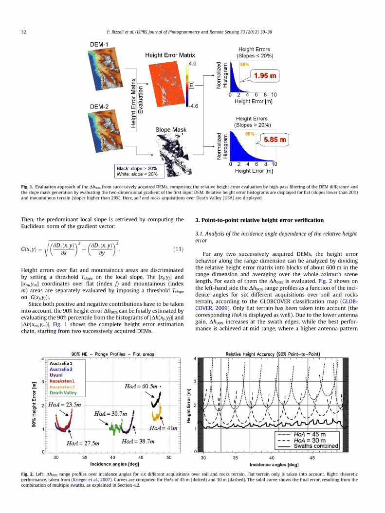
Fig. 1. Evaluation approach of the Dh90% from successively acquired DEMs, comprising the relative height error evaluation by high-pass filtering of the DEM difference andthe slope mask generation by evaluating the two-dimensional gradient of the first input DEM. Relative height error histograms are displayed for flat (slopes lower than 20%)and mountainous terrain (slopes higher than 20%). Here, soil and rocks acquisitions over Death Valley (USA) are displayed.
32 P. Rizzoli et al. / ISPRS Journal of Photogrammetry and Remote Sensing 73 (2012) 30–38
Then, the predominant local slope is retrieved by computing theEuclidean norm of the gradient vector:
Gðx; yÞ ¼
ffiffiffiffiffiffiffiffiffiffiffiffiffiffiffiffiffiffiffiffiffiffiffiffiffiffiffiffiffiffiffiffiffiffiffiffiffiffiffiffiffiffiffiffiffiffiffiffiffiffiffiffiffiffiffiffiffiffiffiffiffiffi@D1ðx; yÞ
@x
� �2
þ @D1ðx; yÞ@y
� �2s
: ð11Þ
Height errors over flat and mountainous areas are discriminatedby setting a threshold Tslope on the local slope. The [xf,yf] and[xm,ym] coordinates over flat (index f) and mountainous (indexm) areas are separately evaluated by imposing a threshold Tslope
on jG(xf,yf)j.Since both positive and negative contributions have to be taken
into account, the 90% height error Dh90% can be finally estimated byevaluating the 90% percentile from the histograms of jDh(xf,yf)j andjDh(xm,ym)j. Fig. 1 shows the complete height error estimationchain, starting from two successively acquired DEMs.
Fig. 2. Left: Dh90% range profiles over incidence angles for six different acquisitions operformance, taken from (Krieger et al., 2007). Curves are computed for HoAs of 45 m (dcombination of multiple swaths, as explained in Section 4.2.
3. Point-to-point relative height error verification
3.1. Analysis of the incidence angle dependence of the relative heighterror
For any two successively acquired DEMs, the height errorbehavior along the range dimension can be analyzed by dividingthe relative height error matrix into blocks of about 600 m in therange dimension and averaging over the whole azimuth scenelength. For each of them the Dh90% is evaluated. Fig. 2 shows onthe left-hand side the Dh90% range profiles as a function of the inci-dence angles for six different acquisitions over soil and rocksterrain, according to the GLOBCOVER classification map (GLOB-COVER, 2009). Only flat terrain has been taken into account (thecorresponding HoA is displayed as well). Due to the lower antennagain, Dh90% increases at the swath edges, while the best perfor-mance is achieved at mid range, where a higher antenna pattern
ver soil and rocks terrain. Flat terrain only is taken into account. Right: theoreticotted) and 30 m (dashed). The solid curve shows the final error, resulting from the

Fig. 3. Summary of the estimated Dh90% from TanDEM-X repeated acquisitions oversoil and rocks terrain for different HoAs. A linear trend is fitted over Dh90%
measurements for flat areas. Green boxes highlight the predicted performance from(Krieger et al., 2007) according to Fig. 2.
P. Rizzoli et al. / ISPRS Journal of Photogrammetry and Remote Sensing 73 (2012) 30–38 33
gain allows for better SNR. Note that, in the case of the Death Valleytest site (green), characterized by a HoA of 30.7 m, the Dh90% rangeprofile is noisier with respect to the other ones because of the lim-ited number of available samples over flat areas. This site is mostlymountainous, especially at mid range, while all the other test sitesare almost completely flat. On the right-hand side of Fig. 2 the the-oretically predicted performance, taken from (Krieger et al., 2007),is displayed. The comparison between the two graphs shows that,for ground areas characterized by stable backscatter, the elevationdata measurements are better than the predicted performance.
Fig. 4. Dh90% for different land cover classes
This result is mainly due to the very stable conditions of the chosentest sites and to the conservative assumption about the backscat-tering levels which has been taken into account in the predictedperformance.
3.2. Relative height error for different HoAs
The theoretical dependency of the relative height error on theHoA has been presented in Eq. (2). Fig. 3 shows a summary of theestimated Dh90% from TanDEM-X repeated acquisitions over soiland rocks terrain for different HoAs. Since many of the consideredacquisitions are characterized by almost completely flat terrain,the Dh90% over mountainous areas is available for a few test sitesonly. A linear trend is fitted over the Dh90% measurements for flatareas, leading to an estimate of Dh90% equal to 1.7 m for an HoAof 30 m and Dh90% equal to 2.5 m for an HoA of 45 m. The two HoAstaken into account are the ones for which the theoretical point-to-point Dh90% profiles in Fig. 2 (right) are evaluated. These resultsmatch very well with the theoretical performance where, if swathoverlapping areas are not taken into account, the Dh90% resideswithin 1.2 m and 2 m for an HoA of 30 m, and within 1.8 m and3 m for an HoA of 45 m.
3.3. Relative height error for different land cover classes
The estimated relative height error depends not only on the sys-tem acquisition parameters, but also on the ground target charac-teristics. Illuminated areas can be grouped into different land cover
: ice, agricultural areas and rain forest.

Fig. 5. Example of the improvement of the relative height error by combining multiple DEM acquisitions. Inputs are the point-to-point relative height error histogramsevaluated from successively acquired DEMs over the same ground area (Death Valley – USA). rHE
1 and rHE2 are the relative height error standard deviations obtained from the
input histograms, while Dh190% and Dh2
90% are the corresponding 90% relative height errors. rHEcomb and Dhcomb
90% are the relative height error standard deviation and 90% confidencelevel after the convolution.
34 P. Rizzoli et al. / ISPRS Journal of Photogrammetry and Remote Sensing 73 (2012) 30–38
classes and separately analyzed, allowing for the development ofdifferent acquisition strategies for each of them, e.g. by setting dif-ferent minimum HoAs as presented in Section 4.1. Fig. 4 shows anexample of some of the considered test sites, characterized by thefollowing land cover classes: ice (a), agricultural areas (b) and rainforest (c). Note that the same system parameters (i.e. baseline andHoA) are not available over different areas. For this reason, data ac-quired with different HoAs are used for performing the relativeheight error analysis for different land cover classes. It becomesclear that, for all cases, further acquisitions will be required in or-der to meet the final DEM specification. This will be presented inSection 4.2. Different aspects, such as volume and temporal decor-relation, have an additional impact on the estimation technique, sothat results may not match with the theoretical performance. Aparticularly significant example is given by the estimated Dh90%
over the rain forest (Fig. 4c), where volume decorrelation stronglyaffects the final performance.
4. Height error improvement approaches
The final TanDEM-X mission performance in terms of the rela-tive height error will have to satisfy the specifications describedin Table 1. For critical areas, characterized by strong volume decor-relation or mountainous terrain, the acquisition strategy has to bespecially optimized. For this reason, different approaches to im-prove the final height error performance have been investigated:
depending on the acquisition parameters and on the target charac-teristics of the illuminated ground area, the achieved performancecan be improved by changing the acquisition geometry or byincreasing the number of acquisitions, which are used to generatethe final DEM (multi-baseline multi-image interferometry). In thefollowing sections, different solutions are proposed.
4.1. HoA impact on height error over highly vegetated areas
Highly vegetated areas, such as rain forest, are affected bystrong volume decorrelation phenomena. In such cases, an increaseof the HoA allows for a reduction of the volume decorrelation im-pact on the interferometric coherence, leading to a reduction ofthe relative phase error. For this reason, a minimum requiredHoA of about 45 m has been established for acquisitions over veg-etated areas, in order to assure a sufficient quality for the phaseunwrapping (Martone et al., this issue). From Eq. (2), it can be no-ticed that the HoA cannot be arbitrarily incremented, because ofthe mission specifications on the final vertical DEM accuracy. Forthis reason, the approach explained in Section 4.2 will be takeninto account as well.
4.2. Height error improvement with multiple acquisitions
A further improvement of the relative height error accuracy canbe achieved by combining multiple interferometric acquisitions

Fig. 6. Relative height error improvement at swath edges by combining overlapping regions. (a) and (b): point-to-point relative height error standard deviation for twoseparate overlapping acquisitions over the Australia test site, characterized by soil and rocks. (c): Final relative point-to-point height error standard deviation after thecombination of the initial scenes with Eq. 12. (d) For each pixel, a Gaussian pdf with a standard deviation equal to the point-to-point relative height error standard deviation isgenerated. (e) Pdf obtained from the sum of pdfs in (d) and estimation of the Dh90%.
P. Rizzoli et al. / ISPRS Journal of Photogrammetry and Remote Sensing 73 (2012) 30–38 35
over the same ground area, recurring to multi-baseline phaseunwrapping techniques, as described in (Lachaise et al., 2007).From Fig. 5 it can be inferred that the relative height error is rea-sonably well characterized by a Gaussian distribution (the Gauss-ian pdf, evaluated using the mean value and standard deviationretrieved from the histogram itself, is plotted as well). Knowingthat the linear combination of two random variables with indepen-dent Gaussian distributions is still a random variable with Gauss-ian distribution, the final relative height error standard deviationDhtot, obtained by the optimum combination of multiple acquisi-tions, can be evaluated as (Krieger et al., 2007):
Dhtot ¼ffiffiffiffiffiffiffiffiffiffiffiffiffiffiffiffiffi
1PNi¼1
1Dh2
i
vuut ð12Þ
where N represents the total number of available acquisitions. Gi-ven the properties of a Gaussian distribution with zero mean, wherethe standard deviation and the 90% confidence level are related toeach other by a fixed ratio, Eq. (12) can be applied to the 90% rela-tive height error as well. This approach has been validated by com-paring the obtained results with the ones generated by convolving astretched version of the input histograms and evaluating the Dh90%
of the obtained histogram. A stretching factor ai, evaluated as in(Krieger et al., 2007), has been applied to the ith input histogram.The example proposed in Fig. 5 presents the results obtained fromsuch a test, taking into account two subsequent repeat-pass acqui-sitions over the same region of interest, situated over the Death Val-ley (USA), and characterized respectively by a HoA of about 39 mand 42 m. Both acquisitions are characterized by Soil and Rocksground classification and present a mean interferometric coherencehigher than 0.8. Using the estimation approach presented in section2, the Dh90% over flat areas can be retrieved for each acquisition sep-arately: Dh1
90% (sub-figure a) refers to the first acquisition, whileDh2
90% (sub-figure b) to the second one. A combined 90% height errorDhcomb
90% of about 1.01 m is obtained after the convolution of thestretched histograms (sub-figure (c)), while the combination ofthe estimated Dh1
90% and Dh290% using Eq. (12) leads to a final 90%
height error Dhtot of 1.02 m. The obtained results are in good agree-ment with each other.
As can be inferred from Fig. 2, the worst performance isachieved at the swath edges. In order to assure the complete cov-erage of land masses, adjacent acquisitions are always character-ized by an overlapped region, both at near and far range. In thisspecific area, two or more overlapping swaths are already availablewithin the first global coverage, allowing for the improvement of

Fig. 7. Estimation of relative height error improvement with multiple acquisitions, starting from the interferometric coherence of Death Valley test site. (a) and (b): 90%height error from interferometric coherence, (c): estimated 90% height error after combining the previous acquisitions in (a) and (b). (d): histogram of combined 90% heighterror per pixel.
36 P. Rizzoli et al. / ISPRS Journal of Photogrammetry and Remote Sensing 73 (2012) 30–38
the relative height error as explained above. In this way, in the caseof highly coherent and stable areas (such as flat areas characterizedby soil and rocks terrain) the combination of acquisitions from thefirst year of the TanDEM-X mission can be sufficient to achieve therequired mission specification. An example is shown in Fig. 6. Twooverlapping DEMs over Australia are taken into account: the singlepoint relative height error standard deviation is firstly evaluatedfrom the interferometric coherence, as presented in (Kriegeret al., 2007). Assuming a zero mean normal distribution, as justi-fied from the example in Fig. 5, the point-to-point relative heighterror standard deviation is then derived by multiplication withthe square root of two. Fig. 6a and b present, for each input acqui-sition, the point-to-point relative height error standard deviationrHE estimated from the interferometric coherence. Fig. 6c showsthe final point-to-point relative height error standard deviationrHE
comb obtained from the combination of the two initial scenes usingEq. (12). Images are color coded using different levels, each of themcharacterizing relative height errors comprised into definiteranges, as described by the colorbar. A consistent improvementof the performance is visible over the overlapped region, which in-volves the swath edges of both single acquisitions. The final point-to-point Dh90% is then directly estimated from rHE
comb in the follow-ing way: each pixel is supposed to be normally distributed withstandard deviation rHE
i and zero mean. The corresponding Gauss-ian pdf is evaluated for each available pixel (Fig. 6d) and the nor-malized sum of all the pdfs is evaluated. The Dh90% is finallyretrieved from the resulting pdf, as presented in Fig. 6e.
4.3. Multiple acquisition global prediction approach
The approach proposed in Section 4.2 shows a significantimprovement of the relative height error performance using multi-ple acquisitions. In order to support the acquisition planning strat-egy for additional acquisitions, a global scale approach isintroduced. It consists in combining multiple acquisitions usingEq. (12) and then deriving the 90% point-to-point relative heighterror as presented in Section 4.2. This approach relies on availablesingle-pass bistatic acquisitions only, instead of evaluating two ormore DEM acquisitions which are available for dedicated test sitesonly. Fig. 7 presents in (a) and (b) the point-to-point relative heighterror standard deviation images, evaluated from each coherencematrix associated with two acquisitions over the Death Valley(USA), while Fig. 7c shows the combined point-to-point relativeheight error standard deviation. Sub-figure (d) on the right handside shows the histogram of the combined height error standarddeviation, evaluated as presented in section 4.2 and characterizedby a Dh90% of 1.10 m.
Note that areas characterized by a point-to-point relative heighterror higher than 2 m still remain. Such areas are mainly character-ized by ground slopes higher than 20%. The interferometric Tan-DEM-X performance parameters acquired up to now provide asolid basis for estimating the impact and necessity of multipleacquisitions on a global scale, depending on the on-ground topog-raphy, land coverage classification and acquisition parameters. Anexample is presented in Fig. 8: sub-figures (a) and (b) show respec-

Fig. 8. Relative height error quantification approach for global monitoring purposes. (a): DEM from 12 overlapping acquisitions over Australia. (b) point-to-point relativeheight error standard deviation. (c) point-to-point relative height error standard deviation ground range profiles of each single acquisition. (d) point-to-point relative heighterror standard deviation ground range profile of the composed acquisitions using Eq. (12).
P. Rizzoli et al. / ISPRS Journal of Photogrammetry and Remote Sensing 73 (2012) 30–38 37
tively the DEM and the point-to-point relative height error stan-dard deviation rHE obtained by mosaicking 12 different TanDEM-X acquisitions over Australia, covering an area of about250 � 100 km2.
rHE is obtained from the interferometric coherence, and Eq. (12)is applied in order to properly compose overlapping regions. Sub-figure (c) presents, for each acquisition separately, the point-to-point relative height error standard deviation ground range pro-files, evaluated by averaging the rHE along the azimuth dimension.Note that the acquisition centered around a ground range of 50 kmis characterized by higher height error, due to an higher HoA. Final-ly, sub-figure (d) shows the ground range rHE profile after the com-bination of all the available acquisitions. It can be noticed that therHE is improved both at swath edges and where two acquisitionsare available over the same ground area. The same approach canbe repeated for different test sites, leading to a global overviewof the system performance.
5. Conclusions
In this paper, the TanDEM-X system performance has been ana-lyzed in terms of the relative height error. The estimation approachand the first results obtained from TanDEM-X successively acquiredDEMs are presented. The relative height error depends on severalfactors, such as the ground characteristics and the acquisitiongeometry. Different tests have been analyzed, as presented inSections 3.1, 3.2 and 3.3, showing the overall good performanceof the TanDEM-X elevation data with a single acquisition already.Different approaches for improving the final DEM performancehave been analyzed in Section 4, taking into account the conse-quences of changing the acquisition geometry or the possibility ofcombining multiple images over the same ground area. This willbe important for difficult terrain or areas suffering from strongdecorrelation effects. An approach for estimating the benefit ofmultiple acquisitions on a global scale has been presented, based
on the interferometric coherence information. The derived relativeheight error is in good agreement with the estimation approachpresented in Section 2 and allows for a further optimization of fu-ture acquisitions for completing the final TanDEM-X DEM.
Acknowledgments
The TanDEM-X project is partly founded by the German FederalMinistry for Economics and Technology (Förderkennzeichen 50 EE1035). The authors would like to thank the anonymous reviewersfor their valuable comments and suggestions to improve the qual-ity of the paper.
References
Fritz, T., Rossi, C., Yague-Martinez, N., Rodriguez-Gonzalez, F., Lachaise, M., Breit, H.,2011. Interferometric performance of TanDEM-X data. In: Proc. Geoscience andRemote Sensing Symposium (IGARSS), Vancouver, 24–27 July, pp. 2428–2431.
GLOBCOVER, 2009. European Space Agency GLOBCOVER. <http://ionia1.esrin.esa.int/> (accessed 02.12).
Hueso Gonzalez, J., Bachmann, M., Hofmann, H., 2010. TanDEM-X commissioningphase status. In: Proc. Geoscience and Remote Sensing Symposium (IGARSS),Honolulu, 25–30 July, pp. 2633–2635.
Hueso Gonzalez, J., Bachmann, M., Krieger, G., Fiedler, H., 2010. Development of theTanDEM-X calibration concept: analysis of systematic errors. IEEE Transactionson Geoscience and Remote Sensing 48 (2), 716–726.
Kraus, T., Schrank, D., Rizzoli, P., Bräutigam, B., 2011. In-orbit SAR Performance ofTerraSAR-X and TanDEM-X satellites. In: 12th URSI commission – triennialopen symposium on wave propagation and remote sensing, Garmisch-Partenkirchen, 8–11 March.
Krieger, G., Moreira, A., Fiedler, H., Hajnsek, I., Werner, M., Younis, M., Zink, M.,2007. TanDEM-X: a satellite formation for high-resolution SAR interferometry.IEEE Transactions on Geoscience and Remote Sensing 45 (11), 3317–3341.
Lachaise, M., Eineder, M., Fritz, T., 2007. Multi baseline SAR acquisition concepts andphase unwrapping algorithms for the TanDEM-X mission. In: Proc. Geoscienceand Remote Sensing Symposium (IGARSS), Barcelona, 23–27 July, pp. 5272–5276.
Lee, J.-S., Hoppel, K.W., Mango, S.A., Miller, A.R., 1994. Intensity and phase statisticsof multilook polarimetric and interferometric SAR imagery. IEEE Transactionson Geoscience and Remote Sensing 32 (5), 1017–1028.
Martone, M., Rizzoli, P., Bräutigam, B., Krieger, G., 2011. First interferometricperformance results of TanDEM-X commissioning phase. In: 12th URSI

38 P. Rizzoli et al. / ISPRS Journal of Photogrammetry and Remote Sensing 73 (2012) 30–38
Commission – Triennial Open Symposium on Wave Propagation and RemoteSensing, Garmisch-Partenkirchen, 8–11 March.
Martone, M., Bräutigam, B., Rizzoli, P., Gonzalez, C., Bachmann, M., Krieger, G., thisissue. Coherence evaluation of TanDEM-X interferometric data. ISPRS Journal ofPhotogrammetry and Remote Sensing.
Rodrı́guez, E., Morris, C.S., Belz, J.E., 2006. A global assessment of the SRTMperformance. Photogrammetric Engineering & Remote Sensing 72 (3), 249–260.
Schwerdt, M., Hueso Gonzalez, H., Bachmann, M., Schrank, D., Döring, B., TousRamon, N., Walter Antony, J.M., 2011. In-orbit calibration of the TanDEM-Xsystem. In: Proc. Geoscience and Remote Sensing Symposium (IGARSS),Vancouver, 24–27 July, pp. 2420–2423.
USGS GTOPO, 2001. GTOPO30 Global Digital Elevation Model. <http://eros.usgs.gov/#/Find_Data/Products_and_Data_Available/gtopo30_info> (accessed 06.12).
Werner, M., 2001. Shuttle radar topography mission (SRTM): mission overview.Frequenz 55 (3–4), 75–79.
Werninghaus, R., Buckreuss, S., 2010. The TerraSAR-X mission and system design.IEEE Transactions on Geoscience and Remote Sensing 48 (2), 606–614.
Wessel, B., 2011. TanDEM-X Ground Segment DEM Products SpecificationDocument. DLR Doc. TD-GS-PS-0021, Issue 1.7, Date 4.11.2011.