Embed Size (px)
Citation preview

ITEM 7
TO: PLANNING & REGULATORY COMMITTEE DATE: 22 June 2011
BY: PLANNING MANAGER DISTRICT(S) MOLE VALLEY DISTRICT COUNCIL ELECTORAL DIVISION(S):
Leatherhead & Fetcham East Mr Hall
PURPOSE: FOR DECISION GRID REF: 514713 157798
TITLE:
MINERALS AND WASTE APPLICATION MO/2011/0221/SCC
SUMMARY REPORT Randalls Road Waste Management Facility, Randalls Road, Leatherhead, Surrey, KT22 0BA Redevelopment and extension of Randalls Road Community Recycling Centre (CRC) and Waste Transfer Station (WTS), including a split-level recycling facility for the receipt of civic amenity wastes, a new enclosed WTS building, amended parking and access layout, weighbridge office and associated facilities. The proposed development is inappropriate development in the Green Belt and therefore the application falls to be considered as a Departure from the provisions of the Development Plan. The existing site (the central section of the application area) currently operates as a CRC and WTS whereas land to the southeast is currently an open field / woodland with residential properties situated to the northeast on the adjacent side of the (unnamed) access road. The application site area is approximately 1.3ha in area, including both the existing CRC /WTS site (approximately 0.8ha), an area approximately 0.5ha containing both an overgrown parcel of land to the southeast and a smaller wooded verge to the northeast (adjoining the existing site entrance). The applicant is seeking to redevelop the site to allow for greater segregation of recyclable materials and increase efficiency within the site. This would include expanding the site towards the southeast and east and the redesign of the internal layout. The redesigned internal layout would include an internal perimeter road along the southern and western boundaries of the site for public visitors to the CRC with parking bays positioned immediately adjacent, and the allocation of recycling containers and bins within the centre of the site (i.e. to the north and east of the CRC parking bays) so that Heavy Goods Vehicles (HGVs) can bulk up and load materials in isolation from members of the public. The western section of the perimeter road would be raised by a maximum of 1.65 metres with both a ramp up and down, to provide a split level facility so that the top of the containers are level with the parking area. Space would be provided between the recycling containers and bins and the parking bays to allow members of the public to walk to recycling containers to dispose of waste in a safe manner. The southwest corner of the application site would include a single storey welfare / re-use building and lay-by. A small recyclables area would be located adjacent to the split-level facility at ground level along the southern boundary and would have an access from the perimeter road. Both the western and southern sections of the CRC would have covered walkways for members of the public and these areas would be connected at the southwest corner by a covered ramp. A drop off point for green waste by public trailers (close to 3no. covered bays) would be provided to the east of the main CRC area, adjacent to the new public entrance. The new dedicated entrance gate and
1
ITEM 7
access point would be provided at the east of the application site for public vehicles visiting the CRC. A new enclosed Waste Transfer Station (WTS) building measuring of 36m by 23.5m, with a maximum height of 12 metres, is also proposed to the northeast of the site and this would be served by a new dedicated entrance for HGV’s with two 18m weighbridge’s and a two storey weighbridge office near the entrance gate for the CRC / WTS operation vehicles. In addition, 8no. roofed / covered external storage bays would be located immediately west of the WTS building. To the east of the WTS building, a small area would provide some visitor and disabled parking and a relocated sub-station. A new separate vehicular access for Grundon’s waste facility to the north of the application site would run along the northern boundary, with a separate entrance to the north of the WTS/CRC gate. Beyond the main CRC/WTS site, adjacent to the weighbridge entrance gate, dedicated staff car parking would be provided. An area of tree / hedgerow planting would be provided along the southern boundary, with tree planting incorporated into the CRC vehicular access point on a small tear-drop shaped traffic island. In addition, a 2.4m high weld mesh fence would be erected around the perimeter of the site, with the exception of the south eastern boundary along which a 2.4m high timber acoustic fence (with 0.6m barbed wire on top) would be constructed and planted with climbing plants. This is proposed to mitigate the impact of tree felling and the removal of hedgerows, which would be needed to allow the enlargement of the existing site. The application proposals would require some demolition, primarily to the north of the application site involving the existing single storey weighbridge office and single storey welfare building (referred to as ‘Building 2’). The proposal does not anticipate any increase to the types of waste received at the site and the applicant states it is not proposed to increase volumes of waste handled. The applicant anticipates that the site would only be closed for one month towards the end of the construction and redevelopment phase, which is predicted to last 9 months. Issues to be considered in determining this application are whether the proposal accords with national, regional and development plan policy; in particular whether very special circumstances exist to justify inappropriate development, which clearly outweigh harm to the Green Belt and any other harm. The proposal should also seek to comply with prevailing standards and development plan policies to ensure protection of the local environment and amenities of local residents from any potential adverse effects. Officers consider that factors amounting to very special circumstances exist consisting of: (1) the lack of alternative suitable sites in or outside of the Green Belt; (2) the close proximity of the site to the arisings of waste it would handle; (3) the characteristics and suitability of the site for the scale of waste operation given the length of time that the site has been in operation and the logistical need to improve the site design and layout to assist in reducing both queuing and congestion around the site; and (4) the need for the County to increase recycling and recovery capacity to contribute to the agreed and emerging targets. The identified factors when taken cumulatively together outweigh the harm to the Green Belt by way of inappropriateness and any other harm caused by the proposal within the Green Belt. There is potential for aspects of the proposed development to be visible from the surroundings, in particular the main WTS building (of up to 12m in height), although this would be from within a localised area. Such visual impacts would subsequently reduce following the establishment of the mitigation planting secured through an agreed Landscape and Ecology Management Plan. The development would otherwise provide a significant qualitative improvement to the facilities at the site. Any other adverse environmental or amenity impacts can be suitably mitigated by the imposition of planning conditions. Accordingly Officers consider that planning permission should be granted as a Departure from the provisions of the Development Plan.
2

ITEM 7
The recommendation is, that subject to the application being referred to the Secretary of State as a Departure, to PERMIT subject to conditions. APPLICATION DETAILS Applicant SITA Surrey Ltd Date application valid 14 February 2011 Period for Determination 16 May 2011 Amending Documents - Site Layout (LE01 Revision 4) received 01/04/11 - Revised Landscape and Visual Impact Assessment received 01/04/11 - Revised Photomontage Viewpoint 2 (LH5) - received 01/04/11 - Photomontage Viewpoint 3 (LH6) - received 01/04/11 - Reptile Survey results dated May 2011 and received 06/05/11 - Lighting Scheme (inc. Dwg No. LE05 / Isolux Diagram Rev 2 and Dwg No. LE05 Rev 2)
dated 31 May 2011 and received 02/06/11 - Drainage Design Revision 3 (inc. Dwg No. LE04 Rev 5; Dwg No. LE04A Rev 1; and Windes
Drainage Analysis Output: Appendix A, B, C & D) dated May 2011 and received 02/06/11 - Odour Management Plan Version 2.1 received 03/06/11 - Stage 1: External/Internal Daytime Inspection for Bats – dated April 2011 and received
06/06/11 - Stage 2: Further Survey for Bats dated June 2011 and received 02/06/11 - 25 Year Landscape and Ecology Management Plan (inc. Dwg No. LE03A Revision F) dated
May 2011 and received 06/06/11 - Dust Management Plan Version 1 dated May 2011 and received 07/06/11
3
ITEM 7
SUMMARY OF PLANNING ISSUES This section identifies and summarises the main planning issues in the report. The full text should be considered before the meeting. Is this aspect of the
proposal in accordance with the development plan?
Paragraphs in the report where this has been
discussed Waste Management Issues:
• Need • Alternative Site
Assessment • Location
Yes
Yes Yes
41-55 56-63
64-66 67-76
Traffic and Highways Impact Yes 77-92 Landscape and Visual Amenity
Yes 94-111
Air Quality, Dust and Odour Yes 112-122 Noise Yes 123-130 Geology, Soils, Groundwater - Surface Water and Flooding
Yes 131-141
Ecology and Nature Conservation
Yes 142-149
Lighting & CCTV Yes 150-155 Archaeology Yes 156-157 Green Belt No 158-173 ILLUSTRATIVE MATERIAL Plan 1 – Site Plan Plan 2 – Indicative Landscape Scheme Figure A – Photomontage LH5, view from site access Figure B – Photomontage LH6, view from field to the south Aerial 1 – Leatherhead CRC Aerial 2 – Leatherhead CRC (close-up) Figure 1 - Photograph of extension area looking west from access road Figure 2 - Photograph of site entrance and group of trees looking southwest Figure 3 - Photograph of existing open style WTS looking southwest Figure 4 - Photograph of open waste area near site entrance looking northeast BACKGROUND Site Description 1. The site lies to the west of Randalls Road and is located within the Metropolitan Green
Belt. The site is located approximately 2km to the north-west of Leatherhead, 500m south of the M25, with the River Mole running to the west of the site. A former landfill lies to the west of the site with open countryside beyond. The existing CRC site is accessed via a 300m long road, which is shared with the adjoining sewage treatment works and Materials Recovery Facility (MRF) to the north. The existing CRC site has been used for the handling of waste since 1958, and as a Civic Amenity Site since 1976.
4

ITEM 7
2. The existing site covers an area of approximately 1 hectare and is partially spilt level and enclosed by combination of palisade fence, chainlink fencing and lockable gates. Within the site there is a welfare office, a reception area for bulky household waste and containers for waste and recyclables, a single weighbridge and weighbridge office, external storage bays and an ‘open’ style transfer station to the southwest, which has a solid metal roof and netted walls to the southwest and southeast. Additionally, an open transfer operation with no roof is located in a ‘sunken’ area to the northeast of the site close to the entrance.
3. As such, the site operates two land-uses, namely the recycling centre and the transfer
station. The recycling centre broadly occupies the northern and eastern sections of the site and is accessed via a dedicated filter lane from the un-named access road. There are 11 individual bays provided for members of the public to dispose of waste, served by a mini-roundabout allowing easy access and egress. The waste transfer section of the application site occupies the western and southern sections of the application site, although access to this area is gained by travelling around the north of the recycling centre area along the un-named access road. Access to the Grundon and Thames Water facilities is also available via this route.
4. The site therefore also forms part of the access route to the Material Recycling Facility
operated by Grundon Waste Management and Thames Water’s Sewerage Treatment Facility located to the north and northeast of the site respectively. Household vehicles, HGVs and 3rd party traffic share the same site access for both entry to the site and exit from the site. Currently, in order for operational vehicles to exchange recycling containers on the upper level of the CRC, public traffic movements have to be temporarily suspended for the exchange to take place, which can lead to some temporary queuing and congestion on the private access road. There is space for about 11 public vehicles to park within the site at any one time.
Planning History 5. In April 1992, planning permission ref: MO92/0195 was granted for the continued use of
1 hectare as a Civic Amenity site and refuse transfer station. In 1998, 2no. planning applications were made at the site – application ref: MO98/0097 was permitted for the construction of a Materials Recovery Facility building of about 1500m2 as part of existing waste operations on a site of 0.8ha; and planning application ref: MO98/0524 was permitted for the continued use as a waste transfer station and civic amenity site for the deposit and temporary storage of waste and associated use of an existing building for staff accommodation, to be operated by a person other than the planning authority.
6. Planning application ref: MO00/1413 was then permitted in March 2001 for the
construction of a raised vehicle off-loading area, four covered storage bays, three open storage bays and internal roadways, together with the infilling of a low lying area of 0.11ha within the site to surrounding ground level. Following this, in January 2003, planning application ref: MO02/1477 was permitted for the installation of a portacabins for use as an ancillary office accommodation. Planning application ref: MO06/1738 was permitted in February 2007 for the installation of a site office ancillary to the operation of Leatherhead waste transfer station.
7. In October 2009, planning application ref: MO09/0984 was permitted for the construction
of a rooftop to an existing external bay and storage area for 3 x waste containers. This planning permission was followed by application ref: MO10/0673 for the approval of details of an Odour Management Plan, pursuant to Condition 4 of planning permission ref: MO09/0948, which was approved in August 2010.
8. Most recently, planning application ref: MO10/0688 was permitted in July 2010 for the
use of the existing Community Recycling Centre (CRC) without compliance with Condition 3 of planning permission ref: MO98/0524 and to extend the operating hours to
5

ITEM 7
07.30 to 19.30 hours Monday to Saturday and 08.00 to 19.30 hours on Sundays and Public Holidays during the summer months (1 April - 30 September) excluding Christmas Day, Boxing Day and New Years Day. (Officers note that the site currently closes earlier than these approved hours.)
THE PROPOSAL 9. The proposal is to expand and thereby allow the redevelopment of the layout at Randalls
Road CRC to provide a split-level recycling facility to improve recycling provision and waste separation at the site. A new enclosed Waste Transfer Station (WTS) building is also proposed and this would be served by a dedicated entrance for HGV’s with weighbridges / weighbridge office and covered external storage bays. The proposal is also designed to improve health and safety and reduce queuing both within and to the site. The applicant intends to expand the site to the southeast and east within an existing ‘L’ shape enlarged to form a more rectangular shape incorporating an overgrown parcel of land. To the east, the site would be enlarged to provide a new dedicated entrance and access way for visitors to the CRC. The application site area is approximately 1.3ha in area, including both the existing CRC site (which accounts for some 0.8ha), the overgrown parcel of land to the southeast and a small wooded verge area south of the existing site entrance (both of which account for some 0.5ha).
10. The application proposals would require some demolition, primarily to the north of the
application site involving the existing single storey weighbridge office and single storey welfare building (referred to as ‘Building 2’). The existing hardstanding surface would be retained and overlaid (if feasible) or the material would be recycled within the new site for construction. The extension area would be levelled to the required formation levels, which would be similar to the existing hardstanding surface, with the exception of the raised split level area, which would be created using any suitable surplus on site materials and imported fill materials as required.
11. The main access to the site would continue through the un-named access road off
Randalls Road, however public vehicles would have a separate entrance and exit from the HGVs, which service the CRC / WTS operation. Third party traffic to both Grundon’s Materials Recycling Facility and Thames Water’s sewage treatment facility (north and northeast respectively) would also utilise a segregated road. As such, members of the public visiting the CRC (including those with trailers) would be segregated from traffic visiting either Thames Water’s facility to the northeast, Grundon’s facility to the north or HGV’s visiting the applicant’s CRC / WTS operation within the central area of the proposed redevelopment.
12. Members of the public would access the site via the proposed new public vehicular
entrance and would use the one-way internal road system, which would circulate around the applicant’s central operational area. The internal road would run along the south eastern edge of the site passing by an area for small recyclables positioned at ground level before turning and going up a ramp (1.65m in height) to the split-level area. This split-level area would run along the south western and western part of the site. A single storey welfare and re-use building (with a brick base, wooden cladding and grey tiled roof) would be located separately in the southwestern corner, with associated re-use drop / collection layby. The internal road would continue to a turning head at the northwestern corner (adjacent to a small staff shelter and staff steps down to the lower CRC area) and then go down a ramp before exiting the site via the public access. In addition, a lay-by area providing a separate drop off point for green and trade bag waste by trailers would be provided to the east of the main CRC area, adjacent to the new public entrance and alongside covered 3no. green waste covered bays for ease of access. This lower CRC area would also contain staff cycle parking and a small staff shelter.
6
ITEM 7
13. The site would also include internal zebra crossings for members of public to commute to different part of non-restricted area within the site, in addition to speed bumps and directional signs to control traffic. The split level area created by the raised internal road is to enable members of the public to drop waste into bins and containers from above. Railings would be installed around the edges of the larger containers/ bins and these railings would have gates positioned such that they can close off the covered pedestrian walkway adjacent to the containers/ bins at times when these are full and require removing so that members of the public are further separated during operational procedures. 32no. parking bays (including 2no. disabled bays) would be located inside of the perimeter access road adjacent to individual storage containers.
14. HGV’s would utilise the central area of the CRC to collect and remove full recyclable
containers and bins from site; this area would not be accessible by members of the public. The central area would also contain a new enclosed Waste Transfer Station (WTS) building measuring of 36m by 23.5m, with a height of 12 metres (constructed of a steel frame on all sides, with small windows in the roof for natural light). This WTS building is proposed to the northeast of the site and would be served by a new dedicated entrance for HGV’s. At the northern part of the application site, two 18m weighbridge’s and a two storey weighbridge office would be positioned near the entrance gate for the CRC / WTS operation vehicles. In addition, 8no. covered external storage bays would be located immediately west of the WTS building with 3no. covered green waste bays attached to the south of the WTS (see reference to green waste drop off point above). To the east of the WTS and adjacent to the new public entrance, an area would provide a relocated electricity sub-station, 3no. visitor / 1no. disabled parking bays, a cycle stand and a small staff store. Both the welfare office and weighbridge office would be constructed with brick bases, wooden clad sides and grey roof tiles, whilst the taller WTS would be in a muted grey to recede against the sky background.
15. A new separate vehicular access for Grundon’s Material Recycling Facility to the north of
the application site would run along the northern boundary, with a separate entrance to the north of the WTS/CRC gate. Beyond the main CRC/WTS site to the northeast, adjacent to the entrance gate, 12no. dedicated staff car parking bays would be provided. The surface of the site would comprise a mixture of tarmac and concrete hardstanding, depending on the operational needs of the area. A new drainage system would be implemented to improve the existing arrangements with Thames Water’s facility to the north and this would incorporate oversized pipes designed to ensure an attenuation capacity of 400m3 in order to achieve greenfield run-off rate.
16. It is not proposed to increase the amount of waste handled on-site and throughput is
expected to be the same as the existing volume, which is approximately 40,000 tonnes per annum (though the facility is licensed for up to 120,000 tonnes per annum). In addition, the proposed hours of operation would remain the same as those permitted through planning application MO10/0688, namely:
Summer (1 April - 30 September) Mondays – Saturdays 0730 – 1930 hours Sundays and Public Holidays 0800 – 1930 hours Winter (1 October – 31 March) Mondays – Saturdays 0730 – 1900 hours Sundays and Public Holidays 0800 – 1700 hours 17. The applicant also proposes to install one 4 metre high metal pole for the installation of
one Automatic Number Plate Recognition (ANPR) camera immediately on entering the public CRC entrance. This ANPR camera would be used to record the number plates of vehicles that are using the site; the recorded information can then be used to identify frequent users of the site, which helps the applicant to ‘grey’ or ‘black’ list vehicles for any potential trader deposits at the site. In addition, a 7 metre high pole would be
7

ITEM 7
installed adjacent to the WTS building for four security cameras to monitor the operation activities. Another four poles of 4 metres in height for LED display boards (for both information and ANPR) are also proposed outside both of the single storey welfare buildings.
18. A lighting scheme would also be implemented to replace the existing site lighting for the
proposed layout of the CRC / WTS site as well as the new dedicated access road for third party traffic. Four different types of luminaries would be used: 6 No. 250W High Pressure Sodium Floodlights mounted on 8 m columns, 11 No. 250W High Pressure Sodium Lanterns mounted on 8 m high columns, 9 No. 26W Low Energy Fluorescent Lights would be mounted in amenity lighting bollard at the staff parking area and 37 No. 8 Low Energy Bulkhead Lighting fixed to underside of covered walkway for members of the public. Typically, the lighting would be used in late autumn through to early spring and come on at the start and end of the shifts for the site personnel.
19. In addition, a 2.4m high weld mesh fence would be erected around the perimeter of the
site, with the exception of the south eastern boundary along which a 2.4m high timber acoustic fence (with 0.6m barbed wire on top) would be constructed and planted with climbing plants. The proposal would involve the felling of trees within the existing site area and to the southeast corner / boundary, in order to allow the enlargement of the site. A revised landscape scheme has been submitted showing an area of tree / hedgerow planting along the southern boundary, with tree planting incorporated into the CRC vehicular access point on the small tear-drop shaped traffic island. A tree would also be planted adjacent to a disabled parking bay to the east of the WTS building.
20. Officers delayed determination of this application until further bat surveys had taken
place and the results have now been submitted and reviewed by Officers. The applicant also took the opportunity during this delay in determination to provide the following information:
• 25 Year Landscape and Ecology Management Plan. • Odour Management Plan; • Dust Management Plan; • Detailed Drainage Design; • Reptile Survey Report; and • Detailed Lighting Scheme;
8

ITEM 7
CONSULTATIONS AND PUBLICITY Mole Valley District Council 21.
Development Control
No objection but recommends more comprehensive landscape scheme; appropriate attenuation for noise, odour, light spillage & flood risk; and regard to traffic implications of highway safety and congestion.
22. Environmental Health No response. Consultees (Statutory and Non-Statutory) 23. The Environment Agency No objection, the submitted Flood Risk
Assessment has demonstrated that there would be no increase in flood risk.
24. Natural England Concerned that the ecology survey highlights need for further surveys – these should be submitted before determination of this application (bats, widespread reptiles and breeding birds). No comments made with regards to the revised landscape proposals.
25. Surrey Wildlife Trust
Concerns that the proposed development would result in the loss of most of the existing habitat on site and may adversely affect legally protected species, such as bats and great crested newts. With regards to the revised landscape proposals, suggested wider mix of tree species be incorporated plus other native species of climbing plants for the fencing (rather than just Ivy). In response to further submitted Reptile Survey, Bat Surveys and LEMP on 8 June 2011: Agree with ‘soft felling’ approach for T1 and T2 and that a suitably local receptor site should be found for any reptiles, which have to be translocated. The Landscape and Ecological Management Plan appears satisfactory.
26. Transportation Development Control No objection on safety, capacity or policy grounds
27. County Geotechnical No objection subject to conditions on: Phase 1 (desk top) and Phase 2 (intrusive) investigations to deal with any contaminated land; and
9

ITEM 7
Submission of detailed design of the new drainage device.
28. County Air Quality/Dust/Odour No objection subject to conditions to control dust and odour, including the adoption of a Dust and Odour Management Plan
29. County Noise Consultant No objection subject to appropriate conditions to ensure noise from site operations is limited to 55 LAeq (30 minutes) with a 5 dBA penalty added to any noise source not attributable to site operations.
30. County Lighting Consultant Concerns over lack of info on light spillage and recommends a full lighting scheme is submitted and agreed prior to commencement of development.
31. County Landscape Architect Welcomes revised landscape proposal though requires further details of a full planting specification & management plan to underpin sustainability. Recommends a 25 year Landscape and Ecology Management Plan, incorporating an initial comprehensive five years aftercare programme.
32. County Ecologist No objection subject to completion of bat and reptiles surveys prior to commencement of development.
33. Health and Safety Executive No objection. 34. County Archaeologist No objection subject to condition. 35. County EIA Officer EIA is not required in this case. 36. Sutton and Surrey Water No comments received. 37. Thames Water No objection re surface water drainage. Summary of publicity undertaken and key issues raised by public 38. The application was publicised by the posting of two site notices and an advert was
placed in the local newspaper. A total of 7 no. owner/occupiers of nearby properties were directly notified by letter. Following this publicity, two letters of representation were received, which raised the following concerns:
• Enlargement of the site in the Green Belt; • Any increase in noise, particularly from large vehicles entering/leaving the site; • Even though previous complaints have been made about the close proximity of the
waste site and the amount of traffic, the distance from the new site entrance to neighbouring properties is proposed to reduce;
• Because of the reduction in waste collections, more and more residents are using the CRC and this results in increasing traffic.
PLANNING CONSIDERATIONS 39. The County Council as Waste Planning Authority (WPA) has a duty under Section 38 (6)
of the Planning and Compulsory Purchase Act 2004 to determine this application in accordance with the Development Plan unless material considerations indicate otherwise. At present in relation to this application the Development Plan consists of the South East Plan 2009, which is the adopted regional spatial strategy (RSS) for the South
10

ITEM 7
East region; the Surrey Waste Local Plan 2008 (SWP 2008), as amended; Mole Valley Local Plan 2000 (‘saved’ polices) and the Mole Valley Core Strategy adopted October 2009. In determining the application the County Council should also have regard to any relevant European and National policy in relevant Planning Policy Guidance Notes (PPG’s) and Planning Policy Statements (PPSs) and any other material considerations. One such material consideration is the Joint Municipal Waste Management Strategy (JMWMS, 2010 Review), produced by Surrey County Council in conjunction with the 11 boroughs and districts, which sets out a 20 year plan for the future of waste management in the County covering the period until the year 2026.
40. The proposed development is at a site located in the Metropolitan Green Belt where there is a policy presumption against inappropriate development. Key issues in determining this application would be compliance with the Development Plan, the protection of the Metropolitan Green Belt, the suitability of the site for waste development, transport and transportation, and the potential impact on local residential, environmental and amenity interests.
WASTE MANAGEMENT ISSUES Government Guidance Waste Strategy for England 2007 Planning Policy Statement 10 (PPS10) Planning for Sustainable Waste Management South East Plan 2009 Policy W3 Regional Self Sufficiency Policy W4 Sub-Regional Self Sufficiency Policy W5 Targets for Diversion from Landfill Policy W6 Recycling and Composting Policy W7 Waste Management Capacity Requirements Policy W17 Location of Waste Management Facilities Surrey Waste Plan 2008 Policy CW4 Waste Management Capacity Policy CW5 Location of Waste Facilities Policy CW6 Development in the Green Belt Policy WD1 Civic Amenity Sites Policy WD2 Recycling, Storage, Transfer, Materials Recovery and Processing Facilities (Excluding Thermal Treatment) 41. Both national and local waste strategies seek to reduce the current dependence on
landfilling of untreated non-inert waste and give priority to more sustainable methods of waste reduction, reuse and recycling. These strategies also seek to ensure that the handling, treatment and disposal of waste are carried out in an environmentally acceptable manner. The national strategy for waste management is contained within the ‘Waste Strategy 2007’ which outlines the key objectives of the 2006 Directive of the European Parliament and of the Council on waste (2006/12/EC) and the Landfill (England and Wales) Regulations 2002 setting out the key vision, aims and objectives to maximise the amount of recycling undertaken and diverting waste from landfill. This strategy sets out national targets for better waste management including recovery of 53% of municipal waste by 2010, 67% by 2015 and 75% by 2020. The strategy seeks to reduce the amount of household waste not re-used, recycled or composted by 45% between 2000 and 2020. The strategy states that achievement of this target would be underpinned by the achievement of much higher national targets for recycling compared to those set in 2000 with at least 40% to be recycled or composted by 2010, 45% by 2015 and 50% by 2020.
42. In order to achieve these targets, the Landfill Allowance Trading Scheme (LATS) was set
up, which specifies (to 2020) an annual quantity of biodegradable Municipal Solid waste (MSW) that each Waste Disposal Authority (WDA), or group of WDAs where they have pooled their allowances, may dispose of at landfill. The allowances decrease each year
11

ITEM 7
and, in combination, set an allowance across England which ensures the country meets the target year allowances as set out above. For every tonne that exceeds the annual allowance, the WDA will be required to pay a financial penalty of £150. Additionally, the landfill tax regime introduced (in 1996) an escalating tax payable on every tonne of waste disposed of within a licensed landfill.
43. Planning Policy Statement 10 (PPS10) is the Government’s planning guidance on
managing waste and should be read alongside the Waste Strategy 2007. PPS10 sets out the overall objective of Government policy on waste being “protect human health and the environment by producing less waste and by using it as a resource wherever possible. Through more sustainable waste management, moving the management of waste up the ‘waste hierarchy’ of reduction, re-use, recycling and composting, using waste as a source of energy and only disposing as a last resort”. PPS10 has its own planning objectives that include: • delivering sustainable development through driving waste management up
the waste hierarchy providing a framework in which communities take more responsibility for their own waste
• helping to implement the national waste strategy and supporting targets • securing the recovery or disposal of waste without endangering human health
and without harming the environment, and enable waste to be disposed of in one of the nearest appropriate installations
• protect Green Belts but recognise the particular locational needs of some types of waste management facilities […] in determining planning applications, that these locational needs, together with the wider environmental and economic benefits of sustainable waste management, are material considerations that should be given significant weight in determining whether proposals should be given planning permission
• ensure the design and layout of new development supports sustainable waste management
44. PPS10 provides advice on identifying land for waste management facilities within Local
Development Documents, such as the SWP 2008. PPS10 states that Waste Planning Authorities should assess the suitability of the site in terms of physical and environmental constraints on development, the cumulative effect of previous waste disposal facilities; and the capacity of existing and potential transport infrastructure. PPS10 goes on to state that priority should be given to the re-use of previously developed land and redundant agricultural buildings and their curtilages. PPS10 also provides guidance on the determination of planning applications and promotes a focus on whether development is an acceptable use of the land; the impacts of those uses on the development and use of the land; and the likely impact on the local environment and amenity. Following the publication of PPS10, a Companion Guide was issued in 2006 to provide further guidance on the suitability of sites and areas that Waste Planning Authorities should seek to identify; this identifies that authorities should also consider opportunities to co-locate facilities on one site with complementary activities.
45. PPS10 and Waste Strategy 2007 both recognise that Green Belts should be protected
but that the particular locational needs of some types of waste management facilities, together with the wider economic and environmental benefits of sustainable waste management, are material considerations that should be given considerable weight in determining planning applications for waste development proposed in the Green Belt.
46. In line with national policy on waste, the South East Plan 2009 adopts a resource
management approach to waste reflecting the waste hierarchy of reduction, re-use, recycling and recovery of value before disposal is considered and working towards the concept of zero waste. The long term aspiration of which is the elimination of waste through product design, behaviour management and changes in the economy. The South East Plan 2009 sets targets for recycling and recovery and contains policies, the aim of which is to reduce waste growth and minimise the production of waste. The
12
ITEM 7
relevant polices from the South East Plan 2009 are Policy W3 - Regional Self Sufficiency; Policy W4 - Sub-Regional Self Sufficiency; Policy W5 - Targets for Diversion from Landfill; Policy W6 - Recycling and Composting; and Policy W7 - Waste Management Capacity Requirements.
47. South East Plan Policy W17 Location of Waste Management Facilities states that waste
development plan documents should, in identifying locations for waste management facilities, ensure that priority is given to safeguarding and expanding suitable sites with existing waste management use and good transport links. The policy sets a series of criteria by which the suitability of new and existing sites should be assessed including good accessibility from existing urban areas, good transport connections, and compatible land uses such as previous or existing industrial land, redundant farm buildings or contaminated or derelict land. The policy also states that waste management facilities should not be precluded from the Green Belt.
48. In May 2010 the Government announced its intention, through the Localism Bill, to
abolish Regional Spatial Strategies (RSSs) (i.e. the 2009 South East Plan), which would mean that the South East Plan would no longer form part of the Development Plan. By letter dated 6 July 2010 the Secretary of State revoked RSSs. That decision was subsequently challenged by Cala Homes and quashed by the High Court on 10 November 2010, whereupon Government advised local authorities to continue to attach considerable weight to its intention to abolish RSSs. That advice has, in turn, been challenged by Cala Homes on the ground that the Government’s intended revocation of RSSs is legally immaterial to the determination of planning applications. On 16 December 2010 the High Court decided that, pending a determination of Cala’s second challenge, local authorities are to be aware of the existence of the second challenge and the fact that the Secretary of State is defending it. Local planning authorities will need, in their decision-making, to consider whether the existence of the challenge and the basis of it, affects the significance and weight that they judge should be given to the Secretary of State’s statements regarding the abolition of RSSs and a letter from the Government’s Chief Planner reflecting them. The second Cala challenge was heard on 17 January 2011 and the judgment was published on 7 February 2011. The High Court has ruled that the Government’s intention to abolish Regional Strategies is a material consideration for decision makers when determining planning applications and appeals. On 27 May 2011, the Court of Appeal rejected a further apeal by Cala. The Localism Bill was introduced to Parliament on 13 December 2010 (including provision for the abolition of RSSs) and is programmed to receive Royal Assent in November 2011 and come into force in April 2012. Officers do not consider that the issue of weight attributable to the RSS is of significance in respect of this particular application because there do not appear to be any conflicts between the South East Plan and relevant national planning policy and the SWP 2008 in particular; and they have therefore proceeded to report simply on the basis of the development plan as it stands, i.e. including the 2009 South East Plan.
49. Policy CW4 of the Surrey Waste Plan 2008 (SWP 2008) states that planning permission
will be granted to enable sufficient waste management capacity to manage the equivalent of the waste arisings in Surrey together with meeting declining landfill needs, in addition to achieving the regional targets for recycling, composting, recovery and diversion from landfill by ensuring a range of facilities is permitted. The SWP 2008 policies also set out sequential principles for the location of waste management facilities and an approach for development in the Green Belt.
50. Policy CW5 ‘Location of Waste Facilities’ of the SWP 2008 sets principles for proposals
on unallocated sites. The site area subject to this application includes an area of overgrown verge outside the SWP 2008 allocation, located directly south of the existing site entrance. Policy CW5 states that proposals for waste facilities on such unallocated sites not in waste management use will be considered in accordance with the following principles:
13

ITEM 7
• priority will be given to industrial / employment sites, particularly those in urban
areas, and to any other suitable urban sites and then to sites close to urban areas and to sites easily accessible by the strategic road network;
• priority will be given over Greenfield land to previously developed land, contaminated, derelict or disturbed land, redundant agricultural buildings and their curtilages, mineral workings and land in waste management use;
• Areas of Outstanding Natural Beauty, Areas of Great Landscape Value, and sites with or close to international nature conservation designations should be avoided; and
• the larger the scale of development and traffic generation, the more important is a location well served by the strategic road network or accessible by alternative means of transport.
51. Although the site boundary shown on the (allocation) Site Map contained in the SWP
2008 is only indicative, the area in question contains 15no. trees and these would need to be felled to make provision for a relocated electricity sub-station, visitors parking area (3no. car parking spaces, 1no. disabled bay), a pedestrian and cycle access gate within a 2.4 metre high weld mesh fence (with climbing planting). Additionally, a single hornbeam tree would be planted in this area. As set out in the submitted Arboricultural Method Statement, the trees that would to be felled in this area are predominantly of ‘low quality’ although 1no. mature Common Lime tree is rated as ‘moderate quality.’
52. Policy CW6 sets out the policy basis for consideration of planning applications for waste development within the Green Belt and the entire application site is subject to the requirements of Policy CW6. The policy states that there will be a presumption against inappropriate waste related development in the Green Belt except in very special circumstances. The policy goes on to state that very special circumstances will not exist unless the harm by inappropriateness and any other harm is clearly outweighed by other considerations. The policy sets out what considerations may contribution to very special circumstances including:
• the lack of suitable non-Green Belt sites; • the need to find locations well related to the source of waste arisings; • the characteristics of the site; and • the wider environmental and economic benefits of sustainable waste
management including the need for a range of sites.
53. Policy WD1 Civic Amenity Sites establishes that planning permission for the improvement of existing civic amenity sites will be granted on allocated sites within Surrey, one of which is Randalls Road. However, permission will only be granted provided the development proposed meets key development criteria for each site and where very special circumstances can be demonstrated in accordance with the provisions of Policy CW6. Policy WD2 Recycling, Storage, Transfer, Materials Recovery and Processing Facilities (Excluding thermal Treatment) identifies the locations where planning permission for development involving bulking up of waste and facilities for recycling, recovery and processing of waste will be granted. Randalls Road is listed as a site where planning permission will be acceptable for this use provided the development proposed meets key development criteria and where very special circumstances can be demonstrated in accordance with the provisions of Policy CW6.
54. Randalls Road is allocated on a site area of 4.64 hectares in the Waste Plan for use as a civic amenity site; and a recycling, storage, transfer, materials recovery and processing facilities (excluding thermal treatment) – Policy WD1 and WD2 respectively. The allocation of land at Randalls Road, as described in the Waste Plan, is ‘4.64ha. of available land on and adjacent to the landfill site – including land south of the sewage treatment works.’ The application site is therefore only a small part of the allocated site area for Randalls Road as it does not include the much larger area of the former landfill
14

ITEM 7
to the southwest of the sewage treatment works. The Key Development Criteria, which any development under Policy WD1 or WD2 would need to address at Randalls Road (including specific references to the former landfill, which does not form part of the application site area), are:
• Green Belt: development should be located to minimise any impact on the
openness of the Green Belt. • Visual impact: the site is visible from the south, particularly the land south of
the sewage treatment works, a visual impact assessment should be undertaken to accompany any planning application.
• Landscape improvements: the perimeter of the landfill provides an effective screen to the site but is poorly restored and maintained. This should be improved.
• The existing civic amenity site is intended for improvement works, whilst new development opportunities are presented on land to the west and to the south of the sewage treatment works.
• Residential amenity: protection for the two houses close to the site entrance. • Flood risk assessment required focussing upon consideration of the land
identified as liable to flood: flood mitigation measures may be required in connection with development of a new waste management facility.
55. Surrey County Council, in conjunction with the 11 boroughs and districts, produced a
Joint Municipal Waste Management Strategy (JMWMS) in 2006 which was reviewed in September 2010. Officers consider the JMWMS to be a material consideration in the determination of this application. The Waste Management Action Plans produced through this process formed part of the evidence base for the SWP 2008. Relevant aims of the JMWMS to the current proposal are:
• The provision of a series of facilities for the bulking and bailing of dry recyclables at
strategic locations (based around the existing waste transfer station network) across the County. This would be developed alongside revised collection and source segregation schemes undertaken by waste collection authorities;
• A series of improvements at existing CRCs and a range of other measures to ensure
that all CRCs within the County are achieving a recycling rate of 70% by 2013/2014; and
• Commitment to provide improved waste transfer stations and bulking facilities to
minimise the haulage impacts of transporting municipal waste. Need for the Development Community Recycling Centre (CRC) 56. The applicant’s need case argues that the proposed development would extend and
improve an existing well-used facility that provides an important service to members of the public, with the proposed development providing a more efficient and user friendly layout that would reduce congestion and increase accessibility to recycling facilities. The applicant argues that the different types of recycling containers proposed would encourage customers to use the recycling facilities as opposed to placing the otherwise recyclable materials into the containers designated for landfill disposal. The proposal is therefore considered in support of both government strategy and meeting the recycling target set by the County Council. In addition, the applicant argues that although composting would not be undertaken at the site, the proposed facilities for collecting green waste would assist in helping to deliver the County’s composting targets.
15

ITEM 7
57. The applicant also argues that CRC’s are required to provide a public service for residents of Surrey and that the existing Leatherhead site is currently operating unsatisfactorily because of its access and site layout. This results in highway safety concerns, for example, with potential conflicts between HGV’s and public vehicles at the access road, especially with queuing problems near the entrance and limited space restricting opportunities for throughflow of traffic. The applicant also highlights that HGV’s often queue onto the weighbridge and public vehicles are then forced to queue to use the CRC facility, which causes congestion at the site entrance and eventually to the access road. The applicant sets out that this congestion in turn affects the two nearby residential properties by blocking their access, with noise and dust problem associated with the queuing of traffic. The applicant therefore argues that such problems cannot be resolved unless provision for segregating third party traffic has been made and additional capacity for on-site parking for members of public to unload their recyclable or waste materials; this cannot be achieved without having an extension to the current site
58. The need for good design of waste management facilities is recognised in PPS10
Companion Guide alongside government guidance from Defra. “Designing Waste Facilities: a guide to modern design in waste” (Defra 2008) outlines that the scale of a waste development proposal will be a function of the requirements of the waste strategy, the size of waste catchment and local needs and classifies civic amenity sites as small scale developments. The guide goes on to discuss that appropriate access for all visitors should be considered within the design of waste facilities and that internal vehicle movements within a site are a critical design consideration. The guide says that a waste site needs to be easy for vehicles and pedestrians to move around and should be logical with the safe manoeuvring of large vehicles which can be challenging on sites where space is at a premium. The guide comments that this is of particular importance when there is a public interface such as at civic amenity sites.
59. The JMWMS recognises that CRC sites provide a significant front line service but that
many sites are cramped, suffer congestion at peak times such as weekends; and some are too small to provide the range of facilities required to meet recycling targets. As such the Action Plan identifies that some CRC sites require improvements and states that these will be carried out where possible, within existing site boundaries. The Action Plan goes on to state that where improvements cannot be carried out within site boundaries there may be a need to go onto adjacent land. The application proposes the improvement of the CRC in addition to providing a dedicated route for CRC traffic to reduce queuing / congestion currently experienced by visitors to the Randalls Road facility. Although a very small part of the proposed new public CRC access goes beyond the SWP 2008’s site allocation boundary, it nevertheless addresses the Key Development Criteria for the site; particularly protecting the amenities of neighbouring residential properties (via reduced queuing of vehicles along the access road).
60. European, National and Regional Policy sets the context for the need for the County to
increase recycling and recovery capacity to contribute to the agreed and emerging targets. This includes improving and upgrading CRC sites to ensure there is an increased recovery of materials to reduce the amount of MSW going to landfill. As set out previously, the amount of waste handled on-site is approximately 40,000 tonnes per annum (though the facility is licensed for up to 120,000 tonnes per annum) and the redevelopment of Randalls Road would provide an important component for Surrey to achieve its ambitious targets for recycling (i.e. 70% by 2013/14). In addition, the segregated access points for third party and CRC traffic would also benefit CRC users. Due to the limited number of parking bays, poor parking layout and limited space within the site, this often leads to queuing both within the site and onto the access road. The extended site area would enable the provision of a passing lane alongside the parking spaces so that traffic can continue moving whilst members of the public park. The extended site area would also allow for the provision of a dedicated public access into the site segregating it from the HGV entrance heading to the central CRC / WTS operation.
16

ITEM 7
Waste Transfer Station (WTS)
61. The submitted Design and Access Statement identifies that the proposed portal frame
building to provide an enclosed Waste Transfer Station (WTS) would minimise any potential impact to local air quality and noise breakout. In addition, the applicant argues that the redevelopment of Leatherhead CRC/ WTS would represent an extension of a well-established facility (in operation for a long period of time), which would improve safety, operational efficiencies and recycling rates. Overall, the applicant argues that the proposed development would enable continued and improved provision of an established CRC site and WTS operation, with the WTS argued to be located in close proximity to the primary source of waste.
62. Officers acknowledge that the sorting of waste at the WTS helps to increase overall
recycling levels in the County and given the ambitious target of 70% by 2013/14 for recycling adopted by the County in conjunction with all 11 borough and districts, any operational improvement of WTS would likely assist in Surrey achieving the higher recycling rates in the future and thereby diverting more waste from landfill in accordance with national targets. The Surrey Waste Plan 2008 also identifies that it is often necessary to bring together waste collected from where it arises for bulking up at a waste transfer station prior to transport to another facility for treatment or disposal and identifies, under Policy WD2, that Randalls Road is an appropriate site for such waste management facilities.
63. Following a joint site visit with Mole Valley District Council, Officers concur that a covered
WTS would be an improvement to the existing ‘open style’ transfer station to the southwest of the site. Additionally, the sunken area used for waste transfer activities immediately to the north of the existing site entrance creates an obvious noise source close to neighbouring properties when operational vehicles are depositing and moving waste (currently used for garden waste, cans and plastic bottles). Such operations would be brought inside the new enclosed facility with control measures in place for noise, dust and odour. Further details of the measures proposed to mitigate potential environmental impacts, including the visual impact of the new steel portal frame WTS building, are detailed in the sections below.
Alternative Site Assessment (ASA) 64. An ASA has been submitted in support of the application and this is an important factor
in the County Planning Authority satisfying itself that there is a genuine ‘lack of suitable non-Green Belt sites’, which Policy CW6 requires this proposal to demonstrate. Regarding any critique of the robustness of the ASA undertaken, it is relevant to note the Inspector’s findings concerning the Wisley Airfield Inquiry (APP/B3600/A/09/2098568). The Inspector concluded that the purpose of the ASA in that case was not to provide an exhaustive list of sites that might be suitable for waste management in the County (i.e. as an alternative to the Surrey Waste Plan exercise, which was found to be ‘sound’) but rather to reinforce the appropriateness of SCC’s allocation of the site by reference to a series of reasonable objective criteria.
65. With regard to alternative sites, the applicant has relied on sites identified within the
Surrey Waste Plan stating that the Plan does not provide any alternative sites to replace the Randalls Road CRC site within the County and that there are specific policy references to the existing site with regards to its improvement and extensions. Based on the criteria stated within Policy WD2 which lists one of the criteria for waste management development to be “land that is or has been used, or is allocated in a development document or has planning permission for industrial or storage purposes”; in total 16 industrial estates were investigated for availability, which might be suitable for the proposed development. The search uncovered very few sites, which satisfied any, let alone all of the criteria at the above industrial estates, principally as the sites were not
17

ITEM 7
large enough to accommodate the proposed development. Apart from the above, 7no. other non-industrial estate sites were identified as being available to the market through the use of local agents. All of these sites were dismissed either due to their distance to urban area or there would be significant competition from other prospective industrial users, which might price any waste management developer out of the market.
66. The ASA argues that the application site is an established site and an extension for the
facility is designed to mitigate any unfavourable impacts which would be strongly resisted if the facility was relocated in an alternative location. As such, the submitted ASA concludes that the development proposals for the extension of the existing site constitute the most appropriate location for the proposed development. It is relevant to note that there were considerable difficulties experienced by the County Planning Authority in identifying sufficient sites through the Surrey Waste Plan process to deal with the County’s waste. However, Officers will – whilst bearing in mind the Inspector’s findings referred to above - need to be satisfied that no new suitable sites have become available since the adoption of the Waste Plan in 2008. On the basis of the submitted ASA, Officers are satisfied that there are no alternative sites available that would be more suitable for the proposed waste operations at Randalls Road.
Location 67. Policy CW5 of the SWP 2008 is relevant for that part of the application site that lies
outside the site allocated in accordance with Policies WD1 and WD2, being solely an overgrown verge located directly south of the existing site entrance. Some built development associated with the waste facility is proposed in this area and would result in the loss of several trees, some of them upwards of 20 metres. A list is provided below setting out those features that would be removed and what would replace this:
Existing features removed
• 3no. middle-aged to mature Common Lime trees (10–21metres high) rated as of ‘moderate’ to ‘low’ quality;
• 2no. mature Austrian Pine trees (20 metres high) rated as ‘low’ quality; • Group of 9no. 4 metre high middle-aged trees situated on top of a 1.5 metre high
bund (4no. Buddleja; 4no. Cherry Laurel; & 1no. Goat Willow) rated as ‘low’ quality; and
• 1no. young Rowan tree (6 metres high) rated as ‘low’ quality. New Features proposed
• electricity sub-station (maximum height of 2.4 metres and 6m2); • visitor’s parking area (3no. car parking spaces, 1no. disabled bay); • 2.4 metre high weld mesh fence (with climbing planting) incorporating a
pedestrian and cycle access gate; and • a single hornbeam tree.
68. This part of the application site would conflict with the priority given in Policy CW5 for
previously developed land over greenfield land. However, Officers consider that substantial weight should be attached to other factors in light of the provisions of Policy CW5. For example, this part of the application site does not contain any nature conservation designations and is considered to be a location well served by the strategic road network being directly south of the existing site entrance connected to Randalls Road to the east via an existing access road. Further, only one of the 15no. trees that would be felled in this area was rated as ‘moderate’ quality with the remaining 14no. trees rated as ‘low’ quality and this is deemed to be an important factor in determining the acceptability of their removal in light of the development plan provisions that seek to protect the natural environment.
18
ITEM 7
69. Officers also consider that, in light of the Key Development Criteria from the SWP 2008, there are benefits to residential amenity by alleviating queuing along the access road and the inclusion of the overgrown verge within the new access / road alignment would be required to provide a separate CRC access. Given the constrained nature of the application site, there is also limited space available to relocate the electricity sub-station and the applicant proposes to position this to the east of the new WTS building, with 2.4 metre high fencing with climbing planting along its north-eastern boundary. The relocation of the substation in this area is considered to be acceptable by Officers in terms of its visual impact given it would significantly screened from the south by the proposed WTS building and views of the substation from the access road would largely screened once the climbing planting becomes established. Lastly, Officers note that a replacement (hornbeam) tree would be planted in this area and the County Council’s Landscape Officer welcomes the inclusion of such planting alongside the visitor parking area and notes that climbing planting on fencing has the potential to establish quickly to screen lower parts of the development. Given the factors set out above, Officers consider that on balance this proposal does not conflict with the principles of Policy CW5 and that the incorporation of the unallocated area into a waste management use would accord with the key development criteria from the SWP 2008 and other development plan provisions.
70. Policies WD1 and WD2 of the SWP 2008 presume that planning permission will be
granted at land at Randalls Road for a civic amenity site and for recycling, storage, transfer, materials recovery and processing of waste subject to certain provisions. For planning permission to be granted the proposal should address the key development criteria set out in the SWP 2008’s allocation and where ‘very special circumstances’ can be demonstrated in accordance with the provision of Policy CW6 (the key development criteria were provided at paragraph 54). South East Plan Policy W17 (Location of Waste Management Facilities) sets out that the suitability of existing sites and potential new sites should be assessed on the basis of good accessibility from existing urban areas, good transport connections, compatibility with land uses and ability to meet a range of locally based environmental and amenity criteria. The policy goes on to state that waste management facilities should not be precluded from the Green Belt. The South East Plan states that the local plan (the SWP 2008) should contain the site specific policies, taking into account the above principles.
71. The next point to consider in accordance with the Development Plan and Policy CW6 in
particular, is whether the Randalls Road site is well related to the source of waste arisings (also known as the ‘proximity principle’). This factor may, in itself, contribute to very special circumstances. During the course of the application, a plan was provided showing survey data relating to the geographical locations of visitors to the Leatherhead site (study undertaken by MEL consultants in 2007). This identifies that most CRC visitors came from the Great Bookham / Leatherhead / Ashtead conurbation, with smaller concentrations of visitors coming from Cobham, Oxshott and parts of Esher. With regards to vehicles visiting the WTS facility, the applicant provided some weighbridge data to reinforce their argument that the current operation is well related to the source of waste arisings it serves. The WTS currently handles domestic collections (DC), food waste (FW) and also deals with recyclable sales/purchases (RS) from surrounding boroughs and districts. In addition, waste form local businesses is handled at the site, though that source is relatively limited compared to the arrangements with neighbouring boroughs and districts (for example, in the period described below, the largest commercial arrangement with Grundon’s brought some 12 tonnes of waste compared to around 376 tonnes of domestic waste from Mole Valley). On the basis of weighbridge data provided by the applicant for 14th to 27th March 2011, it was calculated that:
• Mole Valley District accounts for some 69% of DC, 35% of FW and 2% of RS; • Elmbridge Borough accounts for some 19% of DC, 32% of FW and 32% of RS; • Epsom & Ewell Borough was the largest purchaser of recyclables – some 66%; • Woking Borough accounts for some 30% of FW;
19
ITEM 7
• Guildford Borough accounts for some 7% of DC and 3% of FW; and • Tandridge District accounts for some 5% of DC.
72. Following consideration of the evidence provided by the applicant, Officers consider the
site to be well located to the source of waste arisings, as it is centrally positioned to those districts and boroughs it serves. The site contains a well-used civic amenity facility and a busy recycling, bulking, storage and transfer facility (dealing with some 40,000 tonnes per annum) though the proposed redevelopment and extension of the site is not envisaged to increase the amount of waste dealt with at the site. In accordance with the provisions of SWP 2008 Policy CW6, this is considered to contribute to ‘very special circumstances’ in this case.
Conclusion 73. Randalls Road CRC is identified within the Surrey Waste Plan 2008 in Policy WD1 (Civic
Amenity Sites) and WD2 Recycling, Storage, Transfer, Materials Recovery and Processing Facilities (Excluding thermal Treatment) for improvements / extension of the site or the categories of development named. Policy WD1 states that planning permissions for the improvement or extension of existing civic amenity sites or the provision of new sites will be granted where the land is allocated in a Local Plan or is an existing waste management site amenity sites. Policy WD2 identifies that development involving bulking up of waste and facilities for recycling, recovery and processing of waste will be granted. Both Policy WD1 and WD2 require that development must also meet the key development criteria and very special circumstances must also be demonstrated in accordance with the provisions of Policy CW6 (where a site is located in the Green Belt). There is therefore a presumption in favour for the improvement or extension of Randalls Road CRC in accordance with Policy WD1 and provision of a WTS facility in accordance with Policy WD2, provided they meet the requirements of CW6 and the key development criteria.
74. Officers consider the proposed design of the CRC and WTS facility will provide an
improvement to the site operations, health and safety; and the general use of the site. Officers are satisfied that to provide the improvements in design and layout the existing CRC site is inadequate in terms of size and that increasing the site area is needed. Officers are also satisfied, subject to the assessment of environmental and amenity issues set out below, that there is a satisfactory need for the proposal with regard to design and layout. With regards to the proposed enclosed WTS, Officers concur with the applicant’s argument that the proposed development would enable continued and improved provision of an established WTS operation, with the WTS located in close proximity to the primary source of waste and would also provide a facility which would minimise any potential impact to local air quality and noise breakout from a continued use of the site.
75. With regards to the availability of alternative sites, the Surrey Waste Plan 2008 did not
identify any new sites or existing sites within Mole Valley District that could be used for civic amenity purposes to replace the Randalls Road CRC. On the basis of the submitted ASA, Officers are satisfied that there are no alternative sites available that would be more suitable for the proposed waste operations at Randalls Road. Following consideration of the evidence provided by the applicant, Officers also consider the site to be well located to the source of waste arisings, containing a well-used civic amenity facility and a busy recycling, bulking, storage and transfer facility. Officers consider Randalls Road to be a suitable location for the application proposal when considered against the sequential approach of Surrey Waste Plan 2008 Policy CW5, locational guidance contained in the South East Plan May 2009, and subject to being found to accord with Surrey Waste Plan 2008 Policy CW6 Development in the Green Belt, in relation to Policies WD1 and WD2. Officers have considered the unallocated part of the application site to the south of the existing entrance, presently an overgrown verge, and
20

ITEM 7
deem that on balance there is no conflict with the principles of Policy CW5 of the SWP 2008 or relevant development plan policies.
76. Officers accept that there is strong demonstrable need for the County to increase
recycling and recovery capacity to contribute to the agreed and emerging targets. Meeting the identified need would involve improving and upgrading CRC sites to ensure there is an increased recovery of materials to reduce the amount of municipal solid waste going to landfill. The redevelopment of Randalls Road CRC / WTS would enable an increased recovery rate of recyclable materials as has been seen at other redeveloped sites and would thereby contribute towards targets. Officers therefore consider that the proposal is in accordance with PPS10 and the relevant policies of the South East Plan 2009 and the Surrey Waste Plan 2008.
TRAFFIC AND ACCESS Government Guidance Planning Policy Guidance Note 13: Transport (as amended 3 January 2011) Waste Strategy 2007 Planning Policy Statement 10 – Planning for Sustainable Waste Management (July 2005) South East Plan 2009 Policy CC7 Infrastructure and Implementation Policy T1 (Manage and Invest) Policy W17 Location of Waste Management Facilities Surrey Waste Plan 2008 Policy DC3 General Considerations Key Development Criteria (Randalls Road) Mole Valley Local Plan 2000 (Saved) Policy ENV22 General Development Criteria Mole Valley LDF Core Strategy DPD 2009 Policy CS18 – Transport Options and Accessibility 77. Government advice with regards to transport matters is set out within Planning Policy
Guidance (PPG) 13 “Transport” which recognises that land use planning has a key role in delivering an integrated transport strategy through shaping the pattern of development. Paragraph 4 sets out the core objectives, which are to “promote more sustainable transport choices for both people and for moving freight” and to “reduce the need to travel”. Traffic related impacts associated with waste developments are also covered within PPS10 where Annex E outlines traffic and access issues as key locational criteria in identification of suitable sites.
78. South East Plan Policy CC7 (Infrastructure and Implementation) states that the scale
and pace of development would depend on sufficient capacity being available in existing infrastructure to meet the needs of new development and that additional capacity should be released either through demand management or better management of existing infrastructure. Policy T1 (Manage and Invest) states that proposals should include measures to minimise negative environmental impacts of transport and, where possible, enhance the environment and communities through such interventions. Lastly, South East Plan Policy W17 (Location of Waste Management Facilities) provides that the suitability of existing sites and potential new sites should be assessed on the basis of good accessibility from existing urban areas, good transport connections, compatibility with land uses and ability to meet a range of locally based environmental and amenity criteria, which is reflected in the locational criteria within Policies CW5 and CW6 of the SWP 2008.
79. SWP 2008 recognises that the handling of waste should not give rise to pollution or have
any significant adverse environmental impact. The Plan states that the planning decision making process should ensure that the location of proposed waste development is acceptable. Policy DC3 (General Considerations) states that planning permission for
21

ITEM 7
waste related development would be granted provided it can be demonstrated through the provision of adequate information, that any impacts of the development on traffic generation, access and the suitability of the highway network can be controlled to achieve levels that would not significantly adversely affect people, land, infrastructure and resources.
80. Mole Valley Local Plan 2000 (saved) Policy ENV22 General Development Criteria states
that a design and layout would be required which does not harm the amenities of the occupiers of neighbouring properties by reason of traffic impact; and provides safe access to the site and adequate parking to adopted standards. Mole Valley LDF Core Strategy DPD 2009 Policy CS18 – Transport Options and Accessibility states that the availability of travel options and access would be given significant weight in considering development proposals; and transport schemes that lead to improvements in accessibility and give priority to the needs of pedestrians, cyclists and users of public transport would be supported.
Existing Means of Access and Site Operation 81. Vehicular access to the application site is gained via an un-named road (hereafter called
the ‘access road’), which connects with the primary road network at a priority T-junction with A245 Randalls Road. Visibility from the minor road is approximately 200 metres in each direction, from a position of 2.4 metres back from the give-way line and the submitted transport statement states that this is adequate for the continued operation of the site and would comply with latest highways design guidance. The vehicular access to the application site also serves the adjoining uses comprising of Grundon Materials Recycling Facility and the Thames Water treatment facility. The access road is un-marked in its entirety and is approximately 6 metres wide, although there is some slight variation in the road width and includes a passing place that allows two heavy goods to pass each other comfortably. Vehicular access to the Grundon and Thames Water facilities is achieved by continuing along the access road through the application site. The applicant argues that this access arrangement gives rise to the potential for vehicular conflict.
82. The submitted Transport Statement sets out that at present the site does not provide
enough internal storage to accommodate the number of vehicles that access the recycling centre during peak periods. Consequently, vehicles queue back from this section of the site onto the access road. This forces vehicles wishing to access the waste transfer section or the Grundon and Thames Water facilities to overtake on the wrong side of the access road, placing them in direct conflict with vehicles exiting any of the land uses. Further unnecessary conflict occurs at the exit to the recycling section of the application site. Vehicles exiting here are forced to cross the access road and this movement is in conflict with the movements of vehicles travelling along the access road. This is compounded when visibility is restricted during periods of queuing on the access road and the applicant argues that this configuration is potentially detrimental to safety.
83. The submitted Transport Statement sets out that during their peak hours of operation,
the Grundon facility and the main Thames Water site generate a combined total of some 70 vehicle movements, just over one per minute. During the recycling centre’s peak hour of operation, it generates some 120 outbound movements (1 movement every 30 seconds), which are in direct conflict with the movements to and from the other facilities. The queue has a predicted maximum length of 45 vehicles, approximately 270 metres assuming 6 metres per vehicle. A queue of this length extends significantly along the access road and forces vehicles wishing to access the Grundon or Thames Water facilities to travel on the wrong side of the road, overtaking queuing vehicles, for approximately 170 metres. The applicant argues that this highlights the potential safety risk the site poses due to its existing level of demand and site layout.
22

ITEM 7
Proposed access / circulation arrangements 84. The application seeks to redesign the site to enable it to operate in a more efficient
manner with no increase in the annual waste throughput or hours of operation sought. The development proposal includes the redesign of the internal site layout, which would improve the efficiency of operation. The access road would be clearly marked on the approach to the application site, providing a dedicated lane for each direction of travel. Public access to the recycling centre and access for site operational vehicles are provided via separate, marked priority T-junctions with the access road. The access road then continues along the edge of the site providing segregated access for vehicles associated with the Grundon and Thames Water facilities. The County Highway Authority raises no objection regards access to the site, proposed internal circulation, layout or parking level.
85. The proposal would place small recyclable containers on the same level as parking bays
(southern section of the application site); and to provide a split level area where the access road is raised to a level in alignment with the tops of the larger containers so that members of the public may drop their waste from above into the containers (western section of the application site). A safety railing of 1.1m in height would also be in front of the split-level containers to maintain health and safety at the site. Dedicated spaces would be provided surrounding the edges of the recyclable containers and skips to allow members of the public to walk between different recycling containers to deposit waste in a safe manner and to aid ease of movement around the split-level facility without using a car. A covered walkway would also be provided for members of the public connecting all parts of the CRC. The site design has also implemented the use of internal zebra crossing for members of public to commute to different part of non-restricted area within the site. Overall, Officers consider that this would ensure increased accessibility and safety for users of the CRC.
Proposed parking arrangements
86. The enlarged site proposed would also offers bigger capacity in terms of car parking,
with 32 public bays, 2no. disabled parking spaces and 12no. staff parking spaces. The provision of bigger on-site parking capacity would help reduce vehicles queuing back onto the access road, which currently is occurring during peak hours. As noted previously, a disabled parking space would be provided in both levels of the CRC and should members of the public require any assistance, it would be provided by the site operatives from the site office (split-level part of the CRC) or operatives from the staff shelter (lower level part of the CRC). A further disabled parking space is allocated in the visitor parking area at the eastern section at the lower level (east of WTS building near re-located sub-station), which also provides 3no. visitor parking spaces. A cycle stand shelter would also be provided at this visitor parking area for those who decide to cycle to work and this would accord with Mole Valley District Council’s LDF Core Strategy Policy CS18.
Traffic Flow 87. As previously stated, it is not proposed to increase the amount of waste handled on-site
and throughput is expected to be the same as the existing volume of approximately 40,000 tonnes per annum. However, the applicant argues that the redevelopment would offer better facilities and a more efficient site operation that would encourage better segregation of wastes that can be recycled. Due to changes in waste policy and the introduction of regular kerbside collections of recyclable materials, the applicant also anticipates that trip movement to CRC sites in general may in fact fall in future, reflecting that kerbside collection runs would now collect ‘at source’ some of the household waste currently tipped at CRC sites.
23
ITEM 7
88. The proposed layout provides an increased amount of on-site vehicle storage capacity. This would have a beneficial impact on highway safety as vehicles entering the site would be accommodated within the boundaries of the site. The proposed layout would therefore reduce conflict between vehicles visiting the recycling centre and vehicles using the adjacent land uses. The submitted Transport Statement includes swept path analysis, which demonstrates that the proposed layout would be suitable to accommodate the size/types of vehicles associated with the site. In addition, the applicant argues that although the development proposal would provide an increased amount of waste disposal bins and parking bays, the area and population served by the recycling centre would likely remain unchanged. Coupled with unchanged annual waste throughput and hours of operation, the applicant argues that the number or trips generated by the application site would remain constant post-development (and may in fact fall).
Construction Phase 89. The applicant has set out issues relating to the construction phase and what they
envisage would take place. The applicant states that the potential for mud to be tracked off site onto the public highway would be limited, as most plant would be anticipated to remain on site until construction has been completed or, if they are removed this would be done by loading onto a transporter within the site boundary. During the construction of the split level area the potential for mud to be tracked off site would be also minimised by directing vehicles to tip the soils such that they do not traffic over already deposited soils. Furthermore, the drivers would inspect the vehicle before leaving the site and if necessary they would use a brush (to be provided at the site) to remove any clumps of mud from the tyres. A mobile road sweeper would nevertheless be employed by the applicant, where necessary, on site roads to minimise the potential for mud to traffic onto the public highway. If mud is tracked onto the public highway then a mobile road sweeper would be employed to clean the highway. The requirements for the employment of a road sweeper would be assessed daily by the construction contractor. Officers consider that such measures suggested by the applicant are necessary to protect the residential amenities of neighbouring properties and should therefore be secured by means of a Construction Environmental Management Plan (CEMP).
90. The applicant also sets out that it is not anticipated to provide any solid boundary
hoarding, as ‘heras’ type fencing would be installed. It is anticipated the redevelopment of the whole site would take up to 9 months and a staged approach would be taken to maintain the existing site operations, and 3rd party traffic access, during the redevelopment. The proposed phasing means that the existing CRC would only need to be potentially closed during the last phase of the redevelopment. The temporary closure of the site during this phase of works is anticipated to last approximately one month. The general public would be re-directed to the closest alternative facilities during this time (anticipated to be Dorking and Epsom). During a site visit, Officers witnessed members of the public being informed that “none of the site” would be closed during the construction phase and the applicant has since committed to ensuring their site operatives do not misinform the public and advise them that the site would be fully closed for approximately one month towards the end of then construction phase. This would be clarified by means of a condition to provide a CEMP, as referred to above.
Conclusion 91. Officers concur with the submitted Transport Assessment that as the site currently
suffers from queuing during periods of peak usage and the layout of the site gives rise to conflict (which is exacerbated during busy periods), the proposed layout would reduce conflict between vehicles exiting the recycling centre and vehicles entering or exiting the Grundon and Thames Water facilities. The proposed layout coupled with the increase in the number of disposal bays would help alleviate the queuing problems that currently occur; and the development proposals offer a significant potential benefit towards
24

ITEM 7
highway safety along the access road. Further benefits to safety would be created by the access arrangements for parking/walking within the site for public visitors to the CRC. With reference to the concerns raised by local residents, Officers consider that as waste handled at the site is not predicted to increase yet queuing along the access road would be alleviated; this would be beneficial to residential amenities. The new CRC access point would be closer to the nearest residential property than the existing site entrance, though Officers consider it significant that the existing site entrance causes disturbance by virtue of conflict between CRC users, HGV’s visiting the WTS and vehicles accessing Grundon’s MRF and Thames Water’s sewage treatment works to the north. As such, though the CRC site entrance would be nearer to the closest property, the disturbance associated with vehicles (i.e. queues along the access at peak times) would be alleviated.
92. Officers accept that the development proposal is unlikely to increase the demand for the
site as the catchment area and population served by the application site would be unchanged. The proposed layout of the site would help remove vehicle queuing on the access road, which in turn would be beneficial for visitors to land-uses served by the access road, including neighbouring residential properties. The Key Development Criteria for the Randalls Road SWP 2008 allocation states that protection of residential amenities for the two houses close to the site should be ensured as part of any development proposal under Policies WD1 or WD2. In view of the points set out above, Officers consider that the proposed development would be beneficial from a highway, traffic and transport perspective and also accord with the SWP 2008 Policy DC3, Mole Valley Local Plan 2000 Policy ENV22 and Mole Valley LDF Core Strategy DPD 2009 Policy CS18.
ENVIRONMENT AND AMENITY National Guidance Planning Policy Statement 5 (PPS5) Planning for the Historic Environment Planning Policy Statement 9 (PPS9) Biodiversity and Geological Conservation Planning Policy Statement 10 (PPS10) Planning for Sustainable Waste Management Planning Policy Statement 23 (PPS23) Planning and Pollution Control Planning Policy Guidance note 24 (PPG24) Noise Planning Policy Statement 25 (PPS25) Development and Flood Risk South East Plan 2009 Policy CC1 - Policy CC1 Sustainable Development Policy C4 – Landscape and Countryside Management Policy NE9 -Trees within Development Proposals Policy NRM1 – Sustainable Water Resources and Groundwater Quality Policy NRM2 – Water Quality Policy NRM4 – Sustainable Flood Risk Management Policy NRM5 – Conservation and Improvement of Biodiversity Policy NRM10 - Noise Surrey Waste Plan 2008 Policy DC2 – Planning Designations Policy DC3 – General Considerations Key Development Criteria (Randalls Road) Mole Valley Local Plan 2000 Policy ENV22 General Development Criteria Mole Valley LDF Core Strategy DPD 2009 Policy CS 13 - Landscape Character Policy CS 20 - Flood Risk Management 93. Government guidance in the form of Planning Policy Statement 10 (PPS10) states in
paragraph 29 that waste planning authorities when considering planning applications for waste management facilities, should consider likely impacts on the local environment and on amenity, and refers to Annex E of the guidance. Within Annex E are a number of
25

ITEM 7
locational criteria, which it states waste management authorities should consider in determining the suitability of sites. The Development Plan, through the South East Plan 2009, the Surrey Waste Plan 2008, the Mole Valley Local Plan 2000 and Mole Valley LDF Core Strategy DPD 2009 also seek to protect the environment. The County Council would need to be satisfied that the impact of such proposals could be controlled to achieve levels that would not significantly adversely affect people, land, infrastructure and resources. Although the County Council’s Environmental Impact Assessment team deem this application is not required to complete a full Environmental Statement, the proposals have nevertheless been assessed with regards to: landscape and visual amenity; air quality, dust and odour; noise; geology, soils, groundwater - surface water and flooding; ecology and nature conservation; lighting / CCTV; and archaeology.
Landscape and Visual Amenity 94. Policy CC1 of the South East Plan states that sustainable development priorities include
ensuring the physical and natural environment is conserved and enhanced. South East Plan 2009 Policy NE9 (Trees within Development Proposals) states that when considering development proposals on sites which contain trees, the LPA would not normally permit development proposals:
• which would result in the loss of trees or groups of trees of significant amenity
value, • request tree surveys to be included with planning applications for the development
with proposals retaining trees which are best specimens, • require any trees which are to be retained to be adequately protected to avoid
damage during construction, • require adequate space to be provided between any trees to be retained and the
proposed development; and • consider imposing conditions to secure future maintenance and management of
existing trees and new planting. 95. Policy DC3 of the SWP 2008 states that assessment of the visual and landscape impact
of development on a site and the surrounding land must be submitted with any proposal and this should also identify appropriate mitigation so as to minimise or avoid any material adverse impact. The Key Development Criteria relevant to landscape and visual amenity considerations (which include specific references to the former landfill to the west, not forming part of the application site area) are that development should be located to minimise any impact on the openness of the Green Belt and that given the site is visible from the south, particularly the land south of the sewage treatment works, a visual impact assessment should be undertaken to accompany any planning application. Additionally, the Key Development Criteria state that the perimeter of the landfill provides an effective screen to the site but is poorly restored and maintained and this should be improved. Lastly, the Key Development Criteria state that the residential amenities of the two houses close to the site entrance should be protected.
96. Additionally, Mole Valley LDF Core Strategy DPD 2009 Policy CS 13 states that all new
development must respect and, where appropriate, enhance the character and distinctiveness of the landscape character area in which it is proposed. Landscape enhancement works may be required to avoid adverse impacts associated with new developments. In addition, Policy ENV22 of the Mole Valley Local Plan 2000 (saved policies) provides relevant considerations, namely that design and layout would be required that:
• is appropriate to the site in terms of its scale, form and appearance and external
building materials; • does not harm the amenities of the occupiers of neighbouring properties by reason of
overlooking or its overshadowing or overpowering effect, noise, traffic or other adverse environmental impact;
26

ITEM 7
• respects the character and appearance of the locality; • has regard to attractive features of the site such as trees, hedges, walls or buildings
that contribute to the character of the locality; • provides any necessary screening and landscaping suitable to the character of
locality
Baseline Landscape situation 97. The applicant submitted a Landscape and Visual Impact Assessment and this was
updated on the basis of a revised landscape proposal Officers considered necessary to mitigate the loss of trees and hedgerows that would be required to redevelop and extend the site. The submitted assessment sets out that the area into which the CRC would extend is currently characterised by poor semi-improved grassland with tall ruderal vegetation and scattered broadleaved trees at its periphery. Elsewhere to the west the landscape is generally characterised by predominantly grazed pastures, with some arable fields and a strong network of hedgerows and woodland belts/shaws. To the south of the extension area (i.e. south of the application site boundary) lies a recreational ground and to the east lies isolated properties and parkland/mature trees. The closest residential properties to the site are The White House and Woodland View, whose western boundaries lie approximately 40m from the proposed site entrance. There are no public rights of way crossing through or immediately adjacent to the application site.
98. An arboricultural method statement in accordance with BS 5837:2005 “Trees in relation
to construction” has been submitted to accompany the planning application. The scope of BS5837 is to provide recommendations and guidance on how trees and other vegetation may be satisfactorily integrated into construction and development projects. The arboricultural method statement has focused on the root protection areas, where there is potential conflict and the likelihood of any future pressures arising in respect of remedial works to retained trees. However, the applicant proposes to fell every tree on the site with the only tree identified for retention actually outside of the application site boundary on Thames Water’s land to the east of access road> Officer consider that this would conflict with South East Plan Policy NE9, SWP 2008 Policy DC3, Mole Valley Local Plan Policy ENV22 and Mole Valley LDF Core Strategy Policy CS13 with no mitigation proposed. Assessment of Landscape and Visual effects
99. The proposed development would see minor localised changes to the topography of the
application site to accommodate the new split level facility and other buildings and infrastructure. These changes would however be very limited owing to the existing relatively flat topography of the site. Significantly, the proposed development would also see the removal of the existing vegetation within the existing WTS and CRC site. The viewpoints considered in the assessment (and the significance of the visual impact during both the construction and operation phase identified) are provided in the box below. The most sensitive viewpoints noted in the assessment (viewpoints 2 and 3) are considered in more detail in this chapter.
27
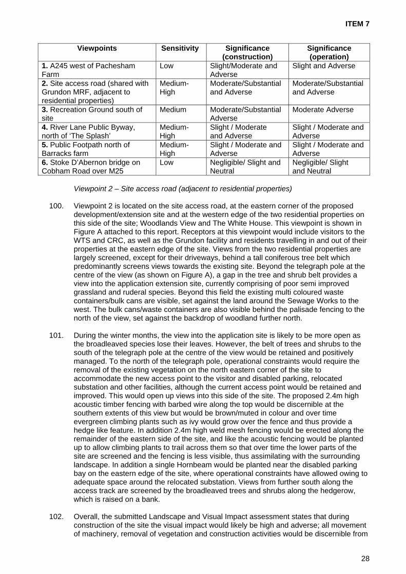
ITEM 7
Viewpoints Sensitivity
Significance (construction)
Significance (operation)
1. A245 west of Pachesham Farm
Low Slight/Moderate and Adverse
Slight and Adverse
2. Site access road (shared with Grundon MRF, adjacent to residential properties)
Medium-High
Moderate/Substantial and Adverse
Moderate/Substantial and Adverse
3. Recreation Ground south of site
Medium Moderate/Substantial Adverse
Moderate Adverse
4. River Lane Public Byway, north of ‘The Splash’
Medium-High
Slight / Moderate and Adverse
Slight / Moderate and Adverse
5. Public Footpath north of Barracks farm
Medium-High
Slight / Moderate and Adverse
Slight / Moderate and Adverse
6. Stoke D’Abernon bridge on Cobham Road over M25
Low Negligible/ Slight and Neutral
Negligible/ Slight and Neutral
Viewpoint 2 – Site access road (adjacent to residential properties) 100. Viewpoint 2 is located on the site access road, at the eastern corner of the proposed
development/extension site and at the western edge of the two residential properties on this side of the site; Woodlands View and The White House. This viewpoint is shown in Figure A attached to this report. Receptors at this viewpoint would include visitors to the WTS and CRC, as well as the Grundon facility and residents travelling in and out of their properties at the eastern edge of the site. Views from the two residential properties are largely screened, except for their driveways, behind a tall coniferous tree belt which predominantly screens views towards the existing site. Beyond the telegraph pole at the centre of the view (as shown on Figure A), a gap in the tree and shrub belt provides a view into the application extension site, currently comprising of poor semi improved grassland and ruderal species. Beyond this field the existing multi coloured waste containers/bulk cans are visible, set against the land around the Sewage Works to the west. The bulk cans/waste containers are also visible behind the palisade fencing to the north of the view, set against the backdrop of woodland further north.
101. During the winter months, the view into the application site is likely to be more open as
the broadleaved species lose their leaves. However, the belt of trees and shrubs to the south of the telegraph pole at the centre of the view would be retained and positively managed. To the north of the telegraph pole, operational constraints would require the removal of the existing vegetation on the north eastern corner of the site to accommodate the new access point to the visitor and disabled parking, relocated substation and other facilities, although the current access point would be retained and improved. This would open up views into this side of the site. The proposed 2.4m high acoustic timber fencing with barbed wire along the top would be discernible at the southern extents of this view but would be brown/muted in colour and over time evergreen climbing plants such as ivy would grow over the fence and thus provide a hedge like feature. In addition 2.4m high weld mesh fencing would be erected along the remainder of the eastern side of the site, and like the acoustic fencing would be planted up to allow climbing plants to trail across them so that over time the lower parts of the site are screened and the fencing is less visible, thus assimilating with the surrounding landscape. In addition a single Hornbeam would be planted near the disabled parking bay on the eastern edge of the site, where operational constraints have allowed owing to adequate space around the relocated substation. Views from further south along the access track are screened by the broadleaved trees and shrubs along the hedgerow, which is raised on a bank.
102. Overall, the submitted Landscape and Visual Impact assessment states that during
construction of the site the visual impact would likely be high and adverse; all movement of machinery, removal of vegetation and construction activities would be discernible from
28

ITEM 7
this viewpoint. During the long term operation of the proposed development the magnitude of change would be medium/high and adverse following the establishment of vegetation around the eastern and south eastern edges of the site along the fence lines.
Viewpoint 3 – Recreation Ground south of site
103. Viewpoint 3 is located south of the application site, at the northern edge of the recreation
Ground. Receptors at this viewpoint include visitors to the recreation ground for sporting activities as well as spectators, and users of the access track running along the northern edge of the recreation ground. This viewpoint is shown in Figure B attached to this report. The proposed extension and redevelopment of the WTS and CRC site would see the loss of much of the existing vegetation along the southern site boundary thus opening up views into the site of the proposed infrastructure, and most notably the Waste Transfer Station at the eastern edge of the site. However, a new native mixed hedgerow with hedgerow trees is proposed along the southern boundary of the site as well as a cluster of trees within the south eastern part of the site and the ‘teardrop’ shaped island within the access road to the CRC. This would help to compensate for the trees lost as part of the development, reinforce the southern boundary of the site helping it to assimilate with its surroundings, as well as visually screening the majority of the proposed development in the long term. In addition, the proposed 2.4m high acoustic fencing along the south eastern edge of the site would restrict lower level views into the site and along with the 2.4m high weld mesh fencing would be planted up with evergreen climbing plants, such as ivy to assist with screening of the lower parts of the development and to assimilate the fencing into its surroundings. Any peripheral planting would be advance planted at the start of the construction phase where possible in order to encourage early establishment. The southern half of the semi-improved grassland field would remain undeveloped beyond the application boundary.
104. From this viewpoint within the recreational ground, there would be open views of the
higher level activities; bays, buildings and lighting columns, etc in the short term whilst the hedgerow trees on the southern boundary grow, and in the longer term where higher level screening is restricted to the south east of the Waste Transfer Station. The western end of the site, and location of the proposed split level area and ramp would however be largely screened by vegetation that would remain in-situ beyond the south western corner of the application site, although the pitch of the welfare building/office and covered walkways and vehicles on the upper area may be discernible above and between existing vegetation along with lighting. It is likely that in the long term views of the WTS (and to a lesser degree the CRC infrastructure and vehicle movements) would remain discernible above fencing and vegetation and also between the latter.
Proposed Mitigation Measures 105. As referred to previously, a landscape mitigation scheme has been produced which
includes a new native hedgerow with hedgerow trees along the southern boundary of the site, and island tree planting in the south eastern corner of the site. In addition, a 2.4m high weld mesh fence would be erected around the perimeter of the site, with the exception of the south eastern boundary along which a 2.4m high timber acoustic fence would be constructed and planted up which climbing plants. The aforementioned would assist with screening the lower parts of the site. It would not be possible to screen all of the buildings in their entirety, owing to their size, however both the welfare office and weighbridge office would be constructed with brick bases, wooden clad sides and grey roof tiles, whilst the taller WTS would be in a muted grey to recede against the sky background.
106. Owing to operational constraints on site, there is limited room for planting, e.g. along the
eastern edge of the site adjacent to the proposed substation. However, a two metre wide strip of land along the majority of the southern boundary of the site has been identified to
29

ITEM 7
provide a new native mixed hedgerow of Hornbeam (Carpinus betulus) and Hawthorn (Crataegus monogyna) with the occasional hedgerow tree of Field Maple (Acer Campestre). In addition a teardrop shaped area on the south eastern edge of the site is to be planted up with a group of small leaved lime (Tilia cordata) and Field Maple (Acer campestre) and underplanted with Vinca major (Big leaf perwinkle).
107. The County Council’s Landscape Officer concurs with the applicant’s assessment that
such measures would help the application site to visually assimilate into its surroundings. Aftercare of proposed planting around the application site would ensure its long term establishment and success and the County’s Landscape Officer has recently agreed a 25 year Landscape and Ecology Management Plan (LEMP). This LEMP details planting species, phasing and management procedures and addresses the District Council’s concerns. Conclusion
108. Overall, Officers consider that there would be no significant landscape effects as the
visibility of the application site is largely restricted. Notwithstanding this, there is potential for aspects of the proposed development to be visible from the surroundings, in particular the main WTS building (of up to 12m in height), although this would be from within a localised area. Such visual impacts would subsequently reduce following the establishment of the mitigation planting secured through the agreed LEMP. The proposed development is an extension and redevelopment of an existing use, which is already characterised by similar development (sewage treatment works and MRF) and as such the impact on the openness of the Green Belt is likely to be minimal.
109. The Key Development Criteria (KDC) of the SWP 2008 Randalls Road allocation indicate
that as the site is visible from the south, particularly the land south of the sewage treatment works, a visual impact assessment should be undertaken to accompany any planning application. The applicant has complied with the requirement to undertake a visual impact assessment and the findings of this work have been considered above. With regards to the Green Belt designation, development should be located to minimise any impact on the openness of the Green Belt and Officers consider that there would be very limited impact on openness (this is further considered in the section on Green Belt later in this report). Officers do not consider that the proposal would have a significant impact on the wider landscape setting, albeit that the sensitive viewpoints noted above would experience visual impacts through the construction and operational phase. However, such impacts would lessen over time as the agreed 25 year LEMP becomes more established.
110. The Key Development Criteria state that the perimeter of the landfill provides an effective
screen to the site but is poorly restored and maintained and that this should be improved. Although this criterion is not particularly relevant to this application, Officers have nevertheless pressed for a much improved landscape scheme compared to that initially submitted and this is deemed to be an acceptable level of mitigation by the County Landscape Officer. With regards to protecting the residential amenities of the two houses close to the site entrance, in light of the concerns raised by local residents, Officers consider that this is readily achieved by the proposal, particularly since the improved access and circulation arrangements would reduce queuing and congestion along the access road in front of the two properties. Any disturbance during the construction phase and loss of outlook from the removal of trees/hedgerow at the eastern edge must be balanced against the benefits attributed to the mitigation measures to be secured via condition.
111. Viewing the proposal and its proposed mitigation, Officers do not consider that the
proposal’s landscape and visual impacts conflict with the SWP 2008 Key Development Criteria or relevant Development Plan policies such as South East Plan Policies CC1 and NE9, SWP 2008 Policy DC3 and Mole Valley Local Plan Policy ENV22 and LDF
30

ITEM 7
Core Strategy Policy CS13. Critical to such a determination is the planting to be secured as part of a 25 year Landscape and Ecology Management Plan; the length of time that the buildings and waste operations have been present at the site and therefore formed part of the local landscape; the alleviation of queuing along the access road; and the noise attenuation measures proposed.
Air Quality, Dust and Odour 112. Policy DC3 ‘General Considerations’ of the SWP 2008 states that planning applications
should assess any adverse effects on neighbouring amenity including fumes, dust, litter and odour, and identify any appropriate mitigation. Policy ENV22 of the Mole Valley Local Plan 2000 (saved policies) requires that development should not harm the amenities of the occupiers of neighbouring properties by reason of adverse environmental impact. The applicant has submitted an air quality assessment in support of this application, which describes potential impacts from both the construction and operational phases on dust, odour and vehicle emissions. The submitted assessment also considers suitable mitigation measures, which takes into account the Odour Management Plan (OMP) already submitted and agreed for the site in connection with application MO10/0673, which was approved in August 2010.
Dust sources 113. The submitted assessment sets out that the redevelopment and extension of the site
would introduce dust emissions from the demolition of existing storage bays and other site buildings; ground-works; material storage / stockpiles; preparation of concrete hard-standings; and movement of vehicles over unsealed surfaces. Regarding the operational phase of the proposal, the applicant refers to a DEFRA sponsored review of Health Impacts from Waste Management Facilities, which found that dust and air quality impacts from Waste Transfer Stations (WTS) were unlikely to be significant.
Odour sources
114. The assessment identifies that there is no potential for release of odour during the
construction phase. However, regarding the operational phase, the submitted assessment highlights that wherever bulk quantities of waste are handled there is potential for the generation of offensive odours. Typically, odour would be potentially generated as a result of the receipt and handling of wastes with a biodegradable fraction. The type of odours generated by a WTS are characteristic of ‘fresh wastes’ and therefore typically considered less offensive than older wastes in which biodegradation and the risk of anaerobic conditions is further advanced. The sources of odour from the site may potentially originate from: food waste from WTS; green waste from CRC and WTS; household waste from CRC and WTS; transport of waste to/from site; and waste deposition, handling and sorting.
115. The applicant argues that the proposed redevelopment would not introduce any
additional sources of odour above the current baseline experienced on site; with the receipt and volume of potentially odorous waste sources not increasing above current levels. The re-development of the site would however change the location of the potential sources of odour as waste delivered to site with the potential to emit odours include green waste and food waste. Food waste is currently handled to the west of the site where waste is directly tipped into containers or into bays for immediate transfer. The redevelopment of the site would involve such operations being confined in an enclosed building positioned to the eastern area of the site, therefore likely reducing the risk of odour being released to the atmosphere. Green waste, currently stored at various locations around the site would be situated in four bays to the far west of the site with two additional bays adjacent to the WTS building. All other waste would be handled in covered bulking bays towards the centre of the site, with the CRC bays located to the south and to the west of the site.
31

ITEM 7
Vehicle exhaust emissions
116. During the construction phase, it was predicted by the applicant that the numbers of
vehicle movements would be minimal and no further assessment was undertaken. Regarding the operational phase and the concerns raised by local residents, traffic associated with the proposed redevelopment is not expected to change from the existing baseline scenario with regards to traffic numbers, as the site redevelopment is principally a layout change. Traffic would enter the site via the existing access road from the A245, Randalls Road and the impact on local air quality was therefore expected by the applicant to be neutral and no further assessment was therefore undertaken. Proposed Mitigation
117. With regards to the construction phase, the assessment makes clear that due to the
proximity of sensitive receptors and prevailing wind direction, dust mitigation measures during the demolition and construction works onsite would need to be implemented. In the absence of mitigation, site preparation (soil removal, stock piling etc), use of haul roads and building construction activities would have the potential for dust generation and potential dispersion beyond the site boundary. Such emissions are common to any construction site and a Construction Environmental Management Plan (CEMP) or similar is suggested which could include the following:
• pre-site preparation: Machinery, fuel and chemical storage and dust generating
activities should not be located close to boundaries and sensitive receptors if at all possible;
• erection of effective barriers around dusty activities or the site boundary; • it is recommended that to comply with good practice, developers should ensure that
hard surfaces or paving are used for all haul routes, as required, even if routes are temporary;
• cleaning or washing all vehicles effectively before they leave a site if there is a risk of affecting nearby sensitive receptors;
• all loads entering and leaving site will be covered where practicable; use of agreed wet cleaning methods or mechanical road sweepers on all roads during periods of dry weather;
• cutting equipment to use water as suppressant or suitable local exhaust ventilation systems.
• chutes and skips: Securely cover skips and minimise drop heights to control the fall of materials; and
• no burning of any material to be permitted on site. 118. With regards to operational dust, the applicant argues that given the operation of the
existing waste transfer facility is not considered to be a significant source of dust emissions, the fact that no additional sources of dust would be introduced as a result of the proposed development above the baseline and that no issues in relation to dust emissions have been encountered at the existing facility, the mitigation measures already in place are sufficient and adequate. However, measures that are incorporated into the working scheme of the proposed development that would enhance the current dust control on site include the following:
• a reception building with rolling doors to enclose food waste operations; • covered bulking bays for general waste; • green waste bay has been moved further from receptors; and • building doors windward side of building.
119. With regards to operational odour, the applicant argues that the proposed redevelopment
of the WTS and CRC would not introduce any additional sources of odour above the
32
ITEM 7
existing situation and as such the mitigation measures within the current OMP are considered to remain sufficient. Providing the existing mitigation measures in place are continued into the proposed working scheme and continue to be effective, no further consideration is considered necessary by the applicant in relation to additional odour control. However, measures that are incorporated into the working scheme of the proposed development that would enhance the current odour control on site include the following:
• food waste is enclosed within a building with roller doors on windward side of
building; • sealed containers for direct tipping of food waste are enclosed within the building;
and • movement of green waste bays further from local residential properties.
120. The applicant concludes by stating that the impact of dust from operation of the
proposed development is considered to be negligible with no increase from the baseline situation and that providing the existing mitigation measures continue to be employed on site, there is not considered be a significant risk of dust impact at local receptors during the operational phase. In addition, the applicant considers that the proposed development is not considered to introduce any additional sources of odour and that mitigation measures for effective odour control are currently in place and are sufficient for the continued management of odour. The applicant also argues that given the designed-in control measures introduced as a result of the redevelopment, odour control would be at a higher standard than the baseline situation and therefore impacts at local receptors are likely to be negligible. There would also be continued regulation of the facility with regard to dust and odour by the Environment Agency under Permit to ensure that standards of control are maintained.
121. Officers have discussed this matter with the County’s Air Quality Consultant (CAQC) and
they agree that with the implementation of appropriate mitigation measures there should be no significant adverse air quality, dust or odour impacts from the proposed development. However, they also highlight that no matter how clear the description of the mitigation measures and unambiguous any statements of commitment made by the applicant in terms of their execution, their inclusion in a standalone assessment report does not oblige them to implement them when the development is constructed/operated. During the course of the application, the applicant to the opportunity to agree both a Dust Management Plan and Odour management Plan with the CAQC. The CAQC recommends that the implantation of these agreed Management Plans should be secured by condition.
Conclusion
122. Overall, Officers consider that the proposed development would not have any adverse effects on neighbouring amenity including fumes, dust, litter and odour, and appropriate mitigation has been identified through the agreed Dust and Odour Management Plans in accordance with Policy DC3 ‘General Considerations’ of the SWP 2008. Additionally, such mitigation measures would ensure the protection of residential amenities in accordance with the Key Development Criteria from the SWP 2008 and Mole Valley Local Plan Policy ENV22.
Noise 123. PPG24 (Planning and Noise) provides Government advice with regards to industrial and
commercial development, which can be used to assess waste development. PPG24 states that in such cases BS4142 (Method for rating industrial noise affecting mixed residential and industrial areas) would be the most appropriate guidance and where a difference in noise levels are recorded of around 10 decibels (dB) or higher, complaints
33

ITEM 7
are likely, whereas a difference of around 5 dB is of marginal significance. Paragraph 11 of PPG24 recognises that the characteristics of development may cause concern such as irregular noise or noise which has a distinguishable tone, and these factors should be considered in the determination of planning applications.
124. South East Plan 2009 Policy NRM10 states that measures to address and reduce noise
pollution would be developed through means such as locating new residential and other sensitive development away from existing sources of significant noise or away from planned new sources of noise. Surrey has produced its own ‘Guidelines for Noise Control Minerals and Waste Disposal 1994’, based on the approach in Mineral Planning Guidance Note 11 (MPG11). Mineral Planning Statement 2 (MPS2) has now superseded MPG11, but the advice in terms of noise remains consistent with MPG11 and the Surrey Guidelines. Policy DC3 ‘General Considerations’ of the 2008 Surrey Waste Plan states that planning applications should assess any adverse effects on neighbouring amenity including noise, vibration and transport impacts and identify any appropriate mitigation. Policy ENV22 of the Mole Valley Local Plan 2000 (saved policies) also provides relevant considerations, namely that development should not harm the amenities of the occupiers of neighbouring properties by reason of noise or other adverse environmental impact.
Predicted Noise
125. The noise predictions were based on peak hour vehicle movements for the site. The
noise levels were also predicted at the nearest residential receptors, with the façade that faces towards the site considered. With regards to operational noise levels, predictions were undertaken on the basis of the following operating regime:
• each private car visiting the site would have an average drop off time of four minutes; • each skip lorry visiting the site would take ten minutes to drop off and pick up a skip
(five minutes per operation); • the loading shovel has a percentage on time of 50% and spends 50% of its time
working in the yard and 50% internally within the main waste transfer building; • the excavator has a percentage on time of 50% and spends 75% of its time working
within the main waste transfer building and 25% of its time acting as a compactor in the yard;
• the main waste transfer building has an average sound reduction (RW) of 20dB; • the main access doors for the waste transfer building are located on the western
façade and so face away from the nearest residential receptors; and • any fences surrounding the site are ‘acoustically invisible’.
126. The assessment predicted that noise levels from operations would lead to a situation
between marginal significance and complaints unlikely during both the midweek and weekend periods. The assessment also identified that that predicted noise at the site would be below the limit specified in Surrey County Council’s noise guideline document of 5dB above the measured background noise level at all the locations assessed during both the midweek and weekend periods. Based on such an assessment result, mitigation measures to reduce the noise impacts generated by operations associated with the site were considered unnecessary by the applicant. Lastly, with regards to predicted noise levels from vehicle movements associated with the site, the applicant sets out that this would have a minor, barely perceptible, impact at all the locations assessed during both the midweek and weekend periods. Consequently, mitigation measures to reduce the noise impacts of vehicle movements are considered unnecessary by the applicant.
127. Despite the findings of the noise assessment undertaken, the applicant proposes a 2.4
metre high close-boarded acoustic fence along the southeastern boundary. However, it is noteworthy that predicted noise assessments were made on the basis that such an acoustic fence was not present (described above as being ‘acoustically invisible’).
34

ITEM 7
128. Even without the proposed acoustic fencing in place, the noise from the site is not predicted to create disturbance to neighbouring properties given vehicles would likely be traveling very slowly along the southeastern boundary and are likely to be rarely audible. Nevertheless, despite the limited noise attenuation benefit, Officers consider it reasonable (since it is offered by the applicant) to attach a condition to ensure the acoustic fence is erected prior to the occupation of the development.
129. The County Council’s Noise Consultant confirms that noise from the existing site is not
generally very loud but as with all CRC there are some quite distinct noises from time to time, in particular the delivery, moving and removal of the bins. In addition, the loading of bulk materials using a loading shovel makes noise that is distinctive and audible at the surrounding residential areas. With the enclosed building being used for this activity, however, the County Council’s Noise Consultant does not expect the noise of the bulk loading to be audible with the redeveloped site, which is identified as a significant benefit. A further significant benefit noted by the County Council’s Noise Consultant is the relocation of the area at the north of the site currently used for the bulk handling of recycled tins and now proposed as a staff car park, which has been a source of short lived but significant noise.
Conclusion
130. The County Council’s Noise Consultant considers that the proposal would have a beneficial effect on noise levels as the noisy activity of tipping and loading bulk materials would not now take place in the open. However, to guarantee appropriate controls in the future, the County Council’s Noise Consultant recommends that a condition be attached that noise from the operations on the site should not exceed 55 LAeq (30 minutes) when measured at, or recalculated as at, 3.5m from any noise sensitive building. Due allowance should be made for any noise that is not attributable to site operations and a 5 dBA penalty added to any noise source that exhibits unpleasant characteristics. Officers consider that such a noise limit condition is necessary to ensure the protection of the residential amenities of the neighbouring properties, in accordance with the Key Development Criteria and Policy DC3 of the SWP 2008, in addition to South East Plan Policy NRM10 and Mole Valley’s Local Plan 2000 (saved) Policy ENV22.
Geology, Soils, Groundwater - Surface Water and Flooding 131. Government guidance and policy on flooding is contained in the March 2010 revised
Planning Policy Statement 25 Development and Flood Risk (PPS25) and Planning Policy Statement 25 Development and Flood Risk Practice Guide (PPS25 Practice Guide). The aims of the planning policy on flood risk, as set out in PPS25 and the related practice guide are to ensure flood risk is taken into account in planning decisions and plan preparation; to avoid inappropriate development in areas at risk of flooding and direct development away from high flood risk; and where development is, exceptionally, necessary in high flood risk areas, make it safe without increasing flood risk elsewhere and where possible reducing flood risk overall.
132. South East Plan Policy NRM1 Sustainable Water Resources and Groundwater Quality
states that water supply and ground water would be maintained and enhanced through avoiding adverse effects of development on the water environment. South East Plan Policy NRM2 Water Quality sets out that water quality would be maintained and enhanced through avoiding adverse effects of development on the water environment. South East Plan Policy NRM4 Sustainable Flood Risk Management states that the sequential approach to development in flood risk areas as set out in PPS25 would be followed and that inappropriate development should not be allocated or permitted in flood zones 2 and 3, areas at risk of surface water flooding (critical drainage areas) or areas with a history of groundwater flooding, or where the proposal would increase flood risk elsewhere unless there is an over-riding need and absence of suitable alternatives.
35

ITEM 7
133. Policy DC3 ‘General Considerations’ of the SWP 2008 states that planning applications
should assess the contamination of ground and surface water; the drainage of the site and adjoining land and the risk of flooding; and the groundwater conditions and the hydrogeology of the locality and identify any appropriate mitigation. The Key Development Criteria for Randalls Road also state that a flood risk assessment would be required focussing upon consideration of the land identified as liable to flood and that flood mitigation measures may be required in connection with development of a new waste management facility. Lastly, Policy CS20 of the Mole Valley LDF Core Strategy DPD 2009 provides relevant considerations and states that the District Council would: “expect to see the use of appropriate sustainable drainage systems (SUDS) as part of any development proposals. A Flood Risk Assessment would be required for sites within or adjacent to areas at risk of surface water flooding as identified in the SFRA. To further reduce the risk from surface water flooding all development should work towards mimicking greenfield run-off situations.”
Proposed drainage scheme
134. The applicants have submitted a Flood Risk Assessment which sets out that based upon
the Flood Zone Maps published by the Environment Agency (EA), the site is shown to lie within Flood Zones 1 and 2, with the majority of the site within Flood Zone 1. Currently the northern half of the site is a CRC and WTS with the southern half undeveloped land. The proposed development would extend the CRC and WTS facilities across a larger developed footprint and based on information provided by the EA the site is shown to lie in Flood Zone 1. As such, the primary flood risk to the site would relate to the potential for the redevelopment to increase flood risk to neighbouring land without suitable mitigation measures being put in place. Existing surface water is currently managed via an underground pipe network with discharge to Thames Water Sewage Treatment Works and the applicant proposes to continue this arrangement limiting offsite discharge to the 100yr plus climate change Greenfield rate of runoff. The applicant states that attenuation within the drainage network would provide sufficient protection up to a 1% plus climate change annual probability flood event. To ensure sufficient capacity within the pipe network, the scheme has also been designed using oversized pipes, which have a design capacity of 400m3, which the applicant highlights as sufficient to ensure all flood waters associated with storms up to and including the 1% plus 20% climate change annual probability event would not increase flood risk downstream of the site.
135. Overall, the applicant argues that the submitted Flood Risk Assessment demonstrates
that flood risk issues at this site would be manageable and that future site occupants could be safeguarded for the lifetime of the development meaning the requirements of PPS25 would be met. The applicant also argues that the site is sustainable in terms of flood risk, subject to the proposed mitigation measures set out above.
136. Officers note that the EA has raised no objection to the proposal and the EA state that
the submitted Flood Risk Assessment has demonstrated that there would be no increase in flood risk.
137. However, the County Council’s Geotechnical Consultant (CCGC) has reviewed both the
submitted Flood Risk Assessment and proposed mitigation measures and has raised some concerns over the applicant’s submission. For example, in respect of the submitted Contamination Assessment, the CCGC highlights that it contains the following shortcomings:
• A Phase 1 desk study has not been carried out and therefore the conceptual site
model and risk assessment is based only on the ground investigation undertaken. Potential on and off site sources, pathways and receptors have not been fully identified;
36

ITEM 7
• Only 4no. soil samples of Made Ground have been tested for contamination and in the absence of identified contaminants of concern from a desk study, the suite of contaminants tested is generalised. Only one sample of Made Ground has been tested below the existing facility making up over 60% of the application area;
• Groundwater or leachability testing has not been undertaken; and • There is no ground gas monitoring.
138. The CCGC therefore recommends that the above-mentioned outstanding matters could
be dealt with by condition, requiring Phase 1 (Desk Top) and Phase 2 (intrusive) investigations and the submission of a remediation strategy (if applicable) before development commences. In response to this recommendation, the applicant argues that such further work would be unnecessary owing to the availability of other data, which the CCGC has also now considered. For example, the applicant has provided further information on ground gas monitoring though the CCGC notes that this ground gas monitoring information appears out of date and is unclear regarding the equipment calibration. As such, the CCGC remains of the opinion that such further work is necessary via Phase 1 and Phase 2 investigations and Officers concur with this approach.
139. The applicant has also sought to agree a scope of works for the investigations in
advance of any planning approval. However, the CCGC advises that agreeing the scope of an intended programme of investigation does not negate the need for appropriate pre-commencement conditions.
140. With regards to the submitted Flooding and Drainage Assessment, the CCGC highlights
that the drainage strategy (discharged directly to Thames Water Sewage Treatment Works) would provide some ‘betterment’ over the existing site drainage, which appears to be unattenuated; this approach would satisfy the requirements of PPS25. However, the CCGC also highlights that the submitted detailed calculations of the storage volume assume a constantly pumped discharge at the peak greenfield run-off whereas the design set out in the submission proposes a ‘vortex’ type flow control. Such a control would give a varying discharge and therefore the storage volume is likely to be slightly underestimated if the device is designed not to pass more than the greenfield run-off. In response to the CCGC concerns, the applicant submitted a detailed drainage design during the course of the application. This drainage scheme has now been reviewed by the CCGC, who is satisfied with the details submitted.
Conclusion 141. In light of the comments made by the County Council’s Geotechnical Consultant, the
submission of a detailed drainage design and the response from the Environment Agency, Officers consider that issues relating to the Geology, Soils, Groundwater, Surface Water and Flooding can be adequately dealt with. Officers therefore consider that the application complies with relevant national, regional and local policies such as PPS25, South East Plan Policies NRM1, NRM 2 and NRM4, SWP 2008 Policy DC3 and the Key Development Criteria for Randalls Road, in addition to Mole Valley LDF Core Strategy Policy CS20.
Ecology and Nature Conservation 142. South East Plan 2009 Policy NRM5 aims to protect and enhance the biodiversity of the
region, seeking to avoid a net loss of biodiversity, actively pursue opportunities to achieve a net gain across the region through providing the highest level of protection for internationally designated sites, to ensure that damage to county and locally important wildlife sites is avoided and that unavoidable damage to wildlife interest is minimised through mitigation and any damage is compensated for. The policy also seeks opportunities for biodiversity improvement including connection of sites, large-scale
37
ITEM 7
habitat restoration and the enhancement and re-creation in areas of strategy opportunity for biodiversity improvement.
143. Policy DC2 ‘Planning Designations’ of the SWP 2008 states that planning permission
would not be granted for waste related development where it would endanger, or have a significant adverse impact, on the character, quality, interest or setting of designated sites such as Special Protection Areas or Biodiversity Action Plan habitat and species. Policy DC3 ‘General Considerations’ of the SWP 2008 states that planning applications should assess the loss or damage to flora and fauna and their respective habitats at the site or on adjoining land and identify any appropriate mitigation. As detailed in the above section on landscape/visual amenity issues, Policy ENV22 of the Mole Valley Local Plan 2000 (saved policies) states that design and layout should respects the character and appearance of the locality; and have regard to attractive features of the site such as trees and hedges. In addition, Mole Valley LDF Core Strategy DPD 2009 Policy CS 13 states that all new development must respect and, where appropriate, enhance the character and distinctiveness of the landscape character area in which it is proposed.
Submitted Desk Top and Extended Phase 1 Habitat Survey 144. A desk study and Phase 1 habitat survey was submitted which identified baseline
ecological data for the site. The main findings of the desk study were that the site is near three designated sites protected by national legislation and eight non-statutory nature conservation sites. These sites lie outside the site boundary but within 2km of the site. In addition, the desk study provided records of protected species and species of conservation concern within close proximity to the site, including bat and bird species. During the field survey, the site was found to support scattered broadleaved trees and woodland, introduced scrub, semi-improved neutral grassland, neutral grassland/tall ruderal vegetation, tall ruderal vegetation, amenity grassland, buildings and hardstanding. A number of common birds were also found breeding on the site, which would be fully protected under the Wildlife and Countryside Act whilst breeding.
145. The submitted Phase 1 survey recommended the following measures: site clearance of
buildings and vegetation should be undertaken outside the bird breeding season; mitigation works to eradicate all rhododendron plants on site. The survey also suggest the following measures should be considered:
• The retention and incorporation of native tree and shrub species into the design of
the development; suitable species may include pedunculate oak (Quercus robur) horse chestnut (Aesculus hippocastanum), hawthorn (Crataegus monogyna), elder (Sambucus nigra) and ash (Fraxinus excelsior);
• The creation of habitats such as wildflower grasslands, in addition to acid grasslands or heath lands, given the proximity of the site to heath land, within public open space proposals;
• The creation of green walls to provide connecting habitats across the site and between habitats retained;
• Provision of nesting boxes attached to retained trees for a variety of bird species; and • Provision of bat boxes on retained trees to provide roosting opportunities for bats.
146. The submitted Survey states that the development should not have a significant effect on
the designated sites identified, the UK Biodiversity Action Plan habitat, or areas of ancient woodland identified in the desk study and that with suitable mitigation proposals the development would be compliant with the law and planning policy. Significantly, the submitted survey sets out that there is also habitat on site that is suitable for bats and reptiles, which are protected species, and that further surveys are required to determine whether these species would be affected by the development, which may require further mitigation measures.
38

ITEM 7
147. As bats are a European protected species, further surveys of bats were required before determination of this application and these have now been carried out with the results considered by Officers. Specifically, the applicant undertook a Stage 1 external/internal daytime inspection for bats in March 2011, which identified that 2no. trees proposed to be removed (T1 and T2 shown on Dwg No. LE08) have a low potential to support roosting bats and this was in addition to low potential from the building proposed to be demolished (known as Building 2). A Stage 2 further bat survey was then conducted over two periods at the start and end of May 2011, which identified that no bats were seen to emerge from or return to Building 2, T1 or T2 during the dusk emergence or dawn return roost surveys. However, common pipistrelle and soprano pipistrelle bats were recorded commuting and foraging across the site during this Stage 2 survey. Following these findings, Officers have agreed a 25 year LEMP with the applicant, which includes the provision of 3no. bird nesting boxes and 3no. bat roosting boxes on mature trees remaining at site periphery and/or edge of proposed buildings and structures. In addition, the County Ecology Officer recommends a ‘soft felling’ approach for T1 and T2 to ensure felling occurs in stages and if any holes, cracks or crevices are found, work would cease and the trees inspected and assessed for bat potential by a qualified ecologist. Officers consider this to be an adequate response to the limited presence of bats across the site.
148. In addition to further bat surveys, a reptile survey was carried out at the site in April 2011
and the results of this were submitted during the course of the application. The reptile survey identified a ‘low’ population of 9no. slow worms on the site and the County’s Ecology Officer recommends that a scheme to capture and translocate these slow worms to a suitable nearby receptor site should be agreed in writing and undertaken before development commences.
Conclusion
149. Natural England and Surrey Wildlife Trust initially raised concerns over this application, given the removal of all trees / hedgerows around the south / southeast / east of the site and the lack of bat and reptile surveys. Officers requested further bat and reptile surveys before determination of this application and the findings have now been received. Officers consider that with the revised landscape proposal secured via the agreed 25 year LEMP and recommended conditions attached to any planning permission (such as the careful translocation of reptiles found; ‘soft felling’ of T1 and T2; and provision of bat roosting and bird nesting boxes), the nature and conservation interests of the site would be adequately protected. Surrey Wildlife Trust has since welcomed the agreed LEMP being taken forward and the conditions on ecology recommended by Officers. As such, with appropriate conditions attached, Officers consider that the application would comply with relevant European and national legislation and Development Plan policies such as South East Plan Policy NRM5, Mole Valley Local Plan policy ENV22 and LDF Core Strategy Policy CS13, and Policy DC2 and DC3 of the SWP 2008.
Lighting / CCTV 150. Policy DC3 ‘General Considerations’ of the SWP 2008 states that planning applications
should assess any adverse effects on neighbouring amenity including glare and identify any appropriate mitigation. Policy ENV22 of the Mole Valley Local Plan 2000 (saved policies) also provides relevant considerations, namely that development should not harm the amenities of the occupiers of neighbouring properties by reason of adverse environmental impact.
151. A lighting scheme would be implemented to replace the existing site lighting for the
proposed layout of the CRC / WTS site as well as the new dedicated access road for third party traffic. Four different types of luminaries would be used: 6 No. 250W High Pressure Sodium Floodlights mounted on 8 m columns, 11 No. 250W High Pressure Sodium Lanterns mounted on 8 m high columns, 9 No. 26W Low Energy Fluorescent Lights would be mounted in amenity lighting bollard at the staff parking area and 37 No.
39

ITEM 7
8 Low Energy Bulkhead Lighting fixed to underside of covered walkway for members of the public. Typically, the lighting would be used in late autumn through to early spring and come on at the start and end of the shifts for the site personnel.
152. The applicant also proposes to install one 4 metre high metal pole for the installation of
one Automatic Number Plate Recognition (ANPR) camera immediately on entering the public CRC entrance. This ANPR camera would be used to record the number plates of vehicles that are using the site; the recorded information can then be used to identify frequent user for the site, which helps the applicant to ‘grey’ or ‘black’ list vehicles for any potential trader deposits at the site. In addition, a 7 metre high pole would be installed adjacent to the WTS building for four security cameras to monitor the operation activities. Another four poles of 4 metres in height for LED display boards (for both information and ANPR) are also proposed outside both the single storey welfare buildings.
153. During the course of the application, the County County’s Lighting Consultant raised
several concerns about a lack of information about the amount of light spillage that would be created from the proposed lighting. Such information is critical to assessing the impact on the residential amenities of neighbouring properties, particularly as the new CRC entrance would be positioned directly in front of the closest residential property (with two first floor windows looking directly southwest towards the new site entrance). The applicant has recently agreed a fully detailed lighting scheme with the County County’s Lighting Consultant and Officers recommend that this should be secured via a condition. Further, Officers consider that as the further ecological surveys identified only a limited potential for roosting bats and that 3no. bat roosting boxes would be secured via the agreed LEMP, any lighting impact on bats would be appropriately mitigated.
154. With regards to the proposed installation and operation of CCTV, Officers consider this
to be acceptable, particularly since the ANPR cameras can be used to identify ‘grey’ or ‘black’ listed vehicles for trader waste disposal. This has the potential to enforce control over the amount of waste received at the site and the types of vehicles using the CRC (i.e. restricting use to members of the public form surrounding districts/boroughs).
Conclusion
155. Policy DC3 ‘General Considerations’ of the SWP 2008 states that planning applications
should assess any adverse effects on neighbouring amenity including glare and identify any appropriate mitigation. The County’s lighting specialist has recently agreed a fully detailed scheme for the design of lighting and this would be secured via a condition. Officers consider this to be sufficient to deal with any light impact and the protection of residential amenity in the vicinity in accordance with the Key Development Criteria for Randalls Road form the SWP 2008.
Archaeology 156. PPS5 (March 2010) sets out national planning policies on the conservation of the historic
environment, which must be taken into account in development management decisions (where relevant). Policy DC2 ‘Planning Designations’ of the SWP 2008 states that planning permission would not be granted for waste related development where it would endanger, or have a significant adverse impact, on the character, quality, interest or setting of designated sites such as Scheduled Ancient Monuments or Sites of Archaeological Importance. Policy DC3 ‘General Considerations’ of the SWP 2008 states that planning applications should assess the loss or damage to archaeological resources and identify any appropriate mitigation. The submitted Archaeological Desk-Based Assessment forms the first stage of the archaeological scheme of work necessary to safeguard any archaeology that may be present on the site.
157. The County’s Archaeology Officer notes that within the southern half of the site, the
submitted Assessment illustrates that there is uncertainty on the history of the field, with
40
ITEM 7
the suggestion that this area was part of the former landfill site. If this is the case, and the area of the field has been subject to previous excavation to create a space for landfill, any archaeological deposits that may have been present are likely to have been destroyed as well. This would therefore mean that further archaeological work was not necessary in this area, and indeed not necessary in connection with any part of this application. If this is not the case, and there is the possibility that archaeological deposits survive here, given that they will be destroyed by the proposed development, the County’s Archaeology Officer recommends that there needs to further archaeological work within the field. This work would initially consist of an evaluation and would aim to determine, as far as is possible, the location, extent, date, character, condition, significance and quality of any archaeological deposits. Officers therefore recommend that further investigation be undertaken to clarify the situation of the field. In this instance, the County’s Archaeology Officer has no objection to the issue of the field being addressed after a decision on any planning permission, and also if it is necessary for further phases of archaeological work (the evaluation and any subsequent mitigation measures), for these to be undertaken after such a determination. To secure the provision and implementation of such work, Officer recommend an appropriate condition, which would accord with PPS5 and the relevant development plan policies.
GREEN BELT National Guidance Planning Policy Guidance note 2 (PPG2) – Green Belts South East Plan 2009 Policy SP5 Green Belts Policy W17 Location of Waste Management Facilities Surrey Waste Plan 2008 Policy CW5 Location of Waste Facilities Policy CW6 Development in the Green Belt Key Development Criteria (land at Randalls Road) Mole Valley LDF Core Strategy DPD 2009 Policy CS1 – Where Development would be Directed (A Spatial Strategy) 158. Randalls Road CRC site lies within the Metropolitan Green Belt where policies of
restraint apply. Planning Policy Guidance note 2 (PPG2) “Green Belts” sets out Government guidance with regard to development within the Green Belt stating at paragraph 1.4 that “the fundamental aim of Green Belt policy is to prevent urban sprawl through keeping land permanently open” and ensuring that development occurs in locations allocated in development plans. Paragraph 3.13 sets out further consideration with regards to the re-development of land which is located within the Green Belt for infrastructure developments or improvements, stating “when re-development of land occurs in the Green Belt, it should as far as possible contribute to the achievement of the objectives for the use of land in Green Belts”. The use of land should accord with the objectives set out in PPG2, that is, the provision to include the enhancement and retention of attractive landscapes, access to the open countryside and to secure nature conservation interests.
159. PPG2 sets out a presumption against development other than for a small range of uses
deemed to be compatible with the objectives of the Green Belt. Where a proposal does not fall within any of the categories of development, which can be considered appropriate in the Green Belt, the proposal is considered to be inappropriate development within the Green Belt and as such is “by definition, harmful to the Green Belt”. In such cases PPG2 states that “very special circumstances to justify inappropriate development would not exist unless the harm by reason of inappropriateness, and any other harm, is clearly outweighed by other considerations”. It is for the applicant to demonstrate this. Waste development does not fall within any of the uses considered to accord with the Green Belt objectives. As this proposal is for waste development it falls into the category of inappropriate development.
41

ITEM 7
160. Policy SP5 (Green Belts) of the South East Plan 2009 states that the broad extent of
Green Belts in the region would be retained and supported and that there should be opportunities taken to improve their land use management and access as part of initiatives to improve the rural urban fringe. The policy supporting text states that Green Belts should continue to be important in preventing urban sprawl and in protecting the countryside. Policy W17 (Location of Waste Management Facilities) within the South East Plan states that waste management facilities should not be precluded from the Green Belt. The policy supporting text states that it is essential that waste facilities proposed in Green Belts are assessed in light of local circumstances and national and regional policy; and that lack of suitable alternative sites and proximity to urban areas and the source of waste are important factors which may justify waste management facilities.
161. The Surrey Waste Plan 2008 Policy CW6 seeks to protect the Green Belt from
inappropriate development stating there would be a presumption against inappropriate waste related development within the Green Belt except in very special circumstances. The policy goes on to state that very special circumstances to justify inappropriate development of waste management facilities in the Green Belt would not exist unless the harm by reason of inappropriateness, and any other harm, is clearly outweighed by other considerations. The policy sets out examples of what considerations may contribute to very special circumstances including: a lack of suitable non-Green Belt sites; the need to find locations well related to the source of waste arisings; the characteristics of the site; and the wider environmental and economic benefits of sustainable waste management, including the need for a range of sites.
162. Policy CW5 (Location of Waste Facilities) of SWP 2008 is dealt with at paragraph 50
above. Mole Valley LDF Core Strategy DPD 2009 Policy CS1 states that in the countryside, development would be considered in the light of other policies within the Core Strategy and the provisions of PPG2 'Green Belts', PPS7 'Sustainable Development in Rural Areas' and Policy C4 'Landscape and Countryside Management' of the South East Plan. Regarding Mole Valley District Council’s policies relating to the Green Belt, therefore, PPG2 would be the relevant consideration.
Harm to the Green Belt and other harm 163. Harm to the Green Belt in this case is an important factor in determining the acceptability
of the application. Waste management development does not fall within any of the categories of appropriate development in PPG2 so is therefore deemed to be ‘inappropriate’ development in the Green Belt; and Officers have therefore taken account of the fact that the proposal is harmful to the Green Belt by definition. Government places substantial importance on the protection of the Green Belt from the effects of inappropriate development.
164. The proposed waste management site would not serve any of the purposes of including
land in Green Belts. Specifically, it would not assist in safeguarding the countryside from encroachment (PPG2 paragraph 1.5), as part of the site would encroach into the open countryside to the southeast of the existing site, set out in paragraph 1.6 of PPG2. The proposed waste management site would not fulfill any Green Belt objective, as set out in paragraph 1.6 of PPG2, particularly as substantial areas of mature planting would be removed to allow the development beyond the existing CRC/WTS boundaries. PPG2 (paragraph 3.15) states that the visual amenities of the Green Belt should not be injured by proposals for development within or conspicuous from the Green Belt which, although they would not prejudice the purposes of including land in Green Belts, might be visually detrimental by reason of their siting, materials or design (see also SWP 2008 Policy CW6).
42

ITEM 7
165. With regards to SWP 2008 Key Development Criterion directed at the Green Belt, this states that development should be located to minimise any impact on openness. Officers note that such a criterion has at its focus development to the southwest of the site allocation and the large open area that exists of a former landfill (Officers note that particular attention is paid to this area in the Key Development Criteria). Officers therefore consider that the proposed scale of development is limited compared with the SWP 2008 allocation (i.e. the large area allocated to the southwest of the sewage treatment works). The proposed layout, though it goes beyond the existing boundaries into an open grassed area to the southeast, focuses mainly on the existing CRC / WTS site and would principally in-fill a gap/corner of the site’s current ‘L – shaped’ making it more rectangular in layout. Officers nevertheless consider that the impact on openness of the Green Belt would be significant.
166. Additionally, part of the application site would go beyond the SWP 2008 allocation
boundary, therefore to be considered in light of the provisions of Policy CW5, though would not contain any nature conservation designations and would be within a location well served by the strategic road network being directly south of the existing site entrance. As noted earlier, only one of the 15no. trees that would be felled in this area was rated as ‘moderate’ quality with the remaining 14no. trees rated as ‘low’ quality and this is deemed to be an important factor in determining the acceptability of their removal. Officers also consider that there are clear benefits to residential amenity by alleviating queuing along the access road and that the inclusion of the overgrown verge within the new access / road alignment would be required to achieve this. Although Officers accept that there is limited space available to relocate the electricity sub-station given the constrained nature of the application site, there would be ‘harm’ to the openness of the Green Belt caused by the felling of several mature trees in this part of the site to allow for both the visitors parking area and a sub-station building (maximum height of 2.4 metres). Overall, however, Officers consider that compliance with the relevant Key Development Criterion of the SWP 2008, particularly the protection of residential amenity for neighbouring properties by virtue of alleviating queuing along the access road, should be accorded significant weight in any assessment of harm to the openness of the Green Belt.
167. In respect of impact on the visual amenities of the wider Green Belt setting (what could
be deemed ‘other harm’), Officers recognise that the proposal would create an obvious impact given substantial areas of mature planting would be lost (including tall mature trees) and built development would occur in an open field to the southeast of the existing site (approximately 05.Ha of currently undeveloped land). Significantly, a 12 metre high (to ridge) WTS facility is proposed in an area presently characterised by tall mature trees and this would constitute a large magnitude of change in this setting. It is clear from the Figure A and Figure B attached to this report that the upper parts the WTS facility would not be screened from the wider area even after the trees / hedgerow has matured along the southern boundary of the site (i.e. after 10 years). However, the visual impact of the proposed built development may be balanced against other benefits including the reduction in vehicle congestion and the control of nuisance.
168. Notwithstanding that such built development and encroachment into the Green Belt
would be inappropriate by virtue of PPG2 and be deemed ‘harmful,’ the disturbance caused to neighbouring properties by the current CRC / WTS operations must be weighed against this. As such, the visual impact (i.e. ‘other harm’) of expanding the site to the southeast with a large WTS facility and amending the parking / circulation layout, with removal of mature tall trees from both within the site and along the southern boundary, is considered to be out-weighed by the benefits of mitigating noise, dust and odour from both vehicle congestion and the outside waste transfer operations that currently takes place.
169. Officers also consider that the harm that would exist to the visual amenities of the locality
(as set out above) must also be weighed against the proposal when deciding whether
43

ITEM 7
‘very special circumstances’ exist to justify it in accordance with PPG2 and the relevant Development Plan policies, such as Policy CW6 of the SWP 2008.
Very Special Circumstances
170. The demonstration of very special circumstances is considered to be a fundamental
factor in determining the acceptability of the application given the discussion of harm above. The applicant has put forward a number of factors, which it considers amount to very special circumstances that clearly outweigh the harm to the Green Belt by reason of inappropriateness and any other harm. For the purposes of this report, the factors amounting to ‘very special circumstances’ put forward by the applicant have been grouped together under the four considerations identified in SWP 2008 Policy CW6 that may contribute to very special circumstances.
(i) the lack of suitable non-Green Belt sites
• there is a lack of alternative sites outside the Green Belt as demonstrated by the
work undertaken by the County Council in preparation of the SWP 2008; • the applicant is not aware of any suitable alternative sites lying outside of the
Green Belt for the existing waste management facility and has not been able to identify any alternative sites;
(ii) the need to find locations well related to the source of waste arisings;
• the CRC is well related to the source of waste arisings, containing a well-used civic
amenity facility and a busy recycling, storage, transfer, materials recovery and processing facility;
• the WTS would also continue to handle domestic collections, food waste and recyclable sales/purchases from the districts/boroughs of Mole Valley, Elmbridge, Epsom and Ewell, Woking, Guildford, Tandridge, in addition to local businesses. It is therefore centrally positioned to the current catchment area;
(iii) the characteristics of the site;
• the proposal relates to an existing waste management facility in the Green Belt, which has been present for a many years with an established need;
• the proposal would provide much needed improvements in terms of design, layout, safety and operational efficiency; thereby reducing both queuing and congestion around the site;
(iv) the wider environmental and economic benefits of sustainable waste management, including the need for a range of sites.
• the Landfill Directive raises the importance of Surrey assuming long term responsibility for its waste;
• there is an accepted need for the County to increase recycling and recovery capacity and the improvement of Randalls Road CRC would provide a component of Surrey achieving its ambitious targets for recycling;
• the SWP 2008 and JMWMS Review supports the provision of waste transfer and bulk and community recycling facilities like those now operating at the site;
• the proposal would not increase the amount of waste handled at the site; 171. The proposal is for inappropriate development in the Green Belt and is therefore harmful
to it by definition; and Government places substantial importance on the protection of the Green Belt from the effects of inappropriate development. The proposal would not serve any of the purposes of including land in the Green Belt and it would not fulfill any Green Belt objective. The proposal complies, however, with the relevant SWP 2008 Key Development Criterion, particularly the protection of residential amenities of neighbouring
44

ITEM 7
properties. Officers consider that very significant weight attaches to compliance with the Key Development Criterion so far as the impact on openness is concerned and the impact of the proposal on the visual amenity of the wider Green Belt would be limited.
172. However, Officers consider there are a number of factors, which together constitute very
special circumstances that clearly outweigh the harm to the Green Belt by reason of inappropriateness, harm to openness and other harm and to justify grant of planning permission. None of the factors identified in the application and listed under the four considerations above can, on its own, be considered to constitute very special circumstances and clearly outweigh the harm referred to above; but in combination they do so. These factors are: (1) the lack of alternative suitable sites in or outside of the Green Belt; (2) the close proximity of the site to the arisings of waste it would handle; (3) the characteristics and suitability of the site for the scale of waste operation given the length of time that the site has been in operation and the logistical need to improve the site design and layout to assist in reducing both queuing and congestion around the site; and (4) the need for the County to increase recycling and recovery capacity to contribute to the agreed and emerging targets.
173. Officers consider that these factors combined are such that very special circumstances
have been demonstrated as required by Surrey Waste Plan 2008 Policy CW6. Officers consider that these clearly outweigh the harm resulting from the proposal. Therefore, an exception to Green Belt policy in PPG2 and South East Plan May 2009 Policy SP5 can and should be made and planning permission be granted subject to conditions.
HUMAN RIGHTS IMPLICATIONS 174. The Human Rights Act Guidance for Interpretation, contained in the Preamble to the
Agenda is expressly incorporated into this report and must be read in conjunction with the following paragraph.
175. In this case, it is the Officer’s view that the scale of any impact is not considered
sufficient to engage Article 8 or Article 1 of Protocol 1 and any impact can be mitigated by condition. As such, this proposal is not considered to interfere with any Convention right.
CONCLUSION 176. The application site is located in the Metropolitan Green Belt and therefore planning
permission may only be granted where very special circumstances are identified which clearly outweigh the harm in terms of inappropriateness and any other harm. The proposed redevelopment of the CRC and provision of a covered WTS and bays given their scale and nature would impact on the openness of the Green Belt and would conflict with one of the purposes of including land in the Green Belt in terms of encroachment on the countryside. As the proposal as a whole would extend the boundaries of the site beyond the current area that is currently built development it is necessary to be satisfied that the additional land release is necessary and that the facility as proposed is needed and cannot be located elsewhere.
177. Officers accept that the proposal would not increase the amount of waste received and
handled at the site but that increased efficiency and segregation of recyclables at the site as a consequence of the redevelopment should improve recycling rates as required by national and regional strategies and the JMWMS. The redevelopment would enable the County to deal more effectively with the materials brought to the site for recycling and would improve health and safety. The proposal would reduce traffic congestion on the access road serving the site. There is a policy presumption for the redevelopment of Randalls Road CRC in the Surrey Waste Plan 2008, alongside the site being identified
45

ITEM 7
for improvement works within the JMWMS Action Plan as a site requiring upgrading due to site deficiencies. Officers are therefore satisfied that need and locational requires are satisfied notwithstanding the Green Belt location.
178. Whilst Randalls Road CRC has a good level of recycling, its layout and design cause
operational problems in terms of congestion caused when the site is closed for HGVs to service containers; and congestion caused by insufficient space within the site for parking and manoeuvring. Officers consider that factors exist which together amount to very special circumstances to justify development in the Green Belt in terms of need, encouraging sustainable waste management and the qualitative improvement to the range of waste facilities; and Officers consider that harm to the Green Belt has been minimised. There is evidence to demonstrate that no land is available beyond the Green Belt and it is also material that most of the application site is already in a waste use.
179. In terms of other harm, the site must satisfy environmental and amenity requirements.
Officers consider that the landscape and visual assessment demonstrates that the suitably mitigated proposal would not have a significant adverse impact on landscape character or visual amenity. The proposed development makes the provision for a revised landscape scheme, which Officers consider adequately mitigates for the loss of trees and hedgerow required for the extension of the site. With reference to the concerns raised by both Surrey Wildlife Trust & Natural England, Officers ensured that further reptile and bat surveys were completed prior to determination of this application. In addition, via the agreement of a 25 year Landscape and Ecology Management Plan; a condition to ensure no removal of trees/vegetation during bird breeding season; and the provision of both bird nesting and bat roosting boxes, Officers consider that such concerns have been overcome.
180. In terms of local concerns regarding visual amenity from the repositioned CRC access
and the removal of vegetation at the eastern margin, Officers consider that such impacts are clearly outweighed by the benefits created by alleviating queuing and reducing noise, odour and dust by enclosing currently ‘open’ waste transfer operations. Overall, there are no policy objections in relation to the impact on local amenity in terms of highways, noise or visual impact and the application is deemed to accord with the Key Development Criteria for Randalls Road contained in the SWP 2008. Where safeguards are required these can be secured through the imposition of conditions and the recommended conditions set out in this report have been assessed against the tests of Circular 11/95.
181. In conclusion, this proposal would provide for a waste management facility with a local
catchment area, to recover waste that is currently being disposed of by landfill and as such would assist Surrey in meeting targets set in national and regional strategies. The development has been found to be consistent with the policies of PPS10 and would be beneficial in terms of assisting sustainable waste management. Planning Officers consider Charlton Lane to be a suitable location for the application proposal when considered against the sequential approach of Surrey Waste Plan 2008 Policy CW5, locational guidance contained in The South East Plan May 2009, and subject to being found to accord with Surrey Waste Plan 2008 Policy CW6 Development in the Green Belt, in relation to Policies WD1 and WD2.Taking all these factors into account, Officers consider that very special circumstances exist which clearly outweigh the arm to Green Belt and any other harm, which justify planning permission being granted in this case subject to appropriate planning conditions dealing with landscape, ecological and amenity issues.
46

ITEM 7
RECOMMENDATION The recommendation is, that the application is referred to the Secretary of State as a Departure, to PERMIT subject to conditions. CONDITIONS: Plans and Drawings 1. The development hereby permitted shall be carried out in accordance with the following
approved plans: • Drawing No WP01 – Site Location Plan dated December 2010 • Drawing No WP2 – Existing Site Layout dated October 2010 • Drawing No WP3 – Existing Site Drainage dated December 2010 • Drawing No LE01 Revision 4 – Site Layout received 1 April 2011 • Drawing No LE02 Revision 2 – Site Cross Sections dated December 2010 • Drawing No LE02A Revision 2 – Welfare Office / Reuse Store Elevations dated
December 2010 • Drawing No LE02B Revision 3 – Welfare Office Elevations dated December 2010 • Drawing No LE02C Revision 3 – Waste Transfer Station Elevation dated December
2010 • Drawing No LE3A Revision F – Landscape Scheme received 6 June 2011 • Drawing No LE04 Revision 5 – Proposed Site Drainage Layout received 2 June 2011 • Drawing No LE04A Revision 1 – Typical Crate Detail received 2 June 2011 • Drawing No LE05 Revision 2 – Proposed Lighting Scheme received 2 June 2011 • Drawing No LE05 / ID Revision 2 – Proposed Lighting Scheme Isolux Diagram received
2 June 2011 • Drawing No LE06 Revision 1 – Traffic Signs & Road Markings dated December 2010 • Drawing No LE07 Revision 3 – Planning Boundary dated December 2010 • Drawing No LE08 – Tree Protection Plan dated December 2010 • Drawing No SWM/ML/2004 Revision B – Indicative Design Drawings for Gates and
Railings dated May 2008 • Drawing No PL131001 – Site Staff Shelter Specification received 14 February 2011
Reason: To ensure the permission is implemented in accordance with the terms of the
application and to enable the County Planning Authority to exercise planning control over the development so as to minimse its impact on the amenities of the local area and local environment in accordance with the terms of Surrey Waste Plan 2008 Policies DC3 and the Key Development Criteria for Randalls Road.
Commencement 2. The development hereby permitted shall begin before the expiration of three years
beginning with the date of this permission. Notice in writing shall be given to the County Planning Authority within seven days of the relevant date.
Reason: To accord with the provisions of Section 91 (1) of the Town and Country Planning
Act 1990 as amended by Section 51 (1) of the Planning and Compulsory Purchase Act 2004 and to enable the County Planning Authority to control the development and monitor the site to ensure compliance with the planning permission.
Noise 3. The development hereby permitted shall not be occupied until the acoustic fence has
been constructed in accordance with drawing no. LE01 Rev 4 received 1 April 2011. The
47

ITEM 7
acoustic fence should be constructed using close-boarded fencing or similar solid screen having a minimum mass of 10kg/m2.
Reason: To ensure the minimum disturbance and avoid nuisance to the locality and in the
interests of local amenity and to comply with South East Plan Policy NRM10, Surrey Waste Plan 2008 Policy DC3 and the Key Development Criteria for Randalls Road, in addition to Mole Valley Local Plan Policy ENV22.
4. The level of operational noise emitted from the site shall not exceed 55 LAeq during any
30 minute period when measured at, or recalculated as at, 3.5m from any noise sensitive building. A 5 dBA penalty shall be added to any noise source that exhibits unpleasant characteristics. Care should be taken to ensure that noise not attributable to site operations is taken into account and excluded from any assessment.
Reason: To ensure the minimum disturbance and avoid nuisance to the locality and in the
interests of local amenity and to comply with South East Plan Policy NRM10, Surrey Waste Plan 2008 Policy DC3 and the Key Development Criteria for Randalls Road, in addition to Mole Valley Local Plan Policy ENV22.
Revised Access 5. The development hereby permitted shall not be occupied unless the access roads;
entrances; internal access roads; and parking, loading and unloading areas have been constructed as shown on drawing LE01 Rev 4 received 1 April 2011. Those roads and areas shall be permanently maintained for the purposes shown on that drawing.
Reason: In order that the development should not prejudice highway safety nor cause
inconvenience to other highway users to comply with South East Plan 2009 Policy T1, Surrey Waste Plan 2008 Policy DC3 and the Key Development Criteria for Randalls Road, in addition to Mole Valley LDF Core Strategy Policy CS18
Construction Environmental Management Plan (CEMP) 6. Construction of the development hereby permitted, including the demolition of the
existing buildings, shall not commence until a Construction Environmental Management Plan (CEMP), has been submitted to and approved in writing by the County Planning Authority. The CEMP shall include details of:
a. noise mitigation measures; b. dust mitigation measures; c. details to minimise the tracking of mud / soil off the site; d. parking for vehicles of site personnel, operatives and visitors; e. loading and unloading of plant and materials; f. storage of plant and materials; g. programme of works (including measures for traffic management); h. details of access to the CRC for the public and waste vehicles; and i. details of redirection for CRC users to the closest facilities during any site
closure. Reason: In order that the development should not prejudice highway safety nor cause
Inconvenience to other highway users in accordance with Planning Policy Guidance note 13 (PPG13) and in the interests of local amenity and to comply with South East Plan Policy NRM10, Surrey Waste Plan 2008 Policy DC3 and the Key Development Criteria for Randalls Road, in addition to Mole Valley Local Plan Policy ENV22.
Dust Management Plan
48

ITEM 7
7. The Dust Management Plan Version 1 dated May 2011 and received on 7 June 2011, shall be implemented strictly in accordance with the approved details contained therein.
Reason: To enable the County Planning Authority to exercise control over the
development and in the interests of the local environment and amenity in accordance with Surrey Waste Plan 2008 Policy DC3 and the Key Development Criteria for Randalls Road, in addition to Mole Valley Local Plan Policy ENV22.
Odour Management Plan 8. The Odour Management Plan Version 2.1 received on 3 June 2011, shall be
implemented strictly in accordance with the approved details contained therein. Reason: To enable the County Planning Authority to exercise control over the
development and in the interests of the local environment and amenity in accordance with Surrey Waste Plan 2008 Policy DC3 and the Key Development Criteria for Randalls Road, in addition to Mole Valley Local Plan Policy ENV22.
Contamination 9. A scheme to deal with the risks associated with ground contamination of the site shall be
submitted to and approved in writing by the County Planning Authority. Any changes to this scheme shall require the express consent in writing of the County Planning Authority. Items a) to e) of the scheme shall be implemented as approved prior to the commencement of any other form of development. It should be conducted in accordance with DEFRA and the Environment Agency's Model Procedures for the Management of Land Contamination, CLR 11. It shall contain the following components:
a). A preliminary risk assessment which has identified:
- all previous historical land uses; - potential contaminants associated with those uses; - a conceptual model of the site indicating sources, pathways and receptors;
and - potentially unacceptable risks arising from contamination at the site.
And if applicable following submission of the preliminary risk assessment to the County Planning Authority:
b). A ground investigation scheme, based on (a) to provide information for a detailed assessment of the risk to all receptors that may be affected, including those off site.
c) A detailed contamination risk assessment.
d). An options appraisal and remediation strategy based on the site investigation
results (b) and the detailed risk assessment (c), which shall provide full details of the remediation measures required and how they are to be undertaken.
e). A verification plan providing details of the data that will be collected in order to
demonstrate that the works set out in (d) are complete and to identify any requirements for longer-term monitoring of pollutant linkages, maintenance and arrangements for contingency action.
Within 1 month of completion of any remediation work, a verification report shall be submitted to the County Planning Authority for approval in writing.
Reason: To ensure that the development poses no risk to groundwater as a result of it
being sited on historically contaminated land to accord with PPS23, PPS25,
49

ITEM 7
South East Plan Policies NRM1, NRM 2 and NRM4, SWP 2008 Policy DC3 and the Key Development Criteria for Randalls Road, in addition to Mole Valley LDF Core Strategy Policy CS20.
10. If, during construction works on any part of the site, land contamination is discovered
which has not been previously identified, then no further development (unless otherwise agreed in writing with the County Planning Authority) shall be carried out in that part of the site until the developer has submitted, and obtained written approval from the County Planning Authority for, an amendment to the remediation strategy detailing how this previously uninvestigated contamination shall be dealt with.
Reason: To ensure that the development poses no risk to groundwater as a result of it
being sited on historically contaminated land to accord with PPS23, PPS25, South East Plan Policies NRM1, NRM 2 and NRM4, SWP 2008 Policy DC3 and the Key Development Criteria for Randalls Road, in addition to Mole Valley LDF Core Strategy Policy CS20.
Drainage 11. The drainage design dated May 2011 and received on 2 June 2011, as shown on
drawings LE04 Revision 5 and LE04A Revision 1; and Windes Drainage Analysis Output: Appendix A, Appendix B, Appendix C & Appendix D, shall be implemented strictly in accordance with the approved details contained therein.
Reason: To prevent flooding by ensuring the satisfactory storage of/disposal of surface
water from the site to comply with PPS25, South East Plan Policies NRM1, NRM 2 and NRM4, SWP 2008 Policy DC3 and the Key Development Criteria for Randalls Road, in addition to Mole Valley LDF Core Strategy Policy CS20.
Landscape and Ecology Management Plan 12. The 25 year Landscape and Ecology Management Plan dated May 2011 and
received on 6 June 2011 (as shown on Drawing No. LE03A Revision F) shall be implemented strictly in accordance with the approved details contained therein.
Reason: To enhance nature conservation interest and assist in absorbing the site into the
local landscape to accord with South East Plan Policies CC1 and NE9, Surrey Waste Plan 2008 Policies DC2 and DC3 and the Key Development Criteria for Randalls Road, Mole Valley’s Local Plan Policy ENV22 and LDF Core Strategy Policy CS13.
Ecology 13. The development hereby permitted shall not commence unless a programme of capture
and translocation of all slow worms (as detailed in Reptile Survey dated received on 6 May 2011) to a suitable local receptor site has been submitted to and agreed in writing by the County Planning Authority. The programme shall include the following measures:
• Capture should generally be undertaken during the Spring and early Autumn,
avoiding periods of frost and the hotter months of July and August; and • Capture and translocation effort should be restricted to periods of appropriate
weather conditions with animals released the same day. Reason: To ensure proper consideration of the impact of the development on the
contribution of nature conservation interests to the amenity of the area, to provide a sound basis for preparation of the Landscape and Ecological Management Plan and to comply with both the Wildlife and Countryside Act (Amended) 1991), Natural England’s Standing Advice (South East Plan Policy NRM5, Mole Valley
50

ITEM 7
Local Plan policy ENV22 and LDF Core Strategy Policy CS13, and Policy DC2 and DC3 of the SWP 2008.
14. No removal or cutting of vegetation including trees and shrubs shall be carried out
between 1 March and 31 August inclusive in any year. Reason: To ensure that breeding birds are not disturbed by the removal of habitat in
accordance with South East Plan Policy NRM5, Mole Valley Local Plan policy ENV22 and LDF Core Strategy Policy CS13, and Policy DC2 and DC3 of the SWP 2008.
15. The trees shown as T1 and T2 on Drawing No. LE08 (dated December 2008) shall be
felled in stages and if any holes, cracks or crevices are found, work shall cease and the trees inspected and assessed for bat potential by a qualified ecologist. The results of this inspection and assessment shall then be submitted to the County Planning Authority. If bats are found to be roosting in the trees, work shall not recommence until a strategy has been submitted to and agreed in writing by the County Planning Authority. Any further work shall be implemented strictly in accordance with the approved details therein.
Reason: The Stage 1 Inspection Report dated April 2011 and received on 6 June 2011
identified that the 2no. trees could potentially provide roosting opportunities for bats and the careful felling of trees named T1 and T2 (as shown on Drawing No. LE08) would be necessary to identify the presence of any bats, in order to comply with South East Plan Policy NRM5, Mole Valley Local Plan policy ENV22 and LDF Core Strategy Policy CS13, and Policy DC2 and DC3 of the SWP 2008.
Lighting 16. The lighting scheme dated 31 May 2011 and received on 2 June 2011, as shown
on Dwg No. LE05 Revision 2 and Dwg No. LE05ID Revision 2, shall be implemented strictly in accordance with the approved details contained therein.
Reason: In the interests of local amenity and to comply with South East Plan Policy NRM5,
Mole Valley Local Plan policy ENV22 and LDF Core Strategy Policy CS13, and Policy DC2, Policy DC3 and the Key Development Criteria for Randalls Road of the Surrey Waste Plan 2008.
Archaeology 17. The development hereby permitted shall not commence unless a Written Scheme of
Investigation has been submitted to and approved in writing by the County Planning Authority. The Written Scheme of Investigation shall be implemented strictly in accordance with the approved details.
Reason: To afford the County Planning Authority a reasonable opportunity to examine any
remains of archaeological interest which are unearthed and decide on any action required for the preservation or recording of such remains in accordance with the terms of Surrey Waste Plan 2008 Policy DC2 and Policy DC3.
51

ITEM 7
THE TOWN AND COUNTRY PLANNING (DEVELOPMENT MANAGEMENT PROCEDURE) (ENGLAND) ORDER 2010 Reasons for the grant of planning permission and development plan policies/proposals relevant to the decision. The reasons for the grant of planning permission are as follows: The Council has considered the impacts of the proposed development in terms of: highways, traffic and access; and environmental and amenity including air quality, dust and odour, landscape and visual amenity, noise, soils, geology and hydrogeology, surface waters and flood risk, ecology and nature conservation, lighting and archaeology. It has concluded that in each of these respects the impacts are such that the proposed development is in accordance with the policies and provisions of the development plan as listed below. The proposed development is for inappropriate development and would not serve any of the purposes of including land in the Green Belt or a Green Belt objective. The impact of the proposed development on openness compared to what currently occurs would be limited, and the impact on openness of the removal of trees and hedgerows around the site is discounted by substantial compliance with the relevant SWP 2008 Key Development Criterion. The impact of the proposal on the visual amenity of the Green Belt would be limited. And there would remain visual impacts on neighbouring properties notwithstanding their reduction by mitigation measures. As against those matters, it has been demonstrated that: there is a lack of alternative suitable sites for the development proposed in or outside of the Green Belt; there is and will remain a need for the County to increase recycling and recovery capacity to contribute to the agreed and emerging targets; the site is in close proximity to the arisings of waste it would continue to handle; the characteristics of the site are such that it is suitable for the scale of waste operation proposed having regard in particular to the length of time that the site has been in operation and the logistical need to improve the site design and layout to assist in reducing both queuing and congestion around the site; and suitable landscape mitigation has been identified (to be managed and protected). These latter factors combined are such that very special circumstances have been demonstrated as required by Surrey Waste Plan 2008 Policy CW6. They clearly out-weigh the harm resulting from the proposed development. Therefore, an exception to Green Belt policy in PPG2 and South East Plan May 2009 Policy SP5 has been justified.
Planning permission has therefore been granted subject to conditions. The proposal has been considered against the following development plan policies / provisions: The South East Plan May 2009 Policy W3 - Regional Self Sufficiency Policy W4 - Sub-Regional Self Sufficiency Policy W5 - Targets for Diversion from Landfill Policy W6 - Recycling and Composting Policy W7 - Waste Management Capacity Requirements Policy W17 - Location of Waste Management Facilities Policy CC7 - Infrastructure and Implementation Policy CC1 - Sustainable Development Policy NE9 – Trees within Development Proposals Policy NRM1 - Sustainable Water Resources and Groundwater Quality Policy NRM2 - Water Quality Policy NRM4 - Sustainable Flood Risk Management Policy NRM5 - Conservation and Improvement of Biodiversity Policy NRM10 - Noise
52

ITEM 7
Policy SP5 - Green Belts Policy T1 - Manage and Invest
Surrey Waste Plan 2008 Policy CW4 - Waste Management Capacity Policy CW5 - Location of Waste Facilities Policy CW6 - Development in the Green Belt Policy WD1 - Civic Amenity Sites Policy WD2 - Recycling, Storage, Transfer, Materials Recovery and Processing Facilities (Excluding Thermal Treatment) Policy DC2 - Planning Designations Policy DC3 - General Considerations Key Development Criteria (Randalls Road) Mole Valley Local Plan 2000 (saved policies) Policy ENV22 – General Development Criteria Mole Valley Core Strategy Development Plan Document Policy CS1 – Where Development would be Directed (A Spatial Strategy) Policy CS13 – Landscape Character Policy CS18 – Transport Options and Accessibility Policy CS20 – Flood Risk Management CONTACT Mark O’Hare TEL. NO. 020 8541 7534 BACKGROUND PAPERS The deposited application documents and plans, including those amending or clarifying the proposal, responses to consultations and representations received as referred to in the report and included in the application file and the following: Government Guidance Waste Strategy for England 2007 Planning Policy Guidance Note 2 Green Belts - Revised January 1995 (PPG2) Planning Policy Statement 9 (PPS9) Biodiversity and Geological Conservation - August 2005 Planning Policy Statement 10 (PPS10) Planning for Sustainable Waste Management Planning Policy Guidance Note 13: Transport (as amended 3 January 2011) Planning Policy Statement 23 – Planning and Pollution Control Planning Policy Guidance Note 24 – Planning and Noise Planning Policy Statement 25 Development and Flood Risk (PPS25) Planning Policy Statement 25 Development and Flood Risk Practice Guide (PPS25 Practice Guide) Circular 11/95 - The Use of Conditions in Planning Permissions The Development Plan The South East Plan May 2009 Surrey Waste Plan 2008 Mole Valley Local Plan 2000 (Saved Policies) Mole Valley Core Strategy Development Plan Document 2009 Other Documents UK Biodiversity Action Plan 1994 Wildlife and Countryside Act (Amended) 1991 Geographical locations of visitors to the Leatherhead CRC site (MEL study dated 2007)
53

ITEM 7
Joint Municipal Waste Strategy 2006 - 2025, 26 September 2006 (Surrey Local Government Association) A Plan for Waste Management (Joint Municipal Waste Strategy) September 2010 (Surrey Waste Partnership) Cala Homes (South) Limited V Secretary of State for Communities & Local Government [2010] EWHC 2866 (Admin). Judgment dated 10 November 2010 Cala Homes (South) Limited V Secretary of State for Communities & Local Government [2011] EWHC 97 (Admin). Judgment dated 7 February 2011 R (Cala Homes (South) Limited) v Secretary of State for Communities & Local Government (No. 2). Judgment dated 27 May 2011 Planning appeal decision dated 8 March 2010 granting planning permission for an ADF at Wisley Airfield (APP/B3600/A/09/2098568) Designing Waste Facilities: A guide to modern design in waste (DEFRA 2008). 2006 Directive of the European Parliament and of the Council on waste (2006/12/EC) The Landfill (England and Wales) Regulations 2002
54