Embed Size (px)
Citation preview

Iterative Reconstruction of Ptolemy’s West Africa Using
a GIS
Dmitri A. GusevAdjunct Assistant Professor
SUNY Brockport
Co-authors: Sergey K. Stafeyev,Lyudmila M. Filatova

Ptolemy’s “Geography”
The book provides coordinates of 8000+ ancient objects (cities, mountains, rivers, lakes, capes, bays) in Ptolemy’s coordinate system, along with additional information (object descriptions, tribe names). 950+ of Ptolemy’s data points are in Africa.
∆Fragment of Ptolemy’s first map of Africa by Donnus Nicolaus Germanus (c. 1460)

Objectives of Our StudyReconstruct Ptolemy’s West Africa as precisely as possibleRealistically estimate the chances of successful localization and discovery of the lost ancient cities known to Ptolemy

Problems with Ptolemy’s DataPtolemy’s coordinate system differs from the modern one. Noise and distortions.Many names of the objects changed over time.A few ancient cities were ruined, abandoned and lost. Others were built over.Ptolemy’s data set is a compilation, so it contains some redundant duplicates. For example, Ptolemy’s Sabathra and Sabrata are one and the same city (Sabratah, Libya).But geographic names can also be duplicated naturally, due to migration of people and similarity of the objects named.Climate changes invalidated some old descriptions. Some tribes migrated, others were assimilated, etc.
Ruins of Sabratah
∆ This picture was captured using Google Earth

Tabula Peutingeriana (fragment)

Portolan by Mateus Prunes (XVI c.), fragment

Recent Ptolemaic Reconstructions
A. Strang, “The Analysis of Ptolemy’s Geography” (1998): Great Britain and Ireland only, final map in Ptolemy’s projectionW.F.G. Lacroix, “Africa in Antiquity: A Linguistic and Toponymic Analysis of Ptolemy’s map of Africa, Together With a Discussion of Ophir, Punt and Hanno’s Voyage” (1998)J.L. Berggren and A. Jones, “Ptolemy’s Geography” (2000): Gallia only, table almost complete, map in Ptolemy’s coordinatesM. Manoledakis, E. Livieratos, “On the digital placement of Aegae, the first capital of ancient Macedonia, according to Ptolemy's Geographia” (2007)

Step 1. Initial mapping of Ptolemy’s data points onto a modern map in a GIS
Using a geographic information system (GIS), S.K. Stafeyev and L.M. Filatova produced an initial mapping of Ptolemy’s points onto a modern map of Africa. Many objects in West Africa (Solis mountains, Hercules promontory, Salathus river, etc.) proved difficult to localize this way. The next steps allowed to improve the reconstruction.
∆This fragment of the initial map was made in ArcView 3.1

Step 2. Extrapolation-Interpolation Based on a Limited Number of Reference Points
Based on 25 reference points located in Morocco, we built a 2D linear regression to compute
LongitudeModern=a0+a1*LongitudePtolemy+a2*LatitudePtolemy ,LatitudeModern =b0+b1*LongitudePtolemy+b2*LatitudePtolemy .

Step 3. Division of the Data Points into Four Groups
From the writings of Herodotus, Hanno and Pliny the Elder we concluded that Ptolemy’s Cotes promontory, Solis mountains, and Soloentia promontory are one and the same object, namely, Cap Spartel.
0
5
10
15
20
25
0 10 20 30 40
(latitude_1 + latitude_2)/2, Ptolemy's degrees
latit
ude_
2 - l
atitu
de_1
, Pt
olem
y's
degr
ees
Group Solis - GroupCotesGroup Soloentia - GroupCotes
We divided Ptolemy’s data points for West Africa into 4 groups (Group Cotes, Group Solis, Group Soloentia, and Group Niger). The latitude data for the pairs of likely duplicates was plotted as shown on the right.
∆

Step 4. Separate Extrapolation-Interpolation for Groups Cotes and Solis
Now Ganaria promontory (Group Cotes) will point at Canaria island (Group Solis), the distance between two Junonia islands (Junonia Minor and Junonia Major of Pliny the Elder) is reduced appropriately (Ptolemy’s difference of latitudes is 8°35’ for them), etc.

Step 5. Classification of Data Points According to Quality of Localization
All data points are classified into four categories:1) Known with certainty2) Tentatively identified3) Localized approximately4) Likely duplicates

Approximate Localization (performed at Step 5)
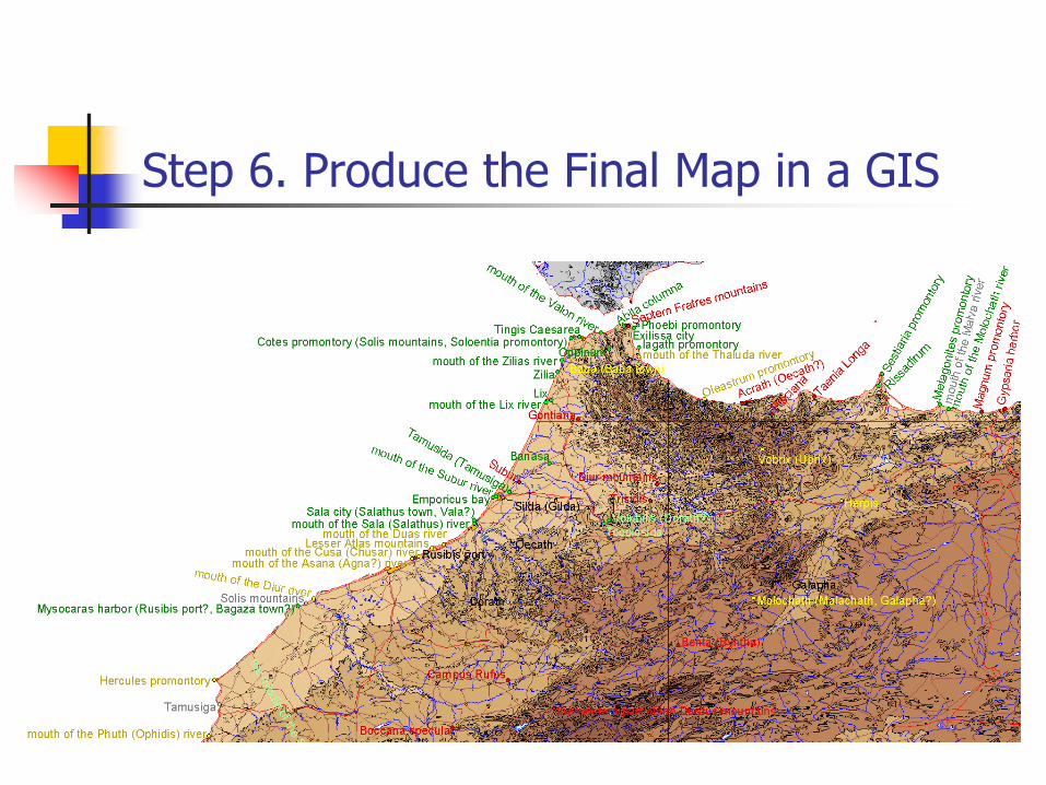
Step 6. Produce the Final Map in a GIS
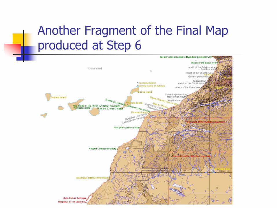
Another Fragment of the Final Map produced at Step 6

Mount Teide (Ptolemy’s Zero Longitude Mark)
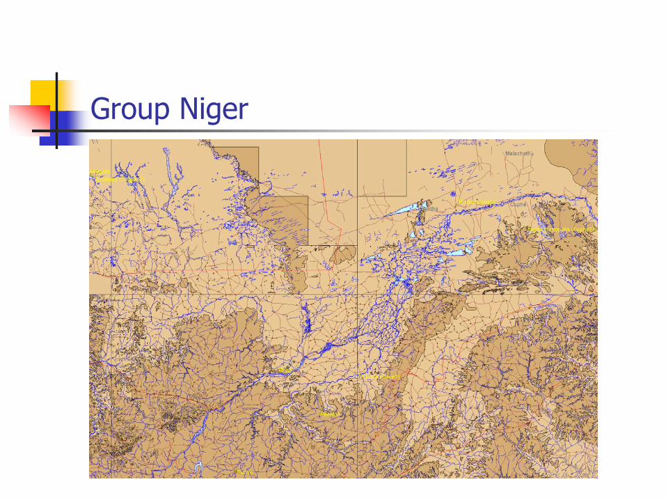
Group Niger

ConclusionsWe produced an improved reconstruction of Ptolemy’s West AfricaLocalization of the lost ancient cities can be further improved a) by studying aerial and space photographs of
the regions of approximate localization, and b) by archaeological work

Libyan Port?

Future WorkHelp locate lost ancient cities throughout the rest of the world known to PtolemyStudy Ptolemy’s precision for different areasContinue development of the reconstruction methods
Kerkennah