Embed Size (px)
Citation preview

N S W D P I
Quarterly Notes G e olo gic al Sur vey of New S o u th Wale s
Januar y 2006 No 119
Gary Burton
Senior Geologist
Geological Survey of New South Wales, NSW Department of Primary Industries
In 2004 the former Department of Mineral Resources was incorporated into the Department of Primary Industries (DPI). We apologise for delays in
producing publications while completing our restructure and relocation. Quarterly Notes are once again being produced on schedule.
Simone Meakin Geological Survey Editor
Papers in Quarterly Notes are subject to external review. External reviewer for this issue was Paul Ashley. His assistance is appreciated.
Quarterly Notes is published to give wide circulation to results of studies in the Geological Survey of New South Wales. Papers are also welcome that arise from team studies with external researchers. Contact: [email protected]
ISSN 0155-3410
AUTHOR
The Willyama Supergroup in the Nardoo and Mount Woowoolahra Inliers ABSTRACT The Nardoo and Mount Woowoolahra Inliers are 100 km north and 90 km north-northwest, respectively, of Broken Hill, in far western New South Wales. Both inliers contain rocks which belong to the Palaeoproterozoic Willyama Supergroup. Geological mapping of the inliers shows that they both contain graphitic to non-graphitic psammitic, psammopelitic and pelitic metasediments. The Nardoo Inlier contains a significant amount of pegmatite and intermixed pegmatite and granitoid while Mundi Mundi type granite is common in the Mount Woowoolahra Inlier. Structural fabrics and metamorphic mineral assemblages within the inliers are consistent with those observed in the nearby Broken Hill and Euriowie Blocks. The metasediments are considered to form part of the Paragon Group. However, it is not clear if they can be correlated with other occurrences of the Paragon Group in the Broken Hill and Euriowie Blocks, or whether they are a separate (stratigraphically higher) part of the Paragon Group. The recent finding that the Paragon Group in the Broken Hill Block is a time equivalent of stratigraphic units which host significant Pb–Zn deposits in the Mount Isa Inlier in Queensland, increases the prospectivity of the Paragon Group. Understanding its distribution and characteristics has, hence, become important.
Keywords: Nardoo Inlier, Mount Woowoolahra Inlier, Paragon Group, Willyama Supergroup, Broken Hill, lead–zinc–silver mineralisation, prospectivity
INTRODUCTION The Nardoo and Mount Woowoolahra Inliers are 100 km north and 90 km north-northwest, respectively, of Broken Hill, in far western New South Wales (Figure 1). Both inliers contain rocks belonging to the Palaeoproterozoic (Statherian) (Plumb 1992) Willyama Supergroup and are surrounded by Adelaidean cover rocks.
The geological mapping of Cooper et al. (1975) has been, until now, the best available for showing the distribution of Willyama Supergroup exposure in the areas of the Nardoo and Mount Woowoolahra Inliers. Their mapping, however, did not differentiate the constituent rocks within the inliers. The aim of this paper is to describe the rock types which occur within both inliers. The work is based on mapping carried out in 1997, as part of the Broken Hill Mapping Project undertaken by the Geological Survey of New South Wales.
Both inliers were mapped at 1:25 000 scale using enlargements of originally 1:60 000 scale Land and Property Information (NSW Department of Lands) black and white aerial photographs, which had been taken in 1965. The geological mapping is lithological in nature, being consistent with the style adopted by Stevens and Willis (1983) for mapping the Willyama Supergroup rocks of the Broken Hill Block and Euriowie Block. The mapping of Cooper et al. (1975) was used as a guide. All coordinates in this paper refer to AMG Zone 54, AGD 66 and all azimuths are with respect to true north.

� January 2006
GEOLOGICAL HISTORY OF THE WILLYAMA SUPERGROUP AND ADELAIDEAN ROCKS IN WESTERN NEW SOUTH WALES An account of the regional geological history is summarised here to place the geology of the Nardoo and Mount Woowoolahra Inliers into a regional context.
The Willyama Supergroup in the Broken Hill and Euriowie Blocks in western New South Wales is interpreted as having been deposited within a deepening intracratonic rift (Willis, Brown et al. 1983; Stevens et al. 1988) between approximately 1710 Ma and 1640 Ma (Page, Stevens et al. 2000). Figure 2 illustrates the stratigraphic column of the Willyama Supergroup as constructed by the Geological Survey of New South Wales. The Thackaringa Group and equivalents and lower units are interpreted to have been deposited in a subaerial/fluvial to evaporitic environment (Stevens et al. 1988). The Alma and Rasp Ridge Gneisses are interpreted as having been emplaced as granitic sills at 1704±3 Ma and 1682±3 Ma respectively (Page, Stevens et al. 2000; Stevens & Barron 2002). The Broken Hill Group, which hosts the Broken Hill Main Lode, is interpreted to have formed within a shallow marine environment (Stevens et al. 1988) and is characterised by the presence of quartzofeldspathic gneiss, some calc silicate rocks and such lode rocks as quartz–gahnite and garnet–quartzite. Basic gneisses within the Broken Hill Group and lower stratigraphic units have been interpreted as representing doleritic sills and dykes (Stevens & Barron 2002). The Sundown Group represents deepwater turbiditic sedimentation (Stevens et al. 1988) and the Paragon Group was interpreted as a deepwater turbidite sequence by Willis, Brown et al. (1983) — though the Cartwrights Creek Metasediments and the Bijerkerno Metasediments may be shallow marine deposits (Stevens et al. 1988). The Paragon Group in the Broken Hill and Euriowie Blocks is characterised by graphitic pelitic schists and fine-grained psammites which tend to be rich in albite (Stevens et al. 1988). The King Gunnia Calc-silicate Member, a distinctive graphitic calcsilicate unit, is present in the upper part of the Cartwrights Creek Metasediments.
The Willyama Supergroup was metamorphosed during the Olarian Orogeny at approximately 1600 Ma (eg, Page & Laing 1993; Page, Stevens et al. 2000). During this event the lower parts of the sequence reached granulite facies (sillimanite+Kfeldspar assemblages in metasediments and two-pyroxene assemblages in mafic rocks), while Paragon Group rocks reached amphibolite facies and commonly contain andalusite/ chiastolite (Phillips 1980; Stevens et al. 1988).
Marjoribanks et al. (1980) described the structural fabric of the central part of the Broken Hill Block. The following account is based on that work, which probably applies to the entire Willyama Supergroup in western New South Wales.
CONTENTS
ABSTRACT 1
INTRODUCTION 1
GEOLOGICAL HISTORY OF THE WILLYAMA SUPERGROUP AND ADELAIDEAN ROCKS IN WESTERN NEW SOUTH WALES 2
THE NARDOO INLIER 5
Mapped rock units 5
Stratigraphy 8
Structure 8
Alteration 8
Adelaidean rocks 8
THE MOUNT WOOWOOLAHRA INLIER 9
Mapped rock units 9
Stratigraphy 9
Structure 12
Alteration 12
Exploration pits 12
Adelaidean rocks 12
PROSPECTIVITY OF THE PARAGON GROUP 12
SPATIAL RELATIONSHIP BETWEEN THE WILLYAMA SUPERGROUP AND ADELAIDEAN ROCKS AND POSSIBLE EXTENT OF PARAGON GROUP BENEATH ADELAIDEAN COVER 14
CONCLUSIONS 14
ACKNOWLEDGMENTS 15
REFERENCES 15
Editor: Richard Facer Geological Survey editor: Simone Meakin Geospatial information: Cheryl Hormann Design: Nicole Irvine Layout: Simone Madigan
The information contained in this publication is based on knowledge and understanding at the time of writing (December 2005). However, because of advances in knowledge, users are reminded of the need to ensure that information upon which they rely is up to date and to check currency of the information with the appropriate officer of New South Wales Department of Primary Industries or the user’s independent adviser.

�Quarterly Notes
Figure 1 Location of the Nardoo and Mount Woowoolahra Inliers and simplified regional geology (modified from Cooper et al. 1975).
Sydney
Bourke
CobarDubbo
Canberra
Broken Hill
ACT
2004_12_0099.ai
Broken Hill
Cainozoic
Palaeozoic
Adelaidean
Mundi Mundi type granite
Willyama Supergroup
Broken Hill Block
Euriowie Block
0 25 km
0 10 km
REFERENCE
Figure 5
Figure 4 NardooInlier
Woowoolahra Trigonometric
Station
MountWoowoolahra
Inlier
N
New South Wales

� January 2006
Figure 2 Stratigraphic subdivision of the Willyama Supergroup within the Broken Hill and Euriowie Blocks as established by
the Geological Survey of New South Wales. Geochronology from Page, Stevens et al. (2000), Stevens (2000) and Page et al.
(2005). Modified from Stevens and Barron (2002).
2004_12_0096
REDAN SUB-BLOCK
Ettlewood Calc-silicate Member
Hores Gneiss1686 + 31689 + 5
King Gunnia Calc-silicate Member
THA
CK
AR
ING
A G
RO
UP
BR
OK
EN
HIL
L G
RO
UP
Age in million years1704
Redan Gneiss
Ednas Gneiss
Mulculca Formation
Farmcote Gneiss>1704 + 3<1705 + 5
Clevedale Migmatite
Thorndale Composite Gneiss
Alma Gneiss1704 + 3
Himalaya Formation<1710 to 1700
>1690 + 11
Allendale Metasediments<1691 + 3
Parnell Formation1693 + 5, >1676 + 7
Freyers Metasediments<1780
Silver KingFormation
SUNDOWN GROUP<1670 to 1680
Cartwrights CreekMetasediments
Bijerkerno Metasediments<1656 + 5, <1657 + 4
Dalnit Bore Metasediments<1642 + 5
PA
RA
GO
N G
RO
UP
Lady Brassey Formation<1710, >1704 + 3_ _ _
__
__
_
__
_ _
__ _
_ _
__
Rasp RidgeGneiss
1682 + 3_
_
CuesFormation
Alders TankFormation
KyongFormation(Euriowie
Block)
Texas Boregneissic
leucogranite(Euriowie Block)
1596 + 31591 + 5
__
Adelaidean rocks
_
_
Post-folding granite intrusions(including Mundi Mundi type granites)
�Quarterly Notes
Prograde deformation associated with the Olarian Orogeny is defined as two events — D1 and D2. D1 deformation produced nappe-style folds (F1), which caused overturning of parts of the stratigraphic succession. These folds have an associated axial planar foliation, S1, defined by prograde metamorphic minerals, which is mostly parallel to bedding. F1 fold axial plane traces trend northeasterly to northerly and are, mainly, only discernible from changes in sedimentary younging directions. D2 deformation produced F2 folds, which are generally upright, open to isoclinal with an axial planar foliation, S2, defined by prograde minerals. F2 fold axial plane traces generally trend northeasterly to northerly.
D3 deformation was mainly a retrograde event. It produced F3 folds, which are open, upright folds, with northerly trending axial plane traces. It is accompanied by an axial planar schistosity, S3, defined mainly by a crenulation cleavage or retrograde minerals, though locally it is defined by prograde metamorphic minerals. Using the U–Pb zircon method Page, Stevens et al. (2000) established that the Cusin Creek Pluton, considered to be syn- or pre-D3, was emplaced at 1596±3 Ma, while a dyke of Mundi Mundi type granite, which post-dates D3, was emplaced at 1591±5 Ma, thereby restraining the age of D3 deformation to soon after the peak prograde deformation. Retrogression was pervasive but particularly concentrated along curvilinear retrograde schist zones consisting of strongly foliated quartz–sericite rock.
White et al. (1995) interpreted all of the prograde deformation within the Broken Hill Block as having occurred during one protracted fold and thrust event. They put forward a model whereby the D2 folds formed in association with high-temperature shear zones and that deformation styles varied from one thrust sheet to another. They considered that the S1 foliation sometimes pre-dated or sometimes post-dated D2 structures (ie, it has no temporal order) and they rejected the concept of an initial nappe-forming deformation. As the temperature waned, deformation within the shear zones became retrograde.
Similarly, Gibson (2000) rejected the idea of an early nappe-forming event. He considered that the S1 fabric could have formed during an extensional phase, probably the rifting event in which sedimentation of the Willyama Supergroup occurred. He considered that the zircon U–Pb dating of Page, Stevens et al. (2000) did not rule out the possibility that D1 deformation could be 1690 to 1670 Ma old. Nutman and Ehlers (1998) also speculated that, at least in some parts of the Broken Hill Block, there may have been a deformation event syn- or post- 1690 Ma. Furthermore, Gibson (2000) proposed that the D2 deformation was associated with high-temperature shearing (thrusting) and was responsible for overturning of parts of the Willyama Supergroup.
The Willyama Supergroup was exposed and partly eroded during the Adelaidean (Figure 2). Further retrogression occurred during Rodinian break-up at approximately 560 Ma (Walter &
Veevers 2000) and during the Delamerian Orogeny, at about 520 Ma (Harrison & McDougall 1981). Further retrogression may have occurred during the Kanimblan/Alice Springs Orogeny at about 350 to 325 Ma (Scheibner & Basden 1998).Adelaidean rocks unconformably overlie the Willyama Supergroup rocks, ranging in age from 840 Ma to about 560 Ma, based on correlation with South Australian units by Cooper et al. (1978) and the time scale given by Walter and Veevers (2000) and references therein. They are dominated by sandstone and siltstone, with lesser shale, quartzite, conglomerate and dolomite and minor limestone and basalt (Cooper et al. 1978). The depositional environment was principally shallow marine, with two major periods of glaciation at 700 Ma and 600 Ma (Walter & Veevers 2000). Figure 3 illustrates the stratigraphic relationships for the Adelaidean rocks in western New South Wales.
THE NARDOO INLIERFigure 4 is a 1:25 000 geological map of the Nardoo Inlier. The inlier is about three kilometres long in a north–south direction and approximately two kilometres wide east–west. It is surrounded by Adelaidean rocks which unconformably overlie the Willyama Supergroup rocks, except on the eastern side of the inlier, where they are in faulted contact.
Mapped rock unitsInterbedded psammite and psammopelite (SM1)
This psammite–psammopelite unit consists of interbedded psammite and psammopelite with minor pelite. The psammite is fine-grained, generally massive, white to pale grey, graphitic to non-graphitic. The rock is comprised mostly of quartz with lesser very fine-grained muscovite which is probably responsible for the pale colouration. Psammopelite consists of fine-grained, quartz–muscovite-rich schist/phyllite, which is mostly grey and graphitic but in places is non-graphitic. Pelite is similar but with more muscovite. In places psammite and psammopelite contain retrogressed andalusite spots.
Interbedded psammite and psammopelite with relict chiastolite (SM2)
This unit is essentially the same as SM1 but contains needle-like to blocky, flattened grains up to about 30 mm long— considered to be retrogressed chiastolite— which in places have a preferred orientation. The grains are now sericite but some of them preserve, in cross-section, a cruciform pattern characteristic of chiastolite. This unit extends discontinuously with an approximate north–south trend. Its outcrop distribution may be explained: by faulting of what was a continuous bed (though no faults were observed on the surface); by disruption (shearing or boudinage) of a continuous bed during prograde or retrograde metamorphism; or by having originally been deposited as discontinuous lenses.

� January 2006
Figure 3 Stratigraphic relationships for the Adelaidean units in western New South Wales
— after Cooper et al. (1978), with age additions from Scheibner and Basden (1998) and Walter
and Veevers (2000).
2004_12_0097.ai
WILLYAMA SUPERGROUP
PO
OLA
MA
CC
A G
RO
UP
FAR
NE
LL G
RO
UP
TOR
RO
WA
NG
EE
GR
OU
P
Lintiss Vale Formation
Camels Humps Quartzite Fowlers Gap Formation
Faraway Hills Quartzite
Sturts Meadows Siltstone
Mantappa Dolomite
Nunduro Conglomerate Dering Siltstone
Gairdners Creek Quartzite
Alberta Conglomerate
Floods Creek Formation
Yowahro Formation
Mitchie Well Formation
Yangalla Formation
MulcatchaFormation
Waukeroo Formation
Cor
ona
Dol
omite
? ?
HIATUS
Wilangee Basalt
Boco Formation
Christine Judith Conglomerate
Lady Don Quartzite Pin
tapa
hS
ubgr
oup
Wen
dalp
a S
ubgr
oup
Eur
iow
ieS
ubgr
oup
McD
ouga
lls W
ell
Con
glom
erta
te
Team
ster
s C
reek
S
ubgr
oup
Yanc
aow
inna
S
ubgr
oup
590
610
650
700
840
MarinoanGlaciation605-595
SturtianGlaciation700-690
(Age in million years, not to scale)
Tanyarto Formation
Wammerra Formation

�Quarterly Notes
Figure 4 1:25 000 geological map of the Nardoo Inlier (comprising Willyama Supergroup rocks) and immediate surrounds.
F
F
FF
??
? ?
??
?
??
72
63
72
r
2004_12_0098.ai
557000mE 558000mE 559000mE
6564000mN
6563000mN
6562000mN
6561000mN
r rr
r r
fb
NARDOO INLIER
WILLYAMA SUPERGROUP
SM2
p
Lq
gr
fb
Ato
Atc
TOPOGRAPHIC FEATURES
GEOLOGICAL FEATURES
Watercourse
NOTE: Grid refers to AMG 66 Zone 54 coordinates but is approximate with accuracy of no better than + 100 m. Derived by GPS measurements withselective availability ON.
p
p
Lq Lq
Ato
Ato
Ato
Atc
?
?
Cz
Ato
Cz
Atc
rSM1
Lq
LqSM1
rSM1
Lq
Cz
rSM1
q
q
q
rSM1
_
SM1
Cz
q
SM2
SM2
Watercourses derived from 1965 black and white 1: 60 000 scale aerial photography by the NSW Department of Lands.
Geology by G. Burton, July 1997
r
SM2r
gr
pr
r
gr
CAINOZOIC
Soil, sand, gravel, clay
ADELAIDEAN
McDougalls Well Conglomerate
Corona Dolomite
q
p
Inlie
r
q
qOutlineof
inlier
Geological boundaries
Accurate
Inferred
Faulting
Accurate
Bedding
Strike and dip, measured
Metamorphic foliation
Retrograde schistosity
Retrograde schistosity vertical(“r” prefix indicates retrogression)
REFERENCE
Interbedded psammite and psammopelite withminor pelite. Psammite fine-grained, generallymassive, quartz-rich, white to pale grey,graphitic to non-graphitic. Psammopelite fine-grained, quartz-muscovite-rich schist/phyllite, mostly grey and graphitic, in places non-graphitic. Pelite is similar but has greaterabundance of muscovite. Andalusite spots in places.
Almost the same as SM1 but with needle-like to blocky, flattened sericite-rich grains to about 30mm, considered to be retrogressed chiastolite.
Coarse-grained quartz–feldspar + muscovitepegmatite.
Intermixed pegmatite (as in p) and medium- to coarse-grained qaurtz–feldspar–biotite–muscovite granite
Greisen. Massive fine- to medium-grainedquartz–muscovite rock
Quartz vein
Fault breccia
-
0 1 km

� January 2006
Pegmatite (p)
Unit p is a coarse-grained quartz–K-feldspar±muscovite pegmatite. It has intruded the metasedimentary rocks, forming a large mass in the southwestern part of the inlier and smaller pods to the north. It has a north-trending retrograde foliation in places but no prograde foliation was recognised.
Intermixed pegmatite and granitoid (Lq)
This unit is comprised of mixtures of pegmatite (as in p) and medium- to coarse-grained quartz–feldspar–biotite–muscovite granite. It forms intrusive masses within the metasedimentary rocks and grades into unit p. Locally it contains a north-trending retrograde foliation but no prograde foliation was recognised in this study.
Quartz veins (q)
Massive, milky quartz veins occur within both the Willyama Supergroup rocks of the Nardoo Inlier and the adjacent Adelaidean rocks. They generally crop out as irregular ‘blows’ and no particular vein orientations were noted.
Fault breccia (fb)
Only one small outcrop of fault breccia has been mapped in the Nardoo Inlier, associated with a north-northwest-trending fault which defines the eastern edge of the inlier. No sense-of-movement indicators were identified.
StratigraphyThe metasedimentary rocks of the Nardoo Inlier are similar to those of the Paragon Group in the Broken Hill and Euriowie Blocks (Willis, Stevens et al. 1983). However, it is not clear whether they correlate with previously defined formations or constitute different units. The psammitic units have the same appearance as those of the Bijerkerno Metasediments (though they do not contain albite) while the chiastolite-bearing psammopelites are suggestive of the Cartwrights Creek Metasediments. There is no recognised occurrence of the King Gunnia Calcsilicate Member in the Nardoo Inlier, but this does not preclude the rocks from belonging to Cartwrights Creek Metasediments, as the calcsilicate unit is not always present (eg, Burton 2001a).
It is considered that U–Pb zircon dating of appropriate rock types within the Nardoo Inlier would help to correlate its constituent units with those in the Broken Hill and Euriowie Blocks.
StructureWithin the Nardoo Inlier bedding is recognised in places, particularly in the northeastern area, where it dips moderately to steeply to the northeast. In that area beds of psammite, several centimetres thick, alternate with pelitic layers several millimetres thick. Younging orientations were not recognised.
Most of the Willyama Supergroup rocks in the Nardoo Inlier are retrogressed and contain a north-trending, vertical, retrograde
schistosity, defined by aligned sericite. In places a prograde foliation, oblique to bedding, is present and defined by aligned muscovite. It is considered to be equivalent to S2 in the Euriowie Block, where similar rocks and structures have been recorded in Paragon Group rocks (Burton 2000a). The few thin sections studied did not reveal any obvious bedding-parallel foliation which could be equated with S1 in the Euriowie Block. There is no evidence for macro- or mega-scale folds within the Nardoo Inlier.
A north-northwest-trending fault marks the eastern boundary of the Nardoo Inlier. There is one outcrop of fault breccia along this structure, but for the most part it is the linear nature of this contact which indicates that it is probably a faulted boundary.
AlterationIn a few places the metasedimentary rocks in the Nardoo Inlier grade into a fine- to medium-grained quartz–green muscovite rock, like a greisen similar to that which commonly occurs adjacent to stanniferous pegmatite bodies in the Euriowie tinfield area (Burton 2000a). Original chiastolite or andalusite grains appear to have been replaced by muscovite and sericite (though this is considered to be a result of retrograde metamorphism). This alteration occurs in the northeastern part of the inlier, adjacent to Lq, and in the central part of the inlier where there is no obvious exposure of pegmatite or granite (Figure 4). It seems likely that the alteration is the result of greisenisation associated with emplacement of pegmatites/granites. The occurrence of this type of alteration suggests that the area may be prospective for tin-bearing pegmatites. No mapped pegmatite in the Nardoo Inlier appears to contain cassiterite at the surface but non-mineralised pegmatites are associated with mineralised pegmatites in the Euriowie tinfield (Burton 2000a). By analogy, pegmatite and granite in the Nardoo Inlier are considered to be of the same age as those in the Euriowie Block, which Burton (2000a) interpreted, on structural grounds, to have been intruded either before or during D1.
Adelaidean rocksAdelaidean rocks of the McDougalls Well Conglomerate and Corona Dolomite (Figures 3 and 4) both unconformably overlie and are in faulted contact with the Willyama Supergroup rocks of the Nardoo Inlier, though the contact relationships are obscured by Cainozoic gravel and sand. The McDougalls Well Conglomerate contains clasts of quartzite boulders, graphitic metasedimentary rock, pegmatite and granite. These indicate that the Willyama Supergroup was a principal source for the clasts. The quartzite boulders were probably derived from the Adelaidean Lady Don Quartzite and/or the Christine Judith Conglomerate, which occur stratigraphically below the McDougalls Well Conglomerate (Figure 3). In places the McDougalls Well Conglomerate consists of mudstone with no clasts.

�Quarterly Notes
THE MOUNT WOOWOOLAHRA INLIERThe Mount Woowoolahra Inlier contains numerous outcrops of Mundi Mundi type granite (see below) and only a small amount of Willyama Supergroup rock, cropping out over a north–south distance of about 10 km (Cooper et al. 1975) (Figure 1). The area containing Willyama Supergroup rocks, at the northern end of the inlier, was examined in order to better understand where those rocks fit within the Willyama Supergroup sequence. A 1:25 000 geological map of that area was constructed. Figure 5 shows the mapped geology of the Mount Woowoolahra Inlier. Areas where only granite occurs (according to Cooper et al. 1975) were examined briefly but were not mapped in detail.
Mapped rock units
Interbedded psammite and psammopelite (SM)
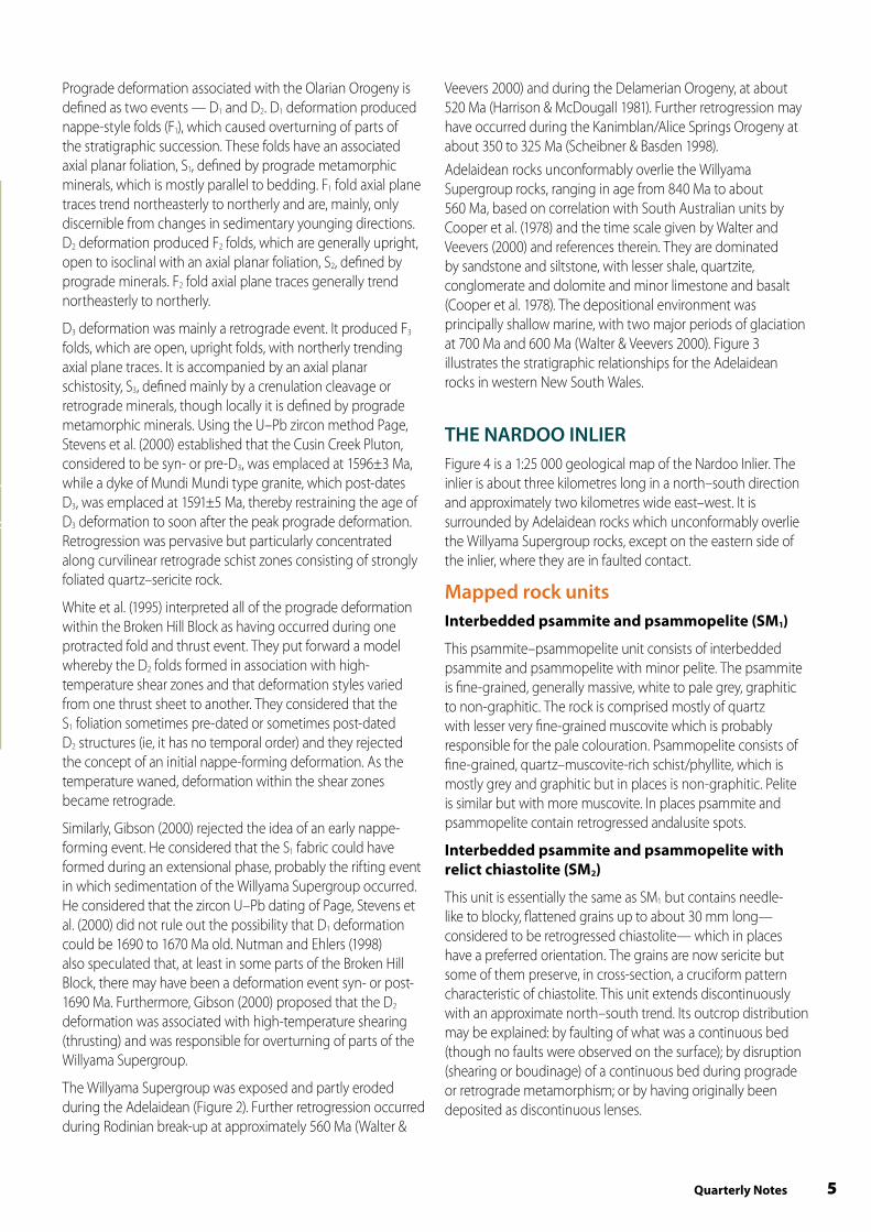
The psammitic–psammopelitic unit of the Mount Woowoolahra Inlier consists of interbedded fine-grained, grey, graphitic phyllite and massive to laminated, pale to cream psammite (Photographs 1 and 2). Thin-section studies indicate that the rock is quartz-rich. Laminae range in thickness from much less than one millimetre to several millimetres, though in places layers may be several centimetres thick. The laminae are defined by quartz-rich and muscovite-rich zones. In places the rock contains andalusite/chiastolite needles up to 10 mm long which have random orientations and have probably formed during contact metamorphism by the Mundi Mundi type granite, similar to that seen in the Poolamacca Inlier (Brown 1981). With increasing muscovite content the graphitic psammopelite grades into graphitic pelite.
A sample of laminated, fine-grained, quartz-rich psammite has been interpreted by L. Barron (pers comm, 2000) as a metamorphosed distal ashy vitric tuff with graded beds. R. Page (pers comm, 2000) supported this interpretation. Similar, interpreted tuffaceous material from the Bijerkerno Metasediments in the Broken Hill and Euriowie Blocks contain primary igneous zircons which were dated by the SHRIMP U–Pb technique at 1656±5 Ma by Page, Stevens et al. (2000). Page, Stevens et al. (2000) dated a similar meta-tuffaceous siltstone from the Dalnit Bore Metasediments in the Broken Hill Block at 1642±5 Ma. The tuffaceous material in the Mount Woowoolahra Inlier may also be amenable to zircon U–Pb dating.
In one exposure the rock type contains grey, ellipsoidal pods or nodules up to 0.3 m across (Figure 5 and Photograph 3). A thin section of this material indicated that it is composed of very fine-grained, granoblastic quartz with fine-grained, tabular to columnar grains of actinolite, with secondary iron oxide staining. The nodules may be similar in origin to ellipsoids of calc-silicate rock observed within the Broken Hill and Sundown Groups within the Broken Hill and Euriowie Blocks (eg, Stevens 1998). However, those ellipsoids tend to be rich in epidote/clinozoisite and have a pink to creamy colour. No ellipsoids of either type have previously been recognised in the Paragon Group.
Interbedded pelite and psammopelite (EM)
This unit consists of dark grey to black, graphitic phyllite/slate. Some rocks contain andalusite grains ranging in length from one millimetre to 10 mm (Photograph 4). The andalusite is randomly oriented and was probably produced by contact metamorphism during emplacement of the Mundi Mundi type granite. Most of the EM rocks are finely laminated and minor cubic pits after disseminated pyrite are present in places.
Mundi Mundi type granite (g)
Mundi Mundi type granite outcrops in the Mount Woowoolahra Inlier consist of medium- to coarse-grained, non-foliated granite. Thin-section study indicates that it contains about 44% quartz, 44% K-feldspar (microcline), 10% plagioclase, 1% muscovite and 1% biotite. Sericite is present as an alteration mineral after feldspar and muscovite. It is homogeneous, with scattered K-feldspar megacrysts up to about 10 mm across. In places it contains clots, several centimetres across, of quartz–tourmaline rock (Photograph 5). Further south, in the vicinity of Woowoolahra Trigonometric Station (Figure 1), tourmaline clots are not conspicuous. The Woowoolahra Trigonometric Station area may be near the centre of the granite and tourmaline may have preferentially formed closer to the contact with the Willyama Supergroup rocks. Adjacent to the contact with the Willyama Supergroup rocks (Figure 5) the granite is finer grained, indicating the presence of a chilled margin. The granite has contact metamorphosed the Willyama Supergroup rocks, producing andalusite needles up to 10 mm long with a random orientation.
Zircon U–Pb dating by Page, Stevens et al. (2000) gave a 1596±3 Ma age for the Cusin Creek Pluton, a Mundi Mundi type granite body in the northern part of the Broken Hill Block. This date places the intrusion age of the Mundi Mundi type granite at around the same time as prograde metamorphism of the Willyama Supergroup. Burton (2000a, 2001b) considered that leucocratic granites in the Euriowie Block, which are mineralogically identical to Mundi Mundi type granite but range from foliated to non-foliated, were emplaced before or during prograde metamorphism and deformation. It is possible that these two granite types are related to each other.
Cainozoic silcrete (Czs)
Silcrete forms extensive slabby outcrops over the area around the Mount Woowoolahra Inlier. They have not been mapped in detail in this study.
StratigraphyThe psammitic metasediments of the Mount Woowoolahra Inlier have the same appearance as albitic psammites of the Bijerkerno Metasediments. However, they do not contain albite. They may correlate with the Bijerkerno Metasediments or, alternatively, they may constitute another stratigraphic unit, not present in the Broken Hill and Euriowie Blocks.

10 January 2006
Photograph 3 Quartz-rich calcsilicate nodule within graphitic psammite of the Mount Woowoolahra Inlier (GR 520300mE, 6549500mN) (cf. Figure 5).
Photograph 2 Laminated graphitic psammite within the Mount Woowoolahra Inlier (GR 520300mE, 6549800mN) (cf. Figure 5)
Photograph 1 Small faults within graphitic psammite of the Mount Woowoolahra Inlier (GR 520300mE, 6549700mN) (cf. Figure 5).
11Quarterly Notes
Photograph 5 Quartz–tourmaline clots (black patches) within the Mundi Mundi type granite, Mount Woowoolahra Inlier (GR 520800mE, 6549100mN) (cf. Figure 5).
Photographs by G.R. Burton(Lens cap is approximately 5 cm in diameter)
Photograph 4 Graphitic psammopelite with needles of andalusite, considered to have formed during contact metamorphism by the emplacement of the Mundi Mundi type granite, Mount Woowoolahra Inlier (GR 521100mE, 6549200mN) (cf. Figure 5).

1� January 2006
StructureIn places within the Mount Woowoolahra Inlier bedding in the metasedimentary units is discernible. In the northeast part of the inlier it strikes easterly and dips steeply to the north. In the southwest it strikes northeasterly and dips vertically to steeply to the southeast. The changes in bedding orientation suggest the presence of folds (of unknown generation) in the area, possibly with northeasterly to easterly trending axes, but no macro-scale folding was seen during the field investigation. No sedimentary younging or vergence relationships were recognised.
A prograde foliation is present in the metasedimentary rocks, which in places is parallel to bedding (particularly where bedding is vertical), while elsewhere it is at a high angle to bedding. Whether there is one foliation or several is not clear. However, in one thin section there appear to be two foliations — an earlier one (S1) parallel to bedding, which is crenulated by a later one (S2) at a high angle to bedding. Small, rounded to elongate domains, up to about one millimetre long, lie parallel to the second foliation. They consist of granoblastic quartz+sericite+biotite grains which are aligned parallel to the second foliation. The domains may be after andalusite. The structural relationship between S1 and S2 is the same as that seen in metasedimentary rocks of the Paragon Group within the Broken Hill and Euriowie Blocks and implies a similar deformation history for the Mount Woowoolahra Inlier.
The dominant prograde foliation at meso-scale in the area trends east-southeasterly to east-northeasterly and has a vertical dip. If it is related to the suspected folding mentioned above, it suggests that folds trend approximately easterly and are upright. The folds could be F2 but this is uncertain as vergence relationships were not determined. If they are F2, and the interpreted orientation is correct, it indicates an orientation quite different to interpreted F2 folds within the northern Broken Hill Block (eg, Brown 1988) and the northern Euriowie Block (Burton 2001a), where their axial plane traces strike northerly. Small-scale faults with displacements of several centimetres displace bedding in some areas (Photograph 1).
Subcrop of mylonitic metasediment occurs about 250 m north of shallow exploration pits (Figure 5), suggesting a major fault runs through the area. However, the orientation of the foliation and its relationship to other fabrics could not be determined. Thin section observation of the mylonite indicates that it consists of strongly foliated quartz–sericite schist with lozenge-shaped aggregates of quartz±sericite, possibly after andalusite, and recrystallised (granoblastic) quartz veinlets, both parallel and discordant to the foliation. If the rock is part of a larger fault structure, such a structure was not recognised in the field.
The arcuate shape of the Lady Don Quartzite outcrop immediately northeast of the Willyama Supergroup of the Mount Woowoolahra Inlier (Figure 5) could be the result of Delamerian folding. Alternatively, the unconformity between the Lady Don Quartzite and the Willyama Supergroup could
have had a pre-Delamerian arcuate shape, reflecting the palaeotopography at the time of deposition of the Lady Don Quartzite.
AlterationThere is one occurrence of greisen-type rock in the Mount Woowoolahra Inlier (Figure 5). It is massive, fine- to coarse-grained, quartz–muscovite-rich rock with clear quartz blebs up to 10 mm long. It is similar to the greisens in the Nardoo Inlier and in the Euriowie tinfield area, in which muscovite is characteristically green to clear (Burton 2000a). These probably formed by metasomatism from pegmatites which were intruded before or during prograde metamorphism. There are no pegmatites considered to be of that age cropping out within the Mount Woowoolahra Inlier. It may be, however, an effect of the Mundi Mundi type granite, which contains tourmaline and may be related to similar pre- to syn-metamorphic granites in the Euriowie Block. Burton (2001b) considered that the granites in the Euriowie Block are genetically related to nearby tin-bearing pegmatites.
Exploration pitsTwo shallow exploration pits have been developed on thin quartz veins (Figure 5). The veins strike 080 ,̊ are weakly ferruginous, but are not mineralised.
Adelaidean rocksThe Lady Don Quartzite occurs immediately northeast of the Mount Woowoolahra Inlier. It is a fine-grained to rarely medium-grained, grey quartzite. In places it is stained black, brown and red by secondary iron oxides and contains fine, black grains which are probably oxidised pyrite. It is well-laminated, commonly cross-bedded and in places is massive. Some conglomeratic horizons with quartzite clasts are present, those horizons being several centimetres to tens of centimetres thick. This unit is incorrectly shown as belonging to the Willyama Supergroup (‘Willyama Complex’) on the map of Cooper et al. (1975).
PROSPECTIVITY OF THE PARAGON GROUPThe recent recognition that the Paragon Group is a time-equivalent unit to stratigraphic units hosting significant stratiform Pb–Zn mineralisation in the Mount Isa Inlier (Page, Stevens et al. 2000) increases its prospectivity. Page, Stevens et al. (2000) dated tuffaceous units in the Bijerkerno Metasediments in both the Broken Hill and Euriowie Blocks at 1656±5 Ma, while the Urquhart Shale, which hosts the Mount Isa, George Fisher and Hilton deposits in the Mount Isa Inlier, has been dated at 1655±4 Ma (Page, Jackson & Krassay 2000). The 1642±5 Ma age obtained by Page, Stevens et al. (2000) for

1�Quarterly Notes
Figure 5 1:25 000 geological map of the Mount Woowoolahra Inlier (comprising Willyama Supergroup rocks) and immediate surrounds.
57
73
?
??
?
?
2004_12_0095.ai
NOTE: Grid refers to AMG 66 Zone 54 coordinatesbut is approximate with accuracy only to withinseveral hundred metres.
Geology by G. Burton, July 1997
Watercourse
CULTURAL AND TOPOGRAPHIC FEATURES
Geological boundaries
GEOLOGICAL FEATURES
72
Vertical
Mine workings - shallow pit
MOUNT WOOWOOLAHRA INLIER
520000mE 521000mE 522000mE
6551000mN
6548000mN
Approximate or gradational
Accurate
Inferred??
Not observed in this study.Based on mapping by Cooper et al. (1975)
Bedding
Strike and dip, measured
Metamorphic foliationPrograde schistosity, vertical
WILLYAMA SUPERGROUP
6549000mN
6550000mN
?
??
g
g
Cz
Cz
Cz
Cz EM
EM
EM
Cz
Cz
Cz
Cz
Cz
Apl
SM
CzsSM
SM myCz
Interbedded psammite andpsammopelite with minorpelite. Fine-grained, grey, graphitic phyllite to massiveor laminated pale cream quartz-rich psammite, in placeswith andalusite/chiastolite needlesup to 10 mm long.Interbedded pelite and psammopelite. Dark grey to black,graphitic, finely laminated phyllite/slate; andalusite in places; minor disseminated pyrite or pyrrhotiteEllipsoidal pods of calcsilcate rockup to 0.3 m. Mainly very fine-grainedquartz and actinolite.
Greisen. Massive, fine- to coarse- grained, quartz-muscovite-rich rock.
Mylonite
Quartz vein
POST-FOLDING INTRUSIONSMundi Mundi type granite.Massive, medium- to coarse- grained quartz-microcline-plagioclase-biotite-muscovitegranite. Sporadic K- feldsparmegacrysts to 10 mm, in places with clots to several centimetresof quartz-tourmaline rock.
ADELAIDEAN
Soil, sand, gravel, clay
CAINOZOIC
Lady Don Quartzite
Cz
Czs
Apl
SM
EM
"nodules"
gr
my
q
qnodules
gr
g
Watercourses derived from 1965 black and white 1:60 000scale aerial photography by the NSW Department of Lands.
SM
SM
Inlie
r
REFERENCE
Silcrete. Extensive slabby outcrops,not fully mapped in this study.
1 km 0

1� January 2006
the Dalnit Bore Metasediments is similar to 1639±3, 1638±7 and 1640±3 Ma ages obtained from tuffaceous units within the Barney Creek Formation (Page & Sweet 1998), which hosts the McArthur River deposit, in the Mount Isa Inlier. Hence recognition of the full extent of the Paragon Group is important.
No stratiform base metal mineralisation has been identified in surface exposures of the Paragon Group. However, stream sediment sampling (Barratt 2002), following work undertaken by CRA Exploration Pty Ltd and Alphadale Pty Ltd, indicates that the stratigraphic interval comprising the upper part of the Cartwrights Creek Metasediments and the basal part of the Bijerkerno Metasediments contains anomalous Pb and Zn values in several areas of the Broken Hill and Euriowie Blocks. Furthermore, minor, possibly syngenetic/diagenetic, sulphides have been identified within that stratigraphic interval in exploration drilling beneath the Mundi Mundi Plain, west of Broken Hill (Barratt 2002 and references therein).
SPATIAL RELATIONSHIP BETWEEN THE WILLYAMA SUPERGROUP AND ADELAIDEAN ROCKS AND POSSIBLE EXTENT OF PARAGON GROUP BENEATH ADELAIDEAN COVERRocks of Adelaidean age unconformably overlie the Willyama Supergroup. However, in some places they are in faulted contact with each other. This is clearly the case along the eastern boundary of the Nardoo Inlier and has also been noted in other areas (eg, along parts of the edge of the Euriowie Block (Burton 2000b)). Between the Euriowie Block and the Nardoo and Mount Woowoolahra Inliers, the Willyama Supergroup is assumed to occur beneath Adelaidean cover rocks, though the depth of that cover and the shape of the basement are not known. There are no exploration drillholes in the area and while some water bores have been drilled the available geological logs are poor.
The northern part of the exposed Broken Hill Block consists solely of Paragon Group rocks (Brown 1988), while Paragon Group rocks occur on the eastern and northern edges of the northern part of the Euriowie Block (Burton 2000b). Paragon Group rocks may dominate the Willyama Supergroup directly beneath Adelaidean cover in the areas between the Euriowie Block and the inliers.
Regional aeromagnetic and radiometric data have been acquired for the area including the Nardoo and Mount Woowoolahra Inliers, as part of the Broken Hill Exploration Initiative — a joint project between the then New South Wales Department of Mineral Resources, the Department of Primary Industries and Resources South Australia and Geoscience Australia (formerly the Australian Geological Survey
Organisation). While the magnetic data are of high quality it is difficult, if not impossible, to directly interpret the nature of the Willyama Supergroup beneath the Adelaidean rocks, which have their own, variable magnetic signatures.
While the depth of Adelaidean cover over the Willyama Supergroup between the Euriowie Block and the inliers is unknown, it is possible that the cover is not so thick as to preclude exploration of the Willyama Supergroup. It may be possible to test the nature of the basement rock by drilling, or some geophysical methods may be useful to ‘see’ through the cover. More detailed mapping of the Adelaidean rocks will provide a better understanding of the structure, which may provide further information on the nature of the basement.
CONCLUSIONSMetasedimentary rocks in both the Nardoo and Mount Woowoolahra Inliers are interpreted as belonging to the Paragon Group of the Willyama Supergroup. The presence of graphitic pelite and psammopelite is considered to be diagnostic of Paragon Group rocks while the presence of andalusite/chiastolite indicates the same metamorphic grade as that generally attained by Paragon Group rocks in the Broken Hill and Euriowie Blocks. At least two prograde foliations and one pervasive retrograde foliation are variably present, which is the same as elsewhere in the Willyama Supergroup.
The rocks of the Nardoo Inlier may be part of the Cartwrights Creek Metasediments and the Bijerkerno Metasediments. Alternatively they may be part of a different stratigraphic package within the Paragon Group not present in the Broken Hill and Euriowie Blocks. Rocks of the Mount Woowoolahra Inlier may form part of the Bijerkerno Metasediments but, alternatively, may also be part of a different stratigraphic unit. The fact that the psammitic rocks of both inliers resemble the albitic psammites seen elsewhere in the Paragon Group, but have been shown by thin section examination to be not albitic, suggests that they are part of a different unit in the Paragon Group. This problem of correlation will only be solved by zircon U–Pb dating of appropriate material, particularly psammitic metasedimentary rock considered to be a metamorphosed tuffaceous rock in the Mount Woowoolahra Inlier.
Understanding the distribution of the Paragon Group has become important for mineral exploration, following the recognition that it is a time-equivalent unit to prospective stratigraphic units within the Mount Isa Inlier. Paragon Group rocks may lie directly beneath Adelaidean cover rocks between the Euriowie Block and the Nardoo and Mount Woowoolahra Inliers. The depth of Adelaidean cover in those areas may not be so thick as to preclude exploration for stratiform Pb-Zn ‘Mount Isa’ style mineralisation. Further mapping of the Adelaidean rocks, the interpretation of geophysical data and drilling will help to understand the nature of the Willyama Supergroup rocks beneath them.
1�Quarterly Notes
ACKNOWLEDGMENTSPaul Ashley (University of New England) and Jim Stroud (Geological Survey of New South Wales [GSNSW]) are thanked for reviewing an earlier version of this paper. Larry Barron (GSNSW, now retired), Rod Page (Australian National University), Barney Stevens (GSNSW) and Jim Stroud (GSNSW) provided advice on thin section descriptions.
REFERENCES
Barratt, R M 2002. Potential for sediment hosted Pb–Zn in the Paragon Group, Broken Hill region, NSW. Geological Survey of New South Wales, Report GS2002/236 (unpublished).
Brown, R E 1981. Willyama Complex geology of parts of the Brewery Well, Campbells Creek and Kantappa Creek 1:25 000 sheets, Broken Hill, New South Wales. Geological Survey of New South Wales, Report GS1981/048 (unpublished).
Brown, R E 1988. Campbells Creek 1:25 000 geological sheet, 7135-II-S. Geological Survey of New South Wales, Sydney.
Burton, G R 2000a. Metallogenic studies of the Broken Hill and Euriowie Blocks, New South Wales. 4. Mineral deposits of the Euriowie Block (including the northernmost Broken Hill Block and Poolamacca Inlier). Geological Survey of New South Wales, Bulletin 32(4), 106 pp.
Burton, G R 2000b. Corona-Kantappa Creek 1:25 000 geological sheet, 7235-III-N & 7135-II-N. Geological Survey of New South Wales, Sydney.
Burton, G R 2001a. Corona 1:25 000 geological map explanatory notes. Geological Survey of New South Wales, Report GS2000/277 (unpublished).
Burton, G R 2001b. Characterisation of leucocratic granites of the northern Euriowie Block, Broken Hill area. Geological Survey of New South Wales, Report GS2001/060 (unpublished).
Cooper, P F, Tuckwell K D, Gilligan, L B & Meares, R M D 1975. Torrowangee — Fowlers Gap 1:100 000 geological sheet, 7135 & 7235. Geological Survey of New South Wales, Sydney.
Cooper, P F, Tuckwell, K D, Gilligan, L B & Meares, R M D 1978. Geology of the Torrowangee and Fowlers Gap 1:100 000 sheets 7135, 7235. Geological Survey of New South Wales, Sydney.
Gibson, G M 2000. Tectonic evolution of the Paleoproterozoic Willyama Supergroup, Broken Hill: the early years. pp. 45–47 In Peljo M, (comp.) Broken Hill Exploration Initiative, Abstracts. AGSO Record 2000/10, 111 pp.
Harrison, T M & McDougall, I 1981. Excess 40Ar in metamorphic rocks from Broken Hill, New South Wales: implications for 40Ar/39Ar age spectra and the thermal history of the region. Earth and Planetary Science Letters 55, 123–149.
Marjoribanks, R W, Rutland, R W R, Glen, R A & Laing, W P 1980. The structure and tectonic evolution of the Broken Hill region, Australia. Precambrian Research 13, 209–240.
Nutman, A P & Ehlers, K 1998. Evidence for multiple Palaeoproterozoic thermal events and magmatism adjacent to the Broken Hill Pb–Zn–Ag orebody, Australia. Precambrian Research 90, 203–238.
Page, R W, Jackson, M J & Krassay, A A 2000. Constraining sequence stratigraphy in north Australian basins: SHRIMP U–Pb zircon geochronology between Mt Isa and McArthur River. Australian Journal of Earth Sciences 47, 431–459.
Page, R W & Laing, W P 1993. Felsic metavolcanic rocks related to the Broken Hill Pb–Zn–Ag orebody, Australia: geology, depositional age, and timing of high-grade metamorphism. Economic Geology 87, 2138–2168.
Page, R W, Stevens, B P J & Gibson, G M 2005. Geochronology of the sequence hosting the Broken Hill Pb–Zn–Ag orebody, Australia. Economic Geology 100, 633–661.
Page, R W, Stevens, B P J, Gibson, G M & Conor, C H H 2000. Geochronology of Willyama Supergroup rocks between Olary and Broken Hill, and comparison to northern Australia. pp. 72–75 In Peljo, M. (comp.) Broken Hill Exploration Initiative, Abstracts. AGSO Record 2000/10, 111 pp.
Page, R W & Sweet, I P 1998. Geochronology of basin phases in the western Mt Isa Inlier, and correlation with the McArthur Basin. Australian Journal of Earth Sciences 45, 219–232.
Phillips, G N 1980. Water activity changes across an amphibolite–granulite facies transition, Broken Hill, Australia. Contributions to Mineralogy and Petrology 75, 377–386.
Plumb, K A 1992. New Precambrian time scale. Episodes 14, 139–140.
Scheibner, E & Basden, H ed. 1998. Geology of New South Wales — Synthesis. Volume 2. Geological evolution. Geological Survey of New South Wales, Memoir Geology 13(2), 666 pp.
Stevens, B P J 1998. A comparative study: calc-silicate ellipsoids from Broken Hill and diagenetic carbonate concretions from the Sydney Basin. Geological Survey of New South Wales, Quarterly Notes 106, 1–15.
1� January 2006
NSW Department of Primary Industries — Mineral Resources Division516 High Street, Maitland NSW 2320PO Box 344 Hunter Region Mail Centre NSW 2310. T: 1300 736 122 T: (02) 4931 6666
www.dpi.nsw.gov.au
6285
01/
06
Stevens, B P J 2000. Evaluating models for tectonic development of the Willyama Supergroup. pp. 87–90 In M. Peljo (comp.) Broken Hill Exploration Initiative Conference, Abstracts. AGSO Record 2000/10, 111 pp.
Stevens, B P J, Barnes, R G, Brown, R E, Stroud, W J & Willis, I L 1988. The Willyama Supergroup in the Broken Hill and Euriowie Blocks, New South Wales. Precambrian Research 40/41, 297–327.
Stevens, B P J & Barron, L M 2002. Volcanic textures in the Palaeoproterozoic Hores Gneiss, Broken Hill, Australia. Geological Survey of New South Wales, Quarterly Notes 113, 1–22.
Stevens, B P J & Willis, I L 1983. Systematic classification of rock units: a key to mapping and interpretation of the Willyama Complex, pp 1–56, In B P J Stevens & W J Stroud (eds) Rocks of the Broken Hill Block: Their classification, nature, stratigraphic distribution, and origin. Geological Survey of New South Wales, Records, 323 pp, 21 (1).
N S W D P I
Quarterly NotesGeologic al Sur vey of New South Wales
April 2005 No 118
Murray–Riverina region: an interpretation of bedrock Palaeozoic geology based on geophysical dataABSTRACTInterpretation of data from the Murray–Riverina airborne magnetic and radiometric survey, acquired in early 2003, has revealed many underlying bedrock features in a region covered by a blanket of Cainozoic sediments.
The new airborne magnetic data, in combination with regional gravity data, contribute to a greater understanding of the geometry and evolution of basement geology through the definition of structural zones. The data are interpreted to define major faults, granitic bodies, basins and igneous centres. Interpretation of the magnetic and gravity data suggests that both the Stawell, Bendigo and Tabberabbera structural zones defined in Victoria continue north into New South Wales. A new zone, named the Hay–Booligal Zone, covers the central section of the survey area and is wholly within New South Wales.
These new data suggest enhanced economic potential in the Murray–Riverina region for extensions of the gold-rich Bendigo and Stawell Zones from Victoria under the Murray Basin in New South Wales.
Keywords: aeromagnetic, gravity, Bendigo Zone, Stawell Zone, Tasmanides, Lachlan Orogen, Delamerian Orogen, Hay–Booligal Zone.
INTRODUCTIONThe Murray–Riverina airborne magnetic/radiometric/digital elevation survey (Figure 1) was flown in early 2003 as a major New South Wales Government Exploration NSW initiative. The aim of the survey is to encourage mineral exploration in southwestern New South Wales which is covered by Cainozoic sediments. The survey data was also acquired to assist a whole-of-government study in the Riverina Bioregion and was co-funded by the Resource and Conservation Assessment Council.
Data acquisitionThe new survey covered approximately 63 000 square km and involved the acquisition of over 160 000 line km of data (Fugro Airborne Surveys 2005). It covered all the Booligal 1:250 000 map sheet area and parts of the Hay, Deniliquin, Bendigo, Swan Hill, Balranald, Pooncarie, Manara and Ivanhoe 1:250 000 map sheet areas. The airborne survey lines were flown east–west at an interline spacing of 400 m and at a nominal ground clearance of 60 m (Geological Survey of New South Wales 2003). The airborne contractor was Fugro Airborne Surveys Pty Ltd. Gravity data examined as part of this interpretation are from the Australian National Gravity Database (Wynne & Bacchin 2004). In New South Wales, the gravity stations are at a nominal 11 km x 11 km grid with additional data provided in the central part of the region by detailed road traverses (1.0 km station spacing) and in the northwest by a nominal 4 km x 4 km grid. In Victoria, the gravity stations are at a nominal 1.5 km x 1.5 km grid.
Michael Hallett
Geological Survey of New South Wales, NSW Department of Primary Industries
Jeffrey Vassallo
Geological Survey of New South Wales, NSW Department of Primary Industries
Richard Glen
Geological Survey of New South Wales, NSW Department of Primary Industries
Steve WebsterSteve Webster Pty. Ltd
Papers in Quarterly Notes are subject to external review. External reviewer for this issue was Ian Hone. His assistance is appreciated.
Quarterly Notes is published to give wide circulation to results of studies in the Geological Survey of New South Wales. Papers are also welcome that arise from team studies with external researchers. Contact: [email protected]
ISSN 0155-3410
CONTRIBUTORS
Quarterly Notes now available on the web
New editions are available to download as pdf documents
Go to www.dpi.nsw.gov.au
N S W D P I
Quarterly NotesGeologic al Sur vey of New South Wales
Januar y 2006 No 119
The Willyama Supergroup in the Nardoo and Mount Woowoolahra InliersABSTRACTThe Nardoo and Mount Woowoolahra Inliers are 100 km north and 90 km north-northwest, respectively, of Broken Hill, in far western New South Wales. Both inliers contain rocks which belong to the Palaeoproterozoic Willyama Supergroup. Geological mapping of the inliers shows that they both contain graphitic to non-graphitic psammitic, psammopelitic and pelitic metasediments. The Nardoo Inlier contains a significant amount of pegmatite and intermixed pegmatite and granitoid while Mundi Mundi type granite is common in the Mount Woowoolahra Inlier. Structural fabrics and metamorphic mineral assemblages within the inliers are consistent with those observed in the nearby Broken Hill and Euriowie Blocks. The metasediments are considered to form part of the Paragon Group. However, it is not clear if they can be correlated with other occurrences of the Paragon Group in the Broken Hill and Euriowie Blocks, or whether they are a separate (stratigraphically higher) part of the Paragon Group. The recent finding that the Paragon Group in the Broken Hill Block is a time equivalent of stratigraphic units which host significant Pb–Zn deposits in the Mount Isa Inlier in Queensland, increases the prospectivity of the Paragon Group. Understanding its distribution and characteristics has, hence, become important.
Keywords: Nardoo Inlier, Mount Woowoolahra Inlier, Paragon Group, Willyama Supergroup, Broken Hill, lead–zinc–silver
mineralisation potential.
INTRODUCTIONThe Nardoo and Mount Woowoolahra Inliers are 100 km north and 90 km north-northwest, respectively, of Broken Hill, in far western New South Wales (Figure 1). Both inliers contain rocks belonging to the Palaeoproterozoic (Statherian) (Plumb 1992) Willyama Supergroup and are surrounded by Adelaidean cover rocks.
The geological mapping of Cooper et al (1975) has been, until now, the best available for showing the distribution of Willyama Supergroup exposure in the areas of the Nardoo and Mount Woowoolahra Inliers. Their mapping, however, did not differentiate the constituent rocks within the inliers. The aim of this paper is to describe the rock types which occur within both inliers. The work is based on mapping carried out in 1997, as part of the Broken Hill Mapping Project undertaken by the Geological Survey of New South Wales.
Both inliers were mapped at 1:25 000 scale using enlargements of originally 1:60 000 scale Land and Property Information black and white aerial photographs, which had been taken in 1965. The geological mapping is lithological in nature, being consistent with the style adopted by Stevens and Willis (1983) for mapping the Willyama Supergroup rocks of the Broken Hill Block and Euriowie Block. The mapping of Cooper et al (1975) was used as a guide. All coordinates in this paper refer to AMG Zone 54, AGD 66 and all azimuths are with respect to true north.
Gary Burton
Geological Survey of New South Wales, NSW Department of Primary Industries
Papers in Quarterly Notes are subject to external review. External reviewer for this issue was Ian Hone. His assistance is appreciated.
Quarterly Notes is published to give wide circulation to results of studies in the Geological Survey of New South Wales. Papers are also welcome that arise from team studies with external researchers. Contact: [email protected]
ISSN 0155-3410
AUTHOR
Walter, M R & Veevers, J J 2000. Neoproterozoic Australia. pp. 131-153 In J. J. Veevers ed. Billion-year earth history of Australia and neighbours in Gondwanaland. Gemoc Press, Sydney, 388 pp.
White, S H, Rothery, E, Lips, A L W & Barclay, T J R 1995. Broken Hill area, Australia, as a Proterozoic fold and thrust belt: implications for the Broken Hill base-metal deposit. Institute of Mining and Metallurgy, Transactions 104, B1–B17.
Willis, I L, Brown, R E, Stroud, W J & Stevens, B P J 1983. The early Proterozoic Willyama Supergroup: stratigraphic subdivision and interpretation of high- to low-grade metamorphic rocks in the Broken Hill Block, New South Wales. Geological Society of Australia, Journal 30, 195–224.
Willis, I L, Stevens, B P J, Stroud, W J, Brown, R E, Bradley, G M & Barnes, R G 1983. 2. Metasediments, composite gneisses and migmatites. pp. 57-125 In B P J Stevens & W J Stroud eds. Rocks of the Broken Hill Block: their classification, nature, stratigraphic distribution and origin. Geological Survey of New South Wales, Records 21(1), 323 pp.