Embed Size (px)
Citation preview
Jemez y Sangre Water Planning Council
Table of Contents
Section Page
Executive Summary ...................................................................................................................ES-1
1. Introduction................................................................................................................................1
2. Summary of Changed Conditions..............................................................................................3 2.1 Interview Process, Survey and Summary of Actions on Alternatives .................................3 2.2 Changes in Policy, Ordinances, Rules and Regulations, and Lawsuits ...............................8
2.2.1 Domestic Well Regulations Adopted in 2006...........................................................8 2.2.2 Active Water Resource Management (AWRM) .......................................................8 2.2.3 Decisions from the OSE and New Mexico Courts....................................................9 2.2.4 San Juan-Chama Project Water..............................................................................10 2.2.5 Other Planning Efforts ............................................................................................11
2.3 Jemez y Sangre Regional Planning Council Planning Activities ......................................11 2.3.1 Landscape Management and Water Capture...........................................................11 2.3.2 Technology Committee ...........................................................................................11 2.3.3 Growth Management Committee ............................................................................12
2.4. Other Planning Activities..................................................................................................12 2.4.1 Española Basin Regional Planning Issues Forum...................................................12 2.4.2 The Upstream-Downstream Project ........................................................................13
3. Updates to Water Supply and Demand Analysis.....................................................................14 3.1 Updates to Water Demand Analysis ..................................................................................14 3.2 Updates to Water Supply Analysis ....................................................................................16 3.3 Revised Water Supply and Demand Projections ..............................................................17
3.3.1 Northern Subregion...............................................................................................19 3.3.2 Aamodt Subregion ................................................................................................20 3.3.3 Los Alamos Subregion..........................................................................................23 3.3.4 Santa Fe Subregion................................................................................................25 3.3.5 South Galisteo Creek Subregion ...........................................................................31
3.4 Effects of Climate Change and Variability on Water Resource Management .................32
4. Recommendations......................................................................................................................36 4.1 Recommendations for Continuation of the Jemez y Sangre Water Planning
Council .............................................................................................................................37 4.2 Recommendations for Improved Understanding of the Supply Demand Gap and
Strategies to Address the Gap ..........................................................................................38
References......................................................................................................................................41
i
Jemez y Sangre Water Planning Council
List of Figures
Figures
ES-1 Projected Municipal and Domestic Demand, Northern Subregion
ES-2 Projected Municipal and Domestic Demand, Aamodt Subregion
ES-3 Projected Municipal and Domestic Demand, Los Alamos Subregion
ES-4 Projected Municipal and Domestic Demand, Santa Fe Subregion
ES-5 Projected Municipal and Domestic Demand, South Galisteo Creek Subregion
1 Jemez y Sangre Subregions
2 Water Supply Infrastructure Projects
3 Municipal Diversions in the Jemez y Sangre Region, 1995-2006
4 Domestic Wells
5 Increased Demand from Domestic Wells
6 Projected Municipal and Domestic Demand, Northern Subregion
7 Options for Meeting Projected Supply/Demand Gap in the Northern Subregion
8 Projected Municipal and Domestic Demand, Aamodt Subregion
9 Options for Meeting Projected Supply/Demand Gap in the Aamodt Subregion
10 Projected Municipal and Domestic Demand, Los Alamos Sub-basin
11 Projected Municipal and Domestic Demand, Santa Fe Subregion
12 Options for Meeting Projected Supply/Demand Gap in the Santa Fe Subregion
13 Projected Municipal and Domestic Demand, South Galisteo Creek Sub-basin
14 Options for Meeting Projected Supply/Demand Gap in the South Galisteo Creek Sub-basin
Jemez y Sangre Water Planning Council
List of Tables
Table
1 Summary of Actions Taken Regarding Jemez y Sangre Regional Water Plan Update (revised)
2 Water Supply Infrastructure Projects in the Jemez y Sangre Water Planning Region
3 Jemez y Sangre Region Water Planning Documents
4 Historical Municipal Diversions
5 Summary of Subdivision Reports Submitted for Review to the OSE Water Use and Conservation Bureau Since 2000
6 Comparison of Projected Population Growth Rates to Census-Measured Growth Rates, 2000-2006
7 Water Use by Mutual Domestic Water Suppliers
8 New Domestic Well Diversions in the Jemez y Sangre Water Planning Region from January 1, 2000 to May 2007
9 Pueblo Water Use in the Aamodt Subregion
List of Appendices
Appendix
A Water System Surveys
B Bibliography
C Watershed Restoration Projects
Jemez y Sangre Water Planning Council
ES-1
Executive Summary
Introduction
The Jemez y Sangre region, which includes most of Santa Fe County, all of Los Alamos County,
and a portion of Rio Arriba County, is one of 16 water planning regions in the State of New
Mexico. Regional water planning was initiated in New Mexico in 1987 with the purpose of
protecting New Mexico water resources while ensuring that each region is prepared to meet
future water demands. Regional water planning activities are overseen by the New Mexico
Interstate Stream Commission (ISC).
For the purposes of the Jemez y Sangre water planning effort, the region was divided into 10
sub-basins for hydrologic and water demand analysis. These sub-basins were then grouped into
5 subregions for the projection of future supply and demand based on source of supply for
projected demands. The 5 subregions, along with the sub-basins that they encompass, are:
• Northern subregion (Velarde, Santa Clara, and Santa Cruz sub-basins)
• Aamodt subregion (Tesuque and Pojoaque-Nambé sub-basins)
• Los Alamos subregion (Los Alamos sub-basin)
• Santa Fe subregion (Santa Fe, Caja del Rio, and North Galisteo Creek sub-basins)
• South Galisteo Creek subregion (South Galisteo Creek sub-basin)
The original Jemez y Sangre Regional Water Plan (2003 JyS Plan) was completed and accepted
by the ISC in 2003. The purpose of the 2003 JyS Plan is to assist governmental and other
entities within the Jemez y Sangre region to make sound planning decisions to provide for the
region’s future needs.
Purpose and Scope of 2007 Update, Phase I
In March of 2007, the Interstate Stream Commission and the Jemez y Sangre Water Planning
Council contracted with Daniel B. Stephens & Associates, Inc. and Amy Lewis to update the
2003 JyS Plan, under the direction of the Jemez y Sangre Water Planning Council (Council).
The Council consists of representatives from local governments, water users groups, and the
Jemez y Sangre Water Planning Council
public. DBS&A produced a draft report for Council review in September of 2007. After review
of the draft report and monthly meetings to discuss the content, the Council has revised that draft
report to produce this document.
The scope of work for Phase I of this Update does not include full revision and re-publication of
the regional water plan. Instead, the present scope of Phase I of the Update of the 2003 JyS plan
is designed to identify changes in the region’s supply and demand. In particular, the scope
focuses on evaluating the public water supply sector, which experienced the most growth when
the original plan was prepared and did not include the agricultural sector where less change has
occurred. Phase I of the Update considers only average precipitation, stream flows and
historically normal conditions and documents changes in policy, ordinances, rules and
regulations, and litigation since completion of the 2003 JyS Plan.
Key Findings from the Jemez y Sangre Regional Water Planning Council
Based on newly available and updated information in the draft report by DBS&A, the Council
determined that the key findings from Phase I of the Update are:
• Since 2003, the Jemez y Sangre Region has made progress in closing the projected gap
between water supply available in 2000 and the projected demand in 2060, largely due to the
implementation of water conservation efforts (decreasing demand) and the proposed projects
to divert native Rio Grande water rights and San Juan-Chama water from the Rio Grande
(increasing available supply).
• Four of the five subregions (Northern, Aamodt, Los Alamos, and Santa Fe) do not expect a
significant gap between demand and supply until the year 2040 based on projected historical
supply while closing the gap for one subregion (South Galisteo) is dependent upon
unquantified groundwater.
• A projected gap for the entire Jemez y Sangre region will not occur until after 2040 based on
2007 conditions provided that City of Santa Fe and Santa Fe County, Los Alamos and
Espanola have all completed proposed projects to divert San Juan/Chama and obtained the full
amount of planned native water rights from the Rio Grande and the water for the Regional
Water System proposed under the Aamodt Settlement is made available.
ES-2
Jemez y Sangre Water Planning Council
• The projections in the Update are based on historically normal conditions. If drought and
other negative conditions impact the region’s water supply, the gaps will be greater than
projected under normal conditions.
• The Update reports that the observed recent annual population growth rate may be lower than
the projections in the 2003 JyS Plan which could affect the projected gap between supply and
demand.
• Changes in population projections will increase or decrease the projected gap between supply
and demand. Given that population growth is responsive to multiple factors (types of business
development, economic conditions, tax policy, reliability of water and other natural resources,
etc.), population projections are indicators of possible future scenarios. Preparation of high,
likely and low projections may be helpful planning tools.
• There is more and improved hydrologic information available to the region.
Sources of Information for Phase I of the Update
To determine the changes that have occurred and revise the projections of supply and demand,
DBS&A, in conjunction with the Council, developed a survey to solicit information regarding
actions taken on each of the alternatives included in the 2003 JyS Plan. In addition, the survey
solicited updated information on water use, changed policies or ordinances, and other activities
that may impact or augment water supplies in the Jemez y Sangre region. The survey was
mailed in the spring of 2007 to 89 water suppliers, government agencies, pueblos, and advocacy
groups, 28 of which responded. In addition to the mailed surveys, DBS&A interviewed key
water suppliers and decision makers in the region. Information was also obtained from
government web sites and communication with agency staff, and from water planning documents
completed since publication of the 2003 JyS Plan.
Revisions in Projected Gap between Supply and Demand
Since 2003, the water providers in the Jemez y Sangre water planning region have made great
strides toward not only closing the gap between supply and demand, but also protecting the
region’s water resources through watershed and riparian restoration projects, stormwater
management, and conjunctive use strategies. Figures ES-1 through ES-5 show the future supply
ES-3
Jemez y Sangre Water Planning Council
and demand projected for the original 2003 JyS Plan along with the revised projections prepared
for this update.
In some cases projected demand has increased:
• The projected demand in the Northern and Aamodt subregions has increased due to new
golf courses in these subregions.
• The Los Alamos subregion’s projected demand has increased due to projected growth
from land transfers and future activities at Los Alamos National Laboratory.
Review of population estimates in 2006 revealed that the annual growth rate from 2000 to 2006
may be less than the rate predicted by BBER for the 2003 JyS Plan except in Los Alamos, where
the growth rate is about twice the rate predicted by BBER. However, the projections of
population growth upon which the demand projections (Figures ES-1 through ES-5) are based
have not been modified for Phase I of the Update, except in the Los Alamos subregion.
Population projections are based on many variables and are uncertain. The uncertainty will only
impact when new measures to close the gap between supply and demand will need to be
implemented, not whether those changes are needed.
In all subregions except the South Galisteo, the gap between supply and demand in the year 2060
is being met, largely due to proposed projects to divert San Juan-Chama water and native Rio
Grande water rights from the Rio Grande (increasing available supply) and to water conservation
efforts (decreasing demand). The gap reduction is also due to new domestic wells that continue
to be drilled in all subregions, amounting to an increased diversion of about 300 acre-feet per
year (ac-ft/yr) since 2000 that could increase another 2,000 ac-ft/yr by 2060 if the rate of well
drilling continues.
Plans are in place for infrastructure projects to address water supply needs through the year 2040
in the Northern subregion, through 2060 in the Aamodt and Los Alamos subregions, and through
2030 in the Santa Fe Subregion. The supply-demand gap in the South Galisteo subregion can
only be met through domestic wells at this time.
ES-4
Jemez y Sangre Water Planning Council
The gaps shown in Figures ES-1 through ES-5 do not account for drought vulnerability, yet as
regions depend more and more on surface water, the vulnerability to drought will increase.
Some of this vulnerability may be offset by a decreased dependence on groundwater (due to the
increased use of surface water in wet years) that allows the aquifers to recover and be available
during drought periods.
Future Activities
An important objective of Phase I of the Update was to solicit input on how the Council and
future updates of the plan could provide the most value to the stakeholders in the region. Survey
respondents were unanimous in agreeing that there is value in communication and collaboration,
but that each entity is going to pursue their own projects and address their specific needs.
Several of those surveyed appreciated the excellent support for projects, projections of future
water uses, useful advice, options charts, and compilation and summaries of existing reports and
documents.
Recommendations from those surveyed included condensing the water plan into a short version
that could be useful to show what is being done now to improve and sustain water resources,
highlighting regional issues such as aquifer management, surface water-groundwater
interactions, plume migration, and sustainability. Survey respondents also indicated that the
Council needs a clear mission and ongoing support, money for public relations and advocacy,
and a more defined educational role.
The Council has an opportunity to continue education through development of a web site or
public meetings on particular issues. The Council could also continue to collect information, as
was done for this Update, and to discuss regional water resources management issues. The
Council could play a vital role in investigating the sustainability of water resources, water right
transfers, adoption of acéquia bylaws, or other information that characterizes changes in the
region. The role of the Council is to examine the issues from a broader perspective and find
common ground and solutions with the greatest benefit.
ES-5
Jemez y Sangre Water Planning Council
Planning for Drought
One of the important issues that the Jemez y Sangre region continues to face is potential drought.
Because predictions of global warming effects on water supplies indicate that a greater
percentage of extreme conditions (both drought and flood) is likely, the region needs to be well
prepared for meeting demands during drought. Recommended strategies that could be
undertaken to better prepare the region to address drought conditions are:
• Conduct regional surface water modeling to assess more quantitatively vulnerability
under scenarios of greater drought (such as shortages of San Juan-Chama project water)
or policy changes that may affect future availability of surface water.
• Develop joint powers agreements and official drought sharing agreements among water
systems in the area; identify where regional solutions (beyond what is currently being
done) can assist in making sure that all water providers are prepared to address drought
conditions.
• Continue to update and implement tiered water conservation plans that can lower water
use during drought. In particular, the Council may be a possible resource to bring
together small providers that have not progressed in this area to the extent that larger
water suppliers have.
In addition to these investigations, future activities that may help the region better understand the
supply-demand gap include evaluation of agricultural water use and acéquia policies (which was
not included in the scope of this update), additional technical updates as new data become
available, and re-evaluation of alternatives.
Key Recommendations from the JyS Regional Water Planning Council
After reviewing the draft DBS&A report, the Council recommends that Phase II of the Update
consider:
• the anticipated changes to future water supplies based on changing conditions
(drought, variable precipitation, increased temperature, climate change);
• the amount of water in the region’s aquifers and the long-term viability of the aquifers
as they impact available water supply;
ES-6
Jemez y Sangre Water Planning Council
• the addition of text and graphs which reflect conjunctive use strategies, i.e. using
renewable surface water in wet years in order to rest the non-renewable water in
aquifers so that water will be available in dry years;
• more information regarding the availability of San Juan/Chama project water in the
event of problems associated with legal constraints and long-term drought, increased
temperatures and/or climate change;
• regional surface water modeling to assess more quantitatively vulnerability under
scenarios of great drought (such as shortages of San Juan-Chama project water) or
policy changes that may affect future availability of surface water;
• update population projections to reflect likely increases or decreases in demand;
• review and update 2003 JyS Plan public welfare statement;
• include updating supply and demand information for the agricultural sector;
• develop a “do nothing” scenario which analyses the risks and costs of no action; and
consider water quality impacts.
ES-7
Jemez y Sangre Water Planning Council
1
1. Introduction
The Jemez y Sangre (JyS) region is one of 16 water planning regions in the State of New
Mexico. Regional water planning was initiated in New Mexico in 1987 for the purpose of
protecting New Mexico water resources while ensuring that each region is prepared to meet
future water demands. Regional water planning activities are overseen by the New Mexico
Interstate Stream Commission (ISC).
The JyS region includes most of Santa Fe County, all of Los Alamos County, and a portion of
Rio Arriba County (Figure 1). For the purposes of the JyS water planning effort, the region was
divided into 10 sub-basins for hydrologic and water demand analysis. These sub-basins were
then grouped into 5 subregions (Figure 1) for the projection of future supply and demand based
on source of supply for projected demands. For instance, the City of Española’s well fields are
in both the Santa Clara and Santa Cruz sub-basins and the City itself and several nearby Pueblos
overlap these and the Velarde sub-basin. The 5 subregions, along with the sub-basins that they
encompass, are:
• Northern subregion (Velarde, Santa Clara, and Santa Cruz sub-basins)
• Aamodt subregion (Tesuque and Pojoaque-Nambé sub-basins)
• Los Alamos subregion (Los Alamos sub-basin)
• Santa Fe subregion (Santa Fe, Caja del Rio, and North Galisteo Creek sub-basins)
• South Galisteo Creek subregion (South Galisteo Creek sub-basin)
The Jemez y Sangre Regional Water Plan (2003 JyS Plan) was completed and accepted by the
ISC in 2003 (DBS&A and Lewis, 2003). In March of 2007, the ISC retained Daniel B. Stephens
& Associates, Inc. (DBS&A) and Amy Lewis to complete Phase I of an Update of the regional
water plan, under the direction of the Jemez y Sangre Water Planning Council (Council). The
Council consists of representatives from local government, water users groups, and the public.
Jemez y Sangre Water Planning Council
The scope of work for this Update does not include full revision and re-publication of the
regional water plan (although it may be valuable at some point in time to consider revising and
republishing the entire plan, that level of effort was not warranted currently). Instead, the present
scope is designed to identify changes in the region as they affect the balance between supply and
demand. Accordingly, the scope of work for this update includes:
• Conducting a survey to identify changed conditions and current or planned
implementation of regional water planning strategies
• Summarizing new water science research, geologic and hydrologic mapping
information, including developing a bibliography and summary tables
• Analyzing the current projected gap between supply and demand
• Discussing how the region’s gap could be affected by weather variability
• Recommending strategies for drought and conservation planning
• Recommending continued water planning based on survey discussions and updated
information
• Recommending ways to make the plan more useful
In September, 2007, DBS&A submitted Phase I of an Update Report to the 2003 JyS Plan. The
Council reviewed the report, added further updates, analyzed findings of the report, discussed
recommendations, and approved this Phase I of the Update (2008).
2
Jemez y Sangre Water Planning Council
2. Summary of Changed Conditions
This section summarizes the Interview Process, Survey, and Summary of Actions on Alternatives
(Section 2.1); Changes in Policy, Ordinances, Rules and Regulations, and Lawsuits (Section
2.2); JyS Regional Planning Council Planning Activities (Section 2.3); and Other Planning
Activities (Section 2.4). A bibliography listing documents relevant to the region that have been
obtained since publication of the 2003 JyS Plan is included in Appendix B.
2.1 Interview Process, Survey and Summary of Actions on Alternatives
To assess the activities that may impact or augment water supplies in the JyS water planning
region, DBS&A, in conjunction with the Council, developed a survey that outlines the various
alternatives included in the 2003 JyS Plan. Through this survey, the Council requested that
respondents provide information regarding actions they have taken on each of the alternatives
included in the original regional water plan. In addition, the survey solicited updated
information on water use, changed policies or ordinances, and other relevant information. The
survey was mailed to 89 water suppliers, government agencies, pueblos, and advocacy groups,
28 of which responded; those returned surveys were used in this summary. In addition to the
mailed surveys, DBS&A also interviewed key water suppliers and decision makers in the region.
A list of all entities receiving or being interviewed regarding the survey, along with the blank
survey form, is included in Appendix A.
Information was also obtained from government web sites and communication with agency staff.
For instance, information on forest restoration projects was obtained from the U.S. Forest
Service (USFS) web site and New Mexico Environment Department (NMED) Surface Water
Bureau. The New Mexico Office of the State Engineer (OSE) was contacted for information on
development of Critical Management Areas, water right transfers, and subdivision review.
OSE’s online WATERS database was accessed to obtain information on new domestic wells.
Completed surveys resulting from interviews include:
• City of Española
3
Jemez y Sangre Water Planning Council
• City of Santa Fe • Eldorado Area Water and Sanitation District (WSD) • Los Alamos Water Utility • Madrid Water Cooperative • New Mexico Rural Water Users Association • Pojoaque Pueblo • Rio Arriba County • Santa Clara Pueblo • Santa Fe County • San Ildefonso Pueblo • Tesuque Pueblo • New Mexico Acéquia Association • Galisteo Mutual Domestic Water Consumers Association (MDWCA)
Interviews were planned, but not completed, with two entities:
• Ohkay Owingeh Pueblo (indicated they don’t want to be surveyed) • Nambé Pueblo (Ernest Mirabal, Nambé Pueblo Council member, attempted to arrange
an interview, but was unable to set a date with the Governor)
Completed surveys (no interview) returned include:
• Acéquia Madre on the Santa Fe River • Chupadero Water-Sewage Corp. • El Vadito de los Cerrillos • Greater Chimayo MDWCA • Hyde Park Water Association • La Acéquia de la Cañada Ancha • La Puebla Community Well Association • La Vista Homeowners’ Association • Lower Cerro Gordo Ditch Association • NMED Surface Water Quality Bureau • New Mexico State Land Office • Santa Cruz Irrigation District • San Marcos Association • Solacito Mutual Domestic Water Users Association (MDWUA)
Additional interviews (no survey) were conducted with:
• Mike Johnson, OSE Hydrology Bureau Chief • Mary Young, OSE Water Rights Bureau • John Longworth and Jerry Keller, OSE Water Use and Conservation Bureau • Peter Chestnut, Northern Pueblo Tributary Water Rights Association Attorney
4
Jemez y Sangre Water Planning Council
• David Hogge, NMED Surface Water Quality Bureau • Ted Bagley, OSE Legal Division
During development of the 2003 JyS Plan, the Council investigated a variety of options for
addressing the current and future needs of the region. These options were grouped into 5
categories:
I. Protect existing supplies
II. Improve system efficiency
III. Mitigate drought
IV. Reduce demand
V. Increase water supply.
Based on the survey and interview results, numerous actions are being pursued by the regions’
water suppliers under each of these categories (Table 1).
Under Category 1 (protecting existing supplies), all of the recommendations are currently being
pursued or considered, from forest restoration and stormwater management to conjunctive use of
surface water and groundwater and restricting the drilling of domestic wells. This category
includes actions that will protect water resources but do not result in a water right for additional
diversions. Numerous forest restoration projects are underway, as outlined in Appendix C.
Cloud seeding has been explored, and funding for a pilot project is being pursued by New
Mexico Weather Modification Association, the successor to the Jemez y Sangre Regional Water
Planning Council Cloud Seeding Committee. The New Mexico Acéquia Association has
provided assistance to more than 20 acéquias in revising bylaws to require approval by acéquia
commissioners before water rights are transferred.
Under Category II, improve system efficiency, all but one of the potential alternatives are being
pursued. Wastewater reuse, replacing septic tanks with regional infrastructure, lining irrigation
ditches, upgrading infrastructure and other improvements to system efficiency are being pursued
by many of the water suppliers. Aquifer storage and recovery was not reported as a current
5
Jemez y Sangre Water Planning Council
project by any of the entities interviewed or surveyed, although Santa Fe County may consider
this option in the future.
Category III includes actions for mitigating drought, which is addressed through water banking,
temporary leases of water, emergency conservation ordinances, and shortage sharing agreements.
The Cities of Santa Fe and Española and the Counties of Santa Fe and Los Alamos have either
adopted or are pursuing emergency conservation ordinances, and some pueblos address
emergencies through instructions to tribal members. Eldorado Area WSD does not have the
authority to pass an ordinance (with fines), but they do have a drought policy and they post signs
to warn residents of drought situations. The Village of Cerrillos, which was supplied by water
from the National Guard during recent droughts, has drilled a supplemental well and built a new
storage tank to address water shortages during droughts.
The demand reduction alternatives for Category IV are being pursued by many water suppliers.
Demand reduction through management of growth and land use has been implemented where
water supplies are marginal to meet demands, such as in Madrid and Cerrillos. Santa Fe County
has mandated minimum lot sizes based on water supply as part of the Land Use Code since the
late 1970s. Rio Arriba County is not restricting population growth, but manages the type of
growth in order to maintain agriculture.
Water conservation is the most effective method for reducing demand and is being pursued
through a variety of mechanisms, such as rate structures and rebates. The City of Santa Fe’s
conservation ordinance has been highly effective in reducing demand, from 168 gallons per
capita per day (gpcd) in 1995 when they purchased the water utility to 106 gpcd in 2006. Las
Campanas is now using effluent from the City of Santa Fe’s wastewater treatment plant on their
two 18-hole golf courses, which has reduced their demand on the Buckman well field water from
a high of 948 acre-feet per year (ac-ft/yr) in 2001 to 521 ac-ft/yr in 2006. The major water
suppliers in the region, including the Cities of Santa Fe and Española and Santa Fe and Los
Alamos Counties, all have conservation plans in place. Based on survey responses (from 2007
6
Jemez y Sangre Water Planning Council
and previous surveys in 2002 and 2003), La Puebla MDWCA, Solacito Homeowners
Association, Eldorado, and Hyde Park Estates also have conservation plans in place.
Most of the alternatives under Category V, increase water supply, are being pursued. In
particular, the entities with contracts for San Juan-Chama project (SJC) water are either in the
feasibility or permitting stage for a direct diversion of their SJC water. In particular:
• The City and County of Santa Fe’s direct diversion of SJC water, the Buckman Direct
Diversion (BDD) project, increases the physical supply available to the areas served by
those entities; however, the allowable diversions in the near future cannot be increased
without the acquisition of more water rights. The BDD project allows for conjunctive
use of surface water and groundwater and improves the reliability of the supply.
• Santa Fe County and Las Campanas will be diverting native Rio Grande water from the
BDD project, increasing the supply available to the region. An estimated 540 acre-feet
of water rights from the middle Rio Grande Valley have been transferred to the
Buckman wells by Las Campanas and Santa Fe County since 2000, 245 of which are
used as offsets. The BDD project allows for a total diversion of 3,125 acre-feet of
native Rio Grande water rights by Santa Fe County and Las Campanas.
• Both Los Alamos County and the City of Española also are pursing diversion of SJC
water.
• The status of Ohkay Owingeh’s diversion of SJC water is not known.
• Above the Otowi gage, water right transfers may be pursued by the City of Española
and parties to the Aamodt Settlement Agreement (Section 3.3.2). No transfers across
the Otowi gage are being pursued.
• Nearly 1,200 new domestic wells have been drilled in the JyS region since 2000, as
discussed in more detail in Section 3.2.
Water diversion projects and their status are summarized in Table 2, and the locations of such
projects are shown in Figure 2.
7
Jemez y Sangre Water Planning Council
2.2 Changes in Policy, Ordinances, Rules and Regulations, and Lawsuits
An important component of understanding changed conditions in the JyS region is an
understanding of new laws or policies that could affect the management of water in the region.
Recent changes to policies, ordinances, rules and regulations, and lawsuits that may impact
supply and demand or water management include the Aamodt Settlement Agreement, newly
revised New Mexico domestic well regulations, the OSE’s Active Water Resource Management
(AWRM) initiative, OSE and New Mexico Supreme Court decisions and issues related to SJC
are discussed below.
2.2.1 Domestic Well Regulations Adopted in 2006
The OSE adopted Rules and Regulations for Governing the Use of Public Underground Waters
for Domestic and Household Use (19.27.5 NMAC) in 2006. These rules increase the fee for
obtaining a domestic well permit to $125 (from $5) and reduce the allowable diversions from 3
ac-ft/yr to 1 ac-ft/yr. The rules and regulations also allow the State Engineer to establish
Domestic Well Management Areas where stream-connected groundwater systems require special
water resource protection. To date, no Domestic Well Management Areas have been established
in the JyS region (Johnson, 2007).
2.2.2 Active Water Resource Management (AWRM)
AWRM was developed by the OSE to manage the state’s water resources, particularly during
droughts, in the absence of adjudicated water rights (only 30 percent of the water rights in New
Mexico are adjudicated). In December 2004, the State Engineer promulgated statewide AWRM
rules and regulations. The tools for AWRM include measuring and metering, rules and
regulations, creation of water districts and appointment of water masters, and development of
water master manuals. In the JyS Region, the Nambé-Pojoaque-Tesuque Basin is one of the
stream systems identified as high priority for AWRM by the State Engineer.
The Tri-State Generation and Transmission Association and the New Mexico Mining
Association sued the OSE over the new AWRM regulations, maintaining that they were
unconstitutional because they violated the separation of powers and the rights of water users to
8
Jemez y Sangre Water Planning Council
due process. In May 2007, Judge Matthew Reynolds upheld the State Engineer’s authority to set
rules for managing the state’s waters, but found portions of the AWRM rules to be
unconstitutional. Only court decrees or a license issued by the OSE can be used to establish
priority dates for priority administration under AWRM. Other evidence such as hydrographic
surveys, permits, or best available evidence may not be used to establish a priority date. Judge
Reynolds’s decision is on appeal.
2.2.3 Decisions from the OSE and New Mexico Courts
Two cases have been decided that may have implications for water use in the region.
* The OSE 2006 Report and Recommendation (Hearing No. 03-27) in the matter of the
application by Mary L.W. Peppler and the estate of Phillip S. McKee (the “Peppler
decision”) for a water right change in point of diversion and place and/or purpose of use from
surface water to groundwater in the Rio Grande Basin held that “. . . it would be contrary to
sound public policy to approve an application for a specified purpose when the applicant
does not intend to actually place water to beneficial use for that purpose and such use is
unlikely to occur within a reasonable period of time.” The applicant had requested
“subdivision” as one of several beneficial uses for the water. During the hearing, however,
the applicant made it clear that she herself did not intend to subdivide the land and would
only place the water to beneficial use for livestock, irrigation, and agricultural purposes. The
applicant also testified that she intended to sell the land to a purchaser that presumably would
subdivide and develop the land.
* In December, 2006, the New Mexico Supreme Court decided Montgomery v. Lomos
Altos, Inc. holding that the State Engineer must:
1. make findings on conservation and public welfare before he can approve an application
(most of the OSE decisions are silent on those issues) and
2. determine if all existing water rights will be impaired, not just those of protestants, when
analyzing impairment.
Both of these holdings may make it slightly harder to transfer water rights.
9
Jemez y Sangre Water Planning Council
2.2.4 San Juan-Chama Project Water
The 2003 JyS Plan White Paper 16, “Alternative: Utilize San Juan-Chama Project Water” (Vol.
2, Appendix F) lists the San Juan-Chama Project Contractors in the Region: City/County Santa
Fe; San Juan Pueblo; Los Alamos County; Pojoaque Valley Irrigation District; and the City of
Espanola. Several changes related to SJC Project water have occurred since the 2003 JyS Plan
was completed:
• The 2003 JyS Plan White Paper notes among the “Actions Needed to Implement/Ease
of Implementation” that: “In order to fully use all the SJ-C Project water collectively
contracted by governmental entities in the region, the following are needed: Convert SJ-
C fixed-term water service contracts to perpetual contracts (if possible).” In 2006,
contractors with SJC water were able to convert their water service agreements with the
Bureau of Reclamation from agreements with expiration dates to permanent repayment
contracts (USBR, 2006)
• The City of Santa Fe has leased 3,000 acre-feet of the Jicarilla Apache Nation SJC
water to use as offsets on Buckman Well Field pumping (City of Santa Fe and Jicarilla
Apache Nation, 2004).
• Santa Fe County and the City of Santa Fe signed a Water Resources Agreement
(January, 2005), in which the previously joint 5,605 ac-ft SJC contract was separated
into 375 ac-ft for the County and 5,230 ac-ft for the City.
• The City of Santa Fe, Santa Fe County, and Las Campanas signed an agreement on
facility operations and procedures for the Buckman Direct Diversion project in
September of 2006, which resolves payment and operation of the facility (City of Santa
Fe et al., 2006).
• SJC water is subject to shortage sharing in the San Juan Basin according to the Navajo
River Settlement (NM OSE, 2005). Under the Settlement, the SJC Project is allowed
17 percent of New Mexico’s Colorado Compact apportionment, which averages
105,200 ac-ft/yr, which is less than the allowed 110,000-ac-ft/yr average diversion (NM
OSE, 2005). The impact of the shortage sharing agreement on SJC contractor water
will depend on the amount of water available from Heron Dam.
10
Jemez y Sangre Water Planning Council
2.2.5 Other Planning Efforts
In addition to these policies, several water planning initiatives have been undertaken in the
region (Table 3). While the bibliography included in Appendix B includes only documents
completed since the plan was published, Table 3 includes older documents as well, to provide a
comprehensive list of planning documents. These planning activities set a direction for future
policies regarding water management in the region.
2.3 Jemez y Sangre Regional Planning Council Planning Activities
The Council has continued to meet monthly and has conducted a number of planning activities
both at the Council and through Council committees.
2.3.1 Landscape Management and Water Capture
On September 21 and 22, 2005, the Council in collaboration with the Water Resources Technical
Assistance Office of the Los Alamos National Laboratory, City of Santa Fe, the Santa Fe Area
Homebuilders Association and the Sierra Club organized the Jemez y Sangre Water Resources
Summit and Workshop on Managing Landscapes and Watersheds for Water Resources. The two-
day meeting provided a forum for the formulation of specific recommendations for increasing
available water supplies. The program and recommendations can be found on the Jemez y
Sangre Water Planning Council website: http://www.ose.state.nm.us/isc_regional_plans3.html.
These recommendations also provided input to the Technology Committees report on Alternative
Water Resources (see 2.3.2 below).
2.3.2 Technology Committee
The Technology Committee focused first on a recommendation to conduct a workshop on cloud
seeding from the 2003 JyS Plan White Paper 8, “Increase Precipitation, Runoff, and Infiltration
from Cloud Seeding” (Vol. 2, Appendix F). The workshop was held on January 22 and 23,
2004. The proceedings are available at http://www.ose.state.nm.us/isc_regional_plans3.html. The
workshop attendees agreed to seek funding for a demonstration project. Because a cloud seeding
11
Jemez y Sangre Water Planning Council
demonstration project might impact more than one water planning region and because of the
synergy with summer cloud seeding projects operational in other parts of New Mexico, a new
organization, the New Mexico Weather Modification Association, Inc, (NMWMA) was formed.
The Technology Committee continues to monitor the potential for cloud seeding and works
collaboratively with the NMWMA. The Technology Committee also completed a
comprehensive review of technologies that may play a role in increasing supply. The review is
currently available on the JyS RWP website at http://www.ose.state.nm.us/water-
info/NMWaterPlanning/regions/jemezysangre/PCTC/PCTC-Report-2007-12-10.pdf.
2.3.3 Growth Management Committee
The 2003 JyS Plan White Paper 18, “Manage Growth and Land Use” (Vol. 2, Appendix F)
identified four approaches:
1. designating geographical limits for growth to deal with a limited water supply;
2. conducting project-level analyses for each development;
3. setting numerical limits on rate of growth; and
4. relying on a market approach.
A committee of the Council evaluated pros and cons of each growth management approach and
developed materials for use by governmental entities which will be reviewed by the Council.
2.4. Other Planning Activities
Other planning activities related to the JyS Water Planning region follow.
2.4.1 Española Basin Regional Issues Forum
The Española Basin Regional Issues Forum (EBRIF) was created in August, 2004. EBRIF is an
ad hoc organization consisting of representatives from fourteen governmental jurisdictions in the
Jemez y Sangre planning area, i.e., the Española Basin. EBRIF members include: the counties
of Los Alamos, Rio Arriba, and Santa Fe; the pueblos of Cochiti, Nambe, Ohkay Owingeh, San
Ildefonso, Santa Clara, Santo Domingo, Picuris, Pojoaque, and Tesuque; and the cities of
Española and Santa Fe.
12
Jemez y Sangre Water Planning Council
EBRIF’s primary goal is to provide recommendations to its member governments by
collaborating on issues of regional concern. Water availability and providing for adequate
potable water supply and wastewater treatment for the people living in the Basin have been the
focus for planning to-date. EBRIF has collaborated with the Council and has a vested interest in
the implementation of the recommendations in the 2003 JyS Plan.
2.4.2 The Upstream-Downstream Project
In 2006, the New Mexico Water Dialogue in cooperation with the Interstate Stream Commission
and the Utton Center convened representatives from the three regional water plans between the
Otowi gage and Elephant Butte Reservoir to discuss the sizable deficit in the region. The
participants have developed a Scope of Work “to standardize certain elements of the Jemez y
Sangre, Middle Rio Grande and Sierra/Sierra Counties’ regional water plans in order to more
readily and accurately quantify the water supply and demand planning projections in the Middle
Rio Grande Basin (Basin) and to develop a template for measuring the impact of various
activities on reducing the Basin’s water deficits.” Information on the project is available at
http://www.nmwaterdialogue.org/id15.html and http://uttoncenter.unm.edu/upstream_downstream.html.
13
Jemez y Sangre Water Planning Council
3. Updates to Water Supply and Demand Analysis
3.1 Updates to Water Demand Analysis
One of the goals of this update is to examine the projected demand graphs from the 2003 JyS
Plan and determine if any revisions are warranted. To that end, per capita demand rates were
examined using recent municipal diversion data, population estimates were compared to
projections, and the number of new domestic wells was estimated. Other changes in demand,
such as new golf courses, were also incorporated. While the 2003 JyS Plan shows projections
both with agricultural water use and without, assessment of changes in agricultural water use was
not part of the current scope of work. Consequently, this update shows only the projections
without agricultural water use. Information on non-agricultural water diversions in the region
was obtained from municipalities and estimated for other public, domestic, and commercial uses.
The groundwater diversions from Los Alamos County, City of Española, City of Santa Fe and
Eldorado Area WSD well fields (Table 4) totaled 15,451 acre-feet in 2000 (assuming an average
use for the City of Española) and was 13,676 acre-feet in 2006. Including the surface water
diversions for the City of Santa Fe, municipal diversions in 2000 and 2006 totaled 18,763 acre-
feet and 15,761 acre-feet, respectively, or about 16 percent less in 6 years, even though 2006 was
a drier year than 2000 (annual precipitation at the Santa Fe Seton gage was 16.7 inches in 2000
as compared to 14.05 inches in 2006). Figure 3 shows the municipal diversions in the JyS Water
Planning Region from 1995 to 2006.
Not included in the water demand estimates in the 2003 JyS Plan is the water use by Pojoaque
Pueblo’s three 9-hole golf courses and Santa Clara Pueblo’s one 18-hole golf course. No records
of metered use were available for the new golf courses, and thus an average water use of 350 ac-
ft/yr for an 18-hole golf course (Grigory, 2007) was used.
Although the OSE’s Water Use by Categories in New Mexico Counties and River Basins, and
Irrigated Acreage in 2000 (Wilson et al., 2003) had been released before the 2003 JyS Plan was
14
Jemez y Sangre Water Planning Council
published, it came out just one month before the 2003 JyS plan was finalized and long after the
water budgets were developed and drafts of the report reviewed. Consequently, the 2003 JyS
Plan had relied upon Wilson et al. (1997), which provided estimates of water use for 1995. Also,
the 2000 census was not available at the time that the Bureau of Business and Economic
Research (BBER) developed their estimates of population in 2000 and projected demand for the
JyS water planning region (BBER, 2001). For Phase I of the Update, some of the year 2000
water use estimates have been revised based on the more recent information (2000 water use
estimates and the 2000 census). The OSE is currently working on the 2005 water use estimates,
but no information is presently available for Santa Fe County.
The OSE’s Water Use and Conservation Bureau, which is tasked with providing an opinion on
new subdivisions, was contacted to determine if information on changes or growth management
in the region could be discerned from their review of subdivisions. Since 2000, 206 proposed
subdivisions with 9,792 parcels in the JyS region have been submitted to the OSE for review. As
shown in Table 5, only about 4 percent of the parcels received a positive review, and most of
these positive reviews were for subdivisions with individual domestic wells. A negative opinion
was issued on 49 percent and the remainder received a “deferral,” which means that the OSE had
no opinion at the time, usually at the master plan stage of review. The OSE opinion has no legal
bearing, and a subdivision may proceed even with a negative opinion.
Additional new data that may be relevant to future planning efforts, including groundwater
modeling studies, hydrologic or hydrogeologic characterization studies, water planning studies,
feasibility analyses for proposed studies, or any other relevant data or published reports, are
listed in the attached bibliography (Appendix B). Of particular note are studies of noble gases
(including helium isotopes) in groundwater in the Española Basin (McKinney, 2006), which will
help in the understanding of recharge mechanisms and quantity. In addition, groundwater
modeling efforts by Los Alamos National Laboratory, the City and County of Santa Fe, and
Eldorado have all advanced the region's understanding of the resources; however, documentation
of the model parameters and stresses will not be published for several months. Abstracts on the
multitude of current investigations are provided in the proceedings of workshops sponsored by
15
Jemez y Sangre Water Planning Council
the Española Basin Technical Advisory Group, which are available online at
http://esp.cr.usgs.gov/ebtag/past.html.
In the 2003 JyS Plan, the projected public, domestic, commercial and industrial water demand
for each subregion was calculated by multiplying the population times a per capita demand rate
of 0.15 ac-ft/yr (134 gpcd), except in Santa Fe, where a per capita demand rate of 0.183 ac-ft/yr
(163 gpcd) was used to account for the greater amount of commercial and institutional water use.
Because estimates of 2006 population for each sub-basin are not available from the Census
(available only by county), the 2006 population by sub-basin was estimated by multiplying the
BBER 2000 population estimate by the Census growth rate for each county. This method was
modified for the Northern, Los Alamos, Aamodt, and Santa Fe subregions, as described in the
corresponding discussions in Section 3.3. In addition, water demand for each sub-basin was
revised to include the increased demand from domestic wells after 2000 (Section 3.2) and for
diversions from golf courses not previously included.
Comparison of the observed annual growth rate from 2000 to 2006 in each county as compared
to the growth rate used in the projections by BBER for each subregion show that BBER’s
estimates are about double the Census estimate (Table 6). However, the Census growth rate
from 2000 to 2007 used for this analysis is based on the entire county (Rio Arriba, Los Alamos,
or Santa Fe) and is not specific to the sub-basin areas, which do not encompass entire counties
(except for Los Alamos). The annual Census does provide estimates for the City of Santa Fe,
which represents much of the Santa Fe River sub-basin, and the Los Alamos sub-basin is almost
entirely in Los Alamos County.
3.2 Updates to Water Supply Analysis
The number of new domestic wells after January 1, 2000 was obtained from the OSE’s
WATERS database. This number includes only domestic wells with locations in the WATERS
database (about 73 percent included coordinates) from January 1, 2000 to May 2007. Some of
these wells may not have been drilled yet, which could overestimate the number of new wells.
However, 27 percent were not counted because no location was available, which may result in an
16
Jemez y Sangre Water Planning Council
underestimate of the number of new wells. Table 7 shows the estimated number of new
domestic wells by subregion, the population served, and the new diversions from these wells.
Figure 4 shows the locations of the new domestic wells in the JyS region.
To evaluate whether the number of new wells in the WATERS database provides a reasonable
estimate of new domestic wells in the region, the population growth rate since 2000 was
compared to the estimated increase in domestic wells. The population in 2006 for each sub-basin
was estimated based on the Bureau of Business and Economic Research’s (BBER’s) 2000
population estimate times the growth rate reported by the Census from 2000 to 2006. The
population served by each domestic well was based on the household size listed by the U.S.
Census for each county (U.S. Census Bureau, 2007a). The amount of water diverted by each
domestic well was based on the average per capita demand for mutual domestic water supply
systems without severe water restrictions of 0.11 acre-feet per capita per year or 99 gpcd
(Table 7). As shown in Table 8, the total estimated increase in water demand from new domestic
wells is 4.9 percent as compared to the estimated growth from 2000 to 2006 of 4.8 percent for
the region according to the census web sites for Los Alamos, Rio Arriba, and Santa Fe Counties.
Therefore, the estimated increase in domestic well use appears to be reasonable. Figure 5 shows
the estimated increase in water use by domestic wells from 2000 through 2006. The figure also
shows the potential increase by 2060 if domestic wells continue to be drilled at the same rate.
Santa Fe County and Las Campanas have purchased and transferred a combined 540 acre-feet of
consumptive use water rights to the Buckman wells since 2000 (Young, 2007), although only
245 ac-ft of the 540 ac-ft are available for offseting Buckman well field pumping effects on the
Rio Grande (Borchert, 2007). Total native Rio Grande water rights applied to the Buckman
wells are 1,248 ac-ft/yr, including 577 acre-feet owned by Las Campanas (Young, 2007).
3.3 Revised Water Supply and Demand Projections
Projections of supply and demand developed for the 2003 JyS Plan were revised based on
information collected during interviews of water suppliers conducted in April and May of 2007
and current data and studies pertaining to water supply and demand. The intent of the review of
17
Jemez y Sangre Water Planning Council
supply and demand information was to determine if any significant changes have occurred since
the 2003 JyS Plan was completed.
The 2003 JyS Plan projected that the gap between supply and demand in 2040 would be
approximately 21,600 ac-ft/yr and approximately 32,700 ac-ft/yr in 2060. The projections in
Phase I of the Update were revised to take into account projected changes in supply and demand.
A major impact on the projected gap depends on the Santa Fe City and County, Los Alamos and
Española all having completed proposed projects to divert SJC project water and that all of the
proposed native water rights from the Rio Grande have been acquired in addition to diversion of
SJC rights. Without either SJC or native water rights, the gap is projected to be approximately
15,500 ac-ft/yr in 2040 and approximately 25,400 ac-ft/yr in 2060. There will be no projected
gap in 2040 assuming completion of the diversion projects and acquisition of the projected water
rights and the gap will be approximately 9,100 ac-ft/yr in 2060. This includes 4,000 ac-ft
obtained through a regional water system proposed under the Aamodt Settlement. Even though
there is no projected gap in 2040, it should be noted that a surplus in one subregion may not be
available to close a gap in another subregion.
This section presents charts of supply and demand based on the projected population increases
and resultant water demand for the public, domestic, commercial, governmental, and industrial
sectors of water use. (The original 2003 projected supply and demand charts are shown along
with the revised charts.) The projected supply and demand are based on average conditions and
represent the diversions of water, not consumptive use. Option charts showing the possibilities
for increasing supply or reducing demand to meet the projected gap in 2060 are also shown for
each subregion (except Los Alamos). Alternatives that may help increase or improve the “wet
water” supply, such as forest thinning, enhancing recharge, or cloud seeding, are not considered
an option for reducing the gap between supply and demand. Such actions will benefit existing
supplies and help offset future droughts and declining water tables, but will not create a new
supply for appropriation. The gap in 2060, in fact, could be greater than that shown herein,
should extended droughts, reduction in aquifer productivity, or limitations due to groundwater
contamination occur.
18
Jemez y Sangre Water Planning Council
The demand projections and source of supply for each subregion are discussed in Sections 3.3.1
through 3.3.5.
3.3.1 Northern Subregion
The Northern subregion consists of the Velarde, Santa Clara and Santa Cruz River sub-basins.
See Figure 1, Jemez y Sangre Subregions; Table 1, Actions Taken on Alternatives; and Table 2,
Water Infrastructure Projects.
Status of the Gap between Water Supply and Demand
When the gap between water demand and supply was calculated in the 2003 JyS Plan, it was
estimated that the gap in the Northern subregion would be approximately 2,700 ac-ft/yr in 2040
and approximately 4,200 ac-ft/yr in 2060. Demand has increased by the addition of a golf course
in the subregion which has increased the projected gap between demand in 2000 and the demand
in 2060 to approximately 4,600 ac-ft. However, the supply was also increased through an
increase in the number of domestic wells, municipal diversions and other metered wells as
shown in Figure 6. Based on these changes, the gap between supply and demand has decreased
to approximately 2,500 ac-ft/yr in 2040 and approximately 4,000 ac-ft/y in 2060. If the Northern
subregion accesses its SJC water, the gap will be reduced to 1 ac-ft/yr in 2040 and 1,500 ac-ft/yr
in 2060.
The Northern subregion can meet projected new demands through 2040 with the diversion of the
City of Española’s 1,000 ac-ft/yr of SJC water, which can be increased to 2,500 ac-ft/yr with
return flow credits as proposed by the City, provided that the SJC water can be made available
where the demand occurs. This action will meet 60 percent of the projected increased demand.
Ohkay Owingeh holds 2,000 ac-ft/yr of SJC water, but their plans to divert this water were not
made available.
Other options for meeting the projected gap between supply and demand are shown in the
updated option chart in Figure 7. Each square in the options chart represents approximately 10
percent of the projected gap by the year 2060. Therefore the options chart can be utilized to
19
Jemez y Sangre Water Planning Council
develop potential scenarios for closing the gap by selecting ten squares that total 100 percent. It
should be noted that the options listed in the chart are based on analyses developed in the 2003
JyS Plan and may not fully represent changing conditions or some new options that will be
available in the future.
Changes in Water Demand
The demand projections for the population were originally based on a per capita demand rate of
0.15 ac-ft/yr (134 gpcd), including commercial, industrial, and public supply demands. This rate
has not changed; however, the demand projections were increased to include new demands by
the Santa Clara Pueblo golf course, estimated at 350 ac-ft/yr for the 18-hole golf course
(Grigory, 2007). This new demand is shown as an increased “other metered” supply usage in
Figure 6.
Changes in Water Supply
Domestic Wells
Based on OSE’s WATERS database, an estimated 312 more domestic wells were drilled or
applied for since 2000 in the Northern subregion. The new domestic wells are diverting an
estimated 94 ac-ft/yr, and if this rate of increase should continue until 2060, new diversions
would amount to 800 ac-ft/yr.
3.3.2 Aamodt Subregion
The Aamodt subregion consists of the Pojoaque – Nambé and Tesuque sub-basins. See Figure 1,
Jemez y Sangre Subregions; Table I, Actions Taken on Alternatives; and Table 2, Water
Infrastructure Projects.
Status of the Gap between Water Supply and Demand
When the gap between water demand and supply was calculated in the 2003 JyS Plan, it was
estimated that the gap in the Aamodt subregion would be approximately 3,100 ac-ft/yr in 2040
and approximately 6,300 ac-ft/yr in 2060. The total demand in the Aamodt Subregion has
20
Jemez y Sangre Water Planning Council
increased by 525 ac-ft, thereby increasing the gap between demand in 2000 and demand in 2060
to 6,775 ac-ft (as shown in Figures 8 and 9). However, supply has increased with increased
diversions by the Pueblo water system, additional domestic wells and increased diversions from
other metered wells. Based on these changes, the gap between supply and demand has decreased
to approximately 3,000 ac-ft/yr in 2040 and approximately 6,100 ac-ft/yr in 2060, without the
water supply described in the Aamodt Settlement Agreement.
Since 2003, the Aamodt Settlement Agreement (Agreement) has been signed, but needs further
action to go into full effect. The water demand projections in the Aamodt subregion (Figure 8)
were revised based on new information available in the Agreement and the Pojoaque Regional
Wastewater Study. The Agreement shows existing and future uses for four pueblos: Pojoaque,
Nambé, Tesuque, and San Ildefonso. Although the Agreement has not been finalized, it
represents the best current understanding of changed conditions in this subregion. The
Agreement plans to increase supply include a new water diversion project and purchase and
transfer of water rights from above the Otowi gage to meet growing demands. If the Agreement
is fully funded and implemented, supply will exceed demand in 2040 by approximately 3,100 ac-
ft-yr in 2040 and will be in relative balance by 2060.
Options for meeting the projected gap between supply and demand are shown in the updated
option chart in Figure 9. Each square in the options chart represents approximately 10 percent of
the projected gap by the year 2060. Therefore the options chart can be utilized to develop
potential scenarios for closing the gap by selecting ten squares that total 100 percent. It should
be noted that the options listed in the chart are based on analyses developed in the 2003 JyS Plan
and may not fully represent changing conditions or some new options that will be available in the
future. For instance, it does not show domestic wells as an option, but as shown in Table 8, 200
new domestic wells were reported by the OSE from Jan 2000 to May of 2007.
Changes in Water Demand
The Aamodt Settlement Agreement (New Mexico ex rel. State Engineer v. Aamodt No.
21
Jemez y Sangre Water Planning Council
66cv06639 MV/LCS-ACE (D.N.M.)) was signed January 19, 2006 by the seven non-federal
parties to one of the longest running federal cases in the United States (began in 1966). The
Agreement is contingent on funding for a water diversion structure and water rights for the
parties in the Pojoaque-Nambé, and Tesuque drainages, including four pueblos and Santa Fe
County. Water rights for the four pueblos as defined by the Agreement are summarized in
Table 9. This information was valuable in refining the water demand projections discussed in
Section 3 because the Agreement specifies existing and future water uses by the four pueblos.
The consumptive use water rights listed in Table 9 are equivalent to diversion rights unless
return flow can be demonstrated. About 750 acre-feet of the water rights are local water rights
that will be diverted from the Pojoaque-Nambé and Tesuque drainages. The acquired water,
which totals 3,250 acre-feet (2,500 for Pueblo and 750 by the County for non-Indian growth),
will be imported from the Rio Grande. The source of water will be SJC project water, native Rio
Grande water, and possibly water made available through recalculation of the Cochiti
Evaporative Pool (Bagley, 2007).
The existing uses listed in the Agreement are based on uses in 2000 and do not include the golf
courses on Pojoaque Pueblo. For this analysis, the existing uses for Pojoaque Pueblo as defined
by the Agreement were revised to include water use for the golf courses and potable water
demands as shown in the Pojoaque Valley Wastewater Study (ASG, 2005).
The diversions and consumptive use for non-agricultural water are assumed to be equal as
defined by the Agreement (Section 5.1.4 of the agreement). The existing and future consumptive
water use from the agreement summarized in Table 9) was used to estimate current uses by the
Pueblos, with the exception of Pojoaque Pueblo, for which uses were revised based on reported
and estimated water use. The water use by Pojoaque Pueblo for a one year period, June 2003 to
May 2004, is reported for domestic and commercial uses (ASCG, 2005). An amount for the
three 9-hole golf courses was assumed to be 525 ac-ft/yr based on the average golf course use
discussed in Section 3.1.
22
Jemez y Sangre Water Planning Council
Changes in Water Supply
Domestic Wells
An estimated 200 more domestic wells, diverting 53 ac-ft/yr, were approved since January 2000
in the Aamodt subregion. However, the estimated total amount of water diverted from the
domestic wells was reduced based on interviews and information in the Agreement which also
included the public water supply systems on the pueblos (in the 2003 JyS Plan it was assumed
that all of the pueblo population was served by domestic wells). Most pueblos have water supply
systems and few are served by individual wells. If the rate of new domestic wells were to
continue, a total increase in diversions from domestic wells would be 455 ac-ft/yr in 2060 above
the amount diverted in 2000 (not shown in Figure 8).
Proposed Direct Diversion
Increased demands can be met through 2050 (Figure 9) with the proposed diversion project in
the Agreement, which includes a direct diversion of 4,000 ac-ft/yr from the Rio Grande above
the Otowi gage on San Ildefonso Pueblo land. The Agreement calls for 2,500 ac-ft/yr of
imported water for the four pueblos and 1,500 ac-ft/yr for the non-pueblo parties. The water
rights for the surface water diversion are not defined in the Aamodt Settlement, but would have
to come from above the Otowi gage. Some amount will also come from groundwater only to the
extent that there will be capacity in the pipeline to convey up to 750 ac-ft/yr to non-Indians.
Leasing Jicarilla Apache Nation SJC water is not considered an option for the Agreement
because a lease would not be permanent.
3.3.3 Los Alamos Subregion
See Figure 1, Jemez y Sangre Subregions; Table I, Actions Taken on Alternatives; and Table 2,
Water Infrastructure Projects.
Status of the Gap between Water Supply and Demand
When the gap between water demand and supply was calculated in the 2003 JyS Plan, it was
estimated that the gap in the Los Alamos subregion would be approximately 500 ac-ft/yr in 2040
23
Jemez y Sangre Water Planning Council
and approximately 600 ac-ft-yr in 2060. The sub-region expects projected demand to increase
over the 2003 estimate. Based on these changes, the gap between supply and demand has been
increased to approximately 1,700 ac-ft/yr in 2040 and approximately 2,000 ac-ft/yr in 2060. If
the Los Alamos subregion accesses its SJC water, the gap will be reduced to approximately 500
ac-ft/yr in 2040 and approximately 800 ac-ft/yr in 2060.
No option chart was previously developed for the Los Alamos subregion because projected
demand could be met with existing groundwater rights. Now that the projected demand has
increased by approximately 7,600 ac-ft/yr, Los Alamos will not only seek diversion of its SJC
water, but also pursue conservation. A reduction in demand of 12 percent will be required to
meet demand with available supply, assuming that groundwater rights and SJC water are
available to the full amount in 2060.
Changes in Water Demand
The projected demands for the Los Alamos subregion were increased based on Los Alamos
County’s recent Long-Range Water Supply Plan (DBS&A, 2006). The projected increase
(Figure 10) is based on the recent acquisition of land from the federal government that is now
proposed for housing development and commercial enterprises. The projections also include the
potential for Los Alamos National Laboratory to increase activities (U.S. DOE, 2006).
Los Alamos County is pursuing adoption of a rate structure to encourage conservation and
ultimately reduce demand by 12 percent and has been implementing voluntary conservation
programs through public education.
Changes in Water Supply
Los Alamos County, which acquired the water utility from the Department of Energy (DOE) in
1998, can meet projected demands through their existing water rights, proposed diversion of
1,200 acre-feet of SJC water, and conservation.
24
Jemez y Sangre Water Planning Council
3.3.4 Santa Fe Subregion
The Santa Fe sub-region consists of the Santa Fe, Caja del Rio and North Galisteo Creek sub-
basins. See Figure 1, Jemez y Sangre Subregions; Table 1, Actions Taken on Alternatives; and
Table 2, Water Infrastructure Projects.
Status of the Gap between Water Supply and Demand
When the gap between water demand and supply was calculated in the 2003 JyS Plan, it was
estimated that the gap would be approximately 14,400 ac-ft/yr in 2040 and approximately 19,900
ac-ft/yr in 2060. Since 2003, the subregion has reduced the demand projected in the plan by
almost 10,000 acre feet by implementing conservation measures as reflected in Figure 11.
Supply has been increased by drilling domestic and public supply wells in parts of the sub-region
and will be further increased when the Buckman Direct Diversion (BDD) project is completed
(now scheduled for 2011) which will enable the region to access native Rio Grande and SJC
water. Although accessing the renewable water supplies does increase the available supply, the
City’s portion will largely reduce reliance on limited ground water supplies. Based on these
changes, the gap between supply and demand has been reduced to approximately 1000 ac-ft/yr in
2040 and approximately 4,900 ac-ft/yr in 2060 assuming not only that the BDD project is
completed but that all of the water rights permitted through the BDD project have been acquired.
Options for meeting the projected gap between supply and demand are shown in the updated
option chart in Figure 12. Note that the total gap shown on this chart remains at 19,900 ac-ft and
the options of conservation are highlighted to show how the gap is being filled. Each square in
the options chart represents approximately 10 percent of the projected gap by the year 2060.
Therefore the options chart can be utilized to develop potential scenarios for closing the gap by
selecting ten squares that total 100 percent. It should be noted that the options listed in the chart
are based on analyses developed in the 2003 JyS Plan and may not fully represent changing
conditions or some new options that will be available in the future.
25
Jemez y Sangre Water Planning Council
Changes in Water Demand
The projected demand has been reduced by about 8,600 acre feet by 2040 and about 10,100 acre-
feet in 2060. Almost 10,000 acre-feet of that reduction is through aggressive conservation
efforts by the City of Santa Fe. The City of Santa Fe’s conservation programs and ordinances
has been highly effective in reducing demand from 168 gallons per capita per day (gpcd) in 1995
when they purchased the water utility to 106 gpcd in 2006. The single most successful
conservation program is the Water Budget Administrative Ordinance, which since 2003 requires
all new development to offset their new water use by replacing high flow toilets with water
efficient toilets. Additionally, Las Campanas is now using effluent from the City of Santa Fe’s
wastewater treatment plant on their two 18-hole golf courses, which has reduced their demand on
the Buckman well field from a high of 948 ac-ft/yr in 2001 to 521 ac-ft/yr in 2006. Thus, the
option chart for Santa Fe (Figure 12) shows that the gap is being reduced through conservation
and domestic wells of water supplies.
Consequently, the revised projected municipal and domestic water demand projections shown in
Figure 11 were based on a much lower per capita demand for the City of Santa Fe and the North
Galisteo Creek sub-basin. Whereas the estimated per capita demand in the 2003 JyS Plan for the
Santa Fe subregion was 0.183 acre-feet per person (163 gpcd), it is now 0.13 acre-feet per person
(116 gpcd), including commercial water use. The lower per capita demand estimate is based on
2006 metered uses for the population served by the City of Santa Fe’s water system (including
Santa Fe County Utility and Las Campanas), Eldorado, and Sunlit Hills. In 2006 the total
diversions in the Santa Fe River sub-basin were estimated to be 12,364 ac-ft/yr (including
domestic and public supply wells) for an estimated 2006 population of 93,673. Projected water
demand in the primarily residential area of the North Galisteo Creek sub-basin (Eldorado and
Sunlit Hills) was reduced to 0.11 acre-foot per person (98 gpcd) from 0.15 acre-foot per person
(134 gpcd) used in the 2003 JyS Plan.
To reduce water demand,
• the City of Santa Fe is continuing to implement its water conservation program, which includes
mandatory offset of new growth with replacement of high flush toilets with low flush toilets or,
26
Jemez y Sangre Water Planning Council
more recently, water right purchases, rebates for washing machines, hot water recirculation
requirements, rain barrels at discounted prices, and public education programs. Summary
Drought and Conservation Ordinances in Santa Fe subregion are included on page 31; and
• Santa Fe County adopted several ordinances addressing water conservation. New development
is required to install water saving fixtures, rainwater catchment systems, instant hot water
devices and swimming pools are disallowed on lots created after 1996. Additionally, most
subdivided lots within SF County are limited to 0.25 ac-ft per lot with exceptions occurring in
traditional communities. Due to aggressive conservation policy single family homes on the Santa
Fe County Utility has water usage of 67 gallons per capita per day.
Changes in Water Supply
Purchased Water Rights
Both Santa Fe County and Las Campanas have purchased and transferred 537 acre-feet of
consumptive use water rights to the Buckman wells since 2000 (Young, 2007) although only 245
ac-ft were used for offsetting pumping effects by December 2007 (Borchert 2007). The Santa Fe
County water transfers are derived by developers providing water rights for their projects and
from Santa Fe County purchases. Total native Rio Grande water rights for offsetting applied to
the Buckman wells as of December of 2007 are 949 ac-ft/yr, including 636 acre-feet owned by
Las Campanas (Borchert, 2007). As of July 2005, the City’s Water Right Transfer Ordinance
requires development projects above 5 ac-ft/yr for commercial or 10 ac-ft/yr residential to
transfer water rights in the amount of their project water budgets to the Buckman Well Field for
offsetting.
Domestic Wells
The number of new domestic wells drilled in the Santa Fe subregion since January of 2000 was
estimated to be 523 based on OSE’s WATERS database. Of the new wells, 51 were in the Caja
del Rio sub-basin, 194 in the North Galisteo Creek sub-basin, and 278 in the Santa Fe River sub-
basin. The water demand for the new domestic wells is estimated to be 132 ac-ft/yr new
diversions since 2000, using 0.25 ac-ft/yr per domestic well. If this rate continues, by 2060
27
Jemez y Sangre Water Planning Council
diversions from domestic wells will have increased by approximately 1,100 ac-ft/yr above the
amount diverted in the year 2000.
New City of Santa Fe Production Wells
Five new wells drilled as part of the Buckman well field for the City of Santa Fe have increased
the capacity of the well field to the permitted amount of 10,000 ac-ft/yr. The increased capacity
will meet demands until the BDD project is completed and in the future under emergency
conditions. Since 1972, the impacts of pumping of the Buckman wells on the flow in the Rio
Grande have been offset with SJC water. With the BDD project on line, the SJC water will be
diverted directly from the Rio Grande and no longer available for offsetting the pumping of
Buckman wells. However, according to the final environmental impact statement (FEIS) for the
BDD project (SFNF and BLM, 2006), once the BDD project is fully operational, the well field
will be initially rested at an average of 1,000 ac-ft/yr. This will allow for conjunctive use of
surface water and groundwater, so that in the future groundwater via the Buckman wells can be
greater in dry years or for water supply emergencies. Even with no diversions from the
Buckman well field, impacts to the Rio Grande will continue for years into the future, and offset
rights will thus be required. To address the future impacts, the City of Santa Fe has leased 3,000
acre-feet of Jicarilla Apache Nation SJC water.
Buckman Direct Diversion Project (BDD Project)
The BDD project is designed to divert 8,730 ac-ft/yr (5,230 ac-ft/yr SJC for the City of Santa Fe,
1,700 ac-ft/yr for Santa Fe County, and 1,800 ac-ft/yr for Las Campanas). The majority of the
water diverted will be SJC water (5,605 ac-ft/yr) and the remainder (3,125 ac-ft/yr) will be native
Rio Grande water rights. Las Campanas currently holds 636 ac-ft/yr of native Rio Grande rights
and will need to acquire an additional 1,164 ac-ft/yr to divert up to their capacity of 1,800 ac-
ft/yr. Between 2000 and 2007, Santa Fe County has acquired 537 ac-ft/yr of native Rio Grande
rights (with 181.84 currently in the Buckman well field for offsets), has 727 ac-ft pending
approval to be diverted from the Buckman Direct Diversion, and has 375 ac-ft/yr of SJC water,
leaving a current deficit of 61 ac-ft/yr to divert their full share of the Buckman Direct Diversion.
28
Jemez y Sangre Water Planning Council
Although diverting the City’s SJC water via the Buckman Direct Diversion does allow the City
full access of its 5,230 ac-ft SJC contract water, it does not increase the City’s available supply
substantially. In Figure 11, the City’s BDD project capacity is shown at full use, but
groundwater use both in the City wellfield and Buckman is below existing capacity. In drought
years when Santa Fe River water is not fully available, groundwater use may increase. The
diversion of the County’s SJC water and their acquired native water rights is largely a new
source of water for growth, and will replace domestic well use in some limited areas. And
although the City has leased 3,000 ac-ft Jicarilla Apache Nation SJC water in 2004, it will be
used for offset credits, so it is also not shown as an option for meeting demand currently. As the
BDD project FEIS (SFNF and BLM, 2006) does not allow for increased annual diversions, any
increased use of the BDD project water beyond the permitted 8730 ac-ft/yr will require
additional National Environmental Policy Act (NEPA) and water right permitting.
Transfer Water Rights
The City of Santa Fe passed the Water Right Transfer Ordinance (WRTO) in 2005 and added the
Escrow Amendment in 2006 to allow an applicant to provide a financial backup to tendered
water rights while awaiting OSE decision. A Water Right Banking Ordinance (WRBO) was also
passed in 2006 to allow applicants to move water rights to the City water system and assigned
them to development projects after the OSE transfer had been completed. The policy basis for
these ordinances was to require new large developments to add to the City water system water
right portfolio so that new supplies could be used to address increasing demand.
Other Updates
Watershed Management
As discussed in Section 2.1, approximately 5,000 acres in the Santa Fe River watershed have
been treated to reduce the risk of catastrophic fire in watershed, which could drastically reduce
the quantity of water available from supply from the Santa Fe reservoirs.
29
Jemez y Sangre Water Planning Council
Habitat Protection and Restoration Ordinance
Interest in restoring the habitat of the Santa Fe River has continued to gain momentum through
efforts of the community. In April of 2007, American Rivers listed the Santa Fe River as
America’s most endangered river of 2007. The City of Santa Fe and Santa Fe County are
restoring the Santa Fe River ecosystem downstream of the reservoirs including efforts to
stabilize banks and habitat in reaches through town and downstream of the wastewater treatment
plant and funding groups to restore portions of the Santa Fe River. Aside from establishing a
River Commission to guide the community efforts, the City of Santa Fe has also adopted various
ordinance, resolutions and policies to help the Santa Fe River. A recent ordinance (Section 25-8
SFCC 1987) establishes a voluntary contribution fund (The Santa Fe River Fund) to acquire
water rights for the benefit of the Santa Fe River and the Rio Grande. The donations generated
are matched 1:1 with City funds. Additionally, a resolution by the City of Santa Fe directs staff
to research and prepare a report on the environmental flow needs of the Santa Fe River.
Water Conservation Policies and Ordinances enacted since 2003
• Eldorado Area WSD adopted the Eldorado Area Water and Sanitation District Water
Alert Management Plan Summary in 2006 to address water shortages during droughts.
• Santa Fe County adopted ordinance No. 2003-6 amending Ordinance 1996-10, the
Santa Fe County Land Development Code, to require rainwater catchment systems for
all commercial and residential development.
• The City of Santa Fe is continuing to implement its water conservation program, which
includes mandatory offset of new growth with replacement of high flush toilets with
low flush toilets or, more recently, water right purchases, rebates for washing machines,
hot water recirculation requirements, rain barrels at discounted prices, and public
education programs.
Aamodt Settlement Agreement
The Aamodt adjudication settlement agreement, begun in 1966, was signed in 2006 by the seven
non-federal government parties to one of the longest running federal cases in the United States
30
Jemez y Sangre Water Planning Council
(see pp. 21-24). The agreement is contingent on funding for a water diversion structure and
water rights for the parties in the Pojoaque-Nambé, and Tesuque drainages, including four
pueblos and Santa Fe County. Settlement of this adjudication provides a greater likelihood of
certainty regarding water rights in the Santa Fe subregion.
Santa Fe County Line Extension and Water Service Ordinance
Santa Fe County adopted Ordinance 2006-57, Santa Fe County Water Resources Department
Line Extension and Water Service Policy which outlines procedures applied to applications for
water service, water line extensions, allocation of scarce resources, and areas served by the
Department with water service.
3.3.5 South Galisteo Creek Subregion
See Figure 1, Jemez y Sangre Subregions and Table I, Actions Taken on Alternatives.
Status of the Gap between Water Supply and Demand
When the gap between water demand and supply was calculated in the 2003 JyS Plan, it was
estimated that the gap in the South Galisteo Creek Subregion would be approximately 900 ac-
ft/yr in 2040 and approximately 1,800 ac-ft/yr in 2060. Closing the gap between supply and
demand is based on unquantified groundwater. Based on these changes, the gap between supply
and demand has been reduced to approximately 900 ac-ft/yr in 2040 and approximately 1,800 ac-
ft/yr in 2060 as shown in Figure 13.
Options for meeting the projected gap between supply and demand are shown in the updated
option chart in Figure 14. Each square in the options chart represents approximately 10 percent
of the projected gap by the year 2060. Therefore the options chart can be utilized to develop
potential scenarios for closing the gap by selecting ten squares that total 100 percent. It should
be noted that the options listed in the chart are based on analyses developed in the 2003 JyS Plan
and may not fully represent changing conditions or some new options that will be available in the
future.
31
Jemez y Sangre Water Planning Council
Changes in Water Supply
Domestic Wells The growth in the South Galisteo Creek subregion has been served entirely by domestic wells. A
total of 150 more domestic wells was identified in the WATERS database for the South Galisteo
Creek Subregion, which results in an increased diversion of 40 ac-ft/yr. If this rate of increase
continues, by 2060 domestic well diversions could be 340 ac-ft/yr above the amount in 2000.
Community systems have instituted a moratorium on additional hookups, as summarized in the
interviews (Appendix A), and Madrid, Cerrillos, and Galisteo have all placed restrictions on new
service connections. Figure 13 shows the projected supply and demand.
Other Updates
The relative growth rate for South Galisteo and North Galisteo (which is in the Santa Fe
Subregion) will depend partially on Santa Fe County’s Growth Management Strategy and Plan
which is in preparation. In addition, oil and gas and other extractive industries are proposing to
drill in South Galisteo subregion which could also impact the growth rate.
3.4 Effects of Climate Change and Variability on Water Resource Management
Recent climatological research has identified a warming trend in global temperatures in the 20th
Century that increased in recent decades (Gutzler 2005), as evidenced by decreased icepack and
snowfields and retreat of glaciers (NM OSE, 2006b). This global warming is thought to be due
to the presence of greenhouse gases, concentrations of which are continuing to increase. In New
Mexico, wintertime average temperatures have increased statewide by about 1.5 degrees since
the 1950s (NM OSE, 2006b).
Though climate predictions are extremely difficult to make and come with large uncertainties
(Gutzler, 2005) and the effects of climate change on New Mexico monsoons is not well
understood (Lenart, 2205), some trends can be expected. Higher temperatures and higher
evapotranspiration will exacerbate effects of droughts when they do occur. According to the
32
Jemez y Sangre Water Planning Council
OSE report on the effects of global climate change on New Mexico’s water supply and ability to
manage water resources (OSE, 2006b), the following effects are likely to occur in New Mexico:
• Temperature is expected to continue to rise.
• The amounts of snowpack and snow water equivalency are expected to decrease, and a
greater percentage of precipitation is expected to fall as rain rather than snow.
• Smaller spring snowmelts and/or earlier runoff are expected to diminish supplies of
water for irrigation and ecological health.
• Reservoir and other open water evaporation is expected to increase.
• Evapotranspiration is expected to increase due to higher water temperatures and longer
growing seasons.
• The severity of droughts and floods is expected to be more extreme.
Effects similar to those predicted state-wide (OSE, 2006b) are expected to occur in the JyS
region. Of particular concern are:
• The combined effect of less snow, earlier runoff, and higher water temperatures could
lead to water shortages for water users who depend on surface water sources (Santa Fe
reservoirs and the BDD as well as agricultural diverters) and could also affect recharge
rates and the potential long-term sustainability of groundwater resources.
• Higher temperatures, particularly during dry periods, can significantly increase
demands for outdoor water.
• Climate change may increase the risk of forest fire, which may subsequently lead to
decreased storage due to sedimentation.
• Global climate change could lead to more intense, although probably less frequent,
storms and to more extreme flooding events in the JyS region.
Some strategies to prepare the region to address the effects of climate change have already been
initiated, but additional strategies will be needed to ensure that the region is prepared to deal with
extreme dry or wet conditions and higher temperatures. Many water providers are initiating
conjunctive use strategies to use surface water when available and to have backup groundwater
supplies available during drought. Though maintaining both surface and groundwater sources of
33
Jemez y Sangre Water Planning Council
supply can involve considerable expense, continuing to implement conjunctive use strategies and
storage where feasible will be important for the region to be prepared for potential long-term
droughts. More attention is also being focused on improving storage capacity that has been lost
to silt.
The region is addressing potential forest fire and sedimentation threats through multiple forest
restoration projects (Section 2), but ongoing restoration work will be important to minimize the
threat of catastrophic forest fire and the resulting impacts on water supply. Continued
monitoring and adaptive management will help to guide an effective long-term forest restoration
program. A combination of land use and water management strategies is needed to address flood
threats, to capture and recharge storm flows where possible, and to ensure readiness for extreme
events.
Early recognition and assessment of potential climate impacts at a local level gives communities
time to develop the capacity to adapt to climate impacts, potentially reducing disruptive effects
(Binder, 2006). Predicted hydrologic responses that may have the greatest impact on water
resource management are the projections for earlier snowmelt and a shift in the timing of peak
spring runoff (to occur earlier), lengthening the summer low-flow season (Whitely Binder, 2006;
OSE, 2006). Whitely Binder (2006) concluded that building adaptive capacity at the local level
is one of the most important components of addressing global climate change, though she
recognized that changes may be difficult to implement due to technical, legal, and financial
constraints.
The American Water Works Association (AWWA) recommends that utilities consider integrated
water resource management (IWRM) to plan for impacts due to greater climate variability.
IWRM is a systematic approach to planning and management that considers a range of supply-
side and demand-side processes and actions, and incorporates stakeholder participation in
decision processes. It also facilitates adaptive management by continually monitoring and
reviewing water resource limitations (Miller and Yates, 2006). Given their large number, small
34

Jemez y Sangre Water Planning Council
utilities in the JyS region could potentially benefit by working together on planning activities at a
regional level.
35
Jemez y Sangre Water Planning Council
4. Recommendations
The water providers in the JyS water planning region have made great strides toward not only
closing the projected gap between supply and demand, but also protecting the region’s water
resources through watershed and riparian restoration projects, stormwater management, and
conjunctive use strategies. The JyS water planning public meetings, participation in JyS Council
meetings, and dissemination of the water plan have likely contributed to the increased awareness
of water supply issues and actions that can help protect supplies and reduce vulnerability during
drought. The projected gap between supply and demand in the year 2060 has decreased in all
subregions except the South Galisteo, largely due to proposed projects to divert San Juan-Chama
water and native Rio Grande water rights from the Rio Grande. For instance, the gap in the
Santa Fe subregion has decreased due in part to the proposed BDD project but also to
conservation efforts by the City of Santa Fe. The gap is also being met due to new domestic
wells that continue to be drilled in all subregions, amounting to an increased diversion of about
300 acre-feet per year (ac-ft/yr) since 2000 that could increase another 2,000 ac-ft/yr by 2060 if
the rate of well drilling
Thus while the demand gap appears to be reduced, this reduction is contingent on the
construction of infrastructure projects for SJC diversions and on the purchase and transfer of
water rights to meet the demands of Santa Fe County, Las Campanas, and the parties to the
Aamodt settlement. In addition, the supply/demand projections represent the average or median
conditions and do not show the vulnerability of surface water supplies to drought or the potential
decline in yield of groundwater resources.
The newly estimated annual growth rate from 2000 to 2060 is less than the rate predicted by
BBER for the 2003 JyS water plan, except in Los Alamos, where the growth rate is about twice
the rate predicted by BBER.
While a great deal of research has been conducted in the Española Basin since the 2003 JyS
Water plan was published, much of the research is ongoing and remains to be published and
36
Jemez y Sangre Water Planning Council
synthesized, particularly with respect to the structure of the aquifer and the long-term
sustainability of the groundwater resources. Groundwater modeling efforts by the City of Santa
Fe and by Santa Fe County were not available for review and incorporation into the assessment
of water budget components for this water plan update. The extent of groundwater
contamination and migration rates of contaminants from Los Alamos National Laboratory
continues to be investigated.
The remainder of this section includes recommendations regarding the future usefulness of the
Council, as determined from the survey process, and actions that may help the region to continue
to update understanding of changed conditions and responses in the region, including strategies
to address conservation and drought.
4.1 Recommendations for Continuation of the Jemez y Sangre Water Planning Council
During the survey process, respondents were asked for their opinions about how the Council and
future updates of the plan could provide the most value to the stakeholders in the region.
Responses regarding the usefulness of the water planning process and the JyS Regional Water
Plan were unanimous in agreeing that there is value in communication and collaboration, but that
each entity is going to pursue their own projects and address their specific needs. Several of
those surveyed appreciated the excellent support for projects, projections of future water uses,
useful advice, options charts, and compilation and summaries of existing reports and documents.
The 2003 JyS Plan does not appear to be used on a day-to-day basis, primarily because of its size
and because stakeholders rely on their own planning documents. A compact version of the plan
might be more useful. Also, a web site that directs the user to information, such as the white
papers on each alternative, could be useful. Recommendations from those surveyed included
condensing the JyS plan into a short version and educating the public.
The update of the JyS plan could be useful to show what is being done now to improve and
sustain water resources and to focus on regional issues such as aquifer management, surface
37
Jemez y Sangre Water Planning Council
water-groundwater interactions, plume migration, and sustainability.
The Council needs a clear mission and ongoing support, money for public relations and
advocacy, and a more defined educational role. Most of those surveyed thought that the most
valuable aspect of the JyS Plan is the communication that has occurred in monthly meetings
since 1998. The Council has an opportunity to continue education through development of a
web site or public meetings on particular issues. The Council could also continue to collect
information, as was done for this water plan update, and to discuss regional water resources
management issues. The Council could play a vital role in investigating sustainability of water
resources, water right transfers, adoption of acéquia bylaws, or other information that
characterizes changes in the region.
It may not be possible for the Council to do much more than that and remain a neutral body.
Each city, county and pueblo is going to proceed with their actions to address their water supply
problems regardless of whether the Council exists or not. However, most entities will only be
looking at their particular situation and not consider regional implications. The role of the
Council is to examine the issues from a broader perspective and find common ground and
solutions with the greatest benefit.
4.2 Recommendations for Improved Understanding of the Supply Demand Gap and
Strategies to Address the Gap
As discussed in Section 1, this update focused on identifying key changes that affect the supply
and demand of the region, but does not include updating and re-publication of all aspects of the
water plan. A complete update is not funded at this point in time; however, if additional update
activities are undertaken by the Council, recommended analyses to be included are:
• Analyze the gap between supply and demand to reflect drought conditions, considering
potential long-term catastrophic droughts.
• Evaluate changes in water rights and policies that would affect water rights transfers,
such as acéquia bylaws.
• Incorporate recent geohydrologic investigations into groundwater models.
38
Jemez y Sangre Water Planning Council
• Use revised groundwater models to evaluate the sustainability of groundwater resources
in the region with the existing and future pumping.
• Use revised groundwater models to evaluate regional flow patterns under changed
conditions, particularly related to contaminant migration from Los Alamos National
Laboratory.
• Use revised groundwater models to evaluate potential impairment to senior water rights
from domestic wells.
• Update maps and charts in the original plan to include more recent data (streamflow
statistics, precipitation data, hydrographs, etc.).
• Update demand estimates based on OSE 2005 water use data when that information is
released.
• Update sub-basin population estimates based on the 2000 census.
• Re-evaluate alternatives to determine if any new alternatives may be applicable or if
some of the alternatives in the 2003 JyS Plan are no longer feasible and should not be
included in future efforts.
• Evaluate changed conditions in the agricultural sector (which was not included in the
scope for this update), including changes in cropping patterns and quantities of irrigated
acreage, as well as any changes in agricultural delivery systems.
• Address the possibilities for new water supplies.
While the water demand and supply budgets could be refined based on the upcoming OSE report
for water use in 2005 and population estimates could be prepared for each sub-basin, the general
trends are not likely to change with better precision. Consequently, while it is recommended that
if future update work occurs the newer data should be included, it is not a critical activity at this
time.
One of the important issues that the JyS region continues to face is potential drought. Because
predictions of global warming effects on water supplies indicate a likelihood for a greater
percentage of extreme conditions (both drought and flood), the region needs to be well prepared
39
Jemez y Sangre Water Planning Council
for meeting demands during drought. A summary of recommended strategies that could be
undertaken to better prepare the region to address drought conditions are:
• Conduct regional surface water modeling to more quantitatively assess vulnerability
under scenarios of greater drought (such as SJC shortages in the San Juan Basin) or
policy changes that may affect future availability of surface water.
• Develop joint powers agreements and official drought sharing agreements between water
systems in the area; identify where regional solutions (beyond what is currently being
done) can assist in making sure that all water providers are prepared to address drought
conditions.
• Continue to update and implement tiered water conservation plans that can lower water
use during drought. In particular, the Council may be a possible resource to bring
together small providers that have not progressed in this area to the extent the larger
water suppliers have.
40
Jemez y Sangre Water Planning Council
References
ASCG, Inc. 2005. Pojoaque regional wastewater facility planning study, Phase one report.
Prepared for the Pueblo of Pojoaque. June 2005.
Bagley, T. 2007. Personal communication from Ted Bagley, New Mexico Office of the State
Engineer, to Amy Lewis regarding Aamodt Settlement Agreement. June 19, 2007.
Borchert, C. 2007. Personal communication from Claudia Borchert, City of Santa Fe, to Amy
Lewis. July 2007.
City of Santa Fe and the Jicarilla Apache Nation. 2004. Water supply agreement between the
City of Santa Fe and the Jicarilla Apache Nation. September 2004.
City of Santa Fe and Santa Fe County. 2006. Water supply projects update.
<http://www.santafenm.gov/waterwise/Water%20Projects%20Update%20fact%20sheet%20
Apr-06.pdf>. Spring 2006.
City of Santa Fe, Santa Fe County, and Las Campanas LP. 2006. Facility operations and
procedures agreement for the Buckman Direct Diversion Project between the City of Santa
Fe, Santa Fe County and Las Campanas LP. September 2006.
Daniel B. Stephens & Associates, Inc. (DBS&A) and Amy C. Lewis. 2003. Jemez y Sangre
regional water plan. Prepared for Jemez y Sangre Water Planning Council. March 2003.
DBS&A. 2006. Long-range water supply plan. Prepared for Los Alamos County Water Utility,
Los Alamos, New Mexico. August 2006.
Grigory, S.C. 2007. Golf course water use. Hill Country Water. <http://hillcountrywater.org/-
GolfCourse.htm> Accessed May 2007.
41
Jemez y Sangre Water Planning Council
Gutzler, D.S. 2005. Climate change: What's in store for New Mexico? Presentation, New Mexico
Climate Change Advisory Group Meeting #2, October 19, 2005. Available at
<http://www.nmclimatechange.us/ewebeditpro/items/O117F7187.pdf>.
Johnson, M. 2007. Personal communication from Mike Johnson, OSE Hydrology Bureau, to
Amy Lewis regarding Domestic Well Management Areas. April 2007.
Keller, J. 2007. E-mail communication from Jerry Keller, OSE Water Use and Conservation
Bureau, to Amy Lewis regarding subdivision review. May 30, 2007.
Miller, K. and D. Yates. 2006. Climate change and water resources: A primer for municipal
water providers. American Water Works Association (AWWA) Research Foundation and
the University Corporation for Atmospheric Research (UCAR).
New Mexico Office of the State Engineer (NM OSE). 2005. Executive Summary of the San Juan
River Basin in New Mexico Navajo Water Rights Settlement. April 19, 2005. Available at
<http://www.ose.state.nm.us/water-info/NavajoSettlement/NavajoExecutiveSummary.pdf>
NM OSE. 2006a. Settlement agreement, New Mexico ex rel. State Engineer v. Aamodt. No.
66cv06639 MV/LCS-ACE (D.N.M.). January 19, 2006.
NM OSE. 2006b. The impact of climate change on New Mexico’s Water Supply and ability to
manage water resources. New Mexico Office of the State Engineer/Interstate Stream
Commission. July 2006. <http://www.ose.state.nm.us/ClimateChangeImpact/complete-
REPORTfinal.pdf>.
NM OSE. 2007. Aamodt information. <http://www.ose.state.nm.us/legal_ose_aamodt_info.html>.
Accessed May 29, 2007.
42
Jemez y Sangre Water Planning Council
Santa Fe National Forest and Taos Field Office of the BLM in Santa Fe County (SFNF and
BLM). 2006. Final environmental impact statement for the Buckman water diversion project.
September 2006. Available at <http://www.blm.gov/nm/st/en/fo/Taos_Field_Office/-
buckman_feis.html> Accessed May 24, 2007.
Smith, L.C. Undated. Magistrate judge’s proposed findings and recommended disposition.
66cv06639 MV-LCS-ACE State of New Mexico, ex rel. v. R. Lee Aamodt, et al., and United
States of America et al. U.S. District Court for the District of New Mexico. Available at
<http://www.ose.state.nm.us/water-info/AamodtSettlement/Appendix01.pdf> Accessed May
2007.
U.S. Bureau of Reclamation (USBR). 2006. Environmental assessment: San Juan–Chama water
contract amendments with City of Santa Fe, County of Santa Fe, County of Los Alamos,
Town of Taos, Village of Taos Ski Valley, Village of Los Lunas, and City of Española. May
19, 2006. Available at <http://www.usbr.gov/uc/albuq/envdocs/ea/-
sanjuanchama/index.html>.
USBR. 2007. San Juan-Chama Project, Colorado and New Mexico. <http://www.usbr.gov/-
dataweb/html/sjuanchama.html> Accessed May 29, 2007.
U.S. Census Bureau. 2007a. State & county quickfacts: Santa Fe County, New Mexico.
<http://quickfacts.census.gov/qfd/states/35/35049.html> Last updated May 7, 2007.
U.S. Census Bureau. 2007b. State & county quickfacts: New Mexico.
<http://quickfacts.census.gov/qfd/states/35000.html> Last updated May 7, 2007.
U.S. Department of Energy (DOE). 2006. Draft site-wide environmental impact statement for
continued operation of Los Alamos National Laboratory, Los Alamos, New Mexico.
DOE/EIS-0380D. June 2006. Available at <http://www.eh.doe.gov/nepa/docs/deis/-
eis0380d/index.html>
43
Jemez y Sangre Water Planning Council
44
U.S. District Court, District of New Mexico. 2006. Settlement agreement. New Mexico ex rel.
State Engineer v. Aamodt, No. 66cv06639 MV/LCS-ACE (D.N.M.). January 19, 2006.
Available at <http://www.ose.state.nm.us/PDF/Settlements/Aamodt/settlement_agreement_-
aamodt.pdf>.
Whitely Binder, L.C. 2006. Climate change and watershed planning in Washington state.
Journal of the American Water Resources Association 42(4):915-926. August 2006.
Wilson, B., A.A. Lucero, J.T. Romero, and P.J. Romero. 2003. Water use by categories in New
Mexico counties and river basins, and irrigated acreage in 2000. New Mexico Office of the
State Engineer Technical Report 51.
Young, M. 2007. Personal communication from Mary Young, OSE Water Rights Bureau, to
Amy Lewis. June 6, 2007.
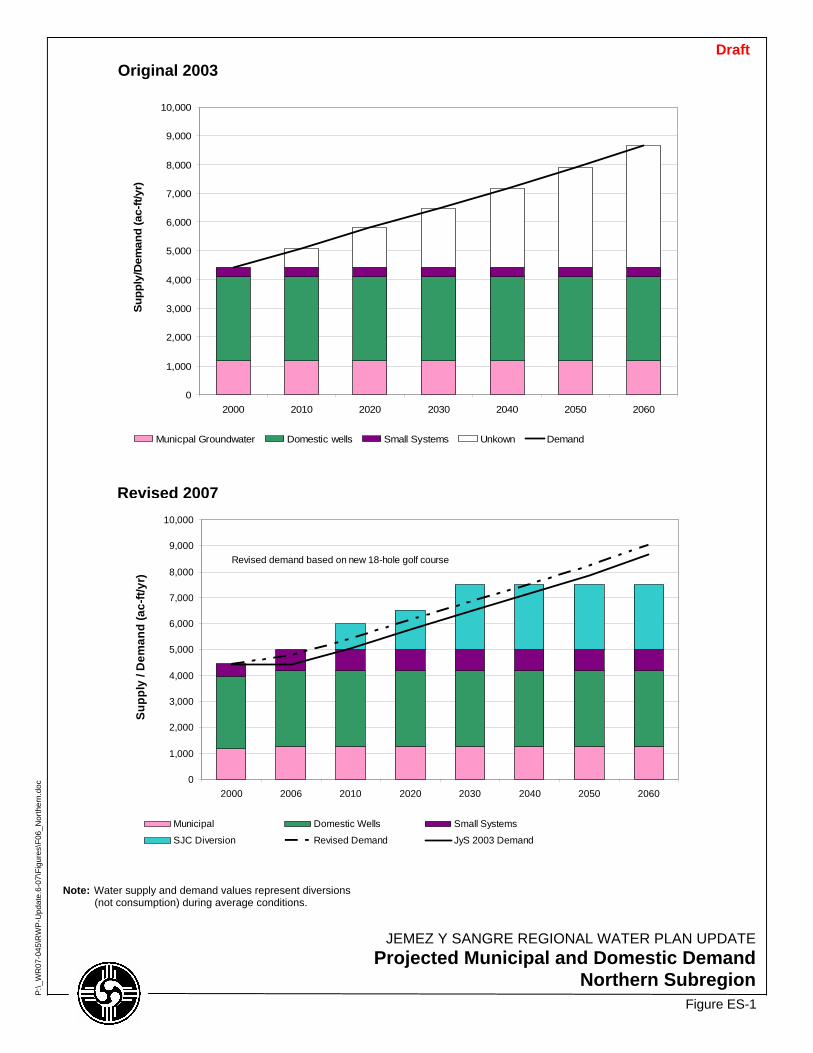
0
1,000
2,000
3,000
4,000
5,000
6,000
7,000
8,000
9,000
10,000
2000 2010 2020 2030 2040 2050 2060
Supp
ly/D
eman
d (a
c-ft/
yr)
Municpal Groundwater Domestic wells Small Systems Unkown Demand
0
1,000
2,000
3,000
4,000
5,000
6,000
7,000
8,000
9,000
10,000
2000 2006 2010 2020 2030 2040 2050 2060
Supp
ly /
Dem
and
(ac-
ft/yr
)
Municipal Domestic Wells Small Systems
SJC Diversion Revised Demand JyS 2003 Demand
Revised demand based on new 18-hole golf course
Figure ES-1
JEMEZ Y SANGRE REGIONAL WATER PLAN UPDATEProjected Municipal and Domestic Demand
Northern Subregion
P:\_
WR
07-0
45\R
WP
-Upd
ate.
6-07
\Fig
ures
\F06
_Nor
ther
n.do
c
Revised 2007
Original 2003 Draft
Note: Water supply and demand values represent diversions (not consumption) during average conditions.

0
1,000
2,000
3,000
4,000
5,000
6,000
7,000
8,000
9,000
2000 2010 2020 2030 2040 2050 2060
Supp
ly/D
eman
d (a
c-ft/
yr)
Domestic Wells Small Systems Unknown Demand
0
1,000
2,000
3,000
4,000
5,000
6,000
7,000
8,000
9,000
2000 2006 2010 2020 2030 2040 2050 2060
Supp
ly /
Dem
and
(ac-
ft/y
r)
Domestic wells Small SystemsExisting pueblo use (in-basin) Unused pueblo water rights (in-basin groundwater)Pueblo Proposed RWS Non-Pueblo Proposed RWSRevised demand Demand projected in Jys 2003 Plan
Figure ES-2
JEMEZ Y SANGRE REGIONAL WATER PLAN UPDATEProjected Municipal and Domestic Demand
Aamodt Subregion
P:\_
WR
07-0
45\R
WP
-Upd
ate.
6-07
\Fig
ures
\F08
_Aam
odt_
0619
07.d
oc
Revised 2007
Original 2003
Note: Water supply and demand values represent diversions (not consumption) during average conditions.
RWS = Regional water system
Draft

0
1,000
2,000
3,000
4,000
5,000
6,000
7,000
8,000
2000 2010 2020 2030 2040 2050 2060
Supp
ly/D
eman
d (a
c-ft/
yr)
Municipal Groundwater Projected Demand
0
1,000
2,000
3,000
4,000
5,000
6,000
7,000
8,000
2000 2006 2010 2020 2030 2040 2050 2060
Supp
ly /
Dem
and
(ac-
ft/y
r)
Municipal Groundwater SJCRevised Demand Projections JyS Water Plan 2003Projected Demand with 12% Reduction
Projected demand revised according to Los Alamos County 40-Year Water Plan
Figure ES-3
JEMEZ Y SANGRE REGIONAL WATER PLAN UPDATEProjected Municipal and Domestic Demand
Los Alamos Subregion
P:\_
WR
07-0
45\R
WP
-Upd
ate.
6-07
\Fig
ures
\F10
_Los
Ala
mos
.doc
Revised 2007
Original 2003 Draft
Note: Water supply and demand values represent diversions (not consumption) during average conditions.
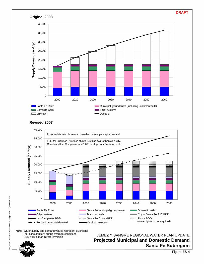
0
5,000
10,000
15,000
20,000
25,000
30,000
35,000
40,000
2000 2010 2020 2030 2040 2050 2060
Supp
ly/D
eman
d (a
c-ft/
yr)
Santa Fe River Municipal groundwater (including Buckman wells)Domestic wells Small systemsUnknown Demand
0
5,000
10,000
15,000
20,000
25,000
30,000
35,000
40,000
2000 2006 2010 2020 2030 2040 2050 2060
Supp
ly /
Dem
and
(ac-
ft/yr
)
Santa Fe River Santa Fe municipal groundwater Domestic wellsOther metered Buckman wells City of Santa Fe SJC BDDLas Campanas BDD Santa Fe County BDD Future BDDRevised projected demand Original projection
Projected demand for revised based on current per capita demand
FEIS for Buckman Diversion shows 8,730 ac-ft/yr for Santa Fe City, County and Las Campanas, and 1,000 ac-ft/yr from Buckman wells
Figure ES-4
JEMEZ Y SANGRE REGIONAL WATER PLAN UPDATEProjected Municipal and Domestic Demand
Santa Fe Subregion
P:\_
WR
07-0
45\R
WP
-Upd
ate.
6-07
\Fig
ures
\F11
_San
taFe
.doc
Revised 2007
Original 2003 DRAFT
Note: Water supply and demand values represent diversions (not consumption) during average conditions.
BDD = Buckman Direct Diversion
(water rights to be acquired)

0
500
1,000
1,500
2,000
2,500
2000 2010 2020 2030 2040 2050 2060
Supp
ly/D
eman
d (a
c-ft
/yr)
Domestic Wells Small Systems Unknown Demand
0
500
1,000
1,500
2,000
2,500
2000 2006 2010 2020 2030 2040 2050 2060
Supp
ly /
Dem
and
(ac-
ft/y
r)
Domestic wells Small Systems Unknown Demand
No change in projected demand
Domestic well use in 2006 increased by 40 ac-ft/yr above amount in 2000
Figure ES-5
JEMEZ Y SANGRE REGIONAL WATER PLAN UPDATEProjected Municipal and Domestic Demand
South Galisteo Creek Subregion
P:\_
WR
07-0
45\R
WP
-Upd
ate.
6-07
\Fig
ures
\F13
_S-G
alis
teo.
doc
Revised 2007
Original 2003
DRAFT
Note: Water supply and demand values represent diversions (not consumption) during average conditions.
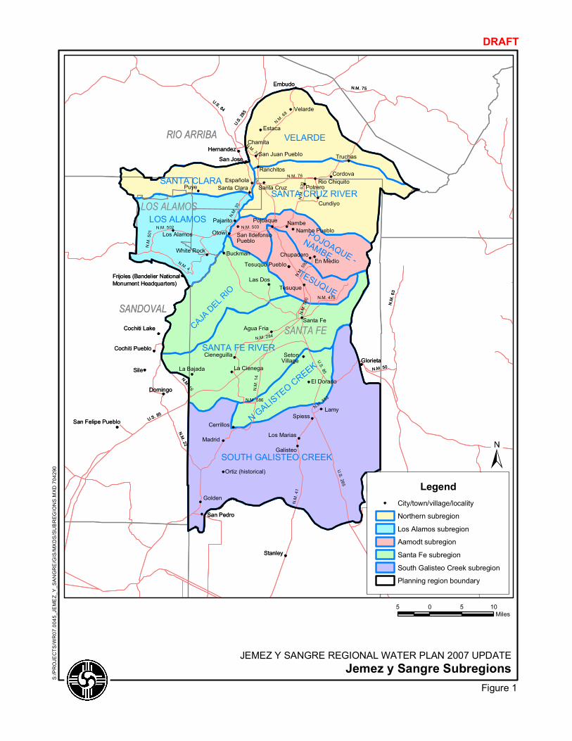
RIO ARRIBA
SANDOVAL
SANTA FE
LOS ALAMOS
N.M. 41
N.M. 34
N.M. 76
N.M. 63
N.M.68
U.S.285
N.M. 75
N.M. 22
U.S. 84
N.M. 30
N.M. 14
N.M. 475
N.M. 16
N.M. 50
N.M. 592
U.S. 285
N.M. 4
U.S. 85
U.S. 85
N.M. 502
N.M. 586
N.M. 501
N.M. 590
N.M. 503
N.M. 520
N.M. 74
N.M. 284
N.M. 553
Puye
Sile
Nambe
Otowi
Embudo
Estaca
Golden
Madrid
Spiess
Buckman
Chamita
Cordova
Cundiyo
Domingo
Las Dos
Potrero
Tesuque
Truchas
Velarde
En Medio
Galisteo
San Jose
Santa FeAgua Fria
El Dorado
La Bajada
San Pedro
Cerrillos
Los Alamos
Los Marias
White Rock
Cieneguilla
Santa Clara
Cochiti Lake
Nambe Pueblo
SetonVillage
Cochiti Pueblo
San Felipe Pueblo
Ortiz (historical)
Española
Pajarito Pojoaque
Chupadero
Hernandez
Ranchitos
Santa CruzRio Chiquito
Tesuque Pueblo
San Juan Pueblo
San IldefonsoPueblo
Frijoles (Bandelier NationalMonument Headquarters)
La CienegaGlorieta
Lamy
Stanley
CAJADEL RIO
LOS ALAMOSPOJOAQUE -
NAMBE
N GALISTEOCREEK
SANTA CLARASANTA CRUZ RIVER
SANTA FE RIVER
SOUTH GALISTEO CREEK
TESUQUE
VELARDERIO ARRIBA
SANDOVAL
SANTA FE
LOS ALAMOS
N.M. 41
N.M. 34
N.M. 76
N.M. 63
N.M.68
U.S.285
N.M. 75
N.M. 22
U.S. 84
N.M. 30
N.M. 14
N.M. 475
N.M. 16
N.M. 50
N.M. 592
U.S. 285
N.M. 4
U.S. 85
U.S. 85
N.M. 502
N.M. 586
N.M. 501
N.M. 590
N.M. 503
N.M. 520
N.M. 74
N.M. 284
N.M. 553
Puye
Sile
Nambe
Otowi
Embudo
Estaca
Golden
Madrid
Spiess
Buckman
Chamita
Cordova
Cundiyo
Domingo
Las Dos
Potrero
Tesuque
Truchas
Velarde
En Medio
Galisteo
San Jose
Santa FeAgua Fria
El Dorado
La Bajada
San Pedro
Cerrillos
Los Alamos
Los Marias
White Rock
Cieneguilla
Santa Clara
Cochiti Lake
Nambe Pueblo
SetonVillage
Cochiti Pueblo
San Felipe Pueblo
Ortiz (historical)
Española
Pajarito Pojoaque
Chupadero
Hernandez
Ranchitos
Santa CruzRio Chiquito
Tesuque Pueblo
San Juan Pueblo
San IldefonsoPueblo
Frijoles (Bandelier NationalMonument Headquarters)
La CienegaGlorieta
Lamy
Stanley
CAJADEL RIO
LOS ALAMOSPOJOAQUE -
NAMBE
N GALISTEOCREEK
SANTA CLARASANTA CRUZ RIVER
SANTA FE RIVER
SOUTH GALISTEO CREEK
TESUQUE
VELARDE
5 0 5 10Miles
S:/PROJECTS/WR07.0045_JEMEZ_Y_SANGRE/GIS/MXDS/SUBREGIONS.MXD704290
JEMEZ Y SANGRE REGIONAL WATER PLAN 2007 UPDATEJemez y Sangre Subregions
DRAFT
Figure 1
LegendCity/town/village/locality
Northern subregion
Los Alamos subregion
Aamodt subregion
Santa Fe subregion
South Galisteo Creek subregion
Planning region boundary
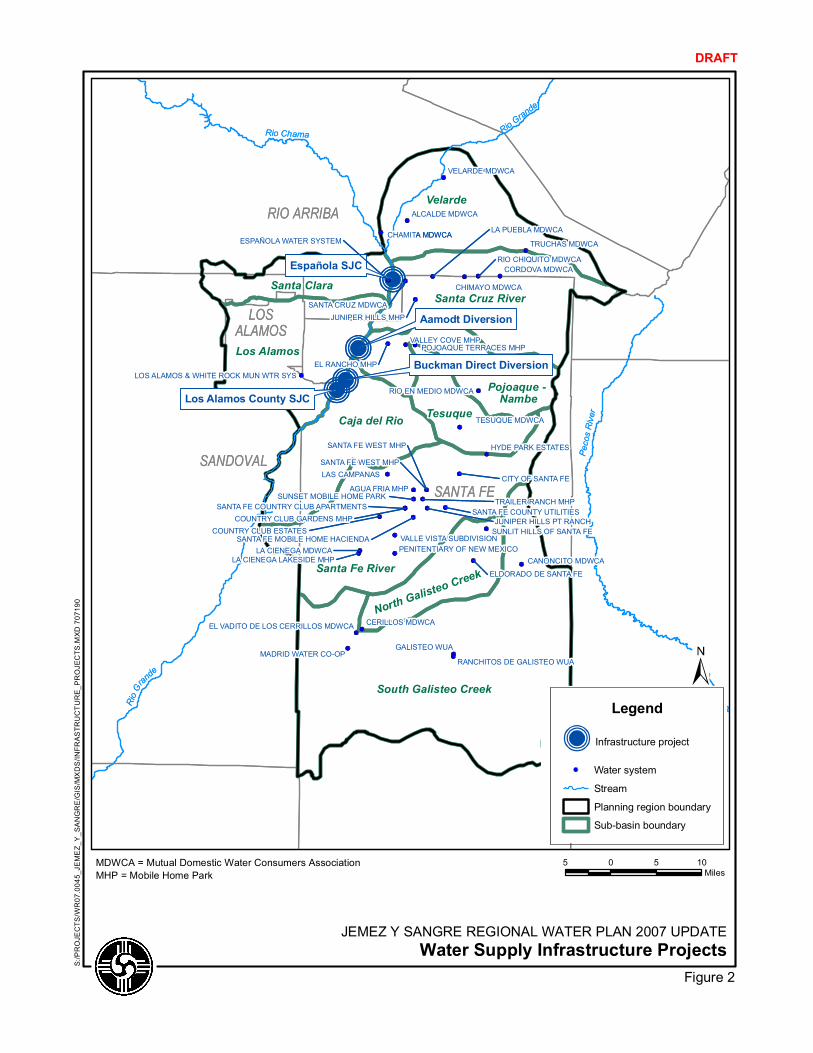
RIO ARRIBA
SANDOVAL
SANTA FE
LOSALAMOS
N.M. 34RioGran
de
Española SJC
Aamodt Diversion
Los Alamos County SJC
Buckman Direct Diversion
RioGrande
PecosRiver
Rio Chama
AGUA FRIA MHP
CORDOVAMDWCA
CHIMAYO MDWCA
ALCALDE MDWCA
SANTA CRUZ MDWCA
TRAILER RANCH MHP
SANTA FE WEST MHP HYDE PARK ESTATES
JUNIPER HILLS MHP
TESUQUE MDWCA
JUNIPER HILLS PT RANCH
VALLE VISTA SUBDIVISIONPENITENTIARY OF NEW MEXICO
GALISTEO WUA
LAS CAMPANAS
CHAMITA MDWCA
VELARDE MDWCA
TRUCHAS MDWCA
CERILLOS MDWCA
LA CIENEGA MDWCA
MADRID WATER CO-OP
CANONCITO MDWCALA CIENEGA LAKESIDE MHP
SUNLIT HILLS OF SANTA FE
RIO EN MEDIO MDWCA
RANCHITOS DE GALISTEO WUA
CITY OF SANTA FE
EL VADITO DE LOS CERRILLOS MDWCA
LOS ALAMOS & WHITE ROCK MUN WTR SYSEL RANCHO MHP
CORDOVAMDWCA
VALLEY COVE MHP
LA PUEBLA MDWCA
SANTA FE WEST MHP
RIO CHIQUITO MDWCA
ELDORADO DE SANTA FE
COUNTRY CLUB ESTATES
POJOAQUE TERRACES MHP
COUNTRY CLUB GARDENS MHPSANTA FE COUNTY UTILITIES
ESPAÑOLAWATER SYSTEM
SANTA FE MOBILE HOME HACIENDA
SUNSET MOBILE HOME PARKSANTA FE COUNTRY CLUB APARTMENTS
South Galisteo Creek
Velarde
Los Alamos
Caja del Rio Tesuque
Santa Clara
Santa Fe River
Santa Cruz River
Pojoaque -Nambe
NorthGalis
teo Creek
5 0 5 10Miles
S:/PROJECTS/WR07.0045_JEMEZ_Y_SANGRE/GIS/MXDS/INFRASTRUCTURE_PROJECTS.MXD707190
DRAFT
Legend
Infrastructure project
Water system
Stream
Planning region boundary
Sub-basin boundary
MDWCA = Mutual Domestic Water Consumers AssociationMHP = Mobile Home Park
JEMEZ Y SANGRE REGIONAL WATER PLAN 2007 UPDATEWater Supply Infrastructure Projects
Figure 2
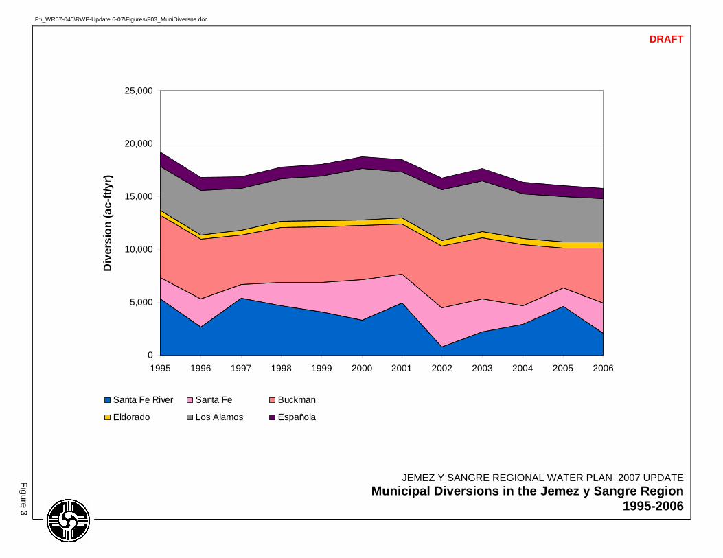
0
5,000
10,000
15,000
20,000
25,000
1995 1996 1997 1998 1999 2000 2001 2002 2003 2004 2005 2006
Div
ersi
on (a
c-ft/
yr)
Santa Fe River Santa Fe Buckman
Eldorado Los Alamos Española
JEMEZ Y SANGRE REGIONAL WATER PLAN 2007 UPDATE Municipal Diversions in the Jemez y Sangre Region
1995-2006
Figure 3
DRAFT
P:\_WR07-045\RWP-Update.6-07\Figures\F03_MuniDiversns.doc
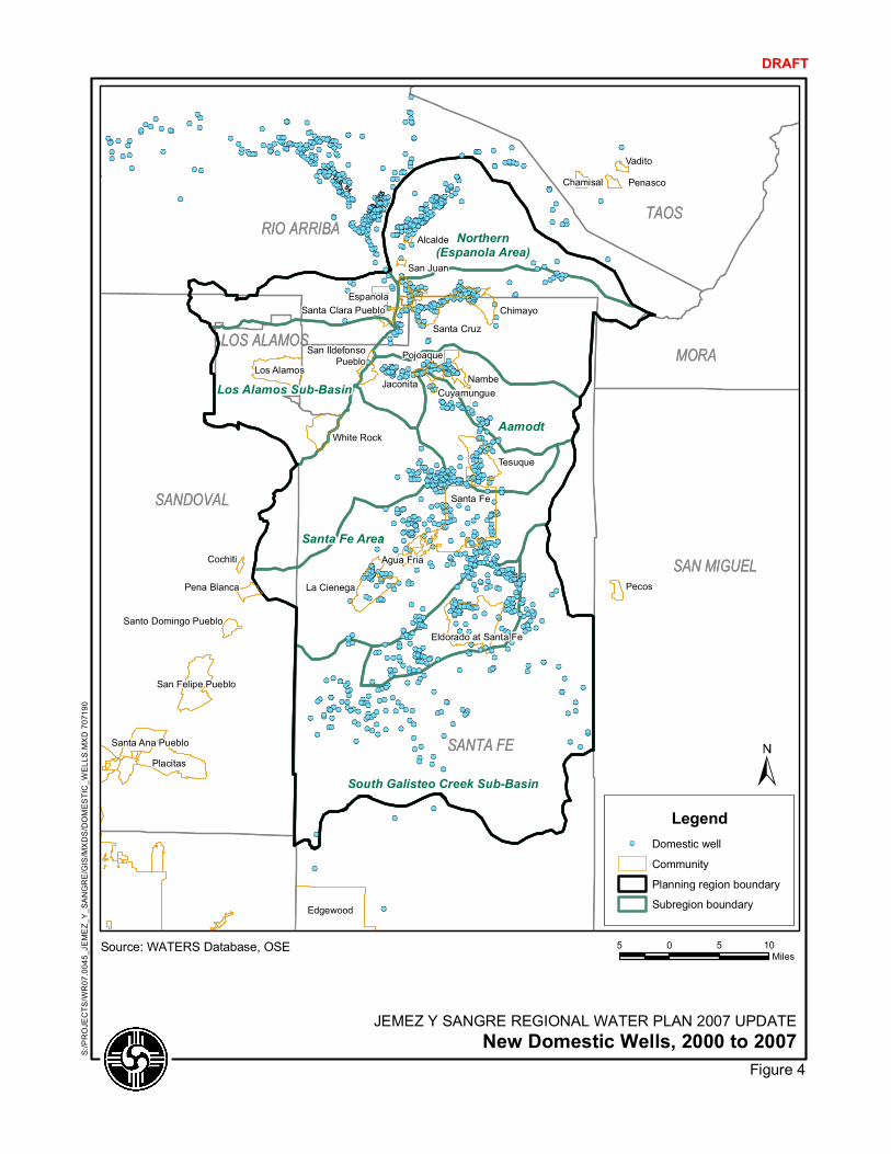
RIO ARRIBA
SANDOVAL
SANTA FE
LOS ALAMOSU.S.285
U.S. 84
SAN MIGUEL
MORA
TAOS
Santa Fe Area
Aamodt
Northern(Espanola Area)
South Galisteo Creek Sub-Basin
Los Alamos Sub-Basin
Santa Fe
Edgewood
Placitas
Eldorado at Santa Fe
Tesuque
La Cienega
Los Alamos
San Felipe Pueblo
Espanola
White Rock
Santa Cruz
Nambe
Santa Ana Pueblo
Chimayo
Pojoaque
Agua Fria
Pena Blanca
San IldefonsoPueblo
Pecos
Chamisal Penasco
Santa Clara Pueblo
Vadito
Santo Domingo Pueblo
Jaconita
Cochiti
Alcalde
San Juan
Cuyamungue
Source: WATERS Database, OSE 5 0 5 10Miles
S:/PROJECTS/WR07.0045_JEMEZ_Y_SANGRE/GIS/MXDS/DOMESTIC_W
ELLS.MXD707190
DRAFT
LegendDomestic well
Community
Planning region boundary
Subregion boundary
JEMEZ Y SANGRE REGIONAL WATER PLAN 2007 UPDATENew Domestic Wells, 2000 to 2007
Figure 4
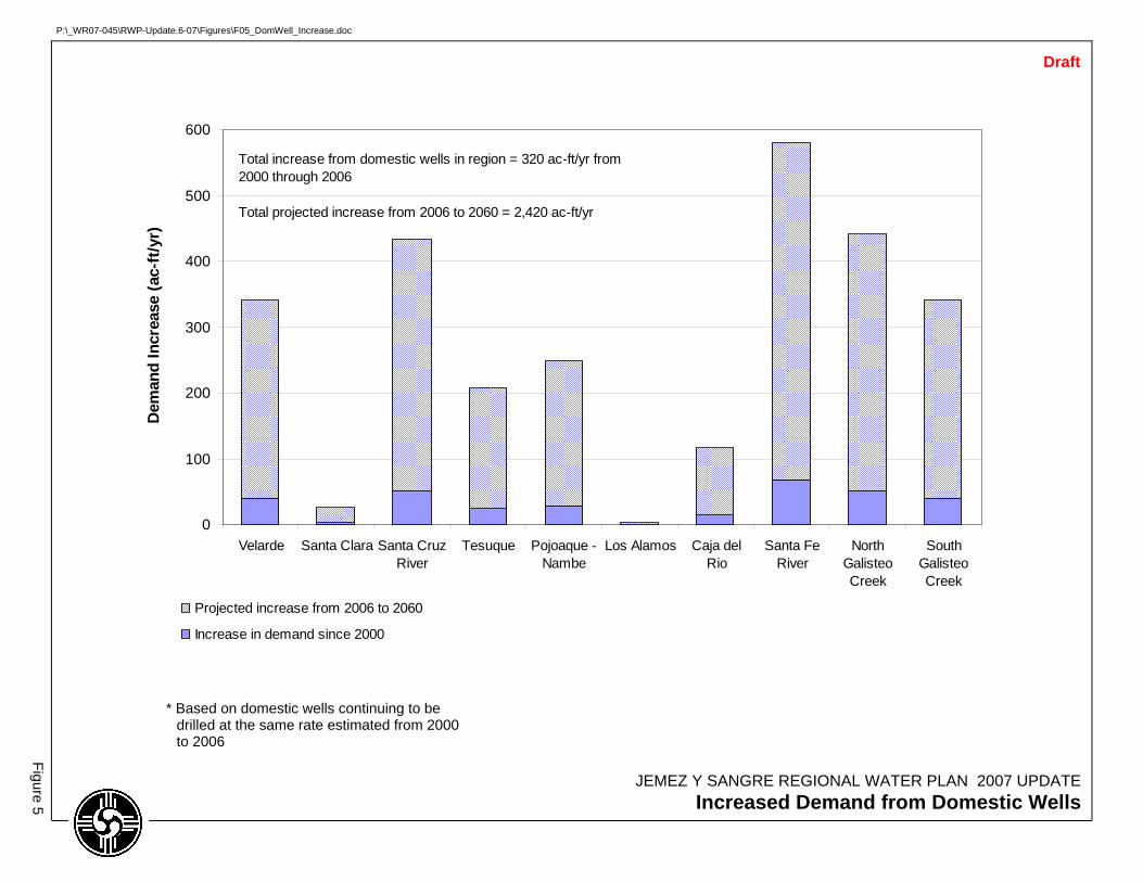
0
100
200
300
400
500
600
Velarde Santa Clara Santa CruzRiver
Tesuque Pojoaque -Nambe
Los Alamos Caja delRio
Santa FeRiver
NorthGalisteoCreek
SouthGalisteoCreek
Dem
and
Incr
ease
(ac-
ft/y
r)
Projected increase from 2006 to 2060
Increase in demand since 2000
Total increase from domestic wells in region = 320 ac-ft/yr from 2000 through 2006
Total projected increase from 2006 to 2060 = 2,420 ac-ft/yr
JEMEZ Y SANGRE REGIONAL WATER PLAN 2007 UPDATE Increased Demand from Domestic Wells
Figure 5
* Based on domestic wells continuing to be drilled at the same rate estimated from 2000 to 2006
Draft
P:\_WR07-045\RWP-Update.6-07\Figures\F05_DomWell_Increase.doc

0
1,000
2,000
3,000
4,000
5,000
6,000
7,000
8,000
9,000
10,000
2000 2010 2020 2030 2040 2050 2060
Supp
ly/D
eman
d (a
c-ft/
yr)
Municpal Groundwater Domestic wells Small Systems Unkown Demand
0
1,000
2,000
3,000
4,000
5,000
6,000
7,000
8,000
9,000
10,000
2000 2006 2010 2020 2030 2040 2050 2060
Supp
ly /
Dem
and
(ac-
ft/yr
)
Municipal Domestic WellsSmall Systems SJC Diversion (proposed)Revised Demand JyS 2003 Demand
Revised demand based on new 18-hole golf course
Figure 6
JEMEZ Y SANGRE REGIONAL WATER PLAN UPDATEProjected Municipal and Domestic Demand
Northern Subregion
P:\_
WR
07-0
45\R
WP
-Upd
ate_
Une
dite
d.7-
08\F
06_N
orth
ern.
doc
Revised 2007
Original 2003 Draft
Note: Water supply and demand values represent diversions (not consumption) during average conditions.
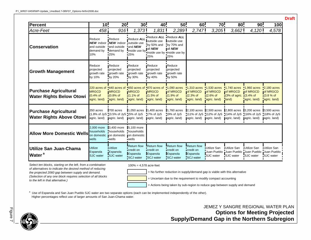
P:\_WR07-045\RWP-Update_Unedited.7-08\F07_Options-Nrthn2008.doc
JEMEZ Y SANGRE REGIONAL WATER PLAN Options for Meeting Projected
Supply/Demand Gap in the Northern Subregion
Figure 7
Draft Percent 10 20 30 40 50 60 70 80 90 100Acre-Feet 458 916 1,373 1,831 2,289 2,747 3,205 3,662 4,120 4,578
Conservation
Reduce NEW indoor and outside demand by 10%
Reduce NEW indoor and outside demand by 25%
Reduce ALL outside use and NEW inside use by 25%
Reduce ALL outside use by 50% and all NEW inside use by 25%
Reduce ALL outside use by 70% and all NEW inside use by 25%
Growth ManagementReduce projected growth rate by 10%
Reduce projected growth rate by 20%
Reduce projected growth rate by 30%
Reduce projected growth rate by 40%
Reduce projected growth rate by 50%
Purchase Agricultural Water Rights Below Otowi
220 acres of MRGCD (0.4% of agric. land)
440 acres of MRGCD (0.8% of agric. land)
650 acres of MRGCD (1.1% of agric. land)
870 acres of MRGCD (1.5% of agric. land)
1,090 acres of MRGCD (1.9% of agric. land)
1,310 acres of MRGCD (2.3% of agric. land)
1,530 acres of MRGCD (2.6% of agric. land)
1,740 acres of MRGCD (3% of agric. land)
1,960 acres of MRGCD (3.4% of agric. land)
2,180 acres of MRGCD (3.8 % of agric. land)
Purchase Agricultural Water Rights Above Otowi
350 acres (1.8% of JyS agric. land)
700 acres (3.5% of JyS agric. land)
1,050 acres (5% of JyS agric. land)
1,400 acres (7% of JyS agric. land)
1,760 acres (9% of JyS agric. land)
2,100 acres (11% of JyS agric. land)
2,500 acres (12% of JyS agric. land)
2,800 acres (14% of JyS agric. land)
3,200 acres (16% of JyS agric. land)
3,500 acres (18% of JyS agric. land)
Allow More Domestic Wells2,000 more households on domestic wells
3,400 more households on domestic wells
5,100 more households on domestic wells
Utilize San Juan-Chama Water a
Utilize Espanola SJC water
Utilize Espanola SJC water
Return flow credit on Espanola SCJ water
Return flow credit on Espanola SCJ water
Return flow credit on Espanola SCJ water
Return flow credit on Espanola SCJ water
Utilize San Juan Pueblo SJC water
Utilize San Juan Pueblo SJC water
Utilize San Juan Pueblo SJC water
Utilize San Juan Pueblo SJC water
100% = 4,578 acre-feet
= No further reduction in supply/demand gap is viable with this alternative
= Uncertain due to the requirement to modify compact accounting
= Actions being taken by sub-region to reduce gap between supply and demand
Select ten blocks, starting on the left, from a combination of alternatives to indicate the desired method of reducing the projected 2060 gap between supply and demand. (Selection of any one block requires selection of all blocks to the left in that alternative.)
a Use of Espanola and San Juan Pueblo SJC water are two separate options (each can be implemented independently of the other). Higher percentages reflect use of larger amounts of San Juan-Chama water.
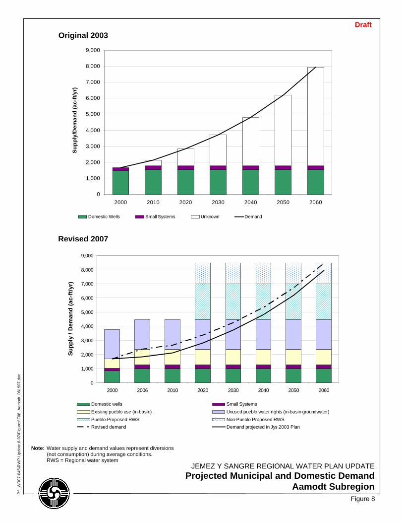
0
1,000
2,000
3,000
4,000
5,000
6,000
7,000
8,000
9,000
2000 2010 2020 2030 2040 2050 2060
Supp
ly/D
eman
d (a
c-ft/
yr)
Domestic Wells Small Systems Unknown Demand
0
1,000
2,000
3,000
4,000
5,000
6,000
7,000
8,000
9,000
2000 2006 2010 2020 2030 2040 2050 2060
Supp
ly /
Dem
and
(ac-
ft/y
r)
Domestic wells Small SystemsExisting pueblo use (in-basin) Unused pueblo water rights (in-basin groundwater)Pueblo Proposed RWS Non-Pueblo Proposed RWSRevised demand Demand projected in Jys 2003 Plan
Figure 8
JEMEZ Y SANGRE REGIONAL WATER PLAN UPDATEProjected Municipal and Domestic Demand
Aamodt Subregion
P:\_
WR
07-0
45\R
WP
-Upd
ate.
6-07
\Fig
ures
\F08
_Aam
odt_
0619
07.d
oc
Revised 2007
Original 2003
Note: Water supply and demand values represent diversions (not consumption) during average conditions.
RWS = Regional water system
Draft
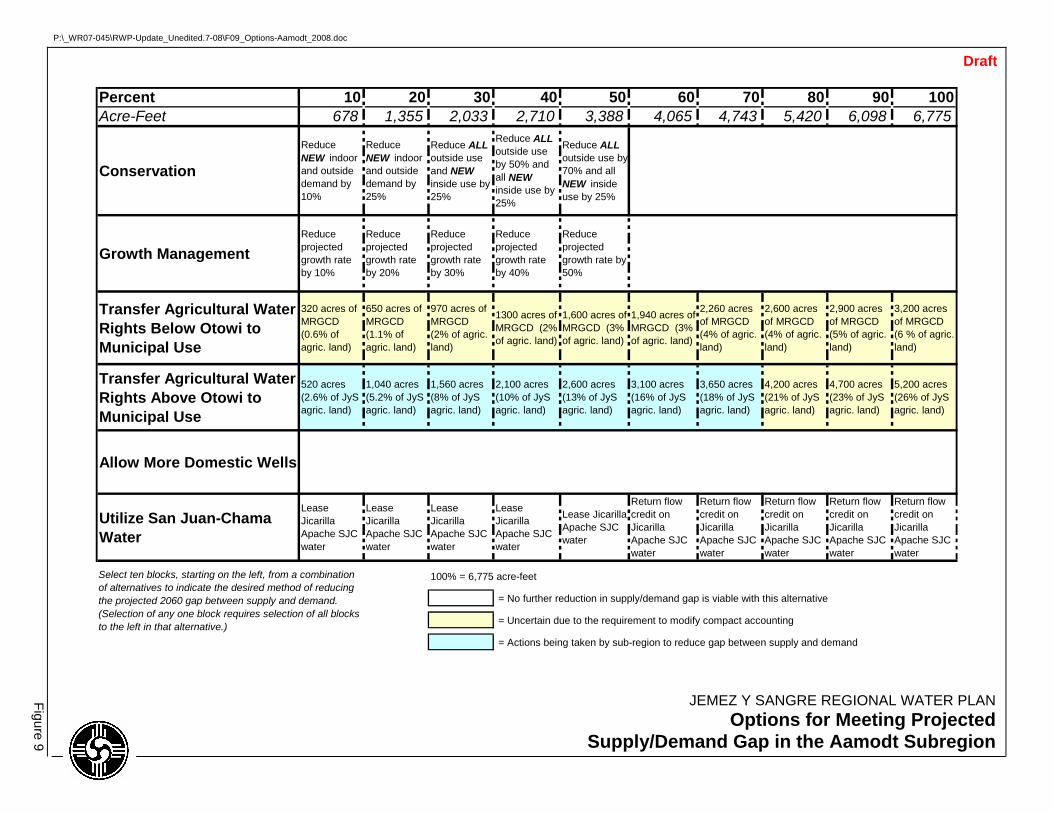
P:\_WR07-045\RWP-Update_Unedited.7-08\F09_Options-Aamodt_2008.doc
JEMEZ Y SANGRE REGIONAL WATER PLAN Options for Meeting Projected
Supply/Demand Gap in the Aamodt Subregion
Figure 9
Draft
Percent 10 20 30 40 50 60 70 80 90 100Acre-Feet 678 1,355 2,033 2,710 3,388 4,065 4,743 5,420 6,098 6,775
Conservation
Reduce NEW indoor and outside demand by 10%
Reduce NEW indoor and outside demand by 25%
Reduce ALL outside use and NEW inside use by 25%
Reduce ALL outside use by 50% and all NEW inside use by 25%
Reduce ALL outside use by 70% and all NEW inside use by 25%
Growth ManagementReduce projected growth rate by 10%
Reduce projected growth rate by 20%
Reduce projected growth rate by 30%
Reduce projected growth rate by 40%
Reduce projected growth rate by 50%
Transfer Agricultural Water Rights Below Otowi to Municipal Use
320 acres of MRGCD (0.6% of agric. land)
650 acres of MRGCD (1.1% of agric. land)
970 acres of MRGCD (2% of agric. land)
1300 acres of MRGCD (2% of agric. land)
1,600 acres of MRGCD (3% of agric. land)
1,940 acres of MRGCD (3% of agric. land)
2,260 acres of MRGCD (4% of agric. land)
2,600 acres of MRGCD (4% of agric. land)
2,900 acres of MRGCD (5% of agric. land)
3,200 acres of MRGCD (6 % of agric. land)
Transfer Agricultural Water Rights Above Otowi to Municipal Use
520 acres (2.6% of JyS agric. land)
1,040 acres (5.2% of JyS agric. land)
1,560 acres (8% of JyS agric. land)
2,100 acres (10% of JyS agric. land)
2,600 acres (13% of JyS agric. land)
3,100 acres (16% of JyS agric. land)
3,650 acres (18% of JyS agric. land)
4,200 acres (21% of JyS agric. land)
4,700 acres (23% of JyS agric. land)
5,200 acres (26% of JyS agric. land)
Allow More Domestic Wells
Utilize San Juan-Chama Water
Lease Jicarilla Apache SJC water
Lease Jicarilla Apache SJC water
Lease Jicarilla Apache SJC water
Lease Jicarilla Apache SJC water
Lease Jicarilla Apache SJC water
Return flow credit on Jicarilla Apache SJC water
Return flow credit on Jicarilla Apache SJC water
Return flow credit on Jicarilla Apache SJC water
Return flow credit on Jicarilla Apache SJC water
Return flow credit on Jicarilla Apache SJC water
100% = 6,775 acre-feet
= No further reduction in supply/demand gap is viable with this alternative
= Uncertain due to the requirement to modify compact accounting
= Actions being taken by sub-region to reduce gap between supply and demand
Select ten blocks, starting on the left, from a combination of alternatives to indicate the desired method of reducing the projected 2060 gap between supply and demand. (Selection of any one block requires selection of all blocks to the left in that alternative.)
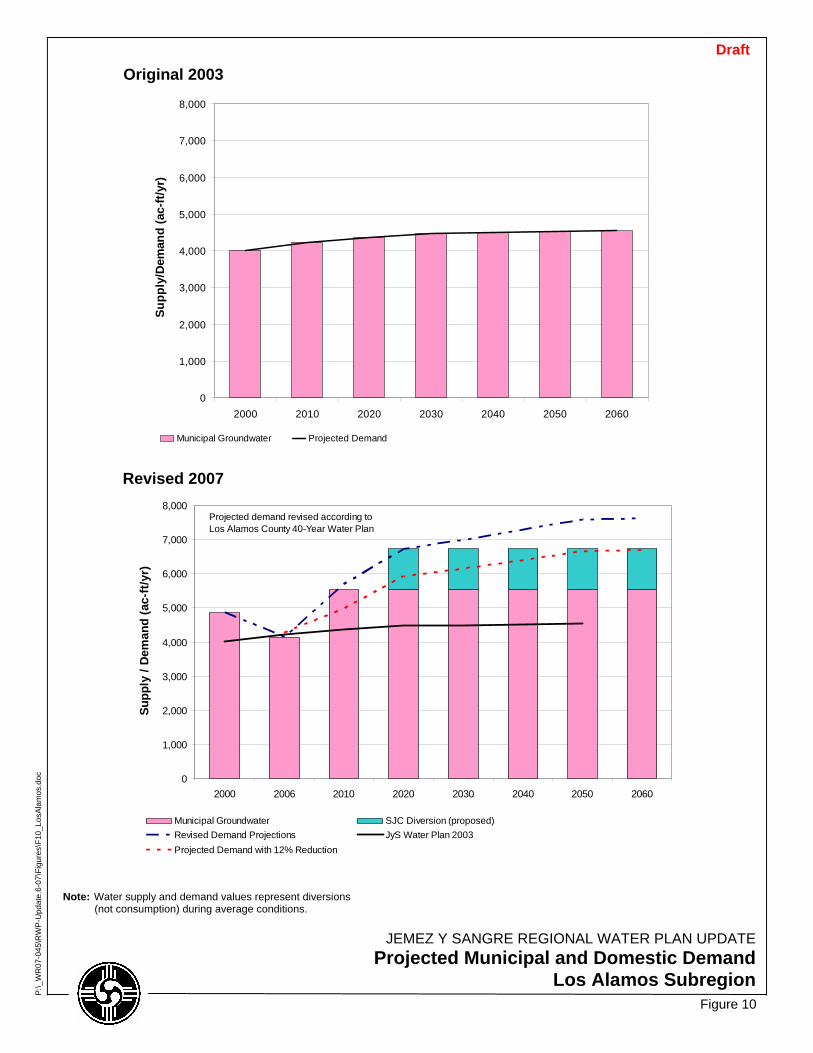
0
1,000
2,000
3,000
4,000
5,000
6,000
7,000
8,000
2000 2010 2020 2030 2040 2050 2060
Supp
ly/D
eman
d (a
c-ft/
yr)
Municipal Groundwater Projected Demand
0
1,000
2,000
3,000
4,000
5,000
6,000
7,000
8,000
2000 2006 2010 2020 2030 2040 2050 2060
Supp
ly /
Dem
and
(ac-
ft/y
r)
Municipal Groundwater SJC Diversion (proposed)Revised Demand Projections JyS Water Plan 2003Projected Demand with 12% Reduction
Projected demand revised according to Los Alamos County 40-Year Water Plan
Figure 10
JEMEZ Y SANGRE REGIONAL WATER PLAN UPDATEProjected Municipal and Domestic Demand
Los Alamos Subregion
P:\_
WR
07-0
45\R
WP
-Upd
ate.
6-07
\Fig
ures
\F10
_Los
Ala
mos
.doc
Revised 2007
Original 2003 Draft
Note: Water supply and demand values represent diversions (not consumption) during average conditions.
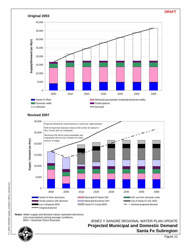
0
5,000
10,000
15,000
20,000
25,000
30,000
35,000
40,000
2000 2010 2020 2030 2040 2050 2060
Supp
ly/D
eman
d (a
c-ft/
yr)
Santa Fe River Municipal groundwater (including Buckman wells)Domestic wells Small systemsUnknown Demand
0
5,000
10,000
15,000
20,000
25,000
30,000
2000 2006 2010 2020 2030 2040 2050 2060
Supp
ly /
Dem
and
(ac-
ft/y
r)
Santa Fe River diversions Municipal SF Basin GW GW use from domestic wellsSmall systems GW diversion Municipal Buckman GW* City of Santa Fe SJC BDDLas Campanas BDD Santa Fe County BDD Revised projected demandOriginal projection
Projected demand for revised based on current per capita demand
FEIS for Buckman Diversion shows 8,730 ac-ft/yr for Santa Fe City, County and Las Campanas
*Buckman GW will be used sustainably and conjuntively with the City of Santa Fe's other sources of supply
Figure 11
JEMEZ Y SANGRE REGIONAL WATER PLAN UPDATEProjected Municipal and Domestic Demand
Santa Fe Subregion
P:\_
WR
07-0
45\R
WP
-Upd
ate_
Une
dite
d.7-
08\F
11_S
anta
Fe.d
oc
Revised 2007
Original 2003 DRAFT
Notes: Water supply and demand values represent diversions (not consumption) during average conditions.
BDD = Buckman Direct Diversion

P:\_WR07-045\RWP-Update_Unedited.7-08\F12_Optns-SantaFe_2008.doc
JEMEZ Y SANGRE REGIONAL WATER PLAN Options for Meeting Projected
Supply/Demand Gap in the Santa Fe Subregion
Figure 12
6/22/2007
Draft
Percent 10 20 30 40 50 60 70 80 90 100Acre-Feet 1,990 3,980 5,970 7,960 9,950 11,940 13,930 15,920 17,910 19,900
Conservation
Reduce NEW indoor and outside demand by 10%
Reduce NEW indoor and outside demand by 25%
Reduce ALL outside use and NEW inside use by 25%
Reduce ALL outside use by 50% and all NEW inside use by 25%
Reduce ALL outside use by 70% and all NEW inside use by 25%
Growth ManagementReduce projected growth rate by 10%
Reduce projected growth rate by 20%
Reduce projected growth rate by 30%
Reduce projected growth rate by 40%
Reduce projected growth rate by 50%
Transfer Agricultural Water Rights Below Otowi to Municipal Use
950 acres of MRGCD (1.6% of agric. land)
1,900 acres of MRGCD (3% of agric. land)
2,800 acres of MRGCD (5% of agric. land)
3,800 acres of MRGCD (7% of agric. land)
4,700 acres of MRGCD (8% of agric. land)
5,700 acres of MRGCD (10% of agric. land)
6,600acres of MRGCD (11% of agric. land)
7,600 acres of MRGCD (13% of agric. land)
8,500 acres of MRGCD (15% of agric. land)
9,500 acres of MRGCD (16 % of agric. land)
Transfer Agricultural Water Rights Above Otowi to Municipal Use
1,500 acres (7.7% of JyS agric. land)
3,000 acres (15% of JyS agric. land)
4,600 acres (23% of JyS agric. land)
6,100 acres (31% of JyS agric. land)
7,700 acres (38% of JyS agric. land)
Allow More Domestic Wells8,000 more households on domestic wells
Utilize San Juan-Chama Water
Return flow credit on City of Santa Fe SJC water
Return flow credit on City of Santa Fe SJC water
Lease Jicarilla Apache SJC water
Lease Jicarilla Apache SJC water
Return flow credit on Jicarilla Apache SJC water
100% = 19,900 acre-feet
= No further reduction in supply/demand gap is viable with this alternative
= Uncertain due to the requirement to modify compact accounting
= Uncertain due to Area of Origin concerns
= Actions being taken by sub-region to reduce gap between supply and demand
Select ten blocks, starting on the left, from a combination of alternatives to indicate the desired method of reducing the projected 2060 gap between supply and demand. (Selection of any one block requires selection of all blocks to the left for that alternative.)
Further demand reduction may be possible through advanced technologies or more restrictive policies
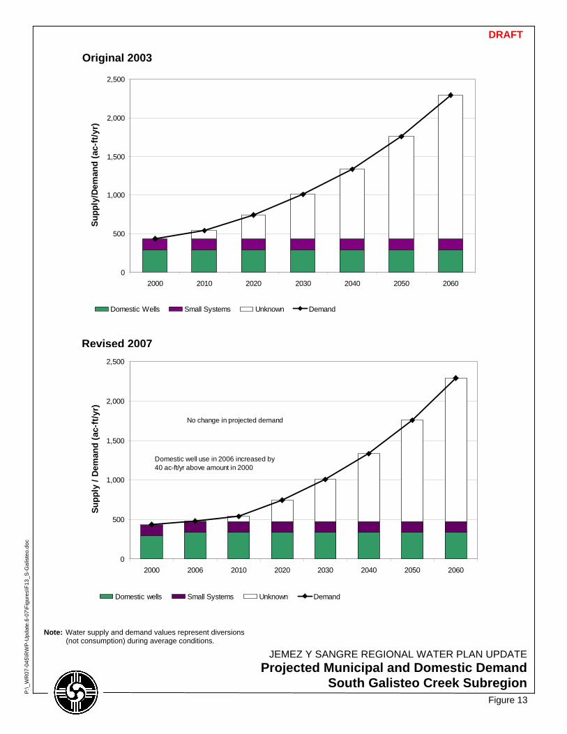
0
500
1,000
1,500
2,000
2,500
2000 2010 2020 2030 2040 2050 2060
Supp
ly/D
eman
d (a
c-ft
/yr)
Domestic Wells Small Systems Unknown Demand
0
500
1,000
1,500
2,000
2,500
2000 2006 2010 2020 2030 2040 2050 2060
Supp
ly /
Dem
and
(ac-
ft/y
r)
Domestic wells Small Systems Unknown Demand
No change in projected demand
Domestic well use in 2006 increased by 40 ac-ft/yr above amount in 2000
Figure 13
JEMEZ Y SANGRE REGIONAL WATER PLAN UPDATEProjected Municipal and Domestic Demand
South Galisteo Creek Subregion
P:\_
WR
07-0
45\R
WP
-Upd
ate.
6-07
\Fig
ures
\F13
_S-G
alis
teo.
doc
Revised 2007
Original 2003
DRAFT
Note: Water supply and demand values represent diversions (not consumption) during average conditions.
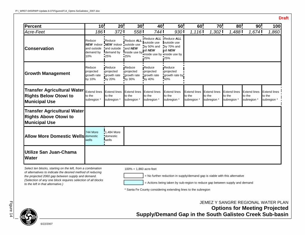
P:\_WR07-045\RWP-Update.6-07\Figures\F14_Optns-SoGalisteo_2007.doc
Percent 10 20 30 40 50 60 70 80 90 100Acre-Feet 186 372 558 744 930 1,116 1,302 1,488 1,674 1,860
Conservation
Reduce NEW indoor and outside demand by 10%
Reduce NEW indoor and outside demand by 25%
Reduce ALL outside use and NEW inside use by 25%
Reduce ALL outside use by 50% and all NEW inside use by 25%
Reduce ALL outside use by 70% and all NEW inside use by 25%
Growth ManagementReduce projected growth rate by 10%
Reduce projected growth rate by 20%
Reduce projected growth rate by 30%
Reduce projected growth rate by 40%
Reduce projected growth rate by 50%
Transfer Agricultural Water Rights Below Otowi to Municipal Use
Extend lines to the subregion *
Extend lines to the subregion *
Extend lines to the subregion *
Extend lines to the subregion *
Extend lines to the subregion *
Extend lines to the subregion *
Extend lines to the subregion *
Extend lines to the subregion *
Extend lines to the subregion *
Extend lines to the subregion *
Transfer Agricultural Water Rights Above Otowi to Municipal Use
Allow More Domestic Wells744 More domestic wells
1,484 More domestic wells
Utilize San Juan-Chama Water
100% = 1,860 acre-feet
= No further reduction in supply/demand gap is viable with this alternative
= Actions being taken by sub-region to reduce gap between supply and demand
* Santa Fe County considering extending lines to the subregion
Select ten blocks, starting on the left, from a combination of alternatives to indicate the desired method of reducing the projected 2060 gap between supply and demand. (Selection of any one block requires selection of all blocks to the left in that alternative.)
JEMEZ Y SANGRE REGIONAL WATER PLAN Options for Meeting Projected
Supply/Demand Gap in the South Galisteo Creek Sub-basin
Figure 14
6/22/2007
Draft
Jemez y Sangre Water Planning Council
Table 1. Summary of Actions Taken Regarding Jemez y Sangre Regional Water Plan Update Page 1 of 10
W:\Water Resource Planning\Jemez y Sangre Regional Planning\Plan Update\REvisions to DBSA Update\Revisions circulated to Council\Post Council revisions\FINAL FINAL FINAL\T01_Actions Taken.doc
Alternative Instigator / Action Taken
Category I: Protect Existing Supplies Forest restoration project • USFS:13 restorations projects funded by CFRP, totaling $4,500,000 (see Appendix C for
summary) • NMED Section 319: 12 funded watershed restoration projects in JyS (Appendix C) • City of Santa Fe has thinned more than 4,700 acres. • Los Alamos County, Pajarito Watershed Association • Pojoaque Pueblo • Santa Clara Pueblo • Santa Fe County, Santa Fe Watershed Association, Forest Guardians, State Land Office • San Ildefonso Pueblo • Ohkay Owingeh • Tesuque Pueblo
Develop storm water management ordinance • Santa Fe County (as part of Subdivision Ordinance) • City of Española • City of Santa Fe • New Mexico State Land Office • Los Alamos County • Cerro Gordo Ditch Association • Hyde Park Water Users Association
Cloud seeding project • Research and workshops, need funding for pilot project Develop well field management plan • OSE not developing critical management area (CMA) in JyS region.
• City of Santa Fe has well field management plan. • Santa Fe County working on model to guide plan. • Pojoaque Pueblo rotates use of wells. • Eldorado Area Water and Sanitation District (WSD) is developing a plan. • City of Española • Solacito Mutual Domestic Water Association developed wellhead protection project. • Hyde Park Water Users Association (WUA). • Los Alamos County will consider addressing plume migration
Jemez y Sangre Water Planning Council
Table 1. Summary of Actions Taken Regarding Jemez y Sangre Regional Water Plan Update Page 2 of 10
W:\Water Resource Planning\Jemez y Sangre Regional Planning\Plan Update\REvisions to DBSA Update\Revisions circulated to Council\Post Council revisions\FINAL FINAL FINAL\T01_Actions Taken.doc
Alternative Instigator / Action Taken
Category I: Protect Existing Supplies (cont.) Propose conjunctive use of surface and groundwater supplies
• City of Santa Fe preferably uses surface water when it is available. • La Puebla Community Well Association • Santa Fe County working on plan (Buckman Direct Diversion [BDD] combined with wells). • Eldorado Area WSD would like to work with Santa Fe County to acquire surface water. • Los Alamos County has Los Alamos Reservoir surface water rights that have not been used
after fire damage. The reservoir is now being rebuilt for nonpotable uses. With San Juan-Chama (SJC) diversion, the County will have additional options.
• Parties to Aamodt Settlement Agreement will have options for conjunctive use once a diversion from the Rio Grande is built.
Expand treatment facilities to remove trace constituents (i.e., arsenic)
• City of Española developed arsenic abatement plan to blend water from wells to reduce arsenic levels.
• City of Santa Fe has conducted wellhead treatment at several wells and applied for a 3-year extension for compliance with the new arsenic standard to explore arsenic treatment options.
Restrict drilling of domestic wells within your jurisdiction
• City of Española • City of Santa Fe • County of Santa Fe • La Vista Homeowners Association • Hyde Park WUA • OSE has new domestic well regulations that reduce allowed water use.
Develop/explore methods for instream flow • Santa Cruz • Pojoaque Pueblo • Santa Fe County is exploring the potential for Valle Vista treatment plant to discharge to Arroyo
Hondo and revitalize La Cienega. • City of Santa Fe is conducting a tree-ring study to analyze longer historical period of streamflow. • City of Santa Fe is exploring possibilities of releasing reservoir water to help restore the Santa
Fe River.
Jemez y Sangre Water Planning Council
Table 1. Summary of Actions Taken Regarding Jemez y Sangre Regional Water Plan Update Page 3 of 10
W:\Water Resource Planning\Jemez y Sangre Regional Planning\Plan Update\REvisions to DBSA Update\Revisions circulated to Council\Post Council revisions\FINAL FINAL FINAL\T01_Actions Taken.doc
Alternative Instigator / Action Taken
Category I: Protect Existing Supplies (cont.) Develop/explore methods for instream flow (cont.) • NMED Clean Water Act Section 319 Watershed Restoration Action Strategies (WRASs) (see
Appendix C for summary of WRASs) Wastewater treatment plant construction, repairs, or upgrades
• PL 108-354 (entitled Chimayo Water Supply System and Española Filtration Facility Act) requires feasibility study of regional system.
• Pojoaque Pueblo upgrading wastewater treatment plant (WWTP) from lagoons to Class A treatment.
• Española upgrading WWTP from 0.96 millions gallons per day (mgd) to 2.2 mgd. • Los Alamos County has almost completed upgrade of WWTP (1.4-mgd design flow). • El Vadito de los Cerrillos MDWCA • Rio Arriba County Commission is looking into a regional wastewater treatment plant. • Santa Fe County received $850,000 grant to address wastewater treatment in Sombrillo area.
Acéquia bylaws to prevent water transfers out of acéquia
• Santa Cruz Irrigation District has completed bylaws for 14 acéquias in the district. • La Acéquia de la Canada Ancha passed bylaws. • Acéquia Madre • Rio Arriba County has hired a liaison to assist acéquias in developing bylaws. • Cerro Gordo Ditch Association • New Mexico Acéquia Association
Category II: Improve System Efficiency Wastewater reuse project • City of Santa Fe has reused effluent since the 1940s and will continue to do so.
• Pojoaque Pueblo reuses wastewater and will use more after new plant is constructed. • Santa Fe County • Los Alamos County • Tesuque Pueblo uses effluent from casino to irrigate landscaping.
Project to replace septic tanks and provide for regional WWTP
• Santa Clara Pueblo and City of Española exploring possibilities for collaborating on a WWTP. • Santa Fe County looking into regional WWTP.
Line irrigation ditches/acéquias • Santa Clara has lined all ditches. • San Ildefonso has lined all ditches. • Cerro Gordo Ditch Association
Jemez y Sangre Water Planning Council
Table 1. Summary of Actions Taken Regarding Jemez y Sangre Regional Water Plan Update Page 4 of 10
W:\Water Resource Planning\Jemez y Sangre Regional Planning\Plan Update\REvisions to DBSA Update\Revisions circulated to Council\Post Council revisions\FINAL FINAL FINAL\T01_Actions Taken.doc
Alternative Instigator / Action Taken
Category II: Improve System Efficiency (cont.) Develop a regional water system authority • Eldorado Area WSD interested in partnering with area communities (Lamy, Canoncito, etc.). • BDD Project Board is a regional authority for the one source of supply as of August 2006. • Los Alamos County Water Utility is a regional water system for Los Alamos, White Rock,
Bandelier, and Los Alamos National Laboratory (LANL). • Aamodt parties will create a water board to operate a surface diversion from Rio Grande. Aquifer storage and recovery project • Santa Fe County may consider using treated effluent and surface water. Optimize reservoir management (sediment removal, evaporative loss reduction)
• Project funded to restore Santa Cruz Reservoir, including raising dam and dredging. • Santa Clara Pueblo removed sediment from ponds that were inundated after the Cerro Grande
fire. • City of Santa Fe will conduct bathymetry study of McClure and Nichols, may seek carryover
storage agreement in Heron Reservoir. • El Vadito de los Cerrillos MDWA has repaired Cerrillos Reservoir dam.
Changes to infrastructure • Santa Clara Pueblo is replacing old infrastructure. • Pojoaque Pueblo is improving infrastructure, adding booster stations, pipelines, and storage
tanks. • Eldorado Area WSD is developing system model and will upgrade accordingly. • Solacito completed new storage tank project, needs more repairs and upgrades. • City of Santa Fe water treatment plant capacity is now 8 mgd; storage capacity has also been
increased. • Los Alamos County is replacing 50-year-old pipes. • El Vadito de los Cerrillos MDWA has installed a new water line extension and 100,000-gallon
tank. • Parties to Aamodt will make changes to infrastructure associated with surface diversion and
wells. • Galisteo MDWCA replacing storage tanks and pipelines.
Jemez y Sangre Water Planning Council
Table 1. Summary of Actions Taken Regarding Jemez y Sangre Regional Water Plan Update Page 5 of 10
W:\Water Resource Planning\Jemez y Sangre Regional Planning\Plan Update\REvisions to DBSA Update\Revisions circulated to Council\Post Council revisions\FINAL FINAL FINAL\T01_Actions Taken.doc
Alternative Instigator / Action Taken
Category II: Improve System Efficiency (cont.) Groundwater modeling studies • Santa Clara Pueblo (groundwater model for Superfund site)
• Santa Fe County • City of Santa Fe • Los Alamos/LANL • Eldorado Area WSD
Water audits • Santa Fe County • La Puebla Community Well Association • City of Santa Fe (looking at non-revenue water)
Leak detection and repair • Eldorado Area WSD has surveyed 40% of old lines as of April 2007. • City of Santa Fe • La Puebla Community Well Association • Los Alamos County conducts leak detection and repair program every 5 years. • El Vadito de los Cerrillos MDWA
Aquifer injection • City of Santa Fe potential option for offsetting impacts of Buckman well pumping on La Cienega. • Rancho Viejo conducted injection tests to explore potential of injecting water to offset impacts of
pumping. Drill replacement wells • Pojoaque Pueblo will add wells for redundancy.
• City of Española will drill four new wells if funded. • Hyde Park WUA • Santa Fe County • City of Santa Fe • Chupadero Water-Sewage Corp. • Los Alamos County (if SJC direct diversion is delayed or potential contamination is an issue) • El Vadito de los Cerrillos MDWCA drilled supplemental well in 2003. • Madrid Water Cooperative
Transfer indoor water use associated with domestic wells to utility system
• Rio Arriba County actively involved in developing legislation to assist mutual domestics, such as SB 901, which provides for transfers of the inside portion of domestic wells into community systems (did not pass in 2007).
Jemez y Sangre Water Planning Council
Table 1. Summary of Actions Taken Regarding Jemez y Sangre Regional Water Plan Update Page 6 of 10
W:\Water Resource Planning\Jemez y Sangre Regional Planning\Plan Update\REvisions to DBSA Update\Revisions circulated to Council\Post Council revisions\FINAL FINAL FINAL\T01_Actions Taken.doc
Alternative Instigator / Action Taken
Category III: Mitigate Drought Water banking/temporary leases of water rights • Santa Cruz Irrigation District
• Acéquia Madre • El Vadito de los Cerrillos • Pojoaque Pueblo sends out letters if water supply is insufficient. Emergency conservation ordinance to restrict water
use • Santa Clara gives instructions to tribal members. • City of Santa Fe has an ordinance. • Eldorado Area WSD has a policy.
• City of Española has an ordinance. • La Vista Homeowners’ Association
• Santa Fe County • Los Alamos County • El Vadito de los Cerrillos MDWA • San Ildefonso Pueblo Shortage sharing agreements (acéquias) • Santa Cruz Irrigation District has a sharing agreement (Hollaman Decree).
• La Puebla Community Well Association • Santa Clara Pueblo has an informal agreement with non-tribal members. • City of Santa Fe has a delivery obligation with Santa Fe County; i.e., in the event of a BDD
shortage, the City will deliver water from the Buckman wells. Category IV: Reduce Demand Manage growth and land use • Santa Fe County has minimum lot size, requirement to show water availability for 100 years.
• City of Santa Fe requires that new demand for new growth be offset either with toilet retrofits or purchase of water rights.
• Rio Arriba manages growth for open space, but doesn’t restrict growth. • San Marcos maintains minimum lot size. • El Vadito de los Cerrillos MDWA • Madrid Water Cooperative has moratorium on new water system connections.
Jemez y Sangre Water Planning Council
Table 1. Summary of Actions Taken Regarding Jemez y Sangre Regional Water Plan Update Page 7 of 10
W:\Water Resource Planning\Jemez y Sangre Regional Planning\Plan Update\REvisions to DBSA Update\Revisions circulated to Council\Post Council revisions\FINAL FINAL FINAL\T01_Actions Taken.doc
Alternative Instigator / Action Taken
Category IV: Reduce Demand (cont.) Water conservation focused on outdoor use • Eldorado Area WSD (conservation plan)
• City of Española • San Marcos • Solacito MDWCA • Hyde Park WUA • Santa Fe County • City of Santa Fe conservation plan addresses fugitive water, requires swimming pool covers,
identifies acceptable vegetation; drought stages triggered by reservoir levels and demand. • Los Alamos County
• El Vadito de los Cerrillos (proposed) • San Ildefonso Pueblo restricts use of potable water for use on gardens or car washing.
Water conservation focused on indoor use for new construction
• Eldorado Area WSD has conservation plan. • City of Española • Solacito MDWCA • Hyde Park WUA • Santa Fe County (including hot water recirculation ordinance) • City of Santa Fe (growth allowed through toilet retrofits) • El Vadito de los Cerrillos (proposed)
Water conservation focused on indoor use through retrofits
• Hyde Park WUA • City of Santa Fe
Water harvesting (rooftop) • Santa Fe County (new construction >2,500-ft2 roof area) • San Marcos, Hyde Park WUA • City of Santa Fe has proposal.
Rate structure incentive for water conservation • Eldorado Area WSD has proposed rate structure to encourage conservation. • City of Española • City of Santa Fe (revised in Jan 2007) • La Vista Home Owners Association
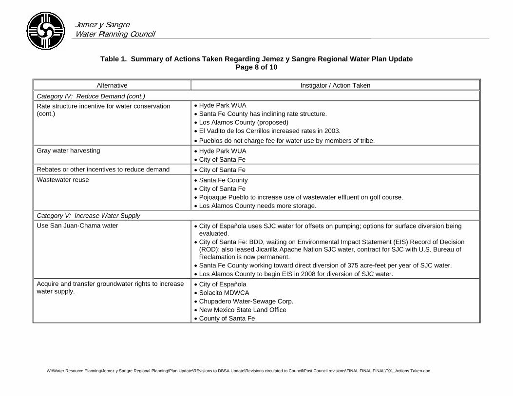
Jemez y Sangre Water Planning Council
Table 1. Summary of Actions Taken Regarding Jemez y Sangre Regional Water Plan Update Page 8 of 10
W:\Water Resource Planning\Jemez y Sangre Regional Planning\Plan Update\REvisions to DBSA Update\Revisions circulated to Council\Post Council revisions\FINAL FINAL FINAL\T01_Actions Taken.doc
Alternative Instigator / Action Taken
Category IV: Reduce Demand (cont.) Rate structure incentive for water conservation (cont.)
• Hyde Park WUA • Santa Fe County has inclining rate structure. • Los Alamos County (proposed) • El Vadito de los Cerrillos increased rates in 2003. • Pueblos do not charge fee for water use by members of tribe.
Gray water harvesting • Hyde Park WUA • City of Santa Fe
Rebates or other incentives to reduce demand • City of Santa Fe Wastewater reuse • Santa Fe County
• City of Santa Fe • Pojoaque Pueblo to increase use of wastewater effluent on golf course. • Los Alamos County needs more storage.
Category V: Increase Water Supply Use San Juan-Chama water • City of Española uses SJC water for offsets on pumping; options for surface diversion being
evaluated. • City of Santa Fe: BDD, waiting on Environmental Impact Statement (EIS) Record of Decision
(ROD); also leased Jicarilla Apache Nation SJC water, contract for SJC with U.S. Bureau of Reclamation is now permanent.
• Santa Fe County working toward direct diversion of 375 acre-feet per year of SJC water. • Los Alamos County to begin EIS in 2008 for diversion of SJC water.
Acquire and transfer groundwater rights to increase water supply.
• City of Española • Solacito MDWCA • Chupadero Water-Sewage Corp. • New Mexico State Land Office • County of Santa Fe
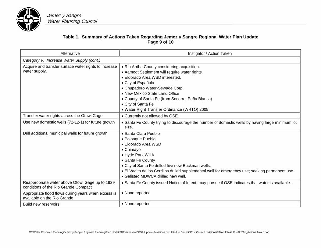
Jemez y Sangre Water Planning Council
Table 1. Summary of Actions Taken Regarding Jemez y Sangre Regional Water Plan Update Page 9 of 10
W:\Water Resource Planning\Jemez y Sangre Regional Planning\Plan Update\REvisions to DBSA Update\Revisions circulated to Council\Post Council revisions\FINAL FINAL FINAL\T01_Actions Taken.doc
Alternative Instigator / Action Taken
Category V: Increase Water Supply (cont.) Acquire and transfer surface water rights to increase water supply.
• Rio Arriba County considering acquisition. • Aamodt Settlement will require water rights. • Eldorado Area WSD interested. • City of Española • Chupadero Water-Sewage Corp. • New Mexico State Land Office • County of Santa Fe (from Socorro, Peña Blanca) • City of Santa Fe • Water Right Transfer Ordinance (WRTO) 2005
Transfer water rights across the Otowi Gage • Currently not allowed by OSE. Use new domestic wells (72-12-1) for future growth • Santa Fe County trying to discourage the number of domestic wells by having large minimum lot
size. Drill additional municipal wells for future growth • Santa Clara Pueblo
• Pojoaque Pueblo • Eldorado Area WSD
• Chimayo • Hyde Park WUA • Santa Fe County • City of Santa Fe drilled five new Buckman wells. • El Vadito de los Cerrillos drilled supplemental well for emergency use; seeking permanent use. • Galisteo MDWCA drilled new well.
Reappropriate water above Otowi Gage up to 1929 conditions of the Rio Grande Compact
• Santa Fe County issued Notice of Intent, may pursue if OSE indicates that water is available.
Appropriate flood flows during years when excess is available on the Rio Grande
• None reported
Build new reservoirs • None reported
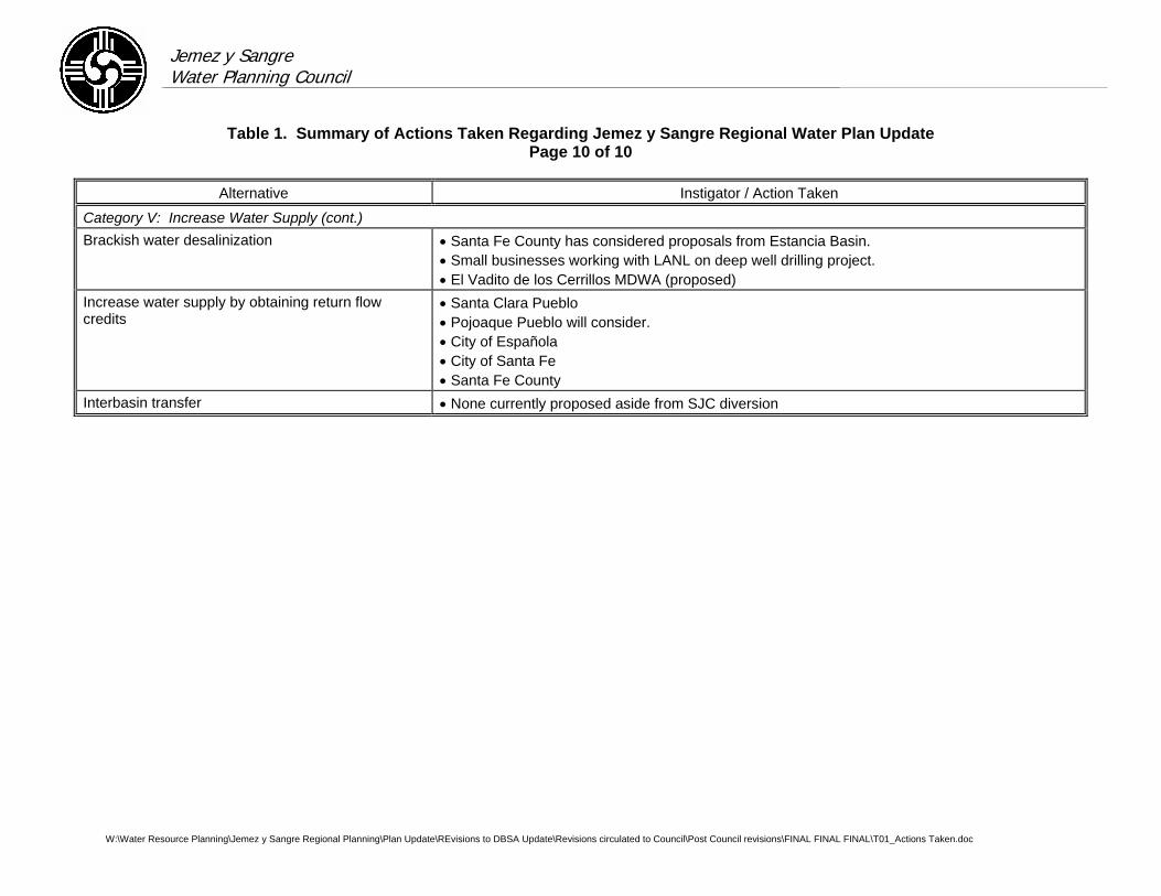
Jemez y Sangre Water Planning Council
Table 1. Summary of Actions Taken Regarding Jemez y Sangre Regional Water Plan Update Page 10 of 10
W:\Water Resource Planning\Jemez y Sangre Regional Planning\Plan Update\REvisions to DBSA Update\Revisions circulated to Council\Post Council revisions\FINAL FINAL FINAL\T01_Actions Taken.doc
Alternative Instigator / Action Taken
Category V: Increase Water Supply (cont.) Brackish water desalinization • Santa Fe County has considered proposals from Estancia Basin.
• Small businesses working with LANL on deep well drilling project. • El Vadito de los Cerrillos MDWA (proposed)
Increase water supply by obtaining return flow credits
• Santa Clara Pueblo • Pojoaque Pueblo will consider. • City of Española • City of Santa Fe • Santa Fe County
Interbasin transfer • None currently proposed aside from SJC diversion
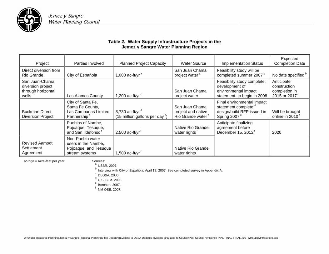
Jemez y Sangre Water Planning Council
W:\Water Resource Planning\Jemez y Sangre Regional Planning\Plan Update\REvisions to DBSA Update\Revisions circulated to Council\Post Council revisions\FINAL FINAL FINAL\T02_WtrSupplyInfrastrctre.doc
Table 2. Water Supply Infrastructure Projects in the Jemez y Sangre Water Planning Region
Project Parties Involved Planned Project Capacity Water Source Implementation Status Expected
Completion Date
Direct diversion from Rio Grande City of Española 1,000 ac-ft/yr a
San Juan Chama project water a
Feasibility study will be completed summer 2007 b No date specified b
San Juan-Chama diversion project through horizontal wells Los Alamos County 1,200 ac-ft/yr c
San Juan Chama project water c
Feasibility study complete; development of environmental impact statement to begin in 2008
Anticipate construction completion in 2015 or 2017 c
Buckman Direct Diversion Project
City of Santa Fe, Santa Fe County, Las Campanas Limited Partnership d
8,730 ac-ft/yr d (15 million gallons per day e)
San Juan Chama project and native Rio Grande water d
Final environmental impact statement complete;d design/build RFP issued in Spring 2007 e
Will be brought online in 2010 e
Pueblos of Nambé, Pojoaque, Tesuque, and San Ildefonso f 2,500 ac-ft/yr f
Native Rio Grande water rights f
Anticipate finalizing agreement before December 15, 2012 f 2020
Revised Aamodt Settlement Agreement
Non-Pueblo water users in the Nambé, Pojoaque, and Tesuque stream systems 1,500 ac-ft/yr f
Native Rio Grande water rights f
ac-ft/yr = Acre-feet per year Sources: a USBR, 2007. b Interview with City of Española, April 18, 2007. See completed survey in Appendix A. c DBS&A, 2006. d U.S. BLM. 2006. e Borchert, 2007. f NM OSE, 2007.
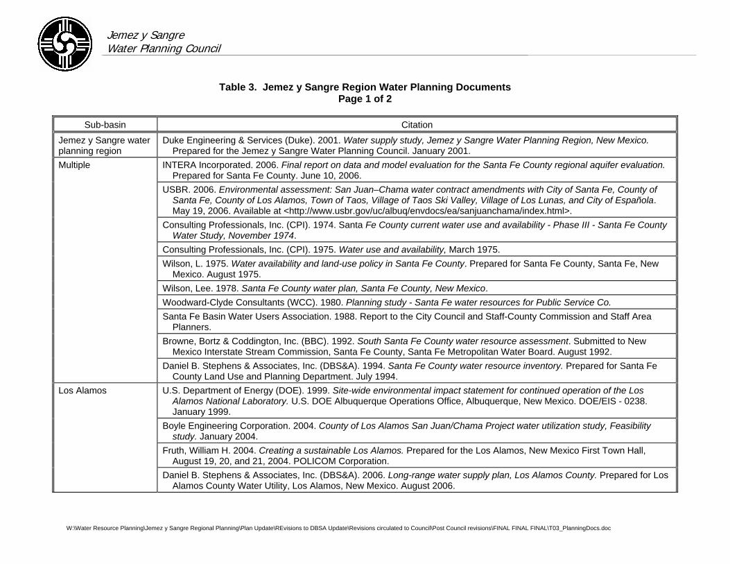
Jemez y Sangre Water Planning Council
Table 3. Jemez y Sangre Region Water Planning Documents Page 1 of 2
W:\Water Resource Planning\Jemez y Sangre Regional Planning\Plan Update\REvisions to DBSA Update\Revisions circulated to Council\Post Council revisions\FINAL FINAL FINAL\T03_PlanningDocs.doc
Sub-basin Citation
Jemez y Sangre water planning region
Duke Engineering & Services (Duke). 2001. Water supply study, Jemez y Sangre Water Planning Region, New Mexico. Prepared for the Jemez y Sangre Water Planning Council. January 2001.
Multiple INTERA Incorporated. 2006. Final report on data and model evaluation for the Santa Fe County regional aquifer evaluation. Prepared for Santa Fe County. June 10, 2006.
USBR. 2006. Environmental assessment: San Juan–Chama water contract amendments with City of Santa Fe, County of Santa Fe, County of Los Alamos, Town of Taos, Village of Taos Ski Valley, Village of Los Lunas, and City of Española. May 19, 2006. Available at <http://www.usbr.gov/uc/albuq/envdocs/ea/sanjuanchama/index.html>.
Consulting Professionals, Inc. (CPI). 1974. Santa Fe County current water use and availability - Phase III - Santa Fe County Water Study, November 1974.
Consulting Professionals, Inc. (CPI). 1975. Water use and availability, March 1975. Wilson, L. 1975. Water availability and land-use policy in Santa Fe County. Prepared for Santa Fe County, Santa Fe, New
Mexico. August 1975. Wilson, Lee. 1978. Santa Fe County water plan, Santa Fe County, New Mexico. Woodward-Clyde Consultants (WCC). 1980. Planning study - Santa Fe water resources for Public Service Co. Santa Fe Basin Water Users Association. 1988. Report to the City Council and Staff-County Commission and Staff Area
Planners. Browne, Bortz & Coddington, Inc. (BBC). 1992. South Santa Fe County water resource assessment. Submitted to New
Mexico Interstate Stream Commission, Santa Fe County, Santa Fe Metropolitan Water Board. August 1992. Daniel B. Stephens & Associates, Inc. (DBS&A). 1994. Santa Fe County water resource inventory. Prepared for Santa Fe
County Land Use and Planning Department. July 1994. Los Alamos U.S. Department of Energy (DOE). 1999. Site-wide environmental impact statement for continued operation of the Los
Alamos National Laboratory. U.S. DOE Albuquerque Operations Office, Albuquerque, New Mexico. DOE/EIS - 0238. January 1999.
Boyle Engineering Corporation. 2004. County of Los Alamos San Juan/Chama Project water utilization study, Feasibility study. January 2004.
Fruth, William H. 2004. Creating a sustainable Los Alamos. Prepared for the Los Alamos, New Mexico First Town Hall, August 19, 20, and 21, 2004. POLICOM Corporation.
Daniel B. Stephens & Associates, Inc. (DBS&A). 2006. Long-range water supply plan, Los Alamos County. Prepared for Los Alamos County Water Utility, Los Alamos, New Mexico. August 2006.
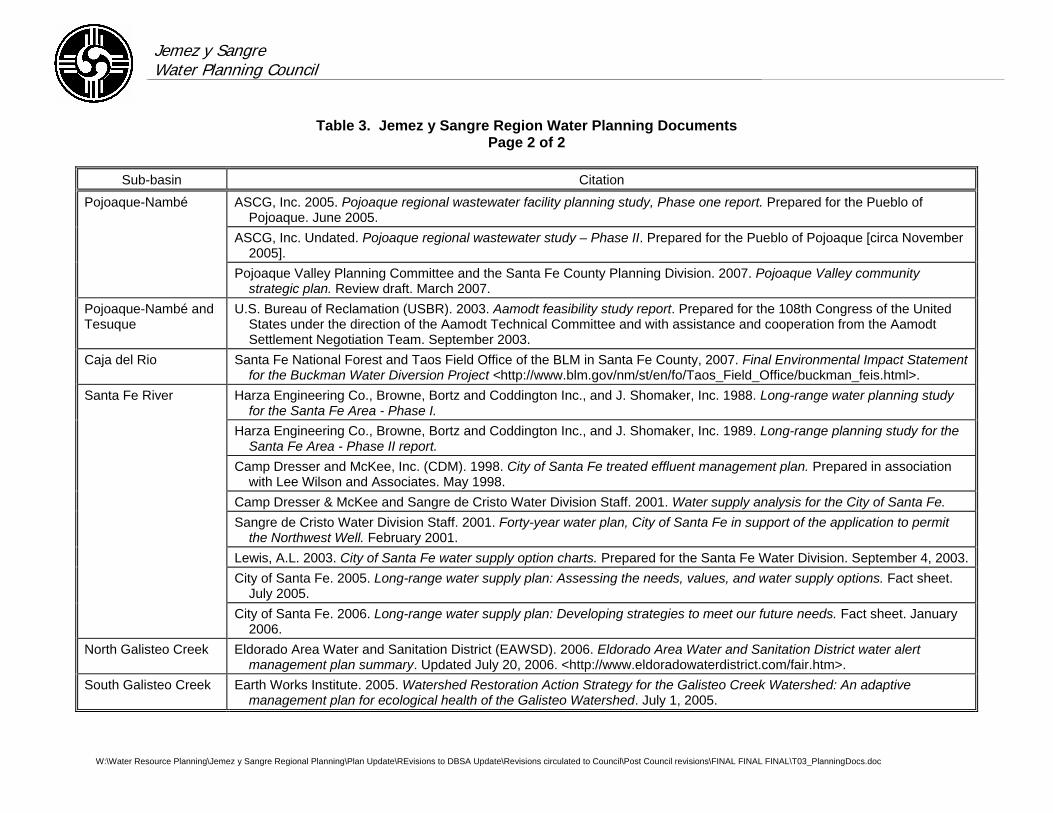
Jemez y Sangre Water Planning Council
Table 3. Jemez y Sangre Region Water Planning Documents Page 2 of 2
W:\Water Resource Planning\Jemez y Sangre Regional Planning\Plan Update\REvisions to DBSA Update\Revisions circulated to Council\Post Council revisions\FINAL FINAL FINAL\T03_PlanningDocs.doc
Sub-basin Citation
Pojoaque-Nambé ASCG, Inc. 2005. Pojoaque regional wastewater facility planning study, Phase one report. Prepared for the Pueblo of Pojoaque. June 2005.
ASCG, Inc. Undated. Pojoaque regional wastewater study – Phase II. Prepared for the Pueblo of Pojoaque [circa November 2005].
Pojoaque Valley Planning Committee and the Santa Fe County Planning Division. 2007. Pojoaque Valley community strategic plan. Review draft. March 2007.
Pojoaque-Nambé and Tesuque
U.S. Bureau of Reclamation (USBR). 2003. Aamodt feasibility study report. Prepared for the 108th Congress of the United States under the direction of the Aamodt Technical Committee and with assistance and cooperation from the Aamodt Settlement Negotiation Team. September 2003.
Caja del Rio Santa Fe National Forest and Taos Field Office of the BLM in Santa Fe County, 2007. Final Environmental Impact Statement for the Buckman Water Diversion Project <http://www.blm.gov/nm/st/en/fo/Taos_Field_Office/buckman_feis.html>.
Santa Fe River Harza Engineering Co., Browne, Bortz and Coddington Inc., and J. Shomaker, Inc. 1988. Long-range water planning study for the Santa Fe Area - Phase I.
Harza Engineering Co., Browne, Bortz and Coddington Inc., and J. Shomaker, Inc. 1989. Long-range planning study for the Santa Fe Area - Phase II report.
Camp Dresser and McKee, Inc. (CDM). 1998. City of Santa Fe treated effluent management plan. Prepared in association with Lee Wilson and Associates. May 1998.
Camp Dresser & McKee and Sangre de Cristo Water Division Staff. 2001. Water supply analysis for the City of Santa Fe. Sangre de Cristo Water Division Staff. 2001. Forty-year water plan, City of Santa Fe in support of the application to permit
the Northwest Well. February 2001. Lewis, A.L. 2003. City of Santa Fe water supply option charts. Prepared for the Santa Fe Water Division. September 4, 2003. City of Santa Fe. 2005. Long-range water supply plan: Assessing the needs, values, and water supply options. Fact sheet.
July 2005. City of Santa Fe. 2006. Long-range water supply plan: Developing strategies to meet our future needs. Fact sheet. January
2006. North Galisteo Creek Eldorado Area Water and Sanitation District (EAWSD). 2006. Eldorado Area Water and Sanitation District water alert
management plan summary. Updated July 20, 2006. <http://www.eldoradowaterdistrict.com/fair.htm>. South Galisteo Creek Earth Works Institute. 2005. Watershed Restoration Action Strategy for the Galisteo Creek Watershed: An adaptive
management plan for ecological health of the Galisteo Watershed. July 1, 2005.

Jemez y Sangre Water Planning Council
Table 4. Historical Municipal Groundwater Diversions Page 1 of 2
Sources: JyS 2003 Plan (DBS&A and Lewis, 2003) and records provided by water suppliers
W:\Water Resource Planning\Jemez y Sangre Regional Planning\Plan Update\REvisions to DBSA Update\Revisions circulated to Council\Post Council revisions\FINAL FINAL FINAL\T04_MunDivrsns.doc
Annual Production (acre-feet per year)
Year Santa Fe City Wells Buckman Los Alamos Española Eldorado Total
1947 0 --- 451 --- --- 451 1948 0 --- 810 --- --- 810 1949 0 --- 930 --- --- 930 1950 121 --- 1,688 --- --- 1,809 1951 2,010 --- 2,366 --- --- 4,376 1952 699 --- 2,449 --- --- 3,148 1953 594 --- 2,504 --- --- 3,098 1954 1,618 --- 2,314 --- --- 3,932 1955 1,649 --- 2,397 --- --- 4,046 1956 2,594 --- 2,891 --- --- 5,485 1957 993 --- 2,228 --- --- 3,221 1958 0 --- 2,354 --- --- 2,354 1959 1,255 --- 2,673 --- --- 3,928 1960 550 --- 3,262 --- --- 3,812 1961 488 --- 3,588 --- --- 4,076 1962 601 --- 3,603 --- --- 4,204 1963 734 --- 3,661 --- --- 4,395 1964 3,154 --- 3,962 --- --- 7,116 1965 199 --- 3,428 --- --- 3,627 1966 185 --- 3,655 --- --- 3,840 1967 3,257 --- 4,048 335 --- 7,640 1968 1,213 --- 4,297 374 --- 5,884 1969 1,338 --- 4,100 339 --- 5,777 1970 4,315 --- 4,229 328 --- 8,872 1971 4,055 --- 4,760 225 --- 9,040 1972 3,739 849 4,628 393 15 9,625 1973 962 2,325 4,803 522 11 8,623 1974 2,202 3,288 4,984 664 11 11,149 1975 450 2,372 4,711 621 13 8,167 1976 1,801 2,700 5,193 758 14 10,465 1977 2,009 3,100 4,517 510 23 10,160 1978 810 1,609 4,413 627 26 7,485 1979 1,196 511 4,318 657 53 6,735 1980 1,565 507 4,803 733 46 7,654 1981 2,607 2,486 4,616 760 41 10,510
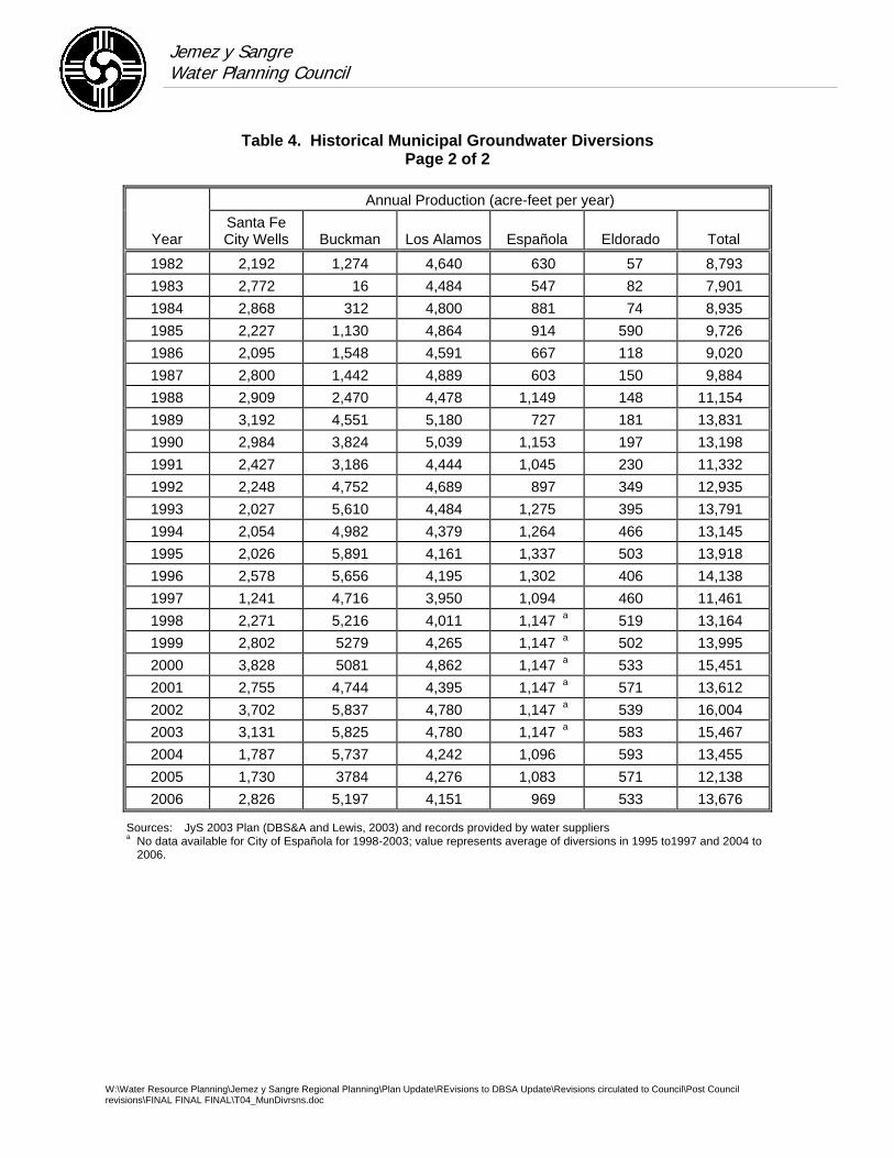
Jemez y Sangre Water Planning Council
Table 4. Historical Municipal Groundwater Diversions Page 2 of 2
W:\Water Resource Planning\Jemez y Sangre Regional Planning\Plan Update\REvisions to DBSA Update\Revisions circulated to Council\Post Council revisions\FINAL FINAL FINAL\T04_MunDivrsns.doc
Annual Production (acre-feet per year)
Year Santa Fe City Wells Buckman Los Alamos Española Eldorado Total
1982 2,192 1,274 4,640 630 57 8,793 1983 2,772 16 4,484 547 82 7,901 1984 2,868 312 4,800 881 74 8,935 1985 2,227 1,130 4,864 914 590 9,726 1986 2,095 1,548 4,591 667 118 9,020 1987 2,800 1,442 4,889 603 150 9,884 1988 2,909 2,470 4,478 1,149 148 11,154 1989 3,192 4,551 5,180 727 181 13,831 1990 2,984 3,824 5,039 1,153 197 13,198 1991 2,427 3,186 4,444 1,045 230 11,332 1992 2,248 4,752 4,689 897 349 12,935 1993 2,027 5,610 4,484 1,275 395 13,791 1994 2,054 4,982 4,379 1,264 466 13,145 1995 2,026 5,891 4,161 1,337 503 13,918 1996 2,578 5,656 4,195 1,302 406 14,138 1997 1,241 4,716 3,950 1,094 460 11,461 1998 2,271 5,216 4,011 1,147 a 519 13,164 1999 2,802 5279 4,265 1,147 a 502 13,995 2000 3,828 5081 4,862 1,147 a 533 15,451 2001 2,755 4,744 4,395 1,147 a 571 13,612 2002 3,702 5,837 4,780 1,147 a 539 16,004 2003 3,131 5,825 4,780 1,147 a 583 15,467 2004 1,787 5,737 4,242 1,096 593 13,455 2005 1,730 3784 4,276 1,083 571 12,138 2006 2,826 5,197 4,151 969 533 13,676
Sources: JyS 2003 Plan (DBS&A and Lewis, 2003) and records provided by water suppliers a No data available for City of Española for 1998-2003; value represents average of diversions in 1995 to1997 and 2004 to
2006.
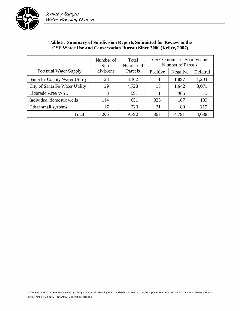
Jemez y Sangre Water Planning Council
W:\Water Resource Planning\Jemez y Sangre Regional Planning\Plan Update\REvisions to DBSA Update\Revisions circulated to Council\Post Council
revisions\FINAL FINAL FINAL\T05_SubdivisionRpts.doc
Table 5. Summary of Subdivision Reports Submitted for Review to the OSE Water Use and Conservation Bureau Since 2000 (Keller, 2007)
OSE Opinion on Subdivision Number of Parcels
Potential Water Supply
Number of Sub-
divisions
Total Number of
Parcels Positive Negative Deferral Santa Fe County Water Utility 28 3,102 1 1,897 1,204 City of Santa Fe Water Utility 39 4,728 15 1,642 3,071 Eldorado Area WSD 8 991 1 985 5 Individual domestic wells 114 651 325 187 139 Other small systems 17 320 21 80 219
Total 206 9,792 363 4,791 4,638
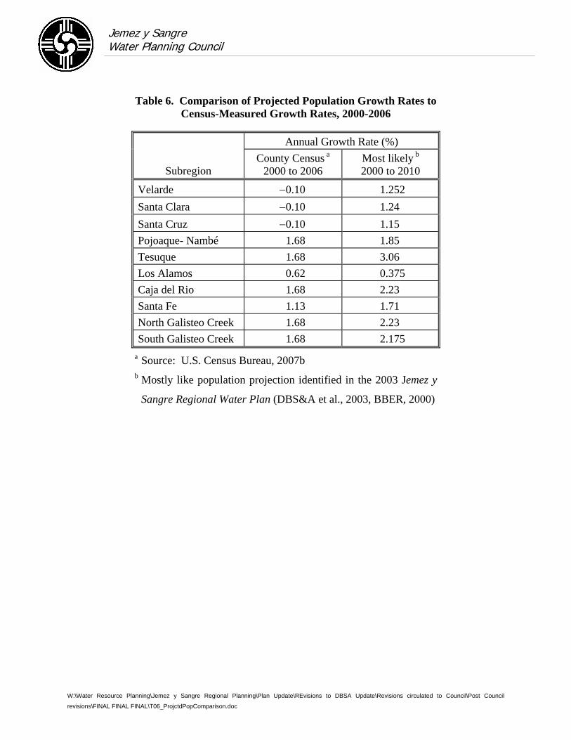
Jemez y Sangre Water Planning Council
W:\Water Resource Planning\Jemez y Sangre Regional Planning\Plan Update\REvisions to DBSA Update\Revisions circulated to Council\Post Council
revisions\FINAL FINAL FINAL\T06_ProjctdPopComparison.doc
Table 6. Comparison of Projected Population Growth Rates to Census-Measured Growth Rates, 2000-2006
Annual Growth Rate (%)
Subregion County Census a
2000 to 2006 Most likely b 2000 to 2010
Velarde −0.10 1.252 Santa Clara −0.10 1.24 Santa Cruz −0.10 1.15 Pojoaque- Nambé 1.68 1.85 Tesuque 1.68 3.06 Los Alamos 0.62 0.375 Caja del Rio 1.68 2.23 Santa Fe 1.13 1.71 North Galisteo Creek 1.68 2.23 South Galisteo Creek 1.68 2.175
a Source: U.S. Census Bureau, 2007b b Mostly like population projection identified in the 2003 Jemez y
Sangre Regional Water Plan (DBS&A et al., 2003, BBER, 2000)
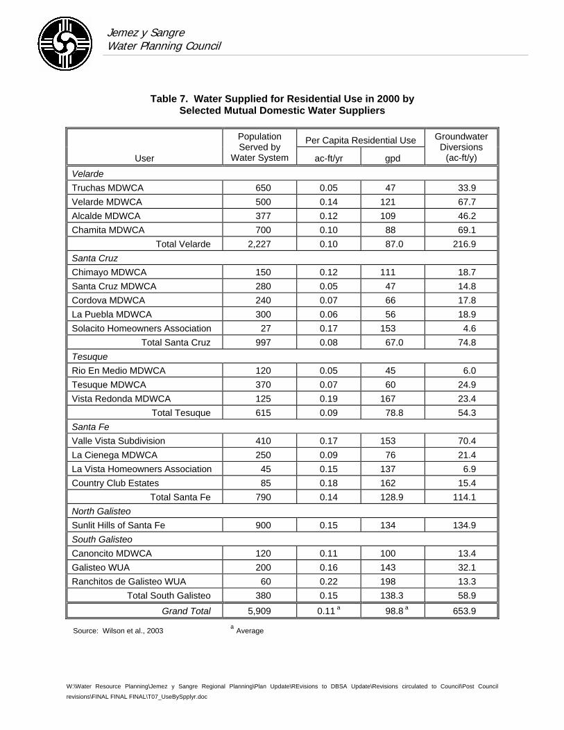
Jemez y Sangre Water Planning Council
W:\Water Resource Planning\Jemez y Sangre Regional Planning\Plan Update\REvisions to DBSA Update\Revisions circulated to Council\Post Council
revisions\FINAL FINAL FINAL\T07_UseBySpplyr.doc
Table 7. Water Supplied for Residential Use in 2000 by Selected Mutual Domestic Water Suppliers
Per Capita Residential Use
User
Population Served by
Water System ac-ft/yr gpd
Groundwater Diversions
(ac-ft/y)
Velarde Truchas MDWCA 650 0.05 47 33.9 Velarde MDWCA 500 0.14 121 67.7 Alcalde MDWCA 377 0.12 109 46.2 Chamita MDWCA 700 0.10 88 69.1
Total Velarde 2,227 0.10 87.0 216.9 Santa Cruz Chimayo MDWCA 150 0.12 111 18.7 Santa Cruz MDWCA 280 0.05 47 14.8 Cordova MDWCA 240 0.07 66 17.8 La Puebla MDWCA 300 0.06 56 18.9 Solacito Homeowners Association 27 0.17 153 4.6
Total Santa Cruz 997 0.08 67.0 74.8 Tesuque Rio En Medio MDWCA 120 0.05 45 6.0 Tesuque MDWCA 370 0.07 60 24.9 Vista Redonda MDWCA 125 0.19 167 23.4
Total Tesuque 615 0.09 78.8 54.3 Santa Fe Valle Vista Subdivision 410 0.17 153 70.4 La Cienega MDWCA 250 0.09 76 21.4 La Vista Homeowners Association 45 0.15 137 6.9 Country Club Estates 85 0.18 162 15.4
Total Santa Fe 790 0.14 128.9 114.1 North Galisteo Sunlit Hills of Santa Fe 900 0.15 134 134.9 South Galisteo Canoncito MDWCA 120 0.11 100 13.4 Galisteo WUA 200 0.16 143 32.1 Ranchitos de Galisteo WUA 60 0.22 198 13.3
Total South Galisteo 380 0.15 138.3 58.9
Grand Total 5,909 0.11 a 98.8 a 653.9
Source: Wilson et al., 2003 a Average
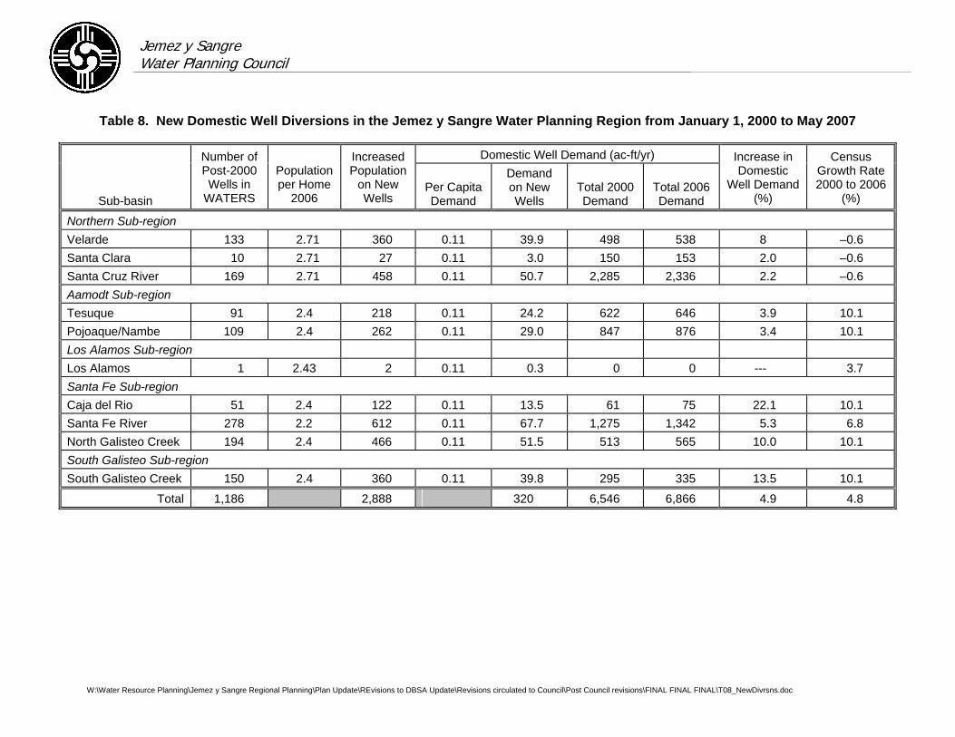
Jemez y Sangre Water Planning Council
W:\Water Resource Planning\Jemez y Sangre Regional Planning\Plan Update\REvisions to DBSA Update\Revisions circulated to Council\Post Council revisions\FINAL FINAL FINAL\T08_NewDivrsns.doc
Table 8. New Domestic Well Diversions in the Jemez y Sangre Water Planning Region from January 1, 2000 to May 2007
Domestic Well Demand (ac-ft/yr)
Sub-basin
Number of Post-2000 Wells in
WATERS
Population per Home
2006
Increased Population
on New Wells
Per Capita Demand
Demand on New Wells
Total 2000 Demand
Total 2006 Demand
Increase in Domestic
Well Demand (%)
Census Growth Rate 2000 to 2006
(%)
Northern Sub-region Velarde 133 2.71 360 0.11 39.9 498 538 8 –0.6 Santa Clara 10 2.71 27 0.11 3.0 150 153 2.0 –0.6 Santa Cruz River 169 2.71 458 0.11 50.7 2,285 2,336 2.2 –0.6 Aamodt Sub-region Tesuque 91 2.4 218 0.11 24.2 622 646 3.9 10.1 Pojoaque/Nambe 109 2.4 262 0.11 29.0 847 876 3.4 10.1 Los Alamos Sub-region Los Alamos 1 2.43 2 0.11 0.3 0 0 --- 3.7 Santa Fe Sub-region Caja del Rio 51 2.4 122 0.11 13.5 61 75 22.1 10.1 Santa Fe River 278 2.2 612 0.11 67.7 1,275 1,342 5.3 6.8 North Galisteo Creek 194 2.4 466 0.11 51.5 513 565 10.0 10.1 South Galisteo Sub-region South Galisteo Creek 150 2.4 360 0.11 39.8 295 335 13.5 10.1
Total 1,186 2,888 320 6,546 6,866 4.9 4.8
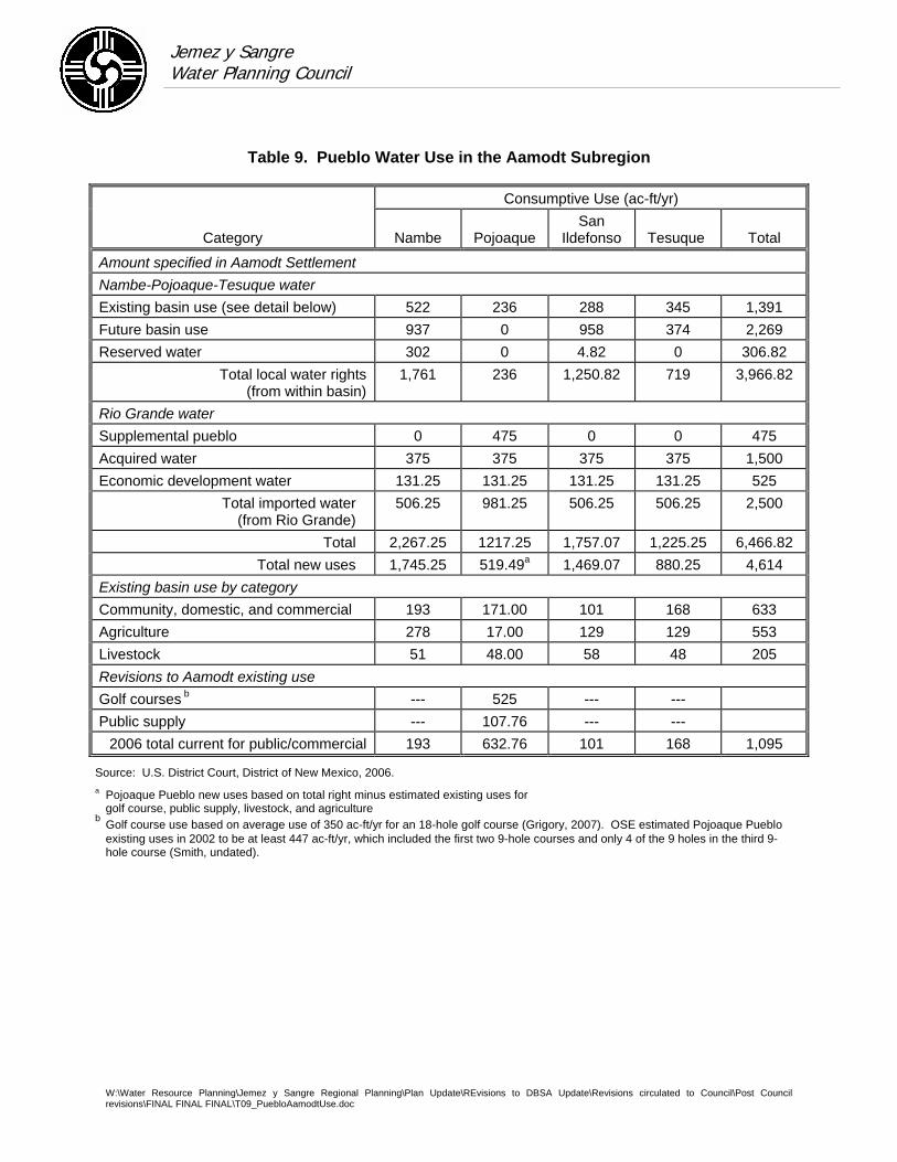
Jemez y Sangre Water Planning Council
W:\Water Resource Planning\Jemez y Sangre Regional Planning\Plan Update\REvisions to DBSA Update\Revisions circulated to Council\Post Council revisions\FINAL FINAL FINAL\T09_PuebloAamodtUse.doc
Table 9. Pueblo Water Use in the Aamodt Subregion
Consumptive Use (ac-ft/yr)
Category Nambe Pojoaque San
Ildefonso Tesuque Total
Amount specified in Aamodt Settlement Nambe-Pojoaque-Tesuque water Existing basin use (see detail below) 522 236 288 345 1,391 Future basin use 937 0 958 374 2,269 Reserved water 302 0 4.82 0 306.82
Total local water rights (from within basin)
1,761 236 1,250.82 719 3,966.82
Rio Grande water Supplemental pueblo 0 475 0 0 475 Acquired water 375 375 375 375 1,500 Economic development water 131.25 131.25 131.25 131.25 525
Total imported water (from Rio Grande)
506.25 981.25 506.25 506.25 2,500
Total 2,267.25 1217.25 1,757.07 1,225.25 6,466.82 Total new uses 1,745.25 519.49a 1,469.07 880.25 4,614
Existing basin use by category Community, domestic, and commercial 193 171.00 101 168 633 Agriculture 278 17.00 129 129 553 Livestock 51 48.00 58 48 205 Revisions to Aamodt existing use Golf courses b --- 525 --- --- Public supply --- 107.76 --- ---
2006 total current for public/commercial 193 632.76 101 168 1,095
Source: U.S. District Court, District of New Mexico, 2006. a Pojoaque Pueblo new uses based on total right minus estimated existing uses for
golf course, public supply, livestock, and agriculture b Golf course use based on average use of 350 ac-ft/yr for an 18-hole golf course (Grigory, 2007). OSE estimated Pojoaque Pueblo
existing uses in 2002 to be at least 447 ac-ft/yr, which included the first two 9-hole courses and only 4 of the 9 holes in the third 9-hole course (Smith, undated).

Jemez y Sangre Water Planning Council Survey of Water Systems
April 2007 Date of interview_________
1. Name of Water System or Governmental Entity and person and title completing the survey (Acéquia, Mutual Domestic, County, Municipality)
2. Actions under Category I: Protect Existing Supplies (Please check all boxes that apply and describe in space provided [or attach longer description])
Current Reports, Data available
Proposed May consider in the future
Forest restoration project Develop storm water management ordinance Cloud seeding project Develop well field management plan Propose conjunctive use of surface and groundwater supplies Expand treatment facilities to remove trace constituents (i.e., arsenic) Restrict drilling of domestic wells within your jurisdiction Develop/explore methods for instream flow Wastewater treatment plant construction, repairs, or upgrades Acéquia bylaws to prevent water transfers out of acéquia Other___________________________
Please briefly describe the proposed projects and/or projects that have been completed in the last 5 years under Category I.
Page 1 of 5

3. Actions under Category II: Improve System Efficiency (Please check all that apply and describe in space provided [or attach longer description])
Current Reports, Data Available
Proposed May consider in the future
Wastewater reuse project Project to replace septic tanks and provide for regional WWTP Line irrigation ditches/acéquias Develop a regional water system authority Aquifer storage and recovery project with wastewater Aquifer storage and recovery project with surface water Optimize reservoir management (sediment removal, evaporative loss reduction) Changes to infrastructure Groundwater modeling studies Water audits Leak detection and repair Aquifer injection Drill replacement wells Transfer indoor water use associated with domestic wells to utility
system Other___________________________
Please briefly describe the proposed projects and/or projects that have been completed in the last 5 years under Category II. Please include records or estimates regarding the amount of water in the project (i.e., diversions for ASR) or any estimates of potential savings from the project.
4. Actions under Category III: Mitigate Drought (Please check all that apply and describe the proposed project in the space provided [or attach longer description]).
Current Reports, Data Available
Proposed May consider in the future
Water banking/temporary leases of water rights Emergency conservation ordinance to restrict water use Shortage sharing agreements (acéquias) Other___________________________
Page 2 of 5

Please briefly describe the proposed projects and/or projects that have been completed in the last 5 years under Category III. Provide a copy of drought plan if available.
5. Actions under Category IV: Reduce Demand (Please check all that apply and describe the proposed project in the space provided [or attach longer description] and provide an estimate of the amount of water demand reduction (per capita and/or total annual).
Current Reports, Data Available
Proposed May consider in the future
Manage growth and land use Water conservation focused on outdoor use Water conservation focused on indoor use for new construction Water conservation focused on indoor use through retrofits Water harvesting (rooftop) Rate structure incentive for water conservation Graywater harvesting Rebates or other incentives to reduce demand Wastewater reuse Other___________________________
Please briefly describe the proposed projects and/or projects that have been completed in the last 5 years under Category IV, including any data or estimates quantifying the demand reduction.
Page 3 of 5

6. Actions under Category V: Increase Water Supply (Please check all that apply and describe in space provided [or attach longer description])
Current Reports, Data Available
Proposed May consider in the future
Use San Juan-Chama water Acquire and transfer groundwater rights to increase water supply. Acquire and transfer surface water rights to increase water supply. Transfer water rights across the Otowi Gage Use new domestic wells (72-12-1) for future growth Drill additional municipal wells for future growth Reappropriate water above Otowi Gage up to 1929 conditions of the
Rio Grande Compact Appropriate flood flows during years when excess is available on the
Rio Grande Build new reservoirs Brackish water desalinization Increase water supply by obtaining return flow credits Develop aquifer storage and recovery project (describe source of water) Interbasin transfer Other___________________________
Please briefly describe the proposed projects and/or projects that have been completed in the last 5 years under Category V, including any data or estimates quantifying the increased supply and methods of offsetting impacts. (For proposed projects, please include the planned completion date.)
7. Please describe other actions, statutes, ordinances, policy changes, lawsuits (i.e., Aamodt) that may impact supply and demand or water management.
Page 4 of 5

8. Please provide diversion data for 2001-2006 or indicate who we can contact to get annual diversion and population data.
______________________________________________________________________________
9. Please describe any additional new data that may be relevant to future planning efforts, including groundwater modeling studies, hydrologic or hydrogeologic characterization studies, water planning studies, feasibility analyses for proposed studies, or any other relevant data or published reports.
______________________________________________________________________________
10. Please provide any comments regarding the usefulness of the Jemez y Sangre regional water planning process. What has been most and least valuable about the process? How can the process be improved in the future? What would make the Jemez y Sangre water plan update most useful to you?
______________________________________________________________________________
Page 5 of 5
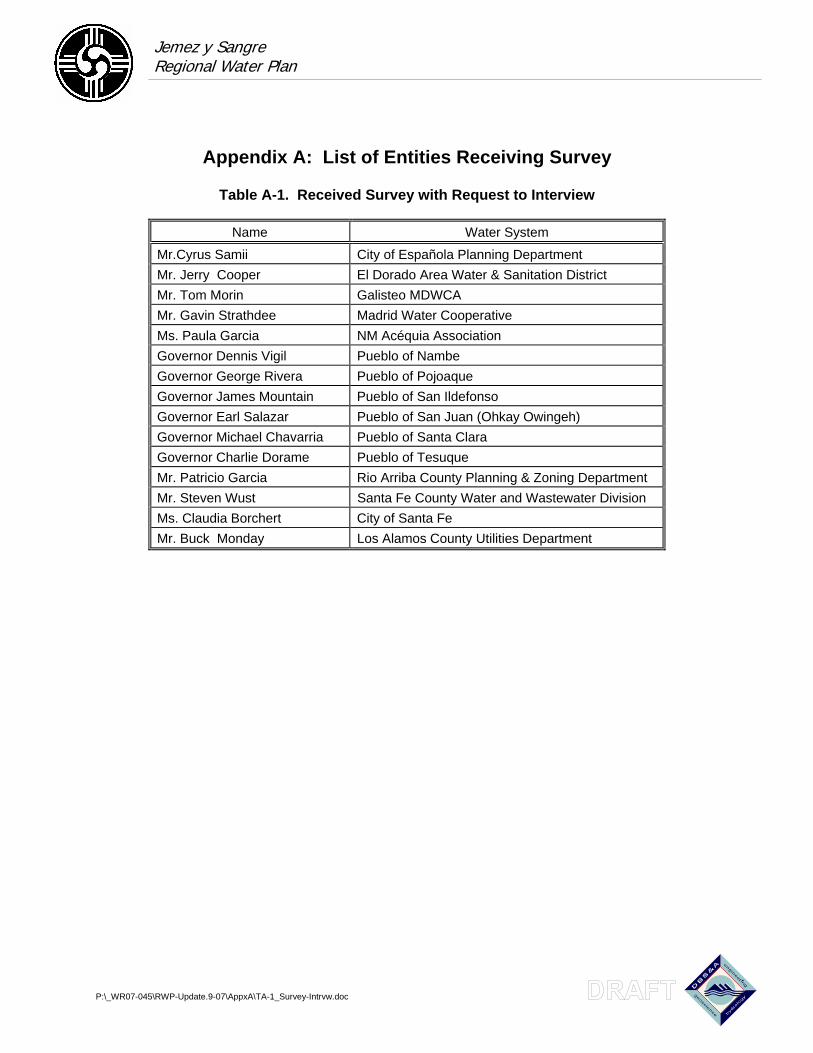
Jemez y Sangre Regional Water Plan
P:\_WR07-045\RWP-Update.9-07\AppxA\TA-1_Survey-Intrvw.doc
Appendix A: List of Entities Receiving Survey
Table A-1. Received Survey with Request to Interview
Name Water System
Mr.Cyrus Samii City of Española Planning Department Mr. Jerry Cooper El Dorado Area Water & Sanitation District Mr. Tom Morin Galisteo MDWCA Mr. Gavin Strathdee Madrid Water Cooperative Ms. Paula Garcia NM Acéquia Association Governor Dennis Vigil Pueblo of Nambe Governor George Rivera Pueblo of Pojoaque Governor James Mountain Pueblo of San Ildefonso Governor Earl Salazar Pueblo of San Juan (Ohkay Owingeh) Governor Michael Chavarria Pueblo of Santa Clara Governor Charlie Dorame Pueblo of Tesuque Mr. Patricio Garcia Rio Arriba County Planning & Zoning Department Mr. Steven Wust Santa Fe County Water and Wastewater Division Ms. Claudia Borchert City of Santa Fe Mr. Buck Monday Los Alamos County Utilities Department
Jemez y Sangre Regional Water Plan
Table A-2. Received Survey Only (no interview) Page 1 of 2
P:\_WR07-045\RWP-Update.9-07\AppxA\TA-2_Survey-Only.doc
Name Water System Environmental Mr. Steve Harris Rio Grande Restoration Director Mr. Paul Paryski Santa Fe Chapter of the Sierra Club Mr. David Groenfeld Santa Fe Watershed Association Government Mr. Patrick H. Lyons New Mexico State Land Commission Mr. Patricio Garcia Rio Arriba County Planning & Zoning Dept. Mr. Daniel Jiron Forest Supervisor Santa Fe National Forest Mr. Rob Baraker BIA Albuquerque Area Office Manager Mr. Mark Blakeslee BLM Division of Resource Planning and Use and Protection Mr. Garry Rowe Albuquerque Area Office Manager Bureau of Reclamation Mr. Paul Montoya Natural Resources Conservation Service Mr. Ed Romero Natural Resources Conservation Service Ms. Mary Helen Follingstad Santa Fe Regional Planning Authority Mr. Toby Martinez State Forester Governor Ray Trujillo Pueblo of Cochiti Governor Nelson Pacheco Pueblo of Santo Domingo Ms. Marcy Leavitt New Mexico Environment Department Surface Water Bureau Mr. Steve Cary New Mexico State Parks Mr. Ignacio Peralta USFS CFRP Coordinator Irrigation Mr. Jim Rogers, Commissioner Acéquia del Caño Mr. Barry Rudolf Lower Cerro Gordo Ditch Association President Mr. Reynaldo Romero Acéquia de La Cienega Mayordomo Mr. & Mrs. Phillip & Eleanor Bove Acéquia Madre Ditch Association Ms. Dolores Baca La Bajada Community Ditch Association Mr. Fred Waltz Santa Cruz Irrigation District Mr. Joe Maestas Santa Cruz Irrigation District (SFP NRCS) Mr. Gilbert Garduno Acéquia de Garduno Mr. Ted Trujillo Acéquia de la Cañanda Ancha Commissioner Mr. Michael Martinez, Mayordomo Acéquia de los Chicos Mr. Luis Sanchez Acéquia del Medio Mr. Mike Lamb Acéquia del Potrero Ms. Helenty Homans Acéquia Larga and Jacono de Ancon Mr. Paul Romero Garcia Ditch Mr. Leonard T. Valdes Llano Ditch Association Mr. Henry Abeyta New Mexico Acéquia Commission Mr. Fred Vigil New Mexico Acéquia Commission Chairman Ms. Josie E. Lujan Secretary, Santa Cruz Irrigation District
Jemez y Sangre Regional Water Plan
Table A-2. Received Survey Only (no interview) Page 2 of 2
P:\_WR07-045\RWP-Update.9-07\AppxA\TA-2_Survey-Only.doc
Name Water System Municipal/Public Supply Mr. Regino Salazar Agua Sana Water Users Association President Alfredo Montoya Alcade MDWCA Canada de Los Alamos MDWCA Canoncito at Apache Canyon Chamita MDWCA Chimayo MDWCA Mr. Phil Villareal Chupadero Water and Sewage Cordova MDWCA Mr. Frank Lopez Cuarto Villas Mutual Domestic Water Users' Association Cundiyo MDWCA El Llano MDWCA Rudy Martinez El Vadito De Los Cerrillos Water Association Mr. Mike Bowlen Haile Mobile Home Park Hyde Park Estates Water Users Association Reynaldo Romero La Cienega MDWCA La Pueblo MDWCA La Vista Homeowners Association Ms. Kathy Pilnock Lamy Domestic Water Users Association Mr. Mikey Baird Las Campanas Llano Chimayo MDWCA Mr. Matt Holmes New Mexico Rural Water Association New Mexico State Penitentiary Mr. David Ortiz Pojoaque Valley Irrigation District Ranchitos de Galisteo Homeowners Assoc. Rio Chiquito MDWCA Rio En Medio MDWCA Kenny Salazar Santa Cruz MDWCA Mr. Sigmund Silbur San Marcos Association Mr. Benny Abruzo Santa Fe Ski Basin Solacito Homeowners Assoc. Mr. Robert Vail Sunlit Hills Water System Sunrise Springs Tesuque MDWCA Truchas MDWCA Velarde MDWCA Vista Redonda MDWCA
Jemez y Sangre Water Planning Council
Selected Bibliography Annotations Jemez y Sangre Regional Water Plan Update
Page 1 of 9
P:\_WR07-045\RWP-Update.9-07\AppxB_Annotations.doc
Note: This bibliography represents new reference material obtained since publication of the 2003 water plan.
Citation Annotation
American Rivers. 2007. America’s most endangered rivers of 2007. Available at <http://www.americanrivers.org/site/DocServer/-2007_MER_FINAL.pdf?docID=5881>.
Ranks the Santa Fe River as the most endangered river in the United States.
ASCG, Inc. 2005. Pojoaque regional wastewater facility planning study, Phase one report. Prepared for the Pueblo of Pojoaque. June 2005.
Investigates options for wastewater treatment and effluent reuse within the boundaries of Pojoaque Pueblo.
ASCG, Inc. Undated. Pojoaque regional wastewater study – Phase II. Prepared for the Pueblo of Pojoaque [circa November 2005].
Expands on Phase 1 study to consider providing wastewater service to surrounding areas.
Birdsell, K.H., B.D. Newman, D.E. Broxton, and B.A. Robinson. 2005. Conceptual models of vadose zone flow and transport beneath the Pajarito Plateau, Los Alamos, New Mexico. Vadose Zone Journal 4(August 2005):620-636.
Describes potential pathways for contamination to reach the water table beneath Los Alamos. Concludes that nitrate migrated vertically 328 feet in approximately 40 years.
Blue Water Environmental Consulting, LLC. 2005. Greater Eldorado area water levels and water quality report for 2004. Prepared for the New Mexico Office of the State Engineer. Blue Water Report #02/05-OSE-001. March 31, 2005.
Basic data report on well locations, water levels and water quality.
Boyle Engineering Corporation. 2004. County of Los Alamos San Juan/Chama Project water utilization study, Feasibility study. January 2004.
Feasibility Study for diverting Los Alamos County’s 1200 ac-ft of San Juan Chama Water. Explores direct diversion at river and deep wells from White Rock Mesa.
Broxton, D.E., and D.T. Vaniman. 2005. Geologic framework of a groundwater system on the margin of a rift basin, Pajarito Plateau, north-central New Mexico. Vadose Zone Journal 4 (August 2005):522-550.
Describes aquifer beneath Los Alamos
City of Santa Fe. 2005. Long-range water supply plan: Assessing the needs, values, and water supply options. Fact sheet. July 2005.
Summarizes City of Santa Fe Strategy for meeting future water supply demands.
Jemez y Sangre Water Planning Council
Selected Bibliography Annotations Jemez y Sangre Regional Water Plan Update
Page 2 of 9
P:\_WR07-045\RWP-Update.9-07\AppxB_Annotations.doc
Citation Annotation
City of Santa Fe. 2005. Administrative procedures for calculating the City of Santa Fe’s operational water system supply and operational water system demand for the purpose of determining an emergency management plan. September 12, 2005.
Describes the method of determining the City’s water supply based on Santa Fe River flows, water rights and production capacity to establish the level of water restrictions.
City of Santa Fe. 2006. An ordinance creating Section 25-7 SFCC 1987 regarding a water rights acquisition fund and creating Section 25-8 SFCC 1987 regarding a voluntary contribution fund to acquire water rights for the benefit of the Santa Fe River and the Rio Grande.
Allows water customers to contribute to the purchase of water rights for instream flow in the Santa Fe River
City of Santa Fe. 2006. Long-range water supply plan: Developing strategies to meet our future needs. Fact sheet. January 2006.
Summarizes City of Santa Fe’s strategy to meet future water demand.
City of Santa Fe. 2006. San Juan-Chama Project, New Mexico: Contract between the United States of America Department of the Interior and Bureau of Reclamation and the City of Santa Fe. Contract No. 05-WC-40-540. October 19, 2006.
Converts the City of Santa Fe’s contract for San Juan-Chama water to a permanent repayment contract instead of a water service contract with an expiration date.
City of Santa Fe. 2007. Santa Fe trends, 2007. City of Santa Fe Planning and Land Use Department. Available at <http://www.santafenm.gov/SFTrends2007.pdf>.
City of Santa Fe information on population and water use.
City of Santa Fe. 2007. Effluent summary data for 2003 through 2006. Microsoft Excel file provided to Daniel B. Stephens & Associates (DBS&A), May 2007.
City of Santa Fe data on wastewater effluent.
City of Santa Fe. 2007. Water demand data. Microsoft Excel file provided to DBS&A, May 2007.
City of Santa Fe production and delivery data.
City of Santa Fe and Las Campanas LP. 2003. Settlement agreement. September 30, 2003.
Limits daily and monthly delivery of Buckman well water, with an annual total not to exceed 322 ac-ft/yr for Las Campanas’ golf course. Allows for purchase of treated effluent from the City of Santa Fe. Agreement expires when BDD on line
City of Santa Fe and the Jicarilla Apache Nation. 2004. Water supply agreement between the City of Santa Fe and the Jicarilla Apache Nation. September 2004.
Agreement to lease 3,000 ac-ft/yr of the Jicarilla Apache Nation’s SJC water for $1,500,000 year beginning January 1, 2007.
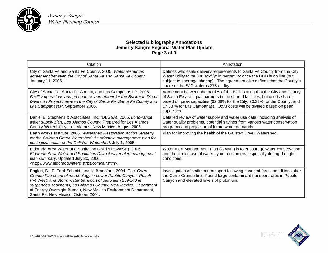
Jemez y Sangre Water Planning Council
Selected Bibliography Annotations Jemez y Sangre Regional Water Plan Update
Page 3 of 9
P:\_WR07-045\RWP-Update.9-07\AppxB_Annotations.doc
Citation Annotation
City of Santa Fe and Santa Fe County. 2005. Water resources agreement between the City of Santa Fe and Santa Fe County. January 11, 2005.
Defines wholesale delivery requirements to Santa Fe County from the City Water Utility to be 500 ac-ft/yr in perpetuity once the BDD is on line (but subject to shortage sharing). The agreement also defines that the County’s share of the SJC water is 375 ac-ft/yr.
City of Santa Fe, Santa Fe County, and Las Campanas LP. 2006. Facility operations and procedures agreement for the Buckman Direct Diversion Project between the City of Santa Fe, Santa Fe County and Las CampanasLP. September 2006.
Agreement between the parties of the BDD stating that the City and County of Santa Fe are equal partners in the shared facilities, but use is shared based on peak capacities (62.09% for the City, 20.33% for the County, and 17.58 % for Las Campanas). O&M costs will be divided based on peak capacities.
Daniel B. Stephens & Associates, Inc. (DBS&A). 2006. Long-range water supply plan, Los Alamos County. Prepared for Los Alamos County Water Utility, Los Alamos, New Mexico. August 2006.
Detailed review of water supply and water use data, including analysis of water quality problems, potential savings from various water conservation programs and projection of future water demands.
Earth Works Institute. 2005. Watershed Restoration Action Strategy for the Galisteo Creek Watershed: An adaptive management plan for ecological health of the Galisteo Watershed. July 1, 2005.
Plan for improving the health of the Galisteo Creek Watershed.
Eldorado Area Water and Sanitation District (EAWSD). 2006. Eldorado Area Water and Sanitation District water alert management plan summary. Updated July 20, 2006. <http://www.eldoradowaterdistrict.com/fair.htm>.
Water Alert Management Plan (WAMP) is to encourage water conservation and the limited use of water by our customers, especially during drought conditions.
Englert, D., F. Ford-Schmid, and K. Bransford. 2004. Post Cerro Grande Fire channel morphology in Lower Pueblo Canyon, Reach P-4 West: and Storm water transport of plutonium 239/240 in suspended sediments, Los Alamos County, New Mexico. Department of Energy Oversight Bureau, New Mexico Environment Department, Santa Fe, New Mexico. October 2004.
Investigation of sediment transport following changed forest conditions after the Cerro Grande fire. Found large contaminant transport rates in Pueblo Canyon and elevated levels of plutonium.
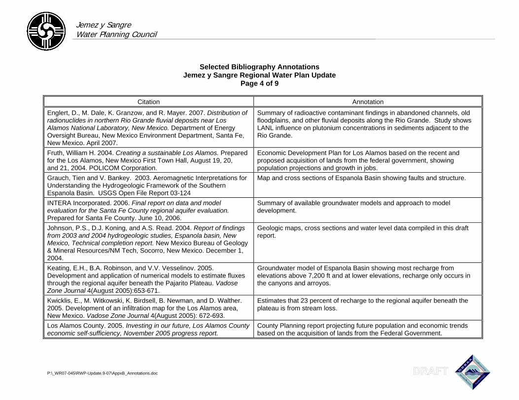
Jemez y Sangre Water Planning Council
Selected Bibliography Annotations Jemez y Sangre Regional Water Plan Update
Page 4 of 9
P:\_WR07-045\RWP-Update.9-07\AppxB_Annotations.doc
Citation Annotation
Englert, D., M. Dale, K. Granzow, and R. Mayer. 2007. Distribution of radionuclides in northern Rio Grande fluvial deposits near Los Alamos National Laboratory, New Mexico. Department of Energy Oversight Bureau, New Mexico Environment Department, Santa Fe, New Mexico. April 2007.
Summary of radioactive contaminant findings in abandoned channels, old floodplains, and other fluvial deposits along the Rio Grande. Study shows LANL influence on plutonium concentrations in sediments adjacent to the Rio Grande.
Fruth, William H. 2004. Creating a sustainable Los Alamos. Prepared for the Los Alamos, New Mexico First Town Hall, August 19, 20, and 21, 2004. POLICOM Corporation.
Economic Development Plan for Los Alamos based on the recent and proposed acquisition of lands from the federal government, showing population projections and growth in jobs.
Grauch, Tien and V. Bankey. 2003. Aeromagnetic Interpretations for Understanding the Hydrogeologic Framework of the Southern Espanola Basin. USGS Open File Report 03-124
Map and cross sections of Espanola Basin showing faults and structure.
INTERA Incorporated. 2006. Final report on data and model evaluation for the Santa Fe County regional aquifer evaluation. Prepared for Santa Fe County. June 10, 2006.
Summary of available groundwater models and approach to model development.
Johnson, P.S., D.J. Koning, and A.S. Read. 2004. Report of findings from 2003 and 2004 hydrogeologic studies, Espanola basin, New Mexico, Technical completion report. New Mexico Bureau of Geology & Mineral Resources/NM Tech, Socorro, New Mexico. December 1, 2004.
Geologic maps, cross sections and water level data compiled in this draft report.
Keating, E.H., B.A. Robinson, and V.V. Vesselinov. 2005. Development and application of numerical models to estimate fluxes through the regional aquifer beneath the Pajarito Plateau. Vadose Zone Journal 4(August 2005):653-671.
Groundwater model of Espanola Basin showing most recharge from elevations above 7,200 ft and at lower elevations, recharge only occurs in the canyons and arroyos.
Kwicklis, E., M. Witkowski, K. Birdsell, B. Newman, and D. Walther. 2005. Development of an infiltration map for the Los Alamos area, New Mexico. Vadose Zone Journal 4(August 2005): 672-693.
Estimates that 23 percent of recharge to the regional aquifer beneath the plateau is from stream loss.
Los Alamos County. 2005. Investing in our future, Los Alamos County economic self-sufficiency, November 2005 progress report.
County Planning report projecting future population and economic trends based on the acquisition of lands from the Federal Government.
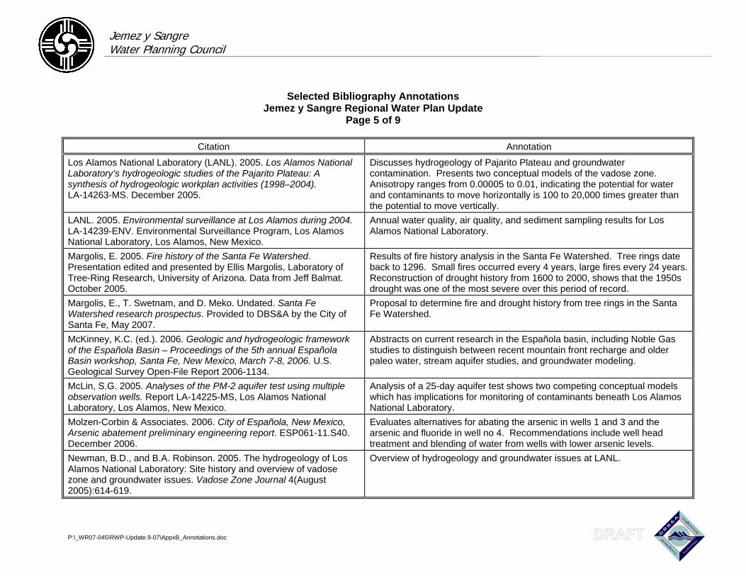
Jemez y Sangre Water Planning Council
Selected Bibliography Annotations Jemez y Sangre Regional Water Plan Update
Page 5 of 9
P:\_WR07-045\RWP-Update.9-07\AppxB_Annotations.doc
Citation Annotation
Los Alamos National Laboratory (LANL). 2005. Los Alamos National Laboratory’s hydrogeologic studies of the Pajarito Plateau: A synthesis of hydrogeologic workplan activities (1998–2004). LA-14263-MS. December 2005.
Discusses hydrogeology of Pajarito Plateau and groundwater contamination. Presents two conceptual models of the vadose zone. Anisotropy ranges from 0.00005 to 0.01, indicating the potential for water and contaminants to move horizontally is 100 to 20,000 times greater than the potential to move vertically.
LANL. 2005. Environmental surveillance at Los Alamos during 2004. LA-14239-ENV. Environmental Surveillance Program, Los Alamos National Laboratory, Los Alamos, New Mexico.
Annual water quality, air quality, and sediment sampling results for Los Alamos National Laboratory.
Margolis, E. 2005. Fire history of the Santa Fe Watershed. Presentation edited and presented by Ellis Margolis, Laboratory of Tree-Ring Research, University of Arizona. Data from Jeff Balmat. October 2005.
Results of fire history analysis in the Santa Fe Watershed. Tree rings date back to 1296. Small fires occurred every 4 years, large fires every 24 years. Reconstruction of drought history from 1600 to 2000, shows that the 1950s drought was one of the most severe over this period of record.
Margolis, E., T. Swetnam, and D. Meko. Undated. Santa Fe Watershed research prospectus. Provided to DBS&A by the City of Santa Fe, May 2007.
Proposal to determine fire and drought history from tree rings in the Santa Fe Watershed.
McKinney, K.C. (ed.). 2006. Geologic and hydrogeologic framework of the Española Basin – Proceedings of the 5th annual Española Basin workshop, Santa Fe, New Mexico, March 7-8, 2006. U.S. Geological Survey Open-File Report 2006-1134.
Abstracts on current research in the Española basin, including Noble Gas studies to distinguish between recent mountain front recharge and older paleo water, stream aquifer studies, and groundwater modeling.
McLin, S.G. 2005. Analyses of the PM-2 aquifer test using multiple observation wells. Report LA-14225-MS, Los Alamos National Laboratory, Los Alamos, New Mexico.
Analysis of a 25-day aquifer test shows two competing conceptual models which has implications for monitoring of contaminants beneath Los Alamos National Laboratory.
Molzen-Corbin & Associates. 2006. City of Española, New Mexico, Arsenic abatement preliminary engineering report. ESP061-11.S40. December 2006.
Evaluates alternatives for abating the arsenic in wells 1 and 3 and the arsenic and fluoride in well no 4. Recommendations include well head treatment and blending of water from wells with lower arsenic levels.
Newman, B.D., and B.A. Robinson. 2005. The hydrogeology of Los Alamos National Laboratory: Site history and overview of vadose zone and groundwater issues. Vadose Zone Journal 4(August 2005):614-619.
Overview of hydrogeology and groundwater issues at LANL.
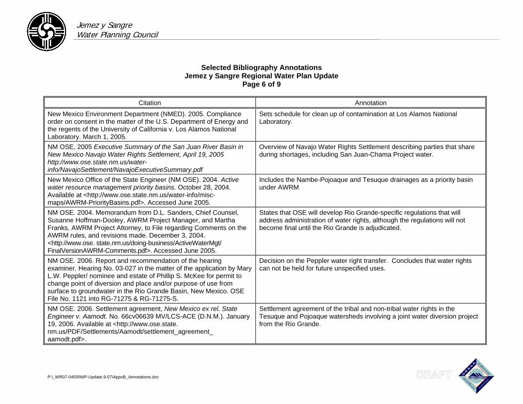
Jemez y Sangre Water Planning Council
Selected Bibliography Annotations Jemez y Sangre Regional Water Plan Update
Page 6 of 9
P:\_WR07-045\RWP-Update.9-07\AppxB_Annotations.doc
Citation Annotation
New Mexico Environment Department (NMED). 2005. Compliance order on consent in the matter of the U.S. Department of Energy and the regents of the University of California v. Los Alamos National Laboratory. March 1, 2005.
Sets schedule for clean up of contamination at Los Alamos National Laboratory.
NM OSE, 2005 Executive Summary of the San Juan River Basin in New Mexico Navajo Water Rights Settlement, April 19, 2005 http://www.ose.state.nm.us/water-info/NavajoSettlement/NavajoExecutiveSummary.pdf
Overview of Navajo Water Rights Settlement describing parties that share during shortages, including San Juan-Chama Project water.
New Mexico Office of the State Engineer (NM OSE). 2004. Active water resource management priority basins. October 28, 2004. Available at <http://www.ose.state.nm.us/water-info/misc-maps/AWRM-PriorityBasins.pdf>. Accessed June 2005.
Includes the Nambe-Pojoaque and Tesuque drainages as a priority basin under AWRM
NM OSE. 2004. Memorandum from D.L. Sanders, Chief Counsel, Susanne Hoffman-Dooley, AWRM Project Manager, and Martha Franks, AWRM Project Attorney, to File regarding Comments on the AWRM rules, and revisions made. December 3, 2004. <http://www.ose. state.nm.us/doing-business/ActiveWaterMgt/-
FinalVersionAWRM-Comments.pdf>. Accessed June 2005.
States that OSE will develop Rio Grande-specific regulations that will address administration of water rights, although the regulations will not become final until the Rio Grande is adjudicated.
NM OSE. 2006. Report and recommendation of the hearing examiner. Hearing No. 03-027 in the matter of the application by Mary L.W. Peppler/ nominee and estate of Phillip S. McKee for permit to change point of diversion and place and/or purpose of use from surface to groundwater in the Rio Grande Basin, New Mexico. OSE File No. 1121 into RG-71275 & RG-71275-S.
Decision on the Peppler water right transfer. Concludes that water rights can not be held for future unspecified uses.
NM OSE. 2006. Settlement agreement, New Mexico ex rel. State Engineer v. Aamodt. No. 66cv06639 MV/LCS-ACE (D.N.M.). January 19, 2006. Available at <http://www.ose.state. nm.us/PDF/Settlements/Aamodt/settlement_agreement_ aamodt.pdf>.
Settlement agreement of the tribal and non-tribal water rights in the Tesuque and Pojoaque watersheds involving a joint water diversion project from the Rio Grande.
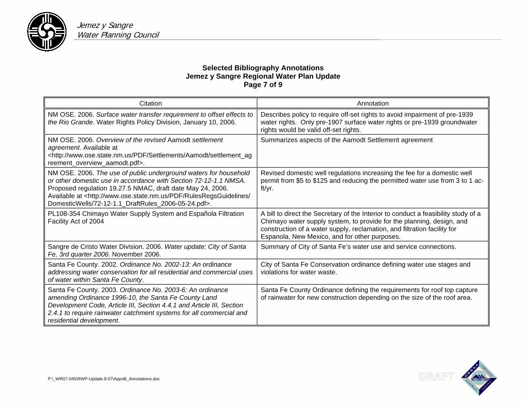
Jemez y Sangre Water Planning Council
Selected Bibliography Annotations Jemez y Sangre Regional Water Plan Update
Page 7 of 9
P:\_WR07-045\RWP-Update.9-07\AppxB_Annotations.doc
Citation Annotation
NM OSE. 2006. Surface water transfer requirement to offset effects to the Rio Grande. Water Rights Policy Division, January 10, 2006.
Describes policy to require off-set rights to avoid impairment of pre-1939 water rights. Only pre-1907 surface water rights or pre-1939 groundwater rights would be valid off-set rights.
NM OSE. 2006. Overview of the revised Aamodt settlement agreement. Available at <http://www.ose.state.nm.us/PDF/Settlements/Aamodt/settlement_agreement_overview_aamodt.pdf>.
Summarizes aspects of the Aamodt Settlement agreement
NM OSE. 2006. The use of public underground waters for household or other domestic use in accordance with Section 72-12-1.1 NMSA. Proposed regulation 19.27.5 NMAC, draft date May 24, 2006. Available at <http://www.ose.state.nm.us/PDF/RulesRegsGuidelines/-
DomesticWells/72-12-1.1_DraftRules_2006-05-24.pdf>.
Revised domestic well regulations increasing the fee for a domestic well permit from $5 to $125 and reducing the permitted water use from 3 to 1 ac-ft/yr.
PL108-354 Chimayo Water Supply System and Española Filtration Facility Act of 2004
A bill to direct the Secretary of the Interior to conduct a feasibility study of a Chimayo water supply system, to provide for the planning, design, and construction of a water supply, reclamation, and filtration facility for Espanola, New Mexico, and for other purposes.
Sangre de Cristo Water Division. 2006. Water update: City of Santa Fe, 3rd quarter 2006. November 2006.
Summary of City of Santa Fe’s water use and service connections.
Santa Fe County. 2002. Ordinance No. 2002-13: An ordinance addressing water conservation for all residential and commercial uses of water within Santa Fe County.
City of Santa Fe Conservation ordinance defining water use stages and violations for water waste.
Santa Fe County. 2003. Ordinance No. 2003-6: An ordinance amending Ordinance 1996-10, the Santa Fe County Land Development Code, Article III, Section 4.4.1 and Article III, Section 2.4.1 to require rainwater catchment systems for all commercial and residential development.
Santa Fe County Ordinance defining the requirements for roof top capture of rainwater for new construction depending on the size of the roof area.
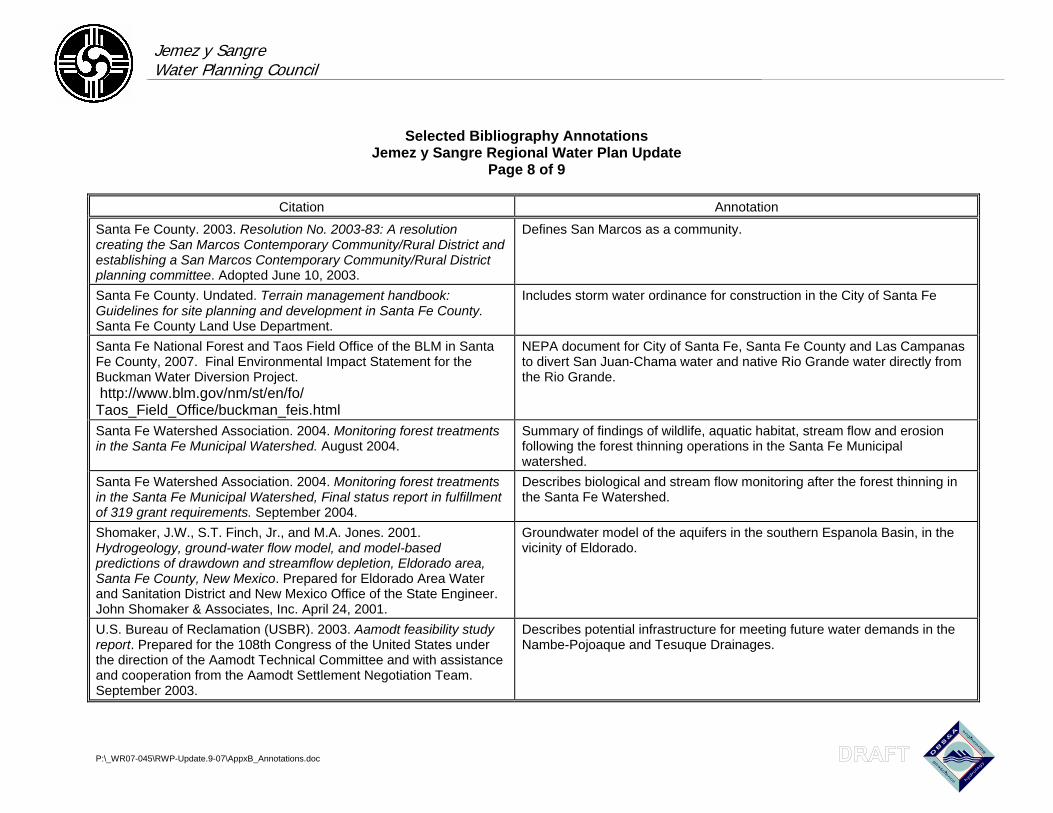
Jemez y Sangre Water Planning Council
Selected Bibliography Annotations Jemez y Sangre Regional Water Plan Update
Page 8 of 9
P:\_WR07-045\RWP-Update.9-07\AppxB_Annotations.doc
Citation Annotation
Santa Fe County. 2003. Resolution No. 2003-83: A resolution creating the San Marcos Contemporary Community/Rural District and establishing a San Marcos Contemporary Community/Rural District planning committee. Adopted June 10, 2003.
Defines San Marcos as a community.
Santa Fe County. Undated. Terrain management handbook: Guidelines for site planning and development in Santa Fe County. Santa Fe County Land Use Department.
Includes storm water ordinance for construction in the City of Santa Fe
Santa Fe National Forest and Taos Field Office of the BLM in Santa Fe County, 2007. Final Environmental Impact Statement for the Buckman Water Diversion Project. http://www.blm.gov/nm/st/en/fo/-Taos_Field_Office/buckman_feis.html
NEPA document for City of Santa Fe, Santa Fe County and Las Campanas to divert San Juan-Chama water and native Rio Grande water directly from the Rio Grande.
Santa Fe Watershed Association. 2004. Monitoring forest treatments in the Santa Fe Municipal Watershed. August 2004.
Summary of findings of wildlife, aquatic habitat, stream flow and erosion following the forest thinning operations in the Santa Fe Municipal watershed.
Santa Fe Watershed Association. 2004. Monitoring forest treatments in the Santa Fe Municipal Watershed, Final status report in fulfillment of 319 grant requirements. September 2004.
Describes biological and stream flow monitoring after the forest thinning in the Santa Fe Watershed.
Shomaker, J.W., S.T. Finch, Jr., and M.A. Jones. 2001. Hydrogeology, ground-water flow model, and model-based predictions of drawdown and streamflow depletion, Eldorado area, Santa Fe County, New Mexico. Prepared for Eldorado Area Water and Sanitation District and New Mexico Office of the State Engineer. John Shomaker & Associates, Inc. April 24, 2001.
Groundwater model of the aquifers in the southern Espanola Basin, in the vicinity of Eldorado.
U.S. Bureau of Reclamation (USBR). 2003. Aamodt feasibility study report. Prepared for the 108th Congress of the United States under the direction of the Aamodt Technical Committee and with assistance and cooperation from the Aamodt Settlement Negotiation Team. September 2003.
Describes potential infrastructure for meeting future water demands in the Nambe-Pojoaque and Tesuque Drainages.
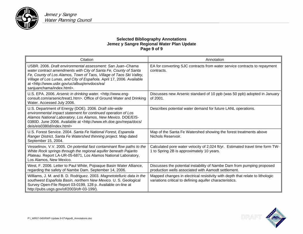
Jemez y Sangre Water Planning Council
Selected Bibliography Annotations Jemez y Sangre Regional Water Plan Update
Page 9 of 9
P:\_WR07-045\RWP-Update.9-07\AppxB_Annotations.doc
Citation Annotation
USBR. 2006. Draft environmental assessment: San Juan–Chama water contract amendments with City of Santa Fe, County of Santa Fe, County of Los Alamos, Town of Taos, Village of Taos Ski Valley, Village of Los Lunas, and City of Española. April 17, 2006. Available at <http://www.usbr.gov/uc/albuq/envdocs/ea/-
sanjuanchama/index.html>.
EA for converting SJC contracts from water service contracts to repayment contracts.
U.S. EPA. 2006. Arsenic in drinking water. <http://www.eng-consult.com/arsenic/treat1.htm>. Office of Ground Water and Drinking Water. Accessed July 2006.
Discusses new Arsenic standard of 10 ppb (was 50 ppb) adopted in January of 2001.
U.S. Department of Energy (DOE). 2006. Draft site-wide environmental impact statement for continued operation of Los Alamos National Laboratory, Los Alamos, New Mexico. DOE/EIS-0380D. June 2006. Available at <http://www.eh.doe.gov/nepa/docs/-
deis/eis0380d/index.html>
Describes potential water demand for future LANL operations.
U.S. Forest Service. 2004. Santa Fe National Forest, Espanola Ranger District, Santa Fe Watershed thinning project. Map dated September 15, 2004.
Map of the Santa Fe Watershed showing the forest treatments above Nichols Reservoir.
Vesselinov, V.V. 2005. On potential fast contaminant flow paths to the White Rock springs through the regional aquifer beneath Pajarito Plateau. Report LA-UR-05-6871, Los Alamos National Laboratory, Los Alamos, New Mexico.
Calculated pore water velocity of 2,024 ft/yr. Estimated travel time form TW-1 to Spring 2B is approximately 10 years.
West, F. 2006. Letter to Paul White, Pojoaque Basin Water Alliance, regarding the safety of Nambe Dam. September 14, 2006.
Discusses the potential instability of Nambe Dam from pumping proposed production wells associated with Aamodt settlement.
Williams, J. M. and B. D. Rodriguez. 2003. Magnetotelluric data in the southwest Española Basin, northern New Mexico. U. S. Geological Survey Open-File Report 03-0199, 128 p. Available on-line at http://pubs.usgs.gov/of/2003/ofr-03-199/).
Mapped changes in electrical resistivity with depth that relate to lithologic variations critical to defining aquifer characteristics.
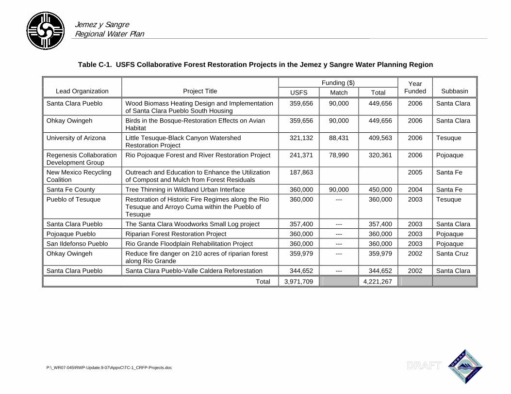
Jemez y Sangre Regional Water Plan
P:\_WR07-045\RWP-Update.9-07\AppxC\TC-1_CRFP-Projects.doc
Table C-1. USFS Collaborative Forest Restoration Projects in the Jemez y Sangre Water Planning Region
Funding ($) Lead Organization Project Title USFS Match Total
Year Funded Subbasin
Santa Clara Pueblo Wood Biomass Heating Design and Implementation of Santa Clara Pueblo South Housing
359,656 90,000 449,656 2006 Santa Clara
Ohkay Owingeh Birds in the Bosque-Restoration Effects on Avian Habitat
359,656 90,000 449,656 2006 Santa Clara
University of Arizona Little Tesuque-Black Canyon Watershed Restoration Project
321,132 88,431 409,563 2006 Tesuque
Regenesis Collaboration Development Group
Rio Pojoaque Forest and River Restoration Project 241,371 78,990 320,361 2006 Pojoaque
New Mexico Recycling Coalition
Outreach and Education to Enhance the Utilization of Compost and Mulch from Forest Residuals
187,863 2005 Santa Fe
Santa Fe County Tree Thinning in Wildland Urban Interface 360,000 90,000 450,000 2004 Santa Fe Pueblo of Tesuque Restoration of Historic Fire Regimes along the Rio
Tesuque and Arroyo Cuma within the Pueblo of Tesuque
360,000 --- 360,000 2003 Tesuque
Santa Clara Pueblo The Santa Clara Woodworks Small Log project 357,400 --- 357,400 2003 Santa Clara Pojoaque Pueblo Riparian Forest Restoration Project 360,000 --- 360,000 2003 Pojoaque San Ildefonso Pueblo Rio Grande Floodplain Rehabilitation Project 360,000 --- 360,000 2003 Pojoaque Ohkay Owingeh Reduce fire danger on 210 acres of riparian forest
along Rio Grande 359,979 --- 359,979 2002 Santa Cruz
Santa Clara Pueblo Santa Clara Pueblo-Valle Caldera Reforestation 344,652 --- 344,652 2002 Santa Clara
Total 3,971,709 4,221,267
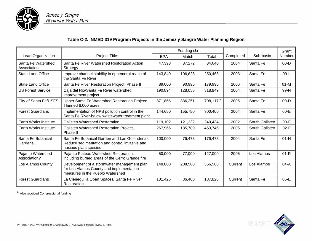
Jemez y Sangre Regional Water Plan
P:\_WR07-045\RWP-Update.9-07\AppxC\TC-2_NMED319-ProjectsRev052407.doc
Table C-2. NMED 319 Program Projects in the Jemez y Sangre Water Planning Region
Funding ($) Lead Organization Project Title EPA Match Total Completed Sub-basin
Grant Number
Santa Fe Watershed Association
Santa Fe River Watershed Restoration Action Strategy
47,398 37,272 84,640 2004 Santa Fe 00-D
State Land Office Improve channel stability in ephemeral reach of the Santa Fe River
143,840 106,628 250,468 2003 Santa Fe 99-L
State Land Office Santa Fe River Restoration Project, Phase II 89,000 90,995 179,995 2006 Santa Fe 01-M US Forest Service Caja del Rio/Santa Fe River watershed
improvement project 190,894 128,055 318,949 2004 Santa Fe 99-N
City of Santa Fe/USFS Upper Santa Fe Watershed Restoration Project: Thinned 6,000 acres
371,866 336,251 708,117 a 2005 Santa Fe 00-D
Forest Guardians Implementation of NPS pollution control in the Santa Fe River-below wastewater treatment plant
144,650 155,750 300,400 2004 Santa Fe 00-E
Earth Works Institute Galisteo Watershed Restoration 119,102 121,332 240,434 2002 South Galisteo 00-F Earth Works Institute Galisteo Watershed Restoration Project,
Phase II 267,966 185,780 453,746 2005 South Galisteo 02-F
Santa Fe Botanical Gardens
Santa Fe Botanical Garden and Las Golondrinas: Reduce sedimentation and control invasive and noxious plant species
100,000 76,473 176,473 2004 Santa Fe 01-N
Pajarito Watershed Association?
Pajarito Plateau Watershed Restoration, including burned areas of the Cerro Grande fire
50,000 77,000 127,000 2005 Los Alamos 01-R
Los Alamos County Development of a stormwater management plan for Los Alamos County and implementation measures in the Pueblo Watershed
148,000 208,500 356,500 Current Los Alamos 04-A
Forest Guardians La Cieneguilla Open Spaces/ Santa Fe River Restoration
101,425 86,400 187,825 Current Santa Fe 05-E
a Also received Congressional funding