Embed Size (px)
DESCRIPTION
the culmination of 5 years at the university of sheffield, this compendium collates student works from the BA, year in practice and completion at MLA level. the project intends to balance the creative and theoretic dynamics of a landscape design education through a range of sectors, sampling sketches, models, visualisations, graphic design and masterplan + construction resolution. 2008-2013.
Citation preview

MLA, BA Hons, university of sheffield. 2008-2013 graduate portfolio
landscape architecturewith town + regional planning
JOTARO TOKUNAGAgraduate portfolio
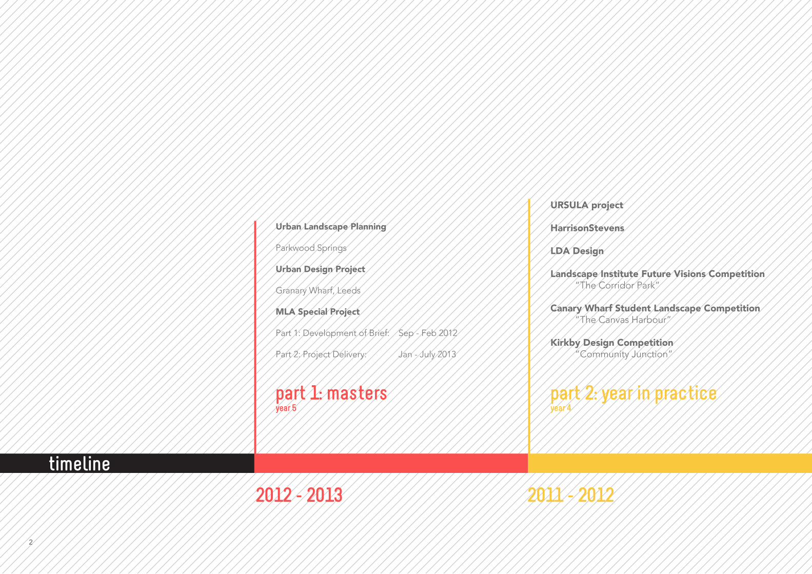
part 1: mastersyear 5
timeline
Urban Landscape Planning
Parkwood Springs
Urban Design Project
Granary Wharf, Leeds
MLA Special Project
Part 1: Development of Brief: Sep - Feb 2012
Part 2: Project Delivery: Jan - July 2013
part 2: year in practiceyear 4
URSULA project
HarrisonStevens
LDA Design
Landscape Institute Future Visions Competition “The Corridor Park”
Canary Wharf Student Landscape Competition “The Canvas Harbour”
Kirkby Design Competition “Community Junction”
2011 - 20122012 - 2013
2
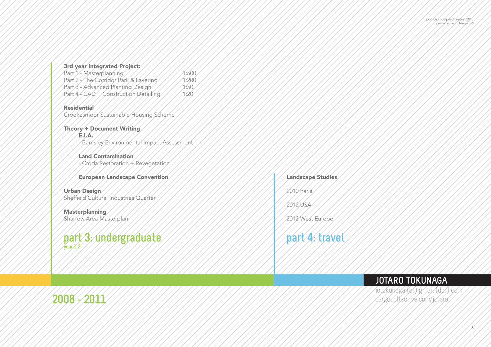
part 3: undergraduateyear 1-3
3rd year Integrated Project:Part 1 - Masterplanning 1:500Part 2 - The Corridor Park & Layering 1:200Part 3 - Advanced Planting Design 1:50Part 4 - CAD + Construction Detailing 1:20
ResidentialCrookesmoor Sustainable Housing Scheme
Theory + Document Writing E.I.A. - Barnsley Environmental Impact Assessment
Land Contamination - Croda Restoration + Revegetation European Landscape Convention
Urban Design Sheffield Cultural Industries Quarter
Masterplanning Sharrow Area Masterplan
part 4: travel
Landscape Studies
2010 Paris
2012 USA
2012 West Europe
2008 - 2011
portfolio compiled august 2013produced in InDesign cs6
JOTARO TOKUNAGA jotokunaga (at) gmail (dot) comcargocollective.com/jotaro
3

PART 1: masters

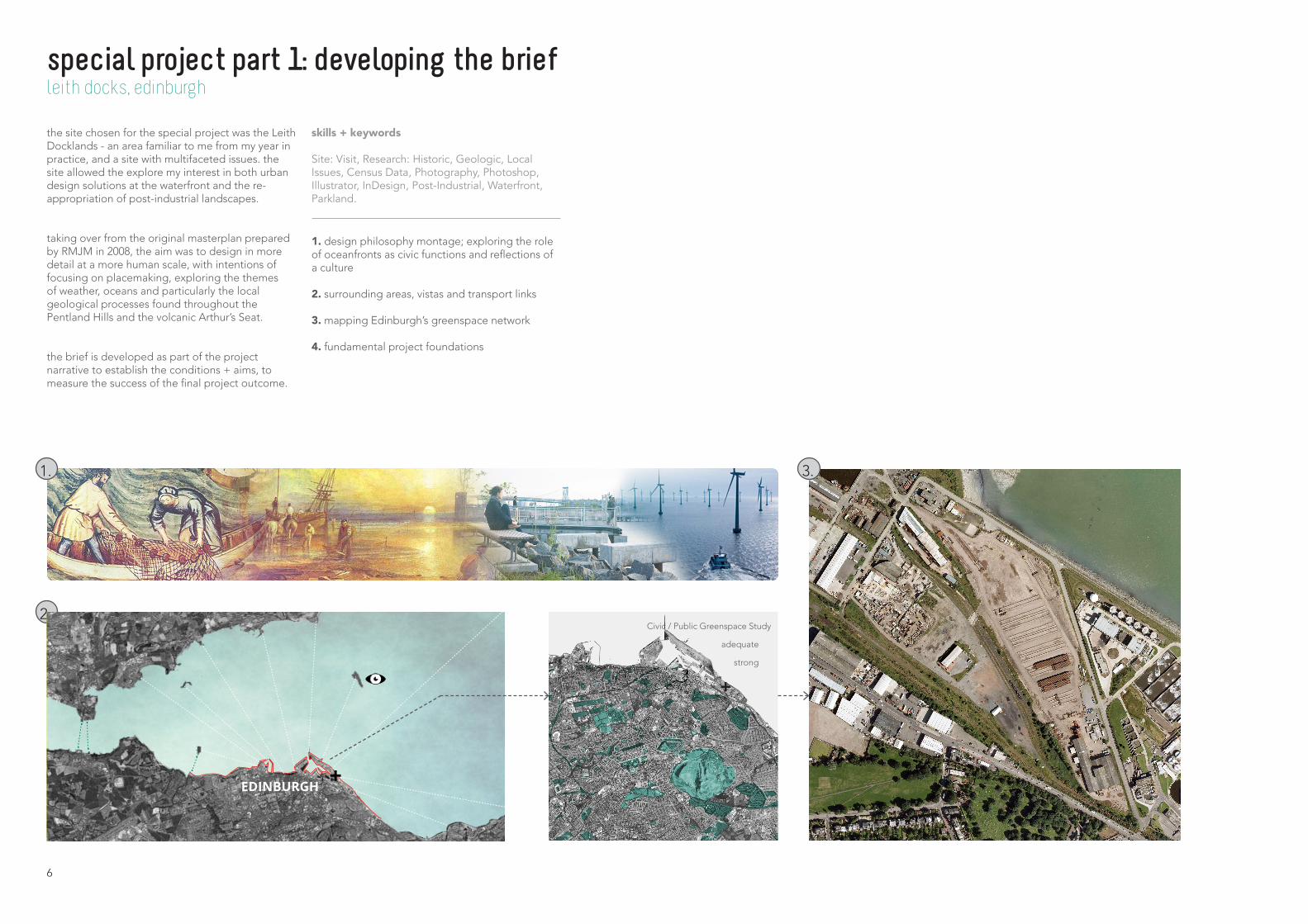
the site chosen for the special project was the Leith Docklands - an area familiar to me from my year in practice, and a site with multifaceted issues. the site allowed the explore my interest in both urban design solutions at the waterfront and the re-appropriation of post-industrial landscapes.
taking over from the original masterplan prepared by RMJM in 2008, the aim was to design in more detail at a more human scale, with intentions of focusing on placemaking, exploring the themes of weather, oceans and particularly the local geological processes found throughout the Pentland Hills and the volcanic Arthur’s Seat.
the brief is developed as part of the project narrative to establish the conditions + aims, to measure the success of the final project outcome.
special project part 1: developing the briefleith docks, edinburgh
1.
2.
3.
1. design philosophy montage; exploring the role of oceanfronts as civic functions and reflections of a culture
2. surrounding areas, vistas and transport links
3. mapping Edinburgh’s greenspace network
4. fundamental project foundations
skills + keywords
Site: Visit, Research: Historic, Geologic, Local Issues, Census Data, Photography, Photoshop, Illustrator, InDesign, Post-Industrial, Waterfront, Parkland.
+EDINBURGH
adequate
Civic / Public Greenspace Study
strong
+
6
cramond island
4.
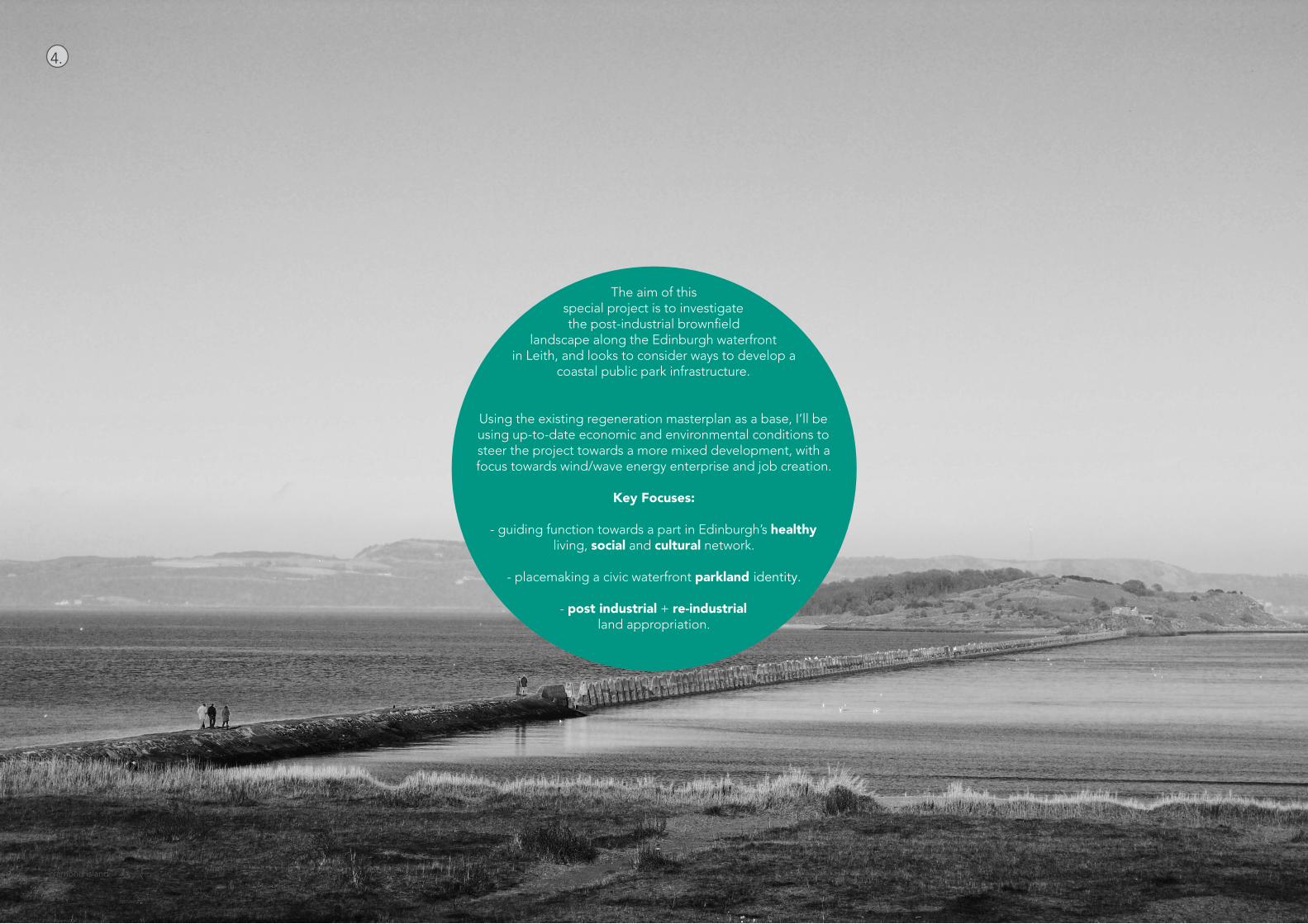
The aim of this special project is to investigate the post-industrial brownfield
landscape along the Edinburgh waterfront in Leith, and looks to consider ways to develop a
coastal public park infrastructure.
Using the existing regeneration masterplan as a base, I’ll be using up-to-date economic and environmental conditions to steer the project towards a more mixed development, with a focus towards wind/wave energy enterprise and job creation.
Key Focuses:
- guiding function towards a part in Edinburgh’s healthy living, social and cultural network.
- placemaking a civic waterfront parkland identity.
- post industrial + re-industrial land appropriation.
7
the final proposals transforms the waste site at the water’s edge, introducing a complex system of park, ecological process and social milieu across 800m meter of site. the industrial relics found over the site are retained and incorporated into a post-industrial civic landscape which prioritises activity and sport, using the size of the site to add a significant portion of greenspace infrastructure where it’s traditionally been lacking.
it makes connections to its immediate and city-wide surroundings and forms a long term growth and construction phases within a wider network of other waterfront developments and Edinburgh’s overall greenspace and lifestyle strategy heading into the 21st century.
accompanying the core masterplan and visualisations are working construction drawings and a planting strategy which focuses on key design features and interventions which define the project, following ideas of the industrial vs natural, existing local character and an ordered rigid plan around which a more abstract and evocative experience plays out.
special project part 2: project deliveryleith docks, edinburgh
skills + keywords
concept, implementation, theory, social + land programming strategy, visual expressions, CAD / visualisation / planting design
humans are constantly fighting nature for control of the waterfront - what emerges is a gradient between two extremes, between totally managed human edges, or powerful natural processes claiming back the land.
coasts are environments of flux, as we’re seduced by the changing weathers and the tides, its dramatic ephemealities.
coastal flux is based on stewardship + management of ecological processes whilst enabling a park to experience these as part of the fabric of life.
concept: coastal flux
nearby Cramond Island is accessible only by a concrete path which reveals itself in low tide. this hide + reveal is an idea explored with the ‘bio dock’ feature and its island mounds.
abandoned, overgrown WWII bunker,Cramond Island
low-intervention coastline management, Portobello Beach
hard demarcations at the wa-terfront sewage works,Leith
suitabilities
- recreation- property development
existing land use
- roads- industry- recreation
existing land types- industrial relics- tidal inundation- emerging ecologies- industrial
access
- entrance edges- logical paths
site conditions
revealing local ecologies/ vegetation strategythe derelicting site already shows a range of vegetation types like heathland, small trees + grasses emerging, and these will be further developed with the addition of local Scottish countryside palettes.
geopark design language
taking the ubiquitous Arthur’s Seat mountain and the local geology into practical consideration, the ‘organised’ forms will emerge based on 4 types of geo-processes to form a dramatic elevated landscape.
crag + tail kettle hole eskerskames
flowering heathland + multistem trees
saltwater marshes native woodland copses: scots pine
sand dunes + marram grasses
5 components of the park
1. esplanadethe active waterfront of the park, with 2 wide walkways 2m height
apart. between them. the low path steps down into the water at it’s
highest tide.
2. north park: ‘geopark’re-interpreting an existing
structure into the Commons Hub - the cultural centre and destination
of the park.
3. the villagefootprints for 9 speculative
building blocks also included, to help populate and activate the
park. based on Edinburgh block sizes, this adapts the original
masterplan for retail, residential and small businesses.
4. bioribbonthe ecological aspect is most
pronounced with a network of sand dunes, and watercourse
which tidally inundates, forming salt-water marsh habitats.
5. south park: ‘commons’based on neighbouring Leith
Links, the south park comprises of large lawn fields and tree lined
walkways. unlike the Links though, it’s tuned towards sports, with a running track, courts and youth
activities.development sketches
8
3
2
1
4
5
3.a
emerging scots pine thicket
5m ‘crag’ (new)w/ skate drop-in
amenity lawns
suggested circular jogging circuit (1.5km)
marram / pioneer grasses
groyne pier
watergate
rip-rap
kayak launch
10m ‘crag’ view (existing)/w climbing wall
sheltered seating enclosure
+2m
+2m
+0.5m
+12m
+7m
+0m (high tide)
-2m (low tide)
+0.2m
+0.4m
+0.6m
+0.8m
+1m
+1.2m
+2m
+4m
+3m
+3m
+2m
+1m
+0.5m
0
0m 150m
15 301:1500
multifunctional exhibition / performance space
treatment works screening
< To Ocean View shopping terminal
< To Leith
Links Park
< To proposed waterfront housing developments
1:20
0
geopark landformsthese small to medium earthworks are based on geological processes, and form gentle ripples across the north park. crag + tail eskers kames kettle hole
New formed ecologies fit in with existing Lothians Character Analysis and its related habitats.
Gannet / Kittiwake / Sandpiper
biodock - tidal inundation
VISUALISATION ANGLE
To Leith + portobello >
9

section
0
0m 20m
1 21:200
1
2
34
5
6
7
8
9
10
1. woodland trail, incorporating old rail tracks2. sports courts, 200m running track3. canopied seating points, with ballast and mulch-planted
strips
4. main promenade path5. recessed grass planters and biodock edge seating
6. elevated water crossing with 2 viewing points7. incorporated further rail tracks into pavement8. saltwater marsh build-up
9. dune crossing point and footpath opening10. dune ecology sequences
detail masterplan + visualisation
10
natural lowland heath and meadows maintained and propagated into the vegetation strategy
multi-purpose sports spaces, open to interpretations and creative, informal uses
10cm raised pathways, based on, and incorporating rail tracks
continuous evocations of local natural characters; earthworks, heathlands, dunes, tides
journey to the ocean heightened with widening saltwater dock
11
biodockmain promenadesports courtsbirch railway walk
groundcovershrub layer
canopy
planting plan location
load-bearing frame + washer strip: galvanised stainless steel
fixings: 5mm bolts, at 30cm intervals. custom long bolts for fixing yellow side-panels.Timber slats bolted onto metal frame,
then secured on top / side of concrete.
Planting and appropriate bedding mulch added.12m
3 x 4m
Transparent plastic caps show soil structure though. Refer to “PANTONE® PLASTICS
transparent selector”or equivalent. 14-0848 Mimosa / RAL 1003
pipe benchtimber slats: galvanised stainless steel
bespoke parts to be constructed off-site, with assembly suggested on-site.
1:40 gradient
ballast base course
dynamic course
water-bound surface course
stainless steel strip /w ground anchor
C15 concrete
pavers with levelling sand
frost course
C20 concrete pavers - light blue tone
50mm crushed building rubble ballast - monochrome shades only.
concrete haunch
C40 concrete frost protection
subsoil
combined with ground strips of woodland trees, mulched planting + ballast strips:
construction + section drawings
12
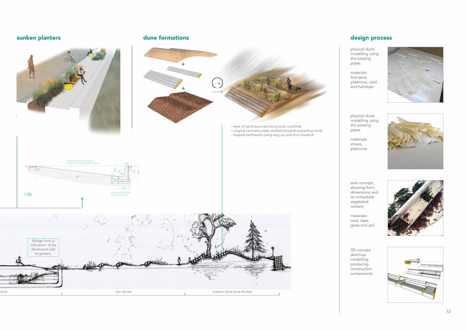
mature dune pine thicketlow dunesbiodock
sunken planters
+
+
- layer of sand (sourced along local coastline)- original concrete pipes stacked (towards prevailing wind)- shaped earthworks using dug up soils from biodock
dune formations design process
Bridge form is indicative - to be developed with
engineers.
soil and mulch requirements to further planting design specifications.
pre-cast retaining C20 concrete base units
physical dune modelling using the existing pipes.
materials:fine sand, plasticine, card and hairdryer
physical dune modelling using the existing pipes.
materials:straws, plasticine
seat concept, showing form, dimensions and its immediate vegetated context
materials:card, tape, grass and soil
3D concept sketchup modelling, producing construction components
13
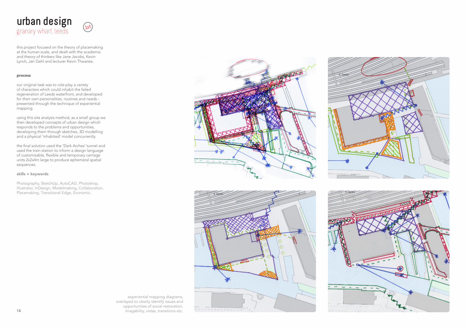
experiential mapping diagrams, overlayed to clearly identify issues and
opportunities of social restoration, imagability, vistas, transitions etc.
this project focused on the theory of placemaking at the human scale, and dealt with the academia and theory of thinkers like Jane Jacobs, Kevin Lynch, Jan Gehl and lecturer Kevin Thwaites.
process
our original task was to role-play a variety of characters which could inhabit the failed regeneration of Leeds waterfront, and developed for their own personalities, routines and needs - presented through the technique of experiential mapping.
using this site analysis method, as a small group we then developed concepts of urban design which responds to the problems and opportunities, developing them through sketches, 3D modelling and a physical ‘inhabited’ model concurrently.
the final solution used the ‘Dark Arches’ tunnel and used the train station to inform a design language of customisable, flexible and temporary carriage units 2x2x4m large to produce ephemeral spatial sequences.
skills + keywords
Photography, SketchUp, AutoCAD, Photoshop, Illustrator, InDesign, Modelmaking, Collaboration, Placemaking, Transitional Edge, Economic.
urban designgranary wharf, leeds
1st
14
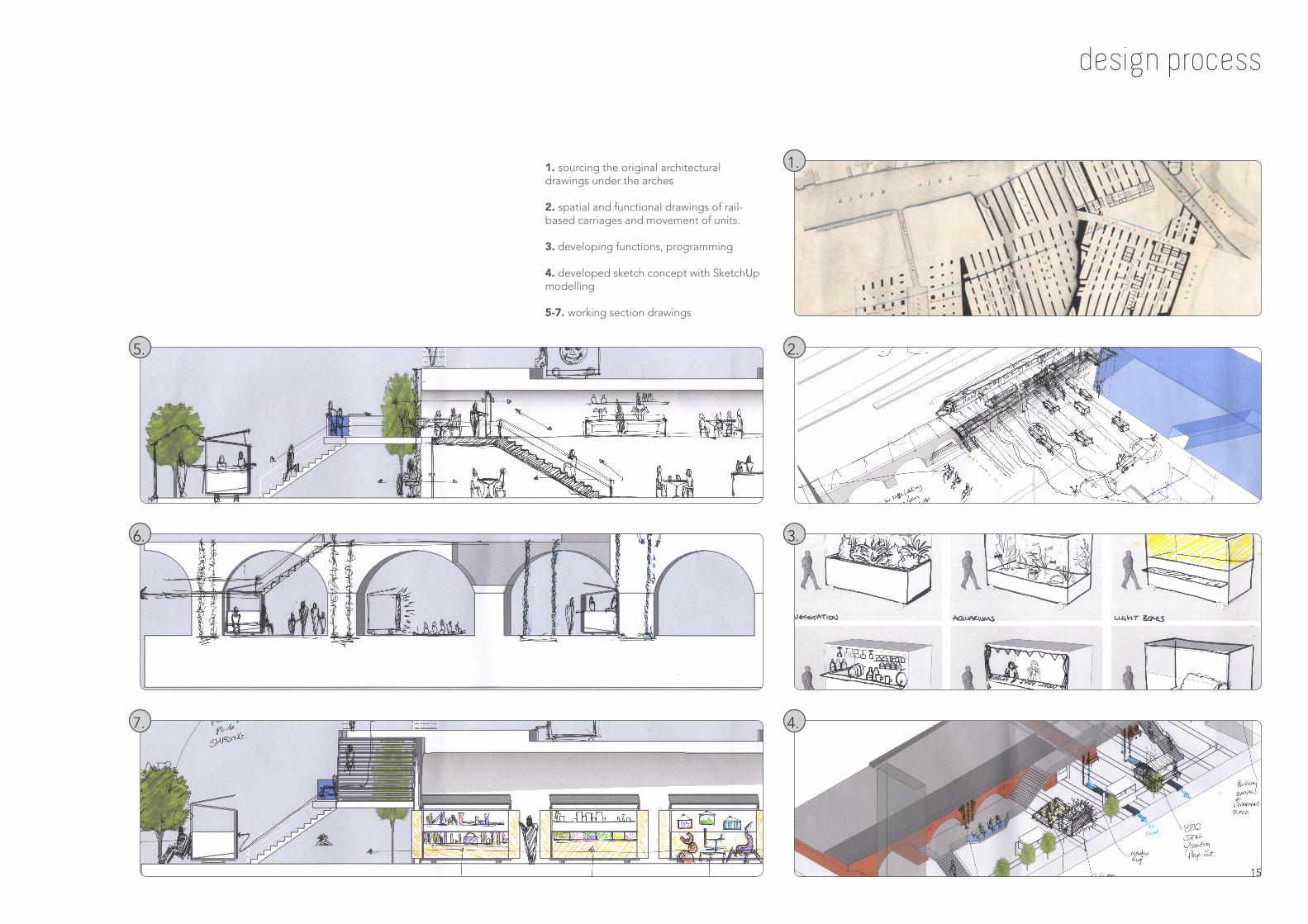
1. sourcing the original architectural drawings under the arches
2. spatial and functional drawings of rail-based carriages and movement of units.
3. developing functions, programming
4. developed sketch concept with SketchUp modelling
5-7. working section drawings
5.
6.
7.
1.
2.
3.
4.
design process
15

Everyday Use
to demonstrate a flexible edge transition and social space, we developed a range of hypothetical spatial sequences based around 4 selected seasonal events, ranging down to informal, quickfire and improvised use of space.
we also went beyond the brief and developed an organisational body called “the friends of Granary Square” and modelled the roles and administrative background the landscape needed to function as we intended.
the “carriages” concept was the design of individual units which could be part-rented out on short leases, used for play, vegetation, retail, events and so-forth.
spatial sequence + programming development
local business + investment
local resident participation
other visitors leeds train station
16
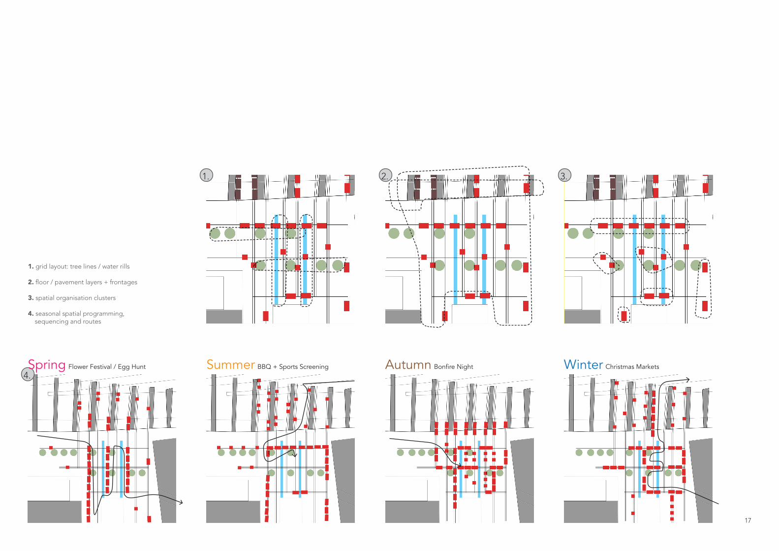
Summer BBQ + Sports Screening Autumn Bonfire Night Winter Christmas Markets
1. grid layout: tree lines / water rills
2. floor / pavement layers + frontages
3. spatial organisation clusters
4. seasonal spatial programming, sequencing and routes
1.
4.
2. 3.
Spring Flower Festival / Egg Hunt
17

a process of developing a detailed SketchUp model, tracing over with pen by hand, then digitally colouring and animating the scene.
1:100 axonometric drawing
18
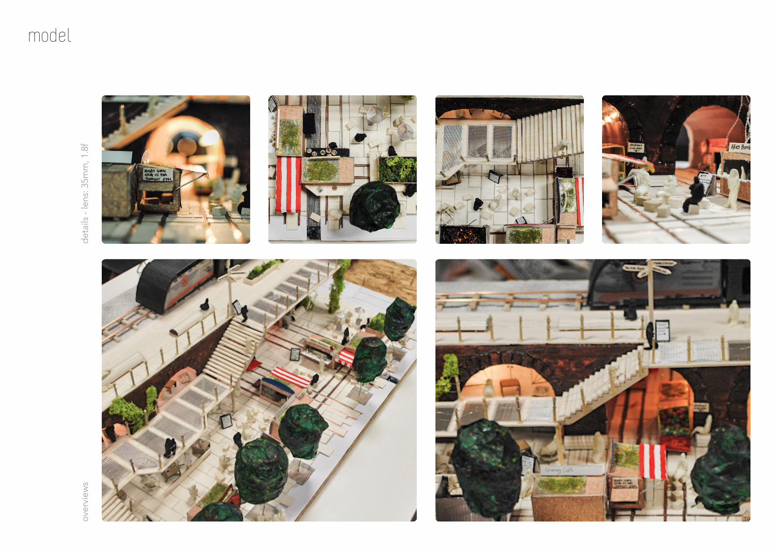
model
det
ails
- le
ns: 3
5mm
, 1.8
fo
verv
iew
s
19

urban landscape planningparkwood springs, sheffield
this project focused on the theory of landscape planning at the city level, and dealt with the academia and theory of urban wildscapes developed by lecturer Anna Jorgensen and the seminal text; ‘design with nature’ by Ian McHarg.
the site dealt with a open ‘urban wildscape’ - a steep expanse of natural parkland, working wasteland and post-industrial environment without a coherent or driven planning agenda.
process
a two-part project, the first was to acquire, map and present census and topological data through arcGIS. this would inform the social basis of the subsequent urban planning.
then, using the designated theme of “transport and healthy living”, we developed phasing diagrams, programming graphs, a masterplan and some visual renderings of re-appropriating this parkland environment into a major local and regional activity centre.
i focused particularly on combining transport with healthy living, looking to cities like Munich and Duisburg to explore combinations of the themes.
skills + keywordsPhotography, AutoCAD, Photoshop, Illustrator, InDesign, GIS, Collaboration, Placemaking, Transitional Edge, Economic.
1st
LegendSite Boundary
<all o
ther v
alues
>
DENSITY dwellings per hec1 2 3 5 6 8 9 10 11 12 14 15 16 17 18 19 21 23 25 27
0 1.5 3 4.5 60.75Miles
LegendSite Boundary
<all other values>
bands1
2
3
4
5
0 1.5 3 4.5 60.75Miles
LegendSite Boundary
<all other values>
bands1
2
3
4
50 1.5 3 4.5 60.75
Miles
functional and environmental emergence: phasing diagram
healthy living programming
census and topology data mapping
20
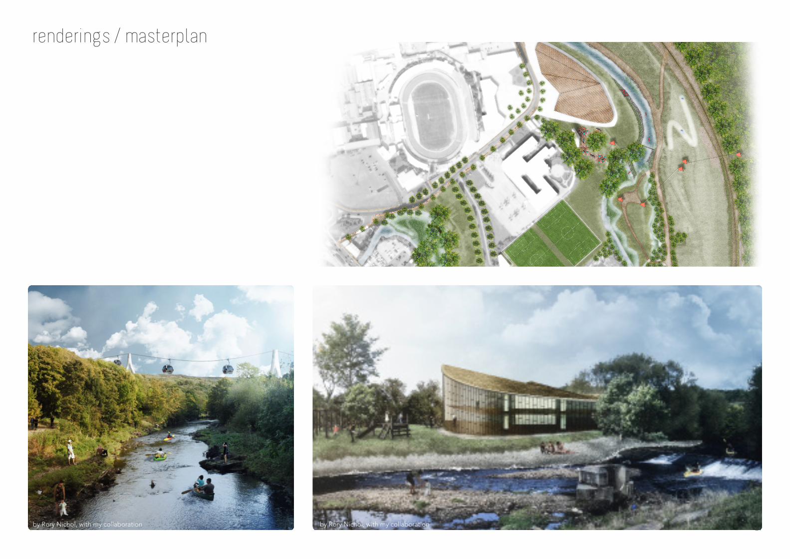
renderings / masterplan
by Rory Nichol, with my collaboration by Rory Nichol, with my collaboration 21

PART 2: year in practice

Landscape InstituteFUTURE VISIONS 2011
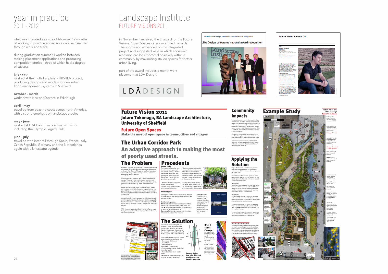
year in practice2011 - 2012
in November, I received the LI award for the Future Visions: Open Spaces category at the LI awards. The submission expanded on my integrated project and suggested ways in which economic recession can be embraced positively within a community by maximising stalled spaces for better urban living.
part of the award includes a month work placement at LDA Design.
what was intended as a straight-forward 12 months of working in practice ended up a diverse meander through work and travel.
during graduation summer, I worked between making placement applications and producing competition entries - three of which had a degree of success.
july - sepworked at the multidisciplinary URSULA project, producing designs and models for new urban flood management systems in Sheffield.
october - marchworked with HarrisonStevens in Edinburgh
april - maytravelled from coast to coast across north America, with a strong emphasis on landscape studies
may - juneworked at LDA Design in London, with work including the Olympic Legacy Park
june - julytravelled with inter-rail through Spain, France, Italy, Czech Republic, Germany and the Netherlands, again with a landscape agenda
Future Vision 2011Jotaro Tokunaga, BA Landscape Architecture, University of Sheffield
Future Open SpacesMake the most of open space in towns, cities and villages
The Urban Corridor ParkAn adaptive approach to making the most of poorly used streets.The ProblemIn Britain, there has recently been a transformation of our cityscapes. ‘Millennium’ branded projects and the rise of shrines to the religion of shopping, retail and leisure were common throughout the country, resulting in a dense homogeny of consumerism.
When that dream began to fade in 2008, it took with it many of the shop fronts and industrial environments which supported it. Parts of our towns and cities are now peppered with boarded up shops and lie dormant.
As this was happening, there too was a type of cheap city environment which always had lagged behind - the pound shops and discount shoe outlets, which were at risk of segregation and disconnection with the rest of the affluent city.
As social mobility decelerates and wealth disparities wid-en, it’s important that such close city districts are glued together and share a common network of spaces which enrich the city centre as a whole - greater than the sum of its parts.
With the coming decades, the urban fabric has an oppor-tunity to reclaim these ‘dead’ streets, and make the most of under used spaces.
Pocket Parks
Stalled Spaces
The concept of a pocket park is not new - taking a small space and squeezing the max-imum impact out of it - was realised famously by Robert Zion’s Paley Park in 1967. Its principles were simple:
- A retreat from the noisy, dirty streets of Manhattan.- Slower paces, vegetation and a recreational attraction.
This report, published last year, explores the idea of stalled spaces (the underlying issue of this pro-ject submission),
Problems they cause:Environmental: overgrown, dangerous and det-rimental to the overall image of the wider area.Social: unpleasant for visitors, and despairing to residents and their quality of life Economic: hamstrings hopes of new attractions into a downward spiral of closures.
Opportunities:These spaces are in essence open canvasses for place-making, community engagement, de-velopment, green infrastructure, growth, education and temporary uses.
If these principles were applied in a way which connects spaces, rather than a reclusion, this would give a higher impetus to inhabit our streets, with a slower pace and a better appreciation for the surroundings.
Crucially, this is about making the connections through the city, over fragmented spaces connect-ed by unappealing streetscapes.
Precedents
A recent article illustrating the impact of a poor city environment, as affecting pedestrian footfall into a spiral of urban dereliction.
The SolutionThe idea of the corridor park, is to allocate a street, or stretches of a street, which are dedicated to en-hancing the site, and the surround-ing streets. It is essentially sacrificed, for the benefit of the rest of the area.
This could take any form, but has the potential to become a haven for:- Stormwater Catchment- Vegetation- Habitat creation- Social and Cultural Milieu- Environmental quality: Shade, Shel-ter and air quality- Recreation, Relaxation, Food + Drink- Allotments, Community functions or other senses of ownership.
Concept Model:How a Corridor Park would radiate its benefits outwards.
Brief + Fabric ConceptA conceptual way of examining the idea is through the idea of fabrics:- Connecting the dif-ferent threads, stitches and patches.
- Weaving in colours, textures, functions.
- Creating a cohesive end product which exceed the sum of its parts: a tapestry of con-nected users, charac-ters and functions.
The boost it creates, in terms of perception, a light-er streetscape, cosmetics, interest, desirability and quality of life will drive the economic investment in that area, whereas a partially derelict street would do very little to enhance its surroundings. In a resi-dential environment, the boost to the quality of life is significant, and would stretch lengths in curbing antisocial behaviour.
The benefit can potentially outweigh the cost of ‘sacrificing’ a flagging street - not just in the imme-diate recession phase, but for the long-term good.
As a route and connection, the park become a seamlessly transient space which helps to merge and create a gradient in character shifts from one neighbourhood to another.
To gain the maximum benefit of space, corridor parks works effectively when the area between two streets are claimed for use. In the example site, this is 40m wide.
The buildings contained in this space should be demolished or adapted to fit the needs of the new corridor park, with the waste material converted to landform or planting beds.
Small Scale:In small streets the site could become spaces for al-lotments or habitat creation, and extend the ideas built on by Pocket Parks, with wider benefits. This could be a school or other community regenera-tion project, along an allocated street.
Large Scale:The potential for the space to become distinctive socio-economic-environmental hubs and as part of the construction of the city is much greater, with a full design and consulation process.
The project is driven by the idea of the space and what it can offer to the area. The details of What, Who, and How, should be at the discretion of the site needs and context.
Theoretically, as long as the context is suitable, this can be applied to any settlement, as it has the flex-ibility to become whatever it needs to be.
Future Vision 2011Jotaro Tokunaga
Future Open SpacesExample StudyCommunity
Impacts
Applying the Solution
Drainage: Slits + gradient direction are used to feed the waterscape + SUDS.
1:200
Pub (The Washington)
Stud
ent A
ccom
mod
atio
n (O
pal 1
)
Modern Apartments
Soil Planting. Herbaceous with winter shapes and silhouettes.
Vegetation Styles:
Crushed Rubble / Gravel Plant-ing + Grasses.
Dense vegetated groundcover and canopy entrance experience
Block seating partially masked from road traffic for a calmer environment.
DownwardsGradient Direction
Leisure
Allotment Shed
Timber crossing creates the sense of entering semi-private space.
Utility Space
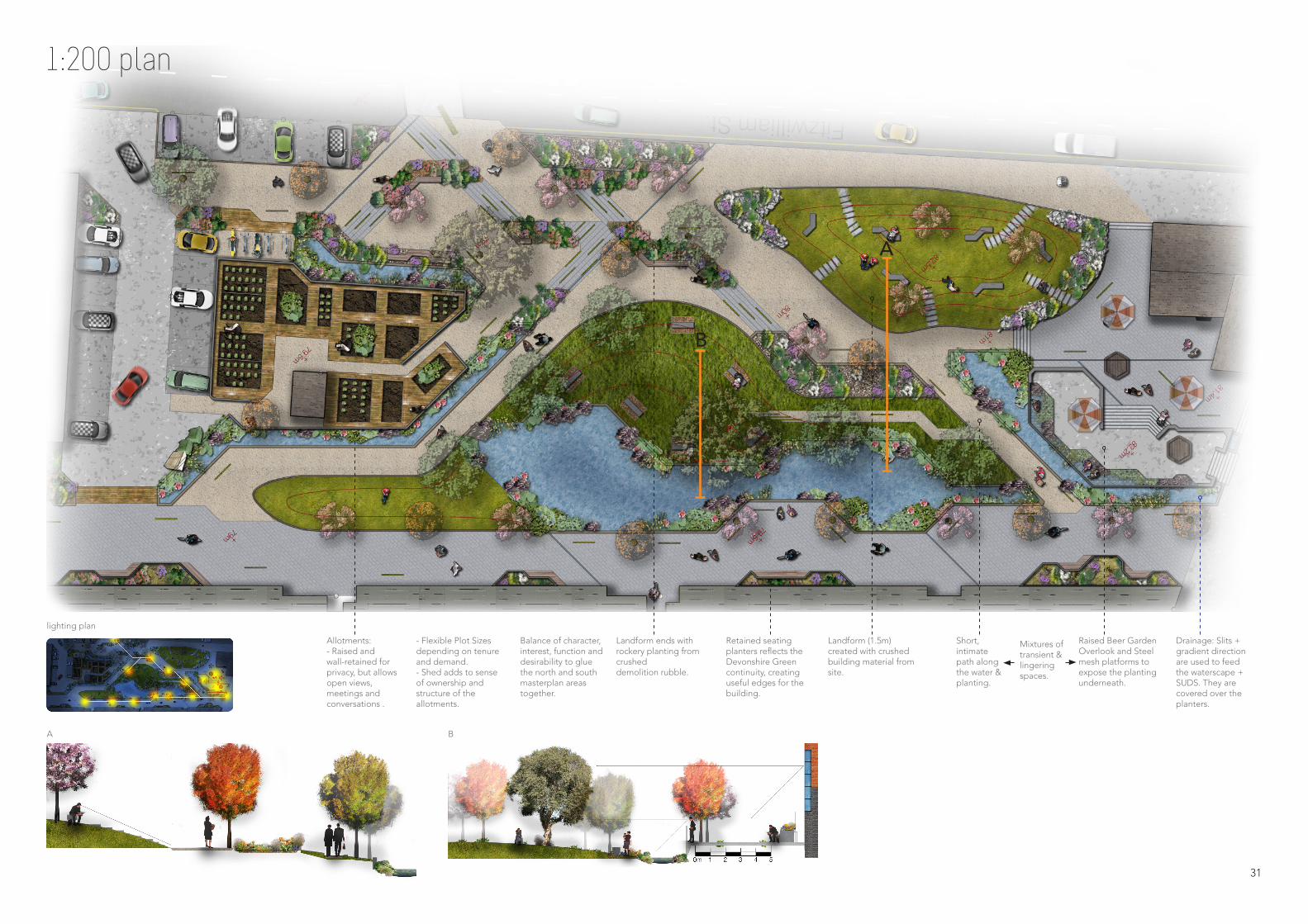
Allotments:- Raised and wall-re-tained for privacy, but allows open views, meetings andconversations . - Flexible Plot Sizes depending on tenure and demand.
- Shed adds to sense of ownership and structure of the allotments.
Landform (1.5m) created with crushed building material from site.
Short, intimate path along the water & planting.
Mixtures of transient & lingering spaces.
Landform ends with rockery planting from crushed demolition rubble.
Dappled shade from Sun and Rain.
Block seating on gravel for drained footspace.
Balance of character, interest, function and desirability to glue the north and south masterplan areas together.
Raised Beer Garden Overlook and Steel mesh platforms to expose the planting underneath.
Depressed grass slits are the threads that stitches the site conti-nuity together.
0m
0mm
5m
25mm
10m
50mm
15m
75mm
Students
Cyclists
Residents
Allotments
Industry+ Business
Site: Fitzwilliam St, Sheffield.The stretch of identified buildings are either dere-lict, poorly used parking or can be relocated rela-tively easily. The space between the two streets is used to create a corridor park, which connects the modern / trendy Devonshire Green, with the poor-ly connected, run-down Moor shopping district.
Night lighting essential as an unlocked public space, for social and park safety.
N
24
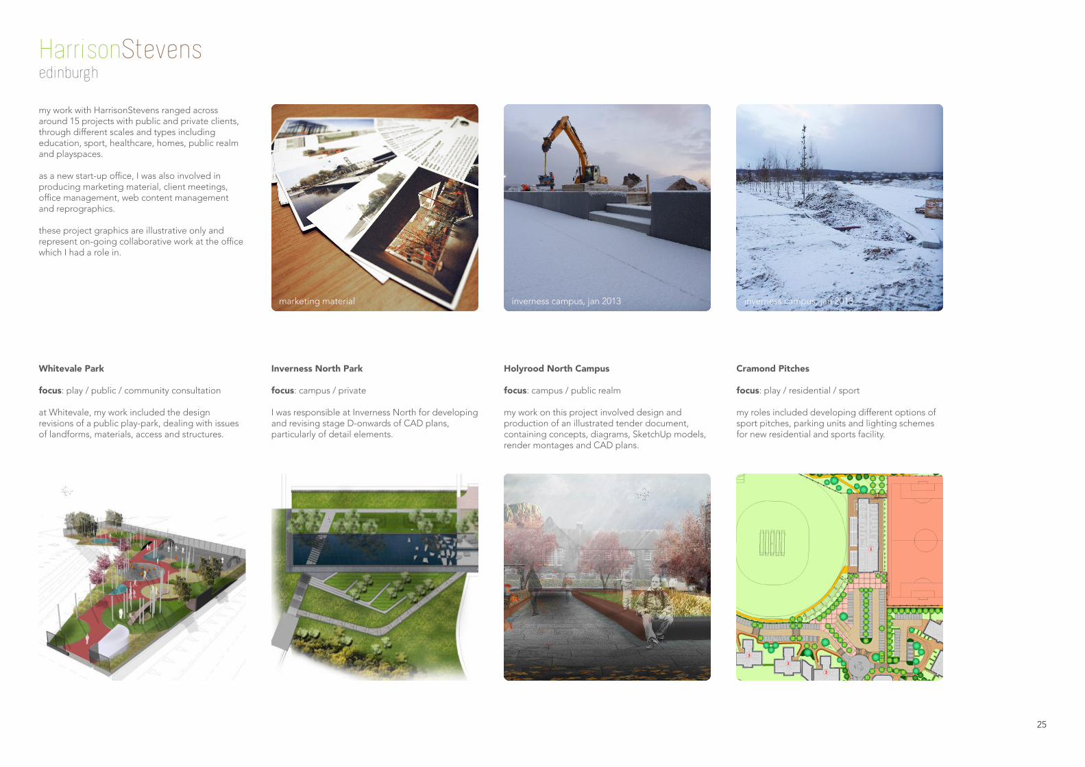
HarrisonStevensedinburgh
Whitevale Park
focus: play / public / community consultation
at Whitevale, my work included the design revisions of a public play-park, dealing with issues of landforms, materials, access and structures.
Inverness North Park
focus: campus / private
I was responsible at Inverness North for developing and revising stage D-onwards of CAD plans, particularly of detail elements.
Holyrood North Campus
focus: campus / public realm
my work on this project involved design and production of an illustrated tender document, containing concepts, diagrams, SketchUp models, render montages and CAD plans.
Cramond Pitches
focus: play / residential / sport
my roles included developing different options of sport pitches, parking units and lighting schemes for new residential and sports facility.
my work with HarrisonStevens ranged across around 15 projects with public and private clients, through different scales and types including education, sport, healthcare, homes, public realm and playspaces.
as a new start-up office, I was also involved in producing marketing material, client meetings, office management, web content management and reprographics.
these project graphics are illustrative only and represent on-going collaborative work at the office which I had a role in.
marketing material inverness campus, jan 2013 inverness campus, jan 2013
25
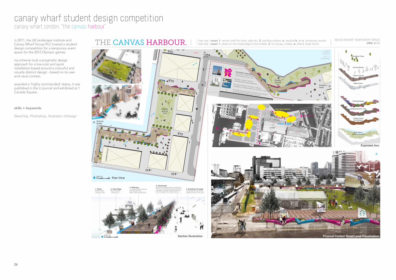
canary wharf student design competitioncanary wharf, london. “the canvas harbour”
in 2011, the UK landscape institute and Canary Wharf Group PLC hosted a student design competition for a temporary event space for the 2012 Olympic games.
my scheme took a pragmatic design approach for a low-cost and quick installation based around a colourful and visually distinct design - based on its user and naval context.
awarded a ‘highly commended’ status, it was published in the LI journal and exhibited at 1 Canada Square.
skills + keywords
SketchUp, Photoshop, Illustrator, InDesign
1. WaterMoored Yachts + London Vistas
Cross S
ection
Pontoon Bridge
Preston’s Road
Flexible Activity
Turf1.
3.
2.
Flexible Activity
Turf
CartierCircle
+5.4m
2. Hard Edge Mini Promenade + Activity Turf
3. Walkway1m elevated floating walkway over block planting. Metal / Timber construction
4. HardscapeMain open circulation space, connected to walkway via sequentially spaced wheelchair accessible rampways. Edge dominated by colourful jagged linear seating feature.
5. Building FrontageActive edge with openspace potential for bars / cafe / food
THE CANVAS HARBOUR. WOOD WHARF TEMPORARY SPACEURN: #182
/ ‘kan-vəs / noun: 1. woven cloth for tents, sails etc. 2. painting surface. a. nautical b. art c. temporary events/ hahr-ber / noun: 1. place on the coast/edge to find shelter. 2. to occupy, shelter. a. inland, linear forms
1:500 @ A1
1:100 @ A1
N0m
0m 2m1m
5m
4m
10m 20m
Exploded Axo
Container Trees
Canvas Boards
Timber Surface
Metal Frame
Planting Design
Seating Element / Soil
Visible Corten Soil Retainer
Base Water / Grass / Concrete
Key Design Languages:1. Maritime / Sailing History Canvas Boards for art / ads2. Edgy + colourful Olympic branding plastic seating aesthetic3. Linear connection of events + features,
modelled on a harbour-like form of access + docking4. Introducing a soft, green character as a prologue
to the Wood Wharf Regeneration Scheme
Section Illustration
Plan View
Physical Context Street Level Visualisation
1.
4.
2.
3.
Working Framework
Primary Access
Building Frontages
Open Space Network
1.
2.
Image Credits:1. lclane2.net/londondocks
2. london2012.com3. earthinpictures.com4. rogers stirk harbour
Map: google maps
Street Level Base Photo: flickr.com/gazkinz/6041352294
3.
26
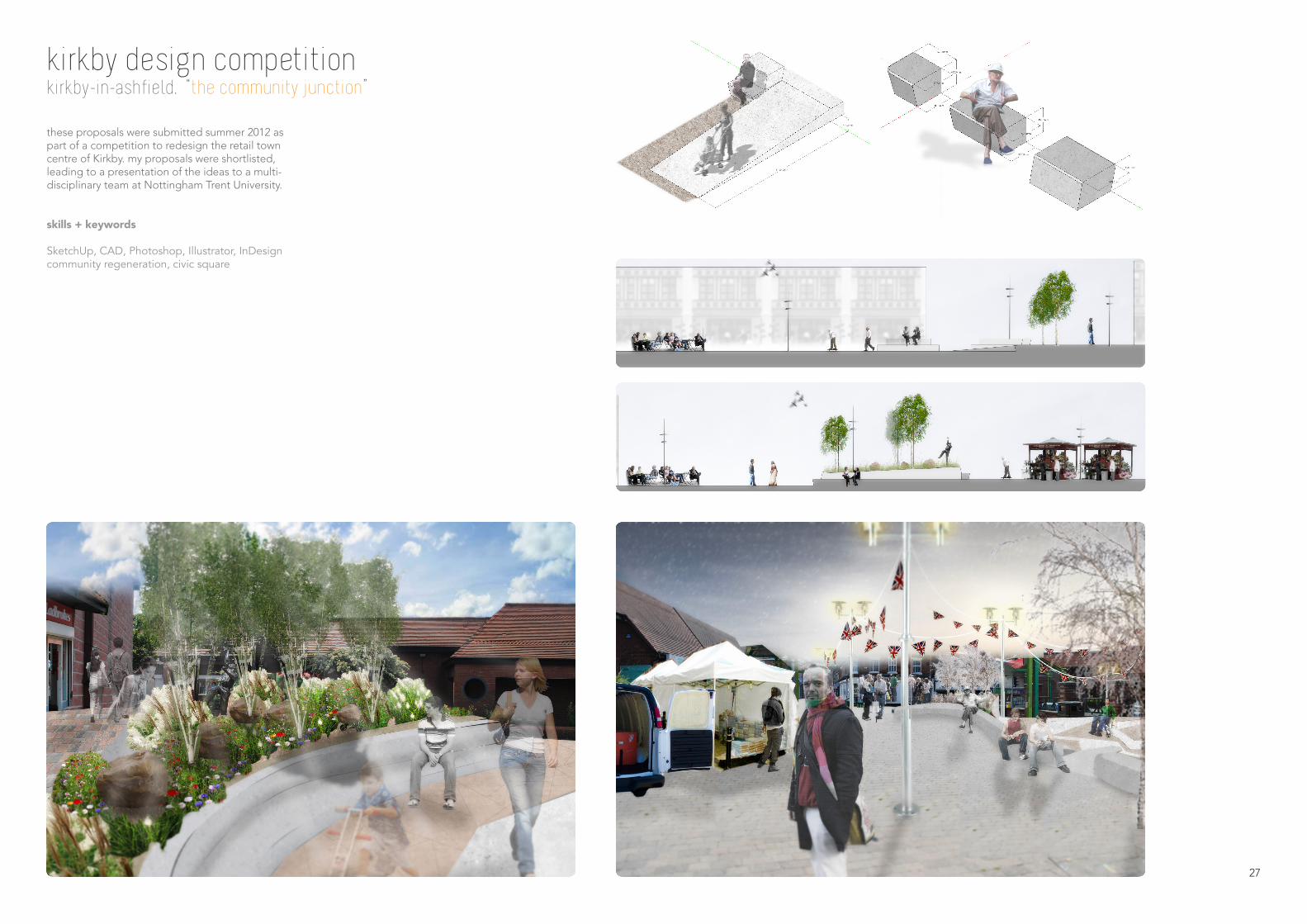
kirkby design competitionkirkby-in-ashfield. “the community junction”§
these proposals were submitted summer 2012 as part of a competition to redesign the retail town centre of Kirkby. my proposals were shortlisted, leading to a presentation of the ideas to a multi-disciplinary team at Nottingham Trent University.
skills + keywords
SketchUp, CAD, Photoshop, Illustrator, InDesigncommunity regeneration, civic square
27

PART 3: undergraduate


3rd year integrated projectdevonshire green, sheffield
combining Masterplanning, Urban Design, Planting Specification + Construction Detailing based around a single site, this project made projections to Sheffield’s future and attempts to respond as a fully working urban organism.
working from 1:2000 all down to 1:2, the task was to design solutions and futures in central Sheffield relating to concepts of a ‘big society’, economic downturn and social divides in a dense area.
process
the nature of the projects required a lengthy period of site research and early sketch plans where history and existing issues were clearly identified. once the masterplan skeleton was in place, Planting + Construction elements were introduced. these both insisted on delivering real-world, buildable solutions which introduced a clear visual character and personality, linking directly to the masterplan’s aims.
skills + keywords
1:2000 Sketch Plan, 1:1000 Masterplan, 1:500 Development, 1:200 Detailed, Photography, Sketching, Drafting, Photoshop, Rendering, Illustrator, AutoCAD, InDesign, SketchUp, Modelmaking, Historical Research
Ideas of fabric (referencing local textile businesses and relocation of the markets) played heavily in the concept masterplan.
1st
Movement + User Built Form + SpaceVegetation
1. Connectivity &
Journey (Corridor Park)
2. Markets & Community(New Markets/
Moor link)
3. Industry & Business
(Industry Skills College & Quarter.)
30
Landform (1.5m) created with crushed building material from site.
Retained seating planters reflects the Devonshire Green continuity, creating useful edges for the building.
Landform ends with rockery planting from crushed demolition rubble.
Balance of character, interest, function and desirability to glue the north and south masterplan areas together.
Allotments:- Raised and wall-retained for privacy, but allows open views, meetings andconversations .
- Flexible Plot Sizes depending on tenure and demand.- Shed adds to sense of ownership and structure of the allotments.
Drainage: Slits + gradient direction are used to feed the waterscape + SUDS. They are covered over the planters.
Raised Beer Garden Overlook and Steel mesh platforms to expose the planting underneath.
Short, intimate path along the water & planting.
Mixtures of transient & lingering spaces.
B
A
A B
lighting plan
1:200 plan
31
Timber Post: RedwoodLaminated ConstructionPretreated with insect, fun-gus and weather-resistant preservers. 100x100mm, Lengths: Page 2
Assembly Stages
1. Cast in-situ concrete to shape and finish. 2. Install vertical posts into post anchor and bolt through
3. Bolt horizontal post be-tween the two vertical posts.
4. Insert final post from top using Carpenter joint: T-Half (see working drawing)
Timber Slats: RedwoodGlue Laminated Construc-tionPretreated with insect, fungus + weather-resistant preservers. Size: 30x30x75mm
Steps Extend outside
side boundaries.
2.
1.
2.
1.
3.
3.
4.
4.
Underground Drainage Gradient to Centre: 1% over 1500mm (25mm)
Paving angle dictated by the direction of concrete.
Concrete Sett Cobble Paving: ‘Tegula’ - Colour: Traditional 80x80x60mmMortar: Light Natural Sand Joint Mortar Gap: 1mmSupplier: Marshalls
Precast Concrete Paving Trim Granite Step Edge (Vertical) 30x200x570mmGranite Step Edge (Horizontal) 30x200xVARIOUSmmColour: Black GRA921 . Flamed.Supplier: Marshalls
Drainage Design Builds in a slightly angled concrete base to prevent water pooling.
Planting Suggestions: Grasses, Herbs and other strong scent specimens.
Drainage Channel
Yorkstone ‘Moselden’: Diamond Sawn 300mm X RANDOMmm X 50mm450mm X RANDOMmm x 50mm (Steps)Mortar: Light Natural Sand Joint MortarMortar Gap: 10mmSupplier: Marshalls
Moselden is used to create a light and natural character. The random lengths and swirls of texture contribute to a organic user experience.
Traditional Tegula is used to create the character of old market squares. The smaller size of the blocks creates a more detailed and human space.
Dark coloured granite is used to contrast with the step colour for better visual clarity, and flamed for a highly textured, gripping surface.
Shadow: 2PM, June
construction
detailed cut-through
base concrete
back view
32

planting design
Colour: Herbaceous Perennials use Colour Wheel Contrasts.
Colour: Crushed Rubble planters use Earthy and Warm palettes, punctuated with occasional variations.
Layer 3 - Dominant Grasses: Stipa, Calamagrostic, Cortaderia, Verbena, Earthy, Wind Animated.
Layer 3 - Stipas : The gradual introduction of Stipas and small ornamental grasses creates an intro/outro intro the main grasses area.
Layer 2 - Grasses + Umbels: Carex, AchilleasStrong forms, mid level bushy grasses.
Layer 2 - Colourful Perennials: Echinacea, Digitalis, Angelica, AchilleasStrong forms, mid level bushy grasses.
Layer 1 - Groundcover: Panicums, Sedum spuriumEvergreen groundcover and low level Herbacous Perennials
Layer 1 - Groundcover: Panicums, Sedum spuriums. Evergreen groundcover and low level Herbacous Perennials
Texture: Water’s edge, damp soils calls for large, blocky foliage for interest from a distance, particularly from the other side of the waterbody.
Leaf surface rain retention adds to sense of ‘the wet’.
Texture: As a linear user experience, all plants (inc. Prunus) are selected for their fine / thin textures for close-up interest, and to maintain visual permeability across beds.
[Spring] Amenity Grass with Bulb emergence: January: GalanthusMarch: Scilla
[Spring] May: Alliums[Spring] Prunus cerasifera ‘Nigra’
Taxodium distichum
Butomus / Iris /
Nymphaea
Form: Umbels
AchilleaForm: Daisie
s
Echinacea /
Achillea / C
arex / Festu
ca / Persi-
caria / Sedum telephium / V
erbena
Form: Spires
DigitalisBase level groundcover
mix for dappled sh
ade
Festuca / P
anicum / Persic
aria /
Sedum spurium / G
alanthus
Achillea / C
ortaderia
/ Digitalis /
Verbena
Sun
Asp
ect
Sun Aspect
Textures: Darmera /
Osmunda / R
heumn
SchedulesType Name Size for Purchase Quantity Supplier Cost
Trees Prunus cerasifera ‘Nigra’ Girth: 14/16cm Container: 65L Pot
2 Coles £98 each.(£196 total)
Taxodium distichum Height: 300/350cm 65L Pot
1 Coles £140
Hedges Carpinus betulus ‘Fastigata’ Height: n/a. 10L Pot
7 Coles £16 (£112)
Herbaceous + Ferns
Achillea ‘Fanal’ 2L Pot 13 Manor Farm £2.15 (£28)
Achillea ‘Walther Funcke’ 2L Pot 16 Manor Farm £2.15 (£35)
Angelica gigas 3L Pot 19 Johnsons £8 (£152)
Darmera peltata 2L Pot 10 Coblands £3.15 (£31.5)
Digitalis ferruginea 2L Pot 35 Coblands £3.15 (£110)
Echinacea purpurea ‘Rubinstern’
2L Pot 15 Coblands £3.45 (£52)
Osmunda regalis 2L Pot 10 Coblands £3.70 (£37)
Persicaria amplexicaulis ‘Firetail’
2L Pot 84 Manor Farm £2.40 (£200)
Rheum palmatum ‘Tanguticum’
2L Pot 7 Coblands £4.95 (£35)
Rudbeckia fulgida var. sullivantii ‘Goldsturm’
3L Pot 15 Coblands £3.15 (£47)
Salvia x sylvestris ‘Mainacht’
2L Pot 17 Coblands £3.45 (£59)
Sedum telephium ‘Xenox’ 2L Pot 23 Johnsons £8 (£184)
Verbena bonariensis P9 (9cm Pots) 72 Manor Farm £1 (£72)
Evergreens Sedum spurium ‘Coccineum’
2L Pot 72 Johnsons £7 (£504)
Aquatics + Watersides
Butomus umbellatus n/a Pot 17 Merebrook £2.75 (£47)
Iris pseudacorus Variegata n/a Pot 17 Merebrook £2.40 (£48)
Nymphaea alba n/a Pot 14 Merebrook £9 (£126)
Grasses + Shrubs
Calamagrostis x acutiflora ‘Karl Foerster’
2L Pot 13 Manor Farm £2.35 (£30)
Carex comans ‘Bronze’ 2L Pot 36 Manor Farm £2.40 (£86)
Cortaderia selloana ‘Pumila’ 3L Pot 11 Coblands £5.25 (£58)
Festuca glauca ‘Elijah Blue’ 2L Pot 27 Manor Farm £2.20 (£60)
Panicum virgatum ‘Rotstrahlbusch’
C2 Pot 30 Coles 3.85 (£115)
Stipa gigantea 2L Pot 22 Manor Farm £2.40 (£53)
Perennial Bulbs
Allium hollandicum ‘Purple Sensation’
Bulb (10 Units) 930 Gee Tee £3 (£280)
Galanthus nivalis Bulb (100 Units) 650 Gee Tee £10 (£70)
Scilla siberica Bulb (100 Units) 850 Gee Tee £6 (£54)
Total £3021.5
PLANTING PLAN LSC 303 Advanced Planting Design 2011.Jotaro Tokunaga // #080166519. // 1 of 2.
Mix 4:7 No. Rheumn palmatum ‘Tanguticum’
10 No. Darmera peltata10 No. Osmunda regalis
Bulbs A (Shade): 100 No. Scilla siberica150 No. Galanthus nivalis
Bulbs B (Full Sun): 250 No. Scilla siberica
Both Blocks - Mix 5:Allium hollandicum ‘Purple Sensation’
Carex comans ‘Bronze’Persicaria amplexicaulis ‘Firetail’
Sedum spurnium ‘Coccineum’Stipa gigantea
See Percentage Mixes:Variation A:
Achillea ‘Walther Funcke’Angelica gigas
Variation B:Echinacea purpurea ‘Rubinstern’
Rudbeckia fulgida var. sullivantii ‘Goldsturm’
Variation C:Digitalis ferruginea
Salvia x sylvestris ‘Mainacht’
Mix 2:Achillea ‘Fanal’Carex comans ‘Bronze’Festuca glauca ‘Elijah Blue’Persicaria amplexicaulis ‘Firetail’Sedum telephium ‘Xenox’Verbena bonariensis
Mix 3:Achillea ‘Walther Funcke’
Digitalis ferrugineaVerbena bonariensis
Variation A: Stipa giganteaVariation B: Calamagrostis x
acutiflora‘ Karl Foerster’ Variation C: Cortaderia
selloana ‘Pumila’
0 0.5 1 1.5 2 2.5
0 1 2 3 4 5 N
m
cm
Topsoil + Mulch GuideArea Specific Area Type Mulch Size
(mm)Depth(mm)
Trees + Hedge
Taxodium Amenity Conifer Bark Mulch <30 150
Prunus Bark Mulch under Tree Grate <30 50
Carpinus (hedge) Amenity Conifer Bark Mulch <30 100
Area 1 Part A: Crushed Building Rubble
Crushed Building Rubble (Sourced on site demolitions)
10-20 50
Part B: Waterside Amenity Conifer Bark Mulch <30 50
Area 2 Amenity Conifer Bark Mulch <30 50
2.
1.
Path
Water
Seating
Seating
Path
Prunus cerasifera ‘Nigra’
Taxodium distichum
17 No. Butomus umbellatus17 No. Iris pseudacorus
14 No. Nymphaea alba
7 No. Carpinus betulus ‘Fastigata’
Amenity Grass Bulb Mix:200 No. Galanthus nivalis200 No. Scilla siberica
Site Plan
Not
es
1. Area: 100m²Fitzwilliam St.
Client James Hitchmough, University of Sheffield
Site “The Corridor Park”,Fitzwilliam Street, Sheffield
Job Title LSC 303: Advanced Planting Design
Author JTSheet 1/1Date 27/05/2011
Scale 1:50 @ A1
SuppliersColes Tel: 0116 2412115
Manor Farm Tel: 01327 [email protected]
Johnsons of Whixley
Tel: 01423 [email protected]
Merebrook Pond Plants
Tel: 01684 310950 [email protected]
Coblands Tel: 01732 [email protected]
Gee Tee Tel: 01205 [email protected]
Mix Percentages Centre Spacing
Per Sq/m
Mix 1‘Border’Average: 8 Plants m/sq
12.5% Festuca glauca ‘Elijah Blue’25% Panicum virgatum ‘Rotstrahlbusch’37.5% Persicaria amplexicaulis ‘Firetail’25% Sedum spurium ‘Coccineum’
350mm350350350
1232
Bulb Galanthus nivalis Scilla siberia
5x Clumps5x Clumps
20/sqm20/sqm
Mix 2‘Middle’Average: 8 Plants m/sq
12.5% Achillea ‘Fanal’25% Carex comans ‘Bronze’12.5% Festuca glauca ‘Elijah Blue’12.5% Persicaria amplexicaulis ‘Firetail’25% Sedum telephium ‘Xenox’12.5% Verbena bonariensis
350350350350350150
121122
Mix 3‘Centre’Average: 4 Plants m/sq
11% Achillea ‘Walther Funcke’11% Digitalis ferruginea11% Verbena bonariensis
300300150
112
Variation A 66% Stipa gigantea Spot (300 Radius) 2
Variation B 66% Calamagrostis x acutiflora‘Karl Foerster’
Spot (300 Radius) 2
Variation C 66% Cortaderia selloana ‘Pumila’ Spot (300 Radius) 2
Mix Percentages Centre Spacing
Per Sq/m
Mix 4‘Waterfront’Average: 3 Plants m/sq
(spot) Rheumn palmatum ‘Tanguticum’0% Darmera peltata0% Osmunda regalis
Spot (350 Radius)700700
Spot11
Bulb A Scilla sibericaGalanthus nivalis
5x Clumps. 10/sqm15/sqm
Bulb B Scilla siberica 5x Clumps. 25/sqm
Mix 5 Base‘Colourful Perennials’Average: 8 Plants m/sq
(spot) Stipa gigantea25% Carex comans ‘Bronze’25% Persicaria amplexicaulis ‘Firetail’50% Sedum spurium ‘Coccineum’
Spot (350 Radius)350350350
-224
Variation A 50% Base mix25% Achillea ‘Walther Funcke’25% Angelica gigas
-350350
-22
Variation B 50% Base mix25% Echinacea purpurea ‘Rubinstern’25% Rudbeckia fulgida ‘Goldsturm’
-350350
-22
Variation C 50% Base mix: 25% Digitalis ferruginea25% Salvia x sylvestris ‘Mainacht’
-350350
-22
Bulb 30/sqm, Allium hollandicum 5x Clumps 30/sqm
2. Area: 20+10m²
See LSC 307: Detailed Area Render. Not to Scale.
Mix 1:Festuca glauca ‘Elijah Blue’Galanthus nivalisPanicum virgatum ‘Rotstrahlbusch’Persicaria amplexicaulis ‘Firetail’Scilla siberiaSedum spurium ‘Coccineum’
3 No. Festuca 6 No. Panicum 10 No. Persicaria 6 No. Sedum spuriumBulb 60 No. Galanthus Bulb 60 No. Scilla
3 No. Festuca 6 No. Panicum 9 No. Persicaria 6 No. Sedum spurium Bulb 60 No. Galanthus Bulb 60 No. Scilla
2 No. Festuca 3 No. Panicum 5 No. Persicaria 3 No. Sedum spurium Bulb 30 No. Galanthus Bulb 30 No. Scilla
4 No. Festuca 7 No. Panicum 10 No. Persicaria7 No. Sedum spuriumBulb 70 No. Galanthus Bulb 70 No. Scilla
2 No. Festuca 4 No. Panicum 6 No. Persicaria4 No. Sedum spuriumBulb 40 No. Galanthus Bulb 40 No. Scilla
2 No. Festuca 4 No. Panicum 6 No. Persicaria4 No. Sedum spuriumBulb 40 No. Galanthus Bulb 40 No. Scilla
1. Bulb planting percentages are independent of the planting plan.2. All bulbs to be planted in loose groups of approx. 5.3. Sedum spurium + Persicaria should generally be planted towards plot edges for more effective evergreen groundcover.
3 No. Achillea 5 No. Carex 3 No. Festuca 2 No. Persicaria3 No. Sedum telephium 10 No. Verbena
2 No. Achillea 4 No. Carex 2 No. Festuca 2 No. Persicaria4 No. Sedum telephium 4 No. Verbena
2 No. Achillea 4 No. Carex 2 No. Festuca 2 No. Persicaria4 No. Sedum telephium 4 No. Verbena
2 No. Achillea 4 No. Carex 2 No. Festuca 2 No. Persicaria4 No. Sedum telephium 4 No. Verbena
2 No. Achillea 4 No. Carex 2 No. Festuca 2 No. Persicaria4 No. Sedum telephium 4 No. Verbena
2 No. Achillea 4 No. Carex 2 No. Festuca 2 No. Persicaria4 No. Sedum telephium 4 No. Verbena
4 No. Carex 4 No. Persicaria8 No. Sedum1 No. StipaBulb 60 No. Allium
6 No. Carex 6 No. Persicaria12 No. Sedum2 No. StipaBulb 90 No. Allium
Variation C: 2 No. Carex 3 No. Digitalis2 No. Persicaria3 No. Sedum3 No. SalviaBulb 45 No. Allium
Variation C: 7 No. Carex 14 No. Digitalis7 No. Persicaria14 No. Sedum14 No. Salvia3 No. StipaBulb 210 No. Allium
Variation A: 4 No. Angelica 2 No. Carex 4 No. Achillea2 No. Persicaria4 No. SedumBulb 60 No. Allium
Variation A: 15 No. Angelica 7 No. Carex 15 No. Achillea7 No. Persicaria15 No. Sedum4 No. StipaBulb 225 No. Allium
Variation B: 2 No. Carex 2 No. Echinacea2 No. Rudbeckia2 No. Persicaria3 No. SedumBulb 45 No. Allium
Variation B: 6 No. Carex 13 No. Echinacea13 No. Rudbeckia6 No. Persicaria13 No. SedumBulb 195 No. Allium
1 No. Achillea1 No. Digitalis4 No. Stipa gigantea 2 No. Verbena
1 No. Achillea1 No. Digitalis3 No. Stipa gigantea 2 No. Verbena
1 No. Achillea1 No. Digitalis3 No. Stipa gigantea 2 No. Verbena
1 No. Achillea1 No. Digitalis2 No. Stipa gigantea 2 No. Verbena
1 No. Achillea3 No. Calamagrostis1 No. Digitalis2 No. Verbena
1 No. Achillea3 No. Calamagrostis2 No. Digitalis2 No. Verbena
5 No. Achillea5 No. Calamagrostis5 No. Digitalis10 No. Verbena
1 No. Achillea2 No. Calamagrostis1 No. Digitalis2 No. Verbena
4 No. Achillea11 No. Cortaderia5 No. Digitalis8 No. Verbena
CAD plan / specifications
33

Residential Housing Landscapes‘Living Around Water’
BriefTo develop a housing scheme from the landscape upwards, to meet a density quota and to take a certain aspect of sustainability and building that into the design.
Context + DesignDue to the steep topography of the site, I felt it necessary to incorporate a high quality drainage scheme which becomes the focal point of the scheme.
FeaturesIt also converts the road into a shared surface, prompting a safer and easier living experience, with parking, waste disposals, a local shop, allotments and both open greenspace and woodland.
KeywordsSUDSSocial InclusivelyUrban WoodlandWaste ManagementRoad InfrastructureShared Streets
MasterplanningSharrow, Sheffield
Brief
Sheffield’s Sharrow district has its ties to its (very close) city centre severed by a wide ring road. Its distinctive features ( river corridor, tower-block open space networks ) offered a chance to turn low socio-economic values into positive and better connected spaces.
The masterplan develops identified opportunities into a workable street fabric through screening and pollution mitigation, as well as amplifying greenspaces and boosting connections with its neighbours using the existing green and blue networks.
KeywordsConnectivityPublic InfrastructureUrban CharacterConcept
1st
34
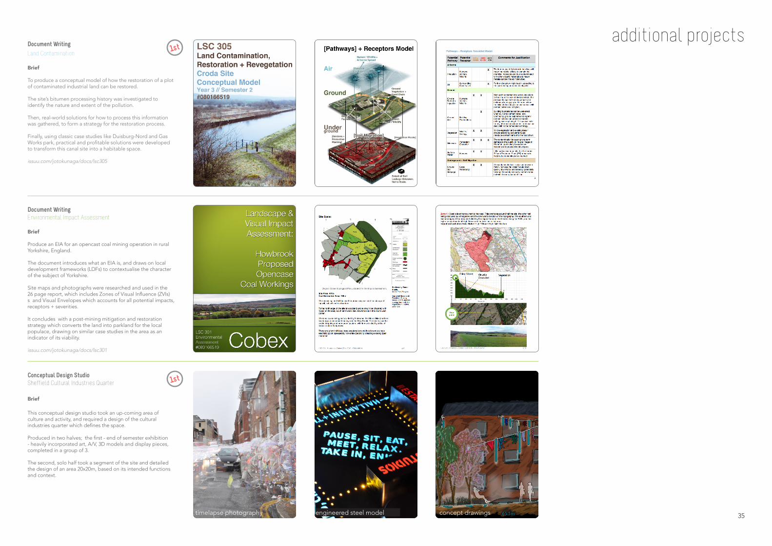
Document Writing
Land Contamination
Brief
To produce a conceptual model of how the restoration of a plot of contaminated industrial land can be restored.
The site’s bitumen processing history was investigated to identify the nature and extent of the pollution.
Then, real-world solutions for how to process this information was gathered, to form a strategy for the restoration process.
Finally, using classic case studies like Duisburg-Nord and Gas Works park, practical and profitable solutions were developed to transform this canal site into a habitable space.
issuu.com/jotokunaga/docs/lsc305
Document WritingEnvironmental Impact Assessment
Brief
Produce an EIA for an opencast coal mining operation in rural Yorkshire, England.
The document introduces what an EIA is, and draws on local development frameworks (LDFs) to contextualise the character of the subject of Yorkshire.
Site maps and photographs were researched and used in the 26 page report, which includes Zones of Visual Influence (ZVIs)s and Visual Envelopes which accounts for all potential impacts, receptors + severities.
It concludes with a post-mining mitigation and restoration strategy which converts the land into parkland for the local populace, drawing on similar case studies in the area as an indicator of its viability.
issuu.com/jotokunaga/docs/lsc301
Conceptual Design StudioSheffield Cultural Industries Quarter
Brief
This conceptual design studio took an up-coming area of culture and activity, and required a design of the cultural industries quarter which defines the space.
Produced in two halves; the first - end of semester exhibition - heavily incorporated art, A/V, 3D models and display pieces, completed in a group of 3.
The second, solo half took a segment of the site and detailed the design of an area 20x20m, based on its intended functions and context.
1st
1st
additional projects
timelapse photography concept drawingsengineered steel model 35

PART 4: travel

Parc André Citroën[1992]
Parc Clichy-Batignolles [2010]
La Defence
Jardins d’Éole [2006]
Jardin de Reuilly [1995]
Parc du La Villette [1990]
Parc du La Villette [1990]
Promenade Plantée [1993]
La ville de Boulogne-Billancourt [2010-]
Parc du Buttes-Chaumont [1867]
Parc de Bercy [1997]
Musée du quai Branly [2006]
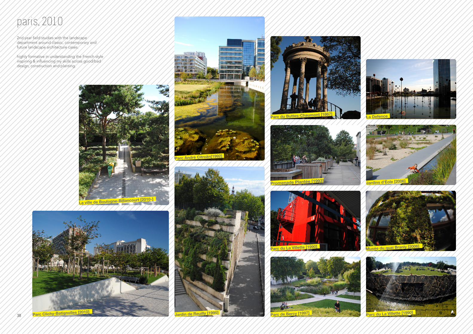
paris, 20102nd year field studies with the landscape department around classic, contemporary and future landscape architecture cases.
highly formative in understanding the French style inspiring & influencing my skills across good/bad design, construction and planting.
38
High Line, NYC
9/11 Memorial, NYC Central Park, NYC
Grand Canyon, AZ
Paley Park, NYC
Lurie Gardens, Chicago IL
Brooklyn Bridge Park, NYC
Las Vegas, NV
The Edge, NYC
de Young, SF Levi’s Plaza, SF
Yosemite, CA
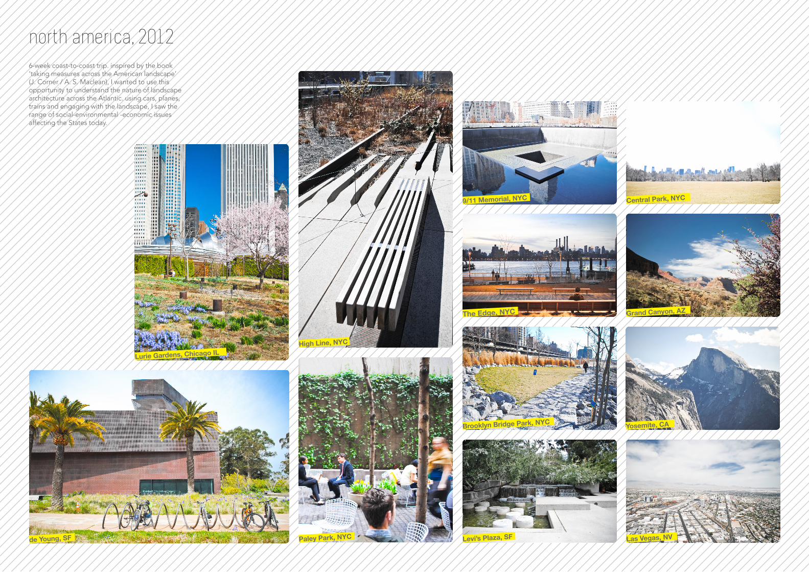
north america, 20126-week coast-to-coast trip. inspired by the book ‘taking measures across the American landscape’ (J. Corner / A. S. Maclean), I wanted to use this opportunity to understand the nature of landscape architecture across the Atlantic. using cars, planes, trains and engaging with the landscape, I saw the range of social-environmental -economic issues affecting the States today.
39
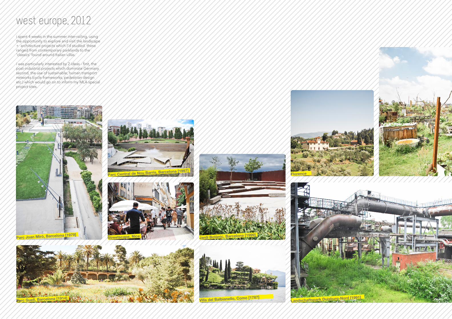
west europe, 2012i spent 4 weeks in the summer inter-railing, using the opportunity to explore and visit the landscape + architecture projects which I’d studied. these ranged from contemporary parklands to the ‘classics’ found around Italian villas.
i was particularly interested by 2 ideas - first, the post-industrial projects which dominate Germany. second, the use of sustainable, human transport networks (cycle frameworks, pedestrian design etc.) which would go on to inform my MLA special project sites.
Florence
Streetscape, Nice
Parc Central de Nou Barris, Barcelona [1997]
Villa del Balbianello, Como [1787]Landschaftspark Duisburg-Nord [1991]
Parc Guell, Barcelona [1914]
Jardí Botànic, Barcelona [1999]
Tempelhof Airport, Berlin
Parc Joan Miró, Barcelona [1979]
40
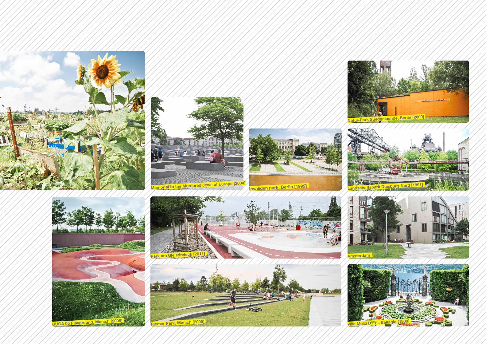
Landschaftspark Duisburg-Nord [1991]
Park am Gleisdreieck [2011]
Memorial to the Murdered Jews of Europe [2004]
Villa Melzi D’Eril, Bellagio [1808]
Invaliden park, Berlin [1992]
BUGA 05 Playground, Munich [2005]
Natur-Park Suedgelaende, Berlin [2000]
Amsterdam
Riemer Park, Munich [2005]4141

JOTA
RO T
OKUN
AGA
jo
toku
naga
§(at
) gm
ail (
dot)
com
carg
ocol
lect
ive.
com
/jot
aro


![Transcalibur : Weight Moving VR Controller for Dynamic …jotaro/transcalibur_web/... · 2018. 6. 4. · studied. Shifty[Zenner and Krüger 2017] proposed the 1d-weight shifting technique](https://img.pdfslide.net/doc/110x75/5fff39b65a9cc258fa34de86/transcalibur-weight-moving-vr-controller-for-dynamic-jotarotranscaliburweb.jpg)